

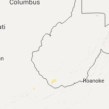
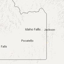
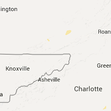
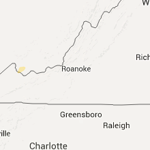
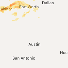
Hail Map for Monday, July 4, 2016

Number of Impacted Households on 7/4/2016
0
Impacted by 1" or Larger Hail
0
Impacted by 1.75" or Larger Hail
0
Impacted by 2.5" or Larger Hail
Square Miles of Populated Area Impacted on 7/4/2016
0
Impacted by 1" or Larger Hail
0
Impacted by 1.75" or Larger Hail
0
Impacted by 2.5" or Larger Hail


Cities Most Affected by Hail Storms of 7/4/2016
| Hail Size | Demographics of Zip Codes Affected | ||||||
|---|---|---|---|---|---|---|---|
| City | Count | Average | Largest | Pop Density | House Value | Income | Age |
| Willow City, ND | 2 | 2.13 | 2.50 | 2 | $15k | $23.6k | 50.3 |
Hail and Wind Damage Spotted on 7/4/2016
Filter by Report Type:Hail ReportsWind Reports
States Impacted
Kentucky, Tennessee, North Dakota, Georgia, West Virginia, Mississippi, Wyoming, North Carolina, South Carolina, South Dakota, Maine, Montana, Virginia, Texas, Alabama, MinnesotaKentucky
| Local Time | Report Details |
|---|---|
| 12:12 PM EDT | Structure and tree damage... public report relayed by spotte in anderson county KY, 34.2 miles E of Louisville, KY |
| 12:45 PM EDT | Several trees down and blocking roadway on ky 3 in woodford county KY, 46.3 miles WNW of Irvine, KY |
| 1:02 PM EDT | Several reports of large trees down... appomattox drive...wolf run rd...and red mile road. in fayette county KY, 38.8 miles NW of Irvine, KY |
| 1:27 PM EDT | Trees dow in bourbon county KY, 37.8 miles NNW of Irvine, KY |
| 1:12 PM CDT | Tree reported down on brier run roa in edmonson county KY, 52.9 miles SSW of Louisville, KY |
| 1:12 PM CDT | 2 trees down near smiths grove. 1 on otter gap road and 1 on hydro pondsville roa in warren county KY, 69.2 miles NNE of Nashville, TN |
| 2:15 PM EDT | Large tree dow in floyd county KY, 61.1 miles E of Irvine, KY |
| 1:19 PM CDT | A couple of trees were reported down in mammoth cave national par in edmonson county KY, 59.1 miles SSW of Louisville, KY |
| 1:25 PM CDT | 2 trees down in frankli in simpson county KY, 39.6 miles NNE of Nashville, TN |
| 1:33 PM CDT | 2 trees down on ky 1171 at mile markers 5 and in simpson county KY, 45 miles NNE of Nashville, TN |
| 1:44 PM CDT | Trees down in the are in hart county KY, 56.9 miles S of Louisville, KY |
| 1:48 PM CDT | Very brief gust measured at 58 mph just south of trento in todd county KY, 46 miles NW of Nashville, TN |
| 1:57 PM CDT | Several trees down across the area in metcalfe county KY, 58.5 miles S of Louisville, KY |
| 1:57 PM CDT | Metal rool peeled off bar in metcalfe county KY, 58.5 miles S of Louisville, KY |
| 2:20 PM CDT | Trees down in the are in green county KY, 57 miles SSE of Louisville, KY |
| 2:23 PM CDT | Trees dow in green county KY, 53.6 miles SSE of Louisville, KY |
| 3:28 PM EDT | Several downed trees blocking e lemon bend r in taylor county KY, 53.9 miles SSE of Louisville, KY |
| 3:44 PM EDT | About 100 trees down... some twisted. roofs damaged. cars overturned. damage near u.s. rt. 23 and ky rt. 32 for about 1 mil in lawrence county KY, 56.5 miles WSW of Charleston, WV |
| 3:45 PM EDT | Multiple reports of extensive wind damage at walmart and its surounding area. cars overturned... apt complex sustained damage... trees dow in lawrence county KY, 56.1 miles WSW of Charleston, WV |
| 4:02 PM EDT | Downed tree blocking hwy 127 near henson ridge r in casey county KY, 62.6 miles WSW of Irvine, KY |
| 4:04 PM EDT | Numerous power lines dow in casey county KY, 62.1 miles WSW of Irvine, KY |
| 4:14 PM EDT | A downed tree on a car on 220 ike singleton rd and several trees down in the waynesburg area. in lincoln county KY, 45.9 miles SW of Irvine, KY |
| 4:23 PM EDT | Several trees and powerlines down on smith vaught rd and the 9000 block of highway 124 in pulaski county KY, 49.8 miles SW of Irvine, KY |
| 4:24 PM EDT | Trees and limbs down on power line in garrard county KY, 33.5 miles W of Irvine, KY |
| 4:33 PM EDT | Lots of trees and tree debris down on highway 3245 about 2 miles west southwest of brodhea in rockcastle county KY, 33.3 miles SW of Irvine, KY |
| 4:33 PM EDT | Tree down on powerline on west main street in broadhea in rockcastle county KY, 32 miles SW of Irvine, KY |
| 4:33 PM EDT | Four trees uprooted. one car flipped upside down. another car windows broken by flying debris. two pick-up moved with one moved approximately 100 fee in rockcastle county KY, 32.9 miles SW of Irvine, KY |
| 3:45 PM CDT | Power outages reported due to trees down on lines. time estimated from rada in clay county TN, 81.9 miles ENE of Nashville, TN |
| 4:51 PM EDT | A tree was blown down in laurel county KY, 31 miles SSW of Irvine, KY |
| 4:58 PM EDT | A tree was blown dow in laurel county KY, 42.2 miles SSW of Irvine, KY |
| 5:01 PM EDT | The roof of a porch of a mobile home was blown off. this is per an image posted to a wymt social media page. the time of the event is estimated from radar dat in jackson county KY, 28.6 miles S of Irvine, KY |
| 5:02 PM EDT | A tree was blown down in laurel county KY, 31.2 miles S of Irvine, KY |
| 5:03 PM EDT | A tree was blown dow in laurel county KY, 40.2 miles S of Irvine, KY |
| 5:05 PM EDT | A tree was blown dow in laurel county KY, 32 miles S of Irvine, KY |
| 5:17 PM EDT | A tree was reported to have been blown down along gum branch roa in clay county KY, 29.2 miles SSE of Irvine, KY |
| 4:21 PM CDT | Trees down on highway 696 near the clinton/wayne county lin in clinton county KY, 80.6 miles NW of Knoxville, TN |
| 5:36 PM EDT | A tree was blown dow in laurel county KY, 43.5 miles S of Irvine, KY |
| 5:54 PM EDT | A tree was blown dow in breathitt county KY, 33.8 miles ESE of Irvine, KY |
| 5:59 PM EDT | Tree was blown down across a road in the coalfields regional industrial park and a mobile home nearby was damage in perry county KY, 45.4 miles ESE of Irvine, KY |
| 6:13 PM EDT | Large tree limbs down on antler drive in perry county KY, 51.7 miles ESE of Irvine, KY |
| 6:13 PM EDT | Several trees were reported to have been blown down. this is from a post to social media page of wymt tv. time of the event is estimated from radar dat in knott county KY, 52.7 miles ESE of Irvine, KY |
| 6:27 PM EDT | Large limbs dow in floyd county KY, 66.7 miles ESE of Irvine, KY |
| 6:28 PM EDT | A tree was blown down in magoffin county KY, 58.2 miles E of Irvine, KY |
| 6:50 PM EDT | Trees were blown down per images posted to social media page of wymt tv. time of the event is estimated from radar dat in floyd county KY, 69.2 miles NNW of Bristol, TN |
| 6:50 PM EDT | Two trees were blown down and large limbs were blow down in the hurricane creek community per images posted to social media pages of wymt tv and ekb news. time of the e in pike county KY, 66.5 miles NNW of Bristol, TN |
| 6:53 PM EDT | A tree was blown down per image posted to social media page of ekb news. time of the event is estimated from radar dat in pike county KY, 57.8 miles NNW of Bristol, TN |
| 6:53 PM EDT | Trees were blown down at a golf course per images posted to social media. the time of the event is estimated from radar dat in pike county KY, 68.6 miles NNW of Bristol, TN |
| 6:55 PM EDT | Downed power lines in the scott subdivision of pikeville... closing us 23 north and south-bound. time estimated from rada in pike county KY, 63.4 miles NNW of Bristol, TN |
Tennessee
| Local Time | Report Details |
|---|---|
| 1:15 PM CDT | Smokey barn news reported several trees and power lines down across the county. one tree fell onto a garage in springfiel in robertson county TN, 23.6 miles NNW of Nashville, TN |
| 2:32 PM CDT | Trees...tree limbs...and power lines down on berkshire drive...blueridge drive off bighorn drive and catskill drive off matterhorn driv in wilson county TN, 12.2 miles ENE of Nashville, TN |
| 2:37 PM CDT | Several tree limbs down and one tree down. time estimated by rada in davidson county TN, 11.1 miles ENE of Nashville, TN |
| 2:39 PM CDT | Tree limb came down and took a power line with i in wilson county TN, 12.4 miles ENE of Nashville, TN |
| 2:40 PM CDT | Tree and power lines down on gay winds drive off bender ferry in wilson county TN, 17.3 miles ENE of Nashville, TN |
| 2:48 PM CDT | Many limbs down across the are in trousdale county TN, 42.9 miles ENE of Nashville, TN |
| 3:15 PM CDT | Power outages on honeysuckle lane due to limbs falling on power line in trousdale county TN, 36.9 miles ENE of Nashville, TN |
| 3:27 PM CDT | Picture of a limb dow in wilson county TN, 11.9 miles ENE of Nashville, TN |
| 3:28 PM CDT | Multiple power outages across the county due to limbs and trees down. source is the power compan in smith county TN, 47.3 miles E of Nashville, TN |
| 3:29 PM CDT | Several trees down around 4402 andrew jackson pkwy in hermitage. picture of limbs down in green hil in davidson county TN, 9.9 miles ENE of Nashville, TN |
| 3:30 PM CDT | Numerous trees down. time estimated from rada in clay county TN, 68 miles ENE of Nashville, TN |
| 3:31 PM CDT | Many limbs down in the are in trousdale county TN, 37.3 miles ENE of Nashville, TN |
| 3:40 PM CDT | Numerous power outages in the area due to trees coming down on power line in jackson county TN, 64.8 miles ENE of Nashville, TN |
| 4:55 PM EDT | Tree down at intersection of south cumberland street and algonquin drive. tree down at dover road and carroll road intersection. another tree down in talbott at allen r in hamblen county TN, 39 miles ENE of Knoxville, TN |
| 4:02 PM CDT | Trees down in area which took down power lines. numerous power outages reporte in jackson county TN, 67.1 miles ENE of Nashville, TN |
| 4:08 PM CDT | Tree and power line down in yard of home in pickett county TN, 79.5 miles WNW of Knoxville, TN |
| 6:40 PM CDT | Facebook photo of a large tree limb down on a home between old hickory blvd and nolensville road. also twitter report of a tree limb down on dustin lane at battery lane in davidson county TN, 9.4 miles SSE of Nashville, TN |
| 8:09 PM EDT | One tree dow in hawkins county TN, 27.5 miles W of Bristol, TN |
| 8:10 PM EDT | Several trees down across the count in hamblen county TN, 41.2 miles ENE of Knoxville, TN |
| 8:28 PM EDT | Trees down in the bloomingdale area near kingspor in sullivan county TN, 17.4 miles W of Bristol, TN |
| 8:40 PM EDT | Powerlines downed in sullivan county TN, 7.4 miles SW of Bristol, TN |
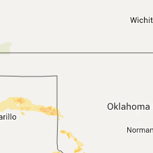
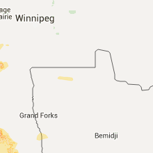
North Dakota
| Local Time | Report Details |
|---|---|
| 3:06 PM CDT | Half Dollar sized hail reported near Willow City, ND, 63.4 miles ENE of Minot, ND, half dollar size hail for roughly 5 to 10 minutes. |
| 3:06 PM CDT | Tennis Ball sized hail reported near Willow City, ND, 63.4 miles ENE of Minot, ND, very few tennis ball size hail stones for roughly 5 to 10 minutes. strong winds and very heavy rainfall. |
| 3:12 PM CDT | Golf Ball sized hail reported near Willow City, ND, 62.6 miles ENE of Minot, ND, golf ball size hail reported 5 miles se of overly. hail lasted roughly 5 to 10 minutes |
| 3:20 PM CDT | Quarter sized hail reported near Rugby, ND, 56.7 miles ENE of Minot, ND, . |
| 3:45 PM CDT | Quarter sized hail reported near Knox, ND, 43.2 miles WNW of Devils Lake, ND |
| 3:45 PM CDT | Peak winds measured at a personnal weather statio in benson county ND, 30.4 miles WNW of Devils Lake, ND |
| 4:15 PM CDT | Quarter sized hail reported near Leeds, ND, 31.9 miles WNW of Devils Lake, ND, hail up to quarter size off and on for nearly 15 minutes. ground covered in hail. |
| 4:20 PM CDT | Large tree branches down and power lines down in town. hail large than quarter size in benson county ND, 29.6 miles WNW of Devils Lake, ND |
| 4:22 PM CDT | Ping Pong Ball sized hail reported near Leeds, ND, 23.3 miles WNW of Devils Lake, ND |
| 4:30 PM CDT | Peak wind reported at the kled rwis station near us hwy 2 and nd hwy 28 in benson county ND, 22.4 miles WNW of Devils Lake, ND |
| 4:56 PM CDT | Peak wind measured at kdvl /devils lake airport in ramsey county ND, 2.5 miles SW of Devils Lake, ND |
| 4:56 PM CDT | Peak wind measured at kdvl /devils lake airport in ramsey county ND, 2.9 miles W of Devils Lake, ND |
| 5:00 PM CDT | Peak wind measured at the hwy 20 rwis station on devils lak in ramsey county ND, 5.2 miles SW of Devils Lake, ND |
| 5:00 PM CDT | Quarter sized hail reported near Devils Lake, ND, 11.7 miles W of Devils Lake, ND, intermittent dime to quarter sized hail from 445 to 5 pm cdt. report near mauvais coulee bridge on cr19. |
| 5:10 PM CDT | Quarter sized hail reported near Saint Michael, ND, 12.1 miles S of Devils Lake, ND, some wind. |
| 5:25 PM CDT | Quarter sized hail reported near Warwick, ND, 17.7 miles S of Devils Lake, ND, dime to quarter sized hail. |
| 5:41 PM CDT | Power is out; hail to nickel size. in dickey county ND, 38.4 miles NNW of Aberdeen, SD |
| 5:44 PM CDT | Also had small hail and heavy rain. event continued at time of call 546 p in dickey county ND, 46.9 miles NNW of Aberdeen, SD |
| 5:46 PM CDT | Peak winds measured by the ndawn station 8n of mchenry... along hwy 15. previous report of 69 mph at 545 pm cd in eddy county ND, 31.5 miles SSE of Devils Lake, ND |
| 5:50 PM CDT | Peak wind gusts estimated at 75 to 85 mp in nelson county ND, 38.6 miles SE of Devils Lake, ND |
| 6:02 PM CDT | State radio passed on report of 80 to 90 mph wind gusts. also nickel sized hail and 2 to 3 inches of rain in 30 minute in griggs county ND, 41.4 miles SSE of Devils Lake, ND |
| 6:10 PM CDT | Frederick rwi in brown county SD, 33.3 miles N of Aberdeen, SD |
| 6:29 PM CDT | Peak wind measured at the ndawn station along hwy 200 at hwy in griggs county ND, 55.9 miles SE of Devils Lake, ND |
| 6:30 PM CDT | Peak wind measured at the ndawn station along hwy 200 at hwy 1. previous report of 62 mph at 629 pm cd in griggs county ND, 55.9 miles SE of Devils Lake, ND |
| 6:51 PM CDT | Half Dollar sized hail reported near Luverne, ND, 57.5 miles WNW of Fargo, ND, hail up to a little bit bigger than a quarter. |
| 7:10 PM CDT | Large branches down. winds estimated at around 60 mp in barnes county ND, 48.5 miles W of Fargo, ND |
| 7:27 PM CDT | Crop debris scattered behind the gust fron in cass county ND, 38.4 miles W of Fargo, ND |
| 7:55 PM CDT | Half Dollar sized hail reported near Wheatland, ND, 30.2 miles W of Fargo, ND |
| 8:30 PM CDT | Construction trailer and barricades blown over at a constrution site on highway 1 in dickey county ND, 37.6 miles N of Aberdeen, SD |
| 8:30 PM CDT | Two to three foot diameter tree blown dow in cass county ND, 5.6 miles W of Fargo, ND |
| 8:40 PM CDT | Ten to twelve inch diameter branches down in the northport area of north fargo. the power was also ou in cass county ND, 1.8 miles W of Fargo, ND |
Georgia
| Local Time | Report Details |
|---|---|
| 4:07 PM EDT | Warning point reports a tree down at the intersection of sand hill rd and boggy bay. time estimated from radar in effingham county GA, 21.6 miles WNW of Savannah, GA |
West Virginia
| Local Time | Report Details |
|---|---|
| 4:41 PM EDT | Multiple trees down at rt 3/rt 214 intersection. damage to houses and maybe a churc in lincoln county WV, 19.8 miles WSW of Charleston, WV |
| 5:01 PM EDT | Trees down and power poles snapped on toolman road about 1.5 miles from the kanawha state forest entrance. time estimated from radar in kanawha county WV, 4.3 miles SSW of Charleston, WV |
| 5:09 PM EDT | Two telephone poles down on south park r in kanawha county WV, 2.7 miles E of Charleston, WV |
| 5:09 PM EDT | Multiple trees and power lines down along sand plant r in kanawha county WV, 6.2 miles SW of Charleston, WV |
| 5:09 PM EDT | Multiple reports of lines down near kanawha state fores in kanawha county WV, 4.3 miles SSW of Charleston, WV |
| 7:26 PM EDT | Trees down in landgraf in mcdowell county WV, 64.8 miles S of Charleston, WV |
| 7:26 PM EDT | Trees down in landgrass in mcdowell county WV, 63.5 miles S of Charleston, WV |
| 7:29 PM EDT | Several trees down along route 18 and near meathouse fork road intersection in doddridge county WV, 46.3 miles WNW of Elkins, WV |
| 7:35 PM EDT | Trees down in carswell hollow near kimball in mcdowell county WV, 63.9 miles S of Charleston, WV |
| 7:35 PM EDT | Trees snapped along elk city road near the lewis and harrison county line in harrison county WV, 35.8 miles WNW of Elkins, WV |
| 7:35 PM EDT | Downed trees along vens run rd near the good hope community in harrison county WV, 33.9 miles WNW of Elkins, WV |
| 7:41 PM EDT | Spotter reports numerous snapped trees and damaged signs along i-79 near the lost creek exit. time estimated from radar in harrison county WV, 31.7 miles WNW of Elkins, WV |
| 7:42 PM EDT | Reports of trees down in the west milford area. time estimated from radar in harrison county WV, 35.8 miles WNW of Elkins, WV |
| 7:47 PM EDT | Reports of multiple trees down and power lines down. outbuilding damaged from trees falling on building in lewis county WV, 33 miles WNW of Elkins, WV |
| 7:48 PM EDT | Reports of multiple trees down in the lost creek area. time estimated from radar in harrison county WV, 34.5 miles NW of Elkins, WV |
| 8:29 PM EDT | Report of 1 tree down along indian fork road/route 57 in barbour county WV, 18.8 miles NW of Elkins, WV |
| 8:37 PM EDT | Trees down along route 10 near hiawath in mercer county WV, 66.5 miles SSE of Charleston, WV |
| 8:40 PM EDT | One tree down along u.s. 52 in bluewel in mercer county WV, 72.7 miles NE of Bristol, TN |
| 8:57 PM EDT | Trees down along route 20 near speedwa in mercer county WV, 60.3 miles WNW of Roanoke, VA |
| 9:00 PM EDT | Tree snapped and uprooted along wv route 2 in mercer county WV, 59.9 miles W of Roanoke, VA |
| 10:05 PM EDT | Thunderstorm winds resulted in multiple trees down within the community of caldwel in greenbrier county WV, 42.9 miles NW of Roanoke, VA |
Mississippi
| Local Time | Report Details |
|---|---|
| 3:55 PM CDT | Tree downed on 164 williams driv in rankin county MS, 14.8 miles SSE of Jackson, MS |
| 5:57 PM CDT | Several trees and power lines down in strayhor in tate county MS, 36.3 miles S of Memphis, TN |
| 7:45 PM CDT | 59mph gust measured at cleveland awos in bolivar county MS, 95.1 miles NE of Bastrop, LA |
| 7:45 PM CDT | Strong winds blew over some corn at aguzzi farms near cleveland airport. a window was also blown out at harmony lanes bowling alley in clevelan in bolivar county MS, 94.1 miles NE of Bastrop, LA |
Wyoming
| Local Time | Report Details |
|---|---|
| 3:00 PM MDT | Halleck ridge by elk mountain sensor. elevation 7550 feet. sustained wind west at 36 mp in carbon county WY, 56.5 miles WNW of Laramie, WY |
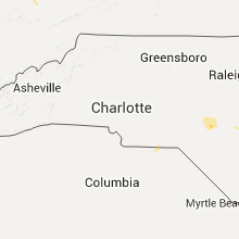
North Carolina
| Local Time | Report Details |
|---|---|
| 5:12 PM EDT | Tree down across lobelia rd east of riverbend rd. radar estimated tim in moore county NC, 49.1 miles SSW of Raleigh, NC |
| 5:27 PM EDT | 51 kt gust reported at pope airfield... n in cumberland county NC, 47.7 miles SSW of Raleigh, NC |
| 5:37 PM EDT | Trees down throughout the county. many reports from lillington area. trees down at nc-27 and nursery rd. time estimated by rada in harnett county NC, 35.5 miles SSW of Raleigh, NC |
| 5:39 PM EDT | 52 kt gust reported at fort bragg... n in cumberland county NC, 49.1 miles SSW of Raleigh, NC |
| 9:08 PM EDT | Reports of multiple trees down in and around raynham. time estimated by rada in robeson county NC, 74.7 miles WNW of Wilmington, NC |
South Carolina
| Local Time | Report Details |
|---|---|
| 5:15 PM EDT | Jasper country warning point reports a tree down at the corner of old house rd and lowcountry dr. time estimated from radar in jasper county SC, 28.4 miles NNE of Savannah, GA |
| 7:37 PM EDT | Trees down on power lines. hwy 52 at dixon r in chesterfield county SC, 69.7 miles SE of Charlotte, NC |
South Dakota
| Local Time | Report Details |
|---|---|
| 5:40 PM CDT | Several trees and an out building knocked down. time estimate in mcpherson county SD, 35.5 miles NNW of Aberdeen, SD |
| 5:52 PM CDT | 3 rv campers along with a few pontoon boats were flipped at elm lake. winds estimated at 70mph. time estimated. no injurie in brown county SD, 32.6 miles NNW of Aberdeen, SD |
| 10:43 PM CDT | Quarter sized hail reported near Sisseton, SD, 69.2 miles E of Aberdeen, SD, spotter report relayed by emergency manager. |
| 10:39 PM MDT | Reported at the foster bay rwi in stanley county SD, 44.2 miles WNW of Pierre, SD |
| 10:44 PM MDT | Reported at the foster bay rwi in stanley county SD, 44.7 miles WNW of Pierre, SD |
Maine
| Local Time | Report Details |
|---|---|
| 6:45 PM EDT | Estimated 40-50 mph gust broke 8-10 poplar in aroostook county ME, 38.9 miles NW of Caribou, ME |
| 7:15 PM EDT | Tree down in acadia housing and on high st in aroostook county ME, 21 miles N of Caribou, ME |
| 8:11 PM EDT | Numerous trees down on elm st... cline rd... w. main st in aroostook county ME, 38.9 miles NW of Caribou, ME |
Montana
| Local Time | Report Details |
|---|---|
| 5:10 PM MDT | Storm damage reported in stillwater county MT, 30.9 miles WSW of Billings, MT |
| 4:10 AM MDT | Quarter sized hail reported near Savage, MT, 58.6 miles SW of Williston, ND |
Virginia
| Local Time | Report Details |
|---|---|
| 7:36 PM EDT | Reports of numerous trees down and roads blocked in the hurley area. time estimated from radar in buchanan county VA, 58.4 miles NNE of Bristol, TN |
| 7:40 PM EDT | 911 dispatch reported trees down in canay ridge in dickenson county VA, 33.6 miles NNW of Bristol, TN |
| 7:40 PM EDT | Reports of trees down in the knob hill road area in buchanan county VA, 44.7 miles N of Bristol, TN |
| 8:17 PM EDT | Multiple trees down and power outages in the midway are in scott county VA, 21.5 miles WNW of Bristol, TN |
| 8:28 PM EDT | Numerous trees down and power outages in scott county VA, 15.5 miles NW of Bristol, TN |
| 9:00 PM EDT | Fifteen to twenty trees down and numerous power outages reported county-wid in washington county VA, 16.2 miles ENE of Bristol, TN |
| 9:13 PM EDT | 911 dispatch reported trees down in canay ridge in dickenson county VA, 33.6 miles NNW of Bristol, TN |
| 9:27 PM EDT | One tree down along apple valley roa in smyth county VA, 34.6 miles ENE of Bristol, TN |
| 9:36 PM EDT | Tree down on apple valley road in smyth county VA, 34.6 miles ENE of Bristol, TN |
| 9:43 PM EDT | Tree down on main street in smyth county VA, 41.5 miles ENE of Bristol, TN |
| 9:45 PM EDT | Tree down at camelot appartments on crown drive in pulaski county VA, 35.2 miles WSW of Roanoke, VA |
| 10:20 PM EDT | Tree down near intersection of hurston road and redbud road in pulaski county VA, 44.1 miles WSW of Roanoke, VA |
| 10:25 PM EDT | Tree down near intersection of julia simpkins road and scott road in pulaski county VA, 47.3 miles WSW of Roanoke, VA |
| 10:28 PM EDT | Tree down near intersection of julia simpkins road and scott road in pulaski county VA, 47.3 miles WSW of Roanoke, VA |
| 10:45 PM EDT | Tree down on horse ridge road nw in floyd county VA, 42.1 miles WSW of Roanoke, VA |
| 10:55 PM EDT | A tree was blown down near the intersection of jennings creek road and solitude roa in botetourt county VA, 26.1 miles NE of Roanoke, VA |
| 11:25 PM EDT | Two large oaks fell along bishop creek road north and west of altavist in campbell county VA, 35.4 miles ESE of Roanoke, VA |
| 11:45 PM EDT | 911 reports large limb down on moons road in pittsylvania county VA, 46.5 miles ESE of Roanoke, VA |
| 12:00 AM EDT | A tree was blown down near the intersection of hat creek road and white tail roa in campbell county VA, 58.3 miles E of Roanoke, VA |
Texas
| Local Time | Report Details |
|---|---|
| 6:54 PM CDT | Quarter sized hail reported near Holliday, TX, 19.3 miles WSW of Wichita Falls, TX |
| 7:10 PM CDT | Roof damage to the noodle community center in jones county TX, 20.8 miles WNW of Abilene, TX |
| 7:41 PM CDT | Ping Pong Ball sized hail reported near Hawley, TX, 11.8 miles NNW of Abilene, TX, trees downed just northast of hawley along fm1226 |
| 7:41 PM CDT | Trees downed just northast of hawley along fm1226 in jones county TX, 11.8 miles NNW of Abilene, TX |
| 9:22 PM CDT | Storm damage reported in taylor county TX, 7.2 miles WSW of Abilene, TX |
| 9:35 PM CDT | Quarter sized hail reported near Breckenridge, TX, 53.3 miles ENE of Abilene, TX |
| 9:35 PM CDT | Power lines down in breckenridge in stephens county TX, 53.3 miles ENE of Abilene, TX |
| 9:50 PM CDT | Quarter sized hail reported near Woodson, TX, 56.2 miles NE of Abilene, TX |
| 9:50 PM CDT | Storm damage reported in throckmorton county TX, 56.2 miles NE of Abilene, TX |
| 11:04 PM CDT | Delayed report---62 mph measured at mineral wells asos (kmwl in palo pinto county TX, 76 miles W of Dallas, TX |
| 11:28 PM CDT | Trees downed along tin top highway near montgomery lane in parker county TX, 58.8 miles W of Dallas, TX |
| 12:25 AM CDT | Recorded by davis vantage pro2 anemometer 1.5 miles west of kfws in tarrant county TX, 32.4 miles WSW of Dallas, TX |
| 12:45 AM CDT | At kdfw in dallas county TX, 11.6 miles WNW of Dallas, TX |
| 12:45 AM CDT | At kdfw in dallas county TX, 11.6 miles WNW of Dallas, TX |
| 12:50 AM CDT | Carports damaged at the promenade at valley ridge apartments in irving in dallas county TX, 7.8 miles WNW of Dallas, TX |
| 1:55 AM CDT | Storm damage reported in roberts county TX, 71.1 miles NE of Amarillo, TX |
Alabama
| Local Time | Report Details |
|---|---|
| 8:05 PM CDT | Trees downed in 17000 block of cr 8 - time estimate in lauderdale county AL, 14.4 miles NW of Florence, AL |
| 8:17 PM CDT | Tree down in 7600 block cr7 in lauderdale county AL, 9.7 miles N of Florence, AL |
| 8:23 PM CDT | Tree down near cr 8 and cr 139 in lauderdale county AL, 10.5 miles NNW of Florence, AL |
| 8:23 PM CDT | Tree downed in 12000 block hwy 157 in lauderdale county AL, 11.9 miles NNW of Florence, AL |
| 9:13 PM CDT | A large tree and several large tree limbs were blown down along highway 27 in lamar county AL, 49 miles NE of Starkville, MS |
| 9:18 PM CDT | Several large tree limbs were blown down along highway 27 in lamar county AL, 52.2 miles NE of Starkville, MS |
Minnesota
| Local Time | Report Details |
|---|---|
| 8:47 PM CDT | Eight inch diameter tree branch dow in clay county MN, 9.6 miles E of Fargo, ND |
| 12:16 AM CDT | Quarter sized hail reported near Benson, MN, 26.1 miles NNE of Montevideo, MN, quarter size hail reported. also estimated 50-60 mph winds. |
Connect with Interactive Hail Maps