

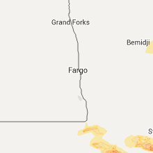
Hail Map for Tuesday, July 5, 2016

Number of Impacted Households on 7/5/2016
0
Impacted by 1" or Larger Hail
0
Impacted by 1.75" or Larger Hail
0
Impacted by 2.5" or Larger Hail
Square Miles of Populated Area Impacted on 7/5/2016
0
Impacted by 1" or Larger Hail
0
Impacted by 1.75" or Larger Hail
0
Impacted by 2.5" or Larger Hail


Cities Most Affected by Hail Storms of 7/5/2016
| Hail Size | Demographics of Zip Codes Affected | ||||||
|---|---|---|---|---|---|---|---|
| City | Count | Average | Largest | Pop Density | House Value | Income | Age |
| Wolsey, SD | 3 | 2.17 | 2.75 | 3 | $39k | $35.8k | 44.8 |
| Ortonville, MN | 1 | 3.00 | 3.00 | 20 | $48k | $31.3k | 49.2 |
| Glencoe, MN | 1 | 2.00 | 2.00 | 66 | $100k | $48.8k | 39.6 |
| Correll, MN | 1 | 2.00 | 2.00 | 3 | $36k | $25.0k | 49.6 |
| Cosmos, MN | 1 | 2.00 | 2.00 | 9 | $65k | $36.3k | 45.5 |
| South Haven, MN | 1 | 2.00 | 2.00 | 54 | $118k | $49.1k | 43.0 |
| Kandiyohi, MN | 1 | 1.75 | 1.75 | 22 | $85k | $44.8k | 40.6 |
| Brookings, SD | 1 | 1.75 | 1.75 | 147 | $95k | $33.4k | 24.2 |
| Dresden, KS | 1 | 1.75 | 1.75 | 2 | $29k | $24.9k | 49.9 |
| Vale, SD | 1 | 1.75 | 1.75 | 2 | $28k | $33.5k | 47.5 |
| Bird Island, MN | 1 | 1.75 | 1.75 | 9 | $56k | $39.1k | 48.2 |
| Huron, SD | 1 | 1.75 | 1.75 | 47 | $59k | $30.0k | 40.5 |
| Spade, TX | 1 | 1.75 | 1.75 | 0 | $29k | $32.3k | 47.3 |
Hail and Wind Damage Spotted on 7/5/2016
Filter by Report Type:Hail ReportsWind Reports
States Impacted
North Carolina, Minnesota, Alabama, Georgia, South Dakota, South Carolina, Nebraska, Mississippi, Texas, North Dakota, Kansas, Wisconsin, Iowa, Michigan, Illinois, Indiana, MissouriNorth Carolina
| Local Time | Report Details |
|---|---|
| 1:24 PM EDT | Multiple trees down and power outages reported along riverside driv in buncombe county NC, 56.5 miles N of Greenville, SC |
| 2:05 PM EDT | Trees down along moffit hill road...bat cave road...old greenlee road...parker padgett road at interstate 4 in mcdowell county NC, 59.8 miles NNE of Greenville, SC |
| 2:12 PM EDT | Trees down at sugar hill road off golf course road...nix creek road...rena street...hoyles orchard road off bethlehem roa in mcdowell county NC, 64 miles S of Bristol, TN |
| 2:12 PM EDT | Tree on a structure on sugar hill roa in mcdowell county NC, 64.6 miles S of Bristol, TN |
| 2:15 PM EDT | Trees on structure at us70w campground in mcdowell county NC, 62.8 miles S of Bristol, TN |
| 2:38 PM EDT | A large oak tree blown down in a yar in burke county NC, 60.4 miles NW of Charlotte, NC |
| 2:39 PM EDT | Tree down on home along snowhill church roa in burke county NC, 64 miles SSE of Bristol, TN |
| 2:39 PM EDT | Trees and powerlines down along jamestown road... kathy road... and also hwy 70 around glen alpine in burke county NC, 63.6 miles WNW of Charlotte, NC |
| 2:40 PM EDT | Multiple trees down at intersection of mount olive church road at jamestown roa in burke county NC, 63.3 miles WNW of Charlotte, NC |
| 2:40 PM EDT | Unoccupied home blown off foundation in burke county NC, 64.1 miles WNW of Charlotte, NC |
| 2:40 PM EDT | Several downed and snapped trees on e parker rd. near grace hospita in burke county NC, 58.1 miles NW of Charlotte, NC |
| 2:40 PM EDT | Over 20 downed trees reported on the campus of the j iverson riddle developmental center off of enola rd. some of the trees fell on parked cars and two trees fell on bu in burke county NC, 58.1 miles NW of Charlotte, NC |
| 2:50 PM EDT | Trees down in northeast burke near the lak in burke county NC, 48 miles NW of Charlotte, NC |
| 3:30 PM EDT | Downed tree and powerline at the end of smith cove rd. near smith harbor dr. and n.c. 1 in lincoln county NC, 20.4 miles NNW of Charlotte, NC |
| 3:55 PM EDT | Downed large tree and powerlines blocking intersection of n. modena st. and e. harrison av in gaston county NC, 19.1 miles W of Charlotte, NC |
| 3:58 PM EDT | Downed large tree blocking road at the intersection of church st. and cedar s in gaston county NC, 13.8 miles W of Charlotte, NC |
| 4:14 PM EDT | Downed tree at least 1 foot in diameter took down powerlines at the intersection of rufus ratchford rd. and cypress pond l in gaston county NC, 14.4 miles WSW of Charlotte, NC |
| 4:20 PM EDT | Downed tree on park rd. near princeton av in mecklenburg county NC, 2.3 miles SSW of Charlotte, NC |
| 4:20 PM EDT | Metal roof torn off of mobile home on harrison rd. near independence d in rowan county NC, 36 miles NNE of Charlotte, NC |
| 4:24 PM EDT | Several trees down in the granite quarry area along and near n salisbury ave. or u.s. 5 in rowan county NC, 35.6 miles NE of Charlotte, NC |
| 4:24 PM EDT | Salisbury fd reporting multiple power outages and road closures due to downed trees and powerlines across salisbur in rowan county NC, 36.9 miles NNE of Charlotte, NC |
| 4:26 PM EDT | 911 center reporting numerous trees down across the southern and eastern portions of the charlotte metro area blocking roads and downing powerlines. duke energy is repo in mecklenburg county NC, 7.5 miles SE of Charlotte, NC |
| 4:48 PM EDT | Tree down along highway 109. time estimated by rada in davidson county NC, 49.7 miles NE of Charlotte, NC |
| 4:49 PM EDT | Tree down. time estimated by rada in davidson county NC, 51.8 miles NE of Charlotte, NC |
| 5:09 PM EDT | Tree dow in randolph county NC, 64.4 miles ENE of Charlotte, NC |
| 5:12 PM EDT | Tree dow in randolph county NC, 65.6 miles W of Raleigh, NC |
| 5:35 PM EDT | Tree down blocking the roa in randolph county NC, 52.7 miles W of Raleigh, NC |
| 5:40 PM EDT | Large tree down in franklinvill in randolph county NC, 58.3 miles W of Raleigh, NC |
| 6:20 PM EDT | Tree dow in wilson county NC, 34.8 miles ESE of Raleigh, NC |
| 6:25 PM EDT | Tree down at 12474 buffalo r in johnston county NC, 17.8 miles ESE of Raleigh, NC |
| 6:43 PM EDT | Tree down at grove street. time estimated by rada in wilson county NC, 40.7 miles E of Raleigh, NC |
| 6:45 PM EDT | Trees down at 885 barber mill r in johnston county NC, 16.6 miles SSE of Raleigh, NC |
| 6:45 PM EDT | Tree down at black creek road. time estimated by radar. in wilson county NC, 41.5 miles E of Raleigh, NC |
| 6:55 PM EDT | Tree down on covered bridge road. in johnston county NC, 14.1 miles ESE of Raleigh, NC |
| 7:09 PM EDT | Tree down at frank price church road and evansdale roa in wilson county NC, 42.4 miles ESE of Raleigh, NC |
| 7:11 PM EDT | Tree down across evansdale roa in wilson county NC, 43.9 miles ESE of Raleigh, NC |
| 7:15 PM EDT | Tree down at 500 west street. time estimated by radar. in johnston county NC, 25.7 miles SE of Raleigh, NC |
| 7:15 PM EDT | Tree down at lloyd road. time estimated by rada in wilson county NC, 34.7 miles ESE of Raleigh, NC |
| 7:30 PM EDT | Tree down on smith street. time estimated by radar. in johnston county NC, 34.8 miles SE of Raleigh, NC |
| 8:05 PM EDT | Numerous trees down across hwy 99/hwy45 and railroad bed r in washington county NC, 68 miles SSW of Virginia Beach, VA |
| 9:14 PM EDT | Tree fell on vehicle and brought down power lines near james cit in craven county NC, 78.6 miles NE of Wilmington, NC |
Minnesota
| Local Time | Report Details |
|---|---|
| 12:50 PM CDT | Quarter sized hail reported near Dumont, MN, 64.2 miles NW of Montevideo, MN |
| 2:20 PM CDT | Tea Cup sized hail reported near Ortonville, MN, 39.1 miles NW of Montevideo, MN, sporadic 2-3" hailstones. |
| 2:36 PM CDT | Hen Egg sized hail reported near Correll, MN, 34.1 miles NW of Montevideo, MN, relayed via social media. picture showed 1.5 to 2 inch hail stones. time estimated via radar. |
| 4:00 PM CDT | Quarter sized hail reported near Benson, MN, 17.6 miles NNE of Montevideo, MN |
| 4:09 PM CDT | Storm damage reported in stearns county MN, 57.4 miles ENE of Montevideo, MN |
| 4:10 PM CDT | Large tree down in yard. time estimate in stearns county MN, 57 miles ENE of Montevideo, MN |
| 4:15 PM CDT | 1 foot diameter branches down power los in meeker county MN, 59.8 miles ENE of Montevideo, MN |
| 4:32 PM CDT | Storm damage reported in stearns county MN, 55.5 miles WNW of Minneapolis, MN |
| 4:38 PM CDT | Several trees down in bemidji including across roads. estimated 50 to 60 mph wind in beltrami county MN, 0.5 miles N of Bemidji, MN |
| 4:40 PM CDT | Lots of trees down. time estimate in meeker county MN, 52.4 miles WNW of Minneapolis, MN |
| 4:50 PM CDT | Multiple trees down up to 2 ft diameter between cold spring and kimbal in stearns county MN, 60.4 miles WNW of Minneapolis, MN |
| 4:54 PM CDT | Quarter sized hail reported near Annandale, MN, 46.1 miles WNW of Minneapolis, MN, . |
| 4:55 PM CDT | Widespread tree damage. trees snapped off between south haven and annandal in wright county MN, 51.4 miles WNW of Minneapolis, MN |
| 4:57 PM CDT | Large tree down blocking hwy 5 in wright county MN, 46.1 miles WNW of Minneapolis, MN |
| 5:00 PM CDT | 50 ft boat flipped. fire department sawing trees away from hwy 5 in wright county MN, 44.3 miles WNW of Minneapolis, MN |
| 5:00 PM CDT | Pole barn blown down debris on roadwa in wright county MN, 38.2 miles NW of Minneapolis, MN |
| 5:00 PM CDT | Golf Ball sized hail reported near Kandiyohi, MN, 39.7 miles ENE of Montevideo, MN, . |
| 5:00 PM CDT | Golf Ball sized hail reported near Bird Island, MN, 44.3 miles E of Montevideo, MN, . |
| 5:00 PM CDT | 20 inch diameter tree snapped about 20 ft up. numerous 2 to 3 to 8 inch diameter branhes down. reported at 118 jansen ave se... hanove in wright county MN, 23.9 miles WNW of Minneapolis, MN |
| 5:07 PM CDT | Storm damage reported in wright county MN, 51.9 miles WNW of Minneapolis, MN |
| 5:10 PM CDT | Hen Egg sized hail reported near South Haven, MN, 51.7 miles WNW of Minneapolis, MN, . |
| 5:21 PM CDT | Trees snapped or uprooted. in wright county MN, 26.1 miles WNW of Minneapolis, MN |
| 5:25 PM CDT | Lots of trees down on highway 2 between mile marker 145 and mile marker 15 in cass county MN, 39.7 miles ESE of Bemidji, MN |
| 5:28 PM CDT | Couple of 8 to 10 inch diameter trees down. power ou in itasca county MN, 42.7 miles E of Bemidji, MN |
| 5:30 PM CDT | West facing siding torn off and shingles torn off on northwest corners of 3 houses. reported at 30th st ne... and kale ave... st michael in wright county MN, 25.4 miles NW of Minneapolis, MN |
| 5:30 PM CDT | Quarter sized hail reported near Cosmos, MN, 49.9 miles E of Montevideo, MN, . |
| 5:30 PM CDT | Barn blown apart. power pole also snapped her in wright county MN, 38.5 miles NW of Minneapolis, MN |
| 5:38 PM CDT | Hen Egg sized hail reported near Cosmos, MN, 51 miles E of Montevideo, MN, . |
| 5:40 PM CDT | Storm damage reported in hennepin county MN, 7 miles NW of Minneapolis, MN |
| 5:40 PM CDT | Large 2 ft diameter tree dow in hennepin county MN, 16.7 miles W of Minneapolis, MN |
| 5:44 PM CDT | 4 to 6 inch tree branch down. reported at berkshire and dallas ln... maple grove m in hennepin county MN, 12.2 miles NW of Minneapolis, MN |
| 5:45 PM CDT | Mndot sensor i-94 and mile marker 21 in hennepin county MN, 13.5 miles NW of Minneapolis, MN |
| 5:45 PM CDT | Estimated 70 mph wind gusts. lots of trees down across county roads in and near deer rive in itasca county MN, 53.4 miles E of Bemidji, MN |
| 5:45 PM CDT | 10 inch diameter tree branch dow in hennepin county MN, 5.5 miles NW of Minneapolis, MN |
| 5:47 PM CDT | Half Dollar sized hail reported near Osseo, MN, 12.2 miles NW of Minneapolis, MN, reported at berkshire and dallas ln... maple grove mn. |
| 5:48 PM CDT | Quarter sized hail reported near Hutchinson, MN, 58.9 miles E of Montevideo, MN, . |
| 5:49 PM CDT | West facing siding torn off and shingles torn off on northwest corners of 3 houses. reported at 30th st ne... and kale ave... st michael in wright county MN, 25.4 miles NW of Minneapolis, MN |
| 5:54 PM CDT | Numerous repots of trees down and power out inf chanhassen this is one. reported at galpin and pheasant trail chanhassen... m in carver county MN, 16.2 miles WSW of Minneapolis, MN |
| 5:55 PM CDT | Storm damage reported in hennepin county MN, 14.1 miles SW of Minneapolis, MN |
| 5:57 PM CDT | Mesonet station effm in itasca county MN, 58 miles SSW of International Falls, MN |
| 6:00 PM CDT | 12 inch tree down near city hall. reported at hwy 55 and winnetka... golden valley... m in hennepin county MN, 5.6 miles W of Minneapolis, MN |
| 6:00 PM CDT | Photos of multiple trees down in the area. largest trees were 2 to 3 feet in diameter. time estimated by rada in itasca county MN, 63.4 miles E of Bemidji, MN |
| 6:02 PM CDT | 6 to 8 inch diameter trees down. time estimated by rada in itasca county MN, 66.1 miles ESE of Bemidji, MN |
| 6:02 PM CDT | Quarter sized hail reported near Hutchinson, MN, 58.2 miles W of Minneapolis, MN, reported at york rd and vale ave... hutchinson. |
| 6:07 PM CDT | Mesonet station effm in itasca county MN, 58 miles SSW of International Falls, MN |
| 6:11 PM CDT | Quarter sized hail reported near Minneota, MN, 30 miles SSW of Montevideo, MN, . |
| 6:15 PM CDT | 2 large trees down on roa in ramsey county MN, 6.3 miles ESE of Minneapolis, MN |
| 6:16 PM CDT | 2 to 3 ft trees down blocking road. reported at pierce and west broadway ave... minneapolis... m in hennepin county MN, 1.9 miles NE of Minneapolis, MN |
| 6:16 PM CDT | Quarter sized hail reported near Glencoe, MN, 45.8 miles WSW of Minneapolis, MN, . |
| 6:20 PM CDT | Hen Egg sized hail reported near Glencoe, MN, 46 miles WSW of Minneapolis, MN, . |
| 6:27 PM CDT | 6 to 8 ft long tree branch dow in dakota county MN, 9.8 miles SE of Minneapolis, MN |
| 6:27 PM CDT | Rice and front street... 6 inch tree branch down on power line in ramsey county MN, 8.2 miles E of Minneapolis, MN |
| 6:27 PM CDT | 18 inch diameter tree down. time estimate in hennepin county MN, 4.9 miles WNW of Minneapolis, MN |
| 6:28 PM CDT | Mesonet station richfield 2wsw /d1498 in hennepin county MN, 8.7 miles SSW of Minneapolis, MN |
| 6:45 PM CDT | Storm damage reported in ramsey county MN, 10.4 miles ESE of Minneapolis, MN |
| 6:47 PM CDT | Large oak tree down on power line in hennepin county MN, 18.7 miles NW of Minneapolis, MN |
| 6:56 PM CDT | 14 to 16 inch diameter maple tree split just above the trunk and knocked ove in st. louis county MN, 41.5 miles NW of Duluth, MN |
| 7:00 PM CDT | 20 inch diameter tree down. reported at 36 th and winnetka... new hope. time estimate in hennepin county MN, 6.3 miles WNW of Minneapolis, MN |
| 7:14 PM CDT | Storm damage reported in hennepin county MN, 14.1 miles SW of Minneapolis, MN |
| 7:15 PM CDT | Several 6 inch branches down near city hall sw corner of i-35 and -69 in ramsey county MN, 7 miles NNE of Minneapolis, MN |
| 7:25 PM CDT | Bass lake rd west bound at nottingham parkway - street light arm is bent so far that lights no longer point at traffic lanes. arm is twisted about 45 degrees from corre in hennepin county MN, 13.4 miles NW of Minneapolis, MN |
| 7:25 PM CDT | Hand held anemometer. reported at hwy 13 and cr 42 streer... savage... m in scott county MN, 15.8 miles SSW of Minneapolis, MN |
| 7:25 PM CDT | Siding ripped off house new construction. reported at hwy 13 and 160th streer... prior lake... m in scott county MN, 19.6 miles SSW of Minneapolis, MN |
| 7:25 PM CDT | Tree down on power lin in nicollet county MN, 66.9 miles SW of Minneapolis, MN |
| 7:30 PM CDT | Large trees branches dow in scott county MN, 19 miles SSW of Minneapolis, MN |
| 7:35 PM CDT | Scattered trees down across tow in rice county MN, 46.9 miles S of Minneapolis, MN |
| 7:38 PM CDT | Large trees and power lines downed. time estimated from rada in st. louis county MN, 16.9 miles N of Duluth, MN |
| 7:40 PM CDT | Siding off house. 6 inch tree blown into and through the house. like a torped in rice county MN, 47.6 miles S of Minneapolis, MN |
| 7:40 PM CDT | Section of large privacy fence blown down. reported at mc andrews road... burnsville... m in dakota county MN, 15.8 miles S of Minneapolis, MN |
| 7:42 PM CDT | Time estimated. damage- high tension power lines (the big ones) downed at this location from earlier storms. they are large wood poles... most snapped about half way up in hennepin county MN, 21.8 miles NW of Minneapolis, MN |
| 7:45 PM CDT | Measured by public weather statio in st. louis county MN, 11.7 miles NNE of Duluth, MN |
| 7:45 PM CDT | 100 yr old 2 foot diameter tree downed. another 7-8" diameter limb fell on car and damaged roof/window. time estimate in dakota county MN, 27.6 miles S of Minneapolis, MN |
| 7:52 PM CDT | Quarter sized hail reported near Farmington, MN, 22.4 miles S of Minneapolis, MN |
| 8:10 PM CDT | Minor tree and roof damage in burnsville. ping pong ball sized hail. time reported is time received via social medi in dakota county MN, 15.2 miles S of Minneapolis, MN |
| 8:10 PM CDT | Mesonet station cannon falls 7sse /mn042 in goodhue county MN, 44.1 miles SSE of Minneapolis, MN |
| 8:15 PM CDT | Tree down on cr 9. time estimate in goodhue county MN, 49.9 miles SE of Minneapolis, MN |
| 8:15 PM CDT | Tree down on hwy 52. time estimate in goodhue county MN, 41.3 miles SSE of Minneapolis, MN |
| 8:18 PM CDT | 3 to 4 trees snappe in goodhue county MN, 46.6 miles SSE of Minneapolis, MN |
| 8:20 PM CDT | Storm damage reported in olmsted county MN, 62.4 miles SSE of Minneapolis, MN |
| 8:20 PM CDT | Barn damage. trees down. power lines dow in goodhue county MN, 53 miles SE of Minneapolis, MN |
| 8:24 PM CDT | Numerous trees down up to 1.5 ft diameter. in rice county MN, 45.3 miles SSE of Minneapolis, MN |
| 8:30 PM CDT | A few trees down and power lines dow in steele county MN, 61.4 miles S of Minneapolis, MN |
| 8:30 PM CDT | Trees down. power lines down over a good part of town.. in waseca county MN, 63.2 miles S of Minneapolis, MN |
| 8:30 PM CDT | Large trees and branches down. widespread power outage in goodhue county MN, 51.1 miles SE of Minneapolis, MN |
| 8:42 PM CDT | Large tree dow in goodhue county MN, 51.1 miles SE of Minneapolis, MN |
| 8:50 PM CDT | Peak wind gust measured 75 mph. several power lines down and lots of trees down. in olmsted county MN, 62.6 miles SSE of Minneapolis, MN |
| 8:50 PM CDT | Damage to grain bin and out buildings near bellchester in wabasha county MN, 59 miles SE of Minneapolis, MN |
| 8:50 PM CDT | Trees down across hwy 60 blocking lanes east of mazeppa near cr in wabasha county MN, 61.8 miles SE of Minneapolis, MN |
| 8:50 PM CDT | Storm damage reported in olmsted county MN, 62.4 miles SSE of Minneapolis, MN |
| 8:55 PM CDT | Tree down on barn 3 miles east of bellchester along cr 9 near cr 8 in wabasha county MN, 57.4 miles SE of Minneapolis, MN |
| 8:56 PM CDT | Storm damage reported in dodge county MN, 64.7 miles NNE of Mason City, IA |
| 9:20 PM CDT | Lots of tree damage along hwy 63 near 700th st. trees on roa in wabasha county MN, 60.3 miles SE of Minneapolis, MN |
| 9:23 PM CDT | Home damaged and barn dow in wabasha county MN, 60.6 miles SE of Minneapolis, MN |
| 9:25 PM CDT | Numerous trees down across hwy 108. road impassabl in fillmore county MN, 32.4 miles W of La Crosse, WI |
| 9:49 PM CDT | Mesonet station 2 nnw zumbro falls /c7148 in wabasha county MN, 61 miles SE of Minneapolis, MN |
| 9:52 PM CDT | Trees down and some branches partially blocking hwy 6 in wabasha county MN, 62.7 miles SE of Minneapolis, MN |
Alabama
| Local Time | Report Details |
|---|---|
| 1:03 PM CDT | Tree knocked down and blocking the entire roa in clarke county AL, 50 miles WSW of Camden, AL |
| 4:14 PM CDT | The kozr asos measured a wind gust of 54 kt in dale county AL, 72.8 miles NNE of Miramar Beach, FL |
| 6:08 PM CDT | Tree and power lines down along sipsey valley rd. time estimated from rada in tuscaloosa county AL, 62.2 miles WSW of Birmingham, AL |
| 6:27 PM CDT | Tree down on house on clinton dr. no known injuries. reported via social media. radar estimated winds of 40-50 mph. time estimated by rada in tuscaloosa county AL, 50.1 miles WSW of Birmingham, AL |
| 6:30 PM CDT | Tree down on power lines near robertson tower. reported via social media. radar estimated winds of 40-50 mph. time estimated by rada in tuscaloosa county AL, 48.3 miles WSW of Birmingham, AL |
Georgia
| Local Time | Report Details |
|---|---|
| 3:00 PM EDT | A tree was blown down on highway 1 in walton county GA, 38.9 miles E of Atlanta, GA |
| 3:40 PM EDT | A tree was snapped on hartley bridge roa in bibb county GA, 79.3 miles SSE of Atlanta, GA |
| 3:50 PM EDT | A tree was blown down on corbin avenu in bibb county GA, 75 miles SE of Atlanta, GA |
| 3:50 PM EDT | Several trees and power lines were blown down on holmes avenu in bibb county GA, 74.7 miles SE of Atlanta, GA |
| 4:47 PM EDT | Mccormick county dispatch reported trees down on power lines on michael st. in thomso in mcduffie county GA, 29.8 miles W of Augusta, GA |
| 5:05 PM EDT | Columbia county dispatch reported powerlines down on tom bartles rd at cobbham r in columbia county GA, 23.4 miles WNW of Augusta, GA |
| 5:09 PM EDT | Augusta bush field measured a 58 mph wind gust at 5:09 p in richmond county GA, 7.7 miles S of Augusta, GA |
| 5:12 PM EDT | Social media report with photo of large trees down on the 300 block of broad st. in august in richmond county GA, 1.6 miles ESE of Augusta, GA |
| 5:15 PM EDT | Columbia county dispatch reported trees down at meadow ln and hereford farm r in columbia county GA, 10.7 miles WNW of Augusta, GA |
| 5:45 PM EDT | Trees and power lines down at claxton road... buck lane and creek road in the girard are in burke county GA, 32.2 miles SSE of Augusta, GA |
South Dakota
| Local Time | Report Details |
|---|---|
| 4:05 PM CDT | Half Dollar sized hail reported near Wessington, SD, 78.3 miles S of Aberdeen, SD, . |
| 4:10 PM CDT | Quarter sized hail reported near Wessington, SD, 71.7 miles S of Aberdeen, SD, . |
| 4:20 PM CDT | Hen Egg sized hail reported near Wolsey, SD, 75.9 miles S of Aberdeen, SD, social media report. |
| 4:20 PM CDT | Baseball sized hail reported near Wolsey, SD, 79.3 miles S of Aberdeen, SD, relayed by wfo abr. |
| 4:25 PM CDT | Storm damage reported in beadle county SD, 80.1 miles S of Aberdeen, SD |
| 4:25 PM CDT | Golf Ball sized hail reported near Wolsey, SD, 80.1 miles S of Aberdeen, SD, . |
| 4:27 PM CDT | Quarter sized hail reported near Watertown, SD, 67 miles W of Montevideo, MN, . |
| 4:42 PM CDT | Quarter sized hail reported near Goodwin, SD, 58.9 miles W of Montevideo, MN, radar estimated time. |
| 4:45 PM CDT | Quarter sized hail reported near Badger, SD, 69.4 miles NNW of Sioux Falls, SD, . |
| 4:50 PM CDT | Golf Ball sized hail reported near Huron, SD, 84.7 miles NW of Sioux Falls, SD, . |
| 5:30 PM CDT | Half Dollar sized hail reported near Goodwin, SD, 51.9 miles W of Montevideo, MN, radar estimated time. |
| 5:31 PM CDT | Golf Ball sized hail reported near Brookings, SD, 57.7 miles N of Sioux Falls, SD, . |
| 5:35 PM CDT | Quarter sized hail reported near Lake Norden, SD, 75.8 miles NNW of Sioux Falls, SD, . |
| 9:10 PM MDT | Storm damage reported in bennett county SD, 63.1 miles WNW of Valentine, NE |
| 9:15 PM MDT | Storm damage reported in bennett county SD, 62.2 miles WNW of Valentine, NE |
| 10:15 PM MDT | Storm damage reported in pennington county SD, 49.2 miles E of Rapid City, SD |
| 2:03 AM MDT | Golf Ball sized hail reported near Vale, SD, 37.7 miles NNW of Rapid City, SD, hail is accumulating on ground. |
| 5:49 AM MDT | Ping Pong Ball sized hail reported near Union Center, SD, 36.6 miles NE of Rapid City, SD, hail accumulated 4 inches deep |
South Carolina
| Local Time | Report Details |
|---|---|
| 5:08 PM EDT | Sc highway patrol reports trees down on stamport circle at riverwalk way. time estimated by rada in richland county SC, 64 miles NE of Augusta, GA |
| 5:28 PM EDT | Sc highway patrol reported a tree in the roadway at caughman road and benson road. in richland county SC, 69.7 miles ENE of Augusta, GA |
| 5:43 PM EDT | Barnwell dispatch reported trees down on pioneer rd. time estimated by rada in barnwell county SC, 34.6 miles ESE of Augusta, GA |
| 6:04 PM EDT | Sc highway patrol reports trees down on us 521 just outside of rembert. time estimated by rada in sumter county SC, 68.4 miles NNW of Charleston, SC |
| 6:12 PM EDT | Allendale co warning point reports a tree down at the intersection of hwy 3 and cohens bluff road. time estimated from rada in allendale county SC, 54.1 miles SE of Augusta, GA |
| 6:16 PM EDT | Orangeburg dispatch reported trees down on ember r in orangeburg county SC, 54.4 miles W of Charleston, SC |
| 6:44 PM EDT | Tree in roadway n center road and billy farrow highway in darlington county SC, 78.2 miles N of Charleston, SC |
| 6:48 PM EDT | Chesterfield dispatch reported a tree blocking the roadway at hwy 52 and new zion church roa in chesterfield county SC, 68.4 miles SE of Charlotte, NC |
| 6:54 PM EDT | Tree in roadway n center road and billy farrow highway in darlington county SC, 78.2 miles N of Charleston, SC |
| 6:54 PM EDT | Trees in roadway on rodgers road in darlington county SC, 74.9 miles N of Charleston, SC |
| 7:08 PM EDT | Trees down westwood circle in marlboro county SC, 77.8 miles SE of Charlotte, NC |
| 7:10 PM EDT | Tree in roadway brushy bay rd and dundee d in marlboro county SC, 77.1 miles ESE of Charlotte, NC |
Nebraska
| Local Time | Report Details |
|---|---|
| 4:09 PM CDT | Quarter sized hail reported near Arapahoe, NE, 72.8 miles SE of North Platte, NE, nickle to quarter sized hail and gusty winds reported |
| 4:13 PM CDT | Quarter sized hail reported near Arapahoe, NE, 69.1 miles SE of North Platte, NE, pea to quarter size. |
| 4:48 PM MDT | Ping Pong Ball sized hail reported near Scottsbluff, NE, 3.3 miles N of Scottsbluff, NE |
| 5:54 PM CDT | Quarter sized hail reported near Hastings, NE, 23.2 miles S of Grand Island, NE |
| 6:03 PM CDT | Half Dollar sized hail reported near Hastings, NE, 22.9 miles SSW of Grand Island, NE, quarter to half dollar sized hail falling near airport |
| 6:07 PM CDT | Quarter sized hail reported near Hastings, NE, 20.1 miles SSW of Grand Island, NE, a few hail stones up to quarter size along marian road |
| 5:26 PM MDT | Quarter sized hail reported near Alliance, NE, 42.1 miles ENE of Scottsbluff, NE |
| 6:30 PM CDT | Quarter sized hail reported near Hastings, NE, 17.1 miles S of Grand Island, NE, 6 n of hastings along hwy 281 |
| 7:07 PM CDT | A few trees reported down in central and northern grand island...also some limited power outages in hall county NE, 1.6 miles WSW of Grand Island, NE |
| 7:16 PM CDT | Trained spotter reported a 60mph wind gust 2 south of doniphan near the seed plan in hall county NE, 12.8 miles S of Grand Island, NE |
| 7:40 PM CDT | Quarter sized hail reported near Marquette, NE, 22.9 miles ENE of Grand Island, NE, dime to quarter size hail |
| 7:40 PM CDT | Half Dollar sized hail reported near Dannebrog, NE, 14.1 miles NW of Grand Island, NE, hail up to half dollar size and estimated 50-60 mph winds |
| 7:48 PM CDT | Quarter sized hail reported near Stratton, NE, 53.4 miles N of Colby, KS |
| 7:53 PM CDT | Ping Pong Ball sized hail reported near Hordville, NE, 25.8 miles ENE of Grand Island, NE, ping pong ball size hail in town |
| 8:11 PM CDT | Half Dollar sized hail reported near Central City, NE, 31.8 miles NE of Grand Island, NE, hail up to half dollar size...highway 14 on the nance-merrick county line |
| 8:55 PM CDT | Storm damage reported in butler county NE, 59.3 miles ENE of Grand Island, NE |
| 8:58 PM CDT | Columbus airport in platte county NE, 61.9 miles NE of Grand Island, NE |
| 8:58 PM CDT | Semi rolled over by winds-hwy 81 and county road 4 in butler county NE, 59.3 miles ENE of Grand Island, NE |
| 9:00 PM CDT | Trees and powerlines down in platte county NE, 61.9 miles NE of Grand Island, NE |
| 9:01 PM CDT | Numerous trees and power lines down in platte county NE, 61.9 miles NE of Grand Island, NE |
| 9:20 PM CDT | Several 8 inch diameter tree limbs down in dodge county NE, 48.6 miles WNW of Omaha, NE |
| 9:25 PM CDT | Semi blown over...wind damage in town in colfax county NE, 59.7 miles WNW of Omaha, NE |
| 9:45 PM CDT | Numerous trees down. a few buildings down. no power in tow in dodge county NE, 46.4 miles NW of Omaha, NE |
| 10:01 PM CDT | Tekamah airport in burt county NE, 38.7 miles NNW of Omaha, NE |
| 10:16 PM CDT | Tekamah airport in burt county NE, 38.7 miles NNW of Omaha, NE |
Mississippi
| Local Time | Report Details |
|---|---|
| 4:30 PM CDT | Tree was blown down across golf course road. a vehicle struck the tree but no injuries occurred. tree was also downed on frog level road. a tree was downed near holy cr in neshoba county MS, 51 miles SSW of Starkville, MS |
Texas
| Local Time | Report Details |
|---|---|
| 5:07 PM CDT | Quarter sized hail reported near Wolfforth, TX, 13.8 miles SW of Lubbock, TX |
| 5:27 PM CDT | Quarter sized hail reported near Lubbock, TX, 8.7 miles SW of Lubbock, TX |
| 5:29 PM CDT | Quarter sized hail reported near Lubbock, TX, 1.6 miles WSW of Lubbock, TX |
| 5:54 PM CDT | Quarter sized hail reported near Lubbock, TX, 1.6 miles WSW of Lubbock, TX, 82nd and slide road |
| 6:05 PM CDT | Downburst measured by west texas mesonet in howard county TX, 47.3 miles ENE of Odessa, TX |
| 6:10 PM CDT | Golf Ball sized hail reported near Spade, TX, 28.8 miles NW of Lubbock, TX |
| 6:32 PM CDT | Roof partially blown off of a home in stanton. large tree also blown down. time estimated from rada in martin county TX, 39.4 miles ENE of Odessa, TX |
| 6:45 PM CDT | Report of 60-70 mph winds lasting around 20 to 30 minute in midland county TX, 30.6 miles ENE of Odessa, TX |
| 8:54 PM CDT | Storm damage reported in martin county TX, 38.9 miles NNE of Odessa, TX |
North Dakota
| Local Time | Report Details |
|---|---|
| 6:10 PM CDT | Quarter sized hail reported near Willow City, ND, 48.7 miles ENE of Minot, ND, hailed for only about 1 minute |
| 8:00 PM CDT | Quarter sized hail reported near Maddock, ND, 34.5 miles SW of Devils Lake, ND, hailed for roughly 2 to 3 minutes |
Kansas
| Local Time | Report Details |
|---|---|
| 7:06 PM CDT | Golf Ball sized hail reported near Dresden, KS, 30.6 miles ENE of Colby, KS, large amount of hail covering the road. mostly golf balls and quarters. |
| 7:52 PM CDT | Quarter sized hail reported near Selden, KS, 27.2 miles ENE of Colby, KS |
| 9:00 PM CDT | Quarter sized hail reported near Hoxie, KS, 32.5 miles E of Colby, KS, several spotter reports of hail in hoxie ranging from 0.75 to 1.00 inch in diameter. |
| 9:25 PM CDT | Quarter sized hail reported near Collyer, KS, 44 miles WNW of Hays, KS, . |
| 9:41 PM CDT | The wind was estimated at 60 to 70 mp in trego county KS, 31.3 miles WNW of Hays, KS |
| 11:19 PM CDT | Storm damage reported in ness county KS, 42.3 miles SW of Hays, KS |
| 11:50 PM CDT | The gust was outflow from nearby thunderstorm in hodgeman county KS, 54.7 miles E of Garden City, KS |
| 11:50 PM CDT | Storm damage reported in pawnee county KS, 47.5 miles SSW of Hays, KS |
| 12:00 AM CDT | 3-6 inch in diameter tree branches blown down. in pawnee county KS, 44 miles SSE of Hays, KS |
| 12:08 AM CDT | Storm damage reported in pawnee county KS, 47.4 miles SSE of Hays, KS |
| 12:10 AM CDT | At larned middle shcoo in pawnee county KS, 49.2 miles SSE of Hays, KS |
| 12:31 AM CDT | Storm damage reported in lincoln county KS, 52.8 miles ENE of Hays, KS |
| 12:33 AM CDT | Law enforcement reports power lines dow in barton county KS, 45.6 miles SSE of Hays, KS |
| 12:47 AM CDT | Trained spotter estimates 50 to 60 mph wind in barton county KS, 34.3 miles ESE of Hays, KS |
| 1:03 AM CDT | Law enforcement reports zero visibility and winds in excess of 60 mp in barton county KS, 40.7 miles ESE of Hays, KS |
| 1:44 AM CDT | Storm damage reported in mcpherson county KS, 49.6 miles NNW of Wichita, KS |
| 1:45 AM CDT | Kake reports a measured 73 mph wind gust at smoky valley middle schoo in mcpherson county KS, 63.6 miles NNW of Wichita, KS |
| 1:45 AM CDT | Kake reports a measured 73 mph wind gust at smoky valley middle schoo in mcpherson county KS, 63.6 miles NNW of Wichita, KS |
| 1:50 AM CDT | Emergency manager estimates 50 to 60 mph wind in reno county KS, 40.6 miles NW of Wichita, KS |
| 2:10 AM CDT | Storm damage reported in dickinson county KS, 41.2 miles WSW of Manhattan, KS |
| 4:15 AM CDT | Deputy estimated 60 mph wind gusts and torrential rainfall in fredoni in wilson county KS, 22.8 miles WSW of Chanute, KS |
| 5:05 AM CDT | Thunderstorm wind gusts downed several 4 inch tree limbs in scammon in cherokee county KS, 44.4 miles SE of Chanute, KS |
| 5:10 AM CDT | Thunderstorm wind gusts downed several tree limbs in columbus kansas in cherokee county KS, 48.8 miles SE of Chanute, KS |
Wisconsin
| Local Time | Report Details |
|---|---|
| 7:26 PM CDT | 8 inch diameter tree dow in pierce county WI, 32.7 miles ESE of Minneapolis, MN |
| 7:26 PM CDT | 10-12" aspen uprooted and blocking road on hollister street (570th ave) in prescott. power and phone lines were downed by the tree. reported to pierce county dispatch v in pierce county WI, 29 miles ESE of Minneapolis, MN |
| 7:52 PM CDT | 8 to 10 inch diameter tree dow in pierce county WI, 32.7 miles ESE of Minneapolis, MN |
| 8:35 PM CDT | Violent winds lots of damage. at least 3 large trees dow in pierce county WI, 54.2 miles ESE of Minneapolis, MN |
| 8:36 PM CDT | Awos station red wing ap /rgk in pierce county WI, 46.2 miles SE of Minneapolis, MN |
| 8:40 PM CDT | Trees snapped or uproote in pierce county WI, 58.1 miles ESE of Minneapolis, MN |
| 9:24 PM CDT | 144 x 60 ft machine shed destroyed in the last 10 min. trees down. along hwy 8 in buffalo county WI, 45.2 miles NW of La Crosse, WI |
| 9:58 PM CDT | Asos station la crosse regional airport /lse in la crosse county WI, 4.7 miles N of La Crosse, WI |
| 10:05 PM CDT | Numerous trees down along oak forest drive. tree on a house. scattered power outage in la crosse county WI, 5.6 miles NNE of La Crosse, WI |
| 10:05 PM CDT | Fireworks tent blown down across from mall. person was trapped inside and had to rescued. no injuries. time estimated based on radar. in la crosse county WI, 4.7 miles NNE of La Crosse, WI |
| 11:27 PM CDT | Two trees down. also... power line fire near avoc in richland county WI, 42 miles WNW of Madison, WI |
| 11:27 PM CDT | Two trees down. also... power line fire near avoc in iowa county WI, 43.1 miles W of Madison, WI |
| 11:30 PM CDT | Numerous trees down in town with some cars and homes damaged. other more sporadic damage reported up highway 14 toward gotham. time estimated from rada in richland county WI, 41.8 miles W of Madison, WI |
| 11:35 PM CDT | 15-20 trees down across the count in sauk county WI, 32.7 miles NNW of Madison, WI |
| 11:40 PM CDT | Klnr asos gusted to 56 knots at 1140 p in sauk county WI, 41.7 miles WNW of Madison, WI |
| 12:21 AM CDT | Storm damage reported in dane county WI, 15.4 miles W of Madison, WI |
| 12:22 AM CDT | 10 inch diameter tree branches dow in sauk county WI, 33 miles NNW of Madison, WI |
| 12:30 AM CDT | Several trees uprooted. trees snapped of in dane county WI, 1.5 miles SW of Madison, WI |
| 12:50 AM CDT | Tree down on car. time estimated based on rada in dodge county WI, 41.7 miles NE of Madison, WI |
| 12:55 AM CDT | Tree down. 12 inch diameter. county j and collins r in jefferson county WI, 29.8 miles E of Madison, WI |
| 1:04 AM CDT | Power flash due to tree branch falling on power lin in rock county WI, 32.9 miles SE of Madison, WI |
Iowa
| Local Time | Report Details |
|---|---|
| 10:40 PM CDT | Numerous trees and power lines down in town in monona county IA, 44.6 miles SW of Storm Lake, IA |
| 10:51 PM CDT | Power lines down in danbury...time estimated from rada in woodbury county IA, 38.7 miles SW of Storm Lake, IA |
| 10:55 PM CDT | Power lines down. from crawford co dispatch. time estimated by rada in crawford county IA, 35 miles SSW of Storm Lake, IA |
| 11:07 PM CDT | Dow city fire chief reported several power lines down across tow in crawford county IA, 51.7 miles SSW of Storm Lake, IA |
| 11:10 PM CDT | Tree damage at the denison airport. pea sized hail. wind speed estimate in crawford county IA, 44 miles S of Storm Lake, IA |
| 11:24 PM CDT | Trees down all around town. estimated 60-70 mph winds in the storm. report via social media. time estimated via rada in sac county IA, 24.5 miles SSE of Storm Lake, IA |
| 11:31 PM CDT | Sheriff reported that half of the city of carroll is without power and numerous crews are clearing 8 foot diameter trees from roads in town along with downed power line in carroll county IA, 43.3 miles SSE of Storm Lake, IA |
| 11:32 PM CDT | Quarter sized hail as well. in carroll county IA, 39.3 miles SSE of Storm Lake, IA |
| 11:35 PM CDT | Storm damage reported in carroll county IA, 46.3 miles SSE of Storm Lake, IA |
| 11:40 PM CDT | Measured by home weather statio in calhoun county IA, 35.5 miles SE of Storm Lake, IA |
| 11:43 PM CDT | Storm damage reported in carroll county IA, 45.7 miles SSE of Storm Lake, IA |
| 11:50 PM CDT | Measured by idot rwis mesonet sit in carroll county IA, 42.1 miles SSE of Storm Lake, IA |
| 11:51 PM CDT | Measured by idot rwis mesone in calhoun county IA, 30.4 miles ESE of Storm Lake, IA |
| 12:15 AM CDT | 2-4" tree branches down... mainly north side of town. time estimated by rada in boone county IA, 37.7 miles NW of Des Moines, IA |
| 12:45 AM CDT | A few 3-4 inch tree branches down. relayed from law enforcemen in story county IA, 41.4 miles N of Des Moines, IA |
| 1:11 AM CDT | Hardin county sheriff reported 1 inch diameter hail and 60 mph gusts while driving through new providenc in hardin county IA, 53.5 miles NNE of Des Moines, IA |
| 2:32 AM CDT | 55 to 60 mph winds... power out at residenc in linn county IA, 1.3 miles SSE of Cedar Rapids, IA |
| 2:35 AM CDT | Storm damage reported in linn county IA, 7.1 miles SSW of Cedar Rapids, IA |
| 2:43 AM CDT | Several 4 inch tree branches down around neighborhood...time estimated from rada in johnson county IA, 24.7 miles SSE of Cedar Rapids, IA |
| 2:47 AM CDT | Storm damage reported in linn county IA, 5.1 miles SE of Cedar Rapids, IA |
| 2:49 AM CDT | Storm damage reported in johnson county IA, 24.7 miles SSE of Cedar Rapids, IA |
| 2:52 AM CDT | Large tree down across road near north ford and east liberty streets...time estimated from rada in jones county IA, 22.3 miles ENE of Cedar Rapids, IA |
| 2:55 AM CDT | Several tree limbs down within town...one large tree north of town on hwy 38 broke off at ground level...relayed by kcr in jones county IA, 30.8 miles NE of Cedar Rapids, IA |
| 2:57 AM CDT | Large tree down in town blocking the road...time estimated from rada in delaware county IA, 33.2 miles NE of Cedar Rapids, IA |
| 3:07 AM CDT | Time estimated from rada in dubuque county IA, 40.8 miles ENE of Cedar Rapids, IA |
| 3:07 AM CDT | Time estimated from rada in dubuque county IA, 40.8 miles ENE of Cedar Rapids, IA |
Michigan
| Local Time | Report Details |
|---|---|
| 11:42 PM EDT | Tree down blocking m-38 near the sturgeon river. time estimated from rada in baraga county MI, 59.6 miles WNW of Marquette, MI |
| 11:52 PM EDT | Picnic table with umbrella blown over by strong winds. rain falling horizontal. in baraga county MI, 51.7 miles WNW of Marquette, MI |
Illinois
| Local Time | Report Details |
|---|---|
| 12:35 AM CDT | Trees down near guilford road and stagecoach trail. time estimate in jo daviess county IL, 67.3 miles SW of Madison, WI |
| 12:35 AM CDT | Trees reported down near council hill road and w east road. time estimate in jo daviess county IL, 63.4 miles SW of Madison, WI |
| 1:34 AM CDT | Large branch/portion of tree down onto fence...destroying the fence and lying into neighboring yard. relayed via facebook. time estimated by rada in mchenry county IL, 59.6 miles SE of Madison, WI |
| 3:06 AM CDT | Measured gust to 58 mph at harrison dever cri in lmz741 county IL, 4.1 miles NE of Chicago, IL |
| 4:20 AM CDT | Power pole down in knox county IL, 41.7 miles NW of Peoria, IL |
Indiana
| Local Time | Report Details |
|---|---|
| 3:49 AM CDT | Storm damage reported in porter county IN, 32.1 miles SE of Chicago, IL |
Missouri
| Local Time | Report Details |
|---|---|
| 5:30 AM CDT | Large tree down at highway yy and county road 284 in jasper county MO, 58.8 miles SE of Chanute, KS |
Connect with Interactive Hail Maps