

Hail Map for Friday, July 6, 2012

Number of Impacted Households on 7/6/2012
0
Impacted by 1" or Larger Hail
0
Impacted by 1.75" or Larger Hail
0
Impacted by 2.5" or Larger Hail
Square Miles of Populated Area Impacted on 7/6/2012
0
Impacted by 1" or Larger Hail
0
Impacted by 1.75" or Larger Hail
0
Impacted by 2.5" or Larger Hail


Cities Most Affected by Hail Storms of 7/6/2012
| Hail Size | Demographics of Zip Codes Affected | ||||||
|---|---|---|---|---|---|---|---|
| City | Count | Average | Largest | Pop Density | House Value | Income | Age |
| Cary, NC | 1 | 1.75 | 1.75 | 2075 | $0k | $0.0k | 35.0 |
| Lagrange, GA | 1 | 1.75 | 1.75 | 213 | $76k | $31.7k | 35.0 |
Hail and Wind Damage Spotted on 7/6/2012
Filter by Report Type:Hail ReportsWind Reports
States Impacted
Florida, Alabama, Georgia, Tennessee, South Carolina, Mississippi, Indiana, North Carolina, Louisiana, Virginia, West Virginia, Arkansas, Missouri, Montana, Kentucky, Wisconsin, MichiganFlorida
| Local Time | Report Details |
|---|---|
| 7:07 AM CDT | Knpa measured a 51 knot or 59 mph wind gust in escambia county FL, 51.8 miles ESE of Mobile, AL |
Alabama
| Local Time | Report Details |
|---|---|
| 12:45 PM CDT | Trees down south of eufaula along us43 in barbour county AL, 55.7 miles SSE of Auburn, AL |
| 1:50 PM CDT | Quarter sized hail reported near Florence, AL, 6.2 miles N of Florence, AL, delayed report from the nssl shave project of quarter sized hail. |
| 1:58 PM CDT | Emergency manager reported numerous trees down of unknown size down at the intersection of county road 8 and county road 157. time estimated via rada in lauderdale county AL, 11 miles NNW of Florence, AL |
| 1:58 PM CDT | Emergency manager reproted numerous trees down of unknown size down at the intersection of county road 8 and county road 157. time estimated via rada in lauderdale county AL, 11 miles NNW of Florence, AL |
| 2:15 PM CDT | Several reports of damage across northern and eastern outskirts of the city of florence. damage includes power lines down along chisholm road...partial roof damage to w in lauderdale county AL, 4.1 miles N of Florence, AL |
| 2:20 PM CDT | A house was heavily damaged in lauderdale county AL, 10.3 miles N of Florence, AL |
| 2:20 PM CDT | Roof was blown off of a manufactured hom in lauderdale county AL, 10.3 miles N of Florence, AL |
| 4:20 PM CDT | Tin roofing blew off a building in detroi in lamar county AL, 53.7 miles NE of Starkville, MS |
| 4:32 PM CDT | Trees down in the beaverton communit in lamar county AL, 55.8 miles NE of Starkville, MS |
| 4:36 PM CDT | Trees down in sulligent in lamar county AL, 49 miles NE of Starkville, MS |
| 5:23 PM CDT | A self standing cell tower was blown down...along with large trees down and roof damage to homes in the mcshan and coal fire communitie in pickens county AL, 36.1 miles E of Starkville, MS |
Georgia
| Local Time | Report Details |
|---|---|
| 2:30 PM EDT | Tree down on old river road off of highway 8 in effingham county GA, 18.4 miles WNW of Savannah, GA |
| 4:33 PM EDT | Washington county 911 relayed a report of two trees down in the deepstep are in washington county GA, 65.7 miles WSW of Augusta, GA |
| 5:03 PM EDT | 8 to 10 trees down in washington county GA, 72.9 miles WSW of Augusta, GA |
| 5:03 PM EDT | Baldwin county 911 relayed a report of three trees down in southeastern baldwin count in baldwin county GA, 69.4 miles WSW of Augusta, GA |
| 5:08 PM EDT | Morgan county ema director relayed a report of many trees down...power outages and dime sized hail in madiso in morgan county GA, 54.1 miles E of Atlanta, GA |
| 5:15 PM EDT | 1 tree down in wilkinson county GA, 76.6 miles WSW of Augusta, GA |
| 5:28 PM EDT | Jones county 911 relayed a report of two trees down east of round oak. time is based on rada in jones county GA, 65.1 miles SE of Atlanta, GA |
| 5:32 PM EDT | Jasper county 911 relayed a report of a chicken coop destroyed. time is based on rada in jasper county GA, 58.4 miles SE of Atlanta, GA |
| 6:38 PM EDT | More than 6 trees down in northern jasper county. time is based on rada in jasper county GA, 46.3 miles ESE of Atlanta, GA |
| 7:00 PM EDT | 6 to 8 trees down along highway 441 in laurens county GA, 75.8 miles N of Douglas, GA |
| 7:09 PM EDT | Media and henry county 911 relayed a report of at least 20 trees down east of stockbridge. time is based on rada in henry county GA, 19.6 miles SE of Atlanta, GA |
| 7:09 PM EDT | The henry county emergency manager and local media reported 40-50 trees down east of stockbridge. time is based on rada in henry county GA, 19.6 miles SE of Atlanta, GA |
| 7:09 PM EDT | National weather service employee reported 3 large oak trees snapped at the intersection highway 155 and kelleytown roa in henry county GA, 20.4 miles SE of Atlanta, GA |
| 7:30 PM EDT | Clayton county 911 relayed a report of two trees down in rex. time based on rada in clayton county GA, 13 miles SSE of Atlanta, GA |
| 7:40 PM EDT | 7 to 8 trees down in henry county GA, 17.1 miles SSE of Atlanta, GA |
| 7:45 PM EDT | Numerous trees reported down including one on a mobile home in and around adairsvill in bartow county GA, 51.4 miles SSE of Chattanooga, TN |
| 8:30 PM EDT | Emergency manager reports 15 trees down on the southside of rome near the silver creek area including pleasant valley roa in floyd county GA, 52.7 miles NW of Atlanta, GA |
| 11:16 PM EDT | Golf Ball sized hail reported near Lagrange, GA, 41.7 miles NE of Auburn, AL, the public reported golf ball sized hail on chase road. |
Tennessee
| Local Time | Report Details |
|---|---|
| 1:36 PM CDT | Storm damage reported in montgomery county TN, 41.8 miles NW of Nashville, TN |
| 1:36 PM CDT | Measured at ckv asos. pk wnd 30058/1836 in montgomery county TN, 47.4 miles NW of Nashville, TN |
| 1:39 PM CDT | Currently a power outage in the city of waverly reported by public. trees and powerlines down in waverly verified by police dispatc in humphreys county TN, 40.9 miles E of Mc Kenzie, TN |
| 2:04 PM CDT | Measured at ckv asos. pk wnd 36051/1904 in montgomery county TN, 47.4 miles NW of Nashville, TN |
| 2:04 PM CDT | Currently a power outage in the city of waverly reported by publi in humphreys county TN, 40.9 miles E of Mc Kenzie, TN |
| 2:05 PM CDT | Trees and power lines reportedly blown down in clarksville. this was the third day in a row of damage in the cit in montgomery county TN, 41.8 miles NW of Nashville, TN |
| 2:05 PM CDT | Trees and power lines blown down in clarksville including on cranklen circle. this was the third day in a row of damage in the cit in montgomery county TN, 47 miles NW of Nashville, TN |
| 2:20 PM CDT | A few trees down near the walnut grove community in southeastern hardin count in hardin county TN, 27.4 miles NW of Florence, AL |
| 2:30 PM CDT | A few powerlines down and several trees snapped east of bruceton in benton county TN, 18.7 miles ESE of Mc Kenzie, TN |
| 2:45 PM CDT | Seven trees were downed in gallati in sumner county TN, 23.5 miles NE of Nashville, TN |
| 2:50 PM CDT | Large limbs blown down resulting in power outages. roof damage and signs blown dow in sumner county TN, 23.5 miles NE of Nashville, TN |
| 2:50 PM CDT | Several large trees fell into homes on lock 4 road in gallatin. hail of unknown size also reporte in sumner county TN, 21.3 miles NE of Nashville, TN |
| 2:55 PM CDT | Several trees were downed. roof damage occurred...with one roof in a roadway on south water avenue. a tree also fell on a house. the power to traffic signals were out i in sumner county TN, 23.5 miles NE of Nashville, TN |
| 3:12 PM CDT | Seven trees were downed in gallati in sumner county TN, 23.5 miles NE of Nashville, TN |
| 3:45 PM CDT | Trees were blown down in west nashville including one that fell on a home on futura drive in davidson county TN, 4.6 miles W of Nashville, TN |
| 3:55 PM CDT | Several trees down south of milan in gibson county TN, 22.8 miles SW of Mc Kenzie, TN |
| 4:00 PM CDT | Wind gusts estimated at least 60 mph in trousdale county TN, 37 miles ENE of Nashville, TN |
| 4:30 PM CDT | Trees down throughout county... multiple fires reported in weakley county TN, 23.8 miles NW of Mc Kenzie, TN |
| 4:30 PM CDT | Several trees were blown down on river road south of ashland city in cheatham county TN, 15.2 miles WNW of Nashville, TN |
| 4:41 PM CDT | Power lines were downed on derby glen lane and williamsburg roa in williamson county TN, 11.6 miles S of Nashville, TN |
| 4:41 PM CDT | Tree downed maryland way near ward circle in brentwoo in williamson county TN, 11.6 miles S of Nashville, TN |
| 4:41 PM CDT | Tree was downed on cornwall drive in brentwood. a large tree was downed on west park drive als in williamson county TN, 11.6 miles S of Nashville, TN |
| 4:47 PM CDT | A tree was downed and across high lea roa in williamson county TN, 11.6 miles S of Nashville, TN |
| 4:52 PM CDT | Portion of residental wood fence blown down in the fieldstone farms neighborhoo in williamson county TN, 14.1 miles SSW of Nashville, TN |
| 4:55 PM CDT | Tree snapped in half... estimated wind gust of 70 mph in hardeman county TN, 62.4 miles E of Memphis, TN |
| 5:02 PM CDT | Tree downed across shadowridge court in western brentwoo in williamson county TN, 11.6 miles S of Nashville, TN |
| 5:20 PM CDT | Trees were downed in the leapers fork are in williamson county TN, 22.7 miles SW of Nashville, TN |
| 5:20 PM CDT | Trees were downed in the leipers fork are in williamson county TN, 22.7 miles SW of Nashville, TN |
South Carolina
| Local Time | Report Details |
|---|---|
| 2:51 PM EDT | The beaufort county warning point relayed a report of a 2 feet diameter tree down near the new river bridg in beaufort county SC, 11.9 miles NNE of Savannah, GA |
Mississippi
| Local Time | Report Details |
|---|---|
| 2:05 PM CDT | A couple of trees were blown dow in hancock county MS, 41 miles NE of New Orleans, LA |
| 4:20 PM CDT | Downed powerline caused grass fire on howell rd in mantachie... several trees down throughout county in itawamba county MS, 57.1 miles SW of Florence, AL |
| 4:30 PM CDT | Trees and powerlines down along clayton ave in tupelo in lee county MS, 54.9 miles N of Starkville, MS |
| 5:00 PM CDT | Several trees down throughout chickasaw county in chickasaw county MS, 35.8 miles NNW of Starkville, MS |
| 5:35 PM CDT | A tree fell across a utility line in lowndes county MS, 28.5 miles E of Starkville, MS |
| 5:35 PM CDT | A tree was downed across a road near lake lowndes state park in lowndes county MS, 29.7 miles E of Starkville, MS |
| 5:40 PM CDT | Tree and limbs down north of dancy in webster county MS, 21.2 miles NW of Starkville, MS |
| 5:45 PM CDT | Tree downed across power lines and tree fell on a house on the east side of columbus in lowndes county MS, 24.6 miles E of Starkville, MS |
| 6:15 PM CDT | Multiple reports of winds estimated over 60 mph. small hail also reporte in oktibbeha county MS, 0.6 miles SW of Starkville, MS |
| 6:15 PM CDT | Roof damage at crossgate apartments. estimated 70 mph wind gust. pea size hai in oktibbeha county MS, 2.2 miles W of Starkville, MS |
| 6:15 PM CDT | Siding damage on a home in the crossgate neighborhood near ms highway 25 and ms highway 182. estimated 70 mph wind gust. pea size hai in oktibbeha county MS, 2.2 miles W of Starkville, MS |
| 6:20 PM CDT | Trees downed in the westland heights neighborhood in oktibbeha county MS, 4 miles WSW of Starkville, MS |
| 7:30 PM CDT | Multiple trees and powerlines down in the town of senatobia. numerous limbs down as wel in tate county MS, 36.8 miles S of Memphis, TN |
Indiana
| Local Time | Report Details |
|---|---|
| 3:30 PM EDT | Power lines reported down on tipton and woodlawn streets in huntingto in huntington county IN, 24.1 miles WSW of Fort Wayne, IN |
| 4:07 PM EDT | Quarter sized hail reported near Huntington, IN, 23.7 miles WSW of Fort Wayne, IN |
| 4:14 PM EDT | Corn laying on its side at 500n and clear creek r in huntington county IN, 24.3 miles WSW of Fort Wayne, IN |
| 4:22 PM EDT | Tree across 200w just south of 600 in huntington county IN, 23.1 miles WSW of Fort Wayne, IN |
| 4:30 PM EDT | Power lines reported down on tipton and woodlawn streets in huntingto in huntington county IN, 24.1 miles WSW of Fort Wayne, IN |
| 4:31 PM EDT | A large tree fell onto two houses on west park drive near downtown huntington causing moderate damage to one and minor damage to the other. the tree appeared to have be in huntington county IN, 24.9 miles WSW of Fort Wayne, IN |
| 4:32 PM EDT | Two 3 to 5 inch branches down on south briant stree in huntington county IN, 25.3 miles SW of Fort Wayne, IN |
| 6:35 PM EDT | Downburst winds caused extensive damage to a 1 square mile area along and to the southeast of sr9 and cr 400n. multiple tree limbs were reported down...power lines were in lagrange county IN, 45.6 miles NNW of Fort Wayne, IN |
| 6:37 PM EDT | A report of 17 to 19 trees toppled on one property. 9 of the trees were uprooted with the rest snapped above the base. the damage occured on the west side of sr9 and a in lagrange county IN, 46.4 miles NNW of Fort Wayne, IN |
| 6:44 PM EDT | Downburst winds caused extensive damage to a 1 square mile area along and to the southeast of sr9 and cr 400n. multiple tree limbs were reported down...power lines were in lagrange county IN, 45.6 miles NNW of Fort Wayne, IN |
| 6:44 PM EDT | Report of a metal shed blown ove in lagrange county IN, 46.2 miles NNW of Fort Wayne, IN |
North Carolina
| Local Time | Report Details |
|---|---|
| 3:41 PM EDT | Tree and powerlines on a mobile home on powers road. one person trapped inside. another tree was reported down on wolf park circle. time determined from radar dat in buncombe county NC, 54.4 miles N of Greenville, SC |
| 4:36 PM EDT | Trees down on greenridge road...monticello road...new stock road...and gill branch roa in buncombe county NC, 61.3 miles N of Greenville, SC |
| 4:50 PM EDT | A few trees down in three places about a half mile inside buncombe county along bear creek road. also had small hail...but was unsure of approximate siz in buncombe county NC, 61.6 miles N of Greenville, SC |
| 4:55 PM EDT | Tree down on edwards road in nash county NC, 35 miles ENE of Raleigh, NC |
| 4:59 PM EDT | Trees were blown down on ward street...relief loop and travis street in clyd in haywood county NC, 51.3 miles NNW of Greenville, SC |
| 5:00 PM EDT | Tree down at new hope church road and brentwood road... time estimated by radar in wake county NC, 4.5 miles NNE of Raleigh, NC |
| 5:02 PM EDT | Tree down at capital blvd and calvary dr in wake county NC, 5.1 miles NE of Raleigh, NC |
| 5:10 PM EDT | Two trees down on laurel hollow place. several minutes of dime size hail was also observed. time estimated by rada in wake county NC, 11.1 miles W of Raleigh, NC |
| 5:13 PM EDT | Quarter sized hail reported near Cary, NC, 12.8 miles W of Raleigh, NC |
| 5:14 PM EDT | Tree down in nash county NC, 40.9 miles ENE of Raleigh, NC |
| 5:14 PM EDT | One lane of us 64 bypass was closed near zebulon due to a downed tree in wake county NC, 18.4 miles E of Raleigh, NC |
| 5:15 PM EDT | Golf Ball sized hail reported near Cary, NC, 12.8 miles W of Raleigh, NC, golfball size hail report relayed by skywarn spotter |
| 5:18 PM EDT | Large oak tree across old raleigh road near intersection with buckingham wa in wake county NC, 10.7 miles WSW of Raleigh, NC |
| 5:20 PM EDT | Tree down along hwy 58 in nash county NC, 38.7 miles NE of Raleigh, NC |
| 5:30 PM EDT | Several trees were blown down in the central part of the county including the waynesville...maggie valley...clyde and lake junaluska areas. time approximat in haywood county NC, 50.1 miles NNW of Greenville, SC |
| 5:30 PM EDT | 3 trees down...intersection of center and satinwood...center and old grove...and lilyford ln in wake county NC, 11.7 miles WSW of Raleigh, NC |
| 5:35 PM EDT | Road closed at us 1 and ten ten road due to downed power lines in wake county NC, 10.9 miles WSW of Raleigh, NC |
| 5:46 PM EDT | Tree down on i-95 in nash county NC, 48.1 miles ENE of Raleigh, NC |
| 7:30 PM EDT | Several trees down across roads and powerlines. one tree down on a home. time estimated by rada in stanly county NC, 37.8 miles ENE of Charlotte, NC |
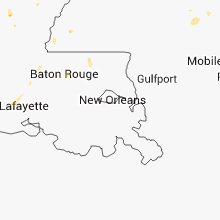
Louisiana
| Local Time | Report Details |
|---|---|
| 2:44 PM CDT | A tree was knocked down off of robert roa in st. tammany county LA, 28.7 miles NE of New Orleans, LA |
| 4:30 PM CDT | Trees were downed south of town along hwy. 1 and hwy. 7 in red river county LA, 41.6 miles SE of Shreveport, LA |
Virginia
| Local Time | Report Details |
|---|---|
| 4:20 PM EDT | Multiple trees down on dunlap creek road in alleghany county VA, 35.1 miles NNW of Roanoke, VA |
West Virginia
| Local Time | Report Details |
|---|---|
| 4:40 PM EDT | At least six trees down in the organ cave are in greenbrier county WV, 41 miles NW of Roanoke, VA |
Arkansas
| Local Time | Report Details |
|---|---|
| 5:05 PM CDT | Reports of trees down across roads in and around lake norell. also...two barns were damage in saline county AR, 21.5 miles W of Little Rock, AR |
| 5:39 PM CDT | Wind gusts estimated at 60 to 65 mph with tree limbs thrown in the air with some hitting vehicles. this occured on the intersate 40 and interstate 30 spli in pulaski county AR, 10.3 miles SW of Little Rock, AR |
| 6:15 PM CDT | Large tree limbs are being lifted and thrown by the wind. some siding was removed from a garage and produced minor structural damage. this occured inside the benton cit in saline county AR, 21.3 miles SW of Little Rock, AR |
Missouri
| Local Time | Report Details |
|---|---|
| 6:35 PM CDT | *** 1 inj *** mobile home blown over near homestown... injuries reported in pemiscot county MO, 68.4 miles SSW of Cape Girardeau, MO |
Montana
| Local Time | Report Details |
|---|---|
| 5:37 PM MDT | 63 mph wind measured at great falls nws office. very heavy rai in cascade county MT, 4.8 miles SW of Great Falls, MT |
| 5:42 PM MDT | Power pole snapped and power lines dow in cascade county MT, 2.8 miles SSE of Great Falls, MT |
Kentucky
| Local Time | Report Details |
|---|---|
| 6:45 PM CDT | Midway between gracey and hopkinsville...two old wooden barns down...and about 10 trees damaged. one barn was flattened and another was pushed ove in christian county KY, 66.3 miles NW of Nashville, TN |
Wisconsin
| Local Time | Report Details |
|---|---|
| 6:49 PM CDT | Several trees down along hwy12 east of hudson...time estimated from rada in st. croix county WI, 32.6 miles E of Minneapolis, MN |
Michigan
| Local Time | Report Details |
|---|---|
| 8:45 PM EDT | Strong thunderstorms winds blew down about 20 trees some two feet in diameter in a two mile wide area. these downed trees blocked several roads in the area and the powe in jackson county MI, 62.3 miles SW of Flint, MI |
| 8:50 PM EDT | Numerous trees and wires down between leslie and dansville due to thunderstorm wind in ingham county MI, 49.7 miles SW of Flint, MI |
Connect with Interactive Hail Maps