

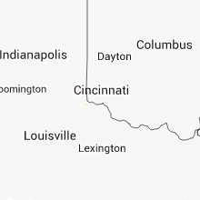
Hail Map for Saturday, July 7, 2012

Number of Impacted Households on 7/7/2012
0
Impacted by 1" or Larger Hail
0
Impacted by 1.75" or Larger Hail
0
Impacted by 2.5" or Larger Hail
Square Miles of Populated Area Impacted on 7/7/2012
0
Impacted by 1" or Larger Hail
0
Impacted by 1.75" or Larger Hail
0
Impacted by 2.5" or Larger Hail


Cities Most Affected by Hail Storms of 7/7/2012
| Hail Size | Demographics of Zip Codes Affected | ||||||
|---|---|---|---|---|---|---|---|
| City | Count | Average | Largest | Pop Density | House Value | Income | Age |
| Belmont, NY | 2 | 1.88 | 2.00 | 39 | $48k | $34.6k | 42.0 |
| Wellsville, NY | 2 | 1.75 | 1.75 | 83 | $52k | $31.1k | 43.9 |
| Turtlepoint, PA | 1 | 1.75 | 1.75 | 22 | $55k | $41.1k | 42.4 |
Hail and Wind Damage Spotted on 7/7/2012
Filter by Report Type:Hail ReportsWind Reports
States Impacted
New York, Arkansas, Ohio, Missouri, Pennsylvania, Tennessee, Oklahoma, Illinois, Mississippi, Florida, Texas, Iowa, New Jersey, Kansas, Kentucky, Oregon, Louisiana, Indiana, Montana, Washington, NebraskaNew York
| Local Time | Report Details |
|---|---|
| 9:50 AM EDT | Multiple trees down... one hitting a ca in genesee county NY, 35.8 miles ENE of Buffalo, NY |
| 11:16 AM EDT | Numerous trees and poles reported down in the village of watkins glen in schuyler county NY, 59.1 miles SW of Syracuse, NY |
| 11:21 AM EDT | Trees reported down in veteran township just southeast of the town of millport in northern chemung count in chemung county NY, 64.4 miles SSW of Syracuse, NY |
| 11:35 AM EDT | Numerous trees down in horseheads... wires down in the city of elmira and trees and wires reported down in southpor in chemung county NY, 70 miles SSW of Syracuse, NY |
| 2:10 PM EDT | Golf Ball sized hail reported near Belmont, NY, 63.1 miles SE of Buffalo, NY, 3.7 miles ssw belmont...recieved a report from nssl shave. |
| 2:15 PM EDT | Quarter sized hail reported near Belmont, NY, 63.1 miles SE of Buffalo, NY, 2.9 miles wsw of belmont... recieved a report from nssl shave. |
| 2:18 PM EDT | Quarter sized hail reported near Scio, NY, 67.9 miles SE of Buffalo, NY |
| 2:25 PM EDT | Hen Egg sized hail reported near Belmont, NY, 63.1 miles SE of Buffalo, NY, 3.7 miles ssw belmont...recieved a report from nssl shave. |
| 2:25 PM EDT | Multiple trees and branches down in olean... all around town center and in oak hill par in cattaraugus county NY, 60.1 miles SSE of Buffalo, NY |
| 2:25 PM EDT | Report of multiple trees and wires down across the city of olea in cattaraugus county NY, 60.1 miles SSE of Buffalo, NY |
| 2:25 PM EDT | Trees down in wellsvill in allegany county NY, 71 miles SE of Buffalo, NY |
| 2:40 PM EDT | Golf Ball sized hail reported near Wellsville, NY, 74.4 miles SE of Buffalo, NY, 5 miles se stannards...recieved a report from nssl shave. |
| 2:45 PM EDT | Golf Ball sized hail reported near Wellsville, NY, 74.4 miles SE of Buffalo, NY, 5 miles se stannards...recieved a report from nssl shave. |
| 9:30 PM EDT | Wires down on middle island blvd in suffolk county NY, 56.6 miles ENE of Brooklyn, NY |
| 9:35 PM EDT | Trees down in westhampton beach...some on wires in suffolk county NY, 72.8 miles E of Brooklyn, NY |
Arkansas
| Local Time | Report Details |
|---|---|
| 1:10 PM CDT | Tree damage along with roof damage to barn in crawford county AR, 22.1 miles NE of Fort Smith, AR |
| 2:10 PM CDT | Large tree down in sebastian county AR, 7.8 miles ESE of Fort Smith, AR |
| 2:35 PM CDT | Garage door damge to auto service station in sebastian county AR, 10 miles S of Fort Smith, AR |
| 2:35 PM CDT | Tree limbs and power lines down on west deane s in washington county AR, 48.8 miles NNE of Fort Smith, AR |
| 2:35 PM CDT | 5 inch tree limb downed in southeast fayetteville at cherry hills boulevard and pumpkin ridge drive. time estimated via rada in washington county AR, 48.8 miles NNE of Fort Smith, AR |
| 3:05 PM CDT | Power lines and poles down on arkansas highway 2 in franklin county AR, 22.3 miles ESE of Fort Smith, AR |
| 3:05 PM CDT | Large tree broken. time estimated via rada in washington county AR, 55 miles NNE of Fort Smith, AR |
| 3:30 PM CDT | Up to 4 inch diameter limbs downed at a campgroun in carroll county AR, 57.4 miles SSW of Springfield, MO |
| 3:50 PM CDT | Reports of tree damage via social media. time estimated via rada in benton county AR, 66.4 miles SSW of Springfield, MO |
| 6:27 PM CDT | Trees and power lines are down in the mountain pine are in garland county AR, 52.5 miles WSW of Little Rock, AR |
| 6:40 PM CDT | Reports of a few trees down in sulphur spring in jefferson county AR, 40.1 miles SSE of Little Rock, AR |
| 7:30 PM CDT | Some downed trees in the hardin communit in jefferson county AR, 33.8 miles SSE of Little Rock, AR |
Ohio
| Local Time | Report Details |
|---|---|
| 2:30 PM EDT | Three trees down in shalerville townshi in portage county OH, 28.6 miles SE of Cleveland, OH |
| 2:58 PM EDT | Large branches broken in columbiana county OH, 55.4 miles NW of Pittsburgh, PA |
Missouri
| Local Time | Report Details |
|---|---|
| 1:35 PM CDT | Large trees reported down near sparta high school. silo reported damaged in the same are in christian county MO, 18.6 miles SE of Springfield, MO |
| 1:40 PM CDT | Tree down in webster county MO, 24.5 miles E of Springfield, MO |
| 1:45 PM CDT | Two barns damaged in webster county MO, 28.3 miles ENE of Springfield, MO |
| 1:50 PM CDT | Tree dow in webster county MO, 25.8 miles ENE of Springfield, MO |
| 1:50 PM CDT | Trees down. roof damage to barn and hom in camden county MO, 53.5 miles WNW of Salem, MO |
| 1:55 PM CDT | Six inch trees reported down in tow in webster county MO, 14.2 miles ESE of Springfield, MO |
| 1:57 PM CDT | Several trees from one and one half to two feet in daimeter reportd down across the road along route 125 near carter r in christian county MO, 17 miles SE of Springfield, MO |
| 1:57 PM CDT | Several trees from one and one half to two feet in diameter reported down across the road along route 125 near carter r in christian county MO, 17 miles SE of Springfield, MO |
| 2:03 PM CDT | Large tree limbs reported down with electrical lines pulled off pol in greene county MO, 12.7 miles ESE of Springfield, MO |
| 2:20 PM CDT | Tree limbs reported down in 60 mph winds along highway 6 in greene county MO, 9.9 miles SE of Springfield, MO |
| 2:21 PM CDT | Six inch trees reported down in tow in webster county MO, 14.2 miles ESE of Springfield, MO |
| 2:25 PM CDT | Trees down and barn damage in greene county MO, 7.5 miles ESE of Springfield, MO |
| 2:30 PM CDT | Trees down. trees on the roofs of some homes. several barns damaged or destoye in greene county MO, 6 miles ESE of Springfield, MO |
| 2:30 PM CDT | Trees down. trees on the roofs of some homes. several barns damaged or destroye in greene county MO, 6 miles ESE of Springfield, MO |
| 2:36 PM CDT | Twelve inch tree down on delaware street north of kearne in greene county MO, 0.6 miles S of Springfield, MO |
| 2:39 PM CDT | Large piece of satellite tower fell into parking lot at tv studi in greene county MO, 0.6 miles S of Springfield, MO |
| 3:05 PM CDT | Tree reported down across highway 173 at intersection of highway 143 and highway 17 in stone county MO, 28.6 miles SSW of Springfield, MO |
| 3:15 PM CDT | Numerous trees reported down across highway aa in the vicinity of barnet in morgan county MO, 43.4 miles SSW of Columbia, MO |
| 3:20 PM CDT | Tree down across highway in morgan county MO, 52.1 miles SSW of Columbia, MO |
| 3:25 PM CDT | Trees and powerlines down. building damage in texas county MO, 24.5 miles SW of Salem, MO |
| 3:42 PM CDT | Tree dow in barry county MO, 52.6 miles SSW of Springfield, MO |
| 4:05 PM CDT | Powerlines dow in barry county MO, 59.6 miles SW of Springfield, MO |
| 4:50 PM CDT | Amateur radio operator reported tree damage in the city limits of st. clair in franklin county MO, 46.4 miles WSW of Saint Louis, MO |
| 5:10 PM CDT | Franklin county sheriff reported several large trees down over the central and western parts of st. clair city limits. large trees fell on top of some home in franklin county MO, 46.4 miles WSW of Saint Louis, MO |
| 5:30 PM CDT | Couple of trees dow in howell county MO, 69.6 miles SSW of Salem, MO |
| 5:54 PM CDT | Damage to willcross seed building in king cit in gentry county MO, 65.4 miles N of Kansas City, MO |
| 5:54 PM CDT | Several power poles blown over in king city...truck also overturne in gentry county MO, 65.4 miles N of Kansas City, MO |
| 6:10 PM CDT | Major damage in cuba including building collapses... vehicle rollovers... and numerous power lines downed. time estimated in crawford county MO, 30.1 miles NNE of Salem, MO |
| 6:10 PM CDT | Quarter sized hail reported near Doe Run, MO, 57.2 miles E of Salem, MO, some trees and power lines downed. |
| 6:14 PM CDT | Estimated 60 to 70 mph wind gusts. time estimated by rada in daviess county MO, 73.3 miles NNE of Kansas City, MO |
| 6:25 PM CDT | *** 1 in crawford county MO, 30.1 miles NNE of Salem, MO |
| 6:25 PM CDT | 8 inch diameter tree down. 6 inch diameter tree limbs broken. powerlines downe in crawford county MO, 30.1 miles NNE of Salem, MO |
| 6:25 PM CDT | Major damage in cuba including building collapses... vehicle rollovers... and numerous power lines downed. time estimated in crawford county MO, 30.1 miles NNE of Salem, MO |
| 6:25 PM CDT | Trees...tree limbs blown down. also...roof was blown off of a truck sto in crawford county MO, 30.1 miles NNE of Salem, MO |
| 6:25 PM CDT | Power lines downed on route 221 in st. francois county MO, 56.6 miles SSW of Saint Louis, MO |
| 6:48 PM CDT | Storm damage reported in grundy county MO, 89.8 miles NE of Kansas City, MO |
| 7:04 PM CDT | Tree and power line damage in kirkwoo in st. louis county MO, 12.4 miles WSW of Saint Louis, MO |
| 7:12 PM CDT | Trees down and power lines down within pilot knob town limits due to microbursts in iron county MO, 49.1 miles E of Salem, MO |
| 7:17 PM CDT | Several trees blown down on vesper driv in st. louis county MO, 20.7 miles W of Saint Louis, MO |
| 7:19 PM CDT | 8 inch diameter tree down. 6 inch diameter tree limbs broken. powerlines downe in crawford county MO, 30.1 miles NNE of Salem, MO |
| 7:38 PM CDT | Trees blown down on brookvale terrac in st. louis county MO, 17.1 miles W of Saint Louis, MO |
Pennsylvania
| Local Time | Report Details |
|---|---|
| 2:50 PM EDT | Trees dow in mckean county PA, 67.7 miles SSE of Buffalo, NY |
| 2:55 PM EDT | Quarter sized hail reported near Port Allegany, PA, 73.4 miles NNW of State College, PA |
| 2:59 PM EDT | Quarter sized hail reported near Genesee, PA, 81.7 miles SE of Buffalo, NY, quarter-sized hail reported northwest of ulysses. |
| 3:00 PM EDT | Golf Ball sized hail reported near Turtlepoint, PA, 75.3 miles SSE of Buffalo, NY |
| 3:05 PM EDT | Large limbs down. estimated 75 mph wind gust in potter county PA, 76.5 miles N of State College, PA |
| 3:25 PM EDT | Numerous trees down in and around new castle in lawrence county PA, 43 miles NNW of Pittsburgh, PA |
| 3:25 PM EDT | Numerous reports of trees and wires down between wellsboro and galeto in tioga county PA, 69.9 miles NNE of State College, PA |
| 3:46 PM EDT | Trees and wires reported down in liberty township in tioga county PA, 70.4 miles NE of State College, PA |
| 3:50 PM EDT | Trees down blocking route 38 in oakland township in butler county PA, 33.2 miles NNE of Pittsburgh, PA |
| 4:00 PM EDT | Trees dow in clinton county PA, 37.5 miles N of State College, PA |
| 4:05 PM EDT | Numerous trees down along rt. 8 in butler county PA, 25.5 miles NNE of Pittsburgh, PA |
| 4:06 PM EDT | Numerous trees down in and around brookville in jefferson county PA, 69.1 miles WNW of State College, PA |
| 4:15 PM EDT | Trees down in butler county PA, 24 miles NNE of Pittsburgh, PA |
| 4:18 PM EDT | Trees down across a roa in lycoming county PA, 61.1 miles NE of State College, PA |
| 4:20 PM EDT | Telephone poles down in mercer county PA, 50 miles N of Pittsburgh, PA |
| 4:20 PM EDT | Tree down on house in mercer county PA, 50 miles N of Pittsburgh, PA |
| 4:20 PM EDT | Trees down on highway 173 at interstate 80 in mercer county PA, 50.7 miles N of Pittsburgh, PA |
| 4:22 PM EDT | Numerous trees down...treetops sheared off...signs down. tree blown onto trailer. long track downburst that extended from route 28 and iron bridge rd eastwar in armstrong county PA, 25.8 miles NE of Pittsburgh, PA |
| 4:23 PM EDT | Numerous trees down near picture rock in lycoming county PA, 55.3 miles W of Scranton, PA |
| 4:25 PM EDT | Large limbs dow in lycoming county PA, 58.4 miles ENE of State College, PA |
| 4:25 PM EDT | Trees down on houses and powerlines at the intersection of sheridan and eldred street in lycoming county PA, 53.7 miles NE of State College, PA |
| 4:26 PM EDT | Quarter sized hail reported near Williamsport, PA, 53.7 miles NE of State College, PA, quarter-sized hail reported in williamsport. |
| 4:27 PM EDT | Wind gust to 58 mph reported by williamsport regional airport aso in lycoming county PA, 58 miles ENE of State College, PA |
| 4:27 PM EDT | Trees reported down in the newberry neighborhood of williamspor in lycoming county PA, 53.7 miles NE of State College, PA |
| 4:30 PM EDT | Numerous trees down in butler county PA, 24.6 miles NE of Pittsburgh, PA |
| 4:30 PM EDT | Numerous trees down on berewer road in butler county PA, 23.7 miles NNE of Pittsburgh, PA |
| 4:30 PM EDT | Trees uprooted at west minister rd and eckestown rd in butler county PA, 23.4 miles NNE of Pittsburgh, PA |
| 4:43 PM EDT | Structural damage in armstrong county PA, 33.6 miles NE of Pittsburgh, PA |
| 4:45 PM EDT | Tree down on ca in northumberland county PA, 56 miles ENE of State College, PA |
| 4:48 PM EDT | Numerous trees and wires down across northern columbia count in columbia county PA, 40.9 miles WSW of Scranton, PA |
| 4:50 PM EDT | Numerous trees down in and around ford city in armstrong county PA, 33.6 miles NE of Pittsburgh, PA |
| 4:50 PM EDT | Numerous trees down in sligo in clarion county PA, 53.2 miles NNE of Pittsburgh, PA |
| 4:57 PM EDT | Large limbs reported dow in centre county PA, 17.7 miles NNE of State College, PA |
| 5:01 PM EDT | Trees dow in luzerne county PA, 32.2 miles SSW of Scranton, PA |
| 5:05 PM EDT | Numerous trees down in the borough of indiana in indiana county PA, 46.3 miles ENE of Pittsburgh, PA |
| 5:05 PM EDT | *** 1 inj *** trees and wires down across road. one person injured by live wire in union county PA, 43 miles ENE of State College, PA |
| 5:10 PM EDT | Trees dow in luzerne county PA, 37.9 miles SW of Scranton, PA |
| 5:25 PM EDT | Numerous trees down in carbon county from around beaver meadows to around bowmanstow in carbon county PA, 35.6 miles SSW of Scranton, PA |
| 5:25 PM EDT | Scattered trees and wires down in luzerne county PA, 35.6 miles SSW of Scranton, PA |
| 5:25 PM EDT | Numerous trees down in ryan and rush twp in schuylkill county PA, 42.7 miles SSW of Scranton, PA |
| 5:30 PM EDT | Storm damage reported in allegheny county PA, 6.2 miles SSE of Pittsburgh, PA |
| 5:32 PM EDT | Trees and power lines down in jefferson county PA, 63.1 miles NE of Pittsburgh, PA |
| 5:34 PM EDT | 16000 without power due to storm damage in hazleton drums nescopeck area in luzerne county PA, 35.6 miles SSW of Scranton, PA |
| 5:36 PM EDT | Trees and power lines down in jefferson county PA, 59 miles W of State College, PA |
| 5:36 PM EDT | Trees and power lines down in jefferson county PA, 57.6 miles WNW of State College, PA |
| 5:42 PM EDT | Trees and power lines down in jefferson county PA, 53.2 miles WNW of State College, PA |
| 5:42 PM EDT | Trees and power lines down in henderson in jefferson county PA, 54.9 miles WNW of State College, PA |
| 5:45 PM EDT | Downed trees in lehigh county PA, 45.6 miles S of Scranton, PA |
| 5:45 PM EDT | Large limbs dow in northampton county PA, 45.7 miles S of Scranton, PA |
| 5:47 PM EDT | Trees reported down in pine grove tw in schuylkill county PA, 70.5 miles SSW of Scranton, PA |
| 5:52 PM EDT | Several trees down in stump creek in jefferson county PA, 53.4 miles WNW of State College, PA |
| 5:55 PM EDT | Separate report... large tree limbs dow in lehigh county PA, 57.4 miles S of Scranton, PA |
| 5:55 PM EDT | Trees reported down in troutvill in clearfield county PA, 51.1 miles WNW of State College, PA |
| 5:56 PM EDT | Trees and wires down in brady and union tw in clearfield county PA, 51.1 miles WNW of State College, PA |
| 5:58 PM EDT | Numerous trees down between altoona and hollidaysbur in blair county PA, 37.5 miles SW of State College, PA |
| 6:00 PM EDT | Storm damage reported in lehigh county PA, 57.4 miles S of Scranton, PA |
| 6:00 PM EDT | Two trees down in westmoreland county PA, 24.9 miles ESE of Pittsburgh, PA |
| 6:15 PM EDT | Trees and wires dow in huntingdon county PA, 34.2 miles SSW of State College, PA |
| 6:25 PM EDT | Trees and wires dow in perry county PA, 44.1 miles ESE of State College, PA |
| 6:28 PM EDT | Trees reported down south of mount unio in huntingdon county PA, 29.9 miles S of State College, PA |
| 6:28 PM EDT | Quarter sized hail reported near Duncannon, PA, 51.1 miles ESE of State College, PA, quarter-sized hail reported near amity hall. |
| 6:30 PM EDT | Trees and wires down in huntingdon county PA, 22.4 miles S of State College, PA |
| 6:30 PM EDT | Trees and wires dow in huntingdon county PA, 30.7 miles S of State College, PA |
| 6:45 PM EDT | Storm damage reported in bucks county PA, 60.4 miles SW of Brooklyn, NY |
| 7:00 PM EDT | Trees and wires reported down in east waterfor in juniata county PA, 32.3 miles SSE of State College, PA |
| 7:02 PM EDT | Trees and wires reported down in honey grov in juniata county PA, 30.5 miles SSE of State College, PA |
| 7:20 PM EDT | Trees and wires reported down near port roya in juniata county PA, 30.7 miles SE of State College, PA |
| 7:35 PM EDT | Trees and wires dow in perry county PA, 47.1 miles SE of State College, PA |
| 7:52 PM EDT | Large branches broken off tree in york county PA, 46.6 miles N of Baltimore, MD |
| 7:57 PM EDT | Two trees down in beaver county PA, 23.6 miles WNW of Pittsburgh, PA |
| 8:05 PM EDT | Trees down across the cit in york county PA, 46.6 miles N of Baltimore, MD |
| 8:28 PM EDT | Trees dow in lancaster county PA, 51.3 miles N of Baltimore, MD |
| 8:30 PM EDT | Tree uprooted... shed and gazebo damaged in lancaster county PA, 50.9 miles NNE of Baltimore, MD |
| 8:52 PM EDT | Quarter sized hail reported near Strasburg, PA, 52.6 miles NNE of Baltimore, MD, dime to quarter-sized hail reported near strasburg. |
| 9:22 PM EDT | Quarter sized hail reported near Coatesville, PA, 63.5 miles NE of Baltimore, MD |
Tennessee
| Local Time | Report Details |
|---|---|
| 3:00 PM CDT | Delayed report from saturday 7/7. bank canopy damaged and gas station awning blown down on highway 99 near highway 64. numerous trees also blown down in the are in wayne county TN, 36 miles N of Florence, AL |
| 5:40 PM CDT | Trees down and power lines down around florence road in savanna in hardin county TN, 43.2 miles NW of Florence, AL |
| 7:41 PM CDT | Quarter sized hail reported near Memphis, TN, 9 miles S of Memphis, TN, hail up to a quarter size. |
| 12:20 AM CDT | Trees reported blown down. time estimated from rada in dickson county TN, 32 miles W of Nashville, TN |
| 12:35 AM CDT | Numerous trees down in the city of dickson. very heavy rainfall and frequent dangerous lightnin in dickson county TN, 34.2 miles W of Nashville, TN |
| 12:55 AM CDT | Delayed report from sunday morning 7/8. several trees were blown down on yellow creek roa in dickson county TN, 40.4 miles W of Nashville, TN |
| 1:00 AM CDT | Trees and power lines blown down in tennessee city along highway 70. time estimated based on rada in dickson county TN, 41.8 miles W of Nashville, TN |
| 1:10 AM CDT | Trees blown down on trace creek road and highway 70 in mcewen. time estimated based on rada in humphreys county TN, 48.4 miles W of Nashville, TN |
| 2:18 AM CDT | Several trees were blown down across benton count in benton county TN, 24 miles ESE of Mc Kenzie, TN |
Oklahoma
| Local Time | Report Details |
|---|---|
| 3:05 PM CDT | Small trees broken. time estimated via rada in le flore county OK, 25.7 miles SSW of Fort Smith, AR |
| 3:30 PM CDT | Small trees broken. numerous power outages. time estimated via rada in le flore county OK, 32.4 miles SSW of Fort Smith, AR |
| 3:30 PM CDT | 16 inch diameter tree uprooted along morris creek road east of howe. time estimated via rada in le flore county OK, 31.6 miles SSW of Fort Smith, AR |
| 3:40 PM CDT | Small trees broken. time estimated via rada in le flore county OK, 33.2 miles SSW of Fort Smith, AR |
Illinois
| Local Time | Report Details |
|---|---|
| 4:15 PM CDT | 3 to 4 trees knocked down with numerous branches down. one soft wood maple tree 1 ft in diameter had its top twisted off 10-12 ft above the groun in ogle county IL, 72.6 miles S of Madison, WI |
| 5:40 PM CDT | Widespread tree limbs down on the northwest side of sterling. tree limbs ranged in diameter from 3 to 16 inches. multiple powerlines in the city were down or damaged ca in whiteside county IL, 76.6 miles N of Peoria, IL |
| 5:40 PM CDT | Several large diameter tree limbs down on the northwest side of sterling with reports of power outage in whiteside county IL, 76.6 miles N of Peoria, IL |
| 8:46 PM CDT | Large tree blown down onto power lines in waterloo...causing power outage in monroe county IL, 20.6 miles S of Saint Louis, MO |
Mississippi
| Local Time | Report Details |
|---|---|
| 4:30 PM CDT | Trees downed along highway 588 in jones county MS, 67.2 miles SE of Jackson, MS |
| 5:05 PM CDT | A tree fell on a power line near florence in rankin county MS, 12.8 miles SSE of Jackson, MS |
| 7:27 PM CDT | Quarter sized hail reported near Southaven, MS, 12.7 miles SSE of Memphis, TN, quarter sized hail on interstate 55 in southaven. |
| 11:00 PM CDT | *** 2 inj *** several downed trees and homes damaged... 1 home destroyed... 2 minor injuries... left 70 percent of charleston without power... time estimated in tallahatchie county MS, 78.6 miles S of Memphis, TN |
| 4:18 AM CDT | Trees reported down near the intersection of county roads 957 and 992 approximately 3 miles south of iuka in tishomingo count in tishomingo county MS, 30 miles W of Florence, AL |
Florida
| Local Time | Report Details |
|---|---|
| 6:00 PM EDT | About 10 trees were knocked down or uprooted in the saint ives blvd and east linden dr area. time estimated from radar in hernando county FL, 65.2 miles N of Bradenton, FL |
| 7:05 PM EDT | National weather service employee reported powerlines down on pine avenue in fleming islan in clay county FL, 18.2 miles S of Jacksonville, FL |
Texas
| Local Time | Report Details |
|---|---|
| 5:19 PM CDT | Trees down between kennard and ratclif in houston county TX, 25.6 miles W of Lufkin, TX |
Iowa
| Local Time | Report Details |
|---|---|
| 5:28 PM CDT | Wind gusts estimated up to 60 mp in clinton county IA, 53 miles E of Cedar Rapids, IA |
New Jersey
| Local Time | Report Details |
|---|---|
| 6:32 PM EDT | Metal hay wagon and chicken coop overturned along sanford road in stockton. also window blown out in house and large tree uproote in hunterdon county NJ, 55.6 miles WSW of Brooklyn, NY |
| 6:35 PM EDT | Trees down in hunterdon county NJ, 47.4 miles WSW of Brooklyn, NY |
| 6:45 PM EDT | Trees dow in somerset county NJ, 42.8 miles WSW of Brooklyn, NY |
| 7:01 PM EDT | Large tree limbs dow in middlesex county NJ, 34.6 miles SW of Brooklyn, NY |
| 7:10 PM EDT | Two trees along shoulder of interstate 195 mile post number 1 in monmouth county NJ, 47.8 miles SW of Brooklyn, NY |
| 7:15 PM EDT | Trees dow in monmouth county NJ, 33.5 miles SSW of Brooklyn, NY |
| 7:25 PM EDT | Multiple trees down in the township... freehold road blocke in monmouth county NJ, 36.4 miles SSW of Brooklyn, NY |
| 7:30 PM EDT | Multiple trees dow in ocean county NJ, 43.8 miles SSW of Brooklyn, NY |
| 7:33 PM EDT | Large limbs dow in ocean county NJ, 47.9 miles S of Brooklyn, NY |
| 7:40 PM EDT | Also public reports of downed tree in ocean county NJ, 43.5 miles S of Brooklyn, NY |
| 7:40 PM EDT | Multiple reports of trees and tree limbs down in toms river. wind gusts estimated around 75 mp in ocean county NJ, 52.4 miles SSW of Brooklyn, NY |
| 7:45 PM EDT | Poles and wires down... at least one tree down... people temporarily trapped on sky rid in ocean county NJ, 52.1 miles S of Brooklyn, NY |
| 7:54 PM EDT | Poles and wires down. in ocean county NJ, 50 miles S of Brooklyn, NY |
| 7:55 PM EDT | Storm damage reported in ocean county NJ, 53.8 miles SSW of Brooklyn, NY |
| 7:55 PM EDT | Trees down in ocean county NJ, 52.8 miles S of Brooklyn, NY |
| 8:00 PM EDT | Trees dow in ocean county NJ, 54.6 miles S of Brooklyn, NY |
Kansas
| Local Time | Report Details |
|---|---|
| 5:43 PM CDT | Small limbs and a few power lines downed in crawford county KS, 44.5 miles ESE of Chanute, KS |
| 6:00 PM CDT | Wind gusts of 50 to 60 mph reported in the pittsburgh/frontenac area. numerous reports of trees and powerlines down in the same area as wel in crawford county KS, 45.3 miles ESE of Chanute, KS |
| 6:07 PM CDT | Sheet metal blown off a barn roof. fireworks tents collapsed near 29th and broadwa in crawford county KS, 44 miles ESE of Chanute, KS |
| 6:10 PM CDT | Storm damage reported in ellis county KS, 11.2 miles S of Hays, KS |
| 8:30 PM CDT | Storm damage reported in thomas county KS, 16.4 miles NW of Colby, KS |
| 8:35 PM CDT | Numerous reports of downed trees on 6th street between constitution and sylvan streets. reports of home and car damage due to trees fallin in lyon county KS, 57.5 miles SSE of Manhattan, KS |
| 11:55 PM CDT | Delayed report...public estimated 55-58 mph winds...small limbs up to 2 inches in diameter broken...pea sized hail...wind blew umbrella into trees in dickinson county KS, 25.4 miles WSW of Manhattan, KS |
Kentucky
| Local Time | Report Details |
|---|---|
| 6:15 PM CDT | Large tree limbs blown down up to 9 inches in diameter on route 272 near julie in christian county KY, 66.7 miles NW of Nashville, TN |
| 6:15 PM CDT | Update... trees uprooted and large metal doors pushed in on toolsheds at a farm. large tree limbs blown down. all damage on route 272 near julie in christian county KY, 66.7 miles NW of Nashville, TN |
Oregon
| Local Time | Report Details |
|---|---|
| 4:20 PM PDT | Strong wind gust from an approaching thunderstorm broke off walnut tree limb approximately 12 to 18 inches in diameter. um- in umatilla county OR, 50.3 miles SSW of Walla Walla, WA |
Louisiana
| Local Time | Report Details |
|---|---|
| 6:45 PM CDT | Fairly extensive wind damage reported at the mansfield international paper mill along highway 509. several pieces of tin were ripped off of buildings and roofs...a few in de soto county LA, 26.8 miles SSE of Shreveport, LA |
| 9:27 PM CDT | Two trees downed in bernic in union county LA, 43.5 miles W of Bastrop, LA |
Indiana
| Local Time | Report Details |
|---|---|
| 9:17 PM EDT | Trees up to 2 feet in diameter blown down. barn destroyed. partial roof damage on another barn. damage occurred in front of observer. wind gust to estimated 70 mp in johnson county IN, 15.4 miles SSE of Indianapolis, IN |
Montana
| Local Time | Report Details |
|---|---|
| 7:38 PM MDT | 20 reports of wind damage...trees down on power lines and homes. also 2115 people were without power for a few hour in flathead county MT, 14.6 miles S of Whitefish, MT |
Washington
| Local Time | Report Details |
|---|---|
| 7:00 PM PDT | Park ranger at the last resort campground 10 miles north of camp wooten reported nickel size hail. also flooding occurred in trenches in the gravel road and parking lot in columbia county WA, 32.2 miles ENE of Walla Walla, WA |
Nebraska
| Local Time | Report Details |
|---|---|
| 10:26 PM MDT | Delayed report from july 7th. estimated 60 mph winds blew corn over in soggy field. pea to marble sized hail combined with the wind gusts helped strip corn cro in chase county NE, 57.8 miles ENE of Yuma, CO |
Connect with Interactive Hail Maps