

Hail Map for Thursday, July 5, 2012

Number of Impacted Households on 7/5/2012
0
Impacted by 1" or Larger Hail
0
Impacted by 1.75" or Larger Hail
0
Impacted by 2.5" or Larger Hail
Square Miles of Populated Area Impacted on 7/5/2012
0
Impacted by 1" or Larger Hail
0
Impacted by 1.75" or Larger Hail
0
Impacted by 2.5" or Larger Hail


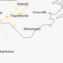


Cities Most Affected by Hail Storms of 7/5/2012
| Hail Size | Demographics of Zip Codes Affected | ||||||
|---|---|---|---|---|---|---|---|
| City | Count | Average | Largest | Pop Density | House Value | Income | Age |
| Ethridge, TN | 2 | 1.88 | 2.00 | 66 | $66k | $27.3k | 31.2 |
| Rome, GA | 1 | 1.75 | 1.75 | 242 | $87k | $35.5k | 35.9 |
| Smyrna, TN | 1 | 1.75 | 1.75 | 894 | $116k | $48.0k | 33.9 |
| Clanton, AL | 1 | 1.75 | 1.75 | 122 | $82k | $30.2k | 38.1 |
| Fairburn, SD | 1 | 1.75 | 1.75 | 1 | $40k | $27.3k | 45.2 |
| Oneonta, AL | 1 | 1.75 | 1.75 | 106 | $78k | $31.7k | 39.3 |
Hail and Wind Damage Spotted on 7/5/2012
Filter by Report Type:Hail ReportsWind Reports
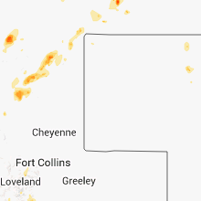
States Impacted
West Virginia, Virginia, North Carolina, Ohio, Kentucky, Mississippi, Michigan, Tennessee, South Carolina, Alabama, Illinois, Arkansas, Georgia, Indiana, Louisiana, Pennsylvania, Wyoming, Maryland, Texas, South Dakota, Colorado, North Dakota, FloridaWest Virginia
| Local Time | Report Details |
|---|---|
| 10:30 AM EDT | Power lines and poles down. 57th and 58th s in kanawha county WV, 0.5 miles E of Charleston, WV |
| 11:33 AM EDT | Large branches broke in putnam county WV, 20.6 miles NW of Charleston, WV |
| 11:51 AM EDT | Multiple trees down into power lines in kanawha county WV, 11.4 miles WNW of Charleston, WV |
| 11:52 AM EDT | At 1152am yeager airport asos in charl in kanawha county WV, 4.7 miles NE of Charleston, WV |
| 11:55 AM EDT | Multiple trees down along 119 just north of bus garag in kanawha county WV, 10.7 miles ENE of Charleston, WV |
| 11:57 AM EDT | Multiple trees and power lines down at the corner of edgewood and garriso in kanawha county WV, 1.4 miles N of Charleston, WV |
| 12:10 PM EDT | Power lines and poles down. 57th and 58th s in kanawha county WV, 0.5 miles E of Charleston, WV |
| 12:30 PM EDT | Power lines and poles down. 57th and 58th s in kanawha county WV, 0.5 miles E of Charleston, WV |
| 12:30 PM EDT | Multiple trees and lines dow in boone county WV, 18.9 miles SSW of Charleston, WV |
| 12:30 PM EDT | Multiple trees and lines down along rt. 85 in boone county WV, 24.1 miles SSW of Charleston, WV |
| 12:33 PM EDT | Multiple trees down in griffithsvill in lincoln county WV, 19.8 miles WSW of Charleston, WV |
| 12:45 PM EDT | Trees down on truck in north beckley. entrapmen in raleigh county WV, 45.7 miles SSE of Charleston, WV |
| 12:58 PM EDT | Multiple trees down on power lines with power outages in the beckley are in raleigh county WV, 45.7 miles SSE of Charleston, WV |
| 1:00 PM EDT | Multiple trees down across roads in the beckley are in raleigh county WV, 48.7 miles SSE of Charleston, WV |
| 1:06 PM EDT | Trees down and power ou in wyoming county WV, 45.5 miles S of Charleston, WV |
| 1:06 PM EDT | Trees down and power ou in wyoming county WV, 53.5 miles S of Charleston, WV |
| 1:12 PM EDT | Multiple trees down. power poles snapped and power lines down in the harts area in lincoln county WV, 32.6 miles SW of Charleston, WV |
| 1:14 PM EDT | Logan raws (lgrw2) at the logan county airport measured a wind gust of 59mph at 0114pm in logan county WV, 36.9 miles SSW of Charleston, WV |
| 1:15 PM EDT | Trees down on road and power line in logan county WV, 36.5 miles SSW of Charleston, WV |
| 1:15 PM EDT | Multiple trees down. power poles snapped and power lines down in the harts area in lincoln county WV, 32.6 miles SW of Charleston, WV |
| 1:20 PM EDT | Traffic light and pole down in the road at the intersection of wv 17 and wv 10 in logan county WV, 39.4 miles SSW of Charleston, WV |
| 1:40 PM EDT | Trees down between welch and iaeger. trees down and power outages throughout the county in mcdowell county WV, 63.5 miles S of Charleston, WV |
| 1:44 PM EDT | Tree fell on power lines along terrace street in summers county WV, 56.9 miles WNW of Roanoke, VA |
| 1:45 PM EDT | Trees down and power outages in taylorville in mingo county WV, 55.1 miles SSW of Charleston, WV |
| 1:52 PM EDT | Trees down on route 102 near the virginia state line in mercer county WV, 69.7 miles NE of Bristol, TN |
Virginia
| Local Time | Report Details |
|---|---|
| 11:25 AM EDT | Quarter sized hail reported near Wytheville, VA, 62.3 miles WSW of Roanoke, VA, quarter size hail at exit 77 on interstate 81 |
| 12:05 PM EDT | Several trees down on iron ridge road in carroll county VA, 66.2 miles SW of Roanoke, VA |
| 12:06 PM EDT | One tree down on mt. vale r in grayson county VA, 70.4 miles SW of Roanoke, VA |
| 2:05 PM EDT | Multiple trees down around marion including route 11 in smyth county VA, 43.3 miles ENE of Bristol, TN |
| 2:09 PM EDT | One tree down on route 100 near wilburn valley in giles county VA, 44.1 miles W of Roanoke, VA |
| 2:20 PM EDT | Trees down on power lines. power outage in buchanan county VA, 47.9 miles N of Bristol, TN |
| 2:24 PM EDT | Tree reported down across road at richlands hs. power outage reported in richland in tazewell county VA, 42.1 miles NNE of Bristol, TN |
| 2:25 PM EDT | Multiple trees down in buchanan county VA, 42.4 miles NNE of Bristol, TN |
| 2:30 PM EDT | Trees down in cedar bluff in tazewell county VA, 42.8 miles NE of Bristol, TN |
| 2:31 PM EDT | Tree down on fairwood road near troutdal in grayson county VA, 44 miles E of Bristol, TN |
| 2:35 PM EDT | Multiple trees down. trees down on power lines. power outage in buchanan county VA, 35.3 miles N of Bristol, TN |
| 2:35 PM EDT | Multiple trees down on thompson valley in tazewell county VA, 50.2 miles NE of Bristol, TN |
| 2:35 PM EDT | One tree down on route 100 near wilburn valley in giles county VA, 44.1 miles W of Roanoke, VA |
| 2:40 PM EDT | Several trees dow in russell county VA, 35.9 miles NNE of Bristol, TN |
| 2:43 PM EDT | Tree down across jefferson highway in grayson county VA, 49 miles E of Bristol, TN |
| 2:45 PM EDT | Trees down in town and throughout the county. another 440 customers without powe in dickenson county VA, 40.7 miles NNW of Bristol, TN |
| 2:50 PM EDT | Trees down on power lines and poles. power outage in dickenson county VA, 33.7 miles NNW of Bristol, TN |
| 2:50 PM EDT | Trees down on highway 636 in grayson county VA, 67.4 miles E of Bristol, TN |
| 2:52 PM EDT | 2 trees down on wilson highway west of independence in grayson county VA, 57.9 miles E of Bristol, TN |
| 3:00 PM EDT | Several trees dow in washington county VA, 16.2 miles ENE of Bristol, TN |
| 3:00 PM EDT | A couple of trees down on the west side of empori in city of emporia county VA, 56.4 miles S of Richmond, VA |
| 3:17 PM EDT | Multiple trees down in grayson county VA, 40.1 miles E of Bristol, TN |
| 3:25 PM EDT | One tree down along hwy 1 in washington county VA, 16.9 miles NNE of Bristol, TN |
| 4:21 PM EDT | Quarter sized hail reported near Gretna, VA, 44.1 miles SE of Roanoke, VA, chalk level road |
| 4:35 PM EDT | Numerous trees down and damage to a hom in lee county VA, 50.4 miles W of Bristol, TN |
| 4:35 PM EDT | Quarter sized hail reported near Appomattox, VA, 61 miles W of Richmond, VA, whipoorwill road |
| 5:15 PM EDT | Viewer reported large oak tree fell and bent some of the corn crop. time estimated by rada in pittsylvania county VA, 37.1 miles SE of Roanoke, VA |
| 5:38 PM EDT | One tree down and several large limbs fell on kemper road in city of danville county VA, 56.3 miles SSE of Roanoke, VA |
| 5:40 PM EDT | Quarter sized hail reported near Chatham, VA, 36.5 miles SE of Roanoke, VA, green pond road |
North Carolina
| Local Time | Report Details |
|---|---|
| 12:45 PM EDT | Tree blocking southbound lane of i-7 in surry county NC, 76.9 miles SW of Roanoke, VA |
| 1:00 PM EDT | Multiple trees down along austin traphill road in wilkes county NC, 74.5 miles N of Charlotte, NC |
| 1:00 PM EDT | Multiple trees down and damage to several buildings in dobso in surry county NC, 76.1 miles SW of Roanoke, VA |
| 1:00 PM EDT | Quarter sized hail reported near Elkin, NC, 75.2 miles N of Charlotte, NC, a.z. phillips road |
| 1:09 PM EDT | Quarter sized hail reported near Elkin, NC, 71.5 miles N of Charlotte, NC, church steeple and large trees down also. |
| 1:18 PM EDT | Multiple trees down across boonville in yadkin county NC, 69.1 miles N of Charlotte, NC |
| 1:55 PM EDT | Numerous trees down near nc 57 and nc 157. multiple trees blocking the roa in orange county NC, 35 miles NW of Raleigh, NC |
| 1:55 PM EDT | Two trees down in the lewisville area in forsyth county NC, 63.9 miles NNE of Charlotte, NC |
| 1:57 PM EDT | Numerous trees down along kiger r in orange county NC, 33 miles NW of Raleigh, NC |
| 2:09 PM EDT | Couple of trees down on walnut grove church road off of nc 86n in orange county NC, 36.7 miles NW of Raleigh, NC |
| 2:15 PM EDT | One tree blown down on cannady rd. time estimate in granville county NC, 26.7 miles N of Raleigh, NC |
| 2:16 PM EDT | Tree blown down along brassfield church road. time estimate in granville county NC, 23.3 miles N of Raleigh, NC |
| 2:17 PM EDT | Tree blown down along horseshoe road. time estimate in granville county NC, 22.6 miles N of Raleigh, NC |
| 2:18 PM EDT | Power lines down and transformer blown on bethel church road in franklin county NC, 37.6 miles NNE of Raleigh, NC |
| 2:30 PM EDT | One tree down at highway 70a and meadowlands drive in orange county NC, 30.5 miles NW of Raleigh, NC |
| 2:50 PM EDT | Trees down on route 113 near piney creek in alleghany county NC, 51.3 miles E of Bristol, TN |
| 3:04 PM EDT | Swath of trees down on southerland mill road with three trees in the road in vance county NC, 40.6 miles NNE of Raleigh, NC |
| 3:05 PM EDT | Several trees down across road in franklin county NC, 31.3 miles NE of Raleigh, NC |
| 3:15 PM EDT | Tree down on bertram drive in north raleigh near capital blv in wake county NC, 4.5 miles NNE of Raleigh, NC |
| 3:15 PM EDT | Multiple trees down along fish hatchery road near 18 in burke county NC, 58.7 miles SSE of Bristol, TN |
| 3:18 PM EDT | Multiple trees down in bunn...time estimated by radar in franklin county NC, 25.1 miles ENE of Raleigh, NC |
| 3:18 PM EDT | Multiple trees down in the justice area. time estimated by rada in franklin county NC, 32.2 miles NE of Raleigh, NC |
| 3:20 PM EDT | Trees and powerlines down on brown mountain beech roa in burke county NC, 59.1 miles SSE of Bristol, TN |
| 3:25 PM EDT | Multiple trees down across the lake lure are in rutherford county NC, 47.5 miles NNE of Greenville, SC |
| 3:25 PM EDT | Multiple trees and powerlines down on newto in catawba county NC, 37.6 miles NW of Charlotte, NC |
| 3:25 PM EDT | One tree down near aberdeen in moore county NC, 63.4 miles SW of Raleigh, NC |
| 3:30 PM EDT | Tree down on bertram drive in north raleigh near capital blv in wake county NC, 4.5 miles NNE of Raleigh, NC |
| 3:40 PM EDT | One large tree fell onto a car in the brentmoor apartment complex off of captial blv in wake county NC, 3.4 miles ENE of Raleigh, NC |
| 3:45 PM EDT | 2 trees dow in vance county NC, 40.6 miles NNE of Raleigh, NC |
| 3:48 PM EDT | Trees down near philadelphia church road generally west of iron statio in lincoln county NC, 24.1 miles NW of Charlotte, NC |
| 3:50 PM EDT | Large limb down on south center church road in wilkes county NC, 73.8 miles ESE of Bristol, TN |
| 3:54 PM EDT | Trees blown down. police also reported house fire due to lightning strik in wake county NC, 5.8 miles WSW of Raleigh, NC |
| 3:55 PM EDT | Observed at the lincoln county regional ai in lincoln county NC, 25.4 miles NW of Charlotte, NC |
| 3:55 PM EDT | One tree blown down along hillsboro street. time estimate in chatham county NC, 30.5 miles W of Raleigh, NC |
| 3:56 PM EDT | Two trees down on bald hill road in rockingham county NC, 62.2 miles S of Roanoke, VA |
| 3:58 PM EDT | Numerous large limbs down at the intersection of hardin road and philadelphia church roa in gaston county NC, 22.9 miles WNW of Charlotte, NC |
| 4:00 PM EDT | Trees down. 1 tree blew down in darby...another along elk creek darby road just southeast of darby. lots of small limbs and debris littered the highwa in wilkes county NC, 51.7 miles SE of Bristol, TN |
| 4:00 PM EDT | Several large trees down in garysbur in northampton county NC, 72.8 miles S of Richmond, VA |
| 4:00 PM EDT | Trees blown down along highway 87 south and churchwood lane. two large pines uprooted. other trees across power lines causing power to be out in the are in chatham county NC, 31.2 miles W of Raleigh, NC |
| 4:00 PM EDT | Tree blown down along old goldston road. time estimate in chatham county NC, 31.2 miles W of Raleigh, NC |
| 4:05 PM EDT | Trees down on planters road in rockingham county NC, 60.8 miles S of Roanoke, VA |
| 4:06 PM EDT | 2 trees down at a residence on rock cove rd. time estimate in wake county NC, 12.8 miles E of Raleigh, NC |
| 4:08 PM EDT | Tree top blown into power lines along old u.s. 1. time estimate in chatham county NC, 26.3 miles WSW of Raleigh, NC |
| 4:30 PM EDT | Trees down near stanle in gaston county NC, 17.6 miles WNW of Charlotte, NC |
| 4:30 PM EDT | Trees down on plato-lee road in cleveland county NC, 43 miles W of Charlotte, NC |
| 4:32 PM EDT | Large limbs in the roadway impeeding traffic and fire department called out to clea in caldwell county NC, 59 miles SE of Bristol, TN |
| 4:35 PM EDT | Numerous trees down to the north and northwest of bakersvill in mitchell county NC, 36.1 miles S of Bristol, TN |
| 4:41 PM EDT | Winds snapped a support cable to a communications tower on brightleaf blvd causing tower to fall. 13 residents and 2 businesses evacuate in johnston county NC, 25.8 miles SE of Raleigh, NC |
| 4:41 PM EDT | Winds snapped a support cable to a communications tower on brightleaf blvd causing tower to lean. 13 residents and 2 businesses evacuate in johnston county NC, 25.8 miles SE of Raleigh, NC |
| 4:44 PM EDT | Minor shingle and home siding damage and stop sign blown over on harris rd and near smith creek par in new hanover county NC, 6.3 miles ENE of Wilmington, NC |
| 4:44 PM EDT | Minor shingle and home siding damage and stop sign blown over on harris rd and near smith creek park. time of event estimated by rada in new hanover county NC, 6.3 miles ENE of Wilmington, NC |
| 4:45 PM EDT | Large limbs down on north country club roa in transylvania county NC, 29.1 miles NNW of Greenville, SC |
| 4:46 PM EDT | Large tree blown down along st. andrews church road. time estimate in lee county NC, 38.6 miles SW of Raleigh, NC |
| 4:50 PM EDT | Tree down on route 770 in rockingham county NC, 53.3 miles SSE of Roanoke, VA |
| 4:52 PM EDT | Many trees down in the northwestern part of yancey count in yancey county NC, 41.5 miles S of Bristol, TN |
| 4:54 PM EDT | One tree down across a road. several large limbs down in the area. time determined from radar dat in cleveland county NC, 39.2 miles W of Charlotte, NC |
| 4:54 PM EDT | Several trees and powerlines down along blacksburg highwa in cleveland county NC, 39.2 miles W of Charlotte, NC |
| 4:58 PM EDT | Large pine tree blown over and onto nws employees vehicle. no injurie in johnston county NC, 18.1 miles SSE of Raleigh, NC |
| 5:00 PM EDT | Tree down on goose pond road in ruffin in rockingham county NC, 55.7 miles SSE of Roanoke, VA |
| 5:05 PM EDT | Tree on house in burke county NC, 58.1 miles NW of Charlotte, NC |
| 5:05 PM EDT | 18-22 inch diameter tree down along with downed power line in harnett county NC, 30.6 miles SSW of Raleigh, NC |
| 5:05 PM EDT | Multiple trees and powerlines down near wolf laure in madison county NC, 49.8 miles SSW of Bristol, TN |
| 5:10 PM EDT | Report of large tree blocking roadway on montford rd near hwy 13 in robeson county NC, 84.2 miles SSW of Raleigh, NC |
| 5:15 PM EDT | Large limbs down on lake james and hankins road in mcdowell county NC, 61.5 miles SSE of Bristol, TN |
| 5:23 PM EDT | Several trees down in the bunnlevel area in harnett county NC, 33.7 miles SSW of Raleigh, NC |
| 5:35 PM EDT | A few trees down near salemburg and several large branches down between autreyville salembur in sampson county NC, 41.8 miles S of Raleigh, NC |
| 5:40 PM EDT | One tree down near weaverville. time estimated by rada in buncombe county NC, 60 miles N of Greenville, SC |
| 5:40 PM EDT | Quarter sized hail reported near Highlands, NC, 39.6 miles WNW of Greenville, SC, dime to quarter sized hail on lost horse trail. |
| 5:41 PM EDT | Numerous trees down near the 3200 block of county rd 22. time estimate in moore county NC, 53.8 miles WSW of Raleigh, NC |
| 5:45 PM EDT | Off duty county employee reported a few large oak tree limbs... up to eight inches in diameter... blown down near highway 42 and ellis road. time estimate in edgecombe county NC, 63.6 miles E of Raleigh, NC |
| 5:47 PM EDT | Tree blown down near alt highway 64...just before the pitt county border. time estimate in edgecombe county NC, 67 miles E of Raleigh, NC |
| 5:55 PM EDT | Several trees down between polkton and highway 742 in anson county NC, 39 miles ESE of Charlotte, NC |
| 5:58 PM EDT | Several trees down with a few on powerlines mainly in the balsam and other areas close to the swain borde in jackson county NC, 51.2 miles NNW of Greenville, SC |
| 6:00 PM EDT | Two trees down near leiceste in buncombe county NC, 55.7 miles N of Greenville, SC |
| 6:05 PM EDT | Three trees dow in rutherford county NC, 47.5 miles NNE of Greenville, SC |
| 6:08 PM EDT | 1 tree down on rays bridge rd in whispering pines. time estimate in moore county NC, 55.6 miles SW of Raleigh, NC |
| 6:10 PM EDT | Numerous trees down across the count in swain county NC, 45.2 miles SE of Knoxville, TN |
| 6:10 PM EDT | Large limbs down on wolf pond road near joe collins roa in union county NC, 26.3 miles SE of Charlotte, NC |
| 6:13 PM EDT | 1 tree down near intersection of bernsalem church rd and hwy 705. time estimate in moore county NC, 62.1 miles WSW of Raleigh, NC |
| 6:15 PM EDT | Four trees down on bruce thomas rd near stack r in union county NC, 27.9 miles SE of Charlotte, NC |
| 6:15 PM EDT | Four trees down on bruce thomas rd near stack rd. quarter size hail also reporte in union county NC, 27.9 miles SE of Charlotte, NC |
| 6:18 PM EDT | Multiple trees down in the justice area. time estimated by rada in franklin county NC, 32.2 miles NE of Raleigh, NC |
| 6:20 PM EDT | Numerous trees down across the northern part of the county. quarter size hail also reported at multiple location in jackson county NC, 51.1 miles NW of Greenville, SC |
| 6:24 PM EDT | Tree across highway 73. intersection of tedder r in richmond county NC, 53.3 miles E of Charlotte, NC |
| 6:30 PM EDT | Trees down all over graham county with the first trees falling with the gust front crossing fontana lake around 630 pm. gust front had crossed the county by 7 p in graham county NC, 36.3 miles S of Knoxville, TN |
| 6:45 PM EDT | Trained spotter estimated 60 mph wind gust. several 15 or more inch diameter oak tree branches dow in richmond county NC, 58 miles E of Charlotte, NC |
| 6:45 PM EDT | Large limbs dow in swain county NC, 45.2 miles SE of Knoxville, TN |
| 6:50 PM EDT | Multiple trees and powerlines down on west franklin street and bragg stree in union county NC, 23.3 miles SE of Charlotte, NC |
| 6:55 PM EDT | One small tree blew down and a few large limbs blown down on highway 215 toward the jackson county borde in transylvania county NC, 32.4 miles NNW of Greenville, SC |
| 7:00 PM EDT | Trees down all over macon county starting north of franklin before 7 pm and reaching the georgia border at 735 p in macon county NC, 52.5 miles WNW of Greenville, SC |
| 7:00 PM EDT | Large limbs down on mecedonia church and medlin road in union county NC, 27.4 miles SE of Charlotte, NC |
| 8:05 PM EDT | Reported tree down at intersection of nc 41 and twisted hickory r in bladen county NC, 52.6 miles WNW of Wilmington, NC |
| 8:30 PM EDT | Tree reported down on gaddys mill r in robeson county NC, 89.2 miles ESE of Charlotte, NC |
| 8:30 PM EDT | Tree reported down on gaddys mill rd. time estimated by rada in robeson county NC, 89.2 miles ESE of Charlotte, NC |
| 8:34 PM EDT | Tree reported down on east raynham rd. time estimated by rada in robeson county NC, 74.9 miles WNW of Wilmington, NC |
| 8:47 PM EDT | Tree reported down across highway on interstate 95 southbound lane near mile marker 3. time estimated by rada in robeson county NC, 77.8 miles WNW of Wilmington, NC |
| 8:50 PM EDT | Tree reported down on butler rd near nc hwy 130 e. time estimated by rada in robeson county NC, 76.6 miles WNW of Wilmington, NC |
Ohio
| Local Time | Report Details |
|---|---|
| 1:20 PM EDT | Quarter sized hail reported near Forest Park, OH, 12.7 miles N of Cincinnati, OH |
| 3:20 PM EDT | Storm damage reported in lucas county OH, 81.7 miles ENE of Fort Wayne, IN |
| 3:23 PM EDT | Several limbs dow in lucas county OH, 84.4 miles ENE of Fort Wayne, IN |
| 3:24 PM EDT | Tree down across roa in lucas county OH, 88.7 miles ENE of Fort Wayne, IN |
| 3:25 PM EDT | West side of cit in lucas county OH, 88.7 miles ENE of Fort Wayne, IN |
| 3:25 PM EDT | Over a dozen trees in lucas county OH, 84.4 miles ENE of Fort Wayne, IN |
| 3:25 PM EDT | Limbs and branches down west side of cit in lucas county OH, 88.7 miles ENE of Fort Wayne, IN |
| 3:28 PM EDT | *** 1 fatal *** tree fell onto vehicle killing the driver in springfield townshi in lucas county OH, 81.4 miles ENE of Fort Wayne, IN |
| 3:31 PM EDT | Several trees and limbs dow in lucas county OH, 82.7 miles ENE of Fort Wayne, IN |
| 3:39 PM EDT | Storm damage reported in lucas county OH, 81.4 miles ENE of Fort Wayne, IN |
| 3:39 PM EDT | Several limbs in lucas county OH, 81.4 miles ENE of Fort Wayne, IN |
| 3:40 PM EDT | Numerous trees in lucas county OH, 88.7 miles ENE of Fort Wayne, IN |
| 3:46 PM EDT | Ten trees down west side of cit in lucas county OH, 88.7 miles ENE of Fort Wayne, IN |
| 3:48 PM EDT | 3 utitlity poles down along lime city road and state rt 79 in wood county OH, 83.6 miles ENE of Fort Wayne, IN |
| 4:03 PM EDT | Report of power poles down at state route 2 and county road 18. time estimated from rada in fulton county OH, 57.5 miles NE of Fort Wayne, IN |
| 4:04 PM EDT | Report of power poles down near u.s. 20 and county road 13 northeast of wauseon. time estimated from rada in fulton county OH, 61.7 miles NE of Fort Wayne, IN |
| 4:08 PM EDT | Report of power poles down near county road j and county road 10-2. time estimated from rada in fulton county OH, 64.6 miles NE of Fort Wayne, IN |
| 5:17 PM EDT | A pole barn and 2 or 3 smaller sheds destroyed. some damage to two homes in the area because of flying debris. two chicken kille in wood county OH, 69.3 miles E of Fort Wayne, IN |
| 5:25 PM EDT | Quarter sized hail reported near West Portsmouth, OH, 80.3 miles ESE of Cincinnati, OH |
| 5:58 PM EDT | Report of trees down along interstate 75 near beaverda in allen county OH, 61.8 miles ESE of Fort Wayne, IN |
| 6:00 PM EDT | Report of a tree down at county road m and u.s. 127 northeast of west unit in williams county OH, 50.6 miles NE of Fort Wayne, IN |
| 6:25 PM EDT | Tree down onto two vehicles in west unit in williams county OH, 49.7 miles NE of Fort Wayne, IN |
| 6:47 PM EDT | Significant damage to a buiding on the eastside of convo in van wert county OH, 23.5 miles ESE of Fort Wayne, IN |
| 7:03 PM EDT | Reports of power outages from downed trees and power lines. in van wert county OH, 29 miles SE of Fort Wayne, IN |
| 7:11 PM EDT | Estimated 60-70 mph wind in marion county OH, 44.8 miles NNW of Columbus, OH |
| 7:11 PM EDT | Three 6 inch diameter limbs dow in marion county OH, 44.8 miles NNW of Columbus, OH |
| 8:26 PM EDT | Lg tree in franklin county OH, 12.8 miles NNW of Columbus, OH |
| 8:30 PM EDT | 2 trees dow in franklin county OH, 12.8 miles NNW of Columbus, OH |
| 8:45 PM EDT | 10 to 12 inch diameter tree split in grandview heights in franklin county OH, 2.3 miles WNW of Columbus, OH |
Kentucky
| Local Time | Report Details |
|---|---|
| 1:33 PM EDT | Many trees down in the hedges station area... thomson station area... and miller hunt are in clark county KY, 21.2 miles NNW of Irvine, KY |
| 1:40 PM EDT | Tree down near l and e junction at ecton roa in clark county KY, 21.5 miles NNW of Irvine, KY |
| 1:45 PM EDT | Trees dowjn in south williamso in pike county KY, 58.5 miles SW of Charleston, WV |
| 1:45 PM EDT | Trees down in south williamso in pike county KY, 58.5 miles SW of Charleston, WV |
| 1:58 PM EDT | Trees down on highway 1056 at mccar in pike county KY, 61.4 miles N of Bristol, TN |
| 1:58 PM EDT | Trees down at staffor in martin county KY, 62.4 miles WSW of Charleston, WV |
| 2:06 PM EDT | Trees down on stoner roa in clark county KY, 23.1 miles NNW of Irvine, KY |
| 2:10 PM EDT | Power lines down on george drake roa in powell county KY, 11.6 miles NNE of Irvine, KY |
| 2:10 PM EDT | Tree down blocking road on wolfpit branch road in pike county KY, 53.4 miles N of Bristol, TN |
| 2:22 PM EDT | Trees down on hwy 36 in morgan county KY, 45.9 miles ENE of Irvine, KY |
| 2:22 PM EDT | Trees down on d abner roa in lee county KY, 21.5 miles E of Irvine, KY |
| 2:40 PM EDT | Trees down on hwy 21 in bath county KY, 34.9 miles NNE of Irvine, KY |
| 2:40 PM EDT | Trees down on van thompson roa in montgomery county KY, 29.9 miles N of Irvine, KY |
| 2:40 PM EDT | Trees down on fairground ridge roa in lee county KY, 15.8 miles ESE of Irvine, KY |
| 2:45 PM EDT | Trees down on yellow rock roa in lee county KY, 12.7 miles SE of Irvine, KY |
| 2:45 PM EDT | Trees down on us 60 in montgomery county KY, 27.3 miles N of Irvine, KY |
| 2:48 PM EDT | Trees down near the carrington green golf course on the bath county lin in menifee county KY, 29 miles NE of Irvine, KY |
| 2:50 PM EDT | Road department reports many trees down along battle memorial highwa in madison county KY, 19.2 miles WSW of Irvine, KY |
| 2:50 PM EDT | Trees down in mount sterling and countywid in montgomery county KY, 24.9 miles N of Irvine, KY |
| 2:55 PM EDT | 4 trees down along highway 52 between bear track and beattyvill in lee county KY, 15.1 miles ESE of Irvine, KY |
| 2:56 PM EDT | Trees down on adams branch road and on hwy 3 in menifee county KY, 26 miles NE of Irvine, KY |
| 3:00 PM EDT | Trees down on hwy 77 in floyd county KY, 64.6 miles ESE of Irvine, KY |
| 3:00 PM EDT | Trees down on hwy 149 in floyd county KY, 59 miles NNW of Bristol, TN |
| 3:00 PM EDT | Tree down on highway 177 in lincoln county KY, 37.3 miles WSW of Irvine, KY |
| 3:04 PM EDT | Trees down at adams branch and on highway 36 at craigs hil in menifee county KY, 26 miles NE of Irvine, KY |
| 3:05 PM EDT | Trees down on tarr ridge and hwy 7 in menifee county KY, 24.3 miles ENE of Irvine, KY |
| 3:06 PM EDT | A nws storm damage survey team found damage associated with downburst winds of 80 to 100 mph affected camp nathaniel on july 5th. numerous large diameter trees were sna in knott county KY, 55.1 miles ESE of Irvine, KY |
| 3:06 PM EDT | Roof blown off an outbuilding at sand ga in jackson county KY, 15.4 miles SSW of Irvine, KY |
| 3:09 PM EDT | Tree fell on a house in the combs area in perry county KY, 51.9 miles SE of Irvine, KY |
| 3:13 PM EDT | Trees down at chavie in perry county KY, 42 miles SE of Irvine, KY |
| 3:13 PM EDT | Power lines down on couchtown roa in perry county KY, 48 miles SE of Irvine, KY |
| 3:19 PM EDT | Tree blown on hous in jackson county KY, 24.5 miles S of Irvine, KY |
| 3:20 PM EDT | Trees down on hwy 582 including a tree down on a vehicl in knott county KY, 59.3 miles NW of Bristol, TN |
| 3:30 PM EDT | The director of camp nathaniel in emmalena reported that 25 to 40 trees were blown down and several buildings were damaged due to thunderstorm wind gusts in west centra in knott county KY, 55.1 miles ESE of Irvine, KY |
| 3:30 PM EDT | *** 1 inj *** tree fell on man on hawk creek roa in laurel county KY, 37.1 miles SSW of Irvine, KY |
| 3:30 PM EDT | Trees down at sand spring in rockcastle county KY, 33.6 miles SW of Irvine, KY |
| 3:35 PM EDT | Power poles snapped on 4th stree in laurel county KY, 39.7 miles S of Irvine, KY |
| 3:35 PM EDT | Tobacco warehouse roof blown off and greenhouse damage in laurel county KY, 39.7 miles S of Irvine, KY |
| 3:35 PM EDT | Tobacco warehouse roof blown of in laurel county KY, 39.7 miles S of Irvine, KY |
| 3:36 PM EDT | Trees down on hwy 638 and 68 in clay county KY, 37.9 miles S of Irvine, KY |
| 3:40 PM EDT | Storm damage reported in knott county KY, 58.2 miles ESE of Irvine, KY |
| 3:45 PM EDT | Storm damage reported in laurel county KY, 39.7 miles S of Irvine, KY |
| 3:48 PM EDT | Trees down on billys branch roa in clay county KY, 45.1 miles SSE of Irvine, KY |
| 3:50 PM EDT | Storm damage reported in laurel county KY, 39.7 miles S of Irvine, KY |
| 3:50 PM EDT | Tree fell on a garage on wendover rd in leslie county KY, 51.5 miles SE of Irvine, KY |
| 3:55 PM EDT | Roof damage at sav-a-lo in whitley county KY, 52.9 miles S of Irvine, KY |
| 3:55 PM EDT | A tree was down on highway 90 in casey county KY, 52.6 miles WSW of Irvine, KY |
| 3:55 PM EDT | Trees and powerlines down on hwy 635...3264 and 167 in pulaski county KY, 54 miles SW of Irvine, KY |
| 4:00 PM EDT | Tree blown onto car in the oak grove are in whitley county KY, 56.1 miles S of Irvine, KY |
| 4:13 PM EDT | Picture posted on facebook of tree that fell on vehicle in casey county KY, 58.7 miles WSW of Irvine, KY |
| 4:13 PM EDT | 1 large tree was down in dunnville and 1 tree was down just east on kentucky 50 in casey county KY, 64.8 miles WSW of Irvine, KY |
| 4:16 PM EDT | One tree down in the city of liberty. road crews called to remove from roadwa in casey county KY, 58.7 miles WSW of Irvine, KY |
| 4:18 PM EDT | Dispatch reports trees down on highways 70...1649...and 501 in casey county KY, 54.7 miles WSW of Irvine, KY |
| 4:20 PM EDT | Numerous trees down in arja in bell county KY, 60.5 miles NNE of Knoxville, TN |
| 4:20 PM EDT | Trees and power lines dow in harlan county KY, 57.4 miles WNW of Bristol, TN |
| 4:20 PM EDT | Trees down on hwy 76 in pulaski county KY, 65.4 miles SW of Irvine, KY |
| 4:30 PM EDT | Numerous trees down in the clear creek are in bell county KY, 54.1 miles N of Knoxville, TN |
| 3:35 PM CDT | Dispatch reports trees and power lines down along 619 near russell springs in russell county KY, 74.7 miles SW of Irvine, KY |
| 4:35 PM EDT | Large oak tree down on an unoccupied car on hwy 83 in whitley county KY, 59.5 miles NNW of Knoxville, TN |
| 4:35 PM EDT | Large oak tree fell on a car off ky 836 north of williamsburg in whitley county KY, 59.5 miles NNW of Knoxville, TN |
| 4:40 PM EDT | Big lots roof damaged and business signs along hwy 25e blown awa in bell county KY, 46.2 miles NNE of Knoxville, TN |
| 3:41 PM CDT | Multiple trees down on highway 156 near jabe in russell county KY, 70.4 miles SW of Irvine, KY |
| 4:45 PM EDT | Several trees down in town along with about 10 minutes of hail up to the size of dime in wayne county KY, 76.4 miles SW of Irvine, KY |
| 4:48 PM EDT | Trees down and siding blown off a garage on missouri hollow roa in wayne county KY, 78.2 miles SW of Irvine, KY |
| 3:50 PM CDT | Dispatch reports trees down in and around christine ky in adair county KY, 64.7 miles SSE of Louisville, KY |
| 4:53 PM EDT | Large tree between 18-24 inch dia. broke off approximately 4 feet off the ground along e 1470 east of strun in mccreary county KY, 52.8 miles NNW of Knoxville, TN |
| 3:59 PM CDT | Dispatch reports trees and power lines down along highway 379 near russell springs in russell county KY, 74.2 miles SSE of Louisville, KY |
| 5:10 PM EDT | Trees down on hwy 20 in wayne county KY, 76.3 miles NW of Knoxville, TN |
| 4:18 PM CDT | Dispatch reports trees down in and around breeding in adair county KY, 73.4 miles SSE of Louisville, KY |
| 4:55 PM CDT | Dispatch reports trees and power lines down throughout the county in cumberland county KY, 84.8 miles SSE of Louisville, KY |
| 6:52 PM EDT | Large trees down in campbell county KY, 3.5 miles ESE of Cincinnati, OH |
| 7:40 PM CDT | Damage from possible micro-burst. power outage. many tree limbs down. damage to closed in henderson county KY, 16.2 miles SW of Evansville, IN |
Mississippi
| Local Time | Report Details |
|---|---|
| 1:25 PM CDT | Quarter sized hail reported near Canton, MS, 24.5 miles NNE of Jackson, MS |
| 1:33 PM CDT | Powerlines down. i-55 exit to highway 16 north close in madison county MS, 25.1 miles NNE of Jackson, MS |
| 1:56 PM CDT | One home with major roof damage and two homes with minor roof damage due to wind. another home suffered damage from a tree falling on it. occurred on brignall roa in lincoln county MS, 48.1 miles SSW of Jackson, MS |
| 1:56 PM CDT | One home with major roof damage and two homes with minor roof damage due to wind. occurred on bringall roa in lincoln county MS, 48.1 miles SSW of Jackson, MS |
| 3:45 PM CDT | Trees down around hwy 540 and hwy 13 near mendenhall in simpson county MS, 29.6 miles SE of Jackson, MS |
| 3:57 PM CDT | Trees down on rj walk in simpson county MS, 29.8 miles SE of Jackson, MS |
| 4:30 PM CDT | Powerlines down in hinds county MS, 19.1 miles WSW of Jackson, MS |
| 4:39 PM CDT | Tree down on belknapp rd in hinds county MS, 13.5 miles WSW of Jackson, MS |
| 4:39 PM CDT | Tree down on belknapp rd in hinds county MS, 16.3 miles WSW of Jackson, MS |
| 4:40 PM CDT | Trees down along belknap rd near military rd in hinds county MS, 22.9 miles W of Jackson, MS |
| 4:57 PM CDT | Trees down on rj walk in simpson county MS, 30.5 miles SE of Jackson, MS |
| 4:57 PM CDT | Trees down on rj walk in simpson county MS, 29.8 miles SE of Jackson, MS |
| 5:12 PM CDT | Powerlines down near fisher ferry road in warren county MS, 35.7 miles W of Jackson, MS |
| 5:15 PM CDT | Trees and powerlines down scattered across vicksburg and warren county in warren county MS, 38 miles W of Jackson, MS |
| 11:55 PM CDT | A military official from columbus air force base reported trees down along highway 8 between highways 45 and 278 in monroe county. this report was relayed from the nati in monroe county MS, 29.1 miles NNE of Starkville, MS |
| 12:05 AM CDT | Trees reported down between hatley and aberdeen in monroe county mississipp in monroe county MS, 29.3 miles NNE of Starkville, MS |
| 12:20 AM CDT | Small tree blocking road in lowndes county MS, 29.9 miles ENE of Starkville, MS |
| 12:25 AM CDT | Trees reported down in the becker community. a tree also struck a car. no reports of injuries at this time. widespread power outages also reported across southeast monr in monroe county MS, 37.3 miles NNE of Starkville, MS |
| 12:25 AM CDT | Tree blocking road in lowndes county MS, 31.5 miles ENE of Starkville, MS |
| 12:25 AM CDT | Trees and power lines down in the city in clay county MS, 14.1 miles NE of Starkville, MS |
| 12:25 AM CDT | Large limbs down in lowndes county MS, 29.9 miles ENE of Starkville, MS |
| 12:40 AM CDT | Trees down and power outages in columbus and across the county in lowndes county MS, 24 miles E of Starkville, MS |
| 12:50 AM CDT | Trees down across the city of starkville...including one tree on a house on w main st and a tree down onto power lines on mckinley st. power was out across a good porti in oktibbeha county MS, 0.6 miles SW of Starkville, MS |
| 12:50 AM CDT | Reports of a large tree blown down across schlater road near artesi in lowndes county MS, 10.5 miles ESE of Starkville, MS |
| 12:57 AM CDT | A few trees were blown down in pheba in clay county MS, 11.2 miles NW of Starkville, MS |
| 1:20 AM CDT | Trees down along several roads in western parts of the county in oktibbeha county MS, 10.8 miles W of Starkville, MS |
| 1:35 AM CDT | Numerous trees down across western parts of winston county in winston county MS, 27.5 miles SSW of Starkville, MS |
| 1:35 AM CDT | Numerous trees down across western parts of winston county in winston county MS, 31.2 miles SW of Starkville, MS |
| 1:40 AM CDT | Trees down across old robinson road as well as hwy 14 west in winston county MS, 27.5 miles SSW of Starkville, MS |
| 1:42 AM CDT | Tree down in winston county MS, 31.9 miles SW of Starkville, MS |
Michigan
| Local Time | Report Details |
|---|---|
| 2:45 PM EDT | Report of trees and power lines down along north adams road between jonesville and north adams in hillsdale county MI, 67.6 miles NNE of Fort Wayne, IN |
| 3:40 PM EDT | Several 5 to 6 inch diameter branches dow in eaton county MI, 54.9 miles WSW of Flint, MI |
| 3:45 PM EDT | 2 to 3 foot diameter tree down at windsor hwy east of canal. tree blocking road and is half rotte in eaton county MI, 55.4 miles WSW of Flint, MI |
| 4:05 PM EDT | Several trees dow in jackson county MI, 62 miles SW of Flint, MI |
| 4:13 PM EDT | 1 foot diameter tree down at waverly and plain in ingham county MI, 47.7 miles WSW of Flint, MI |
| 4:13 PM EDT | Numerous trees dow in jackson county MI, 69.7 miles SW of Flint, MI |
| 4:13 PM EDT | 1 foot diameter tree down at waverly and plain in ingham county MI, 57.9 miles SW of Flint, MI |
| 4:18 PM EDT | Report of power lines down near bird lake. time estimated from rada in hillsdale county MI, 59.9 miles NNE of Fort Wayne, IN |
| 4:18 PM EDT | 2 healthy 1 foot diameter pine trees down at gale and plains. were blocking road but have been cleared of in ingham county MI, 57.1 miles SW of Flint, MI |
| 4:20 PM EDT | 18 inch diameter branch fell on car causing major damag in eaton county MI, 54.9 miles WSW of Flint, MI |
| 4:25 PM EDT | Report of a tree down on the south side of hillsdal in hillsdale county MI, 63.2 miles NNE of Fort Wayne, IN |
Tennessee
| Local Time | Report Details |
|---|---|
| 1:45 PM CDT | Several trees down in the battle creek are in marion county TN, 22.7 miles W of Chattanooga, TN |
| 3:30 PM EDT | Portion of a roof destroyed and 1 tree dow in sullivan county TN, 3.7 miles ESE of Bristol, TN |
| 3:54 PM EDT | 2 large trees down. one on holston ave which was 6 feet in diameter...and one on unaka rd which was 4 feet in diamete in washington county TN, 19.9 miles SSW of Bristol, TN |
| 4:00 PM EDT | Numerous trees and power lines dow in washington county TN, 19.9 miles SSW of Bristol, TN |
| 4:15 PM EDT | Several trees dow in sullivan county TN, 19.3 miles WSW of Bristol, TN |
| 4:30 PM EDT | One tree dow in hawkins county TN, 36.5 miles WSW of Bristol, TN |
| 4:40 PM EDT | Several trees down across the count in greene county TN, 44.3 miles SW of Bristol, TN |
| 4:40 PM EDT | Trees down county wide in hawkins county TN, 45.7 miles WSW of Bristol, TN |
| 4:02 PM CDT | Numerous trees and power lines were blown down across clarksville. roads with trees down included paradise hill road...cumberland drive...crossland avenue...and tanglew in montgomery county TN, 41.8 miles NW of Nashville, TN |
| 4:02 PM CDT | Wind damage reported across austin peay university. several buildings suffered roof damage and broken windows including the sundquist science building and trahern build in montgomery county TN, 41.8 miles NW of Nashville, TN |
| 5:15 PM EDT | Numerous trees down from jellico to la follett in campbell county TN, 30.6 miles NNW of Knoxville, TN |
| 5:20 PM EDT | Numerous trees down across the county including one across a trailer in bulls ga in hawkins county TN, 51.4 miles ENE of Knoxville, TN |
| 5:20 PM EDT | Few trees down on henry stree in hamblen county TN, 38.8 miles ENE of Knoxville, TN |
| 4:20 PM CDT | Golf Ball sized hail reported near Ethridge, TN, 41.7 miles NNE of Florence, AL |
| 5:22 PM EDT | Few trees down in the witt communit in hamblen county TN, 36.9 miles ENE of Knoxville, TN |
| 5:25 PM EDT | Numerous trees and power lines dow in union county TN, 20 miles NNE of Knoxville, TN |
| 4:28 PM CDT | A portion of a roof on an office bldg was blown off in ethridge along hwy 4 in lawrence county TN, 41.7 miles NNE of Florence, AL |
| 5:29 PM EDT | Several trees dow in claiborne county TN, 39.4 miles NNE of Knoxville, TN |
| 5:30 PM EDT | Few trees down near old stage r in hamblen county TN, 38.8 miles ENE of Knoxville, TN |
| 4:30 PM CDT | Dannys discount in grimsley roof blow in fentress county TN, 61.4 miles WNW of Knoxville, TN |
| 5:30 PM EDT | Several trees down near the intersection of east dumplin valley rd and hwy 9 in jefferson county TN, 24.6 miles ENE of Knoxville, TN |
| 4:35 PM CDT | 6 inch limb broke off top of tree due to wind in fentress county TN, 60.9 miles WNW of Knoxville, TN |
| 5:35 PM EDT | One tree and numerous limbs down on ruggles ferry roa in knox county TN, 1.8 miles WNW of Knoxville, TN |
| 5:40 PM EDT | A few trees down across the count in scott county TN, 44.4 miles NW of Knoxville, TN |
| 4:43 PM CDT | Hen Egg sized hail reported near Ethridge, TN, 41.7 miles NNE of Florence, AL, 2 inch hail in ethridge. |
| 4:45 PM CDT | Roof and ceiling blown off a house in ethridg in lawrence county TN, 41.7 miles NNE of Florence, AL |
| 4:55 PM CDT | Numerous trees and power lines were blown down across clarksville. roads with trees down included paradise hill road...cumberland drive...crossland avenue...and tanglew in montgomery county TN, 41.8 miles NW of Nashville, TN |
| 4:55 PM CDT | Trees down in clarksvill in montgomery county TN, 41.8 miles NW of Nashville, TN |
| 4:55 PM CDT | Wind damage reported across austin peay university. several buildings suffered roof damage and broken windows including the sundquist science building and trahern build in montgomery county TN, 41.8 miles NW of Nashville, TN |
| 5:55 PM EDT | Roof blown off of commercial structur in sevier county TN, 19.7 miles ESE of Knoxville, TN |
| 5:55 PM EDT | *** 2 inj *** trees and powerlines down including one tree down on vehicl in hamilton county TN, 16 miles E of Chattanooga, TN |
| 5:55 PM EDT | Trees and powerlines dow in hamilton county TN, 16 miles E of Chattanooga, TN |
| 6:00 PM EDT | Multiple trees dow in morgan county TN, 49.8 miles WNW of Knoxville, TN |
| 6:00 PM EDT | Few trees down and damage to the roof of a commercial structure on john sevier hw in knox county TN, 1.8 miles WNW of Knoxville, TN |
| 5:00 PM CDT | Trees down in grimsle in fentress county TN, 61.4 miles WNW of Knoxville, TN |
| 6:00 PM EDT | Heavy damage to the mountain cove marin in sevier county TN, 21.4 miles E of Knoxville, TN |
| 5:05 PM CDT | Roof damage and power lines and trees down in ethridg in lawrence county TN, 41.7 miles NNE of Florence, AL |
| 6:05 PM EDT | Damage to trailers and several trees down in campground off of wears valley r in sevier county TN, 23.4 miles ESE of Knoxville, TN |
| 6:15 PM EDT | Few trees dow in blount county TN, 16.1 miles S of Knoxville, TN |
| 5:17 PM CDT | Roof damage to a furniture store and trees dow in fentress county TN, 60.9 miles WNW of Knoxville, TN |
| 6:20 PM EDT | Numerous trees and powerlines down county wid in blount county TN, 14.8 miles S of Knoxville, TN |
| 5:30 PM CDT | Trees down and blocking road. winds est at 45 mp in putnam county TN, 74.3 miles E of Nashville, TN |
| 6:30 PM EDT | *** 1 in blount county TN, 25.6 miles SSE of Knoxville, TN |
| 5:30 PM CDT | Trees and power lines were blown down county wide. roads with trees down included broad street...reeser lane and benton young road in cookevill in putnam county TN, 70.9 miles E of Nashville, TN |
| 5:30 PM CDT | Trees down county wid in putnam county TN, 70.9 miles E of Nashville, TN |
| 5:30 PM CDT | Numerous trees and power lines down throughout jackson count in jackson county TN, 64.4 miles ENE of Nashville, TN |
| 6:30 PM EDT | *** 1 in blount county TN, 25.1 miles SE of Knoxville, TN |
| 6:40 PM EDT | Trees and powerlines down across the count in loudon county TN, 22.5 miles WSW of Knoxville, TN |
| 6:40 PM EDT | Several trees dow in roane county TN, 43 miles W of Knoxville, TN |
| 5:45 PM CDT | Trees dow in white county TN, 61.4 miles N of Chattanooga, TN |
| 7:00 PM EDT | Light structural damage to sunbright city garage...also numerous trees and powerlines down across the count in morgan county TN, 46.1 miles WNW of Knoxville, TN |
| 6:00 PM CDT | Numerous trees and power lines down in centertown...newtown...and around the warren county airpor in warren county TN, 53.5 miles NW of Chattanooga, TN |
| 6:05 PM CDT | Numerous trees down in mancheste in coffee county TN, 52.4 miles NW of Chattanooga, TN |
| 7:15 PM EDT | Numerous trees down across the count in meigs county TN, 44.4 miles NE of Chattanooga, TN |
| 7:15 PM EDT | Few trees down in polk county TN, 52.1 miles E of Chattanooga, TN |
| 6:15 PM CDT | Trees and powerlines down and minor structural damage to docks at center hill lake. also several trees down along highway 7 in de kalb county TN, 54.5 miles E of Nashville, TN |
| 7:20 PM EDT | Numerous trees down across the count in rhea county TN, 51.1 miles NNE of Chattanooga, TN |
| 7:24 PM EDT | Several trees dow in mcminn county TN, 48.8 miles NE of Chattanooga, TN |
| 6:25 PM CDT | A few trees blown down in frankli in williamson county TN, 16.8 miles SSW of Nashville, TN |
| 6:25 PM CDT | Trees down across southern portion of count in cannon county TN, 52.1 miles SE of Nashville, TN |
| 7:30 PM EDT | Trees down across highway 3 in polk county TN, 38.5 miles ENE of Chattanooga, TN |
| 6:30 PM CDT | Tree down in watertow in wilson county TN, 36 miles E of Nashville, TN |
| 6:30 PM CDT | Trees down across western portion of count in van buren county TN, 43.7 miles NNW of Chattanooga, TN |
| 6:30 PM CDT | Quarter sized hail reported near Murfreesboro, TN, 28.6 miles SE of Nashville, TN, 1 inch hail and trees down. hail covering ground. |
| 6:35 PM CDT | Trees down at fall creek fall in van buren county TN, 42.4 miles N of Chattanooga, TN |
| 6:38 PM CDT | Trees down western portions of county. winds estimated around 50 mp in de kalb county TN, 55.5 miles ESE of Nashville, TN |
| 7:38 PM EDT | *** 2 fatal *** houseboat capsized on chickmauga lak in hamilton county TN, 8.5 miles NE of Chattanooga, TN |
| 6:40 PM CDT | Trees down across count in warren county TN, 51.7 miles NNW of Chattanooga, TN |
| 6:40 PM CDT | Siding damage to homes with trees and fences blown dow in rutherford county TN, 25.4 miles SE of Nashville, TN |
| 7:50 PM EDT | *** 1 in hamilton county TN, 8.5 miles NE of Chattanooga, TN |
| 6:50 PM CDT | Near willow brook golf course 24 inch tree snapped in coffee county TN, 51.8 miles NW of Chattanooga, TN |
| 7:00 PM CDT | Trees down along sam davis rd in smyrn in rutherford county TN, 19.8 miles SE of Nashville, TN |
| 7:05 PM CDT | Several trees blown down in downtown smyrna including on sam hager street in rutherford county TN, 19.4 miles SE of Nashville, TN |
| 7:05 PM CDT | Golf Ball sized hail reported near Smyrna, TN, 19.4 miles SE of Nashville, TN |
| 7:10 PM CDT | Tree snapped and is partially blocking hwy 4 in coffee county TN, 40.9 miles WNW of Chattanooga, TN |
| 7:15 PM CDT | Power out and 7-8 trees down. time estimate in franklin county TN, 36.2 miles WNW of Chattanooga, TN |
| 7:18 PM CDT | Trees down county wid in grundy county TN, 35.6 miles NW of Chattanooga, TN |
| 7:18 PM CDT | Trees down along sam davis rd in smyrn in rutherford county TN, 19.4 miles SE of Nashville, TN |
| 7:20 PM CDT | Time estimated. lots of tree damage in cowan...along with sustained high wind in franklin county TN, 41.1 miles WNW of Chattanooga, TN |
| 7:20 PM CDT | Tree damage around winchester. time estimate in franklin county TN, 46.4 miles WNW of Chattanooga, TN |
| 7:30 PM CDT | Hwy 41 blocked by fallen tree limbs in coffee county TN, 56.6 miles NW of Chattanooga, TN |
| 7:33 PM CDT | A few trees down in frankli in williamson county TN, 16.8 miles SSW of Nashville, TN |
South Carolina
| Local Time | Report Details |
|---|---|
| 2:57 PM EDT | A few trees down along mountain creek road near the saluda rive in greenville county SC, 25.7 miles SSE of Greenville, SC |
| 4:25 PM EDT | Quarter sized hail reported near Cowpens, SC, 50 miles ENE of Greenville, SC, hail from dime to nickel with a few as large as quarters. |
| 4:25 PM EDT | A few large limbs down around residenc in cherokee county SC, 50 miles ENE of Greenville, SC |
| 4:30 PM EDT | Trees down in roadway on slab landing road near woodhaven s in orangeburg county SC, 54.4 miles E of Augusta, GA |
| 4:52 PM EDT | Quarter sized hail reported near Myrtle Beach, SC, 69.3 miles WSW of Wilmington, NC, report of quarter size hail at intersection of hwy 17 and 707. |
| 4:59 PM EDT | Quarter sized hail reported near Myrtle Beach, SC, 65.6 miles SW of Wilmington, NC, report of quarter size hail in myrtle beach. |
| 5:15 PM EDT | Multiple trees down around tow in york county SC, 34.8 miles WSW of Charlotte, NC |
| 5:20 PM EDT | Large limbs in the road on us 378 in clarendon county SC, 47.9 miles N of Charleston, SC |
| 5:35 PM EDT | Large oak limbs down near fort mil in york county SC, 15.8 miles SSW of Charlotte, NC |
| 5:50 PM EDT | Trees down on seven pines rd 1/2 mile north of hwy 64 in barnwell county SC, 34.1 miles ESE of Augusta, GA |
| 5:56 PM EDT | Tree down on roadway on sardis hwy at intersection of mack road. time of event estimated by rada in florence county SC, 58 miles N of Charleston, SC |
| 6:00 PM EDT | Trees and powerlines down at barnwell airpor in barnwell county SC, 37.9 miles ESE of Augusta, GA |
| 6:00 PM EDT | Trees down at pine bell church rd and cooper drive in aiken county SC, 14.9 miles E of Augusta, GA |
| 6:05 PM EDT | Sheriff department reported trees and powerlines down in indianland around thousand oak road and in black horse ru in lancaster county SC, 15.4 miles S of Charlotte, NC |
| 6:07 PM EDT | Sheriffs office reports a few trees down near easley. location and time obtained from radar dat in pickens county SC, 2.4 miles SSE of Greenville, SC |
| 6:15 PM EDT | Quarter sized hail reported near Aiken, SC, 14.8 miles ENE of Augusta, GA, public reported hail with some stones as large as quarters covering the deck and large tree limbs down on gray horse hollow road in the town of aiken. |
| 6:23 PM EDT | Trees blown down by thunderstorm win in chester county SC, 29.3 miles SSW of Charlotte, NC |
| 6:38 PM EDT | Large limbs down and half inch hai in greenville county SC, 22.3 miles ENE of Greenville, SC |
| 6:38 PM EDT | Powerlines down at hammett bridge road and south suber road and powerlines down at hammett bridge road and south batesvillle roa in greenville county SC, 21 miles ENE of Greenville, SC |
| 6:42 PM EDT | A couple of trees down at western lane and koon road in richland county SC, 61.8 miles NE of Augusta, GA |
| 6:50 PM EDT | Half Dollar sized hail reported near Greer, SC, 23.6 miles ENE of Greenville, SC, half dollar sized hail reported through dial in program. |
| 6:55 PM EDT | Trees down on atomic road and old jackson highway in aiken county SC, 15.7 miles SE of Augusta, GA |
| 6:58 PM EDT | Tree down across hannah creek roa in spartanburg county SC, 38.1 miles ESE of Greenville, SC |
| 7:03 PM EDT | A truck driver told of a tree down on interstate 26 between cross anchor and enore in spartanburg county SC, 40.6 miles ESE of Greenville, SC |
| 7:10 PM EDT | Several trees down on along jackson road in chesterfield county SC, 53.5 miles SE of Charlotte, NC |
| 7:20 PM EDT | Trees down on old spartanburg and hudson roads. corrected event type in original issuanc in greenville county SC, 17 miles ENE of Greenville, SC |
| 7:20 PM EDT | Trees down on old spartanburg and hudson road in greenville county SC, 17 miles ENE of Greenville, SC |
| 8:04 PM EDT | Tree down on adamsville road at us 15. time estimated based off rada in marlboro county SC, 82.1 miles ESE of Charlotte, NC |
| 8:13 PM EDT | Tree down on west old camden highway. time estimated based off rada in darlington county SC, 67.9 miles SSE of Charlotte, NC |
| 8:13 PM EDT | Tree down on old mccoll clio road near sarge road in marlboro county SC, 85.6 miles ESE of Charlotte, NC |
| 8:17 PM EDT | Tree down on hwy 83 just north of clio. time estimated based off rada in marlboro county SC, 85.8 miles ESE of Charlotte, NC |
| 8:17 PM EDT | Several trees down in richland county SC, 64.2 miles NE of Augusta, GA |
| 8:25 PM EDT | Several trees down at sc 121 and elisha church road in newberry county SC, 53.3 miles NNE of Augusta, GA |
| 8:30 PM EDT | A tree was blown down on autun road and another on fants road a little south of pendleto in anderson county SC, 16.6 miles SSW of Greenville, SC |
| 8:38 PM EDT | Several trees down at greentree road and trinity church road in newberry county SC, 57.8 miles NNE of Augusta, GA |
| 8:45 PM EDT | Several trees down at intersection of sc 121 and sc 34 in newberry county SC, 53.3 miles NNE of Augusta, GA |
| 8:48 PM EDT | Trees down at hickory grove road and hollywood road in saluda county SC, 42.2 miles NNE of Augusta, GA |
| 8:51 PM EDT | A few trees down on old chapel ferry road in edgefield county SC, 25.6 miles NNE of Augusta, GA |
| 8:55 PM EDT | Trees and power lines dow in edgefield county SC, 18 miles N of Augusta, GA |
Alabama
| Local Time | Report Details |
|---|---|
| 3:00 PM CDT | Trees were blown down and a marina collapse in lauderdale county AL, 7.3 miles NE of Florence, AL |
| 3:30 PM CDT | Big oak subdivision. trees snapped or uproote in lauderdale county AL, 12.9 miles ENE of Florence, AL |
| 4:34 PM CDT | Quarter sized hail reported near Huntsville, AL, 63.5 miles E of Florence, AL, quarter size hail was reported at the intersection of martin road and memorial parkway |
| 4:44 PM CDT | Quarter sized hail reported near Phenix City, AL, 29.3 miles ESE of Auburn, AL, penny to quarter size hail. |
| 5:15 PM CDT | Large tree branches reported down near the corner of golf road and memorial parkway in madison county AL, 62.9 miles E of Florence, AL |
| 5:22 PM CDT | A few trees were blown down in far southern lee count in lee county AL, 14.3 miles SE of Auburn, AL |
| 5:27 PM CDT | Quarter sized hail reported near Huntsville, AL, 58.3 miles E of Florence, AL, quarter size hail was reported |
| 5:29 PM CDT | Quarter sized hail reported near Huntsville, AL, 62.3 miles E of Florence, AL, quarter size hail reported |
| 5:29 PM CDT | Wind gusts estimated at 60 mph in madison county AL, 62.3 miles E of Florence, AL |
| 5:30 PM CDT | Trees blown down in blountsville blocking the roadwa in blount county AL, 42.1 miles NNE of Birmingham, AL |
| 5:30 PM CDT | Trees blown down in rosa blocking roadwa in blount county AL, 38 miles NNE of Birmingham, AL |
| 5:30 PM CDT | Thunderstorm winds blew several trees down between 530 pm and 550 pm...from blountsville southwestward through rosa and into oneont in blount county AL, 40.2 miles NNE of Birmingham, AL |
| 5:30 PM CDT | Trees blown down in blountsville blocking the roadwa in blount county AL, 40.2 miles NNE of Birmingham, AL |
| 5:47 PM CDT | Storm damage reported in lee county AL, 1.2 miles S of Auburn, AL |
| 5:47 PM CDT | Tree down on highway 25 at pittman road. winds estimated at 40 to 50 mp in shelby county AL, 17.1 miles E of Birmingham, AL |
| 5:52 PM CDT | Trees and power lines blown down near exit 57 on interstate 8 in lee county AL, 1.2 miles S of Auburn, AL |
| 5:52 PM CDT | Trees and power lines were blown down near exit 57 on interstate 8 in lee county AL, 1.2 miles S of Auburn, AL |
| 6:00 PM CDT | Thunderstorm winds blew down numerous trees between 600 pm and 615 pm...in a broken swath that started in the royal community...and continued southward through murphree in blount county AL, 44.4 miles NNE of Birmingham, AL |
| 6:00 PM CDT | Golf Ball sized hail reported near Oneonta, AL, 35.5 miles NNE of Birmingham, AL, law enforcement reports just under golf ball size hail along highway 75. |
| 6:03 PM CDT | Trees and power lines blown down across the city of aubur in lee county AL, 1.2 miles S of Auburn, AL |
| 6:06 PM CDT | Quarter sized hail reported near Auburn, AL, 1.2 miles S of Auburn, AL, berry road on southeast side of town. |
| 6:10 PM CDT | Trees down near low gap church in st. clair county AL, 25.5 miles ENE of Birmingham, AL |
| 6:11 PM CDT | Trees and power lines down near junction of hwys 23 and 3 in st. clair county AL, 28.9 miles NE of Birmingham, AL |
| 6:11 PM CDT | Quarter sized hail reported near Springville, AL, 28.9 miles NE of Birmingham, AL, quarter size hail. |
| 6:38 PM CDT | Quarter sized hail reported near Ashville, AL, 38.3 miles NE of Birmingham, AL |
| 6:48 PM CDT | Several tree limbs were blown down near horse pens 4 in st. clair county AL, 39.9 miles NE of Birmingham, AL |
| 6:49 PM CDT | Quarter sized hail reported near Calera, AL, 25.4 miles SSE of Birmingham, AL, 1 inch hail along village drive in the waterford area. |
| 6:53 PM CDT | Trees down in the wattsville communit in st. clair county AL, 32.6 miles ENE of Birmingham, AL |
| 6:54 PM CDT | Ping Pong Ball sized hail reported near Calera, AL, 24.7 miles SSE of Birmingham, AL, 1 1/2 inch hail along village drive in the waterford area with winds 40 mph gusting to 50. |
| 6:58 PM CDT | Powerline down at the intersection of pistol range rd and highway 81 south of notasulg in macon county AL, 13 miles WSW of Auburn, AL |
| 7:00 PM CDT | Quarter sized hail reported near Vincent, AL, 24.9 miles ESE of Birmingham, AL, quarter size hail in vincent. |
| 7:09 PM CDT | Tree down on county road 4 in henry county AL, 77.9 miles SSE of Auburn, AL |
| 7:09 PM CDT | Several trees down at concorde baptist church 2 miles west of highway 31 on cr 22. one tree is down on roof of portable buildin in shelby county AL, 29 miles S of Birmingham, AL |
| 7:09 PM CDT | Several trees down near the concord baptist church 2 miles west of highway 31 on cr 22. one tree is down on roof of portable buildin in shelby county AL, 29 miles S of Birmingham, AL |
| 7:10 PM CDT | Several trees down near the concord church. the sysco building sustained roof damage and very large bay doors were blown dow in shelby county AL, 25.8 miles S of Birmingham, AL |
| 7:18 PM CDT | Several trees down near the concord church. the sysco building sustained roof damage and very large bay doors were blown dow in shelby county AL, 25.8 miles S of Birmingham, AL |
| 7:22 PM CDT | Trees and powerlines down in the randolph and lawley communitie in bibb county AL, 43.1 miles S of Birmingham, AL |
| 7:25 PM CDT | Golf Ball sized hail reported near Clanton, AL, 49.7 miles SSE of Birmingham, AL, golf ball size hail at the walmart in clanton. |
| 7:30 PM CDT | Several trees and a wooden sign for a dog kennel business were blown down on klein road...west of childersbur in shelby county AL, 27.6 miles SE of Birmingham, AL |
| 7:30 PM CDT | Several trees and a wooden sign for a dog kennel busisness were blown down on klein road...west of childersbur in shelby county AL, 27.6 miles SE of Birmingham, AL |
| 7:35 PM CDT | Law enforcement reports tree blocking roadway on cheaha trai in talladega county AL, 31.4 miles ESE of Birmingham, AL |
| 7:35 PM CDT | Public reports tree down and blocking fairmont road in childersbur in talladega county AL, 31.4 miles ESE of Birmingham, AL |
| 7:35 PM CDT | Public reports tree down and blocking fairmont road in chledersbur in talladega county AL, 31.4 miles ESE of Birmingham, AL |
| 8:03 PM CDT | Tree down on power line on county road 450 just north of intersection of county road 22 and county road 1 in cherokee county AL, 64.2 miles SSW of Chattanooga, TN |
| 8:14 PM CDT | Power lines down on kelly drive in pelha in shelby county AL, 15.2 miles S of Birmingham, AL |
| 8:14 PM CDT | Tree down across county road 114 near alabama highway 3 in cherokee county AL, 53.7 miles SSW of Chattanooga, TN |
| 8:15 PM CDT | 50 knot gust recorded at scottsboro airpor in jackson county AL, 48.5 miles WSW of Chattanooga, TN |
| 8:15 PM CDT | Tree down across county road 114 in gaylesville. tree ran over by fireman just after it fel in cherokee county AL, 55.4 miles SSW of Chattanooga, TN |
| 8:25 PM CDT | 2 large trees down in driveway in city limit in shelby county AL, 29.2 miles S of Birmingham, AL |
| 8:27 PM CDT | Tree down on roa in cherokee county AL, 64 miles SSW of Chattanooga, TN |
| 8:30 PM CDT | Tree down blocking county road 4 in cherokee county AL, 65 miles SSW of Chattanooga, TN |
| 8:30 PM CDT | Tin blown off 2 barns near county road 113 and county road 3 in cherokee county AL, 65.1 miles S of Chattanooga, TN |
| 8:31 PM CDT | Trees down across county road 13 in cherokee county AL, 59.7 miles SSW of Chattanooga, TN |
| 8:32 PM CDT | Numerous tree limbs were blown down across cherokee county. winds estimated at 40 to 45 mp in cherokee county AL, 65.1 miles SSW of Chattanooga, TN |
| 8:32 PM CDT | Numerous tree limbs were blown down across cherokee county. winds estimated at 50 mph or greate in cherokee county AL, 65.1 miles SSW of Chattanooga, TN |
| 8:32 PM CDT | Large tree down blocking the road in the statesville are in autauga county AL, 43.3 miles NE of Camden, AL |
| 8:37 PM CDT | Security light blown down with power lines on county road 3 in cherokee county AL, 72.6 miles WNW of Atlanta, GA |
| 8:47 PM CDT | Tree blown down onto a house on cedar point roa in madison county AL, 72.2 miles WSW of Chattanooga, TN |
| 8:49 PM CDT | Small trees blown down in the city of guntersville. power is also out in guntersville and boa in marshall county AL, 65.2 miles NNE of Birmingham, AL |
| 8:50 PM CDT | Tree fell on powerlines on mail road in new hop in madison county AL, 72.2 miles WSW of Chattanooga, TN |
| 8:50 PM CDT | Trees down across county road 13 in cherokee county AL, 59.7 miles SSW of Chattanooga, TN |
| 9:00 PM CDT | Several 8ft tall pine trees blown down hear hwy 160 in crossvill in dekalb county AL, 65 miles SW of Chattanooga, TN |
| 9:00 PM CDT | Trees down along coats bend r in etowah county AL, 65.4 miles ENE of Birmingham, AL |
| 9:05 PM CDT | Numerous trees blown down on the peninsula in the city of guntersvill in marshall county AL, 65.2 miles NNE of Birmingham, AL |
| 9:23 PM CDT | Trees down in the big oak communit in calhoun county AL, 51 miles ENE of Birmingham, AL |
| 9:25 PM CDT | Widespread trees blown down south of arab near intersection of hulaco road and hwy 6 in marshall county AL, 57.4 miles NNE of Birmingham, AL |
| 9:28 PM CDT | Trees were blown dow in blount county AL, 42.1 miles NNE of Birmingham, AL |
| 9:28 PM CDT | Trees down in snead and blountsvill in blount county AL, 47.6 miles NNE of Birmingham, AL |
| 9:28 PM CDT | Trees down in snea in blount county AL, 47.6 miles NNE of Birmingham, AL |
| 9:30 PM CDT | Powerlines down on the east side of ohatche in calhoun county AL, 52.2 miles ENE of Birmingham, AL |
| 9:40 PM CDT | Multiple reports of widespread damage along court st in downtown moulton. block walls blown down and windows shattered. debris strewn down the roa in lawrence county AL, 31.1 miles SE of Florence, AL |
| 9:45 PM CDT | Along cr59 just southwest of moulton...trees and power poles both snapped by winds. in addition...siding blown off houses...underpinning of trailers removed...and a swi in lawrence county AL, 30.9 miles SE of Florence, AL |
| 9:47 PM CDT | Trees were blown down in the highland lake are in blount county AL, 33.3 miles NE of Birmingham, AL |
| 9:55 PM CDT | One tree blocking a lane on i-59 at mile marker 152. time estimated from rada in st. clair county AL, 24.4 miles NE of Birmingham, AL |
| 9:55 PM CDT | One tree blocking a lane on i-59 at mp 152. time estimated from rada in st. clair county AL, 24.4 miles NE of Birmingham, AL |
| 10:10 PM CDT | Tree down on house in town of new london in st. clair county AL, 26.8 miles ESE of Birmingham, AL |
| 10:20 PM CDT | Trees down in city limits of pell city in st. clair county AL, 31.4 miles E of Birmingham, AL |
| 10:35 PM CDT | Dozens of trees down in ashridge area our about 8 miles north of double springs in winston county AL, 41 miles SSE of Florence, AL |
| 10:35 PM CDT | Trees and power lines down as well as poles broken along alabama highway 195 near county road in winston county AL, 42.9 miles SSE of Florence, AL |
| 10:40 PM CDT | Trees and power lines down on county roads 55 and 3 in winston county AL, 43.7 miles SSE of Florence, AL |
| 10:45 PM CDT | Hwy 20 near mcfarland park in florence. trees snapped or uproote in lauderdale county AL, 0.3 miles W of Florence, AL |
| 10:45 PM CDT | Awning torn off and stucco pulled loose at mount carmel church on highway 27 in winston county AL, 45 miles SSE of Florence, AL |
| 10:55 PM CDT | Estimated wind gust of 60 mph was observed by a trained spotter in the burger king parking lot just sse of the downtown haleyville are in winston county AL, 41.6 miles S of Florence, AL |
| 10:55 PM CDT | House damaged from tree falling on it in delmar area along county road 2 in winston county AL, 43 miles S of Florence, AL |
| 11:07 PM CDT | Oak tree fell across a county road. wind gusts estimated to be 60 mp in franklin county AL, 33.3 miles S of Florence, AL |
| 11:17 PM CDT | Several small trees down along hwy 129 between hwy 278 and downtown brilliant. roadway was covered in tree debris...including numerous small tree limbs. time estimated in marion county AL, 50.5 miles S of Florence, AL |
| 11:41 PM CDT | Numerous trees being reported down due to the wind in the sulligent are in lamar county AL, 49 miles NE of Starkville, MS |
| 12:05 AM CDT | Roof damage to the lamar county emergency management agency office. extent of damage unknown at this tim in lamar county AL, 45.8 miles ENE of Starkville, MS |
| 12:25 AM CDT | Trees down in town of kennedy in lamar county AL, 48.1 miles E of Starkville, MS |
| 12:45 AM CDT | Trees down south of eufaula along us43 in barbour county AL, 55.7 miles SSE of Auburn, AL |
| 12:50 AM CDT | One large tree was downed as well as numerous large limbs along hwy 95 just before the bridge between ponderosa drive and county road 47 or near the white oak creek rec in barbour county AL, 60.2 miles SSE of Auburn, AL |
Illinois
| Local Time | Report Details |
|---|---|
| 3:15 PM CDT | Trees damaged between belmont and diversy along lake shore drive...including two large trees snapped at the base and another large tree spli in cook county IL, 4.9 miles NNW of Chicago, IL |
Arkansas
| Local Time | Report Details |
|---|---|
| 3:40 PM CDT | Trees and powerlines downed in el dorad in union county AR, 52.9 miles NW of Bastrop, LA |
Georgia
| Local Time | Report Details |
|---|---|
| 4:48 PM EDT | Trees down along big hill road. time estimated from radar. public report relayed by broadcast medi in chatham county GA, 5.1 miles WNW of Savannah, GA |
| 4:48 PM EDT | Tress down along big hill road. time estimated from radar. public report relayed by broadcast medi in chatham county GA, 5.1 miles WNW of Savannah, GA |
| 4:50 PM EDT | 6 to 8 trees down along highway 26 just west of buena vista. power lines also down in this area. 1 tree across pineville road about 1 mile southwest of buena vist in marion county GA, 56.8 miles ESE of Auburn, AL |
| 4:50 PM EDT | 4 trees down along highway 45 north of plain in sumter county GA, 73.1 miles ESE of Auburn, AL |
| 5:20 PM EDT | Quarter sized hail reported near Preston, GA, 67.4 miles ESE of Auburn, AL, quarter size hail in and around the city of preston. |
| 5:30 PM EDT | 10 to 20 trees down across columbus...mainly over the south part of the city. at least 10 power lines down. 1 tree down on wynnton road. 1 tree on house on matthew stre in muscogee county GA, 30.4 miles ESE of Auburn, AL |
| 5:55 PM EDT | 1 tree down along hwy 520 east of louvale and north of brookly in stewart county GA, 51.9 miles SE of Auburn, AL |
| 6:04 PM EDT | Thunderstorm winds blew down a power line at the intersection of highway 21 and mccall road. time was estimated from radar dat in effingham county GA, 13.9 miles NNW of Savannah, GA |
| 7:03 PM EDT | A tree was blown down at intersection of highway 80 west and lotts roa in bulloch county GA, 60.8 miles WNW of Savannah, GA |
| 7:04 PM EDT | A tree was blown down on claudia stree in bulloch county GA, 57.9 miles WNW of Savannah, GA |
| 7:06 PM EDT | Us forest service firefighters relayed a report of hail to the size of nickels and many trees down just east of villanow. the crews are using chainsaws to remove all of in walker county GA, 29.6 miles SSE of Chattanooga, TN |
| 7:06 PM EDT | A tree was blown down along old dill roa in bulloch county GA, 60.6 miles S of Augusta, GA |
| 7:07 PM EDT | A tree was blown down at the intersection of old portal road and denver lanier roa in bulloch county GA, 61.3 miles S of Augusta, GA |
| 7:08 PM EDT | A tree was blown down along pleasant hill roa in bulloch county GA, 61.9 miles NW of Savannah, GA |
| 7:27 PM EDT | Trees down on jonathan circle and off mike padgett highwa in richmond county GA, 1.9 miles SW of Augusta, GA |
| 7:29 PM EDT | Trees down off washington road at woodbin in richmond county GA, 2.5 miles NW of Augusta, GA |
| 7:35 PM EDT | Trees down all over rabun county starting near dillard at 735 pm and reaching the southern border around 8 p in rabun county GA, 46.7 miles WNW of Greenville, SC |
| 7:40 PM EDT | Quarter sized hail reported near Armuchee, GA, 45.8 miles S of Chattanooga, TN, numerous reports of quarter sized hail in the armuchee area. |
| 7:45 PM EDT | Trained spotter relayed a report of penny sized hail along with numerous trees and powerlines dow in rockdale county GA, 19.8 miles ESE of Atlanta, GA |
| 7:46 PM EDT | Quarter sized hail reported near Rome, GA, 54.7 miles S of Chattanooga, TN |
| 7:50 PM EDT | Golf Ball sized hail reported near Rome, GA, 52.7 miles S of Chattanooga, TN |
| 7:54 PM EDT | Butts county 911 relayed a report of at least three trees down near jackson lak in butts county GA, 41.3 miles SE of Atlanta, GA |
| 7:54 PM EDT | Jasper 911 relayed a report of at least 6 trees and three powerlines down near jackson lake. time is based on rada in jasper county GA, 42.5 miles SE of Atlanta, GA |
| 8:00 PM EDT | 2 trees down in the macedonia are in towns county GA, 64.4 miles W of Greenville, SC |
| 8:00 PM EDT | 1 large tree down west of gibso in glascock county GA, 43.2 miles WSW of Augusta, GA |
| 8:05 PM EDT | 2 trees down 5 miles east of owltow in union county GA, 71.1 miles W of Greenville, SC |
| 8:15 PM EDT | Emergency manager reported 6 trees down along/near the ga hwy 85 connecto in fayette county GA, 30.7 miles S of Atlanta, GA |
| 8:19 PM EDT | Ema director relayed a report of multiple trees down county wide along with some structure damage and damage to boats at carters lak in gilmer county GA, 49.4 miles SE of Chattanooga, TN |
| 8:25 PM EDT | Public reports a tree on their house causing roof damage along with several other trees dow in pickens county GA, 51.7 miles NNW of Atlanta, GA |
| 8:30 PM EDT | Amatuer radio relayed a report of many trees and powerlines down north of cedartown. time is based off of rada in polk county GA, 53.3 miles WNW of Atlanta, GA |
| 8:30 PM EDT | Trees were blown down along parker road. time was estimated from rada in screven county GA, 49.4 miles SSE of Augusta, GA |
| 8:40 PM EDT | Fire chief reported a tree down on a hous in spalding county GA, 31.4 miles S of Atlanta, GA |
| 8:48 PM EDT | One tree down and a couple powerlines dow in stephens county GA, 44.5 miles WSW of Greenville, SC |
| 8:48 PM EDT | Quarter sized hail reported near Griffin, GA, 35.2 miles SSE of Atlanta, GA, quarter sized hail reported along with one tree down and a 55 mph gust. |
| 8:50 PM EDT | Fire chief reported a tree down on a hous in spalding county GA, 39.9 miles SSE of Atlanta, GA |
| 8:55 PM EDT | Bartow 911 relayed a report of 10 to 15 trees down countywide from the storms. time was estimated based on rada in bartow county GA, 37.4 miles NW of Atlanta, GA |
| 9:00 PM EDT | 6 to 7 trees down and several power lines down in and around the summerville are in chattooga county GA, 39.1 miles S of Chattanooga, TN |
| 9:15 PM EDT | Several power lines down across highfalls road west of forsyth. house high by lightning on johnsonvile roa in monroe county GA, 54 miles SSE of Atlanta, GA |
| 9:15 PM EDT | Several powerlines down around mott road about 6 miles east of barnesvill in lamar county GA, 52 miles SSE of Atlanta, GA |
| 9:16 PM EDT | Tree down across harmony road off of highway 301. time estimated from rada in screven county GA, 45.7 miles SSE of Augusta, GA |
| 9:24 PM EDT | Numerous trees and power lines down in millen. time estimated from rada in jenkins county GA, 46.8 miles S of Augusta, GA |
| 9:29 PM EDT | Trees were blown down along bay branch road. time was estimated from rada in screven county GA, 49.3 miles SSE of Augusta, GA |
| 9:55 PM EDT | Trees and power lines were blown down near the intersection of scarboro highway and dixon branch road. time was estimated from rada in screven county GA, 57.3 miles S of Augusta, GA |
| 10:15 PM EDT | 4 trees down in maxeys area. 1 power line down down in crawford are in oglethorpe county GA, 70.3 miles E of Atlanta, GA |
| 10:25 PM EDT | 1 tree down on pinfield road and 1 tree down on veazey roa in greene county GA, 70 miles E of Atlanta, GA |
Indiana
| Local Time | Report Details |
|---|---|
| 3:54 PM CDT | Thunderstorm downburst winds caused damage from ralston and 11th southeastward to near clark and 17th. trees and limbs were blown down. a garage was detroyed. a church in lake county IN, 23 miles SSE of Chicago, IL |
| 4:05 PM CDT | Several trees uprooted and powerlines down near the intersection of 57th ave and grant st. time estimated with rada in lake county IN, 29.1 miles SSE of Chicago, IL |
| 4:25 PM CDT | Large sections of roof blown off two apartment buildings at 57th ave and hayes. roofing debris damaged cars in the parking lot. trees damage in lake county IN, 32.6 miles SSE of Chicago, IL |
| 4:25 PM CDT | Several trees uprooted and powerlines down near the intersection of 57th ave and grant s in lake county IN, 32.6 miles SSE of Chicago, IL |
| 4:27 PM CDT | Roof blown off apartment building at 57th ave and broadway. highway sign along i-65 blown off support. high profile vehicles nearly turned over onto side. large trees u in lake county IN, 32.6 miles SSE of Chicago, IL |
| 4:27 PM CDT | Roof blown off apartment building at 57th ave and broadway. highway sign along i-65 blown off support. high profile vehicles nearly turned over onto sid in lake county IN, 32.6 miles SSE of Chicago, IL |
| 4:27 PM CDT | Tractor trailer blown down on i-65 just south of 61st av in lake county IN, 32.6 miles SSE of Chicago, IL |
| 4:27 PM CDT | Tractor trailer blown over on i-65 just south of 61st ave. highway sign on i-65 blown dow in lake county IN, 32.6 miles SSE of Chicago, IL |
| 4:27 PM CDT | Tractor trailer blown over on i-65 just south of 61st av in lake county IN, 32.6 miles SSE of Chicago, IL |
| 6:30 PM EDT | Tree down across roadway near reed road and st joe center road in fort wayne. time estimated from rada in allen county IN, 3.9 miles NNE of Fort Wayne, IN |
| 6:33 PM EDT | Trees down in johnny appleseed park. one fallen tree smashed a camper traile in allen county IN, 2.6 miles NNW of Fort Wayne, IN |
| 6:33 PM EDT | Three large trees uprooted near vance ave and santa rosa dr in fort wayne. two of these trees fell into a house causing major structural damage. time estimated from rad in allen county IN, 1.7 miles N of Fort Wayne, IN |
| 6:36 PM EDT | Report of large branches falling in fort wayne...up to 6 inches in diameter. hail of unknown size falling as wel in allen county IN, 1.6 miles W of Fort Wayne, IN |
| 6:43 PM EDT | Report of tree limbs down...2 to 6 inches in diameter. flag pole also blown dow in allen county IN, 2 miles NNW of Fort Wayne, IN |
Louisiana
| Local Time | Report Details |
|---|---|
| 4:25 PM CDT | Trees downed in quitma in jackson county LA, 55.5 miles WSW of Bastrop, LA |
| 5:15 PM CDT | Trees were downed on harmon loop road...st. johns road and on arizona east of tow in claiborne county LA, 44.3 miles ENE of Shreveport, LA |
| 5:30 PM CDT | Trees down near tallulah in madison county LA, 43.5 miles SE of Bastrop, LA |
| 5:50 PM CDT | Trees downed in gibsland along hwy. 8 in bienville county LA, 40.7 miles E of Shreveport, LA |
| 6:50 PM CDT | Quarter sized hail reported near Winnsboro, LA, 45.7 miles SSE of Bastrop, LA |
| 7:15 PM CDT | Several trees down in and just west of city and a couple had to be removed from roadways. dime/nickel hail fell at the courthouse observed by winnsboro polic in franklin county LA, 43.8 miles SSE of Bastrop, LA |
| 7:20 PM CDT | Trees down around the city. a church was damaged due to the wind as wel in franklin county LA, 44.1 miles SSE of Bastrop, LA |
Pennsylvania
| Local Time | Report Details |
|---|---|
| 5:30 PM EDT | Thunderstorm winds snapped approximately 20 trees in a campground. some trees on camper in mifflin county PA, 25 miles SSE of State College, PA |
| 6:07 PM EDT | Trees down blocking roadway in adams county PA, 55.4 miles NNW of Baltimore, MD |
| 6:40 PM EDT | Trees and wires down in cumberland county PA, 48 miles SSE of State College, PA |
| 7:05 PM EDT | Tree on a house punched hole in the roof in cumberland county PA, 55 miles SSE of State College, PA |
Wyoming
| Local Time | Report Details |
|---|---|
| 4:42 PM MDT | Quarter sized hail reported near Garrett, WY, 61 miles SE of Casper, WY, observed by fire officials at the arapaho fire. |
| 4:51 PM MDT | Echeta automated raws site ecew4 in campbell county WY, 20.6 miles WNW of Gillette, WY |
| 5:05 PM MDT | Storm damage reported in campbell county WY, 17 miles N of Gillette, WY |
| 5:10 PM MDT | Folded a garage door in 6 i in campbell county WY, 23.9 miles N of Gillette, WY |
| 5:41 PM MDT | Observed at the wydot coleman sensor along interstate 25 near milepost 9 in platte county WY, 72.1 miles ESE of Casper, WY |
| 6:03 PM MDT | Quarter sized hail reported near Glendo, WY, 69.9 miles ESE of Casper, WY, largest hail was quarter sized. the majority were pea sized. |
| 6:10 PM MDT | Half Dollar sized hail reported near Newcastle, WY, 59.2 miles SE of Gillette, WY |
| 6:56 PM MDT | Storm damage reported in campbell county WY, 41.1 miles NNE of Gillette, WY |
| 8:10 PM MDT | Storm damage reported in goshen county WY, 30.3 miles WNW of Scottsbluff, NE |
| 8:10 PM MDT | Reports of some areas of power outag in goshen county WY, 30.3 miles WNW of Scottsbluff, NE |
| 8:35 PM MDT | Saw a flagpole that was bent in hal in goshen county WY, 27.6 miles WNW of Scottsbluff, NE |
| 8:40 PM MDT | Storm damage reported in crook county WY, 53.2 miles ENE of Gillette, WY |
| 8:45 PM MDT | Storm damage reported in crook county WY, 56.7 miles E of Gillette, WY |
Maryland
| Local Time | Report Details |
|---|---|
| 6:44 PM EDT | Tree down on 1600 block of sparks r in baltimore county MD, 17.2 miles N of Baltimore, MD |
| 6:48 PM EDT | Tree down on 1600 block of sparks r in baltimore county MD, 17.2 miles N of Baltimore, MD |
| 6:52 PM EDT | Tree down on wires along hess rd between jarrettsville pike and man rd near monkton due to strong thunderstorm wind in harford county MD, 19.1 miles NNE of Baltimore, MD |
| 6:55 PM EDT | Tree down on wires along hess rd between jarrettsville pike and man rd near monkton due to strong thunderstorm wind in harford county MD, 19.1 miles NNE of Baltimore, MD |
| 6:55 PM EDT | Tree down across roadway on scarff road off of baldwin mill road due to strong thunderstorms wind in harford county MD, 18.6 miles NNE of Baltimore, MD |
| 6:58 PM EDT | Tree down across roadway on scarff road off of baldwin mill road due to strong thunderstorms wind in harford county MD, 18.6 miles NNE of Baltimore, MD |
| 7:23 PM EDT | Large tree down on wheel road between state route 543 and schucks road due to strong thunderstorm wind in harford county MD, 24.2 miles NE of Baltimore, MD |
| 7:52 PM EDT | Trees down in kent county MD, 29.4 miles E of Baltimore, MD |
| 8:35 PM EDT | Trees and large branches down on md 213 in queen anne's county MD, 33.7 miles ESE of Baltimore, MD |
Texas
| Local Time | Report Details |
|---|---|
| 6:25 PM CDT | Storm spotter from big spring reported that a barn got flattened by 60 to 80 mph estimated wind in howard county TX, 59.3 miles ENE of Odessa, TX |
| 6:38 PM CDT | Media relayed report of 60 mph winds for 15 minutes and tree limbs blown dow in howard county TX, 59.3 miles ENE of Odessa, TX |
South Dakota
| Local Time | Report Details |
|---|---|
| 5:35 PM MDT | Storm damage reported in butte county SD, 53.1 miles NW of Rapid City, SD |
| 5:55 PM MDT | Quarter sized hail reported near Buffalo Gap, SD, 39.1 miles S of Rapid City, SD, 30-40 mph winds and 3/4 of an inch of rain |
| 6:00 PM MDT | Storm damage reported in butte county SD, 58.9 miles NNW of Rapid City, SD |
| 6:10 PM MDT | Storm damage reported in custer county SD, 32.1 miles S of Rapid City, SD |
| 6:10 PM MDT | Golf Ball sized hail reported near Fairburn, SD, 32.1 miles S of Rapid City, SD |
| 6:30 PM MDT | Storm damage reported in butte county SD, 61.5 miles NNW of Rapid City, SD |
| 8:20 PM MDT | Storm damage reported in fall river county SD, 63.7 miles SSW of Rapid City, SD |
| 8:40 PM MDT | Strong winds lasted for 20-30 minutes and took several good-sized tree limbs down in custer county SD, 40.8 miles SSW of Rapid City, SD |
Colorado
| Local Time | Report Details |
|---|---|
| 6:45 PM MDT | Storm damage reported in eagle county CO, 78.9 miles SE of Craig, CO |
| 7:33 PM MDT | Also hail to 3/4 inc in las animas county CO, 56.1 miles SE of Pueblo, CO |
North Dakota
| Local Time | Report Details |
|---|---|
| 4:03 AM CDT | Sw wind gust of 68 mph at 403 am cdt...and n wind gust of 68 mph at 408 am cd in mcintosh county ND, 63 miles SE of Bismarck, ND |
| 4:10 AM CDT | A few trees down...roof off large buildin in mcintosh county ND, 70.1 miles ESE of Bismarck, ND |
| 4:30 AM CDT | Many large tree branches broken in kulm. some streets blocked. spotter reports that based on the bending of trees during the storm she estimates wind speeds were close in lamoure county ND, 62.2 miles NNW of Aberdeen, SD |
| 5:40 AM CDT | Storm damage reported in dickey county ND, 53.1 miles NNE of Aberdeen, SD |
Florida
| Local Time | Report Details |
|---|---|
| 6:50 AM CDT | A tree fell onto a vehicle on pine forest road...just north of blue angel parkwa in escambia county FL, 46.3 miles ESE of Mobile, AL |
| 6:50 AM CDT | Trees reported down near w street and gonzalez street...and near s street and maxwell stree in escambia county FL, 51.4 miles ESE of Mobile, AL |
Connect with Interactive Hail Maps