

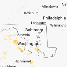
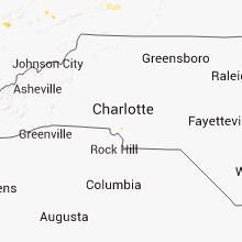
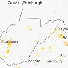
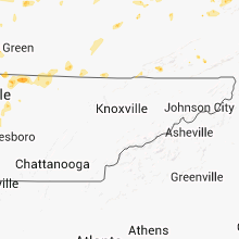
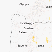
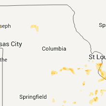
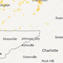
Hail Map for Sunday, July 8, 2012

Number of Impacted Households on 7/8/2012
0
Impacted by 1" or Larger Hail
0
Impacted by 1.75" or Larger Hail
0
Impacted by 2.5" or Larger Hail
Square Miles of Populated Area Impacted on 7/8/2012
0
Impacted by 1" or Larger Hail
0
Impacted by 1.75" or Larger Hail
0
Impacted by 2.5" or Larger Hail


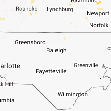


Cities Most Affected by Hail Storms of 7/8/2012
| Hail Size | Demographics of Zip Codes Affected | ||||||
|---|---|---|---|---|---|---|---|
| City | Count | Average | Largest | Pop Density | House Value | Income | Age |
| Madisonville, KY | 2 | 1.75 | 1.75 | 161 | $63k | $32.1k | 40.2 |
| Olive Branch, IL | 1 | 1.75 | 1.75 | 11 | $60k | $30.8k | 46.1 |
| Fredericksburg, VA | 1 | 1.75 | 1.75 | 607 | $136k | $57.8k | 35.1 |
| Bedford, IN | 1 | 1.75 | 1.75 | 152 | $76k | $35.9k | 41.9 |
| Dupo, IL | 1 | 1.75 | 1.75 | 652 | $72k | $41.9k | 36.5 |
Hail and Wind Damage Spotted on 7/8/2012
Filter by Report Type:Hail ReportsWind Reports
States Impacted
Indiana, West Virginia, South Carolina, Arkansas, Alabama, Illinois, Kentucky, Maryland, Virginia, Tennessee, Missouri, North Carolina, Kansas, Minnesota, Florida, Oregon, Colorado, Texas, Oklahoma, Delaware, Washington, District of ColumbiaIndiana
| Local Time | Report Details |
|---|---|
| 1:05 PM EDT | Metal roof in the road in harrison county IN, 31 miles NW of Louisville, KY |
| 1:20 PM EDT | Trees down on cars and in yard in harrison county IN, 16.9 miles NW of Louisville, KY |
| 1:20 PM EDT | Two trees down along whiskey run road and hwy 135 along and south of new salsbury in harrison county IN, 31 miles NW of Louisville, KY |
| 1:39 PM EDT | Golf Ball sized hail reported near Bedford, IN, 57.5 miles SSW of Indianapolis, IN, on state road 37 near monroe lawrenec county line |
| 2:17 PM EDT | A large tree has fallen on a vehicle and power lines are down in orange county IN, 61.1 miles NW of Louisville, KY |
| 2:30 PM EDT | Trees down. power lines down in lawrence county IN, 63 miles SSW of Indianapolis, IN |
| 2:30 PM EDT | 18-inch diameter healthy tree down along the side of state route 3 in monroe county IN, 54.4 miles SSW of Indianapolis, IN |
| 2:42 PM EDT | Norman station area in jackson county IN, 52.5 miles S of Indianapolis, IN |
| 2:52 PM EDT | 6 to 8 inch diameter limbs down in jackson county IN, 62.4 miles NNW of Louisville, KY |
| 2:52 PM EDT | 6 to 8 inch diameter limbs down in randolph county IN, 60 miles S of Fort Wayne, IN |
| 3:04 PM EDT | Two trees were downed across the county. one fell in campbellsburg. the other fell in delaney park in western washington count in washington county IN, 54.4 miles NNW of Louisville, KY |
| 3:08 PM EDT | Quarter sized hail reported near Lyons, IN, 69.6 miles NNE of Evansville, IN |
| 3:13 PM EDT | 12 to 14 inch diameter tree uprooted on lake road in jackson county IN, 60.7 miles NNW of Louisville, KY |
| 3:31 PM EDT | Tree dow in crawford county IN, 37.5 miles WNW of Louisville, KY |
| 3:46 PM EDT | Hwy 37 and rockport r in monroe county IN, 47.6 miles SSW of Indianapolis, IN |
| 4:04 PM EDT | Trees down in the english area in crawford county IN, 46.9 miles WNW of Louisville, KY |
| 5:05 PM EDT | Numerous trees and power lines down in fayette county IN, 45.5 miles E of Indianapolis, IN |
| 5:35 PM EDT | Tree reported dow in scott county IN, 47.6 miles N of Louisville, KY |
West Virginia
| Local Time | Report Details |
|---|---|
| 1:25 PM EDT | Several trees down in morgan county WV, 81 miles WNW of Baltimore, MD |
| 1:36 PM EDT | Trees and wires down in berkeley county WV, 76 miles WNW of Baltimore, MD |
| 2:20 PM EDT | Trees down along rte 57. power outages in and around philippi in barbour county WV, 18.7 miles NW of Elkins, WV |
| 2:23 PM EDT | Several trees down in berkeley county WV, 81.3 miles W of Baltimore, MD |
| 2:26 PM EDT | Quarter sized hail reported near Harpers Ferry, WV, 61.2 miles W of Baltimore, MD, 0.6 mi w of harpers ferry |
| 3:10 PM EDT | Power lines down across interstate 64 at the 5th street exit. west bound lanes close in cabell county WV, 43.1 miles W of Charleston, WV |
| 3:19 PM EDT | Powerlines down on potomac r in morgan county WV, 80.2 miles S of State College, PA |
| 3:19 PM EDT | Large limbs down in morgan county WV, 81.9 miles S of State College, PA |
| 3:35 PM EDT | Multiple trees dow in wayne county WV, 51.2 miles W of Charleston, WV |
| 3:46 PM EDT | Limbs dow in hampshire county WV, 64.4 miles ENE of Elkins, WV |
| 4:10 PM EDT | Tree down across i77 southbound lanes near sissonvill in kanawha county WV, 10.3 miles N of Charleston, WV |
| 4:15 PM EDT | Trees down across the road at pennsylvania ave and main s in kanawha county WV, 10 miles WNW of Charleston, WV |
| 4:17 PM EDT | Multiple trees down in tornado. trees down across coal river r in kanawha county WV, 12.1 miles W of Charleston, WV |
| 4:20 PM EDT | Power lines down in jefferso in kanawha county WV, 7.9 miles WNW of Charleston, WV |
| 4:40 PM EDT | Quarter sized hail reported near Charleston, WV, 5.6 miles SSW of Charleston, WV |
| 4:46 PM EDT | Tree down. dupont ave in kanawha county WV, 9.9 miles SSE of Charleston, WV |
| 4:50 PM EDT | Trees down on houses on veneble ave and washington ave between 42nd and 45th streets in kanawha cit in kanawha county WV, 0.5 miles E of Charleston, WV |
| 4:50 PM EDT | Trees down on maccorkle av in kanawha county WV, 10.5 miles SSE of Charleston, WV |
| 4:55 PM EDT | Power lines down. power ou in kanawha county WV, 14.5 miles SE of Charleston, WV |
| 5:30 PM EDT | Trees down on power lines. power poles dow in boone county WV, 31.1 miles S of Charleston, WV |
| 5:39 PM EDT | Numerous trees down throughout the city as well as throughout the count in fayette county WV, 36.9 miles SE of Charleston, WV |
| 5:40 PM EDT | Tree and power lines down on a house in oak hil in fayette county WV, 36.9 miles SE of Charleston, WV |
| 12:07 AM EDT | Trees dow in hardy county WV, 62.8 miles E of Elkins, WV |
South Carolina
| Local Time | Report Details |
|---|---|
| 2:20 PM EDT | Trees down in park and lightning started forest fir in pickens county SC, 15.1 miles NNW of Greenville, SC |
| 3:40 PM EDT | Trees down along sc28 near the ga state lin in oconee county SC, 32.9 miles W of Greenville, SC |
| 4:10 PM EDT | Trees down on power lines in spartanburg county SC, 39.6 miles ENE of Greenville, SC |
Arkansas
| Local Time | Report Details |
|---|---|
| 1:30 PM CDT | Local coordinator reported roof damage on several houses. also...trees were blown down onto power line in cleburne county AR, 56.4 miles NNE of Little Rock, AR |
| 1:30 PM CDT | Several trees down in wilbur in cleburne county AR, 56.4 miles NNE of Little Rock, AR |
| 1:35 PM CDT | Quarter sized hail reported near Judsonia, AR, 58 miles NE of Little Rock, AR |
| 2:09 PM CDT | Multiple trees down in the lake sylvia recreation area. large limbs are also down. half inch hail was also seen in addition to damaging wind in perry county AR, 32.1 miles WNW of Little Rock, AR |
| 2:11 PM CDT | A few trees down across us 65 just south of damascu in faulkner county AR, 42.2 miles N of Little Rock, AR |
| 2:39 PM CDT | Thunderstorm winds snapped several trees and caused minor roof damage to several houses. lawn furniture was thrown around 300 fee in izard county AR, 84.4 miles N of Little Rock, AR |
| 2:43 PM CDT | Thunderstorm winds hit a truck broadside...pushing it off the road and into a ditc in independence county AR, 67.4 miles NNE of Little Rock, AR |
| 2:47 PM CDT | Trees down and multiple barns have sustained damag in stone county AR, 81.9 miles N of Little Rock, AR |
| 3:00 PM CDT | Trees down on powerlines east of waldro in scott county AR, 41.2 miles SSE of Fort Smith, AR |
| 3:09 PM CDT | Trees downed some powerlines in chickala in yell county AR, 64 miles WNW of Little Rock, AR |
| 3:15 PM CDT | Trees down across collietown road 2 miles west of cushma in independence county AR, 81 miles NNE of Little Rock, AR |
| 3:21 PM CDT | Trees and powerlines down in waldron and also 5 miles wsw in winfiel in scott county AR, 38.3 miles SSE of Fort Smith, AR |
| 3:30 PM CDT | Trees uprooted and roof taken off barn and another outbuilding. barn door also blown of in benton county AR, 62.6 miles N of Fort Smith, AR |
| 3:30 PM CDT | Securely attached large barn door blown 75 to 100 yards in benton county AR, 63.8 miles N of Fort Smith, AR |
| 3:33 PM CDT | Quarter sized hail reported near Glenwood, AR, 31.4 miles NNE of Nashville, AR, hail estimated to be the size of quarters on the northwest side of glenwood. |
| 3:50 PM CDT | Trees were reported down along hwy 15 in yell county AR, 55.7 miles WNW of Little Rock, AR |
| 3:54 PM CDT | Powerlines down 2 miles ne of range in yell county AR, 64.7 miles WNW of Little Rock, AR |
| 3:58 PM CDT | Trees and power lines are down across hardy. lots of reports of people without powe in sharp county AR, 90.9 miles S of Salem, MO |
| 3:58 PM CDT | A tree was blown onto hwy 65 north of omah in boone county AR, 50.6 miles S of Springfield, MO |
| 4:08 PM CDT | Tree in carroll county AR, 49.7 miles S of Springfield, MO |
| 4:16 PM CDT | Trees and powerlines down in beaucham in scott county AR, 40.9 miles S of Fort Smith, AR |
Alabama
| Local Time | Report Details |
|---|---|
| 1:40 PM CDT | A tree fell on a power line near the intersection of south green mountain road and joel driv in madison county AL, 69 miles ESE of Florence, AL |
Illinois
| Local Time | Report Details |
|---|---|
| 2:00 PM CDT | Relayed by lawrence co ema in lawrence county IL, 44.6 miles NNW of Evansville, IN |
| 2:05 PM CDT | A tree was blown down 2 miles northwest of st. francisvill in lawrence county IL, 44 miles N of Evansville, IN |
| 2:05 PM CDT | Tree limbs were blown down onto power lines on billett road south of lawrencevill in lawrence county IL, 49 miles N of Evansville, IN |
| 3:10 PM CDT | Power lines were blown down onto east 600th avenue about 3 miles south of newto in jasper county IL, 39.1 miles SSE of Mattoon, IL |
| 3:15 PM CDT | A tree was blown down at the il 33/49 junction about 6 miles e/ne of newto in jasper county IL, 36.1 miles SSE of Mattoon, IL |
| 3:55 PM CDT | 4 inch diameter tree limbs dow in clinton county IL, 36.8 miles E of Saint Louis, MO |
| 4:05 PM CDT | Trees were blown in lawrence county IL, 52.5 miles SSE of Mattoon, IL |
| 4:30 PM CDT | A few large trees uprooted while large tree branches of 4 to 8 inches were snapped. microbursts occurred in two corn fields flattened corn stalk in clinton county IL, 39.9 miles E of Saint Louis, MO |
| 5:20 PM CDT | Also some small hail in perry county IL, 50.9 miles NNE of Cape Girardeau, MO |
| 5:23 PM CDT | Small tree limbs dow in randolph county IL, 39.9 miles SSE of Saint Louis, MO |
| 5:42 PM CDT | 8 inch diamter tree limbs dow in randolph county IL, 41.9 miles S of Saint Louis, MO |
| 6:23 PM CDT | Trees down in waterloo on the 400 block of west mill road. time estimated from radar. report relayed by local medi in monroe county IL, 20.6 miles S of Saint Louis, MO |
| 6:54 PM CDT | Golf Ball sized hail reported near Olive Branch, IL, 14.1 miles SE of Cape Girardeau, MO, this was occurring at horseshoe lake |
| 6:59 PM CDT | Golf Ball sized hail reported near Dupo, IL, 7.5 miles S of Saint Louis, MO |
| 7:00 PM CDT | Golf Ball sized hail reported near East Carondelet, IL, 6.4 miles SSW of Saint Louis, MO, golf ball size hail reported by amatteur radio operator in east carondelet |
Kentucky
| Local Time | Report Details |
|---|---|
| 3:00 PM EDT | A couple of trees down across the central part of the county. time estimated by rada in mason county KY, 52.4 miles SE of Cincinnati, OH |
| 3:12 PM EDT | Trees down across route 1 and route 2 in greenup county KY, 67.4 miles W of Charleston, WV |
| 3:15 PM EDT | Trees down on power lines. power outage in boyd county KY, 52.3 miles W of Charleston, WV |
| 3:20 PM EDT | Trees down and power outages throughout the city in greenup county KY, 59.8 miles WNW of Charleston, WV |
| 3:20 PM EDT | Trees reported down. one on a car. also power lines dow in bullitt county KY, 10.9 miles S of Louisville, KY |
| 3:45 PM EDT | Numerous trees down and roof damage to porc in fleming county KY, 51.7 miles NNE of Irvine, KY |
| 3:55 PM EDT | One tree down on highway 3 in fleming county KY, 48 miles NNE of Irvine, KY |
| 3:57 PM EDT | Power lines down park ave and brown stree in hardin county KY, 16.8 miles SW of Louisville, KY |
| 4:08 PM EDT | Spotter reported dime sized hail and trees down across power lines in brandenbur in meade county KY, 25.3 miles W of Louisville, KY |
| 4:10 PM EDT | Two trees dow in nicholas county KY, 42.2 miles N of Irvine, KY |
| 4:15 PM EDT | Multiple trees down throughout tow in carter county KY, 60.3 miles NE of Irvine, KY |
| 4:30 PM EDT | Trees down across road in carter county KY, 70.7 miles W of Charleston, WV |
| 4:45 PM EDT | Several trees down in grant county KY, 32.3 miles S of Cincinnati, OH |
| 5:00 PM EDT | Trees down. also pea size hai in grant county KY, 43.6 miles S of Cincinnati, OH |
| 5:05 PM EDT | Numerous trees and power lines down in pendleton county KY, 31.6 miles SSE of Cincinnati, OH |
| 5:26 PM EDT | Large limbs were reported dow in gallatin county KY, 31.6 miles SSW of Cincinnati, OH |
| 5:27 PM EDT | Tree fell on mobile hom in hardin county KY, 33.5 miles SSW of Louisville, KY |
| 5:27 PM EDT | Trees and power lines down on highway 20 in morgan county KY, 34.3 miles ENE of Irvine, KY |
| 5:30 PM EDT | Trees down along hwy 70 in morgan county KY, 37.9 miles ENE of Irvine, KY |
| 5:35 PM EDT | Tree fell and broke power line and power pol in wolfe county KY, 29.2 miles ENE of Irvine, KY |
| 5:39 PM EDT | Trees were reported down along highway 4 in gallatin county KY, 25.3 miles SW of Cincinnati, OH |
| 5:40 PM EDT | A tree fell across state highway 1940. another tree was cleared from highway 1935 about 6 miles west of pari in bourbon county KY, 43.6 miles NNW of Irvine, KY |
| 6:04 PM EDT | Tree down on raintree driv in madison county KY, 17.5 miles W of Irvine, KY |
| 5:14 PM CDT | The monroe county judge reported a house damaged by winds along state highway 63 west of tompkinsvill in monroe county KY, 68 miles ENE of Nashville, TN |
| 6:30 PM EDT | A tree fell across kentucky highway 32 near myers. another tree fell across kentucky highway 1244 in northern nicholas count in nicholas county KY, 44.9 miles N of Irvine, KY |
| 5:45 PM CDT | Golf Ball sized hail reported near Madisonville, KY, 48.1 miles S of Evansville, IN |
| 6:00 PM CDT | A few trees down. one on a house...one on a road in christian county KY, 61.5 miles NW of Nashville, TN |
| 6:10 PM CDT | Golf Ball sized hail reported near Madisonville, KY, 48.1 miles S of Evansville, IN |
| 6:15 PM CDT | Large limbs down in hopkins county KY, 48.8 miles S of Evansville, IN |
| 7:15 PM EDT | One tree down on hwy 89 sout in jackson county KY, 19.4 miles S of Irvine, KY |
| 7:17 PM EDT | Roof off of buildings and multiple trees down. espotter report via mount victory fire department personne in pulaski county KY, 51.6 miles SSW of Irvine, KY |
| 7:40 PM EDT | A tree fell across state highway 1940. another tree was cleared from highway 1935 about 6 miles west of pari in bourbon county KY, 43.6 miles NNW of Irvine, KY |
| 6:42 PM CDT | Power lines down on a hom in cumberland county KY, 85.5 miles ENE of Nashville, TN |
| 7:51 PM EDT | Tree fell on house on may stree in pulaski county KY, 55.2 miles SW of Irvine, KY |
| 7:51 PM EDT | Trees down on gentry lane in somerse in pulaski county KY, 55.2 miles SW of Irvine, KY |
| 7:55 PM EDT | Trees down near intersection of highway 39 and country acres driv in pulaski county KY, 46.9 miles SW of Irvine, KY |
| 8:00 PM EDT | Trees down with powerlines down on a house in the zula and alpha communitie in wayne county KY, 81.3 miles NW of Knoxville, TN |
| 8:00 PM EDT | Powerlines down on highway 1247 south of science hil in pulaski county KY, 52.2 miles SW of Irvine, KY |
| 8:14 PM EDT | Trees down near intersection of gover lane and murphy avenu in pulaski county KY, 55.1 miles SW of Irvine, KY |
| 7:15 PM CDT | Trees down one mile north on highway 10 in monroe county KY, 64 miles ENE of Nashville, TN |
| 7:17 PM CDT | A downburst from a thunderstorm south of monroe county travelled north. several trees fell across roads in and around tompkinsvill in monroe county KY, 70.9 miles ENE of Nashville, TN |
| 7:21 PM CDT | Several trees downed by thunderstorm winds were removed from a couple of roads near corint in logan county KY, 42.2 miles N of Nashville, TN |
| 7:25 PM CDT | The county road crew reported several trees down across state highways 2160 and 100 in scottsville. another tree fell across kentucky highway 482 at the 8 mile marke in allen county KY, 51.5 miles NE of Nashville, TN |
| 7:28 PM CDT | Numerous trees dow in logan county KY, 40.2 miles N of Nashville, TN |
| 7:34 PM CDT | Tree fell on house and went through roof in logan county KY, 46.8 miles N of Nashville, TN |
| 9:15 PM EDT | Two trees down on hwy 167 in mccreary county KY, 55 miles NNW of Knoxville, TN |
| 9:25 PM EDT | One tree down on page cuttoff roa in bell county KY, 54.4 miles NNE of Knoxville, TN |
| 10:25 PM EDT | One tree down on hwy 84 in harlan county KY, 65.1 miles WNW of Bristol, TN |
Maryland
| Local Time | Report Details |
|---|---|
| 3:10 PM EDT | Trees down and heavy decorative urn blown ove in frederick county MD, 53.2 miles W of Baltimore, MD |
| 5:25 PM EDT | Tree down at gilroy and port tobacco r in charles county MD, 63.4 miles SSW of Baltimore, MD |
| 6:12 PM EDT | Tree down on wilson rd and plum pt r in calvert county MD, 47.2 miles S of Baltimore, MD |
| 6:14 PM EDT | Trees down on adelina rd near hallowing point r in calvert county MD, 53.8 miles S of Baltimore, MD |
| 6:18 PM EDT | Trees down on morganza turner r in st. marys county MD, 62.3 miles S of Baltimore, MD |
| 7:11 PM EDT | Bishop head buoy in anz543 county MD, 52.6 miles W of Ocean City, MD |
| 10:25 PM EDT | A couple of trees down in caroline county MD, 46.1 miles ESE of Baltimore, MD |
Virginia
| Local Time | Report Details |
|---|---|
| 3:10 PM EDT | Trees down and heavy decorative urn blown ove in loudoun county VA, 53.6 miles W of Baltimore, MD |
| 3:26 PM EDT | Tree down on 1000 block of mt carmel rd in clarke county VA, 75.1 miles WSW of Baltimore, MD |
| 3:38 PM EDT | Large tree limbs down on rt 50 near horsefields ln in fauquier county VA, 70.8 miles WSW of Baltimore, MD |
| 3:44 PM EDT | Tree down on us highway 50 near wv state lin in frederick county VA, 83.2 miles ENE of Elkins, WV |
| 3:45 PM EDT | Numerous trees and power lines down in and around the delaplane area and towards marshall. largest trees were 16 to 20 inches in diamete in fauquier county VA, 76.2 miles WSW of Baltimore, MD |
| 3:53 PM EDT | Tree down at vantage hill rd and mediterranean ct in fairfax county VA, 45.5 miles WSW of Baltimore, MD |
| 4:02 PM EDT | Tree down blocking road on east side hwy in augusta county VA, 71.9 miles SE of Elkins, WV |
| 4:06 PM EDT | Trees down near leeds manor rd and crest hill rd in fauquier county VA, 82.2 miles WSW of Baltimore, MD |
| 4:06 PM EDT | Quarter sized hail reported near Hume, VA, 82.2 miles WSW of Baltimore, MD, trees down near leeds manor rd and crest hill rd |
| 4:17 PM EDT | Trees dow in fauquier county VA, 78.9 miles WSW of Baltimore, MD |
| 4:20 PM EDT | Dozens of trees and large limbs down on property near leeds manor r in fauquier county VA, 81.6 miles WSW of Baltimore, MD |
| 4:23 PM EDT | Tree down over grimsley rd due to strong thunderstorm wind in rappahannock county VA, 86.5 miles WSW of Baltimore, MD |
| 4:23 PM EDT | Tree down across north poes road due to strong thunderstorm wind in rappahannock county VA, 84.1 miles WSW of Baltimore, MD |
| 4:24 PM EDT | Large tree down on house on toll house r in fairfax county VA, 46.6 miles SW of Baltimore, MD |
| 4:32 PM EDT | Trees down in culpeper county VA, 69.3 miles NNW of Richmond, VA |
| 4:32 PM EDT | Tree blocking route 231 near the madison county lin in rappahannock county VA, 78.8 miles NNW of Richmond, VA |
| 4:32 PM EDT | Large tree fell on house and ca in fairfax county VA, 47.6 miles SW of Baltimore, MD |
| 4:35 PM EDT | Several trees down near 3800 browns gap turnpike in albemarle county VA, 71.4 miles NW of Richmond, VA |
| 4:37 PM EDT | Large tree down on roa in prince william county VA, 66.4 miles SW of Baltimore, MD |
| 4:40 PM EDT | Tree down near urbanna in middlesex county VA, 59.6 miles E of Richmond, VA |
| 4:40 PM EDT | Trees down on ben venue rd in rappahannock county VA, 87.6 miles WSW of Baltimore, MD |
| 4:44 PM EDT | Tree down on sandy ridge rd and tree into power lines on dooms crossing r in augusta county VA, 77.1 miles WNW of Richmond, VA |
| 4:47 PM EDT | Tree down at 1500 poplar rd in stafford county VA, 66.2 miles N of Richmond, VA |
| 4:53 PM EDT | Numerous trees down between the 1000 and 1500 block of owensville rd in albemarle county VA, 64.1 miles NW of Richmond, VA |
| 4:53 PM EDT | Trees dow in prince william county VA, 59.4 miles SW of Baltimore, MD |
| 4:58 PM EDT | Trees down on prince william co pkwy near smoketown rd. relayed by medi in prince william county VA, 57.7 miles SW of Baltimore, MD |
| 5:01 PM EDT | Tree down along richmond road due to strong thunderstorm wind in rappahannock county VA, 83.8 miles NNW of Richmond, VA |
| 5:10 PM EDT | 2 trees down along laurel mills rd due to strong thunderstorm wind in rappahannock county VA, 82.1 miles NNW of Richmond, VA |
| 5:10 PM EDT | Tree down at salem church rd and senseny rd in clarke county VA, 79 miles W of Baltimore, MD |
| 5:10 PM EDT | Quarter sized hail reported near Winchester, VA, 83.6 miles W of Baltimore, MD |
| 5:18 PM EDT | Trees down on plank rd and edge valley rd in albemarle county VA, 62 miles WNW of Richmond, VA |
| 5:18 PM EDT | Quarter sized hail reported near Berryville, VA, 74.6 miles W of Baltimore, MD |
| 5:18 PM EDT | Quarter sized hail reported near Berryville, VA, 76.5 miles W of Baltimore, MD, 1 mi north of rt 7 and russell rd |
| 5:20 PM EDT | *** 7 inj *** a microburst with 80 mph westerly winds tore through an area 3 miles south of fredericksburg. on fleming st between lafayette blvd and route 1... a roof w in spotsylvania county VA, 52.9 miles N of Richmond, VA |
| 5:23 PM EDT | Quarter sized hail reported near Fredericksburg, VA, 53.2 miles N of Richmond, VA |
| 5:27 PM EDT | Tree down at the intersection of sensory rd and sensory glen dr in frederick county VA, 83.2 miles W of Baltimore, MD |
| 5:30 PM EDT | Trees uprooted on jeff davis hwy and harrison r in spotsylvania county VA, 52.8 miles N of Richmond, VA |
| 5:31 PM EDT | Chimney knocked off house in 100 block of brookland c in city of winchester county VA, 83.6 miles W of Baltimore, MD |
| 5:31 PM EDT | *** 2 inj *** structural collapse on fleming st off jeff davis hwy in spotsylvania county VA, 52.9 miles N of Richmond, VA |
| 5:31 PM EDT | Structural collapse on fleming st off jeff davis hwy in spotsylvania county VA, 52.9 miles N of Richmond, VA |
| 5:31 PM EDT | Golf Ball sized hail reported near Fredericksburg, VA, 52.9 miles N of Richmond, VA |
| 5:37 PM EDT | A few trees were down due to thunderstorm wind gust in spotsylvania county VA, 53.7 miles N of Richmond, VA |
| 5:37 PM EDT | Quarter sized hail reported near Fredericksburg, VA, 53.7 miles N of Richmond, VA |
| 5:38 PM EDT | Ping Pong Ball sized hail reported near Fredericksburg, VA, 52.5 miles NNE of Richmond, VA |
| 5:43 PM EDT | Half Dollar sized hail reported near Fredericksburg, VA, 52.5 miles NNE of Richmond, VA |
| 5:50 PM EDT | Tree down on port conway rd in king george county VA, 55.4 miles NNE of Richmond, VA |
| 5:58 PM EDT | Trees down vicinity of route 301 and va 17 in caroline county VA, 51.6 miles NNE of Richmond, VA |
| 6:10 PM EDT | Trees down in the supply road and quarter hill road area in essex county VA, 49.2 miles NE of Richmond, VA |
| 6:10 PM EDT | A few large limbs down on crocketts cove roa in wythe county VA, 59.6 miles WSW of Roanoke, VA |
| 6:15 PM EDT | Trees down in westmoreland county VA, 57.6 miles NE of Richmond, VA |
| 6:25 PM EDT | Large trees down and power poles snapped in half in prince george county VA, 31.1 miles SE of Richmond, VA |
| 6:25 PM EDT | Trees down and power poles snapped...metal gazebo destroye in prince george county VA, 31.1 miles SE of Richmond, VA |
| 7:00 PM EDT | Tree limbs and powerlines down on route 156 in prince george county south of route 460 in prince george county VA, 33 miles SE of Richmond, VA |
| 7:09 PM EDT | 3 trees down in chamblissburg. tree diameter were 8-10 inche in bedford county VA, 12.2 miles E of Roanoke, VA |
| 7:10 PM EDT | Numerous trees down along route 3 in prince george county VA, 35.9 miles SSE of Richmond, VA |
| 7:10 PM EDT | Powers lines down on parker road in bedford county VA, 22.6 miles ENE of Roanoke, VA |
| 7:10 PM EDT | Power lines down on rt 24 in bedford county VA, 13.3 miles E of Roanoke, VA |
| 7:30 PM EDT | Numerous trees down in king william county VA, 44.9 miles E of Richmond, VA |
| 8:05 PM EDT | Several trees down on south river road in rockbridge county VA, 48.3 miles NE of Roanoke, VA |
| 8:10 PM EDT | Trees and powerlines down in the christchurch area in middlesex county VA, 61.9 miles E of Richmond, VA |
| 8:10 PM EDT | Trees down on narrow passage road near rt 11 in botetourt county VA, 20.4 miles NE of Roanoke, VA |
| 11:13 PM EDT | Branches and limbs dow in frederick county VA, 81.4 miles ENE of Elkins, WV |
| 11:33 PM EDT | Branches and limbs dow in frederick county VA, 81.4 miles ENE of Elkins, WV |
| 11:44 PM EDT | Tree top snapped off and trees uprooted snapped nearb in warren county VA, 84.3 miles E of Elkins, WV |
| 1:02 AM EDT | Tree down along route 211 due to strong thunderstorm wind in culpeper county VA, 82 miles N of Richmond, VA |
| 1:07 AM EDT | Numerous trees dow in fauquier county VA, 78.9 miles WSW of Baltimore, MD |
Tennessee
| Local Time | Report Details |
|---|---|
| 2:30 PM CDT | Several trees were blown down between camden and interstate 4 in benton county TN, 30 miles ESE of Mc Kenzie, TN |
| 3:30 PM CDT | Several trees downed on old highway 48 in pinewoo in hickman county TN, 44.7 miles WSW of Nashville, TN |
| 3:40 PM CDT | Ema reports tree down across hwy 48 about 12-15 miles north of centervill in hickman county TN, 39.8 miles WSW of Nashville, TN |
| 4:17 PM CDT | Multiple trees reported down across fairview rd and surrounding roads. reported by williamson county ema in williamson county TN, 21.4 miles WSW of Nashville, TN |
| 4:20 PM CDT | Public report of 2 trees down on maplewood trace near briley parkway and i6 in davidson county TN, 3.6 miles N of Nashville, TN |
| 5:13 PM CDT | Report of tree down at davis park and windellwood drive. 1 mile s of smyrna. reported by smyrna p in rutherford county TN, 19.9 miles SE of Nashville, TN |
| 5:16 PM CDT | At 201 grizzard avenue...a tree knocked down wires...and at 401 springview drive...a tree fell onto power line in davidson county TN, 0.2 miles NNW of Nashville, TN |
| 5:20 PM CDT | Several trees...along with power lines...and traffic wires downed in southern davidson count in davidson county TN, 6.8 miles S of Nashville, TN |
| 5:25 PM CDT | Trees and power lines downed across the count in smith county TN, 47.3 miles E of Nashville, TN |
| 5:28 PM CDT | Numerous traffic light wires were downed and power out at intersections in west nashvill in davidson county TN, 0.2 miles NNW of Nashville, TN |
| 5:46 PM CDT | Tree down reported at linwood rd and roberts ln. 3 miles nw of watertow in wilson county TN, 33 miles E of Nashville, TN |
| 5:51 PM CDT | Multiple tree down reports at 4200 and 4600 trousdale ferry rd. another report on linwood rd 5 miles e of lebano in wilson county TN, 30.8 miles E of Nashville, TN |
| 5:59 PM CDT | Tree down at 2340 bluebird rd. 3 miles e of lebano in wilson county TN, 28.6 miles E of Nashville, TN |
| 6:00 PM CDT | Trees and power lines downed across eastern portions of the count in rutherford county TN, 30.9 miles SE of Nashville, TN |
| 6:01 PM CDT | Tree down at 2340 bluebird rd. 3 miles e of lebano in wilson county TN, 28.6 miles E of Nashville, TN |
| 6:08 PM CDT | Tree down reported at linwood rd and roberts ln. 3 miles nw of watertow in wilson county TN, 33 miles E of Nashville, TN |
| 7:00 PM CDT | Trees downed across the count in macon county TN, 48.3 miles ENE of Nashville, TN |
| 7:00 PM CDT | Trees were downed on mccormick ridge road and baptist ridge road in the union hill communit in clay county TN, 66.7 miles ENE of Nashville, TN |
| 7:00 PM CDT | Trees downed across western portions of the count in clay county TN, 71.3 miles ENE of Nashville, TN |
| 7:08 PM CDT | A few trees were downed on roadways across the count in clay county TN, 76 miles ENE of Nashville, TN |
| 7:43 PM CDT | Two large trees were downed and blocking windle community road near livingsto in overton county TN, 82.3 miles E of Nashville, TN |
| 8:30 PM CDT | Several trees were downed across the count in montgomery county TN, 41.8 miles NW of Nashville, TN |
| 10:30 PM CDT | Delayed report from sunday 7/8. numerous trees and large tree limbs blown down in hermitage along old hickory blvd and in donelson on lebanon road and stewarts ferry pi in davidson county TN, 9 miles E of Nashville, TN |
Missouri
| Local Time | Report Details |
|---|---|
| 2:37 PM CDT | Trees down near the intersection of highway 52 and route p in miller county MO, 51.2 miles S of Columbia, MO |
| 3:40 PM CDT | Storm damage reported in taney county MO, 45.6 miles S of Springfield, MO |
| 3:52 PM CDT | Wind gust of 63 mph measured at branson airport control towe in taney county MO, 45.6 miles S of Springfield, MO |
| 4:00 PM CDT | Three mobile homes heavily damaged. tree down on another mobile hom in polk county MO, 30.4 miles NNW of Springfield, MO |
| 4:12 PM CDT | Trees down in villa ridge with around 2500 without power in franklin count in franklin county MO, 38.4 miles WSW of Saint Louis, MO |
| 4:12 PM CDT | Trees down in villa ridge with around 2500 without power in franklin county. time estimated from rada in franklin county MO, 38.4 miles WSW of Saint Louis, MO |
| 4:22 PM CDT | Numerous three inch tree limbs down in unio in franklin county MO, 45.6 miles WSW of Saint Louis, MO |
| 4:37 PM CDT | Several trees down near the town of else in stone county MO, 28.3 miles SSW of Springfield, MO |
| 5:25 PM CDT | Trees and powerlines down in the goodhope are in douglas county MO, 33.7 miles SE of Springfield, MO |
| 6:10 PM CDT | Tree dow in newton county MO, 50.7 miles WSW of Springfield, MO |
| 7:00 PM CDT | Tree limbs of 4 to 6 inch diameter down by winds associated with the leading storm outflo in st. louis county MO, 7.5 miles WSW of Saint Louis, MO |
| 7:15 PM CDT | Two to four inch diameter tree limbs dow in st. louis county MO, 11 miles SW of Saint Louis, MO |
| 7:35 PM CDT | Tree branches of 6 to 8 inch diameter were down. hail of 0.50 inch fell at this locatio in st. louis county MO, 11 miles SW of Saint Louis, MO |
| 7:41 PM CDT | Wind set measured gusts to 62 mp in st. louis county MO, 7.5 miles WSW of Saint Louis, MO |
| 7:43 PM CDT | Quarter sized hail reported near St Louis, MO, 11 miles SW of Saint Louis, MO |
| 8:00 PM CDT | Tree down and house damage in affton around 8 pm. report relayed by local broadcast medi in st. louis county MO, 8.9 miles SW of Saint Louis, MO |
North Carolina
| Local Time | Report Details |
|---|---|
| 3:45 PM EDT | Two trees blocking johnston rd near hwy 51. other trees down in the same area. reported via social medi in mecklenburg county NC, 10 miles S of Charlotte, NC |
| 4:50 PM EDT | Trees blown down near highway 52 and state road 1637. time estimate in anson county NC, 41.4 miles ESE of Charlotte, NC |
| 4:55 PM EDT | Trees blown down near highway 52 and state road 1641. time estimate in anson county NC, 44.4 miles ESE of Charlotte, NC |
| 6:35 PM EDT | One tree blown down near the intersection of glebe road and dabney road. time estimate in vance county NC, 40.6 miles NNE of Raleigh, NC |
| 6:45 PM EDT | Two trees blown down near u.s. 401 and parktown road. time estimate in warren county NC, 45.3 miles NNE of Raleigh, NC |
Kansas
| Local Time | Report Details |
|---|---|
| 3:50 PM CDT | Storm damage reported in jefferson county KS, 33.3 miles W of Kansas City, MO |
| 3:56 PM CDT | Delayed report...large tree limbs down near reno...winds estimated to 60 mph in leavenworth county KS, 29.1 miles W of Kansas City, MO |
| 4:20 PM CDT | 60 mph wind gusts and nickel sized hail reported by law enforcement in douglas county KS, 30 miles WSW of Kansas City, MO |
| 4:22 PM CDT | Quarter sized hail reported near Eudora, KS, 31 miles WSW of Kansas City, MO |
| 7:40 PM CDT | Storm damage reported in cherokee county KS, 53.6 miles SE of Chanute, KS |
| 7:40 PM CDT | Storm damage reported in cherokee county KS, 53.7 miles SE of Chanute, KS |
Minnesota
| Local Time | Report Details |
|---|---|
| 4:21 PM CDT | A few trees were blown down near a boat landing on big birch lake in todd county MN, 75.2 miles NE of Montevideo, MN |
Florida
| Local Time | Report Details |
|---|---|
| 5:45 PM EDT | Quarter sized hail reported near Orlando, FL, 6.4 miles WSW of Orlando, FL, quarter sized hail reported at the metrowest golf club on hiawassee road in orlando. |
| 5:50 PM EDT | Quarter sized hail reported near Orlando, FL, 7.7 miles WSW of Orlando, FL, quarter sized hail observed in courtleigh park in dr. phillips. damage to residential pool screen from hail. |
| 6:15 PM EDT | A large rotten oak tree fell on a house damaging the roof on wekiva chase blvd in apopk in orange county FL, 11.6 miles NNW of Orlando, FL |
Oregon
| Local Time | Report Details |
|---|---|
| 3:57 PM PDT | Quarter sized hail reported near La Pine, OR, 51.3 miles SW of Bend, OR |
| 4:00 PM PDT | Strong winds heavy rain lightning and thunder reported. power pole 8 to 10 inches in diameter knocked dow in wheeler county OR, 55.9 miles NE of Bend, OR |
| 4:10 PM PDT | Quarter sized hail reported near La Pine, OR, 50.9 miles SW of Bend, OR, received quarter sized hail. temperature dropped from 90 to 66 degrees. elev 4255 ft. de-235. |
| 5:30 PM PDT | Ping Pong Ball sized hail reported near Camp Sherman, OR, 43.2 miles W of Bend, OR, at sutter lodge reported silver dollar size hail. |
Colorado
| Local Time | Report Details |
|---|---|
| 5:05 PM MDT | Penny size hail was also reported with this stor in baca county CO, 114 miles ESE of Pueblo, CO |
Texas
| Local Time | Report Details |
|---|---|
| 6:54 PM CDT | Quarter sized hail reported near Texarkana, TX, 37.1 miles SSW of Nashville, AR, strong winds estimated at 50-70 mph and nickel to quarter size hail in nash |
Oklahoma
| Local Time | Report Details |
|---|---|
| 6:59 PM CDT | Shed type building blown over and 6 inch diameter tree uprooted. report relayed by medi in cherokee county OK, 49 miles ESE of Tulsa, OK |
| 7:15 PM CDT | Barn roof damage and shed blown a half mile. estimated winds of 70 mp in washington county OK, 31.1 miles N of Tulsa, OK |
| 7:40 PM CDT | 8 inch diameter tree limbs broken in delaware county OK, 68.1 miles ENE of Tulsa, OK |
| 8:25 PM CDT | Measured wind gust at the miami mesonet of 71.4 mp in ottawa county OK, 63.9 miles SSE of Chanute, KS |
| 8:34 PM CDT | Downed tree limbs and sporadic power outages in town. estimated 60 to 70 mph wind in ottawa county OK, 64.3 miles SSE of Chanute, KS |
Delaware
| Local Time | Report Details |
|---|---|
| 8:58 PM EDT | Trees down in sussex county DE, 30.2 miles WNW of Ocean City, MD |
Washington
| Local Time | Report Details |
|---|---|
| 8:00 PM PDT | Several tree limbs up to 12 inches in diameter reported dow in walla walla county WA, 1.5 miles WSW of Walla Walla, WA |
| 9:36 PM PDT | Thunderstorm with frequent lightning...gusty winds and heavy rain cause power outages in west valle in yakima county WA, 3 miles WSW of Yakima, WA |
| 9:40 PM PDT | Spotter reporting from downtown yakima reported power lines and trees down...heavy rain caused minor flooding...blown transformers and local 911 responding to structure in yakima county WA, 3.2 miles WSW of Yakima, WA |
| 10:00 PM PDT | Thunderstorm winds caused trees down on power lines and at least one home...wind gust estimated at 50 to 60 mph. el 1595 ft. co-2 in columbia county WA, 24.1 miles NE of Walla Walla, WA |
| 10:00 PM PDT | Power down tree limbs 6 to 8 inches in diameter down. ya-530 reporte in yakima county WA, 4.1 miles WSW of Yakima, WA |
District of Columbia
| Local Time | Report Details |
|---|---|
| 12:05 AM EDT | Tree dow in district of columb county DC, 37 miles SW of Baltimore, MD |
Connect with Interactive Hail Maps