

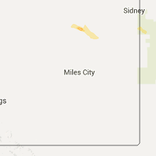
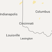
Hail Map for Sunday, June 26, 2016

Number of Impacted Households on 6/26/2016
0
Impacted by 1" or Larger Hail
0
Impacted by 1.75" or Larger Hail
0
Impacted by 2.5" or Larger Hail
Square Miles of Populated Area Impacted on 6/26/2016
0
Impacted by 1" or Larger Hail
0
Impacted by 1.75" or Larger Hail
0
Impacted by 2.5" or Larger Hail


Cities Most Affected by Hail Storms of 6/26/2016
| Hail Size | Demographics of Zip Codes Affected | ||||||
|---|---|---|---|---|---|---|---|
| City | Count | Average | Largest | Pop Density | House Value | Income | Age |
| Sutherland, NE | 3 | 2.00 | 2.50 | 3 | $74k | $38.9k | 40.6 |
| Overland Park, KS | 1 | 2.50 | 2.50 | 3764 | $189k | $87.2k | 34.8 |
| Stilwell, KS | 1 | 2.00 | 2.00 | 305 | $198k | $79.5k | 41.9 |
| Vernon, FL | 1 | 1.75 | 1.75 | 20 | $60k | $23.4k | 43.3 |
| Bucyrus, KS | 1 | 1.75 | 1.75 | 43 | $155k | $59.7k | 43.4 |
| Arthur, NE | 1 | 1.75 | 1.75 | 0 | $48k | $30.5k | 43.8 |
| Bates City, MO | 1 | 1.75 | 1.75 | 104 | $123k | $48.4k | 42.2 |
| Dickens, NE | 1 | 1.75 | 1.75 | 1 | $95k | $50.4k | 38.5 |
| Happy, TX | 1 | 1.75 | 1.75 | 1 | $37k | $32.6k | 41.3 |
| Olathe, KS | 1 | 1.75 | 1.75 | 1589 | $147k | $68.7k | 32.8 |
Hail and Wind Damage Spotted on 6/26/2016
Filter by Report Type:Hail ReportsWind Reports
States Impacted
Ohio, Missouri, Texas, Georgia, Florida, Minnesota, Oklahoma, Kansas, Alabama, North Carolina, Nebraska, ArizonaOhio
| Local Time | Report Details |
|---|---|
| 11:15 AM EDT | Numerous large branches and a few trees down in new albany... oh. one tree is blocking reynoldsburg-new albany road and fenway road. photo sent on social media. time es in franklin county OH, 12.7 miles NE of Columbus, OH |
| 11:15 PM EDT | Numerous large branches and a few trees down in new albany... oh. one tree is blocking reynoldsburg-new albany road and fenway road. photo sent on social media. time es in franklin county OH, 12.7 miles NE of Columbus, OH |
Missouri
| Local Time | Report Details |
|---|---|
| 12:30 PM CDT | Golf Ball sized hail reported near Bates City, MO, 28.3 miles ESE of Kansas City, MO, delayed report. hail golf ball sized or slightly larger and a few tree limbs down. |
| 12:30 PM CDT | Quarter sized hail reported near Bates City, MO, 31.1 miles ESE of Kansas City, MO |
| 12:30 PM CDT | Limbs blown off trees. lawn furniture blown off porch. power out at spotters locatio in lafayette county MO, 31.1 miles ESE of Kansas City, MO |
| 2:00 PM CDT | Large tree limb down on route 127. blocking right lan in pettis county MO, 59.6 miles W of Columbia, MO |
| 4:26 PM CDT | A likely microburst cause a significant amount of tree damage within and around the town of saint elizabeth. over 600 residences are without power at this tim in miller county MO, 47.9 miles S of Columbia, MO |
| 6:03 PM CDT | Severe thunderstorm winds downed a large limb three miles south of strafford. there was also nickel size hail at this same locatio in greene county MO, 9.5 miles E of Springfield, MO |
| 6:59 PM CDT | Severe thunderstorm wind gusts downed several large limbs along westwind road in far northern christian count in christian county MO, 9.2 miles SSE of Springfield, MO |
| 7:15 PM CDT | 4 inch tree limb blown down. time estimated by radar in jasper county MO, 65.6 miles SE of Chanute, KS |
| 7:43 PM CDT | Severe thunderstorm wind gusts downed numerous large tree limbs in the pomona area. the uno asos measured a 49 mph peak wind gust near the wind damag in howell county MO, 56.8 miles SSW of Salem, MO |
Texas
| Local Time | Report Details |
|---|---|
| 12:35 PM CDT | Golf Ball sized hail reported near Happy, TX, 32.2 miles S of Amarillo, TX, relayed from nws ama via nws chat. |
| 1:40 PM CDT | A large 4 to 6 inch diameter tree limb was blown down in the strong wind associated with the severe thunderstor in randall county TX, 15.7 miles S of Amarillo, TX |
| 5:28 PM CDT | Storm damage reported in brewster county TX, 56.2 miles SSE of Alpine, TX |
Georgia
| Local Time | Report Details |
|---|---|
| 1:42 PM EDT | Tree down on lawson mill pond roa in brooks county GA, 54.4 miles SW of Douglas, GA |
| 2:24 PM EDT | Two trees down on tallokas road...one at coffee road and one at highway 12 in brooks county GA, 52.9 miles NE of Tallahassee, FL |
| 2:37 PM EDT | Tree down took out powerlines on adams roa in brooks county GA, 48.5 miles NE of Tallahassee, FL |
| 3:10 PM EDT | 911 call center received report of 1 tree down on hwy 137 in taylor county GA, 66.3 miles E of Auburn, AL |
| 3:25 PM EDT | 911 call center received report of 1 tree down on the county border of taylor and marion countie in taylor county GA, 62.4 miles E of Auburn, AL |
| 3:30 PM EDT | Two trees down in mitchell county GA, 48.5 miles N of Tallahassee, FL |
| 3:45 PM EDT | 911 call center received report of 1 tree down on dr deryl hart rd just northeast of buena vist in marion county GA, 59.6 miles ESE of Auburn, AL |
| 4:12 PM EDT | 911 call center received report of 1 tree down on hannahs mill rd near the jeff davis intersection in upson county GA, 55.8 miles S of Atlanta, GA |
| 4:15 PM EDT | 911 call center received reports of 1 tree down on concord church rd...1 tree down on old hwy 19 s...and several trees down on highway 153 and dosier rd intersection in schley county GA, 73 miles ESE of Auburn, AL |
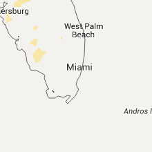
Florida
| Local Time | Report Details |
|---|---|
| 2:20 PM EDT | Broadcast media shared a viewer picture on social media of a couple of trees down in a yard and a trampoline tossed into a tree in bushnell. time was estimated based on in sumter county FL, 45.3 miles W of Orlando, FL |
| 2:30 PM EDT | Broadcast media video showed large tree limbs down along the selmon expressway west of brandon. time estimated from rada in hillsborough county FL, 32.5 miles NNE of Bradenton, FL |
| 2:30 PM EDT | Approx 300 foot long row of trees down along the selmon highway near the 78th street interchange. reported by spotter hil-1048. time estimated by rada in hillsborough county FL, 33.4 miles NNE of Bradenton, FL |
| 2:31 PM EDT | Mesonet station 1 se tampa /d3253 in hillsborough county FL, 32.1 miles NNE of Bradenton, FL |
| 3:00 PM EDT | Law enforcement report of 5 large trees 18-24 inches in diameter down. 1 of the trees fell on a vehicle and 2 others fell on an apartment buildin in citrus county FL, 57 miles W of Orlando, FL |
| 5:02 PM EDT | Trees and power lines down. one roof of a house damaged. reported by glades county sheriff office in glades county FL, 33.7 miles WSW of Port Saint Lucie, FL |
| 5:04 PM CDT | Golf Ball sized hail reported near Vernon, FL, 42.3 miles ENE of Miramar Beach, FL, golf ball hail reported via social media in vernon. |
| 5:09 PM CDT | Numerous trees and powerlines down in the vernon and wausau communitie in washington county FL, 42.3 miles ENE of Miramar Beach, FL |
| 5:43 PM CDT | Storm damage reported in walton county FL, 26.5 miles NE of Miramar Beach, FL |
| 7:49 PM CDT | Whiting field asos reported a 61mph wind gust with thunderstorm passage in santa rosa county FL, 45.6 miles WNW of Miramar Beach, FL |
Minnesota
| Local Time | Report Details |
|---|---|
| 3:04 PM CDT | Several large trees downed. time estimated by rada in aitkin county MN, 57.9 miles W of Duluth, MN |
Oklahoma
| Local Time | Report Details |
|---|---|
| 3:07 PM CDT | Estimated 60-65 mph wind gust in alfalfa county OK, 63.2 miles ENE of Woodward, OK |
| 4:35 PM CDT | Quarter sized hail reported near Fargo, OK, 17.4 miles W of Woodward, OK |
| 4:55 PM CDT | Storm damage reported in noble county OK, 65 miles WNW of Tulsa, OK |
| 5:25 PM CDT | Estimated 50 to 60 mph wind gus in jackson county OK, 55.7 miles ENE of Childress, TX |
| 6:10 PM CDT | Storm damage reported in woodward county OK, 13.4 miles NW of Woodward, OK |
Kansas
| Local Time | Report Details |
|---|---|
| 3:20 PM CDT | Quarter sized hail reported near Stilwell, KS, 19.2 miles S of Kansas City, MO |
| 3:25 PM CDT | Golf Ball sized hail reported near Bucyrus, KS, 22 miles SSW of Kansas City, MO |
| 3:29 PM CDT | Tennis Ball sized hail reported near Overland Park, KS, 16.1 miles SSW of Kansas City, MO, from social media photo. |
| 3:40 PM CDT | Half Dollar sized hail reported near Stilwell, KS, 18.5 miles S of Kansas City, MO, few hailstones...largest around 1.25 inches. |
| 3:46 PM CDT | Quarter sized hail reported near Coats, KS, 77.4 miles NNE of Woodward, OK, . |
| 3:46 PM CDT | Storm damage reported in barber county KS, 77.4 miles NNE of Woodward, OK |
| 3:50 PM CDT | Ping Pong Ball sized hail reported near Stilwell, KS, 19.7 miles SSW of Kansas City, MO, estimated from social media photo...near blue valley west high school |
| 3:54 PM CDT | Golf Ball sized hail reported near Olathe, KS, 19.4 miles SSW of Kansas City, MO, report from social media at 159th and switzer |
| 4:05 PM CDT | Hen Egg sized hail reported near Stilwell, KS, 18.7 miles SSW of Kansas City, MO, report via social media...size estimated from photo...occurred at 159th and metcalf |
| 4:40 PM CDT | Storm damage reported in barber county KS, 69.2 miles WSW of Wichita, KS |
| 5:16 PM CDT | Quarter sized hail reported near Eudora, KS, 28.9 miles SW of Kansas City, MO |
| 6:25 PM CDT | A few trees down 6 miles south of columbus in cherokee county KS, 53.5 miles SE of Chanute, KS |
Alabama
| Local Time | Report Details |
|---|---|
| 3:42 PM CDT | Trees were blown down near the intersection of oswichee road and greenburt roa in russell county AL, 31.4 miles SE of Auburn, AL |
| 6:01 PM CDT | Two small trees were blown down and a tractor barn was destroyed near clanton. winds were estimated around 50 mp in chilton county AL, 48 miles SSE of Birmingham, AL |
| 8:05 PM CDT | Reports of a tree on a house along harris street in atmor in escambia county AL, 41.4 miles NE of Mobile, AL |
North Carolina
| Local Time | Report Details |
|---|---|
| 5:52 PM EDT | 2 trees reported down on deep gap road ese of alarka... n in swain county NC, 50.7 miles SE of Knoxville, TN |
Nebraska
| Local Time | Report Details |
|---|---|
| 5:35 PM MDT | Quarter sized hail reported near Whitman, NE, 60.2 miles NW of North Platte, NE |
| 6:10 PM MDT | Golf Ball sized hail reported near Arthur, NE, 55.7 miles NW of North Platte, NE |
| 7:19 PM CDT | Quarter sized hail reported near Tryon, NE, 46.3 miles NNW of North Platte, NE |
| 8:10 PM CDT | Quarter sized hail reported near Sutherland, NE, 37 miles NW of North Platte, NE, time estimated from radar |
| 9:10 PM CDT | Est 60+ mph winds and nickel size hail in lincoln county NE, 19.2 miles W of North Platte, NE |
| 9:10 PM CDT | Golf Ball sized hail reported near Sutherland, NE, 19.2 miles W of North Platte, NE, estimated time of 910 pm. hail covered lawn and broke out a couple windows on house. |
| 9:15 PM CDT | Quarter sized hail reported near Hershey, NE, 16.1 miles WNW of North Platte, NE, pea to quarter size hail. time estimated by radar. via social media |
| 9:15 PM CDT | Quarter sized hail reported near Sutherland, NE, 22.2 miles WNW of North Platte, NE, pea to quarter size hail. time estimated by radar. via social media |
| 9:15 PM CDT | Tennis Ball sized hail reported near Sutherland, NE, 19.2 miles W of North Platte, NE, golf ball to tennis ball size hail with up to est 80mph winds. numerous tree branches down |
| 9:20 PM CDT | Golf Ball sized hail reported near Sutherland, NE, 19.2 miles W of North Platte, NE, *** 1 inj *** a small child sustained minor injuries from the hail while being taken to shelter. |
| 9:25 PM CDT | Numerous 6-8 in. dia. tree limbs and one power line down in lincoln county NE, 19.2 miles W of North Platte, NE |
| 9:30 PM CDT | Quarter sized hail reported near Sutherland, NE, 19.2 miles W of North Platte, NE, pea to quarter size hail and 60-70 mph winds |
| 9:40 PM CDT | Golf Ball sized hail reported near Dickens, NE, 18.4 miles SW of North Platte, NE, north windows broken out of house. time estimated by radar. via social media |
Arizona
| Local Time | Report Details |
|---|---|
| 7:20 PM MST | Ciity of tucson reports power lines down due to storms... mostly affecting the area around 1st and river and campbell and river. in addition a house fire was caused by in pima county AZ, 2.2 miles NE of Tucson, AZ |
Connect with Interactive Hail Maps