

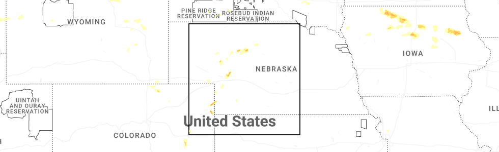
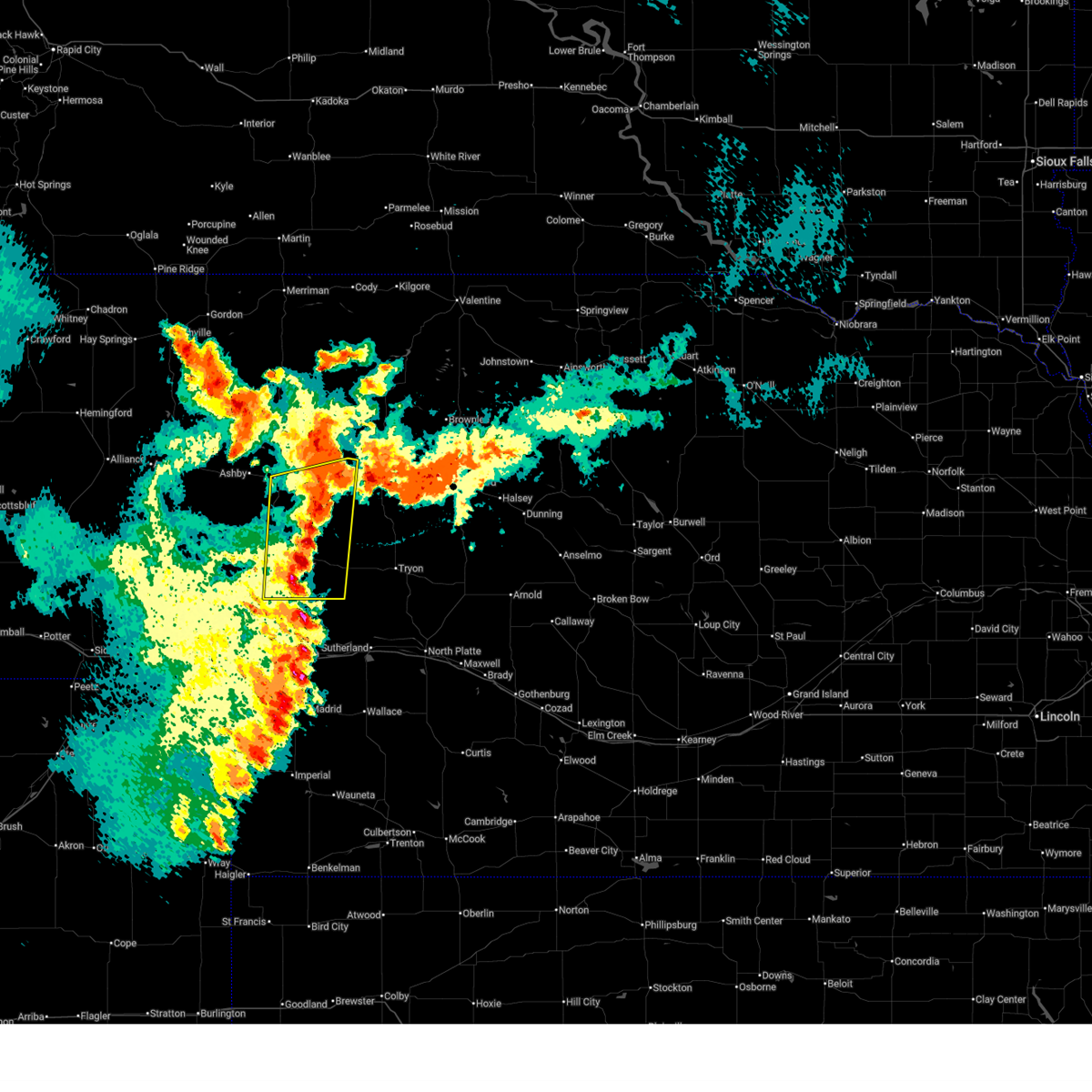
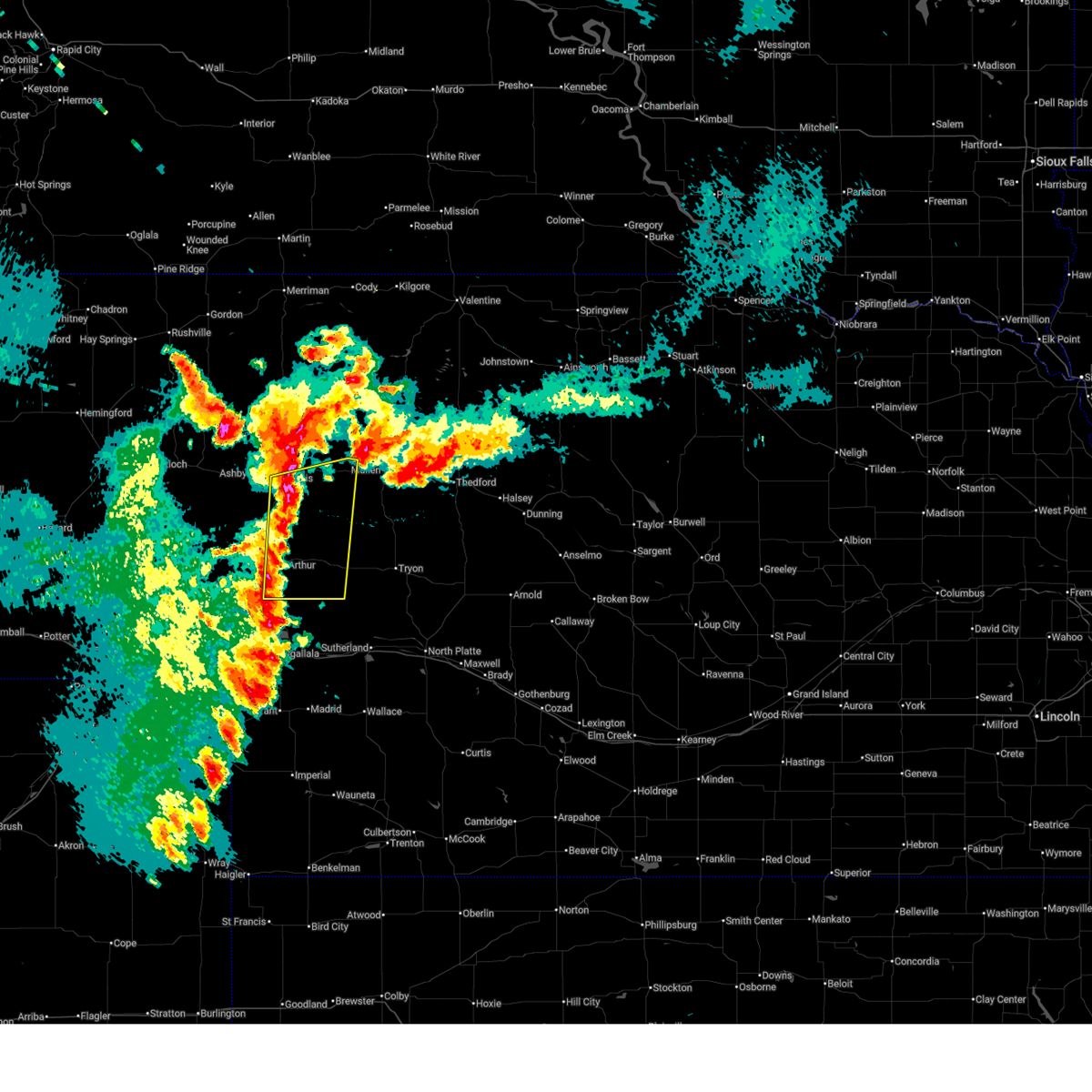
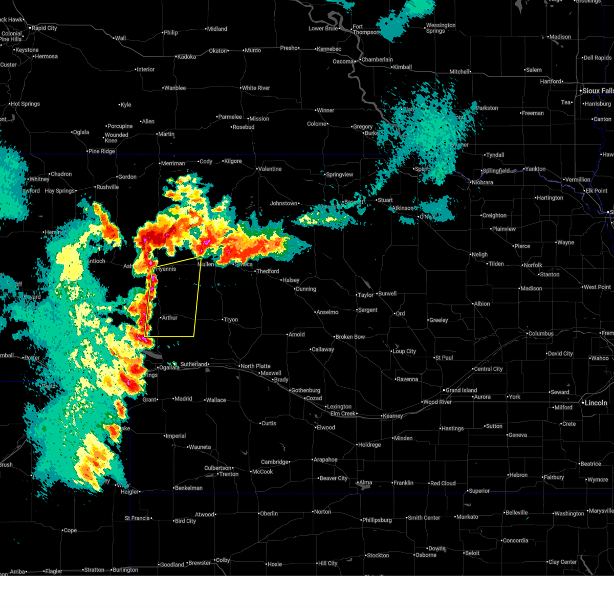
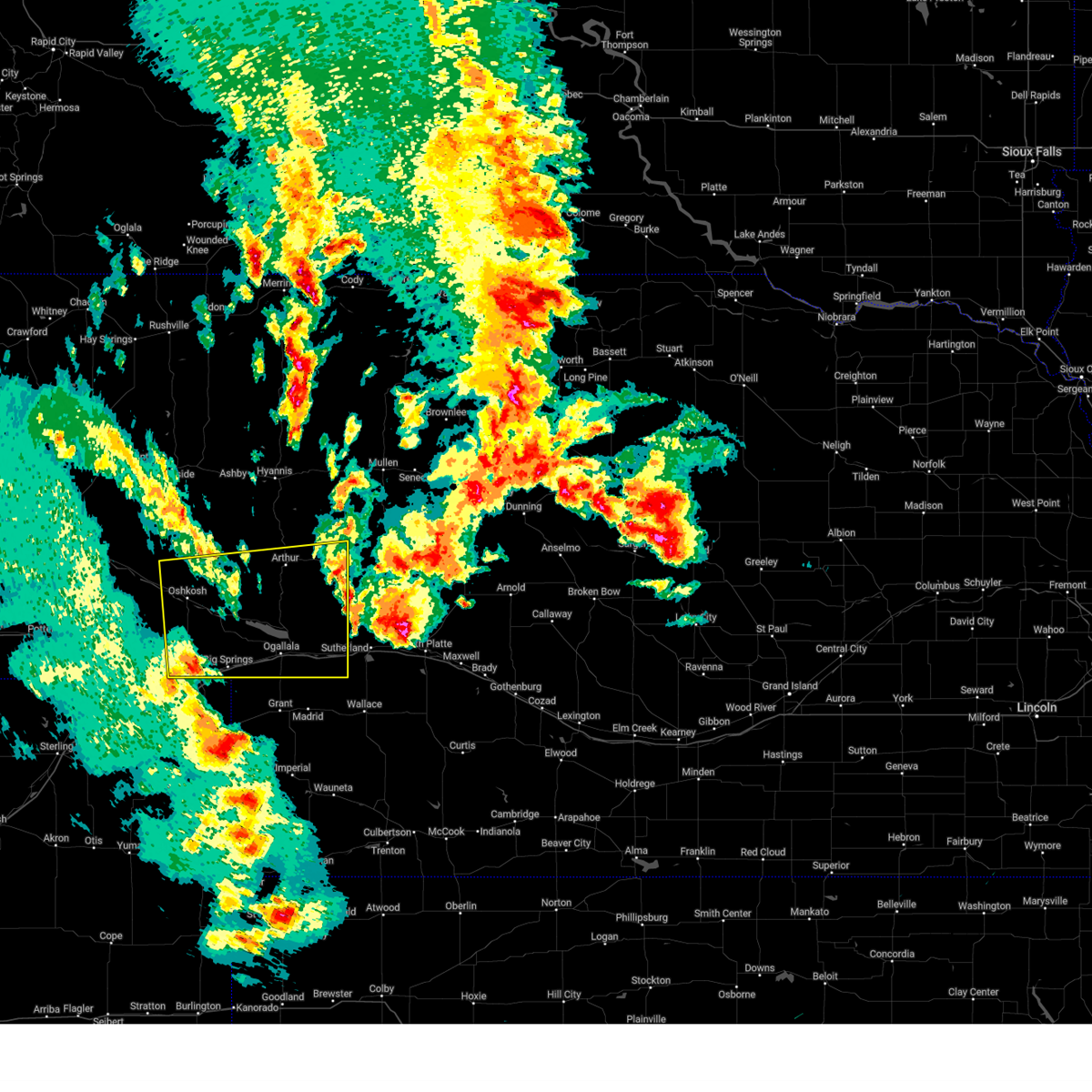
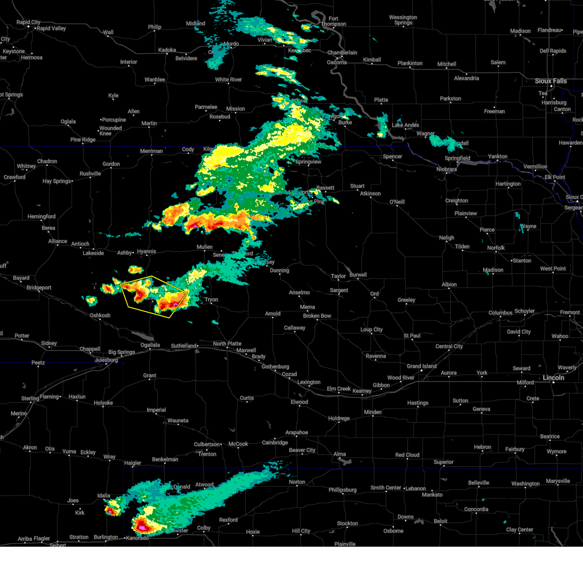
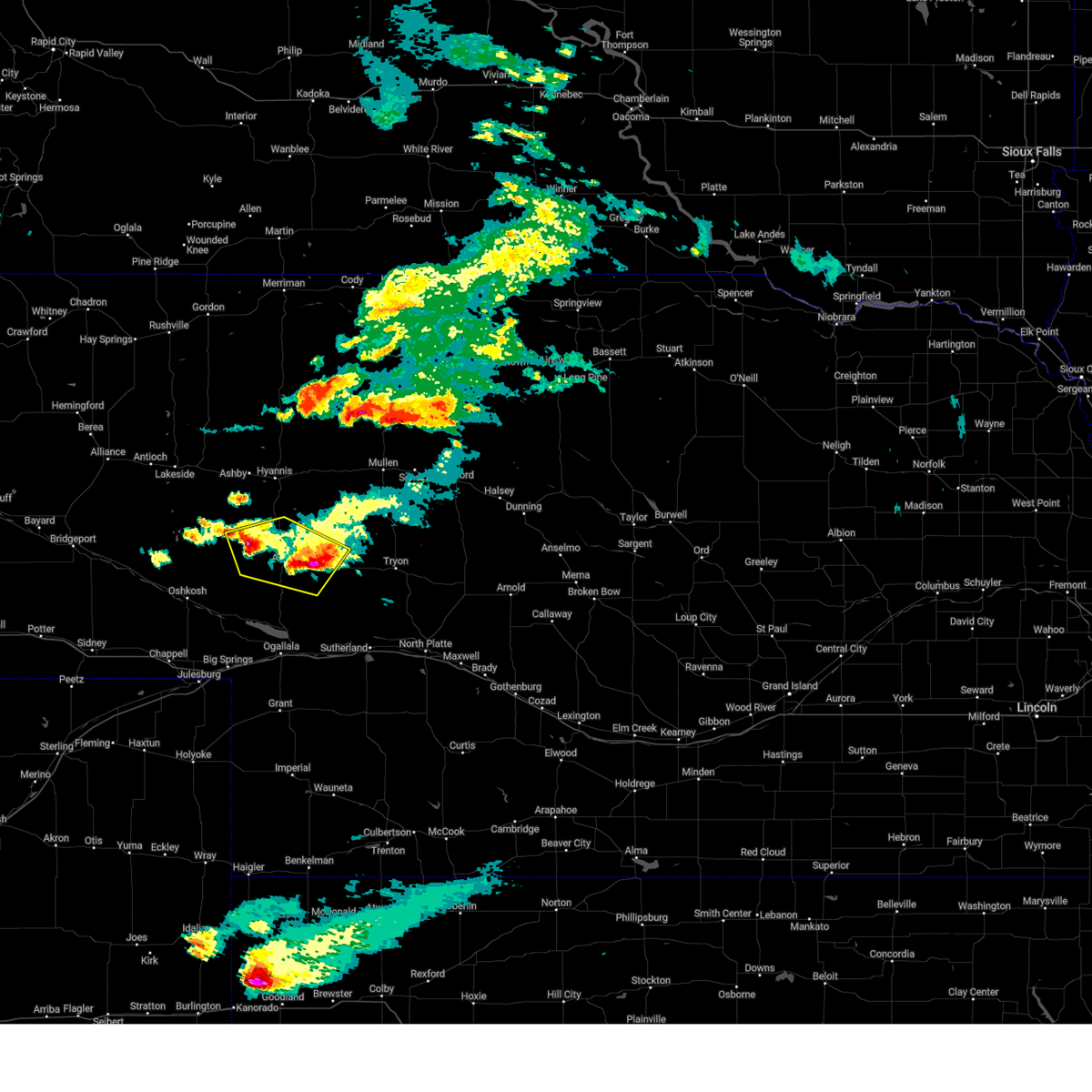
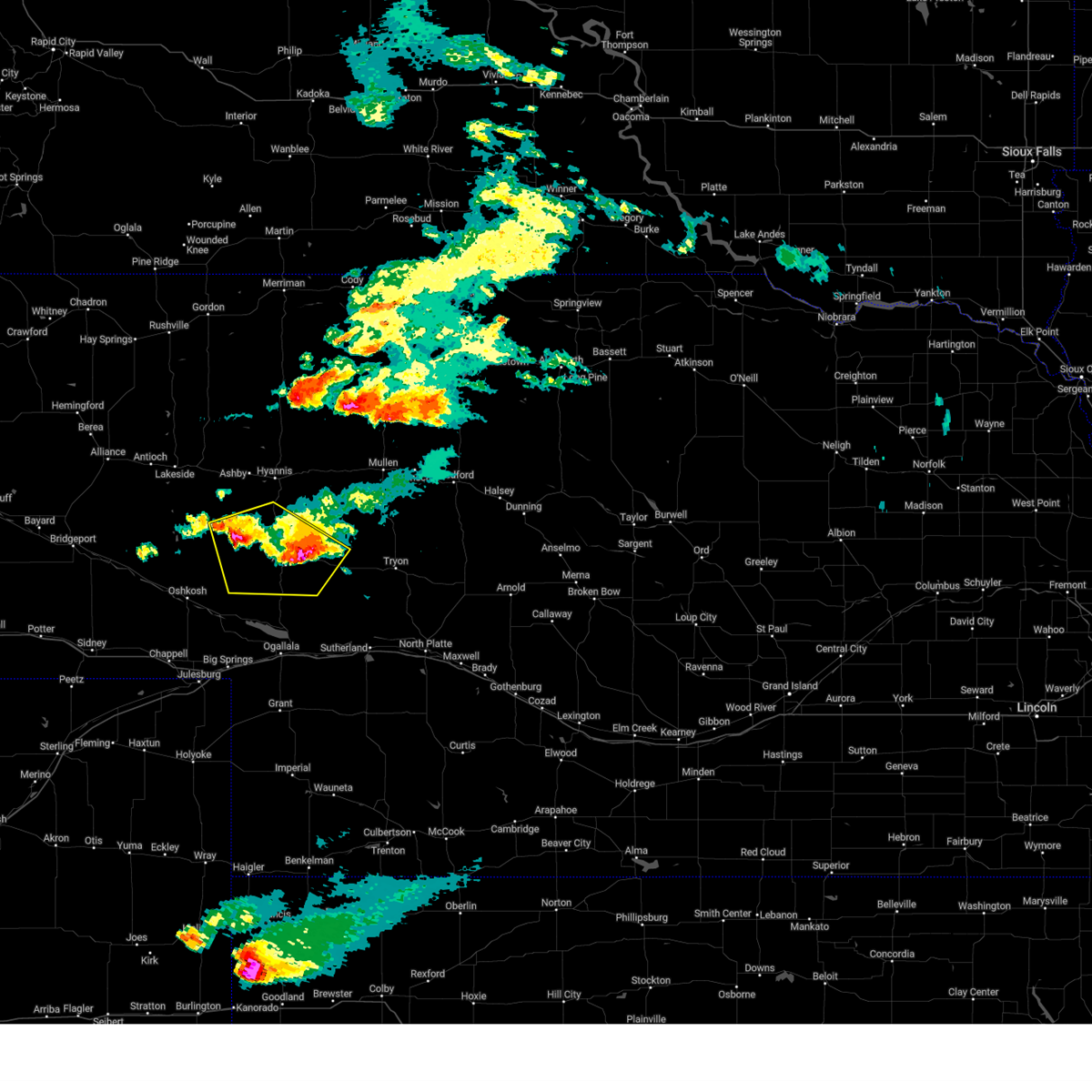
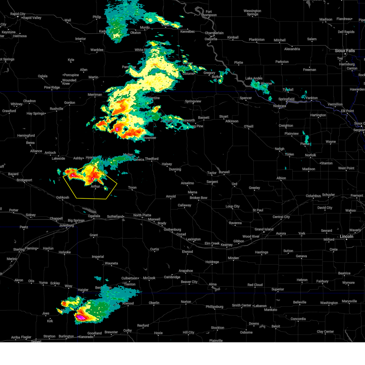
Hail Map for Arthur, NE
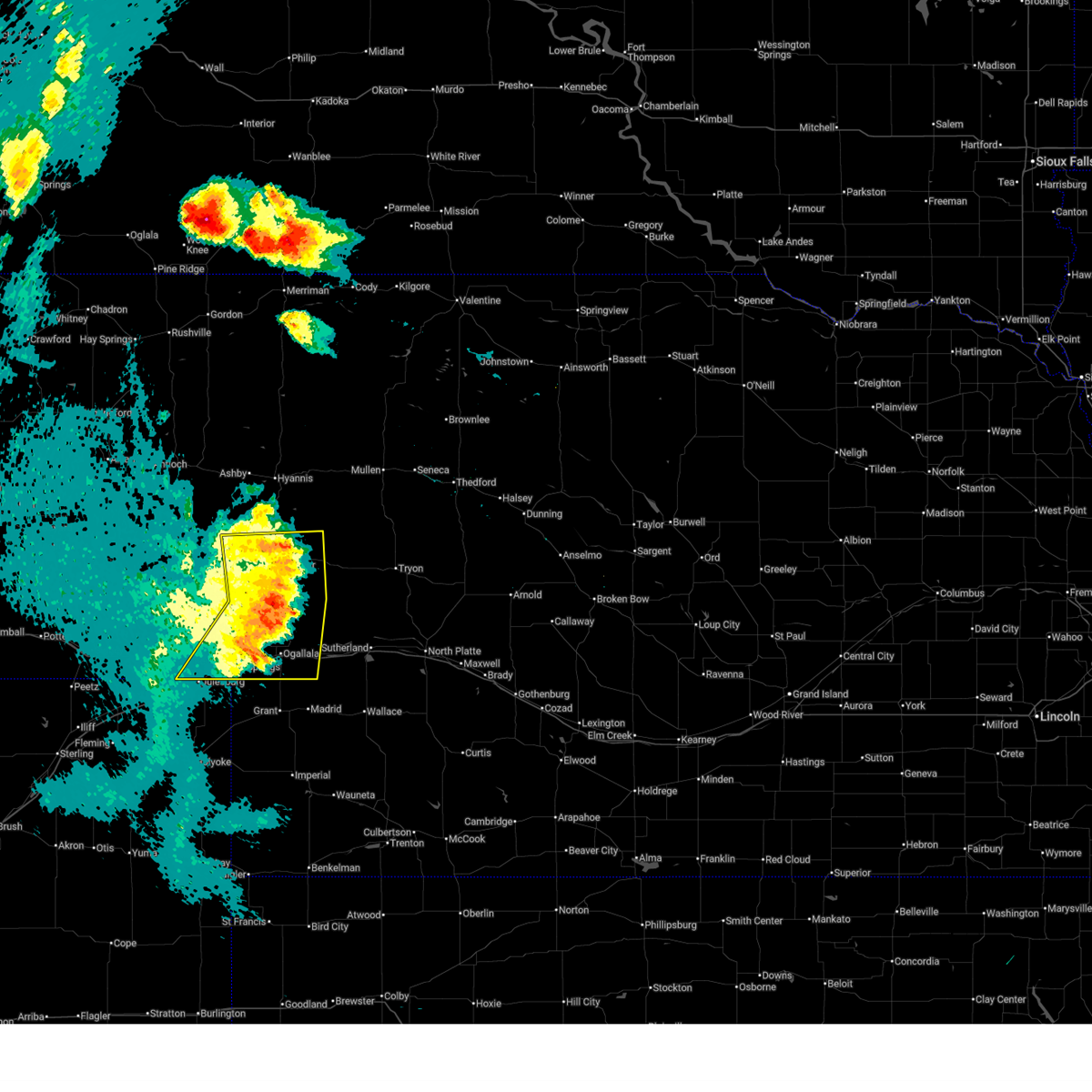
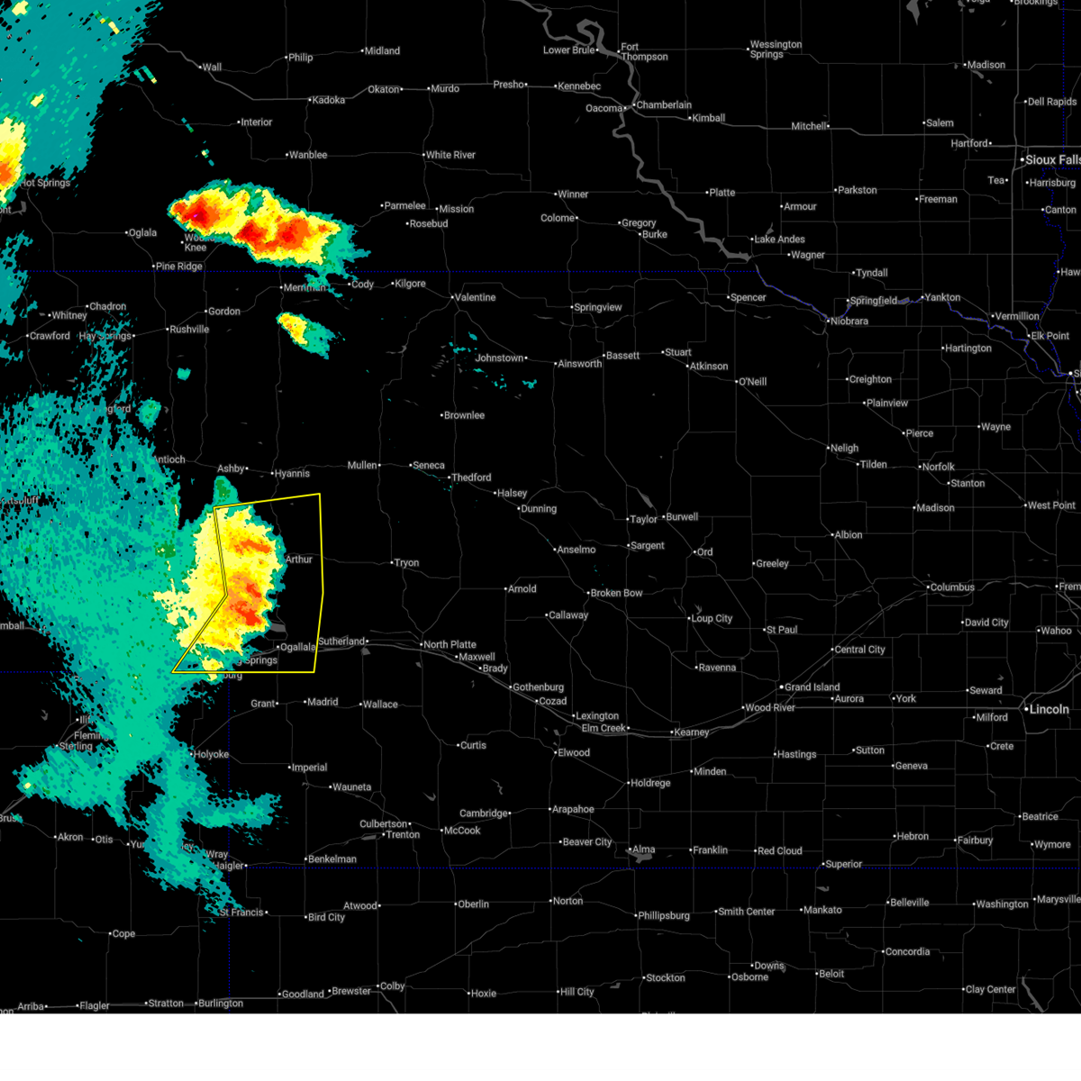
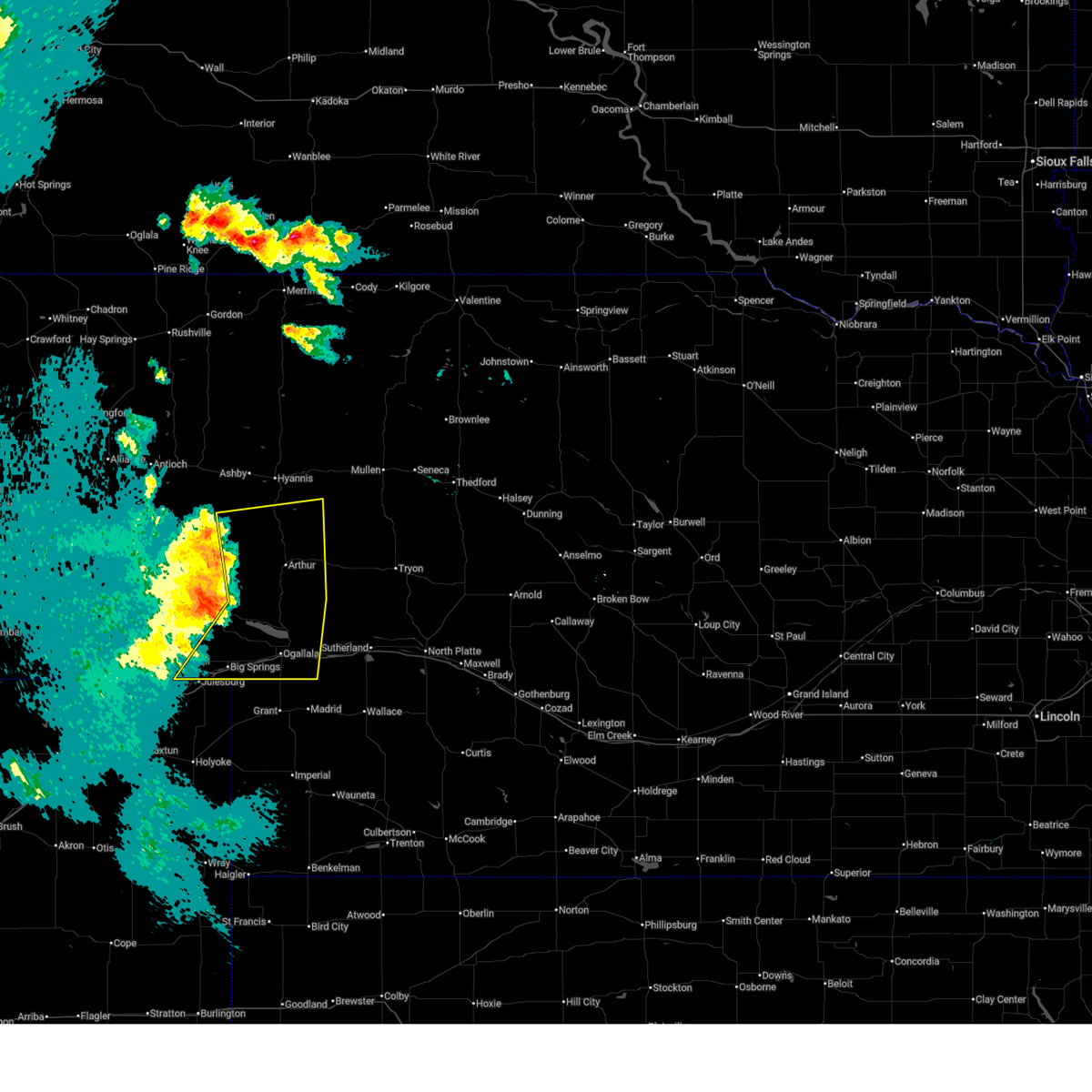
The Arthur, NE area has had 42 reports of on-the-ground hail by trained spotters, and has been under severe weather warnings 15 times during the past 12 months. Doppler radar has detected hail at or near Arthur, NE on 89 occasions, including 3 occasions during the past year.
| Name: | Arthur, NE |
| Where Located: | 56.8 miles WNW of North Platte, NE |
| Map: | Google Map for Arthur, NE |
| Population: | 117 |
| Housing Units: | 82 |
| More Info: | Search Google for Arthur, NE |
0
The Top Recent Hail Date for Arthur, NE is Wednesday, June 11, 2025 (88th out of 89)
Hail and Wind Damage Spotted near Arthur, NE
| Date / Time | Report Details |
|---|---|
| 6/15/2025 8:30 PM MDT |
 the severe thunderstorm warning has been cancelled and is no longer in effect the severe thunderstorm warning has been cancelled and is no longer in effect
|
| 6/15/2025 8:30 PM MDT |
 At 828 pm mdt, severe thunderstorms were located along a line extending from 8 miles north of arthur to 8 miles north of keystone to near ogallala, moving southeast at 45 mph (public). Hazards include 70 mph wind gusts and nickel size hail. Expect considerable tree damage. damage is likely to mobile homes, roofs, and outbuildings. locations impacted include, ogallala, big springs, arthur, brule, swan lake, keystone, kingsley dam, barton, lemoyne, roscoe, megeath, bucktail lake, bourquim hill, three mile lake, eagle gulch campground, ruthon, haythorn lake, clear creek state wildlife management area, lena, and sand puddin lake. this includes the following highways, highway 61 between mile markers 79 and 136. highway 92 between mile markers 115 and 177. Interstate 80 in nebraska between mile markers 91 and 139. At 828 pm mdt, severe thunderstorms were located along a line extending from 8 miles north of arthur to 8 miles north of keystone to near ogallala, moving southeast at 45 mph (public). Hazards include 70 mph wind gusts and nickel size hail. Expect considerable tree damage. damage is likely to mobile homes, roofs, and outbuildings. locations impacted include, ogallala, big springs, arthur, brule, swan lake, keystone, kingsley dam, barton, lemoyne, roscoe, megeath, bucktail lake, bourquim hill, three mile lake, eagle gulch campground, ruthon, haythorn lake, clear creek state wildlife management area, lena, and sand puddin lake. this includes the following highways, highway 61 between mile markers 79 and 136. highway 92 between mile markers 115 and 177. Interstate 80 in nebraska between mile markers 91 and 139.
|
| 6/15/2025 8:15 PM MDT |
 At 814 pm mdt, severe thunderstorms were located along a line extending from 12 miles south of hyannis to 8 miles southwest of arthur to 6 miles north of big springs, moving east at 35 mph (radar indicated). Hazards include 60 mph wind gusts and nickel size hail. Expect damage to roofs, siding, and trees. locations impacted include, ogallala, big springs, arthur, brule, swan lake, keystone, kingsley dam, barton, lemoyne, roscoe, cogill lake, megeath, green lake, bucktail lake, bourquim hill, three mile lake, eagle gulch campground, ruthon, haythorn lake, and clear creek state wildlife management area. this includes the following highways, highway 61 between mile markers 79 and 146. highway 92 between mile markers 115 and 178. Interstate 80 in nebraska between mile markers 91 and 139. At 814 pm mdt, severe thunderstorms were located along a line extending from 12 miles south of hyannis to 8 miles southwest of arthur to 6 miles north of big springs, moving east at 35 mph (radar indicated). Hazards include 60 mph wind gusts and nickel size hail. Expect damage to roofs, siding, and trees. locations impacted include, ogallala, big springs, arthur, brule, swan lake, keystone, kingsley dam, barton, lemoyne, roscoe, cogill lake, megeath, green lake, bucktail lake, bourquim hill, three mile lake, eagle gulch campground, ruthon, haythorn lake, and clear creek state wildlife management area. this includes the following highways, highway 61 between mile markers 79 and 146. highway 92 between mile markers 115 and 178. Interstate 80 in nebraska between mile markers 91 and 139.
|
| 6/15/2025 7:55 PM MDT |
 Svrlbf the national weather service in north platte has issued a * severe thunderstorm warning for, arthur county in west central nebraska, southern grant county in west central nebraska, keith county in southwestern nebraska, southeastern garden county in the panhandle of nebraska, eastern deuel county in the panhandle of nebraska, * until 845 pm mdt. * at 754 pm mdt, severe thunderstorms were located along a line extending from 18 miles south of ashby to 9 miles northeast of lewellen to 7 miles northwest of barton, moving east at 35 mph (radar indicated). Hazards include 60 mph wind gusts and nickel size hail. expect damage to roofs, siding, and trees Svrlbf the national weather service in north platte has issued a * severe thunderstorm warning for, arthur county in west central nebraska, southern grant county in west central nebraska, keith county in southwestern nebraska, southeastern garden county in the panhandle of nebraska, eastern deuel county in the panhandle of nebraska, * until 845 pm mdt. * at 754 pm mdt, severe thunderstorms were located along a line extending from 18 miles south of ashby to 9 miles northeast of lewellen to 7 miles northwest of barton, moving east at 35 mph (radar indicated). Hazards include 60 mph wind gusts and nickel size hail. expect damage to roofs, siding, and trees
|
| 6/12/2025 8:44 PM MDT |
 The storms which prompted the warning have weakened below severe limits, and no longer pose an immediate threat to life or property. therefore, the warning will be allowed to expire. however, gusty winds are still possible with these thunderstorms. a severe thunderstorm watch remains in effect until midnight cdt/1100 pm mdt/ for north central and west central nebraska. to report severe weather, contact your nearest law enforcement agency. they will relay your report to the national weather service north platte. The storms which prompted the warning have weakened below severe limits, and no longer pose an immediate threat to life or property. therefore, the warning will be allowed to expire. however, gusty winds are still possible with these thunderstorms. a severe thunderstorm watch remains in effect until midnight cdt/1100 pm mdt/ for north central and west central nebraska. to report severe weather, contact your nearest law enforcement agency. they will relay your report to the national weather service north platte.
|
| 6/12/2025 8:26 PM MDT |
 At 926 pm cdt/826 pm mdt/, severe thunderstorms were located along a line extending from near whitman to 7 miles southeast of arthur, moving east at 35 mph (radar indicated). Hazards include 60 mph wind gusts and nickel size hail. Expect damage to roofs, siding, and trees. locations impacted include, arthur, hyannis, swan lake, whitman, carr lake, haythorn lake, duluth, lena, sand puddin lake, flatts, cogill lake, mckeag, calora, east cody lake, green lake, bucktail lake, sand beach lake, three mile lake, pratt lake, and diamond bar lake. this includes the following highways, highway 2 between mile markers 145 and 175. highway 61 between mile markers 111 and 159. Highway 92 between mile markers 165 and 186. At 926 pm cdt/826 pm mdt/, severe thunderstorms were located along a line extending from near whitman to 7 miles southeast of arthur, moving east at 35 mph (radar indicated). Hazards include 60 mph wind gusts and nickel size hail. Expect damage to roofs, siding, and trees. locations impacted include, arthur, hyannis, swan lake, whitman, carr lake, haythorn lake, duluth, lena, sand puddin lake, flatts, cogill lake, mckeag, calora, east cody lake, green lake, bucktail lake, sand beach lake, three mile lake, pratt lake, and diamond bar lake. this includes the following highways, highway 2 between mile markers 145 and 175. highway 61 between mile markers 111 and 159. Highway 92 between mile markers 165 and 186.
|
| 6/12/2025 8:11 PM MDT |
 Svrlbf the national weather service in north platte has issued a * severe thunderstorm warning for, arthur county in west central nebraska, eastern grant county in west central nebraska, western hooker county in west central nebraska, western mcpherson county in west central nebraska, * until 945 pm cdt/845 pm mdt/. * at 911 pm cdt/811 pm mdt/, severe thunderstorms were located along a line extending from near hyannis to 8 miles southwest of arthur, moving east at 35 mph (radar indicated). Hazards include 60 mph wind gusts and quarter size hail. Hail damage to vehicles is expected. Expect wind damage to roofs, siding, and trees. Svrlbf the national weather service in north platte has issued a * severe thunderstorm warning for, arthur county in west central nebraska, eastern grant county in west central nebraska, western hooker county in west central nebraska, western mcpherson county in west central nebraska, * until 945 pm cdt/845 pm mdt/. * at 911 pm cdt/811 pm mdt/, severe thunderstorms were located along a line extending from near hyannis to 8 miles southwest of arthur, moving east at 35 mph (radar indicated). Hazards include 60 mph wind gusts and quarter size hail. Hail damage to vehicles is expected. Expect wind damage to roofs, siding, and trees.
|
| 5/14/2025 7:11 PM MDT |
 Svrlbf the national weather service in north platte has issued a * severe thunderstorm warning for, arthur county in west central nebraska, keith county in southwestern nebraska, southern garden county in the panhandle of nebraska, western mcpherson county in west central nebraska, deuel county in the panhandle of nebraska, * until 915 pm cdt/815 pm mdt/. * at 810 pm cdt/710 pm mdt/, severe thunderstorms were located along a line extending from 11 miles southeast of crescent lake national wildlife refuge to near ogallala, moving east at 40 mph (radar indicated). Hazards include 70 mph wind gusts. Expect considerable tree damage. Damage is likely to mobile homes, roofs, and outbuildings. Svrlbf the national weather service in north platte has issued a * severe thunderstorm warning for, arthur county in west central nebraska, keith county in southwestern nebraska, southern garden county in the panhandle of nebraska, western mcpherson county in west central nebraska, deuel county in the panhandle of nebraska, * until 915 pm cdt/815 pm mdt/. * at 810 pm cdt/710 pm mdt/, severe thunderstorms were located along a line extending from 11 miles southeast of crescent lake national wildlife refuge to near ogallala, moving east at 40 mph (radar indicated). Hazards include 70 mph wind gusts. Expect considerable tree damage. Damage is likely to mobile homes, roofs, and outbuildings.
|
| 8/11/2024 6:05 PM MDT |
 The storms which prompted the warning have weakened below severe limits, and have exited the warned area. therefore, the warning will be allowed to expire. a severe thunderstorm watch remains in effect until 1000 pm cdt/900 pm mdt/ for the panhandle of and west central nebraska. The storms which prompted the warning have weakened below severe limits, and have exited the warned area. therefore, the warning will be allowed to expire. a severe thunderstorm watch remains in effect until 1000 pm cdt/900 pm mdt/ for the panhandle of and west central nebraska.
|
| 8/11/2024 5:53 PM MDT |
 At 653 pm cdt/553 pm mdt/, severe thunderstorms were located along a line extending from near swan lake to 7 miles southeast of arthur to 21 miles northeast of lewellen, moving southeast at 45 mph (radar indicated). Hazards include 60 mph wind gusts and quarter size hail. Hail damage to vehicles is expected. expect wind damage to roofs, siding, and trees. locations impacted include, arthur, haythorn lake, lena, sand puddin lake, flatts, calora, jensen lake, green lake, bucktail lake, bourquim hill, sand beach lake, three mile lake, velma, and bucktail. this includes the following highways, highway 61 between mile markers 116 and 141. Highway 92 between mile markers 165 and 183. At 653 pm cdt/553 pm mdt/, severe thunderstorms were located along a line extending from near swan lake to 7 miles southeast of arthur to 21 miles northeast of lewellen, moving southeast at 45 mph (radar indicated). Hazards include 60 mph wind gusts and quarter size hail. Hail damage to vehicles is expected. expect wind damage to roofs, siding, and trees. locations impacted include, arthur, haythorn lake, lena, sand puddin lake, flatts, calora, jensen lake, green lake, bucktail lake, bourquim hill, sand beach lake, three mile lake, velma, and bucktail. this includes the following highways, highway 61 between mile markers 116 and 141. Highway 92 between mile markers 165 and 183.
|
| 8/11/2024 5:42 PM MDT |
 At 642 pm cdt/542 pm mdt/, severe thunderstorms were located along a line extending from near swan lake to arthur to 20 miles east of crescent lake national wildlife refuge, moving southeast at 45 mph (radar indicated). Hazards include 70 mph wind gusts and quarter size hail. Hail damage to vehicles is expected. expect considerable tree damage. wind damage is also likely to mobile homes, roofs, and outbuildings. locations impacted include, arthur, swan lake, haythorn lake, lena, sand puddin lake, flatts, mckeag, calora, jensen lake, green lake, bucktail lake, bourquim hill, sand beach lake, three mile lake, velma, and bucktail. this includes the following highways, highway 61 between mile markers 113 and 147. Highway 92 between mile markers 165 and 183. At 642 pm cdt/542 pm mdt/, severe thunderstorms were located along a line extending from near swan lake to arthur to 20 miles east of crescent lake national wildlife refuge, moving southeast at 45 mph (radar indicated). Hazards include 70 mph wind gusts and quarter size hail. Hail damage to vehicles is expected. expect considerable tree damage. wind damage is also likely to mobile homes, roofs, and outbuildings. locations impacted include, arthur, swan lake, haythorn lake, lena, sand puddin lake, flatts, mckeag, calora, jensen lake, green lake, bucktail lake, bourquim hill, sand beach lake, three mile lake, velma, and bucktail. this includes the following highways, highway 61 between mile markers 113 and 147. Highway 92 between mile markers 165 and 183.
|
| 8/11/2024 5:25 PM MDT |
 Svrlbf the national weather service in north platte has issued a * severe thunderstorm warning for, arthur county in west central nebraska, southern grant county in west central nebraska, east central garden county in the panhandle of nebraska, west central mcpherson county in west central nebraska, * until 715 pm cdt/615 pm mdt/. * at 625 pm cdt/525 pm mdt/, severe thunderstorms were located along a line extending from 12 miles south of hyannis to 10 miles northwest of arthur to 12 miles east of crescent lake national wildlife refuge, moving southeast at 45 mph (radar indicated). Hazards include 70 mph wind gusts and quarter size hail. Hail damage to vehicles is expected. expect considerable tree damage. Wind damage is also likely to mobile homes, roofs, and outbuildings. Svrlbf the national weather service in north platte has issued a * severe thunderstorm warning for, arthur county in west central nebraska, southern grant county in west central nebraska, east central garden county in the panhandle of nebraska, west central mcpherson county in west central nebraska, * until 715 pm cdt/615 pm mdt/. * at 625 pm cdt/525 pm mdt/, severe thunderstorms were located along a line extending from 12 miles south of hyannis to 10 miles northwest of arthur to 12 miles east of crescent lake national wildlife refuge, moving southeast at 45 mph (radar indicated). Hazards include 70 mph wind gusts and quarter size hail. Hail damage to vehicles is expected. expect considerable tree damage. Wind damage is also likely to mobile homes, roofs, and outbuildings.
|
| 7/19/2024 6:03 PM MDT | Golf Ball sized hail reported 9.7 miles NW of Arthur, NE |
| 7/19/2024 5:50 PM MDT | Ping Pong Ball sized hail reported 13.1 miles W of Arthur, NE |
| 7/19/2024 5:45 PM MDT |
 At 644 pm cdt/544 pm mdt/, a severe thunderstorm was located near arthur, moving south at 40 mph (radar indicated). Hazards include ping pong ball size hail. People and animals outdoors will be injured. expect damage to roofs, siding, windows, and vehicles. locations impacted include, arthur, haythorn lake, bucktail lake, sand beach lake, lena, sand puddin lake, three mile lake, flatts, diamond bar lake, bucktail, schnick lake, and calora. this includes the following highways, highway 61 between mile markers 119 and 131. Highway 92 between mile markers 165 and 188. At 644 pm cdt/544 pm mdt/, a severe thunderstorm was located near arthur, moving south at 40 mph (radar indicated). Hazards include ping pong ball size hail. People and animals outdoors will be injured. expect damage to roofs, siding, windows, and vehicles. locations impacted include, arthur, haythorn lake, bucktail lake, sand beach lake, lena, sand puddin lake, three mile lake, flatts, diamond bar lake, bucktail, schnick lake, and calora. this includes the following highways, highway 61 between mile markers 119 and 131. Highway 92 between mile markers 165 and 188.
|
| 7/19/2024 5:45 PM MDT |
 the severe thunderstorm warning has been cancelled and is no longer in effect the severe thunderstorm warning has been cancelled and is no longer in effect
|
| 7/19/2024 5:28 PM MDT | Baseball sized hail reported 16.4 miles SW of Arthur, NE, report via social media. time estimated by radar. |
| 7/19/2024 5:24 PM MDT |
 Svrlbf the national weather service in north platte has issued a * severe thunderstorm warning for, northeastern arthur county in west central nebraska, southeastern grant county in west central nebraska, southwestern hooker county in west central nebraska, western mcpherson county in west central nebraska, * until 715 pm cdt/615 pm mdt/. * at 624 pm cdt/524 pm mdt/, a severe thunderstorm was located near swan lake, or 18 miles northeast of arthur, moving south at 40 mph (radar indicated). Hazards include ping pong ball size hail. People and animals outdoors will be injured. Expect damage to roofs, siding, windows, and vehicles. Svrlbf the national weather service in north platte has issued a * severe thunderstorm warning for, northeastern arthur county in west central nebraska, southeastern grant county in west central nebraska, southwestern hooker county in west central nebraska, western mcpherson county in west central nebraska, * until 715 pm cdt/615 pm mdt/. * at 624 pm cdt/524 pm mdt/, a severe thunderstorm was located near swan lake, or 18 miles northeast of arthur, moving south at 40 mph (radar indicated). Hazards include ping pong ball size hail. People and animals outdoors will be injured. Expect damage to roofs, siding, windows, and vehicles.
|
| 7/3/2024 3:19 PM MDT |
 the severe thunderstorm warning has been cancelled and is no longer in effect the severe thunderstorm warning has been cancelled and is no longer in effect
|
| 7/3/2024 3:04 PM MDT |
 the severe thunderstorm warning has been cancelled and is no longer in effect the severe thunderstorm warning has been cancelled and is no longer in effect
|
| 7/3/2024 3:04 PM MDT |
 At 303 pm mdt, severe thunderstorms were located along a line extending from 11 miles southeast of hyannis to 12 miles west of swan lake to 7 miles west of arthur, moving east at 35 mph (radar indicated). Hazards include 60 mph wind gusts and nickel size hail. Expect damage to roofs, siding, and trees. these severe storms will be near, arthur around 310 pm mdt. swan lake around 315 pm mdt. other locations impacted by these severe thunderstorms include haythorn lake, jensen lake, green lake, lena, sand puddin lake, three mile lake, velma, pratt lake, spring valley lake, and cogill lake. this includes the following highways, highway 61 between mile markers 115 and 149. Highway 92 between mile markers 165 and 171. At 303 pm mdt, severe thunderstorms were located along a line extending from 11 miles southeast of hyannis to 12 miles west of swan lake to 7 miles west of arthur, moving east at 35 mph (radar indicated). Hazards include 60 mph wind gusts and nickel size hail. Expect damage to roofs, siding, and trees. these severe storms will be near, arthur around 310 pm mdt. swan lake around 315 pm mdt. other locations impacted by these severe thunderstorms include haythorn lake, jensen lake, green lake, lena, sand puddin lake, three mile lake, velma, pratt lake, spring valley lake, and cogill lake. this includes the following highways, highway 61 between mile markers 115 and 149. Highway 92 between mile markers 165 and 171.
|
| 7/3/2024 2:40 PM MDT |
 Svrlbf the national weather service in north platte has issued a * severe thunderstorm warning for, arthur county in west central nebraska, southern grant county in west central nebraska, west central hooker county in west central nebraska, east central garden county in the panhandle of nebraska, * until 330 pm mdt. * at 240 pm mdt, severe thunderstorms were located along a line extending from 13 miles southwest of hyannis to 15 miles northwest of arthur to 13 miles north of lewellen, moving east at 25 mph (radar indicated). Hazards include 60 mph wind gusts and quarter size hail. Hail damage to vehicles is expected. expect wind damage to roofs, siding, and trees. severe thunderstorms will be near, arthur around 315 pm mdt. other locations impacted by these severe thunderstorms include haythorn lake, lena, sand puddin lake, swede lake, cogill lake, mckeag, jensen lake, green lake, bourquim hill, and three mile lake. this includes the following highways, highway 61 between mile markers 114 and 149. Highway 92 between mile markers 165 and 171. Svrlbf the national weather service in north platte has issued a * severe thunderstorm warning for, arthur county in west central nebraska, southern grant county in west central nebraska, west central hooker county in west central nebraska, east central garden county in the panhandle of nebraska, * until 330 pm mdt. * at 240 pm mdt, severe thunderstorms were located along a line extending from 13 miles southwest of hyannis to 15 miles northwest of arthur to 13 miles north of lewellen, moving east at 25 mph (radar indicated). Hazards include 60 mph wind gusts and quarter size hail. Hail damage to vehicles is expected. expect wind damage to roofs, siding, and trees. severe thunderstorms will be near, arthur around 315 pm mdt. other locations impacted by these severe thunderstorms include haythorn lake, lena, sand puddin lake, swede lake, cogill lake, mckeag, jensen lake, green lake, bourquim hill, and three mile lake. this includes the following highways, highway 61 between mile markers 114 and 149. Highway 92 between mile markers 165 and 171.
|
| 6/20/2024 6:05 PM MDT |
 Svrlbf the national weather service in north platte has issued a * severe thunderstorm warning for, arthur county in west central nebraska, grant county in west central nebraska, southwestern hooker county in west central nebraska, eastern garden county in the panhandle of nebraska, * until 700 pm mdt. * at 604 pm mdt, severe thunderstorms were located along a line extending from near ashby to near lisco, moving east at 45 mph (radar indicated). Hazards include 70 mph wind gusts. Expect considerable tree damage. Damage is likely to mobile homes, roofs, and outbuildings. Svrlbf the national weather service in north platte has issued a * severe thunderstorm warning for, arthur county in west central nebraska, grant county in west central nebraska, southwestern hooker county in west central nebraska, eastern garden county in the panhandle of nebraska, * until 700 pm mdt. * at 604 pm mdt, severe thunderstorms were located along a line extending from near ashby to near lisco, moving east at 45 mph (radar indicated). Hazards include 70 mph wind gusts. Expect considerable tree damage. Damage is likely to mobile homes, roofs, and outbuildings.
|
| 6/16/2024 11:52 PM MDT |
 The storm which prompted the warning has weakened below severe limits, and no longer poses an immediate threat to life or property. therefore, the warning will be allowed to expire. however, gusty winds are still possible with this thunderstorm. a severe thunderstorm watch remains in effect until 600 am cdt/500 am mdt/ for southwestern and west central nebraska. The storm which prompted the warning has weakened below severe limits, and no longer poses an immediate threat to life or property. therefore, the warning will be allowed to expire. however, gusty winds are still possible with this thunderstorm. a severe thunderstorm watch remains in effect until 600 am cdt/500 am mdt/ for southwestern and west central nebraska.
|
| 6/16/2024 11:37 PM MDT |
 At 1237 am cdt/1137 pm mdt/, a severe thunderstorm was located 7 miles southeast of arthur, moving northeast at 45 mph (radar indicated). Hazards include quarter size hail. Damage to vehicles is expected. locations impacted include, arthur, swan lake, haythorn lake, lena, flatts, mckeag, calora, bucktail lake, sand beach lake, three mile lake, diamond bar lake, bucktail, and schnick lake. this includes the following highways, highway 61 between mile markers 104 and 127. Highway 92 between mile markers 165 and 192. At 1237 am cdt/1137 pm mdt/, a severe thunderstorm was located 7 miles southeast of arthur, moving northeast at 45 mph (radar indicated). Hazards include quarter size hail. Damage to vehicles is expected. locations impacted include, arthur, swan lake, haythorn lake, lena, flatts, mckeag, calora, bucktail lake, sand beach lake, three mile lake, diamond bar lake, bucktail, and schnick lake. this includes the following highways, highway 61 between mile markers 104 and 127. Highway 92 between mile markers 165 and 192.
|
| 6/16/2024 11:10 PM MDT |
 Svrlbf the national weather service in north platte has issued a * severe thunderstorm warning for, eastern arthur county in west central nebraska, northwestern keith county in southwestern nebraska, northwestern mcpherson county in west central nebraska, * until 100 am cdt/midnight mdt/. * at 1209 am cdt/1109 pm mdt/, a severe thunderstorm was located near lemoyne, or 14 miles northwest of ogallala, moving northeast at 45 mph (radar indicated). Hazards include quarter size hail. damage to vehicles is expected Svrlbf the national weather service in north platte has issued a * severe thunderstorm warning for, eastern arthur county in west central nebraska, northwestern keith county in southwestern nebraska, northwestern mcpherson county in west central nebraska, * until 100 am cdt/midnight mdt/. * at 1209 am cdt/1109 pm mdt/, a severe thunderstorm was located near lemoyne, or 14 miles northwest of ogallala, moving northeast at 45 mph (radar indicated). Hazards include quarter size hail. damage to vehicles is expected
|
| 6/1/2024 5:38 AM MDT |
 The storm which prompted the warning has weakened below severe limits, and no longer poses an immediate threat to life or property. therefore, the warning will be allowed to expire. however, small hail is still possible with this thunderstorm. a severe thunderstorm watch remains in effect until 700 am mdt for the panhandle of, southwestern and west central nebraska. The storm which prompted the warning has weakened below severe limits, and no longer poses an immediate threat to life or property. therefore, the warning will be allowed to expire. however, small hail is still possible with this thunderstorm. a severe thunderstorm watch remains in effect until 700 am mdt for the panhandle of, southwestern and west central nebraska.
|
| 6/1/2024 5:19 AM MDT |
 At 519 am mdt, a severe thunderstorm was located 14 miles west of arthur, moving east at 20 mph (radar indicated). Hazards include ping pong ball size hail and 60 mph wind gusts. People and animals outdoors will be injured. expect hail damage to roofs, siding, windows, and vehicles. expect wind damage to roofs, siding, and trees. locations impacted include, arthur, velma, haythorn lake, and bourquim hill. This includes highway 61 between mile markers 122 and 125. At 519 am mdt, a severe thunderstorm was located 14 miles west of arthur, moving east at 20 mph (radar indicated). Hazards include ping pong ball size hail and 60 mph wind gusts. People and animals outdoors will be injured. expect hail damage to roofs, siding, windows, and vehicles. expect wind damage to roofs, siding, and trees. locations impacted include, arthur, velma, haythorn lake, and bourquim hill. This includes highway 61 between mile markers 122 and 125.
|
| 6/1/2024 5:19 AM MDT |
 the severe thunderstorm warning has been cancelled and is no longer in effect the severe thunderstorm warning has been cancelled and is no longer in effect
|
| 6/1/2024 4:59 AM MDT |
 Svrlbf the national weather service in north platte has issued a * severe thunderstorm warning for, southwestern arthur county in west central nebraska, northwestern keith county in southwestern nebraska, east central garden county in the panhandle of nebraska, * until 545 am mdt. * at 458 am mdt, a severe thunderstorm was located 18 miles east of crescent lake national wildlife refuge, or 19 miles west of arthur, moving southeast at 20 mph (radar indicated). Hazards include golf ball size hail and 60 mph wind gusts. People and animals outdoors will be injured. expect hail damage to roofs, siding, windows, and vehicles. Expect wind damage to roofs, siding, and trees. Svrlbf the national weather service in north platte has issued a * severe thunderstorm warning for, southwestern arthur county in west central nebraska, northwestern keith county in southwestern nebraska, east central garden county in the panhandle of nebraska, * until 545 am mdt. * at 458 am mdt, a severe thunderstorm was located 18 miles east of crescent lake national wildlife refuge, or 19 miles west of arthur, moving southeast at 20 mph (radar indicated). Hazards include golf ball size hail and 60 mph wind gusts. People and animals outdoors will be injured. expect hail damage to roofs, siding, windows, and vehicles. Expect wind damage to roofs, siding, and trees.
|
| 4/6/2024 2:35 PM MDT |
 The storms which prompted the warning have weakened below severe limits, and no longer pose an immediate threat to life or property. therefore, the warning will be allowed to expire. however, gusty winds are still possible with these thunderstorms. a severe thunderstorm watch remains in effect until 800 pm cdt/700 pm mdt/ for the panhandle of and west central nebraska. The storms which prompted the warning have weakened below severe limits, and no longer pose an immediate threat to life or property. therefore, the warning will be allowed to expire. however, gusty winds are still possible with these thunderstorms. a severe thunderstorm watch remains in effect until 800 pm cdt/700 pm mdt/ for the panhandle of and west central nebraska.
|
| 4/6/2024 1:54 PM MDT |
 Svrlbf the national weather service in north platte has issued a * severe thunderstorm warning for, arthur county in west central nebraska, southern grant county in west central nebraska, east central garden county in the panhandle of nebraska, southwestern mcpherson county in west central nebraska, * until 345 pm cdt/245 pm mdt/. * at 254 pm cdt/154 pm mdt/, severe thunderstorms were located along a line extending from 17 miles north of lemoyne to 6 miles southeast of arthur to 12 miles north of sarben, moving northwest at 35 mph (radar indicated). Hazards include 70 mph wind gusts. Expect considerable tree damage. Damage is likely to mobile homes, roofs, and outbuildings. Svrlbf the national weather service in north platte has issued a * severe thunderstorm warning for, arthur county in west central nebraska, southern grant county in west central nebraska, east central garden county in the panhandle of nebraska, southwestern mcpherson county in west central nebraska, * until 345 pm cdt/245 pm mdt/. * at 254 pm cdt/154 pm mdt/, severe thunderstorms were located along a line extending from 17 miles north of lemoyne to 6 miles southeast of arthur to 12 miles north of sarben, moving northwest at 35 mph (radar indicated). Hazards include 70 mph wind gusts. Expect considerable tree damage. Damage is likely to mobile homes, roofs, and outbuildings.
|
| 8/7/2023 6:02 PM MDT |
 At 702 pm cdt/602 pm mdt/, a severe thunderstorm was located near swan lake, or 10 miles northeast of arthur, moving south at 20 mph (radar indicated). Hazards include golf ball size hail and 60 mph wind gusts. People and animals outdoors will be injured. expect hail damage to roofs, siding, windows, and vehicles. Expect wind damage to roofs, siding, and trees. At 702 pm cdt/602 pm mdt/, a severe thunderstorm was located near swan lake, or 10 miles northeast of arthur, moving south at 20 mph (radar indicated). Hazards include golf ball size hail and 60 mph wind gusts. People and animals outdoors will be injured. expect hail damage to roofs, siding, windows, and vehicles. Expect wind damage to roofs, siding, and trees.
|
| 8/7/2023 6:00 PM MDT | Quarter sized hail reported 17.3 miles SW of Arthur, NE, quarter inch hail and pea sized hail; 0.50 inches of precip. |
| 7/30/2023 11:57 PM MDT |
 The severe thunderstorm warning for arthur and north central keith counties will expire at midnight mdt. the storm which prompted the warning has weakened below severe limits, and has exited the warned area. therefore, the warning will be allowed to expire. However gusty winds are still possible with this thunderstorm. The severe thunderstorm warning for arthur and north central keith counties will expire at midnight mdt. the storm which prompted the warning has weakened below severe limits, and has exited the warned area. therefore, the warning will be allowed to expire. However gusty winds are still possible with this thunderstorm.
|
| 7/30/2023 11:49 PM MDT |
 At 1149 pm mdt, a severe thunderstorm was located near arthur, moving southeast at 15 mph (radar indicated). Hazards include 60 mph wind gusts and penny size hail. Expect damage to roofs, siding, and trees. locations impacted include, arthur, lemoyne, velma, haythorn lake and mckeag. this includes the following highways, highway 61 between mile markers 101 and 132. highway 92 between mile markers 133 and 136, and between mile markers 165 and 168. hail threat, radar indicated max hail size, 0. 75 in wind threat, radar indicated max wind gust, 60 mph. At 1149 pm mdt, a severe thunderstorm was located near arthur, moving southeast at 15 mph (radar indicated). Hazards include 60 mph wind gusts and penny size hail. Expect damage to roofs, siding, and trees. locations impacted include, arthur, lemoyne, velma, haythorn lake and mckeag. this includes the following highways, highway 61 between mile markers 101 and 132. highway 92 between mile markers 133 and 136, and between mile markers 165 and 168. hail threat, radar indicated max hail size, 0. 75 in wind threat, radar indicated max wind gust, 60 mph.
|
| 7/30/2023 11:26 PM MDT |
 At 1126 pm mdt, a severe thunderstorm was located over arthur, moving southeast at 15 mph (radar indicated). Hazards include 60 mph wind gusts and penny size hail. expect damage to roofs, siding, and trees At 1126 pm mdt, a severe thunderstorm was located over arthur, moving southeast at 15 mph (radar indicated). Hazards include 60 mph wind gusts and penny size hail. expect damage to roofs, siding, and trees
|
| 7/16/2023 7:19 PM MDT |
 At 819 pm cdt/719 pm mdt/, a severe thunderstorm was located near arthur, moving southeast at 45 mph (radar indicated). Hazards include golf ball size hail and 70 mph wind gusts. People and animals outdoors will be injured. expect hail damage to roofs, siding, windows, and vehicles. expect considerable tree damage. wind damage is also likely to mobile homes, roofs, and outbuildings. locations impacted include, arthur, lemoyne, eagle gulch campground, haythorn lake, sand puddin lake, mckeag, otter creek campground, lake view campground, jensen lake, belmar, bucktail lake, three mile lake, velma, and bucktail. this includes the following highways, highway 61 between mile markers 101 and 142. highway 92 between mile markers 123 and 137, and between mile markers 165 and 180. thunderstorm damage threat, considerable hail threat, radar indicated max hail size, 1. 75 in wind threat, radar indicated max wind gust, 70 mph. At 819 pm cdt/719 pm mdt/, a severe thunderstorm was located near arthur, moving southeast at 45 mph (radar indicated). Hazards include golf ball size hail and 70 mph wind gusts. People and animals outdoors will be injured. expect hail damage to roofs, siding, windows, and vehicles. expect considerable tree damage. wind damage is also likely to mobile homes, roofs, and outbuildings. locations impacted include, arthur, lemoyne, eagle gulch campground, haythorn lake, sand puddin lake, mckeag, otter creek campground, lake view campground, jensen lake, belmar, bucktail lake, three mile lake, velma, and bucktail. this includes the following highways, highway 61 between mile markers 101 and 142. highway 92 between mile markers 123 and 137, and between mile markers 165 and 180. thunderstorm damage threat, considerable hail threat, radar indicated max hail size, 1. 75 in wind threat, radar indicated max wind gust, 70 mph.
|
| 7/16/2023 6:57 PM MDT |
 At 756 pm cdt/656 pm mdt/, a severe thunderstorm was located 18 miles south of ashby, or 20 miles northwest of arthur, moving southeast at 45 mph (radar indicated). Hazards include 70 mph wind gusts and ping pong ball size hail. People and animals outdoors will be injured. expect hail damage to roofs, siding, windows, and vehicles. expect considerable tree damage. Wind damage is also likely to mobile homes, roofs, and outbuildings. At 756 pm cdt/656 pm mdt/, a severe thunderstorm was located 18 miles south of ashby, or 20 miles northwest of arthur, moving southeast at 45 mph (radar indicated). Hazards include 70 mph wind gusts and ping pong ball size hail. People and animals outdoors will be injured. expect hail damage to roofs, siding, windows, and vehicles. expect considerable tree damage. Wind damage is also likely to mobile homes, roofs, and outbuildings.
|
| 7/13/2023 6:00 PM MDT |
 At 558 pm mdt, severe thunderstorms were located along a line extending from near arthur to near lemoyne to near chappell, moving east at 45 mph (radar indicated). Hazards include 60 mph wind gusts and penny size hail. Expect damage to roofs, siding, and trees. locations impacted include, ogallala, oshkosh, big springs, arthur, brule, lewellen, kingsley dam, lemoyne, keystone, megeath, mount vernon, bourquim hill, eagle gulch campground, ruthon, haythorn lake, clear creek state wildlife management area, intersection of highway 27 and 9 mile road, mckeag, otter creek campground and lake view campground. this includes the following highways, highway 61 between mile markers 89 and 90, and between mile markers 95 and 125. highway 92 between mile markers 115 and 138. interstate 80 in nebraska between mile markers 106 and 118. hail threat, radar indicated max hail size, 0. 75 in wind threat, observed max wind gust, 60 mph. At 558 pm mdt, severe thunderstorms were located along a line extending from near arthur to near lemoyne to near chappell, moving east at 45 mph (radar indicated). Hazards include 60 mph wind gusts and penny size hail. Expect damage to roofs, siding, and trees. locations impacted include, ogallala, oshkosh, big springs, arthur, brule, lewellen, kingsley dam, lemoyne, keystone, megeath, mount vernon, bourquim hill, eagle gulch campground, ruthon, haythorn lake, clear creek state wildlife management area, intersection of highway 27 and 9 mile road, mckeag, otter creek campground and lake view campground. this includes the following highways, highway 61 between mile markers 89 and 90, and between mile markers 95 and 125. highway 92 between mile markers 115 and 138. interstate 80 in nebraska between mile markers 106 and 118. hail threat, radar indicated max hail size, 0. 75 in wind threat, observed max wind gust, 60 mph.
|
| 7/13/2023 5:43 PM MDT |
 At 542 pm mdt, severe thunderstorms were located along a line extending from 13 miles west of arthur to near lewellen to near lodgepole, moving east at 50 mph (radar indicated). Hazards include 60 mph wind gusts and quarter size hail. Hail damage to vehicles is expected. expect wind damage to roofs, siding, and trees. locations impacted include, ogallala, oshkosh, big springs, arthur, brule, lewellen, kingsley dam, lemoyne, keystone, megeath, mount vernon, bourquim hill, eagle gulch campground, ruthon, haythorn lake, clear creek state wildlife management area, intersection of highway 27 and 9 mile road, mckeag, otter creek campground and lake view campground. this includes the following highways, highway 61 between mile markers 89 and 90, and between mile markers 95 and 125. highway 92 between mile markers 115 and 138. interstate 80 in nebraska between mile markers 106 and 118. hail threat, radar indicated max hail size, 1. 00 in wind threat, observed max wind gust, 60 mph. At 542 pm mdt, severe thunderstorms were located along a line extending from 13 miles west of arthur to near lewellen to near lodgepole, moving east at 50 mph (radar indicated). Hazards include 60 mph wind gusts and quarter size hail. Hail damage to vehicles is expected. expect wind damage to roofs, siding, and trees. locations impacted include, ogallala, oshkosh, big springs, arthur, brule, lewellen, kingsley dam, lemoyne, keystone, megeath, mount vernon, bourquim hill, eagle gulch campground, ruthon, haythorn lake, clear creek state wildlife management area, intersection of highway 27 and 9 mile road, mckeag, otter creek campground and lake view campground. this includes the following highways, highway 61 between mile markers 89 and 90, and between mile markers 95 and 125. highway 92 between mile markers 115 and 138. interstate 80 in nebraska between mile markers 106 and 118. hail threat, radar indicated max hail size, 1. 00 in wind threat, observed max wind gust, 60 mph.
|
| 7/13/2023 5:34 PM MDT |
 At 533 pm mdt, severe thunderstorms were located along a line extending from 16 miles northeast of oshkosh to near lewellen to near sunol, moving east at 45 mph (radar indicated). Hazards include 60 mph wind gusts and quarter size hail. Hail damage to vehicles is expected. Expect wind damage to roofs, siding, and trees. At 533 pm mdt, severe thunderstorms were located along a line extending from 16 miles northeast of oshkosh to near lewellen to near sunol, moving east at 45 mph (radar indicated). Hazards include 60 mph wind gusts and quarter size hail. Hail damage to vehicles is expected. Expect wind damage to roofs, siding, and trees.
|
| 6/29/2023 9:26 PM MDT |
 The severe thunderstorm warning for arthur, southeastern grant, southern hooker, western mcpherson and southwestern thomas counties will expire at 1030 pm cdt/930 pm mdt/, the storms which prompted the warning have weakened below severe limits, and no longer pose an immediate threat to life or property. therefore, the warning will be allowed to expire. a severe thunderstorm watch remains in effect until 200 am cdt/100 am mdt/ for north central and west central nebraska. The severe thunderstorm warning for arthur, southeastern grant, southern hooker, western mcpherson and southwestern thomas counties will expire at 1030 pm cdt/930 pm mdt/, the storms which prompted the warning have weakened below severe limits, and no longer pose an immediate threat to life or property. therefore, the warning will be allowed to expire. a severe thunderstorm watch remains in effect until 200 am cdt/100 am mdt/ for north central and west central nebraska.
|
| 6/29/2023 9:00 PM MDT |
 At 959 pm cdt/859 pm mdt/, severe thunderstorms were located along a line extending from 10 miles south of mullen to 6 miles northwest of lemoyne, moving east at 30 mph (radar indicated). Hazards include 60 mph wind gusts and quarter size hail. Hail damage to vehicles is expected. Expect wind damage to roofs, siding, and trees. At 959 pm cdt/859 pm mdt/, severe thunderstorms were located along a line extending from 10 miles south of mullen to 6 miles northwest of lemoyne, moving east at 30 mph (radar indicated). Hazards include 60 mph wind gusts and quarter size hail. Hail damage to vehicles is expected. Expect wind damage to roofs, siding, and trees.
|
| 6/23/2023 11:00 PM MDT | Pws reports 59 mph gus in arthur county NE, 4.9 miles N of Arthur, NE |
| 6/23/2023 10:39 PM MDT |
 At 1138 pm cdt/1038 pm mdt/, severe thunderstorms were located along a line extending from 17 miles west of tryon to near elsie, moving east at 60 mph (public). Hazards include 70 mph wind gusts and nickel size hail. Expect considerable tree damage. damage is likely to mobile homes, roofs, and outbuildings. locations impacted include, ogallala, grant, arthur, tryon, sutherland, paxton, brule, madrid, elsie, keystone, kingsley dam, sarben, lemoyne, roscoe, flatts, megeath, bucktail lake, three mile lake, lena and brandon. this includes the following highways, highway 61 between mile markers 61 and 128. highway 92 between mile markers 128 and 204. highway 97 between mile markers 32 and 38. interstate 80 in nebraska between mile markers 110 and 157. thunderstorm damage threat, considerable hail threat, radar indicated max hail size, 0. 88 in wind threat, observed max wind gust, 70 mph. At 1138 pm cdt/1038 pm mdt/, severe thunderstorms were located along a line extending from 17 miles west of tryon to near elsie, moving east at 60 mph (public). Hazards include 70 mph wind gusts and nickel size hail. Expect considerable tree damage. damage is likely to mobile homes, roofs, and outbuildings. locations impacted include, ogallala, grant, arthur, tryon, sutherland, paxton, brule, madrid, elsie, keystone, kingsley dam, sarben, lemoyne, roscoe, flatts, megeath, bucktail lake, three mile lake, lena and brandon. this includes the following highways, highway 61 between mile markers 61 and 128. highway 92 between mile markers 128 and 204. highway 97 between mile markers 32 and 38. interstate 80 in nebraska between mile markers 110 and 157. thunderstorm damage threat, considerable hail threat, radar indicated max hail size, 0. 88 in wind threat, observed max wind gust, 70 mph.
|
| 6/23/2023 10:27 PM MDT |
 At 1126 pm cdt/1026 pm mdt/, severe thunderstorms were located along a line extending from 14 miles south of swan lake to 8 miles northwest of grant, moving east at 55 mph (public). Hazards include 70 mph wind gusts and quarter size hail. Hail damage to vehicles is expected. expect considerable tree damage. wind damage is also likely to mobile homes, roofs, and outbuildings. locations impacted include, ogallala, grant, arthur, tryon, sutherland, paxton, brule, madrid, elsie, keystone, kingsley dam, sarben, lemoyne, roscoe, flatts, megeath, bucktail lake, three mile lake, lena and brandon. this includes the following highways, highway 61 between mile markers 61 and 128. highway 92 between mile markers 128 and 204. highway 97 between mile markers 32 and 38. interstate 80 in nebraska between mile markers 110 and 157. thunderstorm damage threat, considerable hail threat, radar indicated max hail size, 1. 00 in wind threat, observed max wind gust, 70 mph. At 1126 pm cdt/1026 pm mdt/, severe thunderstorms were located along a line extending from 14 miles south of swan lake to 8 miles northwest of grant, moving east at 55 mph (public). Hazards include 70 mph wind gusts and quarter size hail. Hail damage to vehicles is expected. expect considerable tree damage. wind damage is also likely to mobile homes, roofs, and outbuildings. locations impacted include, ogallala, grant, arthur, tryon, sutherland, paxton, brule, madrid, elsie, keystone, kingsley dam, sarben, lemoyne, roscoe, flatts, megeath, bucktail lake, three mile lake, lena and brandon. this includes the following highways, highway 61 between mile markers 61 and 128. highway 92 between mile markers 128 and 204. highway 97 between mile markers 32 and 38. interstate 80 in nebraska between mile markers 110 and 157. thunderstorm damage threat, considerable hail threat, radar indicated max hail size, 1. 00 in wind threat, observed max wind gust, 70 mph.
|
| 6/23/2023 10:21 PM MDT |
 At 1121 pm cdt/1021 pm mdt/, severe thunderstorms were located along a line extending from 8 miles southeast of arthur to 11 miles southeast of big springs, moving northeast at 50 mph (radar indicated). Hazards include 70 mph wind gusts and quarter size hail. Hail damage to vehicles is expected. expect considerable tree damage. wind damage is also likely to mobile homes, roofs, and outbuildings. locations impacted include, ogallala, grant, arthur, tryon, sutherland, paxton, brule, madrid, elsie, keystone, kingsley dam, sarben, lemoyne, roscoe, flatts, megeath, bucktail lake, three mile lake, lena and brandon. this includes the following highways, highway 61 between mile markers 61 and 128. highway 92 between mile markers 128 and 204. highway 97 between mile markers 32 and 38. interstate 80 in nebraska between mile markers 110 and 157. thunderstorm damage threat, considerable hail threat, radar indicated max hail size, 1. 00 in wind threat, radar indicated max wind gust, 70 mph. At 1121 pm cdt/1021 pm mdt/, severe thunderstorms were located along a line extending from 8 miles southeast of arthur to 11 miles southeast of big springs, moving northeast at 50 mph (radar indicated). Hazards include 70 mph wind gusts and quarter size hail. Hail damage to vehicles is expected. expect considerable tree damage. wind damage is also likely to mobile homes, roofs, and outbuildings. locations impacted include, ogallala, grant, arthur, tryon, sutherland, paxton, brule, madrid, elsie, keystone, kingsley dam, sarben, lemoyne, roscoe, flatts, megeath, bucktail lake, three mile lake, lena and brandon. this includes the following highways, highway 61 between mile markers 61 and 128. highway 92 between mile markers 128 and 204. highway 97 between mile markers 32 and 38. interstate 80 in nebraska between mile markers 110 and 157. thunderstorm damage threat, considerable hail threat, radar indicated max hail size, 1. 00 in wind threat, radar indicated max wind gust, 70 mph.
|
| 6/23/2023 10:09 PM MDT |
 At 1108 pm cdt/1008 pm mdt/, severe thunderstorms were located along a line extending from near arthur to 8 miles southeast of julesburg, moving northeast at 50 mph (radar indicated). Hazards include 60 mph wind gusts and quarter size hail. Hail damage to vehicles is expected. Expect wind damage to roofs, siding, and trees. At 1108 pm cdt/1008 pm mdt/, severe thunderstorms were located along a line extending from near arthur to 8 miles southeast of julesburg, moving northeast at 50 mph (radar indicated). Hazards include 60 mph wind gusts and quarter size hail. Hail damage to vehicles is expected. Expect wind damage to roofs, siding, and trees.
|
| 6/23/2023 9:42 PM MDT |
 At 941 pm mdt, severe thunderstorms were located along a line extending from 12 miles northeast of lewellen to near ovid, moving northeast at 25 mph (radar indicated). Hazards include golf ball size hail and 60 mph wind gusts. People and animals outdoors will be injured. expect hail damage to roofs, siding, windows, and vehicles. Expect wind damage to roofs, siding, and trees. At 941 pm mdt, severe thunderstorms were located along a line extending from 12 miles northeast of lewellen to near ovid, moving northeast at 25 mph (radar indicated). Hazards include golf ball size hail and 60 mph wind gusts. People and animals outdoors will be injured. expect hail damage to roofs, siding, windows, and vehicles. Expect wind damage to roofs, siding, and trees.
|
| 6/23/2023 9:29 PM MDT |
 At 929 pm mdt, a severe thunderstorm was located 12 miles northeast of lewellen, or 16 miles southwest of arthur, moving northeast at 25 mph (radar indicated). Hazards include golf ball size hail. People and animals outdoors will be injured. expect damage to roofs, siding, windows, and vehicles. locations impacted include, arthur, lewellen, eagle gulch campground, ruthon, haythorn lake, clear creek state wildlife management area, mckeag, otter creek campground, ash hollow state historical park, jensen lake, belmar, bourquim hill, velma and bluewater battlefield state historical park. this includes the following highways, highway 61 between mile markers 106 and 127. highway 92 between mile markers 115 and 130, and near mile marker 165. thunderstorm damage threat, considerable hail threat, radar indicated max hail size, 1. 75 in wind threat, radar indicated max wind gust, <50 mph. At 929 pm mdt, a severe thunderstorm was located 12 miles northeast of lewellen, or 16 miles southwest of arthur, moving northeast at 25 mph (radar indicated). Hazards include golf ball size hail. People and animals outdoors will be injured. expect damage to roofs, siding, windows, and vehicles. locations impacted include, arthur, lewellen, eagle gulch campground, ruthon, haythorn lake, clear creek state wildlife management area, mckeag, otter creek campground, ash hollow state historical park, jensen lake, belmar, bourquim hill, velma and bluewater battlefield state historical park. this includes the following highways, highway 61 between mile markers 106 and 127. highway 92 between mile markers 115 and 130, and near mile marker 165. thunderstorm damage threat, considerable hail threat, radar indicated max hail size, 1. 75 in wind threat, radar indicated max wind gust, <50 mph.
|
| 6/23/2023 8:57 PM MDT |
 At 857 pm mdt, a severe thunderstorm was located 9 miles east of lewellen, or 20 miles southwest of arthur, moving northeast at 20 mph (radar indicated). Hazards include golf ball size hail. People and animals outdoors will be injured. Expect damage to roofs, siding, windows, and vehicles. At 857 pm mdt, a severe thunderstorm was located 9 miles east of lewellen, or 20 miles southwest of arthur, moving northeast at 20 mph (radar indicated). Hazards include golf ball size hail. People and animals outdoors will be injured. Expect damage to roofs, siding, windows, and vehicles.
|
| 5/30/2023 9:10 PM MDT |
 The severe thunderstorm warning for arthur, southwestern cherry, grant, northern keith, hooker, southeastern garden and western mcpherson counties will expire at 1015 pm cdt/915 pm mdt/, the storms which prompted the warning have weakened below severe limits, and no longer pose an immediate threat to life or property. therefore, the warning will be allowed to expire. however small hail and gusty winds are still possible with these thunderstorms. a severe thunderstorm watch remains in effect until midnight cdt/1100 pm mdt/ for the panhandle of, southwestern, north central and west central nebraska. The severe thunderstorm warning for arthur, southwestern cherry, grant, northern keith, hooker, southeastern garden and western mcpherson counties will expire at 1015 pm cdt/915 pm mdt/, the storms which prompted the warning have weakened below severe limits, and no longer pose an immediate threat to life or property. therefore, the warning will be allowed to expire. however small hail and gusty winds are still possible with these thunderstorms. a severe thunderstorm watch remains in effect until midnight cdt/1100 pm mdt/ for the panhandle of, southwestern, north central and west central nebraska.
|
| 5/30/2023 8:54 PM MDT |
 At 954 pm cdt/854 pm mdt/, severe thunderstorms were located along a line extending from 10 miles north of mullen to 8 miles east of swan lake to near keystone, moving east at 30 mph (radar indicated). Hazards include 60 mph wind gusts and penny size hail. Expect damage to roofs, siding, and trees. locations impacted include, mullen, arthur, hyannis, swan lake, whitman, ashby, duluth, swede lake, flatts, cogill lake, green lake, bucktail lake, bourquim hill, three mile lake, pratt lake, kelso, carr lake, haythorn lake and lena. this includes the following highways, highway 2 between mile markers 133 and 193. highway 61 between mile markers 104 and 175. highway 92 between mile markers 165 and 188. highway 97 between mile markers 52 and 76. hail threat, radar indicated max hail size, 0. 75 in wind threat, radar indicated max wind gust, 60 mph. At 954 pm cdt/854 pm mdt/, severe thunderstorms were located along a line extending from 10 miles north of mullen to 8 miles east of swan lake to near keystone, moving east at 30 mph (radar indicated). Hazards include 60 mph wind gusts and penny size hail. Expect damage to roofs, siding, and trees. locations impacted include, mullen, arthur, hyannis, swan lake, whitman, ashby, duluth, swede lake, flatts, cogill lake, green lake, bucktail lake, bourquim hill, three mile lake, pratt lake, kelso, carr lake, haythorn lake and lena. this includes the following highways, highway 2 between mile markers 133 and 193. highway 61 between mile markers 104 and 175. highway 92 between mile markers 165 and 188. highway 97 between mile markers 52 and 76. hail threat, radar indicated max hail size, 0. 75 in wind threat, radar indicated max wind gust, 60 mph.
|
| 5/30/2023 8:14 PM MDT |
 At 914 pm cdt/814 pm mdt/, severe thunderstorms were located along a line extending from 14 miles north of whitman to 11 miles west of swan lake to 9 miles east of lewellen, moving east at 25 mph (radar indicated). Hazards include 60 mph wind gusts and penny size hail. expect damage to roofs, siding, and trees At 914 pm cdt/814 pm mdt/, severe thunderstorms were located along a line extending from 14 miles north of whitman to 11 miles west of swan lake to 9 miles east of lewellen, moving east at 25 mph (radar indicated). Hazards include 60 mph wind gusts and penny size hail. expect damage to roofs, siding, and trees
|
| 5/29/2023 6:27 PM MDT |
 The severe thunderstorm warning for southwestern arthur, keith, southeastern garden and eastern deuel counties will expire at 630 pm mdt, the storms which prompted the warning remain severe so a new warning has been issued. a severe thunderstorm watch remains in effect until 900 pm mdt for the panhandle of, southwestern and west central nebraska. The severe thunderstorm warning for southwestern arthur, keith, southeastern garden and eastern deuel counties will expire at 630 pm mdt, the storms which prompted the warning remain severe so a new warning has been issued. a severe thunderstorm watch remains in effect until 900 pm mdt for the panhandle of, southwestern and west central nebraska.
|
| 5/29/2023 5:43 PM MDT |
 At 543 pm mdt, severe thunderstorms were located along a line extending from 7 miles east of lewellen to near kingsley dam to near big springs, moving east at 20 mph (radar indicated). Hazards include 60 mph wind gusts and quarter size hail. Hail damage to vehicles is expected. Expect wind damage to roofs, siding, and trees. At 543 pm mdt, severe thunderstorms were located along a line extending from 7 miles east of lewellen to near kingsley dam to near big springs, moving east at 20 mph (radar indicated). Hazards include 60 mph wind gusts and quarter size hail. Hail damage to vehicles is expected. Expect wind damage to roofs, siding, and trees.
|
| 6/29/2022 3:57 PM MDT |
 At 455 pm cdt/355 pm mdt/, severe thunderstorms were located along a line extending from 13 miles north of hyannis to 18 miles northeast of arthur to near kingsley dam, moving east at 45 mph (radar indicated). Hazards include 60 mph wind gusts. Expect damage to roofs, siding, and trees. locations impacted include, arthur, paxton, hyannis, whitman, keystone, kingsley dam, sarben, lemoyne, duluth, flatts, cogill lake, green lake, bucktail lake, whitman road crossing the north branch of the middle loup river, three mile lake, pratt lake, carr lake, haythorn lake, lena and sand puddin lake. this includes the following highways, highway 2 between mile markers 139 and 174. highway 61 between mile markers 94 and 175. highway 92 between mile markers 131 and 197. interstate 80 in nebraska between mile markers 144 and 149. hail threat, radar indicated max hail size, <. 75 in wind threat, radar indicated max wind gust, 60 mph. At 455 pm cdt/355 pm mdt/, severe thunderstorms were located along a line extending from 13 miles north of hyannis to 18 miles northeast of arthur to near kingsley dam, moving east at 45 mph (radar indicated). Hazards include 60 mph wind gusts. Expect damage to roofs, siding, and trees. locations impacted include, arthur, paxton, hyannis, whitman, keystone, kingsley dam, sarben, lemoyne, duluth, flatts, cogill lake, green lake, bucktail lake, whitman road crossing the north branch of the middle loup river, three mile lake, pratt lake, carr lake, haythorn lake, lena and sand puddin lake. this includes the following highways, highway 2 between mile markers 139 and 174. highway 61 between mile markers 94 and 175. highway 92 between mile markers 131 and 197. interstate 80 in nebraska between mile markers 144 and 149. hail threat, radar indicated max hail size, <. 75 in wind threat, radar indicated max wind gust, 60 mph.
|
| 6/29/2022 3:35 PM MDT |
 At 435 pm cdt/335 pm mdt/, severe thunderstorms were located along a line extending from 10 miles northwest of ashby to near arthur to 7 miles southwest of lemoyne, moving east at 55 mph (radar indicated). Hazards include 60 mph wind gusts. expect damage to roofs, siding, and trees At 435 pm cdt/335 pm mdt/, severe thunderstorms were located along a line extending from 10 miles northwest of ashby to near arthur to 7 miles southwest of lemoyne, moving east at 55 mph (radar indicated). Hazards include 60 mph wind gusts. expect damage to roofs, siding, and trees
|
| 6/24/2022 5:36 PM MDT |
 At 536 pm mdt, a severe thunderstorm was located near arthur, moving northeast at 15 mph (radar indicated). Hazards include quarter size hail. Damage to vehicles is expected. locations impacted include, arthur, haythorn lake, bucktail lake, lena, three mile lake, bucktail and calora. this includes the following highways, highway 61 between mile markers 115 and 130. highway 92 between mile markers 165 and 178. hail threat, radar indicated max hail size, 1. 00 in wind threat, radar indicated max wind gust, <50 mph. At 536 pm mdt, a severe thunderstorm was located near arthur, moving northeast at 15 mph (radar indicated). Hazards include quarter size hail. Damage to vehicles is expected. locations impacted include, arthur, haythorn lake, bucktail lake, lena, three mile lake, bucktail and calora. this includes the following highways, highway 61 between mile markers 115 and 130. highway 92 between mile markers 165 and 178. hail threat, radar indicated max hail size, 1. 00 in wind threat, radar indicated max wind gust, <50 mph.
|
| 6/24/2022 5:21 PM MDT |
 At 521 pm mdt, a severe thunderstorm was located over arthur, moving east at 15 mph (radar indicated). Hazards include half dollar size hail. damage to vehicles is expected At 521 pm mdt, a severe thunderstorm was located over arthur, moving east at 15 mph (radar indicated). Hazards include half dollar size hail. damage to vehicles is expected
|
| 6/12/2022 10:27 PM MDT |
 At 1127 pm cdt/1027 pm mdt/, a severe thunderstorm was located 8 miles southeast of arthur, moving northeast at 40 mph (radar indicated). Hazards include 60 mph wind gusts and quarter size hail. Hail damage to vehicles is expected. Expect wind damage to roofs, siding, and trees. At 1127 pm cdt/1027 pm mdt/, a severe thunderstorm was located 8 miles southeast of arthur, moving northeast at 40 mph (radar indicated). Hazards include 60 mph wind gusts and quarter size hail. Hail damage to vehicles is expected. Expect wind damage to roofs, siding, and trees.
|
| 5/29/2022 6:53 PM MDT |
 At 752 pm cdt/652 pm mdt/, a severe thunderstorm was located 16 miles northeast of arthur, moving northeast at 35 mph (radar indicated). Hazards include 60 mph wind gusts and half dollar size hail. Hail damage to vehicles is expected. expect wind damage to roofs, siding, and trees. locations impacted include, arthur, carr lake, lena, sand puddin lake, flatts, big lamunyon flats, cogill lake, east cody lake, calora, green lake, bucktail lake, sand beach lake, three mile lake, pratt lake, diamond bar lake, spring valley lake and bucktail. this includes the following highways, highway 61 between mile markers 112 and 154. highway 92 between mile markers 165 and 187. hail threat, radar indicated max hail size, 1. 25 in wind threat, radar indicated max wind gust, 60 mph. At 752 pm cdt/652 pm mdt/, a severe thunderstorm was located 16 miles northeast of arthur, moving northeast at 35 mph (radar indicated). Hazards include 60 mph wind gusts and half dollar size hail. Hail damage to vehicles is expected. expect wind damage to roofs, siding, and trees. locations impacted include, arthur, carr lake, lena, sand puddin lake, flatts, big lamunyon flats, cogill lake, east cody lake, calora, green lake, bucktail lake, sand beach lake, three mile lake, pratt lake, diamond bar lake, spring valley lake and bucktail. this includes the following highways, highway 61 between mile markers 112 and 154. highway 92 between mile markers 165 and 187. hail threat, radar indicated max hail size, 1. 25 in wind threat, radar indicated max wind gust, 60 mph.
|
| 5/29/2022 6:43 PM MDT | Quarter sized hail reported 9.7 miles WSW of Arthur, NE |
| 5/29/2022 6:40 PM MDT |
 At 739 pm cdt/639 pm mdt/, a severe thunderstorm was located 9 miles east of arthur, moving north at 35 mph (radar indicated). Hazards include 60 mph wind gusts and half dollar size hail. Hail damage to vehicles is expected. Expect wind damage to roofs, siding, and trees. At 739 pm cdt/639 pm mdt/, a severe thunderstorm was located 9 miles east of arthur, moving north at 35 mph (radar indicated). Hazards include 60 mph wind gusts and half dollar size hail. Hail damage to vehicles is expected. Expect wind damage to roofs, siding, and trees.
|
| 5/29/2022 6:27 PM MDT |
 At 627 pm mdt, a severe thunderstorm was located 9 miles southeast of arthur, moving north at 35 mph (radar indicated). Hazards include ping pong ball size hail and 60 mph wind gusts. People and animals outdoors will be injured. expect hail damage to roofs, siding, windows, and vehicles. expect wind damage to roofs, siding, and trees. locations impacted include, arthur, haythorn lake, bucktail, bucktail lake and mckeag. this includes the following highways, highway 61 between mile markers 105 and 126. highway 92 between mile markers 165 and 178. hail threat, radar indicated max hail size, 1. 50 in wind threat, radar indicated max wind gust, 60 mph. At 627 pm mdt, a severe thunderstorm was located 9 miles southeast of arthur, moving north at 35 mph (radar indicated). Hazards include ping pong ball size hail and 60 mph wind gusts. People and animals outdoors will be injured. expect hail damage to roofs, siding, windows, and vehicles. expect wind damage to roofs, siding, and trees. locations impacted include, arthur, haythorn lake, bucktail, bucktail lake and mckeag. this includes the following highways, highway 61 between mile markers 105 and 126. highway 92 between mile markers 165 and 178. hail threat, radar indicated max hail size, 1. 50 in wind threat, radar indicated max wind gust, 60 mph.
|
| 5/29/2022 6:11 PM MDT |
 At 611 pm mdt, a severe thunderstorm was located 9 miles northeast of keystone, or 17 miles southeast of arthur, moving north at 35 mph (radar indicated). Hazards include two inch hail and 60 mph wind gusts. People and animals outdoors will be injured. expect hail damage to roofs, siding, windows, and vehicles. expect wind damage to roofs, siding, and trees. locations impacted include, arthur, keystone, kingsley dam, haythorn lake, bucktail lake, bucktail, nevens, broganville and mckeag. this includes the following highways, highway 61 between mile markers 94 and 126. highway 92 between mile markers 138 and 178. thunderstorm damage threat, considerable hail threat, radar indicated max hail size, 2. 00 in wind threat, radar indicated max wind gust, 60 mph. At 611 pm mdt, a severe thunderstorm was located 9 miles northeast of keystone, or 17 miles southeast of arthur, moving north at 35 mph (radar indicated). Hazards include two inch hail and 60 mph wind gusts. People and animals outdoors will be injured. expect hail damage to roofs, siding, windows, and vehicles. expect wind damage to roofs, siding, and trees. locations impacted include, arthur, keystone, kingsley dam, haythorn lake, bucktail lake, bucktail, nevens, broganville and mckeag. this includes the following highways, highway 61 between mile markers 94 and 126. highway 92 between mile markers 138 and 178. thunderstorm damage threat, considerable hail threat, radar indicated max hail size, 2. 00 in wind threat, radar indicated max wind gust, 60 mph.
|
| 5/29/2022 6:00 PM MDT |
 At 600 pm mdt, a severe thunderstorm was located over keystone, or 11 miles northeast of ogallala, moving north at 35 mph (trained weather spotters). Hazards include ping pong ball size hail and 60 mph wind gusts. People and animals outdoors will be injured. expect hail damage to roofs, siding, windows, and vehicles. Expect wind damage to roofs, siding, and trees. At 600 pm mdt, a severe thunderstorm was located over keystone, or 11 miles northeast of ogallala, moving north at 35 mph (trained weather spotters). Hazards include ping pong ball size hail and 60 mph wind gusts. People and animals outdoors will be injured. expect hail damage to roofs, siding, windows, and vehicles. Expect wind damage to roofs, siding, and trees.
|
| 5/7/2022 6:05 PM MDT | Quarter sized hail reported 9.1 miles WSW of Arthur, NE, hail ranged from dimes to quarters. little wind. time estimated from radar. |
| 4/22/2022 11:15 PM MDT |
 At 1214 am cdt/1114 pm mdt/, severe thunderstorms were located along a line extending from 11 miles southwest of medicine lake to 7 miles south of arthur, moving east at 25 mph (radar indicated). Hazards include 70 mph wind gusts and penny size hail. Expect considerable tree damage. Damage is likely to mobile homes, roofs, and outbuildings. At 1214 am cdt/1114 pm mdt/, severe thunderstorms were located along a line extending from 11 miles southwest of medicine lake to 7 miles south of arthur, moving east at 25 mph (radar indicated). Hazards include 70 mph wind gusts and penny size hail. Expect considerable tree damage. Damage is likely to mobile homes, roofs, and outbuildings.
|
| 4/22/2022 10:43 PM MDT |
 At 1042 pm mdt, severe thunderstorms were located along a line extending from 26 miles southeast of gordon to 11 miles northeast of lewellen, moving east at 20 mph (radar indicated). Hazards include 70 mph wind gusts and penny size hail. Expect considerable tree damage. damage is likely to mobile homes, roofs, and outbuildings. locations impacted include, arthur, hyannis, whitman, ashby, duluth, dipping vat meadow, swede lake, cogill lake, intersection of highway 61 and survey valley road, green lake, bucktail lake, whitman road crossing the north branch of the middle loup river, three mile lake, pratt lake, haythorn lake, morgan lake, lena, sand puddin lake, mckeag and calora. this includes the following highways, highway 2 between mile markers 133 and 162. highway 61 between mile markers 113 and 194. highway 92 between mile markers 165 and 177. thunderstorm damage threat, considerable hail threat, radar indicated max hail size, 0. 75 in wind threat, radar indicated max wind gust, 70 mph. At 1042 pm mdt, severe thunderstorms were located along a line extending from 26 miles southeast of gordon to 11 miles northeast of lewellen, moving east at 20 mph (radar indicated). Hazards include 70 mph wind gusts and penny size hail. Expect considerable tree damage. damage is likely to mobile homes, roofs, and outbuildings. locations impacted include, arthur, hyannis, whitman, ashby, duluth, dipping vat meadow, swede lake, cogill lake, intersection of highway 61 and survey valley road, green lake, bucktail lake, whitman road crossing the north branch of the middle loup river, three mile lake, pratt lake, haythorn lake, morgan lake, lena, sand puddin lake, mckeag and calora. this includes the following highways, highway 2 between mile markers 133 and 162. highway 61 between mile markers 113 and 194. highway 92 between mile markers 165 and 177. thunderstorm damage threat, considerable hail threat, radar indicated max hail size, 0. 75 in wind threat, radar indicated max wind gust, 70 mph.
|
| 4/22/2022 10:16 PM MDT |
 At 1016 pm mdt, severe thunderstorms were located along a line extending from 18 miles north of ashby to 6 miles east of oshkosh, moving east at 25 mph (radar indicated). Hazards include 70 mph wind gusts and penny size hail. Expect considerable tree damage. Damage is likely to mobile homes, roofs, and outbuildings. At 1016 pm mdt, severe thunderstorms were located along a line extending from 18 miles north of ashby to 6 miles east of oshkosh, moving east at 25 mph (radar indicated). Hazards include 70 mph wind gusts and penny size hail. Expect considerable tree damage. Damage is likely to mobile homes, roofs, and outbuildings.
|
| 9/5/2021 3:58 AM MDT |
 The severe thunderstorm warning for southeastern arthur county will expire at 400 am mdt, the storm which prompted the warning has weakened below severe limits, and no longer poses an immediate threat to life or property. therefore, the warning will be allowed to expire. however small hail and heavy rain are still possible with this thunderstorm. to report severe weather, contact your nearest law enforcement agency. they will relay your report to the national weather service north platte. The severe thunderstorm warning for southeastern arthur county will expire at 400 am mdt, the storm which prompted the warning has weakened below severe limits, and no longer poses an immediate threat to life or property. therefore, the warning will be allowed to expire. however small hail and heavy rain are still possible with this thunderstorm. to report severe weather, contact your nearest law enforcement agency. they will relay your report to the national weather service north platte.
|
| 9/5/2021 3:39 AM MDT |
 At 339 am mdt, a severe thunderstorm was located near arthur, moving southeast at 30 mph (radar indicated). Hazards include quarter size hail. Damage to vehicles is expected. locations impacted include, arthur, bucktail lake and bucktail. this includes the following highways, highway 61 between mile markers 117 and 129. highway 92 between mile markers 165 and 172. hail threat, radar indicated max hail size, 1. 00 in wind threat, radar indicated max wind gust, <50 mph. At 339 am mdt, a severe thunderstorm was located near arthur, moving southeast at 30 mph (radar indicated). Hazards include quarter size hail. Damage to vehicles is expected. locations impacted include, arthur, bucktail lake and bucktail. this includes the following highways, highway 61 between mile markers 117 and 129. highway 92 between mile markers 165 and 172. hail threat, radar indicated max hail size, 1. 00 in wind threat, radar indicated max wind gust, <50 mph.
|
| 9/5/2021 3:18 AM MDT |
 At 317 am mdt, a severe thunderstorm was located near arthur, moving southeast at 20 mph (radar indicated). Hazards include quarter size hail. damage to vehicles is expected At 317 am mdt, a severe thunderstorm was located near arthur, moving southeast at 20 mph (radar indicated). Hazards include quarter size hail. damage to vehicles is expected
|
| 8/19/2021 6:17 PM MDT |
 At 717 pm cdt/617 pm mdt/, severe thunderstorms were located along a line extending from near arthur to 9 miles north of sarben, moving east at 25 mph (radar indicated). Hazards include 60 mph wind gusts and quarter size hail. Hail damage to vehicles is expected. expect wind damage to roofs, siding, and trees. locations impacted include, arthur, keystone, kingsley dam, haythorn lake, lena, flatts, big lamunyon flats, nevens, broganville, calora, big bald hill, bucktail lake, sand beach lake, three mile lake, diamond bar lake, bucktail and schnick lake. this includes the following highways, highway 61 between mile markers 93 and 100, near mile marker 106, and between mile markers 109 and 130. Highway 92 between mile markers 165 and 190. At 717 pm cdt/617 pm mdt/, severe thunderstorms were located along a line extending from near arthur to 9 miles north of sarben, moving east at 25 mph (radar indicated). Hazards include 60 mph wind gusts and quarter size hail. Hail damage to vehicles is expected. expect wind damage to roofs, siding, and trees. locations impacted include, arthur, keystone, kingsley dam, haythorn lake, lena, flatts, big lamunyon flats, nevens, broganville, calora, big bald hill, bucktail lake, sand beach lake, three mile lake, diamond bar lake, bucktail and schnick lake. this includes the following highways, highway 61 between mile markers 93 and 100, near mile marker 106, and between mile markers 109 and 130. Highway 92 between mile markers 165 and 190.
|
| 8/19/2021 5:59 PM MDT |
 At 659 pm cdt/559 pm mdt/, severe thunderstorms were located along a line extending from arthur to keystone, moving east at 30 mph (radar indicated). Hazards include 60 mph wind gusts and quarter size hail. Hail damage to vehicles is expected. Expect wind damage to roofs, siding, and trees. At 659 pm cdt/559 pm mdt/, severe thunderstorms were located along a line extending from arthur to keystone, moving east at 30 mph (radar indicated). Hazards include 60 mph wind gusts and quarter size hail. Hail damage to vehicles is expected. Expect wind damage to roofs, siding, and trees.
|
| 8/19/2021 5:41 PM MDT |
 At 541 pm mdt, a severe thunderstorm was located 7 miles south of arthur, moving northeast at 15 mph (radar indicated). Hazards include 70 mph wind gusts and quarter size hail. Hail damage to vehicles is expected. expect considerable tree damage. wind damage is also likely to mobile homes, roofs, and outbuildings. locations impacted include, arthur, three mile lake, haythorn lake, bucktail, bucktail lake and mckeag. this includes the following highways, highway 61 between mile markers 110 and 127. Highway 92 between mile markers 165 and 179. At 541 pm mdt, a severe thunderstorm was located 7 miles south of arthur, moving northeast at 15 mph (radar indicated). Hazards include 70 mph wind gusts and quarter size hail. Hail damage to vehicles is expected. expect considerable tree damage. wind damage is also likely to mobile homes, roofs, and outbuildings. locations impacted include, arthur, three mile lake, haythorn lake, bucktail, bucktail lake and mckeag. this includes the following highways, highway 61 between mile markers 110 and 127. Highway 92 between mile markers 165 and 179.
|
| 8/19/2021 5:19 PM MDT |
 At 518 pm mdt, a severe thunderstorm was located 9 miles northeast of lemoyne, or 10 miles south of arthur, moving east at 20 mph (radar indicated). Hazards include 70 mph wind gusts and quarter size hail. Hail damage to vehicles is expected. expect considerable tree damage. Wind damage is also likely to mobile homes, roofs, and outbuildings. At 518 pm mdt, a severe thunderstorm was located 9 miles northeast of lemoyne, or 10 miles south of arthur, moving east at 20 mph (radar indicated). Hazards include 70 mph wind gusts and quarter size hail. Hail damage to vehicles is expected. expect considerable tree damage. Wind damage is also likely to mobile homes, roofs, and outbuildings.
|
| 8/19/2021 4:54 PM MDT |
 At 454 pm mdt, a severe thunderstorm was located 7 miles northwest of lemoyne, or 16 miles southwest of arthur, moving northeast at 40 mph (radar indicated). Hazards include 70 mph wind gusts and quarter size hail. Hail damage to vehicles is expected. expect considerable tree damage. wind damage is also likely to mobile homes, roofs, and outbuildings. locations impacted include, arthur, lewellen, eagle gulch campground, ruthon, haythorn lake, clear creek state wildlife management area, mckeag, otter creek campground, ash hollow state historical park, jensen lake, belmar, bourquim hill, velma and windlass hill. this includes the following highways, highway 61 between mile markers 107 and 128. Highway 92 between mile markers 115 and 131, and between mile markers 165 and 167. At 454 pm mdt, a severe thunderstorm was located 7 miles northwest of lemoyne, or 16 miles southwest of arthur, moving northeast at 40 mph (radar indicated). Hazards include 70 mph wind gusts and quarter size hail. Hail damage to vehicles is expected. expect considerable tree damage. wind damage is also likely to mobile homes, roofs, and outbuildings. locations impacted include, arthur, lewellen, eagle gulch campground, ruthon, haythorn lake, clear creek state wildlife management area, mckeag, otter creek campground, ash hollow state historical park, jensen lake, belmar, bourquim hill, velma and windlass hill. this includes the following highways, highway 61 between mile markers 107 and 128. Highway 92 between mile markers 115 and 131, and between mile markers 165 and 167.
|
| 8/19/2021 4:50 PM MDT |
 At 450 pm mdt, a severe thunderstorm was located near lemoyne, or 17 miles northwest of ogallala, moving northeast at 25 mph (radar indicated). Hazards include 70 mph wind gusts and quarter size hail. Hail damage to vehicles is expected. expect considerable tree damage. wind damage is also likely to mobile homes, roofs, and outbuildings. locations impacted include, arthur, lewellen, eagle gulch campground, ruthon, haythorn lake, clear creek state wildlife management area, mckeag, otter creek campground, ash hollow state historical park, jensen lake, belmar, bourquim hill, velma and windlass hill. this includes the following highways, highway 61 between mile markers 107 and 128. highway 92 between mile markers 115 and 131, and between mile markers 165 and 167. thunderstorm damage threat, considerable hail threat, radar indicated max hail size, 1. 00 in wind threat, radar indicated max wind gust, 70 mph. At 450 pm mdt, a severe thunderstorm was located near lemoyne, or 17 miles northwest of ogallala, moving northeast at 25 mph (radar indicated). Hazards include 70 mph wind gusts and quarter size hail. Hail damage to vehicles is expected. expect considerable tree damage. wind damage is also likely to mobile homes, roofs, and outbuildings. locations impacted include, arthur, lewellen, eagle gulch campground, ruthon, haythorn lake, clear creek state wildlife management area, mckeag, otter creek campground, ash hollow state historical park, jensen lake, belmar, bourquim hill, velma and windlass hill. this includes the following highways, highway 61 between mile markers 107 and 128. highway 92 between mile markers 115 and 131, and between mile markers 165 and 167. thunderstorm damage threat, considerable hail threat, radar indicated max hail size, 1. 00 in wind threat, radar indicated max wind gust, 70 mph.
|
| 8/19/2021 4:35 PM MDT |
 At 434 pm mdt, a severe thunderstorm was located near lewellen, or 16 miles southeast of oshkosh, moving northeast at 40 mph (radar indicated). Hazards include 60 mph wind gusts and half dollar size hail. Hail damage to vehicles is expected. Expect wind damage to roofs, siding, and trees. At 434 pm mdt, a severe thunderstorm was located near lewellen, or 16 miles southeast of oshkosh, moving northeast at 40 mph (radar indicated). Hazards include 60 mph wind gusts and half dollar size hail. Hail damage to vehicles is expected. Expect wind damage to roofs, siding, and trees.
|
| 7/9/2021 11:55 PM MDT |
 The severe thunderstorm warning for arthur, southwestern cherry, grant, northern keith, hooker, northwestern lincoln and mcpherson counties will expire at 100 am cdt/midnight mdt/, the storms which prompted the warning have moved out of the area. therefore, the warning will be allowed to expire. however gusty winds are still possible with these thunderstorms. a severe thunderstorm watch remains in effect until 300 am cdt/200 am mdt/ for southwestern, north central and west central nebraska. to report severe weather, contact your nearest law enforcement agency. they will relay your report to the national weather service north platte. The severe thunderstorm warning for arthur, southwestern cherry, grant, northern keith, hooker, northwestern lincoln and mcpherson counties will expire at 100 am cdt/midnight mdt/, the storms which prompted the warning have moved out of the area. therefore, the warning will be allowed to expire. however gusty winds are still possible with these thunderstorms. a severe thunderstorm watch remains in effect until 300 am cdt/200 am mdt/ for southwestern, north central and west central nebraska. to report severe weather, contact your nearest law enforcement agency. they will relay your report to the national weather service north platte.
|
| 7/9/2021 11:31 PM MDT |
 At 1230 am cdt/1130 pm mdt/, severe thunderstorms were located along a line extending from 22 miles northeast of hyannis to 11 miles east of whitman to 21 miles northwest of tryon to 18 miles southeast of arthur to near kingsley dam, moving east at 60 mph (radar indicated). Hazards include 70 mph wind gusts and quarter size hail. Hail damage to vehicles is expected. expect considerable tree damage. wind damage is also likely to mobile homes, roofs, and outbuildings. locations impacted include, mullen, arthur, tryon, hyannis, whitman, keystone, kingsley dam, lemoyne, duluth, flatts, cogill lake, intersection of highway 61 and survey valley road, green lake, bucktail lake, whitman road crossing the north branch of the middle loup river, three mile lake, pratt lake, sevenmile hill, shimmons lake and carr lake. this includes the following highways, highway 2 between mile markers 142 and 184. highway 61 between mile markers 96 and 184. highway 92 between mile markers 122 and 204. Highway 97 between mile markers 32 and 67. At 1230 am cdt/1130 pm mdt/, severe thunderstorms were located along a line extending from 22 miles northeast of hyannis to 11 miles east of whitman to 21 miles northwest of tryon to 18 miles southeast of arthur to near kingsley dam, moving east at 60 mph (radar indicated). Hazards include 70 mph wind gusts and quarter size hail. Hail damage to vehicles is expected. expect considerable tree damage. wind damage is also likely to mobile homes, roofs, and outbuildings. locations impacted include, mullen, arthur, tryon, hyannis, whitman, keystone, kingsley dam, lemoyne, duluth, flatts, cogill lake, intersection of highway 61 and survey valley road, green lake, bucktail lake, whitman road crossing the north branch of the middle loup river, three mile lake, pratt lake, sevenmile hill, shimmons lake and carr lake. this includes the following highways, highway 2 between mile markers 142 and 184. highway 61 between mile markers 96 and 184. highway 92 between mile markers 122 and 204. Highway 97 between mile markers 32 and 67.
|
| 7/9/2021 11:21 PM MDT |
 At 1221 am cdt/1121 pm mdt/, severe thunderstorms were located along a line extending from 22 miles north of hyannis to near whitman to 9 miles southeast of arthur to lemoyne, moving east at 50 mph (radar indicated). Hazards include 70 mph wind gusts and quarter size hail. Hail damage to vehicles is expected. expect considerable tree damage. wind damage is also likely to mobile homes, roofs, and outbuildings. locations impacted include, mullen, arthur, tryon, lewellen, hyannis, kingsley dam, whitman, keystone, ashby, lemoyne, dipping vat meadow, intersection of highway 61 and survey valley road, whitman road crossing the north branch of the middle loup river, pratt lake, sevenmile hill, shimmons lake, ruthon, haythorn lake, lena and sand puddin lake. this includes the following highways, highway 2 between mile markers 135 and 184. highway 61 between mile markers 96 and 185. highway 92 between mile markers 115 and 204. Highway 97 between mile markers 32 and 67. At 1221 am cdt/1121 pm mdt/, severe thunderstorms were located along a line extending from 22 miles north of hyannis to near whitman to 9 miles southeast of arthur to lemoyne, moving east at 50 mph (radar indicated). Hazards include 70 mph wind gusts and quarter size hail. Hail damage to vehicles is expected. expect considerable tree damage. wind damage is also likely to mobile homes, roofs, and outbuildings. locations impacted include, mullen, arthur, tryon, lewellen, hyannis, kingsley dam, whitman, keystone, ashby, lemoyne, dipping vat meadow, intersection of highway 61 and survey valley road, whitman road crossing the north branch of the middle loup river, pratt lake, sevenmile hill, shimmons lake, ruthon, haythorn lake, lena and sand puddin lake. this includes the following highways, highway 2 between mile markers 135 and 184. highway 61 between mile markers 96 and 185. highway 92 between mile markers 115 and 204. Highway 97 between mile markers 32 and 67.
|
| 7/9/2021 11:09 PM MDT |
 At 1208 am cdt/1108 pm mdt/, severe thunderstorms were located along a line extending from 22 miles north of ashby to near whitman to 15 miles southeast of hyannis to near arthur to near lewellen, moving east at 60 mph. these are very dangerous storms (radar indicated). Hazards include 80 mph wind gusts and quarter size hail. Flying debris will be dangerous to those caught without shelter. mobile homes will be heavily damaged. expect considerable damage to roofs, windows, and vehicles. extensive tree damage and power outages are likely. locations impacted include, oshkosh, mullen, arthur, tryon, lewellen, hyannis, kingsley dam, whitman, keystone, ashby, lemoyne, big hill, dipping vat meadow, intersection of highway 61 and survey valley road, whitman road crossing the north branch of the middle loup river, pratt lake, sevenmile hill, shimmons lake, ruthon and haythorn lake. this includes the following highways, highway 2 between mile markers 126 and 184. highway 61 between mile markers 95 and 185. highway 92 between mile markers 115 and 204. Highway 97 between mile markers 32 and 67. At 1208 am cdt/1108 pm mdt/, severe thunderstorms were located along a line extending from 22 miles north of ashby to near whitman to 15 miles southeast of hyannis to near arthur to near lewellen, moving east at 60 mph. these are very dangerous storms (radar indicated). Hazards include 80 mph wind gusts and quarter size hail. Flying debris will be dangerous to those caught without shelter. mobile homes will be heavily damaged. expect considerable damage to roofs, windows, and vehicles. extensive tree damage and power outages are likely. locations impacted include, oshkosh, mullen, arthur, tryon, lewellen, hyannis, kingsley dam, whitman, keystone, ashby, lemoyne, big hill, dipping vat meadow, intersection of highway 61 and survey valley road, whitman road crossing the north branch of the middle loup river, pratt lake, sevenmile hill, shimmons lake, ruthon and haythorn lake. this includes the following highways, highway 2 between mile markers 126 and 184. highway 61 between mile markers 95 and 185. highway 92 between mile markers 115 and 204. Highway 97 between mile markers 32 and 67.
|
| 7/9/2021 10:53 PM MDT |
 At 1153 pm cdt/1053 pm mdt/, severe thunderstorms were located along a line extending from 23 miles north of ellsworth to near ashby to 13 miles southwest of hyannis to 17 miles north of lewellen to near oshkosh, moving east at 60 mph. these are very dangerous storms (radar indicated). Hazards include 80 mph wind gusts and quarter size hail. Flying debris will be dangerous to those caught without shelter. mobile homes will be heavily damaged. expect considerable damage to roofs, windows, and vehicles. Extensive tree damage and power outages are likely. At 1153 pm cdt/1053 pm mdt/, severe thunderstorms were located along a line extending from 23 miles north of ellsworth to near ashby to 13 miles southwest of hyannis to 17 miles north of lewellen to near oshkosh, moving east at 60 mph. these are very dangerous storms (radar indicated). Hazards include 80 mph wind gusts and quarter size hail. Flying debris will be dangerous to those caught without shelter. mobile homes will be heavily damaged. expect considerable damage to roofs, windows, and vehicles. Extensive tree damage and power outages are likely.
|
| 5/26/2021 7:52 PM MDT | Storm damage reported in arthur county NE, 11 miles NW of Arthur, NE |
| 5/26/2021 7:52 PM MDT | Storm damage reported in arthur county NE, 10.8 miles NE of Arthur, NE |
| 5/26/2021 8:39 PM CDT |
 At 838 pm cdt/738 pm mdt/, severe thunderstorms were located along a line extending from near arthur to 20 miles northeast of kingsley dam to 11 miles northeast of keystone, moving northeast at 50 mph (radar indicated). Hazards include 70 mph wind gusts and quarter size hail. Hail damage to vehicles is expected. expect considerable tree damage. Wind damage is also likely to mobile homes, roofs, and outbuildings. At 838 pm cdt/738 pm mdt/, severe thunderstorms were located along a line extending from near arthur to 20 miles northeast of kingsley dam to 11 miles northeast of keystone, moving northeast at 50 mph (radar indicated). Hazards include 70 mph wind gusts and quarter size hail. Hail damage to vehicles is expected. expect considerable tree damage. Wind damage is also likely to mobile homes, roofs, and outbuildings.
|
| 5/23/2021 6:43 PM MDT | Storm damage reported in arthur county NE, 5.3 miles SE of Arthur, NE |
| 5/23/2021 6:39 PM MDT |
 At 739 pm cdt/639 pm mdt/, severe thunderstorms were located along a line extending from 7 miles northeast of hyannis to 7 miles north of lemoyne, moving east at 30 mph (radar indicated). Hazards include 60 mph wind gusts and quarter size hail. Hail damage to vehicles is expected. Expect wind damage to roofs, siding, and trees. At 739 pm cdt/639 pm mdt/, severe thunderstorms were located along a line extending from 7 miles northeast of hyannis to 7 miles north of lemoyne, moving east at 30 mph (radar indicated). Hazards include 60 mph wind gusts and quarter size hail. Hail damage to vehicles is expected. Expect wind damage to roofs, siding, and trees.
|
| 5/23/2021 6:28 PM MDT |
 At 627 pm mdt, severe thunderstorms were located along a line extending from near hyannis to 8 miles west of lemoyne, moving northeast at 40 mph (radar indicated). Hazards include 60 mph wind gusts and half dollar size hail. Hail damage to vehicles is expected. expect wind damage to roofs, siding, and trees. locations impacted include, arthur, lewellen, clear creek state wildlife management area, sand puddin lake, otter creek campground, ash hollow state historical park, and spring valley lake. this includes the following highways, highway 2 between mile markers 144 and 148. highway 61 between mile markers 117 and 124, and between mile markers 126 and 162. Highway 92 between mile markers 115 and 128. At 627 pm mdt, severe thunderstorms were located along a line extending from near hyannis to 8 miles west of lemoyne, moving northeast at 40 mph (radar indicated). Hazards include 60 mph wind gusts and half dollar size hail. Hail damage to vehicles is expected. expect wind damage to roofs, siding, and trees. locations impacted include, arthur, lewellen, clear creek state wildlife management area, sand puddin lake, otter creek campground, ash hollow state historical park, and spring valley lake. this includes the following highways, highway 2 between mile markers 144 and 148. highway 61 between mile markers 117 and 124, and between mile markers 126 and 162. Highway 92 between mile markers 115 and 128.
|
| 5/23/2021 6:00 PM MDT |
 At 559 pm mdt, severe thunderstorms were located along a line extending from 17 miles east of crescent lake national wildlife refuge to 9 miles southwest of lewellen, moving northeast at 50 mph (radar indicated). Hazards include 60 mph wind gusts and quarter size hail. Hail damage to vehicles is expected. Expect wind damage to roofs, siding, and trees. At 559 pm mdt, severe thunderstorms were located along a line extending from 17 miles east of crescent lake national wildlife refuge to 9 miles southwest of lewellen, moving northeast at 50 mph (radar indicated). Hazards include 60 mph wind gusts and quarter size hail. Hail damage to vehicles is expected. Expect wind damage to roofs, siding, and trees.
|
| 5/13/2021 4:59 PM MDT | Quarter sized hail reported 12.3 miles NNW of Arthur, NE |
| 5/13/2021 4:59 PM MDT | Storm damage reported in arthur county NE, 13.3 miles NNW of Arthur, NE |
| 5/13/2021 4:44 PM MDT |
 The national weather service in north platte has issued a * severe thunderstorm warning for. southeastern arthur county in west central nebraska. northeastern keith county in southwestern nebraska. until 530 pm mdt. At 443 pm mdt, a severe thunderstorm was located 7 miles south of. The national weather service in north platte has issued a * severe thunderstorm warning for. southeastern arthur county in west central nebraska. northeastern keith county in southwestern nebraska. until 530 pm mdt. At 443 pm mdt, a severe thunderstorm was located 7 miles south of.
|
| 5/13/2021 4:13 PM MDT |
 At 413 pm mdt, a severe thunderstorm was located 10 miles west of arthur, moving southeast at 25 mph (radar indicated). Hazards include 60 mph wind gusts and half dollar size hail. Hail damage to vehicles is expected. expect wind damage to roofs, siding, and trees. locations impacted include, arthur, velma, haythorn lake, jensen lake and mckeag. this includes the following highways, highway 61 between mile markers 110 and 133. Highway 92 between mile markers 165 and 177. At 413 pm mdt, a severe thunderstorm was located 10 miles west of arthur, moving southeast at 25 mph (radar indicated). Hazards include 60 mph wind gusts and half dollar size hail. Hail damage to vehicles is expected. expect wind damage to roofs, siding, and trees. locations impacted include, arthur, velma, haythorn lake, jensen lake and mckeag. this includes the following highways, highway 61 between mile markers 110 and 133. Highway 92 between mile markers 165 and 177.
|
| 5/13/2021 3:53 PM MDT |
 At 353 pm mdt, a severe thunderstorm was located 15 miles west of arthur, moving southeast at 25 mph (radar indicated). Hazards include 60 mph wind gusts and quarter size hail. Hail damage to vehicles is expected. Expect wind damage to roofs, siding, and trees. At 353 pm mdt, a severe thunderstorm was located 15 miles west of arthur, moving southeast at 25 mph (radar indicated). Hazards include 60 mph wind gusts and quarter size hail. Hail damage to vehicles is expected. Expect wind damage to roofs, siding, and trees.
|
| 7/25/2020 6:42 PM MDT |
 At 742 pm cdt/642 pm mdt/, a severe thunderstorm was located 8 miles northeast of arthur, moving east at 25 mph (radar indicated). Hazards include 60 mph wind gusts and quarter size hail. Hail damage to vehicles is expected. expect wind damage to roofs, siding, and trees. locations impacted include, arthur, bucktail lake, sand beach lake, lena, sand puddin lake, three mile lake, flatts, diamond bar lake, bucktail and calora. this includes the following highways, highway 61 between mile markers 124 and 128. Highway 92 between mile markers 165 and 185. At 742 pm cdt/642 pm mdt/, a severe thunderstorm was located 8 miles northeast of arthur, moving east at 25 mph (radar indicated). Hazards include 60 mph wind gusts and quarter size hail. Hail damage to vehicles is expected. expect wind damage to roofs, siding, and trees. locations impacted include, arthur, bucktail lake, sand beach lake, lena, sand puddin lake, three mile lake, flatts, diamond bar lake, bucktail and calora. this includes the following highways, highway 61 between mile markers 124 and 128. Highway 92 between mile markers 165 and 185.
|
| 7/25/2020 6:26 PM MDT |
 At 726 pm cdt/626 pm mdt/, a severe thunderstorm was located near arthur, moving east at 25 mph (radar indicated). Hazards include 60 mph wind gusts and half dollar size hail. Hail damage to vehicles is expected. Expect wind damage to roofs, siding, and trees. At 726 pm cdt/626 pm mdt/, a severe thunderstorm was located near arthur, moving east at 25 mph (radar indicated). Hazards include 60 mph wind gusts and half dollar size hail. Hail damage to vehicles is expected. Expect wind damage to roofs, siding, and trees.
|
| 7/12/2020 9:55 AM MDT | Half Dollar sized hail reported 11.7 miles N of Arthur, NE, picture via social media. |
| 7/9/2020 9:57 PM MDT |
 The severe thunderstorm warning for northern arthur, grant, southern hooker and northwestern mcpherson counties will expire at 1100 pm cdt/1000 pm mdt/, the storm which prompted the warning has weakened below severe limits, and no longer poses an immediate threat to life or property. therefore, the warning will be allowed to expire. however small hail, gusty winds and heavy rain are still possible with this thunderstorm. The severe thunderstorm warning for northern arthur, grant, southern hooker and northwestern mcpherson counties will expire at 1100 pm cdt/1000 pm mdt/, the storm which prompted the warning has weakened below severe limits, and no longer poses an immediate threat to life or property. therefore, the warning will be allowed to expire. however small hail, gusty winds and heavy rain are still possible with this thunderstorm.
|
| 7/9/2020 9:42 PM MDT |
 At 1042 pm cdt/942 pm mdt/, a severe thunderstorm was located 9 miles south of hyannis, or 20 miles north of arthur, moving southeast at 30 mph (radar indicated). Hazards include 60 mph wind gusts and penny size hail. Expect damage to roofs, siding, and trees. locations impacted include, arthur, hyannis, ashby, carr lake, duluth, lena, sand puddin lake, swede lake, flatts, cogill lake, east cody lake, calora, jensen lake, green lake, bucktail lake, sand beach lake, highway 97 crossing the dismal river, dominick lake, three mile lake and pratt lake. this includes the following highways, highway 2 between mile markers 133 and 157. highway 61 between mile markers 125 and 164. highway 92 between mile markers 165 and 183. Highway 97 between mile markers 53 and 58. At 1042 pm cdt/942 pm mdt/, a severe thunderstorm was located 9 miles south of hyannis, or 20 miles north of arthur, moving southeast at 30 mph (radar indicated). Hazards include 60 mph wind gusts and penny size hail. Expect damage to roofs, siding, and trees. locations impacted include, arthur, hyannis, ashby, carr lake, duluth, lena, sand puddin lake, swede lake, flatts, cogill lake, east cody lake, calora, jensen lake, green lake, bucktail lake, sand beach lake, highway 97 crossing the dismal river, dominick lake, three mile lake and pratt lake. this includes the following highways, highway 2 between mile markers 133 and 157. highway 61 between mile markers 125 and 164. highway 92 between mile markers 165 and 183. Highway 97 between mile markers 53 and 58.
|
| 7/9/2020 9:19 PM MDT |
 At 1019 pm cdt/919 pm mdt/, severe thunderstorms were located along a line extending from 7 miles southeast of ellsworth to near hyannis, moving southeast at 30 mph (radar indicated). Hazards include 60 mph wind gusts and half dollar size hail. Hail damage to vehicles is expected. Expect wind damage to roofs, siding, and trees. At 1019 pm cdt/919 pm mdt/, severe thunderstorms were located along a line extending from 7 miles southeast of ellsworth to near hyannis, moving southeast at 30 mph (radar indicated). Hazards include 60 mph wind gusts and half dollar size hail. Hail damage to vehicles is expected. Expect wind damage to roofs, siding, and trees.
|
| 6/26/2020 8:47 PM MDT | Quarter sized hail reported 7.2 miles E of Arthur, NE, quarter size hail |
| 6/26/2020 8:45 PM MDT |
 At 945 pm cdt/845 pm mdt/, a severe thunderstorm was located over arthur, moving northeast at 40 mph (radar indicated). Hazards include ping pong ball size hail and 60 mph wind gusts. People and animals outdoors will be injured. expect hail damage to roofs, siding, windows, and vehicles. Expect wind damage to roofs, siding, and trees. At 945 pm cdt/845 pm mdt/, a severe thunderstorm was located over arthur, moving northeast at 40 mph (radar indicated). Hazards include ping pong ball size hail and 60 mph wind gusts. People and animals outdoors will be injured. expect hail damage to roofs, siding, windows, and vehicles. Expect wind damage to roofs, siding, and trees.
|
| 6/26/2020 8:28 PM MDT |
 At 828 pm mdt, a severe thunderstorm was located 13 miles southwest of arthur, moving northeast at 30 mph (radar indicated). Hazards include 60 mph wind gusts and quarter size hail. Hail damage to vehicles is expected. expect wind damage to roofs, siding, and trees. locations impacted include, arthur, velma, haythorn lake, jensen lake and mckeag. This includes highway 61 between mile markers 115 and 123. At 828 pm mdt, a severe thunderstorm was located 13 miles southwest of arthur, moving northeast at 30 mph (radar indicated). Hazards include 60 mph wind gusts and quarter size hail. Hail damage to vehicles is expected. expect wind damage to roofs, siding, and trees. locations impacted include, arthur, velma, haythorn lake, jensen lake and mckeag. This includes highway 61 between mile markers 115 and 123.
|
| 6/26/2020 8:17 PM MDT |
 At 817 pm mdt, a severe thunderstorm was located 9 miles northeast of lewellen, or 17 miles east of oshkosh, moving east at 30 mph (radar indicated). Hazards include 60 mph wind gusts and quarter size hail. Hail damage to vehicles is expected. expect wind damage to roofs, siding, and trees. locations impacted include, arthur, lewellen, haythorn lake, jensen lake, velma, mckeag and bluewater battlefield state historical park. this includes the following highways, highway 61 between mile markers 115 and 123. Highway 92 between mile markers 115 and 117. At 817 pm mdt, a severe thunderstorm was located 9 miles northeast of lewellen, or 17 miles east of oshkosh, moving east at 30 mph (radar indicated). Hazards include 60 mph wind gusts and quarter size hail. Hail damage to vehicles is expected. expect wind damage to roofs, siding, and trees. locations impacted include, arthur, lewellen, haythorn lake, jensen lake, velma, mckeag and bluewater battlefield state historical park. this includes the following highways, highway 61 between mile markers 115 and 123. Highway 92 between mile markers 115 and 117.
|
| 6/26/2020 7:55 PM MDT |
 At 755 pm mdt, a severe thunderstorm was located near lewellen, or 7 miles east of oshkosh, moving northeast at 30 mph (radar indicated). Hazards include ping pong ball size hail and 60 mph wind gusts. People and animals outdoors will be injured. expect hail damage to roofs, siding, windows, and vehicles. Expect wind damage to roofs, siding, and trees. At 755 pm mdt, a severe thunderstorm was located near lewellen, or 7 miles east of oshkosh, moving northeast at 30 mph (radar indicated). Hazards include ping pong ball size hail and 60 mph wind gusts. People and animals outdoors will be injured. expect hail damage to roofs, siding, windows, and vehicles. Expect wind damage to roofs, siding, and trees.
|
| 6/9/2020 12:35 AM MDT |
 The severe thunderstorm warning for arthur, northeastern keith and southwestern mcpherson counties will expire at 145 am cdt/1245 am mdt/, the storm which prompted the warning has weakened below severe limits, and no longer poses an immediate threat to life or property. therefore, the warning will be allowed to expire. however small hail, gusty winds and heavy rain are still possible with this thunderstorm. a severe thunderstorm watch remains in effect until 200 am cdt/100 am mdt/ for southwestern and west central nebraska. The severe thunderstorm warning for arthur, northeastern keith and southwestern mcpherson counties will expire at 145 am cdt/1245 am mdt/, the storm which prompted the warning has weakened below severe limits, and no longer poses an immediate threat to life or property. therefore, the warning will be allowed to expire. however small hail, gusty winds and heavy rain are still possible with this thunderstorm. a severe thunderstorm watch remains in effect until 200 am cdt/100 am mdt/ for southwestern and west central nebraska.
|
| 6/9/2020 12:30 AM MDT |
 At 130 am cdt/1230 am mdt/, a severe thunderstorm was located 13 miles southeast of arthur, moving northeast at 40 mph (radar indicated). Hazards include 60 mph wind gusts and quarter size hail. Hail damage to vehicles is expected. expect wind damage to roofs, siding, and trees. locations impacted include, arthur, big bald hill, haythorn lake, jensen lake, bucktail lake, velma, flatts, diamond bar lake, bucktail, nevens, schnick lake and mckeag. this includes the following highways, highway 61 between mile markers 106 and 131. Highway 92 between mile markers 165 and 193. At 130 am cdt/1230 am mdt/, a severe thunderstorm was located 13 miles southeast of arthur, moving northeast at 40 mph (radar indicated). Hazards include 60 mph wind gusts and quarter size hail. Hail damage to vehicles is expected. expect wind damage to roofs, siding, and trees. locations impacted include, arthur, big bald hill, haythorn lake, jensen lake, bucktail lake, velma, flatts, diamond bar lake, bucktail, nevens, schnick lake and mckeag. this includes the following highways, highway 61 between mile markers 106 and 131. Highway 92 between mile markers 165 and 193.
|
| 6/9/2020 12:11 AM MDT |
 At 105 am cdt/1205 am mdt/, a severe thunderstorm was located over keystone, or 7 miles northeast of ogallala, moving northeast at 40 mph (radar indicated). Hazards include 60 mph wind gusts and quarter size hail. Hail damage to vehicles is expected. Expect wind damage to roofs, siding, and trees. At 105 am cdt/1205 am mdt/, a severe thunderstorm was located over keystone, or 7 miles northeast of ogallala, moving northeast at 40 mph (radar indicated). Hazards include 60 mph wind gusts and quarter size hail. Hail damage to vehicles is expected. Expect wind damage to roofs, siding, and trees.
|
| 6/8/2020 11:56 PM MDT |
 The severe thunderstorm warning for southwestern arthur, northwestern keith and east central garden counties will expire at midnight mdt, the storm which prompted the warning has weakened below severe limits, and no longer poses an immediate threat to life or property. therefore, the warning will be allowed to expire. however small hail, gusty winds and heavy rain are still possible with this thunderstorm. a severe thunderstorm watch remains in effect until 100 am mdt for the panhandle of, southwestern and west central nebraska. The severe thunderstorm warning for southwestern arthur, northwestern keith and east central garden counties will expire at midnight mdt, the storm which prompted the warning has weakened below severe limits, and no longer poses an immediate threat to life or property. therefore, the warning will be allowed to expire. however small hail, gusty winds and heavy rain are still possible with this thunderstorm. a severe thunderstorm watch remains in effect until 100 am mdt for the panhandle of, southwestern and west central nebraska.
|
| 6/8/2020 11:48 PM MDT |
 At 1148 pm mdt, a severe thunderstorm was located 10 miles west of arthur, moving north at 35 mph (radar indicated). Hazards include 60 mph wind gusts and quarter size hail. Hail damage to vehicles is expected. expect wind damage to roofs, siding, and trees. locations impacted include, arthur, lemoyne, eagle gulch campground, ruthon, haythorn lake, clear creek state wildlife management area, mckeag, otter creek campground, lake view campground, jensen lake, belmar, bourquim hill and velma. this includes the following highways, highway 61 between mile markers 105 and 130. Highway 92 between mile markers 120 and 135, and between mile markers 165 and 168. At 1148 pm mdt, a severe thunderstorm was located 10 miles west of arthur, moving north at 35 mph (radar indicated). Hazards include 60 mph wind gusts and quarter size hail. Hail damage to vehicles is expected. expect wind damage to roofs, siding, and trees. locations impacted include, arthur, lemoyne, eagle gulch campground, ruthon, haythorn lake, clear creek state wildlife management area, mckeag, otter creek campground, lake view campground, jensen lake, belmar, bourquim hill and velma. this includes the following highways, highway 61 between mile markers 105 and 130. Highway 92 between mile markers 120 and 135, and between mile markers 165 and 168.
|
| 6/8/2020 11:19 PM MDT |
 At 1118 pm mdt, a severe thunderstorm was located near lemoyne, or 14 miles northwest of ogallala, moving north at 35 mph (radar indicated). Hazards include 60 mph wind gusts and quarter size hail. Hail damage to vehicles is expected. Expect wind damage to roofs, siding, and trees. At 1118 pm mdt, a severe thunderstorm was located near lemoyne, or 14 miles northwest of ogallala, moving north at 35 mph (radar indicated). Hazards include 60 mph wind gusts and quarter size hail. Hail damage to vehicles is expected. Expect wind damage to roofs, siding, and trees.
|
| 6/6/2020 7:18 PM MDT | Storm damage reported in arthur county NE, 13.7 miles NE of Arthur, NE |
| 5/23/2020 8:59 PM MDT |
 At 859 pm mdt, a severe thunderstorm was located 8 miles west of lemoyne, or 17 miles northwest of ogallala, moving northeast at 25 mph (radar indicated). Hazards include 70 mph wind gusts and half dollar size hail. Hail damage to vehicles is expected. expect considerable tree damage. Wind damage is also likely to mobile homes, roofs, and outbuildings. At 859 pm mdt, a severe thunderstorm was located 8 miles west of lemoyne, or 17 miles northwest of ogallala, moving northeast at 25 mph (radar indicated). Hazards include 70 mph wind gusts and half dollar size hail. Hail damage to vehicles is expected. expect considerable tree damage. Wind damage is also likely to mobile homes, roofs, and outbuildings.
|
| 9/19/2019 7:58 PM MDT |
 The severe thunderstorm warning for southeastern arthur and north central keith counties will expire at 800 pm mdt, the storm which prompted the warning has weakened below severe limits, and has exited the warned area. therefore, the warning will be allowed to expire. The severe thunderstorm warning for southeastern arthur and north central keith counties will expire at 800 pm mdt, the storm which prompted the warning has weakened below severe limits, and has exited the warned area. therefore, the warning will be allowed to expire.
|
| 9/19/2019 7:08 PM MDT |
 At 708 pm mdt, a severe thunderstorm was located near kingsley dam, or 9 miles north of ogallala, moving north at 35 mph (law enforcement). Hazards include 60 mph wind gusts and half dollar size hail. Hail damage to vehicles is expected. Expect wind damage to roofs, siding, and trees. At 708 pm mdt, a severe thunderstorm was located near kingsley dam, or 9 miles north of ogallala, moving north at 35 mph (law enforcement). Hazards include 60 mph wind gusts and half dollar size hail. Hail damage to vehicles is expected. Expect wind damage to roofs, siding, and trees.
|
| 8/16/2019 2:31 AM MDT |
 At 231 am mdt, a severe thunderstorm was located 13 miles northwest of arthur, moving southeast at 40 mph (radar indicated). Hazards include two inch hail and 70 mph wind gusts. People and animals outdoors will be injured. expect hail damage to roofs, siding, windows, and vehicles. expect considerable tree damage. wind damage is also likely to mobile homes, roofs, and outbuildings. locations impacted include, arthur, haythorn lake, sand puddin lake, swede lake, cogill lake, mckeag, jensen lake, green lake, bourquim hill, dominick lake, velma, pratt lake and spring valley lake. this includes the following highways, highway 61 between mile markers 112 and 154. Highway 92 between mile markers 165 and 170. At 231 am mdt, a severe thunderstorm was located 13 miles northwest of arthur, moving southeast at 40 mph (radar indicated). Hazards include two inch hail and 70 mph wind gusts. People and animals outdoors will be injured. expect hail damage to roofs, siding, windows, and vehicles. expect considerable tree damage. wind damage is also likely to mobile homes, roofs, and outbuildings. locations impacted include, arthur, haythorn lake, sand puddin lake, swede lake, cogill lake, mckeag, jensen lake, green lake, bourquim hill, dominick lake, velma, pratt lake and spring valley lake. this includes the following highways, highway 61 between mile markers 112 and 154. Highway 92 between mile markers 165 and 170.
|
| 8/16/2019 2:06 AM MDT |
 At 205 am mdt, a severe thunderstorm was located 15 miles southwest of ashby, or 30 miles northwest of arthur, moving east at 55 mph. this is a very dangerous storm (radar indicated). Hazards include baseball size hail and 70 mph wind gusts. People and animals outdoors will be severely injured. Expect shattered windows, extensive damage to roofs, siding, and vehicles. At 205 am mdt, a severe thunderstorm was located 15 miles southwest of ashby, or 30 miles northwest of arthur, moving east at 55 mph. this is a very dangerous storm (radar indicated). Hazards include baseball size hail and 70 mph wind gusts. People and animals outdoors will be severely injured. Expect shattered windows, extensive damage to roofs, siding, and vehicles.
|
| 7/6/2019 11:51 PM MDT |
 The severe thunderstorm warning for western arthur, southwestern grant and northeastern garden counties will expire at midnight mdt, the storms which prompted the warning have weakened below severe limits, and no longer pose an immediate threat to life or property. therefore, the warning will be allowed to expire. however gusty winds and heavy rain are still possible with these thunderstorms. a severe thunderstorm watch remains in effect until 400 am mdt for the panhandle of and west central nebraska. The severe thunderstorm warning for western arthur, southwestern grant and northeastern garden counties will expire at midnight mdt, the storms which prompted the warning have weakened below severe limits, and no longer pose an immediate threat to life or property. therefore, the warning will be allowed to expire. however gusty winds and heavy rain are still possible with these thunderstorms. a severe thunderstorm watch remains in effect until 400 am mdt for the panhandle of and west central nebraska.
|
| 7/6/2019 11:29 PM MDT |
 At 1129 pm mdt, severe thunderstorms were located along a line extending from 8 miles southwest of ashby to 16 miles west of arthur, moving east at 35 mph (radar indicated). Hazards include 70 mph wind gusts and penny size hail. Expect considerable tree damage. damage is likely to mobile homes, roofs, and outbuildings. locations impacted include, arthur, haythorn lake, rackett, swede lake, britton lake, kincaid lake, wild horse flats, jensen lake, bourquim hill, dominick lake, jerry lake, velma and adams flats. this includes the following highways, highway 61 between mile markers 116 and 152. Highway 92 near mile marker 165. At 1129 pm mdt, severe thunderstorms were located along a line extending from 8 miles southwest of ashby to 16 miles west of arthur, moving east at 35 mph (radar indicated). Hazards include 70 mph wind gusts and penny size hail. Expect considerable tree damage. damage is likely to mobile homes, roofs, and outbuildings. locations impacted include, arthur, haythorn lake, rackett, swede lake, britton lake, kincaid lake, wild horse flats, jensen lake, bourquim hill, dominick lake, jerry lake, velma and adams flats. this includes the following highways, highway 61 between mile markers 116 and 152. Highway 92 near mile marker 165.
|
| 7/6/2019 11:04 PM MDT |
 At 1104 pm mdt, severe thunderstorms were located along a line extending from 8 miles southwest of ellsworth to 10 miles southeast of crescent lake national wildlife refuge, moving east at 35 mph (radar indicated). Hazards include 70 mph wind gusts and penny size hail. Expect considerable tree damage. Damage is likely to mobile homes, roofs, and outbuildings. At 1104 pm mdt, severe thunderstorms were located along a line extending from 8 miles southwest of ellsworth to 10 miles southeast of crescent lake national wildlife refuge, moving east at 35 mph (radar indicated). Hazards include 70 mph wind gusts and penny size hail. Expect considerable tree damage. Damage is likely to mobile homes, roofs, and outbuildings.
|
| 5/17/2019 5:13 PM MDT |
 At 612 pm cdt/512 pm mdt/, a severe thunderstorm was located 9 miles east of arthur, moving north at 35 mph (radar indicated). Hazards include ping pong ball size hail. People and animals outdoors will be injured. Expect damage to roofs, siding, windows, and vehicles. At 612 pm cdt/512 pm mdt/, a severe thunderstorm was located 9 miles east of arthur, moving north at 35 mph (radar indicated). Hazards include ping pong ball size hail. People and animals outdoors will be injured. Expect damage to roofs, siding, windows, and vehicles.
|
| 5/17/2019 4:42 PM MDT |
 The severe thunderstorm warning for southwestern arthur, northwestern keith and southeastern garden counties will expire at 445 pm mdt, the storm which prompted the warning has weakened below severe limits, and no longer poses an immediate threat to life or property. therefore, the warning will be allowed to expire. however small hail and heavy rain are still possible with this thunderstorm. a tornado watch remains in effect until 900 pm mdt for the panhandle of, southwestern and west central nebraska. The severe thunderstorm warning for southwestern arthur, northwestern keith and southeastern garden counties will expire at 445 pm mdt, the storm which prompted the warning has weakened below severe limits, and no longer poses an immediate threat to life or property. therefore, the warning will be allowed to expire. however small hail and heavy rain are still possible with this thunderstorm. a tornado watch remains in effect until 900 pm mdt for the panhandle of, southwestern and west central nebraska.
|
| 5/17/2019 4:30 PM MDT |
 At 429 pm mdt, a severe thunderstorm was located 9 miles northwest of lemoyne, or 19 miles southwest of arthur, moving north at 30 mph (radar indicated). Hazards include half dollar size hail. Damage to vehicles is expected. locations impacted include, arthur, lemoyne, eagle gulch campground, ruthon, haythorn lake, jensen lake, belmar, clear creek state wildlife management area, bourquim hill, velma, mckeag and otter creek campground. this includes the following highways, highway 61 between mile markers 102 and 130. highway 92 between mile markers 117 and 136, and between mile markers 165 and 167. A tornado watch remains in effect until 900 pm mdt for the panhandle of, southwestern and west central nebraska. At 429 pm mdt, a severe thunderstorm was located 9 miles northwest of lemoyne, or 19 miles southwest of arthur, moving north at 30 mph (radar indicated). Hazards include half dollar size hail. Damage to vehicles is expected. locations impacted include, arthur, lemoyne, eagle gulch campground, ruthon, haythorn lake, jensen lake, belmar, clear creek state wildlife management area, bourquim hill, velma, mckeag and otter creek campground. this includes the following highways, highway 61 between mile markers 102 and 130. highway 92 between mile markers 117 and 136, and between mile markers 165 and 167. A tornado watch remains in effect until 900 pm mdt for the panhandle of, southwestern and west central nebraska.
|
| 5/17/2019 4:05 PM MDT |
 At 404 pm mdt, a severe thunderstorm was located 8 miles north of brule, or 12 miles northwest of ogallala, moving north at 45 mph (radar indicated). Hazards include golf ball size hail. People and animals outdoors will be injured. Expect damage to roofs, siding, windows, and vehicles. At 404 pm mdt, a severe thunderstorm was located 8 miles north of brule, or 12 miles northwest of ogallala, moving north at 45 mph (radar indicated). Hazards include golf ball size hail. People and animals outdoors will be injured. Expect damage to roofs, siding, windows, and vehicles.
|
| 8/15/2018 5:59 PM CDT |
 At 558 pm cdt/458 pm mdt/, a severe thunderstorm was located 19 miles north of sarben, or 20 miles southeast of arthur, moving southeast at 40 mph (radar indicated). Hazards include tennis ball size hail and 60 mph wind gusts. People and animals outdoors will be injured. expect hail damage to roofs, siding, windows, and vehicles. expect wind damage to roofs, siding, and trees. locations impacted include, arthur, bucktail lake, lena, three mile lake, flatts, diamond bar lake, bucktail, calora and big bald hill. this includes the following highways, highway 61 between mile markers 123 and 128. Highway 92 between mile markers 165 and 185. At 558 pm cdt/458 pm mdt/, a severe thunderstorm was located 19 miles north of sarben, or 20 miles southeast of arthur, moving southeast at 40 mph (radar indicated). Hazards include tennis ball size hail and 60 mph wind gusts. People and animals outdoors will be injured. expect hail damage to roofs, siding, windows, and vehicles. expect wind damage to roofs, siding, and trees. locations impacted include, arthur, bucktail lake, lena, three mile lake, flatts, diamond bar lake, bucktail, calora and big bald hill. this includes the following highways, highway 61 between mile markers 123 and 128. Highway 92 between mile markers 165 and 185.
|
| 8/15/2018 4:51 PM MDT | Quarter sized hail reported 0.1 miles W of Arthur, NE, quarter size hail reported at arthur high school. |
| 8/15/2018 5:51 PM CDT |
 At 550 pm cdt/450 pm mdt/, a severe thunderstorm was located 19 miles north of sarben, or 20 miles southeast of arthur, moving southeast at 40 mph (radar indicated). Hazards include tennis ball size hail and 70 mph wind gusts. People and animals outdoors will be injured. expect hail damage to roofs, siding, windows, and vehicles. expect considerable tree damage. wind damage is also likely to mobile homes, roofs, and outbuildings. locations impacted include, arthur, bucktail lake, lena, three mile lake, flatts, diamond bar lake, bucktail, calora and big bald hill. this includes the following highways, highway 61 between mile markers 123 and 128. Highway 92 between mile markers 165 and 185. At 550 pm cdt/450 pm mdt/, a severe thunderstorm was located 19 miles north of sarben, or 20 miles southeast of arthur, moving southeast at 40 mph (radar indicated). Hazards include tennis ball size hail and 70 mph wind gusts. People and animals outdoors will be injured. expect hail damage to roofs, siding, windows, and vehicles. expect considerable tree damage. wind damage is also likely to mobile homes, roofs, and outbuildings. locations impacted include, arthur, bucktail lake, lena, three mile lake, flatts, diamond bar lake, bucktail, calora and big bald hill. this includes the following highways, highway 61 between mile markers 123 and 128. Highway 92 between mile markers 165 and 185.
|
| 8/15/2018 4:43 PM MDT |
 At 442 pm mdt, a severe thunderstorm was located near arthur, moving southeast at 25 mph (radar indicated). Hazards include golf ball size hail. People and animals outdoors will be injured. expect damage to roofs, siding, windows, and vehicles. locations impacted include, arthur, velma, haythorn lake, jensen lake and mckeag. this includes the following highways, highway 61 between mile markers 111 and 130. Highway 92 between mile markers 165 and 167. At 442 pm mdt, a severe thunderstorm was located near arthur, moving southeast at 25 mph (radar indicated). Hazards include golf ball size hail. People and animals outdoors will be injured. expect damage to roofs, siding, windows, and vehicles. locations impacted include, arthur, velma, haythorn lake, jensen lake and mckeag. this includes the following highways, highway 61 between mile markers 111 and 130. Highway 92 between mile markers 165 and 167.
|
| 8/15/2018 5:35 PM CDT |
 At 534 pm cdt/434 pm mdt/, a severe thunderstorm was located 9 miles east of arthur, moving southeast at 20 mph (radar indicated). Hazards include tennis ball size hail. People and animals outdoors will be injured. expect damage to roofs, siding, windows, and vehicles. locations impacted include, arthur, bucktail lake, lena, three mile lake, flatts, diamond bar lake, bucktail, calora and big bald hill. this includes the following highways, highway 61 between mile markers 123 and 128. Highway 92 between mile markers 165 and 185. At 534 pm cdt/434 pm mdt/, a severe thunderstorm was located 9 miles east of arthur, moving southeast at 20 mph (radar indicated). Hazards include tennis ball size hail. People and animals outdoors will be injured. expect damage to roofs, siding, windows, and vehicles. locations impacted include, arthur, bucktail lake, lena, three mile lake, flatts, diamond bar lake, bucktail, calora and big bald hill. this includes the following highways, highway 61 between mile markers 123 and 128. Highway 92 between mile markers 165 and 185.
|
| 8/15/2018 4:34 PM MDT | Baseball sized hail reported 6.9 miles W of Arthur, NE, wide assortment of hail with largest being baseball size. |
| 8/15/2018 4:28 PM MDT |
 At 427 pm mdt, a severe thunderstorm was located 11 miles northwest of arthur, moving southeast at 30 mph (radar indicated). Hazards include two inch hail. People and animals outdoors will be injured. Expect damage to roofs, siding, windows, and vehicles. At 427 pm mdt, a severe thunderstorm was located 11 miles northwest of arthur, moving southeast at 30 mph (radar indicated). Hazards include two inch hail. People and animals outdoors will be injured. Expect damage to roofs, siding, windows, and vehicles.
|
| 8/15/2018 5:23 PM CDT |
 At 522 pm cdt/422 pm mdt/, a severe thunderstorm was located near arthur, moving southeast at 35 mph (radar indicated). Hazards include tennis ball size hail. People and animals outdoors will be injured. Expect damage to roofs, siding, windows, and vehicles. At 522 pm cdt/422 pm mdt/, a severe thunderstorm was located near arthur, moving southeast at 35 mph (radar indicated). Hazards include tennis ball size hail. People and animals outdoors will be injured. Expect damage to roofs, siding, windows, and vehicles.
|
| 8/15/2018 4:16 PM MDT |
 At 415 pm mdt, a severe thunderstorm was located near arthur, moving southeast at 30 mph. this is a very dangerous storm (radar indicated). Hazards include baseball size hail and 60 mph wind gusts. People and animals outdoors will be severely injured. expect shattered windows, extensive damage to roofs, siding, and vehicles. locations impacted include, arthur, jensen lake, lena, sand puddin lake, three mile lake and calora. this includes the following highways, highway 61 between mile markers 123 and 136. Highway 92 between mile markers 165 and 178. At 415 pm mdt, a severe thunderstorm was located near arthur, moving southeast at 30 mph. this is a very dangerous storm (radar indicated). Hazards include baseball size hail and 60 mph wind gusts. People and animals outdoors will be severely injured. expect shattered windows, extensive damage to roofs, siding, and vehicles. locations impacted include, arthur, jensen lake, lena, sand puddin lake, three mile lake and calora. this includes the following highways, highway 61 between mile markers 123 and 136. Highway 92 between mile markers 165 and 178.
|
| 8/15/2018 4:06 PM MDT |
 At 406 pm mdt, a severe thunderstorm was located 7 miles north of arthur, moving southeast at 30 mph. this is a very dangerous storm (radar indicated). Hazards include baseball size hail and 60 mph wind gusts. People and animals outdoors will be severely injured. expect shattered windows, extensive damage to roofs, siding, and vehicles. locations impacted include, arthur, jensen lake, green lake, lena, sand puddin lake, three mile lake and calora. this includes the following highways, highway 61 between mile markers 123 and 145. Highway 92 between mile markers 165 and 178. At 406 pm mdt, a severe thunderstorm was located 7 miles north of arthur, moving southeast at 30 mph. this is a very dangerous storm (radar indicated). Hazards include baseball size hail and 60 mph wind gusts. People and animals outdoors will be severely injured. expect shattered windows, extensive damage to roofs, siding, and vehicles. locations impacted include, arthur, jensen lake, green lake, lena, sand puddin lake, three mile lake and calora. this includes the following highways, highway 61 between mile markers 123 and 145. Highway 92 between mile markers 165 and 178.
|
| 8/15/2018 3:53 PM MDT |
 At 352 pm mdt, a severe thunderstorm was located 9 miles north of arthur, moving southeast at 20 mph (radar indicated). Hazards include tennis ball size hail. People and animals outdoors will be injured. expect damage to roofs, siding, windows, and vehicles. locations impacted include, arthur, jensen lake, green lake, lena, sand puddin lake, three mile lake and calora. this includes the following highways, highway 61 between mile markers 123 and 145. Highway 92 between mile markers 165 and 178. At 352 pm mdt, a severe thunderstorm was located 9 miles north of arthur, moving southeast at 20 mph (radar indicated). Hazards include tennis ball size hail. People and animals outdoors will be injured. expect damage to roofs, siding, windows, and vehicles. locations impacted include, arthur, jensen lake, green lake, lena, sand puddin lake, three mile lake and calora. this includes the following highways, highway 61 between mile markers 123 and 145. Highway 92 between mile markers 165 and 178.
|
| 8/15/2018 3:51 PM MDT | Golf Ball sized hail reported 13.2 miles SSE of Arthur, NE, winds maxed at 40mph. hail accumulated on the property. |
| 8/15/2018 3:45 PM MDT |
 At 345 pm mdt, a severe thunderstorm was located 12 miles north of arthur, moving east at 30 mph (radar indicated). Hazards include golf ball size hail. People and animals outdoors will be injured. Expect damage to roofs, siding, windows, and vehicles. At 345 pm mdt, a severe thunderstorm was located 12 miles north of arthur, moving east at 30 mph (radar indicated). Hazards include golf ball size hail. People and animals outdoors will be injured. Expect damage to roofs, siding, windows, and vehicles.
|
| 6/30/2018 5:42 PM MDT |
 At 625 pm cdt/525 pm mdt/, severe thunderstorms were located along a line extending from 9 miles south of ashby to 12 miles north of lemoyne to near big springs, moving southeast at 45 mph (radar indicated). Hazards include 60 mph wind gusts and penny size hail. expect damage to roofs, siding, and trees At 625 pm cdt/525 pm mdt/, severe thunderstorms were located along a line extending from 9 miles south of ashby to 12 miles north of lemoyne to near big springs, moving southeast at 45 mph (radar indicated). Hazards include 60 mph wind gusts and penny size hail. expect damage to roofs, siding, and trees
|
| 6/30/2018 5:40 PM MDT | Estimated based off swaying of the trees in arthur county NE, 2.8 miles N of Arthur, NE |
| 6/30/2018 5:25 PM MDT |
 The national weather service in north platte has issued a * severe thunderstorm warning for. arthur county in west central nebraska. northern perkins county in southwestern nebraska. southern grant county in west central nebraska. Keith county in southwestern nebraska. The national weather service in north platte has issued a * severe thunderstorm warning for. arthur county in west central nebraska. northern perkins county in southwestern nebraska. southern grant county in west central nebraska. Keith county in southwestern nebraska.
|
| 5/23/2018 7:41 PM MDT |
 At 840 pm cdt/740 pm mdt/, a severe thunderstorm was located near arthur, moving northeast at 25 mph (radar indicated). Hazards include two inch hail and 70 mph wind gusts. People and animals outdoors will be injured. expect hail damage to roofs, siding, windows, and vehicles. expect considerable tree damage. wind damage is also likely to mobile homes, roofs, and outbuildings. locations impacted include, arthur, haythorn lake, green lake, bucktail lake, lena, sand puddin lake, three mile lake, flatts, bucktail, cogill lake and calora. this includes the following highways, highway 61 between mile markers 118 and 132. Highway 92 between mile markers 165 and 182. At 840 pm cdt/740 pm mdt/, a severe thunderstorm was located near arthur, moving northeast at 25 mph (radar indicated). Hazards include two inch hail and 70 mph wind gusts. People and animals outdoors will be injured. expect hail damage to roofs, siding, windows, and vehicles. expect considerable tree damage. wind damage is also likely to mobile homes, roofs, and outbuildings. locations impacted include, arthur, haythorn lake, green lake, bucktail lake, lena, sand puddin lake, three mile lake, flatts, bucktail, cogill lake and calora. this includes the following highways, highway 61 between mile markers 118 and 132. Highway 92 between mile markers 165 and 182.
|
| 5/23/2018 7:35 PM MDT | Half Dollar sized hail reported 5.9 miles NW of Arthur, NE |
| 5/23/2018 7:25 PM MDT |
 At 824 pm cdt/724 pm mdt/, a severe thunderstorm was located near arthur, moving northeast at 30 mph (radar indicated). Hazards include two inch hail and 60 mph wind gusts. People and animals outdoors will be injured. expect hail damage to roofs, siding, windows, and vehicles. expect wind damage to roofs, siding, and trees. locations impacted include, arthur, haythorn lake, green lake, bucktail lake, lena, sand puddin lake, three mile lake, flatts, bucktail, cogill lake, mckeag and calora. this includes the following highways, highway 61 between mile markers 111 and 133. Highway 92 between mile markers 165 and 182. At 824 pm cdt/724 pm mdt/, a severe thunderstorm was located near arthur, moving northeast at 30 mph (radar indicated). Hazards include two inch hail and 60 mph wind gusts. People and animals outdoors will be injured. expect hail damage to roofs, siding, windows, and vehicles. expect wind damage to roofs, siding, and trees. locations impacted include, arthur, haythorn lake, green lake, bucktail lake, lena, sand puddin lake, three mile lake, flatts, bucktail, cogill lake, mckeag and calora. this includes the following highways, highway 61 between mile markers 111 and 133. Highway 92 between mile markers 165 and 182.
|
| 5/23/2018 7:19 PM MDT |
 At 819 pm cdt/719 pm mdt/, a severe thunderstorm was located 8 miles southwest of arthur, moving northeast at 30 mph (radar indicated). Hazards include ping pong ball size hail and 60 mph wind gusts. People and animals outdoors will be injured. expect hail damage to roofs, siding, windows, and vehicles. Expect wind damage to roofs, siding, and trees. At 819 pm cdt/719 pm mdt/, a severe thunderstorm was located 8 miles southwest of arthur, moving northeast at 30 mph (radar indicated). Hazards include ping pong ball size hail and 60 mph wind gusts. People and animals outdoors will be injured. expect hail damage to roofs, siding, windows, and vehicles. Expect wind damage to roofs, siding, and trees.
|
| 5/17/2018 8:10 PM MDT | Storm damage reported in arthur county NE, 8.8 miles E of Arthur, NE |
| 5/10/2018 7:16 PM MDT |
 At 715 pm mdt, a severe thunderstorm was located 12 miles northwest of lemoyne, or 14 miles southwest of arthur, moving east at 30 mph (radar indicated). Hazards include 70 mph wind gusts and ping pong ball size hail. People and animals outdoors will be injured. expect hail damage to roofs, siding, windows, and vehicles. expect considerable tree damage. wind damage is also likely to mobile homes, roofs, and outbuildings. locations impacted include, arthur, lemoyne, haythorn lake, belmar, mckeag and otter creek campground. this includes the following highways, highway 61 between mile markers 102 and 125. Highway 92 between mile markers 123 and 132, and between mile markers 165 and 172. At 715 pm mdt, a severe thunderstorm was located 12 miles northwest of lemoyne, or 14 miles southwest of arthur, moving east at 30 mph (radar indicated). Hazards include 70 mph wind gusts and ping pong ball size hail. People and animals outdoors will be injured. expect hail damage to roofs, siding, windows, and vehicles. expect considerable tree damage. wind damage is also likely to mobile homes, roofs, and outbuildings. locations impacted include, arthur, lemoyne, haythorn lake, belmar, mckeag and otter creek campground. this includes the following highways, highway 61 between mile markers 102 and 125. Highway 92 between mile markers 123 and 132, and between mile markers 165 and 172.
|
| 5/10/2018 7:07 PM MDT | Quarter sized hail reported 8.3 miles S of Arthur, NE |
| 5/10/2018 6:58 PM MDT |
 At 658 pm mdt, a severe thunderstorm was located near lewellen, or 12 miles east of oshkosh, moving east at 30 mph (radar indicated). Hazards include golf ball size hail and 70 mph wind gusts. People and animals outdoors will be injured. expect hail damage to roofs, siding, windows, and vehicles. expect considerable tree damage. Wind damage is also likely to mobile homes, roofs, and outbuildings. At 658 pm mdt, a severe thunderstorm was located near lewellen, or 12 miles east of oshkosh, moving east at 30 mph (radar indicated). Hazards include golf ball size hail and 70 mph wind gusts. People and animals outdoors will be injured. expect hail damage to roofs, siding, windows, and vehicles. expect considerable tree damage. Wind damage is also likely to mobile homes, roofs, and outbuildings.
|
| 8/29/2017 7:30 PM MDT | Ping Pong Ball sized hail reported 6.1 miles E of Arthur, NE |
| 8/29/2017 7:19 PM MDT |
 At 719 pm mdt, a severe thunderstorm was located 7 miles northwest of arthur, moving south at 20 mph (radar indicated). Hazards include ping pong ball size hail. People and animals outdoors will be injured. expect damage to roofs, siding, windows, and vehicles. locations impacted include, arthur, velma, haythorn lake, jensen lake and mckeag. this includes the following highways, highway 61 between mile markers 112 and 133. Highway 92 between mile markers 165 and 167. At 719 pm mdt, a severe thunderstorm was located 7 miles northwest of arthur, moving south at 20 mph (radar indicated). Hazards include ping pong ball size hail. People and animals outdoors will be injured. expect damage to roofs, siding, windows, and vehicles. locations impacted include, arthur, velma, haythorn lake, jensen lake and mckeag. this includes the following highways, highway 61 between mile markers 112 and 133. Highway 92 between mile markers 165 and 167.
|
| 8/29/2017 7:10 PM MDT | Ping Pong Ball sized hail reported 0.1 miles W of Arthur, NE |
| 8/29/2017 7:09 PM MDT |
 At 708 pm mdt, a severe thunderstorm was located 7 miles northwest of arthur, moving south at 20 mph (radar indicated). Hazards include 60 mph wind gusts and half dollar size hail. Hail damage to vehicles is expected. Expect wind damage to roofs, siding, and trees. At 708 pm mdt, a severe thunderstorm was located 7 miles northwest of arthur, moving south at 20 mph (radar indicated). Hazards include 60 mph wind gusts and half dollar size hail. Hail damage to vehicles is expected. Expect wind damage to roofs, siding, and trees.
|
| 8/2/2017 6:21 PM MDT |
 The severe thunderstorm warning for eastern arthur and southwestern mcpherson counties will expire at 730 pm cdt/630 pm mdt/, the storm which prompted the warning has weakened below severe limits, and no longer poses an immediate threat to life or property. therefore the warning will be allowed to expire. a severe thunderstorm watch remains in effect until 1000 pm cdt/900 pm mdt/ for west central nebraska. to report severe weather, contact your nearest law enforcement agency. they will relay your report to the national weather service north platte. The severe thunderstorm warning for eastern arthur and southwestern mcpherson counties will expire at 730 pm cdt/630 pm mdt/, the storm which prompted the warning has weakened below severe limits, and no longer poses an immediate threat to life or property. therefore the warning will be allowed to expire. a severe thunderstorm watch remains in effect until 1000 pm cdt/900 pm mdt/ for west central nebraska. to report severe weather, contact your nearest law enforcement agency. they will relay your report to the national weather service north platte.
|
| 8/2/2017 6:02 PM MDT |
 At 701 pm cdt/601 pm mdt/, a severe thunderstorm was located 9 miles east of arthur, moving south at 30 mph (radar indicated). Hazards include half dollar size hail. Damage to vehicles is expected. locations impacted include, arthur, bucktail lake, lena, sand puddin lake, three mile lake, bucktail and calora. this includes the following highways, highway 61 between mile markers 124 and 127. Highway 92 between mile markers 165 and 181. At 701 pm cdt/601 pm mdt/, a severe thunderstorm was located 9 miles east of arthur, moving south at 30 mph (radar indicated). Hazards include half dollar size hail. Damage to vehicles is expected. locations impacted include, arthur, bucktail lake, lena, sand puddin lake, three mile lake, bucktail and calora. this includes the following highways, highway 61 between mile markers 124 and 127. Highway 92 between mile markers 165 and 181.
|
| 8/2/2017 5:39 PM MDT |
 At 638 pm cdt/538 pm mdt/, a severe thunderstorm was located 13 miles northeast of arthur, moving south at 30 mph (radar indicated). Hazards include golf ball size hail. People and animals outdoors will be injured. Expect damage to roofs, siding, windows, and vehicles. At 638 pm cdt/538 pm mdt/, a severe thunderstorm was located 13 miles northeast of arthur, moving south at 30 mph (radar indicated). Hazards include golf ball size hail. People and animals outdoors will be injured. Expect damage to roofs, siding, windows, and vehicles.
|
| 8/2/2017 4:00 PM MDT | Golf Ball sized hail reported 13.1 miles W of Arthur, NE, brief large hail up to golf ball size and heavy rain. |
| 6/27/2017 12:51 PM MDT |
 The severe thunderstorm warning for southeastern arthur, northwestern perkins and central keith counties will expire at 700 pm mdt, the storms which prompted the warning have weakened below severe limits, and no longer pose an immediate threat to life or property. therefore the warning will be allowed to expire. however gusty winds and heavy rain are still possible with these thunderstorms. a severe thunderstorm watch remains in effect until 1000 pm mdt for southwestern and west central nebraska. to report severe weather, contact your nearest law enforcement agency. they will relay your report to the national weather service north platte. The severe thunderstorm warning for southeastern arthur, northwestern perkins and central keith counties will expire at 700 pm mdt, the storms which prompted the warning have weakened below severe limits, and no longer pose an immediate threat to life or property. therefore the warning will be allowed to expire. however gusty winds and heavy rain are still possible with these thunderstorms. a severe thunderstorm watch remains in effect until 1000 pm mdt for southwestern and west central nebraska. to report severe weather, contact your nearest law enforcement agency. they will relay your report to the national weather service north platte.
|
| 6/27/2017 12:32 PM MDT |
 At 631 pm mdt, severe thunderstorms were located along a line extending from near arthur to 8 miles north of grant, moving east at 30 mph (radar indicated). Hazards include 60 mph wind gusts and quarter size hail. Hail damage to vehicles is expected. expect wind damage to roofs, siding, and trees. locations impacted include, ogallala, arthur, brule, lemoyne, keystone, roscoe, kingsley dam, haythorn lake, broganville, mckeag, lake view campground, calora and three mile lake. this includes the following highways, highway 61 between mile markers 73 and 128. highway 92 between mile markers 129 and 178. Interstate 80 in nebraska between mile markers 116 and 136. At 631 pm mdt, severe thunderstorms were located along a line extending from near arthur to 8 miles north of grant, moving east at 30 mph (radar indicated). Hazards include 60 mph wind gusts and quarter size hail. Hail damage to vehicles is expected. expect wind damage to roofs, siding, and trees. locations impacted include, ogallala, arthur, brule, lemoyne, keystone, roscoe, kingsley dam, haythorn lake, broganville, mckeag, lake view campground, calora and three mile lake. this includes the following highways, highway 61 between mile markers 73 and 128. highway 92 between mile markers 129 and 178. Interstate 80 in nebraska between mile markers 116 and 136.
|
| 6/27/2017 12:13 PM MDT |
 At 613 pm mdt, severe thunderstorms were located along a line extending from near arthur to 11 miles northeast of venango, moving east at 30 mph (radar indicated). Hazards include 60 mph wind gusts and quarter size hail. Hail damage to vehicles is expected. Expect wind damage to roofs, siding, and trees. At 613 pm mdt, severe thunderstorms were located along a line extending from near arthur to 11 miles northeast of venango, moving east at 30 mph (radar indicated). Hazards include 60 mph wind gusts and quarter size hail. Hail damage to vehicles is expected. Expect wind damage to roofs, siding, and trees.
|
| 10/3/2016 6:10 PM MDT |
 At 709 pm cdt/609 pm mdt/, severe thunderstorms were located along a line extending from near nenzel to 22 miles southwest of merritt reservoir to 10 miles east of arthur, moving east at 30 mph (radar indicated). Hazards include 70 mph wind gusts and quarter size hail. Hail damage to vehicles is expected. expect considerable tree damage. wind damage is also likely to mobile homes, roofs, and outbuildings. Locations impacted include, mullen, arthur, tryon, cody, kilgore, seneca, nenzel, ringgold, valentine national wildlife refuge, whitman, merritt reservoir, medicine lake, crookston, hire, carr lake, bucktail, sand beach lake, giant hill, anderson bridge state wildlife management area and marsh flat. At 709 pm cdt/609 pm mdt/, severe thunderstorms were located along a line extending from near nenzel to 22 miles southwest of merritt reservoir to 10 miles east of arthur, moving east at 30 mph (radar indicated). Hazards include 70 mph wind gusts and quarter size hail. Hail damage to vehicles is expected. expect considerable tree damage. wind damage is also likely to mobile homes, roofs, and outbuildings. Locations impacted include, mullen, arthur, tryon, cody, kilgore, seneca, nenzel, ringgold, valentine national wildlife refuge, whitman, merritt reservoir, medicine lake, crookston, hire, carr lake, bucktail, sand beach lake, giant hill, anderson bridge state wildlife management area and marsh flat.
|
| 10/3/2016 5:56 PM MDT |
 At 655 pm cdt/555 pm mdt/, severe thunderstorms were located along a line extending from near cody to 25 miles southwest of merritt reservoir to 6 miles east of arthur, moving east at 30 mph (radar indicated). Hazards include 70 mph wind gusts and quarter size hail. Hail damage to vehicles is expected. expect considerable tree damage. wind damage is also likely to mobile homes, roofs, and outbuildings. Locations impacted include, mullen, arthur, tryon, cody, kilgore, seneca, nenzel, ringgold, valentine national wildlife refuge, whitman, merritt reservoir, medicine lake, crookston, hire, carr lake, bucktail, sand beach lake, giant hill, anderson bridge state wildlife management area and duluth. At 655 pm cdt/555 pm mdt/, severe thunderstorms were located along a line extending from near cody to 25 miles southwest of merritt reservoir to 6 miles east of arthur, moving east at 30 mph (radar indicated). Hazards include 70 mph wind gusts and quarter size hail. Hail damage to vehicles is expected. expect considerable tree damage. wind damage is also likely to mobile homes, roofs, and outbuildings. Locations impacted include, mullen, arthur, tryon, cody, kilgore, seneca, nenzel, ringgold, valentine national wildlife refuge, whitman, merritt reservoir, medicine lake, crookston, hire, carr lake, bucktail, sand beach lake, giant hill, anderson bridge state wildlife management area and duluth.
|
| 10/3/2016 5:25 PM MDT |
 At 624 pm cdt/524 pm mdt/, severe thunderstorms were located along a line extending from 10 miles southeast of lacreek wildlife refuge to 22 miles south of medicine lake to near arthur, moving east at 35 mph (radar indicated). Hazards include 70 mph wind gusts and quarter size hail. Hail damage to vehicles is expected. expect considerable tree damage. Wind damage is also likely to mobile homes, roofs, and outbuildings. At 624 pm cdt/524 pm mdt/, severe thunderstorms were located along a line extending from 10 miles southeast of lacreek wildlife refuge to 22 miles south of medicine lake to near arthur, moving east at 35 mph (radar indicated). Hazards include 70 mph wind gusts and quarter size hail. Hail damage to vehicles is expected. expect considerable tree damage. Wind damage is also likely to mobile homes, roofs, and outbuildings.
|
| 9/4/2016 6:20 PM MDT |
 At 620 pm mdt, a severe thunderstorm was located 8 miles south of whitman, or 24 miles north of arthur, moving northeast at 60 mph (radar indicated). Hazards include 60 mph wind gusts and quarter size hail. Hail damage to vehicles is expected. expect wind damage to roofs, siding, and trees. locations impacted include, arthur, hyannis, jensen lake, cogill lake, haythorn lake, carr lake, pratt lake, velma, spring valley lake, duluth, sand puddin lake, green lake and mckeag. this includes the following highways, highway 2 between mile markers 139 and 158. highway 61 between mile markers 110 and 162. Highway 92 between mile markers 165 and 169. At 620 pm mdt, a severe thunderstorm was located 8 miles south of whitman, or 24 miles north of arthur, moving northeast at 60 mph (radar indicated). Hazards include 60 mph wind gusts and quarter size hail. Hail damage to vehicles is expected. expect wind damage to roofs, siding, and trees. locations impacted include, arthur, hyannis, jensen lake, cogill lake, haythorn lake, carr lake, pratt lake, velma, spring valley lake, duluth, sand puddin lake, green lake and mckeag. this includes the following highways, highway 2 between mile markers 139 and 158. highway 61 between mile markers 110 and 162. Highway 92 between mile markers 165 and 169.
|
| 9/4/2016 6:00 PM MDT | Storm damage reported in arthur county NE, 6 miles SSE of Arthur, NE |
| 9/4/2016 5:48 PM MDT |
 At 546 pm mdt, a severe thunderstorm was located near arthur, moving north at 50 mph (radar indicated). Hazards include 60 mph wind gusts and quarter size hail. Hail damage to vehicles is expected. Expect wind damage to roofs, siding, and trees. At 546 pm mdt, a severe thunderstorm was located near arthur, moving north at 50 mph (radar indicated). Hazards include 60 mph wind gusts and quarter size hail. Hail damage to vehicles is expected. Expect wind damage to roofs, siding, and trees.
|
| 9/4/2016 5:36 PM MDT |
 At 536 pm mdt, a severe thunderstorm was located 11 miles southwest of arthur, moving north at 55 mph (radar indicated). Hazards include 60 mph wind gusts and quarter size hail. Hail damage to vehicles is expected. expect wind damage to roofs, siding, and trees. locations impacted include, arthur, jensen lake, bourquim hill, haythorn lake, velma and mckeag. this includes the following highways, highway 61 between mile markers 115 and 130. Highway 92 between mile markers 165 and 167. At 536 pm mdt, a severe thunderstorm was located 11 miles southwest of arthur, moving north at 55 mph (radar indicated). Hazards include 60 mph wind gusts and quarter size hail. Hail damage to vehicles is expected. expect wind damage to roofs, siding, and trees. locations impacted include, arthur, jensen lake, bourquim hill, haythorn lake, velma and mckeag. this includes the following highways, highway 61 between mile markers 115 and 130. Highway 92 between mile markers 165 and 167.
|
| 9/4/2016 5:21 PM MDT |
 At 521 pm mdt, a severe thunderstorm was located near lemoyne, or 15 miles northwest of ogallala, moving north at 60 mph (radar indicated). Hazards include 60 mph wind gusts and half dollar size hail. Hail damage to vehicles is expected. Expect wind damage to roofs, siding, and trees. At 521 pm mdt, a severe thunderstorm was located near lemoyne, or 15 miles northwest of ogallala, moving north at 60 mph (radar indicated). Hazards include 60 mph wind gusts and half dollar size hail. Hail damage to vehicles is expected. Expect wind damage to roofs, siding, and trees.
|
| 7/22/2016 8:27 PM MDT |
 The tornado warning for western arthur county will expire at 830 pm mdt, the storm which prompted the warning has weakened below severe limits, and no longer appears capable of producing a tornado. therefore the warning will be allowed to expire. however small hail, gusty winds and heavy rain are still possible with this thunderstorm. The tornado warning for western arthur county will expire at 830 pm mdt, the storm which prompted the warning has weakened below severe limits, and no longer appears capable of producing a tornado. therefore the warning will be allowed to expire. however small hail, gusty winds and heavy rain are still possible with this thunderstorm.
|
| 7/22/2016 7:45 PM MDT |
 At 744 pm mdt, a severe thunderstorm capable of producing a tornado was located 13 miles west of arthur, moving east at 25 mph (radar indicated rotation). Hazards include tornado and quarter size hail. Flying debris will be dangerous to those caught without shelter. mobile homes will be damaged or destroyed. damage to roofs, windows, and vehicles will occur. tree damage is likely. this dangerous storm will be near, arthur around 815 pm mdt. other locations impacted by this tornadic thunderstorm include haythorn lake, mckeag and velma. this includes the following highways, highway 61 between mile markers 112 and 131. Highway 92 between mile markers 165 and 168. At 744 pm mdt, a severe thunderstorm capable of producing a tornado was located 13 miles west of arthur, moving east at 25 mph (radar indicated rotation). Hazards include tornado and quarter size hail. Flying debris will be dangerous to those caught without shelter. mobile homes will be damaged or destroyed. damage to roofs, windows, and vehicles will occur. tree damage is likely. this dangerous storm will be near, arthur around 815 pm mdt. other locations impacted by this tornadic thunderstorm include haythorn lake, mckeag and velma. this includes the following highways, highway 61 between mile markers 112 and 131. Highway 92 between mile markers 165 and 168.
|
| 7/6/2016 6:35 PM MDT | Golf Ball sized hail reported 6.9 miles WNW of Arthur, NE |
| 7/6/2016 6:24 PM MDT |
 At 624 pm mdt, a severe thunderstorm was located 13 miles northeast of arthur, moving northeast at 45 mph (radar indicated). Hazards include 60 mph wind gusts and quarter size hail. Hail damage to vehicles is expected. expect wind damage to roofs, siding, and trees. locations impacted include, arthur, three mile lake, cogill lake, lena, sand puddin lake and green lake. this includes the following highways, highway 61 between mile markers 123 and 137. highway 92 between mile markers 165 and 169. A tornado watch remains in effect until 900 pm mdt for west central nebraska. At 624 pm mdt, a severe thunderstorm was located 13 miles northeast of arthur, moving northeast at 45 mph (radar indicated). Hazards include 60 mph wind gusts and quarter size hail. Hail damage to vehicles is expected. expect wind damage to roofs, siding, and trees. locations impacted include, arthur, three mile lake, cogill lake, lena, sand puddin lake and green lake. this includes the following highways, highway 61 between mile markers 123 and 137. highway 92 between mile markers 165 and 169. A tornado watch remains in effect until 900 pm mdt for west central nebraska.
|
| 7/6/2016 6:01 PM MDT |
 At 601 pm mdt, a severe thunderstorm was located near arthur, moving northeast at 35 mph (radar indicated). Hazards include 60 mph wind gusts and quarter size hail. Hail damage to vehicles is expected. Expect wind damage to roofs, siding, and trees. At 601 pm mdt, a severe thunderstorm was located near arthur, moving northeast at 35 mph (radar indicated). Hazards include 60 mph wind gusts and quarter size hail. Hail damage to vehicles is expected. Expect wind damage to roofs, siding, and trees.
|
| 7/6/2016 4:46 PM MDT |
 At 445 pm mdt, a severe thunderstorm was located near arthur, moving east at 30 mph (radar indicated). Hazards include 60 mph wind gusts and quarter size hail. Hail damage to vehicles is expected. expect wind damage to roofs, siding, and trees. locations impacted include, arthur. this includes the following highways, highway 61 between mile markers 123 and 127. Highway 92 between mile markers 165 and 174. At 445 pm mdt, a severe thunderstorm was located near arthur, moving east at 30 mph (radar indicated). Hazards include 60 mph wind gusts and quarter size hail. Hail damage to vehicles is expected. expect wind damage to roofs, siding, and trees. locations impacted include, arthur. this includes the following highways, highway 61 between mile markers 123 and 127. Highway 92 between mile markers 165 and 174.
|
| 7/6/2016 4:35 PM MDT |
 At 435 pm mdt, a severe thunderstorm was located near arthur, moving east at 20 mph (radar indicated). Hazards include golf ball size hail and 60 mph wind gusts. People and animals outdoors will be injured. expect hail damage to roofs, siding, windows, and vehicles. expect wind damage to roofs, siding, and trees. locations impacted include, arthur, haythorn lake and mckeag. this includes the following highways, highway 61 between mile markers 113 and 128. Highway 92 between mile markers 165 and 174. At 435 pm mdt, a severe thunderstorm was located near arthur, moving east at 20 mph (radar indicated). Hazards include golf ball size hail and 60 mph wind gusts. People and animals outdoors will be injured. expect hail damage to roofs, siding, windows, and vehicles. expect wind damage to roofs, siding, and trees. locations impacted include, arthur, haythorn lake and mckeag. this includes the following highways, highway 61 between mile markers 113 and 128. Highway 92 between mile markers 165 and 174.
|
| 7/6/2016 4:26 PM MDT |
 At 426 pm mdt, a severe thunderstorm was located over arthur, moving east at 20 mph (radar indicated). Hazards include golf ball size hail and 60 mph wind gusts. People and animals outdoors will be injured. expect hail damage to roofs, siding, windows, and vehicles. Expect wind damage to roofs, siding, and trees. At 426 pm mdt, a severe thunderstorm was located over arthur, moving east at 20 mph (radar indicated). Hazards include golf ball size hail and 60 mph wind gusts. People and animals outdoors will be injured. expect hail damage to roofs, siding, windows, and vehicles. Expect wind damage to roofs, siding, and trees.
|
| 7/6/2016 4:10 PM MDT |
 At 410 pm mdt, a severe thunderstorm was located near arthur, moving east at 30 mph (radar indicated). Hazards include golf ball size hail and 60 mph wind gusts. People and animals outdoors will be injured. expect hail damage to roofs, siding, windows, and vehicles. expect wind damage to roofs, siding, and trees. locations impacted include, arthur, haythorn lake and mckeag. this includes the following highways, highway 61 between mile markers 113 and 129. Highway 92 between mile markers 165 and 169. At 410 pm mdt, a severe thunderstorm was located near arthur, moving east at 30 mph (radar indicated). Hazards include golf ball size hail and 60 mph wind gusts. People and animals outdoors will be injured. expect hail damage to roofs, siding, windows, and vehicles. expect wind damage to roofs, siding, and trees. locations impacted include, arthur, haythorn lake and mckeag. this includes the following highways, highway 61 between mile markers 113 and 129. Highway 92 between mile markers 165 and 169.
|
| 7/6/2016 3:59 PM MDT |
 At 357 pm mdt, a severe thunderstorm was located near arthur, moving east at 20 mph (radar indicated). Hazards include golf ball size hail and 60 mph wind gusts. People and animals outdoors will be injured. expect hail damage to roofs, siding, windows, and vehicles. Expect wind damage to roofs, siding, and trees. At 357 pm mdt, a severe thunderstorm was located near arthur, moving east at 20 mph (radar indicated). Hazards include golf ball size hail and 60 mph wind gusts. People and animals outdoors will be injured. expect hail damage to roofs, siding, windows, and vehicles. Expect wind damage to roofs, siding, and trees.
|
| 7/6/2016 3:49 PM MDT |
 At 349 pm mdt, a severe thunderstorm was located over arthur, moving east at 30 mph (radar indicated). Hazards include golf ball size hail and 60 mph wind gusts. People and animals outdoors will be injured. expect hail damage to roofs, siding, windows, and vehicles. expect wind damage to roofs, siding, and trees. locations impacted include, arthur, jensen lake, haythorn lake, velma, sand puddin lake and mckeag. this includes the following highways, highway 61 between mile markers 115 and 134. Highway 92 between mile markers 165 and 168. At 349 pm mdt, a severe thunderstorm was located over arthur, moving east at 30 mph (radar indicated). Hazards include golf ball size hail and 60 mph wind gusts. People and animals outdoors will be injured. expect hail damage to roofs, siding, windows, and vehicles. expect wind damage to roofs, siding, and trees. locations impacted include, arthur, jensen lake, haythorn lake, velma, sand puddin lake and mckeag. this includes the following highways, highway 61 between mile markers 115 and 134. Highway 92 between mile markers 165 and 168.
|
| 7/6/2016 3:42 PM MDT | Quarter sized hail reported 4.9 miles NE of Arthur, NE |
| 7/6/2016 3:35 PM MDT | Half Dollar sized hail reported 8.2 miles E of Arthur, NE |
| 7/6/2016 3:35 PM MDT |
 At 335 pm mdt, a severe thunderstorm was located 9 miles west of arthur, moving east at 30 mph (radar indicated). Hazards include ping pong ball size hail and 60 mph wind gusts. People and animals outdoors will be injured. expect hail damage to roofs, siding, windows, and vehicles. Expect wind damage to roofs, siding, and trees. At 335 pm mdt, a severe thunderstorm was located 9 miles west of arthur, moving east at 30 mph (radar indicated). Hazards include ping pong ball size hail and 60 mph wind gusts. People and animals outdoors will be injured. expect hail damage to roofs, siding, windows, and vehicles. Expect wind damage to roofs, siding, and trees.
|
| 6/28/2016 9:42 PM CDT | The severe thunderstorm warning for eastern arthur. northeastern keith. mcpherson and northwestern lincoln counties will expire at 945 pm cdt/845 pm mdt/. the storms which prompted the warning have moved out of the area. therefore the warning will be allowed to expire. however small hail. Gusty winds and heavy rain are still possible with these. |
| 6/28/2016 8:55 PM CDT |
 At 854 pm cdt/754 pm mdt/, severe thunderstorms were located along a line extending from near tryon to 26 miles west of ringgold to 10 miles south of arthur, moving southeast at 50 mph (radar indicated). Hazards include 60 mph wind gusts and quarter size hail. Hail damage to vehicles is expected. Expect wind damage to roofs, siding, and trees. At 854 pm cdt/754 pm mdt/, severe thunderstorms were located along a line extending from near tryon to 26 miles west of ringgold to 10 miles south of arthur, moving southeast at 50 mph (radar indicated). Hazards include 60 mph wind gusts and quarter size hail. Hail damage to vehicles is expected. Expect wind damage to roofs, siding, and trees.
|
| 6/28/2016 7:42 PM MDT |
 At 841 pm cdt/741 pm mdt/, severe thunderstorms were located along a line extending from 18 miles south of mullen to 17 miles southeast of hyannis to 14 miles northwest of arthur to near lewellen, moving southeast at 30 mph (radar indicated). Hazards include 70 mph wind gusts and quarter size hail. Hail damage to vehicles is expected. expect considerable tree damage. wind damage is also likely to mobile homes, roofs, and outbuildings. locations impacted include, oshkosh, arthur, carr lake, bucktail, sand beach lake, rackett, jensen lake, spring valley lake, lena, east cody lake, big lamunyon flats, three mile lake, cogill lake, pratt lake, velma, bourquim hill, sand puddin lake, adams flats, diamond bar lake and calora. this includes the following highways, highway 61 between mile markers 111 and 156. Highway 92 between mile markers 165 and 189. At 841 pm cdt/741 pm mdt/, severe thunderstorms were located along a line extending from 18 miles south of mullen to 17 miles southeast of hyannis to 14 miles northwest of arthur to near lewellen, moving southeast at 30 mph (radar indicated). Hazards include 70 mph wind gusts and quarter size hail. Hail damage to vehicles is expected. expect considerable tree damage. wind damage is also likely to mobile homes, roofs, and outbuildings. locations impacted include, oshkosh, arthur, carr lake, bucktail, sand beach lake, rackett, jensen lake, spring valley lake, lena, east cody lake, big lamunyon flats, three mile lake, cogill lake, pratt lake, velma, bourquim hill, sand puddin lake, adams flats, diamond bar lake and calora. this includes the following highways, highway 61 between mile markers 111 and 156. Highway 92 between mile markers 165 and 189.
|
| 6/28/2016 7:20 PM MDT |
 At 819 pm cdt/719 pm mdt/, severe thunderstorms were located along a line extending from 13 miles northwest of whitman to near ashby to near crescent lake moving southeast at 45 mph (radar indicated). Hazards include 70 mph wind gusts and quarter size hail. Hail damage to vehicles is expected. expect considerable tree damage. Wind damage is also likely to mobile homes, roofs, and outbuildings. At 819 pm cdt/719 pm mdt/, severe thunderstorms were located along a line extending from 13 miles northwest of whitman to near ashby to near crescent lake moving southeast at 45 mph (radar indicated). Hazards include 70 mph wind gusts and quarter size hail. Hail damage to vehicles is expected. expect considerable tree damage. Wind damage is also likely to mobile homes, roofs, and outbuildings.
|
| 6/26/2016 6:10 PM MDT | Golf Ball sized hail reported 6.8 miles SW of Arthur, NE |
| 6/26/2016 6:08 PM MDT |
 At 607 pm mdt, a severe thunderstorm was located 8 miles northeast of arthur, moving southeast at 25 mph (radar indicated). Hazards include golf ball size hail and 60 mph wind gusts. People and animals outdoors will be injured. expect hail damage to roofs, siding, windows, and vehicles. Expect wind damage to roofs, siding, and trees. At 607 pm mdt, a severe thunderstorm was located 8 miles northeast of arthur, moving southeast at 25 mph (radar indicated). Hazards include golf ball size hail and 60 mph wind gusts. People and animals outdoors will be injured. expect hail damage to roofs, siding, windows, and vehicles. Expect wind damage to roofs, siding, and trees.
|
| 5/22/2016 8:56 PM MDT | Quarter sized hail reported 13.5 miles SW of Arthur, NE, a few quarter size hail pieces fell...however...most of the hail was nickel size in nature. in addition to the hail...winds gusted approximately 40 to 50 mph. |
| 5/22/2016 8:44 PM MDT |
 At 944 pm cdt/844 pm mdt/, severe thunderstorms were located along a line extending from 14 miles south of hyannis to near arthur to near ogallala, moving east at 20 mph (radar indicated). Hazards include 60 mph wind gusts and quarter size hail. Hail damage to vehicles is expected. Expect wind damage to roofs, siding, and trees. At 944 pm cdt/844 pm mdt/, severe thunderstorms were located along a line extending from 14 miles south of hyannis to near arthur to near ogallala, moving east at 20 mph (radar indicated). Hazards include 60 mph wind gusts and quarter size hail. Hail damage to vehicles is expected. Expect wind damage to roofs, siding, and trees.
|
| 3/29/2016 7:00 PM MDT | Quarter sized hail reported 14.7 miles NW of Arthur, NE, hail covering the ground |
| 3/29/2016 6:34 PM MDT |
 At 634 pm mdt, severe thunderstorms were located along a line extending from 9 miles south of arthur to near lemoyne, moving northeast at 25 mph (radar indicated). Hazards include quarter size hail. Damage to vehicles is expected. this includes the following highways, highway 61 between mile markers 103 and 127. highway 92 between mile markers 129 and 134, and between mile markers 165 and 169. Locations impacted include, arthur, haythorn lake, lemoyne and mckeag. At 634 pm mdt, severe thunderstorms were located along a line extending from 9 miles south of arthur to near lemoyne, moving northeast at 25 mph (radar indicated). Hazards include quarter size hail. Damage to vehicles is expected. this includes the following highways, highway 61 between mile markers 103 and 127. highway 92 between mile markers 129 and 134, and between mile markers 165 and 169. Locations impacted include, arthur, haythorn lake, lemoyne and mckeag.
|
| 3/29/2016 6:23 PM MDT |
 At 622 pm mdt, severe thunderstorms were located along a line extending from 10 miles south of arthur to 6 miles west of lemoyne, moving north at 25 mph (radar indicated). Hazards include golf ball size hail. People and animals outdoors will be injured. expect damage to roofs, siding, windows and vehicles. this includes the following highways, highway 61 between mile markers 103 and 127. highway 92 between mile markers 119 and 134, and between mile markers 165 and 169. Locations impacted include, lake view campground, haythorn lake, belmar, otter creek campground, arthur, clear creek state wildlife management area, lemoyne, ruthon, mckeag and eagle gulch campground. At 622 pm mdt, severe thunderstorms were located along a line extending from 10 miles south of arthur to 6 miles west of lemoyne, moving north at 25 mph (radar indicated). Hazards include golf ball size hail. People and animals outdoors will be injured. expect damage to roofs, siding, windows and vehicles. this includes the following highways, highway 61 between mile markers 103 and 127. highway 92 between mile markers 119 and 134, and between mile markers 165 and 169. Locations impacted include, lake view campground, haythorn lake, belmar, otter creek campground, arthur, clear creek state wildlife management area, lemoyne, ruthon, mckeag and eagle gulch campground.
|
| 3/29/2016 6:20 PM MDT |
 At 619 pm mdt, severe thunderstorms were located along a line extending from 11 miles south of arthur to 6 miles west of lemoyne, moving north at 25 mph (radar indicated). Hazards include quarter size hail. Damage to vehicles is expected. this includes the following highways, highway 61 between mile markers 103 and 127. highway 92 between mile markers 119 and 134, and between mile markers 165 and 169. Locations impacted include, lake view campground, haythorn lake, belmar, otter creek campground, arthur, clear creek state wildlife management area, lemoyne, ruthon, mckeag and eagle gulch campground. At 619 pm mdt, severe thunderstorms were located along a line extending from 11 miles south of arthur to 6 miles west of lemoyne, moving north at 25 mph (radar indicated). Hazards include quarter size hail. Damage to vehicles is expected. this includes the following highways, highway 61 between mile markers 103 and 127. highway 92 between mile markers 119 and 134, and between mile markers 165 and 169. Locations impacted include, lake view campground, haythorn lake, belmar, otter creek campground, arthur, clear creek state wildlife management area, lemoyne, ruthon, mckeag and eagle gulch campground.
|
| 3/29/2016 6:11 PM MDT |
 At 611 pm mdt, severe thunderstorms were located along a line extending from 10 miles northeast of lemoyne to 10 miles northwest of brule, moving north at 15 mph (radar indicated). Hazards include quarter size hail. damage to vehicles is expected At 611 pm mdt, severe thunderstorms were located along a line extending from 10 miles northeast of lemoyne to 10 miles northwest of brule, moving north at 15 mph (radar indicated). Hazards include quarter size hail. damage to vehicles is expected
|
| 7/27/2015 11:25 PM MDT |
 The severe thunderstorm warning for grant and northern arthur counties will expire at 1130 pm mdt, the storms which prompted the warning have weakened below severe limits, and no longer pose an immediate threat to life or property. therefore the warning will be allowed to expire. however small. The severe thunderstorm warning for grant and northern arthur counties will expire at 1130 pm mdt, the storms which prompted the warning have weakened below severe limits, and no longer pose an immediate threat to life or property. therefore the warning will be allowed to expire. however small.
|
| 7/27/2015 11:18 PM MDT |
 At 1118 pm mdt, severe thunderstorms were located along a line extending from near whitman to 10 miles northwest of arthur, moving east at 45 mph (radar indicated). Hazards include 60 mph wind gusts and quarter size hail. Hail damage to vehicles is expected. expect wind damage to roofs, siding and trees. These severe thunderstorms will remain over mainly rural areas of grant and northern arthur counties, including the following locations, jensen lake, three mile lake, cogill lake, haythorn lake, pratt lake, velma, spring valley lake, lena, swede lake and sand puddin lake. At 1118 pm mdt, severe thunderstorms were located along a line extending from near whitman to 10 miles northwest of arthur, moving east at 45 mph (radar indicated). Hazards include 60 mph wind gusts and quarter size hail. Hail damage to vehicles is expected. expect wind damage to roofs, siding and trees. These severe thunderstorms will remain over mainly rural areas of grant and northern arthur counties, including the following locations, jensen lake, three mile lake, cogill lake, haythorn lake, pratt lake, velma, spring valley lake, lena, swede lake and sand puddin lake.
|
| 7/27/2015 10:44 PM MDT |
 At 1044 pm mdt, a severe thunderstorm was located 14 miles southeast of crescent lake nwr, or 18 miles northeast of oshkosh, moving northeast at 45 mph (radar indicated). Hazards include 60 mph wind gusts and half dollar size hail. Hail damage to vehicles is expected. expect wind damage to roofs, siding and trees. This severe thunderstorm will remain over mainly rural areas of grant, northern arthur and northeastern garden counties, including the following locations, three mile lake, cogill lake, pratt lake, velma, bourquim hill, sand puddin lake, duluth, adams flats, rackett and jensen lake. At 1044 pm mdt, a severe thunderstorm was located 14 miles southeast of crescent lake nwr, or 18 miles northeast of oshkosh, moving northeast at 45 mph (radar indicated). Hazards include 60 mph wind gusts and half dollar size hail. Hail damage to vehicles is expected. expect wind damage to roofs, siding and trees. This severe thunderstorm will remain over mainly rural areas of grant, northern arthur and northeastern garden counties, including the following locations, three mile lake, cogill lake, pratt lake, velma, bourquim hill, sand puddin lake, duluth, adams flats, rackett and jensen lake.
|
| 7/27/2015 9:38 PM MDT |
 At 938 pm mdt, severe thunderstorms were located along a line extending from 8 miles north of whitman to 10 miles east of crescent lake nwr, moving east at 60 mph (radar indicated). Hazards include 60 mph wind gusts and quarter size hail. Hail damage to vehicles is expected. expect wind damage to roofs, siding and trees. this includes the following highways, highway 2 between mile markers 112 and 163. highway 61 between mile markers 124 and 183. highway 92 between mile markers 165 and 178. Locations impacted include, watson lake, ellsworth, britton lake, bingham, bucktail, arthur, mumper, duluth, ashby, rackett, dipping vat meadow, hyannis, jensen lake, spring valley lake, lena, deer lake, jerry lake, mother lake, three mile lake and cogill lake. At 938 pm mdt, severe thunderstorms were located along a line extending from 8 miles north of whitman to 10 miles east of crescent lake nwr, moving east at 60 mph (radar indicated). Hazards include 60 mph wind gusts and quarter size hail. Hail damage to vehicles is expected. expect wind damage to roofs, siding and trees. this includes the following highways, highway 2 between mile markers 112 and 163. highway 61 between mile markers 124 and 183. highway 92 between mile markers 165 and 178. Locations impacted include, watson lake, ellsworth, britton lake, bingham, bucktail, arthur, mumper, duluth, ashby, rackett, dipping vat meadow, hyannis, jensen lake, spring valley lake, lena, deer lake, jerry lake, mother lake, three mile lake and cogill lake.
|
| 7/27/2015 9:18 PM MDT |
 At 918 pm mdt, severe thunderstorms were located along a line extending from 12 miles northwest of ashby to near crescent lake nwr, moving east at 45 mph (radar indicated). Hazards include 70 mph wind gusts and quarter size hail. Hail damage to vehicles is expected. expect considerable tree damage. wind damage is also likely to mobile homes, roofs and outbuildings. These severe thunderstorms will remain over mainly rural areas of grant, northern arthur, northern garden, southwestern cherry and southeastern sheridan counties, including the following locations, watson lake, britton lake, bingham, bucktail, mumper, duluth, rackett, dipping vat meadow, jensen lake and spring valley lake. At 918 pm mdt, severe thunderstorms were located along a line extending from 12 miles northwest of ashby to near crescent lake nwr, moving east at 45 mph (radar indicated). Hazards include 70 mph wind gusts and quarter size hail. Hail damage to vehicles is expected. expect considerable tree damage. wind damage is also likely to mobile homes, roofs and outbuildings. These severe thunderstorms will remain over mainly rural areas of grant, northern arthur, northern garden, southwestern cherry and southeastern sheridan counties, including the following locations, watson lake, britton lake, bingham, bucktail, mumper, duluth, rackett, dipping vat meadow, jensen lake and spring valley lake.
|
| 7/18/2015 7:45 PM MDT |
 At 743 pm mdt, a severe thunderstorm was located near lemoyne, and moving northeast at 20 mph (radar indicated). Hazards include 70 mph wind gusts and penny size hail. Expect considerable tree damage. Damage is likely to mobile homes, roofs and outbuildings. At 743 pm mdt, a severe thunderstorm was located near lemoyne, and moving northeast at 20 mph (radar indicated). Hazards include 70 mph wind gusts and penny size hail. Expect considerable tree damage. Damage is likely to mobile homes, roofs and outbuildings.
|
| 6/25/2015 7:05 PM MDT |
 At 703 pm mdt, severe thunderstorms were located along a line extending from 13 miles east of arthur to 7 miles northeast of lewellen, and moving southeast at 50 mph (radar indicated). Hazards include 70 mph wind gusts and quarter size hail. Hail damage to vehicles is expected. expect considerable tree damage. Wind damage is also likely to mobile homes, roofs and outbuildings. At 703 pm mdt, severe thunderstorms were located along a line extending from 13 miles east of arthur to 7 miles northeast of lewellen, and moving southeast at 50 mph (radar indicated). Hazards include 70 mph wind gusts and quarter size hail. Hail damage to vehicles is expected. expect considerable tree damage. Wind damage is also likely to mobile homes, roofs and outbuildings.
|
| 6/25/2015 6:41 PM MDT |
 At 638 pm mdt, severe thunderstorms were located along a line extending from 9 miles south of whitman to 12 miles southeast of crescent lake nwr, and moving southeast at 60 mph (radar indicated). Hazards include 60 mph wind gusts and quarter size hail. Hail damage to vehicles is expected. expect wind damage to roofs, siding and trees. locations impacted include, arthur, bourquim hill, jensen lake, green lake, velma, cogill lake, bluewater battlefield state historical park, sand puddin lake, lena, haythorn lake, three mile lake, calora, mckeag and bucktail. this includes highway 2 between mile markers 138 and 145. this includes highway 61 between mile markers 115 and 155. This includes highway 92 between mile markers 165 and 179. At 638 pm mdt, severe thunderstorms were located along a line extending from 9 miles south of whitman to 12 miles southeast of crescent lake nwr, and moving southeast at 60 mph (radar indicated). Hazards include 60 mph wind gusts and quarter size hail. Hail damage to vehicles is expected. expect wind damage to roofs, siding and trees. locations impacted include, arthur, bourquim hill, jensen lake, green lake, velma, cogill lake, bluewater battlefield state historical park, sand puddin lake, lena, haythorn lake, three mile lake, calora, mckeag and bucktail. this includes highway 2 between mile markers 138 and 145. this includes highway 61 between mile markers 115 and 155. This includes highway 92 between mile markers 165 and 179.
|
| 6/25/2015 6:24 PM MDT |
 At 622 pm mdt, severe thunderstorms were located along a line extending from ashby to 7 miles west of crescent lake nwr, and moving southeast at 60 mph (radar indicated). Hazards include 60 mph wind gusts and quarter size hail. Hail damage to vehicles is expected. Expect wind damage to roofs, siding and trees. At 622 pm mdt, severe thunderstorms were located along a line extending from ashby to 7 miles west of crescent lake nwr, and moving southeast at 60 mph (radar indicated). Hazards include 60 mph wind gusts and quarter size hail. Hail damage to vehicles is expected. Expect wind damage to roofs, siding and trees.
|
| 6/21/2015 6:15 AM MDT | Golf Ball sized hail reported 0.1 miles W of Arthur, NE, ping pong to golf ball size hail for 2 to 3 minutes |
| 6/21/2015 6:10 AM MDT | Tennis Ball sized hail reported 4.1 miles S of Arthur, NE, window broken...screens knocked out...car damage |
| 6/21/2015 6:10 AM MDT |
 At 607 am mdt, severe thunderstorms were located along a line extending from 17 miles southeast of whitman to arthur, and moving southeast at 50 mph (radar indicated). Hazards include quarter size hail. Damage to vehicles is expected. locations impacted include, arthur, haythorn lake, three mile lake, east cody lake, calora, sand beach lake, bucktail, flatts, big lamunyon flats, bucktail lake, schnick lake and diamond bar lake. this includes highway 61 between mile markers 116 and 136. This includes highway 92 between mile markers 165 and 200. At 607 am mdt, severe thunderstorms were located along a line extending from 17 miles southeast of whitman to arthur, and moving southeast at 50 mph (radar indicated). Hazards include quarter size hail. Damage to vehicles is expected. locations impacted include, arthur, haythorn lake, three mile lake, east cody lake, calora, sand beach lake, bucktail, flatts, big lamunyon flats, bucktail lake, schnick lake and diamond bar lake. this includes highway 61 between mile markers 116 and 136. This includes highway 92 between mile markers 165 and 200.
|
| 6/21/2015 5:45 AM MDT |
 At 541 am mdt, severe thunderstorms were located along a line extending from 6 miles west of whitman to 13 miles south of bingham, and moving southeast at 50 mph (radar indicated). Hazards include quarter size hail. damage to vehicles is expected At 541 am mdt, severe thunderstorms were located along a line extending from 6 miles west of whitman to 13 miles south of bingham, and moving southeast at 50 mph (radar indicated). Hazards include quarter size hail. damage to vehicles is expected
|
| 6/14/2015 4:09 PM MDT |
 The severe thunderstorm warning for arthur county will expire at 515 pm cdt. the storm which prompted the warning has weakened below severe limits. and no longer poses an immediate threat to life or property. however. Small hail is still possible with this thunderstorm. The severe thunderstorm warning for arthur county will expire at 515 pm cdt. the storm which prompted the warning has weakened below severe limits. and no longer poses an immediate threat to life or property. however. Small hail is still possible with this thunderstorm.
|
| 6/14/2015 3:49 PM MDT |
 At 348 pm mdt, a severe thunderstorm was located 6 miles northwest of arthur, and moving southeast at 15 mph (radar indicated). Hazards include ping pong ball size hail. People and animals outdoors will be injured. expect damage to roofs, siding, windows and vehicles. locations impacted include, arthur and haythorn lake. this includes highway 61 between mile markers 116 and 133. This includes highway 92 between mile markers 165 and 167. At 348 pm mdt, a severe thunderstorm was located 6 miles northwest of arthur, and moving southeast at 15 mph (radar indicated). Hazards include ping pong ball size hail. People and animals outdoors will be injured. expect damage to roofs, siding, windows and vehicles. locations impacted include, arthur and haythorn lake. this includes highway 61 between mile markers 116 and 133. This includes highway 92 between mile markers 165 and 167.
|
| 6/14/2015 3:29 PM MDT |
 At 326 pm mdt, a severe thunderstorm was located 12 miles northwest of arthur, and moving southeast at 15 mph (radar indicated). Hazards include ping pong ball size hail. People and animals outdoors will be injured. Expect damage to roofs, siding, windows and vehicles. At 326 pm mdt, a severe thunderstorm was located 12 miles northwest of arthur, and moving southeast at 15 mph (radar indicated). Hazards include ping pong ball size hail. People and animals outdoors will be injured. Expect damage to roofs, siding, windows and vehicles.
|
| 6/2/2015 9:18 PM MDT | Quarter sized hail reported 3.8 miles SW of Arthur, NE |
| 5/15/2015 9:10 PM MDT | Quarter sized hail reported 5.8 miles W of Arthur, NE |
| 5/15/2015 8:58 PM MDT | At 857 pm mdt, severe thunderstorms were located along a line extending from 13 miles north of arthur to 15 miles northeast of keystone to 6 miles southeast of roscoe, and moving northeast at 40 mph (radar indicated). Hazards include golf ball size hail and 70 mph wind gusts. People and animals outdoors will be injured. expect hail damage to roofs, siding, windows and vehicles. expect considerable tree damage. wind damage is also likely to mobile homes, roofs and outbuildings. locations impacted include, bucktail lake, three mile lake, green lake, nevens, bucktail, lena, big bald hill, calora, cogill lake, diamond bar lake, flatts, sand beach lake, schnick lake, big lamunyon flats and east cody lake. this includes interstate 80 between mile markers 128 and 141. this includes highway 2 between mile markers 172 and 173. this includes highway 61 between mile markers 90 and 138. this includes highway 92 between mile markers 137 and 200. 1. 75in. |
| 5/15/2015 8:45 PM MDT | At 843 pm mdt, severe thunderstorms were located along a line extending from 7 miles northwest of arthur to 7 miles north of keystone to 9 miles south of roscoe, and moving northeast at 40 mph (radar indicated). Hazards include 70 mph wind gusts and half dollar size hail. Hail damage to vehicles is expected. expect considerable tree damage. Wind damage is also likely to mobile homes, roofs and outbuildings. |
| 5/15/2015 8:18 PM MDT | At 816 pm mdt, severe thunderstorms were located along a line extending from 17 miles east of crescent lake nwr to 11 miles west of arthur to 9 miles north of lemoyne, and moving north at 40 mph (radar indicated). Hazards include 60 mph wind gusts and penny size hail. Expect damage to roofs. siding and trees. locations impacted include, arthur, mckeag, velma, haythorn lake, jensen lake, swede lake, sand puddin lake, spring valley lake, green lake, pratt lake and cogill lake. this includes highway 61 between mile markers 114 and 153. this includes highway 92 between mile markers 117 and 168. 0. 75in. |
| 5/15/2015 7:54 PM MDT | At 752 pm mdt, a severe thunderstorm was located 8 miles northeast of lewellen, and moving north northeast at 45 mph (radar indicated). Hazards include 70 mph wind gusts and penny size hail. Expect considerable tree damage. Damage is likely to mobile homes, roofs and outbuildings. |
| 8/9/2014 4:33 PM MDT | Golf Ball sized hail reported 17.7 miles SSW of Arthur, NE |
| 6/3/2014 6:50 PM MDT | Golf Ball sized hail reported 8.7 miles NE of Arthur, NE, golf ball size hail and smaller. |
| 6/1/2014 6:10 PM MDT | Estimated 60 to 70 mph wind gusts as thunderstorms passed. also pea sized hai in grant county NE, 18.1 miles SW of Arthur, NE |
| 5/18/2013 7:15 PM MDT | Quarter sized hail reported 15.2 miles SW of Arthur, NE, quarter size hail reported along with winds estimated at 60mph. |
| 5/18/2013 4:15 PM MDT | Quarter sized hail reported 13.1 miles W of Arthur, NE, stones ranged everywhere from pea to quarter size. |
| 5/18/2013 3:35 PM MDT | Quarter sized hail reported 7.9 miles WNW of Arthur, NE, most stones were pea to dime size and were covering the ground. there were a few quarter sized stones. |
| 5/21/2012 4:04 PM MDT | Quarter sized hail reported 10.8 miles NE of Arthur, NE, a few quarter size stones...but most were half inch or smaller. |
| 5/18/2012 7:28 PM MDT | Quarter sized hail reported 8.7 miles NE of Arthur, NE |
| 8/21/2011 10:20 PM MDT | Quarter sized hail reported 7.9 miles W of Arthur, NE |
| 1/1/0001 12:00 AM | Public reported large elm tree blown down 8 e of arthur last nigh in arthur county NE, 7.9 miles W of Arthur, NE |
| 8/21/2011 10:10 PM MDT | Quarter sized hail reported 3.2 miles W of Arthur, NE, delayed report |
| 1/1/0001 12:00 AM | Quarter sized hail reported 10.5 miles N of Arthur, NE, nebraska department of roads reported they are plowing roads north of lake mcconaughy due to hail 6 inches deep on roads. hail sizes up to the size of a quarter. |
| 1/1/0001 12:00 AM | Golf Ball sized hail reported 2.9 miles NE of Arthur, NE, public reported golf ball sized hail 3 miles southwest of arthur. |
| 1/1/0001 12:00 AM | Storm damage reported in arthur county NE, 8.4 miles SSE of Arthur, NE |
| 1/1/0001 12:00 AM | Quarter sized hail reported 10.3 miles WSW of Arthur, NE |
| 1/1/0001 12:00 AM | Storm damage reported in arthur county NE, 10.3 miles WSW of Arthur, NE |
| 1/1/0001 12:00 AM | Golf Ball sized hail reported 16.6 miles SE of Arthur, NE |
| 1/1/0001 12:00 AM | Quarter sized hail reported 8.9 miles W of Arthur, NE, also estimated 60 mile per hour wind gusts |
| 1/1/0001 12:00 AM | Quarter sized hail reported 6.2 miles S of Arthur, NE |
| 1/1/0001 12:00 AM | Storm damage reported in arthur county NE, 6.2 miles S of Arthur, NE |
| 1/1/0001 12:00 AM | Hail up to quarter size also reporte in arthur county NE, 3.3 miles ESE of Arthur, NE |
Hail Maps for Arthur, NE
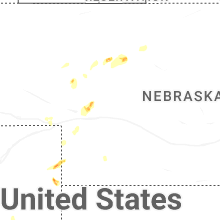


Connect with Interactive Hail Maps