

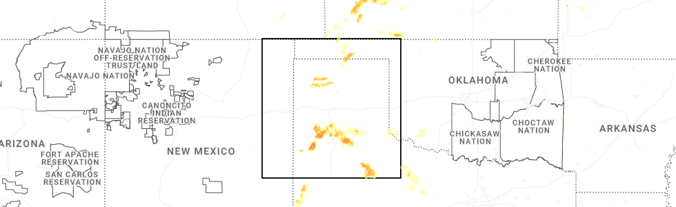
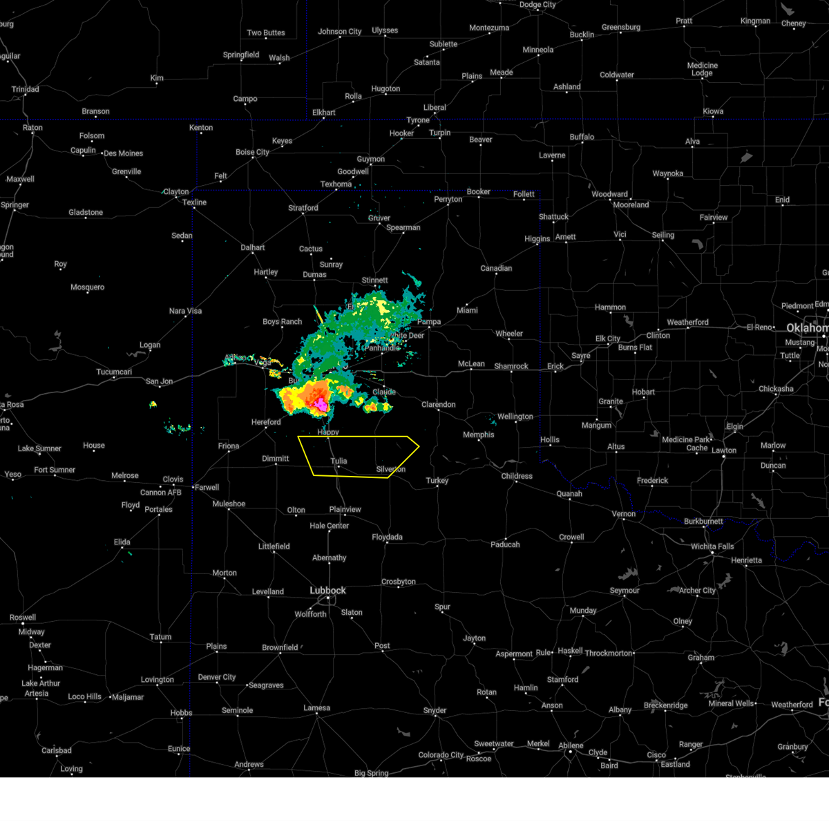
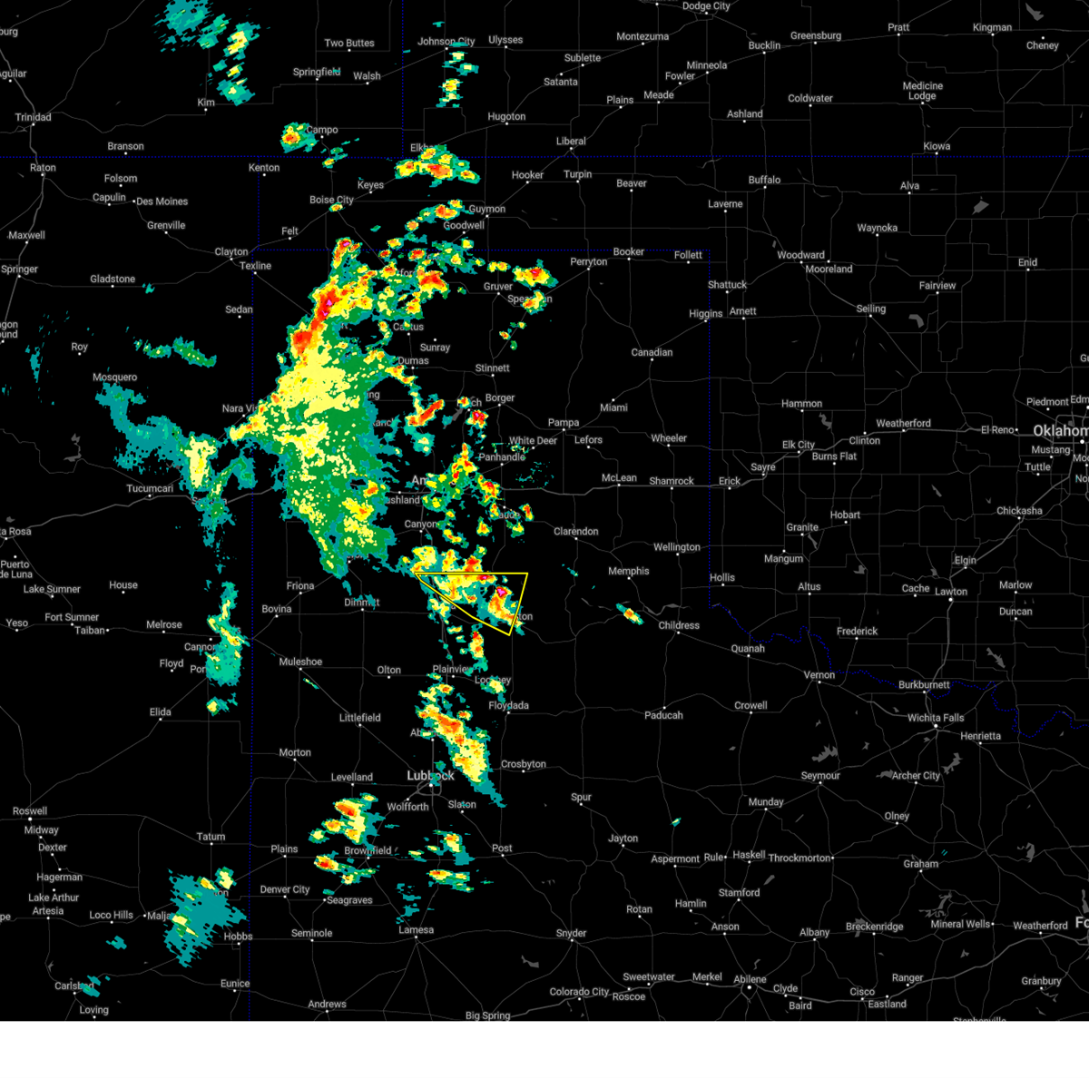
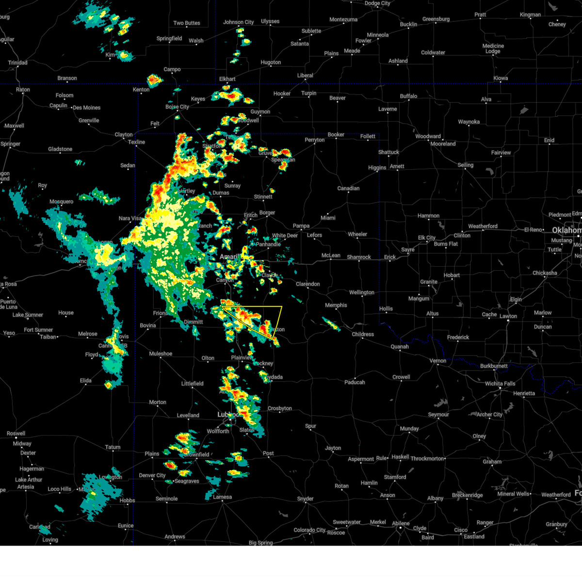
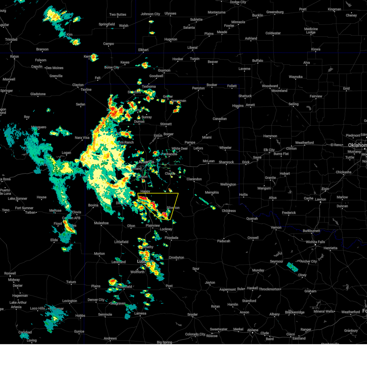
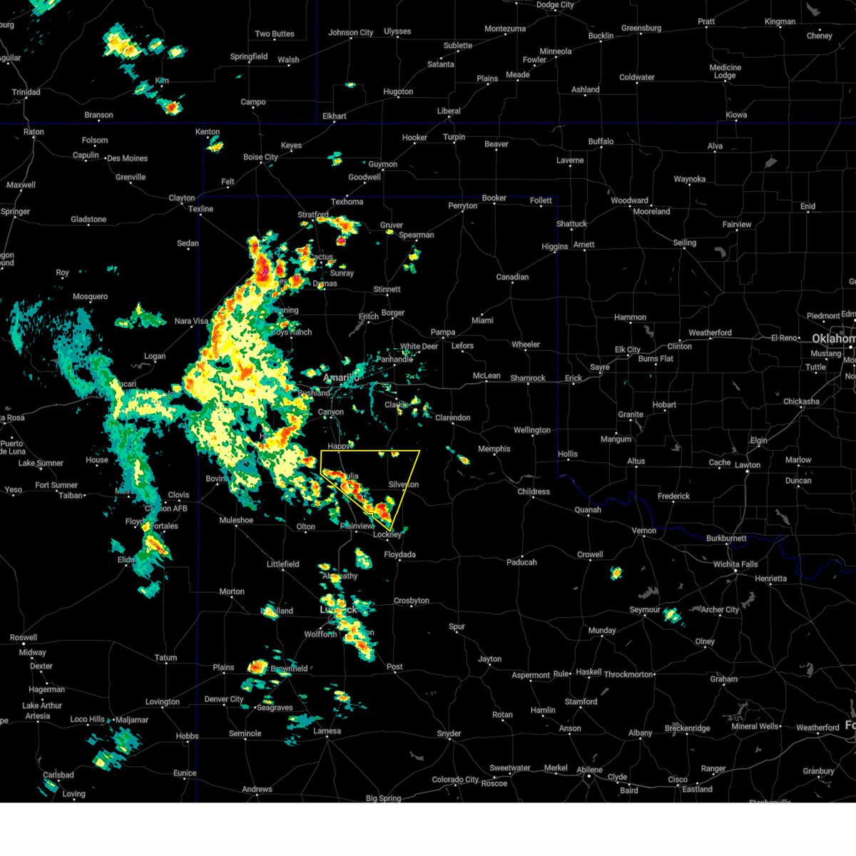
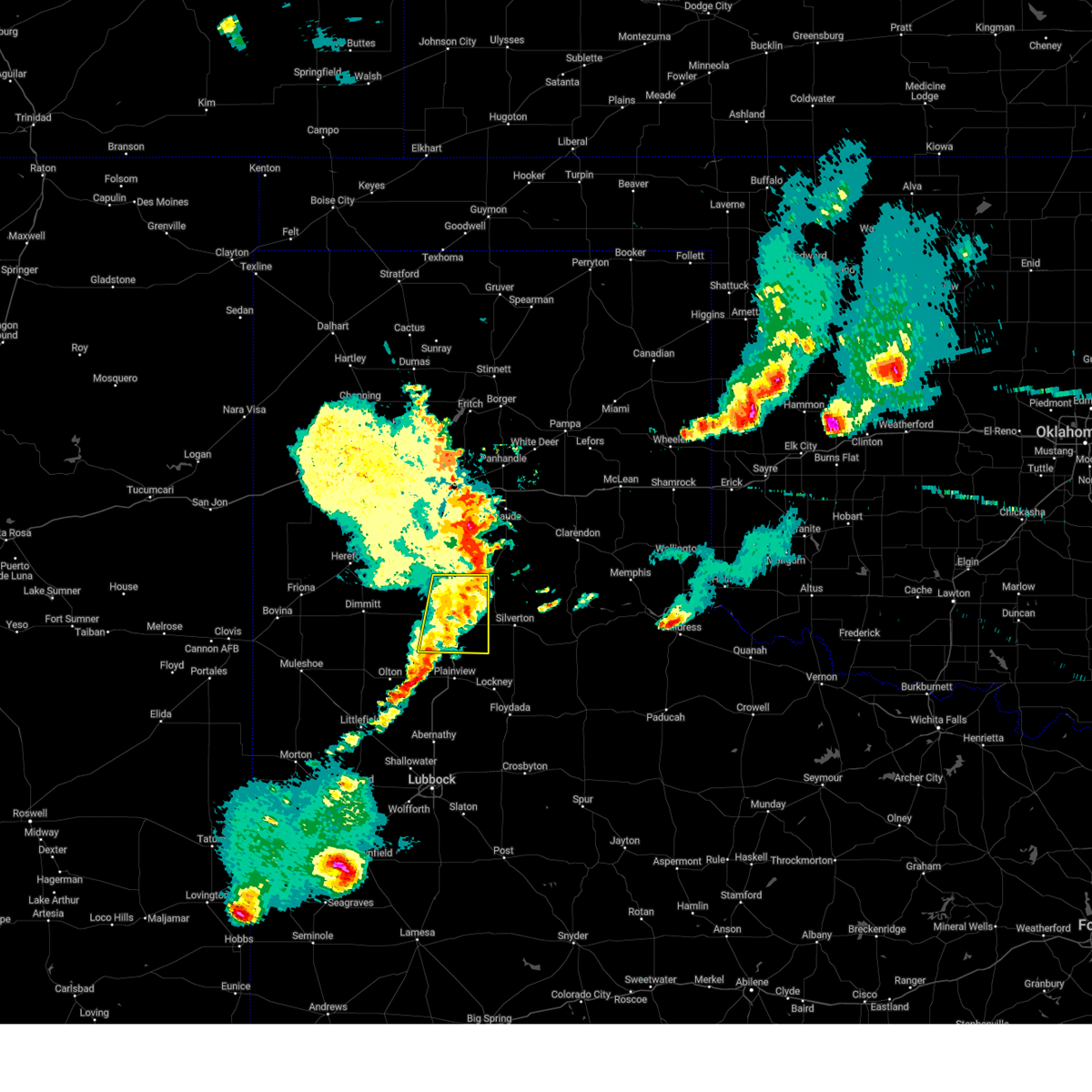
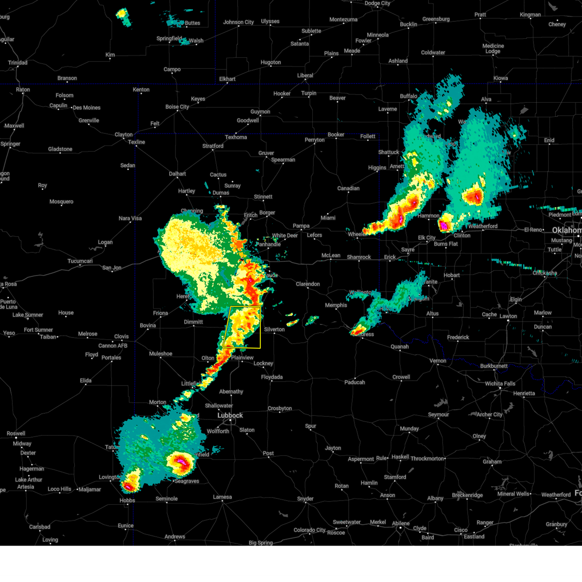
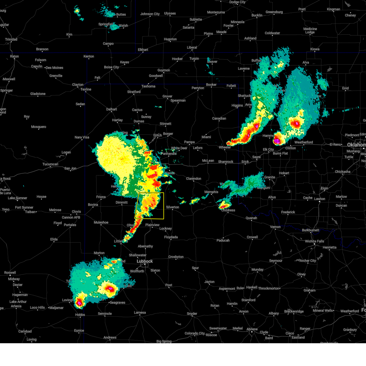
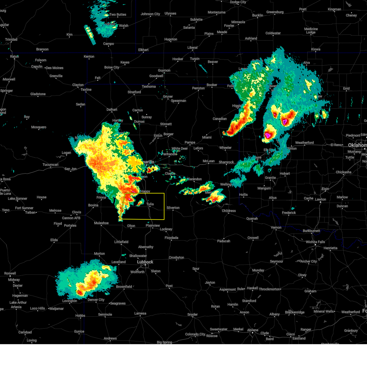
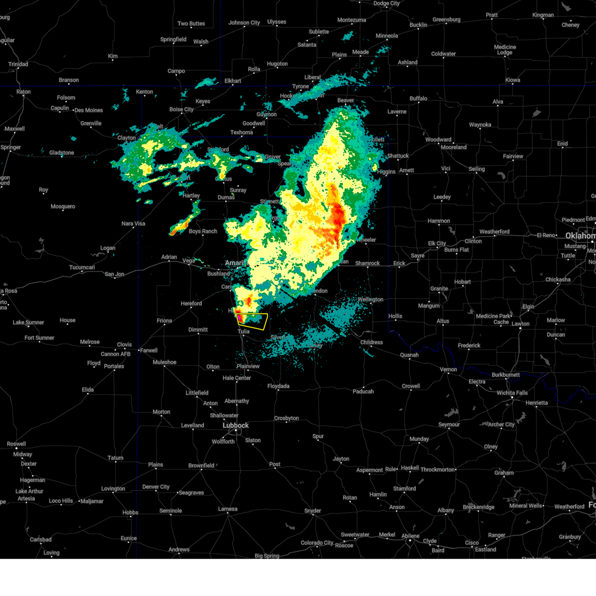
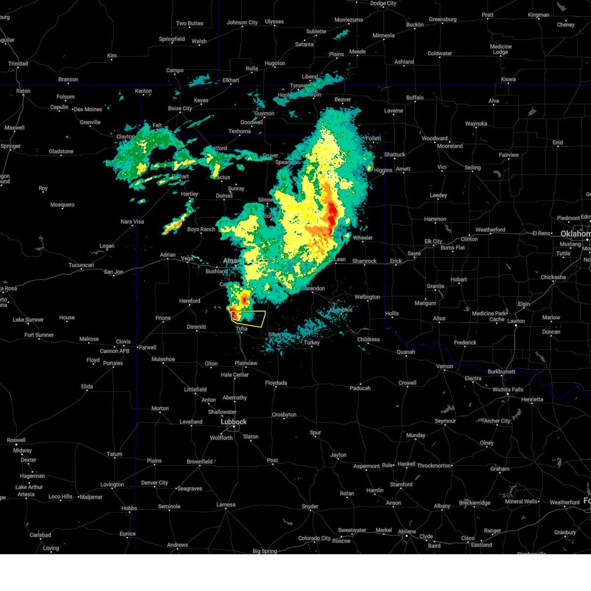
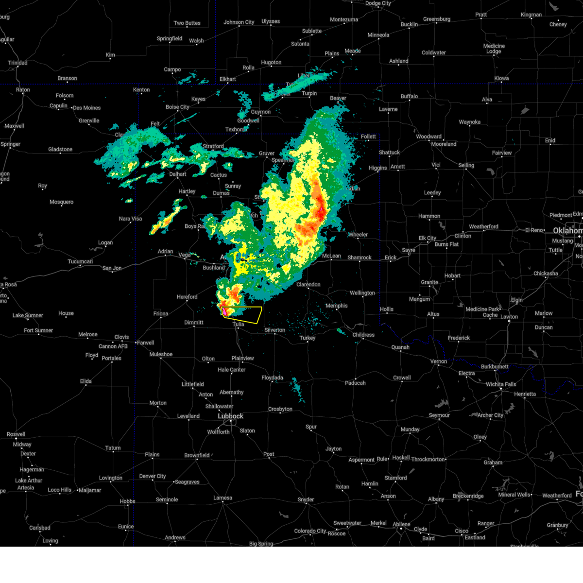
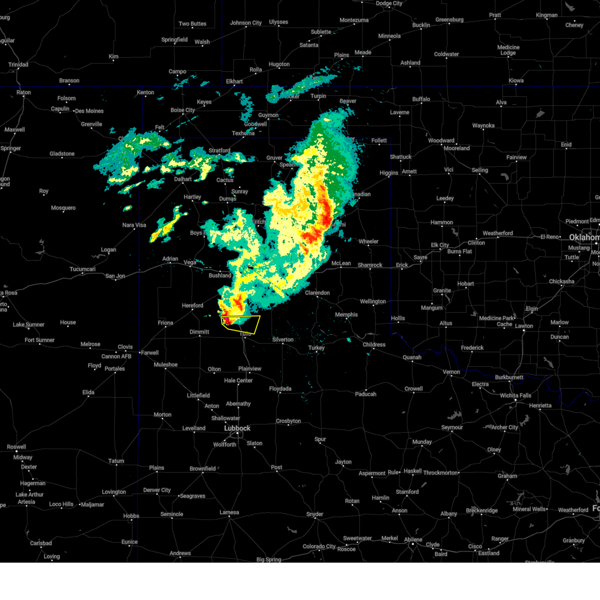
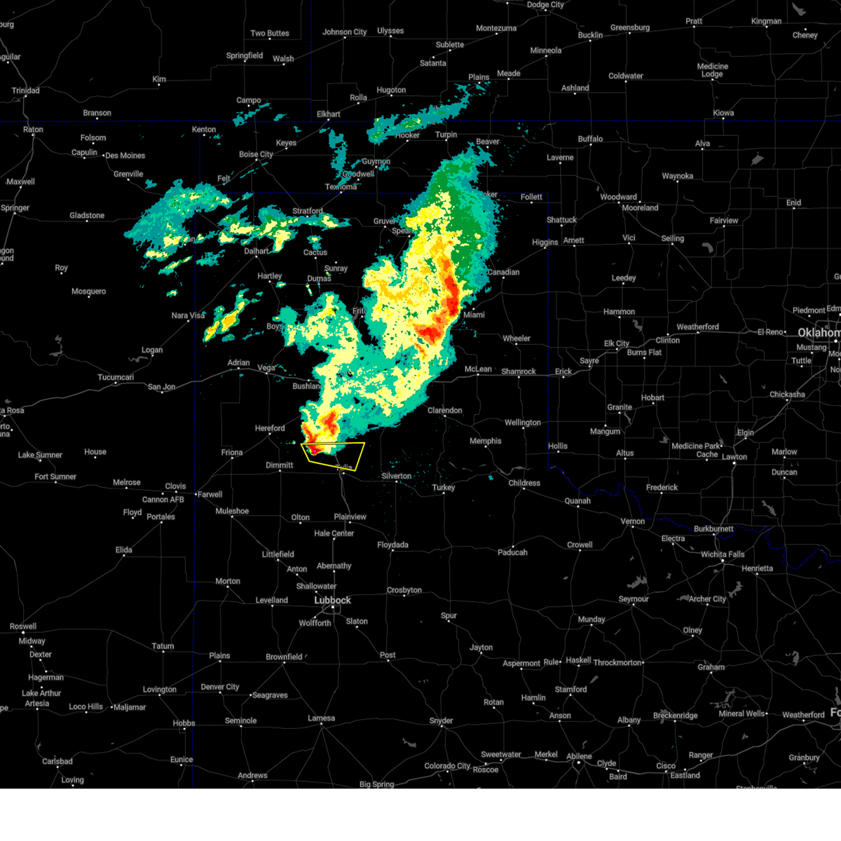
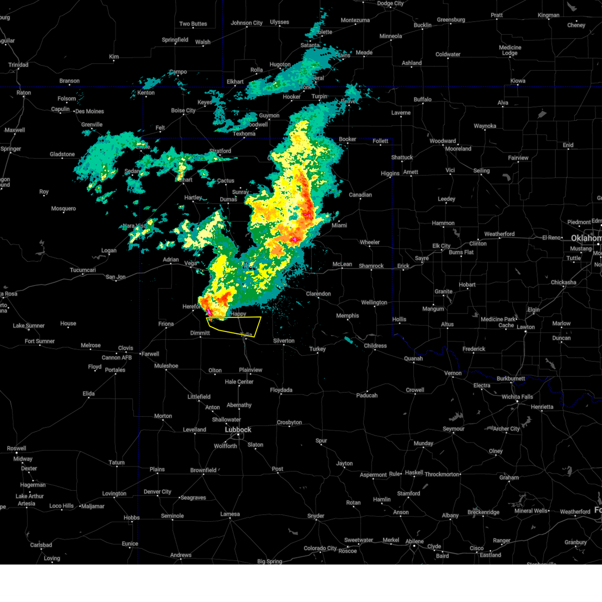
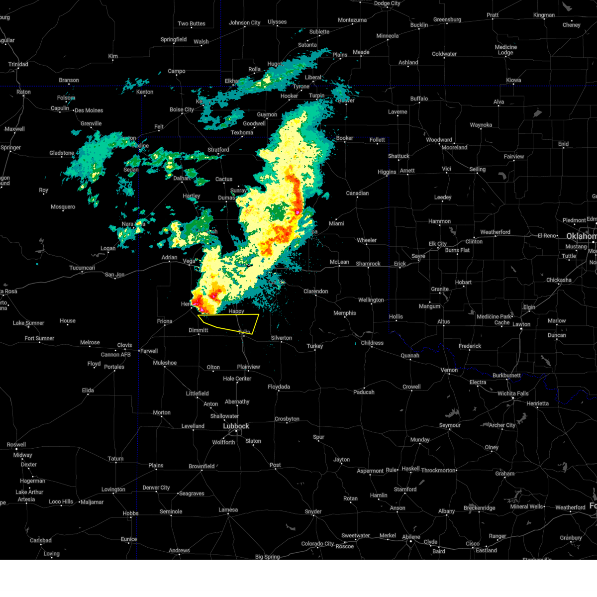
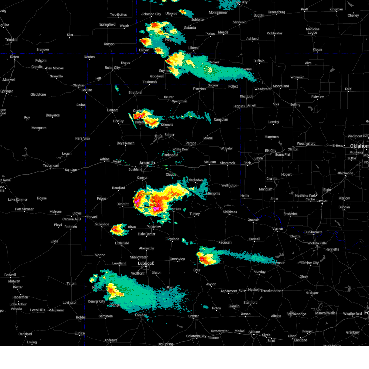
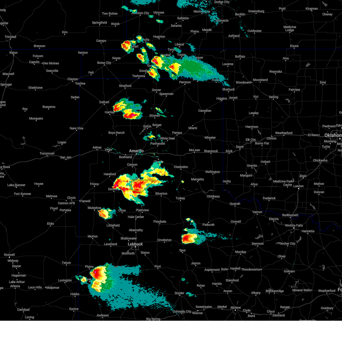
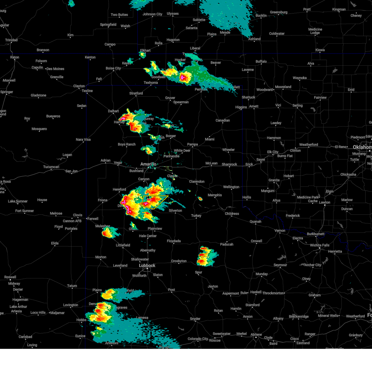
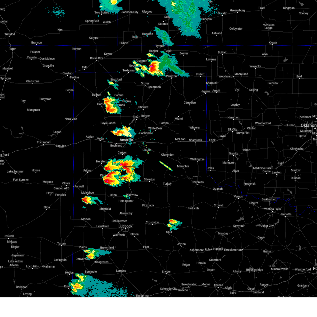
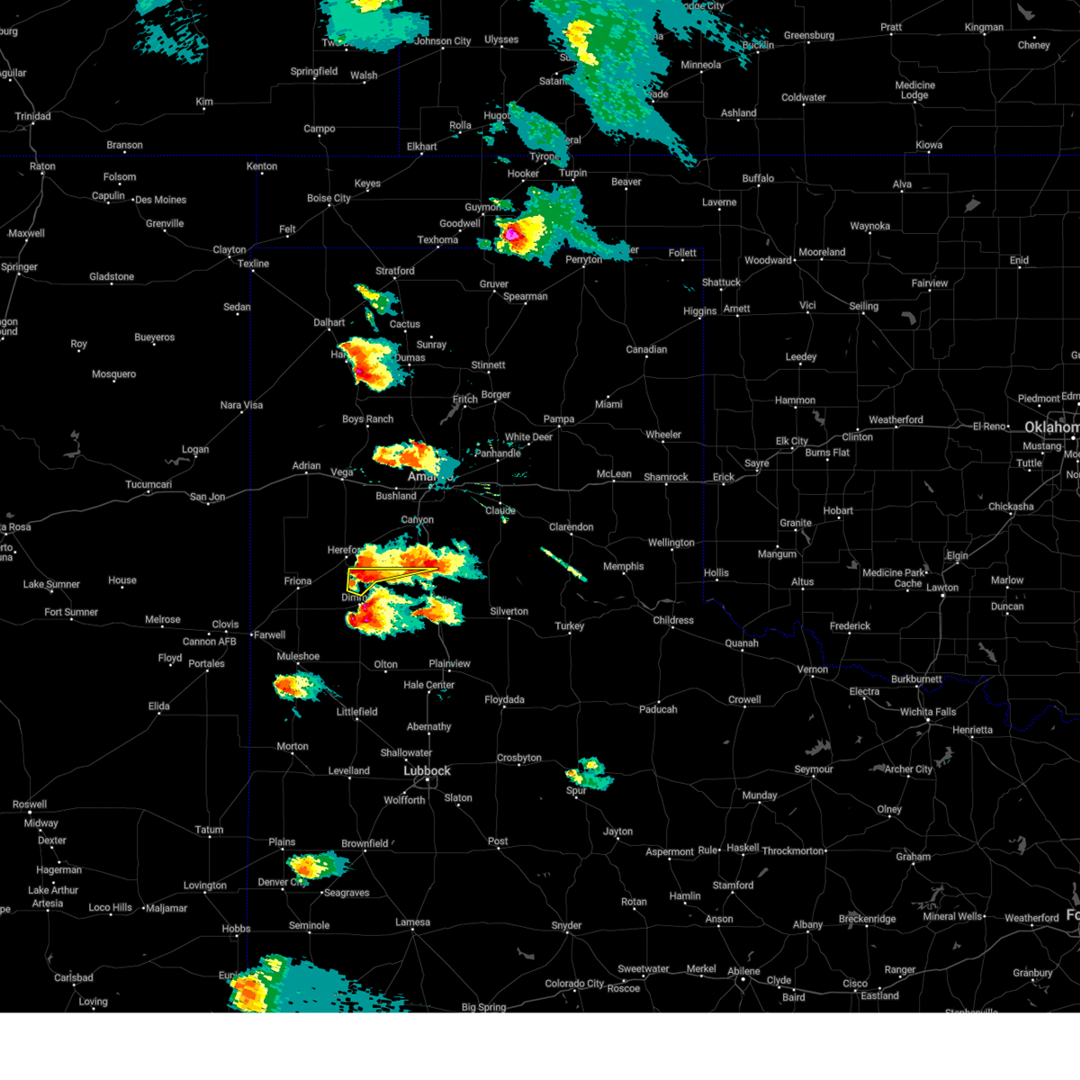
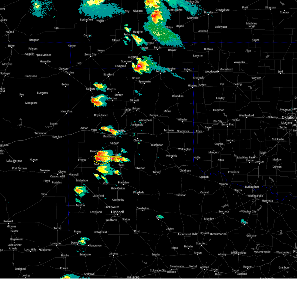
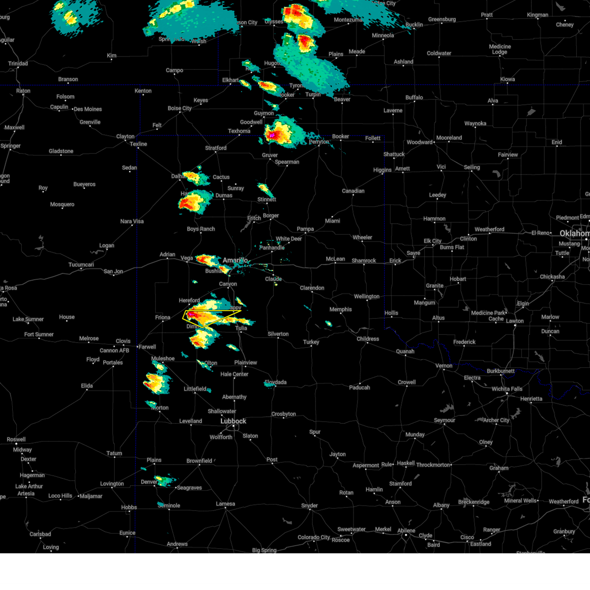
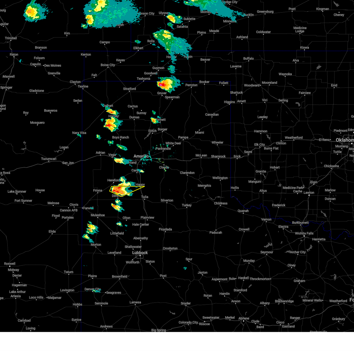
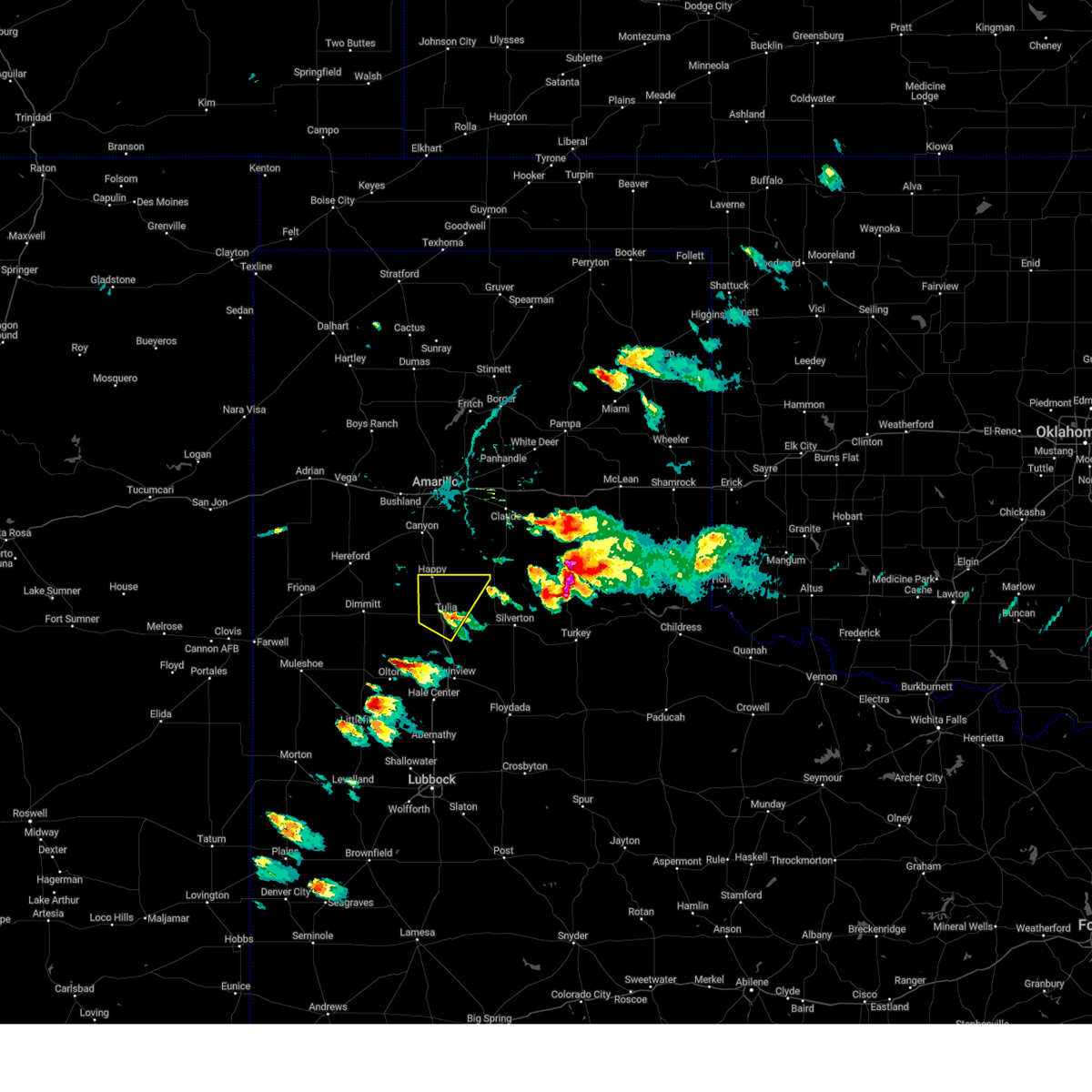
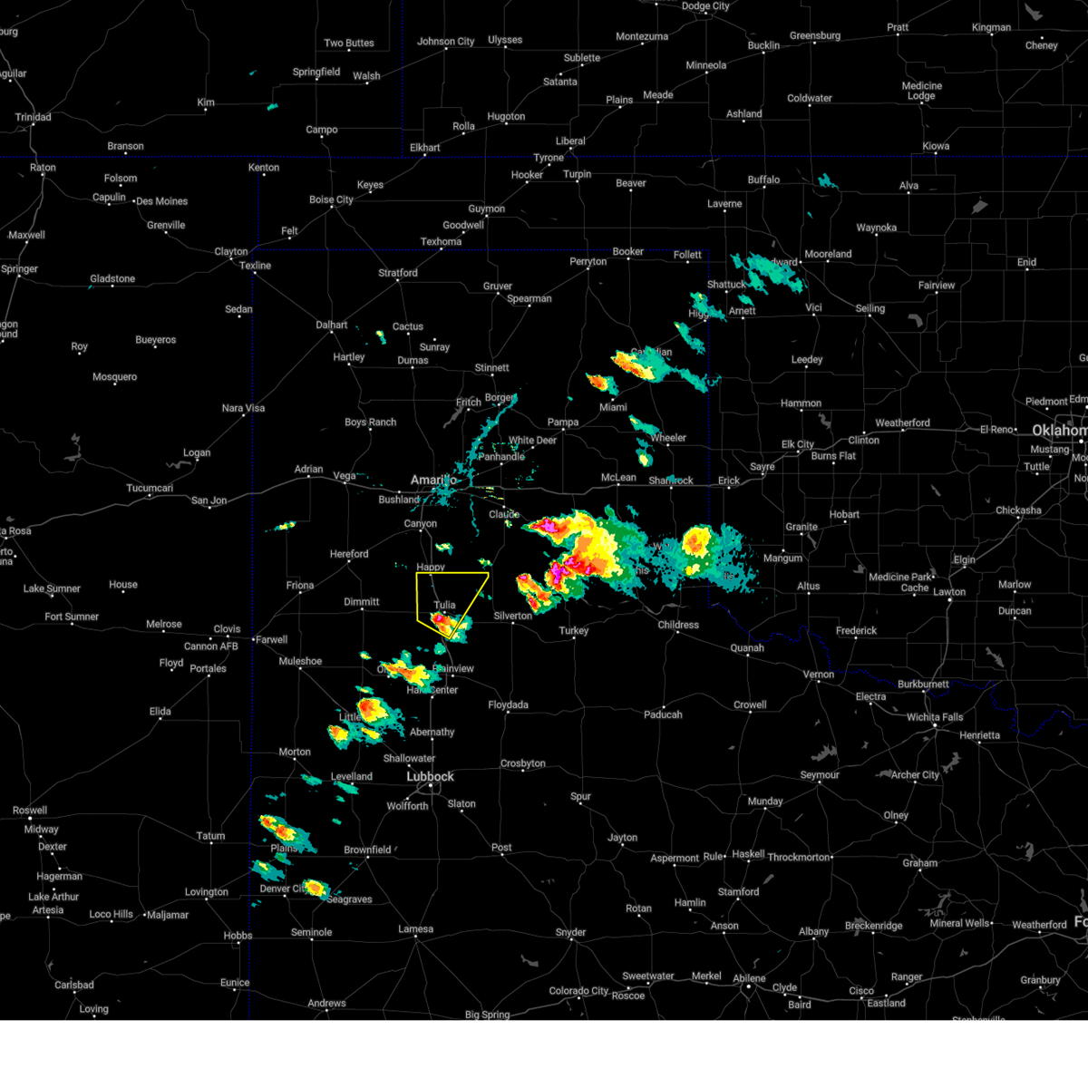
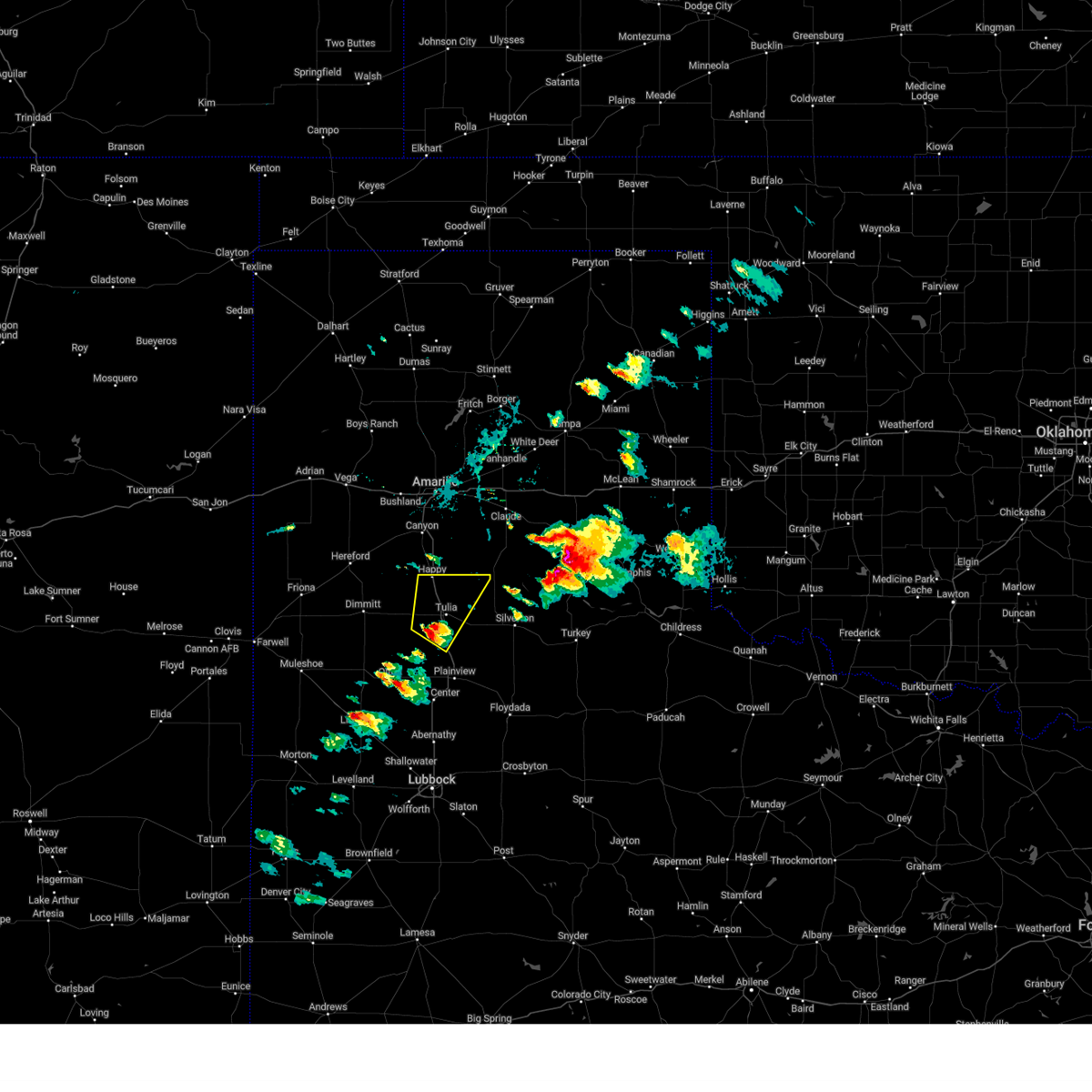
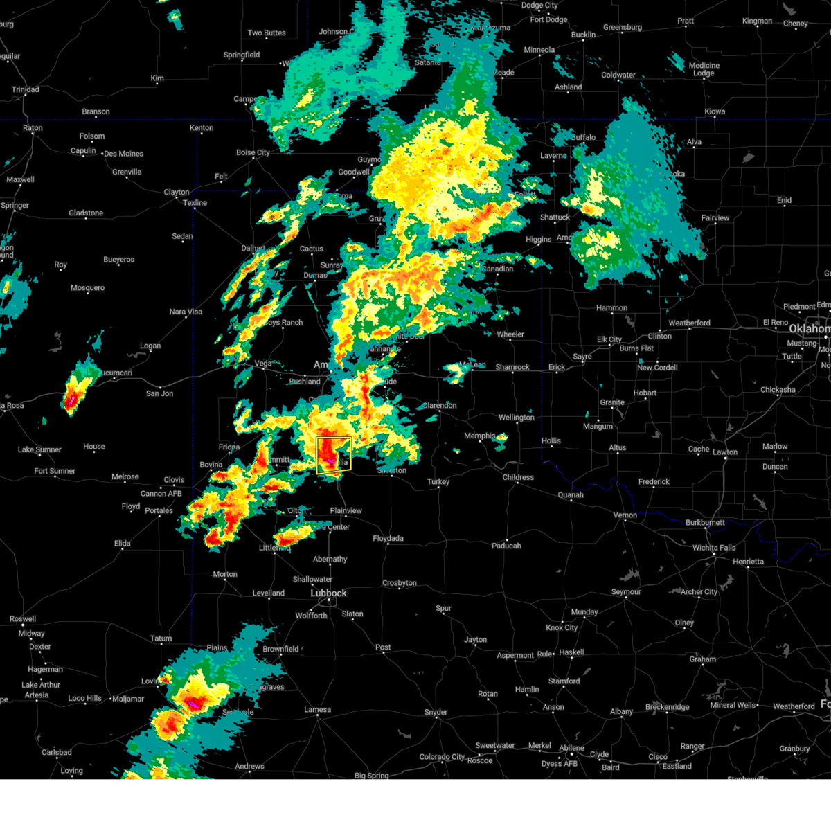
Hail Map for Happy, TX
The Happy, TX area has had 27 reports of on-the-ground hail by trained spotters, and has been under severe weather warnings 46 times during the past 12 months. Doppler radar has detected hail at or near Happy, TX on 95 occasions, including 7 occasions during the past year.
| Name: | Happy, TX |
| Where Located: | 32 miles S of Amarillo, TX |
| Map: | Google Map for Happy, TX |
| Population: | 678 |
| Housing Units: | 301 |
| More Info: | Search Google for Happy, TX |
1
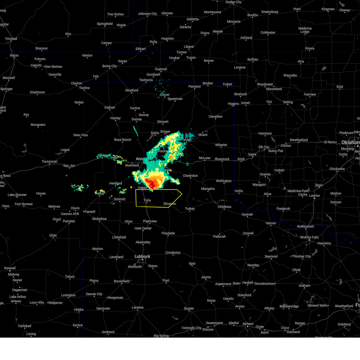
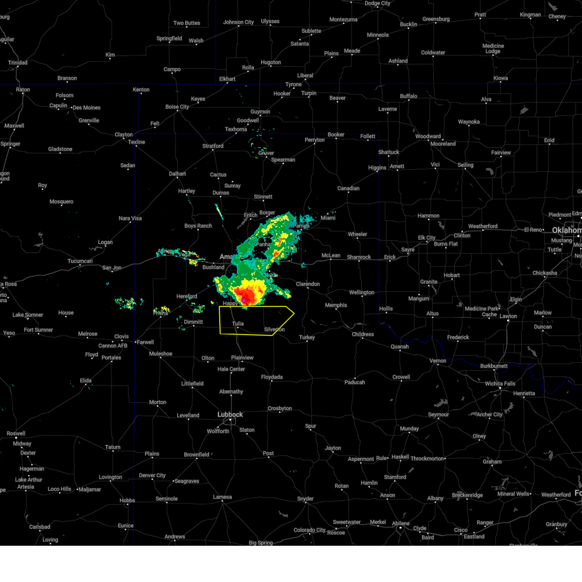
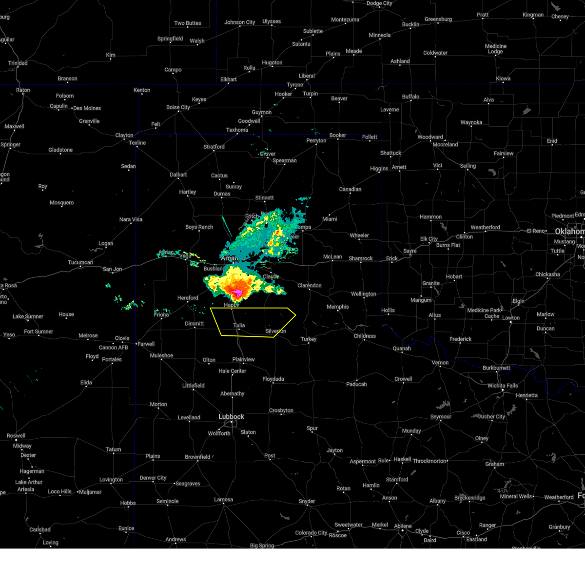
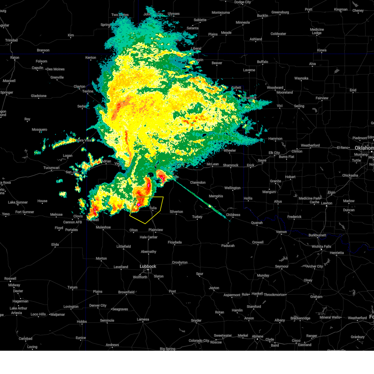
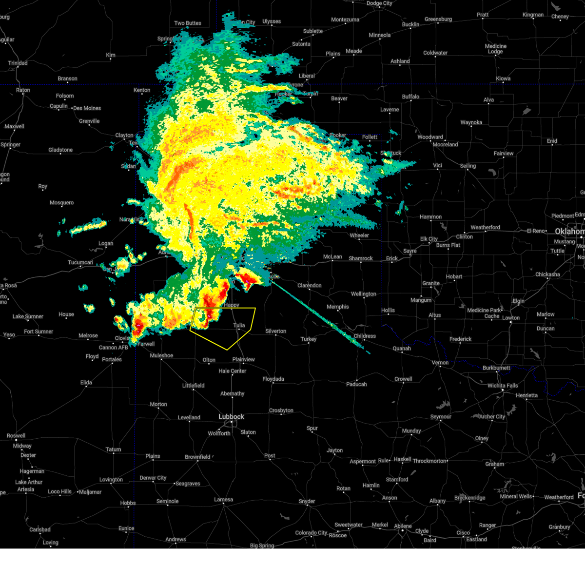
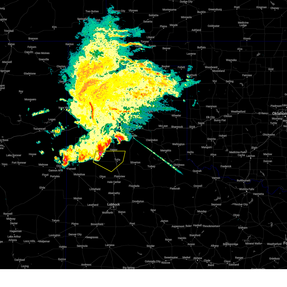
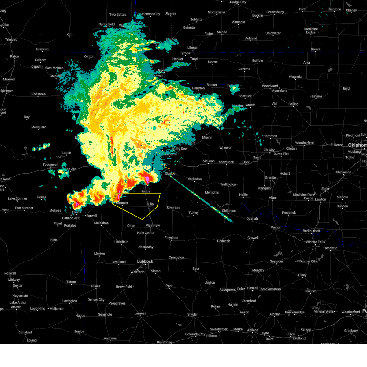
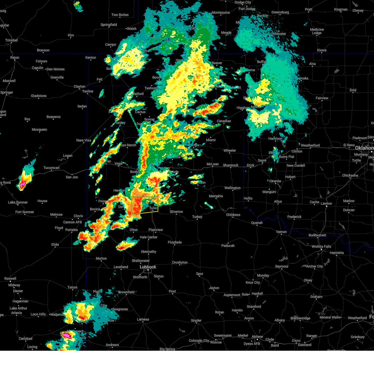
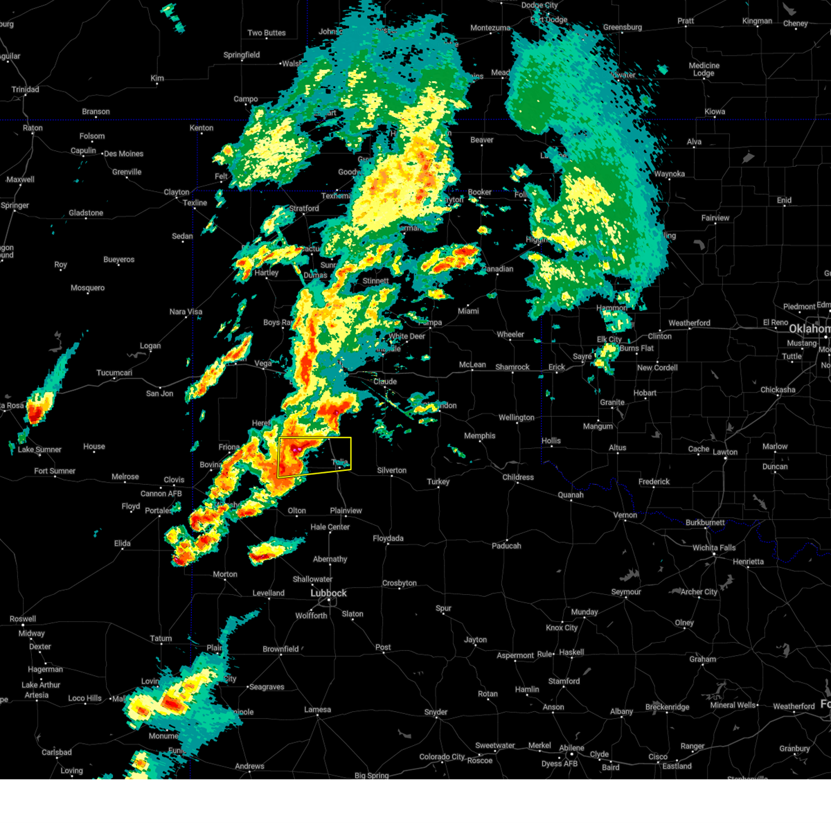
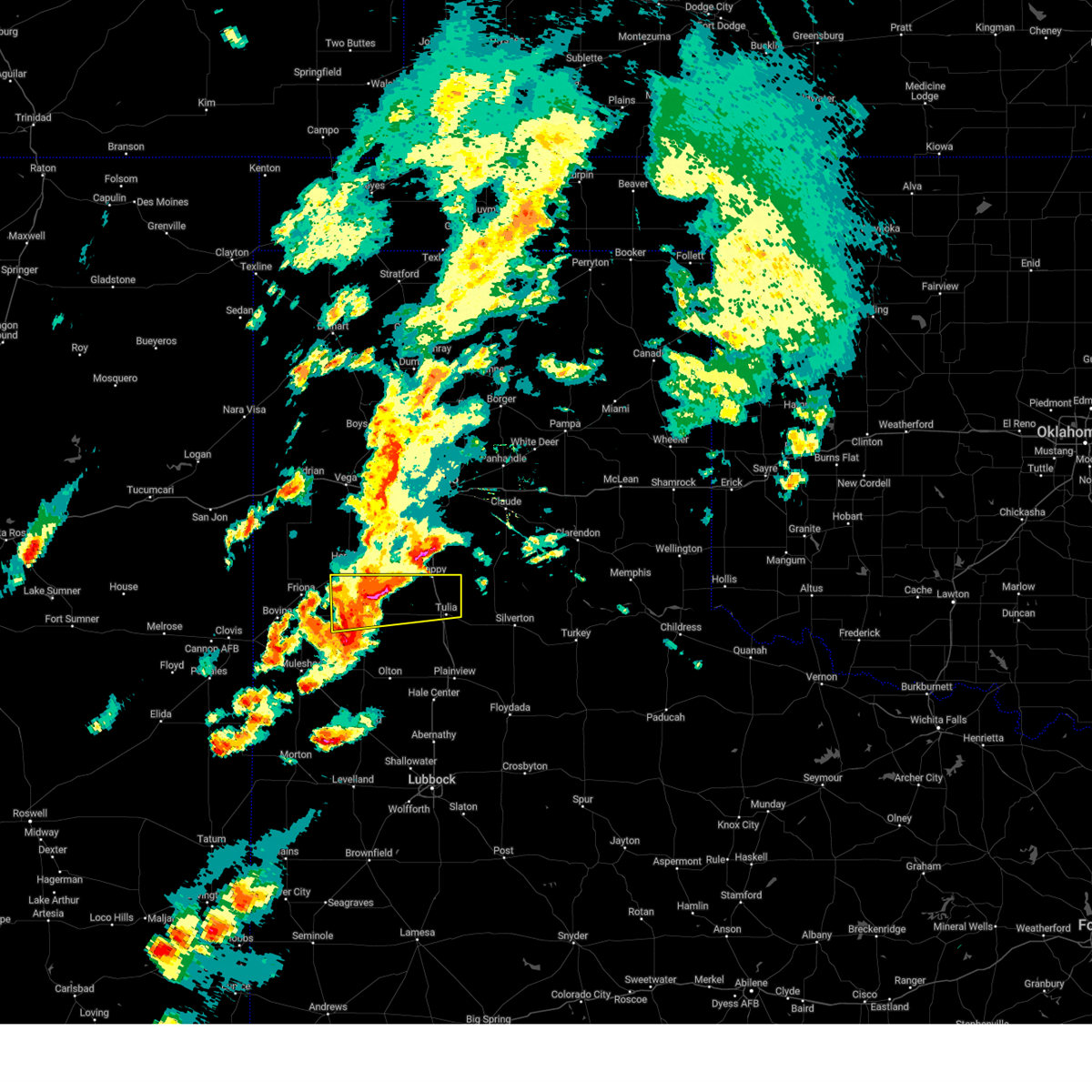
The Top Recent Hail Date for Happy, TX is Wednesday, April 23, 2025 (4th out of 95)
Hail and Wind Damage Spotted near Happy, TX
| Date / Time | Report Details |
|---|---|
| 6/8/2025 3:03 AM CDT |
 the severe thunderstorm warning has been cancelled and is no longer in effect the severe thunderstorm warning has been cancelled and is no longer in effect
|
| 6/8/2025 3:03 AM CDT |
 At 302 am cdt, a severe thunderstorm with a history of producing wind-driven hail was located 4 miles southwest of wayside, or 17 miles northeast of tulia, moving southeast at 50 mph (radar indicated). Hazards include golf ball size hail and 70 mph wind gusts. People and animals outdoors will be injured. expect hail damage to roofs, siding, windows, and vehicles. expect considerable tree damage. wind damage is also likely to mobile homes, roofs, and outbuildings. Locations impacted include, tulia, silverton, happy, vigo park, and mackenzie reservoir. At 302 am cdt, a severe thunderstorm with a history of producing wind-driven hail was located 4 miles southwest of wayside, or 17 miles northeast of tulia, moving southeast at 50 mph (radar indicated). Hazards include golf ball size hail and 70 mph wind gusts. People and animals outdoors will be injured. expect hail damage to roofs, siding, windows, and vehicles. expect considerable tree damage. wind damage is also likely to mobile homes, roofs, and outbuildings. Locations impacted include, tulia, silverton, happy, vigo park, and mackenzie reservoir.
|
| 6/8/2025 2:52 AM CDT |
 At 250 am cdt, a dangerous severe thunderstorm was located 9 miles west of wayside, or 17 miles southeast of canyon, moving southeast at 50 mph. this storm has a history of producing wind gusts of 72 to 84 mph! this is a destructive storm for happy, tulia and vigo park (west texas mesonet). Hazards include 80 mph wind gusts and baseball size hail. Flying debris will be dangerous to those caught without shelter. mobile homes will be heavily damaged. expect considerable damage to roofs, windows, and vehicles. extensive tree damage and power outages are likely. Locations impacted include, tulia, silverton, happy, vigo park, and mackenzie reservoir. At 250 am cdt, a dangerous severe thunderstorm was located 9 miles west of wayside, or 17 miles southeast of canyon, moving southeast at 50 mph. this storm has a history of producing wind gusts of 72 to 84 mph! this is a destructive storm for happy, tulia and vigo park (west texas mesonet). Hazards include 80 mph wind gusts and baseball size hail. Flying debris will be dangerous to those caught without shelter. mobile homes will be heavily damaged. expect considerable damage to roofs, windows, and vehicles. extensive tree damage and power outages are likely. Locations impacted include, tulia, silverton, happy, vigo park, and mackenzie reservoir.
|
| 6/8/2025 2:42 AM CDT |
 Svrlub the national weather service in lubbock texas has issued a * severe thunderstorm warning for, northeastern castro county in the panhandle of texas, swisher county in the panhandle of texas, northwestern briscoe county in the panhandle of texas, * until 345 am cdt. * at 241 am cdt, a severe thunderstorm was located 8 miles southeast of canyon, moving southeast at 60 mph. this is a destructive storm for happy, tulia and vigo park (west texas mesonet). Hazards include 80 mph wind gusts and three inch hail. Flying debris will be dangerous to those caught without shelter. mobile homes will be heavily damaged. expect considerable damage to roofs, windows, and vehicles. Extensive tree damage and power outages are likely. Svrlub the national weather service in lubbock texas has issued a * severe thunderstorm warning for, northeastern castro county in the panhandle of texas, swisher county in the panhandle of texas, northwestern briscoe county in the panhandle of texas, * until 345 am cdt. * at 241 am cdt, a severe thunderstorm was located 8 miles southeast of canyon, moving southeast at 60 mph. this is a destructive storm for happy, tulia and vigo park (west texas mesonet). Hazards include 80 mph wind gusts and three inch hail. Flying debris will be dangerous to those caught without shelter. mobile homes will be heavily damaged. expect considerable damage to roofs, windows, and vehicles. Extensive tree damage and power outages are likely.
|
| 6/6/2025 12:57 AM CDT |
 At 1256 am cdt, severe thunderstorms were located along a line extending from 13 miles west of tulia to muleshoe, moving east at 45 mph. large hail up to 2 inches in diameter is possible near hart (radar indicated). Hazards include two inch hail and 60 mph wind gusts. People and animals outdoors will be injured. expect hail damage to roofs, siding, windows, and vehicles. expect wind damage to roofs, siding, and trees. Locations impacted include, muleshoe, tulia, dimmitt, olton, hart, earth, kress, happy, lazbuddie, nazareth, edmonson, and springlake. At 1256 am cdt, severe thunderstorms were located along a line extending from 13 miles west of tulia to muleshoe, moving east at 45 mph. large hail up to 2 inches in diameter is possible near hart (radar indicated). Hazards include two inch hail and 60 mph wind gusts. People and animals outdoors will be injured. expect hail damage to roofs, siding, windows, and vehicles. expect wind damage to roofs, siding, and trees. Locations impacted include, muleshoe, tulia, dimmitt, olton, hart, earth, kress, happy, lazbuddie, nazareth, edmonson, and springlake.
|
| 6/6/2025 12:31 AM CDT |
 Svrlub the national weather service in lubbock texas has issued a * severe thunderstorm warning for, northeastern bailey county in northwestern texas, southeastern parmer county in the panhandle of texas, northwestern hale county in northwestern texas, castro county in the panhandle of texas, swisher county in the panhandle of texas, northern lamb county in northwestern texas, * until 130 am cdt. * at 1231 am cdt, severe thunderstorms were located along a line extending from 14 miles east of dimmitt to near muleshoe, moving east at 35 mph (radar indicated). Hazards include 60 mph wind gusts and half dollar size hail. Hail damage to vehicles is expected. Expect wind damage to roofs, siding, and trees. Svrlub the national weather service in lubbock texas has issued a * severe thunderstorm warning for, northeastern bailey county in northwestern texas, southeastern parmer county in the panhandle of texas, northwestern hale county in northwestern texas, castro county in the panhandle of texas, swisher county in the panhandle of texas, northern lamb county in northwestern texas, * until 130 am cdt. * at 1231 am cdt, severe thunderstorms were located along a line extending from 14 miles east of dimmitt to near muleshoe, moving east at 35 mph (radar indicated). Hazards include 60 mph wind gusts and half dollar size hail. Hail damage to vehicles is expected. Expect wind damage to roofs, siding, and trees.
|
| 6/5/2025 12:12 AM CDT |
 At 1212 am cdt, a severe thunderstorm was located 5 miles west of tulia, moving southeast at 35 mph (radar indicated). Hazards include two inch hail and 60 mph wind gusts. People and animals outdoors will be injured. expect hail damage to roofs, siding, windows, and vehicles. expect wind damage to roofs, siding, and trees. Locations impacted include, tulia and happy. At 1212 am cdt, a severe thunderstorm was located 5 miles west of tulia, moving southeast at 35 mph (radar indicated). Hazards include two inch hail and 60 mph wind gusts. People and animals outdoors will be injured. expect hail damage to roofs, siding, windows, and vehicles. expect wind damage to roofs, siding, and trees. Locations impacted include, tulia and happy.
|
| 6/5/2025 12:12 AM CDT |
 the severe thunderstorm warning has been cancelled and is no longer in effect the severe thunderstorm warning has been cancelled and is no longer in effect
|
| 6/5/2025 12:01 AM CDT |
 At 1200 am cdt, a severe thunderstorm was located 10 miles northeast of dimmitt, moving southeast at 40 mph (radar indicated). Hazards include two inch hail and 60 mph wind gusts. People and animals outdoors will be injured. expect hail damage to roofs, siding, windows, and vehicles. expect wind damage to roofs, siding, and trees. Locations impacted include, tulia, happy, and nazareth. At 1200 am cdt, a severe thunderstorm was located 10 miles northeast of dimmitt, moving southeast at 40 mph (radar indicated). Hazards include two inch hail and 60 mph wind gusts. People and animals outdoors will be injured. expect hail damage to roofs, siding, windows, and vehicles. expect wind damage to roofs, siding, and trees. Locations impacted include, tulia, happy, and nazareth.
|
| 6/4/2025 11:44 PM CDT |
 At 1143 pm cdt, a severe thunderstorm was located 13 miles southwest of happy, or 15 miles northeast of dimmitt, moving east at 40 mph (radar indicated). Hazards include two inch hail and 60 mph wind gusts. People and animals outdoors will be injured. expect hail damage to roofs, siding, windows, and vehicles. expect wind damage to roofs, siding, and trees. Locations impacted include, tulia, dimmitt, happy, and nazareth. At 1143 pm cdt, a severe thunderstorm was located 13 miles southwest of happy, or 15 miles northeast of dimmitt, moving east at 40 mph (radar indicated). Hazards include two inch hail and 60 mph wind gusts. People and animals outdoors will be injured. expect hail damage to roofs, siding, windows, and vehicles. expect wind damage to roofs, siding, and trees. Locations impacted include, tulia, dimmitt, happy, and nazareth.
|
| 6/4/2025 11:37 PM CDT |
 At 1137 pm cdt, a severe thunderstorm was located 11 miles northeast of dimmitt, moving east at 40 mph (radar indicated). Hazards include golf ball size hail and 60 mph wind gusts. People and animals outdoors will be injured. expect hail damage to roofs, siding, windows, and vehicles. expect wind damage to roofs, siding, and trees. Locations impacted include, tulia, dimmitt, happy, and nazareth. At 1137 pm cdt, a severe thunderstorm was located 11 miles northeast of dimmitt, moving east at 40 mph (radar indicated). Hazards include golf ball size hail and 60 mph wind gusts. People and animals outdoors will be injured. expect hail damage to roofs, siding, windows, and vehicles. expect wind damage to roofs, siding, and trees. Locations impacted include, tulia, dimmitt, happy, and nazareth.
|
| 6/4/2025 11:23 PM CDT |
 Svrlub the national weather service in lubbock texas has issued a * severe thunderstorm warning for, northeastern castro county in the panhandle of texas, northwestern swisher county in the panhandle of texas, * until 1230 am cdt. * at 1123 pm cdt, a severe thunderstorm was located 6 miles east of easter, or 7 miles north of dimmitt, moving east at 40 mph (radar indicated). Hazards include golf ball size hail and 60 mph wind gusts. People and animals outdoors will be injured. expect hail damage to roofs, siding, windows, and vehicles. Expect wind damage to roofs, siding, and trees. Svrlub the national weather service in lubbock texas has issued a * severe thunderstorm warning for, northeastern castro county in the panhandle of texas, northwestern swisher county in the panhandle of texas, * until 1230 am cdt. * at 1123 pm cdt, a severe thunderstorm was located 6 miles east of easter, or 7 miles north of dimmitt, moving east at 40 mph (radar indicated). Hazards include golf ball size hail and 60 mph wind gusts. People and animals outdoors will be injured. expect hail damage to roofs, siding, windows, and vehicles. Expect wind damage to roofs, siding, and trees.
|
| 6/2/2025 4:04 PM CDT |
 the severe thunderstorm warning has been cancelled and is no longer in effect the severe thunderstorm warning has been cancelled and is no longer in effect
|
| 6/2/2025 3:46 PM CDT |
 At 346 pm cdt, severe thunderstorms were located along a line extending from 5 miles north of happy to 3 miles southeast of mackenzie reservoir, moving north at 30 mph (radar indicated). Hazards include 60 mph wind gusts and nickel size hail. Expect damage to roofs, siding, and trees. Locations impacted include, silverton, happy, vigo park, and mackenzie reservoir. At 346 pm cdt, severe thunderstorms were located along a line extending from 5 miles north of happy to 3 miles southeast of mackenzie reservoir, moving north at 30 mph (radar indicated). Hazards include 60 mph wind gusts and nickel size hail. Expect damage to roofs, siding, and trees. Locations impacted include, silverton, happy, vigo park, and mackenzie reservoir.
|
| 6/2/2025 3:35 PM CDT |
 At 335 pm cdt, severe thunderstorms were located along a line extending from 4 miles southwest of happy to 8 miles east of claytonville, moving north at 30 mph (radar indicated). Hazards include 60 mph wind gusts and nickel size hail. Expect damage to roofs, siding, and trees. Locations impacted include, tulia, silverton, happy, vigo park, mackenzie reservoir, and claytonville. At 335 pm cdt, severe thunderstorms were located along a line extending from 4 miles southwest of happy to 8 miles east of claytonville, moving north at 30 mph (radar indicated). Hazards include 60 mph wind gusts and nickel size hail. Expect damage to roofs, siding, and trees. Locations impacted include, tulia, silverton, happy, vigo park, mackenzie reservoir, and claytonville.
|
| 6/2/2025 3:35 PM CDT |
 the severe thunderstorm warning has been cancelled and is no longer in effect the severe thunderstorm warning has been cancelled and is no longer in effect
|
| 6/2/2025 3:26 PM CDT | West texas mesonet repor in swisher county TX, 1 miles WNW of Happy, TX |
| 6/2/2025 3:23 PM CDT |
 Svrlub the national weather service in lubbock texas has issued a * severe thunderstorm warning for, northwestern floyd county in northwestern texas, east central castro county in the panhandle of texas, swisher county in the panhandle of texas, western briscoe county in the panhandle of texas, * until 430 pm cdt. * at 323 pm cdt, severe thunderstorms were located along a line extending from 9 miles south of happy to 7 miles southeast of claytonville, moving north at 35 mph (radar indicated). Hazards include 70 mph wind gusts and nickel size hail. Expect considerable tree damage. Damage is likely to mobile homes, roofs, and outbuildings. Svrlub the national weather service in lubbock texas has issued a * severe thunderstorm warning for, northwestern floyd county in northwestern texas, east central castro county in the panhandle of texas, swisher county in the panhandle of texas, western briscoe county in the panhandle of texas, * until 430 pm cdt. * at 323 pm cdt, severe thunderstorms were located along a line extending from 9 miles south of happy to 7 miles southeast of claytonville, moving north at 35 mph (radar indicated). Hazards include 70 mph wind gusts and nickel size hail. Expect considerable tree damage. Damage is likely to mobile homes, roofs, and outbuildings.
|
| 5/26/2025 10:07 PM CDT |
 the severe thunderstorm warning has been cancelled and is no longer in effect the severe thunderstorm warning has been cancelled and is no longer in effect
|
| 5/26/2025 10:07 PM CDT |
 At 1007 pm cdt, severe thunderstorms were located along a line extending from 4 miles north of vigo park to 4 miles southwest of claytonville, moving east at 40 mph (radar indicated). Hazards include 60 mph wind gusts and penny size hail. Expect damage to roofs, siding, and trees. Locations impacted include, tulia, kress, happy, vigo park, and claytonville. At 1007 pm cdt, severe thunderstorms were located along a line extending from 4 miles north of vigo park to 4 miles southwest of claytonville, moving east at 40 mph (radar indicated). Hazards include 60 mph wind gusts and penny size hail. Expect damage to roofs, siding, and trees. Locations impacted include, tulia, kress, happy, vigo park, and claytonville.
|
| 5/26/2025 9:54 PM CDT |
 At 954 pm cdt, severe thunderstorms were located along a line extending from 6 miles southwest of wayside to 10 miles west of kress, moving east at 30 mph (radar indicated). Hazards include 60 mph wind gusts and nickel size hail. Expect damage to roofs, siding, and trees. Locations impacted include, tulia, kress, happy, vigo park, and claytonville. At 954 pm cdt, severe thunderstorms were located along a line extending from 6 miles southwest of wayside to 10 miles west of kress, moving east at 30 mph (radar indicated). Hazards include 60 mph wind gusts and nickel size hail. Expect damage to roofs, siding, and trees. Locations impacted include, tulia, kress, happy, vigo park, and claytonville.
|
| 5/26/2025 9:21 PM CDT |
 Svrlub the national weather service in lubbock texas has issued a * severe thunderstorm warning for, eastern castro county in the panhandle of texas, swisher county in the panhandle of texas, * until 1015 pm cdt. * at 921 pm cdt, severe thunderstorms were located along a line extending from 12 miles west of happy to 5 miles northwest of hart, moving east at 45 mph (radar indicated). Hazards include 60 mph wind gusts and nickel size hail. expect damage to roofs, siding, and trees Svrlub the national weather service in lubbock texas has issued a * severe thunderstorm warning for, eastern castro county in the panhandle of texas, swisher county in the panhandle of texas, * until 1015 pm cdt. * at 921 pm cdt, severe thunderstorms were located along a line extending from 12 miles west of happy to 5 miles northwest of hart, moving east at 45 mph (radar indicated). Hazards include 60 mph wind gusts and nickel size hail. expect damage to roofs, siding, and trees
|
| 5/1/2025 10:44 PM CDT |
 At 1043 pm cdt, a severe thunderstorm was located 7 miles east of happy, or 11 miles north of tulia, moving east at 30 mph (radar indicated). Hazards include 60 mph wind gusts and half dollar size hail. Hail damage to vehicles is expected. expect wind damage to roofs, siding, and trees. Locations impacted include, happy and vigo park. At 1043 pm cdt, a severe thunderstorm was located 7 miles east of happy, or 11 miles north of tulia, moving east at 30 mph (radar indicated). Hazards include 60 mph wind gusts and half dollar size hail. Hail damage to vehicles is expected. expect wind damage to roofs, siding, and trees. Locations impacted include, happy and vigo park.
|
| 5/1/2025 10:38 PM CDT |
 At 1038 pm cdt, a severe thunderstorm was located 4 miles southeast of happy, or 11 miles north of tulia, moving east at 30 mph (radar indicated). Hazards include 60 mph wind gusts and quarter size hail. Hail damage to vehicles is expected. expect wind damage to roofs, siding, and trees. Locations impacted include, happy and vigo park. At 1038 pm cdt, a severe thunderstorm was located 4 miles southeast of happy, or 11 miles north of tulia, moving east at 30 mph (radar indicated). Hazards include 60 mph wind gusts and quarter size hail. Hail damage to vehicles is expected. expect wind damage to roofs, siding, and trees. Locations impacted include, happy and vigo park.
|
| 5/1/2025 10:29 PM CDT |
 Svrlub the national weather service in lubbock texas has issued a * severe thunderstorm warning for, northern swisher county in the panhandle of texas, * until 1130 pm cdt. * at 1029 pm cdt, a severe thunderstorm was located over happy, or 12 miles northwest of tulia, moving east at 30 mph (radar indicated). Hazards include 60 mph wind gusts and quarter size hail. Hail damage to vehicles is expected. Expect wind damage to roofs, siding, and trees. Svrlub the national weather service in lubbock texas has issued a * severe thunderstorm warning for, northern swisher county in the panhandle of texas, * until 1130 pm cdt. * at 1029 pm cdt, a severe thunderstorm was located over happy, or 12 miles northwest of tulia, moving east at 30 mph (radar indicated). Hazards include 60 mph wind gusts and quarter size hail. Hail damage to vehicles is expected. Expect wind damage to roofs, siding, and trees.
|
| 5/1/2025 10:22 PM CDT |
 At 1021 pm cdt, a severe thunderstorm was located 5 miles southwest of happy, or 13 miles northwest of tulia, moving east at 30 mph (radar indicated). Hazards include 60 mph wind gusts and quarter size hail. Hail damage to vehicles is expected. expect wind damage to roofs, siding, and trees. Locations impacted include, happy. At 1021 pm cdt, a severe thunderstorm was located 5 miles southwest of happy, or 13 miles northwest of tulia, moving east at 30 mph (radar indicated). Hazards include 60 mph wind gusts and quarter size hail. Hail damage to vehicles is expected. expect wind damage to roofs, siding, and trees. Locations impacted include, happy.
|
| 5/1/2025 10:15 PM CDT |
 At 1015 pm cdt, a severe thunderstorm was located 7 miles southwest of happy, or 15 miles northwest of tulia, moving east at 30 mph (radar indicated). Hazards include 60 mph wind gusts and quarter size hail. Hail damage to vehicles is expected. expect wind damage to roofs, siding, and trees. Locations impacted include, happy. At 1015 pm cdt, a severe thunderstorm was located 7 miles southwest of happy, or 15 miles northwest of tulia, moving east at 30 mph (radar indicated). Hazards include 60 mph wind gusts and quarter size hail. Hail damage to vehicles is expected. expect wind damage to roofs, siding, and trees. Locations impacted include, happy.
|
| 5/1/2025 9:58 PM CDT |
 At 958 pm cdt, a severe thunderstorm was located 8 miles south of buffalo lake, or 15 miles east of hereford, moving east at 30 mph (radar indicated). Hazards include 60 mph wind gusts and half dollar size hail. Hail damage to vehicles is expected. expect wind damage to roofs, siding, and trees. Locations impacted include, happy. At 958 pm cdt, a severe thunderstorm was located 8 miles south of buffalo lake, or 15 miles east of hereford, moving east at 30 mph (radar indicated). Hazards include 60 mph wind gusts and half dollar size hail. Hail damage to vehicles is expected. expect wind damage to roofs, siding, and trees. Locations impacted include, happy.
|
| 5/1/2025 9:51 PM CDT |
 Svrlub the national weather service in lubbock texas has issued a * severe thunderstorm warning for, northeastern castro county in the panhandle of texas, northwestern swisher county in the panhandle of texas, * until 1030 pm cdt. * at 950 pm cdt, a severe thunderstorm was located 8 miles southwest of buffalo lake, or 11 miles east of hereford, moving east at 30 mph (radar indicated). Hazards include 60 mph wind gusts and quarter size hail. Hail damage to vehicles is expected. Expect wind damage to roofs, siding, and trees. Svrlub the national weather service in lubbock texas has issued a * severe thunderstorm warning for, northeastern castro county in the panhandle of texas, northwestern swisher county in the panhandle of texas, * until 1030 pm cdt. * at 950 pm cdt, a severe thunderstorm was located 8 miles southwest of buffalo lake, or 11 miles east of hereford, moving east at 30 mph (radar indicated). Hazards include 60 mph wind gusts and quarter size hail. Hail damage to vehicles is expected. Expect wind damage to roofs, siding, and trees.
|
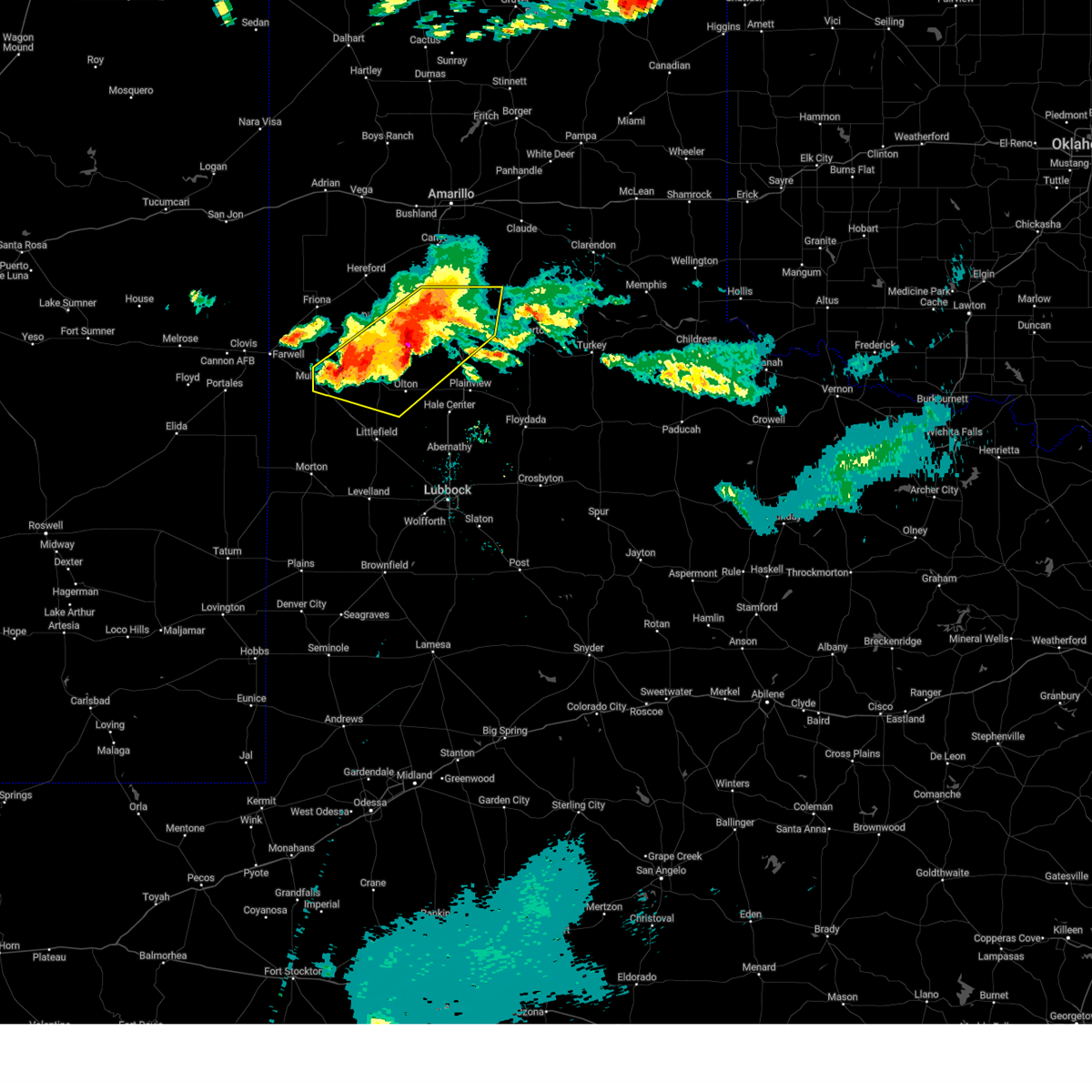
| 4/23/2025 9:12 PM CDT |
 Svrlub the national weather service in lubbock texas has issued a * severe thunderstorm warning for, northeastern castro county in the panhandle of texas, northwestern swisher county in the panhandle of texas, * until 1015 pm cdt. * at 912 pm cdt, a severe thunderstorm was located 12 miles southwest of happy, or 15 miles northwest of tulia, moving east at 15 mph (radar indicated). Hazards include tennis ball size hail and 60 mph wind gusts. People and animals outdoors will be injured. expect hail damage to roofs, siding, windows, and vehicles. Expect wind damage to roofs, siding, and trees. Svrlub the national weather service in lubbock texas has issued a * severe thunderstorm warning for, northeastern castro county in the panhandle of texas, northwestern swisher county in the panhandle of texas, * until 1015 pm cdt. * at 912 pm cdt, a severe thunderstorm was located 12 miles southwest of happy, or 15 miles northwest of tulia, moving east at 15 mph (radar indicated). Hazards include tennis ball size hail and 60 mph wind gusts. People and animals outdoors will be injured. expect hail damage to roofs, siding, windows, and vehicles. Expect wind damage to roofs, siding, and trees.
|
| 4/23/2025 8:26 PM CDT |
 At 826 pm cdt, a severe thunderstorm was located 7 miles north of tulia, moving northeast at 15 mph (west texas mesonet. at 820 pm cdt, a wind gust of 69 mph was measured by the mesonet near tulia). Hazards include two inch hail and 70 mph wind gusts. People and animals outdoors will be injured. expect hail damage to roofs, siding, windows, and vehicles. expect considerable tree damage. wind damage is also likely to mobile homes, roofs, and outbuildings. Locations impacted include, happy and tulia. At 826 pm cdt, a severe thunderstorm was located 7 miles north of tulia, moving northeast at 15 mph (west texas mesonet. at 820 pm cdt, a wind gust of 69 mph was measured by the mesonet near tulia). Hazards include two inch hail and 70 mph wind gusts. People and animals outdoors will be injured. expect hail damage to roofs, siding, windows, and vehicles. expect considerable tree damage. wind damage is also likely to mobile homes, roofs, and outbuildings. Locations impacted include, happy and tulia.
|
| 4/23/2025 7:59 PM CDT |
 Svrlub the national weather service in lubbock texas has issued a * severe thunderstorm warning for, northern swisher county in the panhandle of texas, northwestern briscoe county in the panhandle of texas, * until 900 pm cdt. * at 759 pm cdt, a severe thunderstorm was located 7 miles south of happy, or 9 miles northwest of tulia, moving northeast at 10 mph (public). Hazards include two inch hail and 60 mph wind gusts. People and animals outdoors will be injured. expect hail damage to roofs, siding, windows, and vehicles. Expect wind damage to roofs, siding, and trees. Svrlub the national weather service in lubbock texas has issued a * severe thunderstorm warning for, northern swisher county in the panhandle of texas, northwestern briscoe county in the panhandle of texas, * until 900 pm cdt. * at 759 pm cdt, a severe thunderstorm was located 7 miles south of happy, or 9 miles northwest of tulia, moving northeast at 10 mph (public). Hazards include two inch hail and 60 mph wind gusts. People and animals outdoors will be injured. expect hail damage to roofs, siding, windows, and vehicles. Expect wind damage to roofs, siding, and trees.
|
| 4/23/2025 7:47 PM CDT | At 747 pm cdt, a severe thunderstorm was located 7 miles northwest of tulia, moving northeast at 10 mph (radar indicated). Hazards include ping pong ball size hail and 60 mph wind gusts. People and animals outdoors will be injured. expect hail damage to roofs, siding, windows, and vehicles. expect wind damage to roofs, siding, and trees. Locations impacted include, happy and tulia. |
| 4/23/2025 7:31 PM CDT |
 Svrlub the national weather service in lubbock texas has issued a * severe thunderstorm warning for, northwestern swisher county in the panhandle of texas, * until 800 pm cdt. * at 731 pm cdt, a severe thunderstorm was located 7 miles west of tulia, moving northeast at 10 mph (radar indicated). Hazards include ping pong ball size hail and 60 mph wind gusts. People and animals outdoors will be injured. expect hail damage to roofs, siding, windows, and vehicles. Expect wind damage to roofs, siding, and trees. Svrlub the national weather service in lubbock texas has issued a * severe thunderstorm warning for, northwestern swisher county in the panhandle of texas, * until 800 pm cdt. * at 731 pm cdt, a severe thunderstorm was located 7 miles west of tulia, moving northeast at 10 mph (radar indicated). Hazards include ping pong ball size hail and 60 mph wind gusts. People and animals outdoors will be injured. expect hail damage to roofs, siding, windows, and vehicles. Expect wind damage to roofs, siding, and trees.
|
| 4/23/2025 7:13 PM CDT |
 Svrlub the national weather service in lubbock texas has issued a * severe thunderstorm warning for, northeastern castro county in the panhandle of texas, northwestern swisher county in the panhandle of texas, * until 745 pm cdt. * at 713 pm cdt, a severe thunderstorm was located 9 miles northeast of easter, or 10 miles southeast of hereford, moving east at 25 mph (radar indicated). Hazards include ping pong ball size hail and 60 mph wind gusts. People and animals outdoors will be injured. expect hail damage to roofs, siding, windows, and vehicles. Expect wind damage to roofs, siding, and trees. Svrlub the national weather service in lubbock texas has issued a * severe thunderstorm warning for, northeastern castro county in the panhandle of texas, northwestern swisher county in the panhandle of texas, * until 745 pm cdt. * at 713 pm cdt, a severe thunderstorm was located 9 miles northeast of easter, or 10 miles southeast of hereford, moving east at 25 mph (radar indicated). Hazards include ping pong ball size hail and 60 mph wind gusts. People and animals outdoors will be injured. expect hail damage to roofs, siding, windows, and vehicles. Expect wind damage to roofs, siding, and trees.
|
| 4/23/2025 6:51 PM CDT |
 At 650 pm cdt, a severe thunderstorm was located 9 miles southeast of hereford, moving northeast at 10 mph (radar indicated). Hazards include ping pong ball size hail and 60 mph wind gusts. People and animals outdoors will be injured. expect hail damage to roofs, siding, windows, and vehicles. expect wind damage to roofs, siding, and trees. Locations impacted include, happy and easter. At 650 pm cdt, a severe thunderstorm was located 9 miles southeast of hereford, moving northeast at 10 mph (radar indicated). Hazards include ping pong ball size hail and 60 mph wind gusts. People and animals outdoors will be injured. expect hail damage to roofs, siding, windows, and vehicles. expect wind damage to roofs, siding, and trees. Locations impacted include, happy and easter.
|
| 4/23/2025 6:35 PM CDT |
 At 635 pm cdt, a severe thunderstorm was located 8 miles northeast of easter, or 9 miles southeast of hereford, moving northeast at 10 mph (radar indicated). Hazards include ping pong ball size hail and 60 mph wind gusts. People and animals outdoors will be injured. expect hail damage to roofs, siding, windows, and vehicles. expect wind damage to roofs, siding, and trees. Locations impacted include, happy and easter. At 635 pm cdt, a severe thunderstorm was located 8 miles northeast of easter, or 9 miles southeast of hereford, moving northeast at 10 mph (radar indicated). Hazards include ping pong ball size hail and 60 mph wind gusts. People and animals outdoors will be injured. expect hail damage to roofs, siding, windows, and vehicles. expect wind damage to roofs, siding, and trees. Locations impacted include, happy and easter.
|
| 4/23/2025 6:18 PM CDT |
 Svrlub the national weather service in lubbock texas has issued a * severe thunderstorm warning for, northern castro county in the panhandle of texas, northwestern swisher county in the panhandle of texas, * until 715 pm cdt. * at 618 pm cdt, a severe thunderstorm was located 5 miles northeast of easter, or 9 miles north of dimmitt, moving northeast at 10 mph (radar indicated). Hazards include ping pong ball size hail and 60 mph wind gusts. People and animals outdoors will be injured. expect hail damage to roofs, siding, windows, and vehicles. Expect wind damage to roofs, siding, and trees. Svrlub the national weather service in lubbock texas has issued a * severe thunderstorm warning for, northern castro county in the panhandle of texas, northwestern swisher county in the panhandle of texas, * until 715 pm cdt. * at 618 pm cdt, a severe thunderstorm was located 5 miles northeast of easter, or 9 miles north of dimmitt, moving northeast at 10 mph (radar indicated). Hazards include ping pong ball size hail and 60 mph wind gusts. People and animals outdoors will be injured. expect hail damage to roofs, siding, windows, and vehicles. Expect wind damage to roofs, siding, and trees.
|
| 4/22/2025 5:40 PM CDT |
 the severe thunderstorm warning has been cancelled and is no longer in effect the severe thunderstorm warning has been cancelled and is no longer in effect
|
| 4/22/2025 5:27 PM CDT |
 At 527 pm cdt, a severe thunderstorm was located over tulia, moving north at 25 mph (radar indicated). Hazards include 60 mph wind gusts and half dollar size hail. Hail damage to vehicles is expected. expect wind damage to roofs, siding, and trees. Locations impacted include, happy and tulia. At 527 pm cdt, a severe thunderstorm was located over tulia, moving north at 25 mph (radar indicated). Hazards include 60 mph wind gusts and half dollar size hail. Hail damage to vehicles is expected. expect wind damage to roofs, siding, and trees. Locations impacted include, happy and tulia.
|
| 4/22/2025 5:13 PM CDT |
 Svrlub the national weather service in lubbock texas has issued a * severe thunderstorm warning for, swisher county in the panhandle of texas, * until 615 pm cdt. * at 513 pm cdt, a severe thunderstorm was located 7 miles southwest of tulia, moving north at 25 mph (radar indicated). Hazards include ping pong ball size hail and 60 mph wind gusts. People and animals outdoors will be injured. expect hail damage to roofs, siding, windows, and vehicles. Expect wind damage to roofs, siding, and trees. Svrlub the national weather service in lubbock texas has issued a * severe thunderstorm warning for, swisher county in the panhandle of texas, * until 615 pm cdt. * at 513 pm cdt, a severe thunderstorm was located 7 miles southwest of tulia, moving north at 25 mph (radar indicated). Hazards include ping pong ball size hail and 60 mph wind gusts. People and animals outdoors will be injured. expect hail damage to roofs, siding, windows, and vehicles. Expect wind damage to roofs, siding, and trees.
|
| 9/21/2024 7:30 PM CDT |
 the severe thunderstorm warning has been cancelled and is no longer in effect the severe thunderstorm warning has been cancelled and is no longer in effect
|
| 9/21/2024 7:30 PM CDT |
 At 730 pm cdt, a severe thunderstorm was located near tulia, moving east at 25 mph (radar indicated). Hazards include 70 mph wind gusts and half dollar size hail. Hail damage to vehicles is expected. expect considerable tree damage. wind damage is also likely to mobile homes, roofs, and outbuildings. Locations impacted include, tulia and happy. At 730 pm cdt, a severe thunderstorm was located near tulia, moving east at 25 mph (radar indicated). Hazards include 70 mph wind gusts and half dollar size hail. Hail damage to vehicles is expected. expect considerable tree damage. wind damage is also likely to mobile homes, roofs, and outbuildings. Locations impacted include, tulia and happy.
|
| 9/21/2024 7:20 PM CDT | At 720 pm cdt, a severe thunderstorm was located 5 miles west of tulia, moving east at 30 mph (radar indicated). Hazards include 70 mph wind gusts and half dollar size hail. Hail damage to vehicles is expected. expect considerable tree damage. wind damage is also likely to mobile homes, roofs, and outbuildings. Locations impacted include, tulia and happy. |
| 9/21/2024 7:13 PM CDT |
 At 713 pm cdt, a severe thunderstorm was located 8 miles southwest of happy, or 10 miles northwest of tulia, moving east at 30 mph (radar indicated). Hazards include 70 mph wind gusts and quarter size hail. Hail damage to vehicles is expected. expect considerable tree damage. wind damage is also likely to mobile homes, roofs, and outbuildings. Locations impacted include, tulia, happy, and nazareth. At 713 pm cdt, a severe thunderstorm was located 8 miles southwest of happy, or 10 miles northwest of tulia, moving east at 30 mph (radar indicated). Hazards include 70 mph wind gusts and quarter size hail. Hail damage to vehicles is expected. expect considerable tree damage. wind damage is also likely to mobile homes, roofs, and outbuildings. Locations impacted include, tulia, happy, and nazareth.
|
| 9/21/2024 7:03 PM CDT |
 At 703 pm cdt, a severe thunderstorm was located 11 miles southwest of happy, or 16 miles northwest of tulia, moving northeast at 30 mph (radar indicated). Hazards include 60 mph wind gusts and quarter size hail. Hail damage to vehicles is expected. expect wind damage to roofs, siding, and trees. Locations impacted include, tulia, happy, and nazareth. At 703 pm cdt, a severe thunderstorm was located 11 miles southwest of happy, or 16 miles northwest of tulia, moving northeast at 30 mph (radar indicated). Hazards include 60 mph wind gusts and quarter size hail. Hail damage to vehicles is expected. expect wind damage to roofs, siding, and trees. Locations impacted include, tulia, happy, and nazareth.
|
| 9/21/2024 6:44 PM CDT |
 Svrlub the national weather service in lubbock texas has issued a * severe thunderstorm warning for, castro county in the panhandle of texas, northwestern swisher county in the panhandle of texas, * until 745 pm cdt. * at 644 pm cdt, a severe thunderstorm was located 8 miles east of dimmitt, moving northeast at 30 mph (radar indicated). Hazards include ping pong ball size hail and 60 mph wind gusts. People and animals outdoors will be injured. expect hail damage to roofs, siding, windows, and vehicles. Expect wind damage to roofs, siding, and trees. Svrlub the national weather service in lubbock texas has issued a * severe thunderstorm warning for, castro county in the panhandle of texas, northwestern swisher county in the panhandle of texas, * until 745 pm cdt. * at 644 pm cdt, a severe thunderstorm was located 8 miles east of dimmitt, moving northeast at 30 mph (radar indicated). Hazards include ping pong ball size hail and 60 mph wind gusts. People and animals outdoors will be injured. expect hail damage to roofs, siding, windows, and vehicles. Expect wind damage to roofs, siding, and trees.
|
| 8/16/2024 6:37 PM CDT | Storm damage reported in swisher county TX, 1 miles WNW of Happy, TX |
| 6/25/2024 9:29 PM CDT |
 Svrlub the national weather service in lubbock texas has issued a * severe thunderstorm warning for, southeastern castro county in the panhandle of texas, swisher county in the panhandle of texas, * until 1030 pm cdt. * at 929 pm cdt, a severe thunderstorm was located 6 miles south of happy, or 9 miles northwest of tulia, moving south at 20 mph (radar indicated). Hazards include 60 mph wind gusts and quarter size hail. Hail damage to vehicles is expected. Expect wind damage to roofs, siding, and trees. Svrlub the national weather service in lubbock texas has issued a * severe thunderstorm warning for, southeastern castro county in the panhandle of texas, swisher county in the panhandle of texas, * until 1030 pm cdt. * at 929 pm cdt, a severe thunderstorm was located 6 miles south of happy, or 9 miles northwest of tulia, moving south at 20 mph (radar indicated). Hazards include 60 mph wind gusts and quarter size hail. Hail damage to vehicles is expected. Expect wind damage to roofs, siding, and trees.
|
| 6/25/2024 9:15 PM CDT |
 At 915 pm cdt, a severe thunderstorm was located over happy, or 13 miles north of tulia, moving south at 20 mph (west texas mesonet in happy measured a wind gust to 59 mph). Hazards include 60 mph wind gusts and quarter size hail. Hail damage to vehicles is expected. expect wind damage to roofs, siding, and trees. Locations impacted include, tulia and happy. At 915 pm cdt, a severe thunderstorm was located over happy, or 13 miles north of tulia, moving south at 20 mph (west texas mesonet in happy measured a wind gust to 59 mph). Hazards include 60 mph wind gusts and quarter size hail. Hail damage to vehicles is expected. expect wind damage to roofs, siding, and trees. Locations impacted include, tulia and happy.
|
| 6/25/2024 9:11 PM CDT | Report from mping: 1-inch tree limbs broken; shingles blown of in swisher county TX, 1.6 miles NE of Happy, TX |
| 6/25/2024 9:07 PM CDT | West texas mesone in swisher county TX, 1 miles WNW of Happy, TX |
| 6/25/2024 8:59 PM CDT |
 At 859 pm cdt, severe thunderstorms were located along a line extending from 7 miles northwest of vigo park to 9 miles west of happy, moving south at 20 mph (radar indicated). Hazards include 60 mph wind gusts and quarter size hail. Hail damage to vehicles is expected. expect wind damage to roofs, siding, and trees. Locations impacted include, tulia, happy, vigo park, mackenzie reservoir, and nazareth. At 859 pm cdt, severe thunderstorms were located along a line extending from 7 miles northwest of vigo park to 9 miles west of happy, moving south at 20 mph (radar indicated). Hazards include 60 mph wind gusts and quarter size hail. Hail damage to vehicles is expected. expect wind damage to roofs, siding, and trees. Locations impacted include, tulia, happy, vigo park, mackenzie reservoir, and nazareth.
|
| 6/25/2024 8:50 PM CDT |
 At 850 pm cdt, severe thunderstorms were located along a line extending from 3 miles northwest of vigo park to 3 miles south of buffalo lake, moving south at 20 mph (radar indicated). Hazards include 60 mph wind gusts and quarter size hail. Hail damage to vehicles is expected. expect wind damage to roofs, siding, and trees. Locations impacted include, tulia, happy, vigo park, mackenzie reservoir, and nazareth. At 850 pm cdt, severe thunderstorms were located along a line extending from 3 miles northwest of vigo park to 3 miles south of buffalo lake, moving south at 20 mph (radar indicated). Hazards include 60 mph wind gusts and quarter size hail. Hail damage to vehicles is expected. expect wind damage to roofs, siding, and trees. Locations impacted include, tulia, happy, vigo park, mackenzie reservoir, and nazareth.
|
| 6/25/2024 8:35 PM CDT |
 Svrlub the national weather service in lubbock texas has issued a * severe thunderstorm warning for, eastern castro county in the panhandle of texas, swisher county in the panhandle of texas, * until 930 pm cdt. * at 835 pm cdt, a severe thunderstorm was located over happy, or 13 miles north of tulia, moving south at 25 mph (radar indicated). Hazards include 60 mph wind gusts and quarter size hail. Hail damage to vehicles is expected. Expect wind damage to roofs, siding, and trees. Svrlub the national weather service in lubbock texas has issued a * severe thunderstorm warning for, eastern castro county in the panhandle of texas, swisher county in the panhandle of texas, * until 930 pm cdt. * at 835 pm cdt, a severe thunderstorm was located over happy, or 13 miles north of tulia, moving south at 25 mph (radar indicated). Hazards include 60 mph wind gusts and quarter size hail. Hail damage to vehicles is expected. Expect wind damage to roofs, siding, and trees.
|
| 6/6/2024 8:58 PM CDT |
 At 857 pm cdt, a severe thunderstorm was located 11 miles southwest of happy, or 12 miles northwest of tulia, moving east at 35 mph (radar indicated). Hazards include 60 mph wind gusts and penny size hail. Expect damage to roofs, siding, and trees. Locations impacted include, tulia, happy, and nazareth. At 857 pm cdt, a severe thunderstorm was located 11 miles southwest of happy, or 12 miles northwest of tulia, moving east at 35 mph (radar indicated). Hazards include 60 mph wind gusts and penny size hail. Expect damage to roofs, siding, and trees. Locations impacted include, tulia, happy, and nazareth.
|
| 6/6/2024 8:37 PM CDT |
 At 837 pm cdt, a severe thunderstorm was located 10 miles northeast of dimmitt, moving east at 20 mph (radar indicated). Hazards include 60 mph wind gusts and penny size hail. Expect damage to roofs, siding, and trees. Locations impacted include, tulia, happy, and nazareth. At 837 pm cdt, a severe thunderstorm was located 10 miles northeast of dimmitt, moving east at 20 mph (radar indicated). Hazards include 60 mph wind gusts and penny size hail. Expect damage to roofs, siding, and trees. Locations impacted include, tulia, happy, and nazareth.
|
| 6/6/2024 8:14 PM CDT |
 Svrlub the national weather service in lubbock texas has issued a * severe thunderstorm warning for, northern castro county in the panhandle of texas, northwestern swisher county in the panhandle of texas, * until 915 pm cdt. * at 813 pm cdt, a severe thunderstorm was located 8 miles northeast of dimmitt, moving east at 35 mph (radar indicated). Hazards include 60 mph wind gusts and penny size hail. expect damage to roofs, siding, and trees Svrlub the national weather service in lubbock texas has issued a * severe thunderstorm warning for, northern castro county in the panhandle of texas, northwestern swisher county in the panhandle of texas, * until 915 pm cdt. * at 813 pm cdt, a severe thunderstorm was located 8 miles northeast of dimmitt, moving east at 35 mph (radar indicated). Hazards include 60 mph wind gusts and penny size hail. expect damage to roofs, siding, and trees
|
| 6/2/2024 6:22 PM CDT |
 Svrlub the national weather service in lubbock texas has issued a * severe thunderstorm warning for, northern swisher county in the panhandle of texas, northwestern briscoe county in the panhandle of texas, * until 700 pm cdt. * at 622 pm cdt, a severe thunderstorm was located near happy, or 12 miles north of tulia, moving east at 35 mph (radar indicated). Hazards include 60 mph wind gusts and quarter size hail. Hail damage to vehicles is expected. Expect wind damage to roofs, siding, and trees. Svrlub the national weather service in lubbock texas has issued a * severe thunderstorm warning for, northern swisher county in the panhandle of texas, northwestern briscoe county in the panhandle of texas, * until 700 pm cdt. * at 622 pm cdt, a severe thunderstorm was located near happy, or 12 miles north of tulia, moving east at 35 mph (radar indicated). Hazards include 60 mph wind gusts and quarter size hail. Hail damage to vehicles is expected. Expect wind damage to roofs, siding, and trees.
|
| 6/2/2024 6:20 PM CDT | Quarter sized hail reported 1.6 miles NE of Happy, TX, report from mping: quarter (1.00 in.). |
| 6/2/2024 6:10 PM CDT | Quarter sized hail reported 0.5 miles SSE of Happy, TX |
| 5/3/2024 4:59 PM CDT |
 the severe thunderstorm warning has been cancelled and is no longer in effect the severe thunderstorm warning has been cancelled and is no longer in effect
|
| 5/3/2024 4:54 PM CDT |
 the severe thunderstorm warning has been cancelled and is no longer in effect the severe thunderstorm warning has been cancelled and is no longer in effect
|
| 5/3/2024 4:54 PM CDT |
 At 453 pm cdt, a severe thunderstorm was located 4 miles east of happy, or 13 miles north of tulia, moving east at 30 mph (radar indicated). Hazards include 60 mph wind gusts and quarter size hail. Hail damage to vehicles is expected. expect wind damage to roofs, siding, and trees. Locations impacted include, happy. At 453 pm cdt, a severe thunderstorm was located 4 miles east of happy, or 13 miles north of tulia, moving east at 30 mph (radar indicated). Hazards include 60 mph wind gusts and quarter size hail. Hail damage to vehicles is expected. expect wind damage to roofs, siding, and trees. Locations impacted include, happy.
|
| 5/3/2024 4:41 PM CDT |
 Svrlub the national weather service in lubbock texas has issued a * severe thunderstorm warning for, northeastern castro county in the panhandle of texas, northwestern swisher county in the panhandle of texas, * until 545 pm cdt. * at 440 pm cdt, a severe thunderstorm was located near happy, or 13 miles northwest of tulia, moving east at 30 mph (radar indicated). Hazards include 60 mph wind gusts and quarter size hail. Hail damage to vehicles is expected. Expect wind damage to roofs, siding, and trees. Svrlub the national weather service in lubbock texas has issued a * severe thunderstorm warning for, northeastern castro county in the panhandle of texas, northwestern swisher county in the panhandle of texas, * until 545 pm cdt. * at 440 pm cdt, a severe thunderstorm was located near happy, or 13 miles northwest of tulia, moving east at 30 mph (radar indicated). Hazards include 60 mph wind gusts and quarter size hail. Hail damage to vehicles is expected. Expect wind damage to roofs, siding, and trees.
|
| 9/15/2023 10:23 PM CDT |
 At 1022 pm cdt, a severe thunderstorm was located 8 miles east of happy, or 15 miles north of tulia, moving southeast at 20 mph (radar indicated). Hazards include 60 mph wind gusts and quarter size hail. Hail damage to vehicles is expected. Expect wind damage to roofs, siding, and trees. At 1022 pm cdt, a severe thunderstorm was located 8 miles east of happy, or 15 miles north of tulia, moving southeast at 20 mph (radar indicated). Hazards include 60 mph wind gusts and quarter size hail. Hail damage to vehicles is expected. Expect wind damage to roofs, siding, and trees.
|
| 7/16/2023 12:44 AM CDT |
 At 1244 am cdt, a severe thunderstorm was located near mackenzie reservoir, or 8 miles west of silverton, moving southeast at 25 mph (west texas mesonet). Hazards include 60 mph wind gusts. expect damage to roofs, siding, and trees At 1244 am cdt, a severe thunderstorm was located near mackenzie reservoir, or 8 miles west of silverton, moving southeast at 25 mph (west texas mesonet). Hazards include 60 mph wind gusts. expect damage to roofs, siding, and trees
|
| 7/16/2023 12:31 AM CDT | West texas mesonet report in swisher county TX, 1 miles WNW of Happy, TX |
| 7/13/2023 5:10 PM CDT |
 At 510 pm cdt, a severe thunderstorm was located 5 miles east of happy, or 13 miles north of tulia, moving northeast at 10 mph (radar indicated). Hazards include 60 mph wind gusts and penny size hail. expect damage to roofs, siding, and trees At 510 pm cdt, a severe thunderstorm was located 5 miles east of happy, or 13 miles north of tulia, moving northeast at 10 mph (radar indicated). Hazards include 60 mph wind gusts and penny size hail. expect damage to roofs, siding, and trees
|
| 7/7/2023 6:31 PM CDT |
 At 631 pm cdt, severe thunderstorms were located along a line extending from 4 miles northwest of vigo park to 4 miles northwest of aiken to abernathy to 6 miles southeast of levelland, moving east at 60 mph (radar indicated). Hazards include 70 mph wind gusts. Expect considerable tree damage. Damage is likely to mobile homes, roofs, and outbuildings. At 631 pm cdt, severe thunderstorms were located along a line extending from 4 miles northwest of vigo park to 4 miles northwest of aiken to abernathy to 6 miles southeast of levelland, moving east at 60 mph (radar indicated). Hazards include 70 mph wind gusts. Expect considerable tree damage. Damage is likely to mobile homes, roofs, and outbuildings.
|
| 7/7/2023 6:16 PM CDT |
 At 616 pm cdt, severe thunderstorms were located along a line extending from 8 miles east of happy to kress to cotton center, moving east at 45 mph (radar indicated). Hazards include 70 mph wind gusts. Expect considerable tree damage. damage is likely to mobile homes, roofs, and outbuildings. locations impacted include, plainview, littlefield, tulia, dimmitt, abernathy, hale center, olton, hart, earth, petersburg, sudan, amherst, kress, happy, cotton center, vigo park, fieldton, spade, claytonville and halfway. thunderstorm damage threat, considerable hail threat, radar indicated max hail size, <. 75 in wind threat, radar indicated max wind gust, 70 mph. At 616 pm cdt, severe thunderstorms were located along a line extending from 8 miles east of happy to kress to cotton center, moving east at 45 mph (radar indicated). Hazards include 70 mph wind gusts. Expect considerable tree damage. damage is likely to mobile homes, roofs, and outbuildings. locations impacted include, plainview, littlefield, tulia, dimmitt, abernathy, hale center, olton, hart, earth, petersburg, sudan, amherst, kress, happy, cotton center, vigo park, fieldton, spade, claytonville and halfway. thunderstorm damage threat, considerable hail threat, radar indicated max hail size, <. 75 in wind threat, radar indicated max wind gust, 70 mph.
|
| 7/7/2023 6:10 PM CDT |
 At 609 pm cdt, severe thunderstorms were located along a line extending from 4 miles east of happy to 3 miles southwest of kress to near cotton center, moving east at 45 mph (radar indicated). Hazards include 70 mph wind gusts. Expect considerable tree damage. damage is likely to mobile homes, roofs, and outbuildings. locations impacted include, plainview, littlefield, tulia, dimmitt, abernathy, hale center, olton, hart, earth, petersburg, sudan, amherst, kress, happy, cotton center, vigo park, fieldton, spade, claytonville and halfway. thunderstorm damage threat, considerable hail threat, radar indicated max hail size, <. 75 in wind threat, radar indicated max wind gust, 70 mph. At 609 pm cdt, severe thunderstorms were located along a line extending from 4 miles east of happy to 3 miles southwest of kress to near cotton center, moving east at 45 mph (radar indicated). Hazards include 70 mph wind gusts. Expect considerable tree damage. damage is likely to mobile homes, roofs, and outbuildings. locations impacted include, plainview, littlefield, tulia, dimmitt, abernathy, hale center, olton, hart, earth, petersburg, sudan, amherst, kress, happy, cotton center, vigo park, fieldton, spade, claytonville and halfway. thunderstorm damage threat, considerable hail threat, radar indicated max hail size, <. 75 in wind threat, radar indicated max wind gust, 70 mph.
|
| 7/7/2023 5:31 PM CDT |
 At 530 pm cdt, severe thunderstorms were located along a line extending from 5 miles east of easter to 5 miles northeast of earth to 5 miles east of bula, moving east at 45 mph (west texas mesonet. at 525 pm cdt, dimmitt mesonet gusted to 64 mph). Hazards include 70 mph wind gusts. Expect considerable tree damage. Damage is likely to mobile homes, roofs, and outbuildings. At 530 pm cdt, severe thunderstorms were located along a line extending from 5 miles east of easter to 5 miles northeast of earth to 5 miles east of bula, moving east at 45 mph (west texas mesonet. at 525 pm cdt, dimmitt mesonet gusted to 64 mph). Hazards include 70 mph wind gusts. Expect considerable tree damage. Damage is likely to mobile homes, roofs, and outbuildings.
|
| 7/6/2023 12:50 AM CDT |
 At 1249 am cdt, severe thunderstorms were located along a line extending from 5 miles south of happy to 8 miles northwest of olton, moving east at 35 mph (radar indicated). Hazards include 60 mph wind gusts. Expect damage to roofs, siding, and trees. locations impacted include, dimmitt, hart, happy, easter and nazareth. hail threat, radar indicated max hail size, <. 75 in wind threat, radar indicated max wind gust, 60 mph. At 1249 am cdt, severe thunderstorms were located along a line extending from 5 miles south of happy to 8 miles northwest of olton, moving east at 35 mph (radar indicated). Hazards include 60 mph wind gusts. Expect damage to roofs, siding, and trees. locations impacted include, dimmitt, hart, happy, easter and nazareth. hail threat, radar indicated max hail size, <. 75 in wind threat, radar indicated max wind gust, 60 mph.
|
| 7/6/2023 12:34 AM CDT |
 At 1233 am cdt, severe thunderstorms were located along a line extending from 13 miles south of buffalo lake to 5 miles north of earth, moving east at 40 mph (radar indicated). Hazards include 60 mph wind gusts. Expect damage to roofs, siding, and trees. locations impacted include, dimmitt, friona, hart, happy, summerfield, easter, lazbuddie, black and nazareth. hail threat, radar indicated max hail size, <. 75 in wind threat, radar indicated max wind gust, 60 mph. At 1233 am cdt, severe thunderstorms were located along a line extending from 13 miles south of buffalo lake to 5 miles north of earth, moving east at 40 mph (radar indicated). Hazards include 60 mph wind gusts. Expect damage to roofs, siding, and trees. locations impacted include, dimmitt, friona, hart, happy, summerfield, easter, lazbuddie, black and nazareth. hail threat, radar indicated max hail size, <. 75 in wind threat, radar indicated max wind gust, 60 mph.
|
| 7/6/2023 12:13 AM CDT |
 At 1212 am cdt, severe thunderstorms with a history of producing destructive winds were located along a line extending from 8 miles southeast of hereford to 3 miles southwest of lazbuddie, moving east at 40 mph (west texas mesonet). Hazards include 70 mph wind gusts and penny size hail. Expect considerable tree damage. Damage is likely to mobile homes, roofs, and outbuildings. At 1212 am cdt, severe thunderstorms with a history of producing destructive winds were located along a line extending from 8 miles southeast of hereford to 3 miles southwest of lazbuddie, moving east at 40 mph (west texas mesonet). Hazards include 70 mph wind gusts and penny size hail. Expect considerable tree damage. Damage is likely to mobile homes, roofs, and outbuildings.
|
| 6/11/2023 8:42 PM CDT |
 At 841 pm cdt, a severe thunderstorm was located 9 miles east of happy, or 13 miles north of tulia, moving southeast at 30 mph (west texas mesonet). Hazards include two inch hail and 70 mph wind gusts. at 829 pm cdt, the west texas mesonet at happy gusted to 66 mph. People and animals outdoors will be injured. expect hail damage to roofs, siding, windows, and vehicles. expect considerable tree damage. wind damage is also likely to mobile homes, roofs, and outbuildings. locations impacted include, happy, vigo park and mackenzie reservoir. thunderstorm damage threat, considerable hail threat, radar indicated max hail size, 2. 00 in wind threat, radar indicated max wind gust, 70 mph. At 841 pm cdt, a severe thunderstorm was located 9 miles east of happy, or 13 miles north of tulia, moving southeast at 30 mph (west texas mesonet). Hazards include two inch hail and 70 mph wind gusts. at 829 pm cdt, the west texas mesonet at happy gusted to 66 mph. People and animals outdoors will be injured. expect hail damage to roofs, siding, windows, and vehicles. expect considerable tree damage. wind damage is also likely to mobile homes, roofs, and outbuildings. locations impacted include, happy, vigo park and mackenzie reservoir. thunderstorm damage threat, considerable hail threat, radar indicated max hail size, 2. 00 in wind threat, radar indicated max wind gust, 70 mph.
|
| 6/11/2023 8:29 PM CDT | Hen Egg sized hail reported 1.6 miles NE of Happy, TX |
| 6/11/2023 8:29 PM CDT | West texas mesonet at happy 1 in swisher county TX, 1 miles WNW of Happy, TX |
| 6/11/2023 8:28 PM CDT |
 At 827 pm cdt, a severe thunderstorm was located over happy, or 15 miles north of tulia, moving southeast at 30 mph. this is a destructive storm for northern swisher county, which includes happy (trained weather spotters). Hazards include baseball size hail and 60 mph wind gusts. People and animals outdoors will be severely injured. expect shattered windows, extensive damage to roofs, siding, and vehicles. locations impacted include, tulia, happy, vigo park, mackenzie reservoir and claytonville. thunderstorm damage threat, destructive hail threat, radar indicated max hail size, 2. 75 in wind threat, radar indicated max wind gust, 60 mph. At 827 pm cdt, a severe thunderstorm was located over happy, or 15 miles north of tulia, moving southeast at 30 mph. this is a destructive storm for northern swisher county, which includes happy (trained weather spotters). Hazards include baseball size hail and 60 mph wind gusts. People and animals outdoors will be severely injured. expect shattered windows, extensive damage to roofs, siding, and vehicles. locations impacted include, tulia, happy, vigo park, mackenzie reservoir and claytonville. thunderstorm damage threat, destructive hail threat, radar indicated max hail size, 2. 75 in wind threat, radar indicated max wind gust, 60 mph.
|
| 6/11/2023 8:27 PM CDT | Half Dollar sized hail reported 0.4 miles WNW of Happy, TX |
| 6/11/2023 8:22 PM CDT | Baseball sized hail reported 1.6 miles NE of Happy, TX |
| 6/11/2023 8:20 PM CDT | Baseball sized hail reported 0.6 miles SW of Happy, TX, report via social media with damaged windshield. |
| 6/11/2023 8:11 PM CDT |
 At 811 pm cdt, a severe thunderstorm was located 6 miles northwest of happy, or 12 miles south of canyon, moving southeast at 30 mph (radar indicated). Hazards include 60 mph wind gusts and half dollar size hail. Hail damage to vehicles is expected. Expect wind damage to roofs, siding, and trees. At 811 pm cdt, a severe thunderstorm was located 6 miles northwest of happy, or 12 miles south of canyon, moving southeast at 30 mph (radar indicated). Hazards include 60 mph wind gusts and half dollar size hail. Hail damage to vehicles is expected. Expect wind damage to roofs, siding, and trees.
|
| 6/3/2023 10:14 PM CDT |
 At 1014 pm cdt, a severe thunderstorm was located 5 miles south of tulia, moving south at 25 mph (radar indicated). Hazards include 60 mph wind gusts and quarter size hail. Hail damage to vehicles is expected. expect wind damage to roofs, siding, and trees. locations impacted include, tulia, silverton, kress, happy, vigo park, claytonville and mackenzie reservoir. hail threat, radar indicated max hail size, 1. 00 in wind threat, radar indicated max wind gust, 60 mph. At 1014 pm cdt, a severe thunderstorm was located 5 miles south of tulia, moving south at 25 mph (radar indicated). Hazards include 60 mph wind gusts and quarter size hail. Hail damage to vehicles is expected. expect wind damage to roofs, siding, and trees. locations impacted include, tulia, silverton, kress, happy, vigo park, claytonville and mackenzie reservoir. hail threat, radar indicated max hail size, 1. 00 in wind threat, radar indicated max wind gust, 60 mph.
|
| 6/3/2023 9:52 PM CDT |
 At 952 pm cdt, a severe thunderstorm was located near tulia, moving south at 25 mph (west texas mesonet. the west texas mesonet station in happy recorded a wind gust to 60 mph). Hazards include 60 mph wind gusts and quarter size hail. Hail damage to vehicles is expected. expect wind damage to roofs, siding, and trees. locations impacted include, tulia, hart, silverton, kress, happy, vigo park, claytonville, mackenzie reservoir and nazareth. hail threat, radar indicated max hail size, 1. 00 in wind threat, observed max wind gust, 60 mph. At 952 pm cdt, a severe thunderstorm was located near tulia, moving south at 25 mph (west texas mesonet. the west texas mesonet station in happy recorded a wind gust to 60 mph). Hazards include 60 mph wind gusts and quarter size hail. Hail damage to vehicles is expected. expect wind damage to roofs, siding, and trees. locations impacted include, tulia, hart, silverton, kress, happy, vigo park, claytonville, mackenzie reservoir and nazareth. hail threat, radar indicated max hail size, 1. 00 in wind threat, observed max wind gust, 60 mph.
|
| 6/3/2023 9:43 PM CDT | West texas mesonet in swisher county TX, 1 miles WNW of Happy, TX |
| 6/3/2023 9:40 PM CDT |
 At 940 pm cdt, a severe thunderstorm was located over happy, or 15 miles north of tulia, moving south at 25 mph (radar indicated). Hazards include 60 mph wind gusts and quarter size hail. Hail damage to vehicles is expected. Expect wind damage to roofs, siding, and trees. At 940 pm cdt, a severe thunderstorm was located over happy, or 15 miles north of tulia, moving south at 25 mph (radar indicated). Hazards include 60 mph wind gusts and quarter size hail. Hail damage to vehicles is expected. Expect wind damage to roofs, siding, and trees.
|
| 5/18/2023 10:17 PM CDT | Storm damage reported in swisher county TX, 1 miles WNW of Happy, TX |
| 4/25/2023 6:46 PM CDT |
 At 646 pm cdt, a severe thunderstorm was located 7 miles south of happy, or 9 miles northwest of tulia, moving southeast at 15 mph (radar indicated). Hazards include 60 mph wind gusts and quarter size hail. Hail damage to vehicles is expected. expect wind damage to roofs, siding, and trees. locations impacted include, tulia and happy. hail threat, radar indicated max hail size, 1. 00 in wind threat, radar indicated max wind gust, 60 mph. At 646 pm cdt, a severe thunderstorm was located 7 miles south of happy, or 9 miles northwest of tulia, moving southeast at 15 mph (radar indicated). Hazards include 60 mph wind gusts and quarter size hail. Hail damage to vehicles is expected. expect wind damage to roofs, siding, and trees. locations impacted include, tulia and happy. hail threat, radar indicated max hail size, 1. 00 in wind threat, radar indicated max wind gust, 60 mph.
|
| 4/25/2023 6:27 PM CDT |
 At 625 pm cdt, a severe thunderstorm was located 7 miles southwest of happy, or 14 miles northwest of tulia, moving southeast at 15 mph (radar indicated). Hazards include 60 mph wind gusts and half dollar size hail. Hail damage to vehicles is expected. expect wind damage to roofs, siding, and trees. locations impacted include, tulia and happy. hail threat, radar indicated max hail size, 1. 25 in wind threat, radar indicated max wind gust, 60 mph. At 625 pm cdt, a severe thunderstorm was located 7 miles southwest of happy, or 14 miles northwest of tulia, moving southeast at 15 mph (radar indicated). Hazards include 60 mph wind gusts and half dollar size hail. Hail damage to vehicles is expected. expect wind damage to roofs, siding, and trees. locations impacted include, tulia and happy. hail threat, radar indicated max hail size, 1. 25 in wind threat, radar indicated max wind gust, 60 mph.
|
| 4/25/2023 6:09 PM CDT |
 At 608 pm cdt, a severe thunderstorm was located 11 miles west of happy, or 19 miles northeast of dimmitt, moving southeast at 20 mph (radar indicated). Hazards include two inch hail and 60 mph wind gusts. People and animals outdoors will be injured. expect hail damage to roofs, siding, windows, and vehicles. expect wind damage to roofs, siding, and trees. locations impacted include, tulia and happy. thunderstorm damage threat, considerable hail threat, radar indicated max hail size, 2. 00 in wind threat, radar indicated max wind gust, 60 mph. At 608 pm cdt, a severe thunderstorm was located 11 miles west of happy, or 19 miles northeast of dimmitt, moving southeast at 20 mph (radar indicated). Hazards include two inch hail and 60 mph wind gusts. People and animals outdoors will be injured. expect hail damage to roofs, siding, windows, and vehicles. expect wind damage to roofs, siding, and trees. locations impacted include, tulia and happy. thunderstorm damage threat, considerable hail threat, radar indicated max hail size, 2. 00 in wind threat, radar indicated max wind gust, 60 mph.
|
| 4/25/2023 5:46 PM CDT |
 At 546 pm cdt, a severe thunderstorm was located 8 miles south of buffalo lake, or 16 miles east of hereford, moving southeast at 15 mph (radar indicated). Hazards include ping pong ball size hail and 60 mph wind gusts. People and animals outdoors will be injured. expect hail damage to roofs, siding, windows, and vehicles. Expect wind damage to roofs, siding, and trees. At 546 pm cdt, a severe thunderstorm was located 8 miles south of buffalo lake, or 16 miles east of hereford, moving southeast at 15 mph (radar indicated). Hazards include ping pong ball size hail and 60 mph wind gusts. People and animals outdoors will be injured. expect hail damage to roofs, siding, windows, and vehicles. Expect wind damage to roofs, siding, and trees.
|
| 8/4/2022 5:32 PM CDT |
 At 530 pm cdt, severe thunderstorms were located along a line extending from 10 miles north of caprock canyon state park to 6 miles northwest of vigo park to happy, moving north at 10 mph (radar indicated. at 518 pm a 69 mph wind gust was reported at the texas tech west texas mesonet station located 1 mile east of happy). Hazards include 70 mph wind gusts. Expect considerable tree damage. damage is likely to mobile homes, roofs, and outbuildings. locations impacted include, tulia, silverton, caprock canyon state park, happy, vigo park and mackenzie reservoir. thunderstorm damage threat, considerable hail threat, radar indicated max hail size, <. 75 in wind threat, observed max wind gust, 70 mph. At 530 pm cdt, severe thunderstorms were located along a line extending from 10 miles north of caprock canyon state park to 6 miles northwest of vigo park to happy, moving north at 10 mph (radar indicated. at 518 pm a 69 mph wind gust was reported at the texas tech west texas mesonet station located 1 mile east of happy). Hazards include 70 mph wind gusts. Expect considerable tree damage. damage is likely to mobile homes, roofs, and outbuildings. locations impacted include, tulia, silverton, caprock canyon state park, happy, vigo park and mackenzie reservoir. thunderstorm damage threat, considerable hail threat, radar indicated max hail size, <. 75 in wind threat, observed max wind gust, 70 mph.
|
| 8/4/2022 5:18 PM CDT | Storm damage reported in swisher county TX, 1 miles WNW of Happy, TX |
| 8/4/2022 5:16 PM CDT |
 At 515 pm cdt, severe thunderstorms were located along a line extending from 8 miles northwest of caprock canyon state park to 6 miles west of vigo park to 3 miles south of happy, moving north at 5 mph (radar indicated). Hazards include 60 mph wind gusts. Expect damage to roofs, siding, and trees. locations impacted include, tulia, silverton, caprock canyon state park, happy, vigo park, mackenzie reservoir and nazareth. hail threat, radar indicated max hail size, <. 75 in wind threat, radar indicated max wind gust, 60 mph. At 515 pm cdt, severe thunderstorms were located along a line extending from 8 miles northwest of caprock canyon state park to 6 miles west of vigo park to 3 miles south of happy, moving north at 5 mph (radar indicated). Hazards include 60 mph wind gusts. Expect damage to roofs, siding, and trees. locations impacted include, tulia, silverton, caprock canyon state park, happy, vigo park, mackenzie reservoir and nazareth. hail threat, radar indicated max hail size, <. 75 in wind threat, radar indicated max wind gust, 60 mph.
|
| 8/4/2022 4:58 PM CDT | Storm damage reported in swisher county TX, 1 miles WNW of Happy, TX |
| 8/4/2022 4:58 PM CDT |
 At 458 pm cdt, severe thunderstorms were located along a line extending from 8 miles north of caprock canyon state park to 5 miles west of vigo park to 11 miles southwest of happy, moving north at 15 mph (radar indicated). Hazards include 60 mph wind gusts. expect damage to roofs, siding, and trees At 458 pm cdt, severe thunderstorms were located along a line extending from 8 miles north of caprock canyon state park to 5 miles west of vigo park to 11 miles southwest of happy, moving north at 15 mph (radar indicated). Hazards include 60 mph wind gusts. expect damage to roofs, siding, and trees
|
| 6/8/2022 8:07 AM CDT |
 At 806 am cdt, severe thunderstorms were located along a line extending from 4 miles north of plainview to 11 miles northeast of turkey, moving southeast at 55 mph (radar indicated. at 759 am cdt the west texas mesonet at silverton reported a wind gust of 65 mph). Hazards include 70 mph wind gusts. Expect considerable tree damage. damage is likely to mobile homes, roofs, and outbuildings. locations impacted include, tulia, hart, silverton, turkey, caprock canyon state park, kress, happy, quitaque, vigo park, claytonville, mackenzie reservoir, brice, valley schools, nazareth, lakeview and plaska community. thunderstorm damage threat, considerable hail threat, radar indicated max hail size, <. 75 in wind threat, radar indicated max wind gust, 70 mph. At 806 am cdt, severe thunderstorms were located along a line extending from 4 miles north of plainview to 11 miles northeast of turkey, moving southeast at 55 mph (radar indicated. at 759 am cdt the west texas mesonet at silverton reported a wind gust of 65 mph). Hazards include 70 mph wind gusts. Expect considerable tree damage. damage is likely to mobile homes, roofs, and outbuildings. locations impacted include, tulia, hart, silverton, turkey, caprock canyon state park, kress, happy, quitaque, vigo park, claytonville, mackenzie reservoir, brice, valley schools, nazareth, lakeview and plaska community. thunderstorm damage threat, considerable hail threat, radar indicated max hail size, <. 75 in wind threat, radar indicated max wind gust, 70 mph.
|
| 6/8/2022 7:49 AM CDT |
 At 748 am cdt, severe thunderstorms were located along a line extending from 7 miles east of hart to 8 miles south of brice, moving south at 55 mph (radar indicated. at 731 am cdt the west texas mesonet in happy reported a wind gust of 63 mph). Hazards include 70 mph wind gusts. Expect considerable tree damage. damage is likely to mobile homes, roofs, and outbuildings. locations impacted include, tulia, hart, silverton, turkey, caprock canyon state park, kress, happy, quitaque, vigo park, claytonville, mackenzie reservoir, brice, valley schools, nazareth, lakeview and plaska community. thunderstorm damage threat, considerable hail threat, radar indicated max hail size, <. 75 in wind threat, radar indicated max wind gust, 70 mph. At 748 am cdt, severe thunderstorms were located along a line extending from 7 miles east of hart to 8 miles south of brice, moving south at 55 mph (radar indicated. at 731 am cdt the west texas mesonet in happy reported a wind gust of 63 mph). Hazards include 70 mph wind gusts. Expect considerable tree damage. damage is likely to mobile homes, roofs, and outbuildings. locations impacted include, tulia, hart, silverton, turkey, caprock canyon state park, kress, happy, quitaque, vigo park, claytonville, mackenzie reservoir, brice, valley schools, nazareth, lakeview and plaska community. thunderstorm damage threat, considerable hail threat, radar indicated max hail size, <. 75 in wind threat, radar indicated max wind gust, 70 mph.
|
| 6/8/2022 7:36 AM CDT |
 At 735 am cdt, severe thunderstorms were located along a line extending from 6 miles northwest of tulia to 7 miles east of brice, moving southeast at 70 mph (radar indicated). Hazards include 70 mph wind gusts. Expect considerable tree damage. damage is likely to mobile homes, roofs, and outbuildings. locations impacted include, tulia, hart, silverton, turkey, caprock canyon state park, kress, happy, quitaque, vigo park, claytonville, mackenzie reservoir, brice, valley schools, nazareth, lakeview and plaska community. thunderstorm damage threat, considerable hail threat, radar indicated max hail size, <. 75 in wind threat, radar indicated max wind gust, 70 mph. At 735 am cdt, severe thunderstorms were located along a line extending from 6 miles northwest of tulia to 7 miles east of brice, moving southeast at 70 mph (radar indicated). Hazards include 70 mph wind gusts. Expect considerable tree damage. damage is likely to mobile homes, roofs, and outbuildings. locations impacted include, tulia, hart, silverton, turkey, caprock canyon state park, kress, happy, quitaque, vigo park, claytonville, mackenzie reservoir, brice, valley schools, nazareth, lakeview and plaska community. thunderstorm damage threat, considerable hail threat, radar indicated max hail size, <. 75 in wind threat, radar indicated max wind gust, 70 mph.
|
| 6/8/2022 7:31 AM CDT | West texas mesonet. a gust to 60 mph also occurred at 7:33 a in swisher county TX, 1 miles WNW of Happy, TX |
| 6/8/2022 7:21 AM CDT |
 At 720 am cdt, severe thunderstorms were located along a line extending from 8 miles southeast of buffalo lake to 8 miles east of memphis, moving southeast at 55 mph (radar indicated). Hazards include 70 mph wind gusts. Expect considerable tree damage. Damage is likely to mobile homes, roofs, and outbuildings. At 720 am cdt, severe thunderstorms were located along a line extending from 8 miles southeast of buffalo lake to 8 miles east of memphis, moving southeast at 55 mph (radar indicated). Hazards include 70 mph wind gusts. Expect considerable tree damage. Damage is likely to mobile homes, roofs, and outbuildings.
|
| 6/1/2022 9:47 PM CDT |
 At 947 pm cdt, a severe thunderstorm was located 7 miles north of tulia, moving southeast at 20 mph (radar indicated). Hazards include 60 mph wind gusts and half dollar size hail. Hail damage to vehicles is expected. Expect wind damage to roofs, siding, and trees. At 947 pm cdt, a severe thunderstorm was located 7 miles north of tulia, moving southeast at 20 mph (radar indicated). Hazards include 60 mph wind gusts and half dollar size hail. Hail damage to vehicles is expected. Expect wind damage to roofs, siding, and trees.
|
| 5/31/2022 6:53 PM CDT |
 At 653 pm cdt, a severe thunderstorm was located 10 miles southwest of happy, or 16 miles northwest of tulia, moving north at 45 mph (radar indicated). Hazards include 70 mph wind gusts and ping pong ball size hail. People and animals outdoors will be injured. expect hail damage to roofs, siding, windows, and vehicles. expect considerable tree damage. wind damage is also likely to mobile homes, roofs, and outbuildings. locations impacted include, happy. thunderstorm damage threat, considerable hail threat, radar indicated max hail size, 1. 50 in wind threat, radar indicated max wind gust, 70 mph. At 653 pm cdt, a severe thunderstorm was located 10 miles southwest of happy, or 16 miles northwest of tulia, moving north at 45 mph (radar indicated). Hazards include 70 mph wind gusts and ping pong ball size hail. People and animals outdoors will be injured. expect hail damage to roofs, siding, windows, and vehicles. expect considerable tree damage. wind damage is also likely to mobile homes, roofs, and outbuildings. locations impacted include, happy. thunderstorm damage threat, considerable hail threat, radar indicated max hail size, 1. 50 in wind threat, radar indicated max wind gust, 70 mph.
|
| 5/31/2022 6:36 PM CDT |
 At 636 pm cdt, a severe thunderstorm was located 7 miles north of hart, moving north at 25 mph (radar indicated). Hazards include 70 mph wind gusts and ping pong ball size hail. People and animals outdoors will be injured. expect hail damage to roofs, siding, windows, and vehicles. expect considerable tree damage. Wind damage is also likely to mobile homes, roofs, and outbuildings. At 636 pm cdt, a severe thunderstorm was located 7 miles north of hart, moving north at 25 mph (radar indicated). Hazards include 70 mph wind gusts and ping pong ball size hail. People and animals outdoors will be injured. expect hail damage to roofs, siding, windows, and vehicles. expect considerable tree damage. Wind damage is also likely to mobile homes, roofs, and outbuildings.
|
| 5/18/2022 11:05 PM CDT |
 The severe thunderstorm warning for northern swisher county will expire at 1115 pm cdt, the storm which prompted the warning has weakened below severe limits, and no longer poses an immediate threat to life or property. therefore, the warning will be allowed to expire. however gusty winds are still possible with this thunderstorm. The severe thunderstorm warning for northern swisher county will expire at 1115 pm cdt, the storm which prompted the warning has weakened below severe limits, and no longer poses an immediate threat to life or property. therefore, the warning will be allowed to expire. however gusty winds are still possible with this thunderstorm.
|
| 5/18/2022 10:35 PM CDT |
 At 1034 pm cdt, a severe thunderstorm was located over happy, or 14 miles northwest of tulia, moving southeast at 20 mph (radar indicated). Hazards include 60 mph wind gusts. Expect damage to roofs, siding, and trees. locations impacted include, tulia, happy and vigo park. hail threat, radar indicated max hail size, <. 75 in wind threat, radar indicated max wind gust, 60 mph. At 1034 pm cdt, a severe thunderstorm was located over happy, or 14 miles northwest of tulia, moving southeast at 20 mph (radar indicated). Hazards include 60 mph wind gusts. Expect damage to roofs, siding, and trees. locations impacted include, tulia, happy and vigo park. hail threat, radar indicated max hail size, <. 75 in wind threat, radar indicated max wind gust, 60 mph.
|
| 5/18/2022 10:31 PM CDT |
 At 1031 pm cdt, a severe thunderstorm was located over happy, or 15 miles northwest of tulia, moving southeast at 20 mph (radar indicated). Hazards include 60 mph wind gusts and penny size hail. Expect damage to roofs, siding, and trees. locations impacted include, tulia, happy and vigo park. hail threat, radar indicated max hail size, 0. 75 in wind threat, radar indicated max wind gust, 60 mph. At 1031 pm cdt, a severe thunderstorm was located over happy, or 15 miles northwest of tulia, moving southeast at 20 mph (radar indicated). Hazards include 60 mph wind gusts and penny size hail. Expect damage to roofs, siding, and trees. locations impacted include, tulia, happy and vigo park. hail threat, radar indicated max hail size, 0. 75 in wind threat, radar indicated max wind gust, 60 mph.
|
| 5/18/2022 10:26 PM CDT |
 At 1026 pm cdt, a severe thunderstorm was located 6 miles west of happy, or 14 miles south of canyon, moving southeast at 20 mph (radar indicated). Hazards include 60 mph wind gusts and quarter size hail. Hail damage to vehicles is expected. expect wind damage to roofs, siding, and trees. locations impacted include, tulia, happy and vigo park. hail threat, radar indicated max hail size, 1. 00 in wind threat, radar indicated max wind gust, 60 mph. At 1026 pm cdt, a severe thunderstorm was located 6 miles west of happy, or 14 miles south of canyon, moving southeast at 20 mph (radar indicated). Hazards include 60 mph wind gusts and quarter size hail. Hail damage to vehicles is expected. expect wind damage to roofs, siding, and trees. locations impacted include, tulia, happy and vigo park. hail threat, radar indicated max hail size, 1. 00 in wind threat, radar indicated max wind gust, 60 mph.
|
| 5/18/2022 10:21 PM CDT |
 At 1021 pm cdt, a severe thunderstorm was located 4 miles northwest of happy, or 13 miles south of canyon, moving southeast at 25 mph (radar indicated). Hazards include 60 mph wind gusts and half dollar size hail. Hail damage to vehicles is expected. expect wind damage to roofs, siding, and trees. locations impacted include, tulia, happy and vigo park. hail threat, radar indicated max hail size, 1. 25 in wind threat, radar indicated max wind gust, 60 mph. At 1021 pm cdt, a severe thunderstorm was located 4 miles northwest of happy, or 13 miles south of canyon, moving southeast at 25 mph (radar indicated). Hazards include 60 mph wind gusts and half dollar size hail. Hail damage to vehicles is expected. expect wind damage to roofs, siding, and trees. locations impacted include, tulia, happy and vigo park. hail threat, radar indicated max hail size, 1. 25 in wind threat, radar indicated max wind gust, 60 mph.
|
| 5/18/2022 10:11 PM CDT |
 At 1010 pm cdt, a severe thunderstorm was located 8 miles southeast of buffalo lake, or 11 miles southwest of canyon, moving southeast at 25 mph (radar indicated). Hazards include ping pong ball size hail and 60 mph wind gusts. People and animals outdoors will be injured. expect hail damage to roofs, siding, windows, and vehicles. Expect wind damage to roofs, siding, and trees. At 1010 pm cdt, a severe thunderstorm was located 8 miles southeast of buffalo lake, or 11 miles southwest of canyon, moving southeast at 25 mph (radar indicated). Hazards include ping pong ball size hail and 60 mph wind gusts. People and animals outdoors will be injured. expect hail damage to roofs, siding, windows, and vehicles. Expect wind damage to roofs, siding, and trees.
|
| 5/10/2022 7:27 PM CDT |
 At 725 pm cdt, severe thunderstorms were located along a line extending from 4 miles southwest of wayside to 5 miles east of claytonville to 7 miles north of petersburg, moving east at 45 mph. these are destructive storms for the interstate 27 corridor between tulia and hale center eastward into briscoe and floyd counties (west texas mesonet. at 717 pm cdt, the west texas mesonet at tulia measured a wind gust of 73 mph. a wind gust of 63 mph was also measured at vigo park). Hazards include 80 mph wind gusts and nickel size hail. Flying debris will be dangerous to those caught without shelter. mobile homes will be heavily damaged. expect considerable damage to roofs, windows, and vehicles. extensive tree damage and power outages are likely. locations impacted include, plainview, tulia, floydada, hale center, silverton, caprock canyon state park, lockney, kress, happy, quitaque, vigo park, south plains, claytonville, dougherty, mackenzie reservoir, aiken, and seth ward. thunderstorm damage threat, destructive hail threat, radar indicated max hail size, 0. 88 in wind threat, radar indicated max wind gust, 80 mph. At 725 pm cdt, severe thunderstorms were located along a line extending from 4 miles southwest of wayside to 5 miles east of claytonville to 7 miles north of petersburg, moving east at 45 mph. these are destructive storms for the interstate 27 corridor between tulia and hale center eastward into briscoe and floyd counties (west texas mesonet. at 717 pm cdt, the west texas mesonet at tulia measured a wind gust of 73 mph. a wind gust of 63 mph was also measured at vigo park). Hazards include 80 mph wind gusts and nickel size hail. Flying debris will be dangerous to those caught without shelter. mobile homes will be heavily damaged. expect considerable damage to roofs, windows, and vehicles. extensive tree damage and power outages are likely. locations impacted include, plainview, tulia, floydada, hale center, silverton, caprock canyon state park, lockney, kress, happy, quitaque, vigo park, south plains, claytonville, dougherty, mackenzie reservoir, aiken, and seth ward. thunderstorm damage threat, destructive hail threat, radar indicated max hail size, 0. 88 in wind threat, radar indicated max wind gust, 80 mph.
|
| 5/10/2022 7:21 PM CDT |
 At 720 pm cdt, severe thunderstorms were located along a line extending from 5 miles southwest of wayside to 4 miles east of claytonville to 7 miles north of petersburg, moving east at 45 mph. these are destructive storms for the interstate 27 corridor between tulia and hale center eastward into briscoe and floyd counties. (west texas mesonet. at 711 pm cdt, the west texas mesonet at tulia measured a wind gust of 77 mph). Hazards include 80 mph wind gusts and nickel size hail. Flying debris will be dangerous to those caught without shelter. mobile homes will be heavily damaged. expect considerable damage to roofs, windows, and vehicles. extensive tree damage and power outages are likely. locations impacted include, plainview, tulia, floydada, hale center, silverton, caprock canyon state park, lockney, kress, happy, quitaque, vigo park, south plains, claytonville, dougherty, mackenzie reservoir, aiken, and seth ward. thunderstorm damage threat, destructive hail threat, radar indicated max hail size, 0. 88 in wind threat, radar indicated max wind gust, 80 mph. At 720 pm cdt, severe thunderstorms were located along a line extending from 5 miles southwest of wayside to 4 miles east of claytonville to 7 miles north of petersburg, moving east at 45 mph. these are destructive storms for the interstate 27 corridor between tulia and hale center eastward into briscoe and floyd counties. (west texas mesonet. at 711 pm cdt, the west texas mesonet at tulia measured a wind gust of 77 mph). Hazards include 80 mph wind gusts and nickel size hail. Flying debris will be dangerous to those caught without shelter. mobile homes will be heavily damaged. expect considerable damage to roofs, windows, and vehicles. extensive tree damage and power outages are likely. locations impacted include, plainview, tulia, floydada, hale center, silverton, caprock canyon state park, lockney, kress, happy, quitaque, vigo park, south plains, claytonville, dougherty, mackenzie reservoir, aiken, and seth ward. thunderstorm damage threat, destructive hail threat, radar indicated max hail size, 0. 88 in wind threat, radar indicated max wind gust, 80 mph.
|
| 5/10/2022 7:16 PM CDT |
 At 715 pm cdt, severe thunderstorms were located along a line extending from 7 miles west of wayside to near claytonville to 7 miles northwest of petersburg, moving east at 45 mph. these are destructive storms for the interstate 27 corridor between tulia and hale center eastward into briscoe and floyd counties (west texas mesonet. at 707 pm cdt, the west texas mesonet at tulia measured a wind gust of 79 mph). Hazards include 80 mph wind gusts and nickel size hail. Flying debris will be dangerous to those caught without shelter. mobile homes will be heavily damaged. expect considerable damage to roofs, windows, and vehicles. extensive tree damage and power outages are likely. locations impacted include, plainview, tulia, floydada, hale center, silverton, caprock canyon state park, lockney, kress, happy, quitaque, vigo park, south plains, claytonville, dougherty, mackenzie reservoir, aiken and seth ward. thunderstorm damage threat, destructive hail threat, radar indicated max hail size, 0. 88 in wind threat, radar indicated max wind gust, 80 mph. At 715 pm cdt, severe thunderstorms were located along a line extending from 7 miles west of wayside to near claytonville to 7 miles northwest of petersburg, moving east at 45 mph. these are destructive storms for the interstate 27 corridor between tulia and hale center eastward into briscoe and floyd counties (west texas mesonet. at 707 pm cdt, the west texas mesonet at tulia measured a wind gust of 79 mph). Hazards include 80 mph wind gusts and nickel size hail. Flying debris will be dangerous to those caught without shelter. mobile homes will be heavily damaged. expect considerable damage to roofs, windows, and vehicles. extensive tree damage and power outages are likely. locations impacted include, plainview, tulia, floydada, hale center, silverton, caprock canyon state park, lockney, kress, happy, quitaque, vigo park, south plains, claytonville, dougherty, mackenzie reservoir, aiken and seth ward. thunderstorm damage threat, destructive hail threat, radar indicated max hail size, 0. 88 in wind threat, radar indicated max wind gust, 80 mph.
|
| 5/10/2022 7:12 PM CDT |
 At 711 pm cdt, severe thunderstorms were located along a line extending from 8 miles west of wayside to claytonville to 8 miles northwest of petersburg, moving east at 45 mph. these are destructive storms for the interstate 27 corridor between tulia and hale center eastward into briscoe and floyd counties (west texas mesonet. at 700 pm cdt, the west texas mesonet at tulia measured a wind gust of 77 mph and 75 mph at 703 pm cdt). Hazards include 80 mph wind gusts and nickel size hail. Flying debris will be dangerous to those caught without shelter. mobile homes will be heavily damaged. expect considerable damage to roofs, windows, and vehicles. extensive tree damage and power outages are likely. locations impacted include, plainview, tulia, floydada, hale center, silverton, caprock canyon state park, lockney, kress, happy, quitaque, vigo park, south plains, claytonville, dougherty, mackenzie reservoir, aiken, and seth ward. thunderstorm damage threat, destructive hail threat, radar indicated max hail size, 0. 88 in wind threat, radar indicated max wind gust, 80 mph. At 711 pm cdt, severe thunderstorms were located along a line extending from 8 miles west of wayside to claytonville to 8 miles northwest of petersburg, moving east at 45 mph. these are destructive storms for the interstate 27 corridor between tulia and hale center eastward into briscoe and floyd counties (west texas mesonet. at 700 pm cdt, the west texas mesonet at tulia measured a wind gust of 77 mph and 75 mph at 703 pm cdt). Hazards include 80 mph wind gusts and nickel size hail. Flying debris will be dangerous to those caught without shelter. mobile homes will be heavily damaged. expect considerable damage to roofs, windows, and vehicles. extensive tree damage and power outages are likely. locations impacted include, plainview, tulia, floydada, hale center, silverton, caprock canyon state park, lockney, kress, happy, quitaque, vigo park, south plains, claytonville, dougherty, mackenzie reservoir, aiken, and seth ward. thunderstorm damage threat, destructive hail threat, radar indicated max hail size, 0. 88 in wind threat, radar indicated max wind gust, 80 mph.
|
| 5/10/2022 7:07 PM CDT |
 At 706 pm cdt, severe thunderstorms were located along a line extending from 8 miles east of happy to claytonville to 9 miles northwest of petersburg, moving east at 45 mph. these are destructive storms for the interstate 27 corridor between tulia and hale center eastward into briscoe and floyd counties (west texas mesonet. at 700 pm cdt, the west texas mesonet at tulia measured a wind gust of 77 mph). Hazards include 80 mph wind gusts and nickel size hail. Flying debris will be dangerous to those caught without shelter. mobile homes will be heavily damaged. expect considerable damage to roofs, windows, and vehicles. extensive tree damage and power outages are likely. locations impacted include, plainview, tulia, floydada, hale center, silverton, caprock canyon state park, lockney, kress, happy, quitaque, vigo park, south plains, claytonville, dougherty, mackenzie reservoir, aiken, and seth ward. thunderstorm damage threat, destructive hail threat, radar indicated max hail size, 0. 88 in wind threat, radar indicated max wind gust, 80 mph. At 706 pm cdt, severe thunderstorms were located along a line extending from 8 miles east of happy to claytonville to 9 miles northwest of petersburg, moving east at 45 mph. these are destructive storms for the interstate 27 corridor between tulia and hale center eastward into briscoe and floyd counties (west texas mesonet. at 700 pm cdt, the west texas mesonet at tulia measured a wind gust of 77 mph). Hazards include 80 mph wind gusts and nickel size hail. Flying debris will be dangerous to those caught without shelter. mobile homes will be heavily damaged. expect considerable damage to roofs, windows, and vehicles. extensive tree damage and power outages are likely. locations impacted include, plainview, tulia, floydada, hale center, silverton, caprock canyon state park, lockney, kress, happy, quitaque, vigo park, south plains, claytonville, dougherty, mackenzie reservoir, aiken, and seth ward. thunderstorm damage threat, destructive hail threat, radar indicated max hail size, 0. 88 in wind threat, radar indicated max wind gust, 80 mph.
|
| 5/10/2022 7:06 PM CDT |
 At 704 pm cdt, severe thunderstorms were located along a line extending from 8 miles east of happy to claytonville to 8 miles northwest of petersburg, moving east at 40 mph (west texas mesonet. at 655 pm cdt, the west texas mesonet at tulia measured a wind gust of 70 mph). Hazards include 70 mph wind gusts and nickel size hail. Expect considerable tree damage. damage is likely to mobile homes, roofs, and outbuildings. This storm has a history of producing winds near or in excess of 70 mph. At 704 pm cdt, severe thunderstorms were located along a line extending from 8 miles east of happy to claytonville to 8 miles northwest of petersburg, moving east at 40 mph (west texas mesonet. at 655 pm cdt, the west texas mesonet at tulia measured a wind gust of 70 mph). Hazards include 70 mph wind gusts and nickel size hail. Expect considerable tree damage. damage is likely to mobile homes, roofs, and outbuildings. This storm has a history of producing winds near or in excess of 70 mph.
|
| 5/10/2022 7:04 PM CDT | West texas mesonet reported continous severe gusts between 7:02 pm and 7:11 pm. initial severe gust was reported at 6:39 pm and last severe gust was reported at 7:17 pm in swisher county TX, 1 miles WNW of Happy, TX |
| 5/10/2022 6:39 PM CDT | West texas mesonet in swisher county TX, 1 miles WNW of Happy, TX |
| 4/22/2022 8:00 PM CDT | Hen Egg sized hail reported 9.5 miles W of Happy, TX |
| 4/22/2022 7:40 PM CDT |
 At 740 pm cdt, a severe thunderstorm was located 4 miles west of wayside, or 18 miles northeast of tulia, moving northeast at 55 mph (radar indicated). Hazards include 60 mph wind gusts and half dollar size hail. Hail damage to vehicles is expected. expect wind damage to roofs, siding, and trees. locations impacted include, happy. hail threat, radar indicated max hail size, 1. 25 in wind threat, radar indicated max wind gust, 60 mph. At 740 pm cdt, a severe thunderstorm was located 4 miles west of wayside, or 18 miles northeast of tulia, moving northeast at 55 mph (radar indicated). Hazards include 60 mph wind gusts and half dollar size hail. Hail damage to vehicles is expected. expect wind damage to roofs, siding, and trees. locations impacted include, happy. hail threat, radar indicated max hail size, 1. 25 in wind threat, radar indicated max wind gust, 60 mph.
|
| 4/22/2022 7:29 PM CDT |
 At 729 pm cdt, a severe thunderstorm was located 7 miles southeast of happy, or 8 miles north of tulia, moving northeast at 70 mph (radar indicated). Hazards include ping pong ball size hail and 60 mph wind gusts. People and animals outdoors will be injured. expect hail damage to roofs, siding, windows, and vehicles. Expect wind damage to roofs, siding, and trees. At 729 pm cdt, a severe thunderstorm was located 7 miles southeast of happy, or 8 miles north of tulia, moving northeast at 70 mph (radar indicated). Hazards include ping pong ball size hail and 60 mph wind gusts. People and animals outdoors will be injured. expect hail damage to roofs, siding, windows, and vehicles. Expect wind damage to roofs, siding, and trees.
|
| 4/22/2022 7:19 PM CDT |
 At 718 pm cdt, a severe thunderstorm was located 4 miles south of tulia, moving northeast at 55 mph (radar indicated). Hazards include ping pong ball size hail and 60 mph wind gusts. People and animals outdoors will be injured. expect hail damage to roofs, siding, windows, and vehicles. expect wind damage to roofs, siding, and trees. locations impacted include, tulia, happy and nazareth. hail threat, radar indicated max hail size, 1. 50 in wind threat, radar indicated max wind gust, 60 mph. At 718 pm cdt, a severe thunderstorm was located 4 miles south of tulia, moving northeast at 55 mph (radar indicated). Hazards include ping pong ball size hail and 60 mph wind gusts. People and animals outdoors will be injured. expect hail damage to roofs, siding, windows, and vehicles. expect wind damage to roofs, siding, and trees. locations impacted include, tulia, happy and nazareth. hail threat, radar indicated max hail size, 1. 50 in wind threat, radar indicated max wind gust, 60 mph.
|
| 4/22/2022 7:09 PM CDT |
 At 709 pm cdt, a severe thunderstorm was located 9 miles west of kress, or 11 miles east of hart, moving northeast at 55 mph (radar indicated). Hazards include ping pong ball size hail and 60 mph wind gusts. People and animals outdoors will be injured. expect hail damage to roofs, siding, windows, and vehicles. expect wind damage to roofs, siding, and trees. locations impacted include, tulia, kress, happy, claytonville and nazareth. hail threat, radar indicated max hail size, 1. 50 in wind threat, radar indicated max wind gust, 60 mph. At 709 pm cdt, a severe thunderstorm was located 9 miles west of kress, or 11 miles east of hart, moving northeast at 55 mph (radar indicated). Hazards include ping pong ball size hail and 60 mph wind gusts. People and animals outdoors will be injured. expect hail damage to roofs, siding, windows, and vehicles. expect wind damage to roofs, siding, and trees. locations impacted include, tulia, kress, happy, claytonville and nazareth. hail threat, radar indicated max hail size, 1. 50 in wind threat, radar indicated max wind gust, 60 mph.
|
| 4/22/2022 7:00 PM CDT |
 At 700 pm cdt, a severe thunderstorm was located 5 miles southeast of hart, moving northeast at 55 mph (radar indicated). Hazards include 60 mph wind gusts and quarter size hail. Hail damage to vehicles is expected. expect wind damage to roofs, siding, and trees. locations impacted include, tulia, hart, kress, happy, claytonville and nazareth. hail threat, radar indicated max hail size, 1. 00 in wind threat, radar indicated max wind gust, 60 mph. At 700 pm cdt, a severe thunderstorm was located 5 miles southeast of hart, moving northeast at 55 mph (radar indicated). Hazards include 60 mph wind gusts and quarter size hail. Hail damage to vehicles is expected. expect wind damage to roofs, siding, and trees. locations impacted include, tulia, hart, kress, happy, claytonville and nazareth. hail threat, radar indicated max hail size, 1. 00 in wind threat, radar indicated max wind gust, 60 mph.
|
| 4/22/2022 6:51 PM CDT |
 At 650 pm cdt, a severe thunderstorm was located 6 miles northwest of olton, moving northeast at 55 mph (radar indicated). Hazards include 60 mph wind gusts and quarter size hail. Hail damage to vehicles is expected. Expect wind damage to roofs, siding, and trees. At 650 pm cdt, a severe thunderstorm was located 6 miles northwest of olton, moving northeast at 55 mph (radar indicated). Hazards include 60 mph wind gusts and quarter size hail. Hail damage to vehicles is expected. Expect wind damage to roofs, siding, and trees.
|
| 7/17/2021 8:18 PM CDT |
 At 817 pm cdt, severe thunderstorms were located along a line extending from near bellview to 6 miles northwest of happy, moving southeast at 25 mph (66 mph wind measured at the hereford west texas mesonet). Hazards include 70 mph wind gusts and nickel size hail. Expect considerable tree damage. Damage is likely to mobile homes, roofs, and outbuildings. At 817 pm cdt, severe thunderstorms were located along a line extending from near bellview to 6 miles northwest of happy, moving southeast at 25 mph (66 mph wind measured at the hereford west texas mesonet). Hazards include 70 mph wind gusts and nickel size hail. Expect considerable tree damage. Damage is likely to mobile homes, roofs, and outbuildings.
|
| 6/26/2021 12:59 AM CDT |
 At 1259 am cdt, severe thunderstorms were located along a line extending from 8 miles southwest of wayside to 11 miles west of vigo park to near tulia, moving east at 35 mph (radar indicated). Hazards include 60 mph wind gusts. Expect damage to roofs, siding, and trees. Locations impacted include, tulia and happy. At 1259 am cdt, severe thunderstorms were located along a line extending from 8 miles southwest of wayside to 11 miles west of vigo park to near tulia, moving east at 35 mph (radar indicated). Hazards include 60 mph wind gusts. Expect damage to roofs, siding, and trees. Locations impacted include, tulia and happy.
|
| 6/26/2021 12:53 AM CDT |
 At 1253 am cdt, a severe thunderstorm was located 10 miles west of vigo park, or 10 miles northeast of tulia, moving east at 45 mph (radar indicated). Hazards include 60 mph wind gusts and penny size hail. expect damage to roofs, siding, and trees At 1253 am cdt, a severe thunderstorm was located 10 miles west of vigo park, or 10 miles northeast of tulia, moving east at 45 mph (radar indicated). Hazards include 60 mph wind gusts and penny size hail. expect damage to roofs, siding, and trees
|
| 6/26/2021 12:46 AM CDT |
 At 1246 am cdt, severe thunderstorms were located along a line extending from 5 miles east of happy to 6 miles northwest of tulia to 5 miles northeast of hart, moving east at 45 mph (radar indicated). Hazards include 60 mph wind gusts. Expect damage to roofs, siding, and trees. Locations impacted include, tulia, hart and happy. At 1246 am cdt, severe thunderstorms were located along a line extending from 5 miles east of happy to 6 miles northwest of tulia to 5 miles northeast of hart, moving east at 45 mph (radar indicated). Hazards include 60 mph wind gusts. Expect damage to roofs, siding, and trees. Locations impacted include, tulia, hart and happy.
|
| 6/26/2021 12:31 AM CDT |
 At 1231 am cdt, severe thunderstorms were located along a line extending from 9 miles southeast of hereford to 7 miles northwest of hart to 6 miles northeast of earth, moving east at 30 mph (radar indicated). Hazards include 60 mph wind gusts. Expect damage to roofs, siding, and trees. Locations impacted include, tulia, dimmitt, hart, kress, happy and nazareth. At 1231 am cdt, severe thunderstorms were located along a line extending from 9 miles southeast of hereford to 7 miles northwest of hart to 6 miles northeast of earth, moving east at 30 mph (radar indicated). Hazards include 60 mph wind gusts. Expect damage to roofs, siding, and trees. Locations impacted include, tulia, dimmitt, hart, kress, happy and nazareth.
|
| 6/26/2021 12:24 AM CDT |
 At 1224 am cdt, severe thunderstorms were located along a line extending from 8 miles southeast of hereford to 7 miles southeast of dimmitt to 4 miles northeast of earth, moving east at 30 mph (radar indicated). Hazards include 60 mph wind gusts and penny size hail. Expect damage to roofs, siding, and trees. Locations impacted include, plainview, tulia, dimmitt, olton, hart, earth, kress, happy, easter, halfway, nazareth, edmonson and springlake. At 1224 am cdt, severe thunderstorms were located along a line extending from 8 miles southeast of hereford to 7 miles southeast of dimmitt to 4 miles northeast of earth, moving east at 30 mph (radar indicated). Hazards include 60 mph wind gusts and penny size hail. Expect damage to roofs, siding, and trees. Locations impacted include, plainview, tulia, dimmitt, olton, hart, earth, kress, happy, easter, halfway, nazareth, edmonson and springlake.
|
| 6/26/2021 12:08 AM CDT |
 At 1208 am cdt, severe thunderstorms were located along a line extending from 4 miles south of hereford to 5 miles south of dimmitt to 4 miles northwest of earth, moving east at 30 mph (radar indicated). Hazards include 60 mph wind gusts and penny size hail. expect damage to roofs, siding, and trees At 1208 am cdt, severe thunderstorms were located along a line extending from 4 miles south of hereford to 5 miles south of dimmitt to 4 miles northwest of earth, moving east at 30 mph (radar indicated). Hazards include 60 mph wind gusts and penny size hail. expect damage to roofs, siding, and trees
|
| 6/25/2021 6:23 PM CDT |
 At 623 pm cdt, a severe thunderstorm was located 6 miles southeast of happy, or 9 miles north of tulia, moving east at 15 mph (radar indicated). Hazards include 60 mph wind gusts and quarter size hail. Hail damage to vehicles is expected. Expect wind damage to roofs, siding, and trees. At 623 pm cdt, a severe thunderstorm was located 6 miles southeast of happy, or 9 miles north of tulia, moving east at 15 mph (radar indicated). Hazards include 60 mph wind gusts and quarter size hail. Hail damage to vehicles is expected. Expect wind damage to roofs, siding, and trees.
|
| 6/25/2021 5:58 PM CDT | Storm damage reported in swisher county TX, 1 miles WNW of Happy, TX |
| 6/25/2021 5:45 PM CDT |
 At 545 pm cdt, a severe thunderstorm was located near happy, or 15 miles south of canyon, moving east at 25 mph (radar indicated). Hazards include 60 mph wind gusts and quarter size hail. Hail damage to vehicles is expected. expect wind damage to roofs, siding, and trees. Locations impacted include, happy. At 545 pm cdt, a severe thunderstorm was located near happy, or 15 miles south of canyon, moving east at 25 mph (radar indicated). Hazards include 60 mph wind gusts and quarter size hail. Hail damage to vehicles is expected. expect wind damage to roofs, siding, and trees. Locations impacted include, happy.
|
| 6/25/2021 5:32 PM CDT |
 At 531 pm cdt, a severe thunderstorm was located 10 miles west of happy, or 18 miles south of canyon, moving east at 25 mph (radar indicated). Hazards include 60 mph wind gusts and quarter size hail. Hail damage to vehicles is expected. Expect wind damage to roofs, siding, and trees. At 531 pm cdt, a severe thunderstorm was located 10 miles west of happy, or 18 miles south of canyon, moving east at 25 mph (radar indicated). Hazards include 60 mph wind gusts and quarter size hail. Hail damage to vehicles is expected. Expect wind damage to roofs, siding, and trees.
|
| 6/6/2021 10:36 PM CDT |
 At 1035 pm cdt, a severe thunderstorm was located 8 miles southwest of happy, or 11 miles northwest of tulia, moving east at 25 mph (radar indicated). Hazards include 60 mph wind gusts and quarter size hail. Hail damage to vehicles is expected. expect wind damage to roofs, siding, and trees. Locations impacted include, tulia, happy and nazareth. At 1035 pm cdt, a severe thunderstorm was located 8 miles southwest of happy, or 11 miles northwest of tulia, moving east at 25 mph (radar indicated). Hazards include 60 mph wind gusts and quarter size hail. Hail damage to vehicles is expected. expect wind damage to roofs, siding, and trees. Locations impacted include, tulia, happy and nazareth.
|
| 6/6/2021 10:18 PM CDT |
 At 1018 pm cdt, a severe thunderstorm was located 14 miles southwest of happy, or 15 miles east of dimmitt, moving east at 25 mph (radar indicated). Hazards include 60 mph wind gusts and quarter size hail. Hail damage to vehicles is expected. Expect wind damage to roofs, siding, and trees. At 1018 pm cdt, a severe thunderstorm was located 14 miles southwest of happy, or 15 miles east of dimmitt, moving east at 25 mph (radar indicated). Hazards include 60 mph wind gusts and quarter size hail. Hail damage to vehicles is expected. Expect wind damage to roofs, siding, and trees.
|
| 5/26/2021 9:27 PM CDT |
 At 927 pm cdt, a severe thunderstorm was located 9 miles west of happy, or 17 miles northwest of tulia, moving northeast at 40 mph (radar indicated). Hazards include 60 mph wind gusts and nickel size hail. Expect damage to roofs, siding, and trees. Locations impacted include, happy. At 927 pm cdt, a severe thunderstorm was located 9 miles west of happy, or 17 miles northwest of tulia, moving northeast at 40 mph (radar indicated). Hazards include 60 mph wind gusts and nickel size hail. Expect damage to roofs, siding, and trees. Locations impacted include, happy.
|
| 5/26/2021 9:23 PM CDT |
 At 923 pm cdt, a severe thunderstorm was located 12 miles southwest of happy, or 16 miles northeast of dimmitt, moving northeast at 40 mph (radar indicated). Hazards include 60 mph wind gusts and quarter size hail. Hail damage to vehicles is expected. expect wind damage to roofs, siding, and trees. Locations impacted include, happy and nazareth. At 923 pm cdt, a severe thunderstorm was located 12 miles southwest of happy, or 16 miles northeast of dimmitt, moving northeast at 40 mph (radar indicated). Hazards include 60 mph wind gusts and quarter size hail. Hail damage to vehicles is expected. expect wind damage to roofs, siding, and trees. Locations impacted include, happy and nazareth.
|
| 5/26/2021 9:20 PM CDT |
 At 920 pm cdt, a severe thunderstorm was located 14 miles southwest of happy, or 14 miles northeast of dimmitt, moving northeast at 40 mph (radar indicated). Hazards include 60 mph wind gusts and quarter size hail. Hail damage to vehicles is expected. expect wind damage to roofs, siding, and trees. Locations impacted include, happy and nazareth. At 920 pm cdt, a severe thunderstorm was located 14 miles southwest of happy, or 14 miles northeast of dimmitt, moving northeast at 40 mph (radar indicated). Hazards include 60 mph wind gusts and quarter size hail. Hail damage to vehicles is expected. expect wind damage to roofs, siding, and trees. Locations impacted include, happy and nazareth.
|
| 5/26/2021 9:15 PM CDT |
 At 915 pm cdt, a severe thunderstorm was located 11 miles northeast of dimmitt, moving northeast at 40 mph (radar indicated). Hazards include 60 mph wind gusts and quarter size hail. Hail damage to vehicles is expected. expect wind damage to roofs, siding, and trees. Locations impacted include, happy and nazareth. At 915 pm cdt, a severe thunderstorm was located 11 miles northeast of dimmitt, moving northeast at 40 mph (radar indicated). Hazards include 60 mph wind gusts and quarter size hail. Hail damage to vehicles is expected. expect wind damage to roofs, siding, and trees. Locations impacted include, happy and nazareth.
|
| 5/26/2021 9:05 PM CDT |
 At 904 pm cdt, a severe thunderstorm was located 4 miles northeast of dimmitt, moving northeast at 40 mph (radar indicated). Hazards include 60 mph wind gusts and quarter size hail. Hail damage to vehicles is expected. Expect wind damage to roofs, siding, and trees. At 904 pm cdt, a severe thunderstorm was located 4 miles northeast of dimmitt, moving northeast at 40 mph (radar indicated). Hazards include 60 mph wind gusts and quarter size hail. Hail damage to vehicles is expected. Expect wind damage to roofs, siding, and trees.
|
| 5/26/2021 6:44 PM CDT |
 At 644 pm cdt, a severe thunderstorm was located 9 miles northeast of earth, moving northeast at 15 mph (radar indicated). Hazards include 60 mph wind gusts and quarter size hail. Hail damage to vehicles is expected. expect wind damage to roofs, siding, and trees. Locations impacted include, hart, happy and nazareth. At 644 pm cdt, a severe thunderstorm was located 9 miles northeast of earth, moving northeast at 15 mph (radar indicated). Hazards include 60 mph wind gusts and quarter size hail. Hail damage to vehicles is expected. expect wind damage to roofs, siding, and trees. Locations impacted include, hart, happy and nazareth.
|
| 5/26/2021 6:31 PM CDT |
 At 630 pm cdt, a severe thunderstorm was located 5 miles north of earth, moving northeast at 15 mph (radar indicated). Hazards include 60 mph wind gusts and quarter size hail. Hail damage to vehicles is expected. expect wind damage to roofs, siding, and trees. Locations impacted include, hart, earth, happy and nazareth. At 630 pm cdt, a severe thunderstorm was located 5 miles north of earth, moving northeast at 15 mph (radar indicated). Hazards include 60 mph wind gusts and quarter size hail. Hail damage to vehicles is expected. expect wind damage to roofs, siding, and trees. Locations impacted include, hart, earth, happy and nazareth.
|
| 5/26/2021 6:05 PM CDT |
 At 605 pm cdt, a severe thunderstorm was located near earth, moving northeast at 15 mph (radar indicated). Hazards include 60 mph wind gusts and quarter size hail. Hail damage to vehicles is expected. expect wind damage to roofs, siding, and trees. Locations impacted include, dimmitt, hart, earth, happy and nazareth. At 605 pm cdt, a severe thunderstorm was located near earth, moving northeast at 15 mph (radar indicated). Hazards include 60 mph wind gusts and quarter size hail. Hail damage to vehicles is expected. expect wind damage to roofs, siding, and trees. Locations impacted include, dimmitt, hart, earth, happy and nazareth.
|
| 5/26/2021 5:56 PM CDT |
 At 556 pm cdt, a severe thunderstorm was located 5 miles west of earth, moving northeast at 15 mph (radar indicated). Hazards include 60 mph wind gusts and quarter size hail. Hail damage to vehicles is expected. Expect wind damage to roofs, siding, and trees. At 556 pm cdt, a severe thunderstorm was located 5 miles west of earth, moving northeast at 15 mph (radar indicated). Hazards include 60 mph wind gusts and quarter size hail. Hail damage to vehicles is expected. Expect wind damage to roofs, siding, and trees.
|
| 5/18/2021 6:15 PM CDT |
 At 613 pm cdt, severe thunderstorms were located along a line extending from 7 miles northwest of happy to 7 miles southwest of olton, moving east at 25 mph (radar indicated). Hazards include 60 mph wind gusts and quarter size hail. Hail damage to vehicles is expected. expect wind damage to roofs, siding, and trees. Locations impacted include, tulia, olton, hart, happy, halfway, nazareth and edmonson. At 613 pm cdt, severe thunderstorms were located along a line extending from 7 miles northwest of happy to 7 miles southwest of olton, moving east at 25 mph (radar indicated). Hazards include 60 mph wind gusts and quarter size hail. Hail damage to vehicles is expected. expect wind damage to roofs, siding, and trees. Locations impacted include, tulia, olton, hart, happy, halfway, nazareth and edmonson.
|
| 5/18/2021 5:46 PM CDT |
 At 546 pm cdt, severe thunderstorms were located along a line extending from 5 miles south of buffalo lake to 3 miles northwest of littlefield, moving east at 25 mph (radar indicated). Hazards include 60 mph wind gusts and quarter size hail. Hail damage to vehicles is expected. Expect wind damage to roofs, siding, and trees. At 546 pm cdt, severe thunderstorms were located along a line extending from 5 miles south of buffalo lake to 3 miles northwest of littlefield, moving east at 25 mph (radar indicated). Hazards include 60 mph wind gusts and quarter size hail. Hail damage to vehicles is expected. Expect wind damage to roofs, siding, and trees.
|
| 5/17/2021 8:28 PM CDT |
 At 828 pm cdt, severe thunderstorms were located along a line extending from 8 miles northeast of wayside to 4 miles northwest of claytonville to near olton, moving east at 25 mph (radar indicated). Hazards include 60 mph wind gusts and quarter size hail. Hail damage to vehicles is expected. Expect wind damage to roofs, siding, and trees. At 828 pm cdt, severe thunderstorms were located along a line extending from 8 miles northeast of wayside to 4 miles northwest of claytonville to near olton, moving east at 25 mph (radar indicated). Hazards include 60 mph wind gusts and quarter size hail. Hail damage to vehicles is expected. Expect wind damage to roofs, siding, and trees.
|
| 5/17/2021 7:51 PM CDT |
 At 751 pm cdt, a severe thunderstorm was located over tulia, moving northeast at 30 mph (radar indicated). Hazards include 60 mph wind gusts and quarter size hail. Hail damage to vehicles is expected. expect wind damage to roofs, siding, and trees. Locations impacted include, tulia and happy. At 751 pm cdt, a severe thunderstorm was located over tulia, moving northeast at 30 mph (radar indicated). Hazards include 60 mph wind gusts and quarter size hail. Hail damage to vehicles is expected. expect wind damage to roofs, siding, and trees. Locations impacted include, tulia and happy.
|
| 5/17/2021 7:41 PM CDT |
 At 741 pm cdt, a severe thunderstorm was located 4 miles southwest of tulia, moving northeast at 30 mph (radar indicated). Hazards include 60 mph wind gusts and quarter size hail. Hail damage to vehicles is expected. Expect wind damage to roofs, siding, and trees. At 741 pm cdt, a severe thunderstorm was located 4 miles southwest of tulia, moving northeast at 30 mph (radar indicated). Hazards include 60 mph wind gusts and quarter size hail. Hail damage to vehicles is expected. Expect wind damage to roofs, siding, and trees.
|
| 5/17/2021 7:41 PM CDT |
 The severe thunderstorm warning for northeastern castro and northwestern swisher counties will expire at 745 pm cdt, the storm which prompted the warning has moved out of the area. therefore, the warning will be allowed to expire. however small hail, gusty winds and heavy rain are still possible with this thunderstorm. a tornado watch remains in effect until 1100 pm cdt for the panhandle of texas. to report severe weather, contact your nearest law enforcement agency. they will relay your report to the national weather service lubbock texas. The severe thunderstorm warning for northeastern castro and northwestern swisher counties will expire at 745 pm cdt, the storm which prompted the warning has moved out of the area. therefore, the warning will be allowed to expire. however small hail, gusty winds and heavy rain are still possible with this thunderstorm. a tornado watch remains in effect until 1100 pm cdt for the panhandle of texas. to report severe weather, contact your nearest law enforcement agency. they will relay your report to the national weather service lubbock texas.
|
| 5/17/2021 7:25 PM CDT | Half Dollar sized hail reported 4.7 miles S of Happy, TX |
| 5/17/2021 6:42 PM CDT |
 At 642 pm cdt, a severe thunderstorm was located 4 miles north of dimmitt, moving northeast at 20 mph (radar indicated). Hazards include 70 mph wind gusts and half dollar size hail. Hail damage to vehicles is expected. expect considerable tree damage. Wind damage is also likely to mobile homes, roofs, and outbuildings. At 642 pm cdt, a severe thunderstorm was located 4 miles north of dimmitt, moving northeast at 20 mph (radar indicated). Hazards include 70 mph wind gusts and half dollar size hail. Hail damage to vehicles is expected. expect considerable tree damage. Wind damage is also likely to mobile homes, roofs, and outbuildings.
|
| 5/16/2021 7:42 PM CDT | Quarter sized hail reported 0.9 miles NNE of Happy, TX, mping report |
| 5/7/2021 7:17 PM CDT |
 At 716 pm cdt, severe thunderstorms were located along a line extending from 7 miles southeast of buffalo lake to 8 miles west of mackenzie reservoir, moving east at 35 mph (radar indicated). Hazards include 60 mph wind gusts. Expect damage to roofs, siding, and trees. Locations impacted include, tulia, happy, vigo park, mackenzie reservoir and nazareth. At 716 pm cdt, severe thunderstorms were located along a line extending from 7 miles southeast of buffalo lake to 8 miles west of mackenzie reservoir, moving east at 35 mph (radar indicated). Hazards include 60 mph wind gusts. Expect damage to roofs, siding, and trees. Locations impacted include, tulia, happy, vigo park, mackenzie reservoir and nazareth.
|
| 5/7/2021 6:58 PM CDT |
 At 639 pm cdt, severe thunderstorms were located along a line extending from summerfield to 6 miles northeast of hart, moving east at 25 mph (radar indicated). Hazards include 60 mph wind gusts and penny size hail. expect damage to roofs, siding, and trees At 639 pm cdt, severe thunderstorms were located along a line extending from summerfield to 6 miles northeast of hart, moving east at 25 mph (radar indicated). Hazards include 60 mph wind gusts and penny size hail. expect damage to roofs, siding, and trees
|
| 5/7/2021 6:40 PM CDT |
 At 639 pm cdt, severe thunderstorms were located along a line extending from summerfield to 6 miles northeast of hart, moving east at 25 mph (radar indicated). Hazards include 60 mph wind gusts and penny size hail. expect damage to roofs, siding, and trees At 639 pm cdt, severe thunderstorms were located along a line extending from summerfield to 6 miles northeast of hart, moving east at 25 mph (radar indicated). Hazards include 60 mph wind gusts and penny size hail. expect damage to roofs, siding, and trees
|
| 3/13/2021 4:11 PM CST |
 The tornado warning for north central swisher county will expire at 415 pm cst, the storm which prompted the warning has weakened below severe limits, and has exited the warned area. therefore, the warning will be allowed to expire. a tornado watch remains in effect until 600 pm cst for the panhandle of texas. The tornado warning for north central swisher county will expire at 415 pm cst, the storm which prompted the warning has weakened below severe limits, and has exited the warned area. therefore, the warning will be allowed to expire. a tornado watch remains in effect until 600 pm cst for the panhandle of texas.
|
| 3/13/2021 4:03 PM CST |
 At 403 pm cst, a confirmed tornado was located 4 miles east of happy, or 13 miles north of tulia, moving northeast at 40 mph (emergency management confirmed tornado). Hazards include damaging tornado and two inch hail. Flying debris will be dangerous to those caught without shelter. mobile homes will be damaged or destroyed. damage to roofs, windows, and vehicles will occur. tree damage is likely. Locations impacted include, happy. At 403 pm cst, a confirmed tornado was located 4 miles east of happy, or 13 miles north of tulia, moving northeast at 40 mph (emergency management confirmed tornado). Hazards include damaging tornado and two inch hail. Flying debris will be dangerous to those caught without shelter. mobile homes will be damaged or destroyed. damage to roofs, windows, and vehicles will occur. tree damage is likely. Locations impacted include, happy.
|
| 3/13/2021 3:57 PM CST |
 At 357 pm cst, a severe thunderstorm capable of producing a tornado was located 5 miles southeast of happy, or 10 miles north of tulia, moving northeast at 40 mph (radar indicated rotation). Hazards include tornado and hail up to two inches in diameter. Flying debris will be dangerous to those caught without shelter. mobile homes will be damaged or destroyed. damage to roofs, windows, and vehicles will occur. Tree damage is likely. At 357 pm cst, a severe thunderstorm capable of producing a tornado was located 5 miles southeast of happy, or 10 miles north of tulia, moving northeast at 40 mph (radar indicated rotation). Hazards include tornado and hail up to two inches in diameter. Flying debris will be dangerous to those caught without shelter. mobile homes will be damaged or destroyed. damage to roofs, windows, and vehicles will occur. Tree damage is likely.
|
| 3/13/2021 3:54 PM CST |
 At 354 pm cst, a severe thunderstorm capable of producing a tornado was located over happy, or 15 miles north of tulia, moving northeast at 40 mph (radar indicated rotation). Hazards include tornado and two inch hail. Flying debris will be dangerous to those caught without shelter. mobile homes will be damaged or destroyed. damage to roofs, windows, and vehicles will occur. tree damage is likely. Locations impacted include, happy. At 354 pm cst, a severe thunderstorm capable of producing a tornado was located over happy, or 15 miles north of tulia, moving northeast at 40 mph (radar indicated rotation). Hazards include tornado and two inch hail. Flying debris will be dangerous to those caught without shelter. mobile homes will be damaged or destroyed. damage to roofs, windows, and vehicles will occur. tree damage is likely. Locations impacted include, happy.
|
| 3/13/2021 3:51 PM CST |
 At 351 pm cst, a severe thunderstorm capable of producing a tornado was located over happy, or 13 miles north of tulia, moving northeast at 40 mph (radar indicated rotation). Hazards include tornado and two inch hail. Flying debris will be dangerous to those caught without shelter. mobile homes will be damaged or destroyed. damage to roofs, windows, and vehicles will occur. tree damage is likely. Locations impacted include, happy. At 351 pm cst, a severe thunderstorm capable of producing a tornado was located over happy, or 13 miles north of tulia, moving northeast at 40 mph (radar indicated rotation). Hazards include tornado and two inch hail. Flying debris will be dangerous to those caught without shelter. mobile homes will be damaged or destroyed. damage to roofs, windows, and vehicles will occur. tree damage is likely. Locations impacted include, happy.
|
| 3/13/2021 3:47 PM CST |
 At 347 pm cst, a severe thunderstorm capable of producing a tornado was located near happy, or 11 miles northwest of tulia, moving northeast at 40 mph (radar indicated rotation). Hazards include tornado and two inch hail. Flying debris will be dangerous to those caught without shelter. mobile homes will be damaged or destroyed. damage to roofs, windows, and vehicles will occur. tree damage is likely. Locations impacted include, happy. At 347 pm cst, a severe thunderstorm capable of producing a tornado was located near happy, or 11 miles northwest of tulia, moving northeast at 40 mph (radar indicated rotation). Hazards include tornado and two inch hail. Flying debris will be dangerous to those caught without shelter. mobile homes will be damaged or destroyed. damage to roofs, windows, and vehicles will occur. tree damage is likely. Locations impacted include, happy.
|
| 3/13/2021 3:41 PM CST |
 At 341 pm cst, a severe thunderstorm capable of producing a tornado was located 7 miles southwest of happy, or 10 miles northwest of tulia, moving northeast at 40 mph (radar indicated rotation). Hazards include tornado and two inch hail. Flying debris will be dangerous to those caught without shelter. mobile homes will be damaged or destroyed. damage to roofs, windows, and vehicles will occur. tree damage is likely. Locations impacted include, happy. At 341 pm cst, a severe thunderstorm capable of producing a tornado was located 7 miles southwest of happy, or 10 miles northwest of tulia, moving northeast at 40 mph (radar indicated rotation). Hazards include tornado and two inch hail. Flying debris will be dangerous to those caught without shelter. mobile homes will be damaged or destroyed. damage to roofs, windows, and vehicles will occur. tree damage is likely. Locations impacted include, happy.
|
| 3/13/2021 3:28 PM CST |
 At 327 pm cst, a severe thunderstorm capable of producing a tornado was located 11 miles northeast of hart, moving northeast at 40 mph (radar indicated rotation). Hazards include tornado and hail up to two inches in diameter. Flying debris will be dangerous to those caught without shelter. mobile homes will be damaged or destroyed. damage to roofs, windows, and vehicles will occur. Tree damage is likely. At 327 pm cst, a severe thunderstorm capable of producing a tornado was located 11 miles northeast of hart, moving northeast at 40 mph (radar indicated rotation). Hazards include tornado and hail up to two inches in diameter. Flying debris will be dangerous to those caught without shelter. mobile homes will be damaged or destroyed. damage to roofs, windows, and vehicles will occur. Tree damage is likely.
|
| 3/13/2021 3:15 PM CST |
 At 315 pm cst, a severe thunderstorm capable of producing a tornado was located 10 miles southwest of happy, or 13 miles northwest of tulia, moving northeast at 45 mph (radar indicated rotation). Hazards include tornado and ping pong ball size hail. Flying debris will be dangerous to those caught without shelter. mobile homes will be damaged or destroyed. damage to roofs, windows, and vehicles will occur. Tree damage is likely. At 315 pm cst, a severe thunderstorm capable of producing a tornado was located 10 miles southwest of happy, or 13 miles northwest of tulia, moving northeast at 45 mph (radar indicated rotation). Hazards include tornado and ping pong ball size hail. Flying debris will be dangerous to those caught without shelter. mobile homes will be damaged or destroyed. damage to roofs, windows, and vehicles will occur. Tree damage is likely.
|
| 3/13/2021 3:04 PM CST |
 A tornado warning remains in effect until 315 pm cst for northeastern castro and northwestern swisher counties. at 303 pm cst, a confirmed tornado was located 14 miles southwest of happy, or 15 miles northeast of dimmitt, moving northeast at 45 mph. hazard. tornado and golf ball size hail. source. Weather spotters confirmed tornado. A tornado warning remains in effect until 315 pm cst for northeastern castro and northwestern swisher counties. at 303 pm cst, a confirmed tornado was located 14 miles southwest of happy, or 15 miles northeast of dimmitt, moving northeast at 45 mph. hazard. tornado and golf ball size hail. source. Weather spotters confirmed tornado.
|
| 3/13/2021 2:56 PM CST |
 At 256 pm cst, a confirmed tornado was located 11 miles east of dimmitt, moving northeast at 45 mph (weather spotters confirmed tornado). Hazards include tornado and ping pong ball size hail. Flying debris will be dangerous to those caught without shelter. mobile homes will be damaged or destroyed. damage to roofs, windows, and vehicles will occur. Tree damage is likely. At 256 pm cst, a confirmed tornado was located 11 miles east of dimmitt, moving northeast at 45 mph (weather spotters confirmed tornado). Hazards include tornado and ping pong ball size hail. Flying debris will be dangerous to those caught without shelter. mobile homes will be damaged or destroyed. damage to roofs, windows, and vehicles will occur. Tree damage is likely.
|
| 3/13/2021 2:52 PM CST |
 At 252 pm cst, a severe thunderstorm was located 13 miles northeast of dimmitt, moving northeast at 45 mph (radar indicated). Hazards include ping pong ball size hail and 60 mph wind gusts. People and animals outdoors will be injured. expect hail damage to roofs, siding, windows, and vehicles. expect wind damage to roofs, siding, and trees. Locations impacted include, dimmitt, happy and nazareth. At 252 pm cst, a severe thunderstorm was located 13 miles northeast of dimmitt, moving northeast at 45 mph (radar indicated). Hazards include ping pong ball size hail and 60 mph wind gusts. People and animals outdoors will be injured. expect hail damage to roofs, siding, windows, and vehicles. expect wind damage to roofs, siding, and trees. Locations impacted include, dimmitt, happy and nazareth.
|
| 3/13/2021 2:37 PM CST |
 At 236 pm cst, a severe thunderstorm was located 6 miles southeast of dimmitt, moving northeast at 45 mph (radar indicated). Hazards include ping pong ball size hail and 60 mph wind gusts. People and animals outdoors will be injured. expect hail damage to roofs, siding, windows, and vehicles. Expect wind damage to roofs, siding, and trees. At 236 pm cst, a severe thunderstorm was located 6 miles southeast of dimmitt, moving northeast at 45 mph (radar indicated). Hazards include ping pong ball size hail and 60 mph wind gusts. People and animals outdoors will be injured. expect hail damage to roofs, siding, windows, and vehicles. Expect wind damage to roofs, siding, and trees.
|
| 8/10/2020 10:04 PM CDT |
 At 1003 pm cdt, a severe thunderstorm was located 13 miles west of tulia, moving southeast at 25 mph. the storm has shown some weakening since 945 pm though it remains capable of producing low- end severe accumulating hail (radar indicated). Hazards include 60 mph wind gusts and quarter size hail. Hail damage to vehicles is expected. expect wind damage to roofs, siding, and trees. Locations impacted include, happy and nazareth. At 1003 pm cdt, a severe thunderstorm was located 13 miles west of tulia, moving southeast at 25 mph. the storm has shown some weakening since 945 pm though it remains capable of producing low- end severe accumulating hail (radar indicated). Hazards include 60 mph wind gusts and quarter size hail. Hail damage to vehicles is expected. expect wind damage to roofs, siding, and trees. Locations impacted include, happy and nazareth.
|
| 8/10/2020 9:50 PM CDT |
 At 940 pm cdt, a severe thunderstorm was located 14 miles west of happy, or 15 miles northeast of dimmitt, moving southeast at 25 mph. this storm has a history of producing accumulating hail (radar indicated). Hazards include 60 mph wind gusts and quarter size hail. Hail damage to vehicles is expected. expect wind damage to roofs, siding, and trees. Locations impacted include, happy and nazareth. At 940 pm cdt, a severe thunderstorm was located 14 miles west of happy, or 15 miles northeast of dimmitt, moving southeast at 25 mph. this storm has a history of producing accumulating hail (radar indicated). Hazards include 60 mph wind gusts and quarter size hail. Hail damage to vehicles is expected. expect wind damage to roofs, siding, and trees. Locations impacted include, happy and nazareth.
|
| 8/10/2020 9:41 PM CDT |
 At 929 pm cdt, a severe thunderstorm was located 11 miles south of buffalo lake, or 15 miles northeast of dimmitt, moving southeast at 25 mph. several inches of accumulating hail have been reported with this storm across deaf smith county (radar indicated). Hazards include 60 mph wind gusts and half dollar size accumulating hail. Hail damage to vehicles is expected. expect wind damage to roofs, siding, and trees. Locations impacted include, happy and nazareth. At 929 pm cdt, a severe thunderstorm was located 11 miles south of buffalo lake, or 15 miles northeast of dimmitt, moving southeast at 25 mph. several inches of accumulating hail have been reported with this storm across deaf smith county (radar indicated). Hazards include 60 mph wind gusts and half dollar size accumulating hail. Hail damage to vehicles is expected. expect wind damage to roofs, siding, and trees. Locations impacted include, happy and nazareth.
|
| 8/10/2020 9:31 PM CDT |
 At 929 pm cdt, a severe thunderstorm was located 11 miles south of buffalo lake, or 15 miles northeast of dimmitt, moving southeast at 25 mph. several inches of accumulating hail have been reported with this storm across deaf smith county (radar indicated). Hazards include 60 mph wind gusts and half dollar size accumulating hail. Hail damage to vehicles is expected. expect wind damage to roofs, siding, and trees. Locations impacted include, happy and nazareth. At 929 pm cdt, a severe thunderstorm was located 11 miles south of buffalo lake, or 15 miles northeast of dimmitt, moving southeast at 25 mph. several inches of accumulating hail have been reported with this storm across deaf smith county (radar indicated). Hazards include 60 mph wind gusts and half dollar size accumulating hail. Hail damage to vehicles is expected. expect wind damage to roofs, siding, and trees. Locations impacted include, happy and nazareth.
|
| 8/10/2020 9:14 PM CDT |
 At 913 pm cdt, a severe thunderstorm was located 7 miles southwest of buffalo lake, or 11 miles east of hereford, moving southeast at 25 mph (radar indicated). Hazards include golf ball size hail and 60 mph wind gusts. People and animals outdoors will be injured. expect hail damage to roofs, siding, windows, and vehicles. Expect wind damage to roofs, siding, and trees. At 913 pm cdt, a severe thunderstorm was located 7 miles southwest of buffalo lake, or 11 miles east of hereford, moving southeast at 25 mph (radar indicated). Hazards include golf ball size hail and 60 mph wind gusts. People and animals outdoors will be injured. expect hail damage to roofs, siding, windows, and vehicles. Expect wind damage to roofs, siding, and trees.
|
| 6/22/2020 10:21 PM CDT |
 At 1021 pm cdt, severe thunderstorms were located along a line extending from 7 miles northeast of claytonville to 9 miles east of lazbuddie, moving southeast at 40 mph (radar indicated). Hazards include 60 mph wind gusts and quarter size hail. Hail damage to vehicles is expected. expect wind damage to roofs, siding, and trees. Locations impacted include, plainview, tulia, dimmitt, friona, olton, hart, earth, silverton, kress, happy, summerfield, vigo park, easter, lazbuddie, south plains, claytonville, mackenzie reservoir, aiken, black and halfway. At 1021 pm cdt, severe thunderstorms were located along a line extending from 7 miles northeast of claytonville to 9 miles east of lazbuddie, moving southeast at 40 mph (radar indicated). Hazards include 60 mph wind gusts and quarter size hail. Hail damage to vehicles is expected. expect wind damage to roofs, siding, and trees. Locations impacted include, plainview, tulia, dimmitt, friona, olton, hart, earth, silverton, kress, happy, summerfield, vigo park, easter, lazbuddie, south plains, claytonville, mackenzie reservoir, aiken, black and halfway.
|
| 6/22/2020 9:59 PM CDT |
 The national weather service in lubbock texas has issued a * severe thunderstorm warning for. northern floyd county in northwestern texas. eastern parmer county in the panhandle of texas. northern hale county in northwestern texas. Castro county in the panhandle of texas. The national weather service in lubbock texas has issued a * severe thunderstorm warning for. northern floyd county in northwestern texas. eastern parmer county in the panhandle of texas. northern hale county in northwestern texas. Castro county in the panhandle of texas.
|
| 6/22/2020 9:31 PM CDT |
 At 931 pm cdt, severe thunderstorms were located along a line extending from 5 miles west of wayside to 8 miles northeast of dimmitt, moving south at 30 mph (radar indicated). Hazards include 60 mph wind gusts and quarter size hail. Hail damage to vehicles is expected. expect wind damage to roofs, siding, and trees. Locations impacted include, tulia, dimmitt, hart, happy, vigo park, mackenzie reservoir and nazareth. At 931 pm cdt, severe thunderstorms were located along a line extending from 5 miles west of wayside to 8 miles northeast of dimmitt, moving south at 30 mph (radar indicated). Hazards include 60 mph wind gusts and quarter size hail. Hail damage to vehicles is expected. expect wind damage to roofs, siding, and trees. Locations impacted include, tulia, dimmitt, hart, happy, vigo park, mackenzie reservoir and nazareth.
|
| 6/22/2020 9:07 PM CDT |
 At 906 pm cdt, severe thunderstorms were located along a line extending from 3 miles northwest of palo duro canyon to 6 miles east of hereford, moving south at 30 mph (radar indicated). Hazards include 60 mph wind gusts and quarter size hail. Hail damage to vehicles is expected. Expect wind damage to roofs, siding, and trees. At 906 pm cdt, severe thunderstorms were located along a line extending from 3 miles northwest of palo duro canyon to 6 miles east of hereford, moving south at 30 mph (radar indicated). Hazards include 60 mph wind gusts and quarter size hail. Hail damage to vehicles is expected. Expect wind damage to roofs, siding, and trees.
|
| 6/4/2020 3:44 PM CDT |
 At 343 pm cdt, a severe thunderstorm was located 12 miles southwest of happy, or 15 miles west of tulia, moving east at 20 mph (radar indicated). Hazards include ping pong ball size hail and 60 mph wind gusts. People and animals outdoors will be injured. expect hail damage to roofs, siding, windows, and vehicles. Expect wind damage to roofs, siding, and trees. At 343 pm cdt, a severe thunderstorm was located 12 miles southwest of happy, or 15 miles west of tulia, moving east at 20 mph (radar indicated). Hazards include ping pong ball size hail and 60 mph wind gusts. People and animals outdoors will be injured. expect hail damage to roofs, siding, windows, and vehicles. Expect wind damage to roofs, siding, and trees.
|
| 6/4/2020 3:27 PM CDT |
 At 326 pm cdt, a severe thunderstorm was located 13 miles southwest of happy, or 15 miles west of tulia, moving east at 20 mph (radar indicated). Hazards include ping pong ball size hail and 60 mph wind gusts. People and animals outdoors will be injured. expect hail damage to roofs, siding, windows, and vehicles. expect wind damage to roofs, siding, and trees. Locations impacted include, happy and nazareth. At 326 pm cdt, a severe thunderstorm was located 13 miles southwest of happy, or 15 miles west of tulia, moving east at 20 mph (radar indicated). Hazards include ping pong ball size hail and 60 mph wind gusts. People and animals outdoors will be injured. expect hail damage to roofs, siding, windows, and vehicles. expect wind damage to roofs, siding, and trees. Locations impacted include, happy and nazareth.
|
| 6/4/2020 3:06 PM CDT |
 At 306 pm cdt, a severe thunderstorm was located 12 miles northeast of dimmitt, moving east at 20 mph (radar indicated). Hazards include ping pong ball size hail and 60 mph wind gusts. People and animals outdoors will be injured. expect hail damage to roofs, siding, windows, and vehicles. Expect wind damage to roofs, siding, and trees. At 306 pm cdt, a severe thunderstorm was located 12 miles northeast of dimmitt, moving east at 20 mph (radar indicated). Hazards include ping pong ball size hail and 60 mph wind gusts. People and animals outdoors will be injured. expect hail damage to roofs, siding, windows, and vehicles. Expect wind damage to roofs, siding, and trees.
|
| 5/23/2020 4:56 PM CDT |
 The severe thunderstorm warning for northeastern castro and northwestern swisher counties will expire at 500 pm cdt, the storm which prompted the warning has moved out of the area. therefore, the warning will be allowed to expire. however small hail, gusty winds and heavy rain are still possible with this thunderstorm. a severe thunderstorm watch remains in effect until 1000 pm cdt for the panhandle of texas. The severe thunderstorm warning for northeastern castro and northwestern swisher counties will expire at 500 pm cdt, the storm which prompted the warning has moved out of the area. therefore, the warning will be allowed to expire. however small hail, gusty winds and heavy rain are still possible with this thunderstorm. a severe thunderstorm watch remains in effect until 1000 pm cdt for the panhandle of texas.
|
| 5/23/2020 4:43 PM CDT |
 At 442 pm cdt, a severe thunderstorm was located near happy, or 15 miles south of canyon, moving northeast at 30 mph (radar indicated). Hazards include golf ball size hail and 60 mph wind gusts. People and animals outdoors will be injured. expect hail damage to roofs, siding, windows, and vehicles. expect wind damage to roofs, siding, and trees. Locations impacted include, happy and interstate 27. At 442 pm cdt, a severe thunderstorm was located near happy, or 15 miles south of canyon, moving northeast at 30 mph (radar indicated). Hazards include golf ball size hail and 60 mph wind gusts. People and animals outdoors will be injured. expect hail damage to roofs, siding, windows, and vehicles. expect wind damage to roofs, siding, and trees. Locations impacted include, happy and interstate 27.
|
| 5/23/2020 4:31 PM CDT |
 At 431 pm cdt, a severe thunderstorm was located 7 miles southwest of happy, or 15 miles northwest of tulia, moving northeast at 25 mph (radar indicated). Hazards include 60 mph wind gusts and half dollar size hail. Hail damage to vehicles is expected. Expect wind damage to roofs, siding, and trees. At 431 pm cdt, a severe thunderstorm was located 7 miles southwest of happy, or 15 miles northwest of tulia, moving northeast at 25 mph (radar indicated). Hazards include 60 mph wind gusts and half dollar size hail. Hail damage to vehicles is expected. Expect wind damage to roofs, siding, and trees.
|
| 7/10/2019 2:05 PM CDT |
 At 205 pm cdt, a severe thunderstorm was located 4 miles north of tulia, moving southwest at 25 mph (radar indicated). Hazards include 60 mph wind gusts and quarter size hail. Hail damage to vehicles is expected. expect wind damage to roofs, siding, and trees. Locations impacted include, tulia and happy. At 205 pm cdt, a severe thunderstorm was located 4 miles north of tulia, moving southwest at 25 mph (radar indicated). Hazards include 60 mph wind gusts and quarter size hail. Hail damage to vehicles is expected. expect wind damage to roofs, siding, and trees. Locations impacted include, tulia and happy.
|
| 7/10/2019 1:51 PM CDT |
 At 151 pm cdt, a severe thunderstorm was located 8 miles southeast of happy, or 9 miles north of tulia, moving southwest at 20 mph (radar indicated). Hazards include 60 mph wind gusts and quarter size hail. Hail damage to vehicles is expected. expect wind damage to roofs, siding, and trees. Locations impacted include, tulia and happy. At 151 pm cdt, a severe thunderstorm was located 8 miles southeast of happy, or 9 miles north of tulia, moving southwest at 20 mph (radar indicated). Hazards include 60 mph wind gusts and quarter size hail. Hail damage to vehicles is expected. expect wind damage to roofs, siding, and trees. Locations impacted include, tulia and happy.
|
| 7/10/2019 1:38 PM CDT |
 At 138 pm cdt, a severe thunderstorm was located 8 miles east of happy, or 12 miles north of tulia, moving southwest at 20 mph (radar indicated). Hazards include 60 mph wind gusts and quarter size hail. Hail damage to vehicles is expected. Expect wind damage to roofs, siding, and trees. At 138 pm cdt, a severe thunderstorm was located 8 miles east of happy, or 12 miles north of tulia, moving southwest at 20 mph (radar indicated). Hazards include 60 mph wind gusts and quarter size hail. Hail damage to vehicles is expected. Expect wind damage to roofs, siding, and trees.
|
| 6/25/2019 8:14 PM CDT |
 At 814 pm cdt, a severe thunderstorm was located 6 miles east of claytonville, or 9 miles southwest of silverton, moving southeast at 20 mph (radar indicated). Hazards include 60 mph wind gusts and quarter size hail. Hail damage to vehicles is expected. Expect wind damage to roofs, siding, and trees. At 814 pm cdt, a severe thunderstorm was located 6 miles east of claytonville, or 9 miles southwest of silverton, moving southeast at 20 mph (radar indicated). Hazards include 60 mph wind gusts and quarter size hail. Hail damage to vehicles is expected. Expect wind damage to roofs, siding, and trees.
|
| 6/25/2019 7:57 PM CDT |
 At 757 pm cdt, a severe thunderstorm was located 4 miles west of caprock canyon state park, moving southeast at 20 mph (radar indicated). Hazards include 70 mph wind gusts and quarter size hail. Hail damage to vehicles is expected. expect considerable tree damage. wind damage is also likely to mobile homes, roofs, and outbuildings. Locations impacted include, tulia, silverton, turkey, caprock canyon state park, happy, quitaque, valley schools, claytonville, mackenzie reservoir, brice, lakeview and plaska community. At 757 pm cdt, a severe thunderstorm was located 4 miles west of caprock canyon state park, moving southeast at 20 mph (radar indicated). Hazards include 70 mph wind gusts and quarter size hail. Hail damage to vehicles is expected. expect considerable tree damage. wind damage is also likely to mobile homes, roofs, and outbuildings. Locations impacted include, tulia, silverton, turkey, caprock canyon state park, happy, quitaque, valley schools, claytonville, mackenzie reservoir, brice, lakeview and plaska community.
|
| 6/25/2019 7:35 PM CDT |
 At 734 pm cdt, a severe thunderstorm was located 7 miles northeast of silverton, moving southeast at 20 mph (radar indicated). Hazards include 70 mph wind gusts and quarter size hail. Hail damage to vehicles is expected. expect considerable tree damage. wind damage is also likely to mobile homes, roofs, and outbuildings. Locations impacted include, tulia, silverton, turkey, caprock canyon state park, happy, quitaque, valley schools, claytonville, mackenzie reservoir, brice, lakeview and plaska community. At 734 pm cdt, a severe thunderstorm was located 7 miles northeast of silverton, moving southeast at 20 mph (radar indicated). Hazards include 70 mph wind gusts and quarter size hail. Hail damage to vehicles is expected. expect considerable tree damage. wind damage is also likely to mobile homes, roofs, and outbuildings. Locations impacted include, tulia, silverton, turkey, caprock canyon state park, happy, quitaque, valley schools, claytonville, mackenzie reservoir, brice, lakeview and plaska community.
|
| 6/25/2019 7:13 PM CDT |
 At 713 pm cdt, a severe thunderstorm was located 5 miles northwest of caprock canyon state park, moving southeast at 25 mph (radar indicated). Hazards include 70 mph wind gusts and quarter size hail. Hail damage to vehicles is expected. expect considerable tree damage. Wind damage is also likely to mobile homes, roofs, and outbuildings. At 713 pm cdt, a severe thunderstorm was located 5 miles northwest of caprock canyon state park, moving southeast at 25 mph (radar indicated). Hazards include 70 mph wind gusts and quarter size hail. Hail damage to vehicles is expected. expect considerable tree damage. Wind damage is also likely to mobile homes, roofs, and outbuildings.
|
| 5/26/2019 11:13 PM CDT |
 At 1112 pm cdt, a severe thunderstorm capable of producing a tornado was located 7 miles west of tulia, moving northeast at 40 mph (radar indicated rotation). Hazards include tornado and quarter size hail. Flying debris will be dangerous to those caught without shelter. mobile homes will be damaged or destroyed. damage to roofs, windows, and vehicles will occur. tree damage is likely. Locations impacted include, tulia and happy. At 1112 pm cdt, a severe thunderstorm capable of producing a tornado was located 7 miles west of tulia, moving northeast at 40 mph (radar indicated rotation). Hazards include tornado and quarter size hail. Flying debris will be dangerous to those caught without shelter. mobile homes will be damaged or destroyed. damage to roofs, windows, and vehicles will occur. tree damage is likely. Locations impacted include, tulia and happy.
|
| 5/26/2019 10:45 PM CDT |
 At 1044 pm cdt, a confirmed tornado was located 5 miles northwest of hart, moving northeast at 30 mph (weather spotters confirmed tornado). Hazards include damaging tornado and ping pong ball size hail. Flying debris will be dangerous to those caught without shelter. mobile homes will be damaged or destroyed. damage to roofs, windows, and vehicles will occur. tree damage is likely. Locations impacted include, tulia, happy and nazareth. At 1044 pm cdt, a confirmed tornado was located 5 miles northwest of hart, moving northeast at 30 mph (weather spotters confirmed tornado). Hazards include damaging tornado and ping pong ball size hail. Flying debris will be dangerous to those caught without shelter. mobile homes will be damaged or destroyed. damage to roofs, windows, and vehicles will occur. tree damage is likely. Locations impacted include, tulia, happy and nazareth.
|
| 5/26/2019 10:29 PM CDT |
 At 1028 pm cdt, a confirmed tornado was located 8 miles west of hart, moving northeast at 40 mph (weather spotters confirmed tornado). Hazards include damaging tornado and ping pong ball size hail. Flying debris will be dangerous to those caught without shelter. mobile homes will be damaged or destroyed. damage to roofs, windows, and vehicles will occur. Tree damage is likely. At 1028 pm cdt, a confirmed tornado was located 8 miles west of hart, moving northeast at 40 mph (weather spotters confirmed tornado). Hazards include damaging tornado and ping pong ball size hail. Flying debris will be dangerous to those caught without shelter. mobile homes will be damaged or destroyed. damage to roofs, windows, and vehicles will occur. Tree damage is likely.
|
| 5/23/2019 5:31 PM CDT |
 At 530 pm cdt, a severe thunderstorm was located 5 miles northwest of hart, moving north at 60 mph (radar indicated). Hazards include two inch hail and 60 mph wind gusts. People and animals outdoors will be injured. expect hail damage to roofs, siding, windows, and vehicles. expect wind damage to roofs, siding, and trees. Locations impacted include, dimmitt, hart, happy, easter and nazareth. At 530 pm cdt, a severe thunderstorm was located 5 miles northwest of hart, moving north at 60 mph (radar indicated). Hazards include two inch hail and 60 mph wind gusts. People and animals outdoors will be injured. expect hail damage to roofs, siding, windows, and vehicles. expect wind damage to roofs, siding, and trees. Locations impacted include, dimmitt, hart, happy, easter and nazareth.
|
| 5/23/2019 5:29 PM CDT |
 At 511 pm cdt, a severe thunderstorm was located 6 miles southeast of earth, moving northeast at 60 mph (radar indicated). Hazards include ping pong ball size hail and 60 mph wind gusts. People and animals outdoors will be injured. expect hail damage to roofs, siding, windows, and vehicles. Expect wind damage to roofs, siding, and trees. At 511 pm cdt, a severe thunderstorm was located 6 miles southeast of earth, moving northeast at 60 mph (radar indicated). Hazards include ping pong ball size hail and 60 mph wind gusts. People and animals outdoors will be injured. expect hail damage to roofs, siding, windows, and vehicles. Expect wind damage to roofs, siding, and trees.
|
| 5/23/2019 5:12 PM CDT |
 At 511 pm cdt, a severe thunderstorm was located 6 miles southeast of earth, moving northeast at 60 mph (radar indicated). Hazards include ping pong ball size hail and 60 mph wind gusts. People and animals outdoors will be injured. expect hail damage to roofs, siding, windows, and vehicles. Expect wind damage to roofs, siding, and trees. At 511 pm cdt, a severe thunderstorm was located 6 miles southeast of earth, moving northeast at 60 mph (radar indicated). Hazards include ping pong ball size hail and 60 mph wind gusts. People and animals outdoors will be injured. expect hail damage to roofs, siding, windows, and vehicles. Expect wind damage to roofs, siding, and trees.
|
| 5/20/2019 7:35 AM CDT |
 At 734 am cdt, a severe thunderstorm was located 12 miles west of happy, or 17 miles northeast of dimmitt, moving northeast at 55 mph (radar indicated). Hazards include 60 mph wind gusts and half dollar size hail. Hail damage to vehicles is expected. expect wind damage to roofs, siding, and trees. Locations impacted include, happy. At 734 am cdt, a severe thunderstorm was located 12 miles west of happy, or 17 miles northeast of dimmitt, moving northeast at 55 mph (radar indicated). Hazards include 60 mph wind gusts and half dollar size hail. Hail damage to vehicles is expected. expect wind damage to roofs, siding, and trees. Locations impacted include, happy.
|
| 5/20/2019 7:28 AM CDT |
 At 728 am cdt, a severe thunderstorm was located 14 miles northeast of dimmitt, moving northeast at 65 mph (radar indicated). Hazards include ping pong ball size hail and 60 mph wind gusts. People and animals outdoors will be injured. expect hail damage to roofs, siding, windows, and vehicles. expect wind damage to roofs, siding, and trees. Locations impacted include, happy and nazareth. At 728 am cdt, a severe thunderstorm was located 14 miles northeast of dimmitt, moving northeast at 65 mph (radar indicated). Hazards include ping pong ball size hail and 60 mph wind gusts. People and animals outdoors will be injured. expect hail damage to roofs, siding, windows, and vehicles. expect wind damage to roofs, siding, and trees. Locations impacted include, happy and nazareth.
|
| 5/20/2019 7:17 AM CDT |
 The national weather service in lubbock texas has issued a * severe thunderstorm warning for. eastern castro county in the panhandle of texas. northwestern swisher county in the panhandle of texas. until 745 am cdt. At 716 am cdt, a severe thunderstorm was located 5 miles southeast. The national weather service in lubbock texas has issued a * severe thunderstorm warning for. eastern castro county in the panhandle of texas. northwestern swisher county in the panhandle of texas. until 745 am cdt. At 716 am cdt, a severe thunderstorm was located 5 miles southeast.
|
| 5/8/2019 11:02 PM CDT |
 At 1101 pm cdt, severe thunderstorms were located along a line extending from nazareth to 14 miles north of nazareth, moving east at 25 mph. hail to ping pong ball size was reported with this storm when it was 8 miles southeast of hereford (trained weather spotters). Hazards include ping pong ball size hail. People and animals outdoors will be injured. expect damage to roofs, siding, windows and vehicles. Locations impacted include, happy. At 1101 pm cdt, severe thunderstorms were located along a line extending from nazareth to 14 miles north of nazareth, moving east at 25 mph. hail to ping pong ball size was reported with this storm when it was 8 miles southeast of hereford (trained weather spotters). Hazards include ping pong ball size hail. People and animals outdoors will be injured. expect damage to roofs, siding, windows and vehicles. Locations impacted include, happy.
|
| 5/8/2019 10:48 PM CDT |
 At 1048 pm cdt, severe thunderstorms were located along a line extending from 9 miles southwest of buffalo lake to 13 miles east of easter to 10 miles northeast of dimmitt, moving east at 25 mph (radar indicated). Hazards include 60 mph wind gusts and half dollar size hail. Hail damage to vehicles is expected. expect wind damage to roofs, siding, and trees. Locations impacted include, happy. At 1048 pm cdt, severe thunderstorms were located along a line extending from 9 miles southwest of buffalo lake to 13 miles east of easter to 10 miles northeast of dimmitt, moving east at 25 mph (radar indicated). Hazards include 60 mph wind gusts and half dollar size hail. Hail damage to vehicles is expected. expect wind damage to roofs, siding, and trees. Locations impacted include, happy.
|
| 5/8/2019 10:39 PM CDT |
 At 1039 pm cdt, severe thunderstorms were located along a line extending from 6 miles east of hereford to 9 miles east of easter to 6 miles northeast of dimmitt, moving east at 25 mph (radar indicated). Hazards include ping pong ball size hail and 60 mph wind gusts. People and animals outdoors will be injured. expect hail damage to roofs, siding, windows, and vehicles. expect wind damage to roofs, siding, and trees. Locations impacted include, dimmitt and happy. At 1039 pm cdt, severe thunderstorms were located along a line extending from 6 miles east of hereford to 9 miles east of easter to 6 miles northeast of dimmitt, moving east at 25 mph (radar indicated). Hazards include ping pong ball size hail and 60 mph wind gusts. People and animals outdoors will be injured. expect hail damage to roofs, siding, windows, and vehicles. expect wind damage to roofs, siding, and trees. Locations impacted include, dimmitt and happy.
|
| 5/8/2019 10:27 PM CDT |
 At 1027 pm cdt, severe thunderstorms were located along a line extending from 3 miles southeast of hereford to 5 miles east of easter to near dimmitt, moving east at 25 mph (radar indicated). Hazards include ping pong ball size hail and 60 mph wind gusts. People and animals outdoors will be injured. expect hail damage to roofs, siding, windows, and vehicles. Expect wind damage to roofs, siding, and trees. At 1027 pm cdt, severe thunderstorms were located along a line extending from 3 miles southeast of hereford to 5 miles east of easter to near dimmitt, moving east at 25 mph (radar indicated). Hazards include ping pong ball size hail and 60 mph wind gusts. People and animals outdoors will be injured. expect hail damage to roofs, siding, windows, and vehicles. Expect wind damage to roofs, siding, and trees.
|
| 5/7/2019 5:38 PM CDT |
 At 538 pm cdt, a severe thunderstorm was located over happy, or 14 miles south of canyon, moving northeast at 40 mph (radar indicated). Hazards include 60 mph wind gusts and quarter size hail. Hail damage to vehicles is expected. expect wind damage to roofs, siding, and trees. Locations impacted include, happy. At 538 pm cdt, a severe thunderstorm was located over happy, or 14 miles south of canyon, moving northeast at 40 mph (radar indicated). Hazards include 60 mph wind gusts and quarter size hail. Hail damage to vehicles is expected. expect wind damage to roofs, siding, and trees. Locations impacted include, happy.
|
| 5/7/2019 5:31 PM CDT |
 At 531 pm cdt, a severe thunderstorm was located near happy, or 14 miles northwest of tulia, moving northeast at 40 mph (radar indicated). Hazards include 60 mph wind gusts and half dollar size hail. Hail damage to vehicles is expected. expect wind damage to roofs, siding, and trees. Locations impacted include, happy and nazareth. At 531 pm cdt, a severe thunderstorm was located near happy, or 14 miles northwest of tulia, moving northeast at 40 mph (radar indicated). Hazards include 60 mph wind gusts and half dollar size hail. Hail damage to vehicles is expected. expect wind damage to roofs, siding, and trees. Locations impacted include, happy and nazareth.
|
| 5/7/2019 5:23 PM CDT |
 At 522 pm cdt, a confirmed tornado was located 4 miles northwest of tulia, moving north at 25 mph. the tornado is reported on the ground. tulia residents should continue to shelter in place (weather spotters confirmed tornado). Hazards include damaging tornado and baseball size hail. Flying debris will be dangerous to those caught without shelter. mobile homes will be damaged or destroyed. damage to roofs, windows, and vehicles will occur. tree damage is likely. Locations impacted include, tulia and happy. At 522 pm cdt, a confirmed tornado was located 4 miles northwest of tulia, moving north at 25 mph. the tornado is reported on the ground. tulia residents should continue to shelter in place (weather spotters confirmed tornado). Hazards include damaging tornado and baseball size hail. Flying debris will be dangerous to those caught without shelter. mobile homes will be damaged or destroyed. damage to roofs, windows, and vehicles will occur. tree damage is likely. Locations impacted include, tulia and happy.
|
| 5/7/2019 5:18 PM CDT |
 At 518 pm cdt, a severe thunderstorm was located 11 miles southwest of happy, or 14 miles northwest of tulia, moving northeast at 40 mph (radar indicated). Hazards include golf ball size hail and 60 mph wind gusts. People and animals outdoors will be injured. expect hail damage to roofs, siding, windows, and vehicles. expect wind damage to roofs, siding, and trees. Locations impacted include, happy and nazareth. At 518 pm cdt, a severe thunderstorm was located 11 miles southwest of happy, or 14 miles northwest of tulia, moving northeast at 40 mph (radar indicated). Hazards include golf ball size hail and 60 mph wind gusts. People and animals outdoors will be injured. expect hail damage to roofs, siding, windows, and vehicles. expect wind damage to roofs, siding, and trees. Locations impacted include, happy and nazareth.
|
| 5/7/2019 5:15 PM CDT |
 At 514 pm cdt, a confirmed large and extremely dangerous tornado was located 4 miles west of tulia, moving north at 25 mph. a large multi- vortex tornado has been confirmed by spotters southwest of tulia. this is a particularly dangerous situation. take cover now! (weather spotters confirmed tornado). Hazards include damaging tornado. You are in a life-threatening situation. flying debris may be deadly to those caught without shelter. mobile homes will be destroyed. considerable damage to homes, businesses, and vehicles is likely and complete destruction is possible. Locations impacted include, tulia and happy. At 514 pm cdt, a confirmed large and extremely dangerous tornado was located 4 miles west of tulia, moving north at 25 mph. a large multi- vortex tornado has been confirmed by spotters southwest of tulia. this is a particularly dangerous situation. take cover now! (weather spotters confirmed tornado). Hazards include damaging tornado. You are in a life-threatening situation. flying debris may be deadly to those caught without shelter. mobile homes will be destroyed. considerable damage to homes, businesses, and vehicles is likely and complete destruction is possible. Locations impacted include, tulia and happy.
|
| 5/7/2019 5:11 PM CDT |
 At 510 pm cdt, a severe thunderstorm capable of producing a tornado was located 5 miles west of tulia, moving north at 25 mph. people in tulia should take cover now as this is a particularly volatile situation where a significant tornado could form rapidly (weather spotters reported a funnel cloud). Hazards include tornado and golf ball size hail. Flying debris will be dangerous to those caught without shelter. mobile homes will be damaged or destroyed. damage to roofs, windows, and vehicles will occur. tree damage is likely. Locations impacted include, tulia and happy. At 510 pm cdt, a severe thunderstorm capable of producing a tornado was located 5 miles west of tulia, moving north at 25 mph. people in tulia should take cover now as this is a particularly volatile situation where a significant tornado could form rapidly (weather spotters reported a funnel cloud). Hazards include tornado and golf ball size hail. Flying debris will be dangerous to those caught without shelter. mobile homes will be damaged or destroyed. damage to roofs, windows, and vehicles will occur. tree damage is likely. Locations impacted include, tulia and happy.
|
| 5/7/2019 5:08 PM CDT |
 At 508 pm cdt, a severe thunderstorm capable of producing a tornado was located 5 miles southwest of tulia, moving north at 25 mph (weather spotters reported a funnel cloud). Hazards include tornado and golf ball size hail. Flying debris will be dangerous to those caught without shelter. mobile homes will be damaged or destroyed. damage to roofs, windows, and vehicles will occur. Tree damage is likely. At 508 pm cdt, a severe thunderstorm capable of producing a tornado was located 5 miles southwest of tulia, moving north at 25 mph (weather spotters reported a funnel cloud). Hazards include tornado and golf ball size hail. Flying debris will be dangerous to those caught without shelter. mobile homes will be damaged or destroyed. damage to roofs, windows, and vehicles will occur. Tree damage is likely.
|
| 5/7/2019 5:06 PM CDT |
 At 506 pm cdt, a severe thunderstorm was located 10 miles north of hart, moving northeast at 40 mph (radar indicated). Hazards include golf ball size hail and 60 mph wind gusts. People and animals outdoors will be injured. expect hail damage to roofs, siding, windows, and vehicles. Expect wind damage to roofs, siding, and trees. At 506 pm cdt, a severe thunderstorm was located 10 miles north of hart, moving northeast at 40 mph (radar indicated). Hazards include golf ball size hail and 60 mph wind gusts. People and animals outdoors will be injured. expect hail damage to roofs, siding, windows, and vehicles. Expect wind damage to roofs, siding, and trees.
|
| 5/7/2019 5:00 PM CDT |
 At 500 pm cdt, a severe thunderstorm capable of producing a tornado was located 8 miles southwest of tulia, moving north at 25 mph (weather spotters reported funnel cloud). Hazards include tornado and golf ball size hail. Flying debris will be dangerous to those caught without shelter. mobile homes will be damaged or destroyed. damage to roofs, windows, and vehicles will occur. Tree damage is likely. At 500 pm cdt, a severe thunderstorm capable of producing a tornado was located 8 miles southwest of tulia, moving north at 25 mph (weather spotters reported funnel cloud). Hazards include tornado and golf ball size hail. Flying debris will be dangerous to those caught without shelter. mobile homes will be damaged or destroyed. damage to roofs, windows, and vehicles will occur. Tree damage is likely.
|
| 5/4/2019 9:24 PM CDT |
 At 924 pm cdt, severe thunderstorms were located along a line extending from 7 miles west of happy to 3 miles west of summerfield, moving southeast at 35 mph (radar indicated). Hazards include 60 mph wind gusts. Expect damage to roofs. siding and trees. Locations impacted include, tulia, dimmitt, hart, kress, happy and summerfield. At 924 pm cdt, severe thunderstorms were located along a line extending from 7 miles west of happy to 3 miles west of summerfield, moving southeast at 35 mph (radar indicated). Hazards include 60 mph wind gusts. Expect damage to roofs. siding and trees. Locations impacted include, tulia, dimmitt, hart, kress, happy and summerfield.
|
| 5/4/2019 9:09 PM CDT |
 At 909 pm cdt, severe thunderstorms were located along a line extending from 6 miles southeast of buffalo lake, moving southeast at 35 mph (radar indicated). Hazards include 60 mph wind gusts and quarter size hail. Hail damage to vehicles is expected. Expect wind damage to roofs, siding and trees. At 909 pm cdt, severe thunderstorms were located along a line extending from 6 miles southeast of buffalo lake, moving southeast at 35 mph (radar indicated). Hazards include 60 mph wind gusts and quarter size hail. Hail damage to vehicles is expected. Expect wind damage to roofs, siding and trees.
|
| 3/9/2019 2:05 AM CST |
 At 201 am cst, severe thunderstorms with a history of severe wind gusts were located along a line from near cotton center to vigo park, moving east at 60 mph. recently, a wind gust to 66 mph was measured by a west texas mesonet located near tulia (radar and mesonet indicated). Hazards include 70 mph wind gusts. Expect considerable tree damage. damage is likely to mobile homes, roofs and outbuildings. Locations impacted include, plainview, tulia, hale center, kress, happy and cotton center. At 201 am cst, severe thunderstorms with a history of severe wind gusts were located along a line from near cotton center to vigo park, moving east at 60 mph. recently, a wind gust to 66 mph was measured by a west texas mesonet located near tulia (radar and mesonet indicated). Hazards include 70 mph wind gusts. Expect considerable tree damage. damage is likely to mobile homes, roofs and outbuildings. Locations impacted include, plainview, tulia, hale center, kress, happy and cotton center.
|
| 3/9/2019 1:49 AM CST |
 At 147 am cst, severe thunderstorms with a history of wind gusts around 60 mph were located from near littlefield to near happy, moving east at 60 mph (radar and mesonet indicated). Hazards include 60 mph wind gusts. Expect damage to roofs. siding and trees. Locations impacted include, plainview, tulia, dimmitt, hale center, olton and hart. At 147 am cst, severe thunderstorms with a history of wind gusts around 60 mph were located from near littlefield to near happy, moving east at 60 mph (radar and mesonet indicated). Hazards include 60 mph wind gusts. Expect damage to roofs. siding and trees. Locations impacted include, plainview, tulia, dimmitt, hale center, olton and hart.
|
| 3/9/2019 1:30 AM CST |
 At 129 am cst, severe thunderstorms were located along a line extending from 3 miles south of sudan, moving east at 45 mph (radar indicated). Hazards include 60 mph wind gusts. Expect damage to roofs. Siding and trees. At 129 am cst, severe thunderstorms were located along a line extending from 3 miles south of sudan, moving east at 45 mph (radar indicated). Hazards include 60 mph wind gusts. Expect damage to roofs. Siding and trees.
|
| 6/13/2018 2:13 AM CDT |
 At 212 am cdt, a severe thunderstorm was located near silverton, moving southeast at 25 mph. a second possibly severe thunderstorm was located 3 miles south of happy. a flood advisory is in effect for northeastern swisher and northern briscoe counties (radar indicated). Hazards include 60 mph wind gusts and penny size hail. Expect damage to roofs, siding, and trees. Locations impacted include, tulia, silverton, happy and mackenzie reservoir. At 212 am cdt, a severe thunderstorm was located near silverton, moving southeast at 25 mph. a second possibly severe thunderstorm was located 3 miles south of happy. a flood advisory is in effect for northeastern swisher and northern briscoe counties (radar indicated). Hazards include 60 mph wind gusts and penny size hail. Expect damage to roofs, siding, and trees. Locations impacted include, tulia, silverton, happy and mackenzie reservoir.
|
| 6/13/2018 1:52 AM CDT |
 At 151 am cdt, a severe thunderstorm was located 7 miles northeast of mackenzie reservoir, or 12 miles northwest of silverton, moving southeast at 25 mph. a second storm was located 5 miles southwest of happy (radar indicated). Hazards include 70 mph wind gusts and half dollar size hail. Hail damage to vehicles is expected. expect considerable tree damage. wind damage is also likely to mobile homes, roofs, and outbuildings. Locations impacted include, tulia, silverton, happy and mackenzie reservoir. At 151 am cdt, a severe thunderstorm was located 7 miles northeast of mackenzie reservoir, or 12 miles northwest of silverton, moving southeast at 25 mph. a second storm was located 5 miles southwest of happy (radar indicated). Hazards include 70 mph wind gusts and half dollar size hail. Hail damage to vehicles is expected. expect considerable tree damage. wind damage is also likely to mobile homes, roofs, and outbuildings. Locations impacted include, tulia, silverton, happy and mackenzie reservoir.
|
| 6/13/2018 1:36 AM CDT |
 At 122 am cdt, a severe thunderstorm was located near wayside, or 17 miles northeast of tulia, moving southeast at 30 mph (radar indicated). Hazards include 70 mph wind gusts and half dollar size hail. Hail damage to vehicles is expected. expect considerable tree damage. Wind damage is also likely to mobile homes, roofs, and outbuildings. At 122 am cdt, a severe thunderstorm was located near wayside, or 17 miles northeast of tulia, moving southeast at 30 mph (radar indicated). Hazards include 70 mph wind gusts and half dollar size hail. Hail damage to vehicles is expected. expect considerable tree damage. Wind damage is also likely to mobile homes, roofs, and outbuildings.
|
| 6/13/2018 1:23 AM CDT |
 At 122 am cdt, a severe thunderstorm was located near wayside, or 17 miles northeast of tulia, moving southeast at 30 mph (radar indicated). Hazards include 70 mph wind gusts and half dollar size hail. Hail damage to vehicles is expected. expect considerable tree damage. Wind damage is also likely to mobile homes, roofs, and outbuildings. At 122 am cdt, a severe thunderstorm was located near wayside, or 17 miles northeast of tulia, moving southeast at 30 mph (radar indicated). Hazards include 70 mph wind gusts and half dollar size hail. Hail damage to vehicles is expected. expect considerable tree damage. Wind damage is also likely to mobile homes, roofs, and outbuildings.
|
| 6/13/2018 1:01 AM CDT |
 At 100 am cdt, a severe thunderstorm was located 7 miles south of palo duro canyon, or 17 miles southeast of canyon, moving south at 30 mph. this storm has a history of producing severe wind gusts to 70 mph (radar indicated). Hazards include 70 mph wind gusts and half dollar size hail. Hail damage to vehicles is expected. expect considerable tree damage. Wind damage is also likely to mobile homes, roofs, and outbuildings. At 100 am cdt, a severe thunderstorm was located 7 miles south of palo duro canyon, or 17 miles southeast of canyon, moving south at 30 mph. this storm has a history of producing severe wind gusts to 70 mph (radar indicated). Hazards include 70 mph wind gusts and half dollar size hail. Hail damage to vehicles is expected. expect considerable tree damage. Wind damage is also likely to mobile homes, roofs, and outbuildings.
|
| 6/9/2018 3:32 AM CDT | Storm damage reported in swisher county TX, 1 miles WNW of Happy, TX |
| 5/17/2018 4:35 PM CDT |
 At 434 pm cdt, a severe thunderstorm was located over hart, moving northeast at 25 mph (radar indicated). Hazards include 60 mph wind gusts and half dollar size hail. Hail damage to vehicles is expected. Expect wind damage to roofs, siding, and trees. At 434 pm cdt, a severe thunderstorm was located over hart, moving northeast at 25 mph (radar indicated). Hazards include 60 mph wind gusts and half dollar size hail. Hail damage to vehicles is expected. Expect wind damage to roofs, siding, and trees.
|
| 10/6/2017 9:33 PM CDT |
 At 932 pm cdt, a severe thunderstorm was located over happy, or 16 miles south of canyon, moving northeast at 60 mph (radar indicated). Hazards include 60 mph wind gusts and quarter size hail. Hail damage to vehicles is expected. expect wind damage to roofs, siding, and trees. Locations impacted include, tulia, happy and nazareth. At 932 pm cdt, a severe thunderstorm was located over happy, or 16 miles south of canyon, moving northeast at 60 mph (radar indicated). Hazards include 60 mph wind gusts and quarter size hail. Hail damage to vehicles is expected. expect wind damage to roofs, siding, and trees. Locations impacted include, tulia, happy and nazareth.
|
| 10/6/2017 9:14 PM CDT |
 At 913 pm cdt, a severe thunderstorm was located 8 miles northeast of dimmitt, moving northeast at 60 mph (radar indicated). Hazards include 60 mph wind gusts and quarter size hail. Hail damage to vehicles is expected. Expect wind damage to roofs, siding, and trees. At 913 pm cdt, a severe thunderstorm was located 8 miles northeast of dimmitt, moving northeast at 60 mph (radar indicated). Hazards include 60 mph wind gusts and quarter size hail. Hail damage to vehicles is expected. Expect wind damage to roofs, siding, and trees.
|
| 7/4/2017 8:21 PM CDT |
 At 819 pm cdt, severe thunderstorms were located along a line extending from 9 miles north of hart to olton to near bula, moving east at 30 mph. at 810 pm, the west texas mesonet station at olton reported a wind gust to 62 mph. near zero visibility is also reported in spots along highway 385 near littlefield due to blowing dust (radar indicated). Hazards include 70 mph wind gusts and penny size hail. Expect considerable tree damage. damage is likely to mobile homes, roofs, and outbuildings. Locations impacted include, littlefield, muleshoe, tulia, olton, hart, earth, sudan, amherst, happy, needmore, fieldton, enochs, halfway, muleshoe wildlife refuge, bula, nazareth, edmonson and springlake. At 819 pm cdt, severe thunderstorms were located along a line extending from 9 miles north of hart to olton to near bula, moving east at 30 mph. at 810 pm, the west texas mesonet station at olton reported a wind gust to 62 mph. near zero visibility is also reported in spots along highway 385 near littlefield due to blowing dust (radar indicated). Hazards include 70 mph wind gusts and penny size hail. Expect considerable tree damage. damage is likely to mobile homes, roofs, and outbuildings. Locations impacted include, littlefield, muleshoe, tulia, olton, hart, earth, sudan, amherst, happy, needmore, fieldton, enochs, halfway, muleshoe wildlife refuge, bula, nazareth, edmonson and springlake.
|
| 7/4/2017 8:03 PM CDT |
 At 802 pm cdt, severe thunderstorms were located along a line extending from 14 miles northeast of dimmitt to 9 miles northeast of earth to near sudan, moving southeast at 30 mph (radar indicated). Hazards include 70 mph wind gusts and penny size hail. Expect considerable tree damage. damage is likely to mobile homes, roofs, and outbuildings. Locations impacted include, littlefield, muleshoe, tulia, dimmitt, olton, hart, earth, sudan, amherst, happy, needmore, fieldton, enochs, halfway, muleshoe wildlife refuge, bula, nazareth, edmonson and springlake. At 802 pm cdt, severe thunderstorms were located along a line extending from 14 miles northeast of dimmitt to 9 miles northeast of earth to near sudan, moving southeast at 30 mph (radar indicated). Hazards include 70 mph wind gusts and penny size hail. Expect considerable tree damage. damage is likely to mobile homes, roofs, and outbuildings. Locations impacted include, littlefield, muleshoe, tulia, dimmitt, olton, hart, earth, sudan, amherst, happy, needmore, fieldton, enochs, halfway, muleshoe wildlife refuge, bula, nazareth, edmonson and springlake.
|
| 7/4/2017 7:48 PM CDT |
 At 747 pm cdt, severe thunderstorms were located along a line extending from 11 miles east of easter to 6 miles north of earth to near muleshoe, moving southeast at 30 mph (radar indicated). Hazards include 70 mph wind gusts and nickel size hail. Expect considerable tree damage. Damage is likely to mobile homes, roofs, and outbuildings. At 747 pm cdt, severe thunderstorms were located along a line extending from 11 miles east of easter to 6 miles north of earth to near muleshoe, moving southeast at 30 mph (radar indicated). Hazards include 70 mph wind gusts and nickel size hail. Expect considerable tree damage. Damage is likely to mobile homes, roofs, and outbuildings.
|
| 6/8/2017 10:17 PM CDT |
 At 1015 pm cdt, severe thunderstorms were located along a line extending from near tulia, to 6 miles north of turkey, moving south at 25 mph. the largest hail and strongest winds are expected near turkey (radar indicated). Hazards include golf ball size hail and 70 mph wind gusts. People and animals outdoors will be injured. expect hail damage to roofs, siding, windows and vehicles. expect considerable tree damage. wind damage is likely to mobile homes, roofs and outbuildings. Locations impacted include, tulia, silverton, turkey, caprock canyon state park, kress and happy. At 1015 pm cdt, severe thunderstorms were located along a line extending from near tulia, to 6 miles north of turkey, moving south at 25 mph. the largest hail and strongest winds are expected near turkey (radar indicated). Hazards include golf ball size hail and 70 mph wind gusts. People and animals outdoors will be injured. expect hail damage to roofs, siding, windows and vehicles. expect considerable tree damage. wind damage is likely to mobile homes, roofs and outbuildings. Locations impacted include, tulia, silverton, turkey, caprock canyon state park, kress and happy.
|
| 6/8/2017 10:04 PM CDT |
 At 1002 pm cdt, severe thunderstorms were located along a line extending from just south of brice to near tulia, moving south at 25 mph. the most dangerous storm was located 5 miles southwest of brice and could produce hail up to 2 inches in diameter (radar indicated). Hazards include two inch hail and 60 mph wind gusts. People and animals outdoors will be injured. expect hail damage to roofs, siding, windows and vehicles. expect wind damage to roofs, siding and trees. Locations impacted include, tulia, hart, silverton, turkey, caprock canyon state park and kress. At 1002 pm cdt, severe thunderstorms were located along a line extending from just south of brice to near tulia, moving south at 25 mph. the most dangerous storm was located 5 miles southwest of brice and could produce hail up to 2 inches in diameter (radar indicated). Hazards include two inch hail and 60 mph wind gusts. People and animals outdoors will be injured. expect hail damage to roofs, siding, windows and vehicles. expect wind damage to roofs, siding and trees. Locations impacted include, tulia, hart, silverton, turkey, caprock canyon state park and kress.
|
| 6/8/2017 9:49 PM CDT |
 At 948 pm cdt, severe thunderstorms were located along a line extending from near brice to near happy, moving south at 25 mph (radar indicated). Hazards include 60 mph wind gusts and quarter size hail. Hail damage to vehicles is expected. expect wind damage to roofs, siding and trees. Locations impacted include, tulia, hart, silverton, turkey, caprock canyon state park and kress. At 948 pm cdt, severe thunderstorms were located along a line extending from near brice to near happy, moving south at 25 mph (radar indicated). Hazards include 60 mph wind gusts and quarter size hail. Hail damage to vehicles is expected. expect wind damage to roofs, siding and trees. Locations impacted include, tulia, hart, silverton, turkey, caprock canyon state park and kress.
|
| 6/8/2017 9:33 PM CDT |
 At 931 pm cdt, severe thunderstorms were located along a line extending from brice, moving south at 25 mph (radar indicated). Hazards include ping pong ball size hail and 60 mph wind gusts. Expect hail damage to roofs. siding. Windows and vehicles. At 931 pm cdt, severe thunderstorms were located along a line extending from brice, moving south at 25 mph (radar indicated). Hazards include ping pong ball size hail and 60 mph wind gusts. Expect hail damage to roofs. siding. Windows and vehicles.
|
| 5/10/2017 2:28 AM CDT |
 The severe thunderstorm warning for northeastern swisher county will expire at 230 am cdt. the storm which prompted the warning has moved out of the area. therefore the warning will be allowed to expire. A severe thunderstorm watch remains in effect until 700 am cdt for the panhandle of texas. The severe thunderstorm warning for northeastern swisher county will expire at 230 am cdt. the storm which prompted the warning has moved out of the area. therefore the warning will be allowed to expire. A severe thunderstorm watch remains in effect until 700 am cdt for the panhandle of texas.
|
| 5/10/2017 2:20 AM CDT |
 At 220 am cdt, a severe thunderstorm was located 7 miles west of wayside, moving northeast at 45 mph (radar indicated). Hazards include 60 mph wind gusts and quarter size hail. Hail damage to vehicles is expected. expect wind damage to roofs, siding and trees. Locations impacted include, happy. At 220 am cdt, a severe thunderstorm was located 7 miles west of wayside, moving northeast at 45 mph (radar indicated). Hazards include 60 mph wind gusts and quarter size hail. Hail damage to vehicles is expected. expect wind damage to roofs, siding and trees. Locations impacted include, happy.
|
| 5/10/2017 2:06 AM CDT |
 At 205 am cdt, a severe thunderstorm was located 7 miles southeast of happy, moving northeast at 35 mph (radar indicated). Hazards include 60 mph wind gusts and quarter size hail. Hail damage to vehicles is expected. expect wind damage to roofs, siding and trees. Locations impacted include, happy and interstate 27. At 205 am cdt, a severe thunderstorm was located 7 miles southeast of happy, moving northeast at 35 mph (radar indicated). Hazards include 60 mph wind gusts and quarter size hail. Hail damage to vehicles is expected. expect wind damage to roofs, siding and trees. Locations impacted include, happy and interstate 27.
|
| 5/10/2017 1:53 AM CDT |
 At 152 am cdt, a severe thunderstorm was located 5 miles northwest of tulia, moving northeast at 35 mph (radar indicated). Hazards include 60 mph wind gusts and half dollar size hail. Hail damage to vehicles is expected. expect wind damage to roofs, siding and trees. Locations impacted include, tulia, happy and mackenzie reservoir. At 152 am cdt, a severe thunderstorm was located 5 miles northwest of tulia, moving northeast at 35 mph (radar indicated). Hazards include 60 mph wind gusts and half dollar size hail. Hail damage to vehicles is expected. expect wind damage to roofs, siding and trees. Locations impacted include, tulia, happy and mackenzie reservoir.
|
| 5/10/2017 1:40 AM CDT |
 At 139 am cdt, a severe thunderstorm was located about 10 miles west of tulia, moving northeast at 35 mph (radar indicated). Hazards include golf ball size hail and 60 mph wind gusts. People and animals outdoors will be injured. expect hail damage to roofs, siding, windows and vehicles. Expect wind damage to roofs, siding and trees. At 139 am cdt, a severe thunderstorm was located about 10 miles west of tulia, moving northeast at 35 mph (radar indicated). Hazards include golf ball size hail and 60 mph wind gusts. People and animals outdoors will be injured. expect hail damage to roofs, siding, windows and vehicles. Expect wind damage to roofs, siding and trees.
|
| 4/16/2017 9:55 PM CDT |
 At 955 pm cdt, a severe thunderstorm was located near happy, or 14 miles north of tulia, moving south at 20 mph (radar indicated). Hazards include 60 mph wind gusts and quarter size hail. Hail damage to vehicles is expected. expect wind damage to roofs, siding, and trees. Locations impacted include, happy. At 955 pm cdt, a severe thunderstorm was located near happy, or 14 miles north of tulia, moving south at 20 mph (radar indicated). Hazards include 60 mph wind gusts and quarter size hail. Hail damage to vehicles is expected. expect wind damage to roofs, siding, and trees. Locations impacted include, happy.
|
| 4/16/2017 9:42 PM CDT |
 At 941 pm cdt, a severe thunderstorm was located 7 miles northeast of happy, or 15 miles southeast of canyon, moving south at 25 mph. this storm is exhibiting low level rotation and should be monitored closely for tornado development (radar indicated). Hazards include half dollar size hail. damage to vehicles is expected At 941 pm cdt, a severe thunderstorm was located 7 miles northeast of happy, or 15 miles southeast of canyon, moving south at 25 mph. this storm is exhibiting low level rotation and should be monitored closely for tornado development (radar indicated). Hazards include half dollar size hail. damage to vehicles is expected
|
| 8/25/2016 5:17 PM CDT | Quarter sized hail reported 1 miles WNW of Happy, TX, delayed report relayed from wfo ama. |
| 7/14/2016 7:43 PM CDT | Golf Ball sized hail reported 20.1 miles WSW of Happy, TX |
| 7/14/2016 7:24 PM CDT | Golf Ball sized hail reported 20.1 miles WSW of Happy, TX |
| 6/26/2016 12:35 PM CDT | Golf Ball sized hail reported 0.3 miles NE of Happy, TX, relayed from nws ama via nws chat. |
| 11/16/2015 8:22 PM CST |
 At 821 pm cst, severe thunderstorms were located along a line extending from near palo duro canyon to 8 miles east of happy to near tulia, moving northeast at 55 mph (radar indicated). Hazards include 60 mph wind gusts. Expect damage to roofs. siding and trees. locations impacted include, tulia and happy. A tornado watch remains in effect until 300 am cst for central texas. At 821 pm cst, severe thunderstorms were located along a line extending from near palo duro canyon to 8 miles east of happy to near tulia, moving northeast at 55 mph (radar indicated). Hazards include 60 mph wind gusts. Expect damage to roofs. siding and trees. locations impacted include, tulia and happy. A tornado watch remains in effect until 300 am cst for central texas.
|
| 11/16/2015 8:07 PM CST |
 At 807 pm cst, doppler radar indicated a line of severe thunderstorms capable of producing damaging winds in excess of 60 mph. these storms were located along a line extending from 6 miles east of happy to near tulia to near kress, and moving northeast at 55 mph. At 807 pm cst, doppler radar indicated a line of severe thunderstorms capable of producing damaging winds in excess of 60 mph. these storms were located along a line extending from 6 miles east of happy to near tulia to near kress, and moving northeast at 55 mph.
|
| 11/16/2015 7:30 PM CST |
 At 729 pm cst, doppler radar indicated a severe thunderstorm capable of producing quarter size hail and damaging winds in excess of 60 mph. this storm was located near happy, or 9 miles northwest of tulia, and moving northeast at 60 mph. At 729 pm cst, doppler radar indicated a severe thunderstorm capable of producing quarter size hail and damaging winds in excess of 60 mph. this storm was located near happy, or 9 miles northwest of tulia, and moving northeast at 60 mph.
|
| 8/19/2015 2:24 AM CDT |
 At 224 am cdt, severe thunderstorms were located along a line extending from 6 miles northwest of wayside to 9 miles east of hart, moving southeast at 40 mph (radar indicated). Hazards include quarter size hail and 60 mph wind gusts. Hail damage to vehicles is expected. expect wind damage to roofs, siding and trees. Locations impacted include, tulia, happy and nazareth. At 224 am cdt, severe thunderstorms were located along a line extending from 6 miles northwest of wayside to 9 miles east of hart, moving southeast at 40 mph (radar indicated). Hazards include quarter size hail and 60 mph wind gusts. Hail damage to vehicles is expected. expect wind damage to roofs, siding and trees. Locations impacted include, tulia, happy and nazareth.
|
| 8/19/2015 2:02 AM CDT |
 At 200 am cdt, severe thunderstorms were located along a line extending from near canyon to 6 miles northeast of dimmitt, moving southeast at 40 mph. a second severe thunderstorm was located 5 miles west of hereford also moving southeast at 40 mph (radar indicated). Hazards include half dollar size hail and 60 mph wind gusts. Hail damage to vehicles is expected. expect wind damage to roofs, siding and trees. Locations impacted include, tulia, dimmitt, happy, summerfield, easter and nazareth. At 200 am cdt, severe thunderstorms were located along a line extending from near canyon to 6 miles northeast of dimmitt, moving southeast at 40 mph. a second severe thunderstorm was located 5 miles west of hereford also moving southeast at 40 mph (radar indicated). Hazards include half dollar size hail and 60 mph wind gusts. Hail damage to vehicles is expected. expect wind damage to roofs, siding and trees. Locations impacted include, tulia, dimmitt, happy, summerfield, easter and nazareth.
|
| 8/19/2015 1:37 AM CDT |
 At 136 am cdt, a severe thunderstorm was located near hereford, moving southeast at 35 mph (radar indicated). Hazards include ping pong ball size hail and 60 mph wind gusts. People and animals outdoors will be injured. expect hail damage to roofs, siding, windows and vehicles. Expect wind damage to roofs, siding and trees. At 136 am cdt, a severe thunderstorm was located near hereford, moving southeast at 35 mph (radar indicated). Hazards include ping pong ball size hail and 60 mph wind gusts. People and animals outdoors will be injured. expect hail damage to roofs, siding, windows and vehicles. Expect wind damage to roofs, siding and trees.
|
| 8/18/2015 11:30 PM CDT |
 At 1128 pm cdt, a severe thunderstorm was located 9 miles east of hereford, or 15 miles west-northwest of happy, moving southeast at 30 mph (radar indicated). Hazards include 60 mph wind gusts and quarter size hail. Hail damage to vehicles is expected. Expect wind damage to roofs, siding and trees. At 1128 pm cdt, a severe thunderstorm was located 9 miles east of hereford, or 15 miles west-northwest of happy, moving southeast at 30 mph (radar indicated). Hazards include 60 mph wind gusts and quarter size hail. Hail damage to vehicles is expected. Expect wind damage to roofs, siding and trees.
|
| 7/8/2015 10:10 PM CDT | Golf Ball sized hail reported 0.3 miles NE of Happy, TX, sporadic golf ball size falling now. |
| 7/8/2015 10:04 PM CDT |
 At 945 pm cdt, a severe thunderstorm was located 6 miles northwest of happy, and moving east at 25 mph (radar indicated). Hazards include golf ball size hail and 70 mph wind gusts. People and animals outdoors will be injured. expect hail damage to roofs, siding, windows and vehicles. expect some tree damage. Wind damage is also likely to mobile homes, roofs and outbuildings. At 945 pm cdt, a severe thunderstorm was located 6 miles northwest of happy, and moving east at 25 mph (radar indicated). Hazards include golf ball size hail and 70 mph wind gusts. People and animals outdoors will be injured. expect hail damage to roofs, siding, windows and vehicles. expect some tree damage. Wind damage is also likely to mobile homes, roofs and outbuildings.
|
| 7/8/2015 9:57 PM CDT | Baseball sized hail reported 3.8 miles ESE of Happy, TX, golfball to baseball size hail in happy just into randall county...lasted 5 miinutes ended at 1002 pm. |
| 7/8/2015 9:55 PM CDT |
 At 952 pm cdt, a severe thunderstorm was located 2 miles northwest of happy, moving southeast at 20 mph (radar indicated). Hazards include golf ball size hail and 70 mph wind gusts. People and animals outdoors will be injured. expect hail damage to roofs, siding, windows and vehicles. wind damage is also likely to mobile homes, roofs and outbuildings. Locations impacted include, happy, tulia, vigo park and motorists along interstate 27 from happy to tulia. At 952 pm cdt, a severe thunderstorm was located 2 miles northwest of happy, moving southeast at 20 mph (radar indicated). Hazards include golf ball size hail and 70 mph wind gusts. People and animals outdoors will be injured. expect hail damage to roofs, siding, windows and vehicles. wind damage is also likely to mobile homes, roofs and outbuildings. Locations impacted include, happy, tulia, vigo park and motorists along interstate 27 from happy to tulia.
|
| 7/8/2015 9:47 PM CDT |
 At 945 pm cdt, a severe thunderstorm was located 6 miles northwest of happy, and moving east at 25 mph (radar indicated). Hazards include golf ball size hail and 70 mph wind gusts. People and animals outdoors will be injured. expect hail damage to roofs, siding, windows and vehicles. expect some tree damage. Wind damage is also likely to mobile homes, roofs and outbuildings. At 945 pm cdt, a severe thunderstorm was located 6 miles northwest of happy, and moving east at 25 mph (radar indicated). Hazards include golf ball size hail and 70 mph wind gusts. People and animals outdoors will be injured. expect hail damage to roofs, siding, windows and vehicles. expect some tree damage. Wind damage is also likely to mobile homes, roofs and outbuildings.
|
| 7/8/2015 9:29 PM CDT |
 At 927 pm cdt, a severe thunderstorm was located 7 miles southeast of buffalo lake, moving southeast at 20 mph (radar indicated). Hazards include golf ball size hail and 70 mph wind gusts. People and animals outdoors will be injured. expect hail damage to roofs, siding, windows and vehicles. expect considerable tree damage. Wind damage is also likely to mobile homes, roofs and outbuildings. At 927 pm cdt, a severe thunderstorm was located 7 miles southeast of buffalo lake, moving southeast at 20 mph (radar indicated). Hazards include golf ball size hail and 70 mph wind gusts. People and animals outdoors will be injured. expect hail damage to roofs, siding, windows and vehicles. expect considerable tree damage. Wind damage is also likely to mobile homes, roofs and outbuildings.
|
| 7/8/2015 9:26 PM CDT |
 At 924 pm cdt, a severe thunderstorm was located 5 miles southeast of buffalo lake, and moving east at 25 mph (radar indicated). Hazards include golf ball size hail and 70 mph wind gusts. People and animals outdoors will be injured. expect hail damage to roofs, siding, windows and vehicles. expect some tree damage. Wind damage is also likely to mobile homes, roofs and outbuildings. At 924 pm cdt, a severe thunderstorm was located 5 miles southeast of buffalo lake, and moving east at 25 mph (radar indicated). Hazards include golf ball size hail and 70 mph wind gusts. People and animals outdoors will be injured. expect hail damage to roofs, siding, windows and vehicles. expect some tree damage. Wind damage is also likely to mobile homes, roofs and outbuildings.
|
| 7/8/2015 8:53 PM CDT |
 At 849 pm cdt, a severe thunderstorm was located near dawn, and moving east at 25 mph. this is a very dangerous storm (radar indicated). Hazards include baseball size hail and 70 mph wind gusts. People and animals outdoors will be severely injured. Expect shattered windows, extensive damage to roofs, siding and vehicles. At 849 pm cdt, a severe thunderstorm was located near dawn, and moving east at 25 mph. this is a very dangerous storm (radar indicated). Hazards include baseball size hail and 70 mph wind gusts. People and animals outdoors will be severely injured. Expect shattered windows, extensive damage to roofs, siding and vehicles.
|
| 7/8/2015 8:36 PM CDT |
 At 834 pm cdt, a severe thunderstorm was located 7 miles northeast of hereford, and moving east at 30 mph (radar indicated). Hazards include hen egg size hail and 70 mph wind gusts. People and animals outdoors will be injured. expect hail damage to roofs, siding, windows and vehicles. expect some tree damage. Wind damage is also likely to mobile homes, roofs and outbuildings. At 834 pm cdt, a severe thunderstorm was located 7 miles northeast of hereford, and moving east at 30 mph (radar indicated). Hazards include hen egg size hail and 70 mph wind gusts. People and animals outdoors will be injured. expect hail damage to roofs, siding, windows and vehicles. expect some tree damage. Wind damage is also likely to mobile homes, roofs and outbuildings.
|
| 7/3/2015 9:48 PM CDT |
 At 945 pm cdt, a severe thunderstorm was located 8 miles southwest of amarillo, and moving southwest at 20 mph (radar indicated). Hazards include 70 mph wind gusts and penny size hail. Expect some tree damage. damage is likely to mobile homes. Roofs and outbuildings. At 945 pm cdt, a severe thunderstorm was located 8 miles southwest of amarillo, and moving southwest at 20 mph (radar indicated). Hazards include 70 mph wind gusts and penny size hail. Expect some tree damage. damage is likely to mobile homes. Roofs and outbuildings.
|
| 7/3/2015 9:24 PM CDT |
 At 921 pm cdt, a severe thunderstorm was located near amarillo, and moving south at 30 mph (radar indicated). Hazards include 70 mph wind gusts and penny size hail. Expect some tree damage. Damage is likely to mobile homes, roofs and outbuildings. At 921 pm cdt, a severe thunderstorm was located near amarillo, and moving south at 30 mph (radar indicated). Hazards include 70 mph wind gusts and penny size hail. Expect some tree damage. Damage is likely to mobile homes, roofs and outbuildings.
|
| 5/29/2015 9:42 PM CDT | At 938 pm cdt, severe thunderstorms were located along a line extending from near wayside to 7 miles southeast of claytonville to near petersburg, moving east at 35 mph. the winds will quickly pick up behind a gust front, with the heavy rain not moving in until 10 to 15 minutes later. the strongest winds will occur behind the gust front (radar indicated). Hazards include 60 mph wind gusts. Expect damage to roofs. siding and trees. Locations impacted include, plainview, littlefield, tulia, floydada, abernathy, hale center, silverton, quitaque, lockney, petersburg, kress, happy, cotton center, spade, valley schools, mackenzie reservoir, aiken, caprock canyon state park, claytonville and halfway. |
| 5/29/2015 9:13 PM CDT | At 911 pm cdt, severe thunderstorms were located along a line extending from 6 miles east of happy to 7 miles northwest of plainview to near anton, moving east at 50 mph (radar indicated). Hazards include 60 mph wind gusts and penny size hail. Expect damage to roofs. Siding and trees. |
| 5/29/2015 8:55 PM CDT | At 852 pm cdt, severe thunderstorms were located along a line from 15 miles west of happy to near hart, moving east at 35 mph. this storm produced a 60 mph at the dimmitt west texas mesonet as it moved through at 830 pm (radar indicated). Hazards include quarter size hail and 60 mph wind gusts. Hail damage to vehicles is expected. expect wind damage to roofs, siding and trees. Locations impacted include, tulia, dimmitt, hart, kress, happy, nazareth and edmonson. |
| 5/29/2015 8:31 PM CDT | At 831 pm cdt, a severe thunderstorm was located near dimmitt, moving east at 35 mph (radar indicated). Hazards include 60 mph wind gusts and quarter size hail. Hail damage to vehicles is expected. Expect wind damage to roofs, siding and trees. |
| 5/27/2015 8:00 PM CDT | Baseball sized hail reported 17.7 miles W of Happy, TX |
| 5/16/2015 2:56 PM CDT | Tennis Ball sized hail reported 12.9 miles W of Happy, TX |
| 5/16/2015 2:53 PM CDT | At 253 pm cdt, a severe thunderstorm was located near wayside, or 21 miles north of silverton, moving northeast at 70 mph (radar indicated). Hazards include two inch hail and 70 mph wind gusts. People and animals outdoors will be injured. expect hail damage to roofs, siding, windows and vehicles. expect considerable tree damage. wind damage is also likely to mobile homes, roofs and outbuildings. locations impacted include, happy. a tornado watch remains in effect until 800 pm cdt for central texas. 2. 00in. |
| 5/16/2015 2:41 PM CDT | At 233 pm cdt, a severe thunderstorm was located near happy, and moving northeast at 50 mph (radar indicated). Hazards include 60 mph wind gusts and quarter size hail. Hail damage to vehicles is expected. Minor wind damage to roofs, siding and trees is possible. |
| 5/16/2015 2:38 PM CDT | At 237 pm cdt, a severe thunderstorm was located 7 miles north of tulia, moving northeast at 70 mph (radar indicated). Hazards include two inch hail and 70 mph wind gusts. People and animals outdoors will be injured. expect hail damage to roofs, siding, windows and vehicles. expect considerable tree damage. Wind damage is also likely to mobile homes, roofs and outbuildings. |
| 5/16/2015 12:38 AM CDT | At 1236 am cdt, severe thunderstorms were located along a line extending from 6 miles south of wildorado to buffalo lake to 22 miles southeast of summerfield, and moving northeast at 45 mph (radar indicated). Hazards include 60 mph wind gusts and quarter size hail. Hail damage to vehicles is expected. Minor wind damage to roofs, siding and trees is possible. |
| 5/16/2015 12:32 AM CDT | At 1231 am cdt, severe thunderstorms were located along a line extending from 5 miles southwest of bushland to umbarger to 22 miles southwest of happy, and moving northeast at 120 mph (radar indicated). Hazards include 60 mph wind gusts and quarter size hail. Hail damage to vehicles is expected. Minor wind damage to roofs, siding and trees is possible. |
| 5/16/2015 12:05 AM CDT | At 1202 am cdt, severe thunderstorms were located along a line extending from simms to summerfield to 21 miles south of black, and moving northeast at 45 mph (radar indicated). Hazards include 60 mph wind gusts and quarter size hail. Hail damage to vehicles is expected. Minor wind damage to roofs, siding and trees is possible. |
| 5/5/2015 6:08 PM CDT | At 605 pm cdt, severe thunderstorms were located along a line extending from 8 miles south of wildorado to 5 miles south of buffalo lake, and moving northeast at 40 mph (radar indicated). Hazards include 60 mph wind gusts and quarter size hail. Hail damage to vehicles is expected. Minor wind damage to roofs, siding and trees is possible. |
| 4/22/2015 6:57 PM CDT | At 654 pm cdt, a severe thunderstorm was located near tulia, moving southeast at 30 mph. this is a very dangerous storm and has a history of producing damaging winds and destructive hail (law enforcement). Hazards include baseball size hail and 70 mph wind gusts. People and animals outdoors will be severely injured. expect shattered windows, extensive damage to roofs, siding and vehicles. locations impacted include, tulia and areas west of mackenzie reservoir. a tornado watch remains in effect until 1000 pm cdt for central texas. Possible. |
| 4/22/2015 6:28 PM CDT | At 627 pm cdt, a severe thunderstorm was located over happy, or 15 miles northwest of tulia, moving southeast at 25 mph. this is a very dangerous storm (law enforcement). Hazards include baseball size hail and 70 mph wind gusts. People and animals outdoors will be severely injured. Expect shattered windows, extensive damage to roofs, siding and vehicles. |
| 4/22/2015 6:26 PM CDT | At 624 pm cdt, severe thunderstorms were located along a line extending from 7 miles northeast of wayside to happy, and moving east at 20 mph. these are very dangerous storms (law enforcement. hail up to the size of baseballs was reported in happy at 615 pm cdt). Hazards include up to baseball size hail. People and animals outdoors will be severely injured. Expect shattered windows, extensive damage to roofs, siding and vehicles. |
| 4/22/2015 6:25 PM CDT | Power lines down in town in swisher county TX, 0.3 miles NE of Happy, TX |
| 4/22/2015 6:25 PM CDT | Baseball sized hail reported 0.3 miles NE of Happy, TX, report of tennis ball to baseball size hail in and around happy. |
| 4/22/2015 6:23 PM CDT | Golf Ball sized hail reported 0.3 miles NE of Happy, TX |
| 4/22/2015 6:19 PM CDT | Half Dollar sized hail reported 0.3 miles NE of Happy, TX, reported by media. |
| 4/22/2015 6:18 PM CDT | Tea Cup sized hail reported 10.1 miles SE of Happy, TX |
| 4/22/2015 6:15 PM CDT | Golf Ball sized hail reported 4.9 miles SSW of Happy, TX, golfball hail at frost ranch...quarter mile north of randall/potter county line. |
| 4/22/2015 6:14 PM CDT | At 611 pm cdt, a severe thunderstorm capable of producing a tornado was located 10 miles southeast of buffalo lake, and moving east at 20 mph (weather spotters reported funnel cloud). Hazards include tornado and golf ball size hail. Flying debris will be dangerous to those caught without shelter. mobile homes will be damaged or destroyed. damage to roofs, windows and vehicles will occur. Tree damage is likely. |
| 4/22/2015 6:10 PM CDT | Quarter sized hail reported 10.1 miles SE of Happy, TX |
| 4/22/2015 6:07 PM CDT | Ping Pong Ball sized hail reported 8.5 miles ESE of Happy, TX, half dollar to ping pong ball size hail reported. |
| 4/22/2015 6:04 PM CDT | At 603 pm cdt, a severe thunderstorm was located 11 miles west- northwest of happy, moving southeast at 20 mph (radar indicated). Hazards include tennis ball size hail and 70 mph wind gusts. Expect hail damage to roofs. siding. windows and vehicles. expect considerable tree damage. wind damage is also likely to mobile homes, roofs and outbuildings. locations impacted include, happy. a tornado watch remains in effect until 1000 pm cdt for central texas. Possible. |
| 4/22/2015 5:51 PM CDT | At 548 pm cdt, a severe thunderstorm capable of producing a tornado was located near buffalo lake, and moving east at 20 mph (weather spotters reported funnel cloud). Hazards include tornado and golf ball size hail. Flying debris will be dangerous to those caught without shelter. mobile homes will be damaged or destroyed. damage to roofs, windows and vehicles will occur. Tree damage is likely. |
| 4/22/2015 5:40 PM CDT | At 540 pm cdt, a severe thunderstorm was located over dawn, or 10 miles northeast of hereford, moving southeast at 20 mph (radar indicated). Hazards include golf ball size hail and 70 mph wind gusts. People and animals outdoors will be injured. expect hail damage to roofs, siding, windows and vehicles. expect considerable tree damage. Wind damage is also likely to mobile homes, roofs and outbuildings. |
| 4/20/2015 10:11 PM CDT | At 1011 pm cdt, a severe thunderstorm was located near tulia, moving east at 30 mph (radar indicated). Hazards include 60 mph wind gusts. Expect damage to roofs. siding and trees. locations impacted include, tulia and happy. 75in. |
| 4/20/2015 9:54 PM CDT | At 953 pm cdt, a severe thunderstorm was located 11 miles southwest of happy, or 13 miles northwest of tulia, moving east at 30 mph (radar indicated). Hazards include 60 mph wind gusts. Expect damage to roofs. Siding and trees. |
| 9/27/2013 5:41 PM CDT | Storm damage reported in armstrong county TX, 20.1 miles WSW of Happy, TX |
| 9/27/2013 5:20 PM CDT | Numerous power poles down along and near interstate 27 in swisher county TX, 6.4 miles N of Happy, TX |
| 6/17/2013 1:50 AM CDT | Carport blown off from a residence and settled in a neighboring yar in swisher county TX, 0.3 miles NE of Happy, TX |
| 12/14/2012 3:44 PM CST | Storm damage reported in randall county TX, 6 miles ESE of Happy, TX |
| 7/26/2012 7:59 PM CDT | Storm damage reported in randall county TX, 10 miles E of Happy, TX |
| 6/1/2012 6:50 PM CDT | Half Dollar sized hail reported 20.4 miles WSW of Happy, TX |
| 4/26/2012 5:50 PM CDT | Golf Ball sized hail reported 2.1 miles W of Happy, TX, golf ball size hail accompanied by estimated 70 mph winds |
| 4/26/2012 5:47 PM CDT | Quarter sized hail reported 0.9 miles NNE of Happy, TX |
Hail Maps for Happy, TX

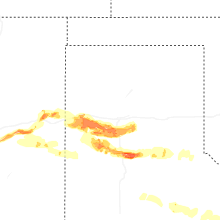
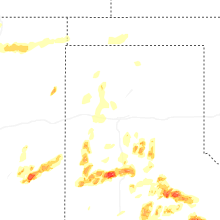
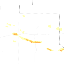
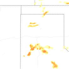


Connect with Interactive Hail Maps