

Hail Map for Tuesday, June 28, 2022
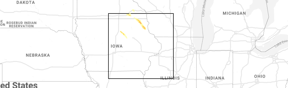
Number of Impacted Households on 6/28/2022
0
Impacted by 1" or Larger Hail
0
Impacted by 1.75" or Larger Hail
0
Impacted by 2.5" or Larger Hail
Square Miles of Populated Area Impacted on 6/28/2022
0
Impacted by 1" or Larger Hail
0
Impacted by 1.75" or Larger Hail
0
Impacted by 2.5" or Larger Hail


Cities Most Affected by Hail Storms of 6/28/2022
| Hail Size | Demographics of Zip Codes Affected | ||||||
|---|---|---|---|---|---|---|---|
| City | Count | Average | Largest | Pop Density | House Value | Income | Age |
| Cable, WI | 2 | 1.75 | 1.75 | 8 | $99k | $29.0k | 54.6 |
| Grand Meadow, MN | 1 | 1.75 | 1.75 | 15 | $78k | $41.9k | 38.5 |
Hail and Wind Damage Spotted on 6/28/2022
Filter by Report Type:Hail ReportsWind Reports
States Impacted
Wisconsin, Utah, Montana, Michigan, Florida, Wyoming, Minnesota, Alabama, Iowa, Texas, Arizona, LouisianaWisconsin
| Local Time | Report Details |
|---|---|
| 1:45 PM CDT | Quarter sized hail reported near Mellen, WI, 72 miles NW of Rhinelander, WI |
| 1:55 PM CDT | Golf Ball sized hail reported near Cable, WI, 60 miles SE of Duluth, MN |
| 1:58 PM CDT | Golf Ball sized hail reported near Cable, WI, 60 miles SE of Duluth, MN |
| 2:04 PM CDT | Quarter sized hail reported near Clam Lake, WI, 68.1 miles SE of Duluth, MN |
| 2:08 PM CDT | Half Dollar sized hail reported near Clam Lake, WI, 69.6 miles SE of Duluth, MN, spotter reports that hail is beginning to accumulate. |
| 2:11 PM CDT | Quarter sized hail reported near Presque Isle, WI, 46 miles NNW of Rhinelander, WI |
| 6:20 PM CDT | Quarter sized hail reported near Menomonie, WI, 65.2 miles E of Minneapolis, MN |
Utah
| Local Time | Report Details |
|---|---|
| 1:25 PM MDT | Causeway weather station in tooele county UT, 94.4 miles NE of Ely, NV |
| 2:20 PM MDT | Beach weather station in salt lake county UT, 16.4 miles W of Salt Lake City, UT |
| 3:20 PM MDT | Salt lake international airport in salt lake county UT, 4.5 miles WNW of Salt Lake City, UT |
| 5:40 PM MDT | I-80 mile post 40 - knolls in tooele county UT, 73.1 miles W of Salt Lake City, UT |
| 6:30 PM MDT | King canyon in millard county UT, 68.5 miles E of Ely, NV |
| 7:00 PM MDT | V-grid weather station in tooele county UT, 85.4 miles WSW of Salt Lake City, UT |
| 7:00 PM MDT | Callao gate in tooele county UT, 85.2 miles SW of Salt Lake City, UT |
| 7:15 PM MDT | Apg weather station in tooele county UT, 79.1 miles WSW of Salt Lake City, UT |
| 7:20 PM MDT | Fremont island - miller hill in weber county UT, 35.5 miles NW of Salt Lake City, UT |
| 8:25 PM MDT | Hat island in box elder county UT, 42.5 miles WNW of Salt Lake City, UT |
| 9:15 PM MDT | Simpson springs in tooele county UT, 80.2 miles SW of Salt Lake City, UT |
| 10:20 PM MDT | Dugway - interstate 80 in tooele county UT, 83 miles W of Salt Lake City, UT |
Montana
| Local Time | Report Details |
|---|---|
| 1:37 PM MDT | Measured via ambient weather statio in beaverhead county MT, 59 miles E of Salmon, ID |
| 1:53 PM MDT | Storm damage reported in beaverhead county MT, 66 miles E of Salmon, ID |
| 3:50 PM MDT | Measured by ennm8 raws. time estimated from rada in madison county MT, 45.6 miles SW of Bozeman, MT |
| 3:57 PM MDT | Measured via ambient weather statio in madison county MT, 37.5 miles WSW of Bozeman, MT |
| 5:06 PM MDT | Measured via ambient weather statio in gallatin county MT, 7.6 miles SSW of Bozeman, MT |
| 5:08 PM MDT | Measured via ambient weather statio in gallatin county MT, 6.2 miles SW of Bozeman, MT |
| 5:44 PM MDT | Storm damage reported in park county MT, 21.1 miles E of Bozeman, MT |
| 6:15 PM MDT | 58 mph thunderstorm wind gus in beaverhead county MT, 56.5 miles E of Salmon, ID |
| 6:45 PM MDT | 36 inch diameter (and larger) trees blown down all over town. 1 power pole 2 miles south of town snappe in petroleum county MT, 84.3 miles N of Billings, MT |
| 7:20 PM MDT | Wind speed 27g71 mp in petroleum county MT, 100.8 miles N of Billings, MT |
| 7:49 PM MDT | Hays site mt-66 mp 10.5 reports winds of 47g60 mp in phillips county MT, 61.6 miles SE of Havre, MT |
| 8:16 PM MDT | Storm damage reported in madison county MT, 43.6 miles SW of Bozeman, MT |
| 10:00 PM MDT | Mesonet station gw0664 shelby airpor in toole county MT, 76 miles NNW of Great Falls, MT |
| 10:28 PM MDT | Mesonet station gw0799 galata 12nn in toole county MT, 74 miles W of Havre, MT |
| 10:37 PM MDT | Mesonet station fw9939 cheste in liberty county MT, 59.2 miles W of Havre, MT |
| 10:45 PM MDT | Mesonet station gw0416 jopli in liberty county MT, 50 miles W of Havre, MT |
| 10:45 PM MDT | Mesonet station dw4821 cheste in liberty county MT, 59.1 miles WNW of Havre, MT |
| 10:50 PM MDT | 63 mph wind gust at the dot sensor near invernes in hill county MT, 44.9 miles W of Havre, MT |
| 11:00 PM MDT | Mesonet station gw0625 joplin 17 nort in liberty county MT, 53.3 miles WNW of Havre, MT |
| 11:07 PM MDT | Mesonet station fw9939 cheste in liberty county MT, 59.2 miles W of Havre, MT |
| 11:09 PM MDT | Mesonet station gw0718 joplin 25nn in liberty county MT, 61.8 miles WNW of Havre, MT |
| 11:15 PM MDT | 60 mph wind gust. mesonet station fw1664 hingha in hill county MT, 40.5 miles WNW of Havre, MT |
| 11:15 PM MDT | 64 mph wind gust. mesonet station ew1937 goldston in hill county MT, 47.2 miles WNW of Havre, MT |
| 11:30 PM MDT | Mesonet station gw0416 jopli in liberty county MT, 50 miles W of Havre, MT |
| 11:33 PM MDT | 61 mph wind gust at asos station khvr havre airpor in hill county MT, 4.5 miles W of Havre, MT |
Michigan
| Local Time | Report Details |
|---|---|
| 4:08 PM EDT | Shared a picture showing two downed trees blocking county rd sd. time estimated by rada in marquette county MI, 37.7 miles S of Marquette, MI |
Florida
| Local Time | Report Details |
|---|---|
| 3:20 PM CDT | Tree down along jw miller road near highway 177a in holmes county FL, 51.5 miles NE of Miramar Beach, FL |
| 3:20 PM CDT | Tree down near monroe paul road and highway 177 in holmes county FL, 53.2 miles NE of Miramar Beach, FL |
| 4:40 PM EDT | Tree down along county road 360 in madison county FL, 46.3 miles E of Tallahassee, FL |
| 4:53 PM EDT | Tree down on ada lane in madison county FL, 51.4 miles E of Tallahassee, FL |
| 5:30 PM EDT | 58 mph wind gust was reported in punta gord in gmz836 county FL, 49.4 miles SE of Bradenton, FL |
| 6:22 PM EDT | A tree fell onto a power line which caused the power line to fall onto a residence at 4555 west state road 238. fire rescue responded and there were no injuries or stru in union county FL, 58.2 miles WSW of Jacksonville, FL |
| 6:47 PM EDT | 68 mph wind gust was reported near charlotte harbo in charlotte county FL, 48 miles SE of Bradenton, FL |
Wyoming
| Local Time | Report Details |
|---|---|
| 4:09 PM MDT | Dry microburst at greybull asos - south big horn county airport. wind gusts were from weak shower in big horn county WY, 89.7 miles SSE of Billings, MT |
| 12:42 AM MDT | Buffalo airport - severe wind gust from weak shower activit in johnson county WY, 60.5 miles W of Gillette, WY |
| 12:48 AM MDT | Storm damage reported in sheridan county WY, 71.1 miles WNW of Gillette, WY |
Minnesota
| Local Time | Report Details |
|---|---|
| 5:40 PM CDT | Large tree down in tow in olmsted county MN, 62.6 miles WNW of La Crosse, WI |
| 5:44 PM CDT | Storm damage reported in olmsted county MN, 62.3 miles WNW of La Crosse, WI |
| 5:50 PM CDT | Tree branches down in rochester. 2-4 inches in diameter. winds estimated at least 50 mp in olmsted county MN, 62 miles WNW of La Crosse, WI |
| 6:03 PM CDT | Golf Ball sized hail reported near Grand Meadow, MN, 50.2 miles NE of Mason City, IA |
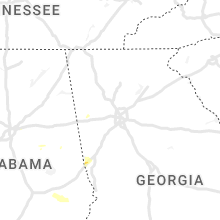
Alabama
| Local Time | Report Details |
|---|---|
| 6:51 PM CDT | Photo of a large tree with full canopy downed... trunk broken toward the base. time estimated from rada in jefferson county AL, 14 miles E of Birmingham, AL |
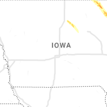
Iowa
| Local Time | Report Details |
|---|---|
| 7:15 PM CDT | Quarter sized hail reported near Cresco, IA, 43.1 miles WSW of La Crosse, WI, rotating wall cloud also observed. |
| 7:16 PM CDT | Half Dollar sized hail reported near Cresco, IA, 45.1 miles WSW of La Crosse, WI, report from mping: half dollar (1.25 in.). |
Texas
| Local Time | Report Details |
|---|---|
| 7:35 PM CDT | The awos at maverick county memorial international airport reported a wind gust of 50 kt in maverick county TX, 42 miles SE of Del Rio, TX |
Arizona
| Local Time | Report Details |
|---|---|
| 5:45 PM MST | Quarter sized hail reported near Prescott, AZ, 61.7 miles SW of Flagstaff, AZ, public reports quarter sized hail. report via twitter. |
| 5:50 PM MST | Quarter sized hail reported near Prescott Valley, AZ, 58.1 miles SW of Flagstaff, AZ, corrects previous hail report from 3 sw prescott valley. corrects previous hail report from 3 sw prescott valley. trained spotter reports nickel sized hail. photo on tw |
| 6:00 PM MST | Trained spotter measured 60 mph wind gus in yavapai county AZ, 76.5 miles NNW of Phoenix, AZ |
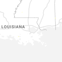
Louisiana
| Local Time | Report Details |
|---|---|
| 7:55 PM CDT | Public caller reported a tin roof was ripped off of their farm equipment building. possible tornado. time estimated by rada in jefferson davis county LA, 46.7 miles ENE of Beaumont, TX |
Connect with Interactive Hail Maps