

Hail Map for Wednesday, June 29, 2022

Number of Impacted Households on 6/29/2022
0
Impacted by 1" or Larger Hail
0
Impacted by 1.75" or Larger Hail
0
Impacted by 2.5" or Larger Hail
Square Miles of Populated Area Impacted on 6/29/2022
0
Impacted by 1" or Larger Hail
0
Impacted by 1.75" or Larger Hail
0
Impacted by 2.5" or Larger Hail


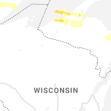


Cities Most Affected by Hail Storms of 6/29/2022
| Hail Size | Demographics of Zip Codes Affected | ||||||
|---|---|---|---|---|---|---|---|
| City | Count | Average | Largest | Pop Density | House Value | Income | Age |
| Bovey, MN | 1 | 2.00 | 2.00 | 15 | $76k | $38.0k | 44.4 |
| Camp Crook, SD | 1 | 1.75 | 1.75 | 0 | $44k | $25.5k | 41.5 |
| Grand Rapids, MN | 1 | 1.75 | 1.75 | 82 | $90k | $37.4k | 44.5 |
Hail and Wind Damage Spotted on 6/29/2022
Filter by Report Type:Hail ReportsWind Reports
States Impacted
Florida, Georgia, Arizona, Utah, Wyoming, South Dakota, Nebraska, Montana, Minnesota, Colorado, North DakotaFlorida
| Local Time | Report Details |
|---|---|
| 3:27 PM EDT | Tree limb fell on a power line resulting in a power outage along ox bottom roa in leon county FL, 7.8 miles NNE of Tallahassee, FL |
| 3:27 PM EDT | Tree limb fell on a power line resulting in a power outage along meridian roa in leon county FL, 5.5 miles N of Tallahassee, FL |
| 7:56 PM EDT | Tree down at stop sign by ne 80th ave and ne 30th stree in gilchrist county FL, 71.7 miles WSW of Jacksonville, FL |
| 8:38 PM EDT | Awos station kmcf macdill afb tam in hillsborough county FL, 24.7 miles N of Bradenton, FL |
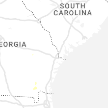
Georgia
| Local Time | Report Details |
|---|---|
| 3:36 PM EDT | Tree down at 41 s and hay road in marion county GA, 62.8 miles ESE of Auburn, AL |
| 8:21 PM EDT | Multiple trees down along punkintown rd and big a rd in douglas county GA, 23 miles WSW of Atlanta, GA |
| 8:45 PM EDT | Tree down north helton and liberty rd in douglas county GA, 28.8 miles WSW of Atlanta, GA |
Arizona
| Local Time | Report Details |
|---|---|
| 1:18 PM MST | Corrects previous tstm wnd dmg report from 1 sse santa rosa. multiple powerlines down in santa rosa... a in pima county AZ, 63 miles W of Tucson, AZ |
| 1:18 PM MST | Corrects previous tstm wnd dmg report from 1 sse santa rosa. multiple powerlines down in santa rosa... a in pima county AZ, 63 miles W of Tucson, AZ |
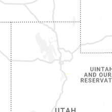
Utah
| Local Time | Report Details |
|---|---|
| 2:40 PM MDT | Durand road in tooele county UT, 66.1 miles SW of Salt Lake City, UT |
| 2:50 PM MDT | Us-189 at deer creek dam in wasatch county UT, 30.6 miles SE of Salt Lake City, UT |
| 3:45 PM MDT | Lofty lake peak in summit county UT, 52.4 miles E of Salt Lake City, UT |
| 4:20 PM MDT | Dugway - nw decon pad in tooele county UT, 68 miles WSW of Salt Lake City, UT |
| 4:45 PM MDT | English village in tooele county UT, 57.5 miles SW of Salt Lake City, UT |
| 5:07 PM MDT | Clover weather station in tooele county UT, 43.2 miles SW of Salt Lake City, UT |
Wyoming
| Local Time | Report Details |
|---|---|
| 2:49 PM MDT | Rock springs airpor in sweetwater county WY, 9 miles E of Rock Springs, WY |
| 5:30 PM MDT | Buffalo airport. peak wind gust from shower activit in johnson county WY, 60.4 miles W of Gillette, WY |
South Dakota
| Local Time | Report Details |
|---|---|
| 2:55 PM MDT | Storm damage reported in butte county SD, 50.9 miles NW of Rapid City, SD |
| 3:33 PM MDT | Storm damage reported in haakon county SD, 54.5 miles W of Pierre, SD |
| 3:55 PM MDT | Storm damage reported in meade county SD, 41.6 miles NE of Rapid City, SD |
| 4:03 PM MDT | Storm damage reported in haakon county SD, 54.5 miles W of Pierre, SD |
| 4:33 PM MDT | Storm damage reported in jackson county SD, 68.7 miles WSW of Pierre, SD |
| 5:50 PM CDT | Semi overturned near vivian on i-90. timing and location is approximate. report relayed via social medi in lyman county SD, 31.7 miles S of Pierre, SD |
| 5:00 PM MDT | Storm damage reported in harding county SD, 92.8 miles NNW of Rapid City, SD |
| 6:03 PM CDT | Corrects previous non-tstm wnd gst report from 6 sw joe creek rec area and changed to a tstm wnd gst report. mesonet station 285 14w lower brule (sddot in lyman county SD, 31.1 miles SE of Pierre, SD |
| 6:08 PM CDT | Time estimated from rada in todd county SD, 42.9 miles NW of Valentine, NE |
| 6:15 PM CDT | Roof blown off trailer home. report relayed via broadcast media on nwschat and social medi in hughes county SD, 34.1 miles ESE of Pierre, SD |
| 6:26 PM CDT | Mesonet station 183 macs corner (sddot in hyde county SD, 45.7 miles E of Pierre, SD |
| 6:31 PM CDT | Mesonet station 183 macs corner (sddot in hyde county SD, 45.7 miles E of Pierre, SD |
| 5:40 PM MDT | Storm damage reported in harding county SD, 91.2 miles N of Rapid City, SD |
| 6:55 PM CDT | Sdsu mesonet statio in hyde county SD, 45.9 miles ENE of Pierre, SD |
| 6:56 PM CDT | Mesonet station 54 reliance (sddot in lyman county SD, 53.2 miles SE of Pierre, SD |
| 6:01 PM MDT | Storm damage reported in meade county SD, 66.7 miles NNE of Rapid City, SD |
| 7:05 PM CDT | Storm damage reported in tripp county SD, 41 miles NNE of Valentine, NE |
| 6:09 PM MDT | Storm damage reported in perkins county SD, 104.2 miles NNE of Rapid City, SD |
| 6:10 PM MDT | 2" diameter branches down around town in perkins county SD, 106.2 miles NNE of Rapid City, SD |
| 7:12 PM CDT | Storm damage reported in hand county SD, 67.4 miles E of Pierre, SD |
| 6:15 PM MDT | Storm damage reported in perkins county SD, 106.2 miles NNE of Rapid City, SD |
| 6:20 PM MDT | Storm damage reported in perkins county SD, 106.2 miles NNE of Rapid City, SD |
| 7:29 PM CDT | Storm damage reported in tripp county SD, 50.3 miles NE of Valentine, NE |
| 6:40 PM MDT | Time estimated from rada in perkins county SD, 102.9 miles SW of Bismarck, ND |
| 6:58 PM MDT | Quarter sized hail reported near Camp Crook, SD, 103.2 miles ESE of Miles City, MT |
| 8:02 PM CDT | Storm damage reported in spink county SD, 52.4 miles S of Aberdeen, SD |
| 7:25 PM MDT | Golf Ball sized hail reported near Camp Crook, SD, 103.2 miles ESE of Miles City, MT, second storm of the evening. |
| 8:29 PM CDT | Mesonet station 214 sd rwis plankinto in aurora county SD, 86.5 miles N of Oneill, NE |
| 8:58 PM CDT | Quarter sized hail reported near Clark, SD, 48.2 miles SE of Aberdeen, SD |
Nebraska
| Local Time | Report Details |
|---|---|
| 3:22 PM MDT | Wind gusts of 50 to 60 mph at time of call. time of onset estimated by rada in sheridan county NE, 70.5 miles ENE of Scottsbluff, NE |
| 4:02 PM MDT | Storm damage reported in grant county NE, 73.7 miles NW of North Platte, NE |
| 6:33 PM CDT | Asos station kvtn valentine airport in cherry county NE, 1 miles S of Valentine, NE |
| 6:39 PM CDT | Mesonet station ew7498 valentine 1en in cherry county NE, 1.1 miles ENE of Valentine, NE |
Montana
| Local Time | Report Details |
|---|---|
| 4:18 PM MDT | Estimate wind gust in carter county MT, 57.5 miles NNE of Gillette, WY |
Minnesota
| Local Time | Report Details |
|---|---|
| 7:22 PM CDT | Quarter sized hail reported near Cohasset, MN, 59 miles ESE of Bemidji, MN, photo sent in via social media of a hailstone next to a tape measure. |
| 7:23 PM CDT | Quarter sized hail reported near Cohasset, MN, 60.9 miles ESE of Bemidji, MN, report sent in via social media. |
| 7:28 PM CDT | Ping Pong Ball sized hail reported near Grand Rapids, MN, 65.5 miles ESE of Bemidji, MN, photo sent in via social media with estimated ping pong ball sized hail. |
| 7:28 PM CDT | Quarter sized hail reported near Grand Rapids, MN, 64.5 miles ESE of Bemidji, MN, report from mping: quarter (1.00 in.). |
| 7:32 PM CDT | Quarter sized hail reported near Coleraine, MN, 68.9 miles E of Bemidji, MN, report from mping: quarter (1.00 in.). |
| 7:37 PM CDT | Ping Pong Ball sized hail reported near Grand Rapids, MN, 66 miles ESE of Bemidji, MN, photo on social media shows the hailstone next to a ruler. |
| 7:38 PM CDT | Ping Pong Ball sized hail reported near Bovey, MN, 68.1 miles WNW of Duluth, MN |
| 7:40 PM CDT | Ping Pong Ball sized hail reported near Grand Rapids, MN, 65.4 miles ESE of Bemidji, MN, 1.22 inches of rain was also measured from this storm with minor street flooding occurring. |
| 7:45 PM CDT | Ping Pong Ball sized hail reported near Grand Rapids, MN, 66 miles ESE of Bemidji, MN, photo sent in via social media showing ping pong ball sized hail with a quarter for scale. |
| 7:46 PM CDT | Golf Ball sized hail reported near Grand Rapids, MN, 64.5 miles ESE of Bemidji, MN, report sent in via social media. |
| 7:55 PM CDT | Hen Egg sized hail reported near Bovey, MN, 68.7 miles ESE of Bemidji, MN, photo sent in via social media showing the hailstone next to a tape measure. time and location estimated from radar. |
| 7:59 PM CDT | Quarter sized hail reported near Bovey, MN, 68.4 miles E of Bemidji, MN |
| 8:13 PM CDT | Quarter sized hail reported near Pengilly, MN, 63.6 miles NW of Duluth, MN, photo sent in via social media showing a deck covered in hailstones. observer reports approximately quarter sized hail. |
| 8:25 PM CDT | Quarter sized hail reported near Hibbing, MN, 49.2 miles NW of Duluth, MN, 2.1 inches of rain also fell from this storm. |
Colorado
| Local Time | Report Details |
|---|---|
| 6:59 PM MDT | Storm damage reported in arapahoe county CO, 14 miles SE of Denver, CO |
North Dakota
| Local Time | Report Details |
|---|---|
| 7:20 PM MDT | Quarter sized hail reported near Bowman, ND, 112.6 miles ESE of Miles City, MT |
| 8:05 PM MDT | Dime size hai in adams county ND, 99.8 miles WSW of Bismarck, ND |
| 9:10 PM CDT | Broadcast media relayed report of intense wind causing trees to lean and blowing dust reducing visibilit in sioux county ND, 53.4 miles S of Bismarck, ND |
| 9:15 PM CDT | Tatanka prairie raws site. time estimated based on rada in sioux county ND, 45 miles S of Bismarck, ND |
| 8:15 PM MDT | Some small tree branches down... estimates diameter of 1.5 inche in adams county ND, 113.8 miles WSW of Bismarck, ND |
| 10:10 PM CDT | Storm damage reported in emmons county ND, 51.5 miles SE of Bismarck, ND |
| 10:20 PM CDT | Wishek nddot site. gusts lasted 15 minute in mcintosh county ND, 61.8 miles SE of Bismarck, ND |
| 10:21 PM CDT | Mesonet station 329519 5 w wishek (ndawn in mcintosh county ND, 64.9 miles SE of Bismarck, ND |
| 11:42 PM CDT | Measured wind gust from davis weather sensor at the busche site east-southeast of marion... nd late wednesday evening june 29... 202 in lamoure county ND, 69 miles WSW of Fargo, ND |
| 11:54 PM CDT | Personal weather station measured 60 mph wind gust near fort ranso in ransom county ND, 58.7 miles WSW of Fargo, ND |
| 12:01 AM CDT | Personal weather station measured 62 mph wind gust near fort ranso in ransom county ND, 61.2 miles WSW of Fargo, ND |
| 12:28 AM CDT | Ndawn near leonard measured 59 mph wind gust at 12:28 am cd in cass county ND, 24.7 miles WSW of Fargo, ND |
| 12:30 AM CDT | Mesonet station 324969 leonard nd 5 in cass county ND, 24 miles WSW of Fargo, ND |
| 12:53 AM CDT | Asos station kfar fargo ap n in cass county ND, 4.2 miles NNW of Fargo, ND |
Connect with Interactive Hail Maps