

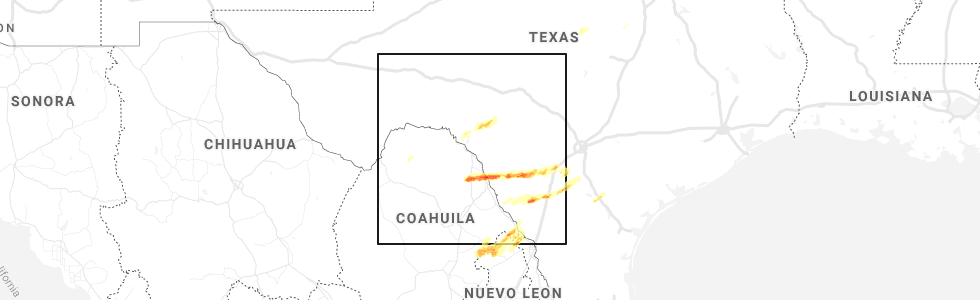
Hail Map for Thursday, March 19, 2020
Number of Impacted Households on 3/19/2020
0
Impacted by 1" or Larger Hail
0
Impacted by 1.75" or Larger Hail
0
Impacted by 2.5" or Larger Hail
Square Miles of Populated Area Impacted on 3/19/2020
0
Impacted by 1" or Larger Hail
0
Impacted by 1.75" or Larger Hail
0
Impacted by 2.5" or Larger Hail


Cities Most Affected by Hail Storms of 3/19/2020
| Hail Size | Demographics of Zip Codes Affected | ||||||
|---|---|---|---|---|---|---|---|
| City | Count | Average | Largest | Pop Density | House Value | Income | Age |
| Stanton, IA | 2 | 1.75 | 1.75 | 9 | $63k | $37.1k | 48.2 |
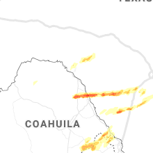
| Catarina, TX | 1 | 2.75 | 2.75 | 0 | $10k | $41.0k | 51.8 |
| Red Oak, IA | 1 | 2.00 | 2.00 | 41 | $61k | $33.0k | 43.9 |
| Villisca, IA | 1 | 2.00 | 2.00 | 14 | $40k | $31.4k | 43.8 |
| Hiawatha, KS | 1 | 1.75 | 1.75 | 23 | $60k | $34.0k | 43.0 |
| Maitland, MO | 1 | 1.75 | 1.75 | 7 | $40k | $30.0k | 44.1 |
| Eagle Pass, TX | 1 | 1.75 | 1.75 | 86 | $51k | $21.4k | 29.8 |
Hail and Wind Damage Spotted on 3/19/2020
Filter by Report Type:Hail ReportsWind Reports
States Impacted
Oklahoma, Nebraska, Illinois, Iowa, Texas, Kansas, Arkansas, Missouri, Ohio, Kentucky, IndianaOklahoma
| Local Time | Report Details |
|---|---|
| 8:55 AM CDT | Storm damage reported in mcclain county OK, 33.9 miles S of Oklahoma City, OK |
| 10:10 AM CDT | Thunderstorm wind gust estimated to 70 mph in stilwell. minor damage to murphys gas statio in adair county OK, 31.6 miles NNW of Fort Smith, AR |
| 10:25 AM CDT | Report of damage to a home. possible tornad in okfuskee county OK, 53.2 miles SSW of Tulsa, OK |
Nebraska
| Local Time | Report Details |
|---|---|
| 2:46 PM CDT | Quarter sized hail reported near Axtell, NE, 48.2 miles WSW of Grand Island, NE, mostly pea to nickel with a few quarters. hail 2 inches deep in yard. |
| 3:04 PM CDT | Half Dollar sized hail reported near Kearney, NE, 41 miles WSW of Grand Island, NE |
| 3:04 PM CDT | Half Dollar sized hail reported near Kearney, NE, 43.8 miles WSW of Grand Island, NE |
| 3:12 PM CDT | Quarter sized hail reported near Kearney, NE, 40.6 miles WSW of Grand Island, NE, mostly 1/2 to 3/4 inch but there was one stone slightly bigger than 1 inch. |
| 3:59 PM CDT | Quarter sized hail reported near Grafton, NE, 38.8 miles ESE of Grand Island, NE, hail covered the ground. mostly peas... some hail as large as quarters mixed in. |
| 4:15 PM CDT | Half Dollar sized hail reported near Mc Cool Junction, NE, 41 miles ESE of Grand Island, NE, quarter to half dollar sized hail. |
| 5:10 PM CDT | Quarter sized hail reported near Omaha, NE, 11.8 miles WSW of Omaha, NE |
| 5:14 PM CDT | Half Dollar sized hail reported near Omaha, NE, 9.1 miles WSW of Omaha, NE |
| 5:14 PM CDT | Quarter sized hail reported near Omaha, NE, 8.1 miles WSW of Omaha, NE |
| 5:18 PM CDT | Quarter sized hail reported near Omaha, NE, 5.7 miles W of Omaha, NE |
Illinois
| Local Time | Report Details |
|---|---|
| 3:43 PM CDT | Multiple power lines and trees down. structural damage to a garage. possible tornado. time estimate in perry county IL, 54.8 miles NNE of Cape Girardeau, MO |
| 3:43 PM CDT | Narrow damage path in sunfield il. 12-15 houses damaged... 4 with major structural damage... 10 with roof damage... garage destroyed. numerous power poles and trees dow in perry county IL, 55.5 miles NNE of Cape Girardeau, MO |
| 3:53 PM CDT | Report from mping: 1-inch tree limbs broken; shingles blown of in perry county IL, 51.7 miles NNE of Cape Girardeau, MO |
| 4:09 PM CDT | Large idot sign blown dow in jefferson county IL, 68.6 miles NNE of Cape Girardeau, MO |
| 4:25 PM CDT | Tree and pole pole blown down in dalhgren. time estimate in hamilton county IL, 63.8 miles WNW of Evansville, IN |
| 4:25 PM CDT | 2 homes with roof decking removed... 2 barns damaged... and numerous trees and power lines dow in hamilton county IL, 62.7 miles WNW of Evansville, IN |
Iowa
| Local Time | Report Details |
|---|---|
| 4:14 PM CDT | Ping Pong Ball sized hail reported near Essex, IA, 43.8 miles SE of Omaha, NE |
| 4:32 PM CDT | Golf Ball sized hail reported near Stanton, IA, 50.1 miles ESE of Omaha, NE |
| 4:36 PM CDT | Golf Ball sized hail reported near Stanton, IA, 47.9 miles ESE of Omaha, NE, golf ball size hail. |
| 4:45 PM CDT | Hen Egg sized hail reported near Villisca, IA, 54.3 miles ESE of Omaha, NE |
| 4:57 PM CDT | Quarter sized hail reported near Villisca, IA, 56.2 miles ESE of Omaha, NE |
| 5:00 PM CDT | Ping Pong Ball sized hail reported near Clarinda, IA, 57.6 miles SE of Omaha, NE |
| 5:53 PM CDT | Hen Egg sized hail reported near Red Oak, IA, 41.4 miles ESE of Omaha, NE |
| 5:59 PM CDT | Half Dollar sized hail reported near Red Oak, IA, 40.6 miles ESE of Omaha, NE |
| 6:50 PM CDT | Ping Pong Ball sized hail reported near Indianola, IA, 22.1 miles S of Des Moines, IA |
Texas
| Local Time | Report Details |
|---|---|
| 4:53 PM CDT | Quarter sized hail reported near Aubrey, TX, 37 miles NNW of Dallas, TX, quarter size hail 1 southwest of aubrey |
| 8:03 PM CDT | Picture on facebook of a tree knocked onto a house at 2nd st and ave b in eagle pass. time estimated from rada in maverick county TX, 50.6 miles SSE of Del Rio, TX |
| 8:05 PM CDT | Ping Pong Ball sized hail reported near Eagle Pass, TX, 44.3 miles SSE of Del Rio, TX, ping pong ball size hail in elm creek. |
| 8:06 PM CDT | Golf Ball sized hail reported near Eagle Pass, TX, 45.2 miles SSE of Del Rio, TX, golf ball size hail north of eagle pass. picture on twitter. |
| 8:33 PM CDT | Baseball sized hail reported near Catarina, TX, 56.8 miles N of Laredo, TX, baseball size hail at a convenience store in catarina. time estimated by radar. |
Kansas
| Local Time | Report Details |
|---|---|
| 6:14 PM CDT | Half Dollar sized hail reported near Hiawatha, KS, 75.2 miles NW of Kansas City, MO, said the ground was covered white with hail. estimated winds of 45 mph. |
| 6:21 PM CDT | Golf Ball sized hail reported near Hiawatha, KS, 76.3 miles NW of Kansas City, MO |
| 6:34 PM CDT | Quarter sized hail reported near Hiawatha, KS, 74.9 miles NE of Manhattan, KS |
Arkansas
| Local Time | Report Details |
|---|---|
| 6:50 PM CDT | Damage was reported to a house and downed power lines east of valley spring in boone county AR, 75.6 miles SSE of Springfield, MO |
| 6:55 PM CDT | Damage was reported to a home in everto in boone county AR, 75.4 miles SSE of Springfield, MO |
| 7:11 PM CDT | Damage was reported at bruno-pyatt schoo in marion county AR, 74.1 miles SSE of Springfield, MO |
| 7:30 PM CDT | Storm damage reported in baxter county AR, 76.3 miles SE of Springfield, MO |
| 9:10 PM CDT | Quarter sized hail reported near Clinton, AR, 58.2 miles N of Little Rock, AR, one inch diameter hail fell near the clinton airport. |
| 10:00 PM CDT | Numerous downed trees caused widespread power outages in sharp count in sharp county AR, 98.3 miles NNE of Little Rock, AR |
| 10:10 PM CDT | Several large trees were uprooted near highway 35 in sharp county AR, 103.2 miles S of Salem, MO |
Missouri
| Local Time | Report Details |
|---|---|
| 7:05 PM CDT | Half Dollar sized hail reported near Mound City, MO, 79.4 miles NNW of Kansas City, MO |
| 7:05 PM CDT | Ping Pong Ball sized hail reported near Mound City, MO, 78.8 miles NNW of Kansas City, MO, em and broadcast media (kmbc) report nickel to to golf ball size hail with numerous nickel to quarter size covering the ground. |
| 7:14 PM CDT | Half Dollar sized hail reported near Maitland, MO, 80 miles NNW of Kansas City, MO |
| 7:14 PM CDT | Golf Ball sized hail reported near Maitland, MO, 80.7 miles NNW of Kansas City, MO |
| 7:14 PM CDT | Quarter sized hail reported near Maitland, MO, 80 miles NNW of Kansas City, MO, report via social media. time estimated via radar. |
| 7:25 PM CDT | Quarter sized hail reported near Skidmore, MO, 79.4 miles NNW of Kansas City, MO |
| 7:27 PM CDT | Quarter sized hail reported near Barnard, MO, 77.7 miles NNW of Kansas City, MO, report via spotter network. |
| 7:30 PM CDT | Half Dollar sized hail reported near Barnard, MO, 76.2 miles N of Kansas City, MO |
| 8:22 PM CDT | Severe thunderstorm wind gusts downed a tree at the china union churc in howell county MO, 73.6 miles SSW of Salem, MO |
| 8:22 PM CDT | Report of a tree knocked onto a house off highway jj... southeast of south for in howell county MO, 74.9 miles SSW of Salem, MO |
| 9:40 PM CDT | Severe thunderstorm wind gusts downed a tree along county road 839 in howell county MO, 73 miles SSW of Salem, MO |
Ohio
| Local Time | Report Details |
|---|---|
| 12:12 AM EDT | Several trees downed along wales road. car dealership sign also damaged. semi-trailer partially blown over near mile marker 19 of i7 in hamilton county OH, 16.1 miles NE of Cincinnati, OH |
| 3:55 AM EDT | Several trees downed near manning road and bear creek road. time of damage estimated from radar dat in montgomery county OH, 39.7 miles NNE of Cincinnati, OH |
Kentucky
| Local Time | Report Details |
|---|---|
| 12:55 AM CDT | Late report. 55 to 60 mph wind gusts and several reports of trees and limbs down around the wickliffe area. time estimated by rada in ballard county KY, 34.4 miles SE of Cape Girardeau, MO |
Indiana
| Local Time | Report Details |
|---|---|
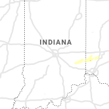
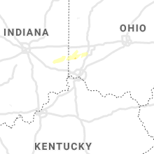
| 3:08 AM EDT | Quarter sized hail reported near Brookville, IN, 41.2 miles NW of Cincinnati, OH, time of event estimated by radar. |
| 3:40 AM EDT | Trees and branches down in the area. time estimated based on rada in dubois county IN, 52.9 miles NE of Evansville, IN |
| 4:18 AM EDT | Trees downed and blocking state road in decatur county IN, 50.7 miles SE of Indianapolis, IN |
Connect with Interactive Hail Maps