

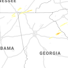
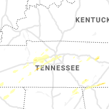
Hail Map for Friday, March 26, 2021

Number of Impacted Households on 3/26/2021
0
Impacted by 1" or Larger Hail
0
Impacted by 1.75" or Larger Hail
0
Impacted by 2.5" or Larger Hail
Square Miles of Populated Area Impacted on 3/26/2021
0
Impacted by 1" or Larger Hail
0
Impacted by 1.75" or Larger Hail
0
Impacted by 2.5" or Larger Hail


Cities Most Affected by Hail Storms of 3/26/2021
| Hail Size | Demographics of Zip Codes Affected | ||||||
|---|---|---|---|---|---|---|---|
| City | Count | Average | Largest | Pop Density | House Value | Income | Age |
Hail and Wind Damage Spotted on 3/26/2021
Filter by Report Type:Hail ReportsWind Reports
South Carolina
| Local Time | Report Details |
|---|---|
| 8:26 AM EDT | Quarter sized hail reported near Mount Carmel, SC, 47.3 miles NW of Augusta, GA, public reported nickel to quarter sized hail on fort charlotte rd just sw of mt. carmel. time estimated. |
| 9:47 AM EDT | Quarter sized hail reported near Ware Shoals, SC, 36.7 miles SE of Greenville, SC, nickel to quarter sized hail that fell for over 2 minutes. |
New York
| Local Time | Report Details |
|---|---|
| 11:08 AM EDT | Damage to a house on route 2 in lewis county NY, 58.3 miles S of Ogdensburg, NY |
| 11:10 AM EDT | Numerous trees blown down and damage to a shed and barn on cr 33 and naumburg r in lewis county NY, 54.8 miles S of Ogdensburg, NY |
| 11:17 AM EDT | Numerous trees and powerlines down in crogha in lewis county NY, 55 miles S of Ogdensburg, NY |
| 12:02 PM EDT | Trees and wires down on white hill road in st. lawrence county NY, 35 miles E of Ogdensburg, NY |
| 12:14 PM EDT | Trees downed in hamilton county NY, 70.3 miles WSW of Burlington, VT |
| 12:16 PM EDT | Numerous trees uprooted and wires downed along route 30 in long lake in hamilton county NY, 69.4 miles WSW of Burlington, VT |
| 12:24 PM EDT | Tree damage with large branches along ludlowville r in tompkins county NY, 42.4 miles SSW of Syracuse, NY |
| 1:14 PM EDT | Tree down on powerlines on river road just off of route 7 in essex county NY, 49.5 miles SSW of Burlington, VT |
| 1:20 PM EDT | Reports of a lot of trees down between schroon lake... crown point and ticoderog in essex county NY, 38 miles SSW of Burlington, VT |
Vermont
| Local Time | Report Details |
|---|---|
| 1:40 PM EDT | *** 1 inj *** reports of structural damage on painter road in middlebury. lots of downed trees are also being reporte in addison county VT, 31.1 miles S of Burlington, VT |
| 2:00 PM EDT | Several trees down in the new haven and cornwall area in addison county VT, 24.8 miles S of Burlington, VT |
| 2:02 PM EDT | State police reported power lines down across vt route 100 near rolston road in washington county VT, 28.2 miles SE of Burlington, VT |
| 2:18 PM EDT | Trees and powerlines down in washington county VT, 39.7 miles ESE of Burlington, VT |
| 2:24 PM EDT | Trees and powerlines down in washington county VT, 38.5 miles ESE of Burlington, VT |
| 2:26 PM EDT | Trees and powerlines down in washington county VT, 41.1 miles ESE of Burlington, VT |
| 2:30 PM EDT | Multiple trees down in washington county VT, 34.1 miles ESE of Burlington, VT |
| 2:30 PM EDT | Tree limb damage and powerline dow in washington county VT, 35.9 miles ESE of Burlington, VT |
| 2:30 PM EDT | Extensive tree limb damage and powerlines dow in washington county VT, 35 miles ESE of Burlington, VT |
| 2:32 PM EDT | Trees and powerlines down all over montpelie in washington county VT, 34.9 miles ESE of Burlington, VT |
New Hampshire
| Local Time | Report Details |
|---|---|
| 4:55 PM EDT | Time estimated from rada in carroll county NH, 39.8 miles W of Portland, ME |
Kansas
| Local Time | Report Details |
|---|---|
| 7:32 PM CDT | Awos station kfri ft riley marsha in geary county KS, 15.2 miles SW of Manhattan, KS |
| 8:07 PM CDT | Quarter sized hail reported near Palmer, KS, 43.9 miles NW of Manhattan, KS, report from mping: quarter (1.00 in.). |
| 8:18 PM CDT | Quarter sized hail reported near Greenleaf, KS, 43.5 miles NNW of Manhattan, KS |
| 9:00 PM CDT | Personal weather statio in jackson county KS, 50.4 miles ENE of Manhattan, KS |
Nebraska
| Local Time | Report Details |
|---|---|
| 7:45 PM CDT | Quarter sized hail reported near Holbrook, NE, 70.8 miles SSE of North Platte, NE, report of up to quarter sized hail. hail covering the ground and it hailed for at least 10 minutes. picture sent via facebook. |
| 7:59 PM CDT | Quarter sized hail reported near Campbell, NE, 48.8 miles SSW of Grand Island, NE |
| 8:03 PM CDT | Quarter sized hail reported near Campbell, NE, 48.8 miles SSW of Grand Island, NE, corrects previous hail report from 1 wsw campbell. |
| 8:29 PM CDT | Quarter sized hail reported near Edison, NE, 78.5 miles SE of North Platte, NE |
| 9:24 PM CDT | Quarter sized hail reported near Elwood, NE, 59.2 miles ESE of North Platte, NE, isolated quarter size hail along county line with pea size hail covering the road. |
Tennessee
| Local Time | Report Details |
|---|---|
| 4:30 AM CDT | Quarter sized hail reported near Whitwell, TN, 15.9 miles NW of Chattanooga, TN, picture of hail that was larger than a penny. |
| 4:40 AM CDT | Quarter sized hail reported near Whitwell, TN, 18.1 miles NNW of Chattanooga, TN, determined from a picture of hail that had fallen. in the sequatchie valley/stone cave area. time and location approximated by radar. |
| 5:18 AM CDT | Half Dollar sized hail reported near Centerville, TN, 55.2 miles SW of Nashville, TN, twitter photo of half dollar size hail on arnold road |
| 6:55 AM EDT | Quarter sized hail reported near Ocoee, TN, 33.9 miles E of Chattanooga, TN, nickel to quarter sized hail near polk county line. |
| 7:00 AM EDT | Quarter sized hail reported near Benton, TN, 37.6 miles E of Chattanooga, TN, hail fell at the tva ocoee hydro plant along us hwy 64. |
| 6:36 AM CDT | Quarter sized hail reported near Brentwood, TN, 11.6 miles S of Nashville, TN, reported at 9475 smithson lane |
| 6:48 AM CDT | Quarter sized hail reported near Antioch, TN, 9.6 miles SE of Nashville, TN, reported on anderson road |
Connect with Interactive Hail Maps