

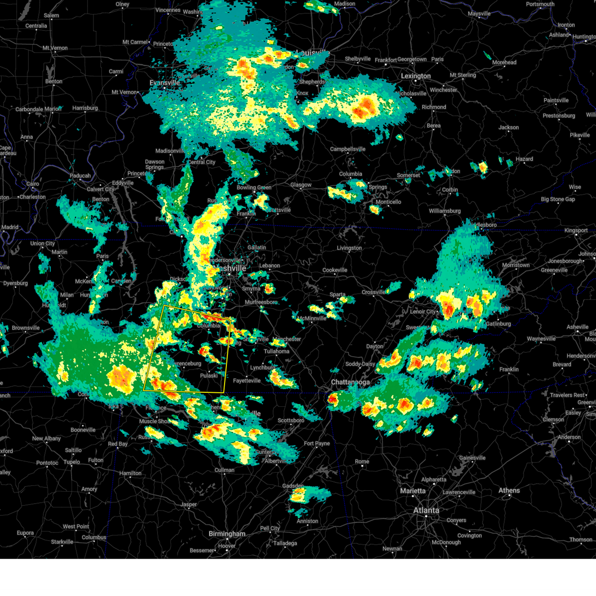
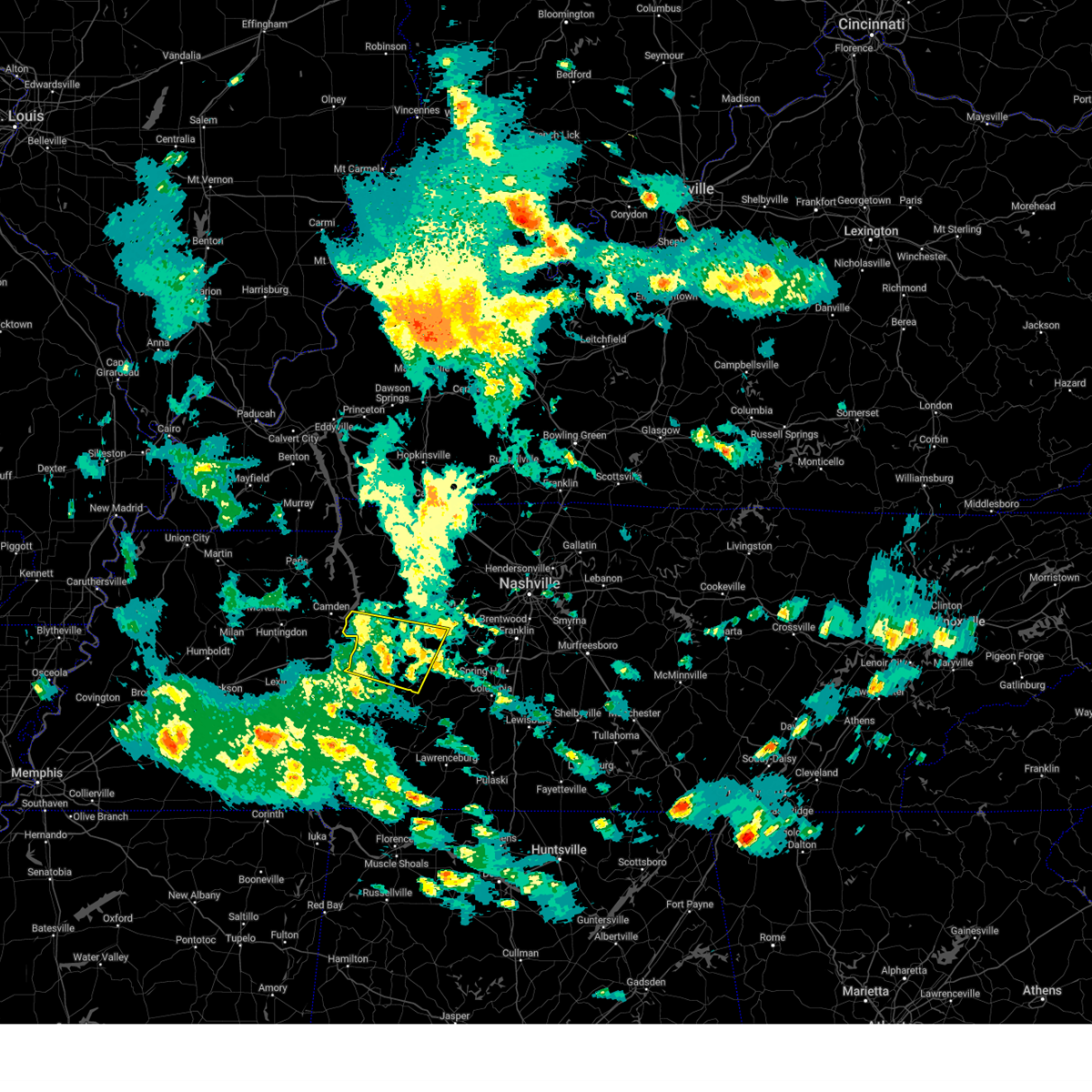
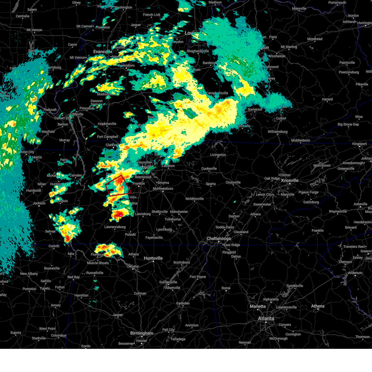
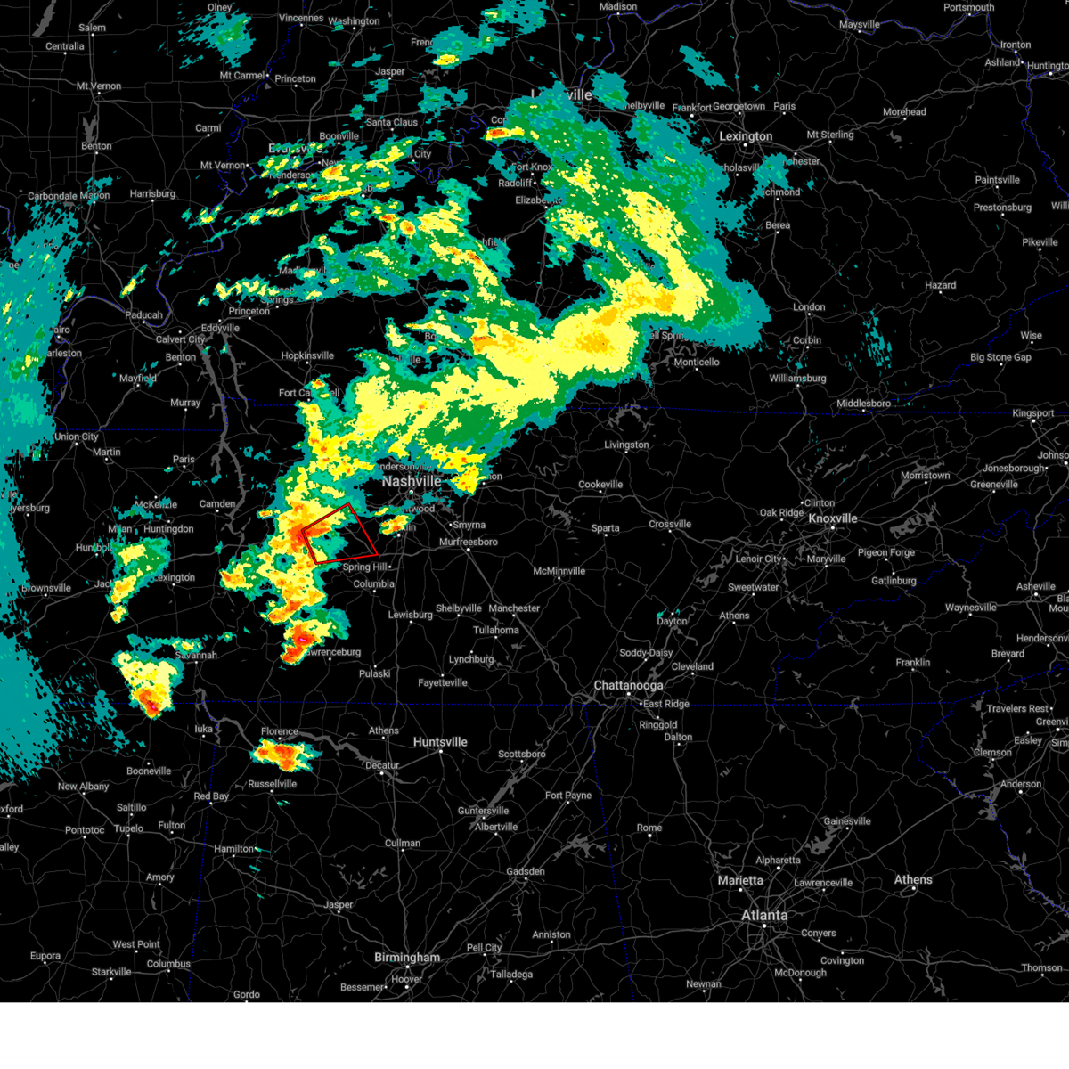
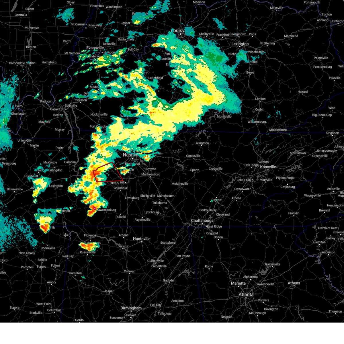
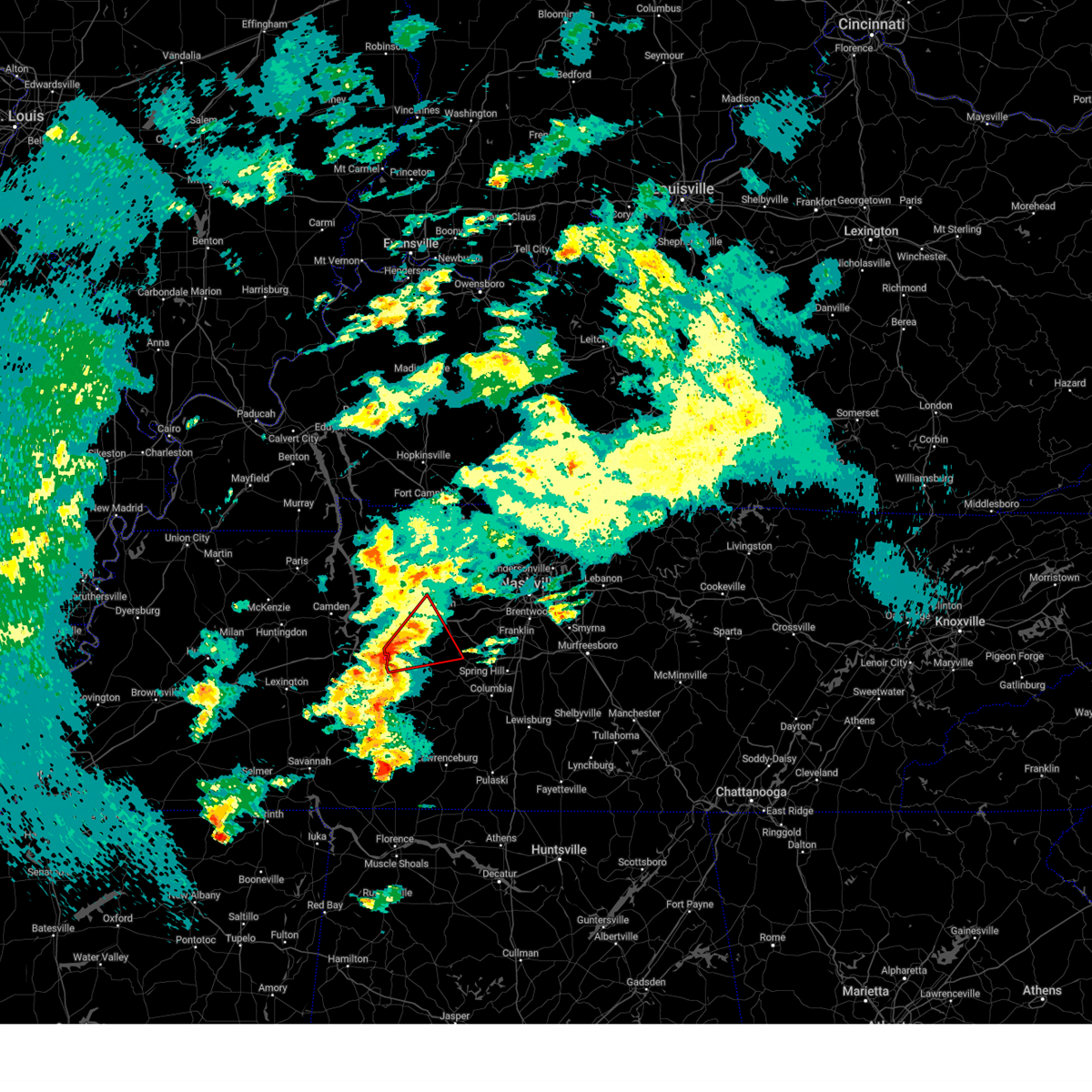
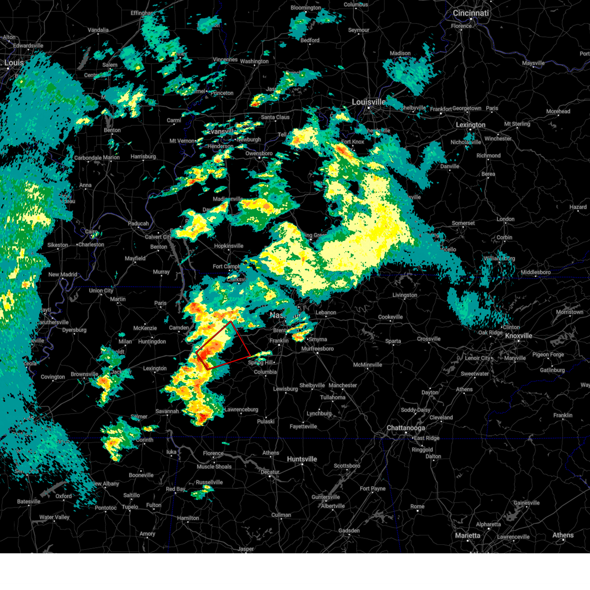
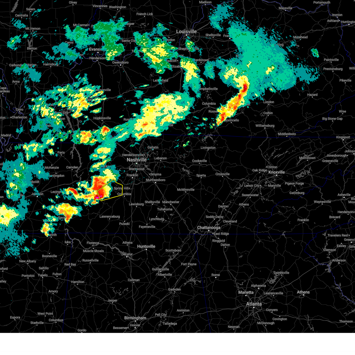
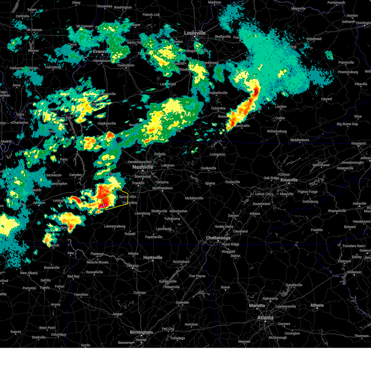
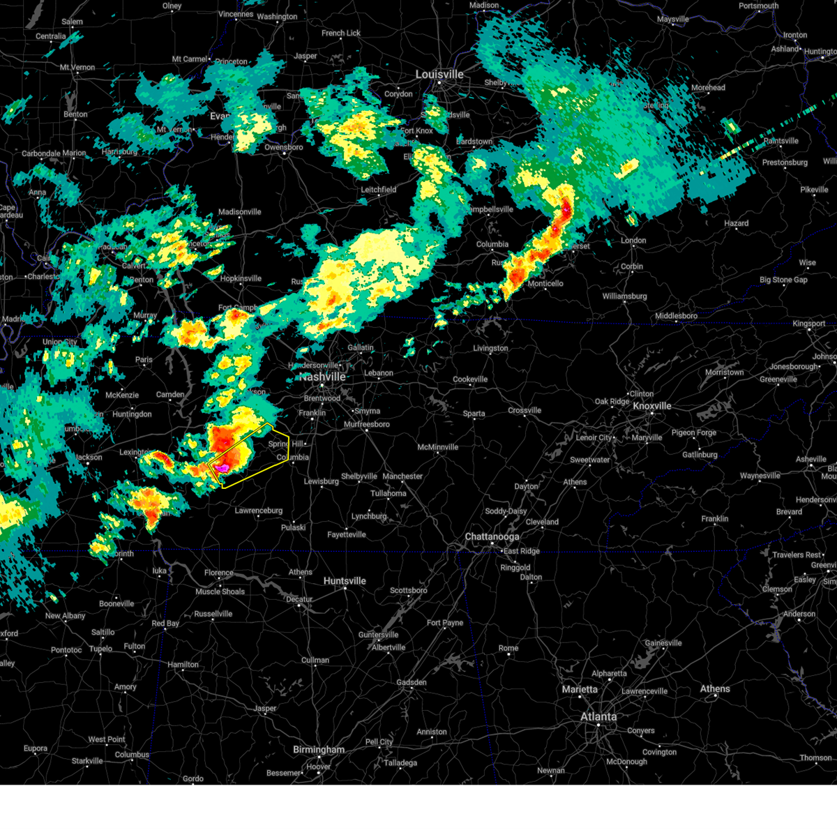
Hail Map for Centerville, TN
The Centerville, TN area has had 10 reports of on-the-ground hail by trained spotters, and has been under severe weather warnings 89 times during the past 12 months. Doppler radar has detected hail at or near Centerville, TN on 81 occasions, including 4 occasions during the past year.
| Name: | Centerville, TN |
| Where Located: | 46.2 miles SW of Nashville, TN |
| Map: | Google Map for Centerville, TN |
| Population: | 3644 |
| Housing Units: | 1723 |
| More Info: | Search Google for Centerville, TN |
3
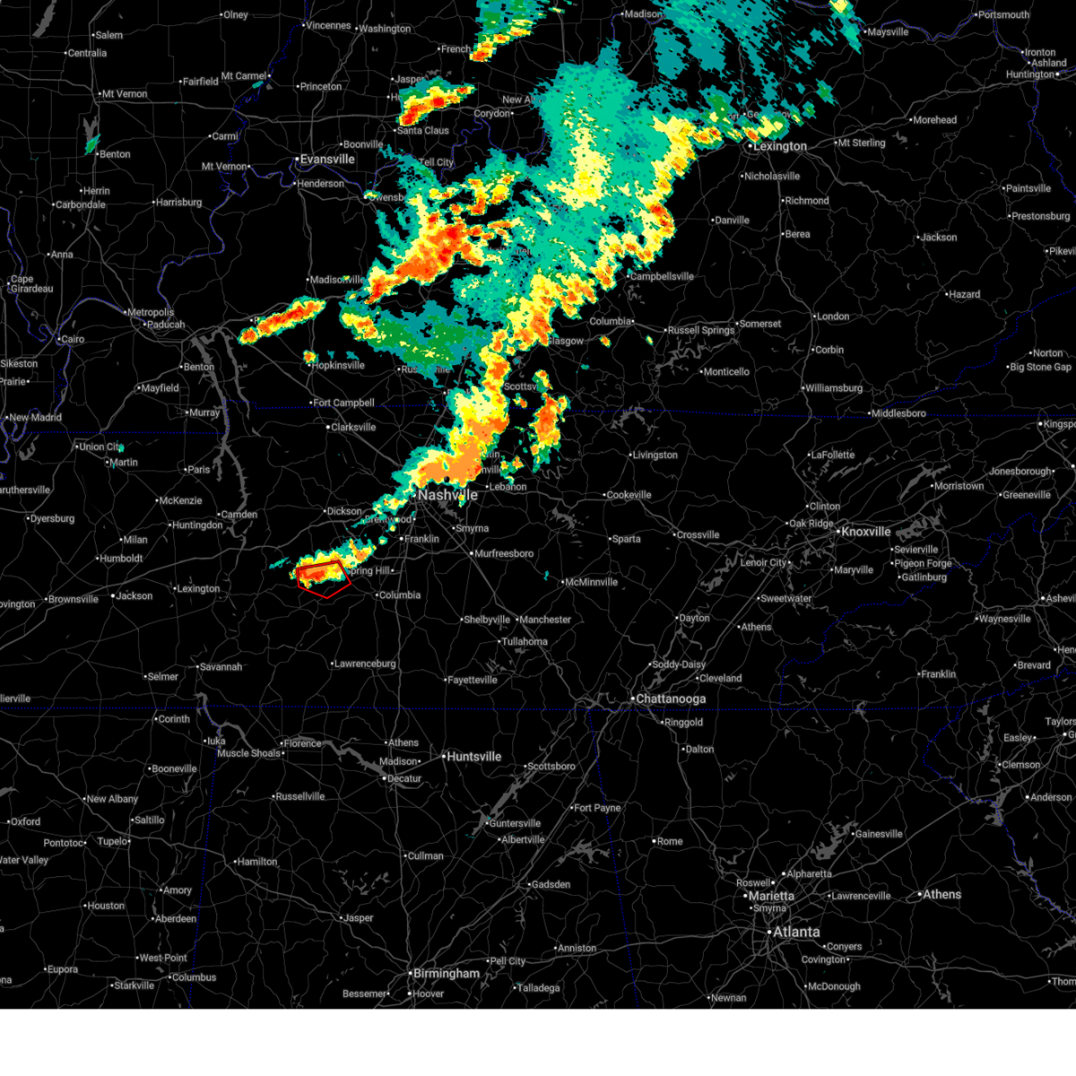
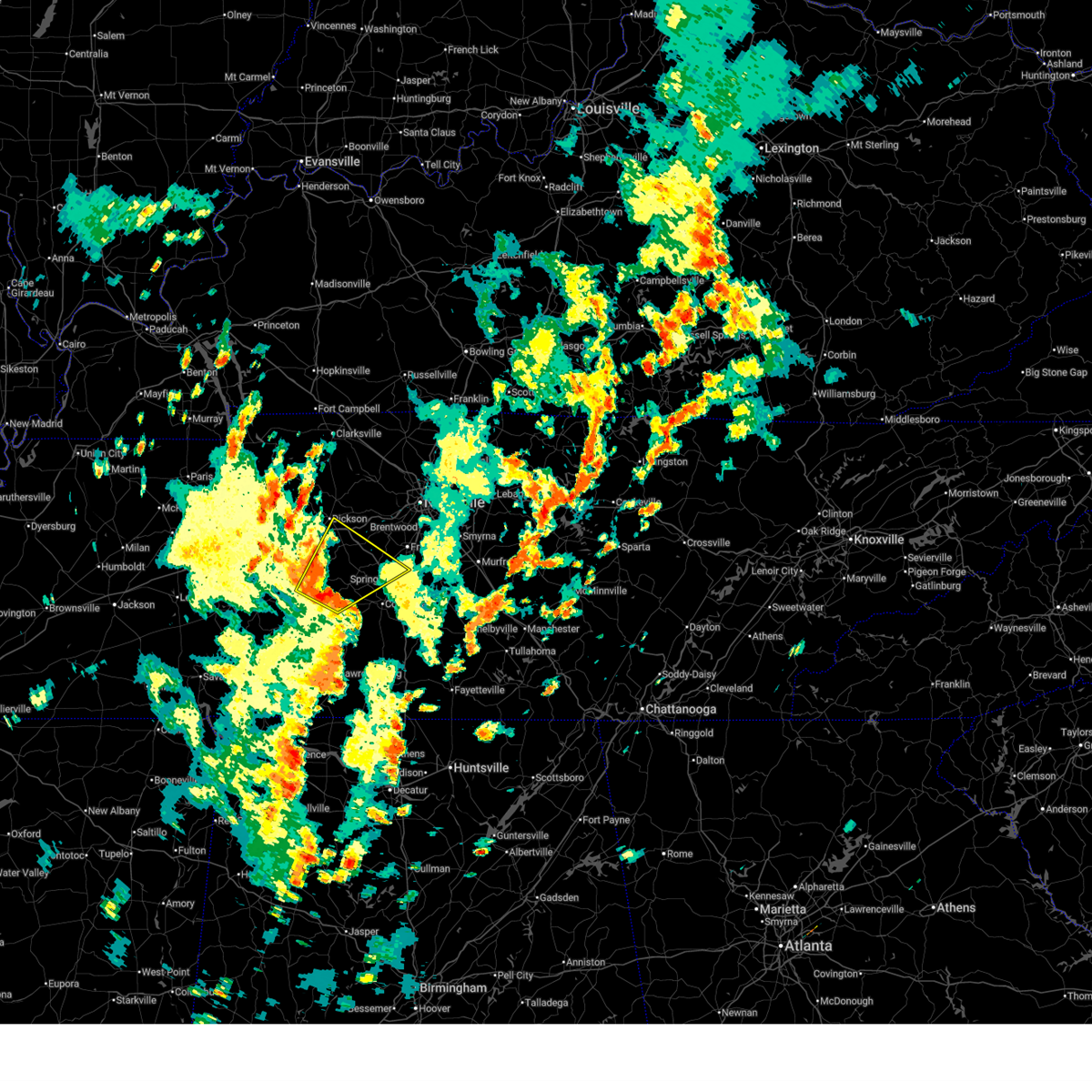
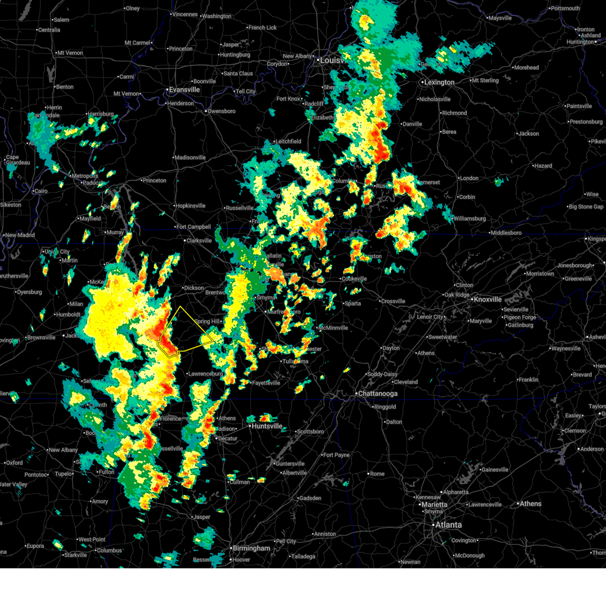
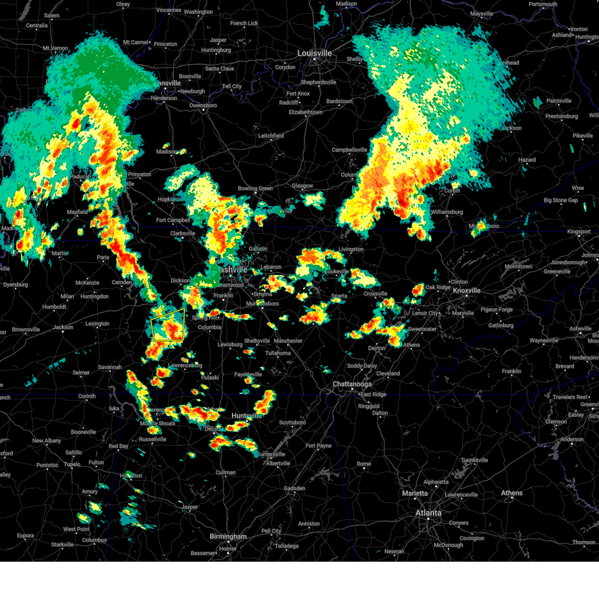
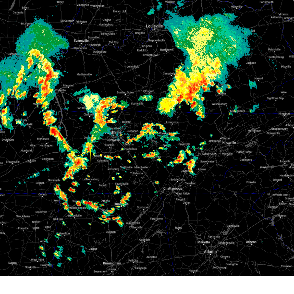
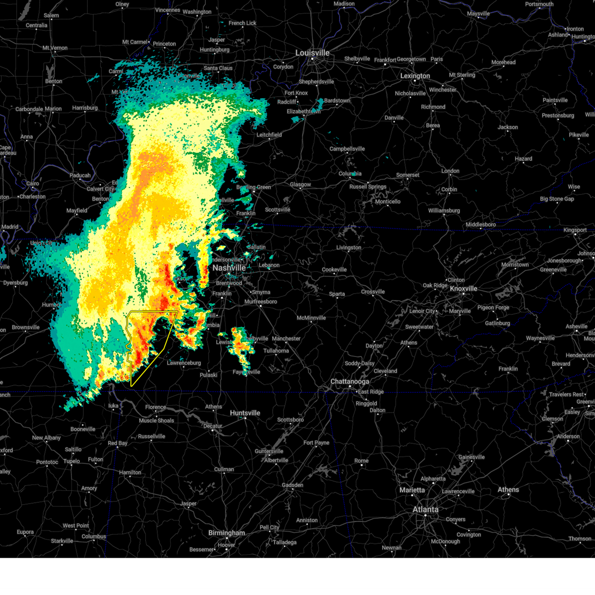
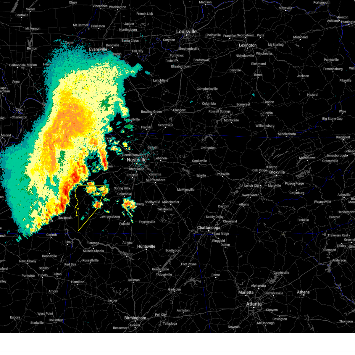
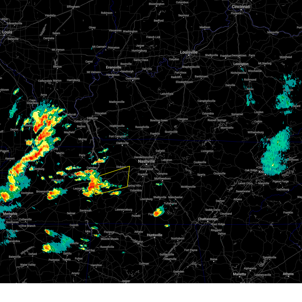
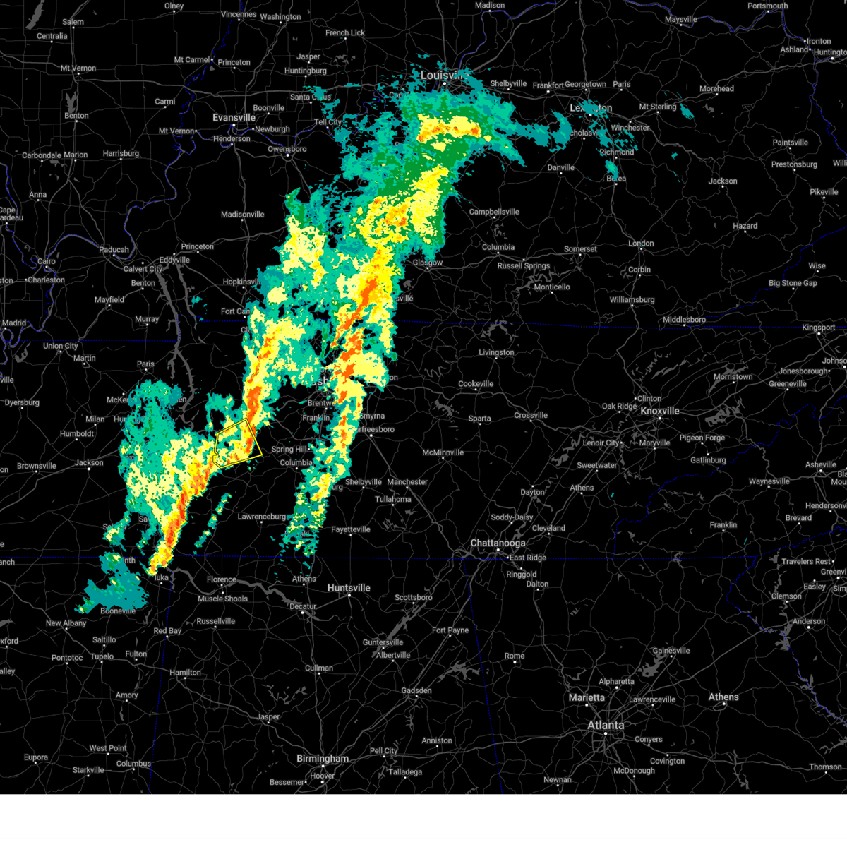
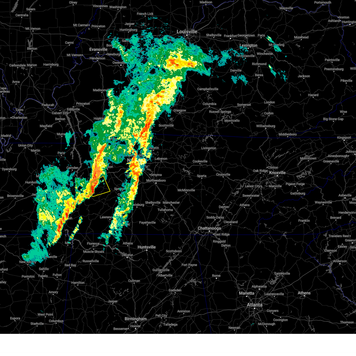
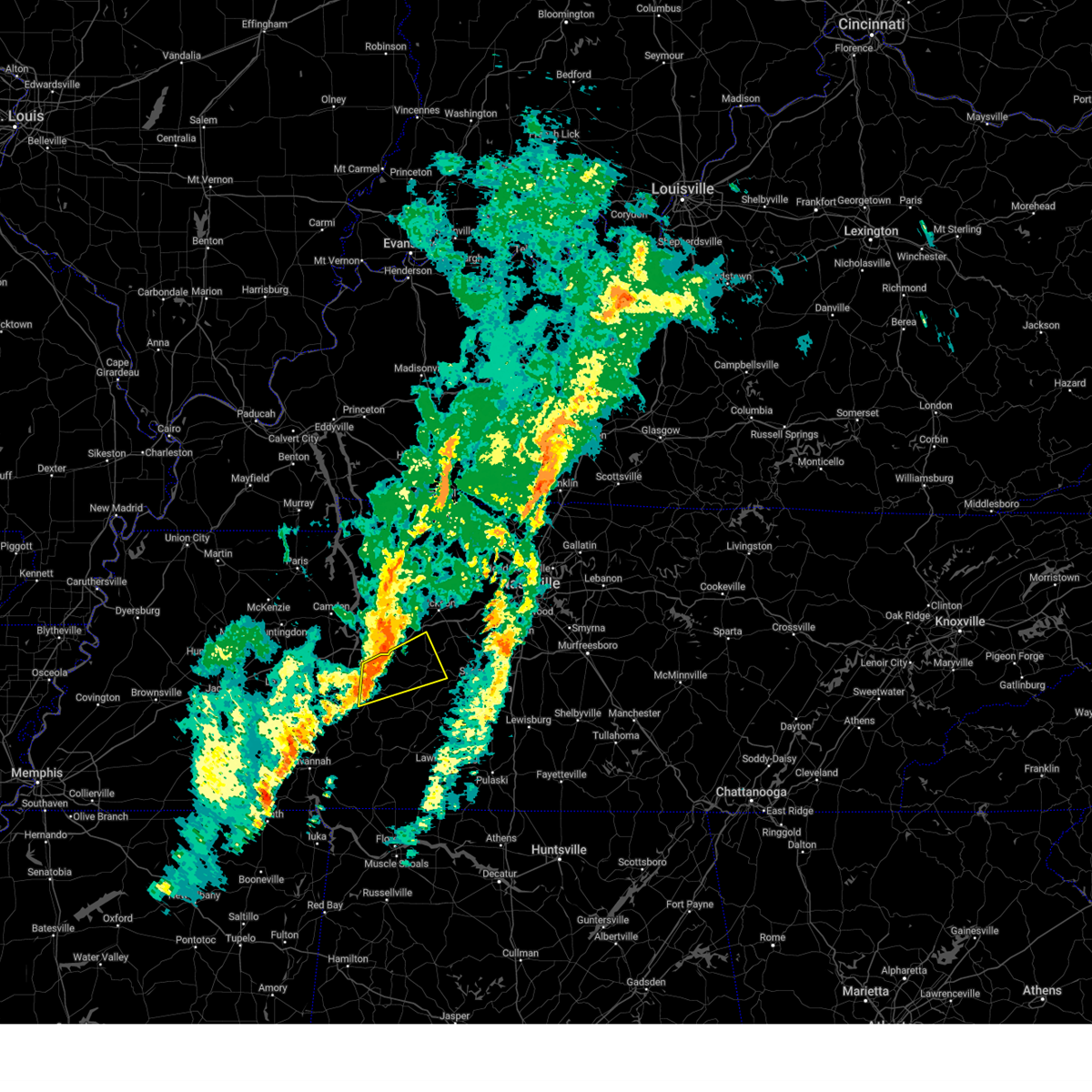
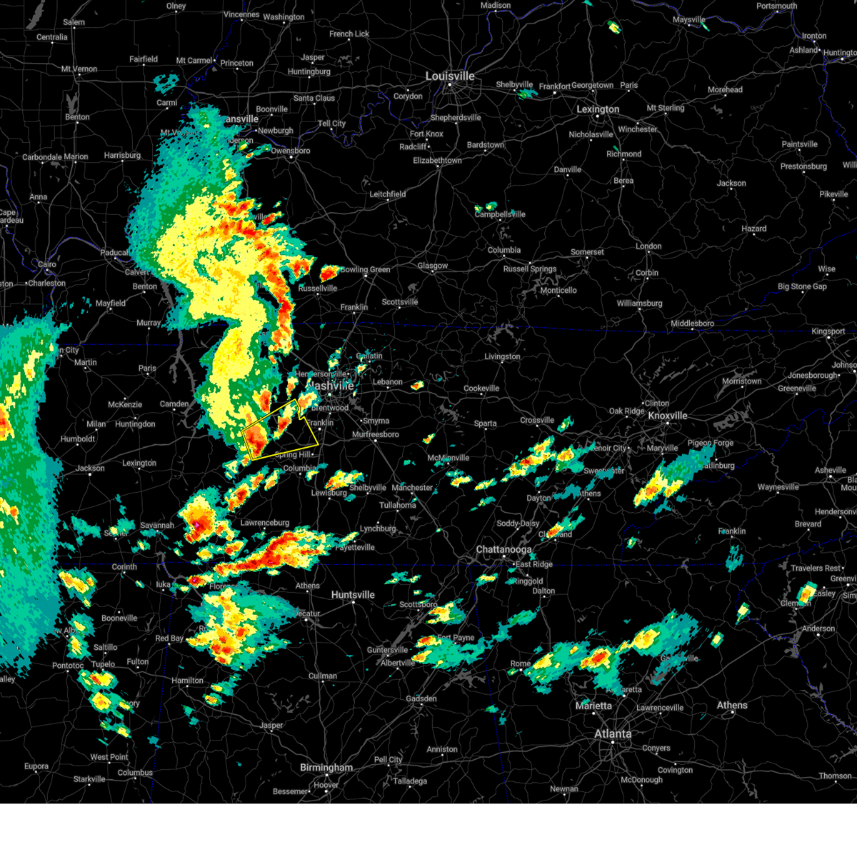
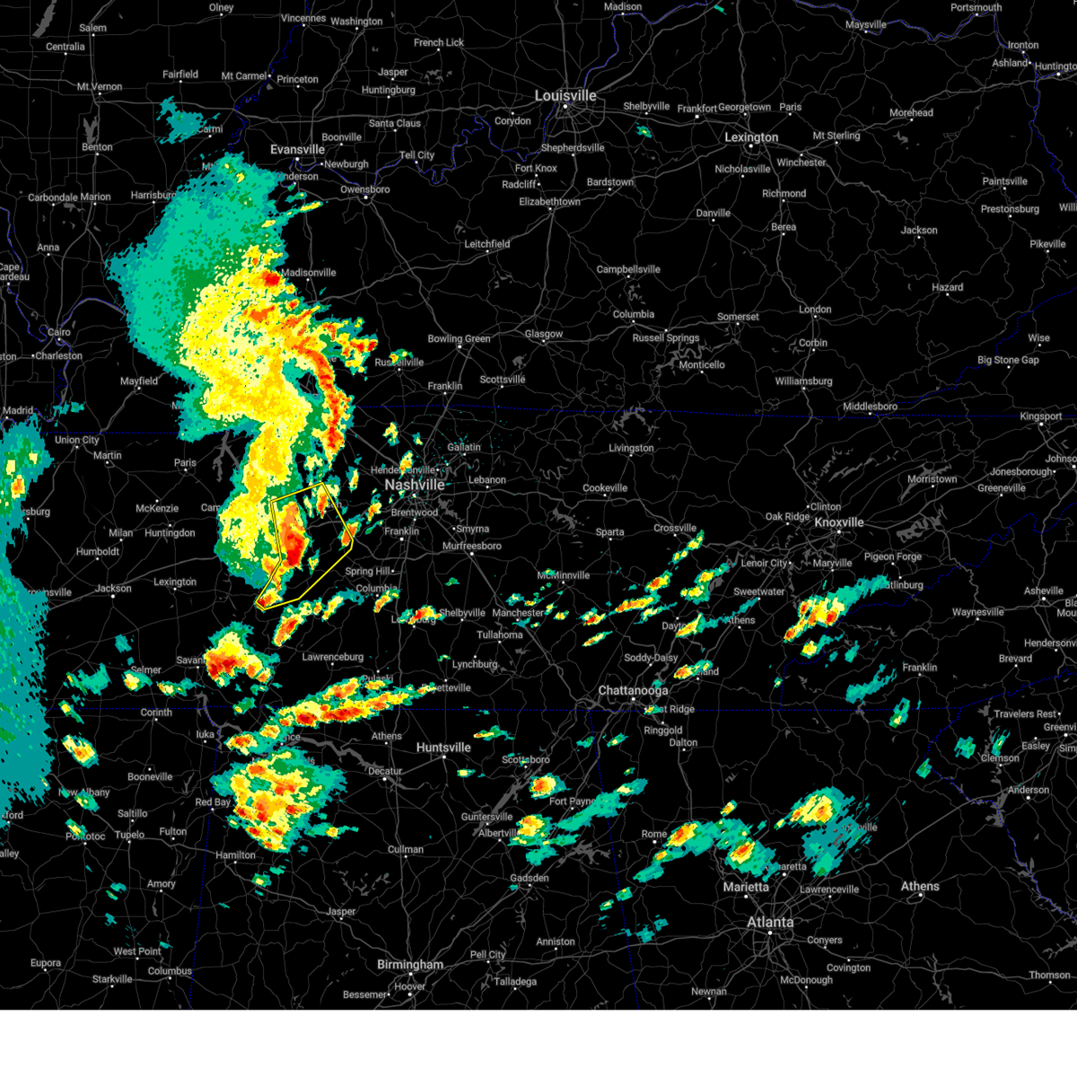
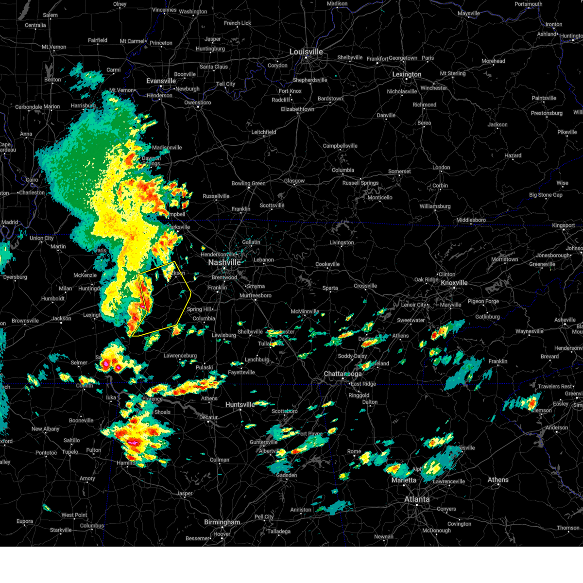
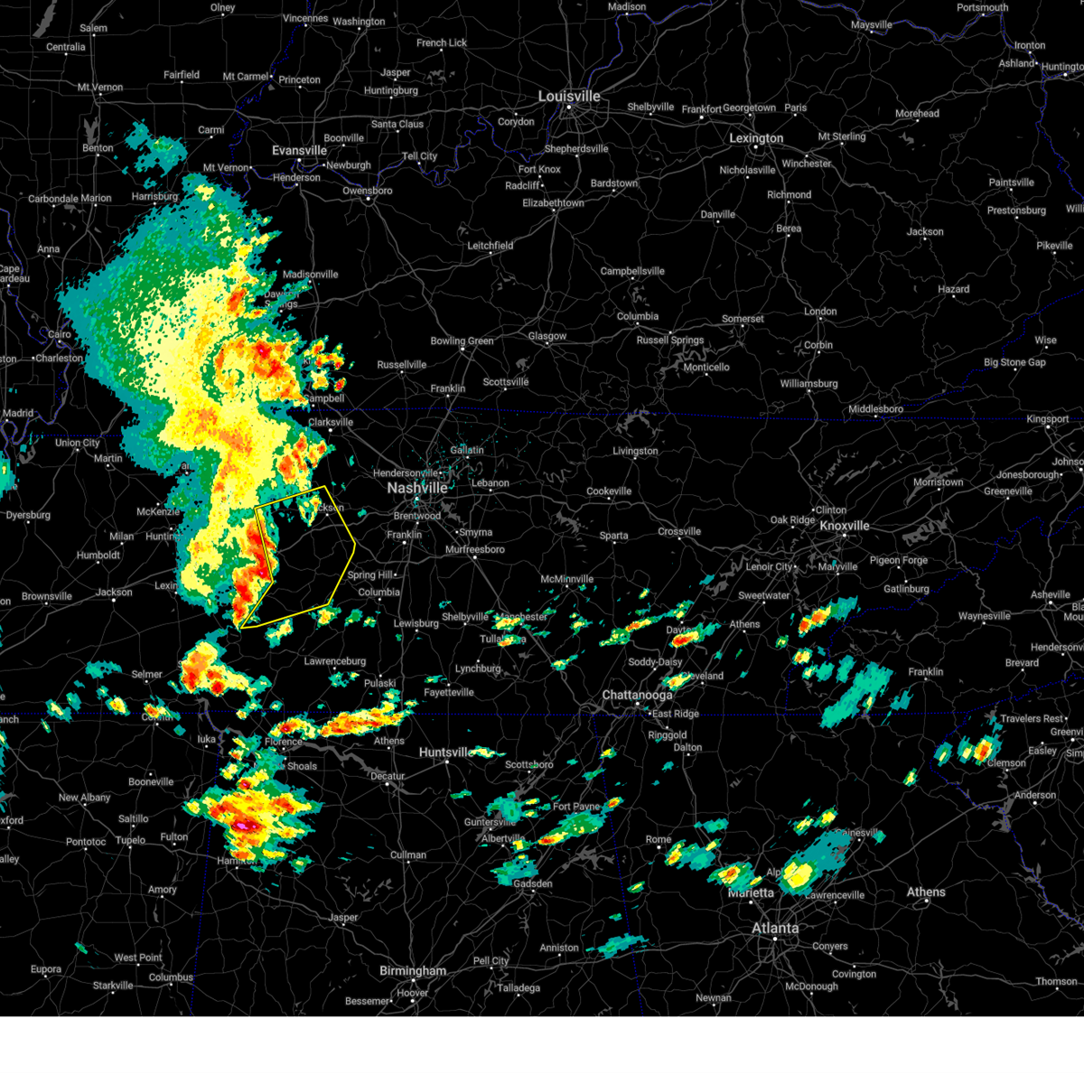
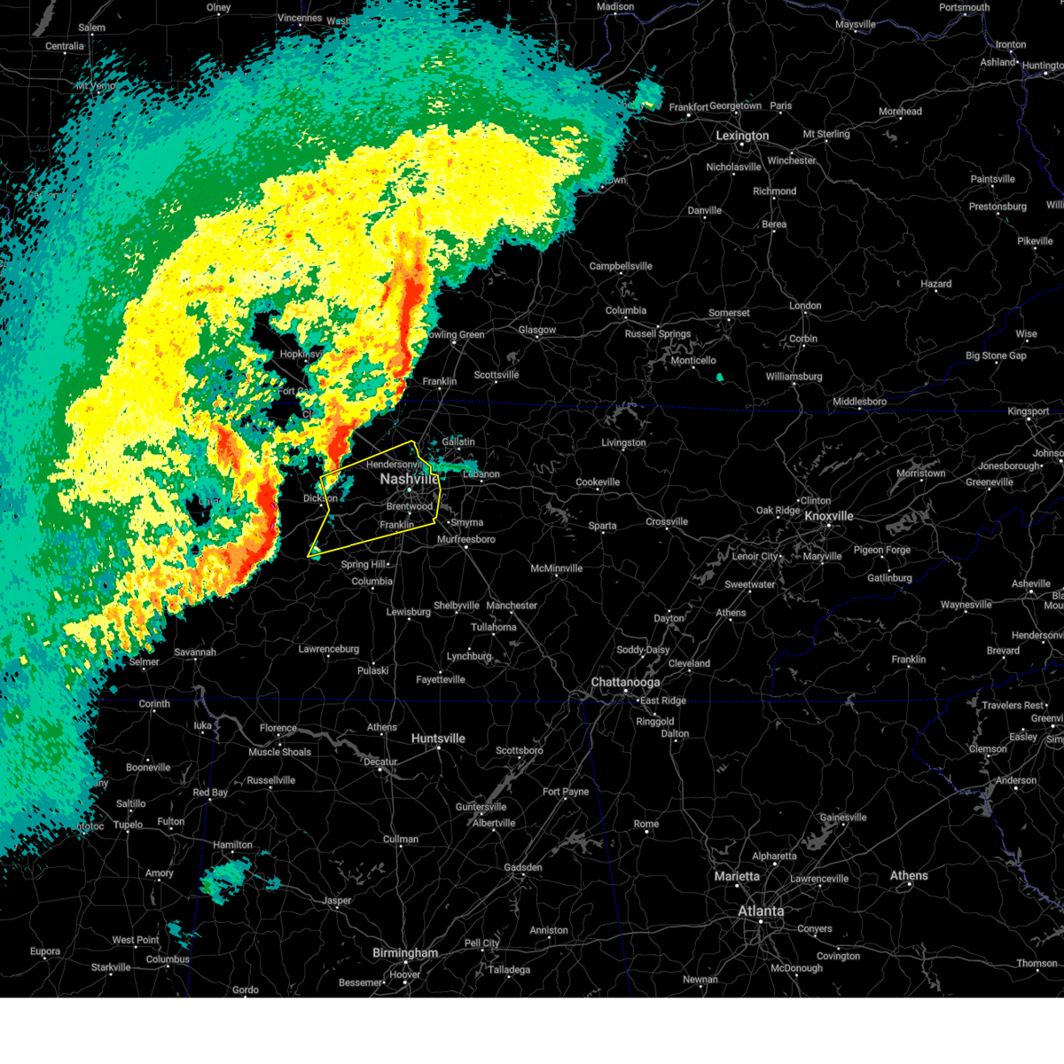
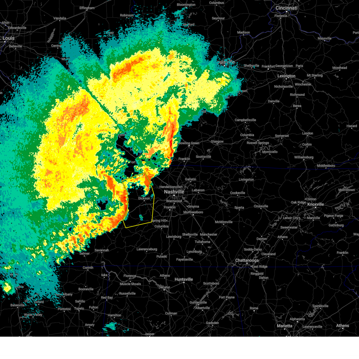
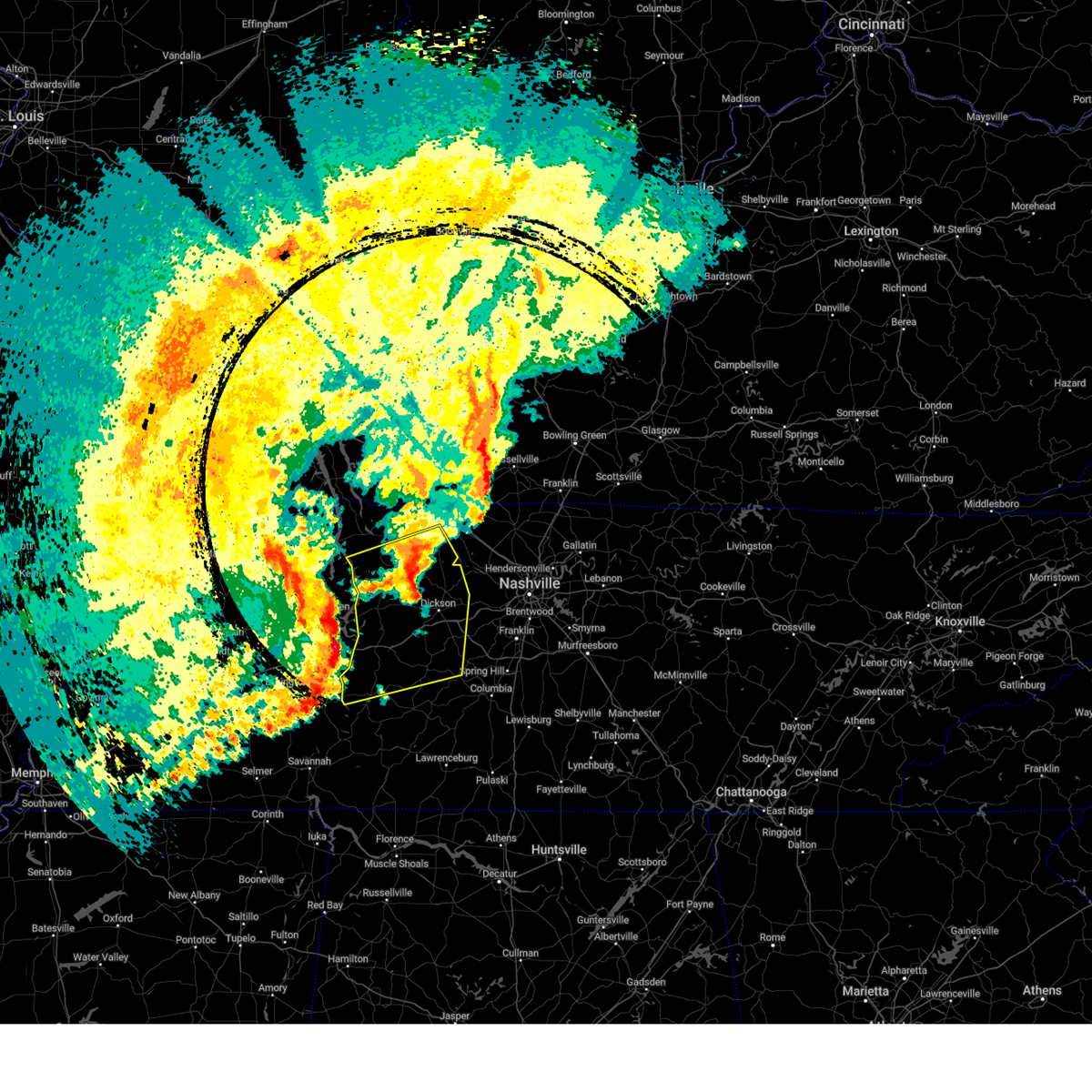
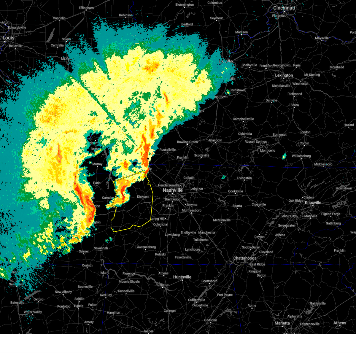
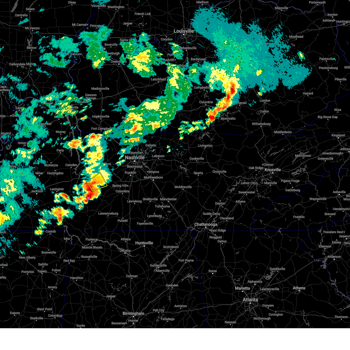
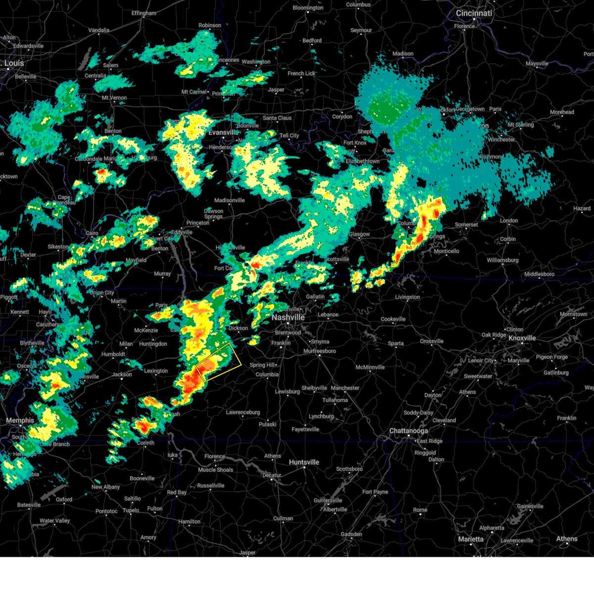
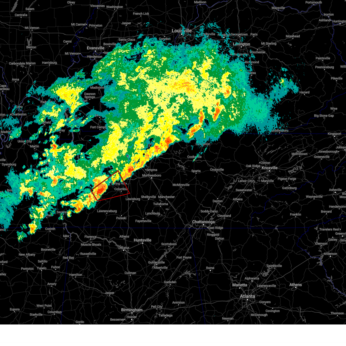
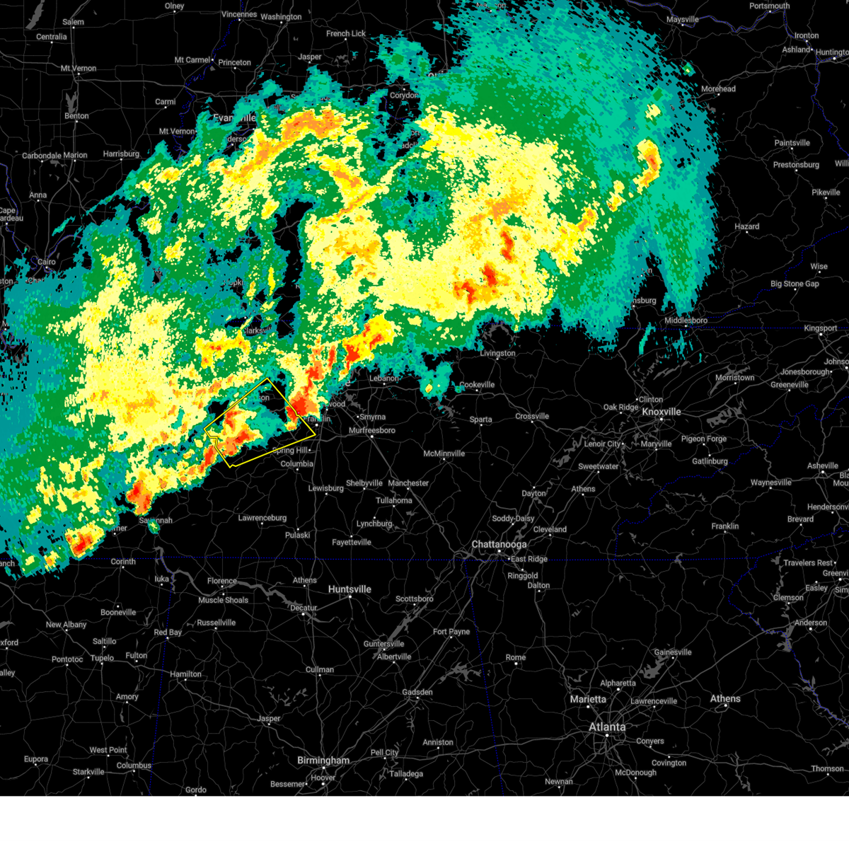
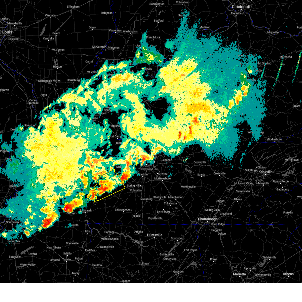
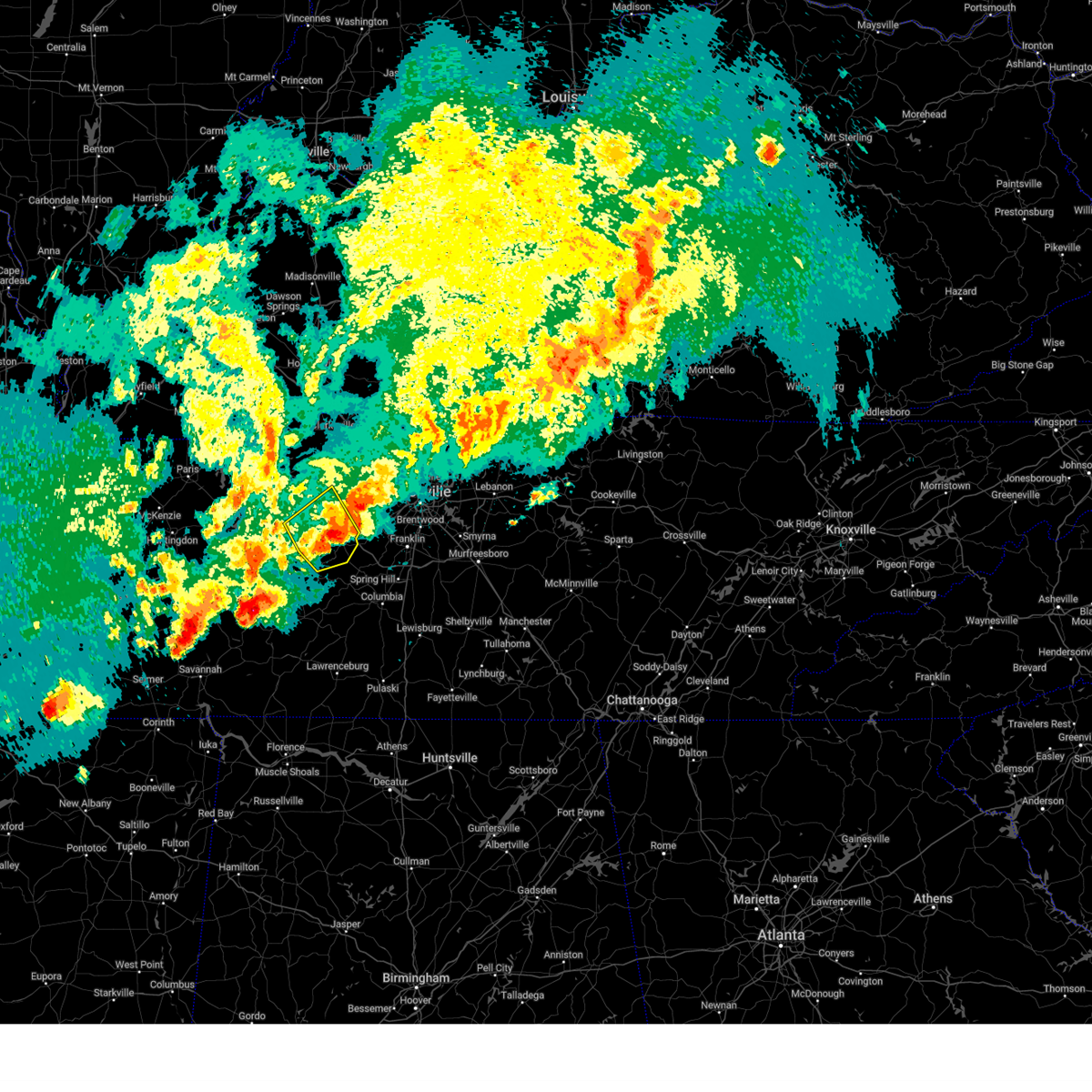
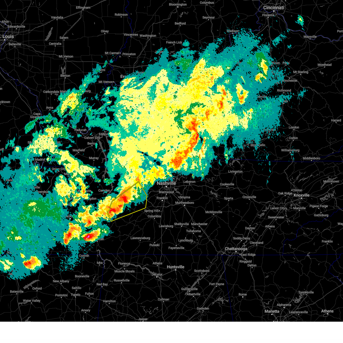
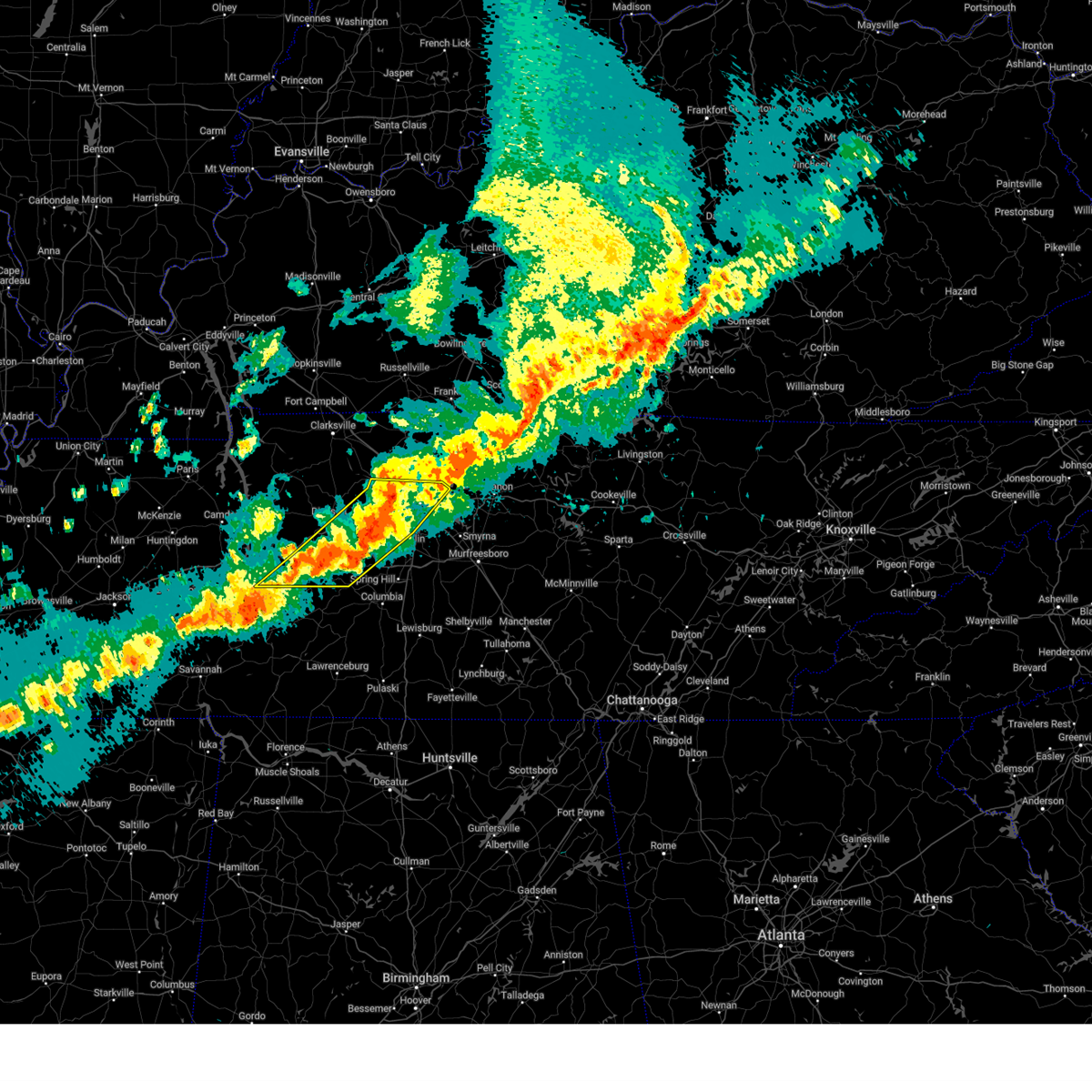
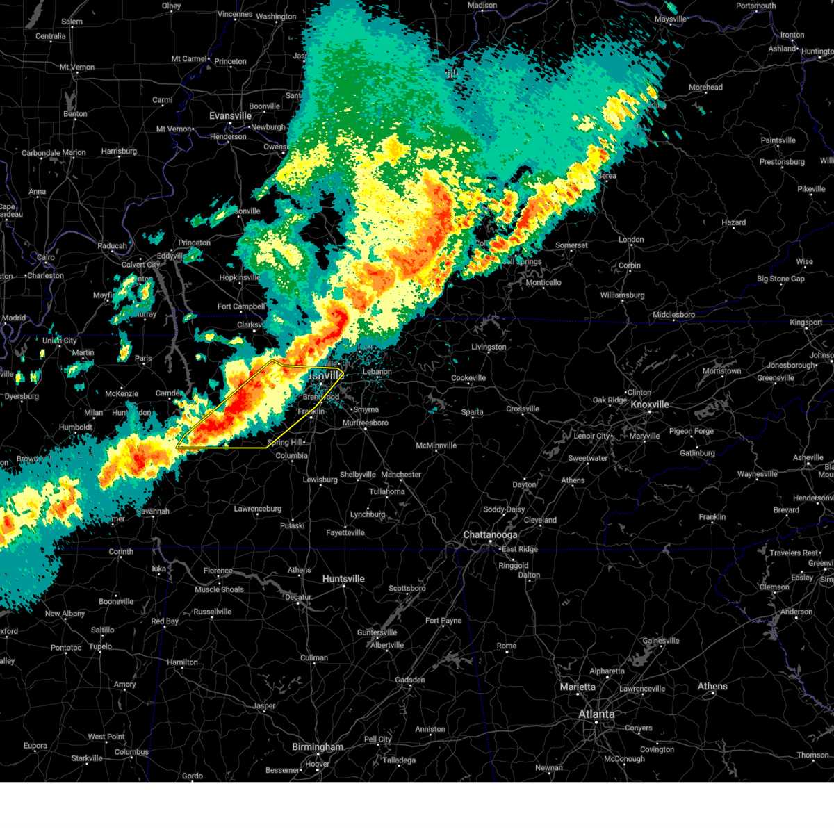
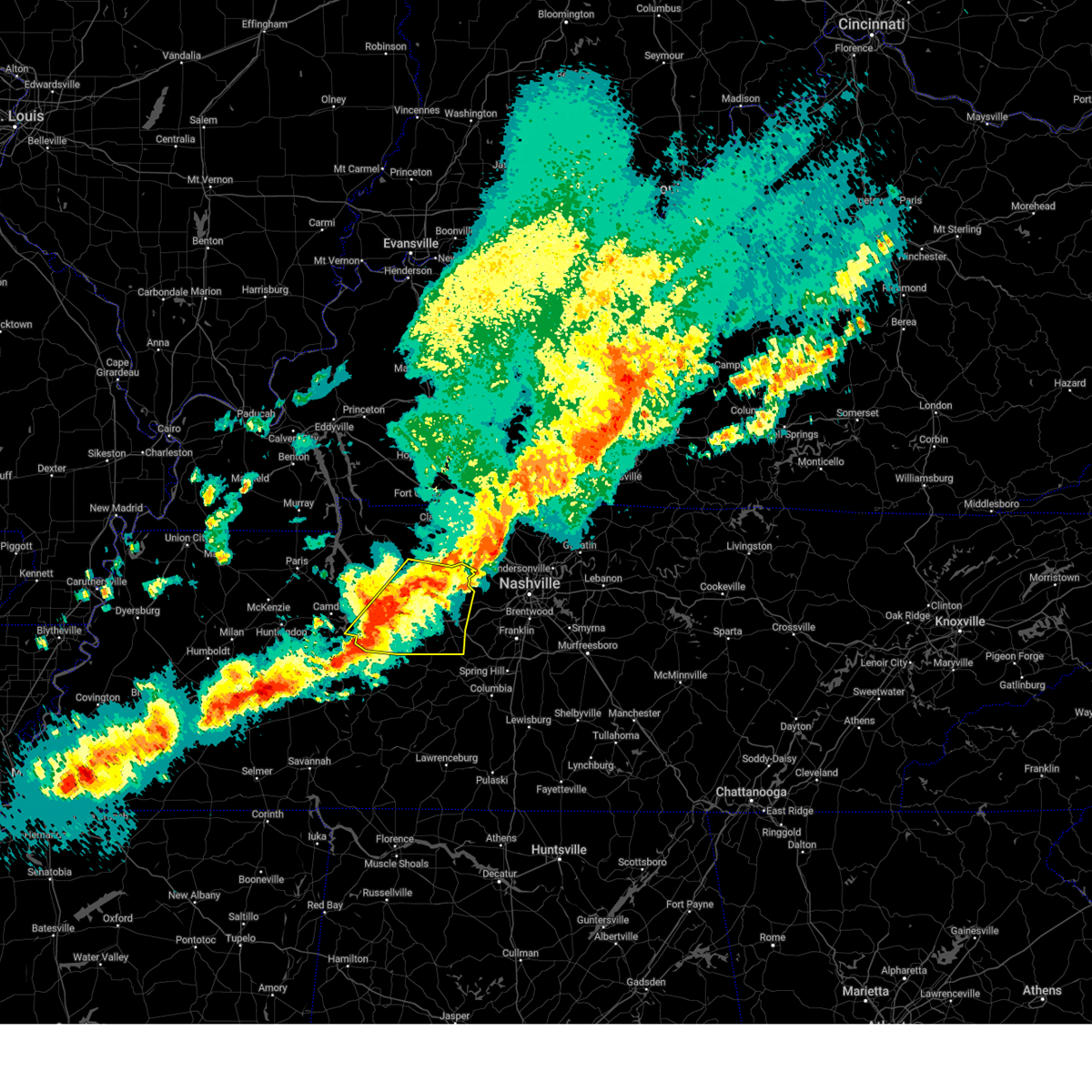
The Top Recent Hail Date for Centerville, TN is Tuesday, May 20, 2025 (3rd out of 81)

Hail and Wind Damage Spotted near Centerville, TN
| Date / Time | Report Details |
|---|---|
| 6/18/2025 8:31 PM CDT |
 Torohx the national weather service in nashville has issued a * tornado warning for, northeastern lewis county in middle tennessee, west central maury county in middle tennessee, southeastern hickman county in middle tennessee, * until 900 pm cdt. * at 830 pm cdt, a severe thunderstorm capable of producing a tornado was located 8 miles south of centerville, moving east at 25 mph (radar indicated rotation). Hazards include tornado. Flying debris will be dangerous to those caught without shelter. mobile homes will be damaged or destroyed. damage to roofs, windows, and vehicles will occur. tree damage is likely. This tornadic thunderstorm will remain over mainly rural areas of northeastern lewis, west central maury and southeastern hickman counties, including the following locations, williamsport. Torohx the national weather service in nashville has issued a * tornado warning for, northeastern lewis county in middle tennessee, west central maury county in middle tennessee, southeastern hickman county in middle tennessee, * until 900 pm cdt. * at 830 pm cdt, a severe thunderstorm capable of producing a tornado was located 8 miles south of centerville, moving east at 25 mph (radar indicated rotation). Hazards include tornado. Flying debris will be dangerous to those caught without shelter. mobile homes will be damaged or destroyed. damage to roofs, windows, and vehicles will occur. tree damage is likely. This tornadic thunderstorm will remain over mainly rural areas of northeastern lewis, west central maury and southeastern hickman counties, including the following locations, williamsport.
|
| 6/18/2025 8:23 PM CDT |
 Svrohx the national weather service in nashville has issued a * severe thunderstorm warning for, southern hickman county in middle tennessee, * until 900 pm cdt. * at 823 pm cdt, a severe thunderstorm was located 8 miles southwest of centerville, moving east at 25 mph (radar indicated). Hazards include 60 mph wind gusts. expect damage to roofs, siding, and trees Svrohx the national weather service in nashville has issued a * severe thunderstorm warning for, southern hickman county in middle tennessee, * until 900 pm cdt. * at 823 pm cdt, a severe thunderstorm was located 8 miles southwest of centerville, moving east at 25 mph (radar indicated). Hazards include 60 mph wind gusts. expect damage to roofs, siding, and trees
|
| 6/18/2025 8:00 PM CDT | Svrohx the national weather service in nashville has issued a * severe thunderstorm warning for, north central lewis county in middle tennessee, southern hickman county in middle tennessee, * until 830 pm cdt. * at 759 pm cdt, a severe thunderstorm was located 11 miles northeast of linden, moving east at 30 mph (radar indicated). Hazards include 60 mph wind gusts. expect damage to roofs, siding, and trees |
| 6/18/2025 7:36 PM CDT | Torohx the national weather service in nashville has issued a * tornado warning for, northwestern lewis county in middle tennessee, northeastern perry county in middle tennessee, southwestern hickman county in middle tennessee, * until 800 pm cdt. * at 736 pm cdt, a severe thunderstorm capable of producing a tornado was located near linden, moving east at 40 mph (radar indicated rotation). Hazards include tornado. Flying debris will be dangerous to those caught without shelter. mobile homes will be damaged or destroyed. damage to roofs, windows, and vehicles will occur. tree damage is likely. This tornadic thunderstorm will remain over mainly rural areas of northwestern lewis, northeastern perry and southwestern hickman counties, including the following locations, lobelville, gordonsburg, kimmins, and pleasantville. |
| 6/13/2025 2:37 PM CDT |
 The storm which prompted the warning has weakened below severe limits, and no longer poses an immediate threat to life or property. therefore, the warning will be allowed to expire. however, gusty winds are still possible with this thunderstorm. The storm which prompted the warning has weakened below severe limits, and no longer poses an immediate threat to life or property. therefore, the warning will be allowed to expire. however, gusty winds are still possible with this thunderstorm.
|
| 6/13/2025 2:25 PM CDT |
 At 224 pm cdt, a severe thunderstorm was located 10 miles east of centerville, moving northeast at 40 mph (radar indicated). Hazards include 60 mph wind gusts and penny size hail. Expect damage to roofs, siding, and trees. locations impacted include, dickson, centerville, spring hill, thompson's station, burns, santa fe, bon aqua, primm springs, williamsport, lyles, and nunnelly. this includes the following highways, interstate 40 between mile markers 169 and 177. interstate 65 near mile marker 57. Interstate 840 between mile markers 1 and 27. At 224 pm cdt, a severe thunderstorm was located 10 miles east of centerville, moving northeast at 40 mph (radar indicated). Hazards include 60 mph wind gusts and penny size hail. Expect damage to roofs, siding, and trees. locations impacted include, dickson, centerville, spring hill, thompson's station, burns, santa fe, bon aqua, primm springs, williamsport, lyles, and nunnelly. this includes the following highways, interstate 40 between mile markers 169 and 177. interstate 65 near mile marker 57. Interstate 840 between mile markers 1 and 27.
|
| 6/13/2025 2:25 PM CDT |
 the severe thunderstorm warning has been cancelled and is no longer in effect the severe thunderstorm warning has been cancelled and is no longer in effect
|
| 6/13/2025 2:13 PM CDT |
 Svrohx the national weather service in nashville has issued a * severe thunderstorm warning for, northeastern lewis county in middle tennessee, south central dickson county in middle tennessee, northwestern maury county in middle tennessee, southwestern williamson county in middle tennessee, hickman county in middle tennessee, * until 245 pm cdt. * at 212 pm cdt, a severe thunderstorm was located 8 miles southeast of centerville, moving northeast at 40 mph (radar indicated). Hazards include 60 mph wind gusts and penny size hail. expect damage to roofs, siding, and trees Svrohx the national weather service in nashville has issued a * severe thunderstorm warning for, northeastern lewis county in middle tennessee, south central dickson county in middle tennessee, northwestern maury county in middle tennessee, southwestern williamson county in middle tennessee, hickman county in middle tennessee, * until 245 pm cdt. * at 212 pm cdt, a severe thunderstorm was located 8 miles southeast of centerville, moving northeast at 40 mph (radar indicated). Hazards include 60 mph wind gusts and penny size hail. expect damage to roofs, siding, and trees
|
| 6/13/2025 1:48 PM CDT |
 Svrohx the national weather service in nashville has issued a * severe thunderstorm warning for, lewis county in middle tennessee, southwestern maury county in middle tennessee, southeastern hickman county in middle tennessee, * until 215 pm cdt. * at 147 pm cdt, a severe thunderstorm was located near hohenwald, moving northeast at 40 mph (radar indicated). Hazards include 60 mph wind gusts and penny size hail. expect damage to roofs, siding, and trees Svrohx the national weather service in nashville has issued a * severe thunderstorm warning for, lewis county in middle tennessee, southwestern maury county in middle tennessee, southeastern hickman county in middle tennessee, * until 215 pm cdt. * at 147 pm cdt, a severe thunderstorm was located near hohenwald, moving northeast at 40 mph (radar indicated). Hazards include 60 mph wind gusts and penny size hail. expect damage to roofs, siding, and trees
|
| 6/6/2025 2:39 PM CDT |
 The storm which prompted the warning has weakened below severe limits, and no longer poses an immediate threat to life or property. therefore, the warning will be allowed to expire. a tornado watch remains in effect until 800 pm cdt for middle tennessee. The storm which prompted the warning has weakened below severe limits, and no longer poses an immediate threat to life or property. therefore, the warning will be allowed to expire. a tornado watch remains in effect until 800 pm cdt for middle tennessee.
|
| 6/6/2025 2:25 PM CDT |
 At 225 pm cdt, a severe thunderstorm was located near hohenwald, moving east at 35 mph (radar indicated). Hazards include 60 mph wind gusts and quarter size hail. Hail damage to vehicles is expected. expect wind damage to roofs, siding, and trees. Locations impacted include, hohenwald, centerville, gordonsburg, kimmins, and pleasantville. At 225 pm cdt, a severe thunderstorm was located near hohenwald, moving east at 35 mph (radar indicated). Hazards include 60 mph wind gusts and quarter size hail. Hail damage to vehicles is expected. expect wind damage to roofs, siding, and trees. Locations impacted include, hohenwald, centerville, gordonsburg, kimmins, and pleasantville.
|
| 6/6/2025 2:04 PM CDT | Svrohx the national weather service in nashville has issued a * severe thunderstorm warning for, lewis county in middle tennessee, central perry county in middle tennessee, southwestern hickman county in middle tennessee, * until 245 pm cdt. * at 204 pm cdt, a severe thunderstorm was located near linden, moving east at 35 mph (radar indicated). Hazards include 60 mph wind gusts and quarter size hail. Hail damage to vehicles is expected. Expect wind damage to roofs, siding, and trees. |
| 5/25/2025 2:24 PM CDT |
 At 223 pm cdt, severe thunderstorms were located along a line extending from 7 miles west of centerville to near waynesboro to near savannah, moving east at 60 mph (radar indicated). Hazards include 60 mph wind gusts. Expect damage to roofs, siding, and trees. Locations impacted include, hohenwald, centerville, waynesboro, linden, clifton, lobelville, kimmins, mousetail landing state park, pleasantville, flatwoods, and lutts. At 223 pm cdt, severe thunderstorms were located along a line extending from 7 miles west of centerville to near waynesboro to near savannah, moving east at 60 mph (radar indicated). Hazards include 60 mph wind gusts. Expect damage to roofs, siding, and trees. Locations impacted include, hohenwald, centerville, waynesboro, linden, clifton, lobelville, kimmins, mousetail landing state park, pleasantville, flatwoods, and lutts.
|
| 5/25/2025 1:50 PM CDT |
 Svrohx the national weather service in nashville has issued a * severe thunderstorm warning for, western lewis county in middle tennessee, northwestern wayne county in middle tennessee, perry county in middle tennessee, southwestern hickman county in middle tennessee, * until 230 pm cdt. * at 148 pm cdt, severe thunderstorms were located along a line extending from 6 miles southwest of new johnsonville to near decaturville to near masseyville, moving east at 45 mph (radar indicated). Hazards include 60 mph wind gusts. expect damage to roofs, siding, and trees Svrohx the national weather service in nashville has issued a * severe thunderstorm warning for, western lewis county in middle tennessee, northwestern wayne county in middle tennessee, perry county in middle tennessee, southwestern hickman county in middle tennessee, * until 230 pm cdt. * at 148 pm cdt, severe thunderstorms were located along a line extending from 6 miles southwest of new johnsonville to near decaturville to near masseyville, moving east at 45 mph (radar indicated). Hazards include 60 mph wind gusts. expect damage to roofs, siding, and trees
|
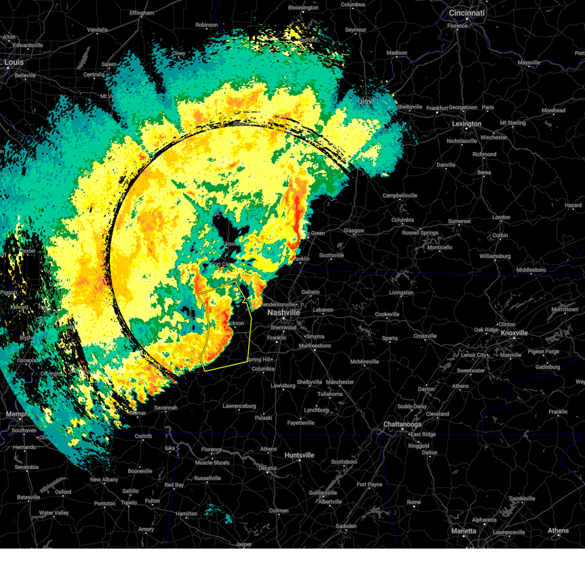
| 5/20/2025 5:59 PM CDT | At 559 pm cdt, severe thunderstorms were located along a line extending from near kingston springs to 7 miles northeast of centerville to 9 miles northwest of linden, moving east at 65 mph (radar indicated). Hazards include 60 mph wind gusts and quarter size hail. Hail damage to vehicles is expected. expect wind damage to roofs, siding, and trees. Locations impacted include, fairview, lobelville, kingston springs, bon aqua, pinewood, white bluff, lyles, nunnelly, burns, dickson, centerville, and pegram. |
| 5/20/2025 5:59 PM CDT | the severe thunderstorm warning has been cancelled and is no longer in effect |
| 5/20/2025 5:51 PM CDT | Tree fell on a vehicle along sr 48 in hickman county. minor injuries to the driver reported. time estimated from rada in hickman county TN, 4.4 miles S of Centerville, TN |
| 5/20/2025 5:45 PM CDT | Tree down on home on keys branch road near bon aqu in hickman county TN, 7.9 miles S of Centerville, TN |
| 5/20/2025 5:21 PM CDT |
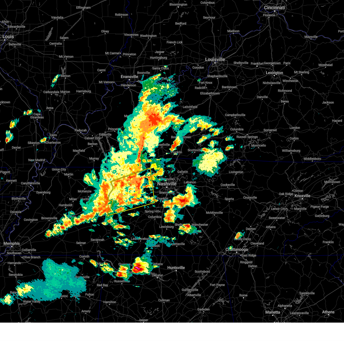 Svrohx the national weather service in nashville has issued a * severe thunderstorm warning for, dickson county in middle tennessee, southern montgomery county in middle tennessee, northwestern williamson county in middle tennessee, houston county in middle tennessee, western cheatham county in middle tennessee, northern perry county in middle tennessee, humphreys county in middle tennessee, northern hickman county in middle tennessee, * until 615 pm cdt. * at 521 pm cdt, severe thunderstorms were located along a line extending from near springville to linden, moving east at 65 mph (radar indicated). Hazards include 60 mph wind gusts and quarter size hail. Hail damage to vehicles is expected. expect wind damage to roofs, siding, and trees. severe thunderstorms will be near, camden, waverly, and new johnsonville around 525 pm cdt. hurricane mills around 530 pm cdt. tennessee ridge and erin around 535 pm cdt. mcewen around 540 pm cdt. centerville around 545 pm cdt. dickson around 550 pm cdt. burns around 555 pm cdt. white bluff around 600 pm cdt. Other locations impacted by these severe thunderstorms include lobelville, charlotte, bon aqua, pinewood, cheatham dam, vanleer, lyles, slayden, nunnelly, and cunningham. Svrohx the national weather service in nashville has issued a * severe thunderstorm warning for, dickson county in middle tennessee, southern montgomery county in middle tennessee, northwestern williamson county in middle tennessee, houston county in middle tennessee, western cheatham county in middle tennessee, northern perry county in middle tennessee, humphreys county in middle tennessee, northern hickman county in middle tennessee, * until 615 pm cdt. * at 521 pm cdt, severe thunderstorms were located along a line extending from near springville to linden, moving east at 65 mph (radar indicated). Hazards include 60 mph wind gusts and quarter size hail. Hail damage to vehicles is expected. expect wind damage to roofs, siding, and trees. severe thunderstorms will be near, camden, waverly, and new johnsonville around 525 pm cdt. hurricane mills around 530 pm cdt. tennessee ridge and erin around 535 pm cdt. mcewen around 540 pm cdt. centerville around 545 pm cdt. dickson around 550 pm cdt. burns around 555 pm cdt. white bluff around 600 pm cdt. Other locations impacted by these severe thunderstorms include lobelville, charlotte, bon aqua, pinewood, cheatham dam, vanleer, lyles, slayden, nunnelly, and cunningham.
|
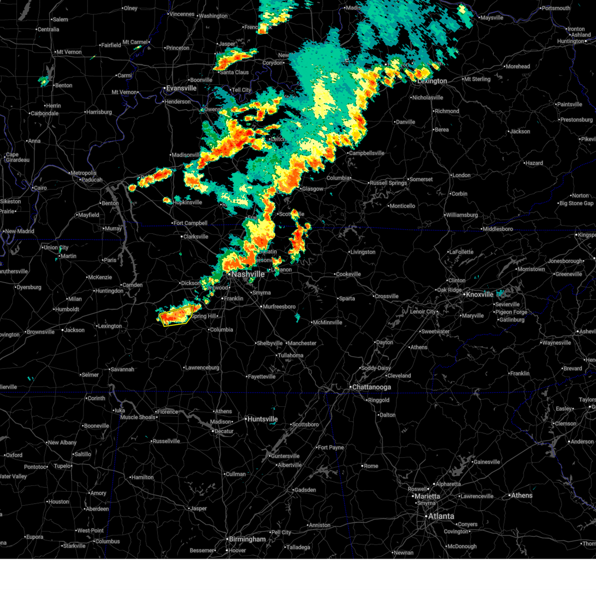
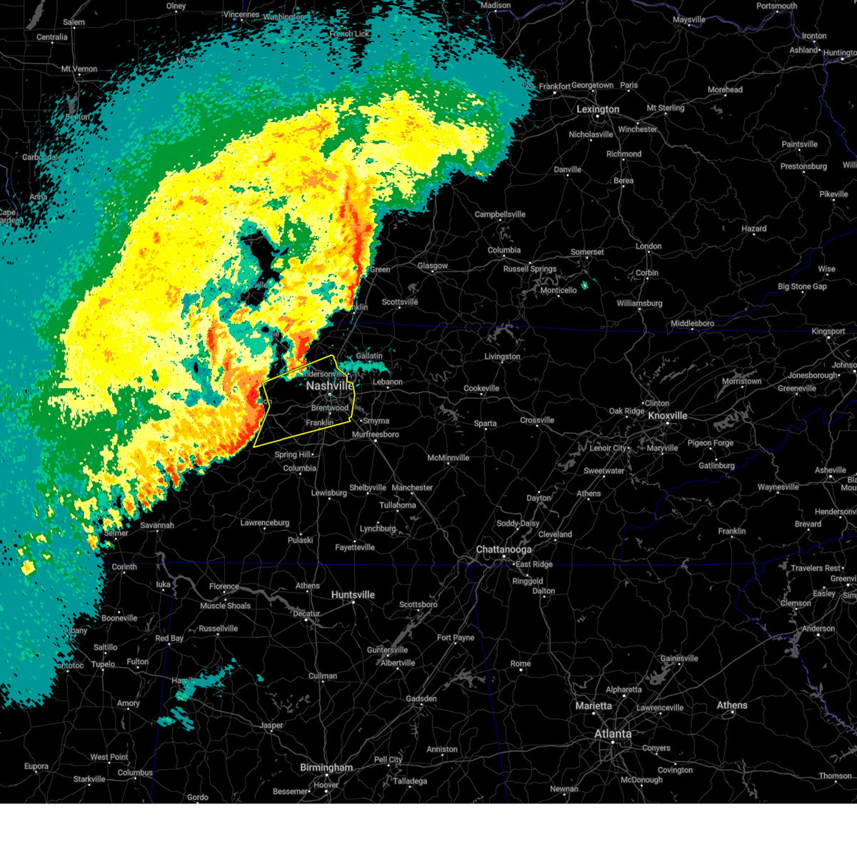
| 5/20/2025 4:04 PM CDT | At 404 pm cdt, a severe thunderstorm was located near centerville, moving east at 35 mph (radar indicated). Hazards include tennis ball size hail and 70 mph wind gusts. People and animals outdoors will be injured. expect hail damage to roofs, siding, windows, and vehicles. expect considerable tree damage. wind damage is also likely to mobile homes, roofs, and outbuildings. Locations impacted include, franklin, forest hills, bon aqua, spring hill, thompson's station, brentwood, primm springs, lyles, bellevue, natchez trace at highway 96, santa fe, fairview, leipers fork, oak hill, belle meade, and centerville. |
| 5/20/2025 4:00 PM CDT | Quarter sized hail reported 1.8 miles SSE of Centerville, TN, public report of penny to quarter sized hail near elkins rd in centerville. |
| 5/20/2025 3:56 PM CDT | Golf Ball sized hail reported 2.2 miles WSW of Centerville, TN, golf ball size hail at hickman county high school. |
| 5/20/2025 3:56 PM CDT | Hen Egg sized hail reported 7.4 miles SW of Centerville, TN, two inch hail reported near tn 100 and tn 230 north of centerville. time estimated from radar. |
| 5/20/2025 3:56 PM CDT | Svrohx the national weather service in nashville has issued a * severe thunderstorm warning for, southwestern davidson county in middle tennessee, southeastern dickson county in middle tennessee, northern maury county in middle tennessee, williamson county in middle tennessee, eastern hickman county in middle tennessee, * until 500 pm cdt. * at 356 pm cdt, a severe thunderstorm was located near centerville, moving east at 40 mph (radar indicated). Hazards include golf ball size hail and 70 mph wind gusts. People and animals outdoors will be injured. expect hail damage to roofs, siding, windows, and vehicles. expect considerable tree damage. Wind damage is also likely to mobile homes, roofs, and outbuildings. |
| 5/20/2025 3:54 PM CDT | Hen Egg sized hail reported 2.2 miles WSW of Centerville, TN, estimated 2 inch hail near centerville middle school. time estimated from radar. |
| 5/20/2025 3:50 PM CDT | Trees reported down at hickman county high school. time estimated from rada in hickman county TN, 2.2 miles WSW of Centerville, TN |
| 5/20/2025 3:50 PM CDT | Golf Ball sized hail reported 2.2 miles WSW of Centerville, TN, golf ball size hail reported at hickman county high school. time estimated from radar. |
| 5/20/2025 3:43 PM CDT | At 343 pm cdt, a severe thunderstorm capable of producing a tornado was located just southwest of centerville, moving northeast at 60 mph (radar indicated rotation). Hazards include tornado and half dollar size hail. Flying debris will be dangerous to those caught without shelter. mobile homes will be damaged or destroyed. damage to roofs, windows, and vehicles will occur. tree damage is likely. Locations impacted include, primm springs and centerville. |
| 5/20/2025 3:42 PM CDT | At 342 pm cdt, a severe thunderstorm was located near centerville, moving northeast at 45 mph (radar indicated). Hazards include 60 mph wind gusts and half dollar size hail. Hail damage to vehicles is expected. expect wind damage to roofs, siding, and trees. Locations impacted include, bon aqua, pinewood, primm springs, lyles, nunnelly, bucksnort, and centerville. |
| 5/20/2025 3:42 PM CDT | the severe thunderstorm warning has been cancelled and is no longer in effect |
| 5/20/2025 3:39 PM CDT | Torohx the national weather service in nashville has issued a * tornado warning for, central hickman county in middle tennessee, * until 415 pm cdt. * at 339 pm cdt, a severe thunderstorm capable of producing a tornado was located 9 miles southwest of centerville, moving east at 55 mph (radar indicated rotation). Hazards include tornado and half dollar size hail. Flying debris will be dangerous to those caught without shelter. mobile homes will be damaged or destroyed. damage to roofs, windows, and vehicles will occur. tree damage is likely. this dangerous storm will be near, centerville around 345 pm cdt. Other locations impacted by this tornadic thunderstorm include primm springs. |
| 5/20/2025 3:29 PM CDT | At 328 pm cdt, a severe thunderstorm was located 12 miles west of centerville, or near coble, moving northeast at 50 mph (radar indicated). Hazards include 60 mph wind gusts and half dollar size hail. Hail damage to vehicles is expected. expect wind damage to roofs, siding, and trees. Locations impacted include, hurricane mills, bon aqua, primm springs, lyles, bucksnort, centerville, lobelville, pinewood, pleasantville, white bluff, nunnelly, burns, dickson, and linden. |
| 5/20/2025 3:11 PM CDT | At 311 pm cdt, a severe thunderstorm capable of producing a tornado was located 7 miles north of hohenwald, moving northeast at 30 mph (radar indicated rotation). Hazards include tornado. Flying debris will be dangerous to those caught without shelter. mobile homes will be damaged or destroyed. damage to roofs, windows, and vehicles will occur. tree damage is likely. Locations impacted include, centerville. |
| 5/20/2025 3:11 PM CDT | the tornado warning has been cancelled and is no longer in effect |
| 5/20/2025 3:02 PM CDT |
 Torohx the national weather service in nashville has issued a * tornado warning for, northern lewis county in middle tennessee, northwestern maury county in middle tennessee, southeastern hickman county in middle tennessee, * until 330 pm cdt. * at 302 pm cdt, a confirmed tornado was located near hohenwald, moving northeast at 35 mph (weather spotters confirmed tornado). Hazards include damaging tornado. Flying debris will be dangerous to those caught without shelter. mobile homes will be damaged or destroyed. damage to roofs, windows, and vehicles will occur. Tree damage is likely. Torohx the national weather service in nashville has issued a * tornado warning for, northern lewis county in middle tennessee, northwestern maury county in middle tennessee, southeastern hickman county in middle tennessee, * until 330 pm cdt. * at 302 pm cdt, a confirmed tornado was located near hohenwald, moving northeast at 35 mph (weather spotters confirmed tornado). Hazards include damaging tornado. Flying debris will be dangerous to those caught without shelter. mobile homes will be damaged or destroyed. damage to roofs, windows, and vehicles will occur. Tree damage is likely.
|
| 5/20/2025 2:56 PM CDT |
 Svrohx the national weather service in nashville has issued a * severe thunderstorm warning for, southern dickson county in middle tennessee, perry county in middle tennessee, southern humphreys county in middle tennessee, hickman county in middle tennessee, * until 400 pm cdt. * at 255 pm cdt, a severe thunderstorm was located near parsons, or 11 miles east of natchez trace state forest, moving northeast at 50 mph (radar indicated). Hazards include 60 mph wind gusts and quarter size hail. Hail damage to vehicles is expected. Expect wind damage to roofs, siding, and trees. Svrohx the national weather service in nashville has issued a * severe thunderstorm warning for, southern dickson county in middle tennessee, perry county in middle tennessee, southern humphreys county in middle tennessee, hickman county in middle tennessee, * until 400 pm cdt. * at 255 pm cdt, a severe thunderstorm was located near parsons, or 11 miles east of natchez trace state forest, moving northeast at 50 mph (radar indicated). Hazards include 60 mph wind gusts and quarter size hail. Hail damage to vehicles is expected. Expect wind damage to roofs, siding, and trees.
|
| 5/20/2025 10:15 AM CDT |
 the severe thunderstorm warning has been cancelled and is no longer in effect the severe thunderstorm warning has been cancelled and is no longer in effect
|
| 5/20/2025 9:55 AM CDT |
 the severe thunderstorm warning has been cancelled and is no longer in effect the severe thunderstorm warning has been cancelled and is no longer in effect
|
| 5/20/2025 9:55 AM CDT |
 At 955 am cdt, a severe thunderstorm was located 11 miles west of centerville, moving northeast at 40 mph (radar indicated). Hazards include 60 mph wind gusts. Expect damage to roofs, siding, and trees. Locations impacted include, nunnelly, pinewood, pleasantville, and centerville. At 955 am cdt, a severe thunderstorm was located 11 miles west of centerville, moving northeast at 40 mph (radar indicated). Hazards include 60 mph wind gusts. Expect damage to roofs, siding, and trees. Locations impacted include, nunnelly, pinewood, pleasantville, and centerville.
|
| 5/20/2025 9:39 AM CDT |
 Svrohx the national weather service in nashville has issued a * severe thunderstorm warning for, northeastern perry county in middle tennessee, western hickman county in middle tennessee, * until 1030 am cdt. * at 939 am cdt, a severe thunderstorm was located near linden, moving east at 40 mph (radar indicated). Hazards include 60 mph wind gusts. expect damage to roofs, siding, and trees Svrohx the national weather service in nashville has issued a * severe thunderstorm warning for, northeastern perry county in middle tennessee, western hickman county in middle tennessee, * until 1030 am cdt. * at 939 am cdt, a severe thunderstorm was located near linden, moving east at 40 mph (radar indicated). Hazards include 60 mph wind gusts. expect damage to roofs, siding, and trees
|
| 5/2/2025 12:29 PM CDT |
 Svrohx the national weather service in nashville has issued a * severe thunderstorm warning for, southeastern dickson county in middle tennessee, north central maury county in middle tennessee, northwestern williamson county in middle tennessee, south central cheatham county in middle tennessee, northeastern hickman county in middle tennessee, * until 115 pm cdt. * at 1229 pm cdt, a severe thunderstorm was located near centerville, moving east at 35 mph (radar indicated). Hazards include 60 mph wind gusts and quarter size hail. Hail damage to vehicles is expected. Expect wind damage to roofs, siding, and trees. Svrohx the national weather service in nashville has issued a * severe thunderstorm warning for, southeastern dickson county in middle tennessee, north central maury county in middle tennessee, northwestern williamson county in middle tennessee, south central cheatham county in middle tennessee, northeastern hickman county in middle tennessee, * until 115 pm cdt. * at 1229 pm cdt, a severe thunderstorm was located near centerville, moving east at 35 mph (radar indicated). Hazards include 60 mph wind gusts and quarter size hail. Hail damage to vehicles is expected. Expect wind damage to roofs, siding, and trees.
|
| 5/2/2025 12:16 PM CDT |
 At 1216 pm cdt, severe thunderstorms were located along a line extending from 10 miles northeast of mcewen to near centerville to near hohenwald, moving northeast at 45 mph (radar indicated). Hazards include 60 mph wind gusts and half dollar size hail. Hail damage to vehicles is expected. expect wind damage to roofs, siding, and trees. locations impacted include, kimmins, bon aqua, pinewood, pleasantville, mcewen, lyles, nunnelly, burns, bucksnort, centerville, and dickson. this includes the following highways, interstate 40 between mile markers 150 and 176. Interstate 840 mile marker 2 and near mile marker 4. At 1216 pm cdt, severe thunderstorms were located along a line extending from 10 miles northeast of mcewen to near centerville to near hohenwald, moving northeast at 45 mph (radar indicated). Hazards include 60 mph wind gusts and half dollar size hail. Hail damage to vehicles is expected. expect wind damage to roofs, siding, and trees. locations impacted include, kimmins, bon aqua, pinewood, pleasantville, mcewen, lyles, nunnelly, burns, bucksnort, centerville, and dickson. this includes the following highways, interstate 40 between mile markers 150 and 176. Interstate 840 mile marker 2 and near mile marker 4.
|
| 5/2/2025 12:03 PM CDT |
 At 1203 pm cdt, severe thunderstorms were located along a line extending from mcewen to near centerville to 7 miles southeast of linden, moving northeast at 45 mph (radar indicated). Hazards include 60 mph wind gusts and half dollar size hail. Hail damage to vehicles is expected. expect wind damage to roofs, siding, and trees. locations impacted include, hurricane mills, kimmins, bon aqua, hohenwald, mcewen, primm springs, lyles, bucksnort, centerville, waverly, pinewood, pleasantville, nunnelly, burns, and dickson. this includes the following highways, interstate 40 between mile markers 144 and 176. Interstate 840 mile marker 2 and near mile marker 4. At 1203 pm cdt, severe thunderstorms were located along a line extending from mcewen to near centerville to 7 miles southeast of linden, moving northeast at 45 mph (radar indicated). Hazards include 60 mph wind gusts and half dollar size hail. Hail damage to vehicles is expected. expect wind damage to roofs, siding, and trees. locations impacted include, hurricane mills, kimmins, bon aqua, hohenwald, mcewen, primm springs, lyles, bucksnort, centerville, waverly, pinewood, pleasantville, nunnelly, burns, and dickson. this includes the following highways, interstate 40 between mile markers 144 and 176. Interstate 840 mile marker 2 and near mile marker 4.
|
| 5/2/2025 11:52 AM CDT |
 Svrohx the national weather service in nashville has issued a * severe thunderstorm warning for, northwestern lewis county in middle tennessee, southwestern dickson county in middle tennessee, eastern perry county in middle tennessee, eastern humphreys county in middle tennessee, hickman county in middle tennessee, * until 1230 pm cdt. * at 1152 am cdt, severe thunderstorms were located along a line extending from waverly to 13 miles west of centerville to 7 miles south of linden, moving northeast at 45 mph (radar indicated). Hazards include 60 mph wind gusts and quarter size hail. Hail damage to vehicles is expected. Expect wind damage to roofs, siding, and trees. Svrohx the national weather service in nashville has issued a * severe thunderstorm warning for, northwestern lewis county in middle tennessee, southwestern dickson county in middle tennessee, eastern perry county in middle tennessee, eastern humphreys county in middle tennessee, hickman county in middle tennessee, * until 1230 pm cdt. * at 1152 am cdt, severe thunderstorms were located along a line extending from waverly to 13 miles west of centerville to 7 miles south of linden, moving northeast at 45 mph (radar indicated). Hazards include 60 mph wind gusts and quarter size hail. Hail damage to vehicles is expected. Expect wind damage to roofs, siding, and trees.
|
| 4/10/2025 5:11 PM CDT |
 Svrohx the national weather service in nashville has issued a * severe thunderstorm warning for, lewis county in middle tennessee, eastern wayne county in middle tennessee, western marshall county in middle tennessee, lawrence county in middle tennessee, maury county in middle tennessee, giles county in middle tennessee, southern hickman county in middle tennessee, * until 600 pm cdt. * at 511 pm cdt, severe thunderstorms were located along a line extending from 6 miles southeast of centerville to 8 miles southwest of loretto, moving southeast at 35 mph (radar indicated). Hazards include 60 mph wind gusts. expect damage to roofs, siding, and trees Svrohx the national weather service in nashville has issued a * severe thunderstorm warning for, lewis county in middle tennessee, eastern wayne county in middle tennessee, western marshall county in middle tennessee, lawrence county in middle tennessee, maury county in middle tennessee, giles county in middle tennessee, southern hickman county in middle tennessee, * until 600 pm cdt. * at 511 pm cdt, severe thunderstorms were located along a line extending from 6 miles southeast of centerville to 8 miles southwest of loretto, moving southeast at 35 mph (radar indicated). Hazards include 60 mph wind gusts. expect damage to roofs, siding, and trees
|
| 4/10/2025 4:44 PM CDT |
 At 444 pm cdt, a severe thunderstorm was located 7 miles south of hurricane mills, or 15 miles south of waverly, moving east at 45 mph (radar indicated). Hazards include 60 mph wind gusts. Expect damage to roofs, siding, and trees. locations impacted include, hurricane mills, lobelville, pinewood, new johnsonville, nunnelly, bucksnort, centerville, and i-40 near the tennessee river. This includes interstate 40 between mile markers 136 and 166. At 444 pm cdt, a severe thunderstorm was located 7 miles south of hurricane mills, or 15 miles south of waverly, moving east at 45 mph (radar indicated). Hazards include 60 mph wind gusts. Expect damage to roofs, siding, and trees. locations impacted include, hurricane mills, lobelville, pinewood, new johnsonville, nunnelly, bucksnort, centerville, and i-40 near the tennessee river. This includes interstate 40 between mile markers 136 and 166.
|
| 4/10/2025 4:17 PM CDT | Svrohx the national weather service in nashville has issued a * severe thunderstorm warning for, southwestern dickson county in middle tennessee, northern perry county in middle tennessee, southern humphreys county in middle tennessee, western hickman county in middle tennessee, * until 500 pm cdt. * at 417 pm cdt, a severe thunderstorm was located 8 miles southwest of camden, moving east at 45 mph (radar indicated). Hazards include 60 mph wind gusts. expect damage to roofs, siding, and trees |
| 4/5/2025 4:34 PM CDT |
 At 433 pm cdt, severe thunderstorms were located along a line extending from near ashland city to kingston springs to 11 miles east of centerville, moving east at 50 mph (radar indicated). Hazards include 70 mph wind gusts and half dollar size hail. Hail damage to vehicles is expected. expect considerable tree damage. wind damage is also likely to mobile homes, roofs, and outbuildings. locations impacted include, madison, bon aqua, hermitage, belle meade, natchez trace at highway 96, fairview, berry hill, ashland city, white bluff, oak hill, forest hills, ridgetop, bells bend, brentwood, lyles, nashville, whites creek, bellevue, antioch, and lakewood. this includes the following highways, interstate 40 between mile markers 174 and 222. interstate 65 between mile markers 67 and 97. interstate 24 between mile markers 29 and 63. Interstate 840 between mile markers 1 and 14. At 433 pm cdt, severe thunderstorms were located along a line extending from near ashland city to kingston springs to 11 miles east of centerville, moving east at 50 mph (radar indicated). Hazards include 70 mph wind gusts and half dollar size hail. Hail damage to vehicles is expected. expect considerable tree damage. wind damage is also likely to mobile homes, roofs, and outbuildings. locations impacted include, madison, bon aqua, hermitage, belle meade, natchez trace at highway 96, fairview, berry hill, ashland city, white bluff, oak hill, forest hills, ridgetop, bells bend, brentwood, lyles, nashville, whites creek, bellevue, antioch, and lakewood. this includes the following highways, interstate 40 between mile markers 174 and 222. interstate 65 between mile markers 67 and 97. interstate 24 between mile markers 29 and 63. Interstate 840 between mile markers 1 and 14.
|
| 4/5/2025 4:31 PM CDT |
 The storms which prompted the warning have moved out of the area. therefore, the warning has been allowed to expire. a tornado watch remains in effect until 900 pm cdt for middle tennessee. remember, a severe thunderstorm warning still remains in effect for dickson and hickman counties. The storms which prompted the warning have moved out of the area. therefore, the warning has been allowed to expire. a tornado watch remains in effect until 900 pm cdt for middle tennessee. remember, a severe thunderstorm warning still remains in effect for dickson and hickman counties.
|
| 4/5/2025 4:21 PM CDT |
 Svrohx the national weather service in nashville has issued a * severe thunderstorm warning for, davidson county in middle tennessee, eastern dickson county in middle tennessee, northern williamson county in middle tennessee, cheatham county in middle tennessee, northeastern hickman county in middle tennessee, south central robertson county in middle tennessee, * until 515 pm cdt. * at 420 pm cdt, severe thunderstorms were located along a line extending from 10 miles north of dickson to near white bluff to centerville, moving northeast at 65 mph (radar indicated). Hazards include 70 mph wind gusts and quarter size hail. Hail damage to vehicles is expected. expect considerable tree damage. Wind damage is also likely to mobile homes, roofs, and outbuildings. Svrohx the national weather service in nashville has issued a * severe thunderstorm warning for, davidson county in middle tennessee, eastern dickson county in middle tennessee, northern williamson county in middle tennessee, cheatham county in middle tennessee, northeastern hickman county in middle tennessee, south central robertson county in middle tennessee, * until 515 pm cdt. * at 420 pm cdt, severe thunderstorms were located along a line extending from 10 miles north of dickson to near white bluff to centerville, moving northeast at 65 mph (radar indicated). Hazards include 70 mph wind gusts and quarter size hail. Hail damage to vehicles is expected. expect considerable tree damage. Wind damage is also likely to mobile homes, roofs, and outbuildings.
|
| 4/5/2025 4:10 PM CDT |
 At 409 pm cdt, severe thunderstorms were located along a line extending from 6 miles east of erin to 8 miles southwest of dickson to 12 miles northeast of linden, moving east at 60 mph (radar indicated). Hazards include 60 mph wind gusts and quarter size hail. Hail damage to vehicles is expected. expect wind damage to roofs, siding, and trees. locations impacted include, charlotte, bon aqua, cumberland city, mcewen, primm springs, lyles, palmyra, tennessee ridge, bucksnort, centerville, lobelville, erin, pinewood, pleasantville, vanleer, white bluff, slayden, nunnelly, burns, and cunningham. this includes the following highways, interstate 40 between mile markers 146 and 180. Interstate 840 between mile markers 1 and 6. At 409 pm cdt, severe thunderstorms were located along a line extending from 6 miles east of erin to 8 miles southwest of dickson to 12 miles northeast of linden, moving east at 60 mph (radar indicated). Hazards include 60 mph wind gusts and quarter size hail. Hail damage to vehicles is expected. expect wind damage to roofs, siding, and trees. locations impacted include, charlotte, bon aqua, cumberland city, mcewen, primm springs, lyles, palmyra, tennessee ridge, bucksnort, centerville, lobelville, erin, pinewood, pleasantville, vanleer, white bluff, slayden, nunnelly, burns, and cunningham. this includes the following highways, interstate 40 between mile markers 146 and 180. Interstate 840 between mile markers 1 and 6.
|
| 4/5/2025 3:58 PM CDT |
 At 358 pm cdt, severe thunderstorms were located along a line extending from near erin to 6 miles east of hurricane mills to 6 miles north of linden, moving east at 65 mph (radar indicated). Hazards include 60 mph wind gusts and quarter size hail. Hail damage to vehicles is expected. expect wind damage to roofs, siding, and trees. locations impacted include, hurricane mills, charlotte, bon aqua, mcewen, primm springs, palmyra, tennessee ridge, bucksnort, erin, linden, pleasantville, houston county airport, white bluff, nunnelly, cunningham, dickson, cumberland city, lyles, i-40 near the tennessee river, and centerville. this includes the following highways, interstate 40 between mile markers 136 and 180. Interstate 840 between mile markers 1 and 6. At 358 pm cdt, severe thunderstorms were located along a line extending from near erin to 6 miles east of hurricane mills to 6 miles north of linden, moving east at 65 mph (radar indicated). Hazards include 60 mph wind gusts and quarter size hail. Hail damage to vehicles is expected. expect wind damage to roofs, siding, and trees. locations impacted include, hurricane mills, charlotte, bon aqua, mcewen, primm springs, palmyra, tennessee ridge, bucksnort, erin, linden, pleasantville, houston county airport, white bluff, nunnelly, cunningham, dickson, cumberland city, lyles, i-40 near the tennessee river, and centerville. this includes the following highways, interstate 40 between mile markers 136 and 180. Interstate 840 between mile markers 1 and 6.
|
| 4/5/2025 3:34 PM CDT |
 Svrohx the national weather service in nashville has issued a * severe thunderstorm warning for, dickson county in middle tennessee, southwestern montgomery county in middle tennessee, southeastern stewart county in middle tennessee, houston county in middle tennessee, perry county in middle tennessee, humphreys county in middle tennessee, hickman county in middle tennessee, * until 430 pm cdt. * at 334 pm cdt, severe thunderstorms were located along a line extending from 6 miles east of vale to 10 miles southwest of new johnsonville to decaturville, moving east at 60 mph (radar indicated). Hazards include 60 mph wind gusts and quarter size hail. Hail damage to vehicles is expected. Expect wind damage to roofs, siding, and trees. Svrohx the national weather service in nashville has issued a * severe thunderstorm warning for, dickson county in middle tennessee, southwestern montgomery county in middle tennessee, southeastern stewart county in middle tennessee, houston county in middle tennessee, perry county in middle tennessee, humphreys county in middle tennessee, hickman county in middle tennessee, * until 430 pm cdt. * at 334 pm cdt, severe thunderstorms were located along a line extending from 6 miles east of vale to 10 miles southwest of new johnsonville to decaturville, moving east at 60 mph (radar indicated). Hazards include 60 mph wind gusts and quarter size hail. Hail damage to vehicles is expected. Expect wind damage to roofs, siding, and trees.
|
| 4/3/2025 6:23 PM CDT |
 The tornadic thunderstorm which prompted the warning has weakened. therefore, the warning will be allowed to expire. however, gusty winds are still possible with this thunderstorm. a tornado watch remains in effect until 1000 pm cdt for middle tennessee. The tornadic thunderstorm which prompted the warning has weakened. therefore, the warning will be allowed to expire. however, gusty winds are still possible with this thunderstorm. a tornado watch remains in effect until 1000 pm cdt for middle tennessee.
|
| 4/3/2025 6:07 PM CDT |
 At 606 pm cdt, a severe thunderstorm capable of producing a tornado was located 9 miles south of burns, or 10 miles northeast of centerville, moving northeast at 45 mph (radar indicated rotation). Hazards include tornado. Flying debris will be dangerous to those caught without shelter. mobile homes will be damaged or destroyed. damage to roofs, windows, and vehicles will occur. tree damage is likely. this dangerous storm will be near, fairview around 615 pm cdt. other locations impacted by this tornadic thunderstorm include primm springs, lyles, bon aqua, and nunnelly. this includes the following highways, interstate 40 between mile markers 169 and 183. Interstate 840 between mile markers 1 and 19. At 606 pm cdt, a severe thunderstorm capable of producing a tornado was located 9 miles south of burns, or 10 miles northeast of centerville, moving northeast at 45 mph (radar indicated rotation). Hazards include tornado. Flying debris will be dangerous to those caught without shelter. mobile homes will be damaged or destroyed. damage to roofs, windows, and vehicles will occur. tree damage is likely. this dangerous storm will be near, fairview around 615 pm cdt. other locations impacted by this tornadic thunderstorm include primm springs, lyles, bon aqua, and nunnelly. this includes the following highways, interstate 40 between mile markers 169 and 183. Interstate 840 between mile markers 1 and 19.
|
| 4/3/2025 5:55 PM CDT |
 Torohx the national weather service in nashville has issued a * tornado warning for, southeastern dickson county in middle tennessee, north central maury county in middle tennessee, western williamson county in middle tennessee, northeastern hickman county in middle tennessee, * until 630 pm cdt. * at 555 pm cdt, a severe thunderstorm capable of producing a tornado was located near centerville, moving east at 45 mph (radar indicated rotation). Hazards include tornado. Flying debris will be dangerous to those caught without shelter. mobile homes will be damaged or destroyed. damage to roofs, windows, and vehicles will occur. tree damage is likely. this dangerous storm will be near, centerville around 600 pm cdt. fairview around 620 pm cdt. other locations impacted by this tornadic thunderstorm include primm springs, lyles, bon aqua, nunnelly, and pinewood. this includes the following highways, interstate 40 between mile markers 156 and 159, and between mile markers 161 and 183. Interstate 840 between mile markers 1 and 21. Torohx the national weather service in nashville has issued a * tornado warning for, southeastern dickson county in middle tennessee, north central maury county in middle tennessee, western williamson county in middle tennessee, northeastern hickman county in middle tennessee, * until 630 pm cdt. * at 555 pm cdt, a severe thunderstorm capable of producing a tornado was located near centerville, moving east at 45 mph (radar indicated rotation). Hazards include tornado. Flying debris will be dangerous to those caught without shelter. mobile homes will be damaged or destroyed. damage to roofs, windows, and vehicles will occur. tree damage is likely. this dangerous storm will be near, centerville around 600 pm cdt. fairview around 620 pm cdt. other locations impacted by this tornadic thunderstorm include primm springs, lyles, bon aqua, nunnelly, and pinewood. this includes the following highways, interstate 40 between mile markers 156 and 159, and between mile markers 161 and 183. Interstate 840 between mile markers 1 and 21.
|
| 4/3/2025 5:43 PM CDT |
 the tornado warning has been cancelled and is no longer in effect the tornado warning has been cancelled and is no longer in effect
|
| 4/3/2025 5:43 PM CDT |
 At 542 pm cdt, a severe thunderstorm capable of producing a tornado was located 10 miles east of hurricane mills, or 11 miles northwest of centerville, moving northeast at 60 mph (radar indicated rotation). Hazards include tornado. Flying debris will be dangerous to those caught without shelter. mobile homes will be damaged or destroyed. damage to roofs, windows, and vehicles will occur. tree damage is likely. this dangerous storm will be near, dickson around 555 pm cdt. other locations impacted by this tornadic thunderstorm include primm springs, lyles, bon aqua, nunnelly, pinewood, and bucksnort. This includes interstate 40 between mile markers 147 and 171. At 542 pm cdt, a severe thunderstorm capable of producing a tornado was located 10 miles east of hurricane mills, or 11 miles northwest of centerville, moving northeast at 60 mph (radar indicated rotation). Hazards include tornado. Flying debris will be dangerous to those caught without shelter. mobile homes will be damaged or destroyed. damage to roofs, windows, and vehicles will occur. tree damage is likely. this dangerous storm will be near, dickson around 555 pm cdt. other locations impacted by this tornadic thunderstorm include primm springs, lyles, bon aqua, nunnelly, pinewood, and bucksnort. This includes interstate 40 between mile markers 147 and 171.
|
| 4/3/2025 5:30 PM CDT |
 Torohx the national weather service in nashville has issued a * tornado warning for, southwestern dickson county in middle tennessee, northeastern perry county in middle tennessee, southeastern humphreys county in middle tennessee, hickman county in middle tennessee, * until 600 pm cdt. * at 530 pm cdt, a severe thunderstorm capable of producing a tornado was located 9 miles south of hurricane mills, or 15 miles north of linden, moving northeast at 55 mph (radar indicated rotation). Hazards include tornado. Flying debris will be dangerous to those caught without shelter. mobile homes will be damaged or destroyed. damage to roofs, windows, and vehicles will occur. tree damage is likely. this dangerous storm will be near, dickson around 555 pm cdt. other locations impacted by this tornadic thunderstorm include lobelville, bon aqua, pinewood, primm springs, lyles, nunnelly, and bucksnort. This includes interstate 40 between mile markers 140 and 171. Torohx the national weather service in nashville has issued a * tornado warning for, southwestern dickson county in middle tennessee, northeastern perry county in middle tennessee, southeastern humphreys county in middle tennessee, hickman county in middle tennessee, * until 600 pm cdt. * at 530 pm cdt, a severe thunderstorm capable of producing a tornado was located 9 miles south of hurricane mills, or 15 miles north of linden, moving northeast at 55 mph (radar indicated rotation). Hazards include tornado. Flying debris will be dangerous to those caught without shelter. mobile homes will be damaged or destroyed. damage to roofs, windows, and vehicles will occur. tree damage is likely. this dangerous storm will be near, dickson around 555 pm cdt. other locations impacted by this tornadic thunderstorm include lobelville, bon aqua, pinewood, primm springs, lyles, nunnelly, and bucksnort. This includes interstate 40 between mile markers 140 and 171.
|
| 4/3/2025 5:03 PM CDT | Svrohx the national weather service in nashville has issued a * severe thunderstorm warning for, northern perry county in middle tennessee, central humphreys county in middle tennessee, northwestern hickman county in middle tennessee, * until 545 pm cdt. * at 501 pm cdt, a severe thunderstorm was located near parsons, or 10 miles east of natchez trace state forest, moving northeast at 55 mph (radar indicated). Hazards include 60 mph wind gusts and quarter size hail. Hail damage to vehicles is expected. Expect wind damage to roofs, siding, and trees. |
| 4/3/2025 3:24 PM CDT | Golf Ball sized hail reported 11.4 miles WNW of Centerville, TN, time estimated via radar. |
| 4/3/2025 3:09 PM CDT |
 the severe thunderstorm warning has been cancelled and is no longer in effect the severe thunderstorm warning has been cancelled and is no longer in effect
|
| 4/3/2025 3:09 PM CDT |
 At 308 pm cdt, a severe thunderstorm was located 10 miles south of centerville, moving northeast at 40 mph (radar indicated). Hazards include two inch hail and 60 mph wind gusts. People and animals outdoors will be injured. expect hail damage to roofs, siding, windows, and vehicles. expect wind damage to roofs, siding, and trees. Locations impacted include, santa fe, gordonsburg, kimmins, hampshire, primm springs, williamsport, centerville, and columbia. At 308 pm cdt, a severe thunderstorm was located 10 miles south of centerville, moving northeast at 40 mph (radar indicated). Hazards include two inch hail and 60 mph wind gusts. People and animals outdoors will be injured. expect hail damage to roofs, siding, windows, and vehicles. expect wind damage to roofs, siding, and trees. Locations impacted include, santa fe, gordonsburg, kimmins, hampshire, primm springs, williamsport, centerville, and columbia.
|
| 4/3/2025 2:53 PM CDT |
 Svrohx the national weather service in nashville has issued a * severe thunderstorm warning for, lewis county in middle tennessee, northwestern maury county in middle tennessee, east central perry county in middle tennessee, southern hickman county in middle tennessee, * until 345 pm cdt. * at 252 pm cdt, a severe thunderstorm was located over hohenwald, moving northeast at 40 mph (radar indicated). Hazards include two inch hail and 60 mph wind gusts. People and animals outdoors will be injured. expect hail damage to roofs, siding, windows, and vehicles. Expect wind damage to roofs, siding, and trees. Svrohx the national weather service in nashville has issued a * severe thunderstorm warning for, lewis county in middle tennessee, northwestern maury county in middle tennessee, east central perry county in middle tennessee, southern hickman county in middle tennessee, * until 345 pm cdt. * at 252 pm cdt, a severe thunderstorm was located over hohenwald, moving northeast at 40 mph (radar indicated). Hazards include two inch hail and 60 mph wind gusts. People and animals outdoors will be injured. expect hail damage to roofs, siding, windows, and vehicles. Expect wind damage to roofs, siding, and trees.
|
| 4/3/2025 2:49 PM CDT |
 the severe thunderstorm warning has been cancelled and is no longer in effect the severe thunderstorm warning has been cancelled and is no longer in effect
|
| 4/3/2025 2:49 PM CDT |
 At 249 pm cdt, a severe thunderstorm was located near centerville, moving northeast at 40 mph (radar indicated). Hazards include 60 mph wind gusts and quarter size hail. Hail damage to vehicles is expected. expect wind damage to roofs, siding, and trees. Locations impacted include, nunnelly, pinewood, and centerville. At 249 pm cdt, a severe thunderstorm was located near centerville, moving northeast at 40 mph (radar indicated). Hazards include 60 mph wind gusts and quarter size hail. Hail damage to vehicles is expected. expect wind damage to roofs, siding, and trees. Locations impacted include, nunnelly, pinewood, and centerville.
|
| 4/3/2025 2:28 PM CDT |
 Svrohx the national weather service in nashville has issued a * severe thunderstorm warning for, northeastern perry county in middle tennessee, western hickman county in middle tennessee, * until 300 pm cdt. * at 227 pm cdt, a severe thunderstorm was located near linden, moving northeast at 40 mph (radar indicated). Hazards include 60 mph wind gusts and quarter size hail. Hail damage to vehicles is expected. Expect wind damage to roofs, siding, and trees. Svrohx the national weather service in nashville has issued a * severe thunderstorm warning for, northeastern perry county in middle tennessee, western hickman county in middle tennessee, * until 300 pm cdt. * at 227 pm cdt, a severe thunderstorm was located near linden, moving northeast at 40 mph (radar indicated). Hazards include 60 mph wind gusts and quarter size hail. Hail damage to vehicles is expected. Expect wind damage to roofs, siding, and trees.
|
| 4/3/2025 4:36 AM CDT |
 Torohx the national weather service in nashville has issued a * tornado warning for, lewis county in middle tennessee, maury county in middle tennessee, southwestern williamson county in middle tennessee, southeastern hickman county in middle tennessee, * until 515 am cdt. * at 436 am cdt, a severe thunderstorm capable of producing a tornado was located near hohenwald, moving northeast at 50 mph (radar indicated rotation). Hazards include tornado and ping pong ball size hail. Flying debris will be dangerous to those caught without shelter. mobile homes will be damaged or destroyed. damage to roofs, windows, and vehicles will occur. tree damage is likely. this dangerous storm will be near, spring hill around 505 am cdt. other locations impacted by this tornadic thunderstorm include santa fe, primm springs, williamsport, gordonsburg, kimmins, and hampshire. this includes the following highways, interstate 65 between mile markers 42 and 45. Interstate 840 between mile markers 9 and 21. Torohx the national weather service in nashville has issued a * tornado warning for, lewis county in middle tennessee, maury county in middle tennessee, southwestern williamson county in middle tennessee, southeastern hickman county in middle tennessee, * until 515 am cdt. * at 436 am cdt, a severe thunderstorm capable of producing a tornado was located near hohenwald, moving northeast at 50 mph (radar indicated rotation). Hazards include tornado and ping pong ball size hail. Flying debris will be dangerous to those caught without shelter. mobile homes will be damaged or destroyed. damage to roofs, windows, and vehicles will occur. tree damage is likely. this dangerous storm will be near, spring hill around 505 am cdt. other locations impacted by this tornadic thunderstorm include santa fe, primm springs, williamsport, gordonsburg, kimmins, and hampshire. this includes the following highways, interstate 65 between mile markers 42 and 45. Interstate 840 between mile markers 9 and 21.
|
| 4/3/2025 4:25 AM CDT | Svrohx the national weather service in nashville has issued a * severe thunderstorm warning for, lewis county in middle tennessee, northeastern wayne county in middle tennessee, western maury county in middle tennessee, southeastern perry county in middle tennessee, southern hickman county in middle tennessee, * until 500 am cdt. * at 425 am cdt, a severe thunderstorm was located near hohenwald, moving northeast at 45 mph (radar indicated). Hazards include ping pong ball size hail and 60 mph wind gusts. People and animals outdoors will be injured. expect hail damage to roofs, siding, windows, and vehicles. Expect wind damage to roofs, siding, and trees. |
| 4/3/2025 3:54 AM CDT | the tornado warning has been cancelled and is no longer in effect |
| 4/3/2025 3:54 AM CDT | At 354 am cdt, a severe thunderstorm capable of producing a tornado was located near centerville, moving northeast at 55 mph (radar indicated rotation). Hazards include tornado and quarter size hail. Flying debris will be dangerous to those caught without shelter. mobile homes will be damaged or destroyed. damage to roofs, windows, and vehicles will occur. tree damage is likely. this tornadic thunderstorm will remain over mainly rural areas of south central dickson, northwestern maury, southwestern williamson and eastern hickman counties, including the following locations, santa fe, primm springs, lyles, bon aqua, and nunnelly. this includes the following highways, interstate 40 near mile marker 178. Interstate 840 between mile markers 1 and 20. |
| 4/3/2025 3:42 AM CDT | Torohx the national weather service in nashville has issued a * tornado warning for, northwestern lewis county in middle tennessee, south central dickson county in middle tennessee, northwestern maury county in middle tennessee, southwestern williamson county in middle tennessee, hickman county in middle tennessee, * until 415 am cdt. * at 342 am cdt, a severe thunderstorm capable of producing a tornado was located near centerville, moving northeast at 60 mph (radar indicated rotation). Hazards include tornado and quarter size hail. Flying debris will be dangerous to those caught without shelter. mobile homes will be damaged or destroyed. damage to roofs, windows, and vehicles will occur. tree damage is likely. this dangerous storm will be near, centerville around 345 am cdt. other locations impacted by this tornadic thunderstorm include santa fe, primm springs, lyles, kimmins, bon aqua, and nunnelly. this includes the following highways, interstate 40 near mile marker 178. Interstate 840 between mile markers 1 and 20. |
| 4/3/2025 3:35 AM CDT |
 At 335 am cdt, a severe thunderstorm capable of producing a tornado was located 10 miles northwest of hohenwald, moving northeast at 55 mph (radar indicated rotation). Hazards include tornado and quarter size hail. Flying debris will be dangerous to those caught without shelter. mobile homes will be damaged or destroyed. damage to roofs, windows, and vehicles will occur. tree damage is likely. this dangerous storm will be near, centerville around 340 am cdt. Other locations impacted by this tornadic thunderstorm include kimmins, pleasantville, and lobelville. At 335 am cdt, a severe thunderstorm capable of producing a tornado was located 10 miles northwest of hohenwald, moving northeast at 55 mph (radar indicated rotation). Hazards include tornado and quarter size hail. Flying debris will be dangerous to those caught without shelter. mobile homes will be damaged or destroyed. damage to roofs, windows, and vehicles will occur. tree damage is likely. this dangerous storm will be near, centerville around 340 am cdt. Other locations impacted by this tornadic thunderstorm include kimmins, pleasantville, and lobelville.
|
| 4/3/2025 3:21 AM CDT | Torohx the national weather service in nashville has issued a * tornado warning for, northwestern lewis county in middle tennessee, central perry county in middle tennessee, western hickman county in middle tennessee, * until 345 am cdt. * at 321 am cdt, a severe thunderstorm capable of producing a tornado was located over linden, moving northeast at 55 mph (radar indicated rotation). Hazards include tornado and quarter size hail. Flying debris will be dangerous to those caught without shelter. mobile homes will be damaged or destroyed. damage to roofs, windows, and vehicles will occur. tree damage is likely. this dangerous storm will be near, linden around 325 am cdt. Other locations impacted by this tornadic thunderstorm include lobelville, kimmins, and pleasantville. |
| 4/3/2025 2:43 AM CDT |
 Svrohx the national weather service in nashville has issued a * severe thunderstorm warning for, southern dickson county in middle tennessee, north central maury county in middle tennessee, northwestern williamson county in middle tennessee, south central cheatham county in middle tennessee, southeastern humphreys county in middle tennessee, hickman county in middle tennessee, * until 345 am cdt. * at 243 am cdt, a severe thunderstorm was located near centerville, moving northeast at 45 mph (radar indicated). Hazards include 60 mph wind gusts and quarter size hail. Hail damage to vehicles is expected. Expect wind damage to roofs, siding, and trees. Svrohx the national weather service in nashville has issued a * severe thunderstorm warning for, southern dickson county in middle tennessee, north central maury county in middle tennessee, northwestern williamson county in middle tennessee, south central cheatham county in middle tennessee, southeastern humphreys county in middle tennessee, hickman county in middle tennessee, * until 345 am cdt. * at 243 am cdt, a severe thunderstorm was located near centerville, moving northeast at 45 mph (radar indicated). Hazards include 60 mph wind gusts and quarter size hail. Hail damage to vehicles is expected. Expect wind damage to roofs, siding, and trees.
|
| 4/3/2025 2:27 AM CDT |
 At 226 am cdt, a severe thunderstorm was located 12 miles west of centerville, moving northeast at 45 mph (radar indicated). Hazards include 60 mph wind gusts and quarter size hail. Hail damage to vehicles is expected. expect wind damage to roofs, siding, and trees. locations impacted include, hurricane mills, lobelville, kimmins, mousetail landing state park, pinewood, linden, pleasantville, i-40 near the tennessee river, nunnelly, bucksnort, and centerville. This includes interstate 40 between mile markers 136 and 163. At 226 am cdt, a severe thunderstorm was located 12 miles west of centerville, moving northeast at 45 mph (radar indicated). Hazards include 60 mph wind gusts and quarter size hail. Hail damage to vehicles is expected. expect wind damage to roofs, siding, and trees. locations impacted include, hurricane mills, lobelville, kimmins, mousetail landing state park, pinewood, linden, pleasantville, i-40 near the tennessee river, nunnelly, bucksnort, and centerville. This includes interstate 40 between mile markers 136 and 163.
|
| 4/3/2025 2:27 AM CDT |
 the severe thunderstorm warning has been cancelled and is no longer in effect the severe thunderstorm warning has been cancelled and is no longer in effect
|
| 4/3/2025 2:22 AM CDT | At 222 am cdt, a severe thunderstorm capable of producing a tornado was located 11 miles southwest of fairview, or 11 miles northeast of centerville, moving northeast at 50 mph (radar indicated rotation). Hazards include tornado and quarter size hail. Flying debris will be dangerous to those caught without shelter. mobile homes will be damaged or destroyed. damage to roofs, windows, and vehicles will occur. tree damage is likely. this dangerous storm will be near, fairview around 230 am cdt. other locations impacted by this tornadic thunderstorm include santa fe, primm springs, leipers fork, lyles, bon aqua, and nunnelly. this includes the following highways, interstate 40 between mile markers 170 and 184. interstate 65 near mile marker 54. Interstate 840 between mile markers 1 and 26. |
| 4/3/2025 2:03 AM CDT | At 203 am cdt, a confirmed large and extremely dangerous tornado was located 9 miles southwest of centerville, moving northeast at 45 mph. this is a particularly dangerous situation. take cover now! (radar confirmed tornado). Hazards include damaging tornado. You are in a life-threatening situation. flying debris may be deadly to those caught without shelter. mobile homes will be destroyed. considerable damage to homes, businesses, and vehicles is likely and complete destruction is possible. the tornado will be near, centerville around 210 am cdt. Other locations impacted by this tornadic thunderstorm include gordonsburg, kimmins, and lobelville. |
| 4/3/2025 2:02 AM CDT | Torohx the national weather service in nashville has issued a * tornado warning for, southeastern dickson county in middle tennessee, northern maury county in middle tennessee, western williamson county in middle tennessee, hickman county in middle tennessee, * until 245 am cdt. * at 202 am cdt, a confirmed large and extremely dangerous tornado was located 8 miles southwest of centerville, moving northeast at 45 mph. this is a particularly dangerous situation. take cover now! (radar confirmed tornado). Hazards include damaging tornado. You are in a life-threatening situation. flying debris may be deadly to those caught without shelter. mobile homes will be destroyed. considerable damage to homes, businesses, and vehicles is likely and complete destruction is possible. the tornado will be near, centerville around 205 am cdt. other locations impacted by this tornadic thunderstorm include santa fe, bon aqua, pinewood, primm springs, williamsport, leipers fork, lyles, and nunnelly. this includes the following highways, interstate 40 between mile markers 170 and 184. interstate 65 near mile marker 54. Interstate 840 between mile markers 1 and 26. |
| 4/3/2025 1:50 AM CDT | At 149 am cdt, a confirmed large and extremely dangerous tornado was located near linden, moving east at 40 mph. this is a particularly dangerous situation. take cover now! (radar confirmed tornado). Hazards include damaging tornado. You are in a life-threatening situation. flying debris may be deadly to those caught without shelter. mobile homes will be destroyed. considerable damage to homes, businesses, and vehicles is likely and complete destruction is possible. the tornado will be near, centerville around 210 am cdt. Other locations impacted by this tornadic thunderstorm include lobelville, gordonsburg, kimmins, and pleasantville. |
| 4/3/2025 1:46 AM CDT | Svrohx the national weather service in nashville has issued a * severe thunderstorm warning for, northern lewis county in middle tennessee, northwestern wayne county in middle tennessee, perry county in middle tennessee, southern humphreys county in middle tennessee, hickman county in middle tennessee, * until 245 am cdt. * at 145 am cdt, a severe thunderstorm was located over decaturville, or 14 miles southeast of natchez trace state forest, moving northeast at 50 mph (radar indicated). Hazards include 60 mph wind gusts and quarter size hail. Hail damage to vehicles is expected. Expect wind damage to roofs, siding, and trees. |
| 4/3/2025 1:40 AM CDT |
 Torohx the national weather service in nashville has issued a * tornado warning for, northern lewis county in middle tennessee, perry county in middle tennessee, western hickman county in middle tennessee, * until 215 am cdt. * at 140 am cdt, a confirmed large and extremely dangerous tornado was located over linden, moving northeast at 50 mph. this is a particularly dangerous situation. take cover now! (radar confirmed tornado). Hazards include damaging tornado. You are in a life-threatening situation. flying debris may be deadly to those caught without shelter. mobile homes will be destroyed. considerable damage to homes, businesses, and vehicles is likely and complete destruction is possible. the tornado will be near, linden around 145 am cdt. centerville around 205 am cdt. Other locations impacted by this tornadic thunderstorm include flatwoods, lobelville, gordonsburg, kimmins, and pleasantville. Torohx the national weather service in nashville has issued a * tornado warning for, northern lewis county in middle tennessee, perry county in middle tennessee, western hickman county in middle tennessee, * until 215 am cdt. * at 140 am cdt, a confirmed large and extremely dangerous tornado was located over linden, moving northeast at 50 mph. this is a particularly dangerous situation. take cover now! (radar confirmed tornado). Hazards include damaging tornado. You are in a life-threatening situation. flying debris may be deadly to those caught without shelter. mobile homes will be destroyed. considerable damage to homes, businesses, and vehicles is likely and complete destruction is possible. the tornado will be near, linden around 145 am cdt. centerville around 205 am cdt. Other locations impacted by this tornadic thunderstorm include flatwoods, lobelville, gordonsburg, kimmins, and pleasantville.
|
| 4/3/2025 1:34 AM CDT |
 At 133 am cdt, a severe thunderstorm was located 7 miles south of dickson, moving northeast at 50 mph (radar indicated). Hazards include 60 mph wind gusts and quarter size hail. Hail damage to vehicles is expected. expect wind damage to roofs, siding, and trees. locations impacted include, charlotte, bon aqua, pinewood, lyles, nunnelly, burns, centerville, and dickson. this includes the following highways, interstate 40 between mile markers 156 and 179. Interstate 840 between mile markers 1 and 6. At 133 am cdt, a severe thunderstorm was located 7 miles south of dickson, moving northeast at 50 mph (radar indicated). Hazards include 60 mph wind gusts and quarter size hail. Hail damage to vehicles is expected. expect wind damage to roofs, siding, and trees. locations impacted include, charlotte, bon aqua, pinewood, lyles, nunnelly, burns, centerville, and dickson. this includes the following highways, interstate 40 between mile markers 156 and 179. Interstate 840 between mile markers 1 and 6.
|
| 4/3/2025 1:34 AM CDT |
 the severe thunderstorm warning has been cancelled and is no longer in effect the severe thunderstorm warning has been cancelled and is no longer in effect
|
| 4/3/2025 1:16 AM CDT | At 116 am cdt, a severe thunderstorm was located 10 miles west of centerville, moving northeast at 50 mph (radar indicated). Hazards include 60 mph wind gusts and quarter size hail. Hail damage to vehicles is expected. expect wind damage to roofs, siding, and trees. locations impacted include, hurricane mills, charlotte, bon aqua, pinewood, pleasantville, primm springs, lyles, nunnelly, burns, bucksnort, centerville, and dickson. this includes the following highways, interstate 40 between mile markers 143 and 179. Interstate 840 between mile markers 1 and 6. |
| 4/3/2025 12:58 AM CDT |
 Svrohx the national weather service in nashville has issued a * severe thunderstorm warning for, southern dickson county in middle tennessee, northern perry county in middle tennessee, southern humphreys county in middle tennessee, hickman county in middle tennessee, * until 200 am cdt. * at 1258 am cdt, a severe thunderstorm was located 9 miles north of linden, moving northeast at 50 mph (radar indicated). Hazards include 60 mph wind gusts and quarter size hail. Hail damage to vehicles is expected. Expect wind damage to roofs, siding, and trees. Svrohx the national weather service in nashville has issued a * severe thunderstorm warning for, southern dickson county in middle tennessee, northern perry county in middle tennessee, southern humphreys county in middle tennessee, hickman county in middle tennessee, * until 200 am cdt. * at 1258 am cdt, a severe thunderstorm was located 9 miles north of linden, moving northeast at 50 mph (radar indicated). Hazards include 60 mph wind gusts and quarter size hail. Hail damage to vehicles is expected. Expect wind damage to roofs, siding, and trees.
|
| 4/3/2025 12:27 AM CDT | Torohx the national weather service in nashville has issued a * tornado warning for, northern perry county in middle tennessee, southern humphreys county in middle tennessee, northwestern hickman county in middle tennessee, * until 100 am cdt. * at 1227 am cdt, a severe thunderstorm capable of producing a tornado was located 9 miles northeast of parsons, or 12 miles east of natchez trace state park, moving northeast at 50 mph (radar indicated rotation). Hazards include tornado and quarter size hail. Flying debris will be dangerous to those caught without shelter. mobile homes will be damaged or destroyed. damage to roofs, windows, and vehicles will occur. tree damage is likely. this tornadic thunderstorm will remain over mainly rural areas of northern perry, southern humphreys and northwestern hickman counties, including the following locations, lobelville, mousetail landing state park, nunnelly, pinewood, bucksnort, and i-40 near the tennessee river. This includes interstate 40 between mile markers 136 and 161. |
| 3/30/2025 11:16 PM CDT |
 At 1115 pm cdt, severe thunderstorms were located along a line extending from near joelton to near fairview to near centerville, moving east at 40 mph (radar indicated). Hazards include 70 mph wind gusts and quarter size hail. Hail damage to vehicles is expected. expect considerable tree damage. wind damage is also likely to mobile homes, roofs, and outbuildings. locations impacted include, madison, bon aqua, belle meade, primm springs, natchez trace at highway 96, fairview, berry hill, ashland city, white bluff, leipers fork, nunnelly, oak hill, dickson, forest hills, bells bend, lyles, nashville, whites creek, bellevue, and lakewood. this includes the following highways, interstate 40 between mile markers 165 and 215. interstate 65 between mile markers 77 and 92. interstate 24 between mile markers 41 and 53. Interstate 840 between mile markers 1 and 17. At 1115 pm cdt, severe thunderstorms were located along a line extending from near joelton to near fairview to near centerville, moving east at 40 mph (radar indicated). Hazards include 70 mph wind gusts and quarter size hail. Hail damage to vehicles is expected. expect considerable tree damage. wind damage is also likely to mobile homes, roofs, and outbuildings. locations impacted include, madison, bon aqua, belle meade, primm springs, natchez trace at highway 96, fairview, berry hill, ashland city, white bluff, leipers fork, nunnelly, oak hill, dickson, forest hills, bells bend, lyles, nashville, whites creek, bellevue, and lakewood. this includes the following highways, interstate 40 between mile markers 165 and 215. interstate 65 between mile markers 77 and 92. interstate 24 between mile markers 41 and 53. Interstate 840 between mile markers 1 and 17.
|
| 3/30/2025 11:16 PM CDT |
 the severe thunderstorm warning has been cancelled and is no longer in effect the severe thunderstorm warning has been cancelled and is no longer in effect
|
| 3/30/2025 10:41 PM CDT |
 Svrohx the national weather service in nashville has issued a * severe thunderstorm warning for, central davidson county in middle tennessee, dickson county in middle tennessee, northwestern maury county in middle tennessee, northwestern williamson county in middle tennessee, southern cheatham county in middle tennessee, northern perry county in middle tennessee, southeastern humphreys county in middle tennessee, hickman county in middle tennessee, * until 1145 pm cdt. * at 1040 pm cdt, severe thunderstorms were located along a line extending from 8 miles north of white bluff to 7 miles southwest of dickson to 9 miles north of linden, moving east at 40 mph (radar indicated). Hazards include 60 mph wind gusts and quarter size hail. Hail damage to vehicles is expected. Expect wind damage to roofs, siding, and trees. Svrohx the national weather service in nashville has issued a * severe thunderstorm warning for, central davidson county in middle tennessee, dickson county in middle tennessee, northwestern maury county in middle tennessee, northwestern williamson county in middle tennessee, southern cheatham county in middle tennessee, northern perry county in middle tennessee, southeastern humphreys county in middle tennessee, hickman county in middle tennessee, * until 1145 pm cdt. * at 1040 pm cdt, severe thunderstorms were located along a line extending from 8 miles north of white bluff to 7 miles southwest of dickson to 9 miles north of linden, moving east at 40 mph (radar indicated). Hazards include 60 mph wind gusts and quarter size hail. Hail damage to vehicles is expected. Expect wind damage to roofs, siding, and trees.
|
| 3/30/2025 10:25 PM CDT |
 At 1025 pm cdt, severe thunderstorms were located along a line extending from 10 miles west of ashland city to near mcewen to near hurricane mills, moving east at 30 mph (radar indicated). Hazards include 60 mph wind gusts and quarter size hail. Hail damage to vehicles is expected. expect wind damage to roofs, siding, and trees. locations impacted include, hurricane mills, charlotte, bon aqua, cheatham dam, mcewen, lyles, bucksnort, waverly, pinewood, vanleer, white bluff, slayden, nunnelly, burns, dickson, new johnsonville, and centerville. this includes the following highways, interstate 40 between mile markers 139 and 180. Interstate 840 between mile markers 1 and 5. At 1025 pm cdt, severe thunderstorms were located along a line extending from 10 miles west of ashland city to near mcewen to near hurricane mills, moving east at 30 mph (radar indicated). Hazards include 60 mph wind gusts and quarter size hail. Hail damage to vehicles is expected. expect wind damage to roofs, siding, and trees. locations impacted include, hurricane mills, charlotte, bon aqua, cheatham dam, mcewen, lyles, bucksnort, waverly, pinewood, vanleer, white bluff, slayden, nunnelly, burns, dickson, new johnsonville, and centerville. this includes the following highways, interstate 40 between mile markers 139 and 180. Interstate 840 between mile markers 1 and 5.
|
| 3/30/2025 10:24 PM CDT |
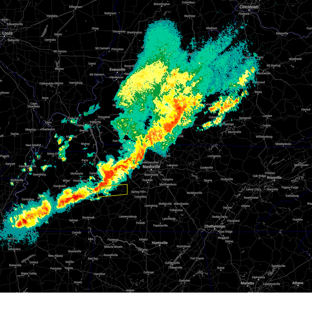 Svrohx the national weather service in nashville has issued a * severe thunderstorm warning for, northern perry county in middle tennessee, south central humphreys county in middle tennessee, central hickman county in middle tennessee, * until 1045 pm cdt. * at 1023 pm cdt, a severe thunderstorm was located 12 miles northeast of parsons, or 15 miles northwest of linden, moving northeast at 55 mph (radar indicated). Hazards include 60 mph wind gusts and quarter size hail. Hail damage to vehicles is expected. Expect wind damage to roofs, siding, and trees. Svrohx the national weather service in nashville has issued a * severe thunderstorm warning for, northern perry county in middle tennessee, south central humphreys county in middle tennessee, central hickman county in middle tennessee, * until 1045 pm cdt. * at 1023 pm cdt, a severe thunderstorm was located 12 miles northeast of parsons, or 15 miles northwest of linden, moving northeast at 55 mph (radar indicated). Hazards include 60 mph wind gusts and quarter size hail. Hail damage to vehicles is expected. Expect wind damage to roofs, siding, and trees.
|
| 3/30/2025 10:18 PM CDT |
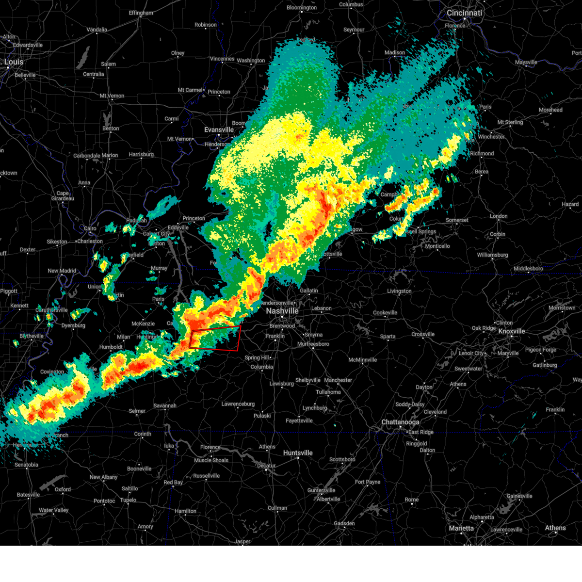 Torohx the national weather service in nashville has issued a * tornado warning for, southwestern dickson county in middle tennessee, southern humphreys county in middle tennessee, northern hickman county in middle tennessee, * until 1100 pm cdt. * at 1018 pm cdt, a severe thunderstorm capable of producing a tornado was located near hurricane mills, or 10 miles south of waverly, moving east at 45 mph (radar indicated rotation). Hazards include tornado. Flying debris will be dangerous to those caught without shelter. mobile homes will be damaged or destroyed. damage to roofs, windows, and vehicles will occur. tree damage is likely. this dangerous storm will be near, hurricane mills around 1025 pm cdt. other locations impacted by this tornadic thunderstorm include lyles, bon aqua, nunnelly, pinewood, and bucksnort. This includes interstate 40 between mile markers 136 and 174. Torohx the national weather service in nashville has issued a * tornado warning for, southwestern dickson county in middle tennessee, southern humphreys county in middle tennessee, northern hickman county in middle tennessee, * until 1100 pm cdt. * at 1018 pm cdt, a severe thunderstorm capable of producing a tornado was located near hurricane mills, or 10 miles south of waverly, moving east at 45 mph (radar indicated rotation). Hazards include tornado. Flying debris will be dangerous to those caught without shelter. mobile homes will be damaged or destroyed. damage to roofs, windows, and vehicles will occur. tree damage is likely. this dangerous storm will be near, hurricane mills around 1025 pm cdt. other locations impacted by this tornadic thunderstorm include lyles, bon aqua, nunnelly, pinewood, and bucksnort. This includes interstate 40 between mile markers 136 and 174.
|
| 3/30/2025 9:50 PM CDT |
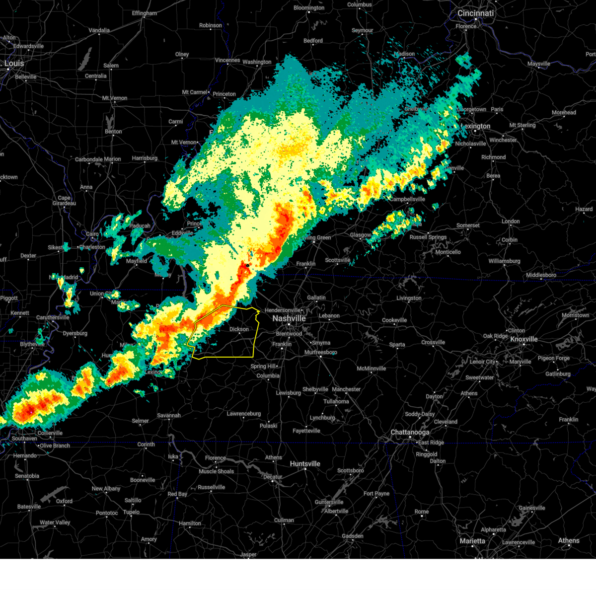 Svrohx the national weather service in nashville has issued a * severe thunderstorm warning for, dickson county in middle tennessee, eastern houston county in middle tennessee, humphreys county in middle tennessee, northern hickman county in middle tennessee, * until 1045 pm cdt. * at 950 pm cdt, severe thunderstorms were located along a line extending from 10 miles east of erin to near mcewen to near camden, moving east at 40 mph (radar indicated). Hazards include 60 mph wind gusts and quarter size hail. Hail damage to vehicles is expected. Expect wind damage to roofs, siding, and trees. Svrohx the national weather service in nashville has issued a * severe thunderstorm warning for, dickson county in middle tennessee, eastern houston county in middle tennessee, humphreys county in middle tennessee, northern hickman county in middle tennessee, * until 1045 pm cdt. * at 950 pm cdt, severe thunderstorms were located along a line extending from 10 miles east of erin to near mcewen to near camden, moving east at 40 mph (radar indicated). Hazards include 60 mph wind gusts and quarter size hail. Hail damage to vehicles is expected. Expect wind damage to roofs, siding, and trees.
|
| 3/19/2025 9:33 PM CDT |
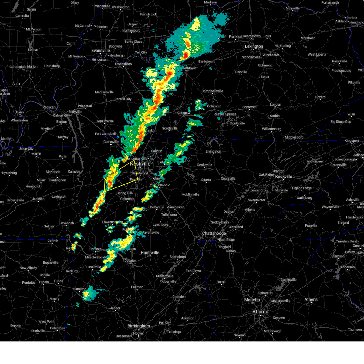 Svrohx the national weather service in nashville has issued a * severe thunderstorm warning for, southwestern davidson county in middle tennessee, southeastern dickson county in middle tennessee, northwestern williamson county in middle tennessee, southeastern cheatham county in middle tennessee, northeastern hickman county in middle tennessee, * until 1015 pm cdt. * at 933 pm cdt, a severe thunderstorm was located near centerville, moving northeast at 55 mph (radar indicated). Hazards include 60 mph wind gusts and penny size hail. expect damage to roofs, siding, and trees Svrohx the national weather service in nashville has issued a * severe thunderstorm warning for, southwestern davidson county in middle tennessee, southeastern dickson county in middle tennessee, northwestern williamson county in middle tennessee, southeastern cheatham county in middle tennessee, northeastern hickman county in middle tennessee, * until 1015 pm cdt. * at 933 pm cdt, a severe thunderstorm was located near centerville, moving northeast at 55 mph (radar indicated). Hazards include 60 mph wind gusts and penny size hail. expect damage to roofs, siding, and trees
|
| 12/18/2024 7:36 AM CST |
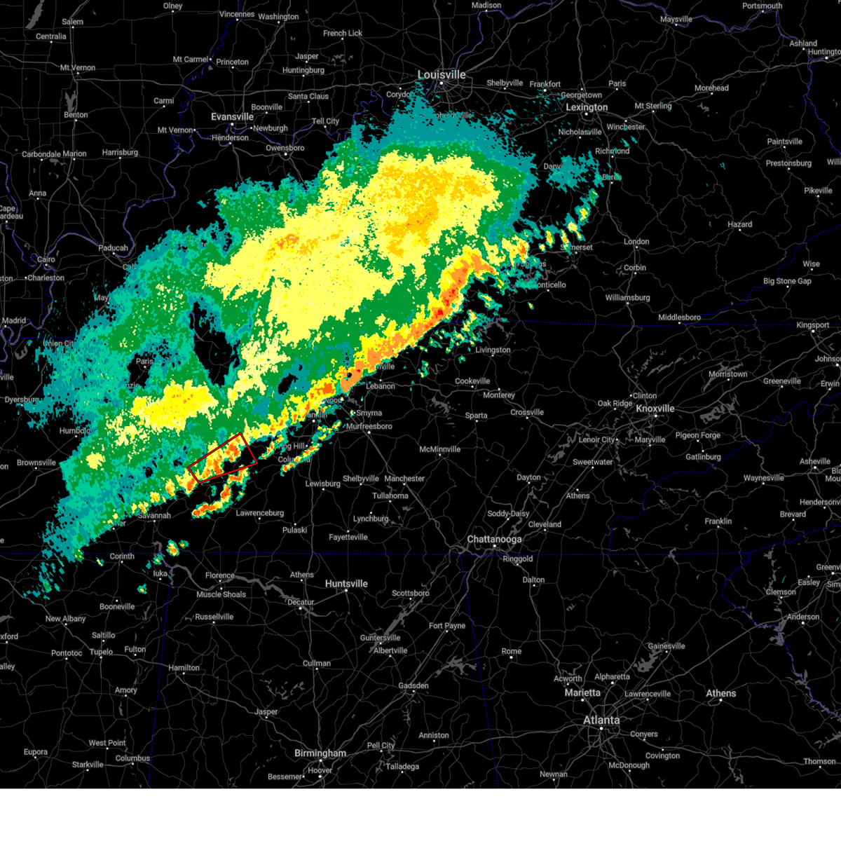 The storm which prompted the warning has weakened below severe limits, and no longer appears capable of producing a tornado. therefore, the warning will be allowed to expire. however, gusty winds and heavy rain are still possible with this thunderstorm. The storm which prompted the warning has weakened below severe limits, and no longer appears capable of producing a tornado. therefore, the warning will be allowed to expire. however, gusty winds and heavy rain are still possible with this thunderstorm.
|
| 12/18/2024 7:23 AM CST |
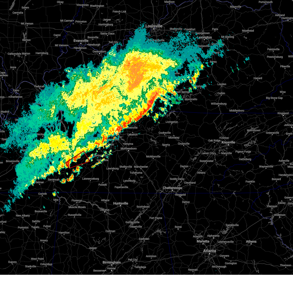 Torohx the national weather service in nashville has issued a * tornado warning for, northwestern lewis county in middle tennessee, central perry county in middle tennessee, southwestern hickman county in middle tennessee, * until 745 am cst. * at 723 am cst, a severe thunderstorm capable of producing a tornado was located near linden, moving northeast at 50 mph (radar indicated rotation). Hazards include tornado. Flying debris will be dangerous to those caught without shelter. mobile homes will be damaged or destroyed. damage to roofs, windows, and vehicles will occur. tree damage is likely. This tornadic thunderstorm will remain over mainly rural areas of northwestern lewis, central perry and southwestern hickman counties, including the following locations, kimmins and pleasantville. Torohx the national weather service in nashville has issued a * tornado warning for, northwestern lewis county in middle tennessee, central perry county in middle tennessee, southwestern hickman county in middle tennessee, * until 745 am cst. * at 723 am cst, a severe thunderstorm capable of producing a tornado was located near linden, moving northeast at 50 mph (radar indicated rotation). Hazards include tornado. Flying debris will be dangerous to those caught without shelter. mobile homes will be damaged or destroyed. damage to roofs, windows, and vehicles will occur. tree damage is likely. This tornadic thunderstorm will remain over mainly rural areas of northwestern lewis, central perry and southwestern hickman counties, including the following locations, kimmins and pleasantville.
|
| 5/26/2024 2:17 PM CDT |
 Svrohx the national weather service in nashville has issued a * severe thunderstorm warning for, southwestern davidson county in middle tennessee, southern dickson county in middle tennessee, northwestern williamson county in middle tennessee, southeastern cheatham county in middle tennessee, northeastern hickman county in middle tennessee, * until 300 pm cdt. * at 216 pm cdt, a severe thunderstorm was located 7 miles southwest of dickson, moving east at 35 mph (radar indicated). Hazards include 60 mph wind gusts and quarter size hail. Hail damage to vehicles is expected. Expect wind damage to roofs, siding, and trees. Svrohx the national weather service in nashville has issued a * severe thunderstorm warning for, southwestern davidson county in middle tennessee, southern dickson county in middle tennessee, northwestern williamson county in middle tennessee, southeastern cheatham county in middle tennessee, northeastern hickman county in middle tennessee, * until 300 pm cdt. * at 216 pm cdt, a severe thunderstorm was located 7 miles southwest of dickson, moving east at 35 mph (radar indicated). Hazards include 60 mph wind gusts and quarter size hail. Hail damage to vehicles is expected. Expect wind damage to roofs, siding, and trees.
|
| 5/22/2024 4:21 PM CDT |
 the severe thunderstorm warning has been cancelled and is no longer in effect the severe thunderstorm warning has been cancelled and is no longer in effect
|
| 5/22/2024 3:58 PM CDT |
 Svrohx the national weather service in nashville has issued a * severe thunderstorm warning for, western dickson county in middle tennessee, southeastern houston county in middle tennessee, northern perry county in middle tennessee, humphreys county in middle tennessee, hickman county in middle tennessee, * until 445 pm cdt. * at 357 pm cdt, severe thunderstorms were located along a line extending from near camden to 6 miles south of new johnsonville to near parsons, moving northeast at 55 mph (radar indicated). Hazards include 60 mph wind gusts and penny size hail. expect damage to roofs, siding, and trees Svrohx the national weather service in nashville has issued a * severe thunderstorm warning for, western dickson county in middle tennessee, southeastern houston county in middle tennessee, northern perry county in middle tennessee, humphreys county in middle tennessee, hickman county in middle tennessee, * until 445 pm cdt. * at 357 pm cdt, severe thunderstorms were located along a line extending from near camden to 6 miles south of new johnsonville to near parsons, moving northeast at 55 mph (radar indicated). Hazards include 60 mph wind gusts and penny size hail. expect damage to roofs, siding, and trees
|
| 5/14/2024 4:10 PM CDT |
 The storm which prompted the warning has weakened below severe limits, and no longer poses an immediate threat to life or property. therefore, the warning will be allowed to expire. a severe thunderstorm watch remains in effect until 800 pm cdt for middle tennessee. The storm which prompted the warning has weakened below severe limits, and no longer poses an immediate threat to life or property. therefore, the warning will be allowed to expire. a severe thunderstorm watch remains in effect until 800 pm cdt for middle tennessee.
|
| 5/14/2024 3:46 PM CDT |
 the severe thunderstorm warning has been cancelled and is no longer in effect the severe thunderstorm warning has been cancelled and is no longer in effect
|
| 5/14/2024 3:46 PM CDT |
 At 345 pm cdt, a severe thunderstorm was located over hohenwald, moving northeast at 30 mph (radar indicated). Hazards include 60 mph wind gusts and quarter size hail. Hail damage to vehicles is expected. expect wind damage to roofs, siding, and trees. Locations impacted include, hohenwald, gordonsburg, and kimmins. At 345 pm cdt, a severe thunderstorm was located over hohenwald, moving northeast at 30 mph (radar indicated). Hazards include 60 mph wind gusts and quarter size hail. Hail damage to vehicles is expected. expect wind damage to roofs, siding, and trees. Locations impacted include, hohenwald, gordonsburg, and kimmins.
|
| 5/14/2024 3:29 PM CDT |
 Svrohx the national weather service in nashville has issued a * severe thunderstorm warning for, lewis county in middle tennessee, northeastern wayne county in middle tennessee, southeastern perry county in middle tennessee, southwestern hickman county in middle tennessee, * until 415 pm cdt. * at 328 pm cdt, a severe thunderstorm was located 7 miles southwest of hohenwald, moving northeast at 30 mph (radar indicated). Hazards include quarter size hail. damage to vehicles is expected Svrohx the national weather service in nashville has issued a * severe thunderstorm warning for, lewis county in middle tennessee, northeastern wayne county in middle tennessee, southeastern perry county in middle tennessee, southwestern hickman county in middle tennessee, * until 415 pm cdt. * at 328 pm cdt, a severe thunderstorm was located 7 miles southwest of hohenwald, moving northeast at 30 mph (radar indicated). Hazards include quarter size hail. damage to vehicles is expected
|
| 5/9/2024 2:42 AM CDT |
 the severe thunderstorm warning has been cancelled and is no longer in effect the severe thunderstorm warning has been cancelled and is no longer in effect
|
| 5/9/2024 2:36 AM CDT |
 At 235 am cdt, a severe thunderstorm was located near fairview, or 9 miles southeast of dickson, moving east at 45 mph (radar indicated). Hazards include 60 mph wind gusts and penny size hail. Expect damage to roofs, siding, and trees. locations impacted include, franklin, columbia, dickson, centerville, spring hill, forest hills, white bluff, kingston springs, thompson's station, pegram, burns, bellevue, fairview, bon aqua, bells bend, primm springs, lyles, natchez trace at highway 96, santa fe, and hampshire. this includes the following highways, interstate 40 between mile markers 165 and 202. interstate 65 between mile markers 48 and 63. Interstate 840 between mile markers 1 and 32. At 235 am cdt, a severe thunderstorm was located near fairview, or 9 miles southeast of dickson, moving east at 45 mph (radar indicated). Hazards include 60 mph wind gusts and penny size hail. Expect damage to roofs, siding, and trees. locations impacted include, franklin, columbia, dickson, centerville, spring hill, forest hills, white bluff, kingston springs, thompson's station, pegram, burns, bellevue, fairview, bon aqua, bells bend, primm springs, lyles, natchez trace at highway 96, santa fe, and hampshire. this includes the following highways, interstate 40 between mile markers 165 and 202. interstate 65 between mile markers 48 and 63. Interstate 840 between mile markers 1 and 32.
|
| 5/9/2024 2:17 AM CDT |
 Svrohx the national weather service in nashville has issued a * severe thunderstorm warning for, southwestern davidson county in middle tennessee, northern lewis county in middle tennessee, southern dickson county in middle tennessee, northern maury county in middle tennessee, williamson county in middle tennessee, south central cheatham county in middle tennessee, hickman county in middle tennessee, * until 300 am cdt. * at 216 am cdt, a severe thunderstorm was located 8 miles northwest of centerville, moving east at 45 mph (radar indicated). Hazards include 60 mph wind gusts and penny size hail. expect damage to roofs, siding, and trees Svrohx the national weather service in nashville has issued a * severe thunderstorm warning for, southwestern davidson county in middle tennessee, northern lewis county in middle tennessee, southern dickson county in middle tennessee, northern maury county in middle tennessee, williamson county in middle tennessee, south central cheatham county in middle tennessee, hickman county in middle tennessee, * until 300 am cdt. * at 216 am cdt, a severe thunderstorm was located 8 miles northwest of centerville, moving east at 45 mph (radar indicated). Hazards include 60 mph wind gusts and penny size hail. expect damage to roofs, siding, and trees
|
| 5/9/2024 1:41 AM CDT |
 At 141 am cdt, a severe thunderstorm was located near centerville, moving east at 35 mph (radar indicated). Hazards include 60 mph wind gusts and quarter size hail. Hail damage to vehicles is expected. expect wind damage to roofs, siding, and trees. locations impacted include, dickson, centerville, burns, santa fe, bon aqua, pinewood, primm springs, lyles, and nunnelly. this includes the following highways, interstate 40 between mile markers 151 and 158, and between mile markers 166 and 180. Interstate 840 between mile markers 1 and 11. At 141 am cdt, a severe thunderstorm was located near centerville, moving east at 35 mph (radar indicated). Hazards include 60 mph wind gusts and quarter size hail. Hail damage to vehicles is expected. expect wind damage to roofs, siding, and trees. locations impacted include, dickson, centerville, burns, santa fe, bon aqua, pinewood, primm springs, lyles, and nunnelly. this includes the following highways, interstate 40 between mile markers 151 and 158, and between mile markers 166 and 180. Interstate 840 between mile markers 1 and 11.
|
| 5/9/2024 1:27 AM CDT |
 Svrohx the national weather service in nashville has issued a * severe thunderstorm warning for, southeastern dickson county in middle tennessee, northwestern maury county in middle tennessee, west central williamson county in middle tennessee, hickman county in middle tennessee, * until 200 am cdt. * at 127 am cdt, a severe thunderstorm was located near centerville, moving east at 35 mph (radar indicated). Hazards include 60 mph wind gusts and quarter size hail. Hail damage to vehicles is expected. Expect wind damage to roofs, siding, and trees. Svrohx the national weather service in nashville has issued a * severe thunderstorm warning for, southeastern dickson county in middle tennessee, northwestern maury county in middle tennessee, west central williamson county in middle tennessee, hickman county in middle tennessee, * until 200 am cdt. * at 127 am cdt, a severe thunderstorm was located near centerville, moving east at 35 mph (radar indicated). Hazards include 60 mph wind gusts and quarter size hail. Hail damage to vehicles is expected. Expect wind damage to roofs, siding, and trees.
|
| 5/9/2024 1:25 AM CDT |
 The storm which prompted the warning has weakened below severe limits, and no longer appears capable of producing a tornado. therefore, the warning will be allowed to expire. however, small hail, gusty winds and heavy rain are still possible with this thunderstorm. a tornado watch remains in effect until 300 am cdt for middle tennessee. The storm which prompted the warning has weakened below severe limits, and no longer appears capable of producing a tornado. therefore, the warning will be allowed to expire. however, small hail, gusty winds and heavy rain are still possible with this thunderstorm. a tornado watch remains in effect until 300 am cdt for middle tennessee.
|
| 5/9/2024 1:17 AM CDT |
 At 117 am cdt, a severe thunderstorm capable of producing a tornado was located 9 miles northeast of linden, moving east at 35 mph (radar indicated rotation). Hazards include tornado. Flying debris will be dangerous to those caught without shelter. mobile homes will be damaged or destroyed. damage to roofs, windows, and vehicles will occur. tree damage is likely. Locations impacted include, centerville, lobelville, pinewood, and pleasantville. At 117 am cdt, a severe thunderstorm capable of producing a tornado was located 9 miles northeast of linden, moving east at 35 mph (radar indicated rotation). Hazards include tornado. Flying debris will be dangerous to those caught without shelter. mobile homes will be damaged or destroyed. damage to roofs, windows, and vehicles will occur. tree damage is likely. Locations impacted include, centerville, lobelville, pinewood, and pleasantville.
|
| 5/9/2024 1:16 AM CDT |
 At 116 am cdt, a severe thunderstorm was located 11 miles west of centerville, moving east at 35 mph (radar indicated). Hazards include 60 mph wind gusts and quarter size hail. Hail damage to vehicles is expected. expect wind damage to roofs, siding, and trees. locations impacted include, dickson, centerville, lobelville, bon aqua, pinewood, primm springs, lyles, nunnelly, and bucksnort. This includes interstate 40 between mile markers 139 and 170. At 116 am cdt, a severe thunderstorm was located 11 miles west of centerville, moving east at 35 mph (radar indicated). Hazards include 60 mph wind gusts and quarter size hail. Hail damage to vehicles is expected. expect wind damage to roofs, siding, and trees. locations impacted include, dickson, centerville, lobelville, bon aqua, pinewood, primm springs, lyles, nunnelly, and bucksnort. This includes interstate 40 between mile markers 139 and 170.
|
| 5/9/2024 1:06 AM CDT |
 Torohx the national weather service in nashville has issued a * tornado warning for, northeastern perry county in middle tennessee, western hickman county in middle tennessee, * until 130 am cdt. * at 106 am cdt, a severe thunderstorm capable of producing a tornado was located near linden, moving east at 35 mph (radar indicated rotation). Hazards include tornado. Flying debris will be dangerous to those caught without shelter. mobile homes will be damaged or destroyed. damage to roofs, windows, and vehicles will occur. tree damage is likely. This tornadic thunderstorm will remain over mainly rural areas of northeastern perry and western hickman counties, including the following locations, pinewood, lobelville, and pleasantville. Torohx the national weather service in nashville has issued a * tornado warning for, northeastern perry county in middle tennessee, western hickman county in middle tennessee, * until 130 am cdt. * at 106 am cdt, a severe thunderstorm capable of producing a tornado was located near linden, moving east at 35 mph (radar indicated rotation). Hazards include tornado. Flying debris will be dangerous to those caught without shelter. mobile homes will be damaged or destroyed. damage to roofs, windows, and vehicles will occur. tree damage is likely. This tornadic thunderstorm will remain over mainly rural areas of northeastern perry and western hickman counties, including the following locations, pinewood, lobelville, and pleasantville.
|
| 5/9/2024 12:54 AM CDT |
 Svrohx the national weather service in nashville has issued a * severe thunderstorm warning for, southwestern dickson county in middle tennessee, northern perry county in middle tennessee, southern humphreys county in middle tennessee, hickman county in middle tennessee, * until 130 am cdt. * at 1253 am cdt, a severe thunderstorm was located 12 miles south of hurricane mills, or 13 miles north of linden, moving east at 30 mph (radar indicated). Hazards include 60 mph wind gusts and quarter size hail. Hail damage to vehicles is expected. Expect wind damage to roofs, siding, and trees. Svrohx the national weather service in nashville has issued a * severe thunderstorm warning for, southwestern dickson county in middle tennessee, northern perry county in middle tennessee, southern humphreys county in middle tennessee, hickman county in middle tennessee, * until 130 am cdt. * at 1253 am cdt, a severe thunderstorm was located 12 miles south of hurricane mills, or 13 miles north of linden, moving east at 30 mph (radar indicated). Hazards include 60 mph wind gusts and quarter size hail. Hail damage to vehicles is expected. Expect wind damage to roofs, siding, and trees.
|
| 5/8/2024 3:43 PM CDT |
 At 342 pm cdt, a severe thunderstorm was located near parsons, or 11 miles northwest of linden, moving northeast at 45 mph (public). Hazards include 60 mph wind gusts and half dollar size hail. Hail damage to vehicles is expected. expect wind damage to roofs, siding, and trees. locations impacted include, centerville, linden, hurricane mills, lobelville, mousetail landing state park, pleasantville, bucksnort, and i-40 near the tennessee river. This includes interstate 40 between mile markers 136 and 155. At 342 pm cdt, a severe thunderstorm was located near parsons, or 11 miles northwest of linden, moving northeast at 45 mph (public). Hazards include 60 mph wind gusts and half dollar size hail. Hail damage to vehicles is expected. expect wind damage to roofs, siding, and trees. locations impacted include, centerville, linden, hurricane mills, lobelville, mousetail landing state park, pleasantville, bucksnort, and i-40 near the tennessee river. This includes interstate 40 between mile markers 136 and 155.
|
| 5/8/2024 3:35 PM CDT |
 Svrohx the national weather service in nashville has issued a * severe thunderstorm warning for, perry county in middle tennessee, southern humphreys county in middle tennessee, western hickman county in middle tennessee, * until 415 pm cdt. * at 334 pm cdt, a severe thunderstorm was located over parsons, or 10 miles southeast of natchez trace state forest, moving northeast at 45 mph (radar indicated). Hazards include 60 mph wind gusts and quarter size hail. Hail damage to vehicles is expected. Expect wind damage to roofs, siding, and trees. Svrohx the national weather service in nashville has issued a * severe thunderstorm warning for, perry county in middle tennessee, southern humphreys county in middle tennessee, western hickman county in middle tennessee, * until 415 pm cdt. * at 334 pm cdt, a severe thunderstorm was located over parsons, or 10 miles southeast of natchez trace state forest, moving northeast at 45 mph (radar indicated). Hazards include 60 mph wind gusts and quarter size hail. Hail damage to vehicles is expected. Expect wind damage to roofs, siding, and trees.
|
| 5/6/2024 3:11 PM CDT |
 At 310 pm cdt, a severe thunderstorm was located 11 miles north of hohenwald, moving east at 20 mph (radar indicated). Hazards include 60 mph wind gusts and quarter size hail. Hail damage to vehicles is expected. expect wind damage to roofs, siding, and trees. Locations impacted include, centerville. At 310 pm cdt, a severe thunderstorm was located 11 miles north of hohenwald, moving east at 20 mph (radar indicated). Hazards include 60 mph wind gusts and quarter size hail. Hail damage to vehicles is expected. expect wind damage to roofs, siding, and trees. Locations impacted include, centerville.
|
| 5/6/2024 3:11 PM CDT |
 the severe thunderstorm warning has been cancelled and is no longer in effect the severe thunderstorm warning has been cancelled and is no longer in effect
|
| 5/6/2024 2:55 PM CDT |
 Svrohx the national weather service in nashville has issued a * severe thunderstorm warning for, northeastern perry county in middle tennessee, southwestern hickman county in middle tennessee, * until 330 pm cdt. * at 254 pm cdt, a severe thunderstorm was located 9 miles northeast of linden, moving east at 20 mph (radar indicated). Hazards include 60 mph wind gusts and quarter size hail. Hail damage to vehicles is expected. Expect wind damage to roofs, siding, and trees. Svrohx the national weather service in nashville has issued a * severe thunderstorm warning for, northeastern perry county in middle tennessee, southwestern hickman county in middle tennessee, * until 330 pm cdt. * at 254 pm cdt, a severe thunderstorm was located 9 miles northeast of linden, moving east at 20 mph (radar indicated). Hazards include 60 mph wind gusts and quarter size hail. Hail damage to vehicles is expected. Expect wind damage to roofs, siding, and trees.
|
| 12/9/2023 5:27 PM CST |
 At 527 pm cst, a severe thunderstorm was located near hohenwald, moving northeast at 50 mph (radar indicated). Hazards include 60 mph wind gusts and quarter size hail. Hail damage to vehicles is expected. Expect wind damage to roofs, siding, and trees. At 527 pm cst, a severe thunderstorm was located near hohenwald, moving northeast at 50 mph (radar indicated). Hazards include 60 mph wind gusts and quarter size hail. Hail damage to vehicles is expected. Expect wind damage to roofs, siding, and trees.
|
| 12/9/2023 4:24 PM CST |
 At 424 pm cst, severe thunderstorms were located along a line extending from hurricane mills to near big hill pond state park, moving northeast at 45 mph (radar indicated). Hazards include 60 mph wind gusts and quarter size hail. Hail damage to vehicles is expected. Expect wind damage to roofs, siding, and trees. At 424 pm cst, severe thunderstorms were located along a line extending from hurricane mills to near big hill pond state park, moving northeast at 45 mph (radar indicated). Hazards include 60 mph wind gusts and quarter size hail. Hail damage to vehicles is expected. Expect wind damage to roofs, siding, and trees.
|
| 8/26/2023 5:22 PM CDT |
 The severe thunderstorm warning for northeastern perry and hickman counties will expire at 530 pm cdt, a new severe thunderstorm warning has been issued for perry and hickman counties, and this warning has been allowed to expire. to report severe weather, contact your nearest law enforcement agency. they will relay your report to the national weather service nashville. The severe thunderstorm warning for northeastern perry and hickman counties will expire at 530 pm cdt, a new severe thunderstorm warning has been issued for perry and hickman counties, and this warning has been allowed to expire. to report severe weather, contact your nearest law enforcement agency. they will relay your report to the national weather service nashville.
|
| 8/26/2023 5:14 PM CDT |
 At 514 pm cdt, severe thunderstorms were located along a line extending from 10 miles east of centerville to 9 miles northeast of linden, moving south at 30 mph (radar indicated). Hazards include 60 mph wind gusts. Expect damage to roofs, siding, and trees. locations impacted include, centerville, lobelville, bon aqua, pinewood, pleasantville, primm springs, lyles, nunnelly, and bucksnort. this includes the following highways, interstate 40 between mile markers 149 and 158, and between mile markers 161 and 163. interstate 840 near mile marker 5. hail threat, radar indicated max hail size, <. 75 in wind threat, radar indicated max wind gust, 60 mph. At 514 pm cdt, severe thunderstorms were located along a line extending from 10 miles east of centerville to 9 miles northeast of linden, moving south at 30 mph (radar indicated). Hazards include 60 mph wind gusts. Expect damage to roofs, siding, and trees. locations impacted include, centerville, lobelville, bon aqua, pinewood, pleasantville, primm springs, lyles, nunnelly, and bucksnort. this includes the following highways, interstate 40 between mile markers 149 and 158, and between mile markers 161 and 163. interstate 840 near mile marker 5. hail threat, radar indicated max hail size, <. 75 in wind threat, radar indicated max wind gust, 60 mph.
|
| 8/26/2023 5:05 PM CDT |
 At 504 pm cdt, severe thunderstorms were located along a line extending from lobelville to bon aqua, moving south at 35 mph (radar indicated). Hazards include 60 mph wind gusts. Expect damage to roofs, siding, and trees. locations impacted include, dickson, centerville, burns, hurricane mills, lobelville, bon aqua, pinewood, pleasantville, primm springs, lyles, nunnelly, and bucksnort. this includes the following highways, interstate 40 between mile markers 144 and 178. interstate 840 between mile markers 1 and 5. hail threat, radar indicated max hail size, <. 75 in wind threat, radar indicated max wind gust, 60 mph. At 504 pm cdt, severe thunderstorms were located along a line extending from lobelville to bon aqua, moving south at 35 mph (radar indicated). Hazards include 60 mph wind gusts. Expect damage to roofs, siding, and trees. locations impacted include, dickson, centerville, burns, hurricane mills, lobelville, bon aqua, pinewood, pleasantville, primm springs, lyles, nunnelly, and bucksnort. this includes the following highways, interstate 40 between mile markers 144 and 178. interstate 840 between mile markers 1 and 5. hail threat, radar indicated max hail size, <. 75 in wind threat, radar indicated max wind gust, 60 mph.
|
| 8/26/2023 4:42 PM CDT |
 At 442 pm cdt, severe thunderstorms were located along a line extending from near dickson to near hurricane mills, moving south at 30 mph (radar indicated). Hazards include 60 mph wind gusts. expect damage to roofs, siding, and trees At 442 pm cdt, severe thunderstorms were located along a line extending from near dickson to near hurricane mills, moving south at 30 mph (radar indicated). Hazards include 60 mph wind gusts. expect damage to roofs, siding, and trees
|
| 8/13/2023 2:45 PM CDT |
 At 245 pm cdt, severe thunderstorms were located along a line extending from oak grove to 9 miles north of white bluff to 9 miles northeast of centerville, moving east at 40 mph (radar indicated). Hazards include 60 mph wind gusts. Expect damage to roofs, siding, and trees. locations impacted include, clarksville, springfield, dickson, oak grove, ashland city, centerville, fort campbell, coopertown, white bluff, kingston springs, pegram, burns, guthrie, fairview, pleasant view, charlotte, adams, vanleer, cedar hill and slayden. this includes the following highways, interstate 40 between mile markers 152 and 159, and between mile markers 161 and 191. interstate 24 between mile markers 1 and 31. interstate 840 between mile markers 1 and 14. hail threat, radar indicated max hail size, <. 75 in wind threat, radar indicated max wind gust, 60 mph. At 245 pm cdt, severe thunderstorms were located along a line extending from oak grove to 9 miles north of white bluff to 9 miles northeast of centerville, moving east at 40 mph (radar indicated). Hazards include 60 mph wind gusts. Expect damage to roofs, siding, and trees. locations impacted include, clarksville, springfield, dickson, oak grove, ashland city, centerville, fort campbell, coopertown, white bluff, kingston springs, pegram, burns, guthrie, fairview, pleasant view, charlotte, adams, vanleer, cedar hill and slayden. this includes the following highways, interstate 40 between mile markers 152 and 159, and between mile markers 161 and 191. interstate 24 between mile markers 1 and 31. interstate 840 between mile markers 1 and 14. hail threat, radar indicated max hail size, <. 75 in wind threat, radar indicated max wind gust, 60 mph.
|
| 8/13/2023 2:09 PM CDT |
 At 209 pm cdt, severe thunderstorms were located along a line extending from near big rock to mcewen to hurricane mills, moving east at 50 mph (radar indicated). Hazards include 60 mph wind gusts. expect damage to roofs, siding, and trees At 209 pm cdt, severe thunderstorms were located along a line extending from near big rock to mcewen to hurricane mills, moving east at 50 mph (radar indicated). Hazards include 60 mph wind gusts. expect damage to roofs, siding, and trees
|
| 8/12/2023 11:35 AM CDT |
 At 1134 am cdt, a severe thunderstorm was located 9 miles south of fairview, or 13 miles west of franklin, moving east at 50 mph (radar indicated). Hazards include 70 mph wind gusts. Expect considerable tree damage. damage is likely to mobile homes, roofs, and outbuildings. locations impacted include, franklin, columbia, centerville, spring hill, thompson`s station, santa fe, primm springs, leipers fork and i-65 east of columbia. this includes the following highways, interstate 65 between mile markers 45 and 63. interstate 840 between mile markers 6 and 36. thunderstorm damage threat, considerable hail threat, radar indicated max hail size, <. 75 in wind threat, radar indicated max wind gust, 70 mph. At 1134 am cdt, a severe thunderstorm was located 9 miles south of fairview, or 13 miles west of franklin, moving east at 50 mph (radar indicated). Hazards include 70 mph wind gusts. Expect considerable tree damage. damage is likely to mobile homes, roofs, and outbuildings. locations impacted include, franklin, columbia, centerville, spring hill, thompson`s station, santa fe, primm springs, leipers fork and i-65 east of columbia. this includes the following highways, interstate 65 between mile markers 45 and 63. interstate 840 between mile markers 6 and 36. thunderstorm damage threat, considerable hail threat, radar indicated max hail size, <. 75 in wind threat, radar indicated max wind gust, 70 mph.
|
| 8/12/2023 11:26 AM CDT |
 At 1126 am cdt, a severe thunderstorm was located 8 miles southwest of fairview, or 15 miles east of centerville, moving east at 50 mph (radar indicated). Hazards include 60 mph wind gusts. expect damage to roofs, siding, and trees At 1126 am cdt, a severe thunderstorm was located 8 miles southwest of fairview, or 15 miles east of centerville, moving east at 50 mph (radar indicated). Hazards include 60 mph wind gusts. expect damage to roofs, siding, and trees
|
| 8/10/2023 12:43 AM CDT |
 At 1243 am cdt, severe thunderstorms were located along a line extending from parsons to near savannah, moving east at 50 mph (radar indicated). Hazards include 60 mph wind gusts and penny size hail. expect damage to roofs, siding, and trees At 1243 am cdt, severe thunderstorms were located along a line extending from parsons to near savannah, moving east at 50 mph (radar indicated). Hazards include 60 mph wind gusts and penny size hail. expect damage to roofs, siding, and trees
|
| 8/7/2023 10:38 AM CDT |
 At 1037 am cdt, severe thunderstorms were located along a line extending from 8 miles east of centerville to 8 miles northwest of loretto, moving east at 50 mph (radar indicated). Hazards include 60 mph wind gusts and penny size hail. Expect damage to roofs, siding, and trees. locations impacted include, franklin, columbia, lawrenceburg, pulaski, hohenwald, centerville, spring hill, mount pleasant, thompson`s station, loretto, summertown, st. joseph, elkton, minor hill, ethridge, lynnville, gordonsburg, kimmins, henryville and culleoka. this includes the following highways, interstate 65 between mile markers 1 and 22, and between mile markers 36 and 66. interstate 840 between mile markers 10 and 37. hail threat, radar indicated max hail size, 0. 75 in wind threat, radar indicated max wind gust, 60 mph. At 1037 am cdt, severe thunderstorms were located along a line extending from 8 miles east of centerville to 8 miles northwest of loretto, moving east at 50 mph (radar indicated). Hazards include 60 mph wind gusts and penny size hail. Expect damage to roofs, siding, and trees. locations impacted include, franklin, columbia, lawrenceburg, pulaski, hohenwald, centerville, spring hill, mount pleasant, thompson`s station, loretto, summertown, st. joseph, elkton, minor hill, ethridge, lynnville, gordonsburg, kimmins, henryville and culleoka. this includes the following highways, interstate 65 between mile markers 1 and 22, and between mile markers 36 and 66. interstate 840 between mile markers 10 and 37. hail threat, radar indicated max hail size, 0. 75 in wind threat, radar indicated max wind gust, 60 mph.
|
| 8/7/2023 10:28 AM CDT |
 At 1027 am cdt, severe thunderstorms were located along a line extending from near centerville to 7 miles south of collinwood, moving east at 50 mph (radar indicated). Hazards include 60 mph wind gusts and penny size hail. expect damage to roofs, siding, and trees At 1027 am cdt, severe thunderstorms were located along a line extending from near centerville to 7 miles south of collinwood, moving east at 50 mph (radar indicated). Hazards include 60 mph wind gusts and penny size hail. expect damage to roofs, siding, and trees
|
| 8/7/2023 9:51 AM CDT |
 At 950 am cdt, severe thunderstorms were located along a line extending from near parsons to 6 miles southwest of shiloh, moving east at 50 mph (radar indicated). Hazards include 60 mph wind gusts and nickel size hail. expect damage to roofs, siding, and trees At 950 am cdt, severe thunderstorms were located along a line extending from near parsons to 6 miles southwest of shiloh, moving east at 50 mph (radar indicated). Hazards include 60 mph wind gusts and nickel size hail. expect damage to roofs, siding, and trees
|
| 7/18/2023 3:55 PM CDT |
 At 355 pm cdt, severe thunderstorms were located along a line extending from near thompson`s station to 7 miles north of mount pleasant to 9 miles west of hohenwald, moving southeast at 55 mph (radar indicated). Hazards include 60 mph wind gusts and penny size hail. Expect damage to roofs, siding, and trees. locations impacted include, franklin, columbia, dickson, hohenwald, centerville, linden, spring hill, mount pleasant, white bluff, kingston springs, thompson`s station, pegram, burns, fairview, lobelville, gordonsburg, kimmins, bon aqua, primm springs and natchez trace at highway 96. this includes the following highways, interstate 40 between mile markers 166 and 192. interstate 65 between mile markers 50 and 63. interstate 840 between mile markers 1 and 32. hail threat, radar indicated max hail size, 0. 75 in wind threat, radar indicated max wind gust, 60 mph. At 355 pm cdt, severe thunderstorms were located along a line extending from near thompson`s station to 7 miles north of mount pleasant to 9 miles west of hohenwald, moving southeast at 55 mph (radar indicated). Hazards include 60 mph wind gusts and penny size hail. Expect damage to roofs, siding, and trees. locations impacted include, franklin, columbia, dickson, hohenwald, centerville, linden, spring hill, mount pleasant, white bluff, kingston springs, thompson`s station, pegram, burns, fairview, lobelville, gordonsburg, kimmins, bon aqua, primm springs and natchez trace at highway 96. this includes the following highways, interstate 40 between mile markers 166 and 192. interstate 65 between mile markers 50 and 63. interstate 840 between mile markers 1 and 32. hail threat, radar indicated max hail size, 0. 75 in wind threat, radar indicated max wind gust, 60 mph.
|
| 7/18/2023 3:50 PM CDT | Facebook report of two trees snapped at a home in centervill in hickman county TN, 1 miles WNW of Centerville, TN |
| 7/18/2023 3:12 PM CDT |
 At 311 pm cdt, severe thunderstorms were located along a line extending from 14 miles northwest of white bluff to near mcewen to near camden, moving southeast at 55 mph (radar indicated). Hazards include 70 mph wind gusts and penny size hail. Expect considerable tree damage. Damage is likely to mobile homes, roofs, and outbuildings. At 311 pm cdt, severe thunderstorms were located along a line extending from 14 miles northwest of white bluff to near mcewen to near camden, moving southeast at 55 mph (radar indicated). Hazards include 70 mph wind gusts and penny size hail. Expect considerable tree damage. Damage is likely to mobile homes, roofs, and outbuildings.
|
| 7/1/2023 12:47 PM CDT |
 At 1247 pm cdt, severe thunderstorms were located along a line extending from 16 miles north of dickson to near burns to 8 miles south of centerville, moving east at 35 mph (radar indicated). Hazards include 70 mph wind gusts and quarter size hail. Hail damage to vehicles is expected. expect considerable tree damage. wind damage is also likely to mobile homes, roofs, and outbuildings. locations impacted include, dickson, centerville, white bluff, kingston springs, burns, fairview, charlotte, vanleer, slayden, bon aqua, primm springs, lyles and nunnelly. this includes the following highways, interstate 40 between mile markers 164 and 187. interstate 840 between mile markers 1 and 12. thunderstorm damage threat, considerable hail threat, radar indicated max hail size, 1. 00 in wind threat, radar indicated max wind gust, 70 mph. At 1247 pm cdt, severe thunderstorms were located along a line extending from 16 miles north of dickson to near burns to 8 miles south of centerville, moving east at 35 mph (radar indicated). Hazards include 70 mph wind gusts and quarter size hail. Hail damage to vehicles is expected. expect considerable tree damage. wind damage is also likely to mobile homes, roofs, and outbuildings. locations impacted include, dickson, centerville, white bluff, kingston springs, burns, fairview, charlotte, vanleer, slayden, bon aqua, primm springs, lyles and nunnelly. this includes the following highways, interstate 40 between mile markers 164 and 187. interstate 840 between mile markers 1 and 12. thunderstorm damage threat, considerable hail threat, radar indicated max hail size, 1. 00 in wind threat, radar indicated max wind gust, 70 mph.
|
| 7/1/2023 12:37 PM CDT | Numerous trees and powerlines down countywide. time estimated on rada in hickman county TN, 7.8 miles S of Centerville, TN |
| 7/1/2023 12:23 PM CDT |
 At 1223 pm cdt, severe thunderstorms were located along a line extending from near erin to 10 miles southwest of dickson to 9 miles northwest of hohenwald, moving east at 35 mph (radar indicated). Hazards include 70 mph wind gusts and quarter size hail. Hail damage to vehicles is expected. expect considerable tree damage. Wind damage is also likely to mobile homes, roofs, and outbuildings. At 1223 pm cdt, severe thunderstorms were located along a line extending from near erin to 10 miles southwest of dickson to 9 miles northwest of hohenwald, moving east at 35 mph (radar indicated). Hazards include 70 mph wind gusts and quarter size hail. Hail damage to vehicles is expected. expect considerable tree damage. Wind damage is also likely to mobile homes, roofs, and outbuildings.
|
| 3/24/2023 10:18 PM CDT |
 At 1017 pm cdt, severe thunderstorms were located along a line extending from near white bluff to 8 miles south of fairview to 7 miles northwest of mount pleasant, moving east at 70 mph (radar indicated). Hazards include 70 mph wind gusts and quarter size hail. Hail damage to vehicles is expected. expect considerable tree damage. wind damage is also likely to mobile homes, roofs, and outbuildings. locations impacted include, dickson, centerville, white bluff, kingston springs, pegram, burns, fairview, charlotte, gordonsburg, bon aqua, primm springs, lyles, santa fe, hampshire, williamsport and leipers fork. this includes the following highways, interstate 40 between mile markers 166 and 191. interstate 840 between mile markers 1 and 19. thunderstorm damage threat, considerable hail threat, radar indicated max hail size, 1. 00 in wind threat, radar indicated max wind gust, 70 mph. At 1017 pm cdt, severe thunderstorms were located along a line extending from near white bluff to 8 miles south of fairview to 7 miles northwest of mount pleasant, moving east at 70 mph (radar indicated). Hazards include 70 mph wind gusts and quarter size hail. Hail damage to vehicles is expected. expect considerable tree damage. wind damage is also likely to mobile homes, roofs, and outbuildings. locations impacted include, dickson, centerville, white bluff, kingston springs, pegram, burns, fairview, charlotte, gordonsburg, bon aqua, primm springs, lyles, santa fe, hampshire, williamsport and leipers fork. this includes the following highways, interstate 40 between mile markers 166 and 191. interstate 840 between mile markers 1 and 19. thunderstorm damage threat, considerable hail threat, radar indicated max hail size, 1. 00 in wind threat, radar indicated max wind gust, 70 mph.
|
| 3/24/2023 10:08 PM CDT |
 At 1007 pm cdt, severe thunderstorms were located along a line extending from near dickson to 6 miles east of centerville to 6 miles east of hohenwald, moving east at 70 mph (radar indicated). Hazards include 70 mph wind gusts and quarter size hail. Hail damage to vehicles is expected. expect considerable tree damage. wind damage is also likely to mobile homes, roofs, and outbuildings. locations impacted include, dickson, hohenwald, centerville, white bluff, kingston springs, pegram, burns, fairview, charlotte, gordonsburg, kimmins, bon aqua, primm springs, lyles, santa fe, pinewood, hampshire, williamsport, leipers fork and nunnelly. this includes the following highways, interstate 40 between mile markers 158 and 191. interstate 840 between mile markers 1 and 19. thunderstorm damage threat, considerable hail threat, radar indicated max hail size, 1. 00 in wind threat, radar indicated max wind gust, 70 mph. At 1007 pm cdt, severe thunderstorms were located along a line extending from near dickson to 6 miles east of centerville to 6 miles east of hohenwald, moving east at 70 mph (radar indicated). Hazards include 70 mph wind gusts and quarter size hail. Hail damage to vehicles is expected. expect considerable tree damage. wind damage is also likely to mobile homes, roofs, and outbuildings. locations impacted include, dickson, hohenwald, centerville, white bluff, kingston springs, pegram, burns, fairview, charlotte, gordonsburg, kimmins, bon aqua, primm springs, lyles, santa fe, pinewood, hampshire, williamsport, leipers fork and nunnelly. this includes the following highways, interstate 40 between mile markers 158 and 191. interstate 840 between mile markers 1 and 19. thunderstorm damage threat, considerable hail threat, radar indicated max hail size, 1. 00 in wind threat, radar indicated max wind gust, 70 mph.
|
| 3/24/2023 9:55 PM CDT |
 At 954 pm cdt, severe thunderstorms were located along a line extending from 6 miles south of mcewen to 9 miles southwest of centerville to 8 miles west of hohenwald, moving east at 80 mph (radar indicated). Hazards include 60 mph wind gusts and quarter size hail. Hail damage to vehicles is expected. Expect wind damage to roofs, siding, and trees. At 954 pm cdt, severe thunderstorms were located along a line extending from 6 miles south of mcewen to 9 miles southwest of centerville to 8 miles west of hohenwald, moving east at 80 mph (radar indicated). Hazards include 60 mph wind gusts and quarter size hail. Hail damage to vehicles is expected. Expect wind damage to roofs, siding, and trees.
|
| 3/24/2023 9:42 PM CDT |
 At 941 pm cdt, severe thunderstorms were located along a line extending from near new johnsonville to 6 miles north of linden to 12 miles northwest of waynesboro, moving east at 70 mph (radar indicated). Hazards include 60 mph wind gusts and quarter size hail. Hail damage to vehicles is expected. expect wind damage to roofs, siding, and trees. locations impacted include, centerville, linden, hurricane mills, lobelville, mousetail landing state park, pinewood, pleasantville, flatwoods, i-40 near the tennessee river and bucksnort. this includes interstate 40 between mile markers 136 and 160. hail threat, radar indicated max hail size, 1. 00 in wind threat, radar indicated max wind gust, 60 mph. At 941 pm cdt, severe thunderstorms were located along a line extending from near new johnsonville to 6 miles north of linden to 12 miles northwest of waynesboro, moving east at 70 mph (radar indicated). Hazards include 60 mph wind gusts and quarter size hail. Hail damage to vehicles is expected. expect wind damage to roofs, siding, and trees. locations impacted include, centerville, linden, hurricane mills, lobelville, mousetail landing state park, pinewood, pleasantville, flatwoods, i-40 near the tennessee river and bucksnort. this includes interstate 40 between mile markers 136 and 160. hail threat, radar indicated max hail size, 1. 00 in wind threat, radar indicated max wind gust, 60 mph.
|
| 3/24/2023 9:24 PM CDT |
 At 923 pm cdt, severe thunderstorms were located along a line extending from near bruceton to near parsons to morris chapel, moving east at 60 mph (radar indicated). Hazards include 60 mph wind gusts. expect damage to roofs, siding, and trees At 923 pm cdt, severe thunderstorms were located along a line extending from near bruceton to near parsons to morris chapel, moving east at 60 mph (radar indicated). Hazards include 60 mph wind gusts. expect damage to roofs, siding, and trees
|
| 11/29/2022 5:45 PM CST |
 At 545 pm cst, a severe thunderstorm was located 8 miles northwest of centerville, moving northeast at 65 mph (radar indicated). Hazards include 60 mph wind gusts and half dollar size hail. Hail damage to vehicles is expected. Expect wind damage to roofs, siding, and trees. At 545 pm cst, a severe thunderstorm was located 8 miles northwest of centerville, moving northeast at 65 mph (radar indicated). Hazards include 60 mph wind gusts and half dollar size hail. Hail damage to vehicles is expected. Expect wind damage to roofs, siding, and trees.
|
| 10/12/2022 3:36 PM CDT |
 At 336 pm cdt, severe thunderstorms were located along a line extending from 7 miles north of dickson to centerville, moving east at 40 mph (radar indicated). Hazards include 60 mph wind gusts and nickel size hail. expect damage to roofs, siding, and trees At 336 pm cdt, severe thunderstorms were located along a line extending from 7 miles north of dickson to centerville, moving east at 40 mph (radar indicated). Hazards include 60 mph wind gusts and nickel size hail. expect damage to roofs, siding, and trees
|
| 6/26/2022 3:42 PM CDT |
 The severe thunderstorm warning for southwestern dickson and northeastern hickman counties will expire at 345 pm cdt, the storm which prompted the warning has weakened below severe limits, and no longer poses an immediate threat to life or property. therefore, the warning will be allowed to expire. however small hail and gusty winds are still possible with this thunderstorm. The severe thunderstorm warning for southwestern dickson and northeastern hickman counties will expire at 345 pm cdt, the storm which prompted the warning has weakened below severe limits, and no longer poses an immediate threat to life or property. therefore, the warning will be allowed to expire. however small hail and gusty winds are still possible with this thunderstorm.
|
| 6/26/2022 3:19 PM CDT |
 At 319 pm cdt, a severe thunderstorm was located 8 miles northeast of centerville, moving southeast at 25 mph (radar indicated). Hazards include 60 mph wind gusts and penny size hail. Expect damage to roofs, siding, and trees. locations impacted include, dickson, centerville, lyles, bon aqua and nunnelly. this includes interstate 40 between mile markers 161 and 173. hail threat, radar indicated max hail size, 0. 75 in wind threat, radar indicated max wind gust, 60 mph. At 319 pm cdt, a severe thunderstorm was located 8 miles northeast of centerville, moving southeast at 25 mph (radar indicated). Hazards include 60 mph wind gusts and penny size hail. Expect damage to roofs, siding, and trees. locations impacted include, dickson, centerville, lyles, bon aqua and nunnelly. this includes interstate 40 between mile markers 161 and 173. hail threat, radar indicated max hail size, 0. 75 in wind threat, radar indicated max wind gust, 60 mph.
|
| 6/26/2022 3:05 PM CDT |
 At 305 pm cdt, a severe thunderstorm was located 7 miles southwest of dickson, moving southeast at 25 mph (radar indicated). Hazards include 60 mph wind gusts and quarter size hail. Hail damage to vehicles is expected. Expect wind damage to roofs, siding, and trees. At 305 pm cdt, a severe thunderstorm was located 7 miles southwest of dickson, moving southeast at 25 mph (radar indicated). Hazards include 60 mph wind gusts and quarter size hail. Hail damage to vehicles is expected. Expect wind damage to roofs, siding, and trees.
|
| 6/17/2022 10:40 AM CDT |
 At 1040 am cdt, severe thunderstorms were located along a line extending from 7 miles southeast of belinda city to thompson`s station to 8 miles east of centerville, moving southeast at 40 mph (radar indicated). Hazards include 60 mph wind gusts and half dollar size hail. Hail damage to vehicles is expected. expect wind damage to roofs, siding, and trees. locations impacted include, murfreesboro, franklin, columbia, lebanon, centerville, smyrna, brentwood, la vergne, spring hill, mount juliet, nolensville, forest hills, oak hill, thompson`s station, walterhill, rural hill, antioch, belinda city, eagleville and primm springs. hail threat, radar indicated max hail size, 1. 25 in wind threat, radar indicated max wind gust, 60 mph. At 1040 am cdt, severe thunderstorms were located along a line extending from 7 miles southeast of belinda city to thompson`s station to 8 miles east of centerville, moving southeast at 40 mph (radar indicated). Hazards include 60 mph wind gusts and half dollar size hail. Hail damage to vehicles is expected. expect wind damage to roofs, siding, and trees. locations impacted include, murfreesboro, franklin, columbia, lebanon, centerville, smyrna, brentwood, la vergne, spring hill, mount juliet, nolensville, forest hills, oak hill, thompson`s station, walterhill, rural hill, antioch, belinda city, eagleville and primm springs. hail threat, radar indicated max hail size, 1. 25 in wind threat, radar indicated max wind gust, 60 mph.
|
| 6/17/2022 10:27 AM CDT |
 At 1026 am cdt, severe thunderstorms were located along a line extending from belinda city to 7 miles northwest of thompson`s station to near centerville, moving southeast at 40 mph (radar indicated). Hazards include 60 mph wind gusts. expect damage to roofs, siding, and trees At 1026 am cdt, severe thunderstorms were located along a line extending from belinda city to 7 miles northwest of thompson`s station to near centerville, moving southeast at 40 mph (radar indicated). Hazards include 60 mph wind gusts. expect damage to roofs, siding, and trees
|
| 6/17/2022 9:58 AM CDT |
 At 956 am cdt, severe thunderstorms were located along a line extending from near ashland city to near white bluff to near mcewen, moving south at 60 mph (radar indicated). Hazards include 60 mph wind gusts. expect damage to roofs, siding, and trees At 956 am cdt, severe thunderstorms were located along a line extending from near ashland city to near white bluff to near mcewen, moving south at 60 mph (radar indicated). Hazards include 60 mph wind gusts. expect damage to roofs, siding, and trees
|
| 5/25/2022 5:30 PM CDT | Twitter report of a tree down in centerville and facebook report of another on highway 100 just south of centervill in hickman county TN, 1 miles WNW of Centerville, TN |
| 5/25/2022 5:25 PM CDT |
 At 525 pm cdt, severe thunderstorms were located along a line extending from 6 miles west of centerville to 15 miles northeast of hohenwald to near mount pleasant, moving northeast at 50 mph (radar indicated). Hazards include 60 mph wind gusts. expect damage to roofs, siding, and trees At 525 pm cdt, severe thunderstorms were located along a line extending from 6 miles west of centerville to 15 miles northeast of hohenwald to near mount pleasant, moving northeast at 50 mph (radar indicated). Hazards include 60 mph wind gusts. expect damage to roofs, siding, and trees
|
| 5/21/2022 6:41 PM CDT |
 The severe thunderstorm warning for northwestern lewis and southern hickman counties will expire at 645 pm cdt, the storm which prompted the warning has weakened below severe limits, and no longer poses an immediate threat to life or property. therefore, the warning will be allowed to expire. however gusty winds and heavy rain are still possible with this thunderstorm. The severe thunderstorm warning for northwestern lewis and southern hickman counties will expire at 645 pm cdt, the storm which prompted the warning has weakened below severe limits, and no longer poses an immediate threat to life or property. therefore, the warning will be allowed to expire. however gusty winds and heavy rain are still possible with this thunderstorm.
|
| 5/21/2022 6:21 PM CDT |
 At 621 pm cdt, a severe thunderstorm was located near hohenwald, moving northeast at 20 mph (radar indicated). Hazards include 60 mph wind gusts and nickel size hail. expect damage to roofs, siding, and trees At 621 pm cdt, a severe thunderstorm was located near hohenwald, moving northeast at 20 mph (radar indicated). Hazards include 60 mph wind gusts and nickel size hail. expect damage to roofs, siding, and trees
|
| 5/5/2022 2:15 PM CDT |
 At 215 pm cdt, a severe thunderstorm was located near centerville, moving northeast at 30 mph (radar indicated). Hazards include 60 mph wind gusts. Expect damage to roofs, siding, and trees. locations impacted include, centerville, nunnelly, pinewood and bucksnort. This includes interstate 40 between mile markers 149 and 158, and between mile markers 161 and 163. At 215 pm cdt, a severe thunderstorm was located near centerville, moving northeast at 30 mph (radar indicated). Hazards include 60 mph wind gusts. Expect damage to roofs, siding, and trees. locations impacted include, centerville, nunnelly, pinewood and bucksnort. This includes interstate 40 between mile markers 149 and 158, and between mile markers 161 and 163.
|
| 5/5/2022 2:00 PM CDT |
 At 200 pm cdt, a severe thunderstorm was located 12 miles northeast of linden, moving northeast at 30 mph (radar indicated). Hazards include 60 mph wind gusts. expect damage to roofs, siding, and trees At 200 pm cdt, a severe thunderstorm was located 12 miles northeast of linden, moving northeast at 30 mph (radar indicated). Hazards include 60 mph wind gusts. expect damage to roofs, siding, and trees
|
| 4/13/2022 7:17 PM CDT | Roof damage and front porch destroyed on home on huddleston r in hickman county TN, 1 miles WNW of Centerville, TN |
| 4/13/2022 7:05 PM CDT |
 At 704 pm cdt, severe thunderstorms were located along a line extending from 8 miles northwest of centerville to 12 miles north of hohenwald to 8 miles north of waynesboro to 9 miles east of walnut grove, moving east at 60 mph (radar indicated). Hazards include 70 mph wind gusts. Expect considerable tree damage. damage is likely to mobile homes, roofs, and outbuildings. locations impacted include, hohenwald, centerville, waynesboro, linden, loretto, collinwood, clifton, lobelville, st. joseph, gordonsburg, bon aqua, kimmins, henryville, flatwoods, bucksnort, lutts, pleasantville, nunnelly, cypress inn and lyles. this includes interstate 40 between mile markers 134 and 161. thunderstorm damage threat, considerable hail threat, radar indicated max hail size, <. 75 in wind threat, radar indicated max wind gust, 70 mph. At 704 pm cdt, severe thunderstorms were located along a line extending from 8 miles northwest of centerville to 12 miles north of hohenwald to 8 miles north of waynesboro to 9 miles east of walnut grove, moving east at 60 mph (radar indicated). Hazards include 70 mph wind gusts. Expect considerable tree damage. damage is likely to mobile homes, roofs, and outbuildings. locations impacted include, hohenwald, centerville, waynesboro, linden, loretto, collinwood, clifton, lobelville, st. joseph, gordonsburg, bon aqua, kimmins, henryville, flatwoods, bucksnort, lutts, pleasantville, nunnelly, cypress inn and lyles. this includes interstate 40 between mile markers 134 and 161. thunderstorm damage threat, considerable hail threat, radar indicated max hail size, <. 75 in wind threat, radar indicated max wind gust, 70 mph.
|
| 4/13/2022 6:34 PM CDT |
 At 633 pm cdt, severe thunderstorms were located along a line extending from 11 miles southwest of new johnsonville to near darden to near sardis to near corinth, moving east at 55 mph (radar indicated). Hazards include 70 mph wind gusts. Expect considerable tree damage. Damage is likely to mobile homes, roofs, and outbuildings. At 633 pm cdt, severe thunderstorms were located along a line extending from 11 miles southwest of new johnsonville to near darden to near sardis to near corinth, moving east at 55 mph (radar indicated). Hazards include 70 mph wind gusts. Expect considerable tree damage. Damage is likely to mobile homes, roofs, and outbuildings.
|
| 3/30/2022 8:10 PM CDT | A few trees down in the county with the main line of storm in hickman county TN, 1.1 miles NNE of Centerville, TN |
| 3/30/2022 7:49 PM CDT |
 At 749 pm cdt, severe thunderstorms were located along a line extending from mcewen to hohenwald, moving northeast at 50 mph (radar indicated). Hazards include 60 mph wind gusts. expect damage to roofs, siding, and trees At 749 pm cdt, severe thunderstorms were located along a line extending from mcewen to hohenwald, moving northeast at 50 mph (radar indicated). Hazards include 60 mph wind gusts. expect damage to roofs, siding, and trees
|
| 1/1/2022 1:09 PM CST |
 At 108 pm cst, a severe thunderstorm was located 11 miles southwest of fairview, or 11 miles northeast of centerville, moving east at 60 mph (radar indicated). Hazards include 60 mph wind gusts and penny size hail. Expect damage to roofs, siding, and trees. locations impacted include, centerville, santa fe, primm springs, lyles and nunnelly. this includes interstate 840 between mile markers 6 and 17. hail threat, radar indicated max hail size, 0. 75 in wind threat, radar indicated max wind gust, 60 mph. At 108 pm cst, a severe thunderstorm was located 11 miles southwest of fairview, or 11 miles northeast of centerville, moving east at 60 mph (radar indicated). Hazards include 60 mph wind gusts and penny size hail. Expect damage to roofs, siding, and trees. locations impacted include, centerville, santa fe, primm springs, lyles and nunnelly. this includes interstate 840 between mile markers 6 and 17. hail threat, radar indicated max hail size, 0. 75 in wind threat, radar indicated max wind gust, 60 mph.
|
| 1/1/2022 12:56 PM CST |
 At 1255 pm cst, a severe thunderstorm capable of producing a tornado was located over centerville, moving east at 70 mph (radar indicated rotation). Hazards include tornado. Flying debris will be dangerous to those caught without shelter. mobile homes will be damaged or destroyed. damage to roofs, windows, and vehicles will occur. tree damage is likely. this dangerous storm will be near, fairview around 115 pm cst. other locations impacted by this tornadic thunderstorm include nunnelly, primm springs and lyles. This includes interstate 840 between mile markers 5 and 19. At 1255 pm cst, a severe thunderstorm capable of producing a tornado was located over centerville, moving east at 70 mph (radar indicated rotation). Hazards include tornado. Flying debris will be dangerous to those caught without shelter. mobile homes will be damaged or destroyed. damage to roofs, windows, and vehicles will occur. tree damage is likely. this dangerous storm will be near, fairview around 115 pm cst. other locations impacted by this tornadic thunderstorm include nunnelly, primm springs and lyles. This includes interstate 840 between mile markers 5 and 19.
|
| 1/1/2022 12:43 PM CST |
 At 1243 pm cst, a severe thunderstorm was located 13 miles northeast of linden, moving east at 60 mph (radar indicated). Hazards include 60 mph wind gusts and penny size hail. expect damage to roofs, siding, and trees At 1243 pm cst, a severe thunderstorm was located 13 miles northeast of linden, moving east at 60 mph (radar indicated). Hazards include 60 mph wind gusts and penny size hail. expect damage to roofs, siding, and trees
|
| 1/1/2022 12:06 PM CST |
 At 1206 pm cst, a severe thunderstorm was located 12 miles west of centerville, moving northeast at 60 mph (radar indicated). Hazards include 60 mph wind gusts. Expect damage to roofs, siding, and trees. locations impacted include, centerville, lyles, nunnelly and pinewood. this includes interstate 40 between mile markers 151 and 159, and between mile markers 161 and 163. hail threat, radar indicated max hail size, <. 75 in wind threat, radar indicated max wind gust, 60 mph. At 1206 pm cst, a severe thunderstorm was located 12 miles west of centerville, moving northeast at 60 mph (radar indicated). Hazards include 60 mph wind gusts. Expect damage to roofs, siding, and trees. locations impacted include, centerville, lyles, nunnelly and pinewood. this includes interstate 40 between mile markers 151 and 159, and between mile markers 161 and 163. hail threat, radar indicated max hail size, <. 75 in wind threat, radar indicated max wind gust, 60 mph.
|
| 1/1/2022 11:59 AM CST |
 At 1159 am cst, a severe thunderstorm was located 9 miles north of linden, moving northeast at 60 mph (radar indicated). Hazards include 60 mph wind gusts. expect damage to roofs, siding, and trees At 1159 am cst, a severe thunderstorm was located 9 miles north of linden, moving northeast at 60 mph (radar indicated). Hazards include 60 mph wind gusts. expect damage to roofs, siding, and trees
|
| 6/29/2021 1:40 PM CDT |
 The severe thunderstorm warning for southwestern hickman county will expire at 145 pm cdt, the storm which prompted the warning has weakened below severe limits, and no longer poses an immediate threat to life or property. therefore, the warning will be allowed to expire. The severe thunderstorm warning for southwestern hickman county will expire at 145 pm cdt, the storm which prompted the warning has weakened below severe limits, and no longer poses an immediate threat to life or property. therefore, the warning will be allowed to expire.
|
| 6/29/2021 1:31 PM CDT |
 At 131 pm cdt, a severe thunderstorm was located near centerville, moving west at 15 mph (radar indicated). Hazards include quarter size hail. Damage to vehicles is expected. Locations impacted include, centerville. At 131 pm cdt, a severe thunderstorm was located near centerville, moving west at 15 mph (radar indicated). Hazards include quarter size hail. Damage to vehicles is expected. Locations impacted include, centerville.
|
| 6/29/2021 1:12 PM CDT |
 At 112 pm cdt, a severe thunderstorm was located 9 miles south of centerville, moving west at 15 mph (radar indicated). Hazards include 60 mph wind gusts and quarter size hail. Hail damage to vehicles is expected. Expect wind damage to roofs, siding, and trees. At 112 pm cdt, a severe thunderstorm was located 9 miles south of centerville, moving west at 15 mph (radar indicated). Hazards include 60 mph wind gusts and quarter size hail. Hail damage to vehicles is expected. Expect wind damage to roofs, siding, and trees.
|
| 6/29/2021 12:20 PM CDT | Tree down on swann creek road in hickman county TN, 8.1 miles N of Centerville, TN |
| 5/6/2021 5:09 PM CDT |
 At 508 pm cdt, severe thunderstorms were located along a line extending from near greenbrier to 10 miles south of fairview, moving east at 55 mph (radar indicated). Hazards include 60 mph wind gusts. expect damage to roofs, siding, and trees At 508 pm cdt, severe thunderstorms were located along a line extending from near greenbrier to 10 miles south of fairview, moving east at 55 mph (radar indicated). Hazards include 60 mph wind gusts. expect damage to roofs, siding, and trees
|
| 5/6/2021 5:05 PM CDT |
 At 505 pm cdt, severe thunderstorms were located along a line extending from 10 miles northeast of centerville to near hohenwald to 8 miles southwest of collinwood, moving east at 60 mph (radar indicated). Hazards include 60 mph wind gusts. expect damage to roofs, siding, and trees At 505 pm cdt, severe thunderstorms were located along a line extending from 10 miles northeast of centerville to near hohenwald to 8 miles southwest of collinwood, moving east at 60 mph (radar indicated). Hazards include 60 mph wind gusts. expect damage to roofs, siding, and trees
|
| 5/6/2021 4:59 PM CDT |
 At 459 pm cdt, severe thunderstorms were located along a line extending from 6 miles west of coopertown to near burns to 10 miles west of centerville, moving east at 45 mph (radar indicated). Hazards include 60 mph wind gusts. Expect damage to roofs, siding, and trees. locations impacted include, dickson, ashland city, centerville, coopertown, white bluff, kingston springs, pegram, burns, fairview, pleasant view, charlotte, bon aqua, cheatham dam, primm springs, lyles, pinewood and nunnelly. this includes the following highways, interstate 40 between mile markers 160 and 191. interstate 24 between mile markers 21 and 31. Interstate 840 between mile markers 1 and 11. At 459 pm cdt, severe thunderstorms were located along a line extending from 6 miles west of coopertown to near burns to 10 miles west of centerville, moving east at 45 mph (radar indicated). Hazards include 60 mph wind gusts. Expect damage to roofs, siding, and trees. locations impacted include, dickson, ashland city, centerville, coopertown, white bluff, kingston springs, pegram, burns, fairview, pleasant view, charlotte, bon aqua, cheatham dam, primm springs, lyles, pinewood and nunnelly. this includes the following highways, interstate 40 between mile markers 160 and 191. interstate 24 between mile markers 21 and 31. Interstate 840 between mile markers 1 and 11.
|
| 5/6/2021 4:44 PM CDT |
 At 443 pm cdt, severe thunderstorms were located along a line extending from 12 miles south of clarksville to 7 miles northwest of dickson to 13 miles north of linden, moving east at 45 mph (radar indicated). Hazards include 60 mph wind gusts. expect damage to roofs, siding, and trees At 443 pm cdt, severe thunderstorms were located along a line extending from 12 miles south of clarksville to 7 miles northwest of dickson to 13 miles north of linden, moving east at 45 mph (radar indicated). Hazards include 60 mph wind gusts. expect damage to roofs, siding, and trees
|
| 5/4/2021 5:52 AM CDT |
 The severe thunderstorm warning for dickson, southeastern cheatham, northern perry, southern humphreys and central hickman counties will expire at 600 am cdt, the storms which prompted the warning have weakened below severe limits, and no longer pose an immediate threat to life or property. therefore, the warning will be allowed to expire. however gusty winds over 50 mph are still possible with these thunderstorms. a severe thunderstorm watch also remains in effect until 1100 am cdt for middle tennessee. to report severe weather, contact your nearest law enforcement agency. they will relay your report to the national weather service nashville. The severe thunderstorm warning for dickson, southeastern cheatham, northern perry, southern humphreys and central hickman counties will expire at 600 am cdt, the storms which prompted the warning have weakened below severe limits, and no longer pose an immediate threat to life or property. therefore, the warning will be allowed to expire. however gusty winds over 50 mph are still possible with these thunderstorms. a severe thunderstorm watch also remains in effect until 1100 am cdt for middle tennessee. to report severe weather, contact your nearest law enforcement agency. they will relay your report to the national weather service nashville.
|
| 5/4/2021 5:29 AM CDT |
 At 528 am cdt, severe thunderstorms were located along a line extending from cumberland furnace to lobelville, moving east at 40 mph (radar indicated). Hazards include 60 mph wind gusts and quarter size hail. Hail damage to vehicles is expected. expect wind damage to roofs, siding, and trees. locations impacted include, dickson, ashland city, centerville, white bluff, kingston springs, mcewen, burns, hurricane mills, charlotte, lobelville, vanleer, bon aqua, lyles, bucksnort, pinewood, nunnelly and i-40 near the tennessee river. this includes the following highways, interstate 40 between mile markers 136 and 180. Interstate 840 between mile markers 1 and 3. At 528 am cdt, severe thunderstorms were located along a line extending from cumberland furnace to lobelville, moving east at 40 mph (radar indicated). Hazards include 60 mph wind gusts and quarter size hail. Hail damage to vehicles is expected. expect wind damage to roofs, siding, and trees. locations impacted include, dickson, ashland city, centerville, white bluff, kingston springs, mcewen, burns, hurricane mills, charlotte, lobelville, vanleer, bon aqua, lyles, bucksnort, pinewood, nunnelly and i-40 near the tennessee river. this includes the following highways, interstate 40 between mile markers 136 and 180. Interstate 840 between mile markers 1 and 3.
|
| 5/4/2021 5:02 AM CDT |
 At 501 am cdt, severe thunderstorms were located along a line extending from mcewen to parsons, moving east at 50 mph (radar indicated). Hazards include 60 mph wind gusts and quarter size hail. Hail damage to vehicles is expected. Expect wind damage to roofs, siding, and trees. At 501 am cdt, severe thunderstorms were located along a line extending from mcewen to parsons, moving east at 50 mph (radar indicated). Hazards include 60 mph wind gusts and quarter size hail. Hail damage to vehicles is expected. Expect wind damage to roofs, siding, and trees.
|
| 3/27/2021 9:59 PM CDT |
 The national weather service in nashville has issued a * severe thunderstorm warning for. northern maury county in middle tennessee. central williamson county in middle tennessee. eastern hickman county in middle tennessee. Until 1030 pm cdt. The national weather service in nashville has issued a * severe thunderstorm warning for. northern maury county in middle tennessee. central williamson county in middle tennessee. eastern hickman county in middle tennessee. Until 1030 pm cdt.
|
| 3/27/2021 9:40 PM CDT |
 At 939 pm cdt, a severe thunderstorm was located over centerville, moving northeast at 40 mph (radar indicated). Hazards include 60 mph wind gusts and quarter size hail. Hail damage to vehicles is expected. expect wind damage to roofs, siding, and trees. locations impacted include, dickson, centerville, bon aqua, pinewood, primm springs, lyles and nunnelly. This includes interstate 40 near mile marker 174. At 939 pm cdt, a severe thunderstorm was located over centerville, moving northeast at 40 mph (radar indicated). Hazards include 60 mph wind gusts and quarter size hail. Hail damage to vehicles is expected. expect wind damage to roofs, siding, and trees. locations impacted include, dickson, centerville, bon aqua, pinewood, primm springs, lyles and nunnelly. This includes interstate 40 near mile marker 174.
|
| 3/27/2021 9:27 PM CDT |
 At 926 pm cdt, a severe thunderstorm was located 10 miles southwest of centerville, moving northeast at 40 mph (radar indicated). Hazards include 60 mph wind gusts and quarter size hail. Hail damage to vehicles is expected. Expect wind damage to roofs, siding, and trees. At 926 pm cdt, a severe thunderstorm was located 10 miles southwest of centerville, moving northeast at 40 mph (radar indicated). Hazards include 60 mph wind gusts and quarter size hail. Hail damage to vehicles is expected. Expect wind damage to roofs, siding, and trees.
|
| 3/27/2021 9:11 PM CDT |
 At 911 pm cdt, a severe thunderstorm was located 12 miles south of hurricane mills, or 14 miles west of centerville, moving northeast at 50 mph (radar indicated). Hazards include 60 mph wind gusts and quarter size hail. Hail damage to vehicles is expected. expect wind damage to roofs, siding, and trees. locations impacted include, centerville, lobelville, nunnelly, pinewood and bucksnort. This includes interstate 40 between mile markers 144 and 162. At 911 pm cdt, a severe thunderstorm was located 12 miles south of hurricane mills, or 14 miles west of centerville, moving northeast at 50 mph (radar indicated). Hazards include 60 mph wind gusts and quarter size hail. Hail damage to vehicles is expected. expect wind damage to roofs, siding, and trees. locations impacted include, centerville, lobelville, nunnelly, pinewood and bucksnort. This includes interstate 40 between mile markers 144 and 162.
|
| 3/27/2021 8:49 PM CDT |
 At 849 pm cdt, a severe thunderstorm was located near parsons, or 11 miles northwest of linden, moving east at 50 mph (radar indicated). Hazards include 60 mph wind gusts and quarter size hail. Hail damage to vehicles is expected. Expect wind damage to roofs, siding, and trees. At 849 pm cdt, a severe thunderstorm was located near parsons, or 11 miles northwest of linden, moving east at 50 mph (radar indicated). Hazards include 60 mph wind gusts and quarter size hail. Hail damage to vehicles is expected. Expect wind damage to roofs, siding, and trees.
|
| 3/27/2021 6:13 PM CDT |
 At 613 pm cdt, a severe thunderstorm was located 10 miles north of mount pleasant, or 12 miles northwest of columbia, moving east at 35 mph (radar indicated). Hazards include ping pong ball size hail and 60 mph wind gusts. People and animals outdoors will be injured. expect hail damage to roofs, siding, windows, and vehicles. expect wind damage to roofs, siding, and trees. Locations impacted include, columbia, centerville, santa fe, williamsport and primm springs. At 613 pm cdt, a severe thunderstorm was located 10 miles north of mount pleasant, or 12 miles northwest of columbia, moving east at 35 mph (radar indicated). Hazards include ping pong ball size hail and 60 mph wind gusts. People and animals outdoors will be injured. expect hail damage to roofs, siding, windows, and vehicles. expect wind damage to roofs, siding, and trees. Locations impacted include, columbia, centerville, santa fe, williamsport and primm springs.
|
| 3/27/2021 6:00 PM CDT |
 At 600 pm cdt, a severe thunderstorm was located 9 miles northeast of hohenwald, moving east at 40 mph (radar indicated). Hazards include 60 mph wind gusts and quarter size hail. Hail damage to vehicles is expected. Expect wind damage to roofs, siding, and trees. At 600 pm cdt, a severe thunderstorm was located 9 miles northeast of hohenwald, moving east at 40 mph (radar indicated). Hazards include 60 mph wind gusts and quarter size hail. Hail damage to vehicles is expected. Expect wind damage to roofs, siding, and trees.
|
| 3/27/2021 5:50 PM CDT |
 At 550 pm cdt, a severe thunderstorm capable of producing a tornado was located near hohenwald, moving east at 35 mph (radar indicated rotation). Hazards include tornado and quarter size hail. Flying debris will be dangerous to those caught without shelter. mobile homes will be damaged or destroyed. damage to roofs, windows, and vehicles will occur. tree damage is likely. This tornadic thunderstorm will remain over mainly rural areas of northern lewis, east central perry and southwestern hickman counties, including the following locations, gordonsburg, pleasantville and kimmins. At 550 pm cdt, a severe thunderstorm capable of producing a tornado was located near hohenwald, moving east at 35 mph (radar indicated rotation). Hazards include tornado and quarter size hail. Flying debris will be dangerous to those caught without shelter. mobile homes will be damaged or destroyed. damage to roofs, windows, and vehicles will occur. tree damage is likely. This tornadic thunderstorm will remain over mainly rural areas of northern lewis, east central perry and southwestern hickman counties, including the following locations, gordonsburg, pleasantville and kimmins.
|
| 3/27/2021 5:33 PM CDT |
 At 532 pm cdt, a severe thunderstorm capable of producing a tornado was located 7 miles east of linden, moving east at 45 mph (radar indicated rotation). Hazards include tornado and quarter size hail. Flying debris will be dangerous to those caught without shelter. mobile homes will be damaged or destroyed. damage to roofs, windows, and vehicles will occur. tree damage is likely. this dangerous storm will be near, hohenwald around 540 pm cdt. Other locations impacted by this tornadic thunderstorm include gordonsburg, pleasantville and kimmins. At 532 pm cdt, a severe thunderstorm capable of producing a tornado was located 7 miles east of linden, moving east at 45 mph (radar indicated rotation). Hazards include tornado and quarter size hail. Flying debris will be dangerous to those caught without shelter. mobile homes will be damaged or destroyed. damage to roofs, windows, and vehicles will occur. tree damage is likely. this dangerous storm will be near, hohenwald around 540 pm cdt. Other locations impacted by this tornadic thunderstorm include gordonsburg, pleasantville and kimmins.
|
| 3/27/2021 6:42 AM CDT |
 At 642 am cdt, severe thunderstorms were located along a line extending from 7 miles north of white bluff to near centerville, moving east at 35 mph (radar indicated). Hazards include 60 mph wind gusts and quarter size hail. Hail damage to vehicles is expected. Expect wind damage to roofs, siding, and trees. At 642 am cdt, severe thunderstorms were located along a line extending from 7 miles north of white bluff to near centerville, moving east at 35 mph (radar indicated). Hazards include 60 mph wind gusts and quarter size hail. Hail damage to vehicles is expected. Expect wind damage to roofs, siding, and trees.
|
| 3/27/2021 5:31 AM CDT |
 At 531 am cdt, a severe thunderstorm was located near centerville, moving northeast at 35 mph (public). Hazards include half dollar size hail. Damage to vehicles is expected. Locations impacted include, centerville, primm springs and lyles. At 531 am cdt, a severe thunderstorm was located near centerville, moving northeast at 35 mph (public). Hazards include half dollar size hail. Damage to vehicles is expected. Locations impacted include, centerville, primm springs and lyles.
|
| 3/27/2021 5:24 AM CDT |
 At 524 am cdt, a severe thunderstorm was located 7 miles south of centerville, moving northeast at 40 mph (radar indicated). Hazards include quarter size hail. Damage to vehicles is expected. Locations impacted include, centerville, primm springs and lyles. At 524 am cdt, a severe thunderstorm was located 7 miles south of centerville, moving northeast at 40 mph (radar indicated). Hazards include quarter size hail. Damage to vehicles is expected. Locations impacted include, centerville, primm springs and lyles.
|
| 3/27/2021 5:18 AM CDT | Half Dollar sized hail reported 10.3 miles NNE of Centerville, TN, twitter photo of half dollar size hail on arnold road |
| 3/27/2021 5:12 AM CDT |
 At 512 am cdt, a severe thunderstorm was located 7 miles northwest of hohenwald, or near kimmins, moving northeast at 35 mph (radar indicated). Hazards include quarter size hail. damage to vehicles is expected At 512 am cdt, a severe thunderstorm was located 7 miles northwest of hohenwald, or near kimmins, moving northeast at 35 mph (radar indicated). Hazards include quarter size hail. damage to vehicles is expected
|
| 3/25/2021 5:15 PM CDT |
 At 515 pm cdt, a severe thunderstorm was located 10 miles north of linden, moving northeast at 50 mph (radar indicated). Hazards include 60 mph wind gusts and quarter size hail. Hail damage to vehicles is expected. Expect wind damage to roofs, siding, and trees. At 515 pm cdt, a severe thunderstorm was located 10 miles north of linden, moving northeast at 50 mph (radar indicated). Hazards include 60 mph wind gusts and quarter size hail. Hail damage to vehicles is expected. Expect wind damage to roofs, siding, and trees.
|
| 8/28/2020 12:08 PM CDT |
 At 1208 pm cdt, severe thunderstorms were located along a line extending from 10 miles northeast of centerville to 6 miles east of hohenwald, moving northeast at 35 mph (radar indicated). Hazards include 60 mph wind gusts. Expect damage to roofs, siding, and trees. locations impacted include, columbia, hohenwald, centerville, fairview, santa fe, gordonsburg, bon aqua, hampshire, williamsport, primm springs and lyles. this includes the following highways, interstate 40 between mile markers 178 and 184. Interstate 840 between mile markers 1 and 18. At 1208 pm cdt, severe thunderstorms were located along a line extending from 10 miles northeast of centerville to 6 miles east of hohenwald, moving northeast at 35 mph (radar indicated). Hazards include 60 mph wind gusts. Expect damage to roofs, siding, and trees. locations impacted include, columbia, hohenwald, centerville, fairview, santa fe, gordonsburg, bon aqua, hampshire, williamsport, primm springs and lyles. this includes the following highways, interstate 40 between mile markers 178 and 184. Interstate 840 between mile markers 1 and 18.
|
| 8/28/2020 12:05 PM CDT | Pictures of trees down... reported in east hickman count in hickman county TN, 1 miles WNW of Centerville, TN |
| 8/28/2020 12:01 PM CDT |
 At 1200 pm cdt, a severe thunderstorm capable of producing a tornado was located near centerville, moving northeast at 40 mph (radar indicated rotation). Hazards include tornado. Flying debris will be dangerous to those caught without shelter. mobile homes will be damaged or destroyed. damage to roofs, windows, and vehicles will occur. tree damage is likely. this tornadic thunderstorm will remain over mainly rural areas of southeastern dickson, north central maury, northwestern williamson and northeastern hickman counties, including the following locations, primm springs and lyles. this includes the following highways, interstate 40 between mile markers 180 and 183. Interstate 840 between mile markers 2 and 16. At 1200 pm cdt, a severe thunderstorm capable of producing a tornado was located near centerville, moving northeast at 40 mph (radar indicated rotation). Hazards include tornado. Flying debris will be dangerous to those caught without shelter. mobile homes will be damaged or destroyed. damage to roofs, windows, and vehicles will occur. tree damage is likely. this tornadic thunderstorm will remain over mainly rural areas of southeastern dickson, north central maury, northwestern williamson and northeastern hickman counties, including the following locations, primm springs and lyles. this includes the following highways, interstate 40 between mile markers 180 and 183. Interstate 840 between mile markers 2 and 16.
|
| 8/28/2020 11:45 AM CDT |
 At 1145 am cdt, severe thunderstorms were located along a line extending from 7 miles northwest of centerville to hohenwald, moving northeast at 50 mph (radar indicated). Hazards include 60 mph wind gusts. expect damage to roofs, siding, and trees At 1145 am cdt, severe thunderstorms were located along a line extending from 7 miles northwest of centerville to hohenwald, moving northeast at 50 mph (radar indicated). Hazards include 60 mph wind gusts. expect damage to roofs, siding, and trees
|
| 8/28/2020 11:39 AM CDT |
 At 1139 am cdt, a severe thunderstorm was located 7 miles southwest of centerville, moving northeast at 50 mph (radar indicated). Hazards include 60 mph wind gusts. Expect damage to roofs, siding, and trees. Locations impacted include, hohenwald, centerville, linden, kimmins and pleasantville. At 1139 am cdt, a severe thunderstorm was located 7 miles southwest of centerville, moving northeast at 50 mph (radar indicated). Hazards include 60 mph wind gusts. Expect damage to roofs, siding, and trees. Locations impacted include, hohenwald, centerville, linden, kimmins and pleasantville.
|
| 8/28/2020 11:21 AM CDT |
 At 1120 am cdt, a severe thunderstorm was located near linden, moving northeast at 50 mph (radar indicated). Hazards include 60 mph wind gusts. expect damage to roofs, siding, and trees At 1120 am cdt, a severe thunderstorm was located near linden, moving northeast at 50 mph (radar indicated). Hazards include 60 mph wind gusts. expect damage to roofs, siding, and trees
|
| 8/27/2020 5:44 PM CDT |
 At 543 pm cdt, a severe thunderstorm was located 7 miles southeast of centerville, moving north at 40 mph (radar indicated). Hazards include 60 mph wind gusts. expect damage to roofs, siding, and trees At 543 pm cdt, a severe thunderstorm was located 7 miles southeast of centerville, moving north at 40 mph (radar indicated). Hazards include 60 mph wind gusts. expect damage to roofs, siding, and trees
|
| 7/12/2020 4:14 AM CDT |
 At 413 am cdt, a severe thunderstorm was located near dickson, moving south at 45 mph (radar indicated). Hazards include 60 mph wind gusts and nickel size hail. expect damage to roofs, siding, and trees At 413 am cdt, a severe thunderstorm was located near dickson, moving south at 45 mph (radar indicated). Hazards include 60 mph wind gusts and nickel size hail. expect damage to roofs, siding, and trees
|
| 6/4/2020 9:27 PM CDT |
 The tornado warning for northwestern maury and southeastern hickman counties will expire at 930 pm cdt, the storm which prompted the warning has weakened below severe limits, and no longer appears capable of producing a tornado. therefore, the warning will be allowed to expire. The tornado warning for northwestern maury and southeastern hickman counties will expire at 930 pm cdt, the storm which prompted the warning has weakened below severe limits, and no longer appears capable of producing a tornado. therefore, the warning will be allowed to expire.
|
| 6/4/2020 9:14 PM CDT |
 At 913 pm cdt, a severe thunderstorm capable of producing a tornado was located near centerville, moving east at 30 mph (radar indicated rotation). Hazards include tornado. Flying debris will be dangerous to those caught without shelter. mobile homes will be damaged or destroyed. damage to roofs, windows, and vehicles will occur. tree damage is likely. Locations impacted include, centerville and primm springs. At 913 pm cdt, a severe thunderstorm capable of producing a tornado was located near centerville, moving east at 30 mph (radar indicated rotation). Hazards include tornado. Flying debris will be dangerous to those caught without shelter. mobile homes will be damaged or destroyed. damage to roofs, windows, and vehicles will occur. tree damage is likely. Locations impacted include, centerville and primm springs.
|
| 6/4/2020 9:08 PM CDT |
 At 907 pm cdt, a severe thunderstorm capable of producing a tornado was located near centerville, moving east at 25 mph (radar indicated rotation). Hazards include tornado. Flying debris will be dangerous to those caught without shelter. mobile homes will be damaged or destroyed. damage to roofs, windows, and vehicles will occur. tree damage is likely. This tornadic thunderstorm will remain over mainly rural areas of northwestern maury and southern hickman counties, including the following locations, primm springs. At 907 pm cdt, a severe thunderstorm capable of producing a tornado was located near centerville, moving east at 25 mph (radar indicated rotation). Hazards include tornado. Flying debris will be dangerous to those caught without shelter. mobile homes will be damaged or destroyed. damage to roofs, windows, and vehicles will occur. tree damage is likely. This tornadic thunderstorm will remain over mainly rural areas of northwestern maury and southern hickman counties, including the following locations, primm springs.
|
| 6/4/2020 8:58 PM CDT |
 At 857 pm cdt, a severe thunderstorm capable of producing a tornado was located near centerville, moving east at 30 mph (radar indicated rotation). Hazards include tornado. Flying debris will be dangerous to those caught without shelter. mobile homes will be damaged or destroyed. damage to roofs, windows, and vehicles will occur. tree damage is likely. this dangerous storm will be near, centerville around 910 pm cdt. Other locations impacted by this tornadic thunderstorm include primm springs and hampshire. At 857 pm cdt, a severe thunderstorm capable of producing a tornado was located near centerville, moving east at 30 mph (radar indicated rotation). Hazards include tornado. Flying debris will be dangerous to those caught without shelter. mobile homes will be damaged or destroyed. damage to roofs, windows, and vehicles will occur. tree damage is likely. this dangerous storm will be near, centerville around 910 pm cdt. Other locations impacted by this tornadic thunderstorm include primm springs and hampshire.
|
| 6/4/2020 8:40 PM CDT |
 At 839 pm cdt, a severe thunderstorm capable of producing a tornado was located 11 miles west of centerville, moving east at 25 mph (radar indicated rotation). Hazards include tornado. Flying debris will be dangerous to those caught without shelter. mobile homes will be damaged or destroyed. damage to roofs, windows, and vehicles will occur. tree damage is likely. This dangerous storm will be near, centerville around 910 pm cdt. At 839 pm cdt, a severe thunderstorm capable of producing a tornado was located 11 miles west of centerville, moving east at 25 mph (radar indicated rotation). Hazards include tornado. Flying debris will be dangerous to those caught without shelter. mobile homes will be damaged or destroyed. damage to roofs, windows, and vehicles will occur. tree damage is likely. This dangerous storm will be near, centerville around 910 pm cdt.
|
| 6/4/2020 8:28 PM CDT |
 At 827 pm cdt, a severe thunderstorm capable of producing a tornado was located 12 miles northeast of linden, moving east at 25 mph (radar indicated rotation). Hazards include tornado. Flying debris will be dangerous to those caught without shelter. mobile homes will be damaged or destroyed. damage to roofs, windows, and vehicles will occur. tree damage is likely. this dangerous storm will be near, centerville around 900 pm cdt. Other locations impacted by this tornadic thunderstorm include lobelville. At 827 pm cdt, a severe thunderstorm capable of producing a tornado was located 12 miles northeast of linden, moving east at 25 mph (radar indicated rotation). Hazards include tornado. Flying debris will be dangerous to those caught without shelter. mobile homes will be damaged or destroyed. damage to roofs, windows, and vehicles will occur. tree damage is likely. this dangerous storm will be near, centerville around 900 pm cdt. Other locations impacted by this tornadic thunderstorm include lobelville.
|
| 5/3/2020 4:22 PM CDT |
 At 422 pm cdt, severe thunderstorms were located along a line extending from 6 miles north of white bluff to near burns to near centerville, moving east at 45 mph (radar indicated). Hazards include 70 mph wind gusts and penny size hail. Expect considerable tree damage. damage is likely to mobile homes, roofs, and outbuildings. locations impacted include, dickson, white bluff, kingston springs, pegram, burns, fairview, bon aqua, primm springs and lyles. this includes the following highways, interstate 40 between mile markers 174 and 190. Interstate 840 between mile markers 1 and 12. At 422 pm cdt, severe thunderstorms were located along a line extending from 6 miles north of white bluff to near burns to near centerville, moving east at 45 mph (radar indicated). Hazards include 70 mph wind gusts and penny size hail. Expect considerable tree damage. damage is likely to mobile homes, roofs, and outbuildings. locations impacted include, dickson, white bluff, kingston springs, pegram, burns, fairview, bon aqua, primm springs and lyles. this includes the following highways, interstate 40 between mile markers 174 and 190. Interstate 840 between mile markers 1 and 12.
|
| 5/3/2020 3:54 PM CDT |
 At 354 pm cdt, severe thunderstorms were located along a line extending from 8 miles southeast of erin to 6 miles south of mcewen to 8 miles south of hurricane mills, moving east at 45 mph (radar indicated). Hazards include 70 mph wind gusts and penny size hail. Expect considerable tree damage. Damage is likely to mobile homes, roofs, and outbuildings. At 354 pm cdt, severe thunderstorms were located along a line extending from 8 miles southeast of erin to 6 miles south of mcewen to 8 miles south of hurricane mills, moving east at 45 mph (radar indicated). Hazards include 70 mph wind gusts and penny size hail. Expect considerable tree damage. Damage is likely to mobile homes, roofs, and outbuildings.
|
| 3/28/2020 10:48 PM CDT |
 At 1048 pm cdt, severe thunderstorms were located along a line extending from cumberland furnace to hohenwald, moving east at 50 mph (radar indicated). Hazards include 60 mph wind gusts. Expect damage to roofs, siding, and trees. locations impacted include, dickson, hohenwald, centerville, burns, charlotte, gordonsburg, kimmins, pinewood, lyles and nunnelly. This includes interstate 40 between mile markers 161 and 173. At 1048 pm cdt, severe thunderstorms were located along a line extending from cumberland furnace to hohenwald, moving east at 50 mph (radar indicated). Hazards include 60 mph wind gusts. Expect damage to roofs, siding, and trees. locations impacted include, dickson, hohenwald, centerville, burns, charlotte, gordonsburg, kimmins, pinewood, lyles and nunnelly. This includes interstate 40 between mile markers 161 and 173.
|
| 3/28/2020 10:03 PM CDT |
 At 1003 pm cdt, severe thunderstorms were located along a line extending from near camden to olive hill, moving northeast at 55 mph (radar indicated). Hazards include 60 mph wind gusts. expect damage to roofs, siding, and trees At 1003 pm cdt, severe thunderstorms were located along a line extending from near camden to olive hill, moving northeast at 55 mph (radar indicated). Hazards include 60 mph wind gusts. expect damage to roofs, siding, and trees
|
| 3/3/2020 2:25 AM CST |
 The severe thunderstorm warning for northeastern perry, southeastern humphreys and northwestern hickman counties will expire at 230 am cst, the storm which prompted the warning has weakened below severe limits, and no longer poses an immediate threat to life or property. therefore, the warning will be allowed to expire. however small hail is still possible with this thunderstorm. a tornado watch remains in effect until 300 am cst for middle tennessee. The severe thunderstorm warning for northeastern perry, southeastern humphreys and northwestern hickman counties will expire at 230 am cst, the storm which prompted the warning has weakened below severe limits, and no longer poses an immediate threat to life or property. therefore, the warning will be allowed to expire. however small hail is still possible with this thunderstorm. a tornado watch remains in effect until 300 am cst for middle tennessee.
|
| 3/3/2020 2:15 AM CST |
 At 215 am cst, a severe thunderstorm was located 11 miles northeast of linden, moving east at 55 mph (radar indicated). Hazards include 60 mph wind gusts and quarter size hail. Hail damage to vehicles is expected. expect wind damage to roofs, siding, and trees. locations impacted include, lobelville and bucksnort. This includes interstate 40 between mile markers 138 and 158. At 215 am cst, a severe thunderstorm was located 11 miles northeast of linden, moving east at 55 mph (radar indicated). Hazards include 60 mph wind gusts and quarter size hail. Hail damage to vehicles is expected. expect wind damage to roofs, siding, and trees. locations impacted include, lobelville and bucksnort. This includes interstate 40 between mile markers 138 and 158.
|
| 3/3/2020 2:13 AM CST |
 At 213 am cst, a severe thunderstorm was located 9 miles north of linden, moving east at 40 mph (radar indicated). Hazards include 60 mph wind gusts and quarter size hail. Hail damage to vehicles is expected. Expect wind damage to roofs, siding, and trees. At 213 am cst, a severe thunderstorm was located 9 miles north of linden, moving east at 40 mph (radar indicated). Hazards include 60 mph wind gusts and quarter size hail. Hail damage to vehicles is expected. Expect wind damage to roofs, siding, and trees.
|
| 3/3/2020 1:50 AM CST |
 At 150 am cst, a severe thunderstorm was located near parsons, or 9 miles east of natchez trace state forest, moving east at 55 mph (radar indicated). Hazards include 60 mph wind gusts and half dollar size hail. Hail damage to vehicles is expected. Expect wind damage to roofs, siding, and trees. At 150 am cst, a severe thunderstorm was located near parsons, or 9 miles east of natchez trace state forest, moving east at 55 mph (radar indicated). Hazards include 60 mph wind gusts and half dollar size hail. Hail damage to vehicles is expected. Expect wind damage to roofs, siding, and trees.
|
| 1/11/2020 7:45 AM CST | Scattered tree damage across the county in hickman county TN, 6.9 miles ENE of Centerville, TN |
| 1/11/2020 7:42 AM CST |
 At 742 am cst, severe thunderstorms were located along a line extending from near mcewen to 11 miles west of centerville to 9 miles northwest of waynesboro, moving northeast at 45 mph (radar indicated). Hazards include 60 mph wind gusts. expect damage to roofs, siding, and trees At 742 am cst, severe thunderstorms were located along a line extending from near mcewen to 11 miles west of centerville to 9 miles northwest of waynesboro, moving northeast at 45 mph (radar indicated). Hazards include 60 mph wind gusts. expect damage to roofs, siding, and trees
|
| 1/11/2020 7:32 AM CST |
 At 731 am cst, severe thunderstorms were located along a line extending from near waverly to 9 miles south of hurricane mills to 10 miles northeast of olive hill, moving northeast at 45 mph (radar indicated). Hazards include 70 mph wind gusts. Expect considerable tree damage. damage is likely to mobile homes, roofs, and outbuildings. locations impacted include, waverly, hohenwald, centerville, linden, new johnsonville, mcewen, hurricane mills, clifton, lobelville, kimmins, flatwoods, i-40 near the tennessee river, bucksnort, pinewood, pleasantville and nunnelly. This includes interstate 40 between mile markers 136 and 166. At 731 am cst, severe thunderstorms were located along a line extending from near waverly to 9 miles south of hurricane mills to 10 miles northeast of olive hill, moving northeast at 45 mph (radar indicated). Hazards include 70 mph wind gusts. Expect considerable tree damage. damage is likely to mobile homes, roofs, and outbuildings. locations impacted include, waverly, hohenwald, centerville, linden, new johnsonville, mcewen, hurricane mills, clifton, lobelville, kimmins, flatwoods, i-40 near the tennessee river, bucksnort, pinewood, pleasantville and nunnelly. This includes interstate 40 between mile markers 136 and 166.
|
| 1/11/2020 7:09 AM CST |
 At 709 am cst, severe thunderstorms were located along a line extending from near camden to 7 miles northeast of parsons to near savannah, moving northeast at 45 mph (radar indicated). Hazards include 70 mph wind gusts. Expect considerable tree damage. Damage is likely to mobile homes, roofs, and outbuildings. At 709 am cst, severe thunderstorms were located along a line extending from near camden to 7 miles northeast of parsons to near savannah, moving northeast at 45 mph (radar indicated). Hazards include 70 mph wind gusts. Expect considerable tree damage. Damage is likely to mobile homes, roofs, and outbuildings.
|
| 6/21/2019 7:44 PM CDT | Trees down county wid in hickman county TN, 1 miles WNW of Centerville, TN |
| 6/21/2019 7:43 PM CDT |
 At 742 pm cdt, severe thunderstorms were located along a line extending from near centerville to 6 miles northeast of linden to 6 miles south of decaturville, moving southeast at 40 mph (radar indicated). Hazards include 60 mph wind gusts and nickel size hail. Expect damage to roofs, siding, and trees. Locations impacted include, hohenwald, centerville, waynesboro, linden, clifton, lobelville, gordonsburg, kimmins, flatwoods, primm springs, lyles, santa fe, hampshire, pleasantville, williamsport and nunnelly. At 742 pm cdt, severe thunderstorms were located along a line extending from near centerville to 6 miles northeast of linden to 6 miles south of decaturville, moving southeast at 40 mph (radar indicated). Hazards include 60 mph wind gusts and nickel size hail. Expect damage to roofs, siding, and trees. Locations impacted include, hohenwald, centerville, waynesboro, linden, clifton, lobelville, gordonsburg, kimmins, flatwoods, primm springs, lyles, santa fe, hampshire, pleasantville, williamsport and nunnelly.
|
| 6/21/2019 7:26 PM CDT |
 At 726 pm cdt, severe thunderstorms were located along a line extending from 10 miles southwest of dickson to 10 miles north of linden to near darden, moving southeast at 50 mph (radar indicated). Hazards include 60 mph wind gusts and nickel size hail. expect damage to roofs, siding, and trees At 726 pm cdt, severe thunderstorms were located along a line extending from 10 miles southwest of dickson to 10 miles north of linden to near darden, moving southeast at 50 mph (radar indicated). Hazards include 60 mph wind gusts and nickel size hail. expect damage to roofs, siding, and trees
|
| 6/21/2019 7:08 PM CDT |
 At 708 pm cdt, severe thunderstorms were located along a line extending from 8 miles northeast of mcewen to waverly to 9 miles southwest of new johnsonville, moving southeast at 40 mph (radar indicated). Hazards include 60 mph wind gusts and nickel size hail. Expect damage to roofs, siding, and trees. locations impacted include, dickson, waverly, centerville, linden, white bluff, new johnsonville, mcewen, burns, hurricane mills, charlotte, lobelville, vanleer, slayden, bon aqua, lyles, bucksnort, mousetail landing state park, pinewood and nunnelly. this includes the following highways, interstate 40 between mile markers 136 and 181. Interstate 840 between mile markers 1 and 4. At 708 pm cdt, severe thunderstorms were located along a line extending from 8 miles northeast of mcewen to waverly to 9 miles southwest of new johnsonville, moving southeast at 40 mph (radar indicated). Hazards include 60 mph wind gusts and nickel size hail. Expect damage to roofs, siding, and trees. locations impacted include, dickson, waverly, centerville, linden, white bluff, new johnsonville, mcewen, burns, hurricane mills, charlotte, lobelville, vanleer, slayden, bon aqua, lyles, bucksnort, mousetail landing state park, pinewood and nunnelly. this includes the following highways, interstate 40 between mile markers 136 and 181. Interstate 840 between mile markers 1 and 4.
|
| 6/21/2019 6:54 PM CDT |
 At 653 pm cdt, severe thunderstorms were located along a line extending from erin to 7 miles northwest of waverly to near bruceton, moving southeast at 40 mph (radar indicated). Hazards include 60 mph wind gusts and nickel size hail. expect damage to roofs, siding, and trees At 653 pm cdt, severe thunderstorms were located along a line extending from erin to 7 miles northwest of waverly to near bruceton, moving southeast at 40 mph (radar indicated). Hazards include 60 mph wind gusts and nickel size hail. expect damage to roofs, siding, and trees
|
| 6/19/2019 8:40 PM CDT |
 The severe thunderstorm warning for southeastern hickman county will expire at 845 pm cdt, the storm which prompted the warning has weakened below severe limits, and no longer poses an immediate threat to life or property. therefore, the warning will be allowed to expire. The severe thunderstorm warning for southeastern hickman county will expire at 845 pm cdt, the storm which prompted the warning has weakened below severe limits, and no longer poses an immediate threat to life or property. therefore, the warning will be allowed to expire.
|
| 6/19/2019 8:25 PM CDT |
 At 825 pm cdt, a severe thunderstorm was located near centerville, moving southeast at 25 mph (radar indicated). Hazards include 60 mph wind gusts and quarter size hail. Hail damage to vehicles is expected. expect wind damage to roofs, siding, and trees. Locations impacted include, centerville. At 825 pm cdt, a severe thunderstorm was located near centerville, moving southeast at 25 mph (radar indicated). Hazards include 60 mph wind gusts and quarter size hail. Hail damage to vehicles is expected. expect wind damage to roofs, siding, and trees. Locations impacted include, centerville.
|
| 6/19/2019 8:17 PM CDT | Trees down on ugly creek road... as well as several other spots in hickman county. this would include hwy 230 east... hwy 100 west and hwy 43 in hickman county TN, 7 miles NW of Centerville, TN |
| 6/19/2019 8:13 PM CDT | Trees down on swan creek road in hickman county TN, 8.1 miles N of Centerville, TN |
| 6/19/2019 8:06 PM CDT |
 At 805 pm cdt, a severe thunderstorm was located near centerville, moving east at 40 mph (radar indicated). Hazards include 60 mph wind gusts and quarter size hail. Hail damage to vehicles is expected. expect wind damage to roofs, siding, and trees. Locations impacted include, centerville, primm springs, lyles, nunnelly and pinewood. At 805 pm cdt, a severe thunderstorm was located near centerville, moving east at 40 mph (radar indicated). Hazards include 60 mph wind gusts and quarter size hail. Hail damage to vehicles is expected. expect wind damage to roofs, siding, and trees. Locations impacted include, centerville, primm springs, lyles, nunnelly and pinewood.
|
| 6/19/2019 7:54 PM CDT |
 At 754 pm cdt, a severe thunderstorm was located 12 miles southeast of hurricane mills, or 13 miles west of centerville, moving east at 25 mph (radar indicated). Hazards include 60 mph wind gusts and quarter size hail. Hail damage to vehicles is expected. Expect wind damage to roofs, siding, and trees. At 754 pm cdt, a severe thunderstorm was located 12 miles southeast of hurricane mills, or 13 miles west of centerville, moving east at 25 mph (radar indicated). Hazards include 60 mph wind gusts and quarter size hail. Hail damage to vehicles is expected. Expect wind damage to roofs, siding, and trees.
|
| 6/19/2019 6:56 PM CDT | Tree down on 48 north in hickman county TN, 7.9 miles S of Centerville, TN |
| 5/1/2019 4:58 PM CDT |
 At 458 pm cdt, a severe thunderstorm was located near centerville, moving northeast at 35 mph (radar indicated). Hazards include 60 mph wind gusts and penny size hail. expect damage to roofs, siding, and trees At 458 pm cdt, a severe thunderstorm was located near centerville, moving northeast at 35 mph (radar indicated). Hazards include 60 mph wind gusts and penny size hail. expect damage to roofs, siding, and trees
|
| 4/13/2019 9:23 PM CDT |
 At 923 pm cdt, a severe thunderstorm was located 9 miles southeast of centerville, moving north at 45 mph (radar indicated). Hazards include quarter size hail. damage to vehicles is expected At 923 pm cdt, a severe thunderstorm was located 9 miles southeast of centerville, moving north at 45 mph (radar indicated). Hazards include quarter size hail. damage to vehicles is expected
|
| 3/30/2019 6:04 PM CDT |
 At 604 pm cdt, a severe thunderstorm was located near centerville, moving east at 55 mph (radar indicated). Hazards include 60 mph wind gusts and penny size hail. expect damage to roofs, siding, and trees At 604 pm cdt, a severe thunderstorm was located near centerville, moving east at 55 mph (radar indicated). Hazards include 60 mph wind gusts and penny size hail. expect damage to roofs, siding, and trees
|
| 2/23/2019 5:23 PM CST |
 At 522 pm cst, a severe thunderstorm capable of producing a tornado was located near centerville, moving northeast at 60 mph (radar indicated rotation). Hazards include tornado. Flying debris will be dangerous to those caught without shelter. mobile homes will be damaged or destroyed. damage to roofs, windows, and vehicles will occur. tree damage is likely. This tornadic thunderstorm will remain over mainly rural areas of south central dickson and hickman counties, including the following locations, primm springs, lyles, bon aqua and nunnelly. At 522 pm cst, a severe thunderstorm capable of producing a tornado was located near centerville, moving northeast at 60 mph (radar indicated rotation). Hazards include tornado. Flying debris will be dangerous to those caught without shelter. mobile homes will be damaged or destroyed. damage to roofs, windows, and vehicles will occur. tree damage is likely. This tornadic thunderstorm will remain over mainly rural areas of south central dickson and hickman counties, including the following locations, primm springs, lyles, bon aqua and nunnelly.
|
| 2/23/2019 5:07 PM CST |
 At 507 pm cst, a severe thunderstorm capable of producing a tornado was located near linden, moving northeast at 60 mph (radar indicated rotation). Hazards include tornado. Flying debris will be dangerous to those caught without shelter. mobile homes will be damaged or destroyed. damage to roofs, windows, and vehicles will occur. tree damage is likely. this dangerous storm will be near, centerville around 530 pm cst. Other locations impacted by this tornadic thunderstorm include lobelville, bon aqua, pinewood, pleasantville, primm springs, lyles and nunnelly. At 507 pm cst, a severe thunderstorm capable of producing a tornado was located near linden, moving northeast at 60 mph (radar indicated rotation). Hazards include tornado. Flying debris will be dangerous to those caught without shelter. mobile homes will be damaged or destroyed. damage to roofs, windows, and vehicles will occur. tree damage is likely. this dangerous storm will be near, centerville around 530 pm cst. Other locations impacted by this tornadic thunderstorm include lobelville, bon aqua, pinewood, pleasantville, primm springs, lyles and nunnelly.
|
| 12/31/2018 1:40 PM CST |
 At 140 pm cst, a severe thunderstorm was located near hohenwald, moving northeast at 55 mph (radar indicated). Hazards include 60 mph wind gusts. expect damage to roofs, siding, and trees At 140 pm cst, a severe thunderstorm was located near hohenwald, moving northeast at 55 mph (radar indicated). Hazards include 60 mph wind gusts. expect damage to roofs, siding, and trees
|
| 11/5/2018 10:55 PM CST |
 At 1055 pm cst, a severe thunderstorm capable of producing a tornado was located 9 miles south of centerville, moving northeast at 55 mph (radar indicated rotation). Hazards include tornado. Flying debris will be dangerous to those caught without shelter. mobile homes will be damaged or destroyed. damage to roofs, windows, and vehicles will occur. Tree damage is likely. At 1055 pm cst, a severe thunderstorm capable of producing a tornado was located 9 miles south of centerville, moving northeast at 55 mph (radar indicated rotation). Hazards include tornado. Flying debris will be dangerous to those caught without shelter. mobile homes will be damaged or destroyed. damage to roofs, windows, and vehicles will occur. Tree damage is likely.
|
| 11/5/2018 10:47 PM CST |
 At 1047 pm cst, a severe thunderstorm capable of producing a tornado was located 8 miles north of hohenwald, moving northeast at 55 mph (radar indicated rotation). Hazards include tornado. Flying debris will be dangerous to those caught without shelter. mobile homes will be damaged or destroyed. damage to roofs, windows, and vehicles will occur. tree damage is likely. this dangerous storm will be near, centerville around 1100 pm cst. Other locations impacted by this tornadic thunderstorm include gordonsburg, kimmins and pleasantville. At 1047 pm cst, a severe thunderstorm capable of producing a tornado was located 8 miles north of hohenwald, moving northeast at 55 mph (radar indicated rotation). Hazards include tornado. Flying debris will be dangerous to those caught without shelter. mobile homes will be damaged or destroyed. damage to roofs, windows, and vehicles will occur. tree damage is likely. this dangerous storm will be near, centerville around 1100 pm cst. Other locations impacted by this tornadic thunderstorm include gordonsburg, kimmins and pleasantville.
|
| 11/5/2018 10:41 PM CST |
 At 1040 pm cst, a severe thunderstorm capable of producing a tornado was located 7 miles northwest of hohenwald, moving northeast at 50 mph (radar indicated rotation). Hazards include tornado. Flying debris will be dangerous to those caught without shelter. mobile homes will be damaged or destroyed. damage to roofs, windows, and vehicles will occur. tree damage is likely. this dangerous storm will be near, centerville around 1100 pm cst. Other locations impacted by this tornadic thunderstorm include gordonsburg, kimmins and pleasantville. At 1040 pm cst, a severe thunderstorm capable of producing a tornado was located 7 miles northwest of hohenwald, moving northeast at 50 mph (radar indicated rotation). Hazards include tornado. Flying debris will be dangerous to those caught without shelter. mobile homes will be damaged or destroyed. damage to roofs, windows, and vehicles will occur. tree damage is likely. this dangerous storm will be near, centerville around 1100 pm cst. Other locations impacted by this tornadic thunderstorm include gordonsburg, kimmins and pleasantville.
|
| 11/5/2018 10:33 PM CST |
 At 1033 pm cst, a severe thunderstorm capable of producing a tornado was located near linden, moving northeast at 55 mph (radar indicated rotation). Hazards include tornado. Flying debris will be dangerous to those caught without shelter. mobile homes will be damaged or destroyed. damage to roofs, windows, and vehicles will occur. tree damage is likely. this dangerous storm will be near, hohenwald around 1040 pm cst. centerville around 1100 pm cst. Other locations impacted by this tornadic thunderstorm include gordonsburg, kimmins and pleasantville. At 1033 pm cst, a severe thunderstorm capable of producing a tornado was located near linden, moving northeast at 55 mph (radar indicated rotation). Hazards include tornado. Flying debris will be dangerous to those caught without shelter. mobile homes will be damaged or destroyed. damage to roofs, windows, and vehicles will occur. tree damage is likely. this dangerous storm will be near, hohenwald around 1040 pm cst. centerville around 1100 pm cst. Other locations impacted by this tornadic thunderstorm include gordonsburg, kimmins and pleasantville.
|
| 8/30/2018 7:40 PM CDT |
 The severe thunderstorm warning for north central maury, west central williamson and northeastern hickman counties will expire at 745 pm cdt, the storms which prompted the warning have weakened below severe limits, and no longer pose an immediate threat to life or property. therefore, the warning will be allowed to expire. however gusty winds and heavy rain are still possible with these thunderstorms. The severe thunderstorm warning for north central maury, west central williamson and northeastern hickman counties will expire at 745 pm cdt, the storms which prompted the warning have weakened below severe limits, and no longer pose an immediate threat to life or property. therefore, the warning will be allowed to expire. however gusty winds and heavy rain are still possible with these thunderstorms.
|
| 8/30/2018 7:15 PM CDT |
 At 714 pm cdt, severe thunderstorms were located along a line extending from near centerville to 14 miles southwest of fairview, moving northwest at 15 mph (radar indicated). Hazards include 60 mph wind gusts. expect damage to roofs, siding, and trees At 714 pm cdt, severe thunderstorms were located along a line extending from near centerville to 14 miles southwest of fairview, moving northwest at 15 mph (radar indicated). Hazards include 60 mph wind gusts. expect damage to roofs, siding, and trees
|
| 6/28/2018 12:38 PM CDT | Tree reported down on the power lines at morrison stree in hickman county TN, 3.1 miles W of Centerville, TN |
| 6/28/2018 12:35 PM CDT | One house on mobley ridge rd sustained wind damag in hickman county TN, 10.2 miles WNW of Centerville, TN |
| 6/28/2018 12:33 PM CDT |
 At 1232 pm cdt, severe thunderstorms were located along a line extending from near dickson to near centerville to hurricane mills, moving southeast at 55 mph (radar indicated). Hazards include 70 mph wind gusts and quarter size hail. Hail damage to vehicles is expected. expect considerable tree damage. wind damage is also likely to mobile homes, roofs, and outbuildings. locations impacted include, dickson, centerville, white bluff, burns, charlotte, vanleer, slayden, bon aqua, primm springs, lyles, bucksnort, pinewood and nunnelly. this includes the following highways, interstate 40 between mile markers 147 and 180. Interstate 840 between mile markers 1 and 5. At 1232 pm cdt, severe thunderstorms were located along a line extending from near dickson to near centerville to hurricane mills, moving southeast at 55 mph (radar indicated). Hazards include 70 mph wind gusts and quarter size hail. Hail damage to vehicles is expected. expect considerable tree damage. wind damage is also likely to mobile homes, roofs, and outbuildings. locations impacted include, dickson, centerville, white bluff, burns, charlotte, vanleer, slayden, bon aqua, primm springs, lyles, bucksnort, pinewood and nunnelly. this includes the following highways, interstate 40 between mile markers 147 and 180. Interstate 840 between mile markers 1 and 5.
|
| 6/28/2018 12:30 PM CDT | Trees down and power outages reporte in hickman county TN, 3.5 miles ESE of Centerville, TN |
| 6/28/2018 12:22 PM CDT | Trees down county wide in hickman count in hickman county TN, 4.4 miles S of Centerville, TN |
| 6/28/2018 12:11 PM CDT |
 At 1210 pm cdt, severe thunderstorms were located along a line extending from vanleer to hurricane mills, moving southeast at 35 mph (radar indicated). Hazards include 60 mph wind gusts and quarter size hail. Hail damage to vehicles is expected. Expect wind damage to roofs, siding, and trees. At 1210 pm cdt, severe thunderstorms were located along a line extending from vanleer to hurricane mills, moving southeast at 35 mph (radar indicated). Hazards include 60 mph wind gusts and quarter size hail. Hail damage to vehicles is expected. Expect wind damage to roofs, siding, and trees.
|
| 4/3/2018 8:59 PM CDT |
 At 858 pm cdt, a severe thunderstorm was located 10 miles east of centerville, moving east at 50 mph (radar indicated). Hazards include 60 mph wind gusts and penny size hail. Expect damage to roofs, siding, and trees. locations impacted include, centerville, williamsport and primm springs. The mule day wagon train will also be impacted. At 858 pm cdt, a severe thunderstorm was located 10 miles east of centerville, moving east at 50 mph (radar indicated). Hazards include 60 mph wind gusts and penny size hail. Expect damage to roofs, siding, and trees. locations impacted include, centerville, williamsport and primm springs. The mule day wagon train will also be impacted.
|
| 4/3/2018 8:42 PM CDT | Tree down along sr 100 in hickman county TN, 2 miles NNW of Centerville, TN |
| 4/3/2018 8:38 PM CDT |
 At 838 pm cdt, a severe thunderstorm was located 9 miles north of hohenwald, moving east at 50 mph (radar indicated). Hazards include 60 mph wind gusts and penny size hail. expect damage to roofs, siding, and trees At 838 pm cdt, a severe thunderstorm was located 9 miles north of hohenwald, moving east at 50 mph (radar indicated). Hazards include 60 mph wind gusts and penny size hail. expect damage to roofs, siding, and trees
|
| 2/24/2018 10:22 PM CST |
 At 1021 pm cst, a severe thunderstorm was located 12 miles southwest of fairview, or 16 miles north of columbia, moving east at 55 mph (trained weather spotters). Hazards include 60 mph wind gusts. Expect damage to roofs, siding, and trees. locations impacted include, franklin, columbia, centerville, brentwood, la vergne, spring hill, nolensville, forest hills, oak hill, belle meade, thompson`s station, antioch, fairview, bellevue, bon aqua, kimmins, primm springs, lyles, natchez trace at highway 96 and triune. A tornado watch remains in effect until 200 am cst for middle tennessee. At 1021 pm cst, a severe thunderstorm was located 12 miles southwest of fairview, or 16 miles north of columbia, moving east at 55 mph (trained weather spotters). Hazards include 60 mph wind gusts. Expect damage to roofs, siding, and trees. locations impacted include, franklin, columbia, centerville, brentwood, la vergne, spring hill, nolensville, forest hills, oak hill, belle meade, thompson`s station, antioch, fairview, bellevue, bon aqua, kimmins, primm springs, lyles, natchez trace at highway 96 and triune. A tornado watch remains in effect until 200 am cst for middle tennessee.
|
| 2/24/2018 10:07 PM CST |
 At 1007 pm cst, a severe thunderstorm was located near centerville, moving east at 55 mph (radar indicated). Hazards include 60 mph wind gusts. expect damage to roofs, siding, and trees At 1007 pm cst, a severe thunderstorm was located near centerville, moving east at 55 mph (radar indicated). Hazards include 60 mph wind gusts. expect damage to roofs, siding, and trees
|
| 11/18/2017 4:12 PM CST |
 At 412 pm cst, severe thunderstorms were located along a line extending from cedar hill to fairview, moving east at 60 mph (radar indicated). Hazards include 70 mph wind gusts. Expect considerable tree damage. damage is likely to mobile homes, roofs, and outbuildings. Locations impacted include, franklin, springfield, dickson, ashland city, clarksville, brentwood, greenbrier, forest hills, coopertown, white bluff, belle meade, kingston springs, pegram, ridgetop, cross plains, burns, fairview, bellevue, joelton and pleasant view. At 412 pm cst, severe thunderstorms were located along a line extending from cedar hill to fairview, moving east at 60 mph (radar indicated). Hazards include 70 mph wind gusts. Expect considerable tree damage. damage is likely to mobile homes, roofs, and outbuildings. Locations impacted include, franklin, springfield, dickson, ashland city, clarksville, brentwood, greenbrier, forest hills, coopertown, white bluff, belle meade, kingston springs, pegram, ridgetop, cross plains, burns, fairview, bellevue, joelton and pleasant view.
|
| 11/18/2017 4:02 PM CST |
 At 402 pm cst, severe thunderstorms were located along a line extending from near burns to 6 miles south of linden, moving east at 55 mph (radar indicated). Hazards include 70 mph wind gusts. Expect considerable tree damage. damage is likely to mobile homes, roofs, and outbuildings. Locations impacted include, hohenwald, centerville, linden, gordonsburg, bon aqua, kimmins, pleasantville, lyles and nunnelly. At 402 pm cst, severe thunderstorms were located along a line extending from near burns to 6 miles south of linden, moving east at 55 mph (radar indicated). Hazards include 70 mph wind gusts. Expect considerable tree damage. damage is likely to mobile homes, roofs, and outbuildings. Locations impacted include, hohenwald, centerville, linden, gordonsburg, bon aqua, kimmins, pleasantville, lyles and nunnelly.
|
| 11/18/2017 4:00 PM CST |
 At 359 pm cst, severe thunderstorms were located along a line extending from guthrie to centerville, moving east at 60 mph (radar indicated). Hazards include 70 mph wind gusts. Expect considerable tree damage. Damage is likely to mobile homes, roofs, and outbuildings. At 359 pm cst, severe thunderstorms were located along a line extending from guthrie to centerville, moving east at 60 mph (radar indicated). Hazards include 70 mph wind gusts. Expect considerable tree damage. Damage is likely to mobile homes, roofs, and outbuildings.
|
| 11/18/2017 3:47 PM CST |
 At 347 pm cst, severe thunderstorms were located along a line extending from 10 miles southeast of mcewen to 6 miles southeast of decaturville, moving east at 55 mph (radar indicated). Hazards include 70 mph wind gusts. Expect considerable tree damage. Damage is likely to mobile homes, roofs, and outbuildings. At 347 pm cst, severe thunderstorms were located along a line extending from 10 miles southeast of mcewen to 6 miles southeast of decaturville, moving east at 55 mph (radar indicated). Hazards include 70 mph wind gusts. Expect considerable tree damage. Damage is likely to mobile homes, roofs, and outbuildings.
|
| 8/31/2017 5:44 PM CDT |
 At 544 pm cdt, a severe thunderstorm capable of producing a tornado was located 8 miles northwest of mount pleasant, or 13 miles southeast of centerville, moving northwest at 15 mph (radar indicated rotation). Hazards include tornado. Flying debris will be dangerous to those caught without shelter. mobile homes will be damaged or destroyed. damage to roofs, windows, and vehicles will occur. tree damage is likely. This tornadic thunderstorm will remain over mainly rural areas of northeastern lewis, west central maury and southeastern hickman counties. At 544 pm cdt, a severe thunderstorm capable of producing a tornado was located 8 miles northwest of mount pleasant, or 13 miles southeast of centerville, moving northwest at 15 mph (radar indicated rotation). Hazards include tornado. Flying debris will be dangerous to those caught without shelter. mobile homes will be damaged or destroyed. damage to roofs, windows, and vehicles will occur. tree damage is likely. This tornadic thunderstorm will remain over mainly rural areas of northeastern lewis, west central maury and southeastern hickman counties.
|
| 7/5/2017 9:04 PM CDT |
 At 903 pm cdt, severe thunderstorms were located along a line extending from 8 miles southwest of dickson to near centerville, moving east at 40 mph (radar indicated). Hazards include 60 mph wind gusts. expect damage to roofs, siding, and trees At 903 pm cdt, severe thunderstorms were located along a line extending from 8 miles southwest of dickson to near centerville, moving east at 40 mph (radar indicated). Hazards include 60 mph wind gusts. expect damage to roofs, siding, and trees
|
| 7/5/2017 8:43 PM CDT |
 At 841 pm cdt, severe thunderstorms were located along a line extending from near waverly to about 10 miles west of linden, moving northeast at 45 mph (radar indicated). Hazards include 60 mph wind gusts. expect damage to roofs, siding, and trees At 841 pm cdt, severe thunderstorms were located along a line extending from near waverly to about 10 miles west of linden, moving northeast at 45 mph (radar indicated). Hazards include 60 mph wind gusts. expect damage to roofs, siding, and trees
|
| 5/27/2017 8:37 PM CDT |
 At 837 pm cdt, a severe thunderstorm was located near centerville, moving southeast at 50 mph (radar indicated). Hazards include 70 mph wind gusts and quarter size hail. Hail damage to vehicles is expected. expect considerable tree damage. wind damage is also likely to mobile homes, roofs, and outbuildings. Locations impacted include, centerville. At 837 pm cdt, a severe thunderstorm was located near centerville, moving southeast at 50 mph (radar indicated). Hazards include 70 mph wind gusts and quarter size hail. Hail damage to vehicles is expected. expect considerable tree damage. wind damage is also likely to mobile homes, roofs, and outbuildings. Locations impacted include, centerville.
|
| 5/27/2017 8:26 PM CDT | Numerous trees and power lines down across hickman county with several roadways blocked. one tree fell on a car in pleasantville but no injurie in hickman county TN, 1 miles WNW of Centerville, TN |
| 5/27/2017 8:26 PM CDT |
 At 826 pm cdt, a severe thunderstorm was located near centerville, moving east at 35 mph (radar indicated). Hazards include 70 mph wind gusts and quarter size hail. Hail damage to vehicles is expected. expect considerable tree damage. Wind damage is also likely to mobile homes, roofs, and outbuildings. At 826 pm cdt, a severe thunderstorm was located near centerville, moving east at 35 mph (radar indicated). Hazards include 70 mph wind gusts and quarter size hail. Hail damage to vehicles is expected. expect considerable tree damage. Wind damage is also likely to mobile homes, roofs, and outbuildings.
|
| 5/27/2017 8:25 PM CDT | Numerous trees and power lines down across hickman county with several roadways blocked. one tree fell on a car in pleasantville but no injurie in hickman county TN, 1 miles WNW of Centerville, TN |
| 5/27/2017 8:04 PM CDT |
 At 803 pm cdt, a severe thunderstorm was located 9 miles southeast of burns, or 12 miles southeast of dickson, moving east at 35 mph (radar indicated). Hazards include 70 mph wind gusts and quarter size hail. Hail damage to vehicles is expected. expect considerable tree damage. wind damage is also likely to mobile homes, roofs, and outbuildings. locations impacted include, franklin, dickson, ashland city, centerville, nashville, brentwood, spring hill, nolensville, forest hills, oak hill, coopertown, white bluff, belle meade, kingston springs, thompson`s station, pegram, mcewen, burns, hurricane mills and fairview. Nashville sounds baseball will also be impacted. At 803 pm cdt, a severe thunderstorm was located 9 miles southeast of burns, or 12 miles southeast of dickson, moving east at 35 mph (radar indicated). Hazards include 70 mph wind gusts and quarter size hail. Hail damage to vehicles is expected. expect considerable tree damage. wind damage is also likely to mobile homes, roofs, and outbuildings. locations impacted include, franklin, dickson, ashland city, centerville, nashville, brentwood, spring hill, nolensville, forest hills, oak hill, coopertown, white bluff, belle meade, kingston springs, thompson`s station, pegram, mcewen, burns, hurricane mills and fairview. Nashville sounds baseball will also be impacted.
|
| 5/27/2017 7:49 PM CDT |
 At 749 pm cdt, a severe thunderstorm was located near burns, or 9 miles southeast of dickson, moving east at 70 mph (radar indicated). Hazards include 70 mph wind gusts and quarter size hail. Hail damage to vehicles is expected. expect considerable tree damage. Wind damage is also likely to mobile homes, roofs, and outbuildings. At 749 pm cdt, a severe thunderstorm was located near burns, or 9 miles southeast of dickson, moving east at 70 mph (radar indicated). Hazards include 70 mph wind gusts and quarter size hail. Hail damage to vehicles is expected. expect considerable tree damage. Wind damage is also likely to mobile homes, roofs, and outbuildings.
|
| 5/27/2017 7:20 PM CDT |
 At 720 pm cdt, a severe thunderstorm was located over dickson, moving southeast at 55 mph (radar indicated). Hazards include 70 mph wind gusts and quarter size hail. Hail damage to vehicles is expected. expect considerable tree damage. Wind damage is also likely to mobile homes, roofs, and outbuildings. At 720 pm cdt, a severe thunderstorm was located over dickson, moving southeast at 55 mph (radar indicated). Hazards include 70 mph wind gusts and quarter size hail. Hail damage to vehicles is expected. expect considerable tree damage. Wind damage is also likely to mobile homes, roofs, and outbuildings.
|
| 5/27/2017 6:44 PM CDT |
 At 644 pm cdt, a line of severe thunderstorm was centered near ashland city, moving southeast at 55 mph (radar indicated). Hazards include 70 mph wind gusts and quarter size hail. Hail damage to vehicles is expected. expect considerable tree damage. Wind damage is also likely to mobile homes, roofs, and outbuildings. At 644 pm cdt, a line of severe thunderstorm was centered near ashland city, moving southeast at 55 mph (radar indicated). Hazards include 70 mph wind gusts and quarter size hail. Hail damage to vehicles is expected. expect considerable tree damage. Wind damage is also likely to mobile homes, roofs, and outbuildings.
|
| 3/27/2017 5:45 PM CDT |
 At 545 pm cdt, a severe thunderstorm was located 7 miles north of centerville, moving east at 40 mph (radar indicated). Hazards include 60 mph wind gusts and quarter size hail. Hail damage to vehicles is expected. Expect wind damage to roofs, siding, and trees. At 545 pm cdt, a severe thunderstorm was located 7 miles north of centerville, moving east at 40 mph (radar indicated). Hazards include 60 mph wind gusts and quarter size hail. Hail damage to vehicles is expected. Expect wind damage to roofs, siding, and trees.
|
| 3/27/2017 5:31 PM CDT |
 At 531 pm cdt, a severe thunderstorm was located 9 miles northwest of centerville, moving east at 35 mph (radar indicated). Hazards include 60 mph wind gusts and quarter size hail. Hail damage to vehicles is expected. expect wind damage to roofs, siding, and trees. Locations impacted include, centerville, nunnelly, pinewood and bucksnort. At 531 pm cdt, a severe thunderstorm was located 9 miles northwest of centerville, moving east at 35 mph (radar indicated). Hazards include 60 mph wind gusts and quarter size hail. Hail damage to vehicles is expected. expect wind damage to roofs, siding, and trees. Locations impacted include, centerville, nunnelly, pinewood and bucksnort.
|
| 3/27/2017 5:15 PM CDT |
 At 515 pm cdt, a severe thunderstorm was located near hurricane mills, or 13 miles south of waverly, moving east at 35 mph (radar indicated). Hazards include 60 mph wind gusts and half dollar size hail. Hail damage to vehicles is expected. Expect wind damage to roofs, siding, and trees. At 515 pm cdt, a severe thunderstorm was located near hurricane mills, or 13 miles south of waverly, moving east at 35 mph (radar indicated). Hazards include 60 mph wind gusts and half dollar size hail. Hail damage to vehicles is expected. Expect wind damage to roofs, siding, and trees.
|
| 3/21/2017 4:11 PM CDT |
 The severe thunderstorm warning for northern lewis. western maury and southeastern hickman counties will expire at 415 pm cdt. the storm which prompted the warning has moved out of the area. therefore the warning will be allowed to expire. A severe thunderstorm watch remains in effect until 1000 pm cdt for middle tennessee. The severe thunderstorm warning for northern lewis. western maury and southeastern hickman counties will expire at 415 pm cdt. the storm which prompted the warning has moved out of the area. therefore the warning will be allowed to expire. A severe thunderstorm watch remains in effect until 1000 pm cdt for middle tennessee.
|
| 3/21/2017 3:40 PM CDT |
 At 340 pm cdt, a severe thunderstorm was located 9 miles northwest of mount pleasant, or 12 miles southeast of centerville, moving east at 45 mph (radar indicated). Hazards include ping pong ball size hail and 60 mph wind gusts. People and animals outdoors will be injured. expect hail damage to roofs, siding, windows, and vehicles. expect wind damage to roofs, siding, and trees. Locations impacted include, columbia, hohenwald, centerville, mount pleasant, santa fe, gordonsburg, kimmins, hampshire and williamsport. At 340 pm cdt, a severe thunderstorm was located 9 miles northwest of mount pleasant, or 12 miles southeast of centerville, moving east at 45 mph (radar indicated). Hazards include ping pong ball size hail and 60 mph wind gusts. People and animals outdoors will be injured. expect hail damage to roofs, siding, windows, and vehicles. expect wind damage to roofs, siding, and trees. Locations impacted include, columbia, hohenwald, centerville, mount pleasant, santa fe, gordonsburg, kimmins, hampshire and williamsport.
|
| 3/21/2017 3:26 PM CDT |
 At 326 pm cdt, a severe thunderstorm was located 8 miles northeast of hohenwald, moving southeast at 40 mph (radar indicated). Hazards include ping pong ball size hail and 60 mph wind gusts. People and animals outdoors will be injured. expect hail damage to roofs, siding, windows, and vehicles. Expect wind damage to roofs, siding, and trees. At 326 pm cdt, a severe thunderstorm was located 8 miles northeast of hohenwald, moving southeast at 40 mph (radar indicated). Hazards include ping pong ball size hail and 60 mph wind gusts. People and animals outdoors will be injured. expect hail damage to roofs, siding, windows, and vehicles. Expect wind damage to roofs, siding, and trees.
|
| 3/9/2017 10:48 PM CST |
 At 1048 pm cst, a severe thunderstorm was located near hohenwald, moving east at 55 mph (radar indicated). Hazards include 60 mph wind gusts. Expect damage to roofs, siding, and trees. Locations impacted include, hohenwald, centerville, flatwoods, primm springs and kimmins. At 1048 pm cst, a severe thunderstorm was located near hohenwald, moving east at 55 mph (radar indicated). Hazards include 60 mph wind gusts. Expect damage to roofs, siding, and trees. Locations impacted include, hohenwald, centerville, flatwoods, primm springs and kimmins.
|
| 3/9/2017 10:37 PM CST |
 At 1037 pm cst, a severe thunderstorm was located 7 miles northwest of hohenwald, moving east at 55 mph (radar indicated). Hazards include 60 mph wind gusts. expect damage to roofs, siding, and trees At 1037 pm cst, a severe thunderstorm was located 7 miles northwest of hohenwald, moving east at 55 mph (radar indicated). Hazards include 60 mph wind gusts. expect damage to roofs, siding, and trees
|
| 3/1/2017 6:40 AM CST | A few trees down in the county. one tree blocked highway 4 in hickman county TN, 1.8 miles N of Centerville, TN |
| 3/1/2017 6:39 AM CST |
 At 638 am cst, severe thunderstorms were located along a line extending from 12 miles south of clarksville to white bluff to near centerville, moving east at 70 mph (radar indicated). Hazards include 70 mph wind gusts and quarter size hail. Hail damage to vehicles is expected. expect considerable tree damage. wind damage is also likely to mobile homes, roofs, and outbuildings. locations impacted include, franklin, springfield, dickson, ashland city, centerville, nashville, brentwood, goodlettsville, greenbrier, forest hills, oak hill, coopertown, white bluff, belle meade, kingston springs, pegram, ridgetop, burns, fairview and bellevue. A tornado watch remains in effect until 1000 am cst for middle tennessee. At 638 am cst, severe thunderstorms were located along a line extending from 12 miles south of clarksville to white bluff to near centerville, moving east at 70 mph (radar indicated). Hazards include 70 mph wind gusts and quarter size hail. Hail damage to vehicles is expected. expect considerable tree damage. wind damage is also likely to mobile homes, roofs, and outbuildings. locations impacted include, franklin, springfield, dickson, ashland city, centerville, nashville, brentwood, goodlettsville, greenbrier, forest hills, oak hill, coopertown, white bluff, belle meade, kingston springs, pegram, ridgetop, burns, fairview and bellevue. A tornado watch remains in effect until 1000 am cst for middle tennessee.
|
| 3/1/2017 6:27 AM CST |
 At 626 am cst, severe thunderstorms were located along a line extending from 6 miles west of dickson to 9 miles west of centerville to 6 miles northwest of linden, moving east at 65 mph (radar indicated). Hazards include 60 mph wind gusts. Expect damage to roofs, siding, and trees. locations impacted include, hohenwald, centerville, linden, lobelville, gordonsburg, kimmins, mousetail landing state park and pleasantville. A tornado watch remains in effect until 1000 am cst for middle tennessee. At 626 am cst, severe thunderstorms were located along a line extending from 6 miles west of dickson to 9 miles west of centerville to 6 miles northwest of linden, moving east at 65 mph (radar indicated). Hazards include 60 mph wind gusts. Expect damage to roofs, siding, and trees. locations impacted include, hohenwald, centerville, linden, lobelville, gordonsburg, kimmins, mousetail landing state park and pleasantville. A tornado watch remains in effect until 1000 am cst for middle tennessee.
|
| 3/1/2017 6:24 AM CST |
 At 624 am cst, severe thunderstorms were located along a line extending from 8 miles east of erin to near dickson to 11 miles west of centerville, moving east at 70 mph (radar indicated). Hazards include 70 mph wind gusts. Expect considerable tree damage. Damage is likely to mobile homes, roofs, and outbuildings. At 624 am cst, severe thunderstorms were located along a line extending from 8 miles east of erin to near dickson to 11 miles west of centerville, moving east at 70 mph (radar indicated). Hazards include 70 mph wind gusts. Expect considerable tree damage. Damage is likely to mobile homes, roofs, and outbuildings.
|
| 3/1/2017 6:17 AM CST |
 At 616 am cst, severe thunderstorms were located along a line extending from 7 miles east of big rock to near mcewen to 12 miles northeast of linden, moving east at 60 mph (radar indicated). Hazards include 70 mph wind gusts. Expect considerable tree damage. damage is likely to mobile homes, roofs, and outbuildings. locations impacted include, clarksville, dickson, waverly, centerville, dover, erin, mcewen, burns, tennessee ridge, hurricane mills, big rock, charlotte, lobelville, vanleer, cumberland city, slayden, bon aqua, palmyra, bucksnort and nunnelly. A tornado watch remains in effect until 1000 am cst for middle tennessee. At 616 am cst, severe thunderstorms were located along a line extending from 7 miles east of big rock to near mcewen to 12 miles northeast of linden, moving east at 60 mph (radar indicated). Hazards include 70 mph wind gusts. Expect considerable tree damage. damage is likely to mobile homes, roofs, and outbuildings. locations impacted include, clarksville, dickson, waverly, centerville, dover, erin, mcewen, burns, tennessee ridge, hurricane mills, big rock, charlotte, lobelville, vanleer, cumberland city, slayden, bon aqua, palmyra, bucksnort and nunnelly. A tornado watch remains in effect until 1000 am cst for middle tennessee.
|
| 3/1/2017 6:04 AM CST |
 At 604 am cst, severe thunderstorms were located along a line extending from near hurricane mills to 9 miles northeast of parsons to near darden, moving east at 65 mph (radar indicated). Hazards include 70 mph wind gusts. Expect considerable tree damage. Damage is likely to mobile homes, roofs, and outbuildings. At 604 am cst, severe thunderstorms were located along a line extending from near hurricane mills to 9 miles northeast of parsons to near darden, moving east at 65 mph (radar indicated). Hazards include 70 mph wind gusts. Expect considerable tree damage. Damage is likely to mobile homes, roofs, and outbuildings.
|
| 3/1/2017 5:54 AM CST |
 At 553 am cst, severe thunderstorms were located along a line extending from 10 miles north of paris landing state park to near new johnsonville to 6 miles east of natchez trace state park, moving east at 70 mph (radar indicated). Hazards include 70 mph wind gusts. Expect considerable tree damage. Damage is likely to mobile homes, roofs, and outbuildings. At 553 am cst, severe thunderstorms were located along a line extending from 10 miles north of paris landing state park to near new johnsonville to 6 miles east of natchez trace state park, moving east at 70 mph (radar indicated). Hazards include 70 mph wind gusts. Expect considerable tree damage. Damage is likely to mobile homes, roofs, and outbuildings.
|
| 8/26/2016 6:28 PM CDT |
 At 628 pm cdt, a severe thunderstorm was located 8 miles north of hohenwald, moving northwest at 25 mph (radar indicated). Hazards include 60 mph wind gusts. Expect damage to roofs. siding. and trees. Locations impacted include, centerville, lobelville and pleasantville. At 628 pm cdt, a severe thunderstorm was located 8 miles north of hohenwald, moving northwest at 25 mph (radar indicated). Hazards include 60 mph wind gusts. Expect damage to roofs. siding. and trees. Locations impacted include, centerville, lobelville and pleasantville.
|
| 8/26/2016 6:24 PM CDT | Report of a tree down on highway 48 sout in hickman county TN, 9.6 miles NNE of Centerville, TN |
| 8/26/2016 6:24 PM CDT | Report of a tree down on highway 100 wes in hickman county TN, 15.8 miles ENE of Centerville, TN |
| 8/26/2016 6:12 PM CDT |
 At 612 pm cdt, a severe thunderstorm was located 9 miles northeast of hohenwald, moving northwest at 25 mph (radar indicated). Hazards include 60 mph wind gusts. Expect damage to roofs. siding. And trees. At 612 pm cdt, a severe thunderstorm was located 9 miles northeast of hohenwald, moving northwest at 25 mph (radar indicated). Hazards include 60 mph wind gusts. Expect damage to roofs. siding. And trees.
|
| 8/14/2016 6:35 PM CDT |
 At 634 pm cdt, severe thunderstorms were located along a line extending from near centerville to 12 miles north of mount pleasant to near columbia, moving northeast at 45 mph (radar indicated). Hazards include 60 mph wind gusts and quarter size hail. Hail damage to vehicles is expected. expect wind damage to roofs, siding, and trees. Locations impacted include, columbia, hohenwald, centerville, spring hill, mount pleasant, primm springs, bon aqua, nunnelly, kimmins, lyles, santa fe, hampshire, williamsport and gordonsburg. At 634 pm cdt, severe thunderstorms were located along a line extending from near centerville to 12 miles north of mount pleasant to near columbia, moving northeast at 45 mph (radar indicated). Hazards include 60 mph wind gusts and quarter size hail. Hail damage to vehicles is expected. expect wind damage to roofs, siding, and trees. Locations impacted include, columbia, hohenwald, centerville, spring hill, mount pleasant, primm springs, bon aqua, nunnelly, kimmins, lyles, santa fe, hampshire, williamsport and gordonsburg.
|
| 8/14/2016 6:17 PM CDT |
 At 617 pm cdt, severe thunderstorms were located along a line extending from 6 miles north of hohenwald to 12 miles west of mount pleasant to near summertown, moving northeast at 50 mph (radar indicated). Hazards include 60 mph wind gusts. Expect damage to roofs. siding. And trees. At 617 pm cdt, severe thunderstorms were located along a line extending from 6 miles north of hohenwald to 12 miles west of mount pleasant to near summertown, moving northeast at 50 mph (radar indicated). Hazards include 60 mph wind gusts. Expect damage to roofs. siding. And trees.
|
| 8/1/2016 6:06 PM CDT | Report of a tree down on highway 48 nort in hickman county TN, 7.1 miles NNE of Centerville, TN |
| 8/1/2016 5:48 PM CDT | Numerous reports of trees down in the vacinity of pucket hollow roa in hickman county TN, 2.3 miles S of Centerville, TN |
| 8/1/2016 5:30 PM CDT |
 At 530 pm cdt, a severe thunderstorm was located 7 miles north of centerville, moving east at 25 mph (radar indicated). Hazards include 60 mph wind gusts and penny size hail. Expect damage to roofs. siding. And trees. At 530 pm cdt, a severe thunderstorm was located 7 miles north of centerville, moving east at 25 mph (radar indicated). Hazards include 60 mph wind gusts and penny size hail. Expect damage to roofs. siding. And trees.
|
| 7/8/2016 8:41 PM CDT |
 At 841 pm cdt, a severe thunderstorm was located near centerville, moving east at 20 mph (radar indicated). Hazards include 60 mph wind gusts and quarter size hail. Hail damage to vehicles is expected. Expect wind damage to roofs, siding, and trees. At 841 pm cdt, a severe thunderstorm was located near centerville, moving east at 20 mph (radar indicated). Hazards include 60 mph wind gusts and quarter size hail. Hail damage to vehicles is expected. Expect wind damage to roofs, siding, and trees.
|
| 7/6/2016 4:37 PM CDT |
 At 437 pm cdt, severe thunderstorms were located along a line extending from near brentwood to near centerville, moving southeast at 35 mph (radar indicated). Hazards include 60 mph wind gusts and penny size hail. Expect damage to roofs. siding. and trees. Locations impacted include, franklin, centerville, brentwood, nolensville, forest hills, oak hill, thompson`s station, fairview, primm springs, bon aqua, nunnelly, lyles, leipers fork and natchez trace at highway 96. At 437 pm cdt, severe thunderstorms were located along a line extending from near brentwood to near centerville, moving southeast at 35 mph (radar indicated). Hazards include 60 mph wind gusts and penny size hail. Expect damage to roofs. siding. and trees. Locations impacted include, franklin, centerville, brentwood, nolensville, forest hills, oak hill, thompson`s station, fairview, primm springs, bon aqua, nunnelly, lyles, leipers fork and natchez trace at highway 96.
|
| 7/6/2016 4:15 PM CDT |
 At 414 pm cdt, severe thunderstorms were located along a line extending from near bellevue to near centerville, moving east at 30 mph (radar indicated). Hazards include 60 mph wind gusts and penny size hail. Expect damage to roofs. siding. And trees. At 414 pm cdt, severe thunderstorms were located along a line extending from near bellevue to near centerville, moving east at 30 mph (radar indicated). Hazards include 60 mph wind gusts and penny size hail. Expect damage to roofs. siding. And trees.
|
| 6/25/2016 10:00 PM CDT | Tree down on greys bend road at defeated creek in hickman county TN, 4.8 miles SW of Centerville, TN |
| 6/15/2016 4:00 PM CDT | 3 foot diamter tree blown down at centerville golf course... about 3 miles north of centerville. spotter also reported other trees blown down in the count in hickman county TN, 3.1 miles SSW of Centerville, TN |
| 3/31/2016 5:06 PM CDT |
 At 506 pm cdt, a severe thunderstorm capable of producing a tornado was located 12 miles east of centerville, moving northeast at 55 mph (radar indicated rotation). Hazards include tornado. Flying debris will be dangerous to those caught without shelter. mobile homes will be damaged or destroyed. damage to roofs, windows, and vehicles will occur. tree damage is likely. Locations impacted include, centerville, mount pleasant, hampshire, williamsport and gordonsburg. At 506 pm cdt, a severe thunderstorm capable of producing a tornado was located 12 miles east of centerville, moving northeast at 55 mph (radar indicated rotation). Hazards include tornado. Flying debris will be dangerous to those caught without shelter. mobile homes will be damaged or destroyed. damage to roofs, windows, and vehicles will occur. tree damage is likely. Locations impacted include, centerville, mount pleasant, hampshire, williamsport and gordonsburg.
|
| 3/31/2016 4:48 PM CDT |
 At 447 pm cdt, a severe thunderstorm capable of producing a tornado was located near hohenwald, moving northeast at 55 mph (radar indicated rotation). Hazards include tornado. Flying debris will be dangerous to those caught without shelter. mobile homes will be damaged or destroyed. damage to roofs, windows, and vehicles will occur. tree damage is likely. This tornadic thunderstorm will remain over mainly rural areas of southwestern maury, lewis and southern hickman counties, including the following locations: kimmins, hampshire, williamsport and gordonsburg. At 447 pm cdt, a severe thunderstorm capable of producing a tornado was located near hohenwald, moving northeast at 55 mph (radar indicated rotation). Hazards include tornado. Flying debris will be dangerous to those caught without shelter. mobile homes will be damaged or destroyed. damage to roofs, windows, and vehicles will occur. tree damage is likely. This tornadic thunderstorm will remain over mainly rural areas of southwestern maury, lewis and southern hickman counties, including the following locations: kimmins, hampshire, williamsport and gordonsburg.
|
| 12/23/2015 6:46 PM CST | At 645 pm cst, a confirmed tornado was located near centerville, moving northeast at 60 mph (radar confirmed tornado). Hazards include damaging tornado and quarter size hail. Flying debris will be dangerous to those caught without shelter. mobile homes will be damaged or destroyed. damage to roofs, windows and vehicles will occur. tree damage is likely. This tornadic thunderstorm will remain over mainly rural areas of northwestern maury and eastern hickman counties, including the following locations, nunnelly, primm springs, lyles and bon aqua. |
| 12/23/2015 6:35 PM CST | At 635 pm cst, a confirmed large and extremely dangerous tornado was located 8 miles southwest of centerville, moving northeast at 55 mph. this is a particularly dangerous situation (radar confirmed tornado). Hazards include damaging tornado. You are in a life threatening situation. flying debris may be deadly to those caught without shelter. mobile homes will be destroyed. considerable damage to homes, businesses and vehicles is likely and complete destruction is possible. the tornado will be near, centerville around 645 pm cst. Other locations impacted by this tornadic thunderstorm include nunnelly, primm springs, lyles and bon aqua. |
| 12/23/2015 6:34 PM CST | Trees down. report received via twitte in hickman county TN, 10.2 miles NNE of Centerville, TN |
| 12/23/2015 6:30 PM CST | A tornado warning remains in effect until 645 pm cst for east central perry. northwestern lewis and southwestern hickman counties. at 629 pm cst. a confirmed large and extremely dangerous tornado was located 8 miles north of hohenwald. moving northeast at 60 mph. This is a particularly dangerous situation. |
| 12/23/2015 6:26 PM CST | Trees across the road on cane creek rd in pleasantvill in hickman county TN, 16.7 miles NE of Centerville, TN |
| 12/23/2015 6:24 PM CST | A tornado warning remains in effect until 645 pm cst for east central perry. northwestern lewis and southwestern hickman counties. at 623 pm cst. a severe thunderstorm capable of producing a tornado was located 8 miles east of linden. moving northeast at 60 mph. hazard. Tornado and quarter size hail. |
| 12/23/2015 6:13 PM CST | The national weather service in nashville has issued a * tornado warning for. central perry county in middle tennessee. northwestern lewis county in middle tennessee. southwestern hickman county in middle tennessee. Until 645 pm cst. |
| 8/5/2015 3:03 PM CDT |
 At 303 pm cdt, a severe thunderstorm was located near centerville, moving northeast at 30 mph (radar indicated). Hazards include 60 mph wind gusts. Expect damage to roofs. siding and trees. This severe thunderstorm will remain over mainly rural areas of central hickman county, including the following locations, nunnelly, primm springs, lyles and bon aqua. At 303 pm cdt, a severe thunderstorm was located near centerville, moving northeast at 30 mph (radar indicated). Hazards include 60 mph wind gusts. Expect damage to roofs. siding and trees. This severe thunderstorm will remain over mainly rural areas of central hickman county, including the following locations, nunnelly, primm springs, lyles and bon aqua.
|
| 8/5/2015 2:48 PM CDT |
 At 248 pm cdt, a severe thunderstorm was located near centerville, moving northeast at 25 mph (radar indicated). Hazards include 60 mph wind gusts. Expect damage to roofs. siding and trees. this severe thunderstorm will be near, centerville around 305 pm cdt. Other locations impacted by this severe thunderstorm include nunnelly, primm springs, lyles and bon aqua. At 248 pm cdt, a severe thunderstorm was located near centerville, moving northeast at 25 mph (radar indicated). Hazards include 60 mph wind gusts. Expect damage to roofs. siding and trees. this severe thunderstorm will be near, centerville around 305 pm cdt. Other locations impacted by this severe thunderstorm include nunnelly, primm springs, lyles and bon aqua.
|
| 7/20/2015 2:00 PM CDT | Power line reportedly blown down in hickman county TN, 1 miles WNW of Centerville, TN |
| 7/14/2015 3:23 PM CDT |
 At 323 pm cdt, severe thunderstorms were located along a line extending from 11 miles east of centerville to 8 miles north of linden, moving southeast at 25 mph (radar indicated). Hazards include 60 mph wind gusts and quarter size hail. Hail damage to vehicles is expected. expect wind damage to roofs, siding and trees. Locations impacted include, centerville, linden, lobelville, nunnelly, primm springs, mousetail landing state park, pleasantville, lyles, pinewood, bon aqua and bucksnort. At 323 pm cdt, severe thunderstorms were located along a line extending from 11 miles east of centerville to 8 miles north of linden, moving southeast at 25 mph (radar indicated). Hazards include 60 mph wind gusts and quarter size hail. Hail damage to vehicles is expected. expect wind damage to roofs, siding and trees. Locations impacted include, centerville, linden, lobelville, nunnelly, primm springs, mousetail landing state park, pleasantville, lyles, pinewood, bon aqua and bucksnort.
|
| 7/14/2015 3:00 PM CDT | Power outages with dime size hail in hickman county TN, 4.4 miles S of Centerville, TN |
| 7/14/2015 2:58 PM CDT |
 At 258 pm cdt, severe thunderstorms were located along a line extending from 9 miles northeast of centerville to 12 miles south of new johnsonville, moving southeast at 25 mph (radar indicated). Hazards include 60 mph wind gusts and quarter size hail. Hail damage to vehicles is expected. expect wind damage to roofs, siding and trees. These severe thunderstorms will remain over mainly rural areas of southern humphreys, northern perry and hickman counties, including the following locations, nunnelly, primm springs, mousetail landing state park, pleasantville, lyles, pinewood, bon aqua, lobelville and bucksnort. At 258 pm cdt, severe thunderstorms were located along a line extending from 9 miles northeast of centerville to 12 miles south of new johnsonville, moving southeast at 25 mph (radar indicated). Hazards include 60 mph wind gusts and quarter size hail. Hail damage to vehicles is expected. expect wind damage to roofs, siding and trees. These severe thunderstorms will remain over mainly rural areas of southern humphreys, northern perry and hickman counties, including the following locations, nunnelly, primm springs, mousetail landing state park, pleasantville, lyles, pinewood, bon aqua, lobelville and bucksnort.
|
| 7/14/2015 2:46 PM CDT |
 At 245 pm cdt, a severe thunderstorm was located 11 miles north of centerville, moving east at 25 mph (radar indicated). Hazards include 60 mph wind gusts and quarter size hail. Hail damage to vehicles is expected. expect wind damage to roofs, siding and trees. this severe storm will be near, centerville around 300 pm cdt. Other locations impacted by this severe thunderstorm include nunnelly, lyles, pinewood and bon aqua. At 245 pm cdt, a severe thunderstorm was located 11 miles north of centerville, moving east at 25 mph (radar indicated). Hazards include 60 mph wind gusts and quarter size hail. Hail damage to vehicles is expected. expect wind damage to roofs, siding and trees. this severe storm will be near, centerville around 300 pm cdt. Other locations impacted by this severe thunderstorm include nunnelly, lyles, pinewood and bon aqua.
|
| 7/14/2015 2:23 PM CDT |
 At 223 pm cdt, a severe thunderstorm was located 7 miles southwest of dickson, moving southeast at 25 mph (radar indicated). Hazards include 60 mph wind gusts and quarter size hail. Hail damage to vehicles is expected. expect wind damage to roofs, siding and trees. this severe thunderstorm will be near, dickson around 230 pm cdt. burns around 245 pm cdt. Other locations impacted by this severe thunderstorm include nunnelly, lyles, pinewood, bon aqua and bucksnort. At 223 pm cdt, a severe thunderstorm was located 7 miles southwest of dickson, moving southeast at 25 mph (radar indicated). Hazards include 60 mph wind gusts and quarter size hail. Hail damage to vehicles is expected. expect wind damage to roofs, siding and trees. this severe thunderstorm will be near, dickson around 230 pm cdt. burns around 245 pm cdt. Other locations impacted by this severe thunderstorm include nunnelly, lyles, pinewood, bon aqua and bucksnort.
|
| 6/26/2015 7:08 PM CDT | The severe thunderstorm warning for northwestern hickman, humphreys and northeastern perry counties will expire at 715 pm cdt, the storm which prompted the warning has weakened below severe limits, and no longer pose an immediate threat to life or property. therefore the warning will be allowed to expire. a severe thunderstorm watch remains in effect until 800 pm cdt for central tennessee. a severe thunderstorm watch also remains in effect until 1000 pm cdt for central tennessee. |
| 6/26/2015 6:53 PM CDT | At 652 pm cdt, a severe thunderstorm was located near hurricane mills, or 11 miles south of waverly, moving east at 40 mph (radar indicated). Hazards include 60 mph wind gusts. Expect damage to roofs. siding and trees. This severe thunderstorm will remain over mainly rural areas of northwestern hickman, humphreys and northeastern perry counties, including the following locations, pinewood, bucksnort, i-40 near the tennessee river and lobelville. |
| 6/26/2015 6:40 PM CDT | At 640 pm cdt, a severe thunderstorm was located near new johnsonville, or 10 miles southeast of camden, moving east at 35 mph (radar indicated). Hazards include 60 mph wind gusts and penny size hail. Expect damage to roofs. siding and trees. this severe thunderstorm will be near, hurricane mills around 700 pm cdt. Other locations impacted by this severe thunderstorm include pinewood, bucksnort, i-40 near the tennessee river and lobelville. |
| 6/8/2015 4:41 PM CDT | At 440 pm cdt, a severe thunderstorm was located 9 miles northeast of centerville, and moving east at 35 mph (radar indicated). Hazards include 60 mph wind gusts. Expect damage to roofs. siding and trees. The severe thunderstorm will affect mainly rural areas of east central hickman, north central maury and west central williamson counties, including the following locations, leipers fork. |
| 6/8/2015 3:58 PM CDT | At 355 pm cdt, a severe thunderstorm was located 9 miles south of burns, and moving east at 30 mph (radar indicated). Hazards include 60 mph wind gusts. Expect damage to roofs. siding and trees. The severe thunderstorm will be near, fairview around 415 pm cdt. |
| 6/8/2015 3:47 PM CDT | At 345 pm cdt, a severe thunderstorm was located 10 miles south of dickson, and moving east at 30 mph (radar indicated). Hazards include 60 mph wind gusts and penny size hail. Expect damage to roofs. siding and trees. the severe thunderstorm will be near, fairview around 415 pm cdt. Other locations in the warning include lyles and bon aqua. |
| 6/8/2015 3:37 PM CDT | At 335 pm cdt, a severe thunderstorm was located 12 miles northwest of centerville, and moving east at 30 mph (trained weather spotters). Hazards include 60 mph wind gusts and half dollar size hail. Hail damage to vehicles is expected. expect wind damage to roofs, siding and trees. the severe thunderstorm will be near, fairview around 415 pm cdt. Other locations in the warning include nunnelly, lyles and bon aqua. |
| 6/8/2015 3:25 PM CDT |
 At 320 pm cdt, a severe thunderstorm was located 7 miles east of hurricane mills, and moving east at 35 mph (radar indicated). Hazards include 60 mph wind gusts and half dollar size hail. Hail damage to vehicles is expected. expect wind damage to roofs, siding and trees. the severe thunderstorm will be near, fairview around 410 pm cdt. Other locations in the warning include pinewood, nunnelly, lyles and bon aqua. At 320 pm cdt, a severe thunderstorm was located 7 miles east of hurricane mills, and moving east at 35 mph (radar indicated). Hazards include 60 mph wind gusts and half dollar size hail. Hail damage to vehicles is expected. expect wind damage to roofs, siding and trees. the severe thunderstorm will be near, fairview around 410 pm cdt. Other locations in the warning include pinewood, nunnelly, lyles and bon aqua.
|
| 5/31/2015 1:46 PM CDT | Quarter sized hail reported 8.2 miles W of Centerville, TN |
| 5/30/2015 4:35 PM CDT | Trees down over highway 48n in nunnell in hickman county TN, 6.8 miles SSE of Centerville, TN |
| 4/20/2015 12:39 AM CDT | At 1236 am cdt, a severe thunderstorm was located 9 miles south of burns, and moving east at 40 mph (radar indicated). Hazards include 60 mph wind gusts and penny size hail. Expect damage to roofs. siding and trees. the severe thunderstorm will affect mainly rural areas of hickman and south central dickson counties. 0. 75in. |
| 4/20/2015 12:30 AM CDT | Trees down on highway 230 in hickman county TN, 6.1 miles SW of Centerville, TN |
| 4/20/2015 12:25 AM CDT | Trees down on highway 100 west near beaverdam road in hickman county TN, 7.1 miles NNE of Centerville, TN |
| 4/20/2015 12:24 AM CDT | At 1223 am cdt, a severe thunderstorm was located 6 miles north of centerville, and moving east at 40 mph (radar indicated). Hazards include 60 mph wind gusts and penny size hail. Expect damage to roofs. siding and trees. the severe thunderstorm will affect mainly rural areas of east central humphreys, east central perry, hickman and southeastern dickson counties, including the following locations, lyles and bon aqua. 0. 75in. |
| 4/20/2015 12:06 AM CDT | At 1204 am cdt, a severe thunderstorm was located 9 miles southeast of hurricane mills, and moving east at 40 mph (radar indicated). Hazards include 60 mph wind gusts and penny size hail. Expect damage to roofs. siding and trees. the severe thunderstorm will affect mainly rural areas of hickman, northeastern perry, southeastern dickson and southeastern humphreys counties, including the following locations, pinewood, nunnelly, lyles and bon aqua. 0. 75in. |
| 4/16/2015 1:13 AM CDT | The severe thunderstorm warning for northeastern hickman county will expire at 115 am cdt. The storm which prompted the warning has moved out of the warned area. |
| 4/16/2015 1:06 AM CDT | A severe thunderstorm warning remains in effect for northeastern hickman county until 115 am cdt. at 104 am cdt. a severe thunderstorm was located 6 miles northeast of centerville. and moving east at 25 mph. hazard. 60 mph wind gusts and quarter size hail. source. Radar indicated. |
| 4/16/2015 12:48 AM CDT | A severe thunderstorm warning remains in effect for hickman county until 115 am cdt. at 1246 am cdt. a severe thunderstorm was located near centerville. and moving east at 25 mph. hazard. 60 mph wind gusts and quarter size hail. source. Radar indicated. |
| 4/16/2015 12:34 AM CDT | A severe thunderstorm warning remains in effect for hickman county until 115 am cdt. at 1233 am cdt. a severe thunderstorm was located 7 miles west of centerville. and moving northeast at 25 mph. hazard. 60 mph wind gusts and quarter size hail. source. Radar indicated. |
| 4/16/2015 12:23 AM CDT | The national weather service in nashville has issued a * severe thunderstorm warning for. hickman county in middle tennessee. until 115 am cdt * at 1222 am cdt. a severe thunderstorm was located 11 miles west of centerville. And moving northeast at 25 mph. |
| 4/3/2015 5:17 PM CDT | A severe thunderstorm warning remains in effect for northern lewis and hickman counties until 545 pm cdt. at 515 pm cdt. a severe thunderstorm was located 7 miles northeast of hohenwald. and moving east at 65 mph. hazard. 60 mph wind gusts and penny size hail. source. Radar indicated. |
| 4/3/2015 4:55 PM CDT | The national weather service in nashville has issued a * severe thunderstorm warning for. hickman county in middle tennessee. northern lewis county in middle tennessee. perry county in middle tennessee. Until 545 pm cdt. |
| 4/2/2015 3:57 PM CDT | A severe thunderstorm warning remains in effect for north central maury. northeastern hickman. southeastern dickson and northwestern williamson counties until 415 pm cdt. at 355 pm cdt. a severe thunderstorm was located 10 miles south of burns. and moving east at 45 mph. hazard. 60 mph wind gusts and quarter size hail. |
| 4/2/2015 2:41 PM CST | Several shingles ripped off roof...heavy wooden rocking chair throw into side of house and broken...and many other items tossed about in the yard. time estimated based in hickman county TN, 2.9 miles NNE of Centerville, TN |
| 4/2/2015 3:40 PM CDT | The national weather service in nashville has issued a * severe thunderstorm warning for. southern dickson county in middle tennessee. hickman county in middle tennessee. north central maury county in middle tennessee. Northwestern williamson county in middle tennessee. |
| 8/23/2014 5:15 PM CDT | Ham operator reported roof damage to a building on the square in centervill in hickman county TN, 1 miles WNW of Centerville, TN |
| 4/4/2014 5:10 AM CDT | A semi truck was blown over on hwy 50 west at the centerville city limi in hickman county TN, 0.5 miles NNE of Centerville, TN |
| 4/4/2014 5:05 AM CDT | A tree was reported down on hwy 100 west just outside of centervill in hickman county TN, 1.4 miles NW of Centerville, TN |
| 4/4/2014 4:56 AM CDT | Trees down on hwy 230 at piney river bridge roa in hickman county TN, 11.4 miles SE of Centerville, TN |
| 4/4/2014 4:51 AM CDT | Trees were reported down on wades branch road about 8 miles west of centervill in hickman county TN, 7 miles E of Centerville, TN |
| 12/21/2013 8:39 PM CST | Hickman county ema reports trees down and power lines down in centeville prope in hickman county TN, 1 miles WNW of Centerville, TN |
| 1/30/2013 2:35 AM CST | An update on damage in the coble community. at least three homes damaged with trees and power lines blocking roads into the are in hickman county TN, 9.3 miles E of Centerville, TN |
| 1/30/2013 2:35 AM CST | Roof was reported off a house and vehicle damage was also reported in the coble communit in hickman county TN, 9.3 miles E of Centerville, TN |
| 1/30/2013 2:35 AM CST | At least 15 houses damaged....some destroyed along hwy 438....from hwy 50 west to the perry county line in hickman county TN, 7 miles E of Centerville, TN |
| 8/16/2012 10:45 PM CDT | Trees and power lines were blown down in nunnelly. time is estimate in hickman county TN, 5.2 miles S of Centerville, TN |
| 7/8/2012 3:30 PM CDT | Several trees downed on old highway 48 in pinewoo in hickman county TN, 4.5 miles S of Centerville, TN |
| 7/2/2012 3:30 PM CDT | Trees and power lines were blown down on highway 48n in pinewood in hickman county TN, 7.2 miles S of Centerville, TN |
| 4/5/2012 3:00 PM CDT | Quarter sized hail reported 1 miles WNW of Centerville, TN, spotter reported quarter size hail near town square of centerville. |
| 3/14/2012 4:50 PM CDT | Golf Ball sized hail reported 3.8 miles SSW of Centerville, TN, hail reported in nunnelly |
| 1/1/0001 12:00 AM | Trees and power lines were downed across portions of the count in hickman county TN, 1 miles WNW of Centerville, TN |
| 1/1/0001 12:00 AM | Numerous trees down along hw in hickman county TN, 1 miles WNW of Centerville, TN |
| 1/1/0001 12:00 AM | Trees down in cit in hickman county TN, 1 miles WNW of Centerville, TN |
| 1/1/0001 12:00 AM | Trees down along hwy 50 east...to the east of centervill in hickman county TN, 8.8 miles NW of Centerville, TN |
| 1/1/0001 12:00 AM | Trees down along the square in centervill in hickman county TN, 1 miles WNW of Centerville, TN |
| 1/1/0001 12:00 AM | In the community of littlelot...2 inch diameter trees down and small outbuilding damage in hickman county TN, 8.7 miles W of Centerville, TN |
| 1/1/0001 12:00 AM | Tree down along hwy 230 in hickman county TN, 8.7 miles W of Centerville, TN |
| 1/1/0001 12:00 AM | Farmers co-op had roof damage. other minor structure damage included gutters torn off houses. trees were blown dow in hickman county TN, 1 miles WNW of Centerville, TN |
Hail Maps for Centerville, TN


Connect with Interactive Hail Maps