

Hail Map for Wednesday, March 31, 2021

Number of Impacted Households on 3/31/2021
0
Impacted by 1" or Larger Hail
0
Impacted by 1.75" or Larger Hail
0
Impacted by 2.5" or Larger Hail
Square Miles of Populated Area Impacted on 3/31/2021
0
Impacted by 1" or Larger Hail
0
Impacted by 1.75" or Larger Hail
0
Impacted by 2.5" or Larger Hail
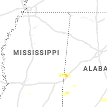


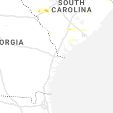

Cities Most Affected by Hail Storms of 3/31/2021
| Hail Size | Demographics of Zip Codes Affected | ||||||
|---|---|---|---|---|---|---|---|
| City | Count | Average | Largest | Pop Density | House Value | Income | Age |
| Aiken, SC | 1 | 1.75 | 1.75 | 297 | $82k | $31.7k | 38.8 |
| Ridge Spring, SC | 1 | 1.75 | 1.75 | 32 | $75k | $29.3k | 39.9 |
Hail and Wind Damage Spotted on 3/31/2021
Filter by Report Type:Hail ReportsWind Reports
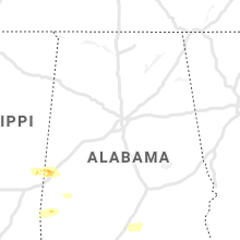
Alabama
| Local Time | Report Details |
|---|---|
| 8:17 AM CDT | Social media photos and video on facebook and twitter via broadcast media shows trees down. possible tornado. time and location very approximate according to rada in blount county AL, 25.8 miles N of Birmingham, AL |
| 1:32 PM CDT | Tree down on hwy 84 near nellie hill rd. time estimated based on rada in clarke county AL, 33.8 miles SW of Camden, AL |
| 1:40 PM CDT | Quarter sized hail reported near Butler, AL, 61.6 miles W of Camden, AL, quarter size hail report from emergency manager. time estimated based on radar. |
| 3:15 PM CDT | Corrects previous tstm wnd dmg report from pine orchard. tree down across highway 5 near pine orchard. report via emergency manager and time estimated based on rada in monroe county AL, 25.9 miles SSE of Camden, AL |
| 3:15 PM CDT | Corrects previous tstm wnd dmg report from pine orchard. tree down across highway 5 near pine orchard. report via emergency manager and time estimated based on rada in monroe county AL, 25.9 miles SSE of Camden, AL |
| 3:40 PM CDT | Tree down across highway 29 near owassa. time estimated based on rada in conecuh county AL, 40.6 miles SSE of Camden, AL |
| 3:40 PM CDT | Tree down on starlington rd near hwy 106. time estimated based on rada in butler county AL, 35.1 miles SE of Camden, AL |
| 3:45 PM CDT | Tree down near 1818 south mount zion rd. time estimated based on rada in butler county AL, 47.1 miles ESE of Camden, AL |
| 3:45 PM CDT | Tree down near the intersection of n friendship dr & hwy 106. time estimated based on rada in butler county AL, 46.2 miles ESE of Camden, AL |
| 3:50 PM CDT | Tree down at near the intersection of cr-16 & hwy 106. time estimated based on rada in butler county AL, 48.4 miles ESE of Camden, AL |
| 3:50 PM CDT | Tree down near 15672 halso mill rd. time estimated based on rada in butler county AL, 49.3 miles ESE of Camden, AL |
| 4:06 PM CDT | Tree down near intersection of woods rd & five points rd. time estimated based on rada in crenshaw county AL, 57.2 miles ESE of Camden, AL |
| 4:10 PM CDT | Multiple trees down near springhill rd & mt ida rd intersection. time estimated based on rada in crenshaw county AL, 62.9 miles ESE of Camden, AL |
| 4:10 PM CDT | Tree down on petrey hwy at city limits. time estimated based on rada in crenshaw county AL, 64.2 miles ESE of Camden, AL |
| 4:10 PM CDT | Tree and powerline down near 3930 cameron chapel rd. time estimated based on rada in crenshaw county AL, 61.6 miles ESE of Camden, AL |
| 4:10 PM CDT | Tree down on compton rd. time estimated based on rada in crenshaw county AL, 61.5 miles ESE of Camden, AL |
| 4:14 PM CDT | Tree down on ellis st. time estimated based on rada in crenshaw county AL, 67 miles ESE of Camden, AL |
| 4:14 PM CDT | Downed powerline near n sasser st at camelia village apts. time estimated based on rada in crenshaw county AL, 66.7 miles ESE of Camden, AL |
| 4:15 PM CDT | Downed powerline on east mill street. time estimated based on rada in crenshaw county AL, 67.2 miles ESE of Camden, AL |
| 4:15 PM CDT | Tree down near 700 carter rd. time estimated based on rada in crenshaw county AL, 67.5 miles ESE of Camden, AL |
| 4:16 PM CDT | Tree down on rose hill rd. near hwy 331. time estimated based on rada in crenshaw county AL, 69.4 miles ESE of Camden, AL |
| 4:18 PM CDT | Tree down near intersection of old notch rd and morgan hill rd. time estimated based on rada in crenshaw county AL, 70.7 miles ESE of Camden, AL |
| 4:20 PM CDT | Tree down on stricklin rd. time estimated based on rada in crenshaw county AL, 71.6 miles ESE of Camden, AL |
| 4:21 PM CDT | Tree down on county road 30 in coffee county AL, 76.2 miles ESE of Camden, AL |
| 4:27 PM CDT | Tree down on highway 8 in coffee county AL, 79.7 miles NNE of Miramar Beach, FL |
| 4:27 PM CDT | Trees down along highway 12 in coffee county AL, 80.2 miles NNE of Miramar Beach, FL |
| 4:29 PM CDT | Multiple trees down along farris ave in elb in coffee county AL, 74 miles NNE of Miramar Beach, FL |
| 4:29 PM CDT | Multiple trees down near highway 87 at highway 12 in coffee county AL, 74.2 miles NNE of Miramar Beach, FL |
| 4:32 PM CDT | Tree blocking both lanes of traffic on cr 237 off of cr 23 in coffee county AL, 80.6 miles NNE of Miramar Beach, FL |
| 4:37 PM CDT | Tree down along county road 233 near county road 23 in coffee county AL, 79.9 miles NNE of Miramar Beach, FL |
| 5:00 PM CDT | Tree down in n edwards st/e kings st & newto in dale county AL, 79.8 miles NE of Miramar Beach, FL |
| 5:07 PM CDT | Tree down near 67 n county (67th echo area in dale county AL, 78.4 miles S of Auburn, AL |
| 5:15 PM CDT | Trees and powerlines down near wallace community colleg in dale county AL, 83.9 miles NE of Miramar Beach, FL |
| 5:30 PM CDT | Tree down near suggs road and headland av in houston county AL, 86.3 miles NE of Miramar Beach, FL |
Georgia
| Local Time | Report Details |
|---|---|
| 11:46 AM EDT | One tree down at mud green road and allgood church roa in paulding county GA, 36.7 miles W of Atlanta, GA |
| 4:48 PM EDT | One tree down along highway 26 in henderso in houston county GA, 79.7 miles NW of Douglas, GA |
| 4:51 PM EDT | One tree down along elko road near highway 2 in houston county GA, 75.9 miles NW of Douglas, GA |
| 5:38 PM EDT | Powerlines reported down at the 1100 block of north lake d in laurens county GA, 76 miles SW of Augusta, GA |
| 5:41 PM EDT | Three trees down on highway 257 near nicholson carr road between roddy and cheste in dodge county GA, 62.8 miles NNW of Douglas, GA |
| 5:47 PM EDT | Large tree reported down and blocking the road at rex miller rd and bobbie s in laurens county GA, 70.6 miles N of Douglas, GA |
| 5:48 PM EDT | Tree reported down at the 600 block of bellevue av in laurens county GA, 71.4 miles N of Douglas, GA |
| 5:48 PM EDT | Powerlines reported down on pearl st in east dubli in laurens county GA, 71.3 miles N of Douglas, GA |
| 5:51 PM EDT | Tree reported down at the intersection of hwy 338 and whittle r in laurens county GA, 60.6 miles N of Douglas, GA |
| 5:55 PM EDT | Two trees reported down at the intersection of old savannah rd and robert lewis r in laurens county GA, 69.9 miles N of Douglas, GA |
| 5:58 PM EDT | Tree reported down at the intersection of hwy 29 and minter tweed r in laurens county GA, 68 miles N of Douglas, GA |
| 5:58 PM EDT | Tree reported down at the intersection of lloyd hester rd and minter tweed r in laurens county GA, 66 miles N of Douglas, GA |
| 5:58 PM EDT | Tree reported down near the intersection of hwy 199 and l.c. pope r in laurens county GA, 64.5 miles N of Douglas, GA |
| 6:02 PM EDT | Tree reported down at the 2300 block of greg couey r in laurens county GA, 58.2 miles N of Douglas, GA |
| 6:45 PM EDT | 1 tree down on damascus hilton rd in early... count in early county GA, 76.5 miles NW of Tallahassee, FL |
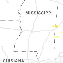
Mississippi
| Local Time | Report Details |
|---|---|
| 11:55 AM CDT | The roof was blown off a business in hazlehurst. reported via social medi in copiah county MS, 32.6 miles SSW of Jackson, MS |
| 12:01 PM CDT | Tree down across scr 5 in smith county MS, 46.9 miles SE of Jackson, MS |
| 12:04 PM CDT | Tree down across scr 4 in smith county MS, 48.8 miles SE of Jackson, MS |
| 12:48 PM CDT | Social media report of trees down along service r in jones county MS, 71 miles SE of Jackson, MS |
| 12:55 PM CDT | Quarter sized hail reported near Sandersville, MS, 75.9 miles ESE of Jackson, MS, multiple social media reports of hail in sandersville with sizes ranging from dimes to quarters. |
South Carolina
| Local Time | Report Details |
|---|---|
| 5:20 PM EDT | Edgefield dispatch reported a few trees down along sweetwater road in the southern half of the county. location and time are estimated based on rada in edgefield county SC, 15.9 miles N of Augusta, GA |
| 5:35 PM EDT | Golf Ball sized hail reported near Aiken, SC, 17.2 miles NE of Augusta, GA, video sent in via twitter shows upwards of golf ball sized hail falling on lake shore dr off hwy 19. time estimated from radar. |
| 5:43 PM EDT | Golf Ball sized hail reported near Ridge Spring, SC, 24.6 miles NE of Augusta, GA, facebook post showed hail up to golf ball sized... and indicated the location was off of exit 22 along i20. this location was determined by that and radar data. |
| 5:54 PM EDT | Quarter sized hail reported near Walterboro, SC, 36.6 miles WSW of Charleston, SC, canadys fire department reports quarter sized hail. |
| 7:47 PM EDT | Tree down on hendersonville highway near see saw roa in colleton county SC, 46.9 miles WSW of Charleston, SC |
Virginia
| Local Time | Report Details |
|---|---|
| 5:50 PM EDT | Corrects previous tstm wnd dmg report from 2 wnw queens lake. tree downed and partially blocking road at va-143 and rochambeau dr. time is radar estimate in york county VA, 51.3 miles NW of Virginia Beach, VA |
| 6:05 PM EDT | Tree downed and partially blocking road at va-143 and rochambeau d in york county VA, 51.3 miles NW of Virginia Beach, VA |
Florida
| Local Time | Report Details |
|---|---|
| 6:15 PM CDT | Tree down along highway in jackson county FL, 60.9 miles NW of Tallahassee, FL |
Connect with Interactive Hail Maps