

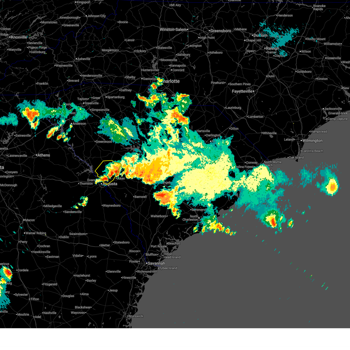
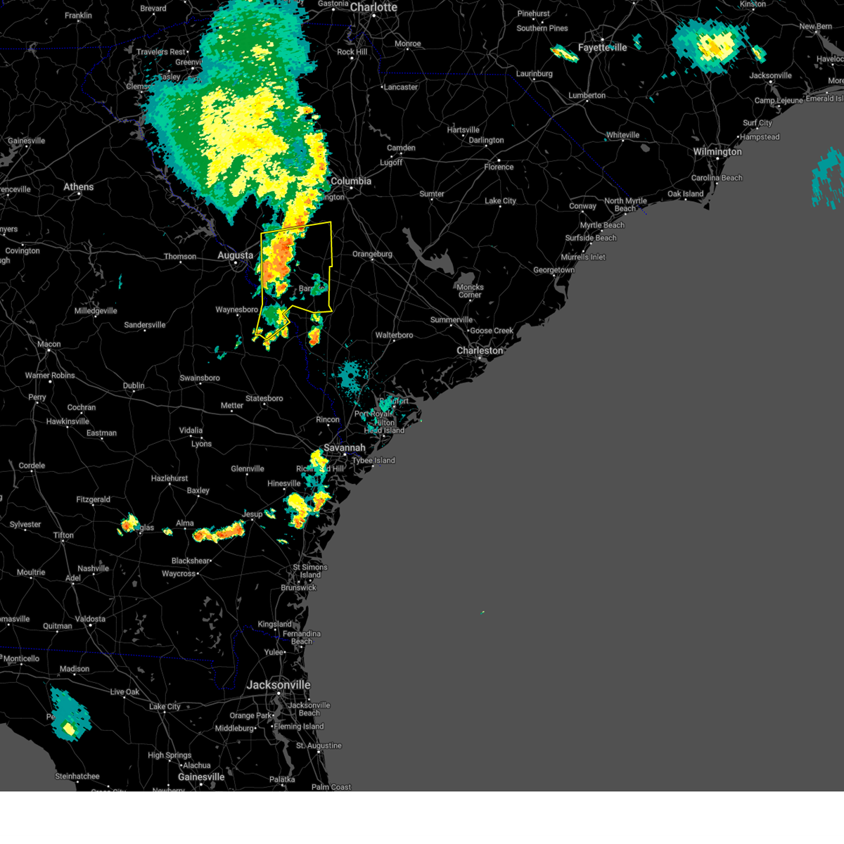
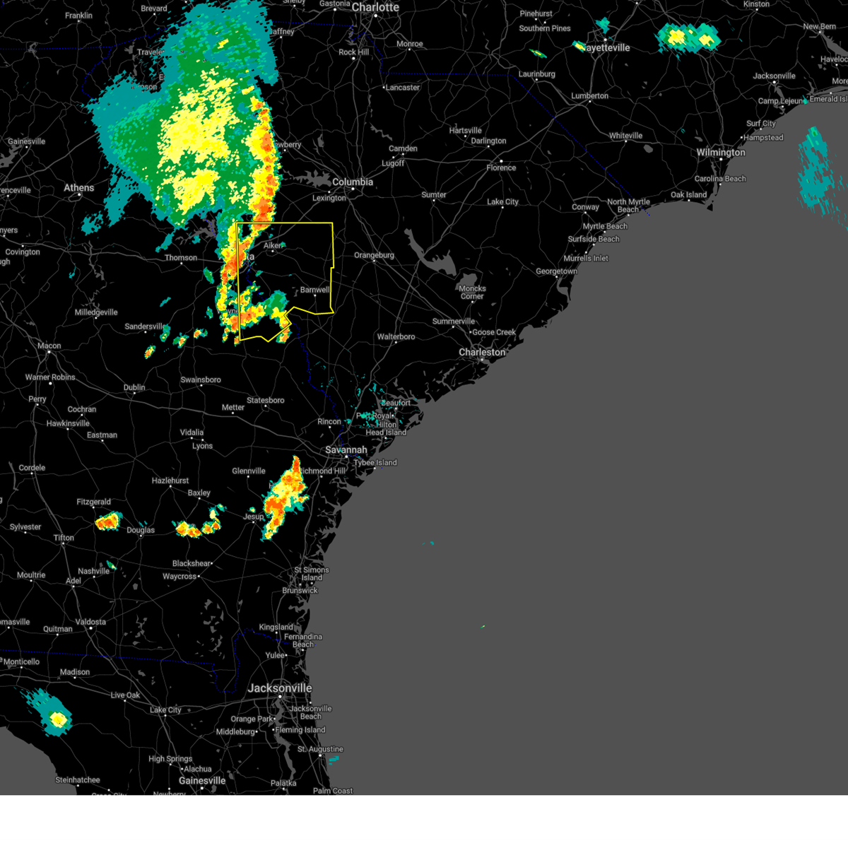
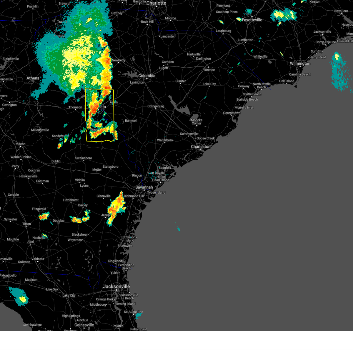
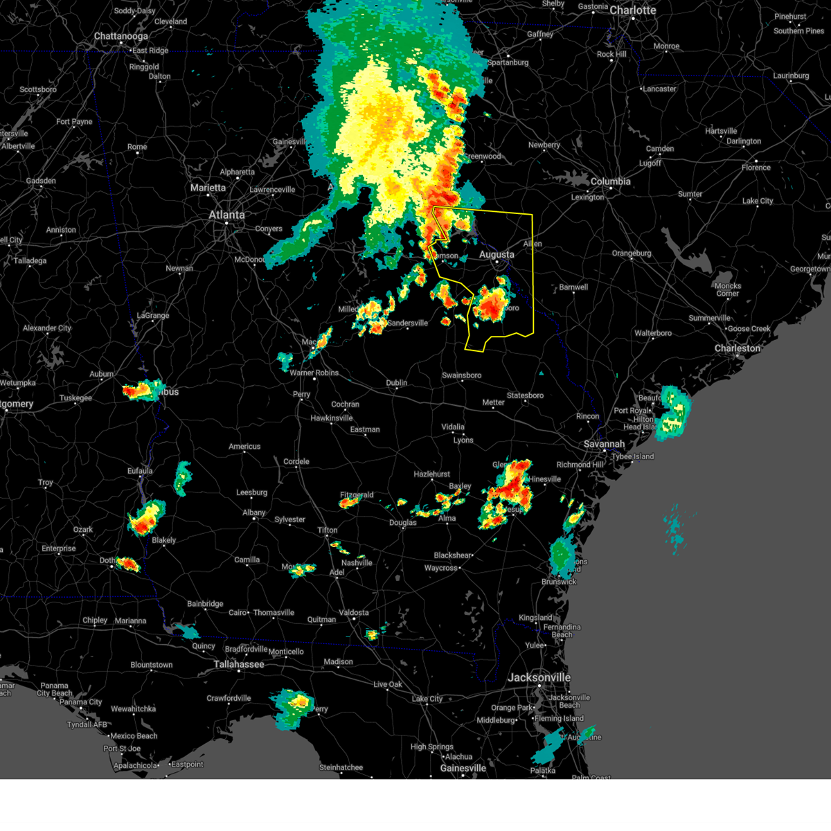
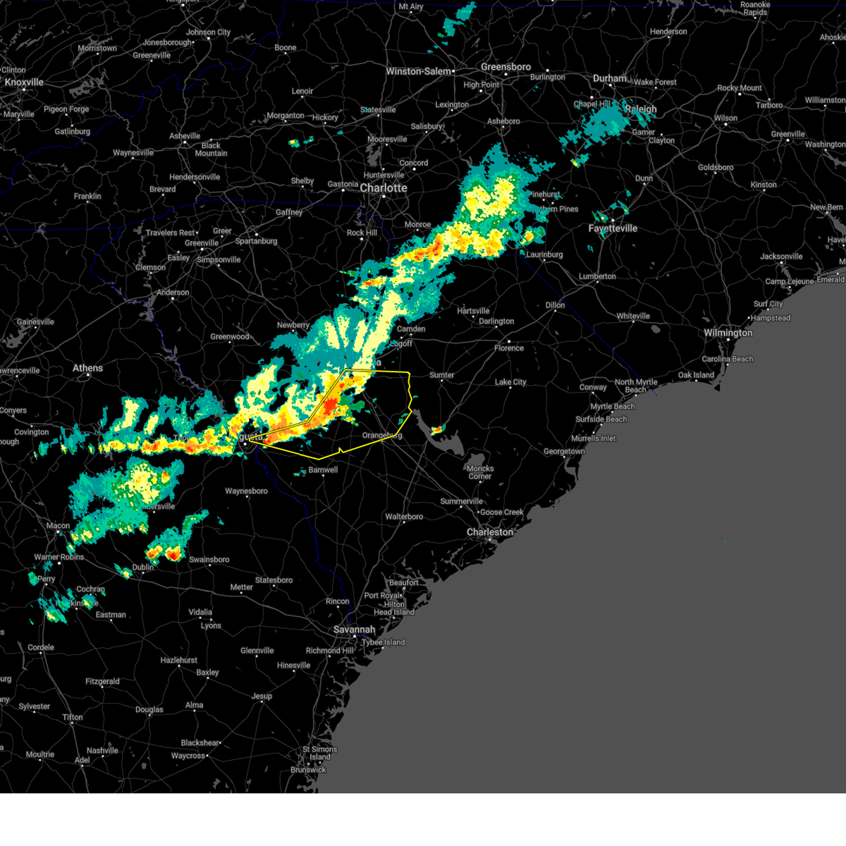
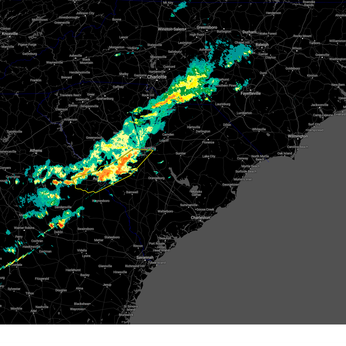
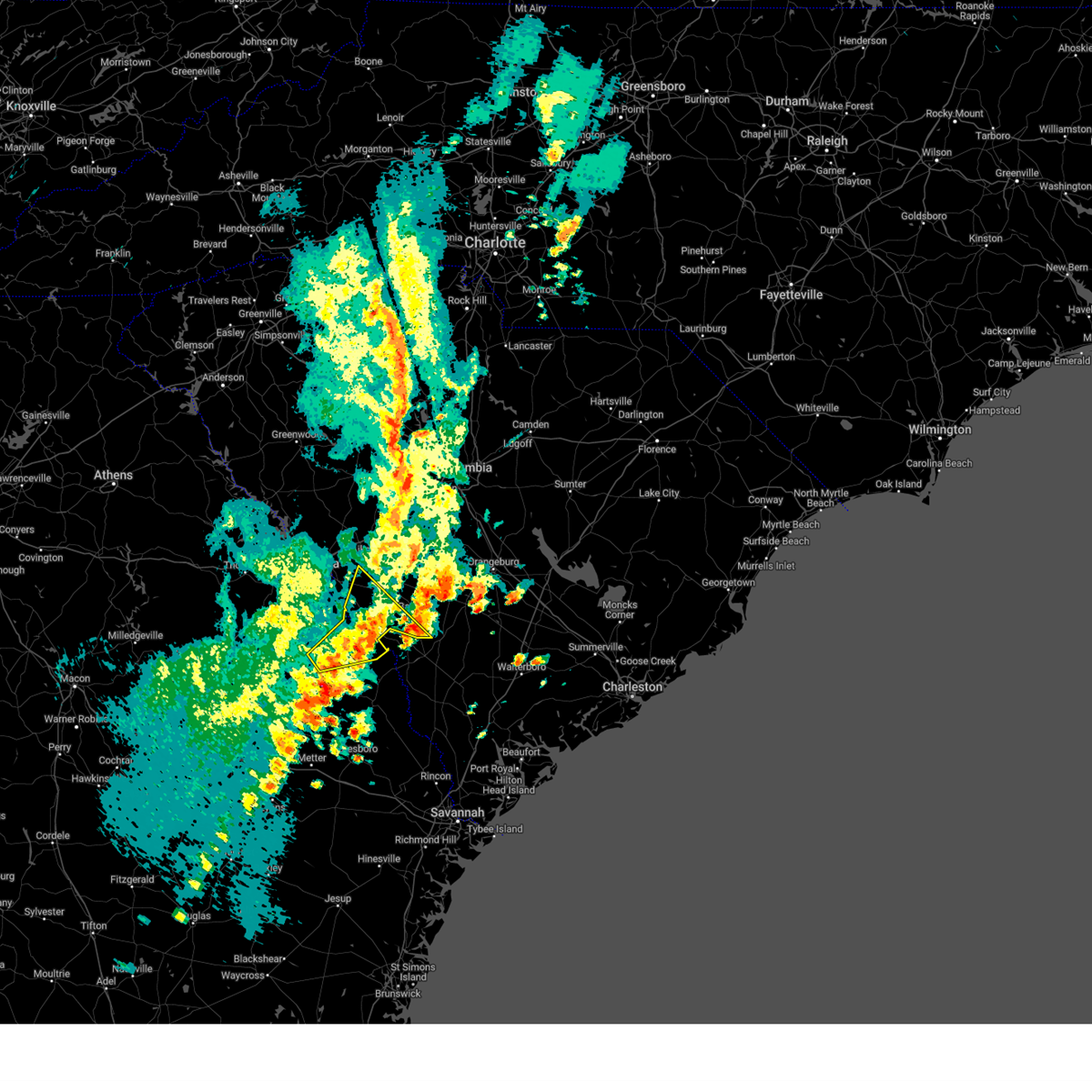
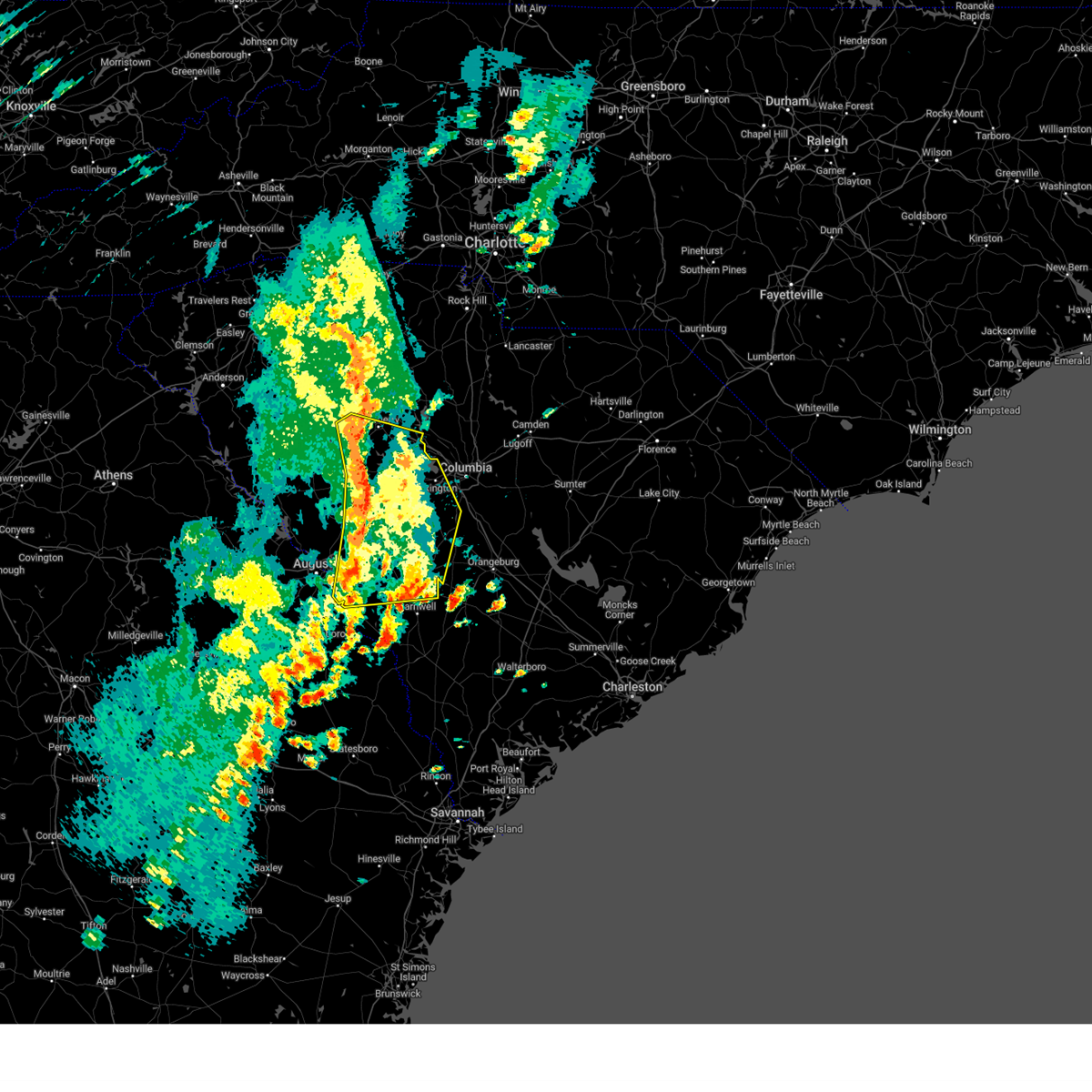
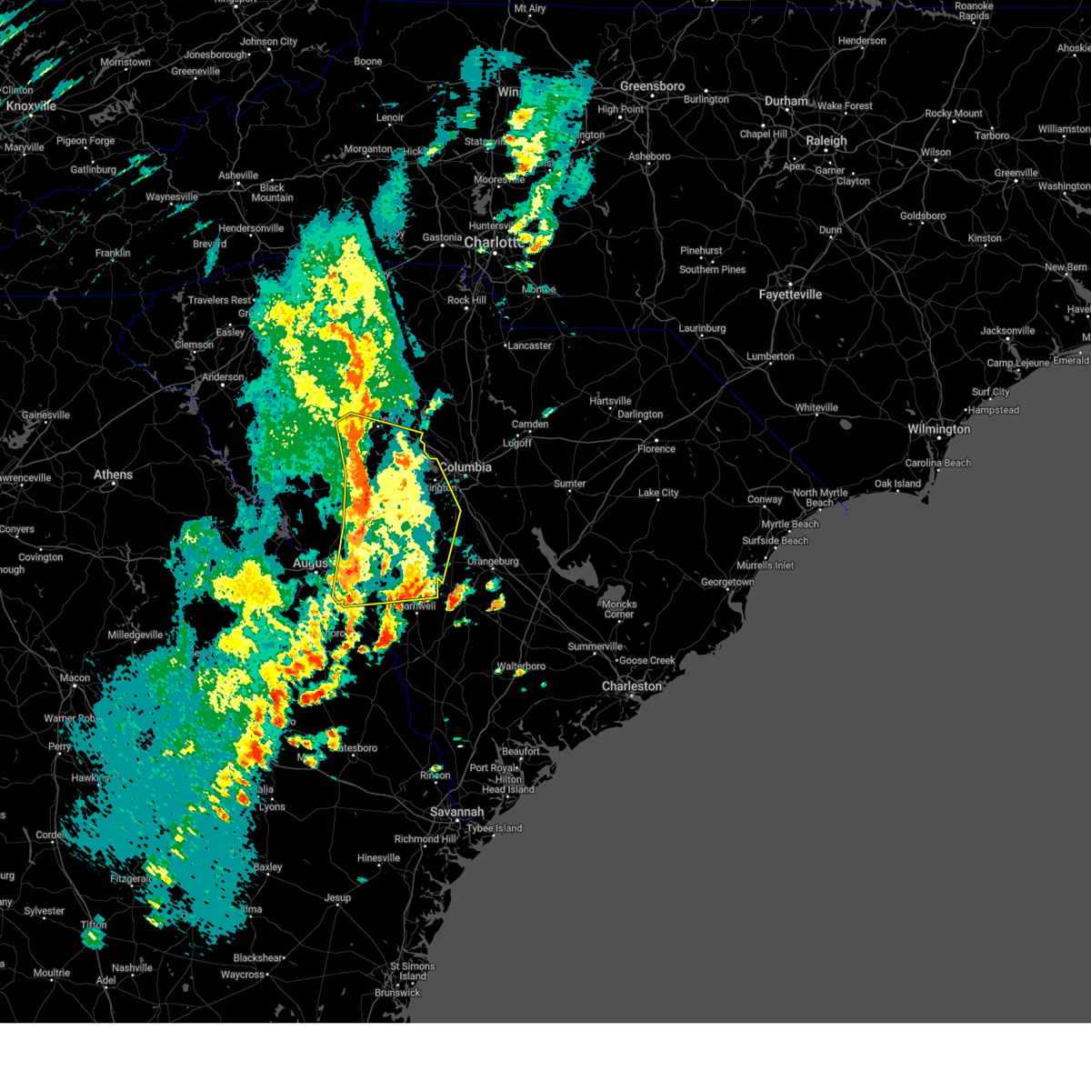
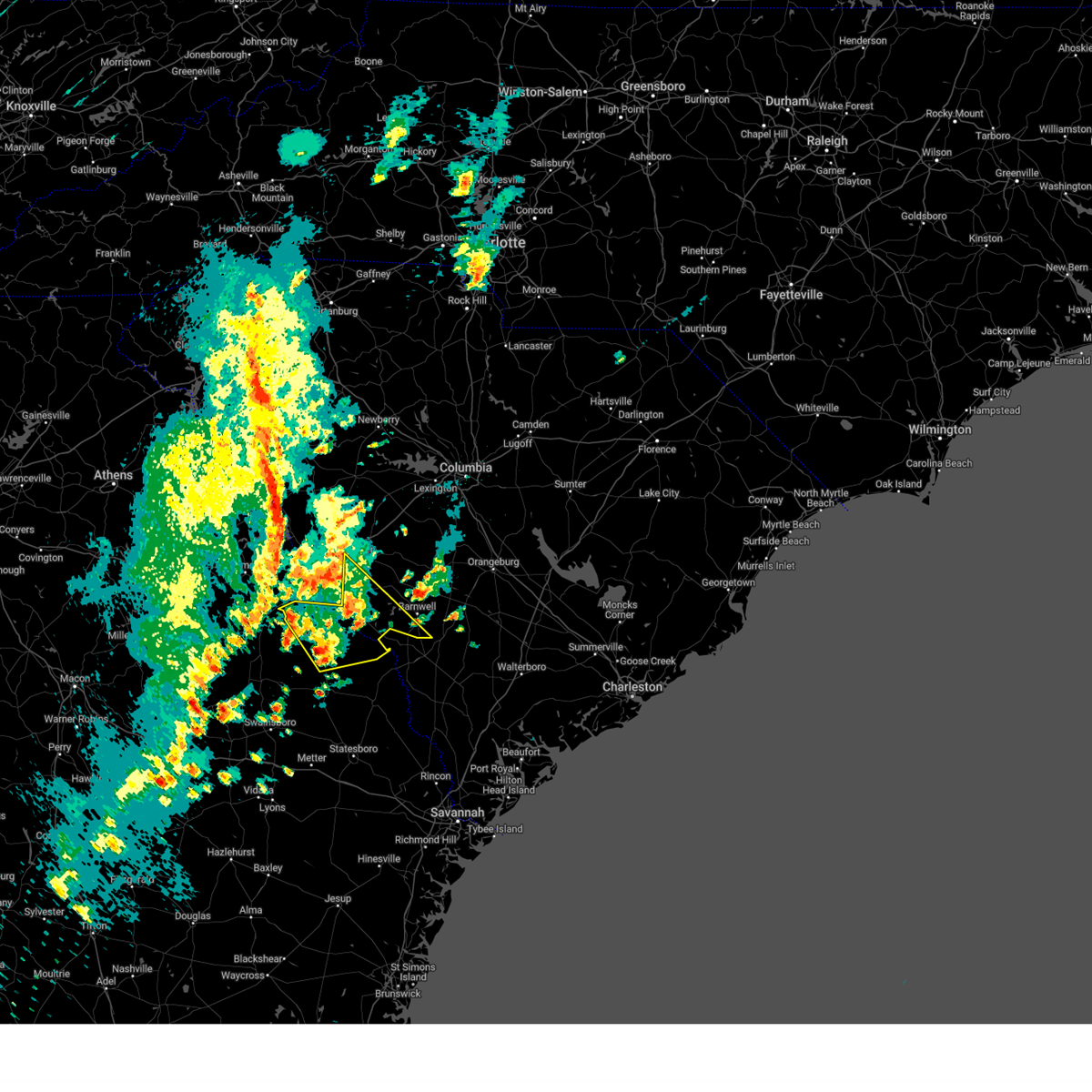
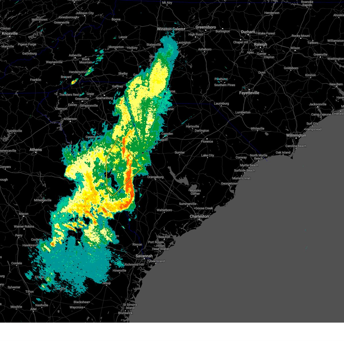
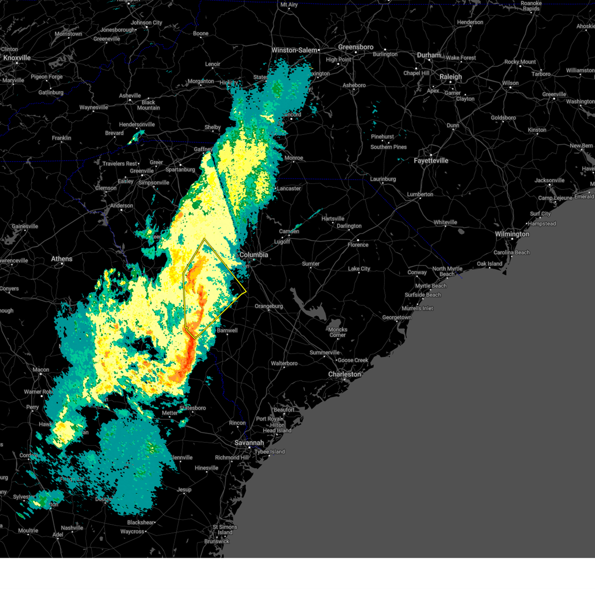
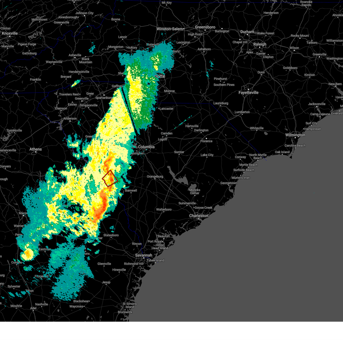
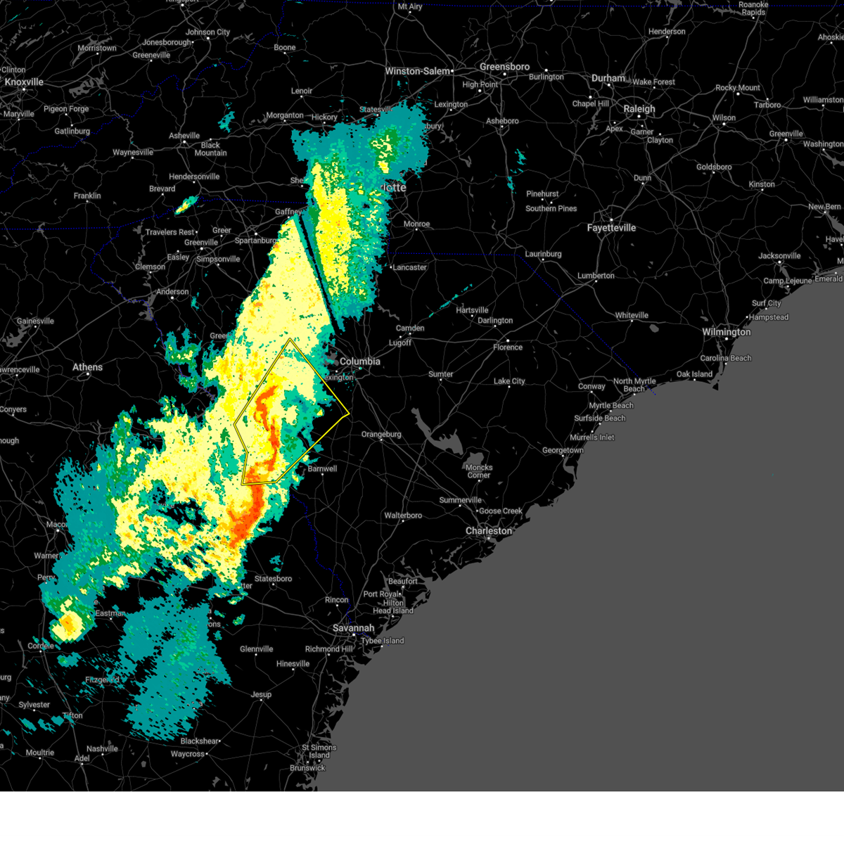
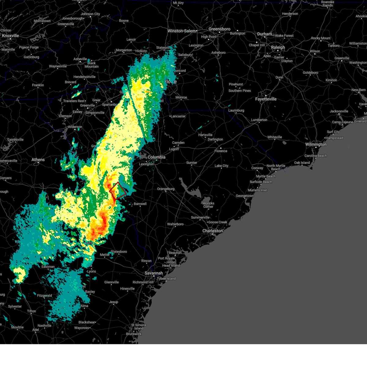
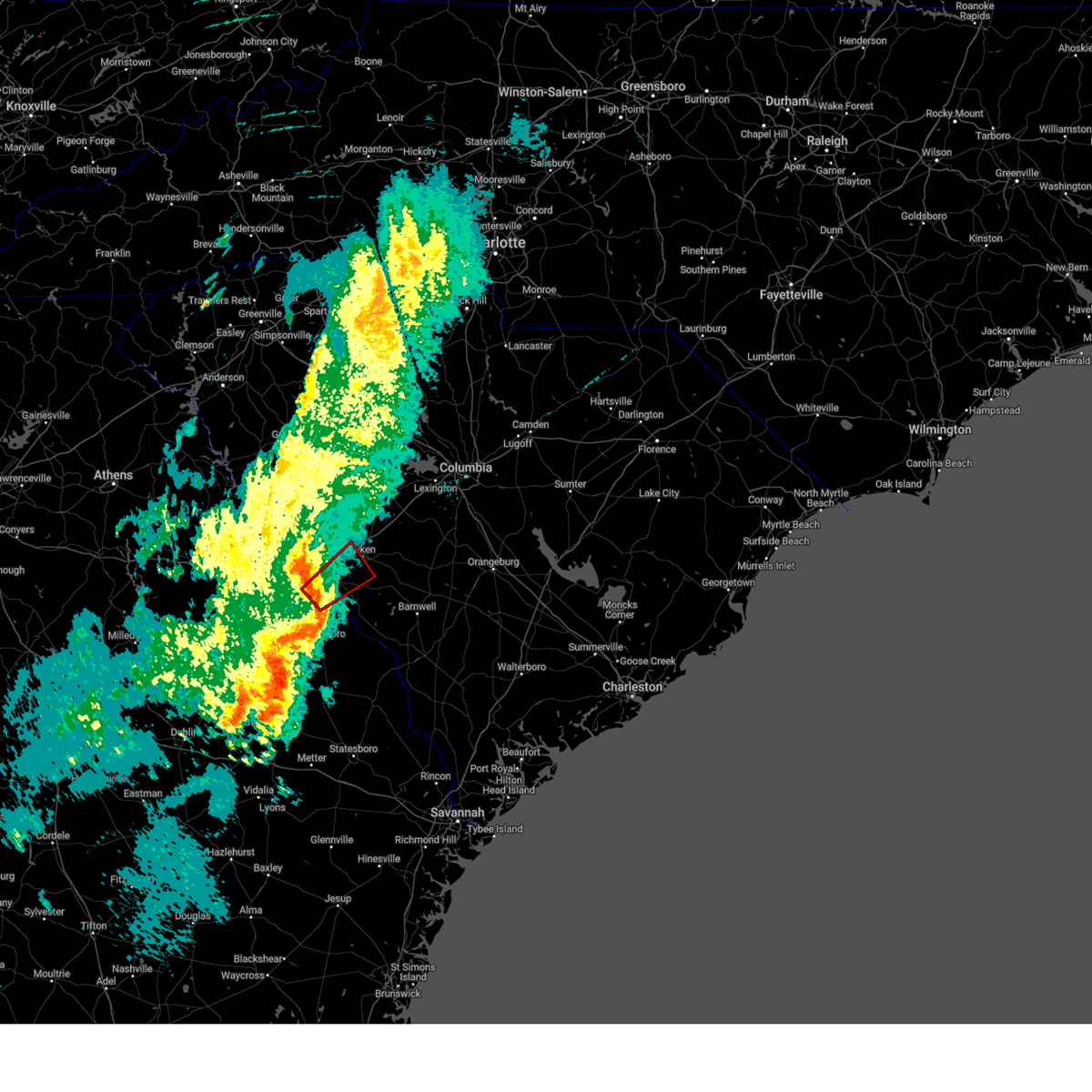
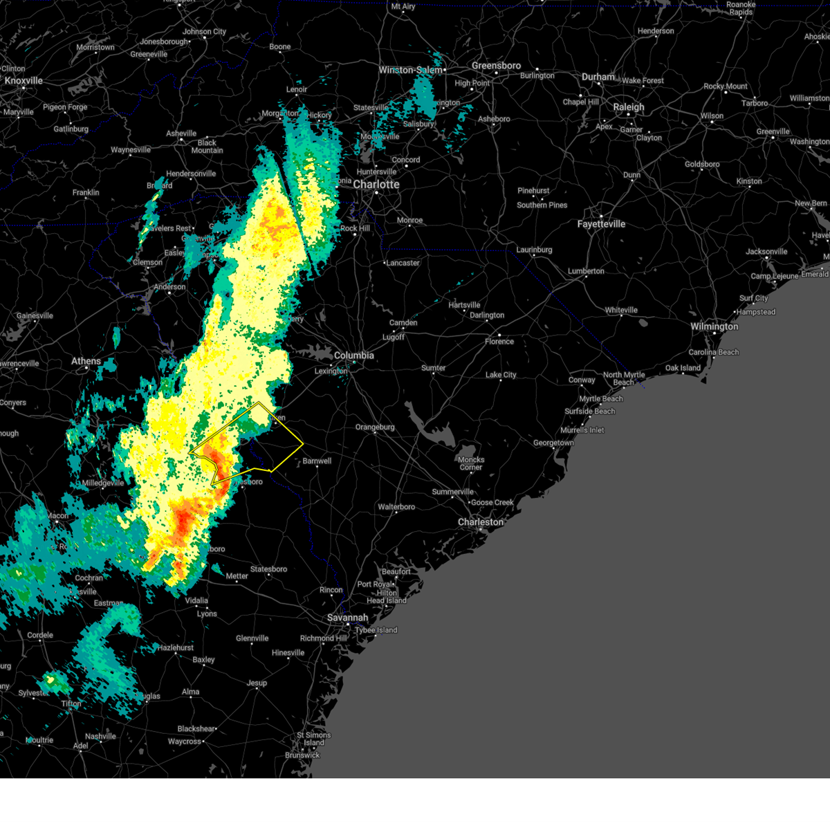
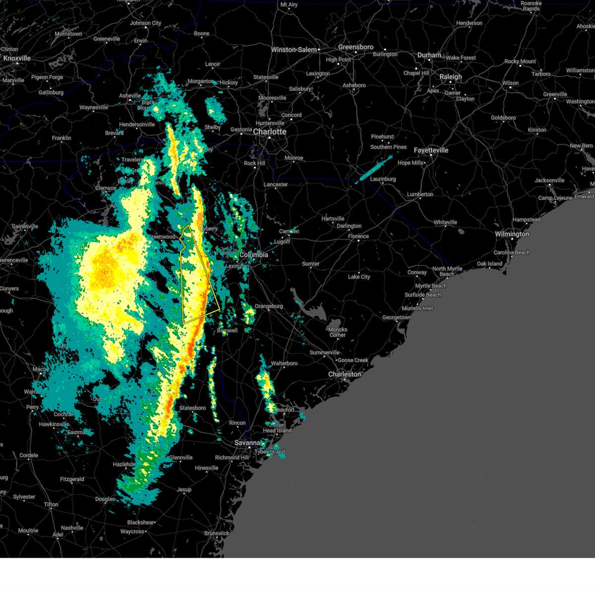
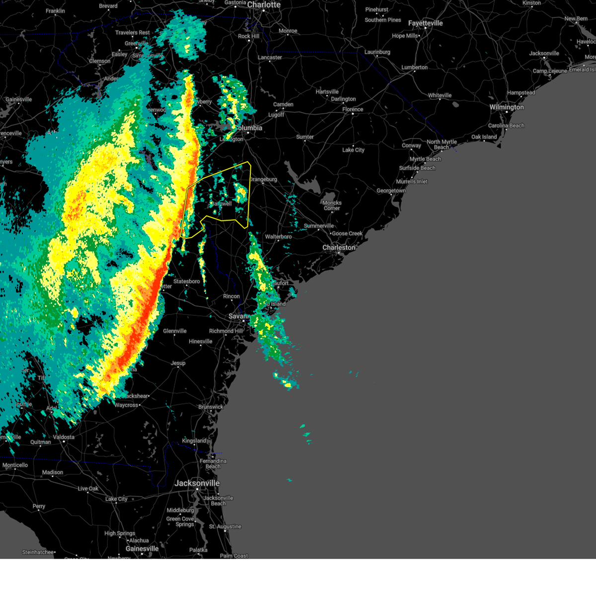
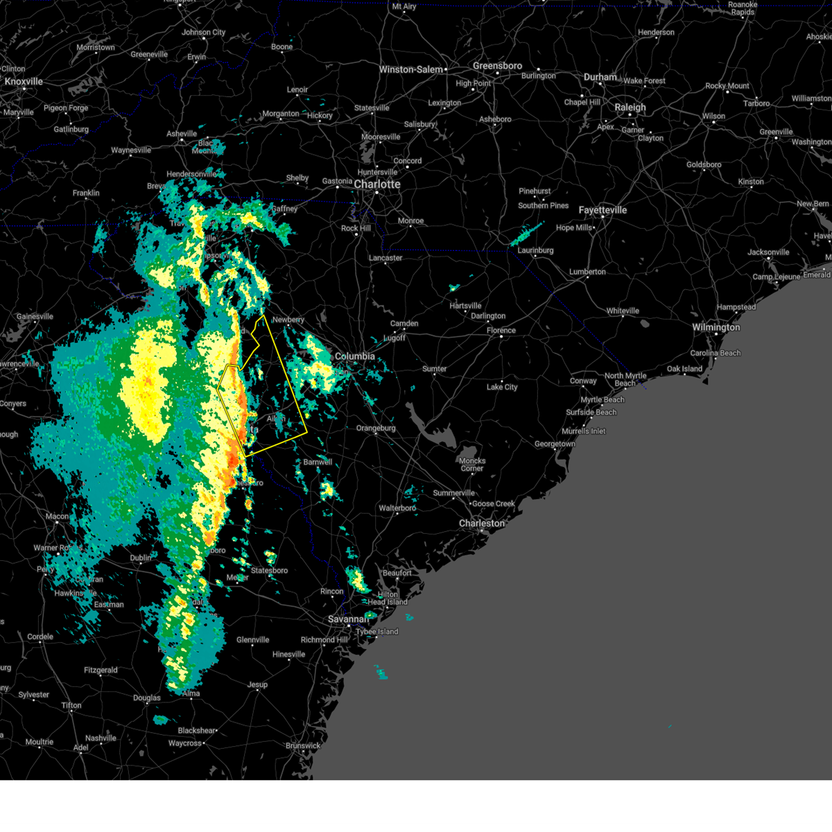
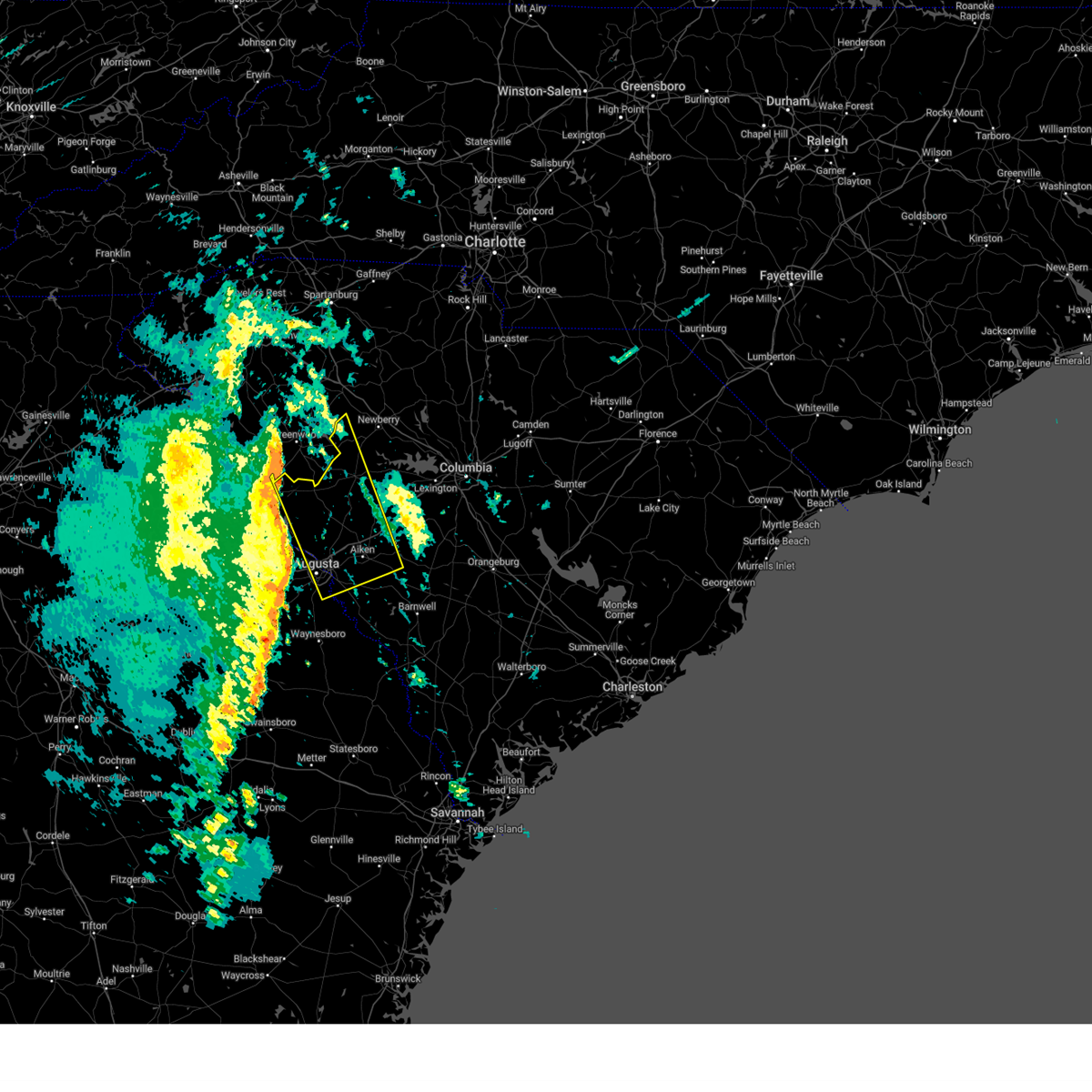
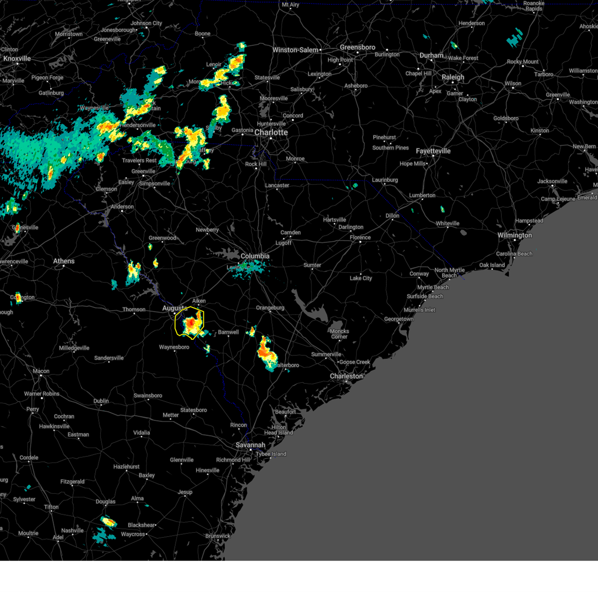
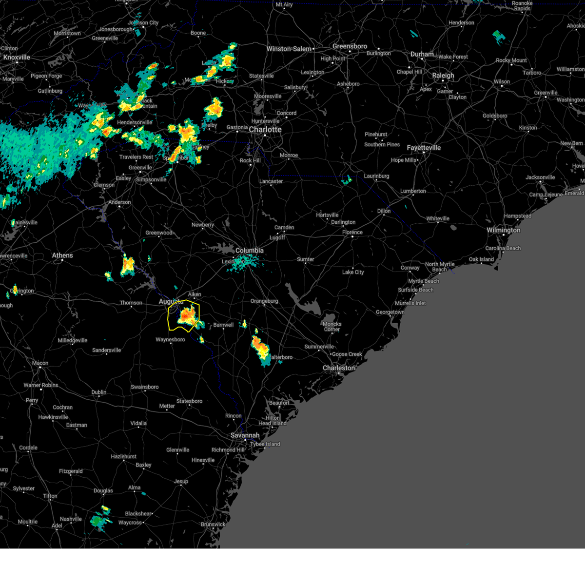
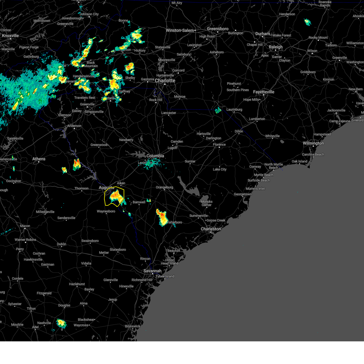
Hail Map for Aiken, SC
The Aiken, SC area has had 13 reports of on-the-ground hail by trained spotters, and has been under severe weather warnings 50 times during the past 12 months. Doppler radar has detected hail at or near Aiken, SC on 70 occasions, including 5 occasions during the past year.
| Name: | Aiken, SC |
| Where Located: | 14.5 miles ENE of Augusta, GA |
| Map: | Google Map for Aiken, SC |
| Population: | 29524 |
| Housing Units: | 14162 |
| More Info: | Search Google for Aiken, SC |
0
The Top Recent Hail Date for Aiken, SC is Wednesday, June 25, 2025 (55th out of 70)

Hail and Wind Damage Spotted near Aiken, SC
| Date / Time | Report Details |
|---|---|
| 6/25/2025 9:37 PM EDT |
 the severe thunderstorm warning has been cancelled and is no longer in effect the severe thunderstorm warning has been cancelled and is no longer in effect
|
| 6/25/2025 9:37 PM EDT |
 At 937 pm edt, a severe thunderstorm was located over belvedere, and is nearly stationary (radar indicated). Hazards include 60 mph wind gusts and penny size hail. Expect damage to trees and powerlines. locations impacted include, aiken, north augusta, clearwater, belvedere, edgefield, johnston, usc aiken, edgefield county airport, gloverville, graniteville, burnettown, trenton, strom thurmond high school, poverty hill, colliers, vaucluse, edgefield federal correction institution, lick fork campground, stevens creek public park, and harmony. this includes the following highways, interstate 20 in south carolina between mile markers 1 and 20. Interstate 520 in south carolina between mile markers 16 and 23. At 937 pm edt, a severe thunderstorm was located over belvedere, and is nearly stationary (radar indicated). Hazards include 60 mph wind gusts and penny size hail. Expect damage to trees and powerlines. locations impacted include, aiken, north augusta, clearwater, belvedere, edgefield, johnston, usc aiken, edgefield county airport, gloverville, graniteville, burnettown, trenton, strom thurmond high school, poverty hill, colliers, vaucluse, edgefield federal correction institution, lick fork campground, stevens creek public park, and harmony. this includes the following highways, interstate 20 in south carolina between mile markers 1 and 20. Interstate 520 in south carolina between mile markers 16 and 23.
|
| 6/25/2025 9:20 PM EDT |
 Svrcae the national weather service in columbia has issued a * severe thunderstorm warning for, barnwell county in central south carolina, bamberg county in central south carolina, aiken county in central south carolina, orangeburg county in central south carolina, * until 1015 pm edt. * at 919 pm edt, severe thunderstorms were located along a line extending from near orangeburg to 11 miles northeast of blackville to near aiken mall, moving south at 30 mph (radar indicated). Hazards include 60 mph wind gusts and penny size hail. expect damage to trees and powerlines Svrcae the national weather service in columbia has issued a * severe thunderstorm warning for, barnwell county in central south carolina, bamberg county in central south carolina, aiken county in central south carolina, orangeburg county in central south carolina, * until 1015 pm edt. * at 919 pm edt, severe thunderstorms were located along a line extending from near orangeburg to 11 miles northeast of blackville to near aiken mall, moving south at 30 mph (radar indicated). Hazards include 60 mph wind gusts and penny size hail. expect damage to trees and powerlines
|
| 6/25/2025 8:54 PM EDT |
 Svrcae the national weather service in columbia has issued a * severe thunderstorm warning for, edgefield county in central south carolina, southern saluda county in central south carolina, northwestern aiken county in central south carolina, * until 1000 pm edt. * at 853 pm edt, a severe thunderstorm was located over ridge spring, or 9 miles southwest of batesburg-leesville, moving southwest at 15 mph (radar indicated). Hazards include 60 mph wind gusts and quarter size hail. Hail damage to vehicles is expected. Expect wind damage to trees and powerlines. Svrcae the national weather service in columbia has issued a * severe thunderstorm warning for, edgefield county in central south carolina, southern saluda county in central south carolina, northwestern aiken county in central south carolina, * until 1000 pm edt. * at 853 pm edt, a severe thunderstorm was located over ridge spring, or 9 miles southwest of batesburg-leesville, moving southwest at 15 mph (radar indicated). Hazards include 60 mph wind gusts and quarter size hail. Hail damage to vehicles is expected. Expect wind damage to trees and powerlines.
|
| 6/17/2025 8:39 PM EDT |
 Svrcae the national weather service in columbia has issued a * severe thunderstorm warning for, east central columbia county in east central georgia, northeastern richmond county in east central georgia, southwestern newberry county in central south carolina, edgefield county in central south carolina, western lexington county in central south carolina, saluda county in central south carolina, central aiken county in central south carolina, * until 915 pm edt. * at 839 pm edt, multiple strong to severe thunderstorms were located along a line extending from near ninety six historic site to johnston to near graniteville, moving northeast at 35 mph (radar indicated). Hazards include 60 mph wind gusts. expect damage to trees and powerlines Svrcae the national weather service in columbia has issued a * severe thunderstorm warning for, east central columbia county in east central georgia, northeastern richmond county in east central georgia, southwestern newberry county in central south carolina, edgefield county in central south carolina, western lexington county in central south carolina, saluda county in central south carolina, central aiken county in central south carolina, * until 915 pm edt. * at 839 pm edt, multiple strong to severe thunderstorms were located along a line extending from near ninety six historic site to johnston to near graniteville, moving northeast at 35 mph (radar indicated). Hazards include 60 mph wind gusts. expect damage to trees and powerlines
|
| 6/7/2025 9:04 PM EDT |
 At 904 pm edt, severe thunderstorms were located along a line extending from 6 miles southeast of ridge spring to near millett, moving east at 45 mph (radar indicated). Hazards include 60 mph wind gusts and penny size hail. Expect damage to trees and powerlines. locations impacted include, aiken, barnwell, savannah river site, aiken mall, plant vogtle, williston, blackville, new ellenton, jackson, sardis, usc aiken, aiken municipal airport, citizens park, aiken state park, barnwell state park, gloverville, wagener, pelion, springfield, and hilda. This includes interstate 20 in south carolina between mile markers 14 and 28. At 904 pm edt, severe thunderstorms were located along a line extending from 6 miles southeast of ridge spring to near millett, moving east at 45 mph (radar indicated). Hazards include 60 mph wind gusts and penny size hail. Expect damage to trees and powerlines. locations impacted include, aiken, barnwell, savannah river site, aiken mall, plant vogtle, williston, blackville, new ellenton, jackson, sardis, usc aiken, aiken municipal airport, citizens park, aiken state park, barnwell state park, gloverville, wagener, pelion, springfield, and hilda. This includes interstate 20 in south carolina between mile markers 14 and 28.
|
| 6/7/2025 9:04 PM EDT |
 the severe thunderstorm warning has been cancelled and is no longer in effect the severe thunderstorm warning has been cancelled and is no longer in effect
|
| 6/7/2025 8:52 PM EDT | Sc highway patrol reports a tree down in the roadway along us 278 at sc 19. time estimated by rada in aiken county SC, 10.5 miles NNW of Aiken, SC |
| 6/7/2025 8:36 PM EDT |
 Svrcae the national weather service in columbia has issued a * severe thunderstorm warning for, central burke county in east central georgia, eastern richmond county in east central georgia, southeastern edgefield county in central south carolina, barnwell county in central south carolina, south central lexington county in central south carolina, aiken county in central south carolina, western orangeburg county in central south carolina, * until 915 pm edt. * at 836 pm edt, severe thunderstorms were located along a line extending from near edgefield to alexander, moving east at 45 mph (radar indicated). Hazards include 60 mph wind gusts and penny size hail. expect damage to trees and powerlines Svrcae the national weather service in columbia has issued a * severe thunderstorm warning for, central burke county in east central georgia, eastern richmond county in east central georgia, southeastern edgefield county in central south carolina, barnwell county in central south carolina, south central lexington county in central south carolina, aiken county in central south carolina, western orangeburg county in central south carolina, * until 915 pm edt. * at 836 pm edt, severe thunderstorms were located along a line extending from near edgefield to alexander, moving east at 45 mph (radar indicated). Hazards include 60 mph wind gusts and penny size hail. expect damage to trees and powerlines
|
| 6/7/2025 8:26 PM EDT |
 the severe thunderstorm warning has been cancelled and is no longer in effect the severe thunderstorm warning has been cancelled and is no longer in effect
|
| 6/7/2025 8:26 PM EDT |
 At 825 pm edt, severe thunderstorms were located along a line extending from near hamilton branch state park to near gough, moving east at 40 mph (radar indicated). Hazards include 60 mph wind gusts. Expect damage to trees and powerlines. locations impacted include, aiken, north augusta, grovetown, evans, waynesboro, fort eisenhower, augusta, clearwater, martinez, plant vogtle, belvedere, edgefield, hephzibah, jackson, sardis, glendale, gough, south augusta, clarks hill recreation area, and edgefield county airport. this includes the following highways, interstate 20 in georgia between mile markers 184 and 201. interstate 20 in south carolina between mile markers 0 and 19. interstate 520 in georgia between mile markers 1 and 15. Interstate 520 in south carolina between mile markers 16 and 23. At 825 pm edt, severe thunderstorms were located along a line extending from near hamilton branch state park to near gough, moving east at 40 mph (radar indicated). Hazards include 60 mph wind gusts. Expect damage to trees and powerlines. locations impacted include, aiken, north augusta, grovetown, evans, waynesboro, fort eisenhower, augusta, clearwater, martinez, plant vogtle, belvedere, edgefield, hephzibah, jackson, sardis, glendale, gough, south augusta, clarks hill recreation area, and edgefield county airport. this includes the following highways, interstate 20 in georgia between mile markers 184 and 201. interstate 20 in south carolina between mile markers 0 and 19. interstate 520 in georgia between mile markers 1 and 15. Interstate 520 in south carolina between mile markers 16 and 23.
|
| 6/7/2025 7:53 PM EDT |
 Svrcae the national weather service in columbia has issued a * severe thunderstorm warning for, mcduffie county in east central georgia, columbia county in east central georgia, lincoln county in east central georgia, burke county in east central georgia, richmond county in east central georgia, edgefield county in central south carolina, southwestern barnwell county in central south carolina, western aiken county in central south carolina, southeastern mccormick county in central south carolina, * until 845 pm edt. * at 753 pm edt, severe thunderstorms were located along a line extending from lincolnton to near louisville, moving east at 40 mph (radar indicated). Hazards include 60 mph wind gusts. expect damage to trees and powerlines Svrcae the national weather service in columbia has issued a * severe thunderstorm warning for, mcduffie county in east central georgia, columbia county in east central georgia, lincoln county in east central georgia, burke county in east central georgia, richmond county in east central georgia, edgefield county in central south carolina, southwestern barnwell county in central south carolina, western aiken county in central south carolina, southeastern mccormick county in central south carolina, * until 845 pm edt. * at 753 pm edt, severe thunderstorms were located along a line extending from lincolnton to near louisville, moving east at 40 mph (radar indicated). Hazards include 60 mph wind gusts. expect damage to trees and powerlines
|
| 5/30/2025 4:10 PM EDT |
 Svrcae the national weather service in columbia has issued a * severe thunderstorm warning for, calhoun county in central south carolina, northeastern barnwell county in central south carolina, southeastern lexington county in central south carolina, central aiken county in central south carolina, northwestern orangeburg county in central south carolina, southeastern richland county in central south carolina, * until 500 pm edt. * at 409 pm edt, severe thunderstorms were located along a line extending from columbia metro airport to 7 miles northeast of aiken state park to near clearwater, moving east at 35 mph (radar indicated). Hazards include 60 mph wind gusts and quarter size hail. Hail damage to vehicles is expected. Expect wind damage to trees and powerlines. Svrcae the national weather service in columbia has issued a * severe thunderstorm warning for, calhoun county in central south carolina, northeastern barnwell county in central south carolina, southeastern lexington county in central south carolina, central aiken county in central south carolina, northwestern orangeburg county in central south carolina, southeastern richland county in central south carolina, * until 500 pm edt. * at 409 pm edt, severe thunderstorms were located along a line extending from columbia metro airport to 7 miles northeast of aiken state park to near clearwater, moving east at 35 mph (radar indicated). Hazards include 60 mph wind gusts and quarter size hail. Hail damage to vehicles is expected. Expect wind damage to trees and powerlines.
|
| 5/30/2025 3:56 PM EDT |
 the severe thunderstorm warning has been cancelled and is no longer in effect the severe thunderstorm warning has been cancelled and is no longer in effect
|
| 5/30/2025 3:56 PM EDT |
 At 355 pm edt, severe thunderstorms were located along a line extending from near lexington to near aiken municipal airport to near grovetown, moving east at 50 mph (radar indicated). Hazards include 60 mph wind gusts. Expect damage to trees and powerlines. locations impacted include, columbia, aiken, north augusta, lexington, west columbia, cayce, grovetown, evans, forest acres, thomson, batesburg-leesville, oak grove, fort eisenhower, augusta, clearwater, martinez, aiken mall, red bank, belvedere, and st. andrews. this includes the following highways, interstate 126 between mile markers 1 and 3. interstate 20 in georgia between mile markers 167 and 201. interstate 20 in south carolina between mile markers 0 and 62. interstate 26 between mile markers 109 and 118. interstate 520 in georgia between mile markers 1 and 15. interstate 520 in south carolina between mile markers 16 and 23. Interstate 77 between mile markers 0 and 5, and between mile markers 10 and 11. At 355 pm edt, severe thunderstorms were located along a line extending from near lexington to near aiken municipal airport to near grovetown, moving east at 50 mph (radar indicated). Hazards include 60 mph wind gusts. Expect damage to trees and powerlines. locations impacted include, columbia, aiken, north augusta, lexington, west columbia, cayce, grovetown, evans, forest acres, thomson, batesburg-leesville, oak grove, fort eisenhower, augusta, clearwater, martinez, aiken mall, red bank, belvedere, and st. andrews. this includes the following highways, interstate 126 between mile markers 1 and 3. interstate 20 in georgia between mile markers 167 and 201. interstate 20 in south carolina between mile markers 0 and 62. interstate 26 between mile markers 109 and 118. interstate 520 in georgia between mile markers 1 and 15. interstate 520 in south carolina between mile markers 16 and 23. Interstate 77 between mile markers 0 and 5, and between mile markers 10 and 11.
|
| 5/30/2025 3:34 PM EDT |
 Svrcae the national weather service in columbia has issued a * severe thunderstorm warning for, mcduffie county in east central georgia, columbia county in east central georgia, richmond county in east central georgia, southeastern newberry county in central south carolina, central edgefield county in central south carolina, lexington county in central south carolina, eastern saluda county in central south carolina, aiken county in central south carolina, southeastern mccormick county in central south carolina, central richland county in central south carolina, * until 415 pm edt. * at 333 pm edt, severe thunderstorms were located along a line extending from 7 miles north of batesburg-leesville to 9 miles northwest of belvedere to thomson-mcduffie county airport, moving east at 35 mph (radar indicated). Hazards include 60 mph wind gusts. expect damage to trees and powerlines Svrcae the national weather service in columbia has issued a * severe thunderstorm warning for, mcduffie county in east central georgia, columbia county in east central georgia, richmond county in east central georgia, southeastern newberry county in central south carolina, central edgefield county in central south carolina, lexington county in central south carolina, eastern saluda county in central south carolina, aiken county in central south carolina, southeastern mccormick county in central south carolina, central richland county in central south carolina, * until 415 pm edt. * at 333 pm edt, severe thunderstorms were located along a line extending from 7 miles north of batesburg-leesville to 9 miles northwest of belvedere to thomson-mcduffie county airport, moving east at 35 mph (radar indicated). Hazards include 60 mph wind gusts. expect damage to trees and powerlines
|
| 3/31/2025 4:23 PM EDT |
 At 423 pm edt, severe thunderstorms were located along a line extending from near savannah river site to near sardis, moving east at 30 mph (radar indicated). Hazards include 60 mph wind gusts and nickel size hail. Expect damage to trees and powerlines. Locations impacted include, savannah river site, alexander, plant vogtle, sardis, girard, burke county airport, new ellenton, savannah river site badge office, jackson, kline, savannah river site h canyon, savannah river site k complex, shell bluff, shell bluff landing, snelling, waynesboro, and aiken. At 423 pm edt, severe thunderstorms were located along a line extending from near savannah river site to near sardis, moving east at 30 mph (radar indicated). Hazards include 60 mph wind gusts and nickel size hail. Expect damage to trees and powerlines. Locations impacted include, savannah river site, alexander, plant vogtle, sardis, girard, burke county airport, new ellenton, savannah river site badge office, jackson, kline, savannah river site h canyon, savannah river site k complex, shell bluff, shell bluff landing, snelling, waynesboro, and aiken.
|
| 3/31/2025 4:23 PM EDT |
 the severe thunderstorm warning has been cancelled and is no longer in effect the severe thunderstorm warning has been cancelled and is no longer in effect
|
| 3/31/2025 4:21 PM EDT | At 421 pm edt, severe thunderstorms were located along a line extending from near newberry county airport to 7 miles northeast of batesburg-leesville to near citizens park, moving east at 50 mph (radar indicated). Hazards include 60 mph wind gusts. Expect damage to trees and powerlines. locations impacted include, newberry, little mountain, cedar grove fire station, bundrick island, putnam's landing, salley, savannah river site badge office, summit, jackson, batesburg-leesville, lexington, aiken mall, camp kinard, perry, new holland, samaria fire station, cedar pond campground, perry airport, stoney hill, and chapin. this includes the following highways, interstate 20 in south carolina between mile markers 20 and 59. Interstate 26 between mile markers 77 and 91. |
| 3/31/2025 4:21 PM EDT | the severe thunderstorm warning has been cancelled and is no longer in effect |
| 3/31/2025 4:11 PM EDT |
 At 411 pm edt, severe thunderstorms were located along a line extending from near jackson to alexander, moving east at 50 mph (radar indicated). Hazards include 60 mph wind gusts and nickel size hail. Expect damage to trees and powerlines. Locations impacted include, savannah river site, alexander, plant vogtle, sardis, audubon's silver bluff sanctuary, girard, burke county airport, new ellenton, savannah river site badge office, jackson, waynesboro, kline, savannah river site h canyon, bennock mill, savannah river site k complex, shell bluff, shell bluff landing, snelling, boyd pond park, and gloverville. At 411 pm edt, severe thunderstorms were located along a line extending from near jackson to alexander, moving east at 50 mph (radar indicated). Hazards include 60 mph wind gusts and nickel size hail. Expect damage to trees and powerlines. Locations impacted include, savannah river site, alexander, plant vogtle, sardis, audubon's silver bluff sanctuary, girard, burke county airport, new ellenton, savannah river site badge office, jackson, waynesboro, kline, savannah river site h canyon, bennock mill, savannah river site k complex, shell bluff, shell bluff landing, snelling, boyd pond park, and gloverville.
|
| 3/31/2025 4:07 PM EDT |
 the severe thunderstorm warning has been cancelled and is no longer in effect the severe thunderstorm warning has been cancelled and is no longer in effect
|
| 3/31/2025 4:07 PM EDT |
 At 406 pm edt, severe thunderstorms were located along a line extending from near saluda to near aiken municipal airport to near jackson, moving east at 45 mph (radar indicated). Hazards include 60 mph wind gusts. Expect damage to trees and powerlines. locations impacted include, little mountain, cedar grove fire station, savannah river site badge office, summit, batesburg-leesville, johnston, camp kinard, edgefield county airport, new holland, samaria fire station, saluda, stoney hill, harmony, hopeland gardens, prosperity, burnettown, dreher island state park, williston, lake murray shores, and circle fire station. this includes the following highways, interstate 20 in south carolina between mile markers 10 and 59. Interstate 26 between mile markers 77 and 91. At 406 pm edt, severe thunderstorms were located along a line extending from near saluda to near aiken municipal airport to near jackson, moving east at 45 mph (radar indicated). Hazards include 60 mph wind gusts. Expect damage to trees and powerlines. locations impacted include, little mountain, cedar grove fire station, savannah river site badge office, summit, batesburg-leesville, johnston, camp kinard, edgefield county airport, new holland, samaria fire station, saluda, stoney hill, harmony, hopeland gardens, prosperity, burnettown, dreher island state park, williston, lake murray shores, and circle fire station. this includes the following highways, interstate 20 in south carolina between mile markers 10 and 59. Interstate 26 between mile markers 77 and 91.
|
| 3/31/2025 3:45 PM EDT |
 Svrcae the national weather service in columbia has issued a * severe thunderstorm warning for, central richmond county in east central georgia, southern newberry county in central south carolina, edgefield county in central south carolina, northeastern barnwell county in central south carolina, lexington county in central south carolina, saluda county in central south carolina, aiken county in central south carolina, northwestern orangeburg county in central south carolina, * until 445 pm edt. * at 345 pm edt, severe thunderstorms were located along a line extending from 8 miles south of ninety six historic site to near edgefield to near south augusta, moving east at 45 mph (radar indicated). Hazards include 60 mph wind gusts. expect damage to trees and powerlines Svrcae the national weather service in columbia has issued a * severe thunderstorm warning for, central richmond county in east central georgia, southern newberry county in central south carolina, edgefield county in central south carolina, northeastern barnwell county in central south carolina, lexington county in central south carolina, saluda county in central south carolina, aiken county in central south carolina, northwestern orangeburg county in central south carolina, * until 445 pm edt. * at 345 pm edt, severe thunderstorms were located along a line extending from 8 miles south of ninety six historic site to near edgefield to near south augusta, moving east at 45 mph (radar indicated). Hazards include 60 mph wind gusts. expect damage to trees and powerlines
|
| 3/31/2025 3:27 PM EDT |
 Svrcae the national weather service in columbia has issued a * severe thunderstorm warning for, burke county in east central georgia, southeastern richmond county in east central georgia, southwestern barnwell county in central south carolina, southwestern aiken county in central south carolina, * until 430 pm edt. * at 327 pm edt, severe thunderstorms were located along a line extending from 6 miles southwest of hephzibah to near perkins, moving east at 30 mph (radar indicated). Hazards include 60 mph wind gusts and nickel size hail. expect damage to trees and powerlines Svrcae the national weather service in columbia has issued a * severe thunderstorm warning for, burke county in east central georgia, southeastern richmond county in east central georgia, southwestern barnwell county in central south carolina, southwestern aiken county in central south carolina, * until 430 pm edt. * at 327 pm edt, severe thunderstorms were located along a line extending from 6 miles southwest of hephzibah to near perkins, moving east at 30 mph (radar indicated). Hazards include 60 mph wind gusts and nickel size hail. expect damage to trees and powerlines
|
| 3/16/2025 7:26 AM EDT |
 The storm which prompted the warning has moved out of the area. therefore, the warning will be allowed to expire. a tornado watch remains in effect until 1000 am edt for east central georgia, and central south carolina. a tornado watch also remains in effect until 200 pm edt for central south carolina. remember, a severe thunderstorm warning still remains in effect for lexington and aiken counties until 830am. The storm which prompted the warning has moved out of the area. therefore, the warning will be allowed to expire. a tornado watch remains in effect until 1000 am edt for east central georgia, and central south carolina. a tornado watch also remains in effect until 200 pm edt for central south carolina. remember, a severe thunderstorm warning still remains in effect for lexington and aiken counties until 830am.
|
| 3/16/2025 6:58 AM EDT |
 the severe thunderstorm warning has been cancelled and is no longer in effect the severe thunderstorm warning has been cancelled and is no longer in effect
|
| 3/16/2025 6:58 AM EDT |
 At 658 am edt, a severe thunderstorm was located near aiken municipal airport, or 10 miles northeast of aiken, moving northeast at 50 mph (radar indicated). Hazards include 60 mph wind gusts. Expect damage to trees and powerlines. locations impacted include, cedar grove fire station, saluda co sheriff's office, salley, savannah river site badge office, summit, jackson, batesburg-leesville, johnston, aiken mall, camp kinard, perry, edgefield county airport, vaucluse, new holland, samaria fire station, saluda, cedar pond campground, perry airport, harmony, and hopeland gardens. This includes interstate 20 in south carolina between mile markers 9 and 47. At 658 am edt, a severe thunderstorm was located near aiken municipal airport, or 10 miles northeast of aiken, moving northeast at 50 mph (radar indicated). Hazards include 60 mph wind gusts. Expect damage to trees and powerlines. locations impacted include, cedar grove fire station, saluda co sheriff's office, salley, savannah river site badge office, summit, jackson, batesburg-leesville, johnston, aiken mall, camp kinard, perry, edgefield county airport, vaucluse, new holland, samaria fire station, saluda, cedar pond campground, perry airport, harmony, and hopeland gardens. This includes interstate 20 in south carolina between mile markers 9 and 47.
|
| 3/16/2025 6:45 AM EDT |
 The storm which prompted the warning has weakened below severe limits, and no longer appears capable of producing a tornado. therefore, the warning will be allowed to expire. a tornado watch remains in effect until 1000 am edt for east central georgia, and central south carolina. remember, a severe thunderstorm warning still remains in effect. The storm which prompted the warning has weakened below severe limits, and no longer appears capable of producing a tornado. therefore, the warning will be allowed to expire. a tornado watch remains in effect until 1000 am edt for east central georgia, and central south carolina. remember, a severe thunderstorm warning still remains in effect.
|
| 3/16/2025 6:42 AM EDT |
 Svrcae the national weather service in columbia has issued a * severe thunderstorm warning for, east central columbia county in east central georgia, north central burke county in east central georgia, eastern richmond county in east central georgia, south central newberry county in central south carolina, central edgefield county in central south carolina, southwestern lexington county in central south carolina, saluda county in central south carolina, aiken county in central south carolina, * until 730 am edt. * at 641 am edt, a severe thunderstorm was located over aiken, moving northeast at 55 mph (radar indicated). Hazards include 60 mph wind gusts. expect damage to trees and powerlines Svrcae the national weather service in columbia has issued a * severe thunderstorm warning for, east central columbia county in east central georgia, north central burke county in east central georgia, eastern richmond county in east central georgia, south central newberry county in central south carolina, central edgefield county in central south carolina, southwestern lexington county in central south carolina, saluda county in central south carolina, aiken county in central south carolina, * until 730 am edt. * at 641 am edt, a severe thunderstorm was located over aiken, moving northeast at 55 mph (radar indicated). Hazards include 60 mph wind gusts. expect damage to trees and powerlines
|
| 3/16/2025 6:32 AM EDT |
 the tornado warning has been cancelled and is no longer in effect the tornado warning has been cancelled and is no longer in effect
|
| 3/16/2025 6:32 AM EDT |
 At 632 am edt, a severe thunderstorm capable of producing a tornado was located near clearwater, moving northeast at 45 mph (radar indicated rotation). Hazards include tornado. Flying debris will be dangerous to those caught without shelter. mobile homes will be damaged or destroyed. damage to roofs, windows, and vehicles will occur. tree damage is likely. this dangerous storm will be near, gloverville, clearwater, new ellenton, north augusta, aiken mall, graniteville, usc aiken, and aiken around 635 am edt. other locations impacted by this tornadic thunderstorm include vaucluse, burnettown, redcliffe plantation state historic site, boyd pond park, and hopeland gardens. this includes the following highways, interstate 20 in south carolina near mile marker 14. Interstate 520 in south carolina between mile markers 16 and 20. At 632 am edt, a severe thunderstorm capable of producing a tornado was located near clearwater, moving northeast at 45 mph (radar indicated rotation). Hazards include tornado. Flying debris will be dangerous to those caught without shelter. mobile homes will be damaged or destroyed. damage to roofs, windows, and vehicles will occur. tree damage is likely. this dangerous storm will be near, gloverville, clearwater, new ellenton, north augusta, aiken mall, graniteville, usc aiken, and aiken around 635 am edt. other locations impacted by this tornadic thunderstorm include vaucluse, burnettown, redcliffe plantation state historic site, boyd pond park, and hopeland gardens. this includes the following highways, interstate 20 in south carolina near mile marker 14. Interstate 520 in south carolina between mile markers 16 and 20.
|
| 3/16/2025 6:15 AM EDT |
 Torcae the national weather service in columbia has issued a * tornado warning for, eastern richmond county in east central georgia, southwestern aiken county in central south carolina, * until 645 am edt. * at 615 am edt, a severe thunderstorm capable of producing a tornado was located over augusta regional airport, or 9 miles south of augusta, moving northeast at 45 mph (radar indicated rotation). Hazards include tornado. Flying debris will be dangerous to those caught without shelter. mobile homes will be damaged or destroyed. damage to roofs, windows, and vehicles will occur. tree damage is likely. this dangerous storm will be near, clearwater, north augusta, augusta regional airport, glendale, midtown, and augusta around 620 am edt. gloverville and belvedere around 625 am edt. graniteville and aiken around 630 am edt. new ellenton, aiken mall, and usc aiken around 635 am edt. other locations impacted by this tornadic thunderstorm include minnick park, riverside village at hammond's ferry, hillcrest memorial park, hopeland gardens, new savannah bluff lock & dam park, glenn hills, burnettown, westover, kroc center, and miles park. this includes the following highways, interstate 20 in south carolina between mile markers 13 and 14. interstate 520 in georgia between mile markers 5 and 15. Interstate 520 in south carolina between mile markers 16 and 21. Torcae the national weather service in columbia has issued a * tornado warning for, eastern richmond county in east central georgia, southwestern aiken county in central south carolina, * until 645 am edt. * at 615 am edt, a severe thunderstorm capable of producing a tornado was located over augusta regional airport, or 9 miles south of augusta, moving northeast at 45 mph (radar indicated rotation). Hazards include tornado. Flying debris will be dangerous to those caught without shelter. mobile homes will be damaged or destroyed. damage to roofs, windows, and vehicles will occur. tree damage is likely. this dangerous storm will be near, clearwater, north augusta, augusta regional airport, glendale, midtown, and augusta around 620 am edt. gloverville and belvedere around 625 am edt. graniteville and aiken around 630 am edt. new ellenton, aiken mall, and usc aiken around 635 am edt. other locations impacted by this tornadic thunderstorm include minnick park, riverside village at hammond's ferry, hillcrest memorial park, hopeland gardens, new savannah bluff lock & dam park, glenn hills, burnettown, westover, kroc center, and miles park. this includes the following highways, interstate 20 in south carolina between mile markers 13 and 14. interstate 520 in georgia between mile markers 5 and 15. Interstate 520 in south carolina between mile markers 16 and 21.
|
| 3/16/2025 5:56 AM EDT |
 Svrcae the national weather service in columbia has issued a * severe thunderstorm warning for, southeastern mcduffie county in east central georgia, southeastern columbia county in east central georgia, northwestern burke county in east central georgia, richmond county in east central georgia, south central edgefield county in central south carolina, southwestern aiken county in central south carolina, * until 645 am edt. * at 556 am edt, a severe thunderstorm was located over hephzibah, or 9 miles south of fort eisenhower, moving northeast at 55 mph (radar indicated). Hazards include 60 mph wind gusts. expect damage to trees and powerlines Svrcae the national weather service in columbia has issued a * severe thunderstorm warning for, southeastern mcduffie county in east central georgia, southeastern columbia county in east central georgia, northwestern burke county in east central georgia, richmond county in east central georgia, south central edgefield county in central south carolina, southwestern aiken county in central south carolina, * until 645 am edt. * at 556 am edt, a severe thunderstorm was located over hephzibah, or 9 miles south of fort eisenhower, moving northeast at 55 mph (radar indicated). Hazards include 60 mph wind gusts. expect damage to trees and powerlines
|
| 2/16/2025 7:36 AM EST | Aiken county sheriff dispatch reported a tree down on i20 at mile marker 2 in aiken county SC, 9.8 miles SSW of Aiken, SC |
| 2/16/2025 7:30 AM EST | Svrcae the national weather service in columbia has issued a * severe thunderstorm warning for, burke county in east central georgia, southeastern richmond county in east central georgia, southern calhoun county in central south carolina, barnwell county in central south carolina, bamberg county in central south carolina, aiken county in central south carolina, western orangeburg county in central south carolina, * until 830 am est. * at 730 am est, severe thunderstorms were located along a line extending from 6 miles northeast of aiken municipal airport to near summertown, moving east at 45 mph (radar indicated). Hazards include 60 mph wind gusts. expect damage to trees and powerlines |
| 2/16/2025 7:27 AM EST | Corrects previous tstm wnd dmg report from 1 nne aiken municipal apt. aiken county sheriff dispatch reported a tree down on i20 at mile marker 2 in aiken county SC, 9.8 miles SSW of Aiken, SC |
| 2/16/2025 6:36 AM EST |
 Svrcae the national weather service in columbia has issued a * severe thunderstorm warning for, columbia county in east central georgia, burke county in east central georgia, southeastern mcduffie county in east central georgia, southeastern lincoln county in east central georgia, richmond county in east central georgia, fairfield county in central south carolina, newberry county in central south carolina, western lexington county in central south carolina, saluda county in central south carolina, aiken county in central south carolina, southeastern mccormick county in central south carolina, edgefield county in central south carolina, northwestern richland county in central south carolina, * until 730 am est. * at 635 am est, severe thunderstorms were located along a line extending from near clinton to near thomson-mcduffie county airport, moving east at 65 mph (radar indicated). Hazards include 60 mph wind gusts. expect damage to trees and powerlines Svrcae the national weather service in columbia has issued a * severe thunderstorm warning for, columbia county in east central georgia, burke county in east central georgia, southeastern mcduffie county in east central georgia, southeastern lincoln county in east central georgia, richmond county in east central georgia, fairfield county in central south carolina, newberry county in central south carolina, western lexington county in central south carolina, saluda county in central south carolina, aiken county in central south carolina, southeastern mccormick county in central south carolina, edgefield county in central south carolina, northwestern richland county in central south carolina, * until 730 am est. * at 635 am est, severe thunderstorms were located along a line extending from near clinton to near thomson-mcduffie county airport, moving east at 65 mph (radar indicated). Hazards include 60 mph wind gusts. expect damage to trees and powerlines
|
| 12/29/2024 8:12 AM EST |
 At 811 am est, severe thunderstorms were located along a line extending from 6 miles northwest of saluda to near clearwater, moving east at 35 mph (radar indicated). Hazards include 60 mph wind gusts. Expect damage to trees and powerlines. locations impacted include, aiken, north augusta, aiken mall, clearwater, edgefield, saluda, johnston, new ellenton, ridge spring, usc aiken, saluda county airport, edgefield county airport, aiken municipal airport, citizens park, gloverville, aiken state park, graniteville, burnettown, monetta, and trenton. This includes interstate 20 in south carolina between mile markers 7 and 30. At 811 am est, severe thunderstorms were located along a line extending from 6 miles northwest of saluda to near clearwater, moving east at 35 mph (radar indicated). Hazards include 60 mph wind gusts. Expect damage to trees and powerlines. locations impacted include, aiken, north augusta, aiken mall, clearwater, edgefield, saluda, johnston, new ellenton, ridge spring, usc aiken, saluda county airport, edgefield county airport, aiken municipal airport, citizens park, gloverville, aiken state park, graniteville, burnettown, monetta, and trenton. This includes interstate 20 in south carolina between mile markers 7 and 30.
|
| 12/29/2024 8:12 AM EST |
 the severe thunderstorm warning has been cancelled and is no longer in effect the severe thunderstorm warning has been cancelled and is no longer in effect
|
| 12/29/2024 8:08 AM EST |
 Svrcae the national weather service in columbia has issued a * severe thunderstorm warning for, northeastern burke county in east central georgia, barnwell county in central south carolina, western bamberg county in central south carolina, southeastern aiken county in central south carolina, northwestern orangeburg county in central south carolina, * until 915 am est. * at 808 am est, severe thunderstorms were located along a line extending from aiken mall to near sardis, moving east at 45 mph (radar indicated). Hazards include 60 mph wind gusts. expect damage to trees and powerlines Svrcae the national weather service in columbia has issued a * severe thunderstorm warning for, northeastern burke county in east central georgia, barnwell county in central south carolina, western bamberg county in central south carolina, southeastern aiken county in central south carolina, northwestern orangeburg county in central south carolina, * until 915 am est. * at 808 am est, severe thunderstorms were located along a line extending from aiken mall to near sardis, moving east at 45 mph (radar indicated). Hazards include 60 mph wind gusts. expect damage to trees and powerlines
|
| 12/29/2024 7:49 AM EST |
 At 748 am est, severe thunderstorms were located along a line extending from 10 miles south of ninety six historic site to south augusta, moving east at 35 mph (radar indicated). Hazards include 60 mph wind gusts. Expect damage to trees and powerlines. locations impacted include, aiken, north augusta, aiken mall, augusta, clearwater, belvedere, martinez, edgefield, saluda, johnston, new ellenton, ridge spring, glendale, edgefield county airport, midtown, summerville, daniel field, citizens park, augusta regional airport, and augusta national golf club. this includes the following highways, interstate 20 in georgia between mile markers 197 and 201. interstate 20 in south carolina between mile markers 0 and 30. interstate 520 in georgia between mile markers 8 and 15. Interstate 520 in south carolina between mile markers 16 and 23. At 748 am est, severe thunderstorms were located along a line extending from 10 miles south of ninety six historic site to south augusta, moving east at 35 mph (radar indicated). Hazards include 60 mph wind gusts. Expect damage to trees and powerlines. locations impacted include, aiken, north augusta, aiken mall, augusta, clearwater, belvedere, martinez, edgefield, saluda, johnston, new ellenton, ridge spring, glendale, edgefield county airport, midtown, summerville, daniel field, citizens park, augusta regional airport, and augusta national golf club. this includes the following highways, interstate 20 in georgia between mile markers 197 and 201. interstate 20 in south carolina between mile markers 0 and 30. interstate 520 in georgia between mile markers 8 and 15. Interstate 520 in south carolina between mile markers 16 and 23.
|
| 12/29/2024 7:29 AM EST |
 Svrcae the national weather service in columbia has issued a * severe thunderstorm warning for, east central columbia county in east central georgia, northeastern richmond county in east central georgia, southwestern newberry county in central south carolina, edgefield county in central south carolina, saluda county in central south carolina, northwestern aiken county in central south carolina, eastern mccormick county in central south carolina, * until 830 am est. * at 729 am est, severe thunderstorms were located along a line extending from near mccormick county airport to 6 miles southeast of harlem, moving east at 35 mph (radar indicated). Hazards include 60 mph wind gusts. expect damage to trees and powerlines Svrcae the national weather service in columbia has issued a * severe thunderstorm warning for, east central columbia county in east central georgia, northeastern richmond county in east central georgia, southwestern newberry county in central south carolina, edgefield county in central south carolina, saluda county in central south carolina, northwestern aiken county in central south carolina, eastern mccormick county in central south carolina, * until 830 am est. * at 729 am est, severe thunderstorms were located along a line extending from near mccormick county airport to 6 miles southeast of harlem, moving east at 35 mph (radar indicated). Hazards include 60 mph wind gusts. expect damage to trees and powerlines
|
| 8/3/2024 4:14 PM EDT |
 At 414 pm edt, a severe thunderstorm was located near jackson, or 8 miles southeast of clearwater, moving northeast at 20 mph (radar indicated). Hazards include 60 mph wind gusts. Expect damage to trees and powerlines. locations impacted include, aiken, north augusta, aiken mall, augusta, clearwater, belvedere, new ellenton, jackson, usc aiken, glendale, midtown, summerville, daniel field, gloverville, augusta regional airport, graniteville, burnettown, west end augusta, new savannah bluff lock & dam park, and glenn hills. this includes the following highways, interstate 520 in georgia between mile markers 3 and 15. Interstate 520 in south carolina between mile markers 16 and 22. At 414 pm edt, a severe thunderstorm was located near jackson, or 8 miles southeast of clearwater, moving northeast at 20 mph (radar indicated). Hazards include 60 mph wind gusts. Expect damage to trees and powerlines. locations impacted include, aiken, north augusta, aiken mall, augusta, clearwater, belvedere, new ellenton, jackson, usc aiken, glendale, midtown, summerville, daniel field, gloverville, augusta regional airport, graniteville, burnettown, west end augusta, new savannah bluff lock & dam park, and glenn hills. this includes the following highways, interstate 520 in georgia between mile markers 3 and 15. Interstate 520 in south carolina between mile markers 16 and 22.
|
| 8/3/2024 4:07 PM EDT |
 Svrcae the national weather service in columbia has issued a * severe thunderstorm warning for, southwestern lexington county in central south carolina, northeastern aiken county in central south carolina, * until 445 pm edt. * at 407 pm edt, a severe thunderstorm was located over aiken municipal airport, or 8 miles north of aiken, moving northeast at 30 mph (radar indicated). Hazards include 60 mph wind gusts. expect damage to trees and powerlines Svrcae the national weather service in columbia has issued a * severe thunderstorm warning for, southwestern lexington county in central south carolina, northeastern aiken county in central south carolina, * until 445 pm edt. * at 407 pm edt, a severe thunderstorm was located over aiken municipal airport, or 8 miles north of aiken, moving northeast at 30 mph (radar indicated). Hazards include 60 mph wind gusts. expect damage to trees and powerlines
|
| 8/3/2024 3:45 PM EDT |
 Svrcae the national weather service in columbia has issued a * severe thunderstorm warning for, northwestern burke county in east central georgia, richmond county in east central georgia, southwestern aiken county in central south carolina, * until 430 pm edt. * at 344 pm edt, a severe thunderstorm was located over augusta regional airport, or 9 miles south of augusta, moving northeast at 20 mph (radar indicated). Hazards include 60 mph wind gusts. expect damage to trees and powerlines Svrcae the national weather service in columbia has issued a * severe thunderstorm warning for, northwestern burke county in east central georgia, richmond county in east central georgia, southwestern aiken county in central south carolina, * until 430 pm edt. * at 344 pm edt, a severe thunderstorm was located over augusta regional airport, or 9 miles south of augusta, moving northeast at 20 mph (radar indicated). Hazards include 60 mph wind gusts. expect damage to trees and powerlines
|
| 7/30/2024 7:36 PM EDT |
 At 734 pm edt, a severe thunderstorm was located near jackson, or 9 miles southeast of clearwater, and is nearly stationary. quarter sized hail reported near beech island, sc (radar indicated). Hazards include 60 mph wind gusts and quarter size hail. Hail damage to vehicles is expected. expect wind damage to trees and powerlines. locations impacted include, aiken, north augusta, augusta, clearwater, new ellenton, jackson, mcbean, gloverville, augusta regional airport, burnettown, audubon's silver bluff sanctuary, new savannah bluff lock & dam park, savannah river site badge office, westover, bennock mill, phinizy swamp nature park, redcliffe plantation state historic site, boyd pond park, beech island, and may park. this includes the following highways, interstate 520 in georgia between mile markers 9 and 15. Interstate 520 in south carolina between mile markers 16 and 18. At 734 pm edt, a severe thunderstorm was located near jackson, or 9 miles southeast of clearwater, and is nearly stationary. quarter sized hail reported near beech island, sc (radar indicated). Hazards include 60 mph wind gusts and quarter size hail. Hail damage to vehicles is expected. expect wind damage to trees and powerlines. locations impacted include, aiken, north augusta, augusta, clearwater, new ellenton, jackson, mcbean, gloverville, augusta regional airport, burnettown, audubon's silver bluff sanctuary, new savannah bluff lock & dam park, savannah river site badge office, westover, bennock mill, phinizy swamp nature park, redcliffe plantation state historic site, boyd pond park, beech island, and may park. this includes the following highways, interstate 520 in georgia between mile markers 9 and 15. Interstate 520 in south carolina between mile markers 16 and 18.
|
| 7/30/2024 7:26 PM EDT |
 At 725 pm edt, a severe thunderstorm was located near jackson, or 8 miles southeast of augusta, and is nearly stationary (radar indicated). Hazards include 60 mph wind gusts and quarter size hail. Hail damage to vehicles is expected. expect wind damage to trees and powerlines. locations impacted include, aiken, north augusta, augusta, clearwater, belvedere, new ellenton, jackson, glendale, midtown, mcbean, gloverville, augusta regional airport, summerville, burnettown, west end augusta, new savannah bluff lock & dam park, savannah river site badge office, westover, kroc center, and richmond county recreation center. this includes the following highways, interstate 520 in georgia between mile markers 7 and 15. Interstate 520 in south carolina between mile markers 16 and 20. At 725 pm edt, a severe thunderstorm was located near jackson, or 8 miles southeast of augusta, and is nearly stationary (radar indicated). Hazards include 60 mph wind gusts and quarter size hail. Hail damage to vehicles is expected. expect wind damage to trees and powerlines. locations impacted include, aiken, north augusta, augusta, clearwater, belvedere, new ellenton, jackson, glendale, midtown, mcbean, gloverville, augusta regional airport, summerville, burnettown, west end augusta, new savannah bluff lock & dam park, savannah river site badge office, westover, kroc center, and richmond county recreation center. this includes the following highways, interstate 520 in georgia between mile markers 7 and 15. Interstate 520 in south carolina between mile markers 16 and 20.
|
| 7/30/2024 7:25 PM EDT | Scdps website reported a tree in roadway at the intersection of green pond road... desoto drive... and dragstrip road. time estimated by rada in aiken county SC, 10.3 miles NNE of Aiken, SC |
| 7/30/2024 7:19 PM EDT | Scdps website reported a tree in roadway at the intersection of storm branch road and silver bluff road (highway 302). time estimated by rada in aiken county SC, 7.1 miles NNE of Aiken, SC |
| 7/30/2024 7:17 PM EDT |
 Svrcae the national weather service in columbia has issued a * severe thunderstorm warning for, eastern richmond county in east central georgia, southwestern aiken county in central south carolina, * until 800 pm edt. * at 717 pm edt, a severe thunderstorm was located near augusta regional airport, or 7 miles southeast of augusta, and is nearly stationary (radar indicated). Hazards include 60 mph wind gusts and penny size hail. expect damage to trees and powerlines Svrcae the national weather service in columbia has issued a * severe thunderstorm warning for, eastern richmond county in east central georgia, southwestern aiken county in central south carolina, * until 800 pm edt. * at 717 pm edt, a severe thunderstorm was located near augusta regional airport, or 7 miles southeast of augusta, and is nearly stationary (radar indicated). Hazards include 60 mph wind gusts and penny size hail. expect damage to trees and powerlines
|
| 7/15/2024 9:45 PM EDT |
 the severe thunderstorm warning has been cancelled and is no longer in effect the severe thunderstorm warning has been cancelled and is no longer in effect
|
| 7/15/2024 9:29 PM EDT |
 At 929 pm edt, a severe thunderstorm was located over north augusta, moving northeast at 5 mph (radar indicated). Hazards include 60 mph wind gusts and penny size hail. Expect damage to trees and powerlines. locations impacted include, aiken, north augusta, augusta, clearwater, belvedere, glendale, midtown, summerville, daniel field, gloverville, augusta national golf club, graniteville, burnettown, west end augusta, poverty hill, westover memorial park, westover, kroc center, savannah bluffs heritage preserve, and phinizy swamp nature park. this includes the following highways, interstate 20 in georgia between mile markers 199 and 201. interstate 20 in south carolina between mile markers 0 and 14. interstate 520 in georgia between mile markers 9 and 15. Interstate 520 in south carolina between mile markers 16 and 23. At 929 pm edt, a severe thunderstorm was located over north augusta, moving northeast at 5 mph (radar indicated). Hazards include 60 mph wind gusts and penny size hail. Expect damage to trees and powerlines. locations impacted include, aiken, north augusta, augusta, clearwater, belvedere, glendale, midtown, summerville, daniel field, gloverville, augusta national golf club, graniteville, burnettown, west end augusta, poverty hill, westover memorial park, westover, kroc center, savannah bluffs heritage preserve, and phinizy swamp nature park. this includes the following highways, interstate 20 in georgia between mile markers 199 and 201. interstate 20 in south carolina between mile markers 0 and 14. interstate 520 in georgia between mile markers 9 and 15. Interstate 520 in south carolina between mile markers 16 and 23.
|
| 7/15/2024 9:29 PM EDT |
 the severe thunderstorm warning has been cancelled and is no longer in effect the severe thunderstorm warning has been cancelled and is no longer in effect
|
| 7/15/2024 9:13 PM EDT |
 Svrcae the national weather service in columbia has issued a * severe thunderstorm warning for, east central columbia county in east central georgia, northeastern richmond county in east central georgia, southwestern edgefield county in central south carolina, west central aiken county in central south carolina, * until 1000 pm edt. * at 913 pm edt, a severe thunderstorm was located over north augusta, moving northeast at 5 mph (radar indicated). Hazards include 60 mph wind gusts and penny size hail. expect damage to trees and powerlines Svrcae the national weather service in columbia has issued a * severe thunderstorm warning for, east central columbia county in east central georgia, northeastern richmond county in east central georgia, southwestern edgefield county in central south carolina, west central aiken county in central south carolina, * until 1000 pm edt. * at 913 pm edt, a severe thunderstorm was located over north augusta, moving northeast at 5 mph (radar indicated). Hazards include 60 mph wind gusts and penny size hail. expect damage to trees and powerlines
|
| 6/10/2024 5:30 AM EDT |
 Svrcae the national weather service in columbia has issued a * severe thunderstorm warning for, north central burke county in east central georgia, southeastern richmond county in east central georgia, barnwell county in central south carolina, southwestern aiken county in central south carolina, * until 615 am edt. * at 529 am edt, severe thunderstorms were located along a line extending from near new ellenton to near mcbean, moving east at 50 mph (radar indicated). Hazards include 60 mph wind gusts and penny size hail. expect damage to trees and powerlines Svrcae the national weather service in columbia has issued a * severe thunderstorm warning for, north central burke county in east central georgia, southeastern richmond county in east central georgia, barnwell county in central south carolina, southwestern aiken county in central south carolina, * until 615 am edt. * at 529 am edt, severe thunderstorms were located along a line extending from near new ellenton to near mcbean, moving east at 50 mph (radar indicated). Hazards include 60 mph wind gusts and penny size hail. expect damage to trees and powerlines
|
| 5/24/2024 4:58 PM EDT |
 The storm which prompted the warning has weakened below severe limits, and no longer poses an immediate threat to life or property. therefore, the warning will be allowed to expire. however, gusty winds are still possible with this thunderstorm. The storm which prompted the warning has weakened below severe limits, and no longer poses an immediate threat to life or property. therefore, the warning will be allowed to expire. however, gusty winds are still possible with this thunderstorm.
|
| 5/24/2024 4:44 PM EDT |
 At 444 pm edt, a severe thunderstorm was located over augusta, moving east at 35 mph (radar indicated). Hazards include 60 mph wind gusts and penny size hail. Expect damage to trees and powerlines. locations impacted include, aiken, north augusta, augusta, clearwater, belvedere, martinez, new ellenton, jackson, glendale, south augusta, midtown, summerville, augusta mall, daniel field, gloverville, augusta regional airport, village plaza shopping center, augusta national golf club, graniteville, and burnettown. this includes the following highways, interstate 20 in georgia between mile markers 195 and 201. interstate 20 in south carolina between mile markers 0 and 11. interstate 520 in georgia between mile markers 1 and 15. Interstate 520 in south carolina between mile markers 16 and 23. At 444 pm edt, a severe thunderstorm was located over augusta, moving east at 35 mph (radar indicated). Hazards include 60 mph wind gusts and penny size hail. Expect damage to trees and powerlines. locations impacted include, aiken, north augusta, augusta, clearwater, belvedere, martinez, new ellenton, jackson, glendale, south augusta, midtown, summerville, augusta mall, daniel field, gloverville, augusta regional airport, village plaza shopping center, augusta national golf club, graniteville, and burnettown. this includes the following highways, interstate 20 in georgia between mile markers 195 and 201. interstate 20 in south carolina between mile markers 0 and 11. interstate 520 in georgia between mile markers 1 and 15. Interstate 520 in south carolina between mile markers 16 and 23.
|
| 5/24/2024 4:14 PM EDT |
 Svrcae the national weather service in columbia has issued a * severe thunderstorm warning for, central richmond county in east central georgia, southwestern aiken county in central south carolina, * until 500 pm edt. * at 414 pm edt, a severe thunderstorm was located over augusta, moving northeast at 15 mph (radar indicated). Hazards include 60 mph wind gusts and quarter size hail. Hail damage to vehicles is expected. Expect wind damage to trees and powerlines. Svrcae the national weather service in columbia has issued a * severe thunderstorm warning for, central richmond county in east central georgia, southwestern aiken county in central south carolina, * until 500 pm edt. * at 414 pm edt, a severe thunderstorm was located over augusta, moving northeast at 15 mph (radar indicated). Hazards include 60 mph wind gusts and quarter size hail. Hail damage to vehicles is expected. Expect wind damage to trees and powerlines.
|
| 5/15/2024 4:46 PM EDT |
 Svrcae the national weather service in columbia has issued a * severe thunderstorm warning for, east central edgefield county in central south carolina, northeastern barnwell county in central south carolina, southern lexington county in central south carolina, central aiken county in central south carolina, northwestern orangeburg county in central south carolina, * until 530 pm edt. * at 445 pm edt, a severe thunderstorm was located over aiken municipal airport, or 7 miles northeast of aiken, moving east at 40 mph (radar indicated). Hazards include 60 mph wind gusts and quarter size hail. Hail damage to vehicles is expected. Expect wind damage to trees and powerlines. Svrcae the national weather service in columbia has issued a * severe thunderstorm warning for, east central edgefield county in central south carolina, northeastern barnwell county in central south carolina, southern lexington county in central south carolina, central aiken county in central south carolina, northwestern orangeburg county in central south carolina, * until 530 pm edt. * at 445 pm edt, a severe thunderstorm was located over aiken municipal airport, or 7 miles northeast of aiken, moving east at 40 mph (radar indicated). Hazards include 60 mph wind gusts and quarter size hail. Hail damage to vehicles is expected. Expect wind damage to trees and powerlines.
|
| 5/15/2024 4:42 PM EDT | Sc dept of public safety reports trees down on jehossee dr se in aiken sc near citizens park. time estimated from rada in aiken county SC, 2.5 miles W of Aiken, SC |
| 5/15/2024 4:19 PM EDT |
 Svrcae the national weather service in columbia has issued a * severe thunderstorm warning for, central edgefield county in central south carolina, western lexington county in central south carolina, southeastern saluda county in central south carolina, northwestern aiken county in central south carolina, * until 445 pm edt. * at 418 pm edt, a severe thunderstorm was located near edgefield, or 14 miles north of belvedere, moving east at 30 mph (radar indicated). Hazards include 60 mph wind gusts and quarter size hail. Hail damage to vehicles is expected. Expect wind damage to trees and powerlines. Svrcae the national weather service in columbia has issued a * severe thunderstorm warning for, central edgefield county in central south carolina, western lexington county in central south carolina, southeastern saluda county in central south carolina, northwestern aiken county in central south carolina, * until 445 pm edt. * at 418 pm edt, a severe thunderstorm was located near edgefield, or 14 miles north of belvedere, moving east at 30 mph (radar indicated). Hazards include 60 mph wind gusts and quarter size hail. Hail damage to vehicles is expected. Expect wind damage to trees and powerlines.
|
| 5/9/2024 11:09 AM EDT |
 the severe thunderstorm warning has been cancelled and is no longer in effect the severe thunderstorm warning has been cancelled and is no longer in effect
|
| 5/9/2024 10:50 AM EDT |
 At 1050 am edt, a severe thunderstorm was located 7 miles east of aiken municipal airport, or 13 miles northeast of aiken, moving east at 40 mph (radar indicated). Hazards include 60 mph wind gusts and penny size hail. Expect damage to trees and powerlines. locations impacted include, aiken, aiken mall, new ellenton, citizens park, aiken state park, aiken municipal airport, swansea, wagener, salley, perry, windsor, aiken gopher tortoise heritage preserve, perry airport, hopeland gardens, thor, and new holland. This includes interstate 20 in south carolina between mile markers 23 and 35. At 1050 am edt, a severe thunderstorm was located 7 miles east of aiken municipal airport, or 13 miles northeast of aiken, moving east at 40 mph (radar indicated). Hazards include 60 mph wind gusts and penny size hail. Expect damage to trees and powerlines. locations impacted include, aiken, aiken mall, new ellenton, citizens park, aiken state park, aiken municipal airport, swansea, wagener, salley, perry, windsor, aiken gopher tortoise heritage preserve, perry airport, hopeland gardens, thor, and new holland. This includes interstate 20 in south carolina between mile markers 23 and 35.
|
| 5/9/2024 10:50 AM EDT |
 the severe thunderstorm warning has been cancelled and is no longer in effect the severe thunderstorm warning has been cancelled and is no longer in effect
|
| 5/9/2024 10:30 AM EDT |
 Svrcae the national weather service in columbia has issued a * severe thunderstorm warning for, southeastern edgefield county in central south carolina, lexington county in central south carolina, aiken county in central south carolina, * until 1130 am edt. * at 1029 am edt, severe thunderstorms were located along a line extending from batesburg-leesville to near edgefield county airport to near belvedere, moving southeast at 40 mph (radar indicated). Hazards include 60 mph wind gusts and penny size hail. expect damage to trees and powerlines Svrcae the national weather service in columbia has issued a * severe thunderstorm warning for, southeastern edgefield county in central south carolina, lexington county in central south carolina, aiken county in central south carolina, * until 1130 am edt. * at 1029 am edt, severe thunderstorms were located along a line extending from batesburg-leesville to near edgefield county airport to near belvedere, moving southeast at 40 mph (radar indicated). Hazards include 60 mph wind gusts and penny size hail. expect damage to trees and powerlines
|
| 5/6/2024 4:05 PM EDT |
 The storm which prompted the warning has weakened below severe limits, and no longer poses an immediate threat to life or property. therefore, the warning will be allowed to expire. however, heavy rain is still possible with this thunderstorm. The storm which prompted the warning has weakened below severe limits, and no longer poses an immediate threat to life or property. therefore, the warning will be allowed to expire. however, heavy rain is still possible with this thunderstorm.
|
| 5/6/2024 3:50 PM EDT |
 the severe thunderstorm warning has been cancelled and is no longer in effect the severe thunderstorm warning has been cancelled and is no longer in effect
|
| 5/6/2024 3:50 PM EDT |
 At 350 pm edt, a severe thunderstorm was located over belvedere, moving northeast at 20 mph (radar indicated). Hazards include 60 mph wind gusts and quarter size hail. Hail damage to vehicles is expected. expect wind damage to trees and powerlines. locations impacted include, aiken, north augusta, clearwater, belvedere, edgefield, usc aiken, gloverville, graniteville, burnettown, trenton, riverside village at hammond's ferry, stevens creek public park, hopeland gardens, poverty hill, murphys estates, mt vintage, forks campground, vaucluse, edgefield federal correction institution, and murphy village. this includes the following highways, interstate 20 in south carolina between mile markers 1 and 18. Interstate 520 in south carolina between mile markers 16 and 23. At 350 pm edt, a severe thunderstorm was located over belvedere, moving northeast at 20 mph (radar indicated). Hazards include 60 mph wind gusts and quarter size hail. Hail damage to vehicles is expected. expect wind damage to trees and powerlines. locations impacted include, aiken, north augusta, clearwater, belvedere, edgefield, usc aiken, gloverville, graniteville, burnettown, trenton, riverside village at hammond's ferry, stevens creek public park, hopeland gardens, poverty hill, murphys estates, mt vintage, forks campground, vaucluse, edgefield federal correction institution, and murphy village. this includes the following highways, interstate 20 in south carolina between mile markers 1 and 18. Interstate 520 in south carolina between mile markers 16 and 23.
|
| 5/6/2024 3:32 PM EDT |
 Svrcae the national weather service in columbia has issued a * severe thunderstorm warning for, east central columbia county in east central georgia, northeastern richmond county in east central georgia, southwestern edgefield county in central south carolina, west central aiken county in central south carolina, * until 415 pm edt. * at 332 pm edt, a severe thunderstorm was located over augusta national golf club, or near north augusta, moving northeast at 20 mph (radar indicated). Hazards include 60 mph wind gusts and quarter size hail. Hail damage to vehicles is expected. Expect wind damage to trees and powerlines. Svrcae the national weather service in columbia has issued a * severe thunderstorm warning for, east central columbia county in east central georgia, northeastern richmond county in east central georgia, southwestern edgefield county in central south carolina, west central aiken county in central south carolina, * until 415 pm edt. * at 332 pm edt, a severe thunderstorm was located over augusta national golf club, or near north augusta, moving northeast at 20 mph (radar indicated). Hazards include 60 mph wind gusts and quarter size hail. Hail damage to vehicles is expected. Expect wind damage to trees and powerlines.
|
| 2/28/2024 6:36 PM EST | At 636 pm est, severe thunderstorms were located along a line extending from 8 miles south of batesburg-leesville to near wrens, moving southeast at 30 mph (radar indicated). Hazards include 60 mph wind gusts. Expect damage to trees and powerlines. locations impacted include, aiken, north augusta, waynesboro, savannah river site, aiken mall, fort eisenhower, augusta, plant vogtle, clearwater, belvedere, hephzibah, williston, new ellenton, jackson, glendale, gough, south augusta, midtown, summerville, and augusta mall. this includes the following highways, interstate 20 in south carolina near mile marker 8, and between mile markers 11 and 36. interstate 520 in georgia between mile markers 2 and 15. Interstate 520 in south carolina between mile markers 16 and 22. |
| 2/28/2024 6:18 PM EST | Svrcae the national weather service in columbia has issued a * severe thunderstorm warning for, southeastern mcduffie county in east central georgia, southern columbia county in east central georgia, northwestern burke county in east central georgia, richmond county in east central georgia, southern edgefield county in central south carolina, central barnwell county in central south carolina, southeastern saluda county in central south carolina, aiken county in central south carolina, northwestern orangeburg county in central south carolina, * until 715 pm est. * at 617 pm est, severe thunderstorms were located along a line extending from near batesburg-leesville to 6 miles north of stapleton, moving southeast at 30 mph (radar indicated). Hazards include 60 mph wind gusts. expect damage to trees and powerlines |
| 1/9/2024 1:46 PM EST |
 At 145 pm est, severe thunderstorms were located along a line extending from 8 miles southwest of red bank to 7 miles west of williston, moving northeast at 70 mph (radar indicated). Hazards include 70 mph wind gusts. Expect considerable tree damage. damage is likely to mobile homes, roofs, and outbuildings. Locations impacted include, aiken, savannah river site, plant vogtle, aiken mall, new ellenton, jackson, sardis, alexander, citizens park, aiken state park, wagener, pelion, girard, windsor, aiken gopher tortoise heritage preserve, hopeland gardens, savannah river site badge office, savannah river site h canyon, savannah river site k complex, and shell bluff landing. At 145 pm est, severe thunderstorms were located along a line extending from 8 miles southwest of red bank to 7 miles west of williston, moving northeast at 70 mph (radar indicated). Hazards include 70 mph wind gusts. Expect considerable tree damage. damage is likely to mobile homes, roofs, and outbuildings. Locations impacted include, aiken, savannah river site, plant vogtle, aiken mall, new ellenton, jackson, sardis, alexander, citizens park, aiken state park, wagener, pelion, girard, windsor, aiken gopher tortoise heritage preserve, hopeland gardens, savannah river site badge office, savannah river site h canyon, savannah river site k complex, and shell bluff landing.
|
| 1/9/2024 1:12 PM EST |
 At 111 pm est, severe thunderstorms were located along a line extending from near belvedere to near gough, moving northeast at 70 mph (radar indicated). Hazards include 70 mph wind gusts. Expect considerable tree damage. Damage is likely to mobile homes, roofs, and outbuildings. At 111 pm est, severe thunderstorms were located along a line extending from near belvedere to near gough, moving northeast at 70 mph (radar indicated). Hazards include 70 mph wind gusts. Expect considerable tree damage. Damage is likely to mobile homes, roofs, and outbuildings.
|
| 1/9/2024 1:08 PM EST |
 At 107 pm est, severe thunderstorms were located along a line extending from near chester state park to johnston, moving northeast at 50 mph (emergency management). Hazards include 70 mph wind gusts. Expect considerable tree damage. Damage is likely to mobile homes, roofs, and outbuildings. At 107 pm est, severe thunderstorms were located along a line extending from near chester state park to johnston, moving northeast at 50 mph (emergency management). Hazards include 70 mph wind gusts. Expect considerable tree damage. Damage is likely to mobile homes, roofs, and outbuildings.
|
| 8/7/2023 7:43 PM EDT |
 The severe thunderstorm warning for northwestern calhoun, southern lexington and aiken counties will expire at 745 pm edt, the storm which prompted the warning has weakened below severe limits, and has exited the warned area. therefore, the warning will be allowed to expire. a severe thunderstorm watch remains in effect until midnight edt for east central georgia, and central south carolina. The severe thunderstorm warning for northwestern calhoun, southern lexington and aiken counties will expire at 745 pm edt, the storm which prompted the warning has weakened below severe limits, and has exited the warned area. therefore, the warning will be allowed to expire. a severe thunderstorm watch remains in effect until midnight edt for east central georgia, and central south carolina.
|
| 8/7/2023 7:26 PM EDT |
 At 726 pm edt, a severe thunderstorm was located 12 miles east of aiken state park, or 18 miles northwest of denmark, moving east at 40 mph (radar indicated). Hazards include 60 mph wind gusts. Expect damage to trees and powerlines. locations impacted include, aiken, cayce, aiken mall, south congaree, pine ridge, new ellenton, jackson, gaston, sc state farmer`s market, sandy run, citizens park, aiken state park, swansea, wagener, pelion, salley, perry, windsor, savannah river site badge office, and thor. this includes the following highways, interstate 26 between mile markers 114 and 129. interstate 77 between mile markers 0 and 1. hail threat, radar indicated max hail size, <. 75 in wind threat, radar indicated max wind gust, 60 mph. At 726 pm edt, a severe thunderstorm was located 12 miles east of aiken state park, or 18 miles northwest of denmark, moving east at 40 mph (radar indicated). Hazards include 60 mph wind gusts. Expect damage to trees and powerlines. locations impacted include, aiken, cayce, aiken mall, south congaree, pine ridge, new ellenton, jackson, gaston, sc state farmer`s market, sandy run, citizens park, aiken state park, swansea, wagener, pelion, salley, perry, windsor, savannah river site badge office, and thor. this includes the following highways, interstate 26 between mile markers 114 and 129. interstate 77 between mile markers 0 and 1. hail threat, radar indicated max hail size, <. 75 in wind threat, radar indicated max wind gust, 60 mph.
|
| 8/7/2023 6:39 PM EDT |
 At 638 pm edt, a severe thunderstorm was located over gloverville, or near clearwater, moving east at 40 mph (radar indicated). Hazards include 70 mph wind gusts. Expect considerable tree damage. Damage is likely to mobile homes, roofs, and outbuildings. At 638 pm edt, a severe thunderstorm was located over gloverville, or near clearwater, moving east at 40 mph (radar indicated). Hazards include 70 mph wind gusts. Expect considerable tree damage. Damage is likely to mobile homes, roofs, and outbuildings.
|
| 7/20/2023 8:54 PM EDT |
 At 853 pm edt, severe thunderstorms were located along a line extending from near ridge spring to near savannah river site to near waynesboro, moving east at 60 mph (radar indicated). Hazards include 60 mph wind gusts. Expect damage to trees and powerlines. locations impacted include, aiken, waynesboro, barnwell, denmark, savannah river site, aiken mall, plant vogtle, hephzibah, williston, blackville, new ellenton, jackson, sardis, midville, gough, citizens park, barnwell state park, alexander, burke county airport and mcbean. this includes interstate 20 in south carolina between mile markers 24 and 41. hail threat, radar indicated max hail size, <. 75 in wind threat, radar indicated max wind gust, 60 mph. At 853 pm edt, severe thunderstorms were located along a line extending from near ridge spring to near savannah river site to near waynesboro, moving east at 60 mph (radar indicated). Hazards include 60 mph wind gusts. Expect damage to trees and powerlines. locations impacted include, aiken, waynesboro, barnwell, denmark, savannah river site, aiken mall, plant vogtle, hephzibah, williston, blackville, new ellenton, jackson, sardis, midville, gough, citizens park, barnwell state park, alexander, burke county airport and mcbean. this includes interstate 20 in south carolina between mile markers 24 and 41. hail threat, radar indicated max hail size, <. 75 in wind threat, radar indicated max wind gust, 60 mph.
|
| 7/20/2023 8:42 PM EDT | Aiken dispatch reported widespread trees and powerlines down across the county. time estimated by rada in aiken county SC, 2.6 miles SW of Aiken, SC |
| 7/20/2023 8:29 PM EDT |
 At 829 pm edt, severe thunderstorms were located along a line extending from near saluda to near glendale to near wrens, moving east at 60 mph (radar indicated). Hazards include 60 mph wind gusts. expect damage to trees and powerlines At 829 pm edt, severe thunderstorms were located along a line extending from near saluda to near glendale to near wrens, moving east at 60 mph (radar indicated). Hazards include 60 mph wind gusts. expect damage to trees and powerlines
|
| 7/20/2023 8:05 PM EDT |
 At 804 pm edt, severe thunderstorms were located along a line extending from 6 miles east of troy to near thomson-mcduffie county airport to 7 miles northeast of sparta, moving southeast at 40 mph (radar indicated). Hazards include 60 to 70 mph wind gusts and penny size hail. this storm has had a history of knocking down trees. Expect damage to trees and powerlines. locations impacted include, aiken, north augusta, grovetown, evans, thomson, fort gordon, augusta, clearwater, martinez, belvedere, edgefield, hephzibah, harlem, johnston, jackson, ridge spring, glendale, south augusta, clarks hill recreation area and edgefield county airport. this includes the following highways, interstate 20 in georgia between mile markers 173 and 201. interstate 20 in south carolina between mile markers 0 and 25. interstate 520 in georgia between mile markers 1 and 15. interstate 520 in south carolina between mile markers 16 and 23. hail threat, radar indicated max hail size, 0. 75 in wind threat, radar indicated max wind gust, 60 mph. At 804 pm edt, severe thunderstorms were located along a line extending from 6 miles east of troy to near thomson-mcduffie county airport to 7 miles northeast of sparta, moving southeast at 40 mph (radar indicated). Hazards include 60 to 70 mph wind gusts and penny size hail. this storm has had a history of knocking down trees. Expect damage to trees and powerlines. locations impacted include, aiken, north augusta, grovetown, evans, thomson, fort gordon, augusta, clearwater, martinez, belvedere, edgefield, hephzibah, harlem, johnston, jackson, ridge spring, glendale, south augusta, clarks hill recreation area and edgefield county airport. this includes the following highways, interstate 20 in georgia between mile markers 173 and 201. interstate 20 in south carolina between mile markers 0 and 25. interstate 520 in georgia between mile markers 1 and 15. interstate 520 in south carolina between mile markers 16 and 23. hail threat, radar indicated max hail size, 0. 75 in wind threat, radar indicated max wind gust, 60 mph.
|
| 7/20/2023 7:40 PM EDT |
 At 739 pm edt, severe thunderstorms were located along a line extending from near abbeville to 6 miles southeast of washington to near white plains, moving southeast at 50 mph (radar indicated). Hazards include 60 to 70 mph wind gusts and penny size hail. expect damage to trees and powerlines At 739 pm edt, severe thunderstorms were located along a line extending from near abbeville to 6 miles southeast of washington to near white plains, moving southeast at 50 mph (radar indicated). Hazards include 60 to 70 mph wind gusts and penny size hail. expect damage to trees and powerlines
|
| 6/27/2023 1:06 AM EDT |
 At 105 am edt, severe thunderstorms were located along a line extending from near gaston to near aiken municipal airport to near graniteville, moving southeast at 15 mph (radar indicated). Hazards include 60 mph wind gusts and quarter size hail. Hail damage to vehicles is expected. expect wind damage to trees and powerlines. locations impacted include, aiken, aiken mall, new ellenton, gaston, usc aiken, aiken municipal airport, citizens park, gloverville, aiken state park, graniteville, burnettown, swansea, wagener, pelion, salley, perry, woodford, windsor, thor and vaucluse. this includes the following highways, interstate 20 in south carolina between mile markers 7 and 35. interstate 26 between mile markers 124 and 131. hail threat, radar indicated max hail size, 1. 00 in wind threat, radar indicated max wind gust, 60 mph. At 105 am edt, severe thunderstorms were located along a line extending from near gaston to near aiken municipal airport to near graniteville, moving southeast at 15 mph (radar indicated). Hazards include 60 mph wind gusts and quarter size hail. Hail damage to vehicles is expected. expect wind damage to trees and powerlines. locations impacted include, aiken, aiken mall, new ellenton, gaston, usc aiken, aiken municipal airport, citizens park, gloverville, aiken state park, graniteville, burnettown, swansea, wagener, pelion, salley, perry, woodford, windsor, thor and vaucluse. this includes the following highways, interstate 20 in south carolina between mile markers 7 and 35. interstate 26 between mile markers 124 and 131. hail threat, radar indicated max hail size, 1. 00 in wind threat, radar indicated max wind gust, 60 mph.
|
| 6/27/2023 12:44 AM EDT |
 At 1244 am edt, severe thunderstorms were located along a line extending from near red bank to near aiken municipal airport to near clarks hill recreation area, moving southeast at 15 mph (radar indicated). Hazards include 60 mph wind gusts and quarter size hail. Hail damage to vehicles is expected. Expect wind damage to trees and powerlines. At 1244 am edt, severe thunderstorms were located along a line extending from near red bank to near aiken municipal airport to near clarks hill recreation area, moving southeast at 15 mph (radar indicated). Hazards include 60 mph wind gusts and quarter size hail. Hail damage to vehicles is expected. Expect wind damage to trees and powerlines.
|
| 6/22/2023 9:55 PM EDT | Aiken dispatch reported a tree and power lines down at old dibble rd and banks mill rd. time estimate in aiken county SC, 4.8 miles NW of Aiken, SC |
| 6/22/2023 9:43 PM EDT |
 The severe thunderstorm warning for southwestern aiken county will expire at 945 pm edt, the storm which prompted the warning has weakened below severe limits, and no longer poses an immediate threat to life or property. therefore, the warning will be allowed to expire. however heavy rain is still possible with this thunderstorm. The severe thunderstorm warning for southwestern aiken county will expire at 945 pm edt, the storm which prompted the warning has weakened below severe limits, and no longer poses an immediate threat to life or property. therefore, the warning will be allowed to expire. however heavy rain is still possible with this thunderstorm.
|
| 6/22/2023 9:27 PM EDT |
 At 927 pm edt, a severe thunderstorm was located near clearwater, moving east at 15 mph (radar indicated). Hazards include 60 mph wind gusts and quarter size hail. Hail damage to vehicles is expected. expect wind damage to trees and powerlines. locations impacted include, new ellenton, jackson, gloverville, burnettown, redcliffe plantation state historic site, boyd pond park and beech island. hail threat, radar indicated max hail size, 1. 00 in wind threat, radar indicated max wind gust, 60 mph. At 927 pm edt, a severe thunderstorm was located near clearwater, moving east at 15 mph (radar indicated). Hazards include 60 mph wind gusts and quarter size hail. Hail damage to vehicles is expected. expect wind damage to trees and powerlines. locations impacted include, new ellenton, jackson, gloverville, burnettown, redcliffe plantation state historic site, boyd pond park and beech island. hail threat, radar indicated max hail size, 1. 00 in wind threat, radar indicated max wind gust, 60 mph.
|
| 6/22/2023 9:07 PM EDT |
 At 906 pm edt, a severe thunderstorm was located over augusta regional airport, or near augusta, moving northeast at 10 mph (radar indicated). Hazards include 60 mph wind gusts and quarter size hail. Hail damage to vehicles is expected. Expect wind damage to trees and powerlines. At 906 pm edt, a severe thunderstorm was located over augusta regional airport, or near augusta, moving northeast at 10 mph (radar indicated). Hazards include 60 mph wind gusts and quarter size hail. Hail damage to vehicles is expected. Expect wind damage to trees and powerlines.
|
| 6/7/2023 5:07 PM EDT |
 At 507 pm edt, a severe thunderstorm was located 8 miles northeast of savannah river site, moving east at 30 mph (radar indicated). Hazards include 60 mph wind gusts and penny size hail. Expect damage to trees and powerlines. locations impacted include, aiken, aiken mall, williston, new ellenton, jackson, citizens park, aiken state park, gloverville, windsor, aiken gopher tortoise heritage preserve, savannah river site badge office, savannah river site h canyon and boyd pond park. hail threat, radar indicated max hail size, 0. 75 in wind threat, radar indicated max wind gust, 60 mph. At 507 pm edt, a severe thunderstorm was located 8 miles northeast of savannah river site, moving east at 30 mph (radar indicated). Hazards include 60 mph wind gusts and penny size hail. Expect damage to trees and powerlines. locations impacted include, aiken, aiken mall, williston, new ellenton, jackson, citizens park, aiken state park, gloverville, windsor, aiken gopher tortoise heritage preserve, savannah river site badge office, savannah river site h canyon and boyd pond park. hail threat, radar indicated max hail size, 0. 75 in wind threat, radar indicated max wind gust, 60 mph.
|
| 6/7/2023 4:54 PM EDT | Trees and down at atomic rd and double springs rd... between beech island and jackson. time estimate in aiken county SC, 12.5 miles NNE of Aiken, SC |
| 6/7/2023 4:48 PM EDT |
 At 448 pm edt, a severe thunderstorm was located near jackson, or 8 miles southeast of clearwater, moving east at 30 mph (radar indicated). Hazards include 60 mph wind gusts and penny size hail. expect damage to trees and powerlines At 448 pm edt, a severe thunderstorm was located near jackson, or 8 miles southeast of clearwater, moving east at 30 mph (radar indicated). Hazards include 60 mph wind gusts and penny size hail. expect damage to trees and powerlines
|
| 3/26/2023 10:20 PM EDT | Quarter sized hail reported 13.2 miles SW of Aiken, SC |
| 3/26/2023 10:05 PM EDT |
 At 1005 pm edt, a severe thunderstorm was located near edgefield county airport, or 12 miles north of aiken, moving east at 35 mph (radar indicated). Hazards include 60 mph wind gusts and quarter size hail. Hail damage to vehicles is expected. expect wind damage to trees and powerlines. locations impacted include, batesburg-leesville, johnston, ridge spring, aiken municipal airport, edgefield county airport, aiken state park, monetta, trenton, ward, hibernia, kneece and new holland. This includes interstate 20 in south carolina between mile markers 14 and 37. At 1005 pm edt, a severe thunderstorm was located near edgefield county airport, or 12 miles north of aiken, moving east at 35 mph (radar indicated). Hazards include 60 mph wind gusts and quarter size hail. Hail damage to vehicles is expected. expect wind damage to trees and powerlines. locations impacted include, batesburg-leesville, johnston, ridge spring, aiken municipal airport, edgefield county airport, aiken state park, monetta, trenton, ward, hibernia, kneece and new holland. This includes interstate 20 in south carolina between mile markers 14 and 37.
|
| 3/26/2023 9:57 PM EDT |
 At 956 pm edt, a severe thunderstorm was located over edgefield county airport, or 13 miles north of aiken, moving east at 30 mph (radar indicated). Hazards include 60 mph wind gusts and nickel size hail. expect damage to trees and powerlines At 956 pm edt, a severe thunderstorm was located over edgefield county airport, or 13 miles north of aiken, moving east at 30 mph (radar indicated). Hazards include 60 mph wind gusts and nickel size hail. expect damage to trees and powerlines
|
| 3/26/2023 9:36 PM EDT |
 At 935 pm edt, a severe thunderstorm was located over edgefield, or 14 miles north of belvedere, moving east at 45 mph (radar indicated). Hazards include 60 mph wind gusts and quarter size hail. Hail damage to vehicles is expected. expect wind damage to trees and powerlines. locations impacted include, aiken, north augusta, edgefield, johnston, ridge spring, usc aiken, saluda county airport, edgefield county airport, aiken municipal airport, citizens park, graniteville, gloverville, trenton, ward, strom thurmond high school, vaucluse, edgefield federal correction institution, lick fork campground, harmony and hopeland gardens. this includes interstate 20 in south carolina between mile markers 6 and 24. hail threat, radar indicated max hail size, 1. 00 in wind threat, radar indicated max wind gust, 60 mph. At 935 pm edt, a severe thunderstorm was located over edgefield, or 14 miles north of belvedere, moving east at 45 mph (radar indicated). Hazards include 60 mph wind gusts and quarter size hail. Hail damage to vehicles is expected. expect wind damage to trees and powerlines. locations impacted include, aiken, north augusta, edgefield, johnston, ridge spring, usc aiken, saluda county airport, edgefield county airport, aiken municipal airport, citizens park, graniteville, gloverville, trenton, ward, strom thurmond high school, vaucluse, edgefield federal correction institution, lick fork campground, harmony and hopeland gardens. this includes interstate 20 in south carolina between mile markers 6 and 24. hail threat, radar indicated max hail size, 1. 00 in wind threat, radar indicated max wind gust, 60 mph.
|
| 3/26/2023 9:23 PM EDT |
 At 923 pm edt, a severe thunderstorm was located near clarks hill recreation area, or 14 miles north of martinez, moving east at 40 mph (radar indicated). Hazards include 60 mph wind gusts and quarter size hail. Hail damage to vehicles is expected. Expect wind damage to trees and powerlines. At 923 pm edt, a severe thunderstorm was located near clarks hill recreation area, or 14 miles north of martinez, moving east at 40 mph (radar indicated). Hazards include 60 mph wind gusts and quarter size hail. Hail damage to vehicles is expected. Expect wind damage to trees and powerlines.
|
| 3/26/2023 9:41 AM EDT |
 The severe thunderstorm warning for southern edgefield and northwestern aiken counties will expire at 945 am edt, the storm which prompted the warning has moved out of the area. therefore, the warning will be allowed to expire. a severe thunderstorm watch remains in effect until 100 pm edt for east central georgia, and central south carolina. remember, a severe thunderstorm warning still remains in effect for eastern aiken county. The severe thunderstorm warning for southern edgefield and northwestern aiken counties will expire at 945 am edt, the storm which prompted the warning has moved out of the area. therefore, the warning will be allowed to expire. a severe thunderstorm watch remains in effect until 100 pm edt for east central georgia, and central south carolina. remember, a severe thunderstorm warning still remains in effect for eastern aiken county.
|
| 3/26/2023 9:23 AM EDT |
 At 923 am edt, a severe thunderstorm was located near belvedere, moving northeast at 45 mph (radar indicated). Hazards include 60 mph wind gusts and quarter size hail. Hail damage to vehicles is expected. expect wind damage to trees and powerlines. locations impacted include, aiken, north augusta, aiken mall, clearwater, belvedere, new ellenton, usc aiken, edgefield county airport, aiken municipal airport, citizens park, gloverville, graniteville, aiken state park, burnettown, trenton, windsor, poverty hill, vaucluse, riverside village at hammond`s ferry and stevens creek public park. this includes the following highways, interstate 20 in south carolina between mile markers 1 and 27. interstate 520 in south carolina between mile markers 16 and 23. hail threat, radar indicated max hail size, 1. 00 in wind threat, radar indicated max wind gust, 60 mph. At 923 am edt, a severe thunderstorm was located near belvedere, moving northeast at 45 mph (radar indicated). Hazards include 60 mph wind gusts and quarter size hail. Hail damage to vehicles is expected. expect wind damage to trees and powerlines. locations impacted include, aiken, north augusta, aiken mall, clearwater, belvedere, new ellenton, usc aiken, edgefield county airport, aiken municipal airport, citizens park, gloverville, graniteville, aiken state park, burnettown, trenton, windsor, poverty hill, vaucluse, riverside village at hammond`s ferry and stevens creek public park. this includes the following highways, interstate 20 in south carolina between mile markers 1 and 27. interstate 520 in south carolina between mile markers 16 and 23. hail threat, radar indicated max hail size, 1. 00 in wind threat, radar indicated max wind gust, 60 mph.
|
| 3/26/2023 9:00 AM EDT |
 At 859 am edt, a severe thunderstorm was located over grovetown, moving northeast at 45 mph (radar indicated). Hazards include 60 mph wind gusts and quarter size hail. Hail damage to vehicles is expected. Expect wind damage to trees and powerlines. At 859 am edt, a severe thunderstorm was located over grovetown, moving northeast at 45 mph (radar indicated). Hazards include 60 mph wind gusts and quarter size hail. Hail damage to vehicles is expected. Expect wind damage to trees and powerlines.
|
| 1/12/2023 7:05 PM EST |
 At 705 pm est, severe thunderstorms were located along a line extending from near edgefield county airport to graniteville to near augusta, moving east at 45 mph (radar indicated). Hazards include 60 mph wind gusts and penny size hail. Expect damage to trees and powerlines. locations impacted include, aiken, north augusta, clearwater, aiken mall, belvedere, new ellenton, usc aiken, aiken municipal airport, citizens park, gloverville, edgefield county airport, graniteville, burnettown, trenton, lick fork campground, hopeland gardens, murphys estates, mt vintage, redcliffe plantation state historic site and boyd pond park. this includes the following highways, interstate 20 in south carolina between mile markers 2 and 28. interstate 520 in south carolina between mile markers 16 and 23. hail threat, radar indicated max hail size, 0. 75 in wind threat, radar indicated max wind gust, 60 mph. At 705 pm est, severe thunderstorms were located along a line extending from near edgefield county airport to graniteville to near augusta, moving east at 45 mph (radar indicated). Hazards include 60 mph wind gusts and penny size hail. Expect damage to trees and powerlines. locations impacted include, aiken, north augusta, clearwater, aiken mall, belvedere, new ellenton, usc aiken, aiken municipal airport, citizens park, gloverville, edgefield county airport, graniteville, burnettown, trenton, lick fork campground, hopeland gardens, murphys estates, mt vintage, redcliffe plantation state historic site and boyd pond park. this includes the following highways, interstate 20 in south carolina between mile markers 2 and 28. interstate 520 in south carolina between mile markers 16 and 23. hail threat, radar indicated max hail size, 0. 75 in wind threat, radar indicated max wind gust, 60 mph.
|
| 1/12/2023 6:43 PM EST |
 At 642 pm est, severe thunderstorms were located along a line extending from near clarks hill recreation area to evans to near grovetown, moving east at 45 mph (radar indicated). Hazards include 60 mph wind gusts and penny size hail. expect damage to trees and powerlines At 642 pm est, severe thunderstorms were located along a line extending from near clarks hill recreation area to evans to near grovetown, moving east at 45 mph (radar indicated). Hazards include 60 mph wind gusts and penny size hail. expect damage to trees and powerlines
|
| 1/4/2023 10:17 AM EST |
 At 1017 am est, severe thunderstorms were located along a line extending from 10 miles southeast of ridge spring to near savannah river site to near sardis, moving east at 45 mph (law enforcement reported multiple trees down in burke county). Hazards include 70 mph wind gusts. Expect considerable tree damage. damage is likely to mobile homes, roofs, and outbuildings. locations impacted include, aiken, barnwell, savannah river site, aiken mall, plant vogtle, williston, blackville, new ellenton, sardis, aiken municipal airport, citizens park, aiken state park, barnwell state park, wagener, pelion, springfield, hilda, salley, snelling and perry. This includes interstate 20 in south carolina between mile markers 20 and 35. At 1017 am est, severe thunderstorms were located along a line extending from 10 miles southeast of ridge spring to near savannah river site to near sardis, moving east at 45 mph (law enforcement reported multiple trees down in burke county). Hazards include 70 mph wind gusts. Expect considerable tree damage. damage is likely to mobile homes, roofs, and outbuildings. locations impacted include, aiken, barnwell, savannah river site, aiken mall, plant vogtle, williston, blackville, new ellenton, sardis, aiken municipal airport, citizens park, aiken state park, barnwell state park, wagener, pelion, springfield, hilda, salley, snelling and perry. This includes interstate 20 in south carolina between mile markers 20 and 35.
|
| 1/4/2023 10:16 AM EST | Couchton fire district reports outbuilding destroyed on farmer rd and hwy 30 in aiken county SC, 11.4 miles WSW of Aiken, SC |
| 1/4/2023 10:05 AM EST |
 The severe thunderstorm warning for southeastern columbia, burke, richmond, southeastern edgefield and western aiken counties will expire at 1015 am est, the storms which prompted the warning have moved out of the area. therefore, the warning will be allowed to expire. a tornado watch remains in effect until 200 pm est for east central georgia, and central south carolina. remember, a severe thunderstorm warning still remains in effect for portions of aiken, burke, and richmond counties until 1045a!. The severe thunderstorm warning for southeastern columbia, burke, richmond, southeastern edgefield and western aiken counties will expire at 1015 am est, the storms which prompted the warning have moved out of the area. therefore, the warning will be allowed to expire. a tornado watch remains in effect until 200 pm est for east central georgia, and central south carolina. remember, a severe thunderstorm warning still remains in effect for portions of aiken, burke, and richmond counties until 1045a!.
|
| 1/4/2023 9:56 AM EST |
 At 956 am est, severe thunderstorms were located along a line extending from near edgefield county airport to near jackson to near perkins, moving east at 45 mph (radar indicated). Hazards include 60 mph wind gusts. expect damage to trees and powerlines At 956 am est, severe thunderstorms were located along a line extending from near edgefield county airport to near jackson to near perkins, moving east at 45 mph (radar indicated). Hazards include 60 mph wind gusts. expect damage to trees and powerlines
|
| 1/4/2023 9:44 AM EST |
 At 944 am est, severe thunderstorms were located along a line extending from near martinez to 7 miles southeast of gough, moving east at 45 mph (radar indicated). Hazards include 60 mph wind gusts. Expect damage to trees and powerlines. locations impacted include, aiken, north augusta, grovetown, evans, waynesboro, martinez, fort gordon, augusta, clearwater, belvedere, hephzibah, jackson, midville, glendale, gough, south augusta, midtown, summerville, augusta mall and daniel field. this includes the following highways, interstate 20 in georgia between mile markers 189 and 201. interstate 20 in south carolina between mile markers 0 and 16. interstate 520 in georgia between mile markers 1 and 15. Interstate 520 in south carolina between mile markers 16 and 23. At 944 am est, severe thunderstorms were located along a line extending from near martinez to 7 miles southeast of gough, moving east at 45 mph (radar indicated). Hazards include 60 mph wind gusts. Expect damage to trees and powerlines. locations impacted include, aiken, north augusta, grovetown, evans, waynesboro, martinez, fort gordon, augusta, clearwater, belvedere, hephzibah, jackson, midville, glendale, gough, south augusta, midtown, summerville, augusta mall and daniel field. this includes the following highways, interstate 20 in georgia between mile markers 189 and 201. interstate 20 in south carolina between mile markers 0 and 16. interstate 520 in georgia between mile markers 1 and 15. Interstate 520 in south carolina between mile markers 16 and 23.
|
| 1/4/2023 9:34 AM EST |
 At 934 am est, severe thunderstorms were located along a line extending from near evans to 8 miles south of gough, moving east at 45 mph (radar indicated). Hazards include 60 mph wind gusts. Expect damage to trees and powerlines. locations impacted include, aiken, north augusta, grovetown, evans, waynesboro, martinez, fort gordon, augusta, clearwater, belvedere, hephzibah, harlem, jackson, midville, glendale, gough, south augusta, midtown, summerville and augusta mall. this includes the following highways, interstate 20 in georgia between mile markers 183 and 201. interstate 20 in south carolina between mile markers 0 and 16. interstate 520 in georgia between mile markers 1 and 15. Interstate 520 in south carolina between mile markers 16 and 23. At 934 am est, severe thunderstorms were located along a line extending from near evans to 8 miles south of gough, moving east at 45 mph (radar indicated). Hazards include 60 mph wind gusts. Expect damage to trees and powerlines. locations impacted include, aiken, north augusta, grovetown, evans, waynesboro, martinez, fort gordon, augusta, clearwater, belvedere, hephzibah, harlem, jackson, midville, glendale, gough, south augusta, midtown, summerville and augusta mall. this includes the following highways, interstate 20 in georgia between mile markers 183 and 201. interstate 20 in south carolina between mile markers 0 and 16. interstate 520 in georgia between mile markers 1 and 15. Interstate 520 in south carolina between mile markers 16 and 23.
|
| 1/4/2023 9:21 AM EST |
 At 920 am est, severe thunderstorms were located along a line extending from near harlem to near wadley, moving east at 45 mph (radar indicated). Hazards include 60 mph wind gusts. expect damage to trees and powerlines At 920 am est, severe thunderstorms were located along a line extending from near harlem to near wadley, moving east at 45 mph (radar indicated). Hazards include 60 mph wind gusts. expect damage to trees and powerlines
|
| 7/19/2022 9:37 PM EDT |
 The severe thunderstorm warning for central aiken and western orangeburg counties will expire at 945 pm edt, the storm which prompted the warning has weakened below severe limits, and no longer poses an immediate threat to life or property. therefore, the warning will be allowed to expire. The severe thunderstorm warning for central aiken and western orangeburg counties will expire at 945 pm edt, the storm which prompted the warning has weakened below severe limits, and no longer poses an immediate threat to life or property. therefore, the warning will be allowed to expire.
|
| 7/19/2022 9:20 PM EDT |
 At 920 pm edt, a severe thunderstorm was located over aiken state park, or 13 miles east of aiken mall, moving east at 35 mph (radar indicated). Hazards include 60 mph wind gusts. Expect damage to trees and powerlines. locations impacted include, aiken, aiken mall, new ellenton, jackson, citizens park, aiken municipal airport, aiken state park, wagener, windsor, aiken gopher tortoise heritage preserve, hopeland gardens, savannah river site badge office, boyd pond park and new holland. this includes interstate 20 in south carolina between mile markers 21 and 31. hail threat, radar indicated max hail size, <. 75 in wind threat, radar indicated max wind gust, 60 mph. At 920 pm edt, a severe thunderstorm was located over aiken state park, or 13 miles east of aiken mall, moving east at 35 mph (radar indicated). Hazards include 60 mph wind gusts. Expect damage to trees and powerlines. locations impacted include, aiken, aiken mall, new ellenton, jackson, citizens park, aiken municipal airport, aiken state park, wagener, windsor, aiken gopher tortoise heritage preserve, hopeland gardens, savannah river site badge office, boyd pond park and new holland. this includes interstate 20 in south carolina between mile markers 21 and 31. hail threat, radar indicated max hail size, <. 75 in wind threat, radar indicated max wind gust, 60 mph.
|
| 7/19/2022 9:03 PM EDT |
 At 903 pm edt, a severe thunderstorm was located over citizens park, or over aiken mall, moving east at 25 mph (radar indicated). Hazards include 60 mph wind gusts and penny size hail. Expect damage to trees and powerlines. locations impacted include, aiken, north augusta, aiken mall, clearwater, belvedere, new ellenton, jackson, usc aiken, citizens park, aiken municipal airport, gloverville, aiken state park, graniteville, burnettown, wagener, windsor, savannah river site badge office, savannah bluffs heritage preserve, vaucluse and new holland. this includes the following highways, interstate 20 in south carolina between mile markers 1 and 35. interstate 520 in south carolina between mile markers 16 and 23. hail threat, radar indicated max hail size, 0. 75 in wind threat, radar indicated max wind gust, 60 mph. At 903 pm edt, a severe thunderstorm was located over citizens park, or over aiken mall, moving east at 25 mph (radar indicated). Hazards include 60 mph wind gusts and penny size hail. Expect damage to trees and powerlines. locations impacted include, aiken, north augusta, aiken mall, clearwater, belvedere, new ellenton, jackson, usc aiken, citizens park, aiken municipal airport, gloverville, aiken state park, graniteville, burnettown, wagener, windsor, savannah river site badge office, savannah bluffs heritage preserve, vaucluse and new holland. this includes the following highways, interstate 20 in south carolina between mile markers 1 and 35. interstate 520 in south carolina between mile markers 16 and 23. hail threat, radar indicated max hail size, 0. 75 in wind threat, radar indicated max wind gust, 60 mph.
|
| 7/19/2022 8:43 PM EDT |
 At 842 pm edt, severe thunderstorms were located along a line extending from near hamilton branch state park to south augusta, moving east at 45 mph (radar indicated). Hazards include 60 mph wind gusts and penny size hail. expect damage to trees and powerlines At 842 pm edt, severe thunderstorms were located along a line extending from near hamilton branch state park to south augusta, moving east at 45 mph (radar indicated). Hazards include 60 mph wind gusts and penny size hail. expect damage to trees and powerlines
|
| 7/7/2022 7:11 PM EDT | Sheriff dispatch reported trees down along valley road near oak street n in aiken county SC, 2.5 miles SSE of Aiken, SC |
| 7/7/2022 7:11 PM EDT | Highway patrol reported a tree in the roadway at evans road in the city of aike in aiken county SC, 0.4 miles NNW of Aiken, SC |
| 7/7/2022 7:10 PM EDT | Sheriff dispatch reported trees down along wrights mill road near main driv in aiken county SC, 5.4 miles WSW of Aiken, SC |
| 7/7/2022 7:01 PM EDT | Sheriff dispatch reported trees down near the intersection of new bridge road and twin creek farm roa in aiken county SC, 7 miles SW of Aiken, SC |
| 7/7/2022 6:56 PM EDT | Highway patrol reported a tree in the roadway at the intersection of atomic road and double springs roa in aiken county SC, 12.5 miles NNE of Aiken, SC |
| 7/7/2022 6:56 PM EDT |
 At 655 pm edt, severe thunderstorms were located along a line extending from near ridge spring to harlem, moving southeast at 20 mph (radar indicated). Hazards include 60 mph wind gusts. Expect damage to trees and powerlines. locations impacted include, aiken, north augusta, grovetown, evans, batesburg-leesville, fort gordon, augusta, clearwater, martinez, aiken mall, belvedere, edgefield, hephzibah, harlem, johnston, new ellenton, jackson, ridge spring, glendale and south augusta. this includes the following highways, interstate 20 in georgia between mile markers 178 and 201. interstate 20 in south carolina between mile markers 0 and 42. interstate 520 in georgia between mile markers 1 and 15. interstate 520 in south carolina between mile markers 16 and 23. hail threat, radar indicated max hail size, <. 75 in wind threat, radar indicated max wind gust, 60 mph. At 655 pm edt, severe thunderstorms were located along a line extending from near ridge spring to harlem, moving southeast at 20 mph (radar indicated). Hazards include 60 mph wind gusts. Expect damage to trees and powerlines. locations impacted include, aiken, north augusta, grovetown, evans, batesburg-leesville, fort gordon, augusta, clearwater, martinez, aiken mall, belvedere, edgefield, hephzibah, harlem, johnston, new ellenton, jackson, ridge spring, glendale and south augusta. this includes the following highways, interstate 20 in georgia between mile markers 178 and 201. interstate 20 in south carolina between mile markers 0 and 42. interstate 520 in georgia between mile markers 1 and 15. interstate 520 in south carolina between mile markers 16 and 23. hail threat, radar indicated max hail size, <. 75 in wind threat, radar indicated max wind gust, 60 mph.
|
| 7/7/2022 6:41 PM EDT |
 At 640 pm edt, severe thunderstorms were located along a line extending from near ridge spring to near thomson, moving southeast at 20 mph (radar indicated). Hazards include 60 mph wind gusts. Expect damage to trees and powerlines. locations impacted include, aiken, north augusta, grovetown, evans, thomson, batesburg-leesville, fort gordon, augusta, clearwater, martinez, aiken mall, belvedere, edgefield, hephzibah, harlem, johnston, new ellenton, jackson, ridge spring and glendale. this includes the following highways, interstate 20 in georgia between mile markers 170 and 201. interstate 20 in south carolina between mile markers 0 and 42. interstate 520 in georgia between mile markers 1 and 15. interstate 520 in south carolina between mile markers 16 and 23. hail threat, radar indicated max hail size, <. 75 in wind threat, radar indicated max wind gust, 60 mph. At 640 pm edt, severe thunderstorms were located along a line extending from near ridge spring to near thomson, moving southeast at 20 mph (radar indicated). Hazards include 60 mph wind gusts. Expect damage to trees and powerlines. locations impacted include, aiken, north augusta, grovetown, evans, thomson, batesburg-leesville, fort gordon, augusta, clearwater, martinez, aiken mall, belvedere, edgefield, hephzibah, harlem, johnston, new ellenton, jackson, ridge spring and glendale. this includes the following highways, interstate 20 in georgia between mile markers 170 and 201. interstate 20 in south carolina between mile markers 0 and 42. interstate 520 in georgia between mile markers 1 and 15. interstate 520 in south carolina between mile markers 16 and 23. hail threat, radar indicated max hail size, <. 75 in wind threat, radar indicated max wind gust, 60 mph.
|
| 7/7/2022 6:34 PM EDT | Sheriff dispatch reported trees down along williston road near boggy gut roa in aiken county SC, 12.9 miles NNW of Aiken, SC |
| 7/7/2022 6:25 PM EDT |
 At 624 pm edt, severe thunderstorms were located along a line extending from near saluda county airport to near thomson, moving southeast at 20 mph. additional widespread strong to severe thunderstorms are developing ahead of the line of storms (mccormick county emergency management reported trees down). Hazards include 60 mph wind gusts. expect damage to trees and powerlines At 624 pm edt, severe thunderstorms were located along a line extending from near saluda county airport to near thomson, moving southeast at 20 mph. additional widespread strong to severe thunderstorms are developing ahead of the line of storms (mccormick county emergency management reported trees down). Hazards include 60 mph wind gusts. expect damage to trees and powerlines
|
| 7/3/2022 4:42 PM EDT |
 The severe thunderstorm warning for south central edgefield and west central aiken counties will expire at 445 pm edt, the storm which prompted the warning has weakened below severe limits, and no longer poses an immediate threat to life or property. therefore, the warning will be allowed to expire. The severe thunderstorm warning for south central edgefield and west central aiken counties will expire at 445 pm edt, the storm which prompted the warning has weakened below severe limits, and no longer poses an immediate threat to life or property. therefore, the warning will be allowed to expire.
|
| 7/3/2022 4:25 PM EDT |
 At 423 pm edt, a severe thunderstorm was located near graniteville, or 7 miles northeast of belvedere, and is nearly stationary (aiken county fire officials reported quarter sized hail and estimated 60 mph winds near graniteville). Hazards include 60 mph wind gusts and quarter size hail. Hail damage to vehicles is expected. expect wind damage to trees and powerlines. locations impacted include, aiken, gloverville, usc aiken, graniteville, burnettown, trenton, hopeland gardens, murphys estates, vaucluse and murphy village. this includes interstate 20 in south carolina between mile markers 6 and 20. hail threat, observed max hail size, 1. 00 in wind threat, radar indicated max wind gust, 60 mph. At 423 pm edt, a severe thunderstorm was located near graniteville, or 7 miles northeast of belvedere, and is nearly stationary (aiken county fire officials reported quarter sized hail and estimated 60 mph winds near graniteville). Hazards include 60 mph wind gusts and quarter size hail. Hail damage to vehicles is expected. expect wind damage to trees and powerlines. locations impacted include, aiken, gloverville, usc aiken, graniteville, burnettown, trenton, hopeland gardens, murphys estates, vaucluse and murphy village. this includes interstate 20 in south carolina between mile markers 6 and 20. hail threat, observed max hail size, 1. 00 in wind threat, radar indicated max wind gust, 60 mph.
|
| 7/3/2022 4:06 PM EDT |
 At 405 pm edt, a severe thunderstorm was located near graniteville, or near belvedere, and is nearly stationary (radar indicated). Hazards include 60 mph wind gusts and quarter size hail. Hail damage to vehicles is expected. Expect wind damage to trees and powerlines. At 405 pm edt, a severe thunderstorm was located near graniteville, or near belvedere, and is nearly stationary (radar indicated). Hazards include 60 mph wind gusts and quarter size hail. Hail damage to vehicles is expected. Expect wind damage to trees and powerlines.
|
| 6/17/2022 7:08 PM EDT | Skywarn spotter relayed a report from beech island fire dept. of a tree down across powerlines at the intersection of old jackson hwy. and kathwood rd. time estimated b in aiken county SC, 13.7 miles NNE of Aiken, SC |
| 6/16/2022 7:18 PM EDT | Dispatch reports trees down along ranchero st at snipes pond r in aiken county SC, 11.4 miles SW of Aiken, SC |
| 6/16/2022 6:26 PM EDT | County dispatch reported trees down along columbia highway at shiloh church r in aiken county SC, 10 miles SSW of Aiken, SC |
| 6/16/2022 5:51 PM EDT | At 550 pm edt, a severe thunderstorm was located near edgefield county airport, or 12 miles north of aiken, moving west at 5 mph (radar indicated). Hazards include 60 mph wind gusts and quarter size hail. Hail damage to vehicles is expected. Expect wind damage to trees and powerlines. |
| 6/14/2022 11:30 AM EDT | Public report of multiple trees down and minor structure damage at three runs plantation. time estimated by rada in aiken county SC, 8.5 miles NW of Aiken, SC |
| 6/14/2022 11:09 AM EDT |
 At 1109 am edt, severe thunderstorms were located along a line extending from 6 miles northeast of williston to 6 miles northwest of jackson, moving south at 20 mph (radar indicated). Hazards include 60 mph wind gusts and quarter size hail. Hail damage to vehicles is expected. Expect wind damage to trees and powerlines. At 1109 am edt, severe thunderstorms were located along a line extending from 6 miles northeast of williston to 6 miles northwest of jackson, moving south at 20 mph (radar indicated). Hazards include 60 mph wind gusts and quarter size hail. Hail damage to vehicles is expected. Expect wind damage to trees and powerlines.
|
| 5/23/2022 11:26 AM EDT | Sheriff dispatch reported a tree fell on a vehicle near the intersection of shiloh heights road and pipeline road. no injuries reporte in aiken county SC, 4.5 miles S of Aiken, SC |
| 5/23/2022 11:04 AM EDT |
 At 1104 am edt, a severe thunderstorm was located over belvedere, moving northeast at 35 mph (radar indicated). Hazards include 60 mph wind gusts and penny size hail. Expect damage to trees and powerlines. locations impacted include, aiken, north augusta, martinez, augusta, clearwater, belvedere, edgefield, glendale, midtown, summerville, augusta mall, daniel field, village plaza shopping center, augusta national golf club, gloverville, graniteville, burnettown, west end augusta, poverty hill and glenn hills. this includes the following highways, interstate 20 in georgia between mile markers 197 and 201. interstate 20 in south carolina between mile markers 0 and 13. interstate 520 in georgia between mile markers 1 and 15. interstate 520 in south carolina between mile markers 16 and 23. hail threat, radar indicated max hail size, 0. 75 in wind threat, radar indicated max wind gust, 60 mph. At 1104 am edt, a severe thunderstorm was located over belvedere, moving northeast at 35 mph (radar indicated). Hazards include 60 mph wind gusts and penny size hail. Expect damage to trees and powerlines. locations impacted include, aiken, north augusta, martinez, augusta, clearwater, belvedere, edgefield, glendale, midtown, summerville, augusta mall, daniel field, village plaza shopping center, augusta national golf club, gloverville, graniteville, burnettown, west end augusta, poverty hill and glenn hills. this includes the following highways, interstate 20 in georgia between mile markers 197 and 201. interstate 20 in south carolina between mile markers 0 and 13. interstate 520 in georgia between mile markers 1 and 15. interstate 520 in south carolina between mile markers 16 and 23. hail threat, radar indicated max hail size, 0. 75 in wind threat, radar indicated max wind gust, 60 mph.
|
| 5/23/2022 11:03 AM EDT |
 At 1102 am edt, a severe thunderstorm was located near edgefield county airport, or 9 miles northeast of belvedere, moving northeast at 35 mph (radar indicated). Hazards include 60 mph wind gusts and penny size hail. expect damage to trees and powerlines At 1102 am edt, a severe thunderstorm was located near edgefield county airport, or 9 miles northeast of belvedere, moving northeast at 35 mph (radar indicated). Hazards include 60 mph wind gusts and penny size hail. expect damage to trees and powerlines
|
| 5/23/2022 10:40 AM EDT |
 At 1039 am edt, a severe thunderstorm was located over fort gordon, moving northeast at 35 mph (radar indicated). Hazards include 60 mph wind gusts and penny size hail. expect damage to trees and powerlines At 1039 am edt, a severe thunderstorm was located over fort gordon, moving northeast at 35 mph (radar indicated). Hazards include 60 mph wind gusts and penny size hail. expect damage to trees and powerlines
|
| 5/22/2022 7:46 PM EDT | Tree fell on a house on davenport lane just ne of new ellenton. time estimate in aiken county SC, 7.9 miles NNW of Aiken, SC |
| 5/22/2022 7:42 PM EDT |
 At 742 pm edt, a severe thunderstorm was located over new ellenton, or near aiken mall, moving northeast at 25 mph (radar indicated). Hazards include 60 mph wind gusts and quarter size hail. Hail damage to vehicles is expected. Expect wind damage to trees and powerlines. At 742 pm edt, a severe thunderstorm was located over new ellenton, or near aiken mall, moving northeast at 25 mph (radar indicated). Hazards include 60 mph wind gusts and quarter size hail. Hail damage to vehicles is expected. Expect wind damage to trees and powerlines.
|
| 5/6/2022 5:11 PM EDT |
 The severe thunderstorm warning for southeastern columbia, central richmond, southern edgefield, northwestern aiken and southeastern mccormick counties will expire at 515 pm edt, the storm which prompted the warning has moved out of the area. therefore, the warning will be allowed to expire. a severe thunderstorm watch remains in effect until 1000 pm edt for east central georgia, and central south carolina. The severe thunderstorm warning for southeastern columbia, central richmond, southern edgefield, northwestern aiken and southeastern mccormick counties will expire at 515 pm edt, the storm which prompted the warning has moved out of the area. therefore, the warning will be allowed to expire. a severe thunderstorm watch remains in effect until 1000 pm edt for east central georgia, and central south carolina.
|
| 5/6/2022 5:10 PM EDT |
 At 509 pm edt, severe thunderstorms were located along a line extending from johnston to near aiken state park, moving northeast at 70 mph (radar indicated). Hazards include 70 mph wind gusts and half dollar size hail. Hail damage to vehicles is expected. expect considerable tree damage. Wind damage is also likely to mobile homes, roofs, and outbuildings. At 509 pm edt, severe thunderstorms were located along a line extending from johnston to near aiken state park, moving northeast at 70 mph (radar indicated). Hazards include 70 mph wind gusts and half dollar size hail. Hail damage to vehicles is expected. expect considerable tree damage. Wind damage is also likely to mobile homes, roofs, and outbuildings.
|
| 5/6/2022 5:00 PM EDT | Highway patrol reported a tree in the roadway. time estimated from rada in aiken county SC, 7.4 miles NNE of Aiken, SC |
| 5/6/2022 4:40 PM EDT |
 At 440 pm edt, a severe thunderstorm was located over augusta mall, or near fort gordon, moving northeast at 65 mph (radar indicated). Hazards include ping pong ball size hail and 60 mph wind gusts. People and animals outdoors will be injured. expect hail damage to roofs, siding, windows, and vehicles. Expect wind damage to trees and powerlines. At 440 pm edt, a severe thunderstorm was located over augusta mall, or near fort gordon, moving northeast at 65 mph (radar indicated). Hazards include ping pong ball size hail and 60 mph wind gusts. People and animals outdoors will be injured. expect hail damage to roofs, siding, windows, and vehicles. Expect wind damage to trees and powerlines.
|
| 4/26/2022 3:08 PM EDT | Corrects previous tstm wnd gst report from 10 s monetta. trees down at gooseneck rd and wire rd. time estimate in aiken county SC, 14.4 miles SW of Aiken, SC |
| 4/26/2022 2:56 PM EDT |
 At 256 pm edt, a severe thunderstorm was located over aiken municipal airport, or 8 miles northeast of aiken, moving east at 30 mph (radar indicated). Hazards include 60 mph wind gusts and quarter size hail. Hail damage to vehicles is expected. Expect wind damage to trees and powerlines. At 256 pm edt, a severe thunderstorm was located over aiken municipal airport, or 8 miles northeast of aiken, moving east at 30 mph (radar indicated). Hazards include 60 mph wind gusts and quarter size hail. Hail damage to vehicles is expected. Expect wind damage to trees and powerlines.
|
| 4/6/2022 7:22 PM EDT |
 At 722 pm edt, a severe thunderstorm was located near johnston, or 18 miles west of batesburg-leesville, moving east at 40 mph (radar indicated). Hazards include 60 mph wind gusts. Expect damage to trees and powerlines. locations impacted include, aiken, north augusta, evans, batesburg-leesville, belvedere, martinez, edgefield, johnston, ridge spring, usc aiken, edgefield county airport, aiken municipal airport, graniteville, gloverville, monetta, trenton, ward, strom thurmond high school, poverty hill and cleora. this includes the following highways, interstate 20 in south carolina between mile markers 1 and 37. interstate 520 in south carolina between mile markers 22 and 23. hail threat, radar indicated max hail size, <. 75 in wind threat, radar indicated max wind gust, 60 mph. At 722 pm edt, a severe thunderstorm was located near johnston, or 18 miles west of batesburg-leesville, moving east at 40 mph (radar indicated). Hazards include 60 mph wind gusts. Expect damage to trees and powerlines. locations impacted include, aiken, north augusta, evans, batesburg-leesville, belvedere, martinez, edgefield, johnston, ridge spring, usc aiken, edgefield county airport, aiken municipal airport, graniteville, gloverville, monetta, trenton, ward, strom thurmond high school, poverty hill and cleora. this includes the following highways, interstate 20 in south carolina between mile markers 1 and 37. interstate 520 in south carolina between mile markers 22 and 23. hail threat, radar indicated max hail size, <. 75 in wind threat, radar indicated max wind gust, 60 mph.
|
| 4/6/2022 7:03 PM EDT |
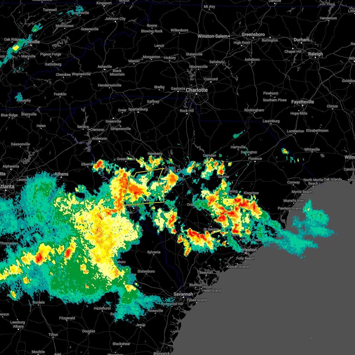 At 703 pm edt, a severe thunderstorm was located 8 miles northwest of edgefield, or 21 miles north of evans, moving east at 40 mph (radar indicated). Hazards include 60 mph wind gusts. expect damage to trees and powerlines At 703 pm edt, a severe thunderstorm was located 8 miles northwest of edgefield, or 21 miles north of evans, moving east at 40 mph (radar indicated). Hazards include 60 mph wind gusts. expect damage to trees and powerlines
|
| 4/5/2022 6:23 PM EDT |
 The severe thunderstorm warning for central barnwell, central aiken and western orangeburg counties will expire at 630 pm edt, the storm which prompted the warning has moved out of the area. therefore, the warning will be allowed to expire but a severe thunderstorm warning is still in effect in aiken, barnwell and orangeburg counties. a tornado watch remains in effect until 900 pm edt for east central georgia, and central south carolina. The severe thunderstorm warning for central barnwell, central aiken and western orangeburg counties will expire at 630 pm edt, the storm which prompted the warning has moved out of the area. therefore, the warning will be allowed to expire but a severe thunderstorm warning is still in effect in aiken, barnwell and orangeburg counties. a tornado watch remains in effect until 900 pm edt for east central georgia, and central south carolina.
|
| 4/5/2022 6:05 PM EDT |
 At 604 pm edt, a severe thunderstorm was located near aiken state park, or 10 miles east of aiken mall, moving northeast at 40 mph (radar indicated). Hazards include 60 mph wind gusts. Expect damage to trees and powerlines. Locations impacted include, aiken, savannah river site, williston, new ellenton, jackson, citizens park, aiken state park, wagener, perry, elko, windsor, aiken gopher tortoise heritage preserve, perry airport, savannah river site badge office and savannah river site h canyon. At 604 pm edt, a severe thunderstorm was located near aiken state park, or 10 miles east of aiken mall, moving northeast at 40 mph (radar indicated). Hazards include 60 mph wind gusts. Expect damage to trees and powerlines. Locations impacted include, aiken, savannah river site, williston, new ellenton, jackson, citizens park, aiken state park, wagener, perry, elko, windsor, aiken gopher tortoise heritage preserve, perry airport, savannah river site badge office and savannah river site h canyon.
|
| 4/5/2022 5:43 PM EDT |
 At 543 pm edt, a severe thunderstorm was located near new ellenton, or 7 miles southwest of aiken mall, moving northeast at 40 mph (radar indicated). Hazards include 60 mph wind gusts. expect damage to trees and powerlines At 543 pm edt, a severe thunderstorm was located near new ellenton, or 7 miles southwest of aiken mall, moving northeast at 40 mph (radar indicated). Hazards include 60 mph wind gusts. expect damage to trees and powerlines
|
| 4/5/2022 5:23 PM EDT |
 At 523 pm edt, a severe thunderstorm was located near ridge spring, or 12 miles southwest of batesburg-leesville, moving northeast at 55 mph (radar indicated). Hazards include 60 mph wind gusts. expect damage to trees and powerlines At 523 pm edt, a severe thunderstorm was located near ridge spring, or 12 miles southwest of batesburg-leesville, moving northeast at 55 mph (radar indicated). Hazards include 60 mph wind gusts. expect damage to trees and powerlines
|
| 4/5/2022 3:02 PM EDT |
 At 301 pm edt, a severe thunderstorm capable of producing a tornado was located over usc aiken, or over aiken, moving northeast at 35 mph (radar indicated rotation). Hazards include tornado. Flying debris will be dangerous to those caught without shelter. mobile homes will be damaged or destroyed. damage to roofs, windows, and vehicles will occur. tree damage is likely. this dangerous storm will be near, aiken municipal airport around 310 pm edt. other locations impacted by this tornadic thunderstorm include new holland and hopeland gardens. This includes interstate 20 in south carolina between mile markers 17 and 34. At 301 pm edt, a severe thunderstorm capable of producing a tornado was located over usc aiken, or over aiken, moving northeast at 35 mph (radar indicated rotation). Hazards include tornado. Flying debris will be dangerous to those caught without shelter. mobile homes will be damaged or destroyed. damage to roofs, windows, and vehicles will occur. tree damage is likely. this dangerous storm will be near, aiken municipal airport around 310 pm edt. other locations impacted by this tornadic thunderstorm include new holland and hopeland gardens. This includes interstate 20 in south carolina between mile markers 17 and 34.
|
| 4/5/2022 2:55 PM EDT |
 At 255 pm edt, a severe thunderstorm capable of producing a tornado was located over graniteville, or near aiken, moving northeast at 35 mph (radar indicated rotation). Hazards include tornado. Flying debris will be dangerous to those caught without shelter. mobile homes will be damaged or destroyed. damage to roofs, windows, and vehicles will occur. tree damage is likely. this dangerous storm will be near, aiken and citizens park around 300 pm edt. aiken municipal airport around 310 pm edt. other locations impacted by this tornadic thunderstorm include vaucluse, burnettown, new holland and hopeland gardens. This includes interstate 20 in south carolina between mile markers 11 and 34. At 255 pm edt, a severe thunderstorm capable of producing a tornado was located over graniteville, or near aiken, moving northeast at 35 mph (radar indicated rotation). Hazards include tornado. Flying debris will be dangerous to those caught without shelter. mobile homes will be damaged or destroyed. damage to roofs, windows, and vehicles will occur. tree damage is likely. this dangerous storm will be near, aiken and citizens park around 300 pm edt. aiken municipal airport around 310 pm edt. other locations impacted by this tornadic thunderstorm include vaucluse, burnettown, new holland and hopeland gardens. This includes interstate 20 in south carolina between mile markers 11 and 34.
|
| 4/5/2022 2:50 PM EDT |
 At 249 pm edt, a severe thunderstorm was located over graniteville, or near clearwater, moving northeast at 45 mph (radar indicated). Hazards include 60 mph wind gusts. Expect damage to trees and powerlines. locations impacted include, aiken, north augusta, clearwater, aiken mall, belvedere, usc aiken, citizens park, aiken municipal airport, gloverville, graniteville, burnettown, hopeland gardens and vaucluse. this includes the following highways, interstate 20 in south carolina between mile markers 6 and 31. Interstate 520 in south carolina between mile markers 20 and 23. At 249 pm edt, a severe thunderstorm was located over graniteville, or near clearwater, moving northeast at 45 mph (radar indicated). Hazards include 60 mph wind gusts. Expect damage to trees and powerlines. locations impacted include, aiken, north augusta, clearwater, aiken mall, belvedere, usc aiken, citizens park, aiken municipal airport, gloverville, graniteville, burnettown, hopeland gardens and vaucluse. this includes the following highways, interstate 20 in south carolina between mile markers 6 and 31. Interstate 520 in south carolina between mile markers 20 and 23.
|
| 4/5/2022 2:45 PM EDT |
 At 243 pm edt, a severe thunderstorm was located over clearwater, moving northeast at 45 mph (radar indicated). Hazards include 60 mph wind gusts. expect damage to trees and powerlines At 243 pm edt, a severe thunderstorm was located over clearwater, moving northeast at 45 mph (radar indicated). Hazards include 60 mph wind gusts. expect damage to trees and powerlines
|
| 8/17/2021 8:40 PM EDT |
 At 840 pm edt, a severe thunderstorm was located over new ellenton, or near aiken mall, moving northeast at 35 mph (radar indicated). Hazards include 60 mph wind gusts. expect damage to roofs, siding, and trees At 840 pm edt, a severe thunderstorm was located over new ellenton, or near aiken mall, moving northeast at 35 mph (radar indicated). Hazards include 60 mph wind gusts. expect damage to roofs, siding, and trees
|
| 7/18/2021 9:09 PM EDT |
 At 906 pm edt, severe thunderstorms were located along a line extending from ridge spring to 11 miles north of blackville, moving northeast at 30 mph (radar indicated). Hazards include 60 mph wind gusts. Expect damage to roofs, siding, and trees. locations impacted include, aiken, lexington, batesburg-leesville, red bank, edgefield, saluda, johnston, gaston, ridge spring, edgefield county airport, saluda county airport, aiken municipal airport, aiken state park, swansea, wagener, north, pelion, gilbert, summit and salley. This includes interstate 20 in south carolina between mile markers 14 and 54. At 906 pm edt, severe thunderstorms were located along a line extending from ridge spring to 11 miles north of blackville, moving northeast at 30 mph (radar indicated). Hazards include 60 mph wind gusts. Expect damage to roofs, siding, and trees. locations impacted include, aiken, lexington, batesburg-leesville, red bank, edgefield, saluda, johnston, gaston, ridge spring, edgefield county airport, saluda county airport, aiken municipal airport, aiken state park, swansea, wagener, north, pelion, gilbert, summit and salley. This includes interstate 20 in south carolina between mile markers 14 and 54.
|
| 7/18/2021 8:35 PM EDT | Sc highway patrol reports tree in roadway at silver bluff road and sc-302. time estimated by rada in aiken county SC, 1.1 miles N of Aiken, SC |
| 7/18/2021 8:31 PM EDT |
 At 831 pm edt, severe thunderstorms were located along a line extending from near graniteville to near barnwell, moving northeast at 40 mph (radar indicated). Hazards include 60 mph wind gusts. expect damage to roofs, siding, and trees At 831 pm edt, severe thunderstorms were located along a line extending from near graniteville to near barnwell, moving northeast at 40 mph (radar indicated). Hazards include 60 mph wind gusts. expect damage to roofs, siding, and trees
|
| 5/4/2021 6:28 PM EDT |
 The severe thunderstorm warning for northern burke, richmond, barnwell, southeastern lexington, aiken and northwestern orangeburg counties will expire at 630 pm edt, the storms which prompted the warning have weakened below severe limits or have exited the warned area. therefore, the warning will be allowed to expire. however gusty winds and heavy rain are still possible with these thunderstorms. a severe thunderstorm watch remains in effect until 900 pm edt for east central georgia, and central south carolina. to report severe weather, contact your nearest law enforcement agency. they will relay your report to the national weather service columbia. The severe thunderstorm warning for northern burke, richmond, barnwell, southeastern lexington, aiken and northwestern orangeburg counties will expire at 630 pm edt, the storms which prompted the warning have weakened below severe limits or have exited the warned area. therefore, the warning will be allowed to expire. however gusty winds and heavy rain are still possible with these thunderstorms. a severe thunderstorm watch remains in effect until 900 pm edt for east central georgia, and central south carolina. to report severe weather, contact your nearest law enforcement agency. they will relay your report to the national weather service columbia.
|
| 5/4/2021 5:57 PM EDT |
 At 556 pm edt, severe thunderstorms were located along a line extending from 11 miles northwest of orangeburg to near hephzibah, moving southeast at 30 mph (radar indicated). Hazards include 60 mph wind gusts. Expect damage to roofs, siding, and trees. locations impacted include, aiken, north augusta, waynesboro, savannah river site, aiken mall, plant vogtle, clearwater, hephzibah, williston, blackville, new ellenton, jackson, gaston, south augusta, citizens park, augusta regional airport, alexander, burke county airport, mcbean and gloverville. this includes the following highways, interstate 520 in georgia between mile markers 6 and 15. Interstate 520 in south carolina near mile marker 16. At 556 pm edt, severe thunderstorms were located along a line extending from 11 miles northwest of orangeburg to near hephzibah, moving southeast at 30 mph (radar indicated). Hazards include 60 mph wind gusts. Expect damage to roofs, siding, and trees. locations impacted include, aiken, north augusta, waynesboro, savannah river site, aiken mall, plant vogtle, clearwater, hephzibah, williston, blackville, new ellenton, jackson, gaston, south augusta, citizens park, augusta regional airport, alexander, burke county airport, mcbean and gloverville. this includes the following highways, interstate 520 in georgia between mile markers 6 and 15. Interstate 520 in south carolina near mile marker 16.
|
| 5/4/2021 5:57 PM EDT |
 At 529 pm edt, severe thunderstorms were located along a line extending from 8 miles southwest of red bank to near hephzibah, moving southeast at 25 mph. additional isolated severe thunderstorms were also located ahead of this line (radar indicated). Hazards include 60 mph wind gusts. expect damage to roofs, siding, and trees At 529 pm edt, severe thunderstorms were located along a line extending from 8 miles southwest of red bank to near hephzibah, moving southeast at 25 mph. additional isolated severe thunderstorms were also located ahead of this line (radar indicated). Hazards include 60 mph wind gusts. expect damage to roofs, siding, and trees
|
| 5/4/2021 5:33 PM EDT | Sc highway patrol reports tree down along trolly line rd near proud pacer. time estimated by rada in aiken county SC, 4.1 miles SE of Aiken, SC |
| 5/4/2021 5:30 PM EDT |
 At 529 pm edt, severe thunderstorms were located along a line extending from 8 miles southwest of red bank to near hephzibah, moving southeast at 25 mph. additional isolated severe thunderstorms were also located ahead of this line (radar indicated). Hazards include 60 mph wind gusts. expect damage to roofs, siding, and trees At 529 pm edt, severe thunderstorms were located along a line extending from 8 miles southwest of red bank to near hephzibah, moving southeast at 25 mph. additional isolated severe thunderstorms were also located ahead of this line (radar indicated). Hazards include 60 mph wind gusts. expect damage to roofs, siding, and trees
|
| 3/31/2021 5:39 PM EDT |
 At 538 pm edt, a severe thunderstorm was located near aiken municipal airport, or 12 miles north of aiken, moving east at 45 mph (radar indicated). Hazards include 60 mph wind gusts and quarter size hail. Hail damage to vehicles is expected. Expect wind damage to roofs, siding, and trees. At 538 pm edt, a severe thunderstorm was located near aiken municipal airport, or 12 miles north of aiken, moving east at 45 mph (radar indicated). Hazards include 60 mph wind gusts and quarter size hail. Hail damage to vehicles is expected. Expect wind damage to roofs, siding, and trees.
|
| 3/31/2021 5:35 PM EDT | Golf Ball sized hail reported 8.8 miles SSE of Aiken, SC, video sent in via twitter shows upwards of golf ball sized hail falling on lake shore dr off hwy 19. time estimated from radar. |
| 8/5/2020 6:27 PM EDT |
 At 627 pm edt, a severe thunderstorm was located near clearwater, moving northeast at 15 mph (radar indicated). Hazards include 60 mph wind gusts and quarter size hail. Hail damage to vehicles is expected. expect wind damage to roofs, siding, and trees. locations impacted include, aiken, north augusta, evans, martinez, augusta, clearwater, belvedere, new ellenton, jackson, glendale, south augusta, midtown, summerville, augusta mall, daniel field, village plaza shopping center, augusta national golf club, gloverville, burnettown and west end augusta. this includes the following highways, interstate 20 in georgia between mile markers 191 and 201. interstate 20 in south carolina between mile markers 0 and 8. interstate 520 in georgia between mile markers 1 and 8, and between mile markers 11 and 15. Interstate 520 in south carolina between mile markers 16 and 23. At 627 pm edt, a severe thunderstorm was located near clearwater, moving northeast at 15 mph (radar indicated). Hazards include 60 mph wind gusts and quarter size hail. Hail damage to vehicles is expected. expect wind damage to roofs, siding, and trees. locations impacted include, aiken, north augusta, evans, martinez, augusta, clearwater, belvedere, new ellenton, jackson, glendale, south augusta, midtown, summerville, augusta mall, daniel field, village plaza shopping center, augusta national golf club, gloverville, burnettown and west end augusta. this includes the following highways, interstate 20 in georgia between mile markers 191 and 201. interstate 20 in south carolina between mile markers 0 and 8. interstate 520 in georgia between mile markers 1 and 8, and between mile markers 11 and 15. Interstate 520 in south carolina between mile markers 16 and 23.
|
| 8/5/2020 5:57 PM EDT |
 At 556 pm edt, a severe thunderstorm was located over augusta regional airport, or near augusta, moving northeast at 15 mph (radar indicated). Hazards include 60 mph wind gusts and quarter size hail. Hail damage to vehicles is expected. Expect wind damage to roofs, siding, and trees. At 556 pm edt, a severe thunderstorm was located over augusta regional airport, or near augusta, moving northeast at 15 mph (radar indicated). Hazards include 60 mph wind gusts and quarter size hail. Hail damage to vehicles is expected. Expect wind damage to roofs, siding, and trees.
|
| 6/30/2020 7:59 PM EDT |
 At 758 pm edt, a severe thunderstorm was located over clearwater, moving east at 20 mph (radar indicated). Hazards include 60 mph wind gusts. Expect damage to roofs, siding, and trees. locations impacted include, aiken, north augusta, clearwater, aiken mall, belvedere, new ellenton, jackson, citizens park, gloverville, graniteville, burnettown, hopeland gardens, savannah bluffs heritage preserve, redcliffe plantation state historic site, boyd pond park, new savannah bluff lock & dam park and riverside village at hammond`s ferry. this includes the following highways, interstate 20 in south carolina between mile markers 1 and 9. Interstate 520 in south carolina between mile markers 16 and 23. At 758 pm edt, a severe thunderstorm was located over clearwater, moving east at 20 mph (radar indicated). Hazards include 60 mph wind gusts. Expect damage to roofs, siding, and trees. locations impacted include, aiken, north augusta, clearwater, aiken mall, belvedere, new ellenton, jackson, citizens park, gloverville, graniteville, burnettown, hopeland gardens, savannah bluffs heritage preserve, redcliffe plantation state historic site, boyd pond park, new savannah bluff lock & dam park and riverside village at hammond`s ferry. this includes the following highways, interstate 20 in south carolina between mile markers 1 and 9. Interstate 520 in south carolina between mile markers 16 and 23.
|
| 6/30/2020 7:38 PM EDT |
 At 737 pm edt, a severe thunderstorm was located over augusta national golf club, or near north augusta, moving southeast at 25 mph (radar indicated). Hazards include 60 mph wind gusts. expect damage to roofs, siding, and trees At 737 pm edt, a severe thunderstorm was located over augusta national golf club, or near north augusta, moving southeast at 25 mph (radar indicated). Hazards include 60 mph wind gusts. expect damage to roofs, siding, and trees
|
| 6/30/2020 7:38 PM EDT |
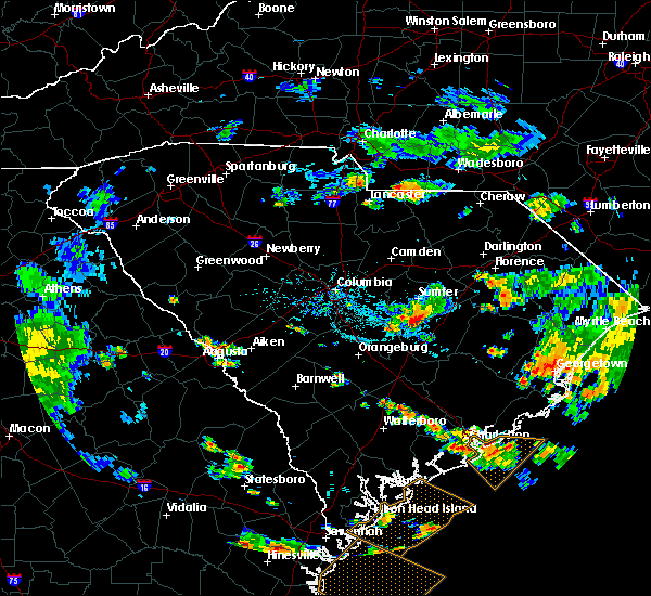 At 737 pm edt, a severe thunderstorm was located over augusta national golf club, or near north augusta, moving southeast at 25 mph (radar indicated). Hazards include 60 mph wind gusts. expect damage to roofs, siding, and trees At 737 pm edt, a severe thunderstorm was located over augusta national golf club, or near north augusta, moving southeast at 25 mph (radar indicated). Hazards include 60 mph wind gusts. expect damage to roofs, siding, and trees
|
| 6/28/2020 9:00 PM EDT | Powerlines down on columbia ave. time estimated from rada in aiken county SC, 2.7 miles SSW of Aiken, SC |
| 6/28/2020 8:51 PM EDT |
 At 851 pm edt, a severe thunderstorm was located near aiken municipal airport, or 11 miles northeast of aiken, moving southeast at 25 mph (radar indicated). Hazards include 60 mph wind gusts. Expect damage to roofs, siding, and trees. locations impacted include, aiken, edgefield, johnston, ridge spring, usc aiken, edgefield county airport, citizens park, aiken municipal airport, aiken state park, wagener, salley, monetta, perry, trenton, windsor, strom thurmond high school, thor, vaucluse, new holland and edgefield federal correction institution. This includes interstate 20 in south carolina between mile markers 13 and 38. At 851 pm edt, a severe thunderstorm was located near aiken municipal airport, or 11 miles northeast of aiken, moving southeast at 25 mph (radar indicated). Hazards include 60 mph wind gusts. Expect damage to roofs, siding, and trees. locations impacted include, aiken, edgefield, johnston, ridge spring, usc aiken, edgefield county airport, citizens park, aiken municipal airport, aiken state park, wagener, salley, monetta, perry, trenton, windsor, strom thurmond high school, thor, vaucluse, new holland and edgefield federal correction institution. This includes interstate 20 in south carolina between mile markers 13 and 38.
|
| 6/28/2020 8:38 PM EDT |
 At 838 pm edt, a severe thunderstorm was located near aiken municipal airport, or 12 miles north of aiken, moving southeast at 25 mph (radar indicated). Hazards include 60 mph wind gusts. expect damage to roofs, siding, and trees At 838 pm edt, a severe thunderstorm was located near aiken municipal airport, or 12 miles north of aiken, moving southeast at 25 mph (radar indicated). Hazards include 60 mph wind gusts. expect damage to roofs, siding, and trees
|
| 6/27/2020 8:20 PM EDT | Tree in roadway at boggy gut road and us-278. time estimated from rada in aiken county SC, 12.9 miles NNW of Aiken, SC |
| 6/27/2020 7:58 PM EDT | Trees down at atomic road and silver bluff roa in aiken county SC, 12.1 miles NNE of Aiken, SC |
| 6/27/2020 7:49 PM EDT | Tree in roadway at croft mill road and university parkwa in aiken county SC, 3.4 miles SSE of Aiken, SC |
| 6/27/2020 7:48 PM EDT | Tree in roadway at old dibble road and woodward driv in aiken county SC, 5.4 miles W of Aiken, SC |
| 6/27/2020 7:47 PM EDT |
 At 747 pm edt, severe thunderstorms were located along a line extending from near edgefield to daniel field to near harlem, moving east at 30 mph (radar indicated). Hazards include 60 mph wind gusts. Expect damage to roofs, siding, and trees. locations impacted include, aiken, north augusta, clearwater, hephzibah, jackson, usc aiken, mcbean, gloverville, augusta regional airport, graniteville, burnettown, blythe, keysville, new savannah bluff lock & dam park, westover, phinizy swamp nature park, vaucluse, audubon`s silver bluff sanctuary, pea patch aerodrome and bennock mill. this includes the following highways, interstate 20 in south carolina between mile markers 14 and 18. interstate 520 in georgia between mile markers 8 and 15. Interstate 520 in south carolina near mile marker 16. At 747 pm edt, severe thunderstorms were located along a line extending from near edgefield to daniel field to near harlem, moving east at 30 mph (radar indicated). Hazards include 60 mph wind gusts. Expect damage to roofs, siding, and trees. locations impacted include, aiken, north augusta, clearwater, hephzibah, jackson, usc aiken, mcbean, gloverville, augusta regional airport, graniteville, burnettown, blythe, keysville, new savannah bluff lock & dam park, westover, phinizy swamp nature park, vaucluse, audubon`s silver bluff sanctuary, pea patch aerodrome and bennock mill. this includes the following highways, interstate 20 in south carolina between mile markers 14 and 18. interstate 520 in georgia between mile markers 8 and 15. Interstate 520 in south carolina near mile marker 16.
|
| 6/27/2020 7:42 PM EDT |
 At 742 pm edt, severe thunderstorms were located along a line extending from near edgefield county airport to near jackson to 9 miles north of gough, moving east at 40 mph (radar indicated). Hazards include 60 mph wind gusts. expect damage to roofs, siding, and trees At 742 pm edt, severe thunderstorms were located along a line extending from near edgefield county airport to near jackson to 9 miles north of gough, moving east at 40 mph (radar indicated). Hazards include 60 mph wind gusts. expect damage to roofs, siding, and trees
|
| 6/27/2020 7:23 PM EDT |
 At 721 pm edt, severe thunderstorms were located along a line extending from 7 miles west of edgefield to near grovetown to near thomson, moving east at 30 mph (radar indicated). Hazards include 60 mph wind gusts. Expect damage to roofs, siding, and trees. a wind gust to 54 mph was already reported with this line of thundertorms in thomson. locations impacted include, aiken, north augusta, grovetown, evans, thomson, fort gordon, augusta, clearwater, martinez, belvedere, edgefield, hephzibah, harlem, johnston, jackson, glendale, south augusta, clarks hill recreation area, edgefield county airport and summerville. this includes the following highways, interstate 20 in georgia between mile markers 172 and 201. interstate 20 in south carolina between mile markers 0 and 20. interstate 520 in georgia between mile markers 1 and 15. Interstate 520 in south carolina between mile markers 16 and 23. At 721 pm edt, severe thunderstorms were located along a line extending from 7 miles west of edgefield to near grovetown to near thomson, moving east at 30 mph (radar indicated). Hazards include 60 mph wind gusts. Expect damage to roofs, siding, and trees. a wind gust to 54 mph was already reported with this line of thundertorms in thomson. locations impacted include, aiken, north augusta, grovetown, evans, thomson, fort gordon, augusta, clearwater, martinez, belvedere, edgefield, hephzibah, harlem, johnston, jackson, glendale, south augusta, clarks hill recreation area, edgefield county airport and summerville. this includes the following highways, interstate 20 in georgia between mile markers 172 and 201. interstate 20 in south carolina between mile markers 0 and 20. interstate 520 in georgia between mile markers 1 and 15. Interstate 520 in south carolina between mile markers 16 and 23.
|
| 6/27/2020 6:57 PM EDT |
 At 656 pm edt, severe thunderstorms were located along a line extending from near hamilton branch state park to near appling to warrenton, moving east at 30 mph. a wind gust over 50 mph was recorded in thomson at the airport (radar indicated). Hazards include 60 mph wind gusts. expect damage to roofs, siding, and trees At 656 pm edt, severe thunderstorms were located along a line extending from near hamilton branch state park to near appling to warrenton, moving east at 30 mph. a wind gust over 50 mph was recorded in thomson at the airport (radar indicated). Hazards include 60 mph wind gusts. expect damage to roofs, siding, and trees
|
| 6/19/2020 9:59 PM EDT |
 At 945 pm edt, a severe thunderstorm was located near martinez, moving southeast at 30 mph (radar indicated). Hazards include 60 mph wind gusts and quarter size hail. Hail damage to vehicles is expected. Expect wind damage to roofs, siding, and trees. At 945 pm edt, a severe thunderstorm was located near martinez, moving southeast at 30 mph (radar indicated). Hazards include 60 mph wind gusts and quarter size hail. Hail damage to vehicles is expected. Expect wind damage to roofs, siding, and trees.
|
| 6/19/2020 9:45 PM EDT |
 At 945 pm edt, a severe thunderstorm was located near martinez, moving southeast at 30 mph (radar indicated). Hazards include 60 mph wind gusts and quarter size hail. Hail damage to vehicles is expected. Expect wind damage to roofs, siding, and trees. At 945 pm edt, a severe thunderstorm was located near martinez, moving southeast at 30 mph (radar indicated). Hazards include 60 mph wind gusts and quarter size hail. Hail damage to vehicles is expected. Expect wind damage to roofs, siding, and trees.
|
| 5/22/2020 4:14 PM EDT | Quarter sized hail reported 10 miles SSW of Aiken, SC, quarter size hail reported at a convenience store on us hwy 1 near exit 22 on interstate 20. |
| 5/22/2020 4:13 PM EDT |
 At 412 pm edt, a severe thunderstorm was located over aiken municipal airport, or near aiken, moving east at 20 mph (radar indicated). Hazards include 60 mph wind gusts and half dollar size hail. Hail damage to vehicles is expected. Expect wind damage to roofs, siding, and trees. At 412 pm edt, a severe thunderstorm was located over aiken municipal airport, or near aiken, moving east at 20 mph (radar indicated). Hazards include 60 mph wind gusts and half dollar size hail. Hail damage to vehicles is expected. Expect wind damage to roofs, siding, and trees.
|
| 4/13/2020 5:06 AM EDT |
 At 505 am edt, severe thunderstorms were located along a line extending from 7 miles northwest of batesburg-leesville to near aiken mall, moving northeast at 45 mph (radar indicated). Hazards include 70 mph wind gusts and penny size hail. Expect considerable tree damage. Damage is likely to mobile homes, roofs, and outbuildings. At 505 am edt, severe thunderstorms were located along a line extending from 7 miles northwest of batesburg-leesville to near aiken mall, moving northeast at 45 mph (radar indicated). Hazards include 70 mph wind gusts and penny size hail. Expect considerable tree damage. Damage is likely to mobile homes, roofs, and outbuildings.
|
| 3/18/2020 7:14 PM EDT |
 At 713 pm edt, a severe thunderstorm was located over clearwater, moving northeast at 20 mph (radar indicated). Hazards include 60 mph wind gusts and penny size hail. expect damage to roofs, siding, and trees At 713 pm edt, a severe thunderstorm was located over clearwater, moving northeast at 20 mph (radar indicated). Hazards include 60 mph wind gusts and penny size hail. expect damage to roofs, siding, and trees
|
| 2/6/2020 4:01 PM EST |
 At 400 pm est, severe thunderstorms were located along a line extending from irmo to jackson, moving northeast at 70 mph (radar indicated). Hazards include 60 mph wind gusts. Expect damage to roofs, siding, and trees. locations impacted include, aiken, waynesboro, aiken mall, plant vogtle, hephzibah, new ellenton, jackson, gough, citizens park, augusta regional airport, burke county airport, usc aiken, aiken municipal airport, mcbean, gloverville, aiken state park, burnettown, wagener, pelion and gilbert. This includes interstate 20 in south carolina between mile markers 19 and 51. At 400 pm est, severe thunderstorms were located along a line extending from irmo to jackson, moving northeast at 70 mph (radar indicated). Hazards include 60 mph wind gusts. Expect damage to roofs, siding, and trees. locations impacted include, aiken, waynesboro, aiken mall, plant vogtle, hephzibah, new ellenton, jackson, gough, citizens park, augusta regional airport, burke county airport, usc aiken, aiken municipal airport, mcbean, gloverville, aiken state park, burnettown, wagener, pelion and gilbert. This includes interstate 20 in south carolina between mile markers 19 and 51.
|
| 2/6/2020 3:38 PM EST |
 At 337 pm est, severe thunderstorms were located along a line extending from near batesburg-leesville to near gough, moving northeast at 70 mph (radar indicated). Hazards include 60 mph wind gusts. expect damage to roofs, siding, and trees At 337 pm est, severe thunderstorms were located along a line extending from near batesburg-leesville to near gough, moving northeast at 70 mph (radar indicated). Hazards include 60 mph wind gusts. expect damage to roofs, siding, and trees
|
| 2/6/2020 3:23 PM EST |
 A severe thunderstorm warning remains in effect until 345 pm est for central edgefield. western lexington. northern aiken and southeastern saluda counties. At 323 pm est, severe thunderstorms were located along a line extending from near monticello to near lexington to 7 miles southeast of batesburg-leesville, moving northeast at 70 mph. A severe thunderstorm warning remains in effect until 345 pm est for central edgefield. western lexington. northern aiken and southeastern saluda counties. At 323 pm est, severe thunderstorms were located along a line extending from near monticello to near lexington to 7 miles southeast of batesburg-leesville, moving northeast at 70 mph.
|
| 2/6/2020 3:14 PM EST |
 At 314 pm est, severe thunderstorms were located along a line extending from clarks hill recreation area to 7 miles northeast of wrens, moving east at 55 mph (radar indicated). Hazards include 60 mph wind gusts. expect damage to roofs, siding, and trees At 314 pm est, severe thunderstorms were located along a line extending from clarks hill recreation area to 7 miles northeast of wrens, moving east at 55 mph (radar indicated). Hazards include 60 mph wind gusts. expect damage to roofs, siding, and trees
|
| 2/6/2020 2:59 PM EST |
 At 259 pm est, severe thunderstorms were located along a line extending from 8 miles southwest of prosperity to near ridge spring to near usc aiken, moving northeast at 70 mph (radar indicated). Hazards include 60 mph wind gusts. expect damage to roofs, siding, and trees At 259 pm est, severe thunderstorms were located along a line extending from 8 miles southwest of prosperity to near ridge spring to near usc aiken, moving northeast at 70 mph (radar indicated). Hazards include 60 mph wind gusts. expect damage to roofs, siding, and trees
|
| 2/6/2020 2:54 PM EST | Multiple trees down on indian spring road and smith lane. time estimated by rada in aiken county SC, 8.3 miles SSE of Aiken, SC |
| 2/6/2020 2:53 PM EST | County emergency manager reports significant damage at stable view farms on springfield church road. 5 stables were destroyed with multiple trees and power lines dow in aiken county SC, 8.5 miles SSE of Aiken, SC |
| 1/11/2020 10:13 PM EST |
 At 1012 pm est, severe thunderstorms were located along a line extending from 12 miles southwest of gaston to near perkins, moving northeast at 50 mph (law enforcement reported multiple trees and power lines down). Hazards include 60 mph wind gusts. Expect damage to roofs, siding, and trees. locations impacted include, aiken, waynesboro, savannah river site, aiken mall, plant vogtle, williston, new ellenton, jackson, alexander, burke county airport, usc aiken, citizens park, aiken municipal airport, aiken state park, gloverville, wagener, pelion, salley, perry and girard. This includes interstate 20 in south carolina between mile markers 22 and 40. At 1012 pm est, severe thunderstorms were located along a line extending from 12 miles southwest of gaston to near perkins, moving northeast at 50 mph (law enforcement reported multiple trees and power lines down). Hazards include 60 mph wind gusts. Expect damage to roofs, siding, and trees. locations impacted include, aiken, waynesboro, savannah river site, aiken mall, plant vogtle, williston, new ellenton, jackson, alexander, burke county airport, usc aiken, citizens park, aiken municipal airport, aiken state park, gloverville, wagener, pelion, salley, perry and girard. This includes interstate 20 in south carolina between mile markers 22 and 40.
|
| 1/11/2020 9:46 PM EST |
 At 946 pm est, severe thunderstorms were located along a line extending from near johnston to near waynesboro, moving northeast at 50 mph (radar indicated). Hazards include 60 mph wind gusts. expect damage to roofs, siding, and trees At 946 pm est, severe thunderstorms were located along a line extending from near johnston to near waynesboro, moving northeast at 50 mph (radar indicated). Hazards include 60 mph wind gusts. expect damage to roofs, siding, and trees
|
| 1/3/2020 6:27 PM EST |
 At 627 pm est, a severe thunderstorm was located near aiken municipal airport, or 7 miles east of aiken, moving northeast at 55 mph (radar indicated). Hazards include 60 mph wind gusts. Expect damage to roofs, siding, and trees. locations impacted include, aiken, aiken mall, new ellenton, usc aiken, citizens park, aiken municipal airport, aiken state park, wagener, salley, perry, windsor, perry airport, hopeland gardens, thor, camp kinard, steedman, new holland, samaria fire station and cedar pond campground. This includes interstate 20 in south carolina between mile markers 17 and 43. At 627 pm est, a severe thunderstorm was located near aiken municipal airport, or 7 miles east of aiken, moving northeast at 55 mph (radar indicated). Hazards include 60 mph wind gusts. Expect damage to roofs, siding, and trees. locations impacted include, aiken, aiken mall, new ellenton, usc aiken, citizens park, aiken municipal airport, aiken state park, wagener, salley, perry, windsor, perry airport, hopeland gardens, thor, camp kinard, steedman, new holland, samaria fire station and cedar pond campground. This includes interstate 20 in south carolina between mile markers 17 and 43.
|
| 1/3/2020 6:19 PM EST |
 At 618 pm est, a severe thunderstorm was located over aiken mall, moving northeast at 45 mph (radar indicated). Hazards include 60 mph wind gusts. expect damage to roofs, siding, and trees At 618 pm est, a severe thunderstorm was located over aiken mall, moving northeast at 45 mph (radar indicated). Hazards include 60 mph wind gusts. expect damage to roofs, siding, and trees
|
| 10/31/2019 5:56 PM EDT |
 At 555 pm edt, severe thunderstorms were located along a line extending from near batesburg-leesville to near sardis, moving southeast at 35 mph (radar indicated). Hazards include 60 mph wind gusts. Expect damage to roofs, siding, and trees. locations impacted include, aiken, batesburg-leesville, barnwell, savannah river site, aiken mall, plant vogtle, williston, new ellenton, jackson, sardis, alexander, citizens park, aiken municipal airport, aiken state park, wagener, snelling, monetta, elko, girard and windsor. This includes interstate 20 in south carolina between mile markers 20 and 46. At 555 pm edt, severe thunderstorms were located along a line extending from near batesburg-leesville to near sardis, moving southeast at 35 mph (radar indicated). Hazards include 60 mph wind gusts. Expect damage to roofs, siding, and trees. locations impacted include, aiken, batesburg-leesville, barnwell, savannah river site, aiken mall, plant vogtle, williston, new ellenton, jackson, sardis, alexander, citizens park, aiken municipal airport, aiken state park, wagener, snelling, monetta, elko, girard and windsor. This includes interstate 20 in south carolina between mile markers 20 and 46.
|
| 10/31/2019 5:25 PM EDT |
 At 525 pm edt, severe thunderstorms were located along a line extending from 6 miles southeast of saluda to burke county airport, moving southeast at 35 mph (radar indicated). Hazards include 60 mph wind gusts. expect damage to roofs, siding, and trees At 525 pm edt, severe thunderstorms were located along a line extending from 6 miles southeast of saluda to burke county airport, moving southeast at 35 mph (radar indicated). Hazards include 60 mph wind gusts. expect damage to roofs, siding, and trees
|
| 10/31/2019 4:43 PM EDT |
 At 442 pm edt, a severe thunderstorm capable of producing a tornado was located over evans, moving northeast at 35 mph (radar indicated rotation). Hazards include tornado. Flying debris will be dangerous to those caught without shelter. mobile homes will be damaged or destroyed. damage to roofs, windows, and vehicles will occur. tree damage is likely. this dangerous storm will be near, augusta national golf club around 455 pm edt. north augusta and belvedere around 505 pm edt. other locations impacted by this tornadic thunderstorm include poverty hill, blanchard park, savannah bluffs heritage preserve, savannah rapids park, westmont, vaucluse, river island, westport, eisenhower park and riverside park. this includes the following highways, interstate 20 in georgia between mile markers 189 and 192, and between mile markers 194 and 201. interstate 20 in south carolina between mile markers 0 and 13. Interstate 520 in south carolina between mile markers 20 and 23. At 442 pm edt, a severe thunderstorm capable of producing a tornado was located over evans, moving northeast at 35 mph (radar indicated rotation). Hazards include tornado. Flying debris will be dangerous to those caught without shelter. mobile homes will be damaged or destroyed. damage to roofs, windows, and vehicles will occur. tree damage is likely. this dangerous storm will be near, augusta national golf club around 455 pm edt. north augusta and belvedere around 505 pm edt. other locations impacted by this tornadic thunderstorm include poverty hill, blanchard park, savannah bluffs heritage preserve, savannah rapids park, westmont, vaucluse, river island, westport, eisenhower park and riverside park. this includes the following highways, interstate 20 in georgia between mile markers 189 and 192, and between mile markers 194 and 201. interstate 20 in south carolina between mile markers 0 and 13. Interstate 520 in south carolina between mile markers 20 and 23.
|
| 7/31/2019 3:25 PM EDT |
 At 325 pm edt, a severe thunderstorm was located over fort gordon, moving northeast at 30 mph (radar indicated). Hazards include 60 mph wind gusts and nickel size hail. expect damage to roofs, siding, and trees At 325 pm edt, a severe thunderstorm was located over fort gordon, moving northeast at 30 mph (radar indicated). Hazards include 60 mph wind gusts and nickel size hail. expect damage to roofs, siding, and trees
|
| 7/31/2019 3:25 PM EDT |
 The national weather service in columbia has issued a * severe thunderstorm warning for. southeastern columbia county in east central georgia. central richmond county in east central georgia. southwestern edgefield county in central south carolina. West central aiken county in central south carolina. The national weather service in columbia has issued a * severe thunderstorm warning for. southeastern columbia county in east central georgia. central richmond county in east central georgia. southwestern edgefield county in central south carolina. West central aiken county in central south carolina.
|
| 6/24/2019 9:24 PM EDT |
 At 923 pm edt, severe thunderstorms were located along a line extending from near mistletoe state park to near warrenton, moving east at 60 mph (radar indicated). Hazards include 60 mph wind gusts and penny size hail. expect damage to roofs, siding, and trees At 923 pm edt, severe thunderstorms were located along a line extending from near mistletoe state park to near warrenton, moving east at 60 mph (radar indicated). Hazards include 60 mph wind gusts and penny size hail. expect damage to roofs, siding, and trees
|
| 6/22/2019 4:38 AM EDT |
 The severe thunderstorm warning for southwestern fairfield, lexington and central aiken counties will expire at 445 am edt, the storms which prompted the warning have moved out of the area. therefore, the warning will be allowed to expire. to report severe weather, contact your nearest law enforcement agency. they will relay your report to the national weather service columbia. The severe thunderstorm warning for southwestern fairfield, lexington and central aiken counties will expire at 445 am edt, the storms which prompted the warning have moved out of the area. therefore, the warning will be allowed to expire. to report severe weather, contact your nearest law enforcement agency. they will relay your report to the national weather service columbia.
|
| 6/22/2019 4:11 AM EDT |
 At 410 am edt, severe thunderstorms were located along a line extending from near oak grove to near new ellenton, moving east at 30 mph (radar indicated). Hazards include 70 mph wind gusts. Expect considerable tree damage. damage is likely to mobile homes, roofs, and outbuildings. locations impacted include, columbia, aiken, lexington, west columbia, cayce, irmo, springdale, aiken mall, lake murray dam, oak grove, red bank, st. andrews, south congaree, pine ridge, new ellenton, gaston, west columbia riverwalk, citizens park, usc aiken and riverbanks zoo. this includes the following highways, interstate 126 between mile markers 0 and 2. interstate 20 in south carolina between mile markers 24 and 64. interstate 26 between mile markers 24 and 64, between mile markers 24 and 64. Interstate 77 between mile markers 0 and 2. At 410 am edt, severe thunderstorms were located along a line extending from near oak grove to near new ellenton, moving east at 30 mph (radar indicated). Hazards include 70 mph wind gusts. Expect considerable tree damage. damage is likely to mobile homes, roofs, and outbuildings. locations impacted include, columbia, aiken, lexington, west columbia, cayce, irmo, springdale, aiken mall, lake murray dam, oak grove, red bank, st. andrews, south congaree, pine ridge, new ellenton, gaston, west columbia riverwalk, citizens park, usc aiken and riverbanks zoo. this includes the following highways, interstate 126 between mile markers 0 and 2. interstate 20 in south carolina between mile markers 24 and 64. interstate 26 between mile markers 24 and 64, between mile markers 24 and 64. Interstate 77 between mile markers 0 and 2.
|
| 6/22/2019 4:10 AM EDT | Highway patrol reported trees down wire rd and newbidge rd near aike in aiken county SC, 4.4 miles SW of Aiken, SC |
| 6/22/2019 3:44 AM EDT |
 At 343 am edt, severe thunderstorms were located along a line extending from near batesburg-leesville to graniteville, moving east at 50 mph (radar indicated). Hazards include 60 mph wind gusts and penny size hail. expect damage to roofs, siding, and trees At 343 am edt, severe thunderstorms were located along a line extending from near batesburg-leesville to graniteville, moving east at 50 mph (radar indicated). Hazards include 60 mph wind gusts and penny size hail. expect damage to roofs, siding, and trees
|
| 6/20/2019 5:30 PM EDT |
 The national weather service in columbia has issued a * severe thunderstorm warning for. burke county in east central georgia. richmond county in east central georgia. barnwell county in central south carolina. West central bamberg county in central south carolina. The national weather service in columbia has issued a * severe thunderstorm warning for. burke county in east central georgia. richmond county in east central georgia. barnwell county in central south carolina. West central bamberg county in central south carolina.
|
| 6/20/2019 5:30 PM EDT |
 At 529 pm edt, severe thunderstorms were located along a line extending from near new ellenton to near gough, moving east at 45 mph (radar indicated). Hazards include 70 mph wind gusts. Expect considerable tree damage. Damage is likely to mobile homes, roofs, and outbuildings. At 529 pm edt, severe thunderstorms were located along a line extending from near new ellenton to near gough, moving east at 45 mph (radar indicated). Hazards include 70 mph wind gusts. Expect considerable tree damage. Damage is likely to mobile homes, roofs, and outbuildings.
|
| 6/20/2019 5:12 PM EDT | Schp reported multiple trees with power lines down on conger drive... evans drive and ivy circle. time estimated by rada in aiken county SC, 0.4 miles NNW of Aiken, SC |
| 6/20/2019 5:00 PM EDT |
 At 459 pm edt, severe thunderstorms were located along a line extending from belvedere to near gibson, moving east at 60 mph (radar indicated). Hazards include 70 mph wind gusts. Expect considerable tree damage. Damage is likely to mobile homes, roofs, and outbuildings. At 459 pm edt, severe thunderstorms were located along a line extending from belvedere to near gibson, moving east at 60 mph (radar indicated). Hazards include 70 mph wind gusts. Expect considerable tree damage. Damage is likely to mobile homes, roofs, and outbuildings.
|
| 6/20/2019 4:54 PM EDT |
 At 454 pm edt, severe thunderstorms were located along a line extending from near sandy run to glendale, moving east at 40 mph (radar indicated). Hazards include 60 mph wind gusts and penny size hail. expect damage to roofs, siding, and trees At 454 pm edt, severe thunderstorms were located along a line extending from near sandy run to glendale, moving east at 40 mph (radar indicated). Hazards include 60 mph wind gusts and penny size hail. expect damage to roofs, siding, and trees
|
| 6/20/2019 4:52 PM EDT | Schp reports tree in roadway i-20 at highway 19 in aiken county SC, 7 miles SSE of Aiken, SC |
| 6/20/2019 4:52 PM EDT | Corrects previous tstm wnd dmg report from 7 nnw aiken. schp reports power lines in roadway i-20 at highway 19 in aiken county SC, 7 miles SSE of Aiken, SC |
| 6/20/2019 4:09 PM EDT |
 At 409 pm edt, severe thunderstorms were located along a line extending from near edgefield to near appling, moving east at 55 mph (radar indicated). Hazards include 60 mph wind gusts and quarter size hail. Hail damage to vehicles is expected. Expect wind damage to roofs, siding, and trees. At 409 pm edt, severe thunderstorms were located along a line extending from near edgefield to near appling, moving east at 55 mph (radar indicated). Hazards include 60 mph wind gusts and quarter size hail. Hail damage to vehicles is expected. Expect wind damage to roofs, siding, and trees.
|
| 6/8/2019 8:28 PM EDT |
 At 828 pm edt, a severe thunderstorm was located over aiken municipal airport, or near aiken, moving northeast at 30 mph (radar indicated). Hazards include 60 mph wind gusts. Expect damage to roofs, siding, and trees. locations impacted include, aiken, aiken municipal airport, citizens park, edgefield county airport, usc aiken, wagener, monetta, trenton, hopeland gardens, vaucluse and new holland. this includes the following highways, interstate 20 in south carolina between mile markers 13 and 37. Interstate 26. At 828 pm edt, a severe thunderstorm was located over aiken municipal airport, or near aiken, moving northeast at 30 mph (radar indicated). Hazards include 60 mph wind gusts. Expect damage to roofs, siding, and trees. locations impacted include, aiken, aiken municipal airport, citizens park, edgefield county airport, usc aiken, wagener, monetta, trenton, hopeland gardens, vaucluse and new holland. this includes the following highways, interstate 20 in south carolina between mile markers 13 and 37. Interstate 26.
|
| 6/8/2019 8:10 PM EDT |
 At 809 pm edt, a severe thunderstorm was located over graniteville, or near aiken, moving northeast at 30 mph (radar indicated). Hazards include 60 mph wind gusts. expect damage to roofs, siding, and trees At 809 pm edt, a severe thunderstorm was located over graniteville, or near aiken, moving northeast at 30 mph (radar indicated). Hazards include 60 mph wind gusts. expect damage to roofs, siding, and trees
|
| 5/4/2019 6:21 PM EDT |
 The severe thunderstorm warning for northeastern aiken county will expire at 630 pm edt, the storm which prompted the warning has weakened below severe limits, and no longer poses an immediate threat to life or property. therefore, the warning will be allowed to expire. however gusty winds are still possible with this thunderstorm. The severe thunderstorm warning for northeastern aiken county will expire at 630 pm edt, the storm which prompted the warning has weakened below severe limits, and no longer poses an immediate threat to life or property. therefore, the warning will be allowed to expire. however gusty winds are still possible with this thunderstorm.
|
| 5/4/2019 6:05 PM EDT | Quarter sized hail reported 8 miles S of Aiken, SC, public report of hail at mile marker 19 on i-20. |
| 5/4/2019 6:05 PM EDT |
 At 604 pm edt, a severe thunderstorm was located over aiken municipal airport, or near aiken, moving northeast at 25 mph (radar indicated). Hazards include 60 mph wind gusts and quarter size hail. Hail damage to vehicles is expected. Expect wind damage to roofs, siding, and trees. At 604 pm edt, a severe thunderstorm was located over aiken municipal airport, or near aiken, moving northeast at 25 mph (radar indicated). Hazards include 60 mph wind gusts and quarter size hail. Hail damage to vehicles is expected. Expect wind damage to roofs, siding, and trees.
|
| 4/8/2019 4:41 PM EDT |
 At 440 pm edt, a severe thunderstorm was located over north augusta, moving northeast at 30 mph (radar indicated). Hazards include 60 mph wind gusts. Expect damage to roofs, siding, and trees. Locations impacted include, aiken, north augusta, aiken mall, augusta, clearwater, belvedere, edgefield, hephzibah, new ellenton, jackson, glendale, south augusta, edgefield county airport, midtown, summerville, daniel field, citizens park, augusta regional airport, augusta national golf club and usc aiken. At 440 pm edt, a severe thunderstorm was located over north augusta, moving northeast at 30 mph (radar indicated). Hazards include 60 mph wind gusts. Expect damage to roofs, siding, and trees. Locations impacted include, aiken, north augusta, aiken mall, augusta, clearwater, belvedere, edgefield, hephzibah, new ellenton, jackson, glendale, south augusta, edgefield county airport, midtown, summerville, daniel field, citizens park, augusta regional airport, augusta national golf club and usc aiken.
|
| 4/8/2019 4:26 PM EDT |
 At 424 pm edt, a severe thunderstorm was located over augusta mall, or near fort gordon, moving northeast at 30 mph (radar indicated). Hazards include 60 mph wind gusts and penny size hail. Expect damage to roofs, siding, and trees. Locations impacted include, aiken, north augusta, grovetown, evans, martinez, aiken mall, fort gordon, augusta, clearwater, belvedere, edgefield, hephzibah, new ellenton, jackson, glendale, south augusta, edgefield county airport, midtown, summerville and augusta mall. At 424 pm edt, a severe thunderstorm was located over augusta mall, or near fort gordon, moving northeast at 30 mph (radar indicated). Hazards include 60 mph wind gusts and penny size hail. Expect damage to roofs, siding, and trees. Locations impacted include, aiken, north augusta, grovetown, evans, martinez, aiken mall, fort gordon, augusta, clearwater, belvedere, edgefield, hephzibah, new ellenton, jackson, glendale, south augusta, edgefield county airport, midtown, summerville and augusta mall.
|
| 4/8/2019 4:07 PM EDT |
 At 406 pm edt, a severe thunderstorm was located near fort gordon, moving northeast at 30 mph (radar indicated). Hazards include 60 mph wind gusts and penny size hail. expect damage to roofs, siding, and trees At 406 pm edt, a severe thunderstorm was located near fort gordon, moving northeast at 30 mph (radar indicated). Hazards include 60 mph wind gusts and penny size hail. expect damage to roofs, siding, and trees
|
| 2/12/2019 5:54 PM EST |
 The severe thunderstorm warning for northern barnwell and central aiken counties will expire at 600 pm est, the storm which prompted the warning has weakened below severe limits, and no longer poses an immediate threat to life or property. therefore, the warning will be allowed to expire. however gusty winds to 50 mph are still possible. The severe thunderstorm warning for northern barnwell and central aiken counties will expire at 600 pm est, the storm which prompted the warning has weakened below severe limits, and no longer poses an immediate threat to life or property. therefore, the warning will be allowed to expire. however gusty winds to 50 mph are still possible.
|
| 2/12/2019 5:40 PM EST |
 At 539 pm est, a severe thunderstorm was located near aiken, moving east at 30 mph (radar indicated). Hazards include 60 mph wind gusts. Expect damage to roofs, siding, and trees. locations impacted include, aiken, williston, new ellenton, jackson, elko and windsor. this includes the following highways, interstate 20 in south carolina between mile markers 20 and 33. Interstate 26. At 539 pm est, a severe thunderstorm was located near aiken, moving east at 30 mph (radar indicated). Hazards include 60 mph wind gusts. Expect damage to roofs, siding, and trees. locations impacted include, aiken, williston, new ellenton, jackson, elko and windsor. this includes the following highways, interstate 20 in south carolina between mile markers 20 and 33. Interstate 26.
|
| 2/12/2019 5:23 PM EST | Wrdw reported car port blown over on snipes pond rd just south of i-2 in aiken county SC, 11 miles SW of Aiken, SC |
| 2/12/2019 5:21 PM EST |
 At 521 pm est, a severe thunderstorm was located near gloverville, or near aiken, moving east at 30 mph (radar indicated). Hazards include 60 mph wind gusts. Expect damage to roofs, siding, and trees. locations impacted include, aiken, clearwater, williston, new ellenton, jackson, gloverville, burnettown, elko and windsor. this includes the following highways, interstate 20 in south carolina between mile markers 10 and 33. Interstate 26. At 521 pm est, a severe thunderstorm was located near gloverville, or near aiken, moving east at 30 mph (radar indicated). Hazards include 60 mph wind gusts. Expect damage to roofs, siding, and trees. locations impacted include, aiken, clearwater, williston, new ellenton, jackson, gloverville, burnettown, elko and windsor. this includes the following highways, interstate 20 in south carolina between mile markers 10 and 33. Interstate 26.
|
| 2/12/2019 5:05 PM EST |
 At 505 pm est, a severe thunderstorm was located near augusta, moving east at 30 to 40 mph (radar indicated). Hazards include 60 mph wind gusts. expect damage to roofs, siding, and trees At 505 pm est, a severe thunderstorm was located near augusta, moving east at 30 to 40 mph (radar indicated). Hazards include 60 mph wind gusts. expect damage to roofs, siding, and trees
|
| 8/9/2018 5:33 PM EDT |
 At 530 pm edt, a likely severe thunderstorm was near the aiken and richmond county line near beach island, moving east-southeast at 20 mph and toward the area from near new ellenton to around jackson (radar indicated). Hazards include 60 mph wind gusts. Expect damage to roofs, siding, and trees. locations impacted include, augusta, fort gordon, clearwater, new ellenton, jackson and windsor. this includes the following highways, interstate 520 in georgia between mile markers 2 and 15. Interstate 520 in south carolina between mile markers 16 and 18. At 530 pm edt, a likely severe thunderstorm was near the aiken and richmond county line near beach island, moving east-southeast at 20 mph and toward the area from near new ellenton to around jackson (radar indicated). Hazards include 60 mph wind gusts. Expect damage to roofs, siding, and trees. locations impacted include, augusta, fort gordon, clearwater, new ellenton, jackson and windsor. this includes the following highways, interstate 520 in georgia between mile markers 2 and 15. Interstate 520 in south carolina between mile markers 16 and 18.
|
| 8/9/2018 5:20 PM EDT |
 At 519 pm edt, national weather service doppler radar indicated strong thunderstorms extending through southern richmond county into southern aiken county. this includes the augusta area. some of these storms likely contained wind gusts near 60 mph (radar indicated). Hazards include 60 mph wind gusts. expect damage to roofs, siding, and trees At 519 pm edt, national weather service doppler radar indicated strong thunderstorms extending through southern richmond county into southern aiken county. this includes the augusta area. some of these storms likely contained wind gusts near 60 mph (radar indicated). Hazards include 60 mph wind gusts. expect damage to roofs, siding, and trees
|
| 8/5/2018 4:56 PM EDT |
 The severe thunderstorm warning for northeastern barnwell, southern lexington, northeastern aiken and northwestern orangeburg counties will expire at 500 pm edt, the storms which prompted the warning have weakened below severe limits, and no longer pose an immediate threat to life or property. therefore, the warning will be allowed to expire. however gusty winds and frequent lightning strikes are still possible with these thunderstorms. to report severe weather, contact your nearest law enforcement agency. they will relay your report to the national weather service columbia. The severe thunderstorm warning for northeastern barnwell, southern lexington, northeastern aiken and northwestern orangeburg counties will expire at 500 pm edt, the storms which prompted the warning have weakened below severe limits, and no longer pose an immediate threat to life or property. therefore, the warning will be allowed to expire. however gusty winds and frequent lightning strikes are still possible with these thunderstorms. to report severe weather, contact your nearest law enforcement agency. they will relay your report to the national weather service columbia.
|
| 8/5/2018 4:18 PM EDT |
 At 417 pm edt, severe thunderstorms were located along a line extending from 10 miles southwest of red bank to 7 miles east of aiken, moving south at 10 mph (radar indicated). Hazards include 60 mph wind gusts and penny size hail. expect damage to roofs, siding, and trees At 417 pm edt, severe thunderstorms were located along a line extending from 10 miles southwest of red bank to 7 miles east of aiken, moving south at 10 mph (radar indicated). Hazards include 60 mph wind gusts and penny size hail. expect damage to roofs, siding, and trees
|
| 7/6/2018 3:21 PM EDT |
 At 318 pm edt, a likely severe thunderstorm was near the intersection of kipling road and hutto pond road in northern aiken county. this was also close to the exit 29 wire road exit of interstate 20. movement was north near 15 mph (radar indicated). Hazards include 60 mph wind gusts and quarter size hail. Hail damage to vehicles is expected. expect wind damage to roofs, siding, and trees. this severe thunderstorm will remain over mainly rural areas of north central aiken county. This includes interstate 20 in south carolina between mile markers 18 and 34. At 318 pm edt, a likely severe thunderstorm was near the intersection of kipling road and hutto pond road in northern aiken county. this was also close to the exit 29 wire road exit of interstate 20. movement was north near 15 mph (radar indicated). Hazards include 60 mph wind gusts and quarter size hail. Hail damage to vehicles is expected. expect wind damage to roofs, siding, and trees. this severe thunderstorm will remain over mainly rural areas of north central aiken county. This includes interstate 20 in south carolina between mile markers 18 and 34.
|
| 7/6/2018 3:11 PM EDT |
 At 311 pm edt, a severe thunderstorm was located 9 miles southeast of ridge spring, or 11 miles south of batesburg, moving north at 15 mph (radar indicated). Hazards include 60 mph wind gusts and quarter size hail. Hail damage to vehicles is expected. expect wind damage to roofs, siding, and trees. this severe thunderstorm will remain over mainly rural areas of north central aiken county. This includes interstate 20 in south carolina between mile markers 18 and 34. At 311 pm edt, a severe thunderstorm was located 9 miles southeast of ridge spring, or 11 miles south of batesburg, moving north at 15 mph (radar indicated). Hazards include 60 mph wind gusts and quarter size hail. Hail damage to vehicles is expected. expect wind damage to roofs, siding, and trees. this severe thunderstorm will remain over mainly rural areas of north central aiken county. This includes interstate 20 in south carolina between mile markers 18 and 34.
|
| 6/26/2018 9:17 PM EDT | Sc highway patrol reported a tree blocking the roadway at new bridge road and joyce branch roa in aiken county SC, 7.4 miles SW of Aiken, SC |
| 6/26/2018 9:07 PM EDT | Trees and power lines down on forest drive in aiken... sc. photo submitted through social medi in aiken county SC, 2.5 miles SSE of Aiken, SC |
| 6/26/2018 8:44 PM EDT |
 At 843 pm edt, a severe thunderstorm was located near edgefield, or 19 miles west of batesburg, moving southeast at 15 mph (radar indicated). Hazards include 60 mph wind gusts and quarter size hail. Hail damage to vehicles is expected. expect wind damage to roofs, siding, and trees. locations impacted include, belvedere, edgefield, johnston, gloverville, burnettown, trenton, murphys estates and clarks hill. this includes the following highways, interstate 20 in south carolina between mile markers 3 and 34. Interstate 520 in south carolina between mile markers 21 and 23. At 843 pm edt, a severe thunderstorm was located near edgefield, or 19 miles west of batesburg, moving southeast at 15 mph (radar indicated). Hazards include 60 mph wind gusts and quarter size hail. Hail damage to vehicles is expected. expect wind damage to roofs, siding, and trees. locations impacted include, belvedere, edgefield, johnston, gloverville, burnettown, trenton, murphys estates and clarks hill. this includes the following highways, interstate 20 in south carolina between mile markers 3 and 34. Interstate 520 in south carolina between mile markers 21 and 23.
|
| 6/26/2018 8:08 PM EDT |
 At 808 pm edt, a severe thunderstorm was located 8 miles northwest of edgefield, or 25 miles north of belvedere, moving southeast at 15 mph (radar indicated). Hazards include 60 mph wind gusts and quarter size hail. Hail damage to vehicles is expected. Expect wind damage to roofs, siding, and trees. At 808 pm edt, a severe thunderstorm was located 8 miles northwest of edgefield, or 25 miles north of belvedere, moving southeast at 15 mph (radar indicated). Hazards include 60 mph wind gusts and quarter size hail. Hail damage to vehicles is expected. Expect wind damage to roofs, siding, and trees.
|
| 6/25/2018 8:15 PM EDT | Sheriffs dispatch reported multiple trees down across the count in aiken county SC, 1.9 miles SSW of Aiken, SC |
| 6/25/2018 8:06 PM EDT |
 At 806 pm edt, a severe thunderstorm was located 10 miles southeast of wrens, or 13 miles west of waynesboro, moving east at 20 mph (radar indicated). Hazards include 60 mph wind gusts and quarter size hail. Hail damage to vehicles is expected. Expect wind damage to roofs, siding, and trees. At 806 pm edt, a severe thunderstorm was located 10 miles southeast of wrens, or 13 miles west of waynesboro, moving east at 20 mph (radar indicated). Hazards include 60 mph wind gusts and quarter size hail. Hail damage to vehicles is expected. Expect wind damage to roofs, siding, and trees.
|
| 6/24/2018 10:52 PM EDT |
 At 1051 pm edt, severe thunderstorms were located along a line extending from bowman to 10 miles north of blackville to near new ellenton to 7 miles south of hephzibah, moving southeast at 20 mph (radar indicated). Hazards include 60 mph wind gusts and quarter size hail. Hail damage to vehicles is expected. Expect wind damage to roofs, siding, and trees. At 1051 pm edt, severe thunderstorms were located along a line extending from bowman to 10 miles north of blackville to near new ellenton to 7 miles south of hephzibah, moving southeast at 20 mph (radar indicated). Hazards include 60 mph wind gusts and quarter size hail. Hail damage to vehicles is expected. Expect wind damage to roofs, siding, and trees.
|
| 6/24/2018 10:00 PM EDT |
 At 1000 pm edt, severe thunderstorms were located along a line extending from 7 miles northeast of aiken to 6 miles southeast of harlem, moving southeast at 20 mph (radar indicated). Hazards include 60 mph wind gusts and nickel size hail. expect damage to roofs, siding, and trees At 1000 pm edt, severe thunderstorms were located along a line extending from 7 miles northeast of aiken to 6 miles southeast of harlem, moving southeast at 20 mph (radar indicated). Hazards include 60 mph wind gusts and nickel size hail. expect damage to roofs, siding, and trees
|
| 6/24/2018 10:02 AM EDT | Trees down at vaucluse road and hancock roa in aiken county SC, 5.2 miles SSE of Aiken, SC |
| 6/22/2018 11:58 PM EDT |
 At 1157 pm edt, severe thunderstorms were located along a line extending from near aiken to 8 miles west of barnwell, moving east at 35 mph (radar indicated). Hazards include 60 mph wind gusts. expect damage to roofs, siding, and trees At 1157 pm edt, severe thunderstorms were located along a line extending from near aiken to 8 miles west of barnwell, moving east at 35 mph (radar indicated). Hazards include 60 mph wind gusts. expect damage to roofs, siding, and trees
|
| 6/22/2018 11:22 PM EDT |
 At 1122 pm edt, severe thunderstorms were located along a line extending from martinez to 6 miles north of waynesboro, moving northeast at 30 mph (radar indicated). Hazards include 60 mph wind gusts. expect damage to roofs, siding, and trees At 1122 pm edt, severe thunderstorms were located along a line extending from martinez to 6 miles north of waynesboro, moving northeast at 30 mph (radar indicated). Hazards include 60 mph wind gusts. expect damage to roofs, siding, and trees
|
| 6/10/2018 10:46 PM EDT | Aiken county dispatch reported multiple trees down on old barnwell rd near express lane. time estimated by rada in aiken county SC, 6.2 miles WNW of Aiken, SC |
| 6/10/2018 10:31 PM EDT |
 At 1031 pm edt, a severe thunderstorm was located near aiken, moving east at 10 mph (radar indicated). Hazards include 60 mph wind gusts. expect damage to roofs, siding, and trees At 1031 pm edt, a severe thunderstorm was located near aiken, moving east at 10 mph (radar indicated). Hazards include 60 mph wind gusts. expect damage to roofs, siding, and trees
|
| 6/3/2018 11:38 PM EDT |
 At 1134 pm edt, thunderstorms extended from near gaston southwestward into western aiken county. movement was eastward near 25 mph. the storm near gaston was strongest. a weakened trend has occurred but gusts of 40 to 60 mph and hail up to the size of quarters are still possible, especially with the storm moving toward the sandy run area of northwest calhoun county (radar indicated). Hazards include 60 mph wind gusts and quarter size hail. Hail damage to vehicles is expected. expect wind damage to roofs, siding, and trees. locations impacted include, aiken, south congaree, pine ridge, new ellenton, gaston, gloverville, burnettown, wagener, pelion, perry and windsor. This includes interstate 20 in south carolina between mile markers 17 and 35. At 1134 pm edt, thunderstorms extended from near gaston southwestward into western aiken county. movement was eastward near 25 mph. the storm near gaston was strongest. a weakened trend has occurred but gusts of 40 to 60 mph and hail up to the size of quarters are still possible, especially with the storm moving toward the sandy run area of northwest calhoun county (radar indicated). Hazards include 60 mph wind gusts and quarter size hail. Hail damage to vehicles is expected. expect wind damage to roofs, siding, and trees. locations impacted include, aiken, south congaree, pine ridge, new ellenton, gaston, gloverville, burnettown, wagener, pelion, perry and windsor. This includes interstate 20 in south carolina between mile markers 17 and 35.
|
| 6/3/2018 11:35 PM EDT | Highway patrol reported trees down at reynolds pond rd and columbia highwa in aiken county SC, 7.8 miles SSW of Aiken, SC |
| 6/3/2018 11:35 PM EDT | Highway patrol reported trees down reynolds pond road and gregory roa in aiken county SC, 6.8 miles SSW of Aiken, SC |
| 6/3/2018 11:07 PM EDT |
 At 1105 pm edt, radar indicated severe thunderstorms in the batesburg-leesville area and in the johnston area. movement was southeast near 30 mph. the area just south of gilbert and the area from trenton to eureka are most threatened by these storms (radar indicated). Hazards include 60 mph wind gusts and quarter size hail. Hail damage to vehicles is expected. expect wind damage to roofs, siding, and trees. locations impacted include, aiken, batesburg, red bank, belvedere, batesburg-leesville, edgefield, johnston, south congaree, pine ridge, new ellenton, gaston, ridge spring, leesville, gloverville, burnettown, wagener, pelion, gilbert, summit and monetta. this includes the following highways, interstate 20 in south carolina between mile markers 4 and 54. interstate 26 near mile marker 120. Interstate 520 in south carolina between mile markers 22 and 23. At 1105 pm edt, radar indicated severe thunderstorms in the batesburg-leesville area and in the johnston area. movement was southeast near 30 mph. the area just south of gilbert and the area from trenton to eureka are most threatened by these storms (radar indicated). Hazards include 60 mph wind gusts and quarter size hail. Hail damage to vehicles is expected. expect wind damage to roofs, siding, and trees. locations impacted include, aiken, batesburg, red bank, belvedere, batesburg-leesville, edgefield, johnston, south congaree, pine ridge, new ellenton, gaston, ridge spring, leesville, gloverville, burnettown, wagener, pelion, gilbert, summit and monetta. this includes the following highways, interstate 20 in south carolina between mile markers 4 and 54. interstate 26 near mile marker 120. Interstate 520 in south carolina between mile markers 22 and 23.
|
| 6/3/2018 11:01 PM EDT |
 At 1101 pm edt, a severe thunderstorm was located 9 miles southeast of leesville, or 10 miles southwest of red bank, moving southeast at 30 mph (radar indicated). Hazards include 60 mph wind gusts and quarter size hail. Hail damage to vehicles is expected. Expect wind damage to roofs, siding, and trees. At 1101 pm edt, a severe thunderstorm was located 9 miles southeast of leesville, or 10 miles southwest of red bank, moving southeast at 30 mph (radar indicated). Hazards include 60 mph wind gusts and quarter size hail. Hail damage to vehicles is expected. Expect wind damage to roofs, siding, and trees.
|
| 6/1/2018 7:11 PM EDT | Power lines down on new holland road. reported by aiken county sherif in aiken county SC, 9.1 miles WSW of Aiken, SC |
| 6/1/2018 6:59 PM EDT |
 At 659 pm edt, a severe thunderstorm was located 7 miles east of aiken, moving northeast at 25 mph (radar indicated). Hazards include 60 mph wind gusts and penny size hail. expect damage to roofs, siding, and trees At 659 pm edt, a severe thunderstorm was located 7 miles east of aiken, moving northeast at 25 mph (radar indicated). Hazards include 60 mph wind gusts and penny size hail. expect damage to roofs, siding, and trees
|
| 6/1/2018 6:41 PM EDT |
 At 640 pm edt, severe thunderstorms were located along a line extending from near ridge spring to 11 miles southeast of johnston to aiken to near jackson, moving east at 40 mph (radar indicated). Hazards include 60 mph wind gusts and penny size hail. Expect damage to roofs, siding, and trees. locations impacted include, aiken, north augusta, augusta, clearwater, belvedere, johnston, new ellenton, ridge spring, gloverville, burnettown, monetta, trenton, ward and murphys estates. this includes the following highways, interstate 20 in south carolina between mile markers 1 and 37. interstate 520 in georgia between mile markers 3 and 15. Interstate 520 in south carolina between mile markers 16 and 23. At 640 pm edt, severe thunderstorms were located along a line extending from near ridge spring to 11 miles southeast of johnston to aiken to near jackson, moving east at 40 mph (radar indicated). Hazards include 60 mph wind gusts and penny size hail. Expect damage to roofs, siding, and trees. locations impacted include, aiken, north augusta, augusta, clearwater, belvedere, johnston, new ellenton, ridge spring, gloverville, burnettown, monetta, trenton, ward and murphys estates. this includes the following highways, interstate 20 in south carolina between mile markers 1 and 37. interstate 520 in georgia between mile markers 3 and 15. Interstate 520 in south carolina between mile markers 16 and 23.
|
| 6/1/2018 6:10 PM EDT |
 At 609 pm edt, severe thunderstorms were located along a line extending from 8 miles west of edgefield to 10 miles north of martinez to evans to near grovetown, moving east at 40 mph (radar indicated). Hazards include 60 mph wind gusts and penny size hail. expect damage to roofs, siding, and trees At 609 pm edt, severe thunderstorms were located along a line extending from 8 miles west of edgefield to 10 miles north of martinez to evans to near grovetown, moving east at 40 mph (radar indicated). Hazards include 60 mph wind gusts and penny size hail. expect damage to roofs, siding, and trees
|
| 4/15/2018 1:37 PM EDT |
 At 136 pm edt, severe thunderstorms were located along a line extending from 6 miles east of aiken to 6 miles northwest of williston to 6 miles west of barnwell, moving northeast at 50 mph (law enforcement reported downed trees from wind gusts). Hazards include 60 mph wind gusts. Expect damage to roofs, siding, and trees. locations impacted include, aiken, barnwell, savannah river site, williston, blackville, new ellenton, jackson, hilda, snelling, elko, girard and windsor. this includes interstate 20 in south carolina between mile markers 24 and 29. A tornado watch remains in effect until 700 pm edt for east central georgia, and central south carolina. At 136 pm edt, severe thunderstorms were located along a line extending from 6 miles east of aiken to 6 miles northwest of williston to 6 miles west of barnwell, moving northeast at 50 mph (law enforcement reported downed trees from wind gusts). Hazards include 60 mph wind gusts. Expect damage to roofs, siding, and trees. locations impacted include, aiken, barnwell, savannah river site, williston, blackville, new ellenton, jackson, hilda, snelling, elko, girard and windsor. this includes interstate 20 in south carolina between mile markers 24 and 29. A tornado watch remains in effect until 700 pm edt for east central georgia, and central south carolina.
|
| 4/15/2018 1:32 PM EDT |
 At 131 pm edt, severe thunderstorms were located along a line extending from near aiken to 7 miles east of new ellenton to 8 miles west of barnwell, moving northeast at 50 mph (radar indicated). Hazards include 60 mph wind gusts. Expect damage to roofs, siding, and trees. locations impacted include, aiken, barnwell, savannah river site, williston, blackville, new ellenton, jackson, hilda, snelling, elko, girard and windsor. this includes interstate 20 in south carolina between mile markers 24 and 29. A tornado watch remains in effect until 700 pm edt for east central georgia, and central south carolina. At 131 pm edt, severe thunderstorms were located along a line extending from near aiken to 7 miles east of new ellenton to 8 miles west of barnwell, moving northeast at 50 mph (radar indicated). Hazards include 60 mph wind gusts. Expect damage to roofs, siding, and trees. locations impacted include, aiken, barnwell, savannah river site, williston, blackville, new ellenton, jackson, hilda, snelling, elko, girard and windsor. this includes interstate 20 in south carolina between mile markers 24 and 29. A tornado watch remains in effect until 700 pm edt for east central georgia, and central south carolina.
|
| 4/15/2018 1:29 PM EDT | Tree in roadway gregg hwy and university lane. time estmd by rada in aiken county SC, 3.2 miles SE of Aiken, SC |
| 4/15/2018 1:12 PM EDT |
 At 112 pm edt, severe thunderstorms were located along a line extending from near jackson to near savannah river site to 6 miles northeast of sardis, moving northeast at 50 mph (radar indicated). Hazards include 60 mph wind gusts. expect damage to roofs, siding, and trees At 112 pm edt, severe thunderstorms were located along a line extending from near jackson to near savannah river site to 6 miles northeast of sardis, moving northeast at 50 mph (radar indicated). Hazards include 60 mph wind gusts. expect damage to roofs, siding, and trees
|
| 4/15/2018 1:00 PM EDT |
 At 1258 pm edt, severe thunderstorms were located along a line extending from 6 miles west of edgefield to 7 miles north of belvedere to near augusta, moving northeast at 55 mph (radar indicated). Hazards include 60 mph wind gusts. Expect damage to roofs, siding, and trees. locations impacted include, aiken, north augusta, augusta, clearwater, fort gordon, belvedere, edgefield, johnston, new ellenton, gloverville, burnettown, trenton and murphys estates. this includes the following highways, interstate 20 in georgia between mile markers 196 and 201. interstate 20 in south carolina between mile markers 0 and 27. interstate 520 in georgia between mile markers 1 and 15. interstate 520 in south carolina between mile markers 16 and 23. A tornado watch remains in effect until 700 pm edt for east central georgia, and central south carolina. At 1258 pm edt, severe thunderstorms were located along a line extending from 6 miles west of edgefield to 7 miles north of belvedere to near augusta, moving northeast at 55 mph (radar indicated). Hazards include 60 mph wind gusts. Expect damage to roofs, siding, and trees. locations impacted include, aiken, north augusta, augusta, clearwater, fort gordon, belvedere, edgefield, johnston, new ellenton, gloverville, burnettown, trenton and murphys estates. this includes the following highways, interstate 20 in georgia between mile markers 196 and 201. interstate 20 in south carolina between mile markers 0 and 27. interstate 520 in georgia between mile markers 1 and 15. interstate 520 in south carolina between mile markers 16 and 23. A tornado watch remains in effect until 700 pm edt for east central georgia, and central south carolina.
|
| 4/15/2018 12:41 PM EDT |
 At 1240 pm edt, severe thunderstorms were located along a line extending from near evans to near fort gordon to near hephzibah, moving northeast at 50 mph (radar indicated). Hazards include 60 mph wind gusts. expect damage to roofs, siding, and trees At 1240 pm edt, severe thunderstorms were located along a line extending from near evans to near fort gordon to near hephzibah, moving northeast at 50 mph (radar indicated). Hazards include 60 mph wind gusts. expect damage to roofs, siding, and trees
|
| 3/20/2018 2:30 AM EDT |
 At 229 am edt, likely severe thunderstorms in richmond county were moving eastward near 45 mph (radar indicated). Hazards include 60 mph wind gusts. expect damage to roofs, siding, and trees At 229 am edt, likely severe thunderstorms in richmond county were moving eastward near 45 mph (radar indicated). Hazards include 60 mph wind gusts. expect damage to roofs, siding, and trees
|
| 3/1/2018 4:04 PM EST |
 At 402 pm est, showers with wind gusts of 40 to 60 mph were in central aiken county moving eastward near 50 mph (radar indicated). Hazards include 60 mph wind gusts. Expect damage to roofs, siding, and trees. Locations impacted include, aiken, new ellenton, wagener, perry and windsor. At 402 pm est, showers with wind gusts of 40 to 60 mph were in central aiken county moving eastward near 50 mph (radar indicated). Hazards include 60 mph wind gusts. Expect damage to roofs, siding, and trees. Locations impacted include, aiken, new ellenton, wagener, perry and windsor.
|
| 3/1/2018 3:58 PM EST | Schp reported trees down rushton road at old wagener road. time estmd by rada in aiken county SC, 3.3 miles WSW of Aiken, SC |
| 3/1/2018 3:51 PM EST | Schp reported tree in roadway wright's mill road. time estmd by rada in aiken county SC, 3 miles WSW of Aiken, SC |
| 3/1/2018 3:49 PM EST |
 At 348 pm est, showers or thunderstorms were western aiken county moving eastward near 45 mph. the storms likely contained wind gusts near 60 mph (radar indicated). Hazards include 60 mph wind gusts. expect damage to roofs, siding, and trees At 348 pm est, showers or thunderstorms were western aiken county moving eastward near 45 mph. the storms likely contained wind gusts near 60 mph (radar indicated). Hazards include 60 mph wind gusts. expect damage to roofs, siding, and trees
|
| 8/31/2017 4:26 PM EDT |
 The severe thunderstorm warning for central edgefield and western aiken counties will expire at 430 pm edt, the storm which prompted the warning has weakened below severe limits, and no longer poses an immediate threat to life or property. therefore the warning will be allowed to expire. The severe thunderstorm warning for central edgefield and western aiken counties will expire at 430 pm edt, the storm which prompted the warning has weakened below severe limits, and no longer poses an immediate threat to life or property. therefore the warning will be allowed to expire.
|
| 8/31/2017 4:20 PM EDT |
 At 420 pm edt, a severe thunderstorm was located 8 miles north of aiken, moving east at 35 mph (radar indicated). Hazards include 60 mph wind gusts. Expect damage to roofs, siding, and trees. Locations impacted include, aiken, north augusta, clearwater, belvedere, new ellenton, jackson, gloverville, burnettown, trenton and murphys estates. At 420 pm edt, a severe thunderstorm was located 8 miles north of aiken, moving east at 35 mph (radar indicated). Hazards include 60 mph wind gusts. Expect damage to roofs, siding, and trees. Locations impacted include, aiken, north augusta, clearwater, belvedere, new ellenton, jackson, gloverville, burnettown, trenton and murphys estates.
|
| 8/31/2017 4:04 PM EDT |
 At 404 pm edt, a severe thunderstorm was located 7 miles northeast of belvedere, moving east at 35 mph (radar indicated). Hazards include 60 mph wind gusts. Expect damage to roofs, siding, and trees. Locations impacted include, aiken, north augusta, grovetown, evans, augusta, martinez, clearwater, fort gordon, belvedere, hephzibah, new ellenton, jackson, gloverville, burnettown, trenton, murphys estates and clarks hill. At 404 pm edt, a severe thunderstorm was located 7 miles northeast of belvedere, moving east at 35 mph (radar indicated). Hazards include 60 mph wind gusts. Expect damage to roofs, siding, and trees. Locations impacted include, aiken, north augusta, grovetown, evans, augusta, martinez, clearwater, fort gordon, belvedere, hephzibah, new ellenton, jackson, gloverville, burnettown, trenton, murphys estates and clarks hill.
|
| 8/31/2017 3:52 PM EDT |
 At 348 pm edt, a severe thunderstorm was located near martinez, moving east at 35 mph. a severe thunderstorm is also located near new ellington moving northeast at 30 mph (radar indicated). Hazards include radar indicated 60 mph wind gusts near evans and martinez. quarter size hail and 60 mph winds are also possible with the storm near new ellington. Hail damage to vehicles is expected. expect wind damage to roofs, siding, and trees. Locations impacted include, aiken, north augusta, grovetown, evans, augusta, martinez, clearwater, fort gordon, belvedere, hephzibah, harlem, new ellenton, jackson, gloverville, burnettown, blythe, trenton, murphys estates and clarks hill. At 348 pm edt, a severe thunderstorm was located near martinez, moving east at 35 mph. a severe thunderstorm is also located near new ellington moving northeast at 30 mph (radar indicated). Hazards include radar indicated 60 mph wind gusts near evans and martinez. quarter size hail and 60 mph winds are also possible with the storm near new ellington. Hail damage to vehicles is expected. expect wind damage to roofs, siding, and trees. Locations impacted include, aiken, north augusta, grovetown, evans, augusta, martinez, clearwater, fort gordon, belvedere, hephzibah, harlem, new ellenton, jackson, gloverville, burnettown, blythe, trenton, murphys estates and clarks hill.
|
| 8/31/2017 3:51 PM EDT | Highway patrol reported power lines down near the intersection of dry branch road and chime bell church roa in aiken county SC, 6.6 miles N of Aiken, SC |
| 8/31/2017 3:26 PM EDT |
 At 326 pm edt, a severe thunderstorm was located near grovetown, moving east at 30 mph (radar indicated). Hazards include 60 mph wind gusts. expect damage to roofs, siding, and trees At 326 pm edt, a severe thunderstorm was located near grovetown, moving east at 30 mph (radar indicated). Hazards include 60 mph wind gusts. expect damage to roofs, siding, and trees
|
| 7/25/2017 7:44 PM EDT | Power lines down at old camp road and columbia highway in aiken county SC, 10 miles SSW of Aiken, SC |
| 7/25/2017 7:25 PM EDT | Power lines down at old camp road and columbia highway n. time based on rada in aiken county SC, 10 miles SSW of Aiken, SC |
| 7/25/2017 7:08 PM EDT | Sc highway patrol reported trees down on sc 39 on new holland and wagener roa in aiken county SC, 8.8 miles SW of Aiken, SC |
| 7/23/2017 6:54 PM EDT |
 At 653 pm edt, a severe thunderstorm was located near gloverville, or near clearwater, moving east at 10 mph (radar indicated). Hazards include 60 mph wind gusts and quarter size hail. Hail damage to vehicles is expected. expect wind damage to roofs, siding, and trees. Locations impacted include, aiken, north augusta, clearwater, belvedere, williston, new ellenton, gloverville, burnettown, swansea, wagener, north, pelion, springfield, salley, neeses, monetta, perry, woodford, livingston and windsor. At 653 pm edt, a severe thunderstorm was located near gloverville, or near clearwater, moving east at 10 mph (radar indicated). Hazards include 60 mph wind gusts and quarter size hail. Hail damage to vehicles is expected. expect wind damage to roofs, siding, and trees. Locations impacted include, aiken, north augusta, clearwater, belvedere, williston, new ellenton, gloverville, burnettown, swansea, wagener, north, pelion, springfield, salley, neeses, monetta, perry, woodford, livingston and windsor.
|
| 7/23/2017 6:49 PM EDT |
 At 648 pm edt, a severe thunderstorm was located over clearwater, moving east at 10 mph (radar indicated). Hazards include 60 mph wind gusts and quarter size hail. Hail damage to vehicles is expected. Expect wind damage to roofs, siding, and trees. At 648 pm edt, a severe thunderstorm was located over clearwater, moving east at 10 mph (radar indicated). Hazards include 60 mph wind gusts and quarter size hail. Hail damage to vehicles is expected. Expect wind damage to roofs, siding, and trees.
|
| 7/8/2017 7:49 PM EDT |
 At 748 pm edt, severe thunderstorms were located along a line extending from near new ellenton to 6 miles southeast of st. matthews, moving east at 15 mph (radar indicated). Hazards include 60 mph wind gusts and quarter size hail. Hail damage to vehicles is expected. Expect wind damage to roofs, siding, and trees. At 748 pm edt, severe thunderstorms were located along a line extending from near new ellenton to 6 miles southeast of st. matthews, moving east at 15 mph (radar indicated). Hazards include 60 mph wind gusts and quarter size hail. Hail damage to vehicles is expected. Expect wind damage to roofs, siding, and trees.
|
| 7/7/2017 8:02 PM EDT |
 At 802 pm edt, a severe thunderstorm was located 10 miles east of aiken, moving east at 25 mph (radar indicated). Hazards include 60 mph wind gusts and quarter size hail. Hail damage to vehicles is expected. expect wind damage to roofs, siding, and trees. Locations impacted include, aiken, gaston, gloverville, wagener, pelion and perry. At 802 pm edt, a severe thunderstorm was located 10 miles east of aiken, moving east at 25 mph (radar indicated). Hazards include 60 mph wind gusts and quarter size hail. Hail damage to vehicles is expected. expect wind damage to roofs, siding, and trees. Locations impacted include, aiken, gaston, gloverville, wagener, pelion and perry.
|
| 7/7/2017 7:40 PM EDT | Reported a couple of trees down in the city of aike in aiken county SC, 2.7 miles SSW of Aiken, SC |
| 7/7/2017 7:32 PM EDT |
 At 732 pm edt, severe thunderstorms were located along a line extending from near gloverville to 17 miles north of williston, moving northeast at 15 mph (radar indicated). Hazards include 60 mph wind gusts and quarter size hail. Hail damage to vehicles is expected. Expect wind damage to roofs, siding, and trees. At 732 pm edt, severe thunderstorms were located along a line extending from near gloverville to 17 miles north of williston, moving northeast at 15 mph (radar indicated). Hazards include 60 mph wind gusts and quarter size hail. Hail damage to vehicles is expected. Expect wind damage to roofs, siding, and trees.
|
| 7/6/2017 5:40 PM EDT |
 At 540 pm edt, a severe thunderstorm was located near new ellenton, or near aiken, moving east at 25 mph (radar indicated). Hazards include 60 mph wind gusts and quarter size hail. Hail damage to vehicles is expected. expect wind damage to roofs, siding, and trees. Locations impacted include, aiken, clearwater, belvedere, new ellenton, gloverville and burnettown. At 540 pm edt, a severe thunderstorm was located near new ellenton, or near aiken, moving east at 25 mph (radar indicated). Hazards include 60 mph wind gusts and quarter size hail. Hail damage to vehicles is expected. expect wind damage to roofs, siding, and trees. Locations impacted include, aiken, clearwater, belvedere, new ellenton, gloverville and burnettown.
|
| 7/6/2017 5:26 PM EDT | 2 trees down at powderhouse rd and woodwardia glen in se aike in aiken county SC, 2.2 miles WNW of Aiken, SC |
| 7/6/2017 5:16 PM EDT |
 At 515 pm edt, a severe thunderstorm was located near clearwater, moving northeast at 20 mph (radar indicated). Hazards include 60 mph wind gusts and quarter size hail, and brief heavy rain. Hail damage to vehicles is expected. Expect wind damage to roofs, siding, and trees. At 515 pm edt, a severe thunderstorm was located near clearwater, moving northeast at 20 mph (radar indicated). Hazards include 60 mph wind gusts and quarter size hail, and brief heavy rain. Hail damage to vehicles is expected. Expect wind damage to roofs, siding, and trees.
|
| 7/6/2017 5:03 PM EDT |
 At 501 pm edt, a severe thunderstorm was located near martinez, moving east at 25 mph. there are also two other potentially severe storms in aiken county near north augusta and burnettown that could produce damaging winds or large hail (radar indicated). Hazards include 60 mph wind gusts and quarter size hail. Hail damage to vehicles is expected. expect wind damage to roofs, siding, and trees. Locations impacted include, north augusta, evans, martinez, clearwater, belvedere, gloverville, burnettown, trenton, murphys estates and clarks hill. At 501 pm edt, a severe thunderstorm was located near martinez, moving east at 25 mph. there are also two other potentially severe storms in aiken county near north augusta and burnettown that could produce damaging winds or large hail (radar indicated). Hazards include 60 mph wind gusts and quarter size hail. Hail damage to vehicles is expected. expect wind damage to roofs, siding, and trees. Locations impacted include, north augusta, evans, martinez, clearwater, belvedere, gloverville, burnettown, trenton, murphys estates and clarks hill.
|
| 7/6/2017 4:48 PM EDT |
 At 447 pm edt, a severe thunderstorm was located near martinez, moving east at 25 mph (radar indicated). Hazards include 60 mph wind gusts and quarter size hail. Hail damage to vehicles is expected. Expect wind damage to roofs, siding, and trees. At 447 pm edt, a severe thunderstorm was located near martinez, moving east at 25 mph (radar indicated). Hazards include 60 mph wind gusts and quarter size hail. Hail damage to vehicles is expected. Expect wind damage to roofs, siding, and trees.
|
| 6/30/2017 6:10 PM EDT |
 At 610 pm edt, a severe thunderstorm was located 9 miles south of ridge spring, or 12 miles northeast of aiken, moving northeast at 35 mph (radar indicated). Hazards include 60 mph wind gusts. expect damage to roofs, siding, and trees At 610 pm edt, a severe thunderstorm was located 9 miles south of ridge spring, or 12 miles northeast of aiken, moving northeast at 35 mph (radar indicated). Hazards include 60 mph wind gusts. expect damage to roofs, siding, and trees
|
| 5/24/2017 11:23 PM EDT |
 At 1121 pm edt, a severe thunderstorm was located near gloverville, or 7 miles northwest of aiken, moving northeast at 35 mph (radar indicated). Hazards include 40 to 60 mph wind gusts and quarter size hail. Hail damage to vehicles is expected. Locations impacted include, the area between aiken and eureka. At 1121 pm edt, a severe thunderstorm was located near gloverville, or 7 miles northwest of aiken, moving northeast at 35 mph (radar indicated). Hazards include 40 to 60 mph wind gusts and quarter size hail. Hail damage to vehicles is expected. Locations impacted include, the area between aiken and eureka.
|
| 5/24/2017 11:16 PM EDT | Trees down blocking both lanes of hampton ave. in aike in aiken county SC, 2.4 miles S of Aiken, SC |
| 5/24/2017 11:09 PM EDT |
 At 1109 pm edt, a severe thunderstorm was located near and north augusta and belvedere, moving northeast at 35 mph (radar indicated). Hazards include 60 mph wind gusts and quarter size hail. Hail damage to vehicles is expected. Expect wind damage to roofs, siding, and trees. At 1109 pm edt, a severe thunderstorm was located near and north augusta and belvedere, moving northeast at 35 mph (radar indicated). Hazards include 60 mph wind gusts and quarter size hail. Hail damage to vehicles is expected. Expect wind damage to roofs, siding, and trees.
|
| 4/5/2017 3:25 PM EDT |
 The severe thunderstorm warning for northeastern barnwell, aiken and northwestern orangeburg counties will expire at 330 pm edt, the storms which prompted the warning have moved out of the area. therefore the warning will be allowed to expire. however gusty winds and heavy rain are still possible with these thunderstorms. a tornado watch remains in effect until 800 pm edt for east central georgia, and central south carolina. The severe thunderstorm warning for northeastern barnwell, aiken and northwestern orangeburg counties will expire at 330 pm edt, the storms which prompted the warning have moved out of the area. therefore the warning will be allowed to expire. however gusty winds and heavy rain are still possible with these thunderstorms. a tornado watch remains in effect until 800 pm edt for east central georgia, and central south carolina.
|
| 4/5/2017 3:21 PM EDT | Schp reports trees in roadway 1735 hatchaway bridge road at langdon roa in aiken county SC, 9.7 miles WSW of Aiken, SC |
| 4/5/2017 2:32 PM EDT |
 At 232 pm edt, severe thunderstorms were located along a line extending from 14 miles southwest of red bank to 6 miles west of new ellenton, moving east at 30 mph (radar indicated). Hazards include 70 mph wind gusts and ping pong ball size hail. People and animals outdoors will be injured. expect hail damage to roofs, siding, windows, and vehicles. expect considerable tree damage. Wind damage is also likely to mobile homes, roofs, and outbuildings. At 232 pm edt, severe thunderstorms were located along a line extending from 14 miles southwest of red bank to 6 miles west of new ellenton, moving east at 30 mph (radar indicated). Hazards include 70 mph wind gusts and ping pong ball size hail. People and animals outdoors will be injured. expect hail damage to roofs, siding, windows, and vehicles. expect considerable tree damage. Wind damage is also likely to mobile homes, roofs, and outbuildings.
|
| 4/5/2017 1:36 PM EDT |
 At 135 pm edt, a severe thunderstorm was located over ridge spring, or 10 miles southwest of batesburg, moving east at 55 mph (radar indicated). Hazards include golf ball size hail and 70 mph wind gusts. People and animals outdoors will be injured. expect hail damage to roofs, siding, windows, and vehicles. expect considerable tree damage. Wind damage is also likely to mobile homes, roofs, and outbuildings. At 135 pm edt, a severe thunderstorm was located over ridge spring, or 10 miles southwest of batesburg, moving east at 55 mph (radar indicated). Hazards include golf ball size hail and 70 mph wind gusts. People and animals outdoors will be injured. expect hail damage to roofs, siding, windows, and vehicles. expect considerable tree damage. Wind damage is also likely to mobile homes, roofs, and outbuildings.
|
| 4/3/2017 4:05 PM EDT | Quarter sized hail reported 1.4 miles WSW of Aiken, SC, quarter size hail at two notch road and brandy road. . |
| 4/3/2017 4:05 PM EDT | Multiple trees down on homes on lynwood drive in aiken... sc. possible tornad in aiken county SC, 0.5 miles NE of Aiken, SC |
| 4/3/2017 4:03 PM EDT |
 At 402 pm edt, severe thunderstorms were located along a line extending from 9 miles north of aiken to near millett, moving northeast at 60 mph (damage reports). Hazards include 70 mph wind gusts and quarter size hail. Hail damage to vehicles is expected. expect considerable tree damage. wind damage is also likely to mobile homes, roofs, and outbuildings. locations impacted include, aiken, barnwell, savannah river site, clearwater, williston, blackville, new ellenton, jackson, sardis, gloverville, burnettown, wagener, gilbert, hilda, summit, salley, snelling, perry, kline and elko. wind damage has been reported in north augusta and clearwater with this line of severe thunderstorms. A tornado watch remains in effect until 900 pm edt for east central georgia, and central south carolina. At 402 pm edt, severe thunderstorms were located along a line extending from 9 miles north of aiken to near millett, moving northeast at 60 mph (damage reports). Hazards include 70 mph wind gusts and quarter size hail. Hail damage to vehicles is expected. expect considerable tree damage. wind damage is also likely to mobile homes, roofs, and outbuildings. locations impacted include, aiken, barnwell, savannah river site, clearwater, williston, blackville, new ellenton, jackson, sardis, gloverville, burnettown, wagener, gilbert, hilda, summit, salley, snelling, perry, kline and elko. wind damage has been reported in north augusta and clearwater with this line of severe thunderstorms. A tornado watch remains in effect until 900 pm edt for east central georgia, and central south carolina.
|
| 4/3/2017 3:57 PM EDT |
 At 357 pm edt, severe thunderstorms were located along a line extending from 8 miles north of aiken to 6 miles west of millett, moving northeast at 60 mph (radar indicated). Hazards include 70 mph wind gusts and quarter size hail. Hail damage to vehicles is expected. expect considerable tree damage. Wind damage is also likely to mobile homes, roofs, and outbuildings. At 357 pm edt, severe thunderstorms were located along a line extending from 8 miles north of aiken to 6 miles west of millett, moving northeast at 60 mph (radar indicated). Hazards include 70 mph wind gusts and quarter size hail. Hail damage to vehicles is expected. expect considerable tree damage. Wind damage is also likely to mobile homes, roofs, and outbuildings.
|
| 4/3/2017 3:48 PM EDT |
 At 347 pm edt, severe thunderstorms were located along a line extending from 13 miles south of batesburg-leesville to near savannah river site, moving northeast at 55 mph (radar indicated). Hazards include 70 mph wind gusts and quarter size hail. Hail damage to vehicles is expected. expect considerable tree damage. wind damage is also likely to mobile homes, roofs, and outbuildings. locations impacted include, aiken, north augusta, waynesboro, savannah river site, augusta, clearwater, belvedere, hephzibah, williston, new ellenton, jackson, sardis, midville, gloverville, burnettown, blythe, snelling, girard, windsor and vidette. a second line of strong to severe thunderstorms is located from august to waynesboro. A tornado watch remains in effect until 900 pm edt for east central georgia, and central south carolina. At 347 pm edt, severe thunderstorms were located along a line extending from 13 miles south of batesburg-leesville to near savannah river site, moving northeast at 55 mph (radar indicated). Hazards include 70 mph wind gusts and quarter size hail. Hail damage to vehicles is expected. expect considerable tree damage. wind damage is also likely to mobile homes, roofs, and outbuildings. locations impacted include, aiken, north augusta, waynesboro, savannah river site, augusta, clearwater, belvedere, hephzibah, williston, new ellenton, jackson, sardis, midville, gloverville, burnettown, blythe, snelling, girard, windsor and vidette. a second line of strong to severe thunderstorms is located from august to waynesboro. A tornado watch remains in effect until 900 pm edt for east central georgia, and central south carolina.
|
| 4/3/2017 3:26 PM EDT |
 At 325 pm edt, severe thunderstorms were located along a line extending from near aiken to 7 miles northwest of sardis, moving northeast at 55 mph (radar indicated). Hazards include 70 mph wind gusts and quarter size hail. Hail damage to vehicles is expected. expect considerable tree damage. wind damage is also likely to mobile homes, roofs, and outbuildings. locations impacted include, aiken, north augusta, waynesboro, savannah river site, augusta, clearwater, fort gordon, belvedere, hephzibah, williston, new ellenton, jackson, sardis, midville, gloverville, burnettown, blythe, keysville, snelling and girard. multiple lines of severe thunderstorms are moving through the warned area. small hail and possible tornadoes have already been reported this afternoon, as well as wind damage. A tornado watch remains in effect until 900 pm edt for east central georgia, and central south carolina. At 325 pm edt, severe thunderstorms were located along a line extending from near aiken to 7 miles northwest of sardis, moving northeast at 55 mph (radar indicated). Hazards include 70 mph wind gusts and quarter size hail. Hail damage to vehicles is expected. expect considerable tree damage. wind damage is also likely to mobile homes, roofs, and outbuildings. locations impacted include, aiken, north augusta, waynesboro, savannah river site, augusta, clearwater, fort gordon, belvedere, hephzibah, williston, new ellenton, jackson, sardis, midville, gloverville, burnettown, blythe, keysville, snelling and girard. multiple lines of severe thunderstorms are moving through the warned area. small hail and possible tornadoes have already been reported this afternoon, as well as wind damage. A tornado watch remains in effect until 900 pm edt for east central georgia, and central south carolina.
|
| 4/3/2017 3:07 PM EDT |
 At 307 pm edt, severe thunderstorms were located along a line extending from near jackson to near herndon, moving northeast at 55 mph (radar indicated). Hazards include 70 mph wind gusts and quarter size hail. Hail damage to vehicles is expected. expect considerable tree damage. Wind damage is also likely to mobile homes, roofs, and outbuildings. At 307 pm edt, severe thunderstorms were located along a line extending from near jackson to near herndon, moving northeast at 55 mph (radar indicated). Hazards include 70 mph wind gusts and quarter size hail. Hail damage to vehicles is expected. expect considerable tree damage. Wind damage is also likely to mobile homes, roofs, and outbuildings.
|
| 3/21/2017 11:16 PM EDT | Sc highway patrol reported multiple trees down on dibble road at westcliff drive and old dibble road at lewis lan in aiken county SC, 2.7 miles SE of Aiken, SC |
| 3/21/2017 10:31 PM EDT |
 At 1030 pm edt, a severe thunderstorm was located near aiken, moving east at 35 mph (radar indicated). Hazards include 70 mph wind gusts. Expect considerable tree damage. Damage is likely to mobile homes, roofs, and outbuildings. At 1030 pm edt, a severe thunderstorm was located near aiken, moving east at 35 mph (radar indicated). Hazards include 70 mph wind gusts. Expect considerable tree damage. Damage is likely to mobile homes, roofs, and outbuildings.
|
| 1/2/2017 11:02 PM EST |
 At 1102 pm est, a severe thunderstorm capable of producing a tornado was located near jackson, or 10 miles west of savannah river site, moving northeast at 30 mph (radar indicated rotation). Hazards include tornado and quarter size hail. Flying debris will be dangerous to those caught without shelter. mobile homes will be damaged or destroyed. damage to roofs, windows, and vehicles will occur. tree damage is likely. this dangerous storm will be near, jackson around 1110 pm est. aiken and new ellenton around 1130 pm est. Other locations impacted by this tornadic thunderstorm include windsor. At 1102 pm est, a severe thunderstorm capable of producing a tornado was located near jackson, or 10 miles west of savannah river site, moving northeast at 30 mph (radar indicated rotation). Hazards include tornado and quarter size hail. Flying debris will be dangerous to those caught without shelter. mobile homes will be damaged or destroyed. damage to roofs, windows, and vehicles will occur. tree damage is likely. this dangerous storm will be near, jackson around 1110 pm est. aiken and new ellenton around 1130 pm est. Other locations impacted by this tornadic thunderstorm include windsor.
|
| 1/2/2017 10:52 PM EST |
 At 1051 pm est, a severe thunderstorm was located 8 miles southwest of jackson, or 12 miles south of augusta, moving northeast at 30 mph (radar indicated). Hazards include 60 mph wind gusts. expect damage to roofs, siding, and trees At 1051 pm est, a severe thunderstorm was located 8 miles southwest of jackson, or 12 miles south of augusta, moving northeast at 30 mph (radar indicated). Hazards include 60 mph wind gusts. expect damage to roofs, siding, and trees
|
| 8/1/2016 8:26 PM EDT |
 At 826 pm edt, severe thunderstorms were located along a line extending from 17 miles south of batesburg-leesville to near new ellenton, moving east at 25 mph (radar indicated). Hazards include 60 mph wind gusts. Expect damage to roofs. siding. and trees. Locations impacted include, aiken, new ellenton, gloverville, wagener, salley, perry and windsor. At 826 pm edt, severe thunderstorms were located along a line extending from 17 miles south of batesburg-leesville to near new ellenton, moving east at 25 mph (radar indicated). Hazards include 60 mph wind gusts. Expect damage to roofs. siding. and trees. Locations impacted include, aiken, new ellenton, gloverville, wagener, salley, perry and windsor.
|
| 8/1/2016 8:17 PM EDT | Tree in roadway poplar springs rd and bass pond r in aiken county SC, 15 miles SW of Aiken, SC |
| 8/1/2016 8:08 PM EDT |
 At 808 pm edt, severe thunderstorms were located along a line extending from 14 miles southeast of ridge spring to near clearwater, moving southeast at 15 mph (radar indicated). Hazards include 60 mph wind gusts and penny size hail. Expect damage to roofs. siding. And trees. At 808 pm edt, severe thunderstorms were located along a line extending from 14 miles southeast of ridge spring to near clearwater, moving southeast at 15 mph (radar indicated). Hazards include 60 mph wind gusts and penny size hail. Expect damage to roofs. siding. And trees.
|
| 7/18/2016 6:25 PM EDT | Trees down in cedar creek developmen in aiken county SC, 7.3 miles NW of Aiken, SC |
| 7/18/2016 6:21 PM EDT | Trees reported down vaucluse and old vaucluse r in aiken county SC, 6.4 miles SE of Aiken, SC |
| 7/18/2016 6:21 PM EDT | Tree down dry branch rd and whiskey r in aiken county SC, 7.1 miles NNW of Aiken, SC |
| 7/18/2016 6:13 PM EDT | Trees down martin hollow and toolbeck roads. in aiken county SC, 4.3 miles W of Aiken, SC |
| 7/18/2016 6:10 PM EDT | Trees down shaws fork rd and new holland r in aiken county SC, 10.2 miles WSW of Aiken, SC |
| 7/18/2016 6:00 PM EDT |
 At 600 pm edt, severe thunderstorms were located along a line extending from 8 miles east of aiken to 6 miles east of new ellenton, moving south at 15 mph (radar indicated). Hazards include 60 mph wind gusts. Expect damage to roofs. siding. And trees. At 600 pm edt, severe thunderstorms were located along a line extending from 8 miles east of aiken to 6 miles east of new ellenton, moving south at 15 mph (radar indicated). Hazards include 60 mph wind gusts. Expect damage to roofs. siding. And trees.
|
| 7/9/2016 12:27 AM EDT |
 At 1227 am edt, severe thunderstorms were located along a line extending from 9 miles north of denmark to savannah river site to 8 miles east of wrens, moving southeast at 80 mph (radar indicated). Hazards include 60 mph wind gusts. Expect damage to roofs. siding. And trees. At 1227 am edt, severe thunderstorms were located along a line extending from 9 miles north of denmark to savannah river site to 8 miles east of wrens, moving southeast at 80 mph (radar indicated). Hazards include 60 mph wind gusts. Expect damage to roofs. siding. And trees.
|
| 7/8/2016 11:53 PM EDT | Trees down on the northwest side of the city of aiken in the vicinity of vaucluse road and trolley line roa in aiken county SC, 4.9 miles SSE of Aiken, SC |
| 7/8/2016 11:50 PM EDT |
 At 1150 pm edt, severe thunderstorms were located along a line extending from 9 miles northeast of aiken to near martinez to 7 miles south of thomson, moving east at 50 mph (radar indicated). Hazards include 60 mph wind gusts. Expect damage to roofs. siding. And trees. At 1150 pm edt, severe thunderstorms were located along a line extending from 9 miles northeast of aiken to near martinez to 7 miles south of thomson, moving east at 50 mph (radar indicated). Hazards include 60 mph wind gusts. Expect damage to roofs. siding. And trees.
|
| 7/8/2016 11:11 PM EDT |
 At 1110 pm edt, a severe thunderstorm was located 12 miles north of evans, moving southeast at 45 mph (radar indicated). Hazards include 60 mph wind gusts. Expect damage to roofs. siding. And trees. At 1110 pm edt, a severe thunderstorm was located 12 miles north of evans, moving southeast at 45 mph (radar indicated). Hazards include 60 mph wind gusts. Expect damage to roofs. siding. And trees.
|
| 7/5/2016 5:13 PM EDT |
 At 511 pm edt, an area of thunderstorms extended from around evans in columbia county southward through western burke county. movement was east-northeast near 35 mph. some of the storms likely contained wind gusts of 40 to 60 mph (radar indicated). Hazards include 60 mph wind gusts. Expect damage to roofs. siding. And trees. At 511 pm edt, an area of thunderstorms extended from around evans in columbia county southward through western burke county. movement was east-northeast near 35 mph. some of the storms likely contained wind gusts of 40 to 60 mph (radar indicated). Hazards include 60 mph wind gusts. Expect damage to roofs. siding. And trees.
|
| 6/17/2016 6:20 PM EDT |
 The severe thunderstorm warning for northern columbia, northeastern richmond, southwestern edgefield, southeastern mccormick and southwestern aiken counties will expire at 630 pm edt, the storm which prompted the warning has weakened below severe limits, and no longer pose an immediate threat to life or property. therefore the warning will be allowed to expire. however gusty winds are still possible with this thunderstorm. The severe thunderstorm warning for northern columbia, northeastern richmond, southwestern edgefield, southeastern mccormick and southwestern aiken counties will expire at 630 pm edt, the storm which prompted the warning has weakened below severe limits, and no longer pose an immediate threat to life or property. therefore the warning will be allowed to expire. however gusty winds are still possible with this thunderstorm.
|
| 6/17/2016 6:11 PM EDT |
 At 611 pm edt, a severe thunderstorm was located over north augusta, moving southeast at 55 mph (radar indicated). Hazards include 60 mph wind gusts. Expect damage to roofs. siding. and trees. Locations impacted include, aiken, north augusta, evans, clearwater, belvedere, augusta, martinez, new ellenton, jackson, gloverville, burnettown, modoc, murphys estates and clarks hill. At 611 pm edt, a severe thunderstorm was located over north augusta, moving southeast at 55 mph (radar indicated). Hazards include 60 mph wind gusts. Expect damage to roofs. siding. and trees. Locations impacted include, aiken, north augusta, evans, clearwater, belvedere, augusta, martinez, new ellenton, jackson, gloverville, burnettown, modoc, murphys estates and clarks hill.
|
| 6/17/2016 5:56 PM EDT |
 At 556 pm edt, a severe thunderstorm was located near martinez, moving southeast at 55 mph (radar indicated). Hazards include 60 mph wind gusts and quarter size hail. Hail damage to vehicles is expected. Expect wind damage to roofs, siding, and trees. At 556 pm edt, a severe thunderstorm was located near martinez, moving southeast at 55 mph (radar indicated). Hazards include 60 mph wind gusts and quarter size hail. Hail damage to vehicles is expected. Expect wind damage to roofs, siding, and trees.
|
| 6/17/2016 3:07 PM EDT | Multiple trees and power lines down. reported by aiken county e in aiken county SC, 1.9 miles SSW of Aiken, SC |
| 6/17/2016 3:07 PM EDT | Trees down city of aiken on vaucluse r in aiken county SC, 4.7 miles SSE of Aiken, SC |
| 6/17/2016 2:50 PM EDT |
 At 249 pm edt, severe thunderstorms were located along a line extending from 6 miles northeast of belvedere to near hephzibah, moving east at 35 mph (radar indicated). Hazards include 70 mph wind gusts and quarter size hail. Hail damage to vehicles is expected. expect considerable tree damage. wind damage is also likely to mobile homes, roofs, and outbuildings. Locations impacted include, aiken, north augusta, fort gordon, clearwater, belvedere, augusta, martinez, hephzibah, new ellenton, jackson, gloverville, burnettown and murphys estates. At 249 pm edt, severe thunderstorms were located along a line extending from 6 miles northeast of belvedere to near hephzibah, moving east at 35 mph (radar indicated). Hazards include 70 mph wind gusts and quarter size hail. Hail damage to vehicles is expected. expect considerable tree damage. wind damage is also likely to mobile homes, roofs, and outbuildings. Locations impacted include, aiken, north augusta, fort gordon, clearwater, belvedere, augusta, martinez, hephzibah, new ellenton, jackson, gloverville, burnettown and murphys estates.
|
| 6/17/2016 2:37 PM EDT |
 At 237 pm edt, severe thunderstorms were located along a line extending from 7 miles northwest of belvedere to near fort gordon, moving east at 35 mph (radar indicated). Hazards include 70 mph wind gusts and quarter size hail. Hail damage to vehicles is expected. expect considerable tree damage. Wind damage is also likely to mobile homes, roofs, and outbuildings. At 237 pm edt, severe thunderstorms were located along a line extending from 7 miles northwest of belvedere to near fort gordon, moving east at 35 mph (radar indicated). Hazards include 70 mph wind gusts and quarter size hail. Hail damage to vehicles is expected. expect considerable tree damage. Wind damage is also likely to mobile homes, roofs, and outbuildings.
|
| 2/24/2016 5:52 AM EST |
 At 549 am est, doppler radar indicated a likely severe thunderstorm near north augusta moving northeast near 40 mph. the strongest part of the storm will affect the area near the aiken and edgefield county line. a small interior room on the lowest floor usually offers the best protection from severe thunderstorms. locations impacted include, aiken, north augusta, clearwater, belvedere, edgefield, gloverville, burnettown, trenton and murphys estates. At 549 am est, doppler radar indicated a likely severe thunderstorm near north augusta moving northeast near 40 mph. the strongest part of the storm will affect the area near the aiken and edgefield county line. a small interior room on the lowest floor usually offers the best protection from severe thunderstorms. locations impacted include, aiken, north augusta, clearwater, belvedere, edgefield, gloverville, burnettown, trenton and murphys estates.
|
| 2/24/2016 5:37 AM EST |
 At 535 am est, doppler radar indicated a likely severe thunderstorm capable of producing damaging winds in excess of 60 mph. the storm was in the augusta area and moving northeast near 40 mph. At 535 am est, doppler radar indicated a likely severe thunderstorm capable of producing damaging winds in excess of 60 mph. the storm was in the augusta area and moving northeast near 40 mph.
|
| 2/3/2016 2:03 PM EST |
 At 201 pm est, doppler radar indicated a severe thunderstorm capable of producing damaging winds in excess of 60 mph. this storm was located over red bank, moving east-northeast at 40 mph. locations impacted include, columbia, aiken, lexington, west columbia, cayce, irmo, forest acres, winnsboro, springdale, st. andrews, batesburg, oak grove, red bank, dentsville, batesburg-leesville, south congaree, pine ridge, gaston, ridge spring and leesville. At 201 pm est, doppler radar indicated a severe thunderstorm capable of producing damaging winds in excess of 60 mph. this storm was located over red bank, moving east-northeast at 40 mph. locations impacted include, columbia, aiken, lexington, west columbia, cayce, irmo, forest acres, winnsboro, springdale, st. andrews, batesburg, oak grove, red bank, dentsville, batesburg-leesville, south congaree, pine ridge, gaston, ridge spring and leesville.
|
| 2/3/2016 1:40 PM EST |
 At 139 pm est, doppler radar indicated a severe thunderstorm capable of producing damaging winds in excess of 60 mph. this storm was located near leesville, or near batesburg, moving east at 40 mph. locations impacted include, columbia, aiken, lexington, west columbia, cayce, irmo, forest acres, winnsboro, springdale, st. andrews, batesburg, oak grove, red bank, dentsville, batesburg-leesville, south congaree, pine ridge, gaston, ridge spring and leesville. At 139 pm est, doppler radar indicated a severe thunderstorm capable of producing damaging winds in excess of 60 mph. this storm was located near leesville, or near batesburg, moving east at 40 mph. locations impacted include, columbia, aiken, lexington, west columbia, cayce, irmo, forest acres, winnsboro, springdale, st. andrews, batesburg, oak grove, red bank, dentsville, batesburg-leesville, south congaree, pine ridge, gaston, ridge spring and leesville.
|
| 2/3/2016 1:25 PM EST |
 At 124 pm est, doppler radar indicated a severe thunderstorm capable of producing damaging winds in excess of 60 mph. this storm was located over ridge spring, or 9 miles southwest of batesburg, and moving east-northeast at 45 mph. At 124 pm est, doppler radar indicated a severe thunderstorm capable of producing damaging winds in excess of 60 mph. this storm was located over ridge spring, or 9 miles southwest of batesburg, and moving east-northeast at 45 mph.
|
| 2/3/2016 12:48 PM EST |
 At 1248 pm est, doppler radar indicated a severe thunderstorm capable of producing damaging winds in excess of 60 mph. this storm was located near martinez, and moving northeast at 50 mph. At 1248 pm est, doppler radar indicated a severe thunderstorm capable of producing damaging winds in excess of 60 mph. this storm was located near martinez, and moving northeast at 50 mph.
|
| 12/24/2015 4:45 PM EST |
 At 445 pm est, doppler radar indicated a severe thunderstorm capable of producing destructive winds in excess of 70 mph. this storm was located near edgefield, or 13 miles north of belvedere, and moving east at 50 mph. At 445 pm est, doppler radar indicated a severe thunderstorm capable of producing destructive winds in excess of 70 mph. this storm was located near edgefield, or 13 miles north of belvedere, and moving east at 50 mph.
|
| 8/6/2015 5:48 PM EDT |
 At 548 pm edt, doppler radar indicated a line of severe thunderstorms capable of producing damaging winds in excess of 60 mph. these storms were located along a line extending from 8 miles south of prosperity to near garfield, and moving east at 25 mph. At 548 pm edt, doppler radar indicated a line of severe thunderstorms capable of producing damaging winds in excess of 60 mph. these storms were located along a line extending from 8 miles south of prosperity to near garfield, and moving east at 25 mph.
|
| 8/6/2015 4:50 PM EDT |
 At 449 pm edt, doppler radar indicated an area of severe thunderstorms over the csra capable of producing damaging winds in excess of 60 mph. these storms were moving east at 30 mph. At 449 pm edt, doppler radar indicated an area of severe thunderstorms over the csra capable of producing damaging winds in excess of 60 mph. these storms were moving east at 30 mph.
|
| 7/20/2015 9:08 PM EDT |
 At 904 pm edt, doppler radar indicated severe thunderstorms capable of producing quarter size hail and damaging winds in excess of 60 mph. multiple storms are located in eastern aiken county and northeastern barnwell county, moving east at 15 mph. locations impacted include, aiken, williston, new ellenton, elko and windsor. At 904 pm edt, doppler radar indicated severe thunderstorms capable of producing quarter size hail and damaging winds in excess of 60 mph. multiple storms are located in eastern aiken county and northeastern barnwell county, moving east at 15 mph. locations impacted include, aiken, williston, new ellenton, elko and windsor.
|
| 7/20/2015 8:40 PM EDT |
 At 839 pm edt, doppler radar indicated a severe thunderstorm capable of producing quarter size hail and damaging winds in excess of 60 mph. this storm was located just west of new ellenton, and moving east at 15 mph. At 839 pm edt, doppler radar indicated a severe thunderstorm capable of producing quarter size hail and damaging winds in excess of 60 mph. this storm was located just west of new ellenton, and moving east at 15 mph.
|
| 7/3/2015 12:13 PM EDT |
 At 1213 pm edt, doppler radar indicated a line of severe thunderstorms capable of producing damaging winds in excess of 60 mph. these storms were located along a line extending from 9 miles southwest of edgefield to augusta to near thomson to near sandersville, moving east at 40 mph. locations impacted include, aiken, north augusta, grovetown, evans, thomson, clearwater, belvedere, augusta, fort gordon, martinez, hephzibah, harlem, gloverville, burnettown, blythe, dearing, murphys estates and clarks hill. At 1213 pm edt, doppler radar indicated a line of severe thunderstorms capable of producing damaging winds in excess of 60 mph. these storms were located along a line extending from 9 miles southwest of edgefield to augusta to near thomson to near sandersville, moving east at 40 mph. locations impacted include, aiken, north augusta, grovetown, evans, thomson, clearwater, belvedere, augusta, fort gordon, martinez, hephzibah, harlem, gloverville, burnettown, blythe, dearing, murphys estates and clarks hill.
|
| 7/3/2015 11:28 AM EDT |
 At 1128 am edt, doppler radar indicated a line of severe thunderstorms capable of producing damaging winds in excess of 60 mph. these storms were located along a line extending from near lincolnton to 8 miles northwest of midway-hardwick, and moving east at 35 mph. At 1128 am edt, doppler radar indicated a line of severe thunderstorms capable of producing damaging winds in excess of 60 mph. these storms were located along a line extending from near lincolnton to 8 miles northwest of midway-hardwick, and moving east at 35 mph.
|
| 7/2/2015 5:06 PM EDT |
 At 506 pm edt, doppler radar indicated a line of severe thunderstorms capable of producing damaging winds in excess of 60 mph. these storms were located along a line extending from 12 miles south of gaston to clearwater to hephzibah, moving east at 30 mph. locations impacted include, aiken, north augusta, barnwell, denmark, clearwater, savannah river site, hephzibah, williston, blackville, new ellenton, jackson, gloverville, burnettown, springfield, hilda, salley, neeses, norway, snelling and perry. At 506 pm edt, doppler radar indicated a line of severe thunderstorms capable of producing damaging winds in excess of 60 mph. these storms were located along a line extending from 12 miles south of gaston to clearwater to hephzibah, moving east at 30 mph. locations impacted include, aiken, north augusta, barnwell, denmark, clearwater, savannah river site, hephzibah, williston, blackville, new ellenton, jackson, gloverville, burnettown, springfield, hilda, salley, neeses, norway, snelling and perry.
|
| 7/2/2015 4:41 PM EDT |
 At 441 pm edt, doppler radar indicated a line of severe thunderstorms capable of producing damaging winds in excess of 60 mph. these storms were located along a line extending from 13 miles southeast of leesville to grovetown, and moving southeast at 40 mph. At 441 pm edt, doppler radar indicated a line of severe thunderstorms capable of producing damaging winds in excess of 60 mph. these storms were located along a line extending from 13 miles southeast of leesville to grovetown, and moving southeast at 40 mph.
|
| 7/2/2015 3:52 PM EDT |
 At 351 pm edt, doppler radar indicated a line of severe thunderstorms capable of producing damaging winds in excess of 60 mph. these storms were located along a line extending from near batesburg to 11 miles east of mccormick to 8 miles south of lincolnton, and moving east at 45 mph. At 351 pm edt, doppler radar indicated a line of severe thunderstorms capable of producing damaging winds in excess of 60 mph. these storms were located along a line extending from near batesburg to 11 miles east of mccormick to 8 miles south of lincolnton, and moving east at 45 mph.
|
| 6/27/2015 5:54 PM EDT |
 At 554 pm edt, doppler radar indicated a line of severe thunderstorms capable of producing damaging winds in excess of 60 mph. these storms were located along a line extending from north augusta to near jackson to near waynesboro, moving east at 35 mph. locations impacted include, aiken, north augusta, waynesboro, clearwater, belvedere, savannah river site, augusta, hephzibah, new ellenton, jackson, gloverville, burnettown and vidette. At 554 pm edt, doppler radar indicated a line of severe thunderstorms capable of producing damaging winds in excess of 60 mph. these storms were located along a line extending from north augusta to near jackson to near waynesboro, moving east at 35 mph. locations impacted include, aiken, north augusta, waynesboro, clearwater, belvedere, savannah river site, augusta, hephzibah, new ellenton, jackson, gloverville, burnettown and vidette.
|
| 6/27/2015 5:17 PM EDT |
 At 517 pm edt, doppler radar indicated a line of severe thunderstorms capable of producing damaging winds in excess of 60 mph. these storms were located along a line extending from near harlem to 6 miles west of hephzibah to 7 miles north of louisville, and moving east at 30 mph. At 517 pm edt, doppler radar indicated a line of severe thunderstorms capable of producing damaging winds in excess of 60 mph. these storms were located along a line extending from near harlem to 6 miles west of hephzibah to 7 miles north of louisville, and moving east at 30 mph.
|
| 6/24/2015 5:08 PM EDT |
 At 507 pm edt, doppler radar indicated a severe thunderstorm capable of producing half dollar size hail and destructive winds in excess of 70 mph. this storm was located over new ellenton, or 9 miles south of aiken, and moving south at 15 mph. At 507 pm edt, doppler radar indicated a severe thunderstorm capable of producing half dollar size hail and destructive winds in excess of 70 mph. this storm was located over new ellenton, or 9 miles south of aiken, and moving south at 15 mph.
|
| 6/24/2015 4:56 PM EDT |
 At 453 pm edt, doppler radar indicated multiple thunderstorms capable of producing quarter size hail and damaging winds in excess of 60 mph. the strongest storm was located along state road 302, north of us highway 278. the storm is nearly stationary. locations impacted include, aiken, north augusta, clearwater, belvedere, new ellenton, gloverville, burnettown and windsor. At 453 pm edt, doppler radar indicated multiple thunderstorms capable of producing quarter size hail and damaging winds in excess of 60 mph. the strongest storm was located along state road 302, north of us highway 278. the storm is nearly stationary. locations impacted include, aiken, north augusta, clearwater, belvedere, new ellenton, gloverville, burnettown and windsor.
|
| 6/24/2015 4:27 PM EDT |
 At 425 pm edt, doppler radar indicated multiple severe thunderstorm capable of producing quarter size hail and damaging winds in excess of 60 mph. the strongest storm was located over gloverville, or near clearwater, and is nearly stationary. storms are also developing north and east of the town of aiken. At 425 pm edt, doppler radar indicated multiple severe thunderstorm capable of producing quarter size hail and damaging winds in excess of 60 mph. the strongest storm was located over gloverville, or near clearwater, and is nearly stationary. storms are also developing north and east of the town of aiken.
|
| 6/22/2015 6:18 PM EDT |
 At 617 pm edt, doppler radar indicated a severe thunderstorm capable of producing quarter size hail and damaging winds in excess of 60 mph. this storm was located near jackson, or near savannah river site, and moving east at 20 mph. At 617 pm edt, doppler radar indicated a severe thunderstorm capable of producing quarter size hail and damaging winds in excess of 60 mph. this storm was located near jackson, or near savannah river site, and moving east at 20 mph.
|
| 6/9/2015 3:41 PM EDT |
 At 340 pm edt, doppler radar indicated a line of severe thunderstorms capable of producing quarter size hail and damaging winds in excess of 60 mph. these storms were located along a line extending from near clearwater to near jackson, and moving northeast at 15 mph. At 340 pm edt, doppler radar indicated a line of severe thunderstorms capable of producing quarter size hail and damaging winds in excess of 60 mph. these storms were located along a line extending from near clearwater to near jackson, and moving northeast at 15 mph.
|
| 4/19/2015 4:19 PM EDT | this alert has expired |
| 4/19/2015 4:14 PM EDT | Sc highway patrol reported trees in the roadway at the intersection of silver bluff rd and dougherty rd. time estimated from rada in aiken county SC, 1.1 miles N of Aiken, SC |
| 4/19/2015 4:13 PM EDT | Public reported trees down on oriole st in aiken. report and photos relayed via social media. time estimate in aiken county SC, 1.1 miles N of Aiken, SC |
| 4/19/2015 4:11 PM EDT | Tree down on a home on arcturus dr. roof damage and carport damage to other homes on the street as wel in aiken county SC, 1.8 miles N of Aiken, SC |
| 4/19/2015 4:10 PM EDT | The national weather service in columbia has issued a * tornado warning for. western lexington county in central south carolina western aiken county in central south carolina * until 500 pm edt * at 409 pm edt. National weather service doppler radar indicated a. |
| 4/19/2015 4:00 PM EDT | Sc highway patrol reported trees in the roadway at the intersection of us 278 and green pond rd. time estimated from radar in aiken county SC, 9.1 miles NNE of Aiken, SC |
| 4/19/2015 3:55 PM EDT | A tornado warning remains in effect until 415 pm edt for aiken county. at 353 pm edt. national weather service doppler radar continued to indicate a tornado. this tornado was located near jackson. or 11 miles southeast of augusta. moving northeast at 45 mph. Other locations in the warning include but are not limited to. |
| 4/19/2015 3:40 PM EDT | The national weather service in columbia has issued a * tornado warning for. Eastern richmond county in east central georgia northern burke county in east central georgia southwestern aiken county in central south carolina * until 415 pm edt. |
| 4/19/2015 3:40 PM EDT | The national weather service in columbia has issued a * tornado warning for. Eastern richmond county in east central georgia northern burke county in east central georgia southwestern aiken county in central south carolina * until 415 pm edt. |
| 4/19/2015 3:25 PM EDT | At 323 pm edt, national weather service doppler radar indicated a line of severe thunderstorms. these storms was located 7 miles southwest of waynesboro, and moving northeast at 45 mph. * some communities in the warning area include savannah river site, waynesboro, sardis, hephzibah, fort gordon, augusta, north augusta, new ellenton, jackson, clearwater, belvedere, barnwell, aiken and gloverville. |
| 4/19/2015 3:25 PM EDT | At 323 pm edt, national weather service doppler radar indicated a line of severe thunderstorms. these storms was located 7 miles southwest of waynesboro, and moving northeast at 45 mph. * some communities in the warning area include savannah river site, waynesboro, sardis, hephzibah, fort gordon, augusta, north augusta, new ellenton, jackson, clearwater, belvedere, barnwell, aiken and gloverville. |
| 9/2/2014 5:15 PM EDT | Quarter sized hail reported 9.6 miles NNE of Aiken, SC, quarter size hail reported on hwy 278 west of new ellenton via facebook. |
| 9/2/2014 5:10 PM EDT | Sc hwy patrol reported trees down on storm branch rd. at boyd pond r in aiken county SC, 7.9 miles NNE of Aiken, SC |
| 5/25/2014 4:25 PM EDT | Quarter sized hail reported 12.1 miles WSW of Aiken, SC, social media report of quarter size hail off flowing well rd. |
| 5/25/2014 4:10 PM EDT | Half Dollar sized hail reported 6.1 miles SW of Aiken, SC, quarter and half dollar size hail reported on new bridge rd. |
| 7/17/2013 4:26 PM EDT | Public reported a tree on a home on palm drive in aike in aiken county SC, 1.4 miles WNW of Aiken, SC |
| 5/21/2013 3:22 PM EDT | Quarter sized hail reported 7.2 miles S of Aiken, SC, public reported quarter size hail at exit 18 on i-26. |
| 1/30/2013 8:40 PM EST | Trees down in beech island area in aiken county SC, 0.4 miles SW of Aiken, SC |
| 1/30/2013 8:15 PM EST | Trees down on power lines in aiken county SC, 2.7 miles NE of Aiken, SC |
| 7/5/2012 6:15 PM EDT | Quarter sized hail reported 0.4 miles SW of Aiken, SC, public reported hail with some stones as large as quarters covering the deck and large tree limbs down on gray horse hollow road in the town of aiken. |
| 7/5/2012 6:00 PM EDT | Trees down at pine bell church rd and cooper drive in aiken county SC, 6 miles N of Aiken, SC |
| 7/1/2012 6:13 PM EDT | Trees down on waterloo road at us-1 in aike in aiken county SC, 0.4 miles SW of Aiken, SC |
| 5/9/2012 12:30 PM EDT | Emergency manager reported several trees down in the nicholson village area east of aiken. a tin roof was also taken off a building and underpinning of some mobile home in aiken county SC, 4.4 miles WSW of Aiken, SC |
| 1/1/0001 12:00 AM | Trees down on pine log road south aiken in aiken county SC, 3.6 miles NE of Aiken, SC |
| 1/1/0001 12:00 AM | Sheriff dispatch reported trees down between vaucluse and aike in aiken county SC, 4.9 miles SSE of Aiken, SC |
| 9/27/2011 5:39 PM EDT | Hen Egg sized hail reported 4.8 miles SW of Aiken, SC, hail larger than golfball size covering the ground...wire rd outside aiken. |
| 1/1/0001 12:00 AM | Trees down on pioneer rd. time estimate in aiken county SC, 14.6 miles SW of Aiken, SC |
| 9/27/2011 5:10 PM EDT | Half Dollar sized hail reported 14.2 miles SW of Aiken, SC, half dollar sized hail reported by the public on gooseneck rd...about 2 miles south of interstate 20/exit 29. time estimated based on radar. |
| 1/1/0001 12:00 AM | Aiken awos reported a wind gust of 51 knots or 59 mp in aiken county SC, 8.3 miles SSW of Aiken, SC |
| 1/1/0001 12:00 AM | Trees down at the intersection of powderhouse rd and vanderbilt dr southeast of aike in aiken county SC, 3.1 miles NW of Aiken, SC |
| 1/1/0001 12:00 AM | Highway dept reports large tree down near toolebeck road and deloach way in aiken county SC, 3.1 miles NW of Aiken, SC |
| 1/1/0001 12:00 AM | Quarter sized hail reported 0.4 miles NNW of Aiken, SC, aiken sheriffs department received reports of nickel to quarter size hail on the south side of aiken |
| 1/1/0001 12:00 AM | Trees down in roadway and on powerlines near the intersection of trolley line road and vaucluse road in aike in aiken county SC, 0.4 miles SW of Aiken, SC |
| 1/1/0001 12:00 AM | Aiken county sheriff reported trees down across the count in aiken county SC, 0.4 miles SW of Aiken, SC |
Hail Maps for Aiken, SC

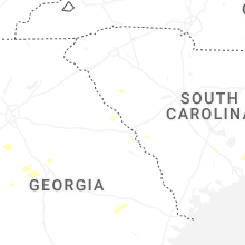
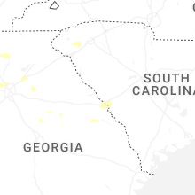
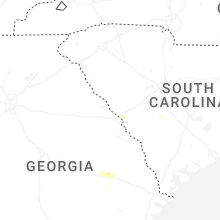


Connect with Interactive Hail Maps