

Hail Map for Monday, May 18, 2015

Number of Impacted Households on 5/18/2015
0
Impacted by 1" or Larger Hail
0
Impacted by 1.75" or Larger Hail
0
Impacted by 2.5" or Larger Hail
Square Miles of Populated Area Impacted on 5/18/2015
0
Impacted by 1" or Larger Hail
0
Impacted by 1.75" or Larger Hail
0
Impacted by 2.5" or Larger Hail


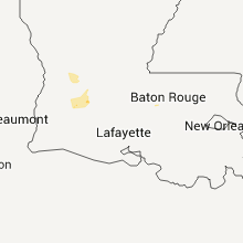


Cities Most Affected by Hail Storms of 5/18/2015
| Hail Size | Demographics of Zip Codes Affected | ||||||
|---|---|---|---|---|---|---|---|
| City | Count | Average | Largest | Pop Density | House Value | Income | Age |
| Pecos, TX | 3 | 1.92 | 2.00 | 8 | $26k | $24.7k | 34.8 |
| Mc Camey, TX | 1 | 1.75 | 1.75 | 0 | $31k | $26.2k | 36.2 |
| Coyanosa, TX | 1 | 1.75 | 1.75 | 0 | $27k | $22.9k | 42.9 |
Hail and Wind Damage Spotted on 5/18/2015
Filter by Report Type:Hail ReportsWind Reports
States Impacted
Wisconsin, Nevada, Oklahoma, Georgia, New York, Texas, Pennsylvania, Indiana, New MexicoWisconsin
| Local Time | Report Details |
|---|---|
| 9:16 AM CDT | Photos relayed via social media to broadcast media. approximately 12 trees in a wooded area knocked down in one directio in langlade county WI, 44.1 miles SE of Rhinelander, WI |
Nevada
| Local Time | Report Details |
|---|---|
| 11:25 AM PDT | Quarter sized hail reported near Las Vegas, NV, 15.8 miles SW of Las Vegas, NV, quarter size hail for 15-20 minutes at cactus joes nursery near intersection of hwy 159 and 160. |
Oklahoma
| Local Time | Report Details |
|---|---|
| 1:39 PM CDT | Quarter sized hail reported near Ardmore, OK, 50.6 miles WSW of Atoka, OK |
Georgia
| Local Time | Report Details |
|---|---|
| 4:27 PM EDT | Quarter sized hail reported near Marietta, GA, 16.6 miles NNW of Atlanta, GA, this report was relayed by wsb-tv. |
| 4:50 PM EDT | Emergency management reported trees down in goshen are in lincoln county GA, 40 miles NW of Augusta, GA |
| 5:18 PM EDT | A couple trees blown down...relayed by ham radio operator. one near shotwell and monroe in bainbridge. the other near clima in decatur county GA, 37 miles NNW of Tallahassee, FL |
| 5:20 PM EDT | Trees blown down in bainbridge including on belcher lane and alday road...and a very large tree blown down on mlk drive in the cit in decatur county GA, 37 miles NNW of Tallahassee, FL |
| 5:45 PM EDT | Gilmer county emergency manager reported trees down on georgia highway 282 in gilmer county GA, 50.8 miles ESE of Chattanooga, TN |
| 5:50 PM EDT | The gilmer county emergency manager reported trees down at highways 52 and 38 in gilmer county GA, 52.7 miles ESE of Chattanooga, TN |
| 5:50 PM EDT | The gilmer county emergency manager reported trees down atr highways 52 and 38 in gilmer county GA, 52.8 miles ESE of Chattanooga, TN |
| 5:54 PM EDT | Trees down at cooper road and jackson roa in brooks county GA, 54.7 miles SW of Douglas, GA |
| 6:54 PM EDT | Trees down at cooper road and jackson roa in brooks county GA, 54.7 miles SW of Douglas, GA |
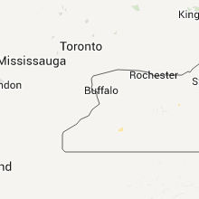
New York
| Local Time | Report Details |
|---|---|
| 5:05 PM EDT | Quarter sized hail reported near Whitney Point, NY, 57.8 miles SSE of Syracuse, NY, golf ball sized hail reported on rt 81 just north of bgm |
| 5:57 PM EDT | Trees and wires dow in chautauqua county NY, 63.8 miles SSW of Buffalo, NY |
| 6:25 PM EDT | Tree and wires down...power outages reported in broome county NY, 57.4 miles S of Syracuse, NY |
| 6:46 PM EDT | Trees and power lines down in cattaraugus county NY, 50.3 miles S of Buffalo, NY |
| 6:57 PM EDT | Trees and wires dow in chautauqua county NY, 63.8 miles SSW of Buffalo, NY |
| 7:05 PM EDT | Trees and power lines down in cattaraugus county NY, 44 miles S of Buffalo, NY |
| 7:10 PM EDT | Trees and power lines down in cattaraugus county NY, 43.8 miles SSE of Buffalo, NY |
| 7:16 PM EDT | Trees and wires dow in chautauqua county NY, 57.3 miles SSW of Buffalo, NY |
| 7:17 PM EDT | Trees and wires dow in erie county NY, 13.4 miles SE of Buffalo, NY |
| 7:17 PM EDT | Trees and wires dow in chautauqua county NY, 56 miles SSW of Buffalo, NY |
| 7:22 PM EDT | Trees and wires dow in chautauqua county NY, 58.8 miles SSW of Buffalo, NY |
| 7:24 PM EDT | Trees and wires dow in chautauqua county NY, 47.3 miles SSW of Buffalo, NY |
| 7:41 PM EDT | Trees and power lines down in allegany county NY, 48.4 miles SE of Buffalo, NY |
| 7:41 PM EDT | Trees and power lines down in cattaraugus county NY, 48.1 miles SE of Buffalo, NY |
| 8:20 PM EDT | Tree partly across route 24 in allegany county NY, 78.6 miles SE of Buffalo, NY |
Texas
| Local Time | Report Details |
|---|---|
| 4:21 PM CDT | Quarter sized hail reported near Bells, TX, 55.9 miles SSW of Atoka, OK, quarter size hail reported at ida and coker rd 5 miles east of sherman. |
| 4:45 PM CDT | Ping Pong Ball sized hail reported near Pecos, TX, 66.6 miles N of Alpine, TX |
| 4:45 PM CDT | Quarter sized hail reported near Pecos, TX, 70.8 miles N of Alpine, TX |
| 5:01 PM CDT | Hen Egg sized hail reported near Pecos, TX, 66.6 miles N of Alpine, TX |
| 5:11 PM CDT | Golf Ball sized hail reported near Pecos, TX, 72.9 miles WSW of Odessa, TX, report received from the reeves county sheriffs office. |
| 5:17 PM CDT | Ping Pong Ball sized hail reported near Pecos, TX, 69.8 miles WSW of Odessa, TX, ping pong sized hail |
| 5:17 PM CDT | Hen Egg sized hail reported near Pecos, TX, 69.3 miles N of Alpine, TX, hail up to 2 inches in diameter covering the ground. |
| 5:45 PM CDT | Quarter sized hail reported near Pecos, TX, 70.3 miles N of Alpine, TX, hail up to 1 foot deep covering us 285 5 miles southeast of pecos with near zero visibility. |
| 6:55 PM CDT | Quarter sized hail reported near Coyanosa, TX, 58.2 miles SW of Odessa, TX |
| 6:59 PM CDT | Quarter sized hail reported near Coyanosa, TX, 57.2 miles SW of Odessa, TX |
| 7:25 PM CDT | Golf Ball sized hail reported near Coyanosa, TX, 58.7 miles SW of Odessa, TX |
| 8:15 PM CDT | Storm damage reported in irion county TX, 88.7 miles ESE of Odessa, TX |
| 8:28 PM CDT | Winds caused a 20 foot tree to split in hal in ward county TX, 44.9 miles SW of Odessa, TX |
| 8:41 PM CDT | Powerlines were down and there were hail drift in pecos county TX, 60.2 miles SW of Odessa, TX |
| 10:51 PM CDT | Storm damage reported in tom green county TX, 91.3 miles SSW of Abilene, TX |
| 11:13 PM CDT | Storm damage reported in tom green county TX, 86.4 miles SSW of Abilene, TX |
| 11:13 PM CDT | Storm damage reported in tom green county TX, 86.4 miles SSW of Abilene, TX |
| 11:15 PM CDT | Storm damage reported in tom green county TX, 87.3 miles SSW of Abilene, TX |
| 11:47 PM CDT | Golf Ball sized hail reported near Mc Camey, TX, 50.4 miles S of Odessa, TX |
| 12:12 AM CDT | Numerous treee limbs dow in tom green county TX, 80.5 miles SSW of Abilene, TX |
| 1:47 AM CDT | Storm damage reported in reagan county TX, 69.7 miles SE of Odessa, TX |
| 1:50 AM CDT | Storm damage reported in reagan county TX, 47.6 miles ESE of Odessa, TX |
| 1:50 AM CDT | At pilot travel center in big lake in reagan county TX, 70.6 miles SE of Odessa, TX |
| 2:25 AM CDT | Storm damage reported in scurry county TX, 67.7 miles WNW of Abilene, TX |
| 2:30 AM CDT | Storm damage reported in irion county TX, 86.7 miles SE of Odessa, TX |
Pennsylvania
| Local Time | Report Details |
|---|---|
| 5:48 PM EDT | Large tree blocking one lane on route 743 in dauphin county PA, 60.8 miles N of Baltimore, MD |
| 6:15 PM EDT | Wires down. road flooded in downtown annville in lebanon county PA, 71.9 miles N of Baltimore, MD |
Indiana
| Local Time | Report Details |
|---|---|
| 6:18 PM EDT | Three trees down. time estimated from rada in tipton county IN, 42.4 miles N of Indianapolis, IN |
| 6:45 PM EDT | Nondescript storm damage on county road 50 e. power outages reported in that area. event time is estimated from radar in tipton county IN, 43.7 miles N of Indianapolis, IN |
New Mexico
| Local Time | Report Details |
|---|---|
| 6:00 PM MDT | 2 aspen trees blown over at dustin and cristo rey av in san juan county NM, 1.8 miles NNE of Farmington, NM |
Connect with Interactive Hail Maps