

Hail Map for Friday, May 25, 2012

Number of Impacted Households on 5/25/2012
0
Impacted by 1" or Larger Hail
0
Impacted by 1.75" or Larger Hail
0
Impacted by 2.5" or Larger Hail
Square Miles of Populated Area Impacted on 5/25/2012
0
Impacted by 1" or Larger Hail
0
Impacted by 1.75" or Larger Hail
0
Impacted by 2.5" or Larger Hail


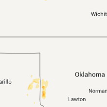


Cities Most Affected by Hail Storms of 5/25/2012
| Hail Size | Demographics of Zip Codes Affected | ||||||
|---|---|---|---|---|---|---|---|
| City | Count | Average | Largest | Pop Density | House Value | Income | Age |
| Palmer, NE | 2 | 2.25 | 2.75 | 4 | $50k | $32.6k | 44.6 |
| Grant City, MO | 2 | 1.75 | 1.75 | 7 | $31k | $28.8k | 48.2 |
| North Port, FL | 1 | 1.75 | 1.75 | 1314 | $102k | $45.5k | 37.4 |
Hail and Wind Damage Spotted on 5/25/2012
Filter by Report Type:Hail ReportsWind Reports
Missouri
| Local Time | Report Details |
|---|---|
| 11:12 AM CDT | Quarter sized hail reported near Sedalia, MO, 50.1 miles WSW of Columbia, MO, quarter size hail was reported near the intersection of mt herman road and highway 65. hail was as deep as 4 inches. |
| 3:05 PM CDT | Golf Ball sized hail reported near Grant City, MO, 85.4 miles SSW of Des Moines, IA, sherrif reported golf ball size hail. 5 miles northwest of grant city |
| 3:12 PM CDT | Golf Ball sized hail reported near Grant City, MO, 85.4 miles SSW of Des Moines, IA, sherrif reported golf ball size hail. 5 miles northwest of grant city |
| 5:40 PM CDT | Half Dollar sized hail reported near Unionville, MO, 67.5 miles W of Kahoka, MO, 1-1.25 inch hail reported |
| 5:42 PM CDT | Quarter sized hail reported near Unionville, MO, 67.6 miles W of Kahoka, MO, coop observer reporting quarter sized hail. |
| 5:45 PM CDT | Half Dollar sized hail reported near Unionville, MO, 67.6 miles W of Kahoka, MO, coop observer reporting half dollar sized hail |
Iowa
| Local Time | Report Details |
|---|---|
| 3:24 PM CDT | Quarter sized hail reported near Redding, IA, 76 miles SSW of Des Moines, IA, mostly dime to nickel with some stones quarter size. |
| 12:30 AM CDT | Semi blown over at intersection of highways 20 and 150 in independenc in buchanan county IA, 35.8 miles NNW of Cedar Rapids, IA |
| 1:00 AM CDT | Quarter sized hail reported near Eldridge, IA, 61.6 miles ESE of Cedar Rapids, IA, relayed by media. time estimated. |
| 1:10 AM CDT | Quarter sized hail reported near Princeton, IA, 71.8 miles ESE of Cedar Rapids, IA |
Florida
| Local Time | Report Details |
|---|---|
| 7:54 PM EDT | Golf Ball sized hail reported near North Port, FL, 38.3 miles SE of Bradenton, FL, the public reported golf ball size hail in north port. |
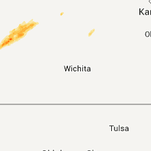
Kansas
| Local Time | Report Details |
|---|---|
| 7:05 PM CDT | Quarter sized hail reported near Hays, KS, 10.7 miles SSW of Hays, KS |
| 7:16 PM CDT | Quarter sized hail reported near Bazine, KS, 35.2 miles SW of Hays, KS |
| 7:25 PM CDT | Quarter sized hail reported near Bazine, KS, 34.9 miles SSW of Hays, KS |
| 7:41 PM CDT | Quarter sized hail reported near McCracken, KS, 22.2 miles SSW of Hays, KS |
| 7:53 PM CDT | Quarter sized hail reported near Bazine, KS, 32.4 miles SW of Hays, KS |
| 8:06 PM CDT | Half Dollar sized hail reported near Brownell, KS, 26.7 miles SW of Hays, KS |
| 8:41 PM CDT | Quarter sized hail reported near McCracken, KS, 22.2 miles SSW of Hays, KS |
| 8:45 PM CDT | Half Dollar sized hail reported near Gorham, KS, 16.8 miles E of Hays, KS |
| 9:26 PM CDT | Quarter sized hail reported near McCracken, KS, 11.7 miles SSW of Hays, KS |
| 10:36 PM CDT | Damage to the grocery store in rush county KS, 23.5 miles S of Hays, KS |
Oklahoma
| Local Time | Report Details |
|---|---|
| 7:14 PM CDT | Quarter sized hail reported near Erick, OK, 52.7 miles NNE of Childress, TX |
| 7:30 PM CDT | Quarter sized hail reported near Erick, OK, 58.5 miles NNE of Childress, TX |
| 8:25 PM CDT | Heat burst generated win in ellis county OK, 36.7 miles SW of Woodward, OK |
| 8:25 PM CDT | Storm damage reported in ellis county OK, 36.7 miles SW of Woodward, OK |
| 8:25 PM CDT | 18 by 16 foot steel framed barn blown apart with debris scattered up to 400 feet away. heat burst generated win in roger mills county OK, 61.8 miles SSW of Woodward, OK |
| 8:25 PM CDT | 18 by 16 foot steel framed barn blown apart with debris scattered up to 400 feet awa in roger mills county OK, 61.8 miles SSW of Woodward, OK |
| 8:35 PM CDT | Quarter sized hail reported near Cheyenne, OK, 65.3 miles SSW of Woodward, OK |
| 8:42 PM CDT | Heat burst generated win in ellis county OK, 22.9 miles WSW of Woodward, OK |
| 8:42 PM CDT | Storm damage reported in ellis county OK, 22.9 miles WSW of Woodward, OK |
| 9:39 PM CDT | Heat burst generated win in ellis county OK, 22.9 miles WSW of Woodward, OK |
| 9:39 PM CDT | Storm damage reported in ellis county OK, 22.9 miles WSW of Woodward, OK |
| 10:15 PM CDT | Heat burst generated win in woodward county OK, 1.5 miles SW of Woodward, OK |
| 10:15 PM CDT | Storm damage reported in woodward county OK, 1.5 miles SW of Woodward, OK |
| 10:15 PM CDT | Roof damage to local dairy queen business. several power poles blown in woodward county OK, 0.6 miles ESE of Woodward, OK |
| 10:15 PM CDT | Roof damage to local dairy queen business. several power poles blown in woodward county OK, 0.6 miles ESE of Woodward, OK |
Texas
| Local Time | Report Details |
|---|---|
| 8:10 PM CDT | Storm damage reported in hemphill county TX, 60.7 miles SW of Woodward, OK |
| 8:41 PM CDT | Carport blown over. two tree limbs dow in lipscomb county TX, 41.7 miles WSW of Woodward, OK |
Nebraska
| Local Time | Report Details |
|---|---|
| 11:04 PM CDT | Golf Ball sized hail reported near Palmer, NE, 21.5 miles N of Grand Island, NE, golf ball size hail falling on arthur road 2 miles west of palmer. |
| 11:10 PM CDT | Quarter sized hail reported near Wisner, NE, 71.1 miles NW of Omaha, NE, also very strong winds...but no speed estimate. |
| 11:16 PM CDT | Baseball sized hail reported near Palmer, NE, 22 miles NNE of Grand Island, NE, baseball size hail reported in palmer by law enforcement. |
| 12:00 AM CDT | Quarter sized hail reported near Lyons, NE, 54.9 miles NNW of Omaha, NE |
Minnesota
| Local Time | Report Details |
|---|---|
| 12:23 AM CDT | Rochester asos pk wnd 31060/1723 in olmsted county MN, 61.7 miles W of La Crosse, WI |
South Dakota
| Local Time | Report Details |
|---|---|
| 6:44 AM CDT | Trees down on west side of town. power lines down. details forthcomin in lake county SD, 37.3 miles NNW of Sioux Falls, SD |
Connect with Interactive Hail Maps