

Hail Map for Thursday, May 4, 2017

Number of Impacted Households on 5/4/2017
0
Impacted by 1" or Larger Hail
0
Impacted by 1.75" or Larger Hail
0
Impacted by 2.5" or Larger Hail
Square Miles of Populated Area Impacted on 5/4/2017
0
Impacted by 1" or Larger Hail
0
Impacted by 1.75" or Larger Hail
0
Impacted by 2.5" or Larger Hail


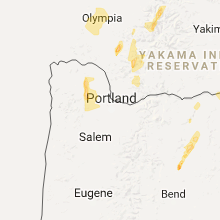


Cities Most Affected by Hail Storms of 5/4/2017
| Hail Size | Demographics of Zip Codes Affected | ||||||
|---|---|---|---|---|---|---|---|
| City | Count | Average | Largest | Pop Density | House Value | Income | Age |
| Prospect, OR | 2 | 1.75 | 1.75 | 8 | $113k | $28.9k | 52.1 |
| Bend, OR | 1 | 2.00 | 2.00 | 92 | $155k | $43.3k | 38.5 |
| Sisters, OR | 1 | 2.00 | 2.00 | 12 | $198k | $48.0k | 50.2 |
| Terrebonne, OR | 1 | 1.75 | 1.75 | 61 | $138k | $38.4k | 50.4 |
| Madras, OR | 1 | 1.75 | 1.75 | 31 | $106k | $34.7k | 37.6 |
Hail and Wind Damage Spotted on 5/4/2017
Filter by Report Type:Hail ReportsWind Reports
States Impacted
Florida, Georgia, Oregon, Washington, Kentucky, South Carolina, California, Tennessee, North Carolina, VirginiaFlorida
| Local Time | Report Details |
|---|---|
| 9:47 AM EDT | Power line down on st. george islan in franklin county FL, 64 miles SSW of Tallahassee, FL |
| 11:04 AM EDT | The 911 call center reported one tree down on new monticello road near hwy 9 in jefferson county FL, 24.2 miles ENE of Tallahassee, FL |
| 4:14 PM EDT | Asos at naval air station jacksonville reported wind gust to 71 mph out of the south from 190 degree in duval county FL, 7.1 miles SSW of Jacksonville, FL |
| 4:18 PM EDT | Ema reported tree down. time estimated from rada in duval county FL, 5.8 miles E of Jacksonville, FL |
| 4:26 PM EDT | Ema reported tree down. time estimated from rada in duval county FL, 4.6 miles E of Jacksonville, FL |
| 4:26 PM EDT | Ema reported three trees down on property. time estimated from rada in duval county FL, 4.9 miles ENE of Jacksonville, FL |
| 4:26 PM EDT | Media shared social media post of large tree limbs down and yard fences heavily damaged. time estimated from rada in duval county FL, 5.5 miles ENE of Jacksonville, FL |
| 4:35 PM EDT | Action news jacksonville reports several trees downed by strong wind gusts in the vicinity of the st. johns town center and extending northeastward to beach boulevar in duval county FL, 9 miles ESE of Jacksonville, FL |
| 4:48 PM EDT | Trained spotter estimated winds at 60 mph. 3 to 5 inch diameter limbs down around the are in gilchrist county FL, 78.7 miles SW of Jacksonville, FL |
| 4:50 PM EDT | A 911 call came in of a tree down on power lines. call received at 457p in levy county FL, 90.2 miles SW of Jacksonville, FL |
| 5:12 PM EDT | Trained storm spotter reported dime size hail at hodges blvd and jtb. peak wind gust estimated at 60 mp in duval county FL, 12.4 miles ESE of Jacksonville, FL |
Georgia
| Local Time | Report Details |
|---|---|
| 1:16 PM EDT | Several trees down along with large branches. sheet metal on out building pulled back. time estimated by rada in atkinson county GA, 9.9 miles SSW of Douglas, GA |
| 2:05 PM EDT | Emergency management reported several different areas of tree damage. tops of trees were snapped. farm sheds damaged. carport shelters damaged. one location of damage w in coffee county GA, 0.3 miles N of Douglas, GA |
| 2:05 PM EDT | Emergency management reported several different areas of tree damage. tops of trees were snapped. farm sheds damaged. carport shelters damaged. one location of damage w in coffee county GA, 11.8 miles NE of Douglas, GA |
| 2:16 PM EDT | 911 reported 2 barns destroyed. trees and powerlines down. possible tornad in jeff davis county GA, 18.1 miles NE of Douglas, GA |
| 2:28 PM EDT | 911 reported part of a building fell onto a car. time estimated from rada in wayne county GA, 57 miles SW of Savannah, GA |
| 3:30 PM EDT | Quarter sized hail reported near Jesup, GA, 56.8 miles E of Douglas, GA, media shared social media post of quarter size hail. |
| 3:30 PM EDT | Half Dollar sized hail reported near Jesup, GA, 57 miles E of Douglas, GA, storm spotter reported quarter to half dollar size hail in the jesup vicinity. time is estimated based on radar. |
| 3:47 PM EDT | Tree down on power lines near huddle house on us hwy 84 in long county GA, 46.4 miles WSW of Savannah, GA |
| 5:04 PM EDT | Tree down on powerlines along clyo kildare rd. time estimated from radar in effingham county GA, 37.3 miles NNW of Savannah, GA |
| 5:13 PM EDT | Media relayed report of large tree down on belfast pines driv in bryan county GA, 21.2 miles SW of Savannah, GA |
| 9:14 PM EDT | Reports of mostly minor damage on north side of atlanta hartsfield airfield. damage reports received thus far are to cargo buildings and cars on ram in fulton county GA, 6.3 miles SSW of Atlanta, GA |
| 10:44 PM EDT | Tree down on power line on friar tuck lan in gwinnett county GA, 34.7 miles NE of Atlanta, GA |
| 10:55 PM EDT | Tree down on power lines on berkeley lake roa in gwinnett county GA, 21 miles NE of Atlanta, GA |
Oregon
| Local Time | Report Details |
|---|---|
| 2:55 PM PDT | Quarter sized hail reported near Myrtle Creek, OR, 57.1 miles NNW of Medford, OR, the caller said it could have easily been larger. |
| 5:45 PM PDT | Quarter sized hail reported near Eagle Point, OR, 11.5 miles NNE of Medford, OR |
| 6:55 PM PDT | Golf Ball sized hail reported near Prospect, OR, 44.5 miles NNE of Medford, OR, public sent in picture of hail about the size of a golf ball at mile post 55 on highway 62 near the natural bridge viewpoint. |
| 7:00 PM PDT | Quarter sized hail reported near Trail, OR, 24.9 miles NNE of Medford, OR, public sent in a picture of quarter size hail occurring at casey state recreational site near trail. this hail fell around 7:00 pm. |
| 7:00 PM PDT | Quarter sized hail reported near Vernonia, OR, 32.6 miles NW of Portland, OR, picture of hail in excess of 1 inch in diameter. |
| 7:20 PM PDT | Quarter sized hail reported near Trail, OR, 24.7 miles NNE of Medford, OR, report from social media. time estimated based on radar. |
| 7:25 PM PDT | Winds brought down power lines... and with trees smoking. this along highway 47... between top hill and johnson roa in washington county OR, 29.8 miles NW of Portland, OR |
| 8:00 PM PDT | Golf Ball sized hail reported near Prospect, OR, 46.2 miles NNE of Medford, OR, time estimated. |
| 9:16 PM PDT | Downed trees reported near the road. not sure when this occurred so left time as is. location near lost creek lake and highway 6 in jackson county OR, 27 miles NNE of Medford, OR |
| 9:21 PM PDT | Spotter reported downed trees along road. not sure about timing... so left as i in jackson county OR, 21.5 miles NE of Medford, OR |
| 10:30 PM PDT | Hen Egg sized hail reported near Bend, OR, 28.2 miles SW of Bend, OR |
| 10:45 PM PDT | Golf Ball sized hail reported near Terrebonne, OR, 24.5 miles WNW of Bend, OR, crooked river ranch. |
| 10:50 PM PDT | Quarter sized hail reported near Terrebonne, OR, 24.3 miles WNW of Bend, OR |
| 11:00 PM PDT | Hen Egg sized hail reported near Sisters, OR, 32 miles W of Bend, OR, public post on ktvz facebook page...includes photo of hail. |
| 11:10 PM PDT | Golf Ball sized hail reported near Madras, OR, 26.6 miles NNW of Bend, OR, public post on nws facebook page with photo. |
| 11:15 PM PDT | Quarter sized hail reported near Terrebonne, OR, 25.5 miles WNW of Bend, OR, hail from three-quarter inch to one inch in diameter. |
Washington
| Local Time | Report Details |
|---|---|
| 4:06 PM PDT | Half Dollar sized hail reported near Carson, WA, 43.7 miles ENE of Portland, OR, hail observed 5 miles nnw of carson... or |
| 4:25 PM PDT | Large tree down on road and other small trees and branches down as well. pea sized hai in thurston county WA, 59.7 miles SSW of Seattle, WA |
| 4:40 PM PDT | Roof ripped off a small building. many trees downed in the olympia area. some vehicles also damaged by downed trees and/or power line in thurston county WA, 47 miles SW of Seattle, WA |
| 5:14 PM PDT | Numerous live wires and power poles downed in the area of yelm highway between wiggins and corporate center loop. road is close in thurston county WA, 46.9 miles SSW of Seattle, WA |
| 5:20 PM PDT | Trees downed...one onto home. a power pole was also snappe in thurston county WA, 45.6 miles SSW of Seattle, WA |
| 9:30 PM PDT | Quarter sized hail reported near West Richland, WA, 53.6 miles WNW of Walla Walla, WA, social media report via nbc tri-cities. time is radar estimated. |
Kentucky
| Local Time | Report Details |
|---|---|
| 6:08 PM CDT | Storm damage reported in cumberland county KY, 83.4 miles S of Louisville, KY |
| 6:31 PM CDT | A portion of a metal roof blown off of a business one block away from the town squar in clinton county KY, 84.6 miles NW of Knoxville, TN |
South Carolina
| Local Time | Report Details |
|---|---|
| 7:48 PM EDT | Trainned spotter reports numerous power poles snapped and trees down on black creek rd near interstate 95. possible tornado in colleton county SC, 51.4 miles WSW of Charleston, SC |
| 7:55 PM EDT | Windowns blow out of and roof damage to house in the 1500 block of cane break rd. possible tornado in colleton county SC, 48.7 miles WSW of Charleston, SC |
| 7:58 PM EDT | Several power lines snapped. one tree snapped in half. damage due to possible tornad in colleton county SC, 47 miles WSW of Charleston, SC |
| 8:04 PM EDT | Sc state hwy patrol reports a tree down at the intersection of penny creek rd and doctors creek rd. possible tornado in colleton county SC, 46.3 miles WSW of Charleston, SC |
| 8:10 PM EDT | Trained spotter reports hwy 64 blocked by numerous trees down just west of interstate 95. possible tornado in colleton county SC, 43.9 miles WSW of Charleston, SC |
| 8:14 PM EDT | Trainned spotter reports damage area approximately 1/4 to 1/2 mile wide along mcleod rd east of interstate 95. possible tornado in colleton county SC, 39.6 miles WSW of Charleston, SC |
| 8:25 PM EDT | Sc state hwy patrol reports tree in roadway on round o road near sc hwy 61. possible tornado in colleton county SC, 35.7 miles WSW of Charleston, SC |
| 8:32 PM EDT | Tree down on car reported in grover. possible tornad in dorchester county SC, 34 miles W of Charleston, SC |
| 8:52 PM EDT | South carolina highway patrol reports a tree down near mile marker 175 along i-26 westboun in dorchester county SC, 26.8 miles W of Charleston, SC |
| 9:02 PM EDT | Orangeburg co em reports trees down on a house at caufield ct and gardner blvd (hwy 453 in orangeburg county SC, 25.2 miles WNW of Charleston, SC |
| 9:05 PM EDT | Reports of trees down near white sands rd and gardner blvd (hwy 453) sw of holly hil in orangeburg county SC, 25.6 miles WNW of Charleston, SC |
| 9:06 PM EDT | Orangeburg co em reported roof damage to a restaurant in holly hil in orangeburg county SC, 24.5 miles WNW of Charleston, SC |
| 10:00 PM EDT | Reports of trees down and trailers overturned from several locations in and near hartsvill in darlington county SC, 73.2 miles SE of Charlotte, NC |
California
| Local Time | Report Details |
|---|---|
| 6:17 PM PDT | Quarter sized hail reported near Etna, CA, 55.5 miles S of Medford, OR, spotter reported hail about the size of nickels. |
Tennessee
| Local Time | Report Details |
|---|---|
| 11:03 PM EDT | Broken power pole near downtown jefferson city in jefferson county TN, 26.5 miles ENE of Knoxville, TN |
| 11:13 PM EDT | Tree down near panther creek rd and seven oaks d in hamblen county TN, 33.8 miles ENE of Knoxville, TN |
North Carolina
| Local Time | Report Details |
|---|---|
| 1:10 AM EDT | Broadcast media reported a small tree snapped and fell on a vehicle at eaves lane and plaza walk dr. no other damage reported in the are in mecklenburg county NC, 3.8 miles ENE of Charlotte, NC |
| 2:20 AM EDT | Trees down blocking both lanes of griffin green blvd in stanly county NC, 26.5 miles E of Charlotte, NC |
| 2:25 AM EDT | Multiple trees down across the county including bill curllee road and nc 74 in anson county NC, 46.8 miles ESE of Charlotte, NC |
| 2:45 AM EDT | Tree down on eugene and w friendly ave in guilford county NC, 67.3 miles WNW of Raleigh, NC |
| 2:45 AM EDT | Tree down blocking one lane at nc49/109 in davidson county NC, 48.2 miles ENE of Charlotte, NC |
| 3:00 AM EDT | Trees down on mechanic rd... granville rd... and loflin r in randolph county NC, 58.1 miles ENE of Charlotte, NC |
| 3:14 AM EDT | Tree reported on a home - 179 kindley rd in randolph county NC, 60.1 miles NE of Charlotte, NC |
| 3:15 AM EDT | Thunderstorm winds resulted in numerous trees down across eden nc. damage to houses also reported as the storm moved through. time radar estimate in rockingham county NC, 53.7 miles SSE of Roanoke, VA |
| 3:15 AM EDT | Three trees down on stratford drive. cars hit and powerlines dow in guilford county NC, 70.8 miles WNW of Raleigh, NC |
| 3:20 AM EDT | Tree reported on a home at landis and jackson school rds in browns summi in guilford county NC, 64.1 miles WNW of Raleigh, NC |
| 3:25 AM EDT | Em officials report more than 2 dozen trees down on roads in guilford co... around a half dozen trees thru homes and route 150 close in guilford county NC, 66.6 miles WNW of Raleigh, NC |
| 3:30 AM EDT | Tree down near route 4 in randolph county NC, 55.9 miles WSW of Raleigh, NC |
| 3:35 AM EDT | Tree down blocking road on plank roa in moore county NC, 56.7 miles WSW of Raleigh, NC |
| 3:40 AM EDT | Tree down across road at wendover and holden road in guilford county NC, 70.3 miles WNW of Raleigh, NC |
| 3:41 AM EDT | Tree on a home on n church st at hwy 150 in browns summit in guilford county NC, 70.9 miles WNW of Raleigh, NC |
| 3:50 AM EDT | Tree down on durham street extension in alamance county NC, 51.8 miles WNW of Raleigh, NC |
| 3:50 AM EDT | Thunderstorm winds downed at least two trees outside of the community of eden. wind estimates at the time were 40 to 50 miles per hour. time radar estimate in rockingham county NC, 57 miles SSE of Roanoke, VA |
| 3:55 AM EDT | Tree down on white rock road in moore county NC, 51.1 miles SW of Raleigh, NC |
| 3:55 AM EDT | Tree down on glendon-carthage road blocking one lan in moore county NC, 51.9 miles WSW of Raleigh, NC |
| 3:55 AM EDT | Tree down on glendon-carthage road in moore county NC, 53.1 miles SW of Raleigh, NC |
| 4:30 AM EDT | Tree down on park avenue in moore county NC, 62.5 miles SW of Raleigh, NC |
| 4:33 AM EDT | Tree down at white cross and old greensboro road in orange county NC, 31.7 miles WNW of Raleigh, NC |
| 4:34 AM EDT | Tree down at the intersection hopewell drive and pickett road. time estimated by rada in durham county NC, 22.7 miles NW of Raleigh, NC |
| 4:35 AM EDT | Tree down on garrett road crashed into by vehicl in durham county NC, 21.6 miles WNW of Raleigh, NC |
| 4:44 AM EDT | Tree down at 4200 brentwood. time estimated by rada in durham county NC, 17 miles WNW of Raleigh, NC |
| 4:45 AM EDT | Tree down on us53 and johnson rd in cumberland county NC, 62.7 miles S of Raleigh, NC |
| 4:45 AM EDT | Tree down at wade stedman and nc2 in cumberland county NC, 53.5 miles S of Raleigh, NC |
| 4:50 AM EDT | Tree down at 6569 maxwell rd in cumberland county NC, 50.2 miles S of Raleigh, NC |
| 5:20 AM EDT | Ttree down on road in benso in johnston county NC, 28.4 miles S of Raleigh, NC |
| 5:23 AM EDT | Several trees blown down around clinton including one tree down on a house on edgar stree in sampson county NC, 57 miles SSE of Raleigh, NC |
| 5:25 AM EDT | Multiple trees down in four oak in johnston county NC, 26.3 miles SSE of Raleigh, NC |
| 5:35 AM EDT | Tree down on road in wilson mill in johnston county NC, 22.2 miles SE of Raleigh, NC |
| 5:49 AM EDT | Several trees blown down in middlesex... including a downed tree on taylors mill roa in nash county NC, 23.7 miles E of Raleigh, NC |
| 6:10 AM EDT | Several trees blown down around nashville... including one downed tree onto a ca in nash county NC, 40.4 miles ENE of Raleigh, NC |
| 6:35 AM EDT | Multiple trees down in the are in halifax county NC, 56.9 miles NE of Raleigh, NC |
| 7:28 AM EDT | Quarter sized hail reported near Trenton, NC, 65.9 miles NNE of Wilmington, NC, spotter reported nickle to quarter size hail in trenton... jones co. on hwy 70. 4 miles out from newbern |
| 7:38 AM EDT | Spotter reported 62 mph at the wild life ramp at cedar point in carteret county NC, 58.2 miles ENE of Wilmington, NC |
Virginia
| Local Time | Report Details |
|---|---|
| 3:59 AM EDT | A tree was blown down along scruggs road near ashmeade roa in franklin county VA, 22.9 miles SE of Roanoke, VA |
| 4:00 AM EDT | A tree was blown down on berry hill roa in pittsylvania county VA, 51.6 miles SSE of Roanoke, VA |
| 4:11 AM EDT | Broadcast media relays report of multiple large trees down... damage to the roof of a single dwelling... and broken windows in the dwelling due to thunderstorm wind in bedford county VA, 20.9 miles ESE of Roanoke, VA |
| 4:12 AM EDT | A tree was blown down near the intersection of smith mountain lake parkway and carters mill roa in bedford county VA, 25.7 miles ESE of Roanoke, VA |
| 4:26 AM EDT | A tree was blown down along highway 58 near hudson driv in halifax county VA, 60.8 miles NNW of Raleigh, NC |
| 4:53 AM EDT | A tree was blown down along howard p anderson road near winns creek roa in halifax county VA, 65.3 miles ESE of Roanoke, VA |
| 5:16 AM EDT | Em reported straight line wind damage. several trees down on boxwood farm rd. time radar estimate in amherst county VA, 57.5 miles ENE of Roanoke, VA |
| 5:30 AM EDT | Tree down on james river road near route 64 in nelson county VA, 67.4 miles ENE of Roanoke, VA |
| 5:48 AM EDT | Tree down near the intersection of miller school road and samuel miller loo in albemarle county VA, 67.2 miles WNW of Richmond, VA |
| 5:50 AM EDT | Report of numerous trees down and a trampoline wrapped around a tre in mecklenburg county VA, 65.7 miles SSW of Richmond, VA |
| 5:55 AM EDT | Tree down in the 1500 block of james river roa in albemarle county VA, 53.4 miles WNW of Richmond, VA |
| 6:05 AM EDT | Numerous reports of trees dow in nottoway county VA, 34.5 miles SW of Richmond, VA |
| 6:13 AM EDT | Funnel cloud spotted with trees down north of five forks along hwy 46 in dinwiddie county VA, 23 miles S of Richmond, VA |
| 6:16 AM EDT | Tree down in the 1700 block of polo grounds roa in albemarle county VA, 59.6 miles NW of Richmond, VA |
| 6:25 AM EDT | Reports of trees down along genito road and also hwy 36 in amelia county VA, 21.3 miles WSW of Richmond, VA |
| 6:40 AM EDT | Reports of trees down near moseley road and bradbury roa in powhatan county VA, 7.8 miles WSW of Richmond, VA |
| 6:50 AM EDT | Possible tornado near baskerville mill road and hwy 40. reports of trees down and structures damage in dinwiddie county VA, 36 miles S of Richmond, VA |
| 7:13 AM EDT | Funnel cloud spotted with trees down north of five forks along hwy 46 in dinwiddie county VA, 23 miles S of Richmond, VA |
| 7:25 AM EDT | Trees down at hickory road and river roa in chesterfield county VA, 11.5 miles SE of Richmond, VA |
Connect with Interactive Hail Maps