

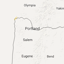
Hail Map for Friday, October 14, 2016

Number of Impacted Households on 10/14/2016
0
Impacted by 1" or Larger Hail
0
Impacted by 1.75" or Larger Hail
0
Impacted by 2.5" or Larger Hail
Square Miles of Populated Area Impacted on 10/14/2016
0
Impacted by 1" or Larger Hail
0
Impacted by 1.75" or Larger Hail
0
Impacted by 2.5" or Larger Hail

Cities Most Affected by Hail Storms of 10/14/2016
| Hail Size | Demographics of Zip Codes Affected | ||||||
|---|---|---|---|---|---|---|---|
| City | Count | Average | Largest | Pop Density | House Value | Income | Age |
Hail and Wind Damage Spotted on 10/14/2016
Filter by Report Type:Hail ReportsWind Reports
Oregon
| Local Time | Report Details |
|---|---|
| 7:50 AM PDT | Mesonet site garo3 in tillamook county OR, 62 miles W of Portland, OR |
| 8:23 AM PDT | Cwop station as612 cape meares. elevation 1420 f in tillamook county OR, 61 miles W of Portland, OR |
| 10:01 AM PDT | Storm damage reported in clatsop county OR, 67.4 miles WNW of Portland, OR |
| 10:32 AM PDT | Sustained 35 to 40 mph. gust 60 mp in clatsop county OR, 73.1 miles NW of Portland, OR |
Wyoming
| Local Time | Report Details |
|---|---|
| 12:25 PM MDT | Halleck ridge wydot sensor. sustained wind 45 mp in carbon county WY, 56.9 miles WNW of Laramie, WY |
| 1:05 PM MDT | Halleck ridge wydot senso in carbon county WY, 56.9 miles WNW of Laramie, WY |
Connect with Interactive Hail Maps