

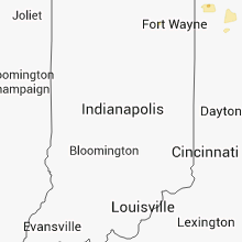
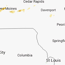
Hail Map for Friday, October 4, 2013

Number of Impacted Households on 10/4/2013
0
Impacted by 1" or Larger Hail
0
Impacted by 1.75" or Larger Hail
0
Impacted by 2.5" or Larger Hail
Square Miles of Populated Area Impacted on 10/4/2013
0
Impacted by 1" or Larger Hail
0
Impacted by 1.75" or Larger Hail
0
Impacted by 2.5" or Larger Hail


Cities Most Affected by Hail Storms of 10/4/2013
| Hail Size | Demographics of Zip Codes Affected | ||||||
|---|---|---|---|---|---|---|---|
| City | Count | Average | Largest | Pop Density | House Value | Income | Age |
| Pacific Junction, IA | 2 | 2.25 | 2.75 | 17 | $94k | $44.2k | 45.1 |
| Murray, NE | 1 | 2.75 | 2.75 | 22 | $89k | $54.3k | 42.5 |
| Amana, IA | 1 | 1.75 | 1.75 | 35 | $132k | $47.5k | 47.6 |
| Pomeroy, IA | 1 | 1.75 | 1.75 | 10 | $48k | $28.7k | 47.1 |
| Burbank, OK | 1 | 1.75 | 1.75 | 4 | $44k | $27.8k | 44.3 |
| Moville, IA | 1 | 1.75 | 1.75 | 18 | $91k | $43.8k | 39.4 |
Hail and Wind Damage Spotted on 10/4/2013
Filter by Report Type:Hail ReportsWind Reports
Iowa
| Local Time | Report Details |
|---|---|
| 7:25 AM CDT | Large tree down highway f90 in jasper county IA, 27.2 miles E of Des Moines, IA |
| 7:30 AM CDT | Storm damage reported in jasper county IA, 27.2 miles E of Des Moines, IA |
| 7:30 AM CDT | Power line blown off insulators and started a fire. time estimated from rada in dallas county IA, 19.9 miles WNW of Des Moines, IA |
| 7:30 AM CDT | 6-7 inch branches down from 60 mph wind gust. several smaller branches down als in jasper county IA, 27.2 miles E of Des Moines, IA |
| 8:47 AM CDT | Quarter sized hail reported near Brooklyn, IA, 41.6 miles WSW of Cedar Rapids, IA, reported on i80 mile marker 200. |
| 8:51 AM CDT | Golf Ball sized hail reported near Amana, IA, 16.9 miles SW of Cedar Rapids, IA |
| 6:14 PM CDT | Quarter sized hail reported near Thornton, IA, 17.2 miles SW of Mason City, IA |
| 6:24 PM CDT | Golf Ball sized hail reported near Pacific Junction, IA, 17.1 miles SSE of Omaha, NE |
| 6:28 PM CDT | Baseball sized hail reported near Pacific Junction, IA, 15.8 miles SSE of Omaha, NE, along i29 rest area northwest of glenwood. hail broke through vehicle windshield. |
| 6:38 PM CDT | Ping Pong Ball sized hail reported near Mason City, IA, 0.2 miles NNE of Mason City, IA, sheriffs dept reported quarter to ping pong ball sized hail outside sheriffs office. |
| 6:40 PM CDT | Quarter sized hail reported near Mason City, IA, 0.2 miles NNE of Mason City, IA, dime to quarter sized hail. |
| 6:40 PM CDT | Half Dollar sized hail reported near Mason City, IA, 1.3 miles SSE of Mason City, IA |
| 6:40 PM CDT | Quarter sized hail reported near Council Bluffs, IA, 6.9 miles ESE of Omaha, NE, in rolling hills area east council bluffs. |
| 6:42 PM CDT | Quarter sized hail reported near Mason City, IA, 0.2 miles NNE of Mason City, IA, nickel to quarter sized hail. reported by kimt-tv. |
| 6:44 PM CDT | Golf Ball sized hail reported near Moville, IA, 47.6 miles WSW of Storm Lake, IA |
| 7:09 PM CDT | Quarter sized hail reported near Kingsley, IA, 33.9 miles W of Storm Lake, IA |
| 7:40 PM CDT | A couple of trees down due to wind and lightning. also small structural fire west of red oak from a lightning strike. time estimate in montgomery county IA, 41.4 miles ESE of Omaha, NE |
| 8:00 PM CDT | A couple of trees down due to wind and lightning. also small structural fire west of red oak from a lightning strike. time estimate in montgomery county IA, 41.4 miles ESE of Omaha, NE |
| 8:18 PM CDT | Quarter sized hail reported near Charles City, IA, 24.4 miles ESE of Mason City, IA |
| 8:37 PM CDT | Quarter sized hail reported near Marble Rock, IA, 18.1 miles SE of Mason City, IA |
| 8:45 PM CDT | Quarter sized hail reported near Marble Rock, IA, 21.1 miles SE of Mason City, IA |
| 9:05 PM CDT | Golf Ball sized hail reported near Pomeroy, IA, 28 miles ESE of Storm Lake, IA, social media report from the public |
| 9:14 PM CDT | Quarter sized hail reported near Ruthven, IA, 38.5 miles NNE of Storm Lake, IA, social media report from public |
| 9:40 PM CDT | Delayed report...time estimated from radar. multiple trees and branches down. power poles down. tops of trees sheered off on a farm near lone rock. crop damage in kossuth county IA, 56.8 miles W of Mason City, IA |
| 9:40 PM CDT | Delayed report...time estimated from radar. high transmission power poles down along highway 1 in kossuth county IA, 54.6 miles NE of Storm Lake, IA |
| 9:50 PM CDT | Kossuth county dispatch reported a large tree fell on a house. the trees canopy covered at least one room of the hous in kossuth county IA, 56.8 miles W of Mason City, IA |
Oklahoma
| Local Time | Report Details |
|---|---|
| 12:07 PM CDT | 10 powepoles were snapped. the time of this report was estimated based on rada in dewey county OK, 25 miles SE of Woodward, OK |
| 4:52 PM CDT | 10 powepoles were snapped. the time of this report was estimated based on rada in dewey county OK, 25 miles SE of Woodward, OK |
| 6:02 PM CDT | Quarter sized hail reported near Waynoka, OK, 33.4 miles E of Woodward, OK |
| 6:50 PM CDT | Quarter sized hail reported near Elk City, OK, 70.6 miles S of Woodward, OK, report at elk city airport by kfor tv |
| 8:13 PM CDT | Quarter sized hail reported near Mangum, OK, 44.3 miles NE of Childress, TX |
| 10:00 PM CDT | Storm damage reported in greer county OK, 51.9 miles ENE of Childress, TX |
| 10:10 PM CDT | Strong thunderstorm wind uprooted trees and snapped large tree limbs in osage county OK, 55.4 miles NW of Tulsa, OK |
| 10:10 PM CDT | Golf Ball sized hail reported near Burbank, OK, 55.4 miles NW of Tulsa, OK |
| 10:23 PM CDT | Quarter sized hail reported near Altus, OK, 50.7 miles ENE of Childress, TX |
| 10:24 PM CDT | Trees across road and 4 power poles down in caddo county OK, 50.7 miles WSW of Oklahoma City, OK |
Ohio
| Local Time | Report Details |
|---|---|
| 2:00 PM EDT | Reports of trees and power lines down in williams county OH, 46.3 miles NE of Fort Wayne, IN |
Kansas
| Local Time | Report Details |
|---|---|
| 4:13 PM CDT | Power is out in city of rile in riley county KS, 16.6 miles WNW of Manhattan, KS |
| 4:27 PM CDT | Storm damage reported in geary county KS, 13.4 miles SW of Manhattan, KS |
| 4:48 PM CDT | Storm damage reported in riley county KS, 6 miles WSW of Manhattan, KS |
| 4:57 PM CDT | Quarter sized hail reported near Harper, KS, 51.4 miles WSW of Wichita, KS, relayed by an off duty nws employee. |
| 5:12 PM CDT | Quarter sized hail reported near White City, KS, 27.8 miles SSW of Manhattan, KS, radar estimated time. relayed via social media. |
| 5:12 PM CDT | 8 inch tree limb snapped. relayed via social media. radar estimated tim in pottawatomie county KS, 7.7 miles E of Manhattan, KS |
| 5:20 PM CDT | Tree down in wamego in pottawatomie county KS, 13.6 miles E of Manhattan, KS |
| 5:45 PM CDT | Storm chaser estimated 50 to 60 mph winds at 119th and kellog in sedgwick county KS, 6.8 miles W of Wichita, KS |
| 5:50 PM CDT | 12 inch diameter tree limb down in jackson county KS, 44 miles ENE of Manhattan, KS |
| 5:55 PM CDT | Winds 60 to 65 mph in jackson county KS, 52.2 miles ENE of Manhattan, KS |
| 5:55 PM CDT | Small limbs were down. pea size hail also reported. radar estimated tim in wabaunsee county KS, 13.6 miles ESE of Manhattan, KS |
| 6:00 PM CDT | Delayed report. estimated near 13th and woodlawn. small tree limbs were downe in sedgwick county KS, 4.2 miles E of Wichita, KS |
| 6:05 PM CDT | A tree of 18 inches in diameter was uprooted onto a mobile home. no damage estimate give in butler county KS, 10.7 miles E of Wichita, KS |
| 6:05 PM CDT | A tree of unknown size was uprooted onto a mobile home. no damage estimate give in butler county KS, 10.7 miles E of Wichita, KS |
| 6:13 PM CDT | Delayed report. bradford pear tree snapped by 60-70 mph winds. at nativity pines. via kfdi news reporte in butler county KS, 13.7 miles NE of Wichita, KS |
| 7:12 PM CDT | Storm damage reported in osage county KS, 48.4 miles SE of Manhattan, KS |
| 7:20 PM CDT | Pea size hail also reported in osage county KS, 51.4 miles ESE of Manhattan, KS |
| 8:34 PM CDT | Large branches down in leavenworth county KS, 27.2 miles W of Kansas City, MO |
| 11:42 PM CDT | Storm damage reported in montgomery county KS, 29 miles SSW of Chanute, KS |
Nebraska
| Local Time | Report Details |
|---|---|
| 6:10 PM CDT | Ping Pong Ball sized hail reported near Union, NE, 29.1 miles S of Omaha, NE |
| 6:18 PM CDT | Baseball sized hail reported near Murray, NE, 25.6 miles S of Omaha, NE |
| 6:21 PM CDT | Ping Pong Ball sized hail reported near Plattsmouth, NE, 18.3 miles S of Omaha, NE, near 33rd and church rd. |
Missouri
| Local Time | Report Details |
|---|---|
| 9:26 PM CDT | Storm damage reported in buchanan county MO, 47.5 miles NNW of Kansas City, MO |
Connect with Interactive Hail Maps