

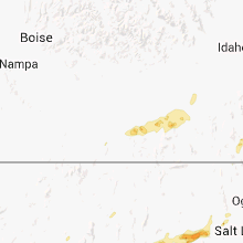
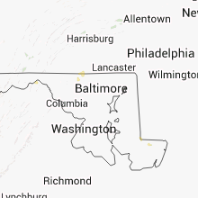
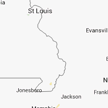
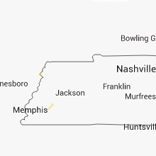
Hail Map for Saturday, September 1, 2012

Number of Impacted Households on 9/1/2012
0
Impacted by 1" or Larger Hail
0
Impacted by 1.75" or Larger Hail
0
Impacted by 2.5" or Larger Hail
Square Miles of Populated Area Impacted on 9/1/2012
0
Impacted by 1" or Larger Hail
0
Impacted by 1.75" or Larger Hail
0
Impacted by 2.5" or Larger Hail


Cities Most Affected by Hail Storms of 9/1/2012
| Hail Size | Demographics of Zip Codes Affected | ||||||
|---|---|---|---|---|---|---|---|
| City | Count | Average | Largest | Pop Density | House Value | Income | Age |
Hail and Wind Damage Spotted on 9/1/2012
Filter by Report Type:Hail ReportsWind Reports
States Impacted
Utah, North Carolina, West Virginia, Kentucky, Wyoming, Arkansas, Montana, Virginia, Pennsylvania, Maryland, South Dakota, Idaho, Tennessee, Illinois, ColoradoUtah
| Local Time | Report Details |
|---|---|
| 11:15 AM MDT | Quarter sized hail reported near Garrison, UT, 51.4 miles ESE of Ely, NV |
| 2:15 PM MDT | Quarter sized hail reported near Nephi, UT, 54.9 miles W of Price, UT, penny to quarter sized hail between mm230-235 on interstate 15. |
| 3:35 PM MDT | Quarter sized hail reported near Wendover, UT, 91.9 miles W of Salt Lake City, UT, marble to quarter sized hail along interstate 80 near mile post 20. |
| 3:45 PM MDT | Interstate 80 at mp2 in tooele county UT, 83 miles W of Salt Lake City, UT |
| 5:51 PM MDT | Quarter sized hail reported near Farmington, UT, 15.9 miles N of Salt Lake City, UT, one inch hail reported in farmington |
North Carolina
| Local Time | Report Details |
|---|---|
| 2:40 PM EDT | Park ranger reports that several trees were downed on a hiking trail in uwharrie national fores in montgomery county NC, 56.1 miles E of Charlotte, NC |
| 4:25 PM EDT | Multiple trees and powerlines down on strickland bridge road near bailey lake road in cumberland county NC, 55.9 miles SSW of Raleigh, NC |
| 4:26 PM EDT | Multiple trees down in bakers mountain park are in catawba county NC, 43.3 miles NW of Charlotte, NC |
| 5:00 PM EDT | Multiple trees down near iron statio in lincoln county NC, 23.6 miles NW of Charlotte, NC |
West Virginia
| Local Time | Report Details |
|---|---|
| 4:02 PM EDT | Quarter sized hail reported near Berkeley Springs, WV, 84.8 miles SSW of State College, PA, tree branches down |
| 4:34 PM EDT | Tree down on autumn acres rd near winchester grade r in morgan county WV, 86.7 miles SSW of State College, PA |
| 4:51 PM EDT | Tree down on quaint acres ln near cacapon r in morgan county WV, 83.6 miles SSW of State College, PA |
Kentucky
| Local Time | Report Details |
|---|---|
| 4:25 PM EDT | Several trees down on akin road near the county borde in jefferson county KY, 24 miles NE of Louisville, KY |
| 5:10 PM CDT | Power line down on county house roa in monroe county KY, 67.6 miles ENE of Nashville, TN |
| 7:00 PM CDT | Scattered tree branch damage in northern ballard county. time estimated. power outages between wickliffe and barlo in ballard county KY, 31.3 miles ESE of Cape Girardeau, MO |
| 7:45 PM CDT | Large tree limb down on bruce stree in mccracken county KY, 52.4 miles ESE of Cape Girardeau, MO |
| 8:00 PM CDT | Tree damage reported in northern mccracken count in mccracken county KY, 48.3 miles ESE of Cape Girardeau, MO |
Wyoming
| Local Time | Report Details |
|---|---|
| 3:08 PM MDT | Storm damage reported in carbon county WY, 87.1 miles SSW of Casper, WY |
| 3:08 PM MDT | Storm damage reported in carbon county WY, 87.1 miles SSW of Casper, WY |
| 7:19 PM MDT | Storm damage reported in fremont county WY, 0.7 miles ENE of Riverton, WY |
| 7:19 PM MDT | 6"-8" diameter tree branch broken of in fremont county WY, 0.7 miles ENE of Riverton, WY |
| 7:19 PM MDT | One inch tree limbs downe in fremont county WY, 0.7 miles ENE of Riverton, WY |
Arkansas
| Local Time | Report Details |
|---|---|
| 4:11 PM CDT | Trees are down in the vilnoia area. several power lines are also dow in faulkner county AR, 23.1 miles N of Little Rock, AR |
| 4:19 PM CDT | 2 miles west of corning on highway 67s. possible tornado...extensive damage to airport property damaging 5 buildings...two hangars and a shed also at least 4 airplane in clay county AR, 85.7 miles SW of Cape Girardeau, MO |
| 4:19 PM CDT | Possible tornado...extensive damage to airport property including airplanes. nearby homes damage in clay county AR, 86.5 miles SW of Cape Girardeau, MO |
| 4:35 PM CDT | Trees down on highway 16 north of searc in white county AR, 48.4 miles NE of Little Rock, AR |
| 4:40 PM CDT | Trees down in judsoni in white county AR, 51.3 miles NE of Little Rock, AR |
| 4:41 PM CDT | Trees down east of morrilto in conway county AR, 37.1 miles NW of Little Rock, AR |
| 4:45 PM CDT | Law enforcement reports roof damage in jusoni in white county AR, 51.3 miles NE of Little Rock, AR |
| 4:58 PM CDT | Multiple trees are down in and around the conway area. several trees are down across southern portions of faulkner county including the area of hamle in faulkner county AR, 25.6 miles NNW of Little Rock, AR |
| 5:07 PM CDT | Large tress limbs were blown down in the newport area. a cable line was also blown dow in jackson county AR, 75 miles WNW of Memphis, TN |
| 5:24 PM CDT | Several trees are down in georgetown. one tree fell on a vehicle that was unoccupie in white county AR, 53.7 miles ENE of Little Rock, AR |
| 5:33 PM CDT | Terees are down in bento in saline county AR, 21.3 miles SW of Little Rock, AR |
| 5:54 PM CDT | Roof damage in bryant. several large trees have been snapped or falle in saline county AR, 15.6 miles SW of Little Rock, AR |
| 5:54 PM CDT | Shingles were blown off of a house in the community of salem just northwest of bryan in saline county AR, 15.6 miles SW of Little Rock, AR |
| 6:25 PM CDT | The austin hotel has structural damage that has blown into the street and is blocking traffic. the extent of damage is unknown at this tim in garland county AR, 47.7 miles WSW of Little Rock, AR |
| 6:37 PM CDT | Trees and powerlines down in the city of beebe. some structural damage also reported in the cit in white county AR, 31.1 miles NE of Little Rock, AR |
| 6:41 PM CDT | Trees are down in and around englan in lonoke county AR, 22.5 miles SE of Little Rock, AR |
| 7:15 PM CDT | Coop observer reported lots of large trees were down along with several down power lines. observer also reported almost 2.5 inches of rain in two hour in prairie county AR, 46.3 miles ENE of Little Rock, AR |
Montana
| Local Time | Report Details |
|---|---|
| 4:06 PM MDT | 60 mph wind gust at the dot sensor just east of geyse in judith basin county MT, 42.6 miles ESE of Great Falls, MT |
| 5:00 PM MDT | Power poles down from thunderstorm wind gusts...power outages also reported in gallatin county MT, 10.2 miles SW of Bozeman, MT |
| 5:12 PM MDT | 60 mph wind gust at the dot sensor on bozeman pass...on interstate 1 in gallatin county MT, 10.3 miles E of Bozeman, MT |
| 5:15 PM MDT | Storm damage reported in gallatin county MT, 10.3 miles E of Bozeman, MT |
| 5:37 PM MDT | Power outages in livingston in park county MT, 28.3 miles E of Bozeman, MT |
| 5:46 PM MDT | Storm damage reported in park county MT, 26.1 miles ESE of Bozeman, MT |
| 8:44 PM MDT | Storm damage reported in gallatin county MT, 10.3 miles E of Bozeman, MT |
Virginia
| Local Time | Report Details |
|---|---|
| 6:13 PM EDT | Large tree down on alleghany springs road near the floyd county borde in montgomery county VA, 19.4 miles SW of Roanoke, VA |
| 6:15 PM EDT | Multiple trees down on sugar run road just northeast of the intersection to autumn drive in floyd county VA, 17.7 miles SW of Roanoke, VA |
| 6:40 PM EDT | Tree and power line down on poor mountain roa in roanoke county VA, 10.7 miles WSW of Roanoke, VA |
Pennsylvania
| Local Time | Report Details |
|---|---|
| 6:45 PM EDT | Damage to roof of barn in adams county PA, 47.8 miles NW of Baltimore, MD |
| 7:15 PM EDT | Tree down on hanover pike in adams county PA, 38.3 miles NW of Baltimore, MD |
| 7:20 PM EDT | Tree damage and possible structural damage in york county PA, 37.4 miles NNW of Baltimore, MD |
Maryland
| Local Time | Report Details |
|---|---|
| 6:55 PM EDT | Tree blocking intersection of greenspring valley rd and greenspring ave in baltimore county MD, 9.9 miles NNW of Baltimore, MD |
South Dakota
| Local Time | Report Details |
|---|---|
| 5:26 PM MDT | Storm damage reported in pennington county SD, 9 miles ESE of Rapid City, SD |
| 6:05 PM MDT | Storm damage reported in meade county SD, 35.5 miles ENE of Rapid City, SD |
| 6:40 PM MDT | Estimated gusts from 60 to 70 mp in pennington county SD, 50.3 miles ENE of Rapid City, SD |
Idaho
| Local Time | Report Details |
|---|---|
| 5:50 PM MDT | Idaho power lost three 60+ foot towers near rast road in american falls due to thunderstorm wind gust in power county ID, 68.9 miles SW of Idaho Falls, ID |
Tennessee
| Local Time | Report Details |
|---|---|
| 7:14 PM CDT | Trees down county in lauderdale county TN, 44.6 miles NE of Memphis, TN |
| 7:28 PM CDT | Tree down blocking road on route 19 in lauderdale county TN, 51.8 miles NE of Memphis, TN |
| 8:00 PM CDT | Large shop with 24 feet high doors was damaged by strong winds in the community of macedoni in tipton county TN, 27.9 miles NE of Memphis, TN |
Illinois
| Local Time | Report Details |
|---|---|
| 7:20 PM CDT | Large trees down...several trees down...tree tops blown out from 2 miles south of round knob and then scattered about metropoli in massac county IL, 45.6 miles E of Cape Girardeau, MO |
| 7:29 PM CDT | Power outages with half the city out. large tree limbs down. time estimate in massac county IL, 47.2 miles ESE of Cape Girardeau, MO |
| 7:40 PM CDT | Scattered tree limbs down. time estimate in pope county IL, 53.2 miles E of Cape Girardeau, MO |
Colorado
| Local Time | Report Details |
|---|---|
| 6:23 PM MDT | Measured at the pinto raws site in rio blanco county CO, 55.3 miles SW of Craig, CO |
Connect with Interactive Hail Maps