

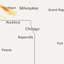
Hail Map for Monday, September 19, 2016

Number of Impacted Households on 9/19/2016
0
Impacted by 1" or Larger Hail
0
Impacted by 1.75" or Larger Hail
0
Impacted by 2.5" or Larger Hail
Square Miles of Populated Area Impacted on 9/19/2016
0
Impacted by 1" or Larger Hail
0
Impacted by 1.75" or Larger Hail
0
Impacted by 2.5" or Larger Hail


Cities Most Affected by Hail Storms of 9/19/2016
| Hail Size | Demographics of Zip Codes Affected | ||||||
|---|---|---|---|---|---|---|---|
| City | Count | Average | Largest | Pop Density | House Value | Income | Age |
| Madison, WI | 4 | 1.88 | 2.00 | 2003 | $154k | $56.3k | 35.2 |
| Guttenberg, IA | 2 | 1.75 | 1.75 | 26 | $82k | $31.9k | 49.1 |
| Verona, WI | 1 | 2.00 | 2.00 | 288 | $182k | $69.7k | 39.3 |
| Middleton, WI | 1 | 1.75 | 1.75 | 797 | $185k | $56.0k | 39.9 |
Hail and Wind Damage Spotted on 9/19/2016
Filter by Report Type:Hail ReportsWind Reports
Wisconsin
| Local Time | Report Details |
|---|---|
| 2:50 PM CDT | Quarter sized hail reported near Hillsboro, WI, 44.7 miles ESE of La Crosse, WI |
| 3:00 PM CDT | Quarter sized hail reported near Richland Center, WI, 52.4 miles ESE of La Crosse, WI, time estimated. |
| 3:22 PM CDT | Quarter sized hail reported near Glen Haven, WI, 66.5 miles NNE of Cedar Rapids, IA |
| 3:25 PM CDT | Quarter sized hail reported near Plain, WI, 36.2 miles WNW of Madison, WI, . |
| 4:00 PM CDT | Quarter sized hail reported near Middleton, WI, 7.5 miles WNW of Madison, WI, . |
| 4:05 PM CDT | Golf Ball sized hail reported near Madison, WI, 6.5 miles WSW of Madison, WI, . |
| 4:05 PM CDT | Golf Ball sized hail reported near Middleton, WI, 6.8 miles W of Madison, WI, 1.5-2 inch diameter hail...majority of hailstones were 1.75 inches in diameter. 1.08 inches of rain in 20 minutes. hail caused damage to car... home roof... siding and |
| 4:06 PM CDT | Quarter sized hail reported near Middleton, WI, 6.5 miles WNW of Madison, WI, reported at middleton police station. |
| 4:10 PM CDT | Ping Pong Ball sized hail reported near Madison, WI, 0.6 miles NE of Madison, WI, 1 1/2 inch diameter hail in the country grove area on the west side of madison. hail started around 410 pm and ended around 420 pm. |
| 4:10 PM CDT | Hen Egg sized hail reported near Madison, WI, 7.8 miles WSW of Madison, WI, . |
| 4:11 PM CDT | Hen Egg sized hail reported near Verona, WI, 7.3 miles W of Madison, WI, 2 inch hail at middleton junction. . |
| 4:12 PM CDT | Ping Pong Ball sized hail reported near Madison, WI, 7.2 miles SW of Madison, WI, . |
| 4:13 PM CDT | Golf Ball sized hail reported near Madison, WI, 5.5 miles WSW of Madison, WI, . |
| 4:15 PM CDT | Ping Pong Ball sized hail reported near Madison, WI, 3.8 miles WSW of Madison, WI, . |
| 4:15 PM CDT | Hen Egg sized hail reported near Madison, WI, 5.6 miles SW of Madison, WI, hail ranging from 1.75 to 2.2 inches in diameter. . |
| 4:15 PM CDT | Ping Pong Ball sized hail reported near Madison, WI, 2.7 miles SW of Madison, WI, 1 1/2 inch diameter hail near intersection of schroeder road and whitney way. hail ended around 425 pm. |
| 4:17 PM CDT | Ping Pong Ball sized hail reported near Madison, WI, 3.3 miles WSW of Madison, WI, . |
| 4:17 PM CDT | Ping Pong Ball sized hail reported near Madison, WI, 4.4 miles SW of Madison, WI, . |
| 4:20 PM CDT | Quarter sized hail reported near Madison, WI, 3.5 miles SW of Madison, WI, . |
| 4:20 PM CDT | Quarter sized hail reported near Madison, WI, 3.2 miles SSW of Madison, WI, . |
| 4:45 PM CDT | Ping Pong Ball sized hail reported near Edgerton, WI, 22.9 miles SE of Madison, WI, 1 mile north of newville. |
Florida
| Local Time | Report Details |
|---|---|
| 4:12 PM EDT | Member of the media called to report medium-sized tree uprooted and fallen due to strong thunderstorm wind gusts at 412 pm near intersection of hillsboro blvd and sw 12 in broward county FL, 41.3 miles N of Miami, FL |
| 4:15 PM EDT | Deerfield beach sheriffs office reported a downed powerline at 415 pm near intersection of military trail and sw 10th street in broward county FL, 39.9 miles N of Miami, FL |
| 4:15 PM EDT | Recieved reports through social media of several trees being knocked down onto parked cars in deerfield beach at 1350 east newport center driv in broward county FL, 40 miles N of Miami, FL |
| 4:28 PM EDT | Deerfield beach sheriffs office reports multiple power lines down near 4400 n powerline rd at 439 pm. event time estimated at 428 pm based on doppler rada in broward county FL, 39 miles N of Miami, FL |
Iowa
| Local Time | Report Details |
|---|---|
| 3:14 PM CDT | Golf Ball sized hail reported near Guttenberg, IA, 63.3 miles NNE of Cedar Rapids, IA, . |
| 3:19 PM CDT | Golf Ball sized hail reported near Guttenberg, IA, 64.6 miles NNE of Cedar Rapids, IA, grape to golfball sized. |
| 5:30 PM CDT | Report of two instances of a large tree downed onto a house in chariton. time and location estimated from rada in lucas county IA, 42.4 miles SSE of Des Moines, IA |
| 5:33 PM CDT | Report of roof off shed and attached garage damaged on southern edge of chariton. time and location estimated from rada in lucas county IA, 43.7 miles SSE of Des Moines, IA |
| 6:21 PM CDT | Wayne county em reported pole barn downed from strong winds. time and location estimated from radar. delayed report. in wayne county IA, 60.2 miles SSE of Des Moines, IA |
| 6:24 PM CDT | Wayne county em reported multiple pole barns blown over. debris from pole barns blew into and downed nearby power line. time estimated from rada in wayne county IA, 64.8 miles SSE of Des Moines, IA |
Georgia
| Local Time | Report Details |
|---|---|
| 7:20 PM EDT | Several trees were blown down in and around the danielsville are in madison county GA, 60.4 miles SW of Greenville, SC |
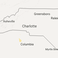
South Carolina
| Local Time | Report Details |
|---|---|
| 7:37 PM EDT | Newberry county dispatch reports trees and power lines down in the city of newberr in newberry county SC, 61.6 miles NNE of Augusta, GA |
| 8:53 PM EDT | Lexington county dispatch reports trees down...one in roadway along s lake dr...other along old chapin r in lexington county SC, 55.5 miles NE of Augusta, GA |
| 8:59 PM EDT | Lexington police department reported a tree down blocking travel near the intersection of bellewood drive and harmon street. time estimated based on rada in lexington county SC, 55.1 miles NE of Augusta, GA |
| 9:15 PM EDT | Sc hwy patrol reports a tree in roadway along hardscrabble rd near sloan rd in ne columbi in richland county SC, 74.2 miles NE of Augusta, GA |
| 9:17 PM EDT | Sc hwy patrol reports a tree in roadway along the 400 block of longtown rd near jilda driv in richland county SC, 74.8 miles S of Charlotte, NC |
| 9:20 PM EDT | Skywarn spotter in the pontiac section of ne columbia reports a tree down along hickory hills trai in richland county SC, 73.9 miles S of Charlotte, NC |
| 9:21 PM EDT | Tree down along us 1 near richland county lin in kershaw county SC, 73.3 miles S of Charlotte, NC |
| 9:27 PM EDT | Sc highway patrol reports a tree in roadway on steven campbell road near the intersection with us 1. time estimated based on radar. in kershaw county SC, 73.9 miles S of Charlotte, NC |
Missouri
| Local Time | Report Details |
|---|---|
| 7:12 PM CDT | Powerlines and a few larger limbs dow in putnam county MO, 73.9 miles SSE of Des Moines, IA |
| 7:20 PM CDT | Several trees down...unknown condition in linn county MO, 78.3 miles S of Des Moines, IA |
| 7:20 PM CDT | Several trees down...unknown condition in mercer county MO, 82.5 miles W of Kahoka, MO |
| 7:48 PM CDT | Reported 60mph gusts west of mila in sullivan county MO, 78.6 miles W of Kahoka, MO |
| 8:10 PM CDT | Porch blown off hous in sullivan county MO, 84.9 miles WSW of Kahoka, MO |
| 8:26 PM CDT | Large tree down along linn s in grundy county MO, 85.4 miles NE of Kansas City, MO |
| 8:26 PM CDT | Multiple tree limbs down along 5th and ellison s in grundy county MO, 84.5 miles NE of Kansas City, MO |
| 8:26 PM CDT | Numerous trees uprooted through trenton. roof blown off industrial building and site built building blown down in park in grundy county MO, 84.8 miles NE of Kansas City, MO |
| 8:56 PM CDT | Large tree down along linn s in grundy county MO, 85.4 miles NE of Kansas City, MO |
| 8:56 PM CDT | Multiple tree limbs down along 5th and ellison s in grundy county MO, 84.5 miles NE of Kansas City, MO |
Kansas
| Local Time | Report Details |
|---|---|
| 8:24 PM CDT | Several trees down...unknown condition in franklin county KS, 49.4 miles SW of Kansas City, MO |
Connect with Interactive Hail Maps