

Hail Map for Saturday, September 3, 2011

Number of Impacted Households on 9/3/2011
0
Impacted by 1" or Larger Hail
0
Impacted by 1.75" or Larger Hail
0
Impacted by 2.5" or Larger Hail
Square Miles of Populated Area Impacted on 9/3/2011
0
Impacted by 1" or Larger Hail
0
Impacted by 1.75" or Larger Hail
0
Impacted by 2.5" or Larger Hail


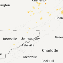


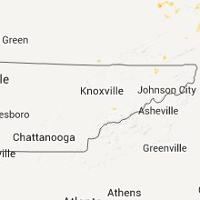


Cities Most Affected by Hail Storms of 9/3/2011
| Hail Size | Demographics of Zip Codes Affected | ||||||
|---|---|---|---|---|---|---|---|
| City | Count | Average | Largest | Pop Density | House Value | Income | Age |
| Homer Glen, IL | 2 | 1.75 | 1.75 | 910 | $0k | $0.0k | 42.8 |
| Centreville, MI | 1 | 2.00 | 2.00 | 67 | $84k | $44.5k | 37.3 |
| Fairfield, IA | 1 | 1.75 | 1.75 | 66 | $77k | $33.5k | 43.7 |
| Galesburg, IL | 1 | 1.75 | 1.75 | 273 | $63k | $32.8k | 40.6 |
| Monmouth, IL | 1 | 1.75 | 1.75 | 70 | $57k | $34.6k | 36.0 |
| Shepherd, MI | 1 | 1.75 | 1.75 | 56 | $84k | $42.4k | 38.7 |
| Lizemores, WV | 1 | 1.75 | 1.75 | 25 | $46k | $22.2k | 40.4 |
| South Bend, IN | 1 | 1.75 | 1.75 | 753 | $70k | $37.0k | 36.8 |
Hail and Wind Damage Spotted on 9/3/2011
Filter by Report Type:Hail ReportsWind Reports
States Impacted
Michigan, Minnesota, Virginia, West Virginia, Iowa, Illinois, Ohio, Tennessee, New Mexico, Missouri, Indiana, Pennsylvania, Kentucky, New York, Louisiana, Mississippi, FloridaMichigan
| Local Time | Report Details |
|---|---|
| 12:00 PM UTC | 2 trees down in cit in ottawa county MI, 28.5 miles WNW of Grand Rapids, MI |
| 12:00 PM UTC | 2 trees down in grand have in ottawa county MI, 28.5 miles WNW of Grand Rapids, MI |
| 12:20 PM UTC | 2 trees down norther kent county. 1 at 16 mile rd. 1 at sargent r in kent county MI, 18 miles NNW of Grand Rapids, MI |
| 12:25 PM UTC | Numerous trees and wires down across count in muskegon county MI, 34.1 miles WNW of Grand Rapids, MI |
| 12:35 PM UTC | Numerous trees and wires down in the area of the cities of newaygo and gran in newaygo county MI, 32.1 miles NNW of Grand Rapids, MI |
| 8:37 AM EDT | Golf Ball sized hail reported near Shepherd, MI, 56 miles NE of Grand Rapids, MI |
| 12:55 PM UTC | Numerous 6 in tree limbs down. some healthy. green house roof blown of in muskegon county MI, 37.3 miles NW of Grand Rapids, MI |
| 12:55 PM UTC | Numerous 6 in tree limbvs down. some healthy. green house roof blown of in muskegon county MI, 37.3 miles NW of Grand Rapids, MI |
| 1:10 PM UTC | Wind estimated 60 to 70 mph. numerous trees down and blocking roadwa in newaygo county MI, 31.4 miles N of Grand Rapids, MI |
| 1:15 PM UTC | Few trees and wires down no significant damag in montcalm county MI, 31.6 miles NNE of Grand Rapids, MI |
| 1:16 PM UTC | Many trees and power lines reported down across the north of montcalm count in montcalm county MI, 35 miles NNE of Grand Rapids, MI |
| 1:35 PM UTC | Scattered healthy trees and limbs dow in mecosta county MI, 46.6 miles NNE of Grand Rapids, MI |
| 1:53 PM UTC | 2 healthy one foot diameter trees snapped near the bas in isabella county MI, 58.8 miles NE of Grand Rapids, MI |
| 2:05 PM UTC | Pea sized hail. wind est at 60 mph. siding torn off building. lot of 2 -3 inch limbs dow in isabella county MI, 61.2 miles NE of Grand Rapids, MI |
| 2:25 PM UTC | Multiple trees and power lines down. lightning struck central dispatchs communications tower...they have no radio communication in gladwin county MI, 77.5 miles SE of Traverse City, MI |
| 2:25 PM UTC | Several large maple trees blown dow in gladwin county MI, 75.5 miles SE of Traverse City, MI |
| 2:40 PM UTC | Numerous trees and powerlines down in the cit in midland county MI, 50.2 miles NNW of Flint, MI |
| 2:42 PM UTC | Powerlines reported dow in saginaw county MI, 39.4 miles NW of Flint, MI |
| 3:07 PM UTC | Powerlines reported dow in saginaw county MI, 31.2 miles NNW of Flint, MI |
| 5:15 PM EDT | Hen Egg sized hail reported near Centreville, MI, 61.9 miles NNW of Fort Wayne, IN, report relayed by media |
| 9:27 PM UTC | Tree down on car on m66 just south of maystead rd in st. joseph county MI, 55.8 miles NNW of Fort Wayne, IN |
| 9:35 PM UTC | Tree down on power lines. power out in the area in st. joseph county MI, 51.8 miles NNW of Fort Wayne, IN |
| 10:00 PM UTC | Storm damage reported in branch county MI, 59.8 miles N of Fort Wayne, IN |
| 10:00 PM UTC | Tree down blocking road in branch county MI, 59.7 miles N of Fort Wayne, IN |
| 10:05 PM UTC | 3 trees down in branch county MI, 59.7 miles N of Fort Wayne, IN |
| 6:05 PM EDT | Quarter sized hail reported near East Leroy, MI, 59.4 miles SSE of Grand Rapids, MI |
| 10:08 PM UTC | Tree down on camper with 2 occupants. injuries unknown at this time in branch county MI, 61.9 miles N of Fort Wayne, IN |
| 10:08 PM UTC | Tree down on camper with 2 occupants. no injuries. minor damage to cars and trailers from fallen tree limbs in branch county MI, 61.9 miles N of Fort Wayne, IN |
| 10:10 PM UTC | Numerous trees down in the northern half of the county in branch county MI, 64.5 miles N of Fort Wayne, IN |
| 6:20 PM EDT | Quarter sized hail reported near Quincy, MI, 64.6 miles NNE of Fort Wayne, IN, at corner of jonesville road and squires road |
| 6:23 PM EDT | Quarter sized hail reported near Quincy, MI, 60.7 miles N of Fort Wayne, IN |
| 10:25 PM UTC | Tree down at squires and genesee road along with sheet metal from barn at squires and jonesville roa in hillsdale county MI, 65.4 miles NNE of Fort Wayne, IN |
| 10:27 PM UTC | Tree down across hadley rd and herring road in hillsdale county MI, 67.6 miles NNE of Fort Wayne, IN |
| 10:30 PM UTC | Power lines and trees down in hillsdale county MI, 68.8 miles NNE of Fort Wayne, IN |
| 10:35 PM UTC | Two trees down. time estimated from radar in hillsdale county MI, 68.8 miles NNE of Fort Wayne, IN |
| 10:48 PM UTC | Multiple large tree limbs down between tripp and folks on mosco in jackson county MI, 74.2 miles SW of Flint, MI |
| 10:50 PM UTC | Trees and power lines down in hillsdale county MI, 73.9 miles NNE of Fort Wayne, IN |
| 10:50 PM UTC | Damage to structures at river rouge days festival. 8 to 10 injuries reported by police...none life threatening. multiple festival tents blown over. vender trailers move in wayne county MI, 58.7 miles SSE of Flint, MI |
| 10:50 PM UTC | Damage to structures at river rouge days festival. several injuries reported in wayne county MI, 58.7 miles SSE of Flint, MI |
| 11:00 PM UTC | 4 to 6 inch diameter tree limb down. estimated 60 mph wind on columbia lak in jackson county MI, 69.9 miles SSW of Flint, MI |
| 11:41 PM UTC | Numerous in washtenaw county MI, 60.1 miles SSW of Flint, MI |
| 11:46 PM UTC | Large tree in road in washtenaw county MI, 44.5 miles SSW of Flint, MI |
| 11:50 PM UTC | Arm-sized tree branch dow in washtenaw county MI, 50.5 miles S of Flint, MI |
| 12:02 AM UTC | 8 inch diameter tree dow in washtenaw county MI, 50.3 miles S of Flint, MI |
| 12:41 AM UTC | Multiple reports of 60 mph wind estimates and power outages through royal oak and madison height in oakland county MI, 47.4 miles SE of Flint, MI |
| 1:15 AM UTC | Trees and powerlines reported down in ira township. reports of trees through houses. powerlines reported down near the m-29/bethuy intersectio in st. clair county MI, 54.8 miles ESE of Flint, MI |
| 4:25 AM UTC | Trees reported town in oregon townshi in lapeer county MI, 16.4 miles ENE of Flint, MI |
Minnesota
| Local Time | Report Details |
|---|---|
| 10:05 AM CDT | Quarter sized hail reported near Albert Lea, MN, 37.4 miles N of Mason City, IA, one mile east of bancroft. lasted about five minutes. little wind. |
Virginia
| Local Time | Report Details |
|---|---|
| 6:01 PM UTC | Trees down along irish creek roa in rockbridge county VA, 52.8 miles NE of Roanoke, VA |
| 3:00 PM EDT | Ping Pong Ball sized hail reported near Hot Springs, VA, 50.6 miles N of Roanoke, VA, reported at the homestead resort |
| 7:02 PM UTC | Trees down along hays creek roa in rockbridge county VA, 56.6 miles NE of Roanoke, VA |
| 7:15 PM UTC | Storm damage reported in bath county VA, 50.6 miles N of Roanoke, VA |
| 7:30 PM UTC | Two trees down on valley ridge roa in alleghany county VA, 35.1 miles N of Roanoke, VA |
| 3:33 PM EDT | Quarter sized hail reported near Covington, VA, 35.1 miles N of Roanoke, VA |
| 7:38 PM UTC | Large tree limbs down in bath county VA, 47.7 miles N of Roanoke, VA |
| 7:40 PM UTC | Large tree down near entrance of douthat state park in bath county VA, 42.6 miles N of Roanoke, VA |
| 8:00 PM UTC | Several trees down on craig creek roa in botetourt county VA, 26.8 miles N of Roanoke, VA |
| 8:30 PM UTC | Tree down on route 606 near border with botetourt count in craig county VA, 19.4 miles N of Roanoke, VA |
| 9:10 PM UTC | Multiple large tree limbs were blown down near...and out to a one mile radius from...exit 84 of i-8 in wythe county VA, 56.4 miles WSW of Roanoke, VA |
| 9:20 PM UTC | Tree blocking stockpen mountain roa in giles county VA, 48.7 miles W of Roanoke, VA |
| 9:25 PM UTC | Tree down on a power line on east main near park stree in montgomery county VA, 26.9 miles WSW of Roanoke, VA |
| 9:35 PM UTC | Tree down on highway 42 in the crandon area in bland county VA, 56.9 miles W of Roanoke, VA |
| 9:35 PM UTC | Tree on a power line on mcdaniel driv in montgomery county VA, 25.1 miles WSW of Roanoke, VA |
West Virginia
| Local Time | Report Details |
|---|---|
| 6:43 PM UTC | Trees down along state route 6 in greenbrier county WV, 50.3 miles NW of Roanoke, VA |
| 6:45 PM UTC | Several large limbs down on boggs road. also had pea size hai in greenbrier county WV, 49.9 miles NNW of Roanoke, VA |
| 6:56 PM UTC | Tree down along sandy ridge road in pendleton county WV, 34.9 miles SE of Elkins, WV |
| 7:34 PM UTC | Trees down on rocky branch road in mercer county WV, 64.6 miles W of Roanoke, VA |
| 8:05 PM UTC | Several trees down around bluestone lak in summers county WV, 60 miles WNW of Roanoke, VA |
| 9:00 PM UTC | Tree down in raleigh county WV, 49.8 miles SSE of Charleston, WV |
| 9:54 PM UTC | Tree down in mingo county WV, 52.3 miles SW of Charleston, WV |
| 6:28 PM EDT | Golf Ball sized hail reported near Lizemores, WV, 25.5 miles E of Charleston, WV |
| 10:42 PM UTC | Tree down over bridge rd and louden heights rd in kanawha county WV, 0.5 miles E of Charleston, WV |
| 10:48 PM UTC | Multiple trees down in ranger in lincoln county WV, 33.4 miles WSW of Charleston, WV |
| 10:56 PM UTC | Trees and power lines down with transformer damage chestnut r in kanawha county WV, 0.5 miles E of Charleston, WV |
| 11:00 PM UTC | Three trees and power poles lines down along crooked creek r in kanawha county WV, 10.2 miles WSW of Charleston, WV |
| 11:00 PM UTC | Several trees... power poles... and power lines down along rte 10 between ranger and branchland in lincoln county WV, 33.4 miles WSW of Charleston, WV |
Iowa
| Local Time | Report Details |
|---|---|
| 1:45 PM CDT | Quarter sized hail reported near Fairfield, IA, 42.7 miles NNW of Kahoka, MO, delayed report. pea to quarter sized hail fell around 145 pm september 3. |
| 1:45 PM CDT | Golf Ball sized hail reported near Fairfield, IA, 44.7 miles NNW of Kahoka, MO, hail continuing as of 151 pm. intensity has diminished a little. |
| 1:52 PM CDT | Quarter sized hail reported near Libertyville, IA, 38.3 miles NNW of Kahoka, MO, mostly nickel sized hail with a few quarter size |
| 1:55 PM CDT | Quarter sized hail reported near Fairfield, IA, 42.1 miles NNW of Kahoka, MO, nickel and dime sized hail with a few quarter size |
| 7:58 PM UTC | Wind gusts estimated to be 65 mph blew a tree down blocking the east bound lane in tow in des moines county IA, 37.2 miles NE of Kahoka, MO |
Illinois
| Local Time | Report Details |
|---|---|
| 7:00 PM UTC | Storm damage reported in la salle county IL, 50.7 miles NNE of Peoria, IL |
| 7:15 PM UTC | Storm damage reported in la salle county IL, 50.7 miles NNE of Peoria, IL |
| 2:20 PM CDT | Golf Ball sized hail reported near Homer Glen, IL, 24.2 miles SW of Chicago, IL, intersection of 143rd and golden oak. corrected time to radar based estimate. |
| 2:35 PM CDT | Quarter sized hail reported near Ottawa, IL, 59.9 miles NE of Peoria, IL, north side. also measured 50 mph. |
| 2:36 PM CDT | Quarter sized hail reported near Ottawa, IL, 59.9 miles NE of Peoria, IL, i-80 and rt 23 |
| 2:39 PM CDT | Golf Ball sized hail reported near Homer Glen, IL, 24.2 miles SW of Chicago, IL, intersection of 143rd and golden oak |
| 2:40 PM CDT | Half Dollar sized hail reported near Channahon, IL, 43.7 miles SW of Chicago, IL, mckinley woods. hail covering ground |
| 2:43 PM CDT | Quarter sized hail reported near Palos Heights, IL, 17.1 miles SSW of Chicago, IL, southwest highway and rt 83 |
| 2:48 PM CDT | Quarter sized hail reported near Worth, IL, 15.7 miles SSW of Chicago, IL, estimated wind gust to 60 mph. small limbs down. |
| 8:07 PM UTC | 5 inch diameter tree limbs down. 2.09 inches of rai in cook county IL, 14.8 miles SSW of Chicago, IL |
| 8:30 PM UTC | Storm damage reported in fulton county IL, 30.5 miles WSW of Peoria, IL |
| 3:35 PM CDT | Half Dollar sized hail reported near Monmouth, IL, 57.2 miles WNW of Peoria, IL, half dollar sized hail reported |
| 3:35 PM CDT | Golf Ball sized hail reported near Monmouth, IL, 57.2 miles WNW of Peoria, IL, golf ball sized hail reported |
| 3:45 PM CDT | Quarter sized hail reported near Monmouth, IL, 57.2 miles WNW of Peoria, IL, pea to quarter sized hail. |
| 3:50 PM CDT | Quarter sized hail reported near Cameron, IL, 50.6 miles WNW of Peoria, IL, time estimated |
| 8:52 PM UTC | Up to 12 inches in diameter tree limbs blown down...time based on radar in knox county IL, 43.3 miles W of Peoria, IL |
| 3:56 PM CDT | Golf Ball sized hail reported near Galesburg, IL, 43.7 miles WNW of Peoria, IL, time based on radar |
| 9:00 PM UTC | 3 to 6 foot tree limbs down at spoon river college in canton...and some corn fields flattened near canto in fulton county IL, 25.5 miles WSW of Peoria, IL |
| 9:00 PM UTC | 5-6 inch diameter trees and branches down in fulton county IL, 45.2 miles WSW of Peoria, IL |
| 9:00 PM UTC | 24 to 30 inch live oak trees nearly 80 feet tall blown down...with the root balls showin in peoria county IL, 3.8 miles W of Peoria, IL |
| 9:00 PM UTC | 18 inch tree down on croy lane near lake camalot in peoria county IL, 4.8 miles W of Peoria, IL |
| 9:00 PM UTC | Utility poles down in lake camalot in peoria county IL, 4.8 miles W of Peoria, IL |
| 9:05 PM UTC | Storm damage reported in peoria county IL, 7.8 miles WSW of Peoria, IL |
| 9:29 PM UTC | Utility poles down in lake camalot in peoria county IL, 4.8 miles W of Peoria, IL |
| 9:45 PM UTC | Large tree down and two telephone poles snapped in madison county IL, 19.4 miles NNE of Saint Louis, MO |
| 11:22 PM UTC | Jim pitchford reported tree limbs blown onto power lines. roof was blown off of barn. time of occurrence was estimated to be around 520 p in macoupin county IL, 34.4 miles NE of Saint Louis, MO |
| 11:22 PM UTC | Jim pitchford reported tree limbs blown onto power lines. roof was blown off of barn. time of occurrence was estimated to be around 620 p in macoupin county IL, 34.4 miles NE of Saint Louis, MO |
| 11:30 PM UTC | Storm damage reported in christian county IL, 48.9 miles W of Mattoon, IL |
| 12:10 AM UTC | Calf barn blown down 2 miles north of bartelso. tin roof blown off of a barn 2.5 miles north of bartelso. 1 power pole snapped in half on the east side of bartelso. tim in clinton county IL, 39.7 miles E of Saint Louis, MO |
| 12:15 AM UTC | Storm damage reported in st. clair county IL, 17.8 miles E of Saint Louis, MO |
Ohio
| Local Time | Report Details |
|---|---|
| 8:00 PM UTC | Barn damaged in logan county OH, 55.7 miles NW of Columbus, OH |
| 6:10 PM EDT | Quarter sized hail reported near Marion, OH, 41 miles NNW of Columbus, OH |
| 8:23 PM EDT | Quarter sized hail reported near Greenville, OH, 68.8 miles N of Cincinnati, OH |
| 12:28 AM UTC | Numerous large trees down on the south side of greenvill in darke county OH, 68.2 miles N of Cincinnati, OH |
| 12:30 AM UTC | Several trees down in the greenville are in darke county OH, 68.8 miles N of Cincinnati, OH |
| 12:32 AM UTC | Roof removed from a barn on kruckeberg roa in darke county OH, 70.1 miles N of Cincinnati, OH |
| 1:37 AM UTC | Tree down on thayer road in allen county OH, 58.6 miles ESE of Fort Wayne, IN |
| 2:10 AM UTC | Storm damage reported in montgomery county OH, 55.9 miles NNE of Cincinnati, OH |
| 2:15 AM UTC | Trees and power poles dow in putnam county OH, 60.7 miles E of Fort Wayne, IN |
| 2:37 AM UTC | Barn roof off and several trees down on eagleville road in wood county OH, 76.5 miles E of Fort Wayne, IN |
| 2:41 AM UTC | Multiple trees down. siding torn off mobile home. time estimate in clark county OH, 53.7 miles W of Columbus, OH |
| 2:55 AM UTC | Storm damage reported in clark county OH, 50.4 miles W of Columbus, OH |
| 3:00 AM UTC | Trees down in preble county OH, 43.7 miles N of Cincinnati, OH |
| 3:15 AM UTC | Numerous trees down in the count in seneca county OH, 80.4 miles N of Columbus, OH |
| 3:58 AM UTC | Storm damage reported in marion county OH, 43.2 miles N of Columbus, OH |
| 4:05 AM UTC | Numerous trees down across the southern part of the county in champaign county OH, 40 miles W of Columbus, OH |
| 4:14 AM UTC | Large limbs down on a hous in champaign county OH, 40.9 miles WNW of Columbus, OH |
| 4:20 AM UTC | One 2 to 3 foot tree down in the middle of town. railroad crossing arm guard equipment bent. several big tree limbs fallen on cars throughout the cit in delaware county OH, 23.7 miles N of Columbus, OH |
| 5:18 AM UTC | Numerous large trees sheared and uprooted. 19 loaded trailers overturned and 2 air conditioning units blown off roof at distribution center. 8 wooden high voltage tower in miami county OH, 62.4 miles NNE of Cincinnati, OH |
| 5:21 AM UTC | Semi tipped over on the i75 bypas in miami county OH, 61.4 miles NNE of Cincinnati, OH |
| 5:35 AM UTC | One tree reported down due to thunderstorm wind in medina county OH, 34.7 miles SSW of Cleveland, OH |
| 5:36 AM UTC | One tree was reported down by thunderstorm wind in medina county OH, 31.9 miles SSW of Cleveland, OH |
| 6:40 AM UTC | Several trees down in the mount gilead are in morrow county OH, 41.5 miles NNE of Columbus, OH |
| 7:00 AM UTC | Trees down in madison county OH, 22.9 miles WNW of Columbus, OH |
Tennessee
| Local Time | Report Details |
|---|---|
| 8:05 PM UTC | Damage to roof and back wall of a business located at the intersection of eastman road and east stone driv in sullivan county TN, 18.2 miles WSW of Bristol, TN |
| 8:35 PM UTC | Roof damage to model city apartments on stonegate roa in sullivan county TN, 19.3 miles WSW of Bristol, TN |
| 9:00 PM UTC | Several trees down in hawkins county TN, 27.5 miles W of Bristol, TN |
| 9:20 PM UTC | Few trees down in blount county TN, 14.8 miles S of Knoxville, TN |
| 9:30 PM UTC | Several trees down in loudon county TN, 25.9 miles SW of Knoxville, TN |
| 10:00 PM UTC | Several trees down in loudon county TN, 22.5 miles WSW of Knoxville, TN |
| 10:25 PM UTC | Several trees down in knox county TN, 1.8 miles WNW of Knoxville, TN |
| 11:00 PM UTC | Few trees down in hamilton county TN, 12 miles NE of Chattanooga, TN |
| 12:00 AM UTC | Several trees down on hard luck ranch roa in sequatchie county TN, 22.2 miles NNW of Chattanooga, TN |
| 2:12 AM UTC | A few trees down and power outages between gallatin and castalian springs in sumner county TN, 25.7 miles NE of Nashville, TN |
New Mexico
| Local Time | Report Details |
|---|---|
| 2:05 PM MDT | Quarter sized hail reported near Mills, NM, 70.6 miles NNW of Tucumcari, NM, pea to quarter size hail. |
| 12:01 AM UTC | Ktcc aso in quay county NM, 6.9 miles ENE of Tucumcari, NM |
Missouri
| Local Time | Report Details |
|---|---|
| 8:40 PM UTC | Power lines down and significant damage to trees near lemay ferry and reavis barracks road. apporximate tim in st. louis county MO, 8 miles SSW of Saint Louis, MO |
| 10:51 PM UTC | Measured by the asos at lambert fiel in st. louis county MO, 13 miles NW of Saint Louis, MO |
| 11:30 PM UTC | Power lines and 3 to 5 inch diameter limbs down in rock hill and mcknight are in st. louis county MO, 8.2 miles W of Saint Louis, MO |
Indiana
| Local Time | Report Details |
|---|---|
| 8:40 PM UTC | At godsey and state road 37...power lines and a few trees down...at least one foot in diameter in morgan county IN, 32.2 miles SSW of Indianapolis, IN |
| 8:46 PM UTC | Storm damage reported in monroe county IN, 50.5 miles SSW of Indianapolis, IN |
| 5:05 PM EDT | Quarter sized hail reported near Goshen, IN, 51.6 miles NW of Fort Wayne, IN, at elkhart co fairgrounds |
| 9:17 PM UTC | Delayed report. 1 large tree down at indiana dunes state park. 4 other trees partially knocked over into other tree in porter county IN, 35.5 miles ESE of Chicago, IL |
| 9:35 PM UTC | Several trees and limbs downed along mann road between mills and thompson roads. adjacent corn field also had numerous stalks blown ove in marion county IN, 6.7 miles SW of Indianapolis, IN |
| 9:44 PM UTC | Large tree limb down at fail road and us 20 in la porte county IN, 51.2 miles ESE of Chicago, IL |
| 9:45 PM UTC | Power lines down in elkhart county IN, 58.2 miles NW of Fort Wayne, IN |
| 9:45 PM UTC | Large tree fell on a residence. the roof is sagging. time estimate in marion county IN, 0.6 miles WNW of Indianapolis, IN |
| 9:45 PM UTC | Trees down at the intersection of state roads 39 and 8 in starke county IN, 60.4 miles SE of Chicago, IL |
| 9:50 PM UTC | Power lines down in elkhart county IN, 51.6 miles NW of Fort Wayne, IN |
| 9:55 PM UTC | Parts of a tree downed on a vehicle near 22nd and college ave just north of downtow in marion county IN, 3 miles N of Indianapolis, IN |
| 10:00 PM UTC | Several tree limbs downed near the intersection of millersville road and 42nd stree in marion county IN, 5.7 miles NE of Indianapolis, IN |
| 6:13 PM EDT | Golf Ball sized hail reported near South Bend, IN, 67.6 miles E of Chicago, IL |
| 10:22 PM UTC | Located at 700 north and 475 west...dime size hail accompanied the winds in hancock county IN, 15.3 miles NE of Indianapolis, IN |
| 10:40 PM UTC | Multiple trees and power lines down in the area in starke county IN, 70.9 miles SE of Chicago, IL |
| 10:52 PM UTC | Trees down on power lines near intersection of sr 32 and 875w. power out in the lapel are in madison county IN, 27.6 miles NE of Indianapolis, IN |
| 10:58 PM UTC | Report from channel 18 blog. time and exact location estimate in fountain county IN, 62.4 miles WNW of Indianapolis, IN |
| 11:00 PM UTC | Report from channel 18 blog. time and exact location estimate in fountain county IN, 62.4 miles WNW of Indianapolis, IN |
| 11:00 PM UTC | Several trees down...up to 3 feet in diameter in fountain county IN, 63.5 miles WNW of Indianapolis, IN |
| 11:10 PM UTC | Utility lines and small trees are down in the frankton are in madison county IN, 37.2 miles NNE of Indianapolis, IN |
| 11:10 PM UTC | Trees and power lines are down in the area of state road 9 and 600 north in madison county IN, 38.9 miles NE of Indianapolis, IN |
| 11:12 PM UTC | *** 1 inj *** damage in park between east highland avenue and mcculloch boulevard. large tree damaged 9 cars and injured 1. injury is believed to be mino in delaware county IN, 51 miles NE of Indianapolis, IN |
| 11:12 PM UTC | Three trees were blown down in the vicinity of county roads 500 south and 600 sout in delaware county IN, 45.3 miles ENE of Indianapolis, IN |
| 11:24 PM UTC | Large tree down onto a van near intersection of state route 13 and county road 26. no injurie in elkhart county IN, 49.2 miles NW of Fort Wayne, IN |
| 11:34 PM UTC | Trees down on the elkhart and lagrange county line... between county roads 28 and 3 in lagrange county IN, 47 miles NW of Fort Wayne, IN |
| 11:35 PM UTC | Trees and power lines down throughout the county in lagrange county IN, 42.4 miles NNW of Fort Wayne, IN |
| 12:06 AM UTC | Small tree limbs down...accompanied by very heavy rain and gusty winds in bartholomew county IN, 45.1 miles S of Indianapolis, IN |
| 3:20 AM UTC | Trees and power lines dow in scott county IN, 48.6 miles N of Louisville, KY |
| 9:32 AM UTC | One tree down near the intersection of state roads 64 and 16 in dubois county IN, 43.9 miles ENE of Evansville, IN |
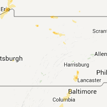
Pennsylvania
| Local Time | Report Details |
|---|---|
| 10:20 PM UTC | Trees down in mckean county PA, 75.7 miles NNW of State College, PA |
| 6:41 PM EDT | Half Dollar sized hail reported near New Kensington, PA, 15 miles NE of Pittsburgh, PA, event occurred between 634 pm 09 03 2011 and 649 pm 09 03 2011 |
| 10:45 PM UTC | Trees down in westmoreland county PA, 15 miles NE of Pittsburgh, PA |
| 6:46 PM EDT | Half Dollar sized hail reported near New Kensington, PA, 15 miles NE of Pittsburgh, PA |
| 11:05 PM UTC | Trees down in clinton county PA, 33.9 miles NE of State College, PA |
| 6:40 AM UTC | Large limb fell on power lin in erie county PA, 70.8 miles ENE of Cleveland, OH |
| 7:05 AM UTC | Tree limb fell on house and pulled down the gutte in erie county PA, 73.8 miles ENE of Cleveland, OH |
Kentucky
| Local Time | Report Details |
|---|---|
| 12:30 AM UTC | One tree down across a power line at the intersection of ky 836 and lloyd wilson r in whitley county KY, 60.2 miles N of Knoxville, TN |
| 3:18 AM UTC | Trees and power lines down. report received via jefferson county indiana dispatc in trimble county KY, 46.8 miles NNE of Louisville, KY |
| 3:55 AM UTC | Trees and power lines dow in logan county KY, 57.5 miles N of Nashville, TN |
New York
| Local Time | Report Details |
|---|---|
| 1:10 AM UTC | Trees down across alma hill roa in allegany county NY, 71.4 miles SE of Buffalo, NY |
| 8:25 AM UTC | Public reported several apartment windows blown in by storm in niagara county NY, 10.7 miles N of Buffalo, NY |
| 8:26 AM UTC | Storm damage reported in niagara county NY, 15.8 miles NNW of Buffalo, NY |
| 8:27 AM UTC | Tree down on lower river road in niagara county NY, 22.7 miles NNW of Buffalo, NY |
| 8:27 AM UTC | Power lines down on upper mountain road in niagara county NY, 20.9 miles NNE of Buffalo, NY |
| 8:31 AM UTC | Power lines down in niagara county NY, 20.6 miles NNE of Buffalo, NY |
| 8:36 AM UTC | Tree down on lombardy street in erie county NY, 11.1 miles E of Buffalo, NY |
| 8:50 AM UTC | Awning torn off of rv and several collapsed tents reported at golden hill state par in niagara county NY, 38.5 miles NNE of Buffalo, NY |
Louisiana
| Local Time | Report Details |
|---|---|
| 1:30 AM UTC | Minor damage to structures reported in verret. possible tornad in st. bernard county LA, 19 miles ESE of New Orleans, LA |
| 1:50 AM UTC | Home on pilate ln damaged by possible tornado. near intersection of hwy 300 and hwy 46. time estimated based on rada in st. bernard county LA, 20.7 miles ESE of New Orleans, LA |
Mississippi
| Local Time | Report Details |
|---|---|
| 3:18 AM UTC | 20613 hwy 603. trailer flipped by possible tornado. time estimated based on rada in hancock county MS, 52.1 miles NE of New Orleans, LA |
Florida
| Local Time | Report Details |
|---|---|
| 9:52 AM UTC | Hurlbert asos reported a wind gust of 59 mp in okaloosa county FL, 18 miles W of Miramar Beach, FL |
Connect with Interactive Hail Maps