

Hail Map for Monday, September 7, 2015

Number of Impacted Households on 9/7/2015
0
Impacted by 1" or Larger Hail
0
Impacted by 1.75" or Larger Hail
0
Impacted by 2.5" or Larger Hail
Square Miles of Populated Area Impacted on 9/7/2015
0
Impacted by 1" or Larger Hail
0
Impacted by 1.75" or Larger Hail
0
Impacted by 2.5" or Larger Hail


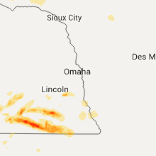


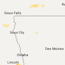

Cities Most Affected by Hail Storms of 9/7/2015
| Hail Size | Demographics of Zip Codes Affected | ||||||
|---|---|---|---|---|---|---|---|
| City | Count | Average | Largest | Pop Density | House Value | Income | Age |
| Fairbury, NE | 3 | 2.08 | 2.50 | 17 | $42k | $31.2k | 46.2 |
| Onida, SD | 2 | 1.88 | 2.00 | 1 | $56k | $35.2k | 43.7 |
| Fort Pierre, SD | 2 | 1.88 | 2.00 | 2 | $85k | $41.6k | 41.8 |
| Odell, NE | 1 | 2.75 | 2.75 | 5 | $47k | $34.6k | 46.6 |
| Gilead, NE | 1 | 2.50 | 2.50 | 0 | $28k | $25.8k | 42.5 |
| Belvidere, NE | 1 | 2.00 | 2.00 | 3 | $13k | $29.7k | 47.8 |
| Pierre, SD | 1 | 2.00 | 2.00 | 27 | $96k | $43.5k | 39.7 |
| Endicott, NE | 1 | 1.75 | 1.75 | 6 | $35k | $36.4k | 49.2 |
| Hastings, NE | 1 | 1.75 | 1.75 | 184 | $78k | $36.9k | 37.0 |
| Pickrell, NE | 1 | 1.75 | 1.75 | 7 | $69k | $35.1k | 44.4 |
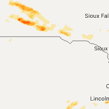
Hail and Wind Damage Spotted on 9/7/2015
Filter by Report Type:Hail ReportsWind Reports
Nebraska
| Local Time | Report Details |
|---|---|
| 2:39 PM CDT | Storm damage reported in thayer county NE, 67.8 miles SE of Grand Island, NE |
| 2:55 PM CDT | Hen Egg sized hail reported near Belvidere, NE, 62.1 miles SE of Grand Island, NE, report via social media |
| 3:08 PM CDT | Tennis Ball sized hail reported near Gilead, NE, 72.1 miles SE of Grand Island, NE, report via social media |
| 3:15 PM CDT | Ping Pong Ball sized hail reported near Alexandria, NE, 68.3 miles SE of Grand Island, NE, time est fm radar. |
| 3:23 PM CDT | Hen Egg sized hail reported near Fairbury, NE, 75 miles NNW of Manhattan, KS |
| 3:25 PM CDT | Tennis Ball sized hail reported near Fairbury, NE, 77.1 miles SE of Grand Island, NE, up to tennis ball size hail. damage to roof and windows broken in house. also crop damage. |
| 3:30 PM CDT | Trees snapped or uproote in jefferson county NE, 68.6 miles NNW of Manhattan, KS |
| 3:32 PM CDT | Storm damage reported in jefferson county NE, 74.1 miles NNW of Manhattan, KS |
| 3:34 PM CDT | Half Dollar sized hail reported near Fairbury, NE, 74.1 miles NNW of Manhattan, KS |
| 3:42 PM CDT | Golf Ball sized hail reported near Fairbury, NE, 73.2 miles NNW of Manhattan, KS, at highway 8 and highway 15. |
| 3:45 PM CDT | Power out throughout fairbur in jefferson county NE, 74.1 miles NNW of Manhattan, KS |
| 3:45 PM CDT | Golf Ball sized hail reported near Endicott, NE, 64.8 miles NNW of Manhattan, KS |
| 3:45 PM CDT | Storm damage reported in jefferson county NE, 64.8 miles NNW of Manhattan, KS |
| 3:51 PM CDT | Quarter sized hail reported near Fairbury, NE, 69.5 miles NNW of Manhattan, KS |
| 3:51 PM CDT | Storm damage reported in jefferson county NE, 69.5 miles NNW of Manhattan, KS |
| 4:20 PM CDT | Storm damage reported in gage county NE, 66.2 miles N of Manhattan, KS |
| 4:30 PM CDT | Baseball sized hail reported near Odell, NE, 61.4 miles NNW of Manhattan, KS |
| 4:40 PM CDT | Storm damage reported in gage county NE, 65.2 miles N of Manhattan, KS |
| 4:45 PM CDT | Vicinity hwy 77/hwy 8 tree damage in gage county NE, 60.2 miles N of Manhattan, KS |
| 4:47 PM MDT | Quarter sized hail reported near Chappell, NE, 71.7 miles N of Yuma, CO, 50 mph winds with quarter size hail. |
| 4:53 PM MDT | Storm damage reported in deuel county NE, 75.7 miles NNE of Yuma, CO |
| 5:24 PM MDT | 70 mph winds with nickel size hai in keith county NE, 66.2 miles W of North Platte, NE |
| 6:08 PM MDT | Storm damage reported in perkins county NE, 60 miles W of North Platte, NE |
| 8:07 PM CDT | Storm damage reported in saline county NE, 75.9 miles SW of Omaha, NE |
| 8:20 PM CDT | Extremely heavy rain with the onset of the stor in gage county NE, 73.7 miles SW of Omaha, NE |
| 8:37 PM CDT | Golf Ball sized hail reported near Pickrell, NE, 73.6 miles SW of Omaha, NE, hwy 77 and cherry rd also 50-60 mph winds |
| 9:05 PM CDT | Golf Ball sized hail reported near Hastings, NE, 25.3 miles S of Grand Island, NE |
| 9:10 PM CDT | Two large trees blown down in town. winds estimated at 60 mph or mor in johnson county NE, 68.3 miles SSW of Omaha, NE |
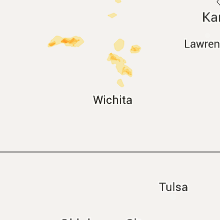
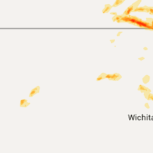
Kansas
| Local Time | Report Details |
|---|---|
| 4:38 PM CDT | Reported large trees down and power outage in marshall county KS, 53.9 miles N of Manhattan, KS |
| 5:02 PM CDT | Storm damage reported in marshall county KS, 55.7 miles NNE of Manhattan, KS |
| 5:18 PM CDT | Storm damage reported in saline county KS, 62.1 miles WSW of Manhattan, KS |
| 6:19 PM CDT | Storm damage reported in marion county KS, 59.1 miles SW of Manhattan, KS |
| 6:28 PM CDT | Storm damage reported in marion county KS, 54.3 miles SW of Manhattan, KS |
| 6:34 PM CDT | Relayed by the tower observer at the hutchinson airpor in reno county KS, 41 miles NW of Wichita, KS |
| 6:38 PM CDT | Some small branches dow in marion county KS, 56.4 miles SW of Manhattan, KS |
| 6:59 PM CDT | Strong winds damaged gutter on house in marion county KS, 50.5 miles NNE of Wichita, KS |
| 7:12 PM CDT | Storm chaser estimated 55-65 mph winds at marion lake dam. stop sign snappped off at the bas in marion county KS, 50 miles NNE of Wichita, KS |
| 7:14 PM CDT | Tree limbs down. some minor awning damage to a house. via kake tv twitter. time estimated by rada in marion county KS, 48.9 miles NNE of Wichita, KS |
| 7:19 PM CDT | Swing set ripped from concrete foundation with 3 inch tree limbs also down in marion county KS, 51.1 miles NNE of Wichita, KS |
| 8:20 PM CDT | *** 1 inj *** roof blown off farm house at 1600 eden rd. minor injuries reported. power poles snapped off for 1 mile along 1700 rd which runs east/west and alos for one in dickinson county KS, 45.8 miles WSW of Manhattan, KS |
| 8:30 PM CDT | Power lines down along jeep rd. trees reported down in abilen in dickinson county KS, 37.7 miles WSW of Manhattan, KS |
| 9:05 PM CDT | Storm damage reported in geary county KS, 21.1 miles SW of Manhattan, KS |
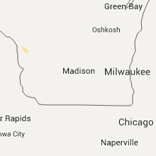
Michigan
| Local Time | Report Details |
|---|---|
| 5:40 PM EDT | A live tree... 8-9 inch diameter... reported snapped off at trun in ingham county MI, 49.5 miles WSW of Flint, MI |
South Dakota
| Local Time | Report Details |
|---|---|
| 6:36 PM CDT | Hen Egg sized hail reported near Fort Pierre, SD, 1.6 miles WSW of Pierre, SD |
| 6:38 PM CDT | Golf Ball sized hail reported near Fort Pierre, SD, 1.6 miles WSW of Pierre, SD |
| 6:40 PM CDT | Quarter sized hail reported near Pierre, SD, 1.5 miles E of Pierre, SD |
| 6:41 PM CDT | Hen Egg sized hail reported near Pierre, SD, 3.8 miles NNE of Pierre, SD, radar estimated time |
| 6:45 PM CDT | Radar estimated time in lyman county SD, 17.4 miles S of Pierre, SD |
| 7:23 PM CDT | Golf Ball sized hail reported near Onida, SD, 23.8 miles NE of Pierre, SD |
| 7:30 PM CDT | Hen Egg sized hail reported near Onida, SD, 30.2 miles NE of Pierre, SD, very jagged hailstones. radar estimated time |
| 7:37 PM CDT | Quarter sized hail reported near Kennebec, SD, 40 miles SE of Pierre, SD |
| 9:35 PM CDT | Storm damage reported in tripp county SD, 62.2 miles SSE of Pierre, SD |
| 9:38 PM CDT | Storm damage reported in tripp county SD, 50.6 miles NE of Valentine, NE |
| 10:25 PM CDT | Quarter sized hail reported near Gregory, SD, 67.7 miles NNW of Oneill, NE, wind gust estimated to 50 mph. |
Iowa
| Local Time | Report Details |
|---|---|
| 3:00 AM CDT | Storm damage reported in woodbury county IA, 61.5 miles W of Storm Lake, IA |
Connect with Interactive Hail Maps