

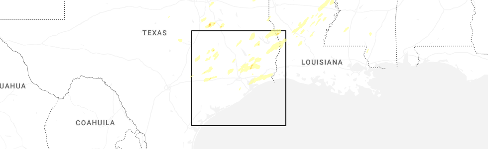
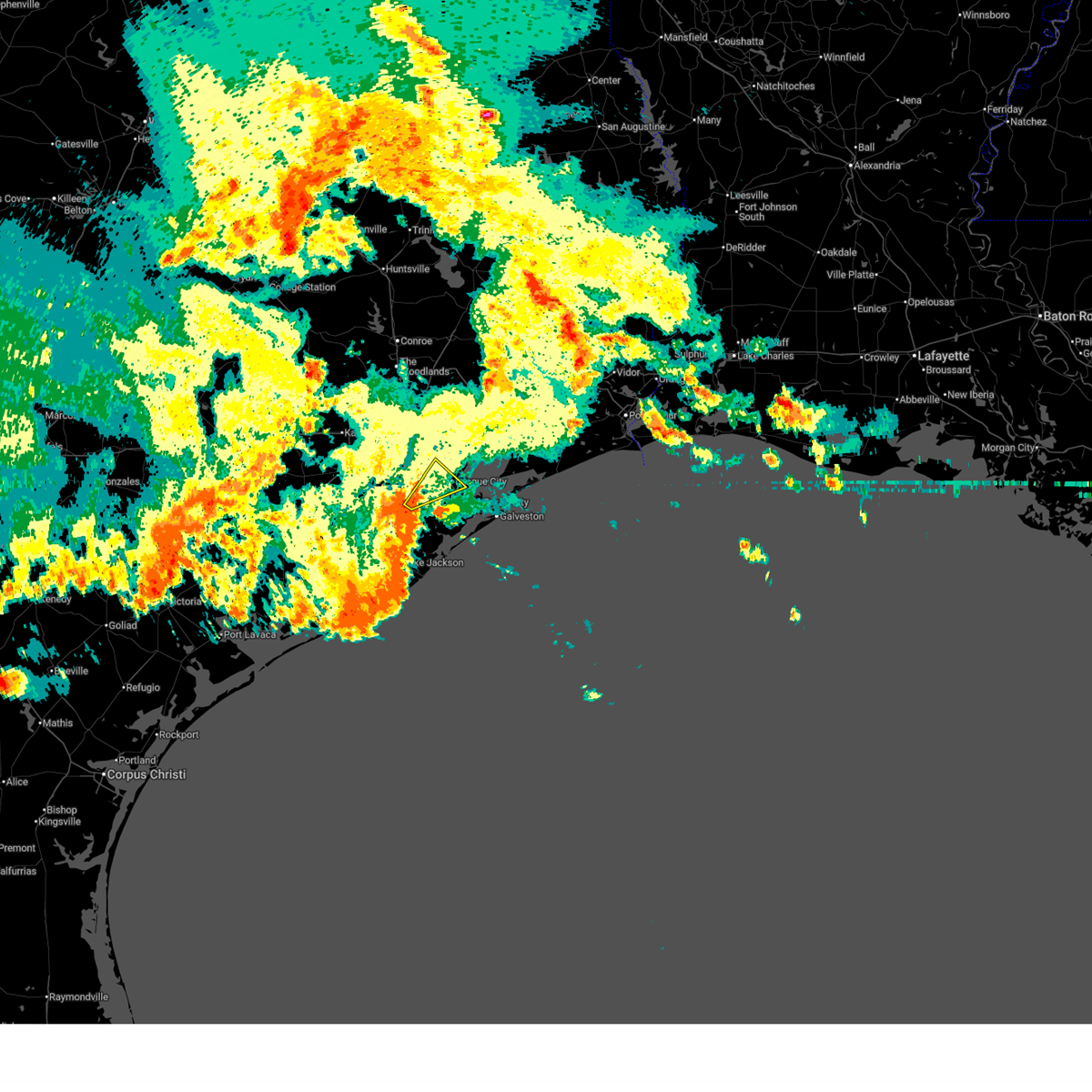
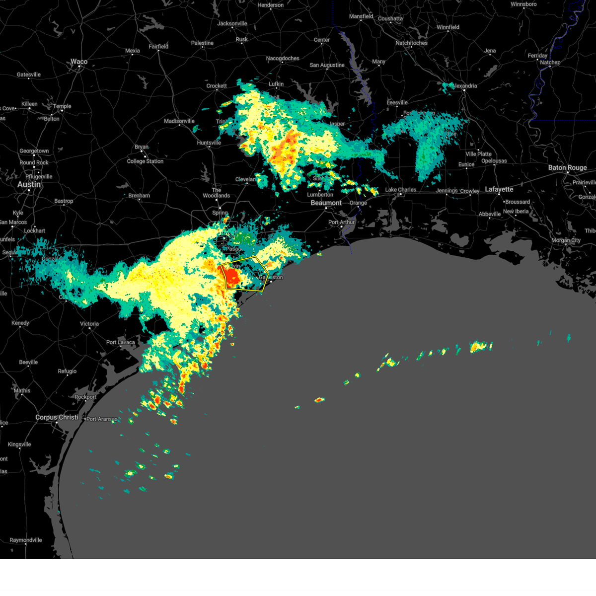
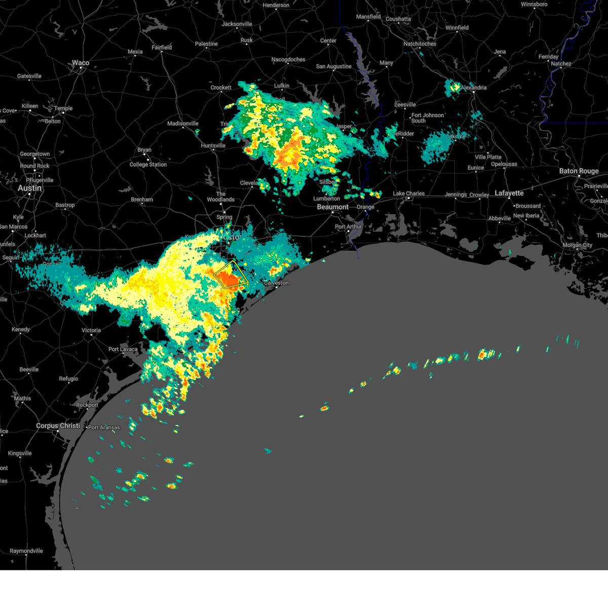
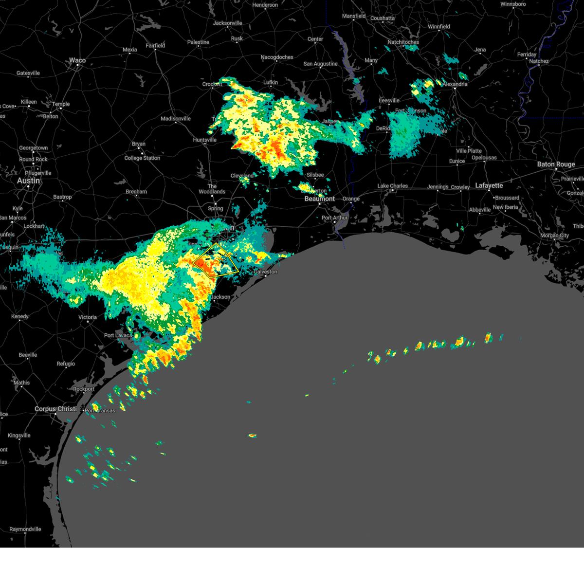
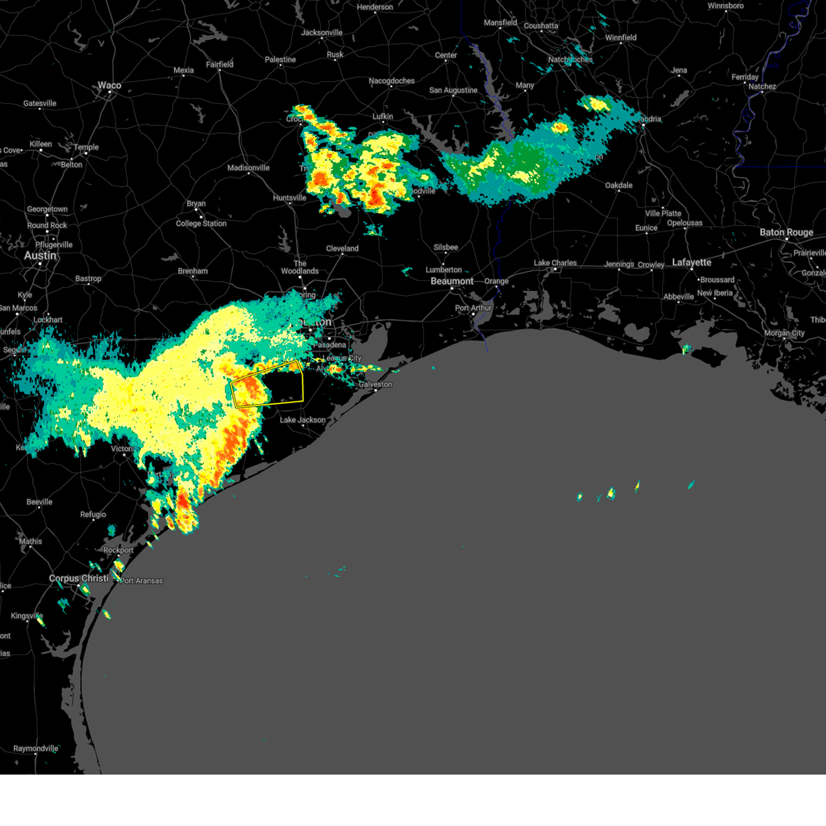
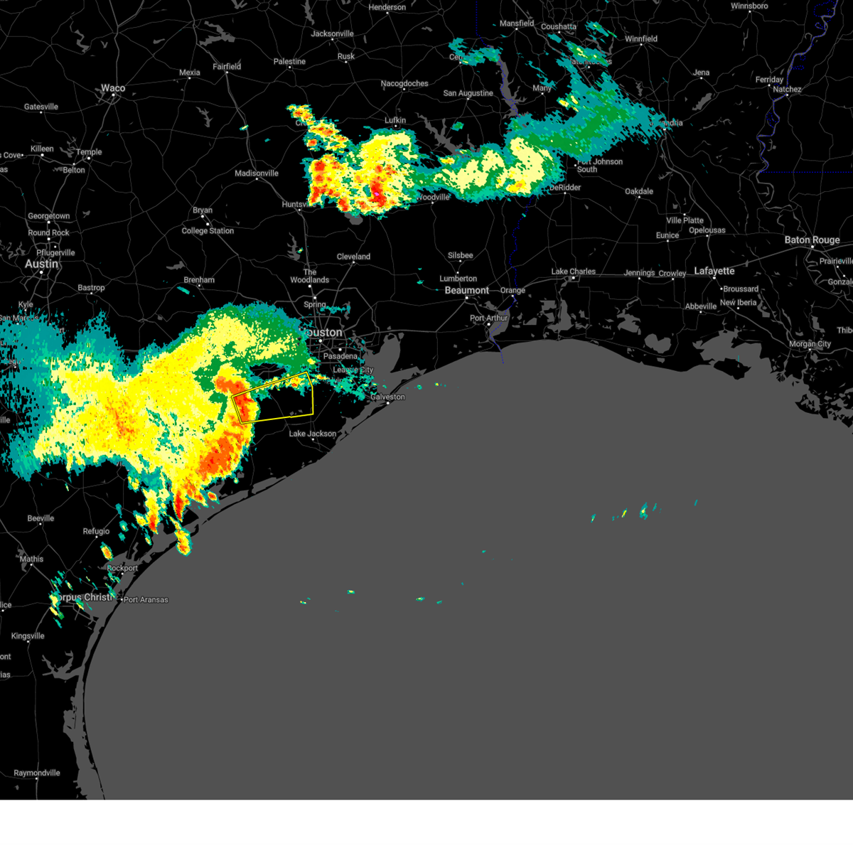
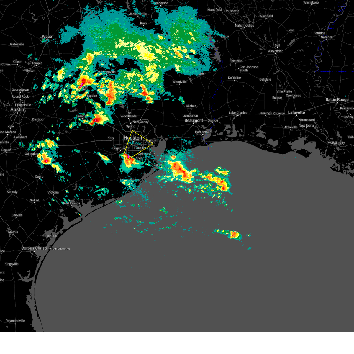
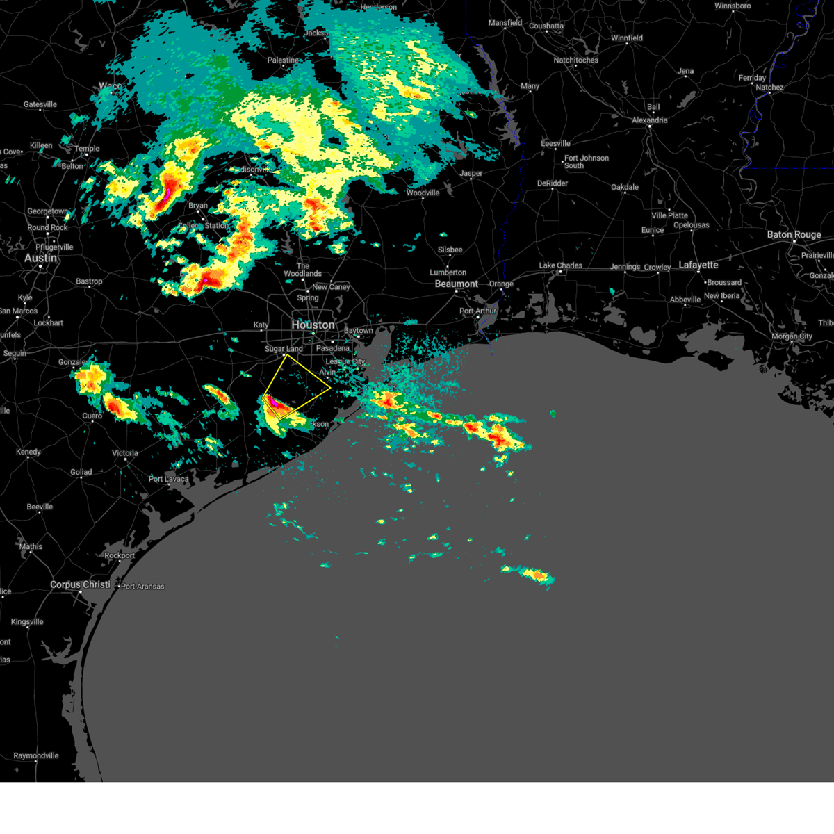
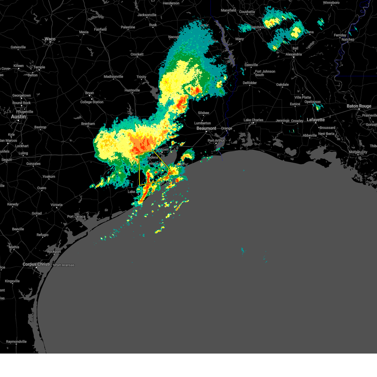
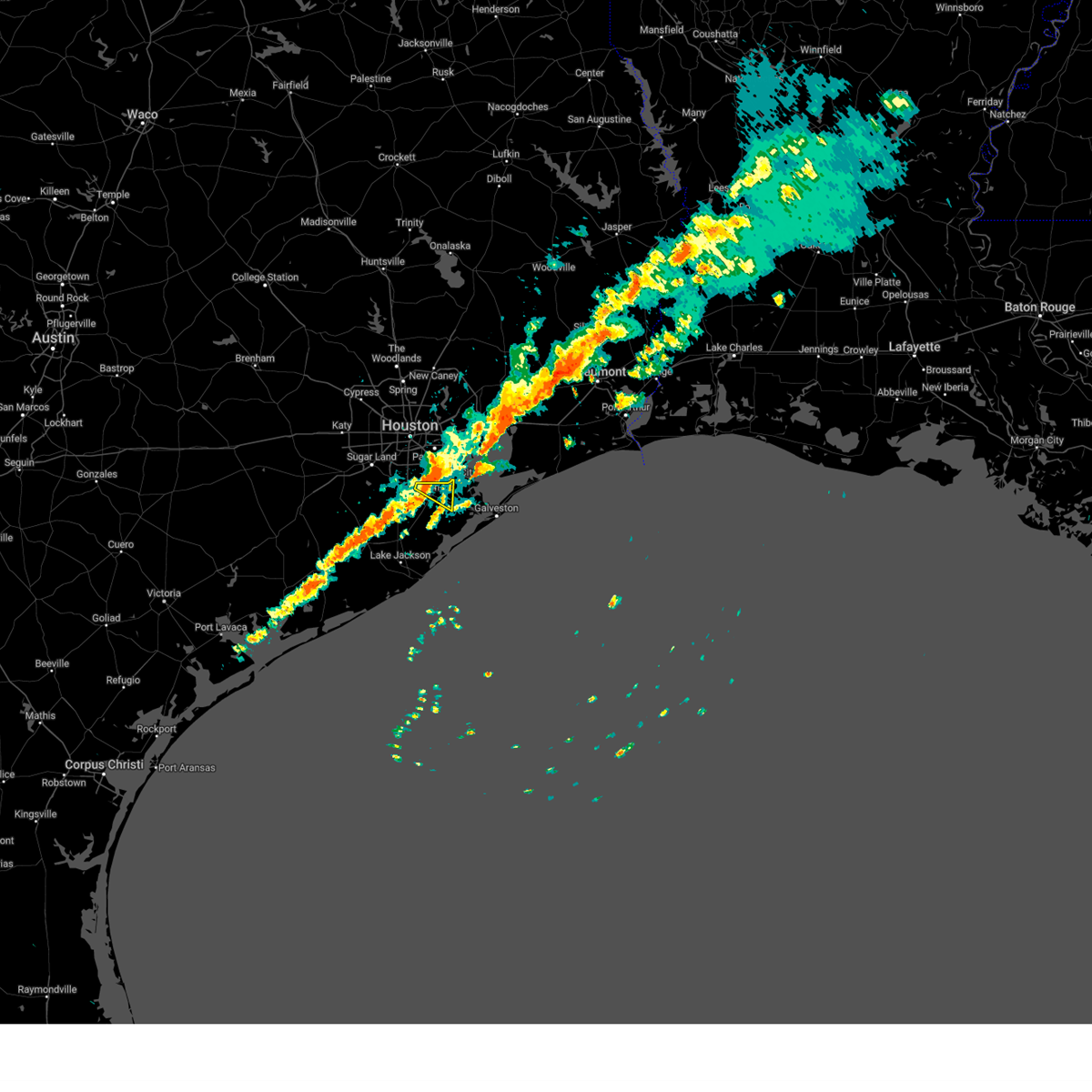
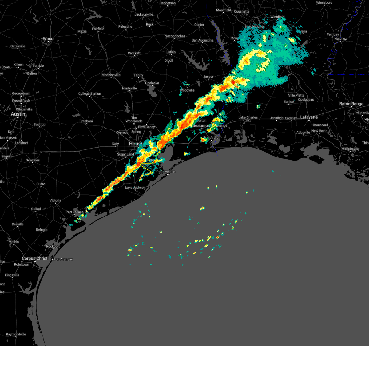
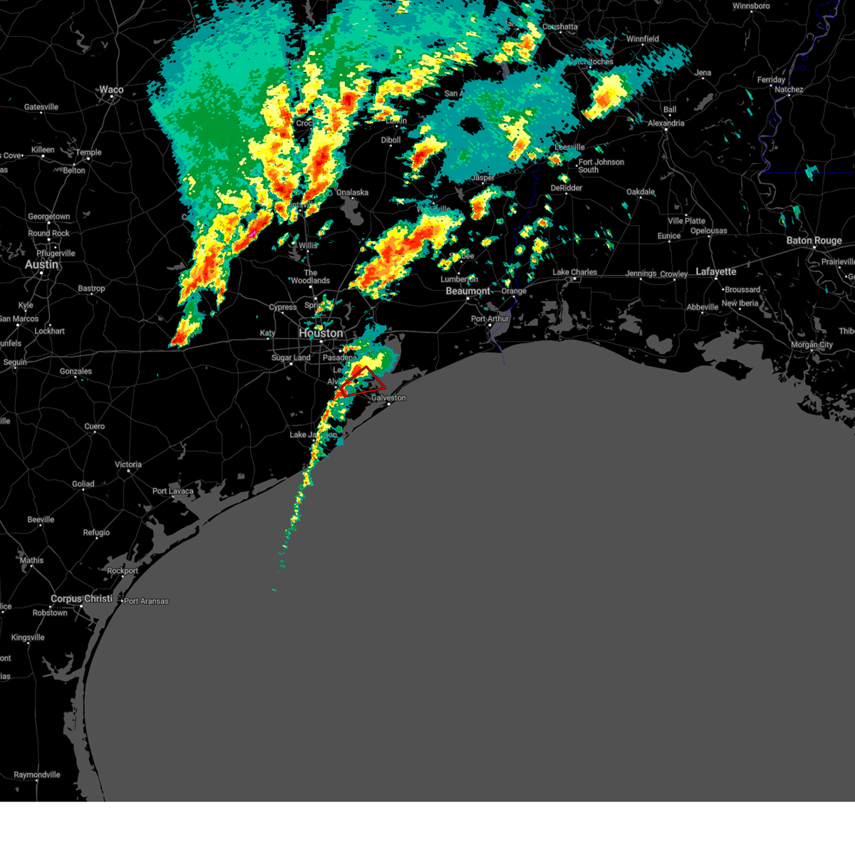
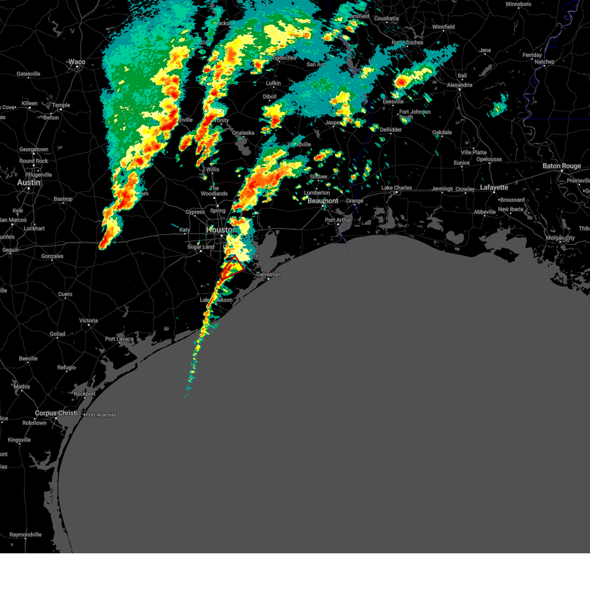
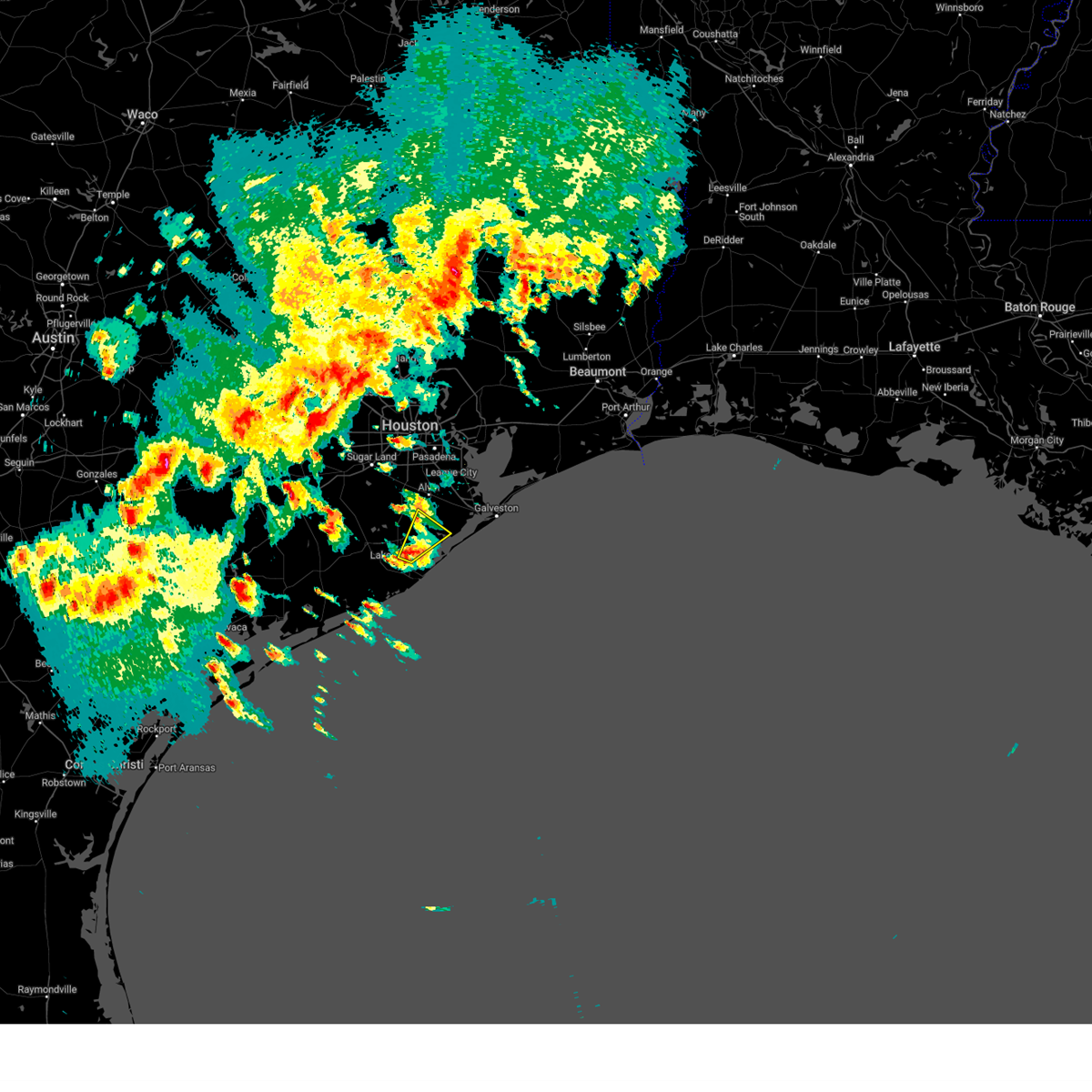
Hail Map for Alvin, TX
The Alvin, TX area has had 6 reports of on-the-ground hail by trained spotters, and has been under severe weather warnings 35 times during the past 12 months. Doppler radar has detected hail at or near Alvin, TX on 97 occasions, including 5 occasions during the past year.
| Name: | Alvin, TX |
| Where Located: | 31.8 miles S of Houston, TX |
| Map: | Google Map for Alvin, TX |
| Population: | 24236 |
| Housing Units: | 9645 |
| More Info: | Search Google for Alvin, TX |
1
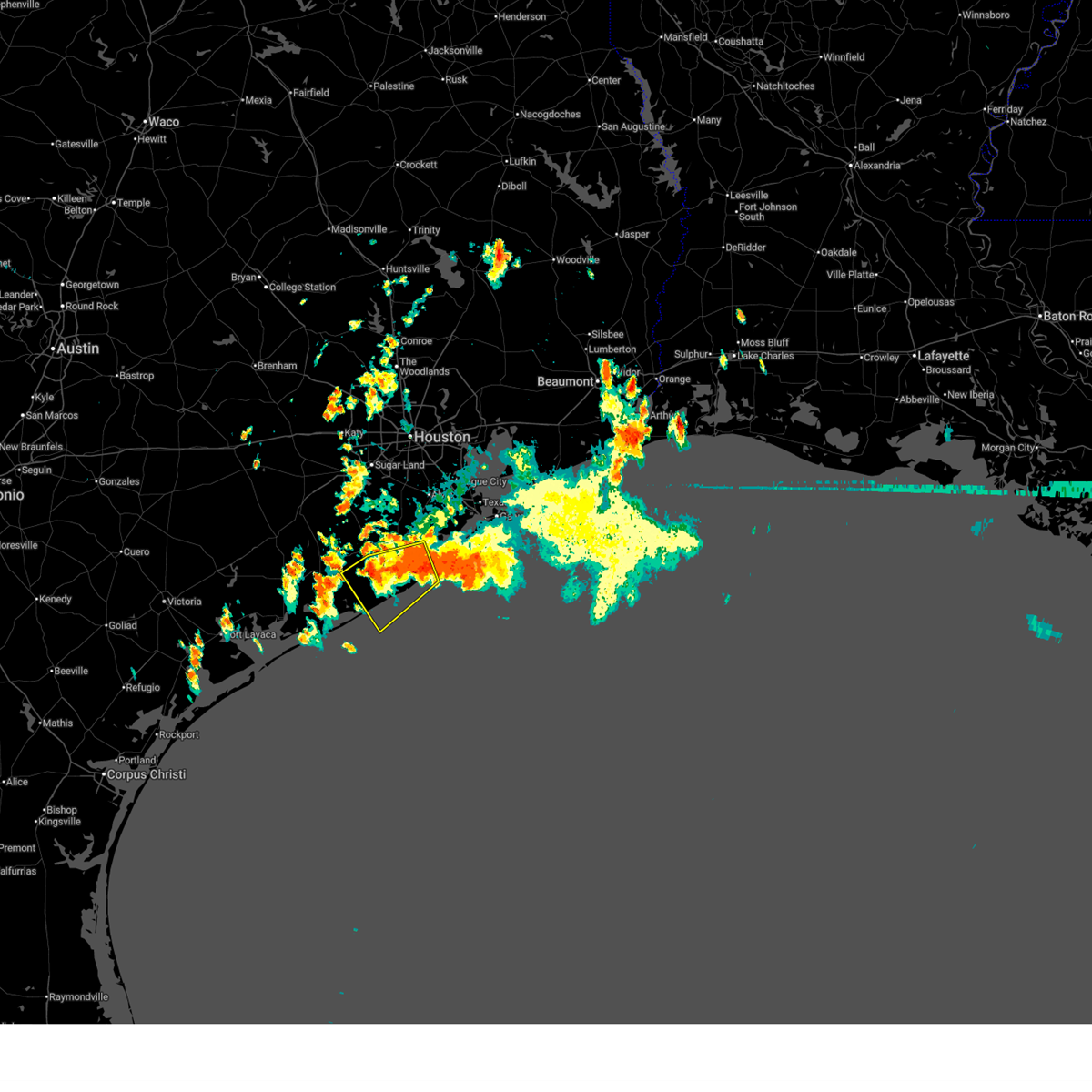
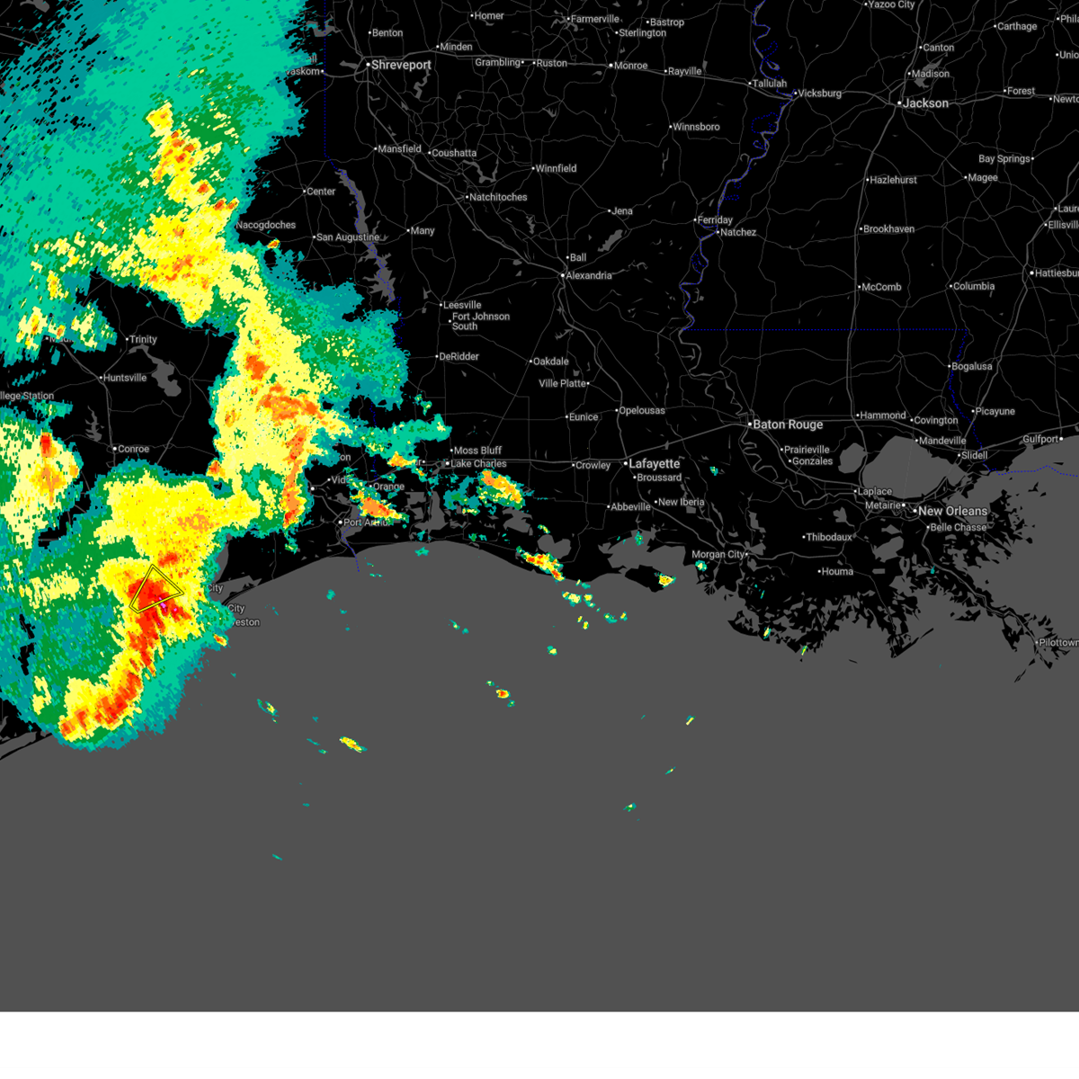
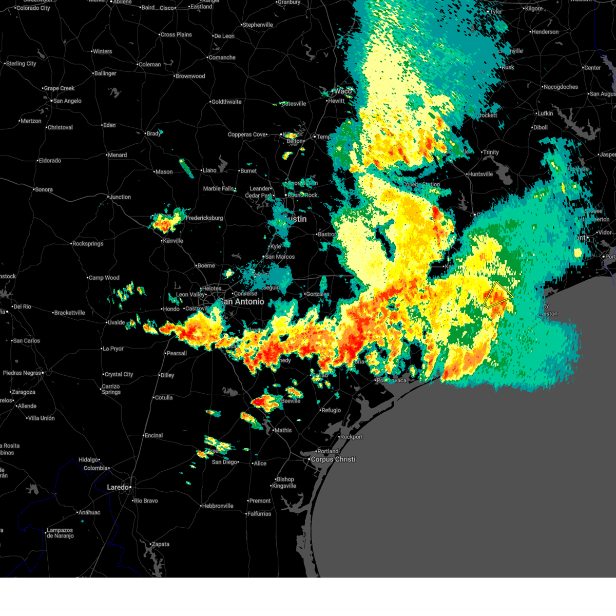
The Top Recent Hail Date for Alvin, TX is Saturday, December 28, 2024 (18th out of 97)
Hail and Wind Damage Spotted near Alvin, TX
| Date / Time | Report Details |
|---|---|
| 6/14/2025 9:38 AM CDT |
 Svrhgx the national weather service in league city has issued a * severe thunderstorm warning for, southern brazoria county in southeastern texas, east central matagorda county in southeastern texas, * until 1030 am cdt. * at 938 am cdt, a severe thunderstorm was located over northeastern freeport, moving southwest at 5 mph (radar indicated). Hazards include 60 mph wind gusts. expect damage to roofs, siding, and trees Svrhgx the national weather service in league city has issued a * severe thunderstorm warning for, southern brazoria county in southeastern texas, east central matagorda county in southeastern texas, * until 1030 am cdt. * at 938 am cdt, a severe thunderstorm was located over northeastern freeport, moving southwest at 5 mph (radar indicated). Hazards include 60 mph wind gusts. expect damage to roofs, siding, and trees
|
| 6/12/2025 7:11 AM CDT |
 The storm which prompted the warning has weakened below severe limits, and has exited the warned area. therefore, the warning will be allowed to expire. however, gusty winds are still possible with this thunderstorm. The storm which prompted the warning has weakened below severe limits, and has exited the warned area. therefore, the warning will be allowed to expire. however, gusty winds are still possible with this thunderstorm.
|
| 6/12/2025 7:04 AM CDT |
 At 704 am cdt, a severe thunderstorm was located over southwestern friendswood, moving northeast at 30 mph (radar indicated). Hazards include 60 mph wind gusts and penny size hail. Expect damage to roofs, siding, and trees. Locations impacted include, southeastern pearland, league city, friendswood, alvin, dickinson, santa fe, webster, south belt / ellington, southern clear lake, nassau bay, hillcrest, and ellington field. At 704 am cdt, a severe thunderstorm was located over southwestern friendswood, moving northeast at 30 mph (radar indicated). Hazards include 60 mph wind gusts and penny size hail. Expect damage to roofs, siding, and trees. Locations impacted include, southeastern pearland, league city, friendswood, alvin, dickinson, santa fe, webster, south belt / ellington, southern clear lake, nassau bay, hillcrest, and ellington field.
|
| 6/12/2025 6:48 AM CDT |
 Svrhgx the national weather service in league city has issued a * severe thunderstorm warning for, northwestern galveston county in southeastern texas, northeastern brazoria county in southeastern texas, southeastern harris county in southeastern texas, * until 715 am cdt. * at 648 am cdt, a severe thunderstorm was located near alvin, moving northeast at 30 mph (radar indicated). Hazards include 60 mph wind gusts and penny size hail. expect damage to roofs, siding, and trees Svrhgx the national weather service in league city has issued a * severe thunderstorm warning for, northwestern galveston county in southeastern texas, northeastern brazoria county in southeastern texas, southeastern harris county in southeastern texas, * until 715 am cdt. * at 648 am cdt, a severe thunderstorm was located near alvin, moving northeast at 30 mph (radar indicated). Hazards include 60 mph wind gusts and penny size hail. expect damage to roofs, siding, and trees
|
| 5/30/2025 11:20 AM CDT |
 At 1119 am cdt, severe thunderstorms were located along a line extending from near dickinson to la marque to near jamaica beach, moving east at 35 mph (radar indicated). Hazards include 60 mph wind gusts. Expect damage to roofs, siding, and trees. Locations impacted include, southern league city, galveston causeway, galveston island west end, texas city, dickinson, la marque, santa fe, hitchcock, bayou vista, tiki island, galveston state park, offatts bayou, san leon, and galveston island east end. At 1119 am cdt, severe thunderstorms were located along a line extending from near dickinson to la marque to near jamaica beach, moving east at 35 mph (radar indicated). Hazards include 60 mph wind gusts. Expect damage to roofs, siding, and trees. Locations impacted include, southern league city, galveston causeway, galveston island west end, texas city, dickinson, la marque, santa fe, hitchcock, bayou vista, tiki island, galveston state park, offatts bayou, san leon, and galveston island east end.
|
| 5/30/2025 11:20 AM CDT |
 the severe thunderstorm warning has been cancelled and is no longer in effect the severe thunderstorm warning has been cancelled and is no longer in effect
|
| 5/30/2025 11:10 AM CDT |
 The storm which prompted the warning is moving out of the area. therefore, the warning will be allowed to expire. remember, a severe thunderstorm warning still remains in effect for brazoria and galveston counties until 1130 am cdt. The storm which prompted the warning is moving out of the area. therefore, the warning will be allowed to expire. remember, a severe thunderstorm warning still remains in effect for brazoria and galveston counties until 1130 am cdt.
|
| 5/30/2025 10:59 AM CDT |
 Svrhgx the national weather service in league city has issued a * severe thunderstorm warning for, galveston county in southeastern texas, northeastern brazoria county in southeastern texas, southeastern harris county in southeastern texas, * until 1130 am cdt. * at 1059 am cdt, severe thunderstorms were located along a line extending from near alvin to near hillcrest to near liverpool, moving east at 30 mph (radar indicated). Hazards include 60 mph wind gusts. expect damage to roofs, siding, and trees Svrhgx the national weather service in league city has issued a * severe thunderstorm warning for, galveston county in southeastern texas, northeastern brazoria county in southeastern texas, southeastern harris county in southeastern texas, * until 1130 am cdt. * at 1059 am cdt, severe thunderstorms were located along a line extending from near alvin to near hillcrest to near liverpool, moving east at 30 mph (radar indicated). Hazards include 60 mph wind gusts. expect damage to roofs, siding, and trees
|
| 5/30/2025 10:54 AM CDT |
 At 1053 am cdt, a severe thunderstorm was located near manvel, moving east at 45 mph (radar indicated). Hazards include 60 mph wind gusts. Expect damage to roofs, siding, and trees. Locations impacted include, pearland, southwestern league city, southwestern friendswood, alvin, santa fe, manvel, iowa colony, hillcrest, liverpool, bonney, southeastern sienna, juliff, and rosharon. At 1053 am cdt, a severe thunderstorm was located near manvel, moving east at 45 mph (radar indicated). Hazards include 60 mph wind gusts. Expect damage to roofs, siding, and trees. Locations impacted include, pearland, southwestern league city, southwestern friendswood, alvin, santa fe, manvel, iowa colony, hillcrest, liverpool, bonney, southeastern sienna, juliff, and rosharon.
|
| 5/30/2025 10:54 AM CDT |
 the severe thunderstorm warning has been cancelled and is no longer in effect the severe thunderstorm warning has been cancelled and is no longer in effect
|
| 5/30/2025 10:37 AM CDT |
 Svrhgx the national weather service in league city has issued a * severe thunderstorm warning for, western galveston county in southeastern texas, southeastern fort bend county in southeastern texas, northeastern brazoria county in southeastern texas, south central harris county in southeastern texas, * until 1115 am cdt. * at 1037 am cdt, a severe thunderstorm was located near sienna, or 8 miles south of fresno, moving east at 20 mph (radar indicated). Hazards include 60 mph wind gusts. expect damage to roofs, siding, and trees Svrhgx the national weather service in league city has issued a * severe thunderstorm warning for, western galveston county in southeastern texas, southeastern fort bend county in southeastern texas, northeastern brazoria county in southeastern texas, south central harris county in southeastern texas, * until 1115 am cdt. * at 1037 am cdt, a severe thunderstorm was located near sienna, or 8 miles south of fresno, moving east at 20 mph (radar indicated). Hazards include 60 mph wind gusts. expect damage to roofs, siding, and trees
|
| 5/30/2025 10:05 AM CDT |
 The storm which prompted the warning has weakened below severe limits, and no longer poses an immediate threat to life or property. therefore, the warning will be allowed to expire. The storm which prompted the warning has weakened below severe limits, and no longer poses an immediate threat to life or property. therefore, the warning will be allowed to expire.
|
| 5/30/2025 9:52 AM CDT |
 At 952 am cdt, a severe thunderstorm was located near needville, or 13 miles south of rosenberg, moving east at 40 mph (radar indicated). Hazards include 60 mph wind gusts and quarter size hail. Hail damage to vehicles is expected. expect wind damage to roofs, siding, and trees. Locations impacted include, needville, iowa colony, holiday lakes, fairchilds, bonney, thompsons, brazos bend state park, sienna, boling-iago, juliff, damon, and rosharon. At 952 am cdt, a severe thunderstorm was located near needville, or 13 miles south of rosenberg, moving east at 40 mph (radar indicated). Hazards include 60 mph wind gusts and quarter size hail. Hail damage to vehicles is expected. expect wind damage to roofs, siding, and trees. Locations impacted include, needville, iowa colony, holiday lakes, fairchilds, bonney, thompsons, brazos bend state park, sienna, boling-iago, juliff, damon, and rosharon.
|
| 5/30/2025 9:42 AM CDT |
 At 942 am cdt, a severe thunderstorm was located near boling-iago, or 10 miles east of wharton, moving east at 30 mph (radar indicated). Hazards include 60 mph wind gusts and quarter size hail. Hail damage to vehicles is expected. expect wind damage to roofs, siding, and trees. Locations impacted include, wharton, needville, iowa colony, holiday lakes, fairchilds, bonney, thompsons, sienna, brazos bend state park, boling-iago, juliff, damon, and rosharon. At 942 am cdt, a severe thunderstorm was located near boling-iago, or 10 miles east of wharton, moving east at 30 mph (radar indicated). Hazards include 60 mph wind gusts and quarter size hail. Hail damage to vehicles is expected. expect wind damage to roofs, siding, and trees. Locations impacted include, wharton, needville, iowa colony, holiday lakes, fairchilds, bonney, thompsons, sienna, brazos bend state park, boling-iago, juliff, damon, and rosharon.
|
| 5/30/2025 9:28 AM CDT |
 Svrhgx the national weather service in league city has issued a * severe thunderstorm warning for, southeastern wharton county in southeastern texas, southern fort bend county in southeastern texas, northwestern brazoria county in southeastern texas, north central matagorda county in southeastern texas, * until 1015 am cdt. * at 928 am cdt, a severe thunderstorm was located near boling-iago, or near wharton, moving east at 40 mph (radar indicated). Hazards include 60 mph wind gusts and quarter size hail. Hail damage to vehicles is expected. Expect wind damage to roofs, siding, and trees. Svrhgx the national weather service in league city has issued a * severe thunderstorm warning for, southeastern wharton county in southeastern texas, southern fort bend county in southeastern texas, northwestern brazoria county in southeastern texas, north central matagorda county in southeastern texas, * until 1015 am cdt. * at 928 am cdt, a severe thunderstorm was located near boling-iago, or near wharton, moving east at 40 mph (radar indicated). Hazards include 60 mph wind gusts and quarter size hail. Hail damage to vehicles is expected. Expect wind damage to roofs, siding, and trees.
|
| 5/27/2025 1:20 AM CDT |
 Svrhgx the national weather service in league city has issued a * severe thunderstorm warning for, galveston county in southeastern texas, chambers county in southeastern texas, northeastern brazoria county in southeastern texas, southeastern liberty county in southeastern texas, southeastern harris county in southeastern texas, * until 215 am cdt. * at 119 am cdt, severe thunderstorms were located along a line extending from near devers to near alvin, moving east southeast at around 40 mph (radar indicated). Hazards include 60 mph wind gusts. expect damage to roofs, siding, and trees Svrhgx the national weather service in league city has issued a * severe thunderstorm warning for, galveston county in southeastern texas, chambers county in southeastern texas, northeastern brazoria county in southeastern texas, southeastern liberty county in southeastern texas, southeastern harris county in southeastern texas, * until 215 am cdt. * at 119 am cdt, severe thunderstorms were located along a line extending from near devers to near alvin, moving east southeast at around 40 mph (radar indicated). Hazards include 60 mph wind gusts. expect damage to roofs, siding, and trees
|
| 5/27/2025 12:45 AM CDT |
 Svrhgx the national weather service in league city has issued a * severe thunderstorm warning for, northwestern galveston county in southeastern texas, eastern fort bend county in southeastern texas, southeastern montgomery county in southeastern texas, southeastern san jacinto county in southeastern texas, northwestern chambers county in southeastern texas, north central brazoria county in southeastern texas, liberty county in southeastern texas, southeastern polk county in southeastern texas, eastern harris county in southeastern texas, * until 145 am cdt. * at 1244 am cdt, severe thunderstorms were located along a line extending from near chester to near splendora to memorial park to east bernard, moving east at 25 mph. stronger segments within the line have a history of producing 45 to 67 mph wind gusts (radar indicated). Hazards include 60 mph wind gusts. expect damage to roofs, siding, and trees Svrhgx the national weather service in league city has issued a * severe thunderstorm warning for, northwestern galveston county in southeastern texas, eastern fort bend county in southeastern texas, southeastern montgomery county in southeastern texas, southeastern san jacinto county in southeastern texas, northwestern chambers county in southeastern texas, north central brazoria county in southeastern texas, liberty county in southeastern texas, southeastern polk county in southeastern texas, eastern harris county in southeastern texas, * until 145 am cdt. * at 1244 am cdt, severe thunderstorms were located along a line extending from near chester to near splendora to memorial park to east bernard, moving east at 25 mph. stronger segments within the line have a history of producing 45 to 67 mph wind gusts (radar indicated). Hazards include 60 mph wind gusts. expect damage to roofs, siding, and trees
|
| 5/5/2025 5:19 PM CDT | the severe thunderstorm warning has been cancelled and is no longer in effect |
| 5/5/2025 4:56 PM CDT |
 Svrhgx the national weather service in league city has issued a * severe thunderstorm warning for, east central fort bend county in southeastern texas, northern brazoria county in southeastern texas, southeastern harris county in southeastern texas, * until 530 pm cdt. * at 455 pm cdt, a severe thunderstorm was located over fresno, moving northeast at 50 mph (radar indicated). Hazards include quarter size hail. damage to vehicles is expected Svrhgx the national weather service in league city has issued a * severe thunderstorm warning for, east central fort bend county in southeastern texas, northern brazoria county in southeastern texas, southeastern harris county in southeastern texas, * until 530 pm cdt. * at 455 pm cdt, a severe thunderstorm was located over fresno, moving northeast at 50 mph (radar indicated). Hazards include quarter size hail. damage to vehicles is expected
|
| 5/5/2025 4:51 PM CDT | At 451 pm cdt, a severe thunderstorm was located over southwestern manvel, moving northeast at 50 mph (radar indicated). Hazards include quarter size hail. Damage to vehicles is expected. Locations impacted include, southern missouri city, southwestern manvel, fresno, arcola, iowa colony, thompsons, riverstone, sienna, and juliff. |
| 5/5/2025 4:25 PM CDT |
 Svrhgx the national weather service in league city has issued a * severe thunderstorm warning for, southeastern fort bend county in southeastern texas, central brazoria county in southeastern texas, * until 500 pm cdt. * at 425 pm cdt, a severe thunderstorm was located near west columbia, moving northeast at 40 mph (radar indicated). Hazards include 60 mph wind gusts and half dollar size hail. Hail damage to vehicles is expected. Expect wind damage to roofs, siding, and trees. Svrhgx the national weather service in league city has issued a * severe thunderstorm warning for, southeastern fort bend county in southeastern texas, central brazoria county in southeastern texas, * until 500 pm cdt. * at 425 pm cdt, a severe thunderstorm was located near west columbia, moving northeast at 40 mph (radar indicated). Hazards include 60 mph wind gusts and half dollar size hail. Hail damage to vehicles is expected. Expect wind damage to roofs, siding, and trees.
|
| 3/24/2025 3:29 AM CDT |
 Svrhgx the national weather service in league city has issued a * severe thunderstorm warning for, southwestern galveston county in southeastern texas, east central brazoria county in southeastern texas, * until 400 am cdt. * at 329 am cdt, severe thunderstorms were located along a line extending from near texas city to la marque to near santa fe, moving south at 60 mph (radar indicated). Hazards include 60 mph wind gusts. expect damage to roofs, siding, and trees Svrhgx the national weather service in league city has issued a * severe thunderstorm warning for, southwestern galveston county in southeastern texas, east central brazoria county in southeastern texas, * until 400 am cdt. * at 329 am cdt, severe thunderstorms were located along a line extending from near texas city to la marque to near santa fe, moving south at 60 mph (radar indicated). Hazards include 60 mph wind gusts. expect damage to roofs, siding, and trees
|
| 3/24/2025 3:21 AM CDT |
 At 320 am cdt, severe thunderstorms were located along a line extending from kemah to near friendswood to near iowa colony, moving southeast at 50 mph (radar indicated). Hazards include 60 mph wind gusts. Expect damage to roofs, siding, and trees. Locations impacted include, san leon, dickinson, clear lake shores, kemah, pasadena, texas city, ellington field, la porte, deer park, clear lake, hillcrest, seabrook, friendswood, the johnson space center, bacliff, league city, nassau bay, hitchcock, bayou vista, and webster. At 320 am cdt, severe thunderstorms were located along a line extending from kemah to near friendswood to near iowa colony, moving southeast at 50 mph (radar indicated). Hazards include 60 mph wind gusts. Expect damage to roofs, siding, and trees. Locations impacted include, san leon, dickinson, clear lake shores, kemah, pasadena, texas city, ellington field, la porte, deer park, clear lake, hillcrest, seabrook, friendswood, the johnson space center, bacliff, league city, nassau bay, hitchcock, bayou vista, and webster.
|
| 3/24/2025 3:05 AM CDT |
 Svrhgx the national weather service in league city has issued a * severe thunderstorm warning for, galveston county in southeastern texas, northeastern brazoria county in southeastern texas, southeastern harris county in southeastern texas, * until 330 am cdt. * at 304 am cdt, severe thunderstorms were located along a line extending from deer park to greater hobby area to fort bend houston, moving southeast at 40 mph (radar indicated). Hazards include 60 mph wind gusts. expect damage to roofs, siding, and trees Svrhgx the national weather service in league city has issued a * severe thunderstorm warning for, galveston county in southeastern texas, northeastern brazoria county in southeastern texas, southeastern harris county in southeastern texas, * until 330 am cdt. * at 304 am cdt, severe thunderstorms were located along a line extending from deer park to greater hobby area to fort bend houston, moving southeast at 40 mph (radar indicated). Hazards include 60 mph wind gusts. expect damage to roofs, siding, and trees
|
| 1/5/2025 3:55 PM CST |
 The storm which prompted the warning is weakening below severe limits, and no longer poses an immediate threat to life or property. therefore, the warning will be allowed to expire. however, gusty winds are still possible with this thunderstorm. The storm which prompted the warning is weakening below severe limits, and no longer poses an immediate threat to life or property. therefore, the warning will be allowed to expire. however, gusty winds are still possible with this thunderstorm.
|
| 1/5/2025 3:43 PM CST |
 Svrhgx the national weather service in league city has issued a * severe thunderstorm warning for, west central galveston county in southeastern texas, northeastern brazoria county in southeastern texas, * until 400 pm cst. * at 343 pm cst, a severe thunderstorm was located near manvel, moving east at 30 mph (radar indicated). Hazards include 60 mph wind gusts and penny size hail. expect damage to roofs, siding, and trees Svrhgx the national weather service in league city has issued a * severe thunderstorm warning for, west central galveston county in southeastern texas, northeastern brazoria county in southeastern texas, * until 400 pm cst. * at 343 pm cst, a severe thunderstorm was located near manvel, moving east at 30 mph (radar indicated). Hazards include 60 mph wind gusts and penny size hail. expect damage to roofs, siding, and trees
|
| 12/28/2024 1:22 PM CST |
 Torhgx the national weather service in league city has issued a * tornado warning for, northwestern galveston county in southeastern texas, northeastern brazoria county in southeastern texas, southeastern harris county in southeastern texas, * until 200 pm cst. * at 122 pm cst, a tornado producing storm was located near santa fe, moving northeast at 20 mph (radar confirmed tornado). Hazards include damaging tornado and quarter size hail. Flying debris will be dangerous to those caught without shelter. mobile homes will be damaged or destroyed. damage to roofs, windows, and vehicles will occur. tree damage is likely. this tornadic storm will be near, eastern league city, texas city, dickinson, la marque, and santa fe around 130 pm cst. Kemah and clear lake shores around 135 pm cst. Torhgx the national weather service in league city has issued a * tornado warning for, northwestern galveston county in southeastern texas, northeastern brazoria county in southeastern texas, southeastern harris county in southeastern texas, * until 200 pm cst. * at 122 pm cst, a tornado producing storm was located near santa fe, moving northeast at 20 mph (radar confirmed tornado). Hazards include damaging tornado and quarter size hail. Flying debris will be dangerous to those caught without shelter. mobile homes will be damaged or destroyed. damage to roofs, windows, and vehicles will occur. tree damage is likely. this tornadic storm will be near, eastern league city, texas city, dickinson, la marque, and santa fe around 130 pm cst. Kemah and clear lake shores around 135 pm cst.
|
| 12/28/2024 1:11 PM CST | At 111 pm cst, a confirmed tornado was located over hillcrest, or near alvin, moving northeast at 25 mph (radar confirmed tornado). Hazards include damaging tornado and quarter size hail. Flying debris will be dangerous to those caught without shelter. mobile homes will be damaged or destroyed. damage to roofs, windows, and vehicles will occur. tree damage is likely. This tornado will be near, southwestern league city and santa fe around 115 pm cst. |
| 12/28/2024 12:58 PM CST |
 At 1258 pm cst, a confirmed tornado was located near liverpool, or near alvin, moving northeast at 30 mph (radar confirmed tornado). Hazards include damaging tornado and quarter size hail. Flying debris will be dangerous to those caught without shelter. mobile homes will be damaged or destroyed. damage to roofs, windows, and vehicles will occur. tree damage is likely. This tornado will be near, southwestern league city, southern friendswood, alvin, santa fe, and hillcrest around 105 pm cst. At 1258 pm cst, a confirmed tornado was located near liverpool, or near alvin, moving northeast at 30 mph (radar confirmed tornado). Hazards include damaging tornado and quarter size hail. Flying debris will be dangerous to those caught without shelter. mobile homes will be damaged or destroyed. damage to roofs, windows, and vehicles will occur. tree damage is likely. This tornado will be near, southwestern league city, southern friendswood, alvin, santa fe, and hillcrest around 105 pm cst.
|
| 12/28/2024 12:53 PM CST |
 Torhgx the national weather service in league city has issued a * tornado warning for, west central galveston county in southeastern texas, northeastern brazoria county in southeastern texas, * until 130 pm cst. * at 1253 pm cst, a severe thunderstorm capable of producing a tornado was located near liverpool, or 7 miles southwest of alvin, moving northeast at 30 mph (radar indicated rotation). Hazards include tornado. Flying debris will be dangerous to those caught without shelter. mobile homes will be damaged or destroyed. damage to roofs, windows, and vehicles will occur. tree damage is likely. This dangerous storm will be near, southwestern league city, friendswood, alvin, santa fe, and hillcrest around 100 pm cst. Torhgx the national weather service in league city has issued a * tornado warning for, west central galveston county in southeastern texas, northeastern brazoria county in southeastern texas, * until 130 pm cst. * at 1253 pm cst, a severe thunderstorm capable of producing a tornado was located near liverpool, or 7 miles southwest of alvin, moving northeast at 30 mph (radar indicated rotation). Hazards include tornado. Flying debris will be dangerous to those caught without shelter. mobile homes will be damaged or destroyed. damage to roofs, windows, and vehicles will occur. tree damage is likely. This dangerous storm will be near, southwestern league city, friendswood, alvin, santa fe, and hillcrest around 100 pm cst.
|
| 12/25/2024 1:31 AM CST |
 Svrhgx the national weather service in league city has issued a * severe thunderstorm warning for, west central galveston county in southeastern texas, northeastern brazoria county in southeastern texas, * until 200 am cst. * at 131 am cst, a severe thunderstorm was located over danbury, or 7 miles northeast of angleton, moving northeast at 20 mph (radar indicated). Hazards include 60 mph wind gusts and half dollar size hail. Hail damage to vehicles is expected. Expect wind damage to roofs, siding, and trees. Svrhgx the national weather service in league city has issued a * severe thunderstorm warning for, west central galveston county in southeastern texas, northeastern brazoria county in southeastern texas, * until 200 am cst. * at 131 am cst, a severe thunderstorm was located over danbury, or 7 miles northeast of angleton, moving northeast at 20 mph (radar indicated). Hazards include 60 mph wind gusts and half dollar size hail. Hail damage to vehicles is expected. Expect wind damage to roofs, siding, and trees.
|
| 12/25/2024 1:20 AM CST |
 At 120 am cst, a severe thunderstorm was located over danbury, or 7 miles northeast of angleton, moving northeast at 15 mph (radar indicated). Hazards include ping pong ball size hail and 60 mph wind gusts. People and animals outdoors will be injured. expect hail damage to roofs, siding, windows, and vehicles. expect wind damage to roofs, siding, and trees. Locations impacted include, northeastern angleton, danbury, liverpool, and chocolate bayou. At 120 am cst, a severe thunderstorm was located over danbury, or 7 miles northeast of angleton, moving northeast at 15 mph (radar indicated). Hazards include ping pong ball size hail and 60 mph wind gusts. People and animals outdoors will be injured. expect hail damage to roofs, siding, windows, and vehicles. expect wind damage to roofs, siding, and trees. Locations impacted include, northeastern angleton, danbury, liverpool, and chocolate bayou.
|
| 12/25/2024 1:08 AM CST |
 Svrhgx the national weather service in league city has issued a * severe thunderstorm warning for, east central brazoria county in southeastern texas, * until 130 am cst. * at 107 am cst, a severe thunderstorm was located near danbury, or near angleton, moving northeast at 20 mph (radar indicated). Hazards include 60 mph wind gusts and quarter size hail. Hail damage to vehicles is expected. Expect wind damage to roofs, siding, and trees. Svrhgx the national weather service in league city has issued a * severe thunderstorm warning for, east central brazoria county in southeastern texas, * until 130 am cst. * at 107 am cst, a severe thunderstorm was located near danbury, or near angleton, moving northeast at 20 mph (radar indicated). Hazards include 60 mph wind gusts and quarter size hail. Hail damage to vehicles is expected. Expect wind damage to roofs, siding, and trees.
|
| 12/25/2024 12:35 AM CST |
 At 1234 am cst, a severe thunderstorm was located over richwood, or near clute, moving northeast at 10 mph (radar indicated). Hazards include quarter size hail. Damage to vehicles is expected. Locations impacted include, eastern lake jackson, richwood, danbury, and liverpool. At 1234 am cst, a severe thunderstorm was located over richwood, or near clute, moving northeast at 10 mph (radar indicated). Hazards include quarter size hail. Damage to vehicles is expected. Locations impacted include, eastern lake jackson, richwood, danbury, and liverpool.
|
| 12/25/2024 12:20 AM CST |
 Svrhgx the national weather service in league city has issued a * severe thunderstorm warning for, east central brazoria county in southeastern texas, * until 100 am cst. * at 1219 am cst, a severe thunderstorm was located over richwood, or near clute, moving northeast at 15 mph (radar indicated). Hazards include quarter size hail. damage to vehicles is expected Svrhgx the national weather service in league city has issued a * severe thunderstorm warning for, east central brazoria county in southeastern texas, * until 100 am cst. * at 1219 am cst, a severe thunderstorm was located over richwood, or near clute, moving northeast at 15 mph (radar indicated). Hazards include quarter size hail. damage to vehicles is expected
|
| 7/8/2024 4:13 AM CDT |
 The storm which prompted the warning has moved out of the area. therefore, the warning will be allowed to expire. however, conditions remain favorable for additional brief weak tornadoes as beryl continues to move inland. a tornado watch remains in effect until 1000 am cdt for southeastern texas. The storm which prompted the warning has moved out of the area. therefore, the warning will be allowed to expire. however, conditions remain favorable for additional brief weak tornadoes as beryl continues to move inland. a tornado watch remains in effect until 1000 am cdt for southeastern texas.
|
| 7/8/2024 3:55 AM CDT |
 Torhgx the national weather service in league city has issued a * tornado warning for, east central fort bend county in southeastern texas, north central brazoria county in southeastern texas, * until 415 am cdt. * at 355 am cdt, a severe thunderstorm capable of producing a tornado was located near iowa colony, or near manvel, moving west at 45 mph (radar indicated rotation). Hazards include tornado. Flying debris will be dangerous to those caught without shelter. mobile homes will be damaged or destroyed. damage to roofs, windows, and vehicles will occur. tree damage is likely. this dangerous storm will be near, southeastern missouri city, southwestern manvel, arcola, iowa colony, and sienna around 400 am cdt. Other locations impacted by this tornadic thunderstorm include juliff. Torhgx the national weather service in league city has issued a * tornado warning for, east central fort bend county in southeastern texas, north central brazoria county in southeastern texas, * until 415 am cdt. * at 355 am cdt, a severe thunderstorm capable of producing a tornado was located near iowa colony, or near manvel, moving west at 45 mph (radar indicated rotation). Hazards include tornado. Flying debris will be dangerous to those caught without shelter. mobile homes will be damaged or destroyed. damage to roofs, windows, and vehicles will occur. tree damage is likely. this dangerous storm will be near, southeastern missouri city, southwestern manvel, arcola, iowa colony, and sienna around 400 am cdt. Other locations impacted by this tornadic thunderstorm include juliff.
|
| 7/8/2024 3:37 AM CDT |
 Torhgx the national weather service in league city has issued a * tornado warning for, southeastern fort bend county in southeastern texas, northern brazoria county in southeastern texas, * until 400 am cdt. * at 337 am cdt, a severe thunderstorm capable of producing a tornado was located near sienna, or 7 miles southwest of fresno, moving west at 50 mph (radar indicated rotation). Hazards include tornado. Flying debris will be dangerous to those caught without shelter. mobile homes will be damaged or destroyed. damage to roofs, windows, and vehicles will occur. tree damage is likely. this dangerous storm will be near, rosenberg, pleak, fairchilds, and thompsons around 345 am cdt. needville around 350 am cdt. Other locations impacted by this tornadic thunderstorm include juliff. Torhgx the national weather service in league city has issued a * tornado warning for, southeastern fort bend county in southeastern texas, northern brazoria county in southeastern texas, * until 400 am cdt. * at 337 am cdt, a severe thunderstorm capable of producing a tornado was located near sienna, or 7 miles southwest of fresno, moving west at 50 mph (radar indicated rotation). Hazards include tornado. Flying debris will be dangerous to those caught without shelter. mobile homes will be damaged or destroyed. damage to roofs, windows, and vehicles will occur. tree damage is likely. this dangerous storm will be near, rosenberg, pleak, fairchilds, and thompsons around 345 am cdt. needville around 350 am cdt. Other locations impacted by this tornadic thunderstorm include juliff.
|
| 6/19/2024 11:07 AM CDT |
 Svrhgx the national weather service in league city has issued a * severe thunderstorm warning for, southwestern galveston county in southeastern texas, east central brazoria county in southeastern texas, * until 1115 am cdt. * at 1106 am cdt, a severe thunderstorm capable of producing a waterspout was located near jamaica beach, or near galveston island west end, moving west at 35 mph (radar indicated). Hazards include 60 mph wind gusts. expect damage to roofs, siding, and trees Svrhgx the national weather service in league city has issued a * severe thunderstorm warning for, southwestern galveston county in southeastern texas, east central brazoria county in southeastern texas, * until 1115 am cdt. * at 1106 am cdt, a severe thunderstorm capable of producing a waterspout was located near jamaica beach, or near galveston island west end, moving west at 35 mph (radar indicated). Hazards include 60 mph wind gusts. expect damage to roofs, siding, and trees
|
| 6/5/2024 11:25 AM CDT |
 The storms which prompted the warning have weakened below severe limits, and no longer pose an immediate threat to life or property. therefore, the warning will be allowed to expire. however, gusty winds are still possible with these thunderstorms. The storms which prompted the warning have weakened below severe limits, and no longer pose an immediate threat to life or property. therefore, the warning will be allowed to expire. however, gusty winds are still possible with these thunderstorms.
|
| 6/5/2024 10:54 AM CDT |
 Svrhgx the national weather service in league city has issued a * severe thunderstorm warning for, northwestern galveston county in southeastern texas, southeastern brazoria county in southeastern texas, * until 1130 am cdt. * at 1053 am cdt, severe thunderstorms were located along a line extending from 13 miles southeast of galveston pleasure pier to near galveston state park to near jamaica beach, moving south at 35 mph. a mesonet site on galveston island measured a 63 mph wind gust from the outflow of these storms (radar indicated and sensor reported). Hazards include 60 mph wind gusts. expect damage to roofs, siding, and trees Svrhgx the national weather service in league city has issued a * severe thunderstorm warning for, northwestern galveston county in southeastern texas, southeastern brazoria county in southeastern texas, * until 1130 am cdt. * at 1053 am cdt, severe thunderstorms were located along a line extending from 13 miles southeast of galveston pleasure pier to near galveston state park to near jamaica beach, moving south at 35 mph. a mesonet site on galveston island measured a 63 mph wind gust from the outflow of these storms (radar indicated and sensor reported). Hazards include 60 mph wind gusts. expect damage to roofs, siding, and trees
|
| 6/1/2024 12:01 PM CDT |
 the severe thunderstorm warning has been cancelled and is no longer in effect the severe thunderstorm warning has been cancelled and is no longer in effect
|
| 6/1/2024 11:54 AM CDT |
 The storm which prompted the warning has weakened below severe limits, and has exited the warned area. therefore, the warning will be allowed to expire. however, gusty winds are still possible with this thunderstorm. a severe thunderstorm watch remains in effect until 600 pm cdt for southeastern texas. remember, a severe thunderstorm warning still remains in effect for portions of brazoria county, mainly near the coastline. The storm which prompted the warning has weakened below severe limits, and has exited the warned area. therefore, the warning will be allowed to expire. however, gusty winds are still possible with this thunderstorm. a severe thunderstorm watch remains in effect until 600 pm cdt for southeastern texas. remember, a severe thunderstorm warning still remains in effect for portions of brazoria county, mainly near the coastline.
|
| 6/1/2024 11:33 AM CDT |
 Svrhgx the national weather service in league city has issued a * severe thunderstorm warning for, southwestern galveston county in southeastern texas, southeastern brazoria county in southeastern texas, * until 1230 pm cdt. * at 1132 am cdt, a severe thunderstorm was located 7 miles northeast of oyster creek, or 9 miles north of surfside beach, moving northeast at 5 mph. a landspout has been observed with this storm by the local emergency manager, as well as members of the public (radar indicated). Hazards include 60 mph wind gusts and quarter size hail. Hail damage to vehicles is expected. Expect wind damage to roofs, siding, and trees. Svrhgx the national weather service in league city has issued a * severe thunderstorm warning for, southwestern galveston county in southeastern texas, southeastern brazoria county in southeastern texas, * until 1230 pm cdt. * at 1132 am cdt, a severe thunderstorm was located 7 miles northeast of oyster creek, or 9 miles north of surfside beach, moving northeast at 5 mph. a landspout has been observed with this storm by the local emergency manager, as well as members of the public (radar indicated). Hazards include 60 mph wind gusts and quarter size hail. Hail damage to vehicles is expected. Expect wind damage to roofs, siding, and trees.
|
| 6/1/2024 11:15 AM CDT |
 At 1114 am cdt, a severe thunderstorm was located over northern freeport, moving south at 5 mph. a landspout has been observed with this storm by the local emergency manager, as well as members of the public (radar indicated). Hazards include 60 mph wind gusts and quarter size hail. Hail damage to vehicles is expected. expect wind damage to roofs, siding, and trees. Locations impacted include, galveston island west end, lake jackson, angleton, freeport, clute, surfside beach, richwood, brazoria, jones creek, oyster creek, holiday lakes, bailey's prairie, and san luis pass. At 1114 am cdt, a severe thunderstorm was located over northern freeport, moving south at 5 mph. a landspout has been observed with this storm by the local emergency manager, as well as members of the public (radar indicated). Hazards include 60 mph wind gusts and quarter size hail. Hail damage to vehicles is expected. expect wind damage to roofs, siding, and trees. Locations impacted include, galveston island west end, lake jackson, angleton, freeport, clute, surfside beach, richwood, brazoria, jones creek, oyster creek, holiday lakes, bailey's prairie, and san luis pass.
|
| 6/1/2024 10:57 AM CDT |
 Svrhgx the national weather service in league city has issued a * severe thunderstorm warning for, southwestern galveston county in southeastern texas, southeastern brazoria county in southeastern texas, * until noon cdt. * at 1055 am cdt, a severe thunderstorm was located over oyster creek, or near freeport, moving south at 5 mph. a landspout has been observed with this storm by the local emergency manager, as well as members of the public (radar indicated). Hazards include 60 mph wind gusts and penny size hail. expect damage to roofs, siding, and trees Svrhgx the national weather service in league city has issued a * severe thunderstorm warning for, southwestern galveston county in southeastern texas, southeastern brazoria county in southeastern texas, * until noon cdt. * at 1055 am cdt, a severe thunderstorm was located over oyster creek, or near freeport, moving south at 5 mph. a landspout has been observed with this storm by the local emergency manager, as well as members of the public (radar indicated). Hazards include 60 mph wind gusts and penny size hail. expect damage to roofs, siding, and trees
|
| 6/1/2024 9:58 AM CDT |
 Svrhgx the national weather service in league city has issued a * severe thunderstorm warning for, southeastern brazoria county in southeastern texas, * until 1100 am cdt. * at 958 am cdt, a severe thunderstorm was located near oyster creek, or near clute, and is nearly stationary. landspout also reported in the area by local emergency manager (radar indicated). Hazards include 60 mph wind gusts and quarter size hail. Hail damage to vehicles is expected. Expect wind damage to roofs, siding, and trees. Svrhgx the national weather service in league city has issued a * severe thunderstorm warning for, southeastern brazoria county in southeastern texas, * until 1100 am cdt. * at 958 am cdt, a severe thunderstorm was located near oyster creek, or near clute, and is nearly stationary. landspout also reported in the area by local emergency manager (radar indicated). Hazards include 60 mph wind gusts and quarter size hail. Hail damage to vehicles is expected. Expect wind damage to roofs, siding, and trees.
|
| 5/31/2024 8:12 AM CDT |
 Svrhgx the national weather service in league city has issued a * severe thunderstorm warning for, central galveston county in southeastern texas, east central brazoria county in southeastern texas, * until 845 am cdt. * at 811 am cdt, severe thunderstorms were located along a line extending from crystal beach to near san luis pass, moving east at 30 mph (radar indicated). Hazards include 60 mph wind gusts and nickel size hail. expect damage to roofs, siding, and trees Svrhgx the national weather service in league city has issued a * severe thunderstorm warning for, central galveston county in southeastern texas, east central brazoria county in southeastern texas, * until 845 am cdt. * at 811 am cdt, severe thunderstorms were located along a line extending from crystal beach to near san luis pass, moving east at 30 mph (radar indicated). Hazards include 60 mph wind gusts and nickel size hail. expect damage to roofs, siding, and trees
|
| 5/31/2024 7:57 AM CDT |
 At 757 am cdt, severe thunderstorms were located along a line extending from smith point to 6 miles southeast of danbury, moving east at 25 mph (radar indicated). Hazards include 70 mph wind gusts and nickel size hail. Expect considerable tree damage. damage is likely to mobile homes, roofs, and outbuildings. Locations impacted include, galveston causeway, galveston island west end, texas city, northern lake jackson, angleton, dickinson, la marque, santa fe, hitchcock, galveston pier 21, danbury, bayou vista, jamaica beach, tiki island, san leon, scholes field, port bolivar, offatts bayou, galveston pleasure pier, and pelican island. At 757 am cdt, severe thunderstorms were located along a line extending from smith point to 6 miles southeast of danbury, moving east at 25 mph (radar indicated). Hazards include 70 mph wind gusts and nickel size hail. Expect considerable tree damage. damage is likely to mobile homes, roofs, and outbuildings. Locations impacted include, galveston causeway, galveston island west end, texas city, northern lake jackson, angleton, dickinson, la marque, santa fe, hitchcock, galveston pier 21, danbury, bayou vista, jamaica beach, tiki island, san leon, scholes field, port bolivar, offatts bayou, galveston pleasure pier, and pelican island.
|
| 5/31/2024 7:47 AM CDT |
 Svrhgx the national weather service in league city has issued a * severe thunderstorm warning for, galveston county in southeastern texas, east central brazoria county in southeastern texas, south central chambers county in southeastern texas, * until 815 am cdt. * at 746 am cdt, severe thunderstorms were located along a line extending from near smith point to near angleton, moving east at 25 mph (radar indicated). Hazards include 60 mph wind gusts and nickel size hail. expect damage to roofs, siding, and trees Svrhgx the national weather service in league city has issued a * severe thunderstorm warning for, galveston county in southeastern texas, east central brazoria county in southeastern texas, south central chambers county in southeastern texas, * until 815 am cdt. * at 746 am cdt, severe thunderstorms were located along a line extending from near smith point to near angleton, moving east at 25 mph (radar indicated). Hazards include 60 mph wind gusts and nickel size hail. expect damage to roofs, siding, and trees
|
| 5/31/2024 7:45 AM CDT |
 At 745 am cdt, a severe thunderstorm was located over western league city, moving southeast at 20 mph (radar indicated). Hazards include 60 mph wind gusts and quarter size hail. Hail damage to vehicles is expected. expect wind damage to roofs, siding, and trees. Locations impacted include, league city, texas city, southern friendswood, alvin, dickinson, la marque, santa fe, webster, hitchcock, kemah, eastern clear lake, nassau bay, hillcrest, the johnson space center, and chocolate bayou. At 745 am cdt, a severe thunderstorm was located over western league city, moving southeast at 20 mph (radar indicated). Hazards include 60 mph wind gusts and quarter size hail. Hail damage to vehicles is expected. expect wind damage to roofs, siding, and trees. Locations impacted include, league city, texas city, southern friendswood, alvin, dickinson, la marque, santa fe, webster, hitchcock, kemah, eastern clear lake, nassau bay, hillcrest, the johnson space center, and chocolate bayou.
|
| 5/31/2024 7:26 AM CDT |
 Svrhgx the national weather service in league city has issued a * severe thunderstorm warning for, northwestern galveston county in southeastern texas, northeastern brazoria county in southeastern texas, southeastern harris county in southeastern texas, * until 800 am cdt. * at 725 am cdt, a severe thunderstorm was located over eastern pearland, moving southeast at 20 mph (radar indicated). Hazards include 60 mph wind gusts and quarter size hail. Hail damage to vehicles is expected. Expect wind damage to roofs, siding, and trees. Svrhgx the national weather service in league city has issued a * severe thunderstorm warning for, northwestern galveston county in southeastern texas, northeastern brazoria county in southeastern texas, southeastern harris county in southeastern texas, * until 800 am cdt. * at 725 am cdt, a severe thunderstorm was located over eastern pearland, moving southeast at 20 mph (radar indicated). Hazards include 60 mph wind gusts and quarter size hail. Hail damage to vehicles is expected. Expect wind damage to roofs, siding, and trees.
|
| 5/31/2024 7:00 AM CDT | At 658 am cdt, severe thunderstorms were located along a line extending from near plum grove to near fairchilds, moving southeast at 45 mph (radar indicated). Hazards include 60 mph wind gusts and nickel size hail. Expect damage to roofs, siding, and trees. Locations impacted include, pasadena, pearland, sugar land, missouri city, eastern conroe, deer park, rosenberg, stafford, south houston, bellaire, humble, west university place, richmond, galena park, jacinto city, cleveland, northwestern manvel, hunters creek village, bunker hill village, and piney point village. |
| 5/31/2024 6:54 AM CDT |
 At 654 am cdt, a severe thunderstorm was located over southern league city, and is nearly stationary (trained weather spotters). Hazards include golf ball size hail and 60 mph wind gusts. People and animals outdoors will be injured. expect hail damage to roofs, siding, windows, and vehicles. expect wind damage to roofs, siding, and trees. Locations impacted include, southern pasadena, league city, texas city, friendswood, dickinson, la marque, santa fe, southwestern seabrook, webster, hitchcock, kemah, clear lake, nassau bay, taylor lake village, el lago, clear lake shores, the johnson space center, bacliff, and san leon. At 654 am cdt, a severe thunderstorm was located over southern league city, and is nearly stationary (trained weather spotters). Hazards include golf ball size hail and 60 mph wind gusts. People and animals outdoors will be injured. expect hail damage to roofs, siding, windows, and vehicles. expect wind damage to roofs, siding, and trees. Locations impacted include, southern pasadena, league city, texas city, friendswood, dickinson, la marque, santa fe, southwestern seabrook, webster, hitchcock, kemah, clear lake, nassau bay, taylor lake village, el lago, clear lake shores, the johnson space center, bacliff, and san leon.
|
| 5/31/2024 6:50 AM CDT |
 Svrhgx the national weather service in league city has issued a * severe thunderstorm warning for, northwestern galveston county in southeastern texas, northeastern brazoria county in southeastern texas, southern harris county in southeastern texas, * until 715 am cdt. * at 650 am cdt, a severe thunderstorm was located over southern league city, and is nearly stationary (radar indicated). Hazards include 60 mph wind gusts and quarter size hail. Hail damage to vehicles is expected. Expect wind damage to roofs, siding, and trees. Svrhgx the national weather service in league city has issued a * severe thunderstorm warning for, northwestern galveston county in southeastern texas, northeastern brazoria county in southeastern texas, southern harris county in southeastern texas, * until 715 am cdt. * at 650 am cdt, a severe thunderstorm was located over southern league city, and is nearly stationary (radar indicated). Hazards include 60 mph wind gusts and quarter size hail. Hail damage to vehicles is expected. Expect wind damage to roofs, siding, and trees.
|
| 5/31/2024 6:46 AM CDT |
 Svrhgx the national weather service in league city has issued a * severe thunderstorm warning for, fort bend county in southeastern texas, eastern montgomery county in southeastern texas, southwestern san jacinto county in southeastern texas, northwestern brazoria county in southeastern texas, northwestern liberty county in southeastern texas, southeastern walker county in southeastern texas, central harris county in southeastern texas, * until 715 am cdt. * at 645 am cdt, severe thunderstorms were located along a line extending from near splendora to near beasley, moving southeast at around 45 mph (radar indicated). Hazards include 60 mph wind gusts and penny size hail. expect damage to roofs, siding, and trees Svrhgx the national weather service in league city has issued a * severe thunderstorm warning for, fort bend county in southeastern texas, eastern montgomery county in southeastern texas, southwestern san jacinto county in southeastern texas, northwestern brazoria county in southeastern texas, northwestern liberty county in southeastern texas, southeastern walker county in southeastern texas, central harris county in southeastern texas, * until 715 am cdt. * at 645 am cdt, severe thunderstorms were located along a line extending from near splendora to near beasley, moving southeast at around 45 mph (radar indicated). Hazards include 60 mph wind gusts and penny size hail. expect damage to roofs, siding, and trees
|
| 5/28/2024 2:43 PM CDT |
 Svrhgx the national weather service in league city has issued a * severe thunderstorm warning for, southwestern galveston county in southeastern texas, southeastern brazoria county in southeastern texas, * until 330 pm cdt. * at 242 pm cdt, severe thunderstorms were located along a line extending from bayou vista to 7 miles west of jamaica beach to near angleton, moving south at 30 mph (radar indicated). Hazards include 60 mph wind gusts and nickel size hail. expect damage to roofs, siding, and trees Svrhgx the national weather service in league city has issued a * severe thunderstorm warning for, southwestern galveston county in southeastern texas, southeastern brazoria county in southeastern texas, * until 330 pm cdt. * at 242 pm cdt, severe thunderstorms were located along a line extending from bayou vista to 7 miles west of jamaica beach to near angleton, moving south at 30 mph (radar indicated). Hazards include 60 mph wind gusts and nickel size hail. expect damage to roofs, siding, and trees
|
| 5/28/2024 1:55 PM CDT |
 Svrhgx the national weather service in league city has issued a * severe thunderstorm warning for, galveston county in southeastern texas, east central fort bend county in southeastern texas, northeastern brazoria county in southeastern texas, western chambers county in southeastern texas, south central liberty county in southeastern texas, southeastern harris county in southeastern texas, * until 245 pm cdt. * at 155 pm cdt, severe thunderstorms were located along a line extending from beach city to near shoreacres to pearland, moving southeast at 35 mph (radar indicated). Hazards include 70 mph wind gusts and quarter size hail. Hail damage to vehicles is expected. expect considerable tree damage. Wind damage is also likely to mobile homes, roofs, and outbuildings. Svrhgx the national weather service in league city has issued a * severe thunderstorm warning for, galveston county in southeastern texas, east central fort bend county in southeastern texas, northeastern brazoria county in southeastern texas, western chambers county in southeastern texas, south central liberty county in southeastern texas, southeastern harris county in southeastern texas, * until 245 pm cdt. * at 155 pm cdt, severe thunderstorms were located along a line extending from beach city to near shoreacres to pearland, moving southeast at 35 mph (radar indicated). Hazards include 70 mph wind gusts and quarter size hail. Hail damage to vehicles is expected. expect considerable tree damage. Wind damage is also likely to mobile homes, roofs, and outbuildings.
|
| 5/28/2024 1:22 PM CDT |
 At 122 pm cdt, severe thunderstorms were located along a line extending from 7 miles north of hardin to east little york / homestead to westchase, moving southeast at 50 mph (radar indicated). Hazards include 70 mph wind gusts and quarter size hail. Hail damage to vehicles is expected. expect considerable tree damage. wind damage is also likely to mobile homes, roofs, and outbuildings. Locations impacted include, pasadena, pearland, league city, northeastern sugar land, baytown, missouri city, texas city, friendswood, la porte, deer park, alvin, dickinson, stafford, south houston, bellaire, humble, west university place, la marque, santa fe, and seabrook. At 122 pm cdt, severe thunderstorms were located along a line extending from 7 miles north of hardin to east little york / homestead to westchase, moving southeast at 50 mph (radar indicated). Hazards include 70 mph wind gusts and quarter size hail. Hail damage to vehicles is expected. expect considerable tree damage. wind damage is also likely to mobile homes, roofs, and outbuildings. Locations impacted include, pasadena, pearland, league city, northeastern sugar land, baytown, missouri city, texas city, friendswood, la porte, deer park, alvin, dickinson, stafford, south houston, bellaire, humble, west university place, la marque, santa fe, and seabrook.
|
| 5/28/2024 1:14 PM CDT |
 Svrhgx the national weather service in league city has issued a * severe thunderstorm warning for, northwestern galveston county in southeastern texas, northeastern fort bend county in southeastern texas, northeastern brazoria county in southeastern texas, chambers county in southeastern texas, liberty county in southeastern texas, eastern harris county in southeastern texas, * until 200 pm cdt. * at 114 pm cdt, severe thunderstorms were located along a line extending from 11 miles north of dayton lakes to aldine to near addicks park ten, moving southeast at 50 mph (radar indicated). Hazards include 60 mph wind gusts and quarter size hail. Hail damage to vehicles is expected. Expect wind damage to roofs, siding, and trees. Svrhgx the national weather service in league city has issued a * severe thunderstorm warning for, northwestern galveston county in southeastern texas, northeastern fort bend county in southeastern texas, northeastern brazoria county in southeastern texas, chambers county in southeastern texas, liberty county in southeastern texas, eastern harris county in southeastern texas, * until 200 pm cdt. * at 114 pm cdt, severe thunderstorms were located along a line extending from 11 miles north of dayton lakes to aldine to near addicks park ten, moving southeast at 50 mph (radar indicated). Hazards include 60 mph wind gusts and quarter size hail. Hail damage to vehicles is expected. Expect wind damage to roofs, siding, and trees.
|
| 5/16/2024 7:09 PM CDT |
 Svrhgx the national weather service in league city has issued a * severe thunderstorm warning for, northwestern galveston county in southeastern texas, northeastern brazoria county in southeastern texas, southeastern harris county in southeastern texas, * until 745 pm cdt. * at 709 pm cdt, severe thunderstorms were located along a line extending from clear lake to near friendswood to near arcola, moving southeast at 40 mph (radar indicated). Hazards include 60 mph wind gusts. expect damage to roofs, siding, and trees Svrhgx the national weather service in league city has issued a * severe thunderstorm warning for, northwestern galveston county in southeastern texas, northeastern brazoria county in southeastern texas, southeastern harris county in southeastern texas, * until 745 pm cdt. * at 709 pm cdt, severe thunderstorms were located along a line extending from clear lake to near friendswood to near arcola, moving southeast at 40 mph (radar indicated). Hazards include 60 mph wind gusts. expect damage to roofs, siding, and trees
|
| 5/13/2024 5:00 PM CDT |
 Svrhgx the national weather service in league city has issued a * severe thunderstorm warning for, central galveston county in southeastern texas, eastern brazoria county in southeastern texas, * until 530 pm cdt. * at 500 pm cdt, severe thunderstorms were located along a line extending from galveston causeway to near galveston state park to 6 miles east of san luis pass, moving east at 50 mph (radar indicated). Hazards include 60 mph wind gusts. expect damage to roofs, siding, and trees Svrhgx the national weather service in league city has issued a * severe thunderstorm warning for, central galveston county in southeastern texas, eastern brazoria county in southeastern texas, * until 530 pm cdt. * at 500 pm cdt, severe thunderstorms were located along a line extending from galveston causeway to near galveston state park to 6 miles east of san luis pass, moving east at 50 mph (radar indicated). Hazards include 60 mph wind gusts. expect damage to roofs, siding, and trees
|
| 5/13/2024 4:36 PM CDT |
 The storm which prompted the warning has moved out of the area. therefore, the warning will be allowed to expire. however, small hail, gusty winds and heavy rain are still possible with this thunderstorm. a severe thunderstorm watch remains in effect until 800 pm cdt for southeastern texas. The storm which prompted the warning has moved out of the area. therefore, the warning will be allowed to expire. however, small hail, gusty winds and heavy rain are still possible with this thunderstorm. a severe thunderstorm watch remains in effect until 800 pm cdt for southeastern texas.
|
| 5/13/2024 4:21 PM CDT |
 At 421 pm cdt, a severe thunderstorm was located 8 miles north of san luis pass, or 9 miles southwest of hitchcock, moving northeast at 35 mph (radar indicated). Hazards include quarter size hail. Damage to vehicles is expected. Locations impacted include, galveston island west end, santa fe, hitchcock, and jamaica beach. At 421 pm cdt, a severe thunderstorm was located 8 miles north of san luis pass, or 9 miles southwest of hitchcock, moving northeast at 35 mph (radar indicated). Hazards include quarter size hail. Damage to vehicles is expected. Locations impacted include, galveston island west end, santa fe, hitchcock, and jamaica beach.
|
| 5/13/2024 4:12 PM CDT |
 Svrhgx the national weather service in league city has issued a * severe thunderstorm warning for, southwestern galveston county in southeastern texas, east central brazoria county in southeastern texas, * until 445 pm cdt. * at 411 pm cdt, a severe thunderstorm was located 8 miles northwest of san luis pass, or 11 miles east of angleton, moving northeast at 35 mph (radar indicated). Hazards include quarter size hail. damage to vehicles is expected Svrhgx the national weather service in league city has issued a * severe thunderstorm warning for, southwestern galveston county in southeastern texas, east central brazoria county in southeastern texas, * until 445 pm cdt. * at 411 pm cdt, a severe thunderstorm was located 8 miles northwest of san luis pass, or 11 miles east of angleton, moving northeast at 35 mph (radar indicated). Hazards include quarter size hail. damage to vehicles is expected
|
| 5/2/2024 11:37 AM CDT |
 The storms which prompted the warning have weakened below severe limits, and no longer pose an immediate threat to life or property. therefore, the warning will be allowed to expire. however, gusty winds of up to 40 mph are still possible with these thunderstorms. The storms which prompted the warning have weakened below severe limits, and no longer pose an immediate threat to life or property. therefore, the warning will be allowed to expire. however, gusty winds of up to 40 mph are still possible with these thunderstorms.
|
| 5/2/2024 11:00 AM CDT |
 Svrhgx the national weather service in league city has issued a * severe thunderstorm warning for, east central fort bend county in southeastern texas, northeastern brazoria county in southeastern texas, southeastern harris county in southeastern texas, * until 1145 am cdt. * at 1059 am cdt, severe thunderstorms were located along a line extending from hidden valley to hilshire village to briar forest, moving southeast at 35 mph (radar indicated). Hazards include 60 mph wind gusts. expect damage to roofs, siding, and trees Svrhgx the national weather service in league city has issued a * severe thunderstorm warning for, east central fort bend county in southeastern texas, northeastern brazoria county in southeastern texas, southeastern harris county in southeastern texas, * until 1145 am cdt. * at 1059 am cdt, severe thunderstorms were located along a line extending from hidden valley to hilshire village to briar forest, moving southeast at 35 mph (radar indicated). Hazards include 60 mph wind gusts. expect damage to roofs, siding, and trees
|
| 4/29/2024 5:14 AM CDT |
 At 514 am cdt, a severe thunderstorm was located near la marque, moving east at 20 mph (radar indicated). Hazards include 70 mph wind gusts and penny size hail. Expect considerable tree damage. damage is likely to mobile homes, roofs, and outbuildings. Locations impacted include, texas city, dickinson, la marque, santa fe, hitchcock, bayou vista, and tiki island. At 514 am cdt, a severe thunderstorm was located near la marque, moving east at 20 mph (radar indicated). Hazards include 70 mph wind gusts and penny size hail. Expect considerable tree damage. damage is likely to mobile homes, roofs, and outbuildings. Locations impacted include, texas city, dickinson, la marque, santa fe, hitchcock, bayou vista, and tiki island.
|
| 4/29/2024 4:56 AM CDT |
 Svrhgx the national weather service in league city has issued a * severe thunderstorm warning for, west central galveston county in southeastern texas, northeastern brazoria county in southeastern texas, * until 530 am cdt. * at 456 am cdt, a severe thunderstorm was located near santa fe, moving east at 35 mph (radar indicated). Hazards include 60 mph wind gusts and penny size hail. expect damage to roofs, siding, and trees Svrhgx the national weather service in league city has issued a * severe thunderstorm warning for, west central galveston county in southeastern texas, northeastern brazoria county in southeastern texas, * until 530 am cdt. * at 456 am cdt, a severe thunderstorm was located near santa fe, moving east at 35 mph (radar indicated). Hazards include 60 mph wind gusts and penny size hail. expect damage to roofs, siding, and trees
|
| 4/10/2024 3:59 AM CDT |
 the severe thunderstorm warning has been cancelled and is no longer in effect the severe thunderstorm warning has been cancelled and is no longer in effect
|
| 4/10/2024 3:38 AM CDT |
 At 338 am cdt, severe thunderstorms were located along a line extending from near fresno to bonney to near bailey's prairie, moving east at 50 mph (radar indicated). Hazards include 60 mph wind gusts. Expect damage to roofs, siding, and trees. Locations impacted include, pearland, sugar land, missouri city, rosenberg, lake jackson, alvin, angleton, stafford, richmond, clute, manvel, west columbia, sweeny, fresno, first colony, pecan grove, greater hobby area, richwood, brazoria, and needville. At 338 am cdt, severe thunderstorms were located along a line extending from near fresno to bonney to near bailey's prairie, moving east at 50 mph (radar indicated). Hazards include 60 mph wind gusts. Expect damage to roofs, siding, and trees. Locations impacted include, pearland, sugar land, missouri city, rosenberg, lake jackson, alvin, angleton, stafford, richmond, clute, manvel, west columbia, sweeny, fresno, first colony, pecan grove, greater hobby area, richwood, brazoria, and needville.
|
| 4/10/2024 3:23 AM CDT |
 Svrhgx the national weather service in league city has issued a * severe thunderstorm warning for, east central wharton county in southeastern texas, fort bend county in southeastern texas, brazoria county in southeastern texas, north central matagorda county in southeastern texas, south central harris county in southeastern texas, * until 415 am cdt. * at 323 am cdt, severe thunderstorms were located along a line extending from riverstone to near brazos bend state park to near west columbia, moving east at 35 mph (radar indicated). Hazards include 70 mph wind gusts. Expect considerable tree damage. Damage is likely to mobile homes, roofs, and outbuildings. Svrhgx the national weather service in league city has issued a * severe thunderstorm warning for, east central wharton county in southeastern texas, fort bend county in southeastern texas, brazoria county in southeastern texas, north central matagorda county in southeastern texas, south central harris county in southeastern texas, * until 415 am cdt. * at 323 am cdt, severe thunderstorms were located along a line extending from riverstone to near brazos bend state park to near west columbia, moving east at 35 mph (radar indicated). Hazards include 70 mph wind gusts. Expect considerable tree damage. Damage is likely to mobile homes, roofs, and outbuildings.
|
| 3/16/2024 4:26 AM CDT |
 The storm which prompted the warning has weakened below severe limits, and no longer poses an immediate threat to life or property. therefore, the warning will be allowed to expire. however, small hail is still possible with this thunderstorm. The storm which prompted the warning has weakened below severe limits, and no longer poses an immediate threat to life or property. therefore, the warning will be allowed to expire. however, small hail is still possible with this thunderstorm.
|
| 3/16/2024 4:01 AM CDT |
 Svrhgx the national weather service in league city has issued a * severe thunderstorm warning for, west central galveston county in southeastern texas, northeastern brazoria county in southeastern texas, * until 430 am cdt. * at 400 am cdt, a severe thunderstorm was located over bonney, or 10 miles north of angleton, moving east at 25 mph (radar indicated). Hazards include half dollar size hail. damage to vehicles is expected Svrhgx the national weather service in league city has issued a * severe thunderstorm warning for, west central galveston county in southeastern texas, northeastern brazoria county in southeastern texas, * until 430 am cdt. * at 400 am cdt, a severe thunderstorm was located over bonney, or 10 miles north of angleton, moving east at 25 mph (radar indicated). Hazards include half dollar size hail. damage to vehicles is expected
|
| 3/16/2024 3:52 AM CDT |
 At 352 am cdt, a severe thunderstorm was located over bonney, or 7 miles north of angleton, moving east at 30 mph (radar indicated). Hazards include 60 mph wind gusts and half dollar size hail. Hail damage to vehicles is expected. expect wind damage to roofs, siding, and trees. Locations impacted include, northwestern angleton, bonney, and rosharon. At 352 am cdt, a severe thunderstorm was located over bonney, or 7 miles north of angleton, moving east at 30 mph (radar indicated). Hazards include 60 mph wind gusts and half dollar size hail. Hail damage to vehicles is expected. expect wind damage to roofs, siding, and trees. Locations impacted include, northwestern angleton, bonney, and rosharon.
|
| 3/16/2024 3:43 AM CDT |
 At 342 am cdt, a severe thunderstorm was located near bonney, or 11 miles northwest of angleton, moving east at 30 mph (radar indicated). Hazards include two inch hail and 60 mph wind gusts. People and animals outdoors will be injured. expect hail damage to roofs, siding, windows, and vehicles. expect wind damage to roofs, siding, and trees. Locations impacted include, northwestern angleton, holiday lakes, bailey's prairie, bonney, brazos bend state park, and rosharon. At 342 am cdt, a severe thunderstorm was located near bonney, or 11 miles northwest of angleton, moving east at 30 mph (radar indicated). Hazards include two inch hail and 60 mph wind gusts. People and animals outdoors will be injured. expect hail damage to roofs, siding, windows, and vehicles. expect wind damage to roofs, siding, and trees. Locations impacted include, northwestern angleton, holiday lakes, bailey's prairie, bonney, brazos bend state park, and rosharon.
|
| 3/16/2024 3:29 AM CDT |
 Svrhgx the national weather service in league city has issued a * severe thunderstorm warning for, southeastern fort bend county in southeastern texas, central brazoria county in southeastern texas, * until 400 am cdt. * at 328 am cdt, a severe thunderstorm was located near brazos bend state park, or 12 miles north of west columbia, moving east at 30 mph. this is a destructive storm for southeastern fort bend and central brazoria counties (radar indicated). Hazards include baseball size hail and 60 mph wind gusts. People and animals outdoors will be severely injured. Expect shattered windows, extensive damage to roofs, siding, and vehicles. Svrhgx the national weather service in league city has issued a * severe thunderstorm warning for, southeastern fort bend county in southeastern texas, central brazoria county in southeastern texas, * until 400 am cdt. * at 328 am cdt, a severe thunderstorm was located near brazos bend state park, or 12 miles north of west columbia, moving east at 30 mph. this is a destructive storm for southeastern fort bend and central brazoria counties (radar indicated). Hazards include baseball size hail and 60 mph wind gusts. People and animals outdoors will be severely injured. Expect shattered windows, extensive damage to roofs, siding, and vehicles.
|
| 3/16/2024 3:18 AM CDT |
 At 318 am cdt, a severe thunderstorm was located near brazos bend state park, or 14 miles southeast of rosenberg, moving east at 30 mph. this is a destructive storm for portions of southern fort bend and northwestern brazoria counties (radar indicated). Hazards include baseball size hail and 60 mph wind gusts. People and animals outdoors will be severely injured. expect shattered windows, extensive damage to roofs, siding, and vehicles. Locations impacted include, fairchilds, brazos bend state park, and damon. At 318 am cdt, a severe thunderstorm was located near brazos bend state park, or 14 miles southeast of rosenberg, moving east at 30 mph. this is a destructive storm for portions of southern fort bend and northwestern brazoria counties (radar indicated). Hazards include baseball size hail and 60 mph wind gusts. People and animals outdoors will be severely injured. expect shattered windows, extensive damage to roofs, siding, and vehicles. Locations impacted include, fairchilds, brazos bend state park, and damon.
|
| 3/16/2024 3:14 AM CDT |
 At 313 am cdt, a severe thunderstorm with a confirmed history of producing large hail was located near fairchilds, or 12 miles south of rosenberg, moving east at 30 mph. this is a destructive storm for portions of southern fort bend and northwestern brazoria counties (radar indicated). Hazards include baseball size hail and 60 mph wind gusts. People and animals outdoors will be severely injured. expect shattered windows, extensive damage to roofs, siding, and vehicles. Locations impacted include, needville, pleak, fairchilds, brazos bend state park, and damon. At 313 am cdt, a severe thunderstorm with a confirmed history of producing large hail was located near fairchilds, or 12 miles south of rosenberg, moving east at 30 mph. this is a destructive storm for portions of southern fort bend and northwestern brazoria counties (radar indicated). Hazards include baseball size hail and 60 mph wind gusts. People and animals outdoors will be severely injured. expect shattered windows, extensive damage to roofs, siding, and vehicles. Locations impacted include, needville, pleak, fairchilds, brazos bend state park, and damon.
|
| 3/16/2024 3:07 AM CDT |
 Svrhgx the national weather service in league city has issued a * severe thunderstorm warning for, southeastern fort bend county in southeastern texas, northwestern brazoria county in southeastern texas, * until 330 am cdt. * at 306 am cdt, a severe thunderstorm was located over needville, or 10 miles south of rosenberg, moving east at 30 mph (law enforcement in ft bend county has reported golf ball sized hail associated with this storm). Hazards include two inch hail and 60 mph wind gusts. People and animals outdoors will be injured. expect hail damage to roofs, siding, windows, and vehicles. Expect wind damage to roofs, siding, and trees. Svrhgx the national weather service in league city has issued a * severe thunderstorm warning for, southeastern fort bend county in southeastern texas, northwestern brazoria county in southeastern texas, * until 330 am cdt. * at 306 am cdt, a severe thunderstorm was located over needville, or 10 miles south of rosenberg, moving east at 30 mph (law enforcement in ft bend county has reported golf ball sized hail associated with this storm). Hazards include two inch hail and 60 mph wind gusts. People and animals outdoors will be injured. expect hail damage to roofs, siding, windows, and vehicles. Expect wind damage to roofs, siding, and trees.
|
| 3/15/2024 6:44 PM CDT |
 Svrhgx the national weather service in league city has issued a * severe thunderstorm warning for, southwestern galveston county in southeastern texas, southeastern brazoria county in southeastern texas, * until 715 pm cdt. * at 644 pm cdt, a severe thunderstorm was located 8 miles northwest of san luis pass, or 12 miles east of angleton, moving southeast at 30 mph (radar indicated). Hazards include golf ball size hail and 70 mph wind gusts. People and animals outdoors will be injured. expect hail damage to roofs, siding, windows, and vehicles. expect considerable tree damage. Wind damage is also likely to mobile homes, roofs, and outbuildings. Svrhgx the national weather service in league city has issued a * severe thunderstorm warning for, southwestern galveston county in southeastern texas, southeastern brazoria county in southeastern texas, * until 715 pm cdt. * at 644 pm cdt, a severe thunderstorm was located 8 miles northwest of san luis pass, or 12 miles east of angleton, moving southeast at 30 mph (radar indicated). Hazards include golf ball size hail and 70 mph wind gusts. People and animals outdoors will be injured. expect hail damage to roofs, siding, windows, and vehicles. expect considerable tree damage. Wind damage is also likely to mobile homes, roofs, and outbuildings.
|
| 3/15/2024 6:38 PM CDT |
 At 637 pm cdt, a severe thunderstorm was located near san luis pass, or 12 miles northeast of surfside beach, moving southeast at 30 mph (public). Hazards include golf ball size hail and 70 mph wind gusts. People and animals outdoors will be injured. expect hail damage to roofs, siding, windows, and vehicles. expect considerable tree damage. wind damage is also likely to mobile homes, roofs, and outbuildings. Locations impacted include, galveston island west end, southern lake jackson, angleton, freeport, clute, surfside beach, richwood, jones creek, danbury, oyster creek, northeastern bailey's prairie, and san luis pass. At 637 pm cdt, a severe thunderstorm was located near san luis pass, or 12 miles northeast of surfside beach, moving southeast at 30 mph (public). Hazards include golf ball size hail and 70 mph wind gusts. People and animals outdoors will be injured. expect hail damage to roofs, siding, windows, and vehicles. expect considerable tree damage. wind damage is also likely to mobile homes, roofs, and outbuildings. Locations impacted include, galveston island west end, southern lake jackson, angleton, freeport, clute, surfside beach, richwood, jones creek, danbury, oyster creek, northeastern bailey's prairie, and san luis pass.
|
| 3/15/2024 6:26 PM CDT |
 At 625 pm cdt, a severe thunderstorm was located near danbury, or 7 miles east of angleton, moving southeast at 30 mph (radar indicated). Hazards include two inch hail and 70 mph wind gusts. People and animals outdoors will be injured. expect hail damage to roofs, siding, windows, and vehicles. expect considerable tree damage. wind damage is also likely to mobile homes, roofs, and outbuildings. Locations impacted include, galveston island west end, lake jackson, angleton, freeport, clute, surfside beach, richwood, brazoria, jones creek, danbury, oyster creek, holiday lakes, bailey's prairie, bonney, and san luis pass. At 625 pm cdt, a severe thunderstorm was located near danbury, or 7 miles east of angleton, moving southeast at 30 mph (radar indicated). Hazards include two inch hail and 70 mph wind gusts. People and animals outdoors will be injured. expect hail damage to roofs, siding, windows, and vehicles. expect considerable tree damage. wind damage is also likely to mobile homes, roofs, and outbuildings. Locations impacted include, galveston island west end, lake jackson, angleton, freeport, clute, surfside beach, richwood, brazoria, jones creek, danbury, oyster creek, holiday lakes, bailey's prairie, bonney, and san luis pass.
|
| 3/15/2024 6:26 PM CDT |
 the severe thunderstorm warning has been cancelled and is no longer in effect the severe thunderstorm warning has been cancelled and is no longer in effect
|
| 3/15/2024 6:22 PM CDT |
 The storm which prompted the warning has moved out of the area. therefore, the warning will be allowed to expire. a severe thunderstorm watch remains in effect until 800 pm cdt for southeastern texas. remember, a severe thunderstorm warning still remains in effect for fort bend and brazoria counties. The storm which prompted the warning has moved out of the area. therefore, the warning will be allowed to expire. a severe thunderstorm watch remains in effect until 800 pm cdt for southeastern texas. remember, a severe thunderstorm warning still remains in effect for fort bend and brazoria counties.
|
| 3/15/2024 6:04 PM CDT |
 Svrhgx the national weather service in league city has issued a * severe thunderstorm warning for, southern galveston county in southeastern texas, southeastern fort bend county in southeastern texas, southern brazoria county in southeastern texas, * until 645 pm cdt. * at 603 pm cdt, a severe thunderstorm was located near holiday lakes, or near angleton, moving southeast at 30 mph (radar indicated). Hazards include two inch hail and 70 mph wind gusts. People and animals outdoors will be injured. expect hail damage to roofs, siding, windows, and vehicles. expect considerable tree damage. Wind damage is also likely to mobile homes, roofs, and outbuildings. Svrhgx the national weather service in league city has issued a * severe thunderstorm warning for, southern galveston county in southeastern texas, southeastern fort bend county in southeastern texas, southern brazoria county in southeastern texas, * until 645 pm cdt. * at 603 pm cdt, a severe thunderstorm was located near holiday lakes, or near angleton, moving southeast at 30 mph (radar indicated). Hazards include two inch hail and 70 mph wind gusts. People and animals outdoors will be injured. expect hail damage to roofs, siding, windows, and vehicles. expect considerable tree damage. Wind damage is also likely to mobile homes, roofs, and outbuildings.
|
| 3/15/2024 5:56 PM CDT |
 At 556 pm cdt, a severe thunderstorm was located near brazos bend state park, or 10 miles northeast of west columbia, moving southeast at 20 mph (radar indicated). Hazards include two inch hail and 70 mph wind gusts. People and animals outdoors will be injured. expect hail damage to roofs, siding, windows, and vehicles. expect considerable tree damage. wind damage is also likely to mobile homes, roofs, and outbuildings. Locations impacted include, west columbia, holiday lakes, western bailey's prairie, bonney, brazos bend state park, wild peach village, and rosharon. At 556 pm cdt, a severe thunderstorm was located near brazos bend state park, or 10 miles northeast of west columbia, moving southeast at 20 mph (radar indicated). Hazards include two inch hail and 70 mph wind gusts. People and animals outdoors will be injured. expect hail damage to roofs, siding, windows, and vehicles. expect considerable tree damage. wind damage is also likely to mobile homes, roofs, and outbuildings. Locations impacted include, west columbia, holiday lakes, western bailey's prairie, bonney, brazos bend state park, wild peach village, and rosharon.
|
| 3/15/2024 5:43 PM CDT |
 Svrhgx the national weather service in league city has issued a * severe thunderstorm warning for, southeastern fort bend county in southeastern texas, central brazoria county in southeastern texas, * until 630 pm cdt. * at 543 pm cdt, a severe thunderstorm was located near brazos bend state park, or 11 miles north of west columbia, moving southeast at 20 mph (radar indicated). Hazards include two inch hail and 60 mph wind gusts. People and animals outdoors will be injured. expect hail damage to roofs, siding, windows, and vehicles. Expect wind damage to roofs, siding, and trees. Svrhgx the national weather service in league city has issued a * severe thunderstorm warning for, southeastern fort bend county in southeastern texas, central brazoria county in southeastern texas, * until 630 pm cdt. * at 543 pm cdt, a severe thunderstorm was located near brazos bend state park, or 11 miles north of west columbia, moving southeast at 20 mph (radar indicated). Hazards include two inch hail and 60 mph wind gusts. People and animals outdoors will be injured. expect hail damage to roofs, siding, windows, and vehicles. Expect wind damage to roofs, siding, and trees.
|
| 3/15/2024 5:26 PM CDT |
 Svrhgx the national weather service in league city has issued a * severe thunderstorm warning for, south central fort bend county in southeastern texas, west central brazoria county in southeastern texas, * until 600 pm cdt. * at 526 pm cdt, a severe thunderstorm was located near needville, or 12 miles south of rosenberg, moving southeast at 30 mph (radar indicated). Hazards include two inch hail and 60 mph wind gusts. People and animals outdoors will be injured. expect hail damage to roofs, siding, windows, and vehicles. Expect wind damage to roofs, siding, and trees. Svrhgx the national weather service in league city has issued a * severe thunderstorm warning for, south central fort bend county in southeastern texas, west central brazoria county in southeastern texas, * until 600 pm cdt. * at 526 pm cdt, a severe thunderstorm was located near needville, or 12 miles south of rosenberg, moving southeast at 30 mph (radar indicated). Hazards include two inch hail and 60 mph wind gusts. People and animals outdoors will be injured. expect hail damage to roofs, siding, windows, and vehicles. Expect wind damage to roofs, siding, and trees.
|
| 3/15/2024 5:15 PM CDT |
 At 514 pm cdt, a severe thunderstorm was located over needville, or 9 miles south of rosenberg, moving east at 20 mph (radar indicated). Hazards include golf ball size hail and 60 mph wind gusts. People and animals outdoors will be injured. expect hail damage to roofs, siding, windows, and vehicles. expect wind damage to roofs, siding, and trees. Locations impacted include, southern sugar land, southeastern rosenberg, needville, pleak, fairchilds, beasley, thompsons, brazos bend state park, greatwood, and western riverstone. At 514 pm cdt, a severe thunderstorm was located over needville, or 9 miles south of rosenberg, moving east at 20 mph (radar indicated). Hazards include golf ball size hail and 60 mph wind gusts. People and animals outdoors will be injured. expect hail damage to roofs, siding, windows, and vehicles. expect wind damage to roofs, siding, and trees. Locations impacted include, southern sugar land, southeastern rosenberg, needville, pleak, fairchilds, beasley, thompsons, brazos bend state park, greatwood, and western riverstone.
|
| 3/15/2024 5:15 PM CDT |
 the severe thunderstorm warning has been cancelled and is no longer in effect the severe thunderstorm warning has been cancelled and is no longer in effect
|
| 3/15/2024 5:02 PM CDT |
 Svrhgx the national weather service in league city has issued a * severe thunderstorm warning for, northeastern wharton county in southeastern texas, southwestern fort bend county in southeastern texas, northwestern brazoria county in southeastern texas, * until 530 pm cdt. * at 502 pm cdt, a severe thunderstorm was located near needville, or 9 miles southwest of rosenberg, moving east at 20 mph (radar indicated). Hazards include 60 mph wind gusts and half dollar size hail. Hail damage to vehicles is expected. Expect wind damage to roofs, siding, and trees. Svrhgx the national weather service in league city has issued a * severe thunderstorm warning for, northeastern wharton county in southeastern texas, southwestern fort bend county in southeastern texas, northwestern brazoria county in southeastern texas, * until 530 pm cdt. * at 502 pm cdt, a severe thunderstorm was located near needville, or 9 miles southwest of rosenberg, moving east at 20 mph (radar indicated). Hazards include 60 mph wind gusts and half dollar size hail. Hail damage to vehicles is expected. Expect wind damage to roofs, siding, and trees.
|
| 3/15/2024 3:33 PM CDT |
 the severe thunderstorm warning has been cancelled and is no longer in effect the severe thunderstorm warning has been cancelled and is no longer in effect
|
| 3/15/2024 3:33 PM CDT |
 At 332 pm cdt, a severe thunderstorm was located over thompsons, or near first colony, moving east at 40 mph (radar indicated). Hazards include 60 mph wind gusts and half dollar size hail. Hail damage to vehicles is expected. expect wind damage to roofs, siding, and trees. Locations impacted include, sugar land, missouri city, rosenberg, stafford, richmond, town west, pecan grove, first colony, fresno, mission bend, meadows place, arcola, pleak, fairchilds, beasley, thompsons, sienna, new territory, four corners, and greatwood. At 332 pm cdt, a severe thunderstorm was located over thompsons, or near first colony, moving east at 40 mph (radar indicated). Hazards include 60 mph wind gusts and half dollar size hail. Hail damage to vehicles is expected. expect wind damage to roofs, siding, and trees. Locations impacted include, sugar land, missouri city, rosenberg, stafford, richmond, town west, pecan grove, first colony, fresno, mission bend, meadows place, arcola, pleak, fairchilds, beasley, thompsons, sienna, new territory, four corners, and greatwood.
|
| 3/15/2024 3:23 PM CDT |
 Svrhgx the national weather service in league city has issued a * severe thunderstorm warning for, northeastern wharton county in southeastern texas, central fort bend county in southeastern texas, northern brazoria county in southeastern texas, south central harris county in southeastern texas, * until 400 pm cdt. * at 322 pm cdt, a severe thunderstorm was located near pleak, or near rosenberg, moving east at 40 mph (radar indicated). Hazards include 60 mph wind gusts and quarter size hail. Hail damage to vehicles is expected. Expect wind damage to roofs, siding, and trees. Svrhgx the national weather service in league city has issued a * severe thunderstorm warning for, northeastern wharton county in southeastern texas, central fort bend county in southeastern texas, northern brazoria county in southeastern texas, south central harris county in southeastern texas, * until 400 pm cdt. * at 322 pm cdt, a severe thunderstorm was located near pleak, or near rosenberg, moving east at 40 mph (radar indicated). Hazards include 60 mph wind gusts and quarter size hail. Hail damage to vehicles is expected. Expect wind damage to roofs, siding, and trees.
|
| 1/5/2024 5:56 AM CST |
 At 556 am cst, a severe thunderstorm capable of producing a tornado was located over lake jackson, moving northeast at 30 mph (radar indicated rotation). Hazards include tornado. Flying debris will be dangerous to those caught without shelter. mobile homes will be damaged or destroyed. damage to roofs, windows, and vehicles will occur. tree damage is likely. This dangerous storm will be near, lake jackson, angleton, richwood, and bailey`s prairie around 600 am cst. At 556 am cst, a severe thunderstorm capable of producing a tornado was located over lake jackson, moving northeast at 30 mph (radar indicated rotation). Hazards include tornado. Flying debris will be dangerous to those caught without shelter. mobile homes will be damaged or destroyed. damage to roofs, windows, and vehicles will occur. tree damage is likely. This dangerous storm will be near, lake jackson, angleton, richwood, and bailey`s prairie around 600 am cst.
|
| 10/5/2023 10:20 AM CDT |
 The severe thunderstorm warning for southern galveston, southeastern brazoria and central matagorda counties will expire at 1030 am cdt, the storms which prompted the warning have moved out of the area. therefore, the warning will be allowed to expire. however, gusty winds are still possible with these thunderstorms. The severe thunderstorm warning for southern galveston, southeastern brazoria and central matagorda counties will expire at 1030 am cdt, the storms which prompted the warning have moved out of the area. therefore, the warning will be allowed to expire. however, gusty winds are still possible with these thunderstorms.
|
| 10/5/2023 9:59 AM CDT |
 At 959 am cdt, severe thunderstorms were located along a line extending from near san luis pass to 10 miles southeast of sargent to 15 miles south of palacios, moving southeast at 30 mph (radar indicated). Hazards include 60 mph wind gusts. expect damage to roofs, siding, and trees At 959 am cdt, severe thunderstorms were located along a line extending from near san luis pass to 10 miles southeast of sargent to 15 miles south of palacios, moving southeast at 30 mph (radar indicated). Hazards include 60 mph wind gusts. expect damage to roofs, siding, and trees
|
| 10/5/2023 9:51 AM CDT |
 At 950 am cdt, severe thunderstorms were located along a line extending from 10 miles south of galveston state park to 17 miles south of freeport to 6 miles southeast of schicke point, moving southeast at 35 mph (radar indicated). Hazards include 70 mph wind gusts. Expect considerable tree damage. damage is likely to mobile homes, roofs, and outbuildings. locations impacted include, galveston island west end, matagorda, lake jackson, freeport, clute, hitchcock, palacios, surfside beach, south texas nuclear plant, richwood, brazoria, jones creek, oyster creek, jamaica beach, galveston state park, sargent, san luis pass, and wadsworth. thunderstorm damage threat, considerable hail threat, radar indicated max hail size, <. 75 in wind threat, observed max wind gust, 70 mph. At 950 am cdt, severe thunderstorms were located along a line extending from 10 miles south of galveston state park to 17 miles south of freeport to 6 miles southeast of schicke point, moving southeast at 35 mph (radar indicated). Hazards include 70 mph wind gusts. Expect considerable tree damage. damage is likely to mobile homes, roofs, and outbuildings. locations impacted include, galveston island west end, matagorda, lake jackson, freeport, clute, hitchcock, palacios, surfside beach, south texas nuclear plant, richwood, brazoria, jones creek, oyster creek, jamaica beach, galveston state park, sargent, san luis pass, and wadsworth. thunderstorm damage threat, considerable hail threat, radar indicated max hail size, <. 75 in wind threat, observed max wind gust, 70 mph.
|
| 10/5/2023 9:37 AM CDT |
 At 936 am cdt, severe thunderstorms were located along a line extending from near jamaica beach to 11 miles southeast of sargent to schicke point, moving southeast at 35 mph. palacios reported a wind gust of 75 mph at 929 am cdt (radar indicated). Hazards include 70 mph wind gusts. Expect considerable tree damage. Damage is likely to mobile homes, roofs, and outbuildings. At 936 am cdt, severe thunderstorms were located along a line extending from near jamaica beach to 11 miles southeast of sargent to schicke point, moving southeast at 35 mph. palacios reported a wind gust of 75 mph at 929 am cdt (radar indicated). Hazards include 70 mph wind gusts. Expect considerable tree damage. Damage is likely to mobile homes, roofs, and outbuildings.
|
| 9/25/2023 6:00 PM CDT |
 At 600 pm cdt, a severe thunderstorm was located near pearland, moving southeast at 25 mph (radar indicated). Hazards include 60 mph wind gusts. expect damage to roofs, siding, and trees At 600 pm cdt, a severe thunderstorm was located near pearland, moving southeast at 25 mph (radar indicated). Hazards include 60 mph wind gusts. expect damage to roofs, siding, and trees
|
| 7/23/2023 4:35 PM CDT |
 The severe thunderstorm warning for northwestern galveston, northeastern brazoria and southeastern harris counties will expire at 445 pm cdt, the storm which prompted the warning has weakened below severe limits, and no longer poses an immediate threat to life or property. therefore, the warning will be allowed to expire. however gusty winds are still possible with this thunderstorm. The severe thunderstorm warning for northwestern galveston, northeastern brazoria and southeastern harris counties will expire at 445 pm cdt, the storm which prompted the warning has weakened below severe limits, and no longer poses an immediate threat to life or property. therefore, the warning will be allowed to expire. however gusty winds are still possible with this thunderstorm.
|
| 7/23/2023 4:20 PM CDT |
 At 419 pm cdt, a severe thunderstorm was located over western league city, moving southeast at 10 mph (radar indicated). Hazards include 60 mph wind gusts and nickel size hail. expect damage to roofs, siding, and trees At 419 pm cdt, a severe thunderstorm was located over western league city, moving southeast at 10 mph (radar indicated). Hazards include 60 mph wind gusts and nickel size hail. expect damage to roofs, siding, and trees
|
| 6/21/2023 9:53 PM CDT |
 At 953 pm cdt, severe thunderstorms were located along a line extending from baytown to central southwest to kendleton, moving south at 20 mph (radar indicated). Hazards include 60 mph wind gusts. Expect damage to roofs, siding, and trees. locations impacted include, southern pasadena, pearland, league city, baytown, southeastern missouri city, texas city, friendswood, la porte, deer park, alvin, dickinson, south houston, la marque, santa fe, seabrook, webster, hitchcock, manvel, west columbia and beach city. hail threat, radar indicated max hail size, <. 75 in wind threat, radar indicated max wind gust, 60 mph. At 953 pm cdt, severe thunderstorms were located along a line extending from baytown to central southwest to kendleton, moving south at 20 mph (radar indicated). Hazards include 60 mph wind gusts. Expect damage to roofs, siding, and trees. locations impacted include, southern pasadena, pearland, league city, baytown, southeastern missouri city, texas city, friendswood, la porte, deer park, alvin, dickinson, south houston, la marque, santa fe, seabrook, webster, hitchcock, manvel, west columbia and beach city. hail threat, radar indicated max hail size, <. 75 in wind threat, radar indicated max wind gust, 60 mph.
|
| 6/21/2023 9:52 PM CDT |
 At 951 pm cdt, severe thunderstorms were located along a line extending from near smith point to santa fe to 6 miles west of holiday lakes, moving south at 40 mph (radar indicated). Hazards include 60 mph wind gusts. expect damage to roofs, siding, and trees At 951 pm cdt, severe thunderstorms were located along a line extending from near smith point to santa fe to 6 miles west of holiday lakes, moving south at 40 mph (radar indicated). Hazards include 60 mph wind gusts. expect damage to roofs, siding, and trees
|
| 6/21/2023 9:27 PM CDT |
 At 927 pm cdt, severe thunderstorms were located along a line extending from near barrett to bellaire to near east bernard, moving south at 20 mph (radar indicated). Hazards include 70 mph wind gusts. Expect considerable tree damage. Damage is likely to mobile homes, roofs, and outbuildings. At 927 pm cdt, severe thunderstorms were located along a line extending from near barrett to bellaire to near east bernard, moving south at 20 mph (radar indicated). Hazards include 70 mph wind gusts. Expect considerable tree damage. Damage is likely to mobile homes, roofs, and outbuildings.
|
| 6/10/2023 10:09 PM CDT |
 At 1009 pm cdt, severe thunderstorms were located along a line extending from pasadena to near kemah boardwalk to near smith point to 8 miles northeast of high island, moving southeast at 40 mph (radar indicated). Hazards include 60 mph wind gusts. expect damage to roofs, siding, and trees At 1009 pm cdt, severe thunderstorms were located along a line extending from pasadena to near kemah boardwalk to near smith point to 8 miles northeast of high island, moving southeast at 40 mph (radar indicated). Hazards include 60 mph wind gusts. expect damage to roofs, siding, and trees
|
| 6/8/2023 7:39 PM CDT |
 The severe thunderstorm warning for southwestern galveston, east central brazoria and southwestern chambers counties will expire at 745 pm cdt, the strong winds associated with the storm which prompted the warning have moved out of the area. therefore, the warning will be allowed to expire. The severe thunderstorm warning for southwestern galveston, east central brazoria and southwestern chambers counties will expire at 745 pm cdt, the strong winds associated with the storm which prompted the warning have moved out of the area. therefore, the warning will be allowed to expire.
|
| 6/8/2023 7:17 PM CDT |
 At 717 pm cdt, a severe thunderstorm was located over galveston causeway, moving southeast at 25 mph (radar indicated). Hazards include 60 mph wind gusts and quarter size hail. Hail damage to vehicles is expected. Expect wind damage to roofs, siding, and trees. At 717 pm cdt, a severe thunderstorm was located over galveston causeway, moving southeast at 25 mph (radar indicated). Hazards include 60 mph wind gusts and quarter size hail. Hail damage to vehicles is expected. Expect wind damage to roofs, siding, and trees.
|
| 6/8/2023 6:41 PM CDT |
 At 640 pm cdt, a severe thunderstorm was located over bacliff, or near dickinson, moving southeast at 35 mph (radar indicated). Hazards include ping pong ball size hail and 60 mph wind gusts. People and animals outdoors will be injured. expect hail damage to roofs, siding, windows, and vehicles. Expect wind damage to roofs, siding, and trees. At 640 pm cdt, a severe thunderstorm was located over bacliff, or near dickinson, moving southeast at 35 mph (radar indicated). Hazards include ping pong ball size hail and 60 mph wind gusts. People and animals outdoors will be injured. expect hail damage to roofs, siding, windows, and vehicles. Expect wind damage to roofs, siding, and trees.
|
| 6/8/2023 6:20 PM CDT |
 At 620 pm cdt, a severe thunderstorm was located over eastern south belt / ellington, moving southeast at 20 mph (radar indicated). Hazards include ping pong ball size hail and 60 mph wind gusts. People and animals outdoors will be injured. expect hail damage to roofs, siding, windows, and vehicles. Expect wind damage to roofs, siding, and trees. At 620 pm cdt, a severe thunderstorm was located over eastern south belt / ellington, moving southeast at 20 mph (radar indicated). Hazards include ping pong ball size hail and 60 mph wind gusts. People and animals outdoors will be injured. expect hail damage to roofs, siding, windows, and vehicles. Expect wind damage to roofs, siding, and trees.
|
| 6/4/2023 2:26 AM CDT |
 At 225 am cdt, severe thunderstorms were located along a line extending from 7 miles northwest of smith point to near san leon to near bayou vista to 6 miles north of san luis pass to oyster creek, moving southeast at 25 mph (radar indicated). Hazards include 60 mph wind gusts. expect damage to roofs, siding, and trees At 225 am cdt, severe thunderstorms were located along a line extending from 7 miles northwest of smith point to near san leon to near bayou vista to 6 miles north of san luis pass to oyster creek, moving southeast at 25 mph (radar indicated). Hazards include 60 mph wind gusts. expect damage to roofs, siding, and trees
|
| 6/4/2023 1:47 AM CDT |
 At 146 am cdt, severe thunderstorms were located along a line extending from bush intercontinental airport to downtown houston to near arcola, moving east at 25 mph (radar indicated). Hazards include 60 mph wind gusts and quarter size hail. Hail damage to vehicles is expected. expect wind damage to roofs, siding, and trees. Locations impacted include, pasadena, pearland, southeastern sugar land, northwestern baytown, missouri city, deer park, stafford, south houston, bellaire, humble, west university place, galena park, jacinto city, manvel, hunters creek village, piney point village, cloverleaf, downtown houston, greenway / upper kirby area and kingwood. At 146 am cdt, severe thunderstorms were located along a line extending from bush intercontinental airport to downtown houston to near arcola, moving east at 25 mph (radar indicated). Hazards include 60 mph wind gusts and quarter size hail. Hail damage to vehicles is expected. expect wind damage to roofs, siding, and trees. Locations impacted include, pasadena, pearland, southeastern sugar land, northwestern baytown, missouri city, deer park, stafford, south houston, bellaire, humble, west university place, galena park, jacinto city, manvel, hunters creek village, piney point village, cloverleaf, downtown houston, greenway / upper kirby area and kingwood.
|
| 6/4/2023 1:26 AM CDT |
 At 125 am cdt, severe thunderstorms were located along a line extending from near splashtown to memorial park to fairchilds, moving east at 25 mph (radar indicated). Hazards include 60 mph wind gusts and quarter size hail. Hail damage to vehicles is expected. expect wind damage to roofs, siding, and trees. Locations impacted include, pasadena, pearland, sugar land, northwestern baytown, missouri city, deer park, eastern rosenberg, stafford, south houston, bellaire, humble, west university place, richmond, galena park, tomball, jacinto city, jersey village, manvel, hunters creek village and bunker hill village. At 125 am cdt, severe thunderstorms were located along a line extending from near splashtown to memorial park to fairchilds, moving east at 25 mph (radar indicated). Hazards include 60 mph wind gusts and quarter size hail. Hail damage to vehicles is expected. expect wind damage to roofs, siding, and trees. Locations impacted include, pasadena, pearland, sugar land, northwestern baytown, missouri city, deer park, eastern rosenberg, stafford, south houston, bellaire, humble, west university place, richmond, galena park, tomball, jacinto city, jersey village, manvel, hunters creek village and bunker hill village.
|
| 6/4/2023 1:12 AM CDT |
 At 111 am cdt, severe thunderstorms were located along a line extending from near hooks airport to greater uptown to near needville, moving east at 25 mph (radar indicated). Hazards include 60 mph wind gusts and quarter size hail. Hail damage to vehicles is expected. Expect wind damage to roofs, siding, and trees. At 111 am cdt, severe thunderstorms were located along a line extending from near hooks airport to greater uptown to near needville, moving east at 25 mph (radar indicated). Hazards include 60 mph wind gusts and quarter size hail. Hail damage to vehicles is expected. Expect wind damage to roofs, siding, and trees.
|
| 5/10/2023 6:29 AM CDT |
 At 628 am cdt, severe thunderstorms were located along a line extending from pearland to 16 miles southeast of surfside beach, moving east at 20 mph (radar indicated). Hazards include 60 mph wind gusts. expect damage to roofs, siding, and trees At 628 am cdt, severe thunderstorms were located along a line extending from pearland to 16 miles southeast of surfside beach, moving east at 20 mph (radar indicated). Hazards include 60 mph wind gusts. expect damage to roofs, siding, and trees
|
| 5/10/2023 5:54 AM CDT |
 At 554 am cdt, severe thunderstorms were located along a line extending from near riverstone to near richwood to 16 miles southeast of sargent, moving east at 25 mph (radar indicated). Hazards include 60 mph wind gusts. expect damage to roofs, siding, and trees At 554 am cdt, severe thunderstorms were located along a line extending from near riverstone to near richwood to 16 miles southeast of sargent, moving east at 25 mph (radar indicated). Hazards include 60 mph wind gusts. expect damage to roofs, siding, and trees
|
| 4/21/2023 4:58 AM CDT |
 The severe thunderstorm warning for northwestern galveston, northeastern brazoria and southeastern harris counties will expire at 500 am cdt, the storms which prompted the warning have weakened below severe limits, and no longer pose an immediate threat to life or property. therefore, the warning will be allowed to expire. however gusty winds are still possible with these thunderstorms. a severe thunderstorm watch remains in effect until 700 am cdt for southeastern texas. a severe thunderstorm watch also remains in effect until 700 am cdt for southeastern texas. The severe thunderstorm warning for northwestern galveston, northeastern brazoria and southeastern harris counties will expire at 500 am cdt, the storms which prompted the warning have weakened below severe limits, and no longer pose an immediate threat to life or property. therefore, the warning will be allowed to expire. however gusty winds are still possible with these thunderstorms. a severe thunderstorm watch remains in effect until 700 am cdt for southeastern texas. a severe thunderstorm watch also remains in effect until 700 am cdt for southeastern texas.
|
| 4/21/2023 4:47 AM CDT |
 At 447 am cdt, severe thunderstorms were located along a line extending from northshore to clear lake to league city, moving northeast at 50 mph (radar indicated). Hazards include 60 mph wind gusts. Expect damage to roofs, siding, and trees. locations impacted include, pasadena, eastern pearland, league city, western baytown, texas city, friendswood, la porte, deer park, alvin, dickinson, south houston, la marque, santa fe, seabrook, galena park, webster, hitchcock, kemah, south belt / ellington and greater hobby area. hail threat, radar indicated max hail size, <. 75 in wind threat, radar indicated max wind gust, 60 mph. At 447 am cdt, severe thunderstorms were located along a line extending from northshore to clear lake to league city, moving northeast at 50 mph (radar indicated). Hazards include 60 mph wind gusts. Expect damage to roofs, siding, and trees. locations impacted include, pasadena, eastern pearland, league city, western baytown, texas city, friendswood, la porte, deer park, alvin, dickinson, south houston, la marque, santa fe, seabrook, galena park, webster, hitchcock, kemah, south belt / ellington and greater hobby area. hail threat, radar indicated max hail size, <. 75 in wind threat, radar indicated max wind gust, 60 mph.
|
| 4/21/2023 4:28 AM CDT |
 At 428 am cdt, severe thunderstorms were located along a line extending from central southwest to manvel to near bonney, moving northeast at 50 mph (radar indicated). Hazards include 60 mph wind gusts. expect damage to roofs, siding, and trees At 428 am cdt, severe thunderstorms were located along a line extending from central southwest to manvel to near bonney, moving northeast at 50 mph (radar indicated). Hazards include 60 mph wind gusts. expect damage to roofs, siding, and trees
|
| 4/21/2023 4:18 AM CDT |
 At 417 am cdt, severe thunderstorms were located along a line extending from westwood to sienna to near brazos bend state park, moving east at 45 mph (radar indicated). Hazards include 60 mph wind gusts and penny size hail. Expect damage to roofs, siding, and trees. locations impacted include, pearland, sugar land, missouri city, alvin, stafford, bellaire, west university place, manvel, second ward, fresno, greater eastwood, greater third ward, university place, first colony, astrodome area, macgregor, greater hobby area, midtown houston, downtown houston and meadows place. hail threat, radar indicated max hail size, 0. 75 in wind threat, radar indicated max wind gust, 60 mph. At 417 am cdt, severe thunderstorms were located along a line extending from westwood to sienna to near brazos bend state park, moving east at 45 mph (radar indicated). Hazards include 60 mph wind gusts and penny size hail. Expect damage to roofs, siding, and trees. locations impacted include, pearland, sugar land, missouri city, alvin, stafford, bellaire, west university place, manvel, second ward, fresno, greater eastwood, greater third ward, university place, first colony, astrodome area, macgregor, greater hobby area, midtown houston, downtown houston and meadows place. hail threat, radar indicated max hail size, 0. 75 in wind threat, radar indicated max wind gust, 60 mph.
|
| 4/21/2023 4:06 AM CDT |
 At 405 am cdt, severe thunderstorms were located along a line extending from new territory to near thompsons to 6 miles southwest of brazos bend state park, moving east at 45 mph (radar indicated). Hazards include 60 mph wind gusts and penny size hail. expect damage to roofs, siding, and trees At 405 am cdt, severe thunderstorms were located along a line extending from new territory to near thompsons to 6 miles southwest of brazos bend state park, moving east at 45 mph (radar indicated). Hazards include 60 mph wind gusts and penny size hail. expect damage to roofs, siding, and trees
|
| 1/24/2023 3:15 PM CST |
 At 314 pm cst, severe thunderstorms were located along a line extending from 9 miles northeast of smith point to near port bolivar to near galveston island west end, moving east at 25 mph (radar indicated). Hazards include 60 mph wind gusts. expect damage to roofs, siding, and trees At 314 pm cst, severe thunderstorms were located along a line extending from 9 miles northeast of smith point to near port bolivar to near galveston island west end, moving east at 25 mph (radar indicated). Hazards include 60 mph wind gusts. expect damage to roofs, siding, and trees
|
| 1/24/2023 2:00 PM CST |
 At 159 pm cst, a line of severe thunderstorms were located along a line extending from arcola to holiday lakes to near sweeny, moving east at 50 mph (radar indicated). Hazards include 60 mph wind gusts. expect damage to roofs, siding, and trees At 159 pm cst, a line of severe thunderstorms were located along a line extending from arcola to holiday lakes to near sweeny, moving east at 50 mph (radar indicated). Hazards include 60 mph wind gusts. expect damage to roofs, siding, and trees
|
| 1/24/2023 1:53 PM CST |
 At 152 pm cst, a radar confirmed tornado was located near sienna plantation, or near fresno, moving northeast at 45 mph (radar confirmed tornado). Hazards include damaging tornado. Flying debris will be dangerous to those caught without shelter. mobile homes will be damaged or destroyed. damage to roofs, windows, and vehicles will occur. tree damage is likely. this tornado will be near, fresno and arcola around 200 pm cst. iowa colony and fort bend houston around 205 pm cst. western manvel around 210 pm cst. Other locations impacted by this tornadic thunderstorm include juliff. At 152 pm cst, a radar confirmed tornado was located near sienna plantation, or near fresno, moving northeast at 45 mph (radar confirmed tornado). Hazards include damaging tornado. Flying debris will be dangerous to those caught without shelter. mobile homes will be damaged or destroyed. damage to roofs, windows, and vehicles will occur. tree damage is likely. this tornado will be near, fresno and arcola around 200 pm cst. iowa colony and fort bend houston around 205 pm cst. western manvel around 210 pm cst. Other locations impacted by this tornadic thunderstorm include juliff.
|
| 1/24/2023 1:45 PM CST |
 At 144 pm cst, a severe thunderstorm capable of producing a tornado was located near thompsons, or 10 miles south of first colony, moving northeast at 45 mph (radar indicated rotation). Hazards include tornado. Flying debris will be dangerous to those caught without shelter. mobile homes will be damaged or destroyed. damage to roofs, windows, and vehicles will occur. tree damage is likely. this dangerous storm will be near, southeastern riverstone around 150 pm cst. sienna plantation around 155 pm cst. Fresno, arcola, iowa colony and fort bend houston around 200 pm cst. At 144 pm cst, a severe thunderstorm capable of producing a tornado was located near thompsons, or 10 miles south of first colony, moving northeast at 45 mph (radar indicated rotation). Hazards include tornado. Flying debris will be dangerous to those caught without shelter. mobile homes will be damaged or destroyed. damage to roofs, windows, and vehicles will occur. tree damage is likely. this dangerous storm will be near, southeastern riverstone around 150 pm cst. sienna plantation around 155 pm cst. Fresno, arcola, iowa colony and fort bend houston around 200 pm cst.
|
| 11/24/2022 2:52 PM CST |
 At 249 pm cst, a severe thunderstorm capable of producing a tornado was located near pearland, moving northeast at 35 mph. the rotation is gradually weakening and has become broader since the original warning was issued (radar indicated rotation). Hazards include tornado. Flying debris will be dangerous to those caught without shelter. mobile homes will be damaged or destroyed. damage to roofs, windows, and vehicles will occur. tree damage is likely. this dangerous storm will be near, friendswood and greater hobby area around 300 pm cst. southwestern south belt / ellington around 305 pm cst. Western league city around 315 pm cst. At 249 pm cst, a severe thunderstorm capable of producing a tornado was located near pearland, moving northeast at 35 mph. the rotation is gradually weakening and has become broader since the original warning was issued (radar indicated rotation). Hazards include tornado. Flying debris will be dangerous to those caught without shelter. mobile homes will be damaged or destroyed. damage to roofs, windows, and vehicles will occur. tree damage is likely. this dangerous storm will be near, friendswood and greater hobby area around 300 pm cst. southwestern south belt / ellington around 305 pm cst. Western league city around 315 pm cst.
|
| 11/24/2022 2:39 PM CST |
 At 239 pm cst, a severe thunderstorm capable of producing a tornado was located over southwestern manvel, moving northeast at 35 mph (radar indicated rotation). Hazards include tornado. Flying debris will be dangerous to those caught without shelter. mobile homes will be damaged or destroyed. damage to roofs, windows, and vehicles will occur. tree damage is likely. this dangerous storm will be near, alvin and brookside village around 250 pm cst. Pearland, friendswood, southwestern south belt / ellington and greater hobby area around 300 pm cst. At 239 pm cst, a severe thunderstorm capable of producing a tornado was located over southwestern manvel, moving northeast at 35 mph (radar indicated rotation). Hazards include tornado. Flying debris will be dangerous to those caught without shelter. mobile homes will be damaged or destroyed. damage to roofs, windows, and vehicles will occur. tree damage is likely. this dangerous storm will be near, alvin and brookside village around 250 pm cst. Pearland, friendswood, southwestern south belt / ellington and greater hobby area around 300 pm cst.
|
| 11/14/2022 4:53 PM CST |
 At 451 pm cst, a severe thunderstorm capable of producing a tornado was located over san luis pass, or 9 miles southwest of galveston island west end, moving northeast at 15 mph. the storm is currently taking a track just off the coast of the west end of galveston island. strong, damaging winds remain a possibility over land (radar indicated rotation). Hazards include tornado. Flying debris will be dangerous to those caught without shelter. mobile homes will be damaged or destroyed. damage to roofs, windows, and vehicles will occur. tree damage is likely. Locations impacted include, galveston island west end and san luis pass. At 451 pm cst, a severe thunderstorm capable of producing a tornado was located over san luis pass, or 9 miles southwest of galveston island west end, moving northeast at 15 mph. the storm is currently taking a track just off the coast of the west end of galveston island. strong, damaging winds remain a possibility over land (radar indicated rotation). Hazards include tornado. Flying debris will be dangerous to those caught without shelter. mobile homes will be damaged or destroyed. damage to roofs, windows, and vehicles will occur. tree damage is likely. Locations impacted include, galveston island west end and san luis pass.
|
| 11/14/2022 4:38 PM CST |
 At 438 pm cst, a severe thunderstorm capable of producing a tornado was located over san luis pass, or 12 miles northeast of surfside beach, moving northeast at 20 mph (radar indicated rotation). Hazards include tornado. Flying debris will be dangerous to those caught without shelter. mobile homes will be damaged or destroyed. damage to roofs, windows, and vehicles will occur. tree damage is likely. This tornadic thunderstorm will remain over mainly rural areas of southwestern galveston and east central brazoria counties. At 438 pm cst, a severe thunderstorm capable of producing a tornado was located over san luis pass, or 12 miles northeast of surfside beach, moving northeast at 20 mph (radar indicated rotation). Hazards include tornado. Flying debris will be dangerous to those caught without shelter. mobile homes will be damaged or destroyed. damage to roofs, windows, and vehicles will occur. tree damage is likely. This tornadic thunderstorm will remain over mainly rural areas of southwestern galveston and east central brazoria counties.
|
| 11/14/2022 4:22 PM CST |
 At 422 pm cst, a severe thunderstorm was located near san luis pass, or 8 miles northeast of surfside beach, moving northeast at 25 mph (radar indicated). Hazards include 60 mph wind gusts. expect damage to roofs, siding, and trees At 422 pm cst, a severe thunderstorm was located near san luis pass, or 8 miles northeast of surfside beach, moving northeast at 25 mph (radar indicated). Hazards include 60 mph wind gusts. expect damage to roofs, siding, and trees
|
| 8/18/2022 5:35 PM CDT |
 At 535 pm cdt, a severe thunderstorm was located over northeastern central southwest, or over astrodome area, moving southeast at 25 mph (emergency management). Hazards include 60 mph wind gusts. Expect damage to roofs, siding, and trees. locations impacted include, pearland, eastern missouri city, northern friendswood, stafford, south houston, bellaire, west university place, northern manvel, hunters creek village, bunker hill village, piney point village, midtown houston, downtown houston, greenway / upper kirby area, greater heights, fresno, south belt / ellington, neartown / montrose, greater eastwood and greater hobby area. hail threat, radar indicated max hail size, <. 75 in wind threat, observed max wind gust, 60 mph. At 535 pm cdt, a severe thunderstorm was located over northeastern central southwest, or over astrodome area, moving southeast at 25 mph (emergency management). Hazards include 60 mph wind gusts. Expect damage to roofs, siding, and trees. locations impacted include, pearland, eastern missouri city, northern friendswood, stafford, south houston, bellaire, west university place, northern manvel, hunters creek village, bunker hill village, piney point village, midtown houston, downtown houston, greenway / upper kirby area, greater heights, fresno, south belt / ellington, neartown / montrose, greater eastwood and greater hobby area. hail threat, radar indicated max hail size, <. 75 in wind threat, observed max wind gust, 60 mph.
|
| 8/18/2022 5:21 PM CDT |
 At 520 pm cdt, a severe thunderstorm was located over the galleria, or over greenway / upper kirby area, moving southeast at 25 mph (radar indicated). Hazards include 60 mph wind gusts. expect damage to roofs, siding, and trees At 520 pm cdt, a severe thunderstorm was located over the galleria, or over greenway / upper kirby area, moving southeast at 25 mph (radar indicated). Hazards include 60 mph wind gusts. expect damage to roofs, siding, and trees
|
| 8/18/2022 4:46 PM CDT |
 At 446 pm cdt, a severe thunderstorm was located over northeastern pearland, moving north at 10 mph (radar indicated). Hazards include 60 mph wind gusts and quarter size hail. Hail damage to vehicles is expected. Expect wind damage to roofs, siding, and trees. At 446 pm cdt, a severe thunderstorm was located over northeastern pearland, moving north at 10 mph (radar indicated). Hazards include 60 mph wind gusts and quarter size hail. Hail damage to vehicles is expected. Expect wind damage to roofs, siding, and trees.
|
| 6/2/2022 9:44 PM CDT |
 At 943 pm cdt, a severe thunderstorm was located near oyster creek, or 8 miles north of surfside beach, moving south at 20 mph (radar indicated). Hazards include 60 mph wind gusts. expect damage to roofs, siding, and trees At 943 pm cdt, a severe thunderstorm was located near oyster creek, or 8 miles north of surfside beach, moving south at 20 mph (radar indicated). Hazards include 60 mph wind gusts. expect damage to roofs, siding, and trees
|
| 5/24/2022 10:35 AM CDT |
 At 1034 am cdt, a severe thunderstorm was located over northern pasadena, moving north at 45 mph (radar indicated). Hazards include 60 mph wind gusts. Expect damage to roofs, siding, and trees. locations impacted include, pasadena, pearland, league city, northwestern baytown, friendswood, la porte, deer park, alvin, south houston, seabrook, webster, manvel, kemah, greater hobby area, clear lake, south belt / ellington, astrodome area, channelview, nassau bay and taylor lake village. hail threat, radar indicated max hail size, <. 75 in wind threat, radar indicated max wind gust, 60 mph. At 1034 am cdt, a severe thunderstorm was located over northern pasadena, moving north at 45 mph (radar indicated). Hazards include 60 mph wind gusts. Expect damage to roofs, siding, and trees. locations impacted include, pasadena, pearland, league city, northwestern baytown, friendswood, la porte, deer park, alvin, south houston, seabrook, webster, manvel, kemah, greater hobby area, clear lake, south belt / ellington, astrodome area, channelview, nassau bay and taylor lake village. hail threat, radar indicated max hail size, <. 75 in wind threat, radar indicated max wind gust, 60 mph.
|
| 5/24/2022 10:10 AM CDT |
 At 1010 am cdt, severe thunderstorms was located near league city, moving north at 45 mph (radar indicated). Hazards include 60 mph wind gusts. expect damage to roofs, siding, and trees At 1010 am cdt, severe thunderstorms was located near league city, moving north at 45 mph (radar indicated). Hazards include 60 mph wind gusts. expect damage to roofs, siding, and trees
|
| 5/24/2022 9:58 AM CDT |
 At 958 am cdt, a severe thunderstorm was located near liverpool, or near santa fe, moving north at 50 mph (radar indicated). Hazards include 60 mph wind gusts. expect damage to roofs, siding, and trees At 958 am cdt, a severe thunderstorm was located near liverpool, or near santa fe, moving north at 50 mph (radar indicated). Hazards include 60 mph wind gusts. expect damage to roofs, siding, and trees
|
| 5/24/2022 9:42 AM CDT |
 At 941 am cdt, a severe thunderstorm was located near richwood, or near clute, moving north at 40 mph (radar indicated). Hazards include 60 mph wind gusts. Expect damage to roofs, siding, and trees. locations impacted include, galveston island west end, lake jackson, angleton, freeport, clute, hitchcock, surfside beach, richwood, brazoria, jones creek, danbury, oyster creek, bailey`s prairie, san luis pass and eastern wild peach village. hail threat, radar indicated max hail size, <. 75 in wind threat, radar indicated max wind gust, 60 mph. At 941 am cdt, a severe thunderstorm was located near richwood, or near clute, moving north at 40 mph (radar indicated). Hazards include 60 mph wind gusts. Expect damage to roofs, siding, and trees. locations impacted include, galveston island west end, lake jackson, angleton, freeport, clute, hitchcock, surfside beach, richwood, brazoria, jones creek, danbury, oyster creek, bailey`s prairie, san luis pass and eastern wild peach village. hail threat, radar indicated max hail size, <. 75 in wind threat, radar indicated max wind gust, 60 mph.
|
| 5/24/2022 9:27 AM CDT |
 At 927 am cdt, a severe thunderstorm was located over freeport, moving north at 40 mph (radar indicated). Hazards include 60 mph wind gusts. expect damage to roofs, siding, and trees At 927 am cdt, a severe thunderstorm was located over freeport, moving north at 40 mph (radar indicated). Hazards include 60 mph wind gusts. expect damage to roofs, siding, and trees
|
| 5/6/2022 5:43 PM CDT |
 At 543 pm cdt, a severe thunderstorm was located over northeastern pearland, moving northeast at 35 mph (radar indicated). Hazards include 60 mph wind gusts and nickel size hail. expect damage to roofs, siding, and trees At 543 pm cdt, a severe thunderstorm was located over northeastern pearland, moving northeast at 35 mph (radar indicated). Hazards include 60 mph wind gusts and nickel size hail. expect damage to roofs, siding, and trees
|
| 5/6/2022 5:39 PM CDT |
 At 538 pm cdt, a severe thunderstorm was located over western pearland, moving northeast at 30 mph (radar indicated). Hazards include 60 mph wind gusts and nickel size hail. Expect damage to roofs, siding, and trees. locations impacted include, pearland, southeastern missouri city, alvin, manvel, astrodome area, fresno, arcola, brookside village, iowa colony, nrg park, sienna plantation, fort bend houston, south acres / crestmont park, central southwest, south main, sunnyside, willowbend, medical center area, minnetex and juliff. hail threat, radar indicated max hail size, 0. 88 in wind threat, radar indicated max wind gust, 60 mph. At 538 pm cdt, a severe thunderstorm was located over western pearland, moving northeast at 30 mph (radar indicated). Hazards include 60 mph wind gusts and nickel size hail. Expect damage to roofs, siding, and trees. locations impacted include, pearland, southeastern missouri city, alvin, manvel, astrodome area, fresno, arcola, brookside village, iowa colony, nrg park, sienna plantation, fort bend houston, south acres / crestmont park, central southwest, south main, sunnyside, willowbend, medical center area, minnetex and juliff. hail threat, radar indicated max hail size, 0. 88 in wind threat, radar indicated max wind gust, 60 mph.
|
| 5/6/2022 5:21 PM CDT |
 At 521 pm cdt, a severe thunderstorm was located over eastern sienna plantation, or over fresno, moving northeast at 15 mph (radar indicated). Hazards include 60 mph wind gusts and nickel size hail. expect damage to roofs, siding, and trees At 521 pm cdt, a severe thunderstorm was located over eastern sienna plantation, or over fresno, moving northeast at 15 mph (radar indicated). Hazards include 60 mph wind gusts and nickel size hail. expect damage to roofs, siding, and trees
|
| 3/22/2022 6:57 AM CDT |
 The tornado warning for east central fort bend and north central brazoria counties will expire at 700 am cdt, the tornado threat has diminished and the tornado warning will be allowed to expire. however, damaging winds remain likely and a severe thunderstorm warning remains in effect for the area. a tornado watch remains in effect until 800 am cdt for southeastern texas. remember, a severe thunderstorm warning still remains in effect!. The tornado warning for east central fort bend and north central brazoria counties will expire at 700 am cdt, the tornado threat has diminished and the tornado warning will be allowed to expire. however, damaging winds remain likely and a severe thunderstorm warning remains in effect for the area. a tornado watch remains in effect until 800 am cdt for southeastern texas. remember, a severe thunderstorm warning still remains in effect!.
|
| 3/22/2022 6:54 AM CDT |
 At 654 am cdt, severe thunderstorms were located along a line extending from missouri city to 6 miles northwest of bonney to west columbia, moving east at 45 mph (radar indicated). Hazards include 60 mph wind gusts. Expect damage to roofs, siding, and trees. locations impacted include, pearland, alvin, manvel, fresno, arcola, iowa colony, fairchilds, liverpool, bonney, thompsons, sienna plantation, brazos bend state park, juliff, damon and rosharon. hail threat, radar indicated max hail size, <. 75 in wind threat, radar indicated max wind gust, 60 mph. At 654 am cdt, severe thunderstorms were located along a line extending from missouri city to 6 miles northwest of bonney to west columbia, moving east at 45 mph (radar indicated). Hazards include 60 mph wind gusts. Expect damage to roofs, siding, and trees. locations impacted include, pearland, alvin, manvel, fresno, arcola, iowa colony, fairchilds, liverpool, bonney, thompsons, sienna plantation, brazos bend state park, juliff, damon and rosharon. hail threat, radar indicated max hail size, <. 75 in wind threat, radar indicated max wind gust, 60 mph.
|
| 3/22/2022 6:49 AM CDT |
 At 649 am cdt, a severe thunderstorm capable of producing a tornado was located over iowa colony, or near fresno, moving northeast at 40 mph (radar indicated rotation). Hazards include tornado. Flying debris will be dangerous to those caught without shelter. mobile homes will be damaged or destroyed. damage to roofs, windows, and vehicles will occur. tree damage is likely. this dangerous storm will be near, manvel around 700 am cdt. Other locations impacted by this tornadic thunderstorm include juliff. At 649 am cdt, a severe thunderstorm capable of producing a tornado was located over iowa colony, or near fresno, moving northeast at 40 mph (radar indicated rotation). Hazards include tornado. Flying debris will be dangerous to those caught without shelter. mobile homes will be damaged or destroyed. damage to roofs, windows, and vehicles will occur. tree damage is likely. this dangerous storm will be near, manvel around 700 am cdt. Other locations impacted by this tornadic thunderstorm include juliff.
|
| 3/22/2022 6:29 AM CDT |
 At 628 am cdt, severe thunderstorms were located along a line extending from fairchilds to 8 miles southeast of needville to van vleck, moving east at 40 mph (radar indicated). Hazards include 60 mph wind gusts. expect damage to roofs, siding, and trees At 628 am cdt, severe thunderstorms were located along a line extending from fairchilds to 8 miles southeast of needville to van vleck, moving east at 40 mph (radar indicated). Hazards include 60 mph wind gusts. expect damage to roofs, siding, and trees
|
| 7/21/2021 1:39 PM CDT |
 At 138 pm cdt, a severe thunderstorm was located over southwestern friendswood, moving west at 10 mph (radar indicated). Hazards include 60 mph wind gusts and nickel size hail. expect damage to roofs, siding, and trees At 138 pm cdt, a severe thunderstorm was located over southwestern friendswood, moving west at 10 mph (radar indicated). Hazards include 60 mph wind gusts and nickel size hail. expect damage to roofs, siding, and trees
|
| 6/15/2021 7:38 PM CDT |
 At 738 pm cdt, severe thunderstorms were located along a line extending from league city to galveston causeway to 19 miles southeast of galveston pleasure pier, moving southwest at 30 mph (radar indicated). Hazards include 60 mph wind gusts. Expect damage to roofs, siding, and trees. Locations impacted include, league city, galveston island west end, galveston causeway, texas city, southern friendswood, dickinson, la marque, santa fe, webster, hitchcock, kemah, nassau bay, bayou vista, clear lake shores, jamaica beach, tiki island, galveston state park, schlitterbahn, scholes field and offatts bayou. At 738 pm cdt, severe thunderstorms were located along a line extending from league city to galveston causeway to 19 miles southeast of galveston pleasure pier, moving southwest at 30 mph (radar indicated). Hazards include 60 mph wind gusts. Expect damage to roofs, siding, and trees. Locations impacted include, league city, galveston island west end, galveston causeway, texas city, southern friendswood, dickinson, la marque, santa fe, webster, hitchcock, kemah, nassau bay, bayou vista, clear lake shores, jamaica beach, tiki island, galveston state park, schlitterbahn, scholes field and offatts bayou.
|
| 6/15/2021 7:02 PM CDT |
 At 700 pm cdt, severe thunderstorms were located along a line extending from near baytown to crystal beach. movement was southwest at 30 mph. strong outflow winds can be expected in advance of the main line of storms as well (radar indicated). Hazards include 60 mph wind gusts. expect damage to roofs, siding, and trees At 700 pm cdt, severe thunderstorms were located along a line extending from near baytown to crystal beach. movement was southwest at 30 mph. strong outflow winds can be expected in advance of the main line of storms as well (radar indicated). Hazards include 60 mph wind gusts. expect damage to roofs, siding, and trees
|
| 5/28/2021 11:07 PM CDT |
 At 1107 pm cdt, a severe thunderstorm was located over sunnyside, or over astrodome area, moving east at 35 mph (radar indicated). Hazards include 60 mph wind gusts. expect damage to roofs, siding, and trees At 1107 pm cdt, a severe thunderstorm was located over sunnyside, or over astrodome area, moving east at 35 mph (radar indicated). Hazards include 60 mph wind gusts. expect damage to roofs, siding, and trees
|
| 5/28/2021 11:02 PM CDT |
 At 1056 pm cdt, a severe thunderstorm was located over gulfton, or over bellaire, moving east at 35 mph (radar indicated. at 10:55 pm cdt, trained spotter reported damaging winds causing power flashes 3 miles ene mission bend). Hazards include 60 mph wind gusts. Expect damage to roofs, siding, and trees. Locations impacted include, pearland, sugar land, missouri city, northern rosenberg, stafford, bellaire, west university place, katy, richmond, galena park, jacinto city, manvel, hunters creek village, bunker hill village, piney point village, downtown houston, greenway / upper kirby area, spring branch north, second ward and greater heights. At 1056 pm cdt, a severe thunderstorm was located over gulfton, or over bellaire, moving east at 35 mph (radar indicated. at 10:55 pm cdt, trained spotter reported damaging winds causing power flashes 3 miles ene mission bend). Hazards include 60 mph wind gusts. Expect damage to roofs, siding, and trees. Locations impacted include, pearland, sugar land, missouri city, northern rosenberg, stafford, bellaire, west university place, katy, richmond, galena park, jacinto city, manvel, hunters creek village, bunker hill village, piney point village, downtown houston, greenway / upper kirby area, spring branch north, second ward and greater heights.
|
| 5/28/2021 10:42 PM CDT |
 At 1041 pm cdt, a severe thunderstorm was located over southeastern eldridge / west oaks, moving east at 35 mph (radar indicated). Hazards include 60 mph wind gusts. expect damage to roofs, siding, and trees At 1041 pm cdt, a severe thunderstorm was located over southeastern eldridge / west oaks, moving east at 35 mph (radar indicated). Hazards include 60 mph wind gusts. expect damage to roofs, siding, and trees
|
| 5/18/2021 10:19 PM CDT |
 At 1017 pm cdt, severe thunderstorms were located along a line extending from near east houston to pearland, moving east at 40 mph (radar indicated). Hazards include 60 mph wind gusts. Expect damage to roofs, siding, and trees. Locations impacted include, pasadena, pearland, league city, sugar land, northwestern baytown, missouri city, texas city, friendswood, la porte, deer park, alvin, dickinson, stafford, south houston, bellaire, west university place, seabrook, galena park, jacinto city and webster. At 1017 pm cdt, severe thunderstorms were located along a line extending from near east houston to pearland, moving east at 40 mph (radar indicated). Hazards include 60 mph wind gusts. Expect damage to roofs, siding, and trees. Locations impacted include, pasadena, pearland, league city, sugar land, northwestern baytown, missouri city, texas city, friendswood, la porte, deer park, alvin, dickinson, stafford, south houston, bellaire, west university place, seabrook, galena park, jacinto city and webster.
|
| 5/18/2021 9:51 PM CDT |
 At 951 pm cdt, severe thunderstorms were located along a line extending from fairbanks / northwest crossing to near sienna plantation, moving east at 40 mph (radar indicated). Hazards include 60 mph wind gusts. expect damage to roofs, siding, and trees At 951 pm cdt, severe thunderstorms were located along a line extending from fairbanks / northwest crossing to near sienna plantation, moving east at 40 mph (radar indicated). Hazards include 60 mph wind gusts. expect damage to roofs, siding, and trees
|
| 1/6/2021 6:45 PM CST |
 At 644 pm cst, a severe thunderstorm was located 16 miles east of high island, or 17 miles southwest of sabine pass, moving east at 50 mph (radar indicated). Hazards include 60 mph wind gusts and quarter size hail. Hail damage to vehicles is expected. expect wind damage to roofs, siding, and trees. Locations impacted include, galveston causeway, galveston island west end, texas city, southeastern lake jackson, la marque, freeport, clute, hitchcock, surfside beach, galveston pier 21, richwood, jones creek, bayou vista, oyster creek, jamaica beach, tiki island, high island, scholes field, port bolivar and offatts bayou. At 644 pm cst, a severe thunderstorm was located 16 miles east of high island, or 17 miles southwest of sabine pass, moving east at 50 mph (radar indicated). Hazards include 60 mph wind gusts and quarter size hail. Hail damage to vehicles is expected. expect wind damage to roofs, siding, and trees. Locations impacted include, galveston causeway, galveston island west end, texas city, southeastern lake jackson, la marque, freeport, clute, hitchcock, surfside beach, galveston pier 21, richwood, jones creek, bayou vista, oyster creek, jamaica beach, tiki island, high island, scholes field, port bolivar and offatts bayou.
|
| 1/6/2021 6:16 PM CST |
 At 616 pm cst, a severe thunderstorm was located over san leon, or 7 miles northeast of texas city, moving east at 50 mph (radar indicated). Hazards include 60 mph wind gusts and quarter size hail. Hail damage to vehicles is expected. Expect wind damage to roofs, siding, and trees. At 616 pm cst, a severe thunderstorm was located over san leon, or 7 miles northeast of texas city, moving east at 50 mph (radar indicated). Hazards include 60 mph wind gusts and quarter size hail. Hail damage to vehicles is expected. Expect wind damage to roofs, siding, and trees.
|
| 1/6/2021 5:23 PM CST |
 The national weather service in league city has issued a * severe thunderstorm warning for. southeastern fort bend county in southeastern texas. northeastern brazoria county in southeastern texas. south central harris county in southeastern texas. Until 600 pm cst. The national weather service in league city has issued a * severe thunderstorm warning for. southeastern fort bend county in southeastern texas. northeastern brazoria county in southeastern texas. south central harris county in southeastern texas. Until 600 pm cst.
|
| 1/6/2021 5:23 PM CST |
 The national weather service in league city has issued a * severe thunderstorm warning for. southeastern fort bend county in southeastern texas. northeastern brazoria county in southeastern texas. south central harris county in southeastern texas. Until 545 pm cst. The national weather service in league city has issued a * severe thunderstorm warning for. southeastern fort bend county in southeastern texas. northeastern brazoria county in southeastern texas. south central harris county in southeastern texas. Until 545 pm cst.
|
| 1/6/2021 4:56 PM CST |
 At 456 pm cst, a severe thunderstorm was located over fairchilds, or 8 miles south of rosenberg, moving east at 40 mph (radar indicated). Hazards include 60 mph wind gusts and quarter size hail. Hail damage to vehicles is expected. Expect wind damage to roofs, siding, and trees. At 456 pm cst, a severe thunderstorm was located over fairchilds, or 8 miles south of rosenberg, moving east at 40 mph (radar indicated). Hazards include 60 mph wind gusts and quarter size hail. Hail damage to vehicles is expected. Expect wind damage to roofs, siding, and trees.
|
| 12/31/2020 10:18 AM CST |
 At 1017 am cst, a severe thunderstorm was located near oyster creek, or near surfside beach, moving north at 30 mph (radar indicated). Hazards include 60 mph wind gusts. Expect damage to roofs, siding, and trees. Locations impacted include, surfside beach, danbury and oyster creek. At 1017 am cst, a severe thunderstorm was located near oyster creek, or near surfside beach, moving north at 30 mph (radar indicated). Hazards include 60 mph wind gusts. Expect damage to roofs, siding, and trees. Locations impacted include, surfside beach, danbury and oyster creek.
|
| 12/31/2020 10:03 AM CST |
 At 1001 am cst, a severe thunderstorm was located over surfside beach, moving north at 25 mph (radar indicated). Hazards include 60 mph wind gusts. expect damage to roofs, siding, and trees At 1001 am cst, a severe thunderstorm was located over surfside beach, moving north at 25 mph (radar indicated). Hazards include 60 mph wind gusts. expect damage to roofs, siding, and trees
|
| 10/23/2020 2:25 PM CDT |
 At 222 pm cdt, thunderstorms along a cold front have produced a outflow producing winds up to 60 mph. this boundary was located along a line extending from atascocita to hidden valley to near westbranch to katy, moving south at 30 mph (radar indicated). Hazards include 60 mph wind gusts. expect damage to roofs, siding, and trees At 222 pm cdt, thunderstorms along a cold front have produced a outflow producing winds up to 60 mph. this boundary was located along a line extending from atascocita to hidden valley to near westbranch to katy, moving south at 30 mph (radar indicated). Hazards include 60 mph wind gusts. expect damage to roofs, siding, and trees
|
| 5/27/2020 5:06 PM CDT |
 At 505 pm cdt, severe thunderstorms were located along a line extending from near nome to beach city to clear lake to pearland to near thompsons, moving east southeast at 50 mph (radar indicated). Hazards include 70 mph wind gusts. Expect considerable tree damage. Damage is likely to mobile homes, roofs, and outbuildings. At 505 pm cdt, severe thunderstorms were located along a line extending from near nome to beach city to clear lake to pearland to near thompsons, moving east southeast at 50 mph (radar indicated). Hazards include 70 mph wind gusts. Expect considerable tree damage. Damage is likely to mobile homes, roofs, and outbuildings.
|
| 5/27/2020 4:28 PM CDT |
 At 428 pm cdt, severe thunderstorms were located along a line extending from near nome to liberty to 6 miles northwest of dayton to near woodbranch to near the woodlands to near tomball to near jersey village to near katy to near brookshire to 9 miles north of eagle lake, moving southeast at 20 mph (radar indicated). Hazards include 60 mph wind gusts. expect damage to roofs, siding, and trees At 428 pm cdt, severe thunderstorms were located along a line extending from near nome to liberty to 6 miles northwest of dayton to near woodbranch to near the woodlands to near tomball to near jersey village to near katy to near brookshire to 9 miles north of eagle lake, moving southeast at 20 mph (radar indicated). Hazards include 60 mph wind gusts. expect damage to roofs, siding, and trees
|
| 5/25/2020 4:16 AM CDT |
 At 416 am cdt, a severe thunderstorm was located over alvin, moving northeast at 30 mph (radar indicated). Hazards include 60 mph wind gusts. expect damage to roofs, siding, and trees At 416 am cdt, a severe thunderstorm was located over alvin, moving northeast at 30 mph (radar indicated). Hazards include 60 mph wind gusts. expect damage to roofs, siding, and trees
|
| 5/16/2020 3:11 AM CDT |
 The severe thunderstorm warning for central fort bend county will expire at 315 am cdt, the storm which prompted the warning has weakened below severe limits, and no longer poses an immediate threat to life or property. therefore, the warning will be allowed to expire. however gusty winds and heavy rain are still possible with this thunderstorm. a severe thunderstorm watch remains in effect until 500 am cdt for southeastern texas. to report severe weather, contact your nearest law enforcement agency. they will relay your report to the national weather service league city. The severe thunderstorm warning for central fort bend county will expire at 315 am cdt, the storm which prompted the warning has weakened below severe limits, and no longer poses an immediate threat to life or property. therefore, the warning will be allowed to expire. however gusty winds and heavy rain are still possible with this thunderstorm. a severe thunderstorm watch remains in effect until 500 am cdt for southeastern texas. to report severe weather, contact your nearest law enforcement agency. they will relay your report to the national weather service league city.
|
| 5/16/2020 2:52 AM CDT |
 At 252 am cdt, a severe thunderstorm was located near pleak, or near rosenberg, moving east at 40 mph (radar indicated). Hazards include 60 mph wind gusts. expect damage to roofs, siding, and trees At 252 am cdt, a severe thunderstorm was located near pleak, or near rosenberg, moving east at 40 mph (radar indicated). Hazards include 60 mph wind gusts. expect damage to roofs, siding, and trees
|
| 5/16/2020 2:41 AM CDT |
 At 241 am cdt, a severe thunderstorm was located near needville, or 15 miles northwest of west columbia, moving east at 45 mph (radar indicated). Hazards include 60 mph wind gusts. expect damage to roofs, siding, and trees At 241 am cdt, a severe thunderstorm was located near needville, or 15 miles northwest of west columbia, moving east at 45 mph (radar indicated). Hazards include 60 mph wind gusts. expect damage to roofs, siding, and trees
|
| 5/5/2020 8:19 PM CDT |
 At 818 pm cdt, a severe thunderstorm was located near brazos bend state park, or 13 miles north of west columbia, moving southwest at 10 mph (radar indicated). Hazards include 60 mph wind gusts and half dollar size hail. Hail damage to vehicles is expected. Expect wind damage to roofs, siding, and trees. At 818 pm cdt, a severe thunderstorm was located near brazos bend state park, or 13 miles north of west columbia, moving southwest at 10 mph (radar indicated). Hazards include 60 mph wind gusts and half dollar size hail. Hail damage to vehicles is expected. Expect wind damage to roofs, siding, and trees.
|
| 4/29/2020 6:11 AM CDT |
 The severe thunderstorm warning for central galveston, southeastern brazoria and southeastern chambers counties will expire at 615 am cdt, the strongest winds from these storms which prompted the warning have moved out of the area. therefore, the warning will be allowed to expire. however small hail, gusty winds and heavy rain are still possible with remaining thunderstorms. a severe thunderstorm watch remains in effect until 900 am cdt for southeastern texas. The severe thunderstorm warning for central galveston, southeastern brazoria and southeastern chambers counties will expire at 615 am cdt, the strongest winds from these storms which prompted the warning have moved out of the area. therefore, the warning will be allowed to expire. however small hail, gusty winds and heavy rain are still possible with remaining thunderstorms. a severe thunderstorm watch remains in effect until 900 am cdt for southeastern texas.
|
| 4/29/2020 5:56 AM CDT |
 At 555 am cdt, severe thunderstorms were located along a line extending from near bolivar peninsula to near galveston pleasure pier to near san luis pass to 6 miles northeast of oyster creek, moving southeast at 50 mph (trained weather spotters have reported gusts and damage to trees with these storms.). Hazards include 60 mph wind gusts and penny size hail. expect damage to trees At 555 am cdt, severe thunderstorms were located along a line extending from near bolivar peninsula to near galveston pleasure pier to near san luis pass to 6 miles northeast of oyster creek, moving southeast at 50 mph (trained weather spotters have reported gusts and damage to trees with these storms.). Hazards include 60 mph wind gusts and penny size hail. expect damage to trees
|
| 4/29/2020 5:51 AM CDT |
 At 550 am cdt, severe thunderstorms were located along a line extending from near bolivar peninsula to near hitchcock to angleton to 9 miles west of west columbia, moving south at 45 mph (trained weather spotters have reported wind gusts to 60 mph with these storms. there have also been reports of wind damage to trees). Hazards include 60 mph wind gusts and penny size hail. Expect damage to trees. Locations impacted include, league city, galveston causeway, galveston island west end, texas city, southern friendswood, lake jackson, alvin, angleton, dickinson, la marque, santa fe, freeport, clute, webster, hitchcock, southeastern manvel, west columbia, kemah, surfside beach and galveston pier 21. At 550 am cdt, severe thunderstorms were located along a line extending from near bolivar peninsula to near hitchcock to angleton to 9 miles west of west columbia, moving south at 45 mph (trained weather spotters have reported wind gusts to 60 mph with these storms. there have also been reports of wind damage to trees). Hazards include 60 mph wind gusts and penny size hail. Expect damage to trees. Locations impacted include, league city, galveston causeway, galveston island west end, texas city, southern friendswood, lake jackson, alvin, angleton, dickinson, la marque, santa fe, freeport, clute, webster, hitchcock, southeastern manvel, west columbia, kemah, surfside beach and galveston pier 21.
|
| 4/29/2020 5:41 AM CDT |
 At 540 am cdt, severe thunderstorms continnued with a gust front located along a line extending from near bolivar peninsula to near santa fe to near bonney to 8 miles south of needville, moving south at 45 mph (trained weather spotters have reported gusts to 60 mph in this line of storms. small hail was observed at the nws houston/galveston office). Hazards include 60 mph wind gusts and penny size hail. Expect damage to trees. Locations impacted include, southeastern pasadena, pearland, league city, southeastern baytown, galveston causeway, galveston island west end, texas city, friendswood, la porte, lake jackson, alvin, angleton, dickinson, la marque, santa fe, freeport, seabrook, clute, webster and hitchcock. At 540 am cdt, severe thunderstorms continnued with a gust front located along a line extending from near bolivar peninsula to near santa fe to near bonney to 8 miles south of needville, moving south at 45 mph (trained weather spotters have reported gusts to 60 mph in this line of storms. small hail was observed at the nws houston/galveston office). Hazards include 60 mph wind gusts and penny size hail. Expect damage to trees. Locations impacted include, southeastern pasadena, pearland, league city, southeastern baytown, galveston causeway, galveston island west end, texas city, friendswood, la porte, lake jackson, alvin, angleton, dickinson, la marque, santa fe, freeport, seabrook, clute, webster and hitchcock.
|
| 4/29/2020 5:29 AM CDT |
 At 528 am cdt, severe thunderstorms continued with a gust front located along a line extending from near stowell to near san leon to near alvin to near brazos bend state park to near east bernard, moving south at 45 mph (radar indicated. this line of storms has a history of producing measured gusts over 50 mph and small hail). Hazards include 60 mph wind gusts and penny size hail. Expect damage to roofs, siding, and trees. Locations impacted include, pasadena, pearland, league city, sugar land, baytown, missouri city, galveston causeway, galveston island west end, texas city, friendswood, la porte, deer park, rosenberg, lake jackson, alvin, angleton, dickinson, stafford, south houston and bellaire. At 528 am cdt, severe thunderstorms continued with a gust front located along a line extending from near stowell to near san leon to near alvin to near brazos bend state park to near east bernard, moving south at 45 mph (radar indicated. this line of storms has a history of producing measured gusts over 50 mph and small hail). Hazards include 60 mph wind gusts and penny size hail. Expect damage to roofs, siding, and trees. Locations impacted include, pasadena, pearland, league city, sugar land, baytown, missouri city, galveston causeway, galveston island west end, texas city, friendswood, la porte, deer park, rosenberg, lake jackson, alvin, angleton, dickinson, stafford, south houston and bellaire.
|
| 4/29/2020 5:18 AM CDT |
 At 516 am cdt, severe thunderstorms were located along a line extending from near winnie to near shoreacres to near pearland to thompsons to near wallis, moving south at 45 mph (radar indicated. this storm has produced a gust to 56 mph at hobby airport, along with reports of small hail). Hazards include 60 mph wind gusts and penny size hail. Expect damage to roofs, siding, and trees. Locations impacted include, pasadena, pearland, league city, sugar land, baytown, missouri city, galveston island west end, galveston causeway, texas city, friendswood, la porte, deer park, rosenberg, lake jackson, alvin, angleton, dickinson, stafford, south houston and bellaire. At 516 am cdt, severe thunderstorms were located along a line extending from near winnie to near shoreacres to near pearland to thompsons to near wallis, moving south at 45 mph (radar indicated. this storm has produced a gust to 56 mph at hobby airport, along with reports of small hail). Hazards include 60 mph wind gusts and penny size hail. Expect damage to roofs, siding, and trees. Locations impacted include, pasadena, pearland, league city, sugar land, baytown, missouri city, galveston island west end, galveston causeway, texas city, friendswood, la porte, deer park, rosenberg, lake jackson, alvin, angleton, dickinson, stafford, south houston and bellaire.
|
| 4/29/2020 4:59 AM CDT |
 The national weather service in league city has issued a * severe thunderstorm warning for. eastern austin county in southeastern texas. galveston county in southeastern texas. fort bend county in southeastern texas. Brazoria county in southeastern texas. The national weather service in league city has issued a * severe thunderstorm warning for. eastern austin county in southeastern texas. galveston county in southeastern texas. fort bend county in southeastern texas. Brazoria county in southeastern texas.
|
| 4/19/2020 2:54 PM CDT |
 At 252 pm cdt, a cluster of severe thunderstorms was centered near liverpool, or 12 miles northeast of angleton, moving east at 40 mph (radar indicated). Hazards include 60 mph wind gusts and quarter size hail. Hail damage to vehicles is possible. Wind damage to roofs, siding, and trees is possible. At 252 pm cdt, a cluster of severe thunderstorms was centered near liverpool, or 12 miles northeast of angleton, moving east at 40 mph (radar indicated). Hazards include 60 mph wind gusts and quarter size hail. Hail damage to vehicles is possible. Wind damage to roofs, siding, and trees is possible.
|
| 4/19/2020 2:42 PM CDT |
 At 242 pm cdt, a severe thunderstorm capable of producing a tornado was located over danbury, or near angleton, moving east at 35 mph (radar indicated rotation). Hazards include tornado and half dollar size hail. Flying debris will be dangerous to those caught without shelter. mobile homes will be damaged or destroyed. damage to roofs, windows, and vehicles will occur. tree damage is likely. this dangerous storm will be near, liverpool around 250 pm cdt. Other locations impacted by this tornadic thunderstorm include chocolate bayou. At 242 pm cdt, a severe thunderstorm capable of producing a tornado was located over danbury, or near angleton, moving east at 35 mph (radar indicated rotation). Hazards include tornado and half dollar size hail. Flying debris will be dangerous to those caught without shelter. mobile homes will be damaged or destroyed. damage to roofs, windows, and vehicles will occur. tree damage is likely. this dangerous storm will be near, liverpool around 250 pm cdt. Other locations impacted by this tornadic thunderstorm include chocolate bayou.
|
| 4/19/2020 2:34 PM CDT |
 At 233 pm cdt, a severe thunderstorm was located over bonney, or 8 miles north of angleton, moving east at 20 mph (radar indicated). Hazards include 60 mph wind gusts and half dollar size hail. Hail damage to vehicles is expected. expect wind damage to roofs, siding, and trees. Locations impacted include, iowa colony, liverpool, bonney and rosharon. At 233 pm cdt, a severe thunderstorm was located over bonney, or 8 miles north of angleton, moving east at 20 mph (radar indicated). Hazards include 60 mph wind gusts and half dollar size hail. Hail damage to vehicles is expected. expect wind damage to roofs, siding, and trees. Locations impacted include, iowa colony, liverpool, bonney and rosharon.
|
| 4/19/2020 2:27 PM CDT |
 At 224 pm cdt, a severe thunderstorm with a history of producing a tornado was located over holiday lakes, or near angleton, moving east at 35 mph (radar indicated rotation). Hazards include tornado and half dollar size hail. Flying debris will be dangerous to those caught without shelter. mobile homes will be damaged or destroyed. damage to roofs, windows, and vehicles will occur. tree damage is likely. this dangerous storm will be near, angleton around 235 pm cdt. danbury around 240 pm cdt. liverpool around 250 pm cdt. Other locations impacted by this tornadic thunderstorm include chocolate bayou. At 224 pm cdt, a severe thunderstorm with a history of producing a tornado was located over holiday lakes, or near angleton, moving east at 35 mph (radar indicated rotation). Hazards include tornado and half dollar size hail. Flying debris will be dangerous to those caught without shelter. mobile homes will be damaged or destroyed. damage to roofs, windows, and vehicles will occur. tree damage is likely. this dangerous storm will be near, angleton around 235 pm cdt. danbury around 240 pm cdt. liverpool around 250 pm cdt. Other locations impacted by this tornadic thunderstorm include chocolate bayou.
|
| 4/19/2020 2:15 PM CDT |
 At 215 pm cdt, a severe thunderstorm was located near holiday lakes, or 9 miles north of west columbia, moving east at 30 mph (radar indicated). Hazards include half dollar size hail. damage to vehicles is expected At 215 pm cdt, a severe thunderstorm was located near holiday lakes, or 9 miles north of west columbia, moving east at 30 mph (radar indicated). Hazards include half dollar size hail. damage to vehicles is expected
|
| 1/11/2020 1:56 AM CST |
 The severe thunderstorm warning for central galveston and eastern chambers counties will expire at 200 am cst, the storms which prompted the warning are moving out of the area. therefore, the warning will be allowed to expire. to report severe weather, contact your nearest law enforcement agency. they will relay your report to the national weather service league city. The severe thunderstorm warning for central galveston and eastern chambers counties will expire at 200 am cst, the storms which prompted the warning are moving out of the area. therefore, the warning will be allowed to expire. to report severe weather, contact your nearest law enforcement agency. they will relay your report to the national weather service league city.
|
| 1/11/2020 1:44 AM CST |
 At 143 am cst, severe thunderstorms were located along a line extending from near china to 6 miles north of gilchrist to 7 miles south of scholes field to 12 miles southeast of san luis pass, moving east at 35 mph (radar indicated). Hazards include 60 mph wind gusts. Expect damage to roofs, siding, and trees. Locations impacted include, galveston island west end, galveston causeway, galveston pier 21, jamaica beach, pelican island, galveston state park, crystal beach, high island, schlitterbahn, scholes field, the strand, port bolivar, offatts bayou, gilchrist, rollover pass, galveston pleasure pier, bolivar peninsula, stowell, moody gardens and winnie. At 143 am cst, severe thunderstorms were located along a line extending from near china to 6 miles north of gilchrist to 7 miles south of scholes field to 12 miles southeast of san luis pass, moving east at 35 mph (radar indicated). Hazards include 60 mph wind gusts. Expect damage to roofs, siding, and trees. Locations impacted include, galveston island west end, galveston causeway, galveston pier 21, jamaica beach, pelican island, galveston state park, crystal beach, high island, schlitterbahn, scholes field, the strand, port bolivar, offatts bayou, gilchrist, rollover pass, galveston pleasure pier, bolivar peninsula, stowell, moody gardens and winnie.
|
| 1/11/2020 1:29 AM CST |
 At 128 am cst, severe thunderstorms were located along a line extending from near nome to 8 miles north of bolivar peninsula to near jamaica beach to 8 miles east of surfside beach, moving east at 75 mph (radar indicated). Hazards include 60 mph wind gusts. Expect damage to roofs, siding, and trees. Locations impacted include, galveston causeway, galveston island west end, texas city, la marque, hitchcock, surfside beach, galveston pier 21, anahuac, bayou vista, jamaica beach, tiki island, devers, high island, scholes field, port bolivar, offatts bayou, galveston pleasure pier, pelican island, galveston state park and crystal beach. At 128 am cst, severe thunderstorms were located along a line extending from near nome to 8 miles north of bolivar peninsula to near jamaica beach to 8 miles east of surfside beach, moving east at 75 mph (radar indicated). Hazards include 60 mph wind gusts. Expect damage to roofs, siding, and trees. Locations impacted include, galveston causeway, galveston island west end, texas city, la marque, hitchcock, surfside beach, galveston pier 21, anahuac, bayou vista, jamaica beach, tiki island, devers, high island, scholes field, port bolivar, offatts bayou, galveston pleasure pier, pelican island, galveston state park and crystal beach.
|
| 1/11/2020 1:11 AM CST |
 At 110 am cst, severe thunderstorms were located along a line extending from near saratoga to near anahuac to near san luis pass to 17 miles south of freeport, moving east at 35 mph (radar indicated). Hazards include 60 mph wind gusts. expect damage to roofs, siding, and trees At 110 am cst, severe thunderstorms were located along a line extending from near saratoga to near anahuac to near san luis pass to 17 miles south of freeport, moving east at 35 mph (radar indicated). Hazards include 60 mph wind gusts. expect damage to roofs, siding, and trees
|
| 1/11/2020 12:50 AM CST |
 At 1250 am cst, a severe thunderstorm capable of producing a tornado was located near santa fe, moving east at 40 mph (radar indicated rotation). Hazards include tornado. Flying debris will be dangerous to those caught without shelter. mobile homes will be damaged or destroyed. damage to roofs, windows, and vehicles will occur. tree damage is likely. this dangerous storm will be near, santa fe around 1255 am cst. la marque and hitchcock around 100 am cst. bayou vista and tiki island around 110 am cst. Galveston causeway around 115 am cst. At 1250 am cst, a severe thunderstorm capable of producing a tornado was located near santa fe, moving east at 40 mph (radar indicated rotation). Hazards include tornado. Flying debris will be dangerous to those caught without shelter. mobile homes will be damaged or destroyed. damage to roofs, windows, and vehicles will occur. tree damage is likely. this dangerous storm will be near, santa fe around 1255 am cst. la marque and hitchcock around 100 am cst. bayou vista and tiki island around 110 am cst. Galveston causeway around 115 am cst.
|
| 1/11/2020 12:48 AM CST |
 At 1247 am cst, severe thunderstorms were located along a line extending from 10 miles north of rockland to 8 miles southeast of alabama-coushatta reservation to near hardin to near dayton to near baytown to nassau bay, moving east at 35 mph (these storms have a history of numerous law enforcement and public reports of wind damage). Hazards include 60 mph wind gusts. Expect damage to roofs, siding, and trees. Locations impacted include, pasadena, pearland, league city, baytown, texas city, friendswood, la porte, deer park, alvin, dickinson, south houston, seabrook, webster, liberty, dayton, manvel, beach city, kemah, cloverleaf and south belt / ellington. At 1247 am cst, severe thunderstorms were located along a line extending from 10 miles north of rockland to 8 miles southeast of alabama-coushatta reservation to near hardin to near dayton to near baytown to nassau bay, moving east at 35 mph (these storms have a history of numerous law enforcement and public reports of wind damage). Hazards include 60 mph wind gusts. Expect damage to roofs, siding, and trees. Locations impacted include, pasadena, pearland, league city, baytown, texas city, friendswood, la porte, deer park, alvin, dickinson, south houston, seabrook, webster, liberty, dayton, manvel, beach city, kemah, cloverleaf and south belt / ellington.
|
| 1/11/2020 12:23 AM CST |
 At 1222 am cst, severe thunderstorms were located along a line extending from 8 miles southeast of diboll to 6 miles east of goodrich to 6 miles east of plum grove to near lake houston to houston ship channel to manvel, moving east at 35 mph (public). Hazards include a history of 60 mph wind gusts. expect damage to roofs, siding, and trees At 1222 am cst, severe thunderstorms were located along a line extending from 8 miles southeast of diboll to 6 miles east of goodrich to 6 miles east of plum grove to near lake houston to houston ship channel to manvel, moving east at 35 mph (public). Hazards include a history of 60 mph wind gusts. expect damage to roofs, siding, and trees
|
| 1/11/2020 12:14 AM CST |
 At 1214 am cst, severe thunderstorms were located along a line extending from downtown houston to sienna plantation, moving east at 40 mph (radar indicated). Hazards include 60 mph wind gusts. Expect damage to roofs, siding, and trees. Locations impacted include, northwestern pasadena, pearland, southeastern sugar land, missouri city, northwestern friendswood, deer park, alvin, stafford, south houston, bellaire, west university place, galena park, jacinto city, manvel, hunters creek village, bunker hill village, piney point village, cloverleaf, downtown houston and greenway / upper kirby area. At 1214 am cst, severe thunderstorms were located along a line extending from downtown houston to sienna plantation, moving east at 40 mph (radar indicated). Hazards include 60 mph wind gusts. Expect damage to roofs, siding, and trees. Locations impacted include, northwestern pasadena, pearland, southeastern sugar land, missouri city, northwestern friendswood, deer park, alvin, stafford, south houston, bellaire, west university place, galena park, jacinto city, manvel, hunters creek village, bunker hill village, piney point village, cloverleaf, downtown houston and greenway / upper kirby area.
|
| 1/10/2020 11:56 PM CST |
 At 1156 pm cst, severe thunderstorms were located along a line extending from piney point village to near thompsons, moving east at 35 mph (radar indicated). Hazards include 60 mph wind gusts. expect damage to roofs, siding, and trees At 1156 pm cst, severe thunderstorms were located along a line extending from piney point village to near thompsons, moving east at 35 mph (radar indicated). Hazards include 60 mph wind gusts. expect damage to roofs, siding, and trees
|
| 9/18/2019 7:05 PM CDT |
 The severe thunderstorm warning for central brazoria county will expire at 715 pm cdt, the storm which prompted the warning has weakened below severe limits, and no longer poses an immediate threat to life or property. therefore, the warning will be allowed to expire. The severe thunderstorm warning for central brazoria county will expire at 715 pm cdt, the storm which prompted the warning has weakened below severe limits, and no longer poses an immediate threat to life or property. therefore, the warning will be allowed to expire.
|
| 9/18/2019 6:24 PM CDT |
 At 624 pm cdt, a severe thunderstorm was located over west columbia, moving east at 30 mph (radar indicated). Hazards include 60 mph wind gusts. expect damage to roofs, siding, and trees At 624 pm cdt, a severe thunderstorm was located over west columbia, moving east at 30 mph (radar indicated). Hazards include 60 mph wind gusts. expect damage to roofs, siding, and trees
|
| 8/14/2019 7:58 PM CDT |
 At 757 pm cdt, a severe thunderstorm was located near iowa colony, or south of manvel, moving south at 20 mph (radar indicated). Hazards include 60 mph wind gusts. Expect damage to siding, and trees. Locations impacted include, alvin, southern manvel, iowa colony, liverpool, bonney, chocolate bayou and rosharon. At 757 pm cdt, a severe thunderstorm was located near iowa colony, or south of manvel, moving south at 20 mph (radar indicated). Hazards include 60 mph wind gusts. Expect damage to siding, and trees. Locations impacted include, alvin, southern manvel, iowa colony, liverpool, bonney, chocolate bayou and rosharon.
|
| 8/14/2019 7:42 PM CDT |
 At 742 pm cdt, a severe thunderstorm was located near southern manvel, moving south at 25 mph (radar indicated). Hazards include 60 mph wind gusts. expect damage to siding, and trees At 742 pm cdt, a severe thunderstorm was located near southern manvel, moving south at 25 mph (radar indicated). Hazards include 60 mph wind gusts. expect damage to siding, and trees
|
| 6/6/2019 8:00 PM CDT | Wind gust was measured at san juis pass tcoon sit in gmz335 county TX, 18.8 miles NW of Alvin, TX |
| 6/6/2019 7:08 PM CDT |
 At 705 pm cdt, a severe thunderstorm was located near rosharon and brazos state park, moving east at 30 mph (radar indicated). Hazards include 60 mph wind gusts and quarter size hail. Hail damage to vehicles is expected. expect wind damage to roofs, siding, and trees. Locations impacted include, alvin, southern manvel, danbury, arcola, iowa colony, bonney, thompsons, sienna plantation, brazos bend state park, juliff and rosharon. At 705 pm cdt, a severe thunderstorm was located near rosharon and brazos state park, moving east at 30 mph (radar indicated). Hazards include 60 mph wind gusts and quarter size hail. Hail damage to vehicles is expected. expect wind damage to roofs, siding, and trees. Locations impacted include, alvin, southern manvel, danbury, arcola, iowa colony, bonney, thompsons, sienna plantation, brazos bend state park, juliff and rosharon.
|
| 6/6/2019 6:56 PM CDT |
 At 655 pm cdt, a severe thunderstorm was located near brazos state park moving east at 30 mph (radar indicated). Hazards include 60 mph wind gusts and quarter size hail. Hail damage to vehicles is expected. expect wind damage to roofs, siding, and trees. Locations impacted include, alvin, southern manvel, danbury, arcola, iowa colony, fairchilds, bonney, thompsons, greatwood, sienna plantation, brazos bend state park, juliff and rosharon. At 655 pm cdt, a severe thunderstorm was located near brazos state park moving east at 30 mph (radar indicated). Hazards include 60 mph wind gusts and quarter size hail. Hail damage to vehicles is expected. expect wind damage to roofs, siding, and trees. Locations impacted include, alvin, southern manvel, danbury, arcola, iowa colony, fairchilds, bonney, thompsons, greatwood, sienna plantation, brazos bend state park, juliff and rosharon.
|
| 6/6/2019 6:28 PM CDT |
 At 626 pm cdt, a severe thunderstorm was located over southeastern rosenberg, moving east at 30 mph. this storm has had a history of damaging winds (radar indicated). Hazards include 60 mph wind gusts and quarter size hail. Hail damage to vehicles is expected. Expect wind damage to roofs, siding, and trees. At 626 pm cdt, a severe thunderstorm was located over southeastern rosenberg, moving east at 30 mph. this storm has had a history of damaging winds (radar indicated). Hazards include 60 mph wind gusts and quarter size hail. Hail damage to vehicles is expected. Expect wind damage to roofs, siding, and trees.
|
| 5/10/2019 12:45 AM CDT |
 At 1244 am cdt, severe thunderstorms were located along a line extending from 6 miles south of jamaica beach to 16 miles south of matagorda, moving east at 60 mph. dime size hail was reported in lake jackson (radar indicated). Hazards include 60 mph wind gusts and quarter size hail. Hail damage to vehicles is expected. Expect wind damage to roofs, siding, and trees. At 1244 am cdt, severe thunderstorms were located along a line extending from 6 miles south of jamaica beach to 16 miles south of matagorda, moving east at 60 mph. dime size hail was reported in lake jackson (radar indicated). Hazards include 60 mph wind gusts and quarter size hail. Hail damage to vehicles is expected. Expect wind damage to roofs, siding, and trees.
|
| 5/10/2019 12:21 AM CDT |
 At 1221 am cdt, severe thunderstorms were located along a line extending from 8 miles southeast of galveston state park to 6 miles south of la belle, moving east at 30 mph. another severe thunderstorm was located near san luis pass that could produce large hail (radar indicated). Hazards include 60 mph wind gusts and quarter size hail. Hail damage to vehicles is expected. expect wind damage to roofs, siding, and trees. Locations impacted include, galveston causeway, galveston island west end, texas city, la marque, hitchcock, galveston pier 21, bayou vista, jamaica beach, tiki island, high island, scholes field, port bolivar, offatts bayou, galveston pleasure pier, pelican island, galveston state park, crystal beach, schlitterbahn, the strand and smith point. At 1221 am cdt, severe thunderstorms were located along a line extending from 8 miles southeast of galveston state park to 6 miles south of la belle, moving east at 30 mph. another severe thunderstorm was located near san luis pass that could produce large hail (radar indicated). Hazards include 60 mph wind gusts and quarter size hail. Hail damage to vehicles is expected. expect wind damage to roofs, siding, and trees. Locations impacted include, galveston causeway, galveston island west end, texas city, la marque, hitchcock, galveston pier 21, bayou vista, jamaica beach, tiki island, high island, scholes field, port bolivar, offatts bayou, galveston pleasure pier, pelican island, galveston state park, crystal beach, schlitterbahn, the strand and smith point.
|
| 5/9/2019 11:56 PM CDT |
 At 1155 pm cdt, severe thunderstorms were located along a line extending from near jamaica beach to winnie, moving east at 30 mph (radar indicated). Hazards include 60 mph wind gusts and quarter size hail. Hail damage to vehicles is expected. Expect wind damage to roofs, siding, and trees. At 1155 pm cdt, severe thunderstorms were located along a line extending from near jamaica beach to winnie, moving east at 30 mph (radar indicated). Hazards include 60 mph wind gusts and quarter size hail. Hail damage to vehicles is expected. Expect wind damage to roofs, siding, and trees.
|
| 5/9/2019 11:10 PM CDT |
 At 1110 pm cdt, a line of severe thunderstorms was centered near smith point, or 10 miles south of beach city, moving east at 45 mph (radar indicated). Hazards include ping pong ball size hail and 60 mph wind gusts. People and animals outdoors will be injured. expect hail damage to roofs, siding, windows, and vehicles. Expect wind damage to roofs, siding, and trees. At 1110 pm cdt, a line of severe thunderstorms was centered near smith point, or 10 miles south of beach city, moving east at 45 mph (radar indicated). Hazards include ping pong ball size hail and 60 mph wind gusts. People and animals outdoors will be injured. expect hail damage to roofs, siding, windows, and vehicles. Expect wind damage to roofs, siding, and trees.
|
| 5/9/2019 10:54 PM CDT |
 At 1052 pm cdt, a line of severe thunderstorms was centered near cove, or near beach city, moving east at 35 mph. there are three areas where the largest is currently located, near clear lake, 5 to 10 miles southwest of alvin, and 5 miles northeast of baytown (radar indicated). Hazards include golf ball size hail and 60 mph wind gusts. People and animals outdoors will be injured. expect hail damage to roofs, siding, windows, and vehicles. expect wind damage to roofs, siding, and trees. Locations impacted include, pasadena, eastern pearland, league city, baytown, texas city, friendswood, la porte, deer park, alvin, dickinson, south houston, la marque, santa fe, seabrook, webster, liberty, dayton, hitchcock, southeastern manvel and beach city. At 1052 pm cdt, a line of severe thunderstorms was centered near cove, or near beach city, moving east at 35 mph. there are three areas where the largest is currently located, near clear lake, 5 to 10 miles southwest of alvin, and 5 miles northeast of baytown (radar indicated). Hazards include golf ball size hail and 60 mph wind gusts. People and animals outdoors will be injured. expect hail damage to roofs, siding, windows, and vehicles. expect wind damage to roofs, siding, and trees. Locations impacted include, pasadena, eastern pearland, league city, baytown, texas city, friendswood, la porte, deer park, alvin, dickinson, south houston, la marque, santa fe, seabrook, webster, liberty, dayton, hitchcock, southeastern manvel and beach city.
|
| 5/9/2019 10:43 PM CDT |
 At 1041 pm cdt, a line of severe thunderstorms was centered near baytown, moving east at 35 mph (radar indicated). Hazards include 60 mph wind gusts and quarter size hail. Hail damage to vehicles is possible. Expect wind damage to roofs, siding, and trees. At 1041 pm cdt, a line of severe thunderstorms was centered near baytown, moving east at 35 mph (radar indicated). Hazards include 60 mph wind gusts and quarter size hail. Hail damage to vehicles is possible. Expect wind damage to roofs, siding, and trees.
|
| 5/4/2019 2:41 AM CDT |
 A severe thunderstorm warning remains in effect until 300 am cdt for galveston. northeastern brazoria and southeastern harris counties. at 241 am cdt, a severe thunderstorm was located over southeastern clear lake, moving east at 25 mph. hazard. 60 mph wind gusts. A severe thunderstorm warning remains in effect until 300 am cdt for galveston. northeastern brazoria and southeastern harris counties. at 241 am cdt, a severe thunderstorm was located over southeastern clear lake, moving east at 25 mph. hazard. 60 mph wind gusts.
|
| 5/4/2019 2:26 AM CDT |
 At 226 am cdt, a severe thunderstorm capable of producing a tornado was located near hillcrest, or near santa fe, moving northeast at 35 mph (radar indicated rotation). Hazards include tornado. Flying debris will be dangerous to those caught without shelter. mobile homes will be damaged or destroyed. damage to roofs, windows, and vehicles will occur. tree damage is likely. this dangerous storm will be near, santa fe around 235 am cdt. hitchcock around 240 am cdt. la marque around 245 am cdt. league city and dickinson around 250 am cdt. texas city, kemah, bacliff and kemah boardwalk around 255 am cdt. san leon around 300 am cdt. Other locations impacted by this tornadic thunderstorm include chocolate bayou. At 226 am cdt, a severe thunderstorm capable of producing a tornado was located near hillcrest, or near santa fe, moving northeast at 35 mph (radar indicated rotation). Hazards include tornado. Flying debris will be dangerous to those caught without shelter. mobile homes will be damaged or destroyed. damage to roofs, windows, and vehicles will occur. tree damage is likely. this dangerous storm will be near, santa fe around 235 am cdt. hitchcock around 240 am cdt. la marque around 245 am cdt. league city and dickinson around 250 am cdt. texas city, kemah, bacliff and kemah boardwalk around 255 am cdt. san leon around 300 am cdt. Other locations impacted by this tornadic thunderstorm include chocolate bayou.
|
| 5/4/2019 2:18 AM CDT |
 At 217 am cdt, a severe thunderstorm was located over pearland, moving east at 25 mph (radar indicated). Hazards include 60 mph wind gusts. expect damage to roofs, siding, and trees At 217 am cdt, a severe thunderstorm was located over pearland, moving east at 25 mph (radar indicated). Hazards include 60 mph wind gusts. expect damage to roofs, siding, and trees
|
| 5/4/2019 2:03 AM CDT |
 At 202 am cdt, a severe thunderstorm capable of producing a tornado was located over manvel, moving east at 35 mph. the rotation with this storm appears to be weakening, but damaging wind will still be possible (radar indicated rotation). Hazards include tornado. Flying debris will be dangerous to those caught without shelter. mobile homes will be damaged or destroyed. damage to roofs, windows, and vehicles will occur. tree damage is likely. this dangerous storm will be near, manvel around 205 am cdt. brookside village around 210 am cdt. pearland, southwestern friendswood and alvin around 215 am cdt. Other locations impacted by this tornadic thunderstorm include juliff. At 202 am cdt, a severe thunderstorm capable of producing a tornado was located over manvel, moving east at 35 mph. the rotation with this storm appears to be weakening, but damaging wind will still be possible (radar indicated rotation). Hazards include tornado. Flying debris will be dangerous to those caught without shelter. mobile homes will be damaged or destroyed. damage to roofs, windows, and vehicles will occur. tree damage is likely. this dangerous storm will be near, manvel around 205 am cdt. brookside village around 210 am cdt. pearland, southwestern friendswood and alvin around 215 am cdt. Other locations impacted by this tornadic thunderstorm include juliff.
|
| 5/4/2019 1:43 AM CDT |
 At 143 am cdt, a severe thunderstorm capable of producing a tornado was located over thompsons, or near first colony, moving east at 35 mph (radar indicated rotation). Hazards include tornado. Flying debris will be dangerous to those caught without shelter. mobile homes will be damaged or destroyed. damage to roofs, windows, and vehicles will occur. tree damage is likely. this dangerous storm will be near, fresno around 150 am cdt. arcola around 155 am cdt. iowa colony around 200 am cdt. manvel and southeastern central southwest around 205 am cdt. brookside village around 210 am cdt. pearland, southwestern friendswood and alvin around 215 am cdt. Other locations impacted by this tornadic thunderstorm include juliff. At 143 am cdt, a severe thunderstorm capable of producing a tornado was located over thompsons, or near first colony, moving east at 35 mph (radar indicated rotation). Hazards include tornado. Flying debris will be dangerous to those caught without shelter. mobile homes will be damaged or destroyed. damage to roofs, windows, and vehicles will occur. tree damage is likely. this dangerous storm will be near, fresno around 150 am cdt. arcola around 155 am cdt. iowa colony around 200 am cdt. manvel and southeastern central southwest around 205 am cdt. brookside village around 210 am cdt. pearland, southwestern friendswood and alvin around 215 am cdt. Other locations impacted by this tornadic thunderstorm include juliff.
|
| 5/4/2019 1:35 AM CDT |
 At 134 am cdt, a severe thunderstorm capable of producing a tornado was located near thompsons, or 7 miles southwest of first colony, moving east at 30 mph (radar indicated rotation). Hazards include tornado. Flying debris will be dangerous to those caught without shelter. mobile homes will be damaged or destroyed. damage to roofs, windows, and vehicles will occur. tree damage is likely. this dangerous storm will be near, thompsons around 140 am cdt. First colony and sienna plantation around 145 am cdt. At 134 am cdt, a severe thunderstorm capable of producing a tornado was located near thompsons, or 7 miles southwest of first colony, moving east at 30 mph (radar indicated rotation). Hazards include tornado. Flying debris will be dangerous to those caught without shelter. mobile homes will be damaged or destroyed. damage to roofs, windows, and vehicles will occur. tree damage is likely. this dangerous storm will be near, thompsons around 140 am cdt. First colony and sienna plantation around 145 am cdt.
|
| 5/4/2019 1:27 AM CDT |
 At 127 am cdt, a severe thunderstorm was located near thompsons, or 9 miles southwest of first colony, moving east at 35 mph (radar indicated). Hazards include 70 mph wind gusts. Expect considerable tree damage. damage is likely to mobile homes, roofs, and outbuildings. Locations impacted include, sugar land, missouri city, rosenberg, stafford, richmond, first colony, fresno, needville, pleak, fairchilds, beasley, thompsons, greatwood, new territory, fifth street, sienna plantation, brazos bend state park, fort bend houston, cumings and damon. At 127 am cdt, a severe thunderstorm was located near thompsons, or 9 miles southwest of first colony, moving east at 35 mph (radar indicated). Hazards include 70 mph wind gusts. Expect considerable tree damage. damage is likely to mobile homes, roofs, and outbuildings. Locations impacted include, sugar land, missouri city, rosenberg, stafford, richmond, first colony, fresno, needville, pleak, fairchilds, beasley, thompsons, greatwood, new territory, fifth street, sienna plantation, brazos bend state park, fort bend houston, cumings and damon.
|
| 5/4/2019 1:25 AM CDT |
 At 124 am cdt, a severe thunderstorm capable of producing a tornado was located over fairchilds, or near rosenberg, moving east at 35 mph (radar indicated rotation). Hazards include tornado. Flying debris will be dangerous to those caught without shelter. mobile homes will be damaged or destroyed. damage to roofs, windows, and vehicles will occur. tree damage is likely. this dangerous storm will be near, greatwood around 135 am cdt. first colony and thompsons around 140 am cdt. Sienna plantation and fifth street around 145 am cdt. At 124 am cdt, a severe thunderstorm capable of producing a tornado was located over fairchilds, or near rosenberg, moving east at 35 mph (radar indicated rotation). Hazards include tornado. Flying debris will be dangerous to those caught without shelter. mobile homes will be damaged or destroyed. damage to roofs, windows, and vehicles will occur. tree damage is likely. this dangerous storm will be near, greatwood around 135 am cdt. first colony and thompsons around 140 am cdt. Sienna plantation and fifth street around 145 am cdt.
|
| 5/4/2019 1:13 AM CDT |
 At 113 am cdt, a severe thunderstorm was located near needville, or 7 miles south of rosenberg, moving east at 35 mph (radar indicated). Hazards include 70 mph wind gusts. Expect considerable tree damage. Damage is likely to mobile homes, roofs, and outbuildings. At 113 am cdt, a severe thunderstorm was located near needville, or 7 miles south of rosenberg, moving east at 35 mph (radar indicated). Hazards include 70 mph wind gusts. Expect considerable tree damage. Damage is likely to mobile homes, roofs, and outbuildings.
|
| 4/7/2019 12:58 PM CDT |
 At 1258 pm cdt, severe thunderstorms were located along a line extending from 6 miles northwest of montgomery to 6 miles east of texas city, moving north at 45 mph. pea size hail has been reported with these storms. some of the storms show weak rotation and funnel clouds could be possible. weak tornadoes could form with little to no warning (radar indicated). Hazards include 60 mph wind gusts and penny size hail. expect damage to roofs, siding, and trees At 1258 pm cdt, severe thunderstorms were located along a line extending from 6 miles northwest of montgomery to 6 miles east of texas city, moving north at 45 mph. pea size hail has been reported with these storms. some of the storms show weak rotation and funnel clouds could be possible. weak tornadoes could form with little to no warning (radar indicated). Hazards include 60 mph wind gusts and penny size hail. expect damage to roofs, siding, and trees
|
| 4/7/2019 12:51 PM CDT |
 At 1250 pm cdt, severe thunderstorms were located along a line extending from near lake conroe dam to near deer park, moving northeast at 50 mph. pea size hail has been reported with these storms. some of the storms show weak rotation and funnel clouds could be possible. weak tornadoes could form with little to no warning (radar indicated). Hazards include 60 mph wind gusts and penny size hail. Expect damage to roofs, siding, and trees. Locations impacted include, pasadena, pearland, league city, western baytown, missouri city, conroe, galveston island west end, galveston causeway, texas city, friendswood, la porte, deer park, alvin, dickinson, stafford, south houston, bellaire, humble, west university place and la marque. At 1250 pm cdt, severe thunderstorms were located along a line extending from near lake conroe dam to near deer park, moving northeast at 50 mph. pea size hail has been reported with these storms. some of the storms show weak rotation and funnel clouds could be possible. weak tornadoes could form with little to no warning (radar indicated). Hazards include 60 mph wind gusts and penny size hail. Expect damage to roofs, siding, and trees. Locations impacted include, pasadena, pearland, league city, western baytown, missouri city, conroe, galveston island west end, galveston causeway, texas city, friendswood, la porte, deer park, alvin, dickinson, stafford, south houston, bellaire, humble, west university place and la marque.
|
| 4/7/2019 12:35 PM CDT |
 At 1235 pm cdt, severe thunderstorms were located along a line extending from pinehurst to friendswood, moving northeast at 50 mph. pea size hail has been reported with these storms. some of the storms show weak rotation and funnel clouds could be possible. weak tornadoes could form with little to no warning (radar indicated). Hazards include 60 mph wind gusts and penny size hail. expect damage to roofs, siding, and trees At 1235 pm cdt, severe thunderstorms were located along a line extending from pinehurst to friendswood, moving northeast at 50 mph. pea size hail has been reported with these storms. some of the storms show weak rotation and funnel clouds could be possible. weak tornadoes could form with little to no warning (radar indicated). Hazards include 60 mph wind gusts and penny size hail. expect damage to roofs, siding, and trees
|
| 4/7/2019 12:04 PM CDT |
 At 1204 pm cdt, severe thunderstorms were located along a line extending from 6 miles northwest of katy to near danbury, moving northeast at 55 mph (radar indicated). Hazards include 60 mph wind gusts. expect damage to roofs, siding, and trees At 1204 pm cdt, severe thunderstorms were located along a line extending from 6 miles northwest of katy to near danbury, moving northeast at 55 mph (radar indicated). Hazards include 60 mph wind gusts. expect damage to roofs, siding, and trees
|
| 4/7/2019 11:45 AM CDT |
 At 1144 am cdt, severe thunderstorms were located along a line extending from near brookshire to 6 miles southwest of brazos bend state park, moving northeast at 50 mph. in excess of 70 mph winds approaching southern fort bend county (radar indicated). Hazards include 60 mph wind gusts. Expect damage to roofs, siding, and trees. Locations impacted include, sugar land, southwestern missouri city, rosenberg, lake jackson, angleton, stafford, eastern bay city, katy, freeport, richmond, clute, wharton, sealy, prairie view, brookshire, west columbia, sweeny, surfside beach, mission bend and town west. At 1144 am cdt, severe thunderstorms were located along a line extending from near brookshire to 6 miles southwest of brazos bend state park, moving northeast at 50 mph. in excess of 70 mph winds approaching southern fort bend county (radar indicated). Hazards include 60 mph wind gusts. Expect damage to roofs, siding, and trees. Locations impacted include, sugar land, southwestern missouri city, rosenberg, lake jackson, angleton, stafford, eastern bay city, katy, freeport, richmond, clute, wharton, sealy, prairie view, brookshire, west columbia, sweeny, surfside beach, mission bend and town west.
|
| 4/7/2019 11:23 AM CDT |
 At 1122 am cdt, severe thunderstorms were located along a line extending from near east bernard to near van vleck, moving northeast at 50 mph (radar indicated). Hazards include 60 mph wind gusts. expect damage to roofs, siding, and trees At 1122 am cdt, severe thunderstorms were located along a line extending from near east bernard to near van vleck, moving northeast at 50 mph (radar indicated). Hazards include 60 mph wind gusts. expect damage to roofs, siding, and trees
|
| 2/26/2019 8:55 PM CST |
 The severe thunderstorm warning for northwestern galveston, northeastern brazoria and southeastern harris counties will expire at 900 pm cst, the storm which prompted the warning has weakened below severe limits, and no longer poses an immediate threat to life or property. therefore, the warning will be allowed to expire. however pea size hail and heavy rain is still possible with this thunderstorm. The severe thunderstorm warning for northwestern galveston, northeastern brazoria and southeastern harris counties will expire at 900 pm cst, the storm which prompted the warning has weakened below severe limits, and no longer poses an immediate threat to life or property. therefore, the warning will be allowed to expire. however pea size hail and heavy rain is still possible with this thunderstorm.
|
| 2/26/2019 8:40 PM CST | Quarter sized hail reported 10.1 miles SSW of Alvin, TX |
| 2/26/2019 8:21 PM CST |
 At 821 pm cst, a severe thunderstorm was located over southeastern manvel, moving east at 15 mph (radar indicated). Hazards include quarter size hail. damage to vehicles is expected At 821 pm cst, a severe thunderstorm was located over southeastern manvel, moving east at 15 mph (radar indicated). Hazards include quarter size hail. damage to vehicles is expected
|
| 2/26/2019 7:06 PM CST |
 At 706 pm cst, a severe thunderstorm was located over alvin, moving east at 30 mph (radar indicated). Hazards include quarter size hail. damage to vehicles is expected At 706 pm cst, a severe thunderstorm was located over alvin, moving east at 30 mph (radar indicated). Hazards include quarter size hail. damage to vehicles is expected
|
| 2/26/2019 6:24 PM CST |
 At 624 pm cst, a severe thunderstorm was located over brazos bend state park, or 14 miles north of west columbia, moving east at 20 mph (radar indicated). Hazards include quarter size hail. damage to vehicles is expected At 624 pm cst, a severe thunderstorm was located over brazos bend state park, or 14 miles north of west columbia, moving east at 20 mph (radar indicated). Hazards include quarter size hail. damage to vehicles is expected
|
| 1/19/2019 3:53 AM CST |
 At 350 am cst, a severe thunderstorm was located near santa fe, moving east at 50 mph (radar indicated). Hazards include 60 mph wind gusts. expect damage to roofs, siding, and trees At 350 am cst, a severe thunderstorm was located near santa fe, moving east at 50 mph (radar indicated). Hazards include 60 mph wind gusts. expect damage to roofs, siding, and trees
|
| 10/31/2018 9:53 PM CDT |
 The severe thunderstorm warning for west central galveston and northeastern brazoria counties will expire at 1000 pm cdt, the storm which prompted the warning has weakened below severe limits, and has exited the warned area. therefore, the warning will be allowed to expire. however gusty winds and heavy rain are still possible with this thunderstorm. a tornado watch remains in effect until midnight cdt for southeastern texas. The severe thunderstorm warning for west central galveston and northeastern brazoria counties will expire at 1000 pm cdt, the storm which prompted the warning has weakened below severe limits, and has exited the warned area. therefore, the warning will be allowed to expire. however gusty winds and heavy rain are still possible with this thunderstorm. a tornado watch remains in effect until midnight cdt for southeastern texas.
|
| 10/31/2018 9:40 PM CDT |
 At 940 pm cdt, a severe thunderstorm was located near alvin, moving southeast at 30 mph (radar indicated). Hazards include 60 mph wind gusts. Expect damage to roofs, siding, and trees. locations impacted include, southeastern pearland, southwestern league city, southwestern friendswood, alvin, santa fe, eastern manvel and hillcrest. A tornado watch remains in effect until 1000 pm cdt for southeastern texas. At 940 pm cdt, a severe thunderstorm was located near alvin, moving southeast at 30 mph (radar indicated). Hazards include 60 mph wind gusts. Expect damage to roofs, siding, and trees. locations impacted include, southeastern pearland, southwestern league city, southwestern friendswood, alvin, santa fe, eastern manvel and hillcrest. A tornado watch remains in effect until 1000 pm cdt for southeastern texas.
|
| 10/31/2018 9:29 PM CDT |
 At 929 pm cdt, a severe thunderstorm was located over manvel, moving southeast at 30 mph (radar indicated). Hazards include 60 mph wind gusts. expect damage to roofs, siding, and trees At 929 pm cdt, a severe thunderstorm was located over manvel, moving southeast at 30 mph (radar indicated). Hazards include 60 mph wind gusts. expect damage to roofs, siding, and trees
|
| 10/15/2018 8:49 AM CDT |
 At 848 am cdt, a severe thunderstorm capable of producing a tornado was located over bonney, or 9 miles north of angleton, moving north at 20 mph. although rotation has weakened, the threat for tornadoes still exists with this isolated supercell (radar indicated rotation). Hazards include tornado. Flying debris will be dangerous to those caught without shelter. mobile homes will be damaged or destroyed. damage to roofs, windows, and vehicles will occur. tree damage is likely. Locations impacted include, iowa colony, holiday lakes, bonney and rosharon. At 848 am cdt, a severe thunderstorm capable of producing a tornado was located over bonney, or 9 miles north of angleton, moving north at 20 mph. although rotation has weakened, the threat for tornadoes still exists with this isolated supercell (radar indicated rotation). Hazards include tornado. Flying debris will be dangerous to those caught without shelter. mobile homes will be damaged or destroyed. damage to roofs, windows, and vehicles will occur. tree damage is likely. Locations impacted include, iowa colony, holiday lakes, bonney and rosharon.
|
| 10/15/2018 8:38 AM CDT |
 At 838 am cdt, a severe thunderstorm capable of producing a tornado was located near holiday lakes, or near angleton, moving north at 20 mph (radar indicated rotation). Hazards include tornado. Flying debris will be dangerous to those caught without shelter. mobile homes will be damaged or destroyed. damage to roofs, windows, and vehicles will occur. tree damage is likely. Locations impacted include, northern angleton, iowa colony, holiday lakes, bonney and rosharon. At 838 am cdt, a severe thunderstorm capable of producing a tornado was located near holiday lakes, or near angleton, moving north at 20 mph (radar indicated rotation). Hazards include tornado. Flying debris will be dangerous to those caught without shelter. mobile homes will be damaged or destroyed. damage to roofs, windows, and vehicles will occur. tree damage is likely. Locations impacted include, northern angleton, iowa colony, holiday lakes, bonney and rosharon.
|
| 7/31/2018 12:43 PM CDT |
 The severe thunderstorm warning for northwestern galveston. northeastern brazoria and southeastern harris counties will expire at 1245 pm cdt. the storm which prompted the warning has weakened below severe limits, and no longer poses an immediate threat to life or property. therefore, the warning will be allowed to expire. However gusty. The severe thunderstorm warning for northwestern galveston. northeastern brazoria and southeastern harris counties will expire at 1245 pm cdt. the storm which prompted the warning has weakened below severe limits, and no longer poses an immediate threat to life or property. therefore, the warning will be allowed to expire. However gusty.
|
| 7/31/2018 12:21 PM CDT |
 At 1221 pm cdt, a severe thunderstorm was located over northshore, or over jacinto city, moving southeast at 35 mph (radar indicated). Hazards include 60 mph wind gusts. expect damage to roofs, siding, and trees At 1221 pm cdt, a severe thunderstorm was located over northshore, or over jacinto city, moving southeast at 35 mph (radar indicated). Hazards include 60 mph wind gusts. expect damage to roofs, siding, and trees
|
| 7/3/2018 9:01 PM CDT |
 At 901 pm cdt, a severe thunderstorm was located near tiki island, or near hitchcock, moving south at 25 mph (radar indicated). Hazards include 60 mph wind gusts. expect damage to roofs, siding, and trees At 901 pm cdt, a severe thunderstorm was located near tiki island, or near hitchcock, moving south at 25 mph (radar indicated). Hazards include 60 mph wind gusts. expect damage to roofs, siding, and trees
|
| 6/14/2018 1:38 PM CDT |
 At 137 pm cdt, a severe thunderstorm was located over south belt / ellington, moving south at 10 mph (radar indicated). Hazards include 60 mph wind gusts. expect damage to roofs, siding, and trees At 137 pm cdt, a severe thunderstorm was located over south belt / ellington, moving south at 10 mph (radar indicated). Hazards include 60 mph wind gusts. expect damage to roofs, siding, and trees
|
| 5/26/2018 9:51 PM CDT |
 At 950 pm cdt, a severe thunderstorm was located over bonney, or 9 miles north of angleton, moving south at 35 mph (radar indicated). Hazards include 60 mph wind gusts and quarter size hail. Hail damage to vehicles is expected. expect wind damage to roofs, siding, and trees. Locations impacted include, northern lake jackson, angleton, southwestern manvel, richwood, danbury, iowa colony, holiday lakes, bailey`s prairie, liverpool, bonney, brazos bend state park, southeastern sienna plantation, juliff, chocolate bayou and rosharon. At 950 pm cdt, a severe thunderstorm was located over bonney, or 9 miles north of angleton, moving south at 35 mph (radar indicated). Hazards include 60 mph wind gusts and quarter size hail. Hail damage to vehicles is expected. expect wind damage to roofs, siding, and trees. Locations impacted include, northern lake jackson, angleton, southwestern manvel, richwood, danbury, iowa colony, holiday lakes, bailey`s prairie, liverpool, bonney, brazos bend state park, southeastern sienna plantation, juliff, chocolate bayou and rosharon.
|
| 5/26/2018 9:34 PM CDT |
 At 933 pm cdt, a severe thunderstorm was located over iowa colony, or near manvel, moving southwest at 35 mph (radar indicated). Hazards include 60 mph wind gusts and quarter size hail. Hail damage to vehicles is expected. Expect wind damage to roofs, siding, and trees. At 933 pm cdt, a severe thunderstorm was located over iowa colony, or near manvel, moving southwest at 35 mph (radar indicated). Hazards include 60 mph wind gusts and quarter size hail. Hail damage to vehicles is expected. Expect wind damage to roofs, siding, and trees.
|
| 5/26/2018 9:14 PM CDT |
 At 914 pm cdt, a severe thunderstorm was located over south acres / crestmont park, or near greater hobby area, moving southwest at 40 mph (radar indicated). Hazards include 60 mph wind gusts and quarter size hail. Hail damage to vehicles is expected. Expect wind damage to roofs, siding, and trees. At 914 pm cdt, a severe thunderstorm was located over south acres / crestmont park, or near greater hobby area, moving southwest at 40 mph (radar indicated). Hazards include 60 mph wind gusts and quarter size hail. Hail damage to vehicles is expected. Expect wind damage to roofs, siding, and trees.
|
| 5/26/2018 9:08 PM CDT |
 At 907 pm cdt, a severe thunderstorm was located near hobby airport moving southwest at 25 mph (radar indicated). Hazards include 60 mph wind gusts. expect damage to roofs, siding, and trees At 907 pm cdt, a severe thunderstorm was located near hobby airport moving southwest at 25 mph (radar indicated). Hazards include 60 mph wind gusts. expect damage to roofs, siding, and trees
|
| 5/26/2018 7:27 PM CDT |
 The severe thunderstorm warning for east central fort bend and north central brazoria counties will expire at 730 pm cdt, the storm which prompted the warning has weakened below severe limits, and no longer poses an immediate threat to life or property. therefore, the warning will be allowed to expire. however gusty winds and small hail are still possible with this thunderstorm. The severe thunderstorm warning for east central fort bend and north central brazoria counties will expire at 730 pm cdt, the storm which prompted the warning has weakened below severe limits, and no longer poses an immediate threat to life or property. therefore, the warning will be allowed to expire. however gusty winds and small hail are still possible with this thunderstorm.
|
| 5/26/2018 7:14 PM CDT |
 At 713 pm cdt, a severe thunderstorm was located near sienna plantation, or 7 miles south of fresno, moving southwest at 15 mph (trained weather spotters). Hazards include 60 mph wind gusts and quarter size hail. Hail damage to vehicles is expected. expect wind damage to roofs, siding, and trees. Locations impacted include, southwestern pearland, southeastern missouri city, manvel, fresno, arcola, iowa colony, thompsons, sienna plantation, juliff and rosharon. At 713 pm cdt, a severe thunderstorm was located near sienna plantation, or 7 miles south of fresno, moving southwest at 15 mph (trained weather spotters). Hazards include 60 mph wind gusts and quarter size hail. Hail damage to vehicles is expected. expect wind damage to roofs, siding, and trees. Locations impacted include, southwestern pearland, southeastern missouri city, manvel, fresno, arcola, iowa colony, thompsons, sienna plantation, juliff and rosharon.
|
| 5/26/2018 6:58 PM CDT | Quarter sized hail reported 13.1 miles S of Alvin, TX |
| 5/26/2018 6:53 PM CDT |
 At 652 pm cdt, a severe thunderstorm was located near arcola, or near manvel, moving southwest at 15 mph (radar indicated). Hazards include 60 mph wind gusts and quarter size hail. Hail damage to vehicles is expected. Expect wind damage to roofs, siding, and trees. At 652 pm cdt, a severe thunderstorm was located near arcola, or near manvel, moving southwest at 15 mph (radar indicated). Hazards include 60 mph wind gusts and quarter size hail. Hail damage to vehicles is expected. Expect wind damage to roofs, siding, and trees.
|
| 4/3/2018 11:53 PM CDT |
 At 1153 pm cdt, a severe thunderstorm was located over edgebrook area, or over south houston, moving east at 30 mph (radar indicated). Hazards include quarter size hail. damage to vehicles is expected At 1153 pm cdt, a severe thunderstorm was located over edgebrook area, or over south houston, moving east at 30 mph (radar indicated). Hazards include quarter size hail. damage to vehicles is expected
|
| 3/29/2018 2:56 AM CDT |
 At 256 am cdt, a severe thunderstorm capable of producing a tornado was located over santa fe, moving east at 30 mph (radar indicated rotation). Hazards include tornado. Flying debris will be dangerous to those caught without shelter. mobile homes will be damaged or destroyed. damage to roofs, windows, and vehicles will occur. tree damage is likely. this dangerous storm will be near, la marque and hitchcock around 300 am cdt. Bayou vista and tiki island around 315 am cdt. At 256 am cdt, a severe thunderstorm capable of producing a tornado was located over santa fe, moving east at 30 mph (radar indicated rotation). Hazards include tornado. Flying debris will be dangerous to those caught without shelter. mobile homes will be damaged or destroyed. damage to roofs, windows, and vehicles will occur. tree damage is likely. this dangerous storm will be near, la marque and hitchcock around 300 am cdt. Bayou vista and tiki island around 315 am cdt.
|
| 3/29/2018 2:53 AM CDT |
 At 253 am cdt, severe thunderstorms were located along a line extending from shoreacres to 6 miles east of sargent, moving east at 30 mph (radar indicated). Hazards include 60 mph wind gusts and possible brief tornadoes. expect damage to roofs, siding, and trees At 253 am cdt, severe thunderstorms were located along a line extending from shoreacres to 6 miles east of sargent, moving east at 30 mph (radar indicated). Hazards include 60 mph wind gusts and possible brief tornadoes. expect damage to roofs, siding, and trees
|
| 3/29/2018 2:28 AM CDT |
 At 227 am cdt, severe thunderstorms were located along a line extending from greater hobby area to near matagorda, moving east at 45 mph. brief tornadoes may be possible along the leading edge of this line (radar indicated). Hazards include 60 mph wind gusts and nickel size hail. expect damage to roofs, siding, and trees At 227 am cdt, severe thunderstorms were located along a line extending from greater hobby area to near matagorda, moving east at 45 mph. brief tornadoes may be possible along the leading edge of this line (radar indicated). Hazards include 60 mph wind gusts and nickel size hail. expect damage to roofs, siding, and trees
|
| 3/29/2018 2:20 AM CDT |
 At 219 am cdt, severe thunderstorms were located along a line extending from near west columbia to 6 miles southwest of south texas nuclear plant, moving east at 45 mph (radar indicated). Hazards include 60 mph wind gusts and quarter size hail. Hail damage to vehicles is expected. expect wind damage to roofs, siding, and trees. Locations impacted include, matagorda, northwestern lake jackson, angleton, bay city, palacios, west columbia, sweeny, south texas nuclear plant, brazoria, holiday lakes, bailey`s prairie, bonney, sargent, wild peach village, van vleck, damon, wadsworth and rosharon. At 219 am cdt, severe thunderstorms were located along a line extending from near west columbia to 6 miles southwest of south texas nuclear plant, moving east at 45 mph (radar indicated). Hazards include 60 mph wind gusts and quarter size hail. Hail damage to vehicles is expected. expect wind damage to roofs, siding, and trees. Locations impacted include, matagorda, northwestern lake jackson, angleton, bay city, palacios, west columbia, sweeny, south texas nuclear plant, brazoria, holiday lakes, bailey`s prairie, bonney, sargent, wild peach village, van vleck, damon, wadsworth and rosharon.
|
| 3/29/2018 2:13 AM CDT |
 At 213 am cdt, a severe thunderstorm capable of producing a tornado was located near iowa colony, or 7 miles southwest of manvel, moving east at 25 mph (radar indicated rotation). Hazards include tornado. Flying debris will be dangerous to those caught without shelter. mobile homes will be damaged or destroyed. damage to roofs, windows, and vehicles will occur. tree damage is likely. this dangerous storm will be near, hillcrest and liverpool around 230 am cdt. Other locations impacted by this tornadic thunderstorm include chocolate bayou, juliff and rosharon. At 213 am cdt, a severe thunderstorm capable of producing a tornado was located near iowa colony, or 7 miles southwest of manvel, moving east at 25 mph (radar indicated rotation). Hazards include tornado. Flying debris will be dangerous to those caught without shelter. mobile homes will be damaged or destroyed. damage to roofs, windows, and vehicles will occur. tree damage is likely. this dangerous storm will be near, hillcrest and liverpool around 230 am cdt. Other locations impacted by this tornadic thunderstorm include chocolate bayou, juliff and rosharon.
|
| 3/29/2018 1:52 AM CDT |
 At 151 am cdt, severe thunderstorms were located along a line extending from near boling-iago to near point comfort, moving east at 45 mph (radar indicated). Hazards include 60 mph wind gusts and quarter size hail. Hail damage to vehicles is expected. Expect wind damage to roofs, siding, and trees. At 151 am cdt, severe thunderstorms were located along a line extending from near boling-iago to near point comfort, moving east at 45 mph (radar indicated). Hazards include 60 mph wind gusts and quarter size hail. Hail damage to vehicles is expected. Expect wind damage to roofs, siding, and trees.
|
| 1/7/2018 11:08 PM CST |
 At 1108 pm cst, a severe thunderstorm was located near bonney, or 8 miles north of angleton, moving east at 30 mph (radar indicated). Hazards include 60 mph wind gusts and quarter size hail. Hail damage to vehicles is expected. Expect wind damage to roofs, siding, and trees. At 1108 pm cst, a severe thunderstorm was located near bonney, or 8 miles north of angleton, moving east at 30 mph (radar indicated). Hazards include 60 mph wind gusts and quarter size hail. Hail damage to vehicles is expected. Expect wind damage to roofs, siding, and trees.
|
| 8/27/2017 12:36 PM CDT |
 The tornado warning for northwestern galveston, northeastern brazoria and southeastern harris counties will expire at 1245 pm cdt, the tornadic thunderstorm which prompted the warning has moved out of the warned area. therefore, the warning will be allowed to expire. a tornado watch remains in effect until 100 pm cdt for southeastern texas. The tornado warning for northwestern galveston, northeastern brazoria and southeastern harris counties will expire at 1245 pm cdt, the tornadic thunderstorm which prompted the warning has moved out of the warned area. therefore, the warning will be allowed to expire. a tornado watch remains in effect until 100 pm cdt for southeastern texas.
|
| 8/27/2017 12:32 PM CDT |
 At 1232 pm cdt, a severe thunderstorm was located near oyster creek, or near surfside beach, moving north at 25 mph (radar indicated). Hazards include 60 mph wind gusts. expect damage to roofs, siding, and trees At 1232 pm cdt, a severe thunderstorm was located near oyster creek, or near surfside beach, moving north at 25 mph (radar indicated). Hazards include 60 mph wind gusts. expect damage to roofs, siding, and trees
|
| 8/27/2017 12:27 PM CDT |
 At 1226 pm cdt, a severe thunderstorm capable of producing a tornado was located over western league city, moving north at 30 mph. another storm capable of a tornado was located near friendswood (radar indicated rotation). Hazards include tornado. Flying debris will be dangerous to those caught without shelter. mobile homes will be damaged or destroyed. damage to roofs, windows, and vehicles will occur. Tree damage is likely. At 1226 pm cdt, a severe thunderstorm capable of producing a tornado was located over western league city, moving north at 30 mph. another storm capable of a tornado was located near friendswood (radar indicated rotation). Hazards include tornado. Flying debris will be dangerous to those caught without shelter. mobile homes will be damaged or destroyed. damage to roofs, windows, and vehicles will occur. Tree damage is likely.
|
| 8/27/2017 12:19 PM CDT |
 At 1219 pm cdt, a severe thunderstorm capable of producing a tornado was located over southwestern friendswood, moving north at 30 mph (radar indicated rotation). Hazards include tornado. Flying debris will be dangerous to those caught without shelter. mobile homes will be damaged or destroyed. damage to roofs, windows, and vehicles will occur. Tree damage is likely. At 1219 pm cdt, a severe thunderstorm capable of producing a tornado was located over southwestern friendswood, moving north at 30 mph (radar indicated rotation). Hazards include tornado. Flying debris will be dangerous to those caught without shelter. mobile homes will be damaged or destroyed. damage to roofs, windows, and vehicles will occur. Tree damage is likely.
|
| 8/27/2017 11:20 AM CDT |
 At 1120 am cdt, a severe thunderstorm capable of producing a tornado was located over brookside village, or near pearland, moving north at 35 mph (radar indicated rotation). Hazards include tornado. Flying debris will be dangerous to those caught without shelter. mobile homes will be damaged or destroyed. damage to roofs, windows, and vehicles will occur. Tree damage is likely. At 1120 am cdt, a severe thunderstorm capable of producing a tornado was located over brookside village, or near pearland, moving north at 35 mph (radar indicated rotation). Hazards include tornado. Flying debris will be dangerous to those caught without shelter. mobile homes will be damaged or destroyed. damage to roofs, windows, and vehicles will occur. Tree damage is likely.
|
| 8/27/2017 5:01 AM CDT |
 At 501 am cdt, a severe thunderstorm capable of producing a tornado was located 9 miles southeast of liverpool, or 9 miles southwest of hitchcock, moving north at 35 mph (radar indicated rotation). Hazards include tornado. Flying debris will be dangerous to those caught without shelter. mobile homes will be damaged or destroyed. damage to roofs, windows, and vehicles will occur. Tree damage is likely. At 501 am cdt, a severe thunderstorm capable of producing a tornado was located 9 miles southeast of liverpool, or 9 miles southwest of hitchcock, moving north at 35 mph (radar indicated rotation). Hazards include tornado. Flying debris will be dangerous to those caught without shelter. mobile homes will be damaged or destroyed. damage to roofs, windows, and vehicles will occur. Tree damage is likely.
|
| 8/27/2017 4:58 AM CDT |
 At 458 am cdt, a severe thunderstorm capable of producing a tornado was located 7 miles northwest of west columbia, moving north at 30 mph (radar indicated rotation). Hazards include tornado. Flying debris will be dangerous to those caught without shelter. mobile homes will be damaged or destroyed. damage to roofs, windows, and vehicles will occur. Tree damage is likely. At 458 am cdt, a severe thunderstorm capable of producing a tornado was located 7 miles northwest of west columbia, moving north at 30 mph (radar indicated rotation). Hazards include tornado. Flying debris will be dangerous to those caught without shelter. mobile homes will be damaged or destroyed. damage to roofs, windows, and vehicles will occur. Tree damage is likely.
|
| 8/27/2017 4:29 AM CDT |
 At 428 am cdt, a severe thunderstorm capable of producing a tornado was located near west columbia, moving north at 40 mph (radar indicated rotation). Hazards include tornado. Flying debris will be dangerous to those caught without shelter. mobile homes will be damaged or destroyed. damage to roofs, windows, and vehicles will occur. Tree damage is likely. At 428 am cdt, a severe thunderstorm capable of producing a tornado was located near west columbia, moving north at 40 mph (radar indicated rotation). Hazards include tornado. Flying debris will be dangerous to those caught without shelter. mobile homes will be damaged or destroyed. damage to roofs, windows, and vehicles will occur. Tree damage is likely.
|
| 8/27/2017 3:29 AM CDT |
 At 329 am cdt, a severe thunderstorm capable of producing a tornado was located 7 miles northwest of west columbia, moving north at 35 mph (radar indicated rotation). Hazards include tornado. Flying debris will be dangerous to those caught without shelter. mobile homes will be damaged or destroyed. damage to roofs, windows, and vehicles will occur. Tree damage is likely. At 329 am cdt, a severe thunderstorm capable of producing a tornado was located 7 miles northwest of west columbia, moving north at 35 mph (radar indicated rotation). Hazards include tornado. Flying debris will be dangerous to those caught without shelter. mobile homes will be damaged or destroyed. damage to roofs, windows, and vehicles will occur. Tree damage is likely.
|
| 8/27/2017 1:58 AM CDT |
 At 158 am cdt, a severe thunderstorm capable of producing a tornado was located near jamaica beach, or 8 miles south of hitchcock, moving north at 10 mph (radar indicated rotation). Hazards include tornado. Flying debris will be dangerous to those caught without shelter. mobile homes will be damaged or destroyed. damage to roofs, windows, and vehicles will occur. Tree damage is likely. At 158 am cdt, a severe thunderstorm capable of producing a tornado was located near jamaica beach, or 8 miles south of hitchcock, moving north at 10 mph (radar indicated rotation). Hazards include tornado. Flying debris will be dangerous to those caught without shelter. mobile homes will be damaged or destroyed. damage to roofs, windows, and vehicles will occur. Tree damage is likely.
|
| 8/26/2017 7:40 PM CDT |
 At 740 pm cdt, a severe thunderstorm capable of producing a tornado was located near sienna plantation, or 10 miles southwest of fresno, moving north at 30 mph (radar indicated rotation). Hazards include tornado. Flying debris will be dangerous to those caught without shelter. mobile homes will be damaged or destroyed. damage to roofs, windows, and vehicles will occur. Tree damage is likely. At 740 pm cdt, a severe thunderstorm capable of producing a tornado was located near sienna plantation, or 10 miles southwest of fresno, moving north at 30 mph (radar indicated rotation). Hazards include tornado. Flying debris will be dangerous to those caught without shelter. mobile homes will be damaged or destroyed. damage to roofs, windows, and vehicles will occur. Tree damage is likely.
|
| 8/26/2017 7:28 PM CDT |
 At 728 pm cdt, a severe thunderstorm capable of producing a tornado was located near bonney, or 11 miles northwest of angleton, moving north at 20 mph (radar indicated rotation). Hazards include tornado. Flying debris will be dangerous to those caught without shelter. mobile homes will be damaged or destroyed. damage to roofs, windows, and vehicles will occur. tree damage is likely. Locations impacted include, iowa colony, bonney and rosharon. At 728 pm cdt, a severe thunderstorm capable of producing a tornado was located near bonney, or 11 miles northwest of angleton, moving north at 20 mph (radar indicated rotation). Hazards include tornado. Flying debris will be dangerous to those caught without shelter. mobile homes will be damaged or destroyed. damage to roofs, windows, and vehicles will occur. tree damage is likely. Locations impacted include, iowa colony, bonney and rosharon.
|
| 8/26/2017 7:20 PM CDT |
 At 719 pm cdt, a severe thunderstorm capable of producing a tornado was located near holiday lakes, or 8 miles northwest of angleton, moving north at 15 mph. at 715 pm cdt, a trained weather spotter reported a rotating wall cloud near highway 30 and fm 521 (radar indicated rotation). Hazards include tornado. Flying debris will be dangerous to those caught without shelter. mobile homes will be damaged or destroyed. damage to roofs, windows, and vehicles will occur. tree damage is likely. Locations impacted include, northwestern angleton, iowa colony, holiday lakes, bonney, brazos bend state park and rosharon. At 719 pm cdt, a severe thunderstorm capable of producing a tornado was located near holiday lakes, or 8 miles northwest of angleton, moving north at 15 mph. at 715 pm cdt, a trained weather spotter reported a rotating wall cloud near highway 30 and fm 521 (radar indicated rotation). Hazards include tornado. Flying debris will be dangerous to those caught without shelter. mobile homes will be damaged or destroyed. damage to roofs, windows, and vehicles will occur. tree damage is likely. Locations impacted include, northwestern angleton, iowa colony, holiday lakes, bonney, brazos bend state park and rosharon.
|
| 8/26/2017 7:01 PM CDT |
 At 701 pm cdt, a severe thunderstorm capable of producing a tornado was located over southwestern bailey`s prairie, or near angleton, moving north at 30 mph (radar indicated rotation). Hazards include tornado. Flying debris will be dangerous to those caught without shelter. mobile homes will be damaged or destroyed. damage to roofs, windows, and vehicles will occur. Tree damage is likely. At 701 pm cdt, a severe thunderstorm capable of producing a tornado was located over southwestern bailey`s prairie, or near angleton, moving north at 30 mph (radar indicated rotation). Hazards include tornado. Flying debris will be dangerous to those caught without shelter. mobile homes will be damaged or destroyed. damage to roofs, windows, and vehicles will occur. Tree damage is likely.
|
| 8/26/2017 1:16 AM CDT |
 At 115 am cdt, a severe thunderstorm capable of producing a tornado was located over arcola, or near fresno, moving northwest at 45 mph (radar indicated rotation). Hazards include tornado. Flying debris will be dangerous to those caught without shelter. mobile homes will be damaged or destroyed. damage to roofs, windows, and vehicles will occur. Tree damage is likely. At 115 am cdt, a severe thunderstorm capable of producing a tornado was located over arcola, or near fresno, moving northwest at 45 mph (radar indicated rotation). Hazards include tornado. Flying debris will be dangerous to those caught without shelter. mobile homes will be damaged or destroyed. damage to roofs, windows, and vehicles will occur. Tree damage is likely.
|
| 8/26/2017 12:52 AM CDT |
 The tornado warning for west central galveston and east central brazoria counties will expire at 100 am cdt, the storm which prompted the warning has moved out of the area. therefore the warning will be allowed to expire. a tornado watch remains in effect until 200 am cdt for southeastern texas. The tornado warning for west central galveston and east central brazoria counties will expire at 100 am cdt, the storm which prompted the warning has moved out of the area. therefore the warning will be allowed to expire. a tornado watch remains in effect until 200 am cdt for southeastern texas.
|
| 8/26/2017 12:49 AM CDT |
 At 1249 am cdt, a severe thunderstorm capable of producing a tornado was located over iowa colony, or 7 miles southwest of manvel, moving northwest at 30 mph (radar indicated rotation). Hazards include tornado. Flying debris will be dangerous to those caught without shelter. mobile homes will be damaged or destroyed. damage to roofs, windows, and vehicles will occur. Tree damage is likely. At 1249 am cdt, a severe thunderstorm capable of producing a tornado was located over iowa colony, or 7 miles southwest of manvel, moving northwest at 30 mph (radar indicated rotation). Hazards include tornado. Flying debris will be dangerous to those caught without shelter. mobile homes will be damaged or destroyed. damage to roofs, windows, and vehicles will occur. Tree damage is likely.
|
| 8/26/2017 12:46 AM CDT |
 At 1246 am cdt, a severe thunderstorm capable of producing a tornado was located near liverpool, or 8 miles southwest of santa fe, moving northwest at 45 mph (radar indicated rotation). Hazards include tornado. Flying debris will be dangerous to those caught without shelter. mobile homes will be damaged or destroyed. damage to roofs, windows, and vehicles will occur. Tree damage is likely. At 1246 am cdt, a severe thunderstorm capable of producing a tornado was located near liverpool, or 8 miles southwest of santa fe, moving northwest at 45 mph (radar indicated rotation). Hazards include tornado. Flying debris will be dangerous to those caught without shelter. mobile homes will be damaged or destroyed. damage to roofs, windows, and vehicles will occur. Tree damage is likely.
|
| 8/26/2017 12:39 AM CDT |
 At 1238 am cdt, a severe thunderstorm capable of producing a tornado was located 8 miles southwest of hitchcock, moving northwest at 45 mph (radar indicated rotation). Hazards include tornado. Flying debris will be dangerous to those caught without shelter. mobile homes will be damaged or destroyed. damage to roofs, windows, and vehicles will occur. Tree damage is likely. At 1238 am cdt, a severe thunderstorm capable of producing a tornado was located 8 miles southwest of hitchcock, moving northwest at 45 mph (radar indicated rotation). Hazards include tornado. Flying debris will be dangerous to those caught without shelter. mobile homes will be damaged or destroyed. damage to roofs, windows, and vehicles will occur. Tree damage is likely.
|
| 8/26/2017 12:26 AM CDT |
 At 1225 am cdt, a severe thunderstorm capable of producing a tornado was located over liverpool, or 10 miles south of alvin, moving northwest at 30 mph (radar indicated rotation). Hazards include tornado. Flying debris will be dangerous to those caught without shelter. mobile homes will be damaged or destroyed. damage to roofs, windows, and vehicles will occur. Tree damage is likely. At 1225 am cdt, a severe thunderstorm capable of producing a tornado was located over liverpool, or 10 miles south of alvin, moving northwest at 30 mph (radar indicated rotation). Hazards include tornado. Flying debris will be dangerous to those caught without shelter. mobile homes will be damaged or destroyed. damage to roofs, windows, and vehicles will occur. Tree damage is likely.
|
| 8/25/2017 11:50 PM CDT |
 At 1150 pm cdt, a severe thunderstorm capable of producing a tornado was located near san luis pass, or 14 miles southwest of hitchcock, moving northwest at 35 mph (radar indicated rotation). Hazards include tornado. Flying debris will be dangerous to those caught without shelter. mobile homes will be damaged or destroyed. damage to roofs, windows, and vehicles will occur. Tree damage is likely. At 1150 pm cdt, a severe thunderstorm capable of producing a tornado was located near san luis pass, or 14 miles southwest of hitchcock, moving northwest at 35 mph (radar indicated rotation). Hazards include tornado. Flying debris will be dangerous to those caught without shelter. mobile homes will be damaged or destroyed. damage to roofs, windows, and vehicles will occur. Tree damage is likely.
|
| 8/25/2017 10:26 PM CDT |
 The tornado warning for central brazoria county will expire at 1030 pm cdt, the storm which prompted the warning has moved out of the area. therefore the warning will be allowed to expire. a tornado watch remains in effect until 200 am cdt for southeastern texas. The tornado warning for central brazoria county will expire at 1030 pm cdt, the storm which prompted the warning has moved out of the area. therefore the warning will be allowed to expire. a tornado watch remains in effect until 200 am cdt for southeastern texas.
|
| 8/25/2017 10:00 PM CDT |
 At 1000 pm cdt, a severe thunderstorm capable of producing a tornado was located over bonney, or 9 miles northwest of angleton, moving northwest at 30 mph (radar indicated rotation). Hazards include tornado. Flying debris will be dangerous to those caught without shelter. mobile homes will be damaged or destroyed. damage to roofs, windows, and vehicles will occur. Tree damage is likely. At 1000 pm cdt, a severe thunderstorm capable of producing a tornado was located over bonney, or 9 miles northwest of angleton, moving northwest at 30 mph (radar indicated rotation). Hazards include tornado. Flying debris will be dangerous to those caught without shelter. mobile homes will be damaged or destroyed. damage to roofs, windows, and vehicles will occur. Tree damage is likely.
|
| 8/25/2017 9:42 PM CDT |
 At 941 pm cdt, a severe thunderstorm capable of producing a tornado was located over danbury, or near angleton, moving northwest at 35 mph (radar indicated rotation). Hazards include tornado. Flying debris will be dangerous to those caught without shelter. mobile homes will be damaged or destroyed. damage to roofs, windows, and vehicles will occur. Tree damage is likely. At 941 pm cdt, a severe thunderstorm capable of producing a tornado was located over danbury, or near angleton, moving northwest at 35 mph (radar indicated rotation). Hazards include tornado. Flying debris will be dangerous to those caught without shelter. mobile homes will be damaged or destroyed. damage to roofs, windows, and vehicles will occur. Tree damage is likely.
|
| 8/25/2017 9:40 PM CDT |
 At 940 pm cdt, a severe thunderstorm capable of producing a tornado was located near jamaica beach, or 14 miles south of hitchcock, moving northwest at 35 mph (radar indicated rotation). Hazards include tornado. Flying debris will be dangerous to those caught without shelter. mobile homes will be damaged or destroyed. damage to roofs, windows, and vehicles will occur. Tree damage is likely. At 940 pm cdt, a severe thunderstorm capable of producing a tornado was located near jamaica beach, or 14 miles south of hitchcock, moving northwest at 35 mph (radar indicated rotation). Hazards include tornado. Flying debris will be dangerous to those caught without shelter. mobile homes will be damaged or destroyed. damage to roofs, windows, and vehicles will occur. Tree damage is likely.
|
| 8/25/2017 9:38 PM CDT |
 At 938 pm cdt, a severe thunderstorm capable of producing a tornado was located over brazos bend state park, or 14 miles south of first colony, moving northwest at 45 mph (radar indicated rotation). Hazards include tornado. Flying debris will be dangerous to those caught without shelter. mobile homes will be damaged or destroyed. damage to roofs, windows, and vehicles will occur. Tree damage is likely. At 938 pm cdt, a severe thunderstorm capable of producing a tornado was located over brazos bend state park, or 14 miles south of first colony, moving northwest at 45 mph (radar indicated rotation). Hazards include tornado. Flying debris will be dangerous to those caught without shelter. mobile homes will be damaged or destroyed. damage to roofs, windows, and vehicles will occur. Tree damage is likely.
|
| 8/25/2017 9:21 PM CDT |
 At 921 pm cdt, a severe thunderstorm capable of producing a tornado was located near san luis pass, or 9 miles northeast of surfside beach, moving northwest at 15 mph (radar indicated rotation). Hazards include tornado. Flying debris will be dangerous to those caught without shelter. mobile homes will be damaged or destroyed. damage to roofs, windows, and vehicles will occur. tree damage is likely. This tornadic thunderstorm will remain over mainly rural areas of east central brazoria county. At 921 pm cdt, a severe thunderstorm capable of producing a tornado was located near san luis pass, or 9 miles northeast of surfside beach, moving northwest at 15 mph (radar indicated rotation). Hazards include tornado. Flying debris will be dangerous to those caught without shelter. mobile homes will be damaged or destroyed. damage to roofs, windows, and vehicles will occur. tree damage is likely. This tornadic thunderstorm will remain over mainly rural areas of east central brazoria county.
|
| 8/25/2017 9:05 PM CDT |
 At 905 pm cdt, a severe thunderstorm capable of producing a tornado was located near danbury, or near angleton, moving northwest at 40 mph (radar indicated rotation). Hazards include tornado. Flying debris will be dangerous to those caught without shelter. mobile homes will be damaged or destroyed. damage to roofs, windows, and vehicles will occur. Tree damage is likely. At 905 pm cdt, a severe thunderstorm capable of producing a tornado was located near danbury, or near angleton, moving northwest at 40 mph (radar indicated rotation). Hazards include tornado. Flying debris will be dangerous to those caught without shelter. mobile homes will be damaged or destroyed. damage to roofs, windows, and vehicles will occur. Tree damage is likely.
|
| 8/25/2017 8:33 PM CDT |
 At 833 pm cdt, a severe thunderstorm capable of producing a tornado was located near san luis pass, or 11 miles east of surfside beach, moving northwest at 35 mph (radar indicated rotation). Hazards include tornado. Flying debris will be dangerous to those caught without shelter. mobile homes will be damaged or destroyed. damage to roofs, windows, and vehicles will occur. Tree damage is likely. At 833 pm cdt, a severe thunderstorm capable of producing a tornado was located near san luis pass, or 11 miles east of surfside beach, moving northwest at 35 mph (radar indicated rotation). Hazards include tornado. Flying debris will be dangerous to those caught without shelter. mobile homes will be damaged or destroyed. damage to roofs, windows, and vehicles will occur. Tree damage is likely.
|
| 8/25/2017 8:18 PM CDT |
 At 818 pm cdt, a severe thunderstorm capable of producing a tornado was located near san luis pass, or 7 miles east of surfside beach, moving west at 20 mph (radar indicated rotation). Hazards include tornado. Flying debris will be dangerous to those caught without shelter. mobile homes will be damaged or destroyed. damage to roofs, windows, and vehicles will occur. Tree damage is likely. At 818 pm cdt, a severe thunderstorm capable of producing a tornado was located near san luis pass, or 7 miles east of surfside beach, moving west at 20 mph (radar indicated rotation). Hazards include tornado. Flying debris will be dangerous to those caught without shelter. mobile homes will be damaged or destroyed. damage to roofs, windows, and vehicles will occur. Tree damage is likely.
|
| 8/25/2017 7:45 PM CDT |
 At 745 pm cdt, a severe thunderstorm capable of producing a tornado was located 11 miles east of san luis pass, or 20 miles south of hitchcock, moving northwest at 40 mph (radar indicated rotation). Hazards include tornado. Flying debris will be dangerous to those caught without shelter. mobile homes will be damaged or destroyed. damage to roofs, windows, and vehicles will occur. Tree damage is likely. At 745 pm cdt, a severe thunderstorm capable of producing a tornado was located 11 miles east of san luis pass, or 20 miles south of hitchcock, moving northwest at 40 mph (radar indicated rotation). Hazards include tornado. Flying debris will be dangerous to those caught without shelter. mobile homes will be damaged or destroyed. damage to roofs, windows, and vehicles will occur. Tree damage is likely.
|
| 8/25/2017 7:36 PM CDT |
 The tornado warning for east central brazoria county will expire at 745 pm cdt, the storm which prompted the warning has moved out of the area. therefore the warning will be allowed to expire. a tornado watch remains in effect until 200 am cdt for southeastern texas. The tornado warning for east central brazoria county will expire at 745 pm cdt, the storm which prompted the warning has moved out of the area. therefore the warning will be allowed to expire. a tornado watch remains in effect until 200 am cdt for southeastern texas.
|
| 8/25/2017 7:28 PM CDT |
 At 728 pm cdt, a severe thunderstorm capable of producing a tornado was located near danbury, or near angleton, moving northwest at 35 mph (radar indicated rotation). Hazards include tornado. Flying debris will be dangerous to those caught without shelter. mobile homes will be damaged or destroyed. damage to roofs, windows, and vehicles will occur. tree damage is likely. Locations impacted include, angleton and danbury. At 728 pm cdt, a severe thunderstorm capable of producing a tornado was located near danbury, or near angleton, moving northwest at 35 mph (radar indicated rotation). Hazards include tornado. Flying debris will be dangerous to those caught without shelter. mobile homes will be damaged or destroyed. damage to roofs, windows, and vehicles will occur. tree damage is likely. Locations impacted include, angleton and danbury.
|
| 8/25/2017 7:08 PM CDT |
 At 708 pm cdt, a severe thunderstorm capable of producing a tornado was located 8 miles southeast of danbury, or 11 miles east of angleton, moving northwest at 35 mph (radar indicated rotation). Hazards include tornado. Flying debris will be dangerous to those caught without shelter. mobile homes will be damaged or destroyed. damage to roofs, windows, and vehicles will occur. Tree damage is likely. At 708 pm cdt, a severe thunderstorm capable of producing a tornado was located 8 miles southeast of danbury, or 11 miles east of angleton, moving northwest at 35 mph (radar indicated rotation). Hazards include tornado. Flying debris will be dangerous to those caught without shelter. mobile homes will be damaged or destroyed. damage to roofs, windows, and vehicles will occur. Tree damage is likely.
|
| 8/25/2017 7:03 PM CDT |
 At 703 pm cdt, a severe thunderstorm capable of producing a tornado was located near san luis pass, or 12 miles north of surfside beach, moving northwest at 35 mph (radar indicated rotation). Hazards include tornado. Flying debris will be dangerous to those caught without shelter. mobile homes will be damaged or destroyed. damage to roofs, windows, and vehicles will occur. tree damage is likely. This tornadic thunderstorm will remain over mainly rural areas of east central brazoria county. At 703 pm cdt, a severe thunderstorm capable of producing a tornado was located near san luis pass, or 12 miles north of surfside beach, moving northwest at 35 mph (radar indicated rotation). Hazards include tornado. Flying debris will be dangerous to those caught without shelter. mobile homes will be damaged or destroyed. damage to roofs, windows, and vehicles will occur. tree damage is likely. This tornadic thunderstorm will remain over mainly rural areas of east central brazoria county.
|
| 8/25/2017 7:02 PM CDT |
 At 701 pm cdt, a severe thunderstorm capable of producing a tornado was located near liverpool, or 7 miles south of alvin, moving northwest at 45 mph (radar indicated rotation). Hazards include tornado. Flying debris will be dangerous to those caught without shelter. mobile homes will be damaged or destroyed. damage to roofs, windows, and vehicles will occur. tree damage is likely. Locations impacted include, hillcrest, liverpool and chocolate bayou. At 701 pm cdt, a severe thunderstorm capable of producing a tornado was located near liverpool, or 7 miles south of alvin, moving northwest at 45 mph (radar indicated rotation). Hazards include tornado. Flying debris will be dangerous to those caught without shelter. mobile homes will be damaged or destroyed. damage to roofs, windows, and vehicles will occur. tree damage is likely. Locations impacted include, hillcrest, liverpool and chocolate bayou.
|
| 8/25/2017 6:53 PM CDT |
 At 653 pm cdt, a severe thunderstorm capable of producing a tornado was located over san luis pass, or 12 miles northeast of surfside beach, moving northwest at 35 mph (radar indicated rotation). Hazards include tornado. Flying debris will be dangerous to those caught without shelter. mobile homes will be damaged or destroyed. damage to roofs, windows, and vehicles will occur. Tree damage is likely. At 653 pm cdt, a severe thunderstorm capable of producing a tornado was located over san luis pass, or 12 miles northeast of surfside beach, moving northwest at 35 mph (radar indicated rotation). Hazards include tornado. Flying debris will be dangerous to those caught without shelter. mobile homes will be damaged or destroyed. damage to roofs, windows, and vehicles will occur. Tree damage is likely.
|
| 8/25/2017 6:39 PM CDT |
 At 638 pm cdt, a severe thunderstorm capable of producing a tornado was located over galveston state park, or 9 miles south of hitchcock, moving west at 40 mph (radar indicated rotation). Hazards include tornado. Flying debris will be dangerous to those caught without shelter. mobile homes will be damaged or destroyed. damage to roofs, windows, and vehicles will occur. Tree damage is likely. At 638 pm cdt, a severe thunderstorm capable of producing a tornado was located over galveston state park, or 9 miles south of hitchcock, moving west at 40 mph (radar indicated rotation). Hazards include tornado. Flying debris will be dangerous to those caught without shelter. mobile homes will be damaged or destroyed. damage to roofs, windows, and vehicles will occur. Tree damage is likely.
|
| 8/25/2017 6:35 PM CDT |
 At 635 pm cdt, a severe thunderstorm capable of producing a tornado was located near richwood, or near clute, moving northwest at 40 mph (radar indicated rotation). Hazards include tornado. Flying debris will be dangerous to those caught without shelter. mobile homes will be damaged or destroyed. damage to roofs, windows, and vehicles will occur. Tree damage is likely. At 635 pm cdt, a severe thunderstorm capable of producing a tornado was located near richwood, or near clute, moving northwest at 40 mph (radar indicated rotation). Hazards include tornado. Flying debris will be dangerous to those caught without shelter. mobile homes will be damaged or destroyed. damage to roofs, windows, and vehicles will occur. Tree damage is likely.
|
| 8/25/2017 5:45 PM CDT |
 At 543 pm cdt, a severe thunderstorm capable of producing a tornado was located near surfside beach. additional cells to the north up to near angleton and holiday lakes were also capable of producing tornadoes. movement was northwest at 45 mph (radar indicated rotation). Hazards include tornado. Flying debris will be dangerous to those caught without shelter. mobile homes will be damaged or destroyed. damage to roofs, windows, and vehicles will occur. Tree damage is likely. At 543 pm cdt, a severe thunderstorm capable of producing a tornado was located near surfside beach. additional cells to the north up to near angleton and holiday lakes were also capable of producing tornadoes. movement was northwest at 45 mph (radar indicated rotation). Hazards include tornado. Flying debris will be dangerous to those caught without shelter. mobile homes will be damaged or destroyed. damage to roofs, windows, and vehicles will occur. Tree damage is likely.
|
| 8/25/2017 4:25 PM CDT |
 The tornado warning for west central galveston and east central brazoria counties will expire at 430 pm cdt, the storm which prompted the warning has weakened below severe limits, and no longer appears capable of producing a tornado. therefore the warning will be allowed to expire. a tornado watch remains in effect until 200 am cdt for southeastern texas. The tornado warning for west central galveston and east central brazoria counties will expire at 430 pm cdt, the storm which prompted the warning has weakened below severe limits, and no longer appears capable of producing a tornado. therefore the warning will be allowed to expire. a tornado watch remains in effect until 200 am cdt for southeastern texas.
|
| 8/25/2017 4:17 PM CDT |
 At 417 pm cdt, a severe thunderstorm capable of producing a tornado was located over santa fe, moving west at 35 mph (radar indicated rotation). Hazards include tornado. Flying debris will be dangerous to those caught without shelter. mobile homes will be damaged or destroyed. damage to roofs, windows, and vehicles will occur. tree damage is likely. Locations impacted include, southern league city, la marque, santa fe and hitchcock. At 417 pm cdt, a severe thunderstorm capable of producing a tornado was located over santa fe, moving west at 35 mph (radar indicated rotation). Hazards include tornado. Flying debris will be dangerous to those caught without shelter. mobile homes will be damaged or destroyed. damage to roofs, windows, and vehicles will occur. tree damage is likely. Locations impacted include, southern league city, la marque, santa fe and hitchcock.
|
| 8/25/2017 4:07 PM CDT |
 At 407 pm cdt, a severe thunderstorm capable of producing a tornado was located over hitchcock, moving west at 35 mph. this thunderstorm has produced damage on galveston island (radar indicated rotation). Hazards include tornado. Flying debris will be dangerous to those caught without shelter. mobile homes will be damaged or destroyed. damage to roofs, windows, and vehicles will occur. Tree damage is likely. At 407 pm cdt, a severe thunderstorm capable of producing a tornado was located over hitchcock, moving west at 35 mph. this thunderstorm has produced damage on galveston island (radar indicated rotation). Hazards include tornado. Flying debris will be dangerous to those caught without shelter. mobile homes will be damaged or destroyed. damage to roofs, windows, and vehicles will occur. Tree damage is likely.
|
| 5/23/2017 8:43 PM CDT |
 At 842 pm cdt, a severe thunderstorm was located near smith point, or 8 miles northeast of texas city, moving east at 45 mph (radar indicated). Hazards include 60 mph wind gusts. Expect damage to roofs, siding, and trees. Locations impacted include, southeastern pasadena, league city, southern baytown, galveston causeway, galveston island west end, texas city, friendswood, la porte, deer park, alvin, dickinson, la marque, santa fe, eastern freeport, seabrook, webster, hitchcock, beach city, kemah and surfside beach. At 842 pm cdt, a severe thunderstorm was located near smith point, or 8 miles northeast of texas city, moving east at 45 mph (radar indicated). Hazards include 60 mph wind gusts. Expect damage to roofs, siding, and trees. Locations impacted include, southeastern pasadena, league city, southern baytown, galveston causeway, galveston island west end, texas city, friendswood, la porte, deer park, alvin, dickinson, la marque, santa fe, eastern freeport, seabrook, webster, hitchcock, beach city, kemah and surfside beach.
|
| 5/23/2017 8:24 PM CDT |
 At 823 pm cdt, a severe thunderstorm was located over dickinson, moving east at 45 mph (radar indicated). Hazards include 60 mph wind gusts and penny size hail. expect damage to roofs, siding, and trees At 823 pm cdt, a severe thunderstorm was located over dickinson, moving east at 45 mph (radar indicated). Hazards include 60 mph wind gusts and penny size hail. expect damage to roofs, siding, and trees
|
| 5/23/2017 8:07 PM CDT |
 At 807 pm cdt, a severe thunderstorm was located near friendswood, moving east at 45 mph. the core of the strongest winds is moving on a path towards friendswood, alvin, and league city (radar indicated). Hazards include 60 mph wind gusts and nickel size hail. expect damage to roofs, siding, and trees At 807 pm cdt, a severe thunderstorm was located near friendswood, moving east at 45 mph. the core of the strongest winds is moving on a path towards friendswood, alvin, and league city (radar indicated). Hazards include 60 mph wind gusts and nickel size hail. expect damage to roofs, siding, and trees
|
| 5/23/2017 8:05 PM CDT |
 At 804 pm cdt, a severe thunderstorm capable of producing a tornado was located over holiday lakes, or near angleton, moving east at 45 mph (radar indicated rotation). Hazards include tornado. Flying debris will be dangerous to those caught without shelter. mobile homes will be damaged or destroyed. damage to roofs, windows, and vehicles will occur. Tree damage is likely. At 804 pm cdt, a severe thunderstorm capable of producing a tornado was located over holiday lakes, or near angleton, moving east at 45 mph (radar indicated rotation). Hazards include tornado. Flying debris will be dangerous to those caught without shelter. mobile homes will be damaged or destroyed. damage to roofs, windows, and vehicles will occur. Tree damage is likely.
|
| 5/23/2017 8:01 PM CDT |
 At 752 pm cdt, a severe thunderstorm capable of producing a tornado was located over arcola, or near fresno, moving east at 50 mph. strong winds expected between fresno and arcola (radar indicated rotation). Hazards include tornado. Flying debris will be dangerous to those caught without shelter. mobile homes will be damaged or destroyed. damage to roofs, windows, and vehicles will occur. Tree damage is likely. At 752 pm cdt, a severe thunderstorm capable of producing a tornado was located over arcola, or near fresno, moving east at 50 mph. strong winds expected between fresno and arcola (radar indicated rotation). Hazards include tornado. Flying debris will be dangerous to those caught without shelter. mobile homes will be damaged or destroyed. damage to roofs, windows, and vehicles will occur. Tree damage is likely.
|
| 5/23/2017 7:55 PM CDT |
 At 754 pm cdt, a severe thunderstorm was located near west columbia, moving southeast at 65 mph. golf ball size has been reported near reading road and fm 762 (radar indicated). Hazards include 70 mph wind gusts and nickel size hail. Expect considerable tree damage. damage is likely to mobile homes, roofs, and outbuildings. Locations impacted include, southwestern pearland, southwestern league city, sugar land, missouri city, southwestern friendswood, southeastern rosenberg, lake jackson, alvin, angleton, stafford, santa fe, richmond, manvel, west columbia, sweeny, first colony, fresno, pecan grove, richwood and brazoria. At 754 pm cdt, a severe thunderstorm was located near west columbia, moving southeast at 65 mph. golf ball size has been reported near reading road and fm 762 (radar indicated). Hazards include 70 mph wind gusts and nickel size hail. Expect considerable tree damage. damage is likely to mobile homes, roofs, and outbuildings. Locations impacted include, southwestern pearland, southwestern league city, sugar land, missouri city, southwestern friendswood, southeastern rosenberg, lake jackson, alvin, angleton, stafford, santa fe, richmond, manvel, west columbia, sweeny, first colony, fresno, pecan grove, richwood and brazoria.
|
| 5/23/2017 7:53 PM CDT |
 At 752 pm cdt, a severe thunderstorm capable of producing a tornado was located over arcola, or near fresno, moving east at 50 mph. strong winds expected between fresno and arcola (radar indicated rotation). Hazards include tornado. Flying debris will be dangerous to those caught without shelter. mobile homes will be damaged or destroyed. damage to roofs, windows, and vehicles will occur. Tree damage is likely. At 752 pm cdt, a severe thunderstorm capable of producing a tornado was located over arcola, or near fresno, moving east at 50 mph. strong winds expected between fresno and arcola (radar indicated rotation). Hazards include tornado. Flying debris will be dangerous to those caught without shelter. mobile homes will be damaged or destroyed. damage to roofs, windows, and vehicles will occur. Tree damage is likely.
|
| 5/23/2017 7:49 PM CDT |
 At 748 pm cdt, a severe thunderstorm was located 8 miles southwest of brazos bend state park, or 12 miles northwest of west columbia, moving southeast at 65 mph. very strong winds will effect the communities of fresno and arcola (radar indicated). Hazards include 70 mph wind gusts and nickel size hail. Expect considerable tree damage. damage is likely to mobile homes, roofs, and outbuildings. Locations impacted include, southwestern pearland, southwestern league city, sugar land, missouri city, southwestern friendswood, southeastern rosenberg, lake jackson, alvin, angleton, stafford, santa fe, richmond, manvel, west columbia, sweeny, first colony, fresno, pecan grove, richwood and brazoria. At 748 pm cdt, a severe thunderstorm was located 8 miles southwest of brazos bend state park, or 12 miles northwest of west columbia, moving southeast at 65 mph. very strong winds will effect the communities of fresno and arcola (radar indicated). Hazards include 70 mph wind gusts and nickel size hail. Expect considerable tree damage. damage is likely to mobile homes, roofs, and outbuildings. Locations impacted include, southwestern pearland, southwestern league city, sugar land, missouri city, southwestern friendswood, southeastern rosenberg, lake jackson, alvin, angleton, stafford, santa fe, richmond, manvel, west columbia, sweeny, first colony, fresno, pecan grove, richwood and brazoria.
|
| 5/23/2017 7:42 PM CDT |
 At 742 pm cdt, a severe thunderstorm was located over needville, or 12 miles south of rosenberg, moving southeast at 65 mph (radar indicated). Hazards include 60 mph wind gusts and nickel size hail. expect damage to roofs, siding, and trees At 742 pm cdt, a severe thunderstorm was located over needville, or 12 miles south of rosenberg, moving southeast at 65 mph (radar indicated). Hazards include 60 mph wind gusts and nickel size hail. expect damage to roofs, siding, and trees
|
| 5/22/2017 10:55 AM CDT |
 At 1055 am cdt, severe thunderstorms were located along a line extending from league city to 6 miles south of jamaica beach, moving northeast at 20 mph (radar indicated). Hazards include 60 mph wind gusts. Expect damage to roofs, siding, and trees. Locations impacted include, southeastern pearland, league city, texas city, friendswood, alvin, dickinson, la marque, santa fe, webster, hitchcock, eastern manvel, nassau bay, hillcrest and san luis pass. At 1055 am cdt, severe thunderstorms were located along a line extending from league city to 6 miles south of jamaica beach, moving northeast at 20 mph (radar indicated). Hazards include 60 mph wind gusts. Expect damage to roofs, siding, and trees. Locations impacted include, southeastern pearland, league city, texas city, friendswood, alvin, dickinson, la marque, santa fe, webster, hitchcock, eastern manvel, nassau bay, hillcrest and san luis pass.
|
| 5/22/2017 10:28 AM CDT |
 At 1027 am cdt, severe thunderstorms were located along a line extending from near liverpool to 6 miles south of san luis pass, moving north at 15 mph. a brief tornado may be possible with these storms (radar indicated). Hazards include 60 mph wind gusts. expect damage to roofs, siding, and trees At 1027 am cdt, severe thunderstorms were located along a line extending from near liverpool to 6 miles south of san luis pass, moving north at 15 mph. a brief tornado may be possible with these storms (radar indicated). Hazards include 60 mph wind gusts. expect damage to roofs, siding, and trees
|
| 5/22/2017 10:05 AM CDT |
 At 1004 am cdt, a severe thunderstorm capable of producing a tornado was located over danbury, or 8 miles northeast of angleton, moving northeast at 20 mph (radar indicated rotation). Hazards include tornado. Flying debris will be dangerous to those caught without shelter. mobile homes will be damaged or destroyed. damage to roofs, windows, and vehicles will occur. Tree damage is likely. At 1004 am cdt, a severe thunderstorm capable of producing a tornado was located over danbury, or 8 miles northeast of angleton, moving northeast at 20 mph (radar indicated rotation). Hazards include tornado. Flying debris will be dangerous to those caught without shelter. mobile homes will be damaged or destroyed. damage to roofs, windows, and vehicles will occur. Tree damage is likely.
|
| 3/25/2017 12:36 AM CDT |
 At 1235 am cdt, severe thunderstorms were located along a line extending from near old river-winfree to pearland, moving east southeast at 15 mph (radar indicated). Hazards include 60 mph wind gusts and penny size hail. expect damage to roofs, siding, and trees At 1235 am cdt, severe thunderstorms were located along a line extending from near old river-winfree to pearland, moving east southeast at 15 mph (radar indicated). Hazards include 60 mph wind gusts and penny size hail. expect damage to roofs, siding, and trees
|
| 2/14/2017 10:22 AM CST |
 The tornado warning for southwestern galveston and east central brazoria counties will expire at 1030 am cst, the tornado threat has diminished and the tornado warning has been cancelled. however, damaging winds remain likely and a severe thunderstorm warning remains in effect for the area. a tornado watch remains in effect until 100 pm cst for southeastern texas. The tornado warning for southwestern galveston and east central brazoria counties will expire at 1030 am cst, the tornado threat has diminished and the tornado warning has been cancelled. however, damaging winds remain likely and a severe thunderstorm warning remains in effect for the area. a tornado watch remains in effect until 100 pm cst for southeastern texas.
|
| 2/14/2017 10:07 AM CST |
 At 1007 am cst, a severe thunderstorm capable of producing a tornado was located near jamaica beach, or 11 miles south of hitchcock, moving northeast at 35 mph (radar indicated rotation). Hazards include tornado. Flying debris will be dangerous to those caught without shelter. mobile homes will be damaged or destroyed. damage to roofs, windows, and vehicles will occur. tree damage is likely. Locations impacted include, galveston island west end, galveston causeway, texas city, la marque, hitchcock, bayou vista, jamaica beach, tiki island, galveston pleasure pier, schlitterbahn, galveston state park, scholes field, moody gardens, offatts bayou and pelican island. At 1007 am cst, a severe thunderstorm capable of producing a tornado was located near jamaica beach, or 11 miles south of hitchcock, moving northeast at 35 mph (radar indicated rotation). Hazards include tornado. Flying debris will be dangerous to those caught without shelter. mobile homes will be damaged or destroyed. damage to roofs, windows, and vehicles will occur. tree damage is likely. Locations impacted include, galveston island west end, galveston causeway, texas city, la marque, hitchcock, bayou vista, jamaica beach, tiki island, galveston pleasure pier, schlitterbahn, galveston state park, scholes field, moody gardens, offatts bayou and pelican island.
|
| 2/14/2017 9:56 AM CST |
 At 956 am cst, a severe thunderstorm capable of producing a tornado was located over san luis pass, or 12 miles northeast of surfside beach, moving northeast at 35 mph (radar indicated rotation). Hazards include tornado. Flying debris will be dangerous to those caught without shelter. mobile homes will be damaged or destroyed. damage to roofs, windows, and vehicles will occur. Tree damage is likely. At 956 am cst, a severe thunderstorm capable of producing a tornado was located over san luis pass, or 12 miles northeast of surfside beach, moving northeast at 35 mph (radar indicated rotation). Hazards include tornado. Flying debris will be dangerous to those caught without shelter. mobile homes will be damaged or destroyed. damage to roofs, windows, and vehicles will occur. Tree damage is likely.
|
| 2/14/2017 9:55 AM CST |
 The tornado warning for east central brazoria county will expire at 1000 am cst, the storm which prompted the warning is no longer showing significant rotation. however strong winds are still possible and the area remains under a severe thunderstorm warning. a tornado watch remains in effect until 100 pm cst for southeastern texas. remember, a severe thunderstorm warning still remains in effect. The tornado warning for east central brazoria county will expire at 1000 am cst, the storm which prompted the warning is no longer showing significant rotation. however strong winds are still possible and the area remains under a severe thunderstorm warning. a tornado watch remains in effect until 100 pm cst for southeastern texas. remember, a severe thunderstorm warning still remains in effect.
|
| 2/14/2017 9:44 AM CST |
 At 944 am cst, a severe thunderstorm capable of producing a tornado was located 8 miles southeast of liverpool, or 13 miles southwest of hitchcock, moving east at 35 mph (radar indicated rotation). Hazards include tornado. Flying debris will be dangerous to those caught without shelter. mobile homes will be damaged or destroyed. damage to roofs, windows, and vehicles will occur. tree damage is likely. This tornadic thunderstorm will remain over mainly rural areas of east central brazoria county. At 944 am cst, a severe thunderstorm capable of producing a tornado was located 8 miles southeast of liverpool, or 13 miles southwest of hitchcock, moving east at 35 mph (radar indicated rotation). Hazards include tornado. Flying debris will be dangerous to those caught without shelter. mobile homes will be damaged or destroyed. damage to roofs, windows, and vehicles will occur. tree damage is likely. This tornadic thunderstorm will remain over mainly rural areas of east central brazoria county.
|
| 2/14/2017 9:24 AM CST |
 At 924 am cst, a severe thunderstorm capable of producing a tornado was located near angleton, moving east at 35 mph (radar indicated rotation). Hazards include tornado. Flying debris will be dangerous to those caught without shelter. mobile homes will be damaged or destroyed. damage to roofs, windows, and vehicles will occur. Tree damage is likely. At 924 am cst, a severe thunderstorm capable of producing a tornado was located near angleton, moving east at 35 mph (radar indicated rotation). Hazards include tornado. Flying debris will be dangerous to those caught without shelter. mobile homes will be damaged or destroyed. damage to roofs, windows, and vehicles will occur. Tree damage is likely.
|
| 2/14/2017 9:21 AM CST |
 At 920 am cst, severe thunderstorms were located along a line extending from near danbury to near freeport to 9 miles southeast of sargent, moving east at 50 mph (radar indicated). Hazards include 60 mph wind gusts. expect damage to roofs, siding, and trees At 920 am cst, severe thunderstorms were located along a line extending from near danbury to near freeport to 9 miles southeast of sargent, moving east at 50 mph (radar indicated). Hazards include 60 mph wind gusts. expect damage to roofs, siding, and trees
|
| 2/14/2017 9:13 AM CST |
 At 913 am cst, severe thunderstorms were located along a line extending from near brazos bend state park to bailey`s prairie, moving northeast at 50 mph. this warning replaces the tornado warning that was in effect (radar indicated). Hazards include 60 mph wind gusts. expect damage to roofs, siding, and trees At 913 am cst, severe thunderstorms were located along a line extending from near brazos bend state park to bailey`s prairie, moving northeast at 50 mph. this warning replaces the tornado warning that was in effect (radar indicated). Hazards include 60 mph wind gusts. expect damage to roofs, siding, and trees
|
| 2/14/2017 8:59 AM CST |
 At 858 am cst, a severe thunderstorm capable of producing a tornado was located between wild peach village and west columbia, moving northeast at 25 mph (radar indicated rotation). Hazards include tornado. Flying debris will be dangerous to those caught without shelter. mobile homes will be damaged or destroyed. damage to roofs, windows, and vehicles will occur. tree damage is likely. Locations impacted include, southwestern league city, southwestern friendswood, northern lake jackson, alvin, angleton, santa fe, hitchcock, west columbia, sweeny, brazoria, danbury, holiday lakes, hillcrest, bailey`s prairie, liverpool, bonney, wild peach village and chocolate bayou. At 858 am cst, a severe thunderstorm capable of producing a tornado was located between wild peach village and west columbia, moving northeast at 25 mph (radar indicated rotation). Hazards include tornado. Flying debris will be dangerous to those caught without shelter. mobile homes will be damaged or destroyed. damage to roofs, windows, and vehicles will occur. tree damage is likely. Locations impacted include, southwestern league city, southwestern friendswood, northern lake jackson, alvin, angleton, santa fe, hitchcock, west columbia, sweeny, brazoria, danbury, holiday lakes, hillcrest, bailey`s prairie, liverpool, bonney, wild peach village and chocolate bayou.
|
| 2/14/2017 8:56 AM CST |
 At 856 am cst, severe thunderstorms were located along a line extending from near porter heights to golfcrest / bellfort / reveille to near iowa colony, moving east at 60 mph (radar indicated). Hazards include 60 mph wind gusts. expect damage to roofs, siding, and trees At 856 am cst, severe thunderstorms were located along a line extending from near porter heights to golfcrest / bellfort / reveille to near iowa colony, moving east at 60 mph (radar indicated). Hazards include 60 mph wind gusts. expect damage to roofs, siding, and trees
|
| 2/14/2017 8:45 AM CST |
 At 844 am cst, a severe thunderstorm was located near brazoria, or near sweeny, moving east at 50 mph (radar indicated). Hazards include 60 mph wind gusts. expect damage to roofs, siding, and trees At 844 am cst, a severe thunderstorm was located near brazoria, or near sweeny, moving east at 50 mph (radar indicated). Hazards include 60 mph wind gusts. expect damage to roofs, siding, and trees
|
| 2/14/2017 8:42 AM CST |
 At 842 am cst, a severe thunderstorm capable of producing a tornado was located over sweeny, moving northeast at 25 mph (radar indicated rotation). Hazards include tornado. Flying debris will be dangerous to those caught without shelter. mobile homes will be damaged or destroyed. damage to roofs, windows, and vehicles will occur. Tree damage is likely. At 842 am cst, a severe thunderstorm capable of producing a tornado was located over sweeny, moving northeast at 25 mph (radar indicated rotation). Hazards include tornado. Flying debris will be dangerous to those caught without shelter. mobile homes will be damaged or destroyed. damage to roofs, windows, and vehicles will occur. Tree damage is likely.
|
| 2/14/2017 8:26 AM CST |
 At 825 am cst, a confirmed tornado was located over greatwood, or near first colony, moving northeast at 45 mph (weather spotters confirmed tornado earlier). Hazards include damaging tornado. Flying debris will be dangerous to those caught without shelter. mobile homes will be damaged or destroyed. damage to roofs, windows, and vehicles will occur. tree damage is likely. Locations impacted include, sugar land, missouri city, rosenberg, stafford, richmond, southwestern manvel, fresno, first colony, pecan grove, meadows place, needville, arcola, iowa colony, pleak, fairchilds, beasley, thompsons, brazos bend state park, brays oaks and new territory. At 825 am cst, a confirmed tornado was located over greatwood, or near first colony, moving northeast at 45 mph (weather spotters confirmed tornado earlier). Hazards include damaging tornado. Flying debris will be dangerous to those caught without shelter. mobile homes will be damaged or destroyed. damage to roofs, windows, and vehicles will occur. tree damage is likely. Locations impacted include, sugar land, missouri city, rosenberg, stafford, richmond, southwestern manvel, fresno, first colony, pecan grove, meadows place, needville, arcola, iowa colony, pleak, fairchilds, beasley, thompsons, brazos bend state park, brays oaks and new territory.
|
| 2/14/2017 8:16 AM CST |
 At 816 am cst, severe thunderstorms were located along a line extending from 8 miles southwest of huntsville state park to 7 miles southwest of lake conroe dam to 6 miles southwest of cypress to near cumings, moving east at 25 mph (radar indicated). Hazards include 60 mph wind gusts. expect damage to roofs, siding, and trees At 816 am cst, severe thunderstorms were located along a line extending from 8 miles southwest of huntsville state park to 7 miles southwest of lake conroe dam to 6 miles southwest of cypress to near cumings, moving east at 25 mph (radar indicated). Hazards include 60 mph wind gusts. expect damage to roofs, siding, and trees
|
| 2/14/2017 8:14 AM CST |
 At 813 am cst, a confirmed tornado was located over fairchilds, or 7 miles south of rosenberg, moving east at 50 mph (weather spotters confirmed tornado). Hazards include damaging tornado. large area of damaging winds in excess of 50 knots as well. Flying debris will be dangerous to those caught without shelter. mobile homes will be damaged or destroyed. damage to roofs, windows, and vehicles will occur. tree damage is likely. Locations impacted include, sugar land, missouri city, rosenberg, stafford, richmond, southwestern manvel, fresno, first colony, pecan grove, meadows place, needville, arcola, iowa colony, pleak, fairchilds, beasley, thompsons, brazos bend state park, brays oaks and new territory. At 813 am cst, a confirmed tornado was located over fairchilds, or 7 miles south of rosenberg, moving east at 50 mph (weather spotters confirmed tornado). Hazards include damaging tornado. large area of damaging winds in excess of 50 knots as well. Flying debris will be dangerous to those caught without shelter. mobile homes will be damaged or destroyed. damage to roofs, windows, and vehicles will occur. tree damage is likely. Locations impacted include, sugar land, missouri city, rosenberg, stafford, richmond, southwestern manvel, fresno, first colony, pecan grove, meadows place, needville, arcola, iowa colony, pleak, fairchilds, beasley, thompsons, brazos bend state park, brays oaks and new territory.
|
| 2/14/2017 7:55 AM CST |
 At 754 am cst, a severe thunderstorm capable of producing a tornado was located near kendleton, or near wharton, moving east at 30 mph (radar indicated rotation). Hazards include tornado. Flying debris will be dangerous to those caught without shelter. mobile homes will be damaged or destroyed. damage to roofs, windows, and vehicles will occur. tree damage is likely. Valentines day tents may be upended. At 754 am cst, a severe thunderstorm capable of producing a tornado was located near kendleton, or near wharton, moving east at 30 mph (radar indicated rotation). Hazards include tornado. Flying debris will be dangerous to those caught without shelter. mobile homes will be damaged or destroyed. damage to roofs, windows, and vehicles will occur. tree damage is likely. Valentines day tents may be upended.
|
| 2/14/2017 7:25 AM CST |
 At 724 am cst, severe thunderstorms were located along a line extending from near wallis to near lolita, moving east at 30 mph (radar indicated). Hazards include 60 mph wind gusts. expect damage to roofs, siding, and trees At 724 am cst, severe thunderstorms were located along a line extending from near wallis to near lolita, moving east at 30 mph (radar indicated). Hazards include 60 mph wind gusts. expect damage to roofs, siding, and trees
|
| 1/20/2017 6:15 PM CST |
 At 615 pm cst, a severe thunderstorm was located over hobby airport, or over greater hobby area, moving northeast at 35 mph (radar indicated). Hazards include 60 mph wind gusts and quarter size hail. Hail damage to vehicles is expected. expect wind damage to roofs, siding, and trees. Locations impacted include, pearland, southeastern missouri city, manvel, fresno, arcola, brookside village, iowa colony, sienna plantation, south acres / crestmont park, southeastern central southwest, fort bend houston, sunnyside, minnetex and juliff. At 615 pm cst, a severe thunderstorm was located over hobby airport, or over greater hobby area, moving northeast at 35 mph (radar indicated). Hazards include 60 mph wind gusts and quarter size hail. Hail damage to vehicles is expected. expect wind damage to roofs, siding, and trees. Locations impacted include, pearland, southeastern missouri city, manvel, fresno, arcola, brookside village, iowa colony, sienna plantation, south acres / crestmont park, southeastern central southwest, fort bend houston, sunnyside, minnetex and juliff.
|
| 1/20/2017 5:57 PM CST |
 At 556 pm cst, a severe thunderstorm was located over fresno, moving northeast at 35 mph (radar indicated). Hazards include 60 mph wind gusts and quarter size hail. Hail damage to vehicles is expected. Expect wind damage to roofs, siding, and trees. At 556 pm cst, a severe thunderstorm was located over fresno, moving northeast at 35 mph (radar indicated). Hazards include 60 mph wind gusts and quarter size hail. Hail damage to vehicles is expected. Expect wind damage to roofs, siding, and trees.
|
| 1/2/2017 8:44 AM CST |
 At 844 am cst, severe thunderstorms were located along a line extending from 7 miles west of warren to near roman forest to thompsons, moving east at 40 mph (radar indicated). Hazards include 60 mph wind gusts and up to penny size hail. expect damage to roofs, siding, and trees At 844 am cst, severe thunderstorms were located along a line extending from 7 miles west of warren to near roman forest to thompsons, moving east at 40 mph (radar indicated). Hazards include 60 mph wind gusts and up to penny size hail. expect damage to roofs, siding, and trees
|
| 7/30/2016 3:54 PM CDT |
 At 352 pm cdt, a severe thunderstorm was located near brazos bend state park, or 13 miles southwest of fresno, and is nearly stationary (radar indicated). Hazards include 60 mph wind gusts and penny size hail. Expect damage to roofs. siding. And trees. At 352 pm cdt, a severe thunderstorm was located near brazos bend state park, or 13 miles southwest of fresno, and is nearly stationary (radar indicated). Hazards include 60 mph wind gusts and penny size hail. Expect damage to roofs. siding. And trees.
|
| 6/28/2016 2:38 PM CDT |
 At 236 pm cdt, severe thunderstorms were located along a line extending from near cypress to westbranch to near northside houston to jacinto city to channelview, moving south at 15 mph. radar estimates 65 mph wind just above the ground and this may mix to the surface to produce wind damage (radar indicated). Hazards include 60 mph wind gusts. Expect damage to roofs. siding. And trees. At 236 pm cdt, severe thunderstorms were located along a line extending from near cypress to westbranch to near northside houston to jacinto city to channelview, moving south at 15 mph. radar estimates 65 mph wind just above the ground and this may mix to the surface to produce wind damage (radar indicated). Hazards include 60 mph wind gusts. Expect damage to roofs. siding. And trees.
|
| 5/21/2016 3:58 PM CDT | The national weather service in league city has issued a * severe thunderstorm warning for. coastal galveston county in southeastern texas. coastal brazoria county in southeastern texas. until 445 pm cdt * at 358 pm cdt. A severe thunderstorm was located near surfside. |
| 5/13/2016 4:55 PM CDT |
 At 454 pm cdt, a severe thunderstorm was located over eastern pearland, moving northeast at 5 mph (radar indicated). Hazards include quarter to near golf ball size hail. Damage to vehicles is expected. Locations impacted include, eastern pearland, northern friendswood, greater hobby area, western south belt / ellington, brookside village, minnetex and hobby airport. At 454 pm cdt, a severe thunderstorm was located over eastern pearland, moving northeast at 5 mph (radar indicated). Hazards include quarter to near golf ball size hail. Damage to vehicles is expected. Locations impacted include, eastern pearland, northern friendswood, greater hobby area, western south belt / ellington, brookside village, minnetex and hobby airport.
|
| 5/13/2016 4:41 PM CDT |
 At 441 pm cdt, a severe thunderstorm was located over eastern pearland, moving northeast at 5 mph (radar indicated). Hazards include quarter size hail. damage to vehicles is expected At 441 pm cdt, a severe thunderstorm was located over eastern pearland, moving northeast at 5 mph (radar indicated). Hazards include quarter size hail. damage to vehicles is expected
|
| 4/27/2016 6:08 AM CDT |
 At 608 am cdt, severe thunderstorms were located along a line extending from near port bolivar to 6 miles west of san luis pass, moving southeast at 40 mph (radar indicated). Hazards include 60 mph wind gusts. Expect damage to roofs. siding. And trees. At 608 am cdt, severe thunderstorms were located along a line extending from near port bolivar to 6 miles west of san luis pass, moving southeast at 40 mph (radar indicated). Hazards include 60 mph wind gusts. Expect damage to roofs. siding. And trees.
|
| 4/27/2016 5:18 AM CDT |
 At 518 am cdt, severe thunderstorms were located along a line extending from lake houston dam to south park to near first colony, moving southeast at 40 mph (radar indicated). Hazards include 60 mph wind gusts. Expect damage to roofs. siding. And trees. At 518 am cdt, severe thunderstorms were located along a line extending from lake houston dam to south park to near first colony, moving southeast at 40 mph (radar indicated). Hazards include 60 mph wind gusts. Expect damage to roofs. siding. And trees.
|
| 4/27/2016 4:25 AM CDT |
 At 425 am cdt, severe thunderstorms were located along a line extending from near huntsville state park to near todd mission to 8 miles east of columbus, moving northeast at 145 mph (radar indicated). Hazards include 60 mph wind gusts and nickel size hail. Expect damage to roofs. siding. And trees. At 425 am cdt, severe thunderstorms were located along a line extending from near huntsville state park to near todd mission to 8 miles east of columbus, moving northeast at 145 mph (radar indicated). Hazards include 60 mph wind gusts and nickel size hail. Expect damage to roofs. siding. And trees.
|
| 4/13/2016 2:27 AM CDT |
 At 224 am cdt, severe thunderstorms were located along a line extending from old river-winfree to league city to near danbury to near bay city, moving southeast at 40 mph (radar indicated). Hazards include 60 mph wind gusts and quarter size hail. Hail damage to vehicles is expected. Expect wind damage to roofs, siding, and trees. At 224 am cdt, severe thunderstorms were located along a line extending from old river-winfree to league city to near danbury to near bay city, moving southeast at 40 mph (radar indicated). Hazards include 60 mph wind gusts and quarter size hail. Hail damage to vehicles is expected. Expect wind damage to roofs, siding, and trees.
|
| 4/13/2016 1:41 AM CDT |
 At 141 am cdt, severe thunderstorms were located along a line extending from spring branch central to fairchilds to near needville to near boling-iago, moving east at 45 mph (radar indicated). Hazards include 60 mph wind gusts and quarter size hail. Hail damage to vehicles is expected. Expect wind damage to roofs, siding, and trees. At 141 am cdt, severe thunderstorms were located along a line extending from spring branch central to fairchilds to near needville to near boling-iago, moving east at 45 mph (radar indicated). Hazards include 60 mph wind gusts and quarter size hail. Hail damage to vehicles is expected. Expect wind damage to roofs, siding, and trees.
|
| 3/18/2016 6:44 PM CDT |
 At 643 pm cdt, a severe thunderstorm was located over south park, or near macgregor, moving southeast at 5 mph (radar indicated). Hazards include 60 mph wind gusts and quarter size hail. Hail damage to vehicles is expected. Expect wind damage to roofs, siding, and trees. At 643 pm cdt, a severe thunderstorm was located over south park, or near macgregor, moving southeast at 5 mph (radar indicated). Hazards include 60 mph wind gusts and quarter size hail. Hail damage to vehicles is expected. Expect wind damage to roofs, siding, and trees.
|
| 2/23/2016 7:17 AM CST |
 At 716 am cst, a severe thunderstorm capable of producing a tornado was located over hitchcock, moving northeast at 45 mph (radar indicated rotation). Hazards include tornado. Flying debris will be dangerous to those caught without shelter. mobile homes will be damaged or destroyed. damage to roofs, windows, and vehicles will occur. tree damage is likely. This dangerous storm will be near, bayou vista and tiki island around 725 am cst. At 716 am cst, a severe thunderstorm capable of producing a tornado was located over hitchcock, moving northeast at 45 mph (radar indicated rotation). Hazards include tornado. Flying debris will be dangerous to those caught without shelter. mobile homes will be damaged or destroyed. damage to roofs, windows, and vehicles will occur. tree damage is likely. This dangerous storm will be near, bayou vista and tiki island around 725 am cst.
|
| 1/8/2016 5:06 PM CST |
 At 506 pm cst, a severe thunderstorm was located near central near fresno, moving northeast at 40 mph (radar indicated). Hazards include quarter size hail. damage to vehicles is expected At 506 pm cst, a severe thunderstorm was located near central near fresno, moving northeast at 40 mph (radar indicated). Hazards include quarter size hail. damage to vehicles is expected
|
| 10/31/2015 5:18 AM CDT |
 At 517 am cdt, a severe thunderstorm capable of producing a tornado was located west of alvin, moving northeast at 30 mph (radar indicated rotation). Hazards include tornado. Flying debris will be dangerous to those caught without shelter. mobile homes will be damaged or destroyed. damage to roofs, windows and vehicles will occur. tree damage is likely. this dangerous storm will be near, pearland, northwestern friendswood and brookside village around 535 am cdt. minnetex around 540 am cdt. Western south belt / ellington and greater hobby area around 545 am cdt. At 517 am cdt, a severe thunderstorm capable of producing a tornado was located west of alvin, moving northeast at 30 mph (radar indicated rotation). Hazards include tornado. Flying debris will be dangerous to those caught without shelter. mobile homes will be damaged or destroyed. damage to roofs, windows and vehicles will occur. tree damage is likely. this dangerous storm will be near, pearland, northwestern friendswood and brookside village around 535 am cdt. minnetex around 540 am cdt. Western south belt / ellington and greater hobby area around 545 am cdt.
|
| 10/31/2015 5:07 AM CDT |
 At 507 am cdt, a severe thunderstorm capable of producing a tornado was located near friendswood, moving northeast at 35 mph (radar indicated rotation). Hazards include tornado. Flying debris will be dangerous to those caught without shelter. mobile homes will be damaged or destroyed. damage to roofs, windows and vehicles will occur. tree damage is likely. this dangerous storm will be near, southeastern pearland and webster around 515 am cdt. western league city, nassau bay and the johnson space center around 520 am cdt. south houston, clear lake, south belt / ellington, taylor lake village, el lago, ellington field and edgebrook area around 525 am cdt. La porte, deer park and shoreacres around 530 am cdt. At 507 am cdt, a severe thunderstorm capable of producing a tornado was located near friendswood, moving northeast at 35 mph (radar indicated rotation). Hazards include tornado. Flying debris will be dangerous to those caught without shelter. mobile homes will be damaged or destroyed. damage to roofs, windows and vehicles will occur. tree damage is likely. this dangerous storm will be near, southeastern pearland and webster around 515 am cdt. western league city, nassau bay and the johnson space center around 520 am cdt. south houston, clear lake, south belt / ellington, taylor lake village, el lago, ellington field and edgebrook area around 525 am cdt. La porte, deer park and shoreacres around 530 am cdt.
|
| 10/31/2015 5:00 AM CDT |
 At 459 am cdt, a severe thunderstorm capable of producing a tornado was located over alvin, moving northeast at 30 mph (radar indicated rotation). Hazards include tornado. Flying debris will be dangerous to those caught without shelter. mobile homes will be damaged or destroyed. damage to roofs, windows and vehicles will occur. tree damage is likely. this dangerous storm will be near, southeastern pearland, southwestern league city and southwestern friendswood around 515 am cdt. Other locations impacted by this tornadic thunderstorm include chocolate bayou. At 459 am cdt, a severe thunderstorm capable of producing a tornado was located over alvin, moving northeast at 30 mph (radar indicated rotation). Hazards include tornado. Flying debris will be dangerous to those caught without shelter. mobile homes will be damaged or destroyed. damage to roofs, windows and vehicles will occur. tree damage is likely. this dangerous storm will be near, southeastern pearland, southwestern league city and southwestern friendswood around 515 am cdt. Other locations impacted by this tornadic thunderstorm include chocolate bayou.
|
| 10/31/2015 4:58 AM CDT | Tree limbs down and 50 to 60 mph winds on the southeast side of alvin. possible tornad in brazoria county TX, 9.2 miles SW of Alvin, TX |
| 10/31/2015 4:45 AM CDT |
 At 444 am cdt, a severe thunderstorm capable of producing a tornado was located over liverpool, or 7 miles south of alvin, moving northeast at 30 mph (radar indicated rotation). Hazards include tornado. Flying debris will be dangerous to those caught without shelter. mobile homes will be damaged or destroyed. damage to roofs, windows and vehicles will occur. tree damage is likely. this dangerous storm will be near, hillcrest around 455 am cdt. alvin and santa fe around 500 am cdt. southeastern pearland, southwestern league city, southwestern friendswood and dickinson around 515 am cdt. Other locations impacted by this tornadic thunderstorm include chocolate bayou. At 444 am cdt, a severe thunderstorm capable of producing a tornado was located over liverpool, or 7 miles south of alvin, moving northeast at 30 mph (radar indicated rotation). Hazards include tornado. Flying debris will be dangerous to those caught without shelter. mobile homes will be damaged or destroyed. damage to roofs, windows and vehicles will occur. tree damage is likely. this dangerous storm will be near, hillcrest around 455 am cdt. alvin and santa fe around 500 am cdt. southeastern pearland, southwestern league city, southwestern friendswood and dickinson around 515 am cdt. Other locations impacted by this tornadic thunderstorm include chocolate bayou.
|
| 10/31/2015 4:14 AM CDT |
 At 413 am cdt, a severe thunderstorm capable of producing a tornado was located over angleton, moving northeast at 40 mph (radar indicated rotation). Hazards include tornado. Flying debris will be dangerous to those caught without shelter. mobile homes will be damaged or destroyed. damage to roofs, windows and vehicles will occur. Tree damage is likely. At 413 am cdt, a severe thunderstorm capable of producing a tornado was located over angleton, moving northeast at 40 mph (radar indicated rotation). Hazards include tornado. Flying debris will be dangerous to those caught without shelter. mobile homes will be damaged or destroyed. damage to roofs, windows and vehicles will occur. Tree damage is likely.
|
| 10/31/2015 3:38 AM CDT |
 The tornado warning for northeastern brazoria, northwestern galveston, east central fort bend and southeastern harris counties will expire at 345 am cdt, the storm which prompted the warning has weakened below severe limits, and no longer appears capable of producing a tornado. therefore the warning will be allowed to expire. however heavy rain is still possible with this thunderstorm. a tornado watch remains in effect until 1000 am cdt for southeastern texas. The tornado warning for northeastern brazoria, northwestern galveston, east central fort bend and southeastern harris counties will expire at 345 am cdt, the storm which prompted the warning has weakened below severe limits, and no longer appears capable of producing a tornado. therefore the warning will be allowed to expire. however heavy rain is still possible with this thunderstorm. a tornado watch remains in effect until 1000 am cdt for southeastern texas.
|
| 10/31/2015 3:27 AM CDT |
 At 325 am cdt, a severe thunderstorm capable of producing a tornado was located near jones creek, or 7 miles west of freeport, moving northeast at 30 mph (radar indicated rotation). Hazards include tornado. Flying debris will be dangerous to those caught without shelter. mobile homes will be damaged or destroyed. damage to roofs, windows and vehicles will occur. Tree damage is likely. At 325 am cdt, a severe thunderstorm capable of producing a tornado was located near jones creek, or 7 miles west of freeport, moving northeast at 30 mph (radar indicated rotation). Hazards include tornado. Flying debris will be dangerous to those caught without shelter. mobile homes will be damaged or destroyed. damage to roofs, windows and vehicles will occur. Tree damage is likely.
|
| 10/31/2015 3:01 AM CDT |
 At 300 am cdt, a severe thunderstorm capable of producing a tornado was located over fresno, moving northeast at 35 mph (radar indicated rotation). Hazards include tornado. Flying debris will be dangerous to those caught without shelter. mobile homes will be damaged or destroyed. damage to roofs, windows and vehicles will occur. Tree damage is likely. At 300 am cdt, a severe thunderstorm capable of producing a tornado was located over fresno, moving northeast at 35 mph (radar indicated rotation). Hazards include tornado. Flying debris will be dangerous to those caught without shelter. mobile homes will be damaged or destroyed. damage to roofs, windows and vehicles will occur. Tree damage is likely.
|
| 10/24/2015 2:22 PM CDT |
 The tornado warning for east central brazoria and southwestern galveston counties will expire at 230 pm cdt, the storm which prompted the warning has weakened below severe limits, and no longer appears capable of producing a tornado. therefore the warning will be allowed to expire. The tornado warning for east central brazoria and southwestern galveston counties will expire at 230 pm cdt, the storm which prompted the warning has weakened below severe limits, and no longer appears capable of producing a tornado. therefore the warning will be allowed to expire.
|
| 10/24/2015 2:06 PM CDT |
 At 204 pm cdt, a severe thunderstorm capable of producing a tornado was located over west galveston bay near jamaica beach, or 8 miles south of hitchcock, moving northwest at 15 mph (radar indicated rotation). Hazards include tornado. Flying debris will be dangerous to those caught without shelter. mobile homes will be damaged or destroyed. damage to roofs, windows and vehicles will occur. tree damage is likely. This dangerous storm will be near, areas west of hitchcock around 230 pm cdt. At 204 pm cdt, a severe thunderstorm capable of producing a tornado was located over west galveston bay near jamaica beach, or 8 miles south of hitchcock, moving northwest at 15 mph (radar indicated rotation). Hazards include tornado. Flying debris will be dangerous to those caught without shelter. mobile homes will be damaged or destroyed. damage to roofs, windows and vehicles will occur. tree damage is likely. This dangerous storm will be near, areas west of hitchcock around 230 pm cdt.
|
| 8/25/2015 2:27 PM CDT | The severe thunderstorm warning for northeastern brazoria, northwestern galveston and southeastern harris counties will expire at 230 pm cdt, the line of storms which prompted the warning weakened some, just below severe limits and exited the warned area. therefore the warning will be allowed to expire. however gusty winds to 50 mph, heavy rain..and small hail are likely with this line of thunderstorms. |
| 8/25/2015 2:10 PM CDT |
 At 209 pm cdt, doppler radar indicated a severe thunderstorm capable of producing damaging winds in excess of 60 mph. this storm was centered over league city, moving south at 20 mph. penny size hail may also accompany the damaging winds. locations impacted include, southeastern pasadena, pearland, league city, texas city, friendswood, alvin, dickinson, la marque, santa fe, seabrook, webster, manvel, kemah, clear lake, south belt / ellington, greater hobby area, nassau bay, taylor lake village, el lago and brookside village. At 209 pm cdt, doppler radar indicated a severe thunderstorm capable of producing damaging winds in excess of 60 mph. this storm was centered over league city, moving south at 20 mph. penny size hail may also accompany the damaging winds. locations impacted include, southeastern pasadena, pearland, league city, texas city, friendswood, alvin, dickinson, la marque, santa fe, seabrook, webster, manvel, kemah, clear lake, south belt / ellington, greater hobby area, nassau bay, taylor lake village, el lago and brookside village.
|
| 8/25/2015 1:47 PM CDT |
 At 146 pm cdt, doppler radar indicated a severe thunderstorm capable of producing damaging winds in excess of 60 mph. this storm was located over pasadena and south houston, and moving south at 20 mph. At 146 pm cdt, doppler radar indicated a severe thunderstorm capable of producing damaging winds in excess of 60 mph. this storm was located over pasadena and south houston, and moving south at 20 mph.
|
| 8/11/2015 7:20 PM CDT |
 At 717 pm cdt, doppler radar indicated a line of severe thunderstorms capable of producing damaging winds in excess of 60 mph. these storms were situated roughly along a line from near rosenberg to egypt to nada, moving southwest at 20 mph. locations impacted include, southern rosenberg, wharton, needville, east bernard, pleak, fairchilds, beasley, kendleton, orchard, thompsons, boling-iago, brazos bend state park, sienna plantation, greatwood, hungerford, egypt and damon. At 717 pm cdt, doppler radar indicated a line of severe thunderstorms capable of producing damaging winds in excess of 60 mph. these storms were situated roughly along a line from near rosenberg to egypt to nada, moving southwest at 20 mph. locations impacted include, southern rosenberg, wharton, needville, east bernard, pleak, fairchilds, beasley, kendleton, orchard, thompsons, boling-iago, brazos bend state park, sienna plantation, greatwood, hungerford, egypt and damon.
|
| 8/11/2015 6:58 PM CDT |
 At 657 pm cdt, doppler radar indicated a line of severe thunderstorms capable of producing damaging winds in excess of 60 mph. these storms stretched from league city to richmond to beasley, moving southwest at 20 mph. At 657 pm cdt, doppler radar indicated a line of severe thunderstorms capable of producing damaging winds in excess of 60 mph. these storms stretched from league city to richmond to beasley, moving southwest at 20 mph.
|
| 8/11/2015 6:19 PM CDT |
 At 618 pm cdt, doppler radar indicated a line of severe thunderstorms capable of producing damaging winds in excess of 60 mph. these storms were located along a line extending from deer park to mission bend to simonton, and moving southwest at 15 mph. At 618 pm cdt, doppler radar indicated a line of severe thunderstorms capable of producing damaging winds in excess of 60 mph. these storms were located along a line extending from deer park to mission bend to simonton, and moving southwest at 15 mph.
|
| 5/30/2015 5:55 PM CDT | At 554 pm cdt, doppler radar indicated a severe thunderstorm capable of producing penny size hail and damaging winds in excess of 60 mph. this storm was located over sienna plantation, or near missouri city, and moving east at 25 mph. |
| 5/26/2015 4:38 AM CDT | The severe thunderstorm warning for north central brazoria, southeastern harris and northwestern galveston counties will expire at 445 am cdt, the storm which prompted the warning has weakened below severe limits and exited the warned area. therefore the warning will be allowed to expire. however gusty winds and heavy rain are still possible with this thunderstorm. |
| 5/26/2015 3:58 AM CDT | At 357 am cdt, doppler radar indicated a severe thunderstorm capable of producing quarter size hail and damaging winds in excess of 60 mph. this storm was located over eastern pearland, and moving east at 30 mph. |
| 5/26/2015 3:35 AM CDT | At 333 am cdt, doppler radar indicated a severe thunderstorm capable of producing golf ball size hail and damaging winds in excess of 60 mph. this storm was located over southeastern sienna plantation, or near fresno, moving east at 30 mph. locations impacted include, pearland, alvin, manvel, fresno, arcola, iowa colony, thompsons, sienna plantation, juliff and rosharon. |
| 5/26/2015 3:21 AM CDT | At 320 am cdt, doppler radar indicated a severe thunderstorm capable of producing quarter size hail and damaging winds in excess of 60 mph. this storm was located near thompsons, or 8 miles south of first colony, and moving east at 30 mph. |
| 5/26/2015 1:41 AM CDT | At 141 am cdt, doppler radar indicated a severe thunderstorm capable of producing damaging winds in excess of 60 mph. this storm was located near brazos bend state park, or 11 miles southwest of fresno, and moving northeast at 35 mph. |
| 5/24/2015 6:08 AM CDT | At 608 am cdt, doppler radar indicated a line of severe thunderstorms capable of producing damaging winds in excess of 60 mph. these storms were located along a line extending from near thompsons to near bonney to 6 miles south of danbury to near quintana to 20 miles south of surfside beach, and moving northeast at 50 mph. |
| 5/24/2015 5:39 AM CDT | At 535 am cdt, doppler radar indicated a line of severe thunderstorms capable of producing damaging winds in excess of 60 mph. these storms were located along a line extending from near bellville to near san felipe to kendleton to 7 miles west of sargent to 25 miles southeast of matagorda, moving east northeast at 20 mph. the segment of the line between bellville to simonton to wallis appears to be bowing out which signals potentially damaging winds as the line pushes through austin, waller, northern fort bend and western harris counties. locations impacted include, sugar land, missouri city, rosenberg, lake jackson, angleton, stafford, eastern bay city, katy, freeport, richmond, clute, sealy, hempstead, prairie view, brookshire, bellville, west columbia, sweeny, surfside beach and town west. |
| 5/24/2015 5:16 AM CDT | At 516 am cdt, doppler radar indicated a line of severe thunderstorms capable of producing damaging winds in excess of 60 mph. these storms were located along a line extending from near bellville to near sealy to near kendleton to 11 miles west of sargent to 23 miles southeast of matagorda, and moving northeast at 20 mph. |
| 5/12/2015 1:40 AM CDT | At 140 am cdt, doppler radar indicated a severe thunderstorm capable of producing a tornado. this dangerous storm was located 8 miles southeast of liverpool, or 9 miles southwest of hitchcock, and moving north at 25 mph. * this tornadic thunderstorm will remain over mainly rural areas of northeastern brazoria and west central galveston counties. |
| 4/26/2015 7:24 PM CDT | At 724 pm cdt, doppler radar indicated a severe thunderstorm capable of producing quarter size hail and damaging winds in excess of 60 mph. this storm was located over hillcrest, or over alvin, and moving east at 30 mph. |
| 4/26/2015 7:08 PM CDT | At 708 pm cdt, doppler radar indicated a severe thunderstorm capable of producing quarter size hail and damaging winds in excess of 60 mph. this storm was located near brazos bend state park, or 13 miles south of fresno, moving east at 15 mph. locations impacted include, southwestern friendswood, alvin, southern manvel, iowa colony, hillcrest, liverpool, bonney, chocolate bayou and rosharon. a tornado watch remains in effect until 1000 pm cdt for southeastern texas. |
| 4/26/2015 6:49 PM CDT | At 649 pm cdt, doppler radar indicated a severe thunderstorm capable of producing quarter size hail and damaging winds in excess of 60 mph. this storm was located over brazos bend state park, or 13 miles north of west columbia, and moving east at 15 mph. |
| 4/26/2015 6:16 PM CDT | At 615 pm cdt, doppler radar indicated a severe thunderstorm capable of producing quarter size hail and destructive winds in excess of 70 mph. this storm was located near boling-lago, or 14 miles northwest of west columbia, and moving east at 35 mph. |
| 4/26/2015 5:51 PM CDT | At 551 pm cdt, doppler radar indicated a severe thunderstorm capable of producing half dollar size hail and destructive winds in excess of 70 mph. this storm was located near kendleton, or 8 miles northeast of wharton, and moving east at 40 mph. |
| 4/25/2015 10:18 AM CDT | At 1017 am cdt, doppler radar indicated a severe thunderstorm capable of producing damaging winds in excess of 60 mph. this storm was located near fairchilds, or 8 miles southeast of rosenberg, and moving east at 55 mph. penny size hail may also accompany the damaging winds. |
| 4/25/2015 8:33 AM CDT | At 832 am cdt, doppler radar indicated a rapidly intensifying severe thunderstorm capable of producing a tornado. this dangerous storm was located over brazoria, or near lake jackson, and moving northeast at 35 mph. |
| 4/25/2015 8:23 AM CDT | At 823 am cdt, doppler radar indicated a line of severe thunderstorms capable of producing quarter size hail and damaging winds in excess of 60 mph. these storms were located along a line extending from webster to 7 miles northwest of san luis pass to near jones creek, and moving east at 50 mph. |
| 4/25/2015 8:13 AM CDT | At 813 am cdt, doppler radar indicated a severe thunderstorm capable of producing quarter size hail and damaging winds in excess of 60 mph. this storm was located over richwood, or over lake jackson, and moving east at 40 mph. |
| 4/25/2015 7:50 AM CDT | At 749 am cdt, doppler radar indicated a line of severe thunderstorms capable of producing damaging winds in excess of 60 mph. these storms were located along a line extending from rosenberg to near brazos bend state park to 8 miles southeast of fairchilds, moving east at 50 mph. locations impacted include, pearland, southwestern league city, sugar land, missouri city, friendswood, rosenberg, alvin, stafford, south houston, richmond, manvel, astrodome area, meadows, fresno, pecan grove, first colony, greater hobby area, western south belt / ellington, meadows place and needville. |
| 4/25/2015 7:36 AM CDT | At 735 am cdt, doppler radar indicated a line of severe thunderstorms capable of producing damaging winds in excess of 60 mph. these storms were located along a line extending from richmond to needville to near wharton, and moving east at 50 mph. |
| 4/17/2015 8:01 PM CDT | At 800 pm cdt, doppler radar indicated a line of severe thunderstorms capable of producing large damaging hail up to two inches in diameter and destructive winds in excess of 75 mph. these storms were located along a line extending from gulfton to san luis pass to near jones creek, and moving east at 55 mph. |
| 4/17/2015 7:53 PM CDT | At 752 pm cdt, doppler radar indicated a line of severe thunderstorms capable of producing destructive winds in excess of 75 mph. these storms were located along a line extending from near four corners to near liverpool to near freeport, moving east at 45 mph. locations impacted include, pasadena, pearland, league city, sugar land, missouri city, galveston island west end, texas city, friendswood, la porte, deer park, lake jackson, alvin, angleton, dickinson, stafford, south houston, bellaire, west university place, la marque and santa fe. a tornado watch remains in effect until 200 am cdt for southeastern texas. |
| 4/17/2015 7:37 PM CDT | At 735 pm cdt, doppler radar indicated a line of severe thunderstorms capable of producing damaging winds in excess of 60 mph. these storms were located along a line extending from mission bend to bonney to near brazoria, and moving east at 40 mph. |
| 4/17/2015 6:56 PM CDT | At 655 pm cdt, doppler radar indicated a line of severe thunderstorms capable of producing damaging winds in excess of 60 mph. these storms were located along a line extending from near east bernard to near brazoria, and moving northeast at 35 mph. |
| 4/16/2015 10:36 PM CDT | At 1034 pm cdt, doppler radar indicated a severe thunderstorm capable of producing quarter size hail and damaging winds in excess of 60 mph. this storm was located over thompsons, or near first colony, moving east at 20 mph. 60 mph wind and nickel size hail has been reported with this storm in the richmond area. locations impacted include, southwestern pearland, sugar land, missouri city, rosenberg, richmond, northwestern manvel, first colony, fresno, pecan grove, arcola, iowa colony, pleak, fairchilds, thompsons, brazos bend state park, sienna plantation, new territory, greatwood, cumings and fifth street. a tornado watch remains in effect until midnight cdt for southeastern texas. |
| 4/16/2015 10:14 PM CDT | At 1012 pm cdt, doppler radar indicated a severe thunderstorm capable of producing quarter size hail and damaging winds in excess of 60 mph. this storm was located near rosenberg, and moving east at 20 mph. |
| 4/4/2012 12:41 PM CDT | Golf Ball sized hail reported 10.1 miles SSW of Alvin, TX, public report of golfball size hail at alvin community college |
| 4/4/2012 12:39 PM CDT | Golf Ball sized hail reported 10.1 miles SSW of Alvin, TX, golfball size hail reported by the public at a local 711 store in west alvin |
| 4/4/2012 12:38 PM CDT | Baseball sized hail reported 10.1 miles SSW of Alvin, TX, baseball size hail reported on community drive near alvin community college |
| 4/4/2012 12:35 PM CDT | Quarter sized hail reported 10.1 miles SSW of Alvin, TX, quarter size hail reported by the public in alvin |
Hail Maps for Alvin, TX


Connect with Interactive Hail Maps