

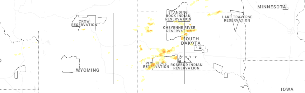
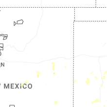
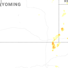
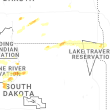
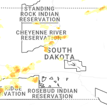
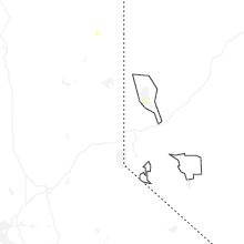
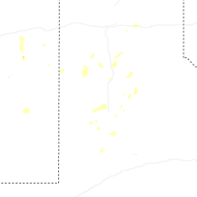
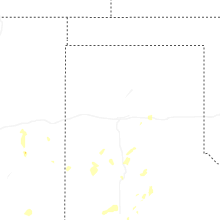
Hail Map for Monday, July 14, 2025
Number of Impacted Households on 7/14/2025
0
Impacted by 1" or Larger Hail
0
Impacted by 1.75" or Larger Hail
0
Impacted by 2.5" or Larger Hail
Square Miles of Populated Area Impacted on 7/14/2025
0
Impacted by 1" or Larger Hail
0
Impacted by 1.75" or Larger Hail
0
Impacted by 2.5" or Larger Hail
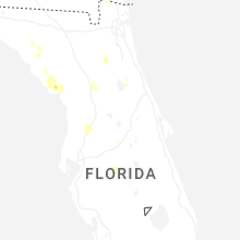
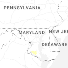
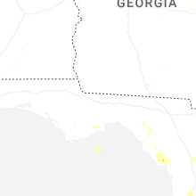
Cities Most Affected by Hail Storms of 7/14/2025
| Hail Size | Demographics of Zip Codes Affected | ||||||
|---|---|---|---|---|---|---|---|
| City | Count | Average | Largest | Pop Density | House Value | Income | Age |
Hail and Wind Damage Spotted on 7/14/2025
Filter by Report Type:Hail ReportsWind Reports
States Impacted
Florida, Georgia, New York, New Hampshire, Wyoming, Mississippi, Maine, Pennsylvania, Colorado, Idaho, South Carolina, Virginia, South Dakota, Texas, MarylandFlorida
| Local Time | Report Details |
|---|---|
| 2:44 PM EDT | Personnel weather station reynolds park - kflgreen22 reported wind gust of 63 mp in clay county FL, 23.5 miles S of Jacksonville, FL |
| 2:45 PM EDT | A video was relayed of a tree down on powerlines along leonard c taylor pkwy. time was estimated by radar. nearby gust of 63 mph was measured by a personal weather stat in clay county FL, 24.2 miles S of Jacksonville, FL |
| 3:28 PM EDT | Trees and powerlines reported down in the town of florahome. time of event based on radar dat in putnam county FL, 43.5 miles SSW of Jacksonville, FL |
| 4:06 PM EDT | Storm chaser relayed photo and video on social media showing trees down along us-441. time est. off radar and max wind gust of 36 mph at kgnv at 4:07p in alachua county FL, 59.5 miles SW of Jacksonville, FL |
| 5:24 PM EDT | Dot traffic cameras show that trees have fallen onto southbound lanes of i-75 at exit 293. time estimated from rada in pasco county FL, 56.1 miles W of Orlando, FL |
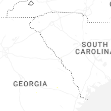
Georgia
| Local Time | Report Details |
|---|---|
| 3:30 PM EDT | Trees down on highway 121 between brannen road and pond view road. time estimated by rada in candler county GA, 62.2 miles WNW of Savannah, GA |
New York
| Local Time | Report Details |
|---|---|
| 3:35 PM EDT | Trees down blocking right lane of i 87 northbound. time estimated by rada in rockland county NY, 28.2 miles N of Brooklyn, NY |
New Hampshire
| Local Time | Report Details |
|---|---|
| 3:35 PM EDT | Stratford hollow fire dept employee reported 4 downed trees and numerous large branches along the daniel webster hwy between mt view rd and percy rd; 1 tree was partial in coos county NH, 82.2 miles E of Burlington, VT |
| 6:41 PM EDT | Multiple reports of trees and wires down on north side of newfound lake. numerous reports of power outages (residential and commercial in grafton county NH, 76.4 miles W of Portland, ME |
Wyoming
| Local Time | Report Details |
|---|---|
| 2:15 PM MDT | Storm damage reported in laramie county WY, 26.4 miles E of Laramie, WY |
Mississippi
| Local Time | Report Details |
|---|---|
| 3:15 PM CDT | Trees were blown down on sylvarena roa in copiah county MS, 42.6 miles SSW of Jackson, MS |
Maine
| Local Time | Report Details |
|---|---|
| 4:19 PM EDT | Tree down across the roa in aroostook county ME, 25.2 miles SW of Caribou, ME |
| 4:19 PM EDT | Quarter sized hail reported near Ashland, ME, 24.3 miles SW of Caribou, ME, quarter size hail in ashland. |
| 4:25 PM EDT | Large tree uproote in aroostook county ME, 24.3 miles SW of Caribou, ME |
| 4:26 PM EDT | Corrects timing of previous tstm wnd dmg report from 1 ese ashland. trees down and pole snapped near ashland high school closing roa in aroostook county ME, 24.3 miles SW of Caribou, ME |
| 4:49 PM EDT | Trees down and pole snapped near ashland high school closing roa in aroostook county ME, 24.3 miles SW of Caribou, ME |
Pennsylvania
| Local Time | Report Details |
|---|---|
| 5:12 PM EDT | Tree down blocking the road at oriole l in york county PA, 53.2 miles NNW of Baltimore, MD |
| 5:12 PM EDT | Power lines dow in york county PA, 52.6 miles NNW of Baltimore, MD |
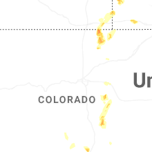
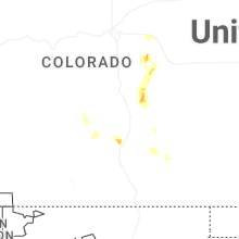
Colorado
| Local Time | Report Details |
|---|---|
| 3:15 PM MDT | Storm damage reported in arapahoe county CO, 27.2 miles ESE of Denver, CO |
| 4:05 PM MDT | Quarter sized hail reported near Kiowa, CO, 45.3 miles SE of Denver, CO |
| 4:10 PM MDT | Corrects previous tstm wnd gst report from 2 ese kiow in arapahoe county CO, 42.8 miles E of Denver, CO |
| 4:10 PM MDT | Storm damage reported in elbert county CO, 41.2 miles SE of Denver, CO |
Idaho
| Local Time | Report Details |
|---|---|
| 3:30 PM MDT | Mesonet station pc374 reno gulc in clark county ID, 51.3 miles NW of Idaho Falls, ID |
| 3:30 PM MDT | Pacificorp reno gulc in jefferson county ID, 45.7 miles NW of Idaho Falls, ID |
| 4:10 PM MDT | Mesonet station bas base of howe pea in butte county ID, 50.3 miles WNW of Idaho Falls, ID |
| 4:15 PM MDT | Mesonet station itdd3 d6 junction summit id-22/id-3 in butte county ID, 45.6 miles WNW of Idaho Falls, ID |
South Carolina
| Local Time | Report Details |
|---|---|
| 5:37 PM EDT | Bamberg county dispatch reported trees down on a powerline in denmark... sc. time estimated by rada in bamberg county SC, 49 miles ESE of Augusta, GA |
Virginia
| Local Time | Report Details |
|---|---|
| 6:08 PM EDT | Tree downed by thunderstorm winds at the intersection of howardsville road and mulberry grove roa in buckingham county VA, 52.4 miles W of Richmond, VA |
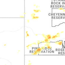
South Dakota
| Local Time | Report Details |
|---|---|
| 4:10 PM MDT | Storm damage reported in pennington county SD, 49.8 miles E of Rapid City, SD |
| 4:20 PM MDT | Storm damage reported in pennington county SD, 49.8 miles E of Rapid City, SD |
| 4:40 PM MDT | Storm damage reported in pennington county SD, 51.3 miles ESE of Rapid City, SD |
| 4:46 PM MDT | Semi blown over on i-90 near mm14 in jackson county SD, 71.3 miles ESE of Rapid City, SD |
| 4:46 PM MDT | Storm damage reported in jackson county SD, 72.3 miles ESE of Rapid City, SD |
| 4:51 PM MDT | Storm damage reported in jackson county SD, 72.3 miles ESE of Rapid City, SD |
| 4:55 PM MDT | Storm damage reported in haakon county SD, 65.9 miles WSW of Pierre, SD |
| 5:20 PM MDT | Storm damage reported in fall river county SD, 68.3 miles S of Rapid City, SD |
| 5:31 PM MDT | Storm damage reported in fall river county SD, 62.6 miles S of Rapid City, SD |
| 5:40 PM MDT | Storm damage reported in jackson county SD, 66.7 miles WSW of Pierre, SD |
| 5:55 PM MDT | Storm damage reported in oglala lakota county SD, 63.3 miles SE of Rapid City, SD |
| 6:26 PM MDT | Storm damage reported in jackson county SD, 49.4 miles SW of Pierre, SD |
| 7:50 PM CDT | Mesonet station onms2 onida 13wsw (sd mesonet in sully county SD, 19.5 miles N of Pierre, SD |
Texas
| Local Time | Report Details |
|---|---|
| 5:24 PM CDT | Quarter sized hail reported near Ropesville, TX, 22.9 miles WSW of Lubbock, TX, accumulating hail up to a depth of two inches... with quarter size hail measured within the swath. vegetation shredded. |
| 6:10 PM CDT | West texas mesonet repor in lynn county TX, 42.9 miles S of Lubbock, TX |
| 6:14 PM CDT | Public reported power pole leaning after strong winds moved through the area. wooden fence also normal to the wind direction... exhibited no visible damag in lubbock county TX, 5.7 miles S of Lubbock, TX |
Maryland
| Local Time | Report Details |
|---|---|
| 6:32 PM EDT | Large tree branch has fallen on a garage and part of the house connected to it at 2414 blooming way in anne arundel county MD, 17.1 miles SSW of Baltimore, MD |
Connect with Interactive Hail Maps