

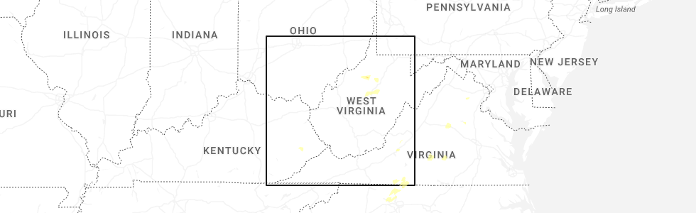
Hail Map for Auburn, WV
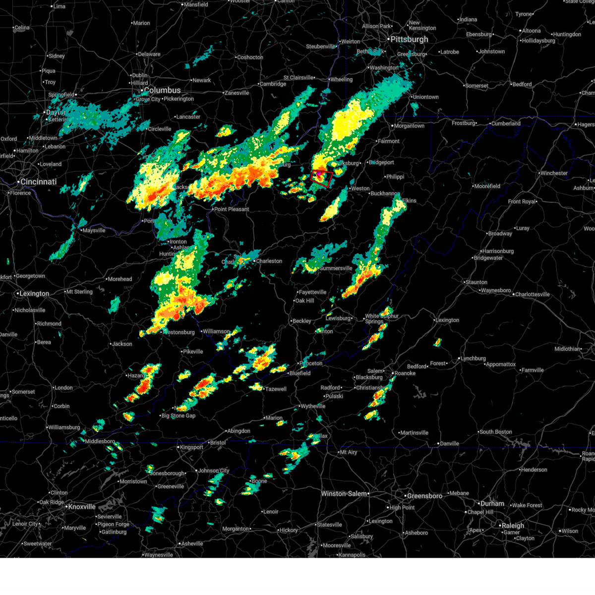
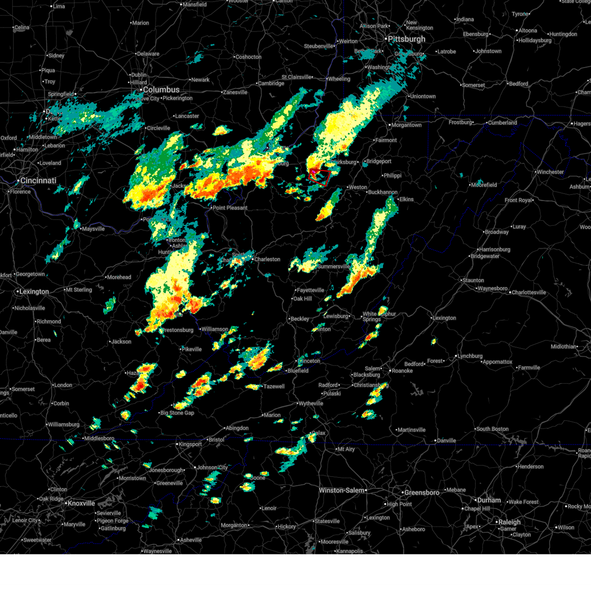
The Auburn, WV area has had 4 reports of on-the-ground hail by trained spotters, and has been under severe weather warnings 16 times during the past 12 months. Doppler radar has detected hail at or near Auburn, WV on 31 occasions, including 3 occasions during the past year.
| Name: | Auburn, WV |
| Where Located: | 55.8 miles WNW of Elkins, WV |
| Map: | Google Map for Auburn, WV |
| Population: | 97 |
| Housing Units: | 56 |
| More Info: | Search Google for Auburn, WV |
0
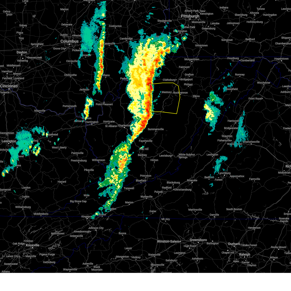
The Top Recent Hail Date for Auburn, WV is Wednesday, July 9, 2025 (21st out of 31)
Hail and Wind Damage Spotted near Auburn, WV
| Date / Time | Report Details |
|---|---|
| 7/9/2025 12:42 PM EDT |
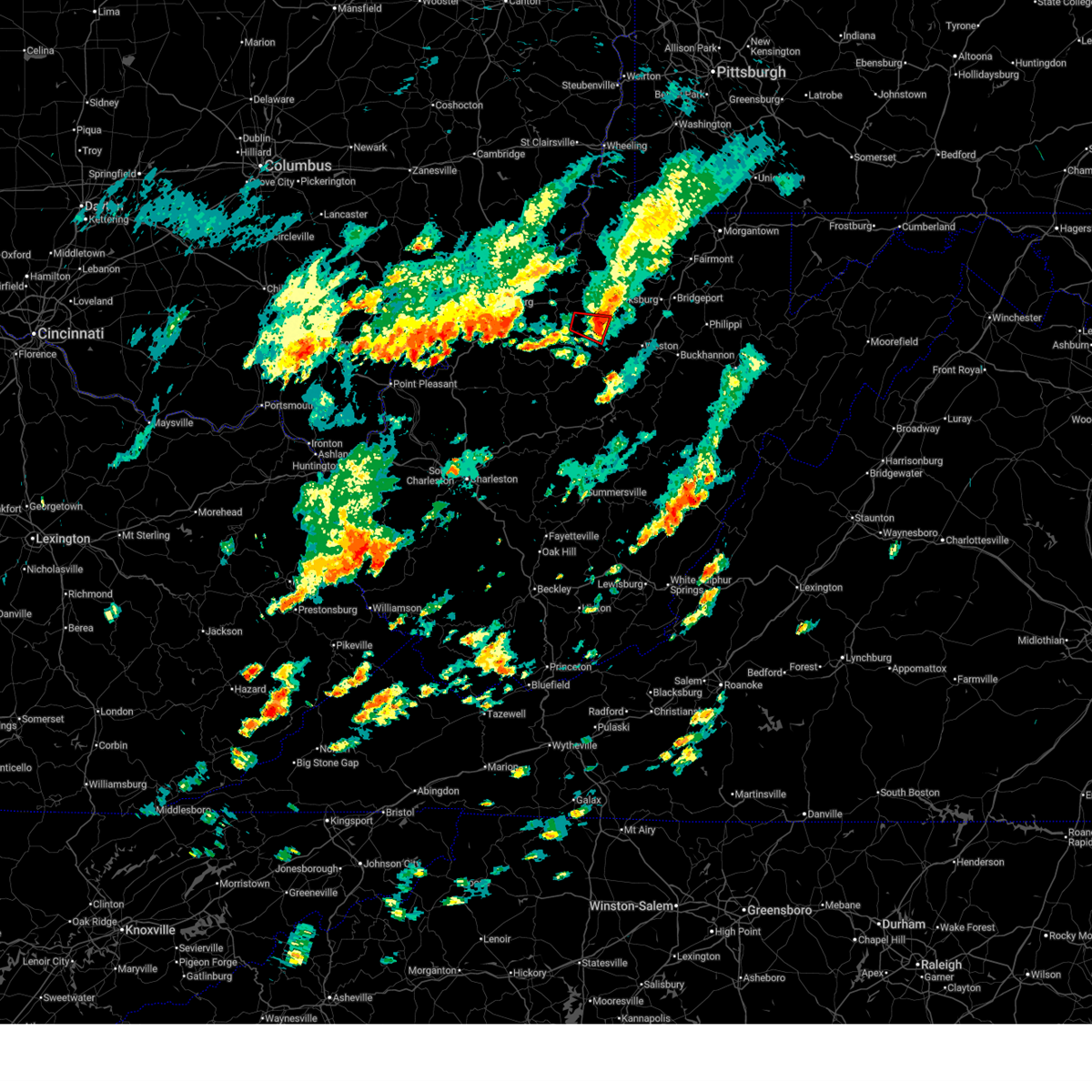 The tornado threat has diminished and the tornado warning has been cancelled. however, damaging winds remain likely and a severe thunderstorm warning remains in effect for the area. The tornado threat has diminished and the tornado warning has been cancelled. however, damaging winds remain likely and a severe thunderstorm warning remains in effect for the area.
|
| 7/9/2025 12:33 PM EDT |
 At 1233 pm edt, a severe thunderstorm capable of producing a tornado was located 10 miles south of west union, or 13 miles east of harrisville, moving east at 15 mph (radar indicated rotation). Hazards include tornado and ping pong ball size hail. Flying debris will be dangerous to those caught without shelter. mobile homes will be damaged or destroyed. damage to roofs, windows, and vehicles will occur. tree damage is likely. Locations impacted include, auburn, berea, grove, and leopold. At 1233 pm edt, a severe thunderstorm capable of producing a tornado was located 10 miles south of west union, or 13 miles east of harrisville, moving east at 15 mph (radar indicated rotation). Hazards include tornado and ping pong ball size hail. Flying debris will be dangerous to those caught without shelter. mobile homes will be damaged or destroyed. damage to roofs, windows, and vehicles will occur. tree damage is likely. Locations impacted include, auburn, berea, grove, and leopold.
|
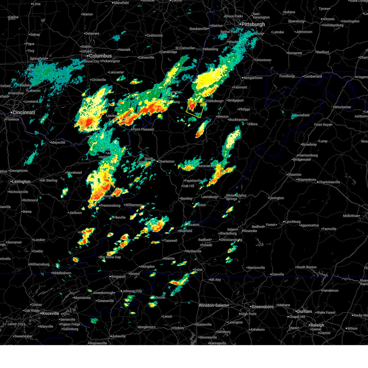
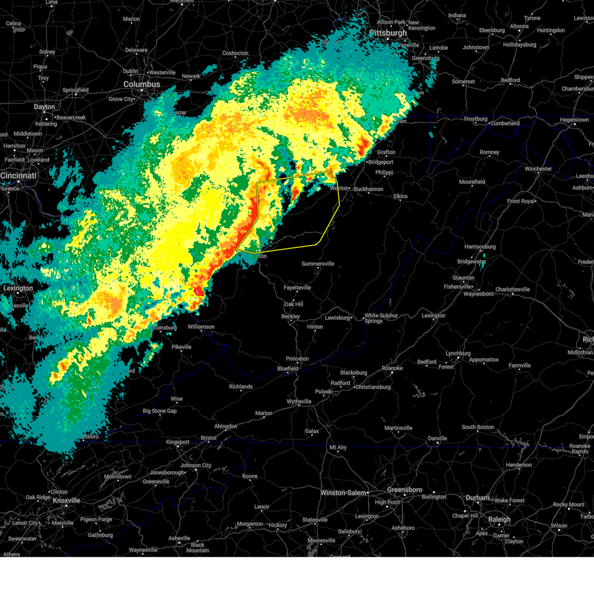
| 7/9/2025 12:26 PM EDT |
 At 1226 pm edt, a severe thunderstorm capable of producing a tornado was located 11 miles south of west union, or 11 miles southeast of harrisville, moving east at 15 mph (radar indicated rotation). Hazards include tornado and two inch hail. Flying debris will be dangerous to those caught without shelter. mobile homes will be damaged or destroyed. damage to roofs, windows, and vehicles will occur. tree damage is likely. Locations impacted include, auburn, berea, grove, and leopold. At 1226 pm edt, a severe thunderstorm capable of producing a tornado was located 11 miles south of west union, or 11 miles southeast of harrisville, moving east at 15 mph (radar indicated rotation). Hazards include tornado and two inch hail. Flying debris will be dangerous to those caught without shelter. mobile homes will be damaged or destroyed. damage to roofs, windows, and vehicles will occur. tree damage is likely. Locations impacted include, auburn, berea, grove, and leopold.
|
| 7/9/2025 12:25 PM EDT |
 At 1225 pm edt, a severe thunderstorm was located 7 miles east of harrisville, moving east at 15 mph (radar indicated). Hazards include two inch hail and 60 mph wind gusts. People and animals outdoors will be injured. expect hail damage to roofs, siding, windows, and vehicles. expect wind damage to trees and power lines, resulting in some power outages. Locations impacted include, pullman, auburn, coxs mills, berea, grove, and greenwood. At 1225 pm edt, a severe thunderstorm was located 7 miles east of harrisville, moving east at 15 mph (radar indicated). Hazards include two inch hail and 60 mph wind gusts. People and animals outdoors will be injured. expect hail damage to roofs, siding, windows, and vehicles. expect wind damage to trees and power lines, resulting in some power outages. Locations impacted include, pullman, auburn, coxs mills, berea, grove, and greenwood.
|
| 7/9/2025 12:21 PM EDT |
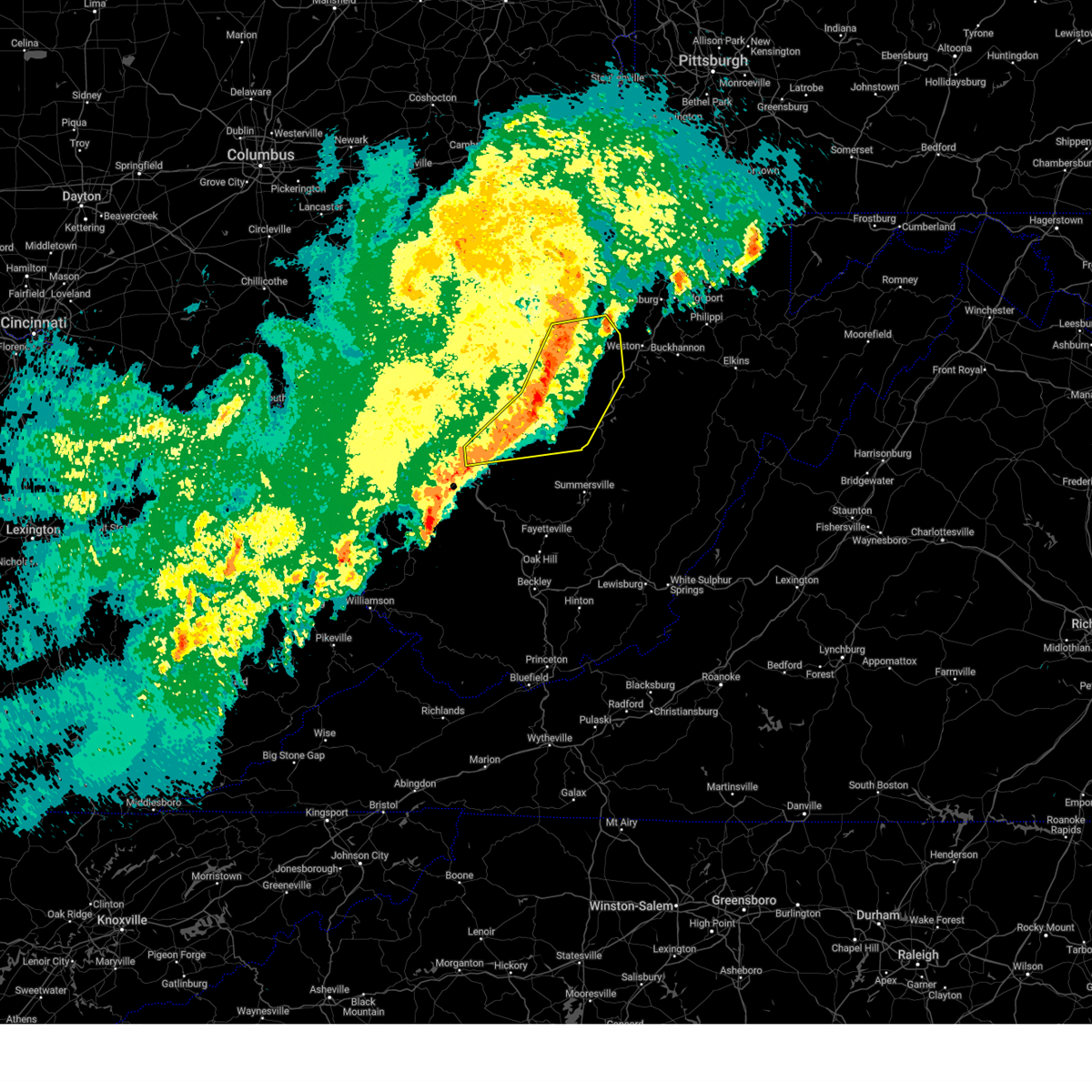
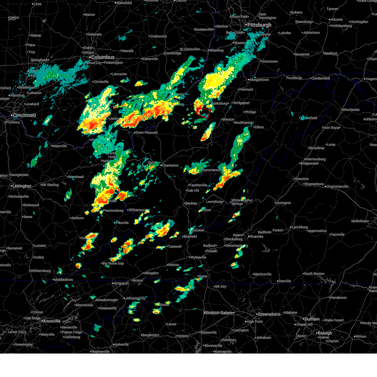 Torrlx the national weather service in charleston west virginia has issued a * tornado warning for, east central ritchie county in northwestern west virginia, southwestern doddridge county in northern west virginia, north central gilmer county in north central west virginia, * until 1245 pm edt. * at 1221 pm edt, a severe thunderstorm capable of producing a tornado was located 10 miles southeast of harrisville, moving east at 15 mph (radar indicated rotation). Hazards include tornado and ping pong ball size hail. Flying debris will be dangerous to those caught without shelter. mobile homes will be damaged or destroyed. damage to roofs, windows, and vehicles will occur. tree damage is likely. This tornadic thunderstorm will remain over mainly rural areas of east central ritchie, southwestern doddridge and north central gilmer counties, including the following locations, auburn, berea, grove, and leopold. Torrlx the national weather service in charleston west virginia has issued a * tornado warning for, east central ritchie county in northwestern west virginia, southwestern doddridge county in northern west virginia, north central gilmer county in north central west virginia, * until 1245 pm edt. * at 1221 pm edt, a severe thunderstorm capable of producing a tornado was located 10 miles southeast of harrisville, moving east at 15 mph (radar indicated rotation). Hazards include tornado and ping pong ball size hail. Flying debris will be dangerous to those caught without shelter. mobile homes will be damaged or destroyed. damage to roofs, windows, and vehicles will occur. tree damage is likely. This tornadic thunderstorm will remain over mainly rural areas of east central ritchie, southwestern doddridge and north central gilmer counties, including the following locations, auburn, berea, grove, and leopold.
|
| 7/9/2025 12:17 PM EDT |
 At 1217 pm edt, a severe thunderstorm was located near harrisville, moving east at 15 mph (radar indicated). Hazards include ping pong ball size hail and 60 mph wind gusts. People and animals outdoors will be injured. expect hail damage to roofs, siding, windows, and vehicles. expect wind damage to trees and power lines, resulting in some power outages. Locations impacted include, pullman, auburn, coxs mills, berea, and grove. At 1217 pm edt, a severe thunderstorm was located near harrisville, moving east at 15 mph (radar indicated). Hazards include ping pong ball size hail and 60 mph wind gusts. People and animals outdoors will be injured. expect hail damage to roofs, siding, windows, and vehicles. expect wind damage to trees and power lines, resulting in some power outages. Locations impacted include, pullman, auburn, coxs mills, berea, and grove.
|
| 7/9/2025 12:05 PM EDT |
 Svrrlx the national weather service in charleston west virginia has issued a * severe thunderstorm warning for, southeastern ritchie county in northwestern west virginia, southwestern doddridge county in northern west virginia, north central gilmer county in north central west virginia, * until 1245 pm edt. * at 1205 pm edt, a severe thunderstorm was located over harrisville, moving east at 15 mph (radar indicated). Hazards include 60 mph wind gusts and quarter size hail. Minor hail damage to vehicles is possible. Expect wind damage to trees and power lines, resulting in some power outages. Svrrlx the national weather service in charleston west virginia has issued a * severe thunderstorm warning for, southeastern ritchie county in northwestern west virginia, southwestern doddridge county in northern west virginia, north central gilmer county in north central west virginia, * until 1245 pm edt. * at 1205 pm edt, a severe thunderstorm was located over harrisville, moving east at 15 mph (radar indicated). Hazards include 60 mph wind gusts and quarter size hail. Minor hail damage to vehicles is possible. Expect wind damage to trees and power lines, resulting in some power outages.
|
| 6/19/2025 2:24 PM EDT | Tree dow in ritchie county WV, 7.9 miles ENE of Auburn, WV |
| 4/3/2025 5:46 AM EDT |
 At 545 am edt, severe thunderstorms were located along a line extending from 11 miles north of glenville to near grantsville to amma, moving east at 60 mph (radar indicated). Hazards include 60 mph wind gusts. Expect damage to roofs, siding, and trees. Locations impacted include, smithville, glenville, newberne, berea, stumptown, tanner, frametown, wilsie, sand fork, tariff, gassaway, arnoldsburg, servia, auburn, grantsville, stouts mills, leopold, walton, troy, and exchange. At 545 am edt, severe thunderstorms were located along a line extending from 11 miles north of glenville to near grantsville to amma, moving east at 60 mph (radar indicated). Hazards include 60 mph wind gusts. Expect damage to roofs, siding, and trees. Locations impacted include, smithville, glenville, newberne, berea, stumptown, tanner, frametown, wilsie, sand fork, tariff, gassaway, arnoldsburg, servia, auburn, grantsville, stouts mills, leopold, walton, troy, and exchange.
|
| 4/3/2025 5:46 AM EDT |
 the severe thunderstorm warning has been cancelled and is no longer in effect the severe thunderstorm warning has been cancelled and is no longer in effect
|
| 4/3/2025 5:34 AM EDT | the severe thunderstorm warning has been cancelled and is no longer in effect |
| 4/3/2025 5:34 AM EDT | At 533 am edt, severe thunderstorms were located along a line extending from near elizabeth to near spencer to near sissonville, moving east at 60 mph (radar indicated). Hazards include 60 mph wind gusts. Expect damage to roofs, siding, and trees. Locations impacted include, cherry, smithville, glenville, newberne, lucille, berea, stumptown, poca, tanner, macfarlan, frametown, wilsie, harmony, sand fork, tariff, gassaway, arnoldsburg, servia, auburn, and grantsville. |
| 4/3/2025 5:21 AM EDT |
 Svrrlx the national weather service in charleston west virginia has issued a * severe thunderstorm warning for, calhoun county in north central west virginia, east central putnam county in western west virginia, northern kanawha county in central west virginia, wirt county in northwestern west virginia, roane county in central west virginia, eastern jackson county in northwestern west virginia, south central wood county in northwestern west virginia, southern ritchie county in northwestern west virginia, southwestern doddridge county in northern west virginia, gilmer county in north central west virginia, northwestern lewis county in northern west virginia, western braxton county in north central west virginia, northern clay county in north central west virginia, * until 600 am edt. * at 521 am edt, severe thunderstorms were located along a line extending from 8 miles west of elizabeth to 7 miles west of spencer to near poca, moving east at 60 mph (radar indicated). Hazards include 60 mph wind gusts. expect damage to roofs, siding, and trees Svrrlx the national weather service in charleston west virginia has issued a * severe thunderstorm warning for, calhoun county in north central west virginia, east central putnam county in western west virginia, northern kanawha county in central west virginia, wirt county in northwestern west virginia, roane county in central west virginia, eastern jackson county in northwestern west virginia, south central wood county in northwestern west virginia, southern ritchie county in northwestern west virginia, southwestern doddridge county in northern west virginia, gilmer county in north central west virginia, northwestern lewis county in northern west virginia, western braxton county in north central west virginia, northern clay county in north central west virginia, * until 600 am edt. * at 521 am edt, severe thunderstorms were located along a line extending from 8 miles west of elizabeth to 7 miles west of spencer to near poca, moving east at 60 mph (radar indicated). Hazards include 60 mph wind gusts. expect damage to roofs, siding, and trees
|
| 4/3/2025 5:00 AM EDT |
 the severe thunderstorm warning has been cancelled and is no longer in effect the severe thunderstorm warning has been cancelled and is no longer in effect
|
| 4/3/2025 5:00 AM EDT |
 At 500 am edt, severe thunderstorms were located along a line extending from 7 miles south of jacksonburg to 6 miles southwest of salem to 8 miles north of grantsville, moving east at 60 mph (radar indicated). Hazards include 60 mph wind gusts. Expect damage to roofs, siding, and trees. Locations impacted include, shinnston, lumberport, anmoore, wolf summit, bridgeport, newberne, west milford, center point, sedalia, salem, despard, burnt house, clarksburg, blandville, auburn, avon, grove, leopold, new milton, and wallace. At 500 am edt, severe thunderstorms were located along a line extending from 7 miles south of jacksonburg to 6 miles southwest of salem to 8 miles north of grantsville, moving east at 60 mph (radar indicated). Hazards include 60 mph wind gusts. Expect damage to roofs, siding, and trees. Locations impacted include, shinnston, lumberport, anmoore, wolf summit, bridgeport, newberne, west milford, center point, sedalia, salem, despard, burnt house, clarksburg, blandville, auburn, avon, grove, leopold, new milton, and wallace.
|
| 4/3/2025 4:43 AM EDT | Svrrlx the national weather service in charleston west virginia has issued a * severe thunderstorm warning for, southeastern pleasants county in northwestern west virginia, north central calhoun county in north central west virginia, ritchie county in northwestern west virginia, doddridge county in northern west virginia, northwestern taylor county in northern west virginia, northwestern gilmer county in north central west virginia, northwestern lewis county in northern west virginia, east central wirt county in northwestern west virginia, central tyler county in northern west virginia, harrison county in northern west virginia, * until 530 am edt. * at 442 am edt, severe thunderstorms were located along a line extending from near jacksonburg to near west union to 9 miles south of harrisville, moving east at 65 mph (radar indicated). Hazards include 60 mph wind gusts. expect damage to roofs, siding, and trees |
| 3/16/2025 11:34 AM EDT |
 Svrrlx the national weather service in charleston west virginia has issued a * severe thunderstorm warning for, southeastern ritchie county in northwestern west virginia, southern doddridge county in northern west virginia, gilmer county in north central west virginia, lewis county in northern west virginia, braxton county in north central west virginia, western upshur county in northeastern west virginia, north central webster county in northeastern west virginia, southwestern harrison county in northern west virginia, * until 1215 pm edt. * at 1133 am edt, severe thunderstorms were located along a line extending from 6 miles southeast of harrisville to near glenville to 7 miles northeast of big otter, moving east at 40 mph (radar indicated). Hazards include 60 mph wind gusts. expect damage to roofs, siding, and trees Svrrlx the national weather service in charleston west virginia has issued a * severe thunderstorm warning for, southeastern ritchie county in northwestern west virginia, southern doddridge county in northern west virginia, gilmer county in north central west virginia, lewis county in northern west virginia, braxton county in north central west virginia, western upshur county in northeastern west virginia, north central webster county in northeastern west virginia, southwestern harrison county in northern west virginia, * until 1215 pm edt. * at 1133 am edt, severe thunderstorms were located along a line extending from 6 miles southeast of harrisville to near glenville to 7 miles northeast of big otter, moving east at 40 mph (radar indicated). Hazards include 60 mph wind gusts. expect damage to roofs, siding, and trees
|
| 9/24/2024 1:36 PM EDT | Power lines down in tanner rd... big spring in ritchie county WV, 7.6 miles ENE of Auburn, WV |
| 9/24/2024 1:28 PM EDT | County 911 reports a tree down blocking one lane of wv-47 east of wolfpen run road. time estimated from rada in gilmer county WV, 5.3 miles NW of Auburn, WV |
| 6/29/2024 7:22 PM EDT |
 Svrrlx the national weather service in charleston west virginia has issued a * severe thunderstorm warning for, east central ritchie county in northwestern west virginia, doddridge county in northern west virginia, northwestern lewis county in northern west virginia, western harrison county in northern west virginia, * until 745 pm edt. * at 721 pm edt, a severe thunderstorm was located 7 miles south of west union, or 12 miles east of harrisville, moving east at 25 mph (radar indicated). Hazards include 60 mph wind gusts and quarter size hail. Hail damage to vehicles is expected. Expect wind damage to roofs, siding, and trees. Svrrlx the national weather service in charleston west virginia has issued a * severe thunderstorm warning for, east central ritchie county in northwestern west virginia, doddridge county in northern west virginia, northwestern lewis county in northern west virginia, western harrison county in northern west virginia, * until 745 pm edt. * at 721 pm edt, a severe thunderstorm was located 7 miles south of west union, or 12 miles east of harrisville, moving east at 25 mph (radar indicated). Hazards include 60 mph wind gusts and quarter size hail. Hail damage to vehicles is expected. Expect wind damage to roofs, siding, and trees.
|
| 6/29/2024 7:10 PM EDT |
 the severe thunderstorm warning has been cancelled and is no longer in effect the severe thunderstorm warning has been cancelled and is no longer in effect
|
| 6/29/2024 7:10 PM EDT |
 At 709 pm edt, a severe thunderstorm was located 7 miles southeast of pennsboro, or 8 miles east of harrisville, moving northeast at 20 mph (radar indicated). Hazards include 60 mph wind gusts and quarter size hail. Hail damage to vehicles is expected. expect wind damage to roofs, siding, and trees. Locations impacted include, west union, pullman, auburn, new milton, smithburg, greenwood, blandville, berea, avon, canton, grove, and leopold. At 709 pm edt, a severe thunderstorm was located 7 miles southeast of pennsboro, or 8 miles east of harrisville, moving northeast at 20 mph (radar indicated). Hazards include 60 mph wind gusts and quarter size hail. Hail damage to vehicles is expected. expect wind damage to roofs, siding, and trees. Locations impacted include, west union, pullman, auburn, new milton, smithburg, greenwood, blandville, berea, avon, canton, grove, and leopold.
|
| 6/29/2024 6:58 PM EDT |
 Svrrlx the national weather service in charleston west virginia has issued a * severe thunderstorm warning for, southeastern ritchie county in northwestern west virginia, doddridge county in northern west virginia, north central gilmer county in north central west virginia, northwestern lewis county in northern west virginia, southeastern tyler county in northern west virginia, * until 730 pm edt. * at 657 pm edt, a severe thunderstorm was located near harrisville, moving east at 30 mph (radar indicated). Hazards include 60 mph wind gusts and quarter size hail. Hail damage to vehicles is expected. Expect wind damage to roofs, siding, and trees. Svrrlx the national weather service in charleston west virginia has issued a * severe thunderstorm warning for, southeastern ritchie county in northwestern west virginia, doddridge county in northern west virginia, north central gilmer county in north central west virginia, northwestern lewis county in northern west virginia, southeastern tyler county in northern west virginia, * until 730 pm edt. * at 657 pm edt, a severe thunderstorm was located near harrisville, moving east at 30 mph (radar indicated). Hazards include 60 mph wind gusts and quarter size hail. Hail damage to vehicles is expected. Expect wind damage to roofs, siding, and trees.
|
| 4/17/2024 10:02 PM EDT |
 At 1002 pm edt, a severe thunderstorm was located 12 miles northeast of glenville, moving southeast at 35 mph (radar indicated). Hazards include 60 mph wind gusts and quarter size hail. Hail damage to vehicles is expected. expect wind damage to roofs, siding, and trees. Locations impacted include, jackson mill, west milford, auburn, camden, baldwin, avon, grove, leopold, troy, new milton, newberne, alum bridge, coxs mills, linn, and berea. At 1002 pm edt, a severe thunderstorm was located 12 miles northeast of glenville, moving southeast at 35 mph (radar indicated). Hazards include 60 mph wind gusts and quarter size hail. Hail damage to vehicles is expected. expect wind damage to roofs, siding, and trees. Locations impacted include, jackson mill, west milford, auburn, camden, baldwin, avon, grove, leopold, troy, new milton, newberne, alum bridge, coxs mills, linn, and berea.
|
| 4/17/2024 9:42 PM EDT |
 Svrrlx the national weather service in charleston west virginia has issued a * severe thunderstorm warning for, southeastern ritchie county in northwestern west virginia, doddridge county in northern west virginia, northeastern gilmer county in north central west virginia, northwestern lewis county in northern west virginia, southwestern harrison county in northern west virginia, * until 1015 pm edt. * at 941 pm edt, a severe thunderstorm was located near harrisville, moving southeast at 35 mph (radar indicated). Hazards include 60 mph wind gusts and nickel size hail. expect damage to roofs, siding, and trees Svrrlx the national weather service in charleston west virginia has issued a * severe thunderstorm warning for, southeastern ritchie county in northwestern west virginia, doddridge county in northern west virginia, northeastern gilmer county in north central west virginia, northwestern lewis county in northern west virginia, southwestern harrison county in northern west virginia, * until 1015 pm edt. * at 941 pm edt, a severe thunderstorm was located near harrisville, moving southeast at 35 mph (radar indicated). Hazards include 60 mph wind gusts and nickel size hail. expect damage to roofs, siding, and trees
|
| 4/17/2024 9:29 PM EDT |
 the severe thunderstorm warning has been cancelled and is no longer in effect the severe thunderstorm warning has been cancelled and is no longer in effect
|
| 4/17/2024 9:29 PM EDT |
 At 929 pm edt, severe thunderstorms were located along a line extending from 8 miles north of salem to 9 miles northeast of elizabeth, moving east at 30 mph (radar indicated). Hazards include 60 mph wind gusts and quarter size hail. Hail damage to vehicles is expected. expect wind damage to roofs, siding, and trees. Locations impacted include, harrisville, shinnston, salem, pennsboro, lumberport, west union, north bend state park, enterprise, ellenboro, cairo, pullman, auburn, wolf summit, pike, center point, sedalia, berea, highland, greenwood, and blandville. At 929 pm edt, severe thunderstorms were located along a line extending from 8 miles north of salem to 9 miles northeast of elizabeth, moving east at 30 mph (radar indicated). Hazards include 60 mph wind gusts and quarter size hail. Hail damage to vehicles is expected. expect wind damage to roofs, siding, and trees. Locations impacted include, harrisville, shinnston, salem, pennsboro, lumberport, west union, north bend state park, enterprise, ellenboro, cairo, pullman, auburn, wolf summit, pike, center point, sedalia, berea, highland, greenwood, and blandville.
|
| 4/17/2024 9:15 PM EDT |
 Svrrlx the national weather service in charleston west virginia has issued a * severe thunderstorm warning for, pleasants county in northwestern west virginia, ritchie county in northwestern west virginia, doddridge county in northern west virginia, central tyler county in northern west virginia, east central wood county in northwestern west virginia, northern harrison county in northern west virginia, * until 945 pm edt. * at 915 pm edt, severe thunderstorms were located along a line extending from 6 miles southwest of jacksonburg to near parkersburg, moving southeast at 20 mph (radar indicated). Hazards include 60 mph wind gusts and quarter size hail. Hail damage to vehicles is expected. Expect wind damage to roofs, siding, and trees. Svrrlx the national weather service in charleston west virginia has issued a * severe thunderstorm warning for, pleasants county in northwestern west virginia, ritchie county in northwestern west virginia, doddridge county in northern west virginia, central tyler county in northern west virginia, east central wood county in northwestern west virginia, northern harrison county in northern west virginia, * until 945 pm edt. * at 915 pm edt, severe thunderstorms were located along a line extending from 6 miles southwest of jacksonburg to near parkersburg, moving southeast at 20 mph (radar indicated). Hazards include 60 mph wind gusts and quarter size hail. Hail damage to vehicles is expected. Expect wind damage to roofs, siding, and trees.
|
| 4/2/2024 12:11 PM EDT |
 The storms which prompted the warning have weakened below severe limits, and have exited the warned area. therefore, the warning will be allowed to expire. a tornado watch remains in effect until 100 pm edt for northern and north central west virginia. The storms which prompted the warning have weakened below severe limits, and have exited the warned area. therefore, the warning will be allowed to expire. a tornado watch remains in effect until 100 pm edt for northern and north central west virginia.
|
| 4/2/2024 11:50 AM EDT |
 At 1149 am edt, severe thunderstorms were located along a line extending from near harrisville to near grantsville, moving east at 50 mph (radar indicated). Hazards include 60 mph wind gusts. Expect damage to roofs, siding, and trees. Locations impacted include, salem, pennsboro, lumberport, west union, pullman, auburn, greenwood, blandville, avon, grove, leopold, wolf summit, new milton, smithburg, and berea. At 1149 am edt, severe thunderstorms were located along a line extending from near harrisville to near grantsville, moving east at 50 mph (radar indicated). Hazards include 60 mph wind gusts. Expect damage to roofs, siding, and trees. Locations impacted include, salem, pennsboro, lumberport, west union, pullman, auburn, greenwood, blandville, avon, grove, leopold, wolf summit, new milton, smithburg, and berea.
|
| 4/2/2024 11:50 AM EDT |
 the severe thunderstorm warning has been cancelled and is no longer in effect the severe thunderstorm warning has been cancelled and is no longer in effect
|
| 4/2/2024 11:36 AM EDT |
 the severe thunderstorm warning has been cancelled and is no longer in effect the severe thunderstorm warning has been cancelled and is no longer in effect
|
| 4/2/2024 11:36 AM EDT |
 At 1135 am edt, severe thunderstorms were located along a line extending from north bend state park to 7 miles southeast of elizabeth, moving east at 50 mph (radar indicated). Hazards include 60 mph wind gusts. Expect damage to roofs, siding, and trees. Locations impacted include, harrisville, salem, pennsboro, lumberport, west union, north bend state park, ellenboro, cairo, pullman, auburn, smithville, wolf summit, pike, sedalia, berea, macfarlan, highland, greenwood, blandville, and nutter farm. At 1135 am edt, severe thunderstorms were located along a line extending from north bend state park to 7 miles southeast of elizabeth, moving east at 50 mph (radar indicated). Hazards include 60 mph wind gusts. Expect damage to roofs, siding, and trees. Locations impacted include, harrisville, salem, pennsboro, lumberport, west union, north bend state park, ellenboro, cairo, pullman, auburn, smithville, wolf summit, pike, sedalia, berea, macfarlan, highland, greenwood, blandville, and nutter farm.
|
| 4/2/2024 11:35 AM EDT |
 The tornado threat has diminished and the tornado warning has been cancelled. however, damaging winds remain likely and a severe thunderstorm warning remains in effect for the area. a tornado watch remains in effect until 100 pm edt for northern and north central west virginia. The tornado threat has diminished and the tornado warning has been cancelled. however, damaging winds remain likely and a severe thunderstorm warning remains in effect for the area. a tornado watch remains in effect until 100 pm edt for northern and north central west virginia.
|
| 4/2/2024 11:22 AM EDT |
 Torrlx the national weather service in charleston west virginia has issued a * tornado warning for, southern ritchie county in northwestern west virginia, southwestern doddridge county in northern west virginia, north central gilmer county in north central west virginia, northeastern wirt county in northwestern west virginia, * until 1145 am edt. * at 1122 am edt, severe thunderstorms capable of producing both tornadoes and extensive straight line wind damage were located near elizabeth, moving east at 65 mph (radar indicated rotation). Hazards include tornado. Flying debris will be dangerous to those caught without shelter. mobile homes will be damaged or destroyed. damage to roofs, windows, and vehicles will occur. tree damage is likely. This tornadic thunderstorm will remain over mainly rural areas of southern ritchie, southwestern doddridge, north central gilmer and northeastern wirt counties, including the following locations, smithville, freeport, auburn, berea, macfarlan, pullman, grove, and leopold. Torrlx the national weather service in charleston west virginia has issued a * tornado warning for, southern ritchie county in northwestern west virginia, southwestern doddridge county in northern west virginia, north central gilmer county in north central west virginia, northeastern wirt county in northwestern west virginia, * until 1145 am edt. * at 1122 am edt, severe thunderstorms capable of producing both tornadoes and extensive straight line wind damage were located near elizabeth, moving east at 65 mph (radar indicated rotation). Hazards include tornado. Flying debris will be dangerous to those caught without shelter. mobile homes will be damaged or destroyed. damage to roofs, windows, and vehicles will occur. tree damage is likely. This tornadic thunderstorm will remain over mainly rural areas of southern ritchie, southwestern doddridge, north central gilmer and northeastern wirt counties, including the following locations, smithville, freeport, auburn, berea, macfarlan, pullman, grove, and leopold.
|
| 4/2/2024 11:11 AM EDT |
 Svrrlx the national weather service in charleston west virginia has issued a * severe thunderstorm warning for, southern pleasants county in northwestern west virginia, ritchie county in northwestern west virginia, doddridge county in northern west virginia, north central gilmer county in north central west virginia, northwestern lewis county in northern west virginia, northern wirt county in northwestern west virginia, south central tyler county in northern west virginia, southeastern wood county in northwestern west virginia, southwestern harrison county in northern west virginia, * until 1215 pm edt. * at 1111 am edt, severe thunderstorms were located along a line extending from 6 miles east of parkersburg to 7 miles northeast of sandyville, moving east at 60 mph (radar indicated). Hazards include 60 mph wind gusts. expect damage to roofs, siding, and trees Svrrlx the national weather service in charleston west virginia has issued a * severe thunderstorm warning for, southern pleasants county in northwestern west virginia, ritchie county in northwestern west virginia, doddridge county in northern west virginia, north central gilmer county in north central west virginia, northwestern lewis county in northern west virginia, northern wirt county in northwestern west virginia, south central tyler county in northern west virginia, southeastern wood county in northwestern west virginia, southwestern harrison county in northern west virginia, * until 1215 pm edt. * at 1111 am edt, severe thunderstorms were located along a line extending from 6 miles east of parkersburg to 7 miles northeast of sandyville, moving east at 60 mph (radar indicated). Hazards include 60 mph wind gusts. expect damage to roofs, siding, and trees
|
| 3/30/2024 9:12 PM EDT |
 The storm which prompted the warning has weakened below severe limits, and no longer poses an immediate threat to life or property. therefore, the warning will be allowed to expire. however, small hail and gusty winds are still possible with this thunderstorm. a severe thunderstorm watch remains in effect until 1000 pm edt for northern and northwestern west virginia. The storm which prompted the warning has weakened below severe limits, and no longer poses an immediate threat to life or property. therefore, the warning will be allowed to expire. however, small hail and gusty winds are still possible with this thunderstorm. a severe thunderstorm watch remains in effect until 1000 pm edt for northern and northwestern west virginia.
|
| 3/30/2024 8:59 PM EDT |
 At 858 pm edt, a severe thunderstorm was located 10 miles north of glenville, moving southeast at 45 mph (radar indicated). Hazards include 60 mph wind gusts and quarter size hail. Hail damage to vehicles is expected. expect wind damage to roofs, siding, and trees. Locations impacted include, sand fork, auburn, camden, alum bridge, baldwin, coxs mills, linn, stouts mills, grove, leopold, and troy. At 858 pm edt, a severe thunderstorm was located 10 miles north of glenville, moving southeast at 45 mph (radar indicated). Hazards include 60 mph wind gusts and quarter size hail. Hail damage to vehicles is expected. expect wind damage to roofs, siding, and trees. Locations impacted include, sand fork, auburn, camden, alum bridge, baldwin, coxs mills, linn, stouts mills, grove, leopold, and troy.
|
| 3/30/2024 8:46 PM EDT |
 Svrrlx the national weather service in charleston west virginia has issued a * severe thunderstorm warning for, southeastern ritchie county in northwestern west virginia, southwestern doddridge county in northern west virginia, northeastern gilmer county in north central west virginia, northwestern lewis county in northern west virginia, * until 915 pm edt. * at 846 pm edt, a severe thunderstorm was located near harrisville, moving southeast at 45 mph (radar indicated). Hazards include 60 mph wind gusts and quarter size hail. Hail damage to vehicles is expected. Expect wind damage to roofs, siding, and trees. Svrrlx the national weather service in charleston west virginia has issued a * severe thunderstorm warning for, southeastern ritchie county in northwestern west virginia, southwestern doddridge county in northern west virginia, northeastern gilmer county in north central west virginia, northwestern lewis county in northern west virginia, * until 915 pm edt. * at 846 pm edt, a severe thunderstorm was located near harrisville, moving southeast at 45 mph (radar indicated). Hazards include 60 mph wind gusts and quarter size hail. Hail damage to vehicles is expected. Expect wind damage to roofs, siding, and trees.
|
| 7/28/2023 3:39 PM EDT |
 At 339 pm edt, a severe thunderstorm was located 8 miles southwest of west union, or 9 miles east of harrisville, moving east at 40 mph (radar indicated). Hazards include 60 mph wind gusts and quarter size hail. Hail damage to vehicles is expected. expect wind damage to roofs, siding, and trees. Locations impacted include, glenville, pennsboro, pullman, auburn, greenwood, blandville, baldwin, grove, leopold, troy, newberne, coxs mills, linn, berea, tanner, and burnt house. At 339 pm edt, a severe thunderstorm was located 8 miles southwest of west union, or 9 miles east of harrisville, moving east at 40 mph (radar indicated). Hazards include 60 mph wind gusts and quarter size hail. Hail damage to vehicles is expected. expect wind damage to roofs, siding, and trees. Locations impacted include, glenville, pennsboro, pullman, auburn, greenwood, blandville, baldwin, grove, leopold, troy, newberne, coxs mills, linn, berea, tanner, and burnt house.
|
| 7/28/2023 3:35 PM EDT | The joint 911 center for gilmer and lewis counties reported a tree down in the 7600 block of alice road near the town of coxs mills. time estimated via rada in gilmer county WV, 4.9 miles NNW of Auburn, WV |
| 7/28/2023 3:18 PM EDT |
 At 317 pm edt, a severe thunderstorm was located near north bend state park, or near harrisville, moving east at 40 mph (radar indicated). Hazards include 60 mph wind gusts and nickel size hail. expect damage to roofs, siding, and trees At 317 pm edt, a severe thunderstorm was located near north bend state park, or near harrisville, moving east at 40 mph (radar indicated). Hazards include 60 mph wind gusts and nickel size hail. expect damage to roofs, siding, and trees
|
| 7/18/2023 7:39 PM EDT |
 The severe thunderstorm warning for southeastern ritchie, southwestern doddridge and northwestern gilmer counties will expire at 745 pm edt, the storm which prompted the warning has weakened below severe limits, and no longer poses an immediate threat to life or property. therefore, the warning will be allowed to expire. however gusty winds and heavy rain are still possible with this thunderstorm. The severe thunderstorm warning for southeastern ritchie, southwestern doddridge and northwestern gilmer counties will expire at 745 pm edt, the storm which prompted the warning has weakened below severe limits, and no longer poses an immediate threat to life or property. therefore, the warning will be allowed to expire. however gusty winds and heavy rain are still possible with this thunderstorm.
|
| 7/18/2023 7:31 PM EDT |
 At 731 pm edt, a severe thunderstorm was located 9 miles south of harrisville, moving southwest at 10 mph (radar indicated). Hazards include 60 mph wind gusts and quarter size hail. Hail damage to vehicles is expected. expect wind damage to roofs, siding, and trees. locations impacted include, pullman, auburn, newberne, coxs mills, berea and burnt house. hail threat, radar indicated max hail size, 1. 00 in wind threat, radar indicated max wind gust, 60 mph. At 731 pm edt, a severe thunderstorm was located 9 miles south of harrisville, moving southwest at 10 mph (radar indicated). Hazards include 60 mph wind gusts and quarter size hail. Hail damage to vehicles is expected. expect wind damage to roofs, siding, and trees. locations impacted include, pullman, auburn, newberne, coxs mills, berea and burnt house. hail threat, radar indicated max hail size, 1. 00 in wind threat, radar indicated max wind gust, 60 mph.
|
| 7/18/2023 7:14 PM EDT |
 At 713 pm edt, a severe thunderstorm was located 9 miles north of grantsville, moving east at 35 mph (radar indicated). Hazards include 60 mph wind gusts and quarter size hail. Hail damage to vehicles is expected. Expect wind damage to roofs, siding, and trees. At 713 pm edt, a severe thunderstorm was located 9 miles north of grantsville, moving east at 35 mph (radar indicated). Hazards include 60 mph wind gusts and quarter size hail. Hail damage to vehicles is expected. Expect wind damage to roofs, siding, and trees.
|
| 7/23/2022 3:54 PM EDT | Multiple trees down at sand for in lewis county WV, 8.5 miles W of Auburn, WV |
| 6/13/2022 9:06 PM EDT |
 The national weather service in charleston west virginia has issued a * severe thunderstorm warning for. southeastern washington county in southeastern ohio. pleasants county in northwestern west virginia. calhoun county in north central west virginia. Ritchie county in northwestern west virginia. The national weather service in charleston west virginia has issued a * severe thunderstorm warning for. southeastern washington county in southeastern ohio. pleasants county in northwestern west virginia. calhoun county in north central west virginia. Ritchie county in northwestern west virginia.
|
| 6/13/2022 9:06 PM EDT |
 At 905 pm edt, severe thunderstorms were located along a line extending from near vienna to near elizabeth to 7 miles west of spencer, moving east at 55 mph (radar indicated). Hazards include 60 mph wind gusts and quarter size hail. Hail damage to vehicles is possible. Expect wind damage to roofs, siding, and trees. At 905 pm edt, severe thunderstorms were located along a line extending from near vienna to near elizabeth to 7 miles west of spencer, moving east at 55 mph (radar indicated). Hazards include 60 mph wind gusts and quarter size hail. Hail damage to vehicles is possible. Expect wind damage to roofs, siding, and trees.
|
| 6/21/2021 5:09 PM EDT |
 At 509 pm edt, a severe thunderstorm was located 9 miles east of mineralwells, or 9 miles north of elizabeth, moving northeast at 45 mph (radar indicated). Hazards include 70 mph wind gusts and penny size hail. Expect considerable tree damage. Damage is likely to mobile homes, roofs, and outbuildings. At 509 pm edt, a severe thunderstorm was located 9 miles east of mineralwells, or 9 miles north of elizabeth, moving northeast at 45 mph (radar indicated). Hazards include 70 mph wind gusts and penny size hail. Expect considerable tree damage. Damage is likely to mobile homes, roofs, and outbuildings.
|
| 6/14/2021 8:09 PM EDT |
 The severe thunderstorm warning for southeastern ritchie, gilmer, west central lewis and north central braxton counties will expire at 815 pm edt, the storm which prompted the warning has weakened below severe limits, and has exited the warned area. therefore, the warning will be allowed to expire. however heavy rain is still possible with this thunderstorm. a severe thunderstorm watch remains in effect until 900 pm edt for northern and northwestern west virginia. The severe thunderstorm warning for southeastern ritchie, gilmer, west central lewis and north central braxton counties will expire at 815 pm edt, the storm which prompted the warning has weakened below severe limits, and has exited the warned area. therefore, the warning will be allowed to expire. however heavy rain is still possible with this thunderstorm. a severe thunderstorm watch remains in effect until 900 pm edt for northern and northwestern west virginia.
|
| 6/14/2021 7:58 PM EDT |
 At 758 pm edt, a severe thunderstorm was located 7 miles southeast of harrisville, moving east at 25 mph (radar indicated). Hazards include 60 mph wind gusts and quarter size hail. Hail damage to vehicles is expected. expect wind damage to roofs, siding, and trees. Locations impacted include, glenville, cedar creek state park, burnsville, sand fork, pullman, auburn, smithville, baldwin, stouts mills, sand run, troy, exchange, newberne, alum bridge, coxs mills, linn, berea, tanner, cedarville and burnt house. At 758 pm edt, a severe thunderstorm was located 7 miles southeast of harrisville, moving east at 25 mph (radar indicated). Hazards include 60 mph wind gusts and quarter size hail. Hail damage to vehicles is expected. expect wind damage to roofs, siding, and trees. Locations impacted include, glenville, cedar creek state park, burnsville, sand fork, pullman, auburn, smithville, baldwin, stouts mills, sand run, troy, exchange, newberne, alum bridge, coxs mills, linn, berea, tanner, cedarville and burnt house.
|
| 6/14/2021 7:34 PM EDT |
 At 733 pm edt, a severe thunderstorm was located near north bend state park, or near harrisville, moving southeast at 50 mph (radar indicated). Hazards include 60 mph wind gusts and quarter size hail. Hail damage to vehicles is expected. Expect wind damage to roofs, siding, and trees. At 733 pm edt, a severe thunderstorm was located near north bend state park, or near harrisville, moving southeast at 50 mph (radar indicated). Hazards include 60 mph wind gusts and quarter size hail. Hail damage to vehicles is expected. Expect wind damage to roofs, siding, and trees.
|
| 8/1/2020 7:55 PM EDT |
 At 754 pm edt, a severe thunderstorm was located 7 miles northwest of glenville, moving northeast at 30 mph (radar indicated). Hazards include 60 mph wind gusts. expect damage to roofs, siding, and trees At 754 pm edt, a severe thunderstorm was located 7 miles northwest of glenville, moving northeast at 30 mph (radar indicated). Hazards include 60 mph wind gusts. expect damage to roofs, siding, and trees
|
| 4/9/2020 2:01 AM EDT |
 At 158 am edt, severe thunderstorms were located along a line extending from 8 miles north of glenville to 6 miles southeast of cedar creek state park, moving east at 55 mph (radar indicated). Hazards include 70 mph wind gusts and penny size hail. Expect considerable tree damage. damage is likely to mobile homes, roofs, and outbuildings. Locations impacted include, buckhannon, weston, glenville, jackson mill, stonewall jackson, rock cave, cedar creek state park, burnsville, jane lew, sand fork, auburn, newberne, alum bridge, ireland, stumptown, tanner, french creek, burnt house, camden and baldwin. At 158 am edt, severe thunderstorms were located along a line extending from 8 miles north of glenville to 6 miles southeast of cedar creek state park, moving east at 55 mph (radar indicated). Hazards include 70 mph wind gusts and penny size hail. Expect considerable tree damage. damage is likely to mobile homes, roofs, and outbuildings. Locations impacted include, buckhannon, weston, glenville, jackson mill, stonewall jackson, rock cave, cedar creek state park, burnsville, jane lew, sand fork, auburn, newberne, alum bridge, ireland, stumptown, tanner, french creek, burnt house, camden and baldwin.
|
| 4/9/2020 1:36 AM EDT |
 At 136 am edt, a severe thunderstorm was located near grantsville, moving east at 75 mph (radar indicated). Hazards include 70 mph wind gusts and penny size hail. Expect considerable tree damage. Damage is likely to mobile homes, roofs, and outbuildings. At 136 am edt, a severe thunderstorm was located near grantsville, moving east at 75 mph (radar indicated). Hazards include 70 mph wind gusts and penny size hail. Expect considerable tree damage. Damage is likely to mobile homes, roofs, and outbuildings.
|
| 4/8/2020 4:06 AM EDT |
 The severe thunderstorm warning for southern ritchie county will expire at 415 am edt, the storm which prompted the warning has weakened below severe limits, and no longer poses an immediate threat to life or property. therefore, the warning will be allowed to expire. however gusty winds are still possible with this thunderstorm. a severe thunderstorm watch remains in effect until 600 am edt for north central and northwestern west virginia. The severe thunderstorm warning for southern ritchie county will expire at 415 am edt, the storm which prompted the warning has weakened below severe limits, and no longer poses an immediate threat to life or property. therefore, the warning will be allowed to expire. however gusty winds are still possible with this thunderstorm. a severe thunderstorm watch remains in effect until 600 am edt for north central and northwestern west virginia.
|
| 4/8/2020 3:53 AM EDT |
 At 352 am edt, a severe thunderstorm was located over north bend state park, or near harrisville, moving southeast at 60 mph (radar indicated). Hazards include 60 mph wind gusts and quarter size hail. Hail damage to vehicles is expected. expect wind damage to roofs, siding, and trees. Locations impacted include, north bend state park, cairo, auburn, nutter farm, petroleum, burnt house and berea. At 352 am edt, a severe thunderstorm was located over north bend state park, or near harrisville, moving southeast at 60 mph (radar indicated). Hazards include 60 mph wind gusts and quarter size hail. Hail damage to vehicles is expected. expect wind damage to roofs, siding, and trees. Locations impacted include, north bend state park, cairo, auburn, nutter farm, petroleum, burnt house and berea.
|
| 4/8/2020 3:40 AM EDT |
 At 340 am edt, a severe thunderstorm was located 9 miles southwest of belmont, or 11 miles east of parkersburg, moving southeast at 60 mph (radar indicated). Hazards include 60 mph wind gusts and quarter size hail. Hail damage to vehicles is expected. Expect wind damage to roofs, siding, and trees. At 340 am edt, a severe thunderstorm was located 9 miles southwest of belmont, or 11 miles east of parkersburg, moving southeast at 60 mph (radar indicated). Hazards include 60 mph wind gusts and quarter size hail. Hail damage to vehicles is expected. Expect wind damage to roofs, siding, and trees.
|
| 4/7/2020 7:07 PM EDT | Quarter sized hail reported 5.9 miles W of Auburn, WV, quarter size hail. |
| 1/11/2020 5:00 PM EST |
 At 500 pm est, severe thunderstorms were located along a line extending from near paden city to 7 miles southeast of middlebourne to 8 miles southeast of harrisville to 6 miles northwest of glenville to near grantsville, moving east at 55 mph (radar indicated). Hazards include 70 mph wind gusts. Expect considerable tree damage. Damage is likely to mobile homes, roofs, and outbuildings. At 500 pm est, severe thunderstorms were located along a line extending from near paden city to 7 miles southeast of middlebourne to 8 miles southeast of harrisville to 6 miles northwest of glenville to near grantsville, moving east at 55 mph (radar indicated). Hazards include 70 mph wind gusts. Expect considerable tree damage. Damage is likely to mobile homes, roofs, and outbuildings.
|
| 1/11/2020 4:51 PM EST |
 At 450 pm est, severe thunderstorms were located along a line extending from 12 miles south of harrisville to near grantsville to near arnoldsburg, moving east at 60 mph (radar indicated). Hazards include 60 mph wind gusts. Expect damage to roofs, siding, and trees. Locations impacted include, glenville, grantsville, arnoldsburg, cedar creek state park, sand fork, auburn, shock, millstone, smithville, baldwin, stouts mills, mount zion, troy, newberne, coxs mills, linn, big springs, berea, brohard and stumptown. At 450 pm est, severe thunderstorms were located along a line extending from 12 miles south of harrisville to near grantsville to near arnoldsburg, moving east at 60 mph (radar indicated). Hazards include 60 mph wind gusts. Expect damage to roofs, siding, and trees. Locations impacted include, glenville, grantsville, arnoldsburg, cedar creek state park, sand fork, auburn, shock, millstone, smithville, baldwin, stouts mills, mount zion, troy, newberne, coxs mills, linn, big springs, berea, brohard and stumptown.
|
| 1/11/2020 4:36 PM EST |
 At 435 pm est, severe thunderstorms were located along a line extending from 6 miles south of elizabeth to near spencer to 12 miles east of kenna, moving east at 55 mph (radar indicated). Hazards include 60 mph wind gusts. expect damage to roofs, siding, and trees At 435 pm est, severe thunderstorms were located along a line extending from 6 miles south of elizabeth to near spencer to 12 miles east of kenna, moving east at 55 mph (radar indicated). Hazards include 60 mph wind gusts. expect damage to roofs, siding, and trees
|
| 8/8/2019 6:21 PM EDT |
 At 621 pm edt, a severe thunderstorm was located 8 miles northwest of glenville, moving southeast at 30 mph (radar indicated). Hazards include 60 mph wind gusts and quarter size hail. Hail damage to vehicles is expected. Expect wind damage to roofs, siding, and trees. At 621 pm edt, a severe thunderstorm was located 8 miles northwest of glenville, moving southeast at 30 mph (radar indicated). Hazards include 60 mph wind gusts and quarter size hail. Hail damage to vehicles is expected. Expect wind damage to roofs, siding, and trees.
|
| 8/8/2019 5:57 PM EDT |
 The severe thunderstorm warning for central pleasants, ritchie, southern doddridge and northwestern gilmer counties will expire at 600 pm edt, the storm which prompted the warning has weakened below severe limits, and no longer poses an immediate threat to life or property. therefore, the warning will be allowed to expire. however gusty winds are still possible with this thunderstorm. The severe thunderstorm warning for central pleasants, ritchie, southern doddridge and northwestern gilmer counties will expire at 600 pm edt, the storm which prompted the warning has weakened below severe limits, and no longer poses an immediate threat to life or property. therefore, the warning will be allowed to expire. however gusty winds are still possible with this thunderstorm.
|
| 8/8/2019 5:22 PM EDT |
 At 522 pm edt, a severe thunderstorm was located near north bend state park, or 7 miles southeast of st. marys, moving southeast at 40 mph (radar indicated). Hazards include 60 mph wind gusts and quarter size hail. Hail damage to vehicles is expected. Expect wind damage to roofs, siding, and trees. At 522 pm edt, a severe thunderstorm was located near north bend state park, or 7 miles southeast of st. marys, moving southeast at 40 mph (radar indicated). Hazards include 60 mph wind gusts and quarter size hail. Hail damage to vehicles is expected. Expect wind damage to roofs, siding, and trees.
|
| 8/8/2019 4:53 PM EDT |
 At 452 pm edt, a severe thunderstorm was located near pennsboro, or near harrisville, moving southeast at 30 mph (radar indicated). Hazards include 60 mph wind gusts and quarter size hail. Hail damage to vehicles is expected. expect wind damage to roofs, siding, and trees. Locations impacted include, harrisville, pennsboro, ellenboro, pullman, auburn, greenwood, pike, berea, grove and highland. At 452 pm edt, a severe thunderstorm was located near pennsboro, or near harrisville, moving southeast at 30 mph (radar indicated). Hazards include 60 mph wind gusts and quarter size hail. Hail damage to vehicles is expected. expect wind damage to roofs, siding, and trees. Locations impacted include, harrisville, pennsboro, ellenboro, pullman, auburn, greenwood, pike, berea, grove and highland.
|
| 8/8/2019 4:29 PM EDT |
 At 429 pm edt, a severe thunderstorm was located near pennsboro, or 8 miles north of harrisville, moving southeast at 30 mph (radar indicated). Hazards include 60 mph wind gusts and quarter size hail. Hail damage to vehicles is expected. Expect wind damage to roofs, siding, and trees. At 429 pm edt, a severe thunderstorm was located near pennsboro, or 8 miles north of harrisville, moving southeast at 30 mph (radar indicated). Hazards include 60 mph wind gusts and quarter size hail. Hail damage to vehicles is expected. Expect wind damage to roofs, siding, and trees.
|
| 7/11/2019 8:51 PM EDT |
 The severe thunderstorm warning for southeastern pleasants, eastern ritchie, doddridge, northeastern gilmer, northwestern lewis, southern tyler and northwestern harrison counties will expire at 900 pm edt, the storm which prompted the warning has weakened below severe limits, and no longer poses an immediate threat to life or property. therefore, the warning will be allowed to expire. The severe thunderstorm warning for southeastern pleasants, eastern ritchie, doddridge, northeastern gilmer, northwestern lewis, southern tyler and northwestern harrison counties will expire at 900 pm edt, the storm which prompted the warning has weakened below severe limits, and no longer poses an immediate threat to life or property. therefore, the warning will be allowed to expire.
|
| 7/11/2019 8:22 PM EDT |
 At 822 pm edt, a severe thunderstorm was located 8 miles east of elizabeth, moving southeast at 15 mph (radar indicated). Hazards include 60 mph wind gusts. Expect damage to roofs, siding, and trees. Locations impacted include, parkersburg, harrisville, elizabeth, mineralwells, north bend state park, ellenboro, cairo, pullman, auburn, cherry, smithville, schultz, lucille, pike, davisville, berea, brohard, macfarlan, burnt house and walker. At 822 pm edt, a severe thunderstorm was located 8 miles east of elizabeth, moving southeast at 15 mph (radar indicated). Hazards include 60 mph wind gusts. Expect damage to roofs, siding, and trees. Locations impacted include, parkersburg, harrisville, elizabeth, mineralwells, north bend state park, ellenboro, cairo, pullman, auburn, cherry, smithville, schultz, lucille, pike, davisville, berea, brohard, macfarlan, burnt house and walker.
|
| 7/11/2019 8:18 PM EDT |
 At 818 pm edt, a severe thunderstorm was located near harrisville, moving southeast at 35 mph (radar indicated). Hazards include 60 mph wind gusts. expect damage to roofs, siding, and trees At 818 pm edt, a severe thunderstorm was located near harrisville, moving southeast at 35 mph (radar indicated). Hazards include 60 mph wind gusts. expect damage to roofs, siding, and trees
|
| 7/11/2019 8:04 PM EDT |
 The national weather service in charleston west virginia has issued a * severe thunderstorm warning for. southwestern pleasants county in northwestern west virginia. northwestern calhoun county in north central west virginia. ritchie county in northwestern west virginia. Wirt county in northwestern west virginia. The national weather service in charleston west virginia has issued a * severe thunderstorm warning for. southwestern pleasants county in northwestern west virginia. northwestern calhoun county in north central west virginia. ritchie county in northwestern west virginia. Wirt county in northwestern west virginia.
|
| 5/26/2019 4:39 PM EDT |
 At 438 pm edt, a severe thunderstorm was located 8 miles south of north bend state park, or 9 miles southwest of harrisville, moving east at 35 mph (radar indicated). Hazards include 60 mph wind gusts and quarter size hail. Hail damage to vehicles is expected. expect wind damage to roofs, siding, and trees. Locations impacted include, harrisville, north bend state park, pullman, auburn, smithville, blandville, baldwin, avon, grove, leopold, troy, new milton, newberne, alum bridge, coxs mills, linn, berea, macfarlan and burnt house. At 438 pm edt, a severe thunderstorm was located 8 miles south of north bend state park, or 9 miles southwest of harrisville, moving east at 35 mph (radar indicated). Hazards include 60 mph wind gusts and quarter size hail. Hail damage to vehicles is expected. expect wind damage to roofs, siding, and trees. Locations impacted include, harrisville, north bend state park, pullman, auburn, smithville, blandville, baldwin, avon, grove, leopold, troy, new milton, newberne, alum bridge, coxs mills, linn, berea, macfarlan and burnt house.
|
| 5/26/2019 4:28 PM EDT |
 At 427 pm edt, a severe thunderstorm was located near north bend state park, or 8 miles southwest of harrisville, moving east at 30 mph (radar indicated). Hazards include 60 mph wind gusts and quarter size hail. Hail damage to vehicles is expected. Expect wind damage to roofs, siding, and trees. At 427 pm edt, a severe thunderstorm was located near north bend state park, or 8 miles southwest of harrisville, moving east at 30 mph (radar indicated). Hazards include 60 mph wind gusts and quarter size hail. Hail damage to vehicles is expected. Expect wind damage to roofs, siding, and trees.
|
| 5/17/2019 5:22 PM EDT |
 The severe thunderstorm warning for eastern pleasants, central ritchie, western doddridge and southern tyler counties will expire at 530 pm edt, the storm which prompted the warning has weakened below severe limits, and no longer poses an immediate threat to life or property. therefore, the warning will be allowed to expire. a severe thunderstorm watch remains in effect until 1100 pm edt for northern, north central and northwestern west virginia. The severe thunderstorm warning for eastern pleasants, central ritchie, western doddridge and southern tyler counties will expire at 530 pm edt, the storm which prompted the warning has weakened below severe limits, and no longer poses an immediate threat to life or property. therefore, the warning will be allowed to expire. a severe thunderstorm watch remains in effect until 1100 pm edt for northern, north central and northwestern west virginia.
|
| 5/17/2019 5:12 PM EDT |
 At 512 pm edt, a severe thunderstorm was located near north bend state park, or near harrisville, moving east at 35 mph (radar indicated). Hazards include 60 mph wind gusts and quarter size hail. Hail damage to vehicles is expected. expect wind damage to roofs, siding, and trees. Locations impacted include, harrisville, pennsboro, west union, north bend state park, ellenboro, cairo, pullman, auburn, alma, greenwood, nutter farm, maxwell, arvilla, point lookout, wick, mountain, hebron, pike, berea and canton. At 512 pm edt, a severe thunderstorm was located near north bend state park, or near harrisville, moving east at 35 mph (radar indicated). Hazards include 60 mph wind gusts and quarter size hail. Hail damage to vehicles is expected. expect wind damage to roofs, siding, and trees. Locations impacted include, harrisville, pennsboro, west union, north bend state park, ellenboro, cairo, pullman, auburn, alma, greenwood, nutter farm, maxwell, arvilla, point lookout, wick, mountain, hebron, pike, berea and canton.
|
| 5/17/2019 4:52 PM EDT |
 The national weather service in charleston west virginia has issued a * severe thunderstorm warning for. east central washington county in southeastern ohio. pleasants county in northwestern west virginia. central ritchie county in northwestern west virginia. Western doddridge county in northern west virginia. The national weather service in charleston west virginia has issued a * severe thunderstorm warning for. east central washington county in southeastern ohio. pleasants county in northwestern west virginia. central ritchie county in northwestern west virginia. Western doddridge county in northern west virginia.
|
| 5/3/2019 3:41 PM EDT |
 At 339 pm edt, severe thunderstorms were located along a line extending from 7 miles west of grantsville to near arnoldsburg to 10 miles northeast of wallback to near big otter, moving northeast at 30 mph (radar indicated). Hazards include 60 mph wind gusts. Expect damage to roofs, siding, and trees. Locations impacted include, glenville, sutton, grantsville, gassaway, arnoldsburg, cedar creek state park, burnsville, flatwoods, sand fork, pullman, auburn, shock, millstone, smithville, rosedale, mount zion, newberne, big springs, berea and stumptown. At 339 pm edt, severe thunderstorms were located along a line extending from 7 miles west of grantsville to near arnoldsburg to 10 miles northeast of wallback to near big otter, moving northeast at 30 mph (radar indicated). Hazards include 60 mph wind gusts. Expect damage to roofs, siding, and trees. Locations impacted include, glenville, sutton, grantsville, gassaway, arnoldsburg, cedar creek state park, burnsville, flatwoods, sand fork, pullman, auburn, shock, millstone, smithville, rosedale, mount zion, newberne, big springs, berea and stumptown.
|
| 5/3/2019 3:17 PM EDT |
 At 315 pm edt, severe thunderstorms were located along a line extending from spencer to 6 miles southwest of arnoldsburg to wallback to near clay, moving northeast at 30 mph (radar indicated). Hazards include 60 mph wind gusts. expect damage to roofs, siding, and trees At 315 pm edt, severe thunderstorms were located along a line extending from spencer to 6 miles southwest of arnoldsburg to wallback to near clay, moving northeast at 30 mph (radar indicated). Hazards include 60 mph wind gusts. expect damage to roofs, siding, and trees
|
| 4/14/2019 8:14 PM EDT |
 At 814 pm edt, severe thunderstorms were located along a line extending from 7 miles west of mannington to 9 miles northwest of gassaway, moving east at 35 mph (radar indicated). Hazards include 60 mph wind gusts. Expect damage to roofs, siding, and trees. Locations impacted include, clarksburg, weston, glenville, bridgeport, shinnston, stonewood, nutter fort, salem, lumberport, west union, anmoore, jackson mill, cedar creek state park, stonewall jackson, enterprise, west milford, burnsville, lost creek, jane lew and sand fork. At 814 pm edt, severe thunderstorms were located along a line extending from 7 miles west of mannington to 9 miles northwest of gassaway, moving east at 35 mph (radar indicated). Hazards include 60 mph wind gusts. Expect damage to roofs, siding, and trees. Locations impacted include, clarksburg, weston, glenville, bridgeport, shinnston, stonewood, nutter fort, salem, lumberport, west union, anmoore, jackson mill, cedar creek state park, stonewall jackson, enterprise, west milford, burnsville, lost creek, jane lew and sand fork.
|
| 4/14/2019 7:40 PM EDT |
 At 740 pm edt, severe thunderstorms were located along a line extending from near pine grove to near arnoldsburg, moving northeast at 50 mph (radar indicated). Hazards include 60 mph wind gusts. expect damage to roofs, siding, and trees At 740 pm edt, severe thunderstorms were located along a line extending from near pine grove to near arnoldsburg, moving northeast at 50 mph (radar indicated). Hazards include 60 mph wind gusts. expect damage to roofs, siding, and trees
|
| 12/1/2018 10:57 PM EST |
 At 1056 pm est, a severe thunderstorm was located near mineralwells, or 9 miles northwest of elizabeth, moving east at 55 mph (radar indicated). Hazards include 60 mph wind gusts and quarter size hail. Hail damage to vehicles is expected. Expect wind damage to roofs, siding, and trees. At 1056 pm est, a severe thunderstorm was located near mineralwells, or 9 miles northwest of elizabeth, moving east at 55 mph (radar indicated). Hazards include 60 mph wind gusts and quarter size hail. Hail damage to vehicles is expected. Expect wind damage to roofs, siding, and trees.
|
| 7/20/2018 3:25 PM EDT |
 At 325 pm edt, a severe thunderstorm was located near grantsville, moving northeast at 30 mph (radar indicated). Hazards include 60 mph wind gusts and penny size hail. expect damage to roofs, siding, and trees At 325 pm edt, a severe thunderstorm was located near grantsville, moving northeast at 30 mph (radar indicated). Hazards include 60 mph wind gusts and penny size hail. expect damage to roofs, siding, and trees
|
| 5/14/2018 4:09 PM EDT |
 The severe thunderstorm warning for southeastern ritchie, south central doddridge and northwestern gilmer counties will expire at 415 pm edt, the storm which prompted the warning has weakened below severe limits, and no longer poses an immediate threat to life or property. therefore the warning will be allowed to expire. however small hail, gusty winds and heavy rain are still possible with this thunderstorm. a severe thunderstorm watch remains in effect until 900 pm edt for northern, north central and northwestern west virginia. The severe thunderstorm warning for southeastern ritchie, south central doddridge and northwestern gilmer counties will expire at 415 pm edt, the storm which prompted the warning has weakened below severe limits, and no longer poses an immediate threat to life or property. therefore the warning will be allowed to expire. however small hail, gusty winds and heavy rain are still possible with this thunderstorm. a severe thunderstorm watch remains in effect until 900 pm edt for northern, north central and northwestern west virginia.
|
| 5/14/2018 3:57 PM EDT |
 At 357 pm edt, a severe thunderstorm was located 10 miles north of glenville, moving east at 30 mph (radar indicated). Hazards include 60 mph wind gusts and quarter size hail. Hail damage to vehicles is expected. expect wind damage to roofs, siding, and trees. locations impacted include, auburn, newberne, coxs mills, grove, leopold, troy and burnt house. At 357 pm edt, a severe thunderstorm was located 10 miles north of glenville, moving east at 30 mph (radar indicated). Hazards include 60 mph wind gusts and quarter size hail. Hail damage to vehicles is expected. expect wind damage to roofs, siding, and trees. locations impacted include, auburn, newberne, coxs mills, grove, leopold, troy and burnt house.
|
| 5/14/2018 3:42 PM EDT | Golf Ball sized hail reported 6.7 miles E of Auburn, WV, mostly nickel size but a few up to golf ball size. |
| 5/14/2018 3:40 PM EDT |
 At 340 pm edt, a severe thunderstorm was located 8 miles south of harrisville, moving east at 25 mph (radar indicated). Hazards include 60 mph wind gusts and quarter size hail. Hail damage to vehicles is expected. Expect wind damage to roofs, siding, and trees. At 340 pm edt, a severe thunderstorm was located 8 miles south of harrisville, moving east at 25 mph (radar indicated). Hazards include 60 mph wind gusts and quarter size hail. Hail damage to vehicles is expected. Expect wind damage to roofs, siding, and trees.
|
| 7/22/2017 6:16 PM EDT |
 At 616 pm edt, severe thunderstorms were located along a line extending from 7 miles southwest of west union to 7 miles northwest of grantsville, moving southeast at 45 mph (radar indicated). Hazards include 70 mph wind gusts and ping pong ball size hail. People and animals outdoors will be injured. expect hail damage to roofs, siding, windows, and vehicles. expect considerable tree damage. Wind damage is also likely to mobile homes, roofs, and outbuildings. At 616 pm edt, severe thunderstorms were located along a line extending from 7 miles southwest of west union to 7 miles northwest of grantsville, moving southeast at 45 mph (radar indicated). Hazards include 70 mph wind gusts and ping pong ball size hail. People and animals outdoors will be injured. expect hail damage to roofs, siding, windows, and vehicles. expect considerable tree damage. Wind damage is also likely to mobile homes, roofs, and outbuildings.
|
| 7/22/2017 5:51 PM EDT |
 At 551 pm edt, a severe thunderstorm was located 9 miles southeast of harrisville, moving east at 40 mph (radar indicated). Hazards include 70 mph wind gusts and half dollar size hail. Hail damage to vehicles is expected. expect considerable tree damage. Wind damage is also likely to mobile homes, roofs, and outbuildings. At 551 pm edt, a severe thunderstorm was located 9 miles southeast of harrisville, moving east at 40 mph (radar indicated). Hazards include 70 mph wind gusts and half dollar size hail. Hail damage to vehicles is expected. expect considerable tree damage. Wind damage is also likely to mobile homes, roofs, and outbuildings.
|
| 7/22/2017 3:37 PM EDT |
 At 337 pm edt, a severe thunderstorm was located over north bend state park, or near harrisville, moving east at 30 mph (radar indicated). Hazards include 60 mph wind gusts and half dollar size hail. Hail damage to vehicles is expected. Expect wind damage to roofs, siding, and trees. At 337 pm edt, a severe thunderstorm was located over north bend state park, or near harrisville, moving east at 30 mph (radar indicated). Hazards include 60 mph wind gusts and half dollar size hail. Hail damage to vehicles is expected. Expect wind damage to roofs, siding, and trees.
|
| 3/1/2017 10:30 AM EST | Many trees down with a lot of damag in gilmer county WV, 4.7 miles NNW of Auburn, WV |
| 3/1/2017 10:19 AM EST |
 At 1019 am est, severe thunderstorms were located along a line extending from pennsboro to grantsville, moving east at 55 mph (radar indicated). Hazards include 70 mph wind gusts and penny size hail. Expect considerable tree damage. damage is likely to mobile homes, roofs, and outbuildings. locations impacted include, harrisville, pennsboro, west union, north bend state park, ellenboro, cairo, pullman, auburn, greenwood, smithville, grove, newberne, smithburg, pike, coxs mills, big springs, berea, tanner, canton and highland. This includes route 50 in west virginia between mile markers 33 and 56. At 1019 am est, severe thunderstorms were located along a line extending from pennsboro to grantsville, moving east at 55 mph (radar indicated). Hazards include 70 mph wind gusts and penny size hail. Expect considerable tree damage. damage is likely to mobile homes, roofs, and outbuildings. locations impacted include, harrisville, pennsboro, west union, north bend state park, ellenboro, cairo, pullman, auburn, greenwood, smithville, grove, newberne, smithburg, pike, coxs mills, big springs, berea, tanner, canton and highland. This includes route 50 in west virginia between mile markers 33 and 56.
|
| 3/1/2017 10:01 AM EST |
 At 1001 am est, severe thunderstorms were located along a line extending from 7 miles west of north bend state park to near spencer, moving east at 55 mph (radar indicated). Hazards include 70 mph wind gusts and penny size hail. Expect considerable tree damage. Damage is likely to mobile homes, roofs, and outbuildings. At 1001 am est, severe thunderstorms were located along a line extending from 7 miles west of north bend state park to near spencer, moving east at 55 mph (radar indicated). Hazards include 70 mph wind gusts and penny size hail. Expect considerable tree damage. Damage is likely to mobile homes, roofs, and outbuildings.
|
| 3/1/2017 7:00 AM EST | Many trees down with a lot of damag in gilmer county WV, 4.7 miles NNW of Auburn, WV |
| 7/4/2016 6:50 PM EDT |
 At 650 pm edt, a severe thunderstorm capable of producing a tornado was located near harrisville, moving east at 40 mph (radar indicated rotation). Hazards include tornado. Flying debris will be dangerous to those caught without shelter. mobile homes will be damaged or destroyed. damage to roofs, windows, and vehicles will occur. tree damage is likely. This tornadic thunderstorm will remain over mainly rural areas of east central ritchie, southern doddridge, northwestern lewis and northeastern gilmer counties, including the following locations: grove, berea, avon, new milton, pullman, leopold and auburn. At 650 pm edt, a severe thunderstorm capable of producing a tornado was located near harrisville, moving east at 40 mph (radar indicated rotation). Hazards include tornado. Flying debris will be dangerous to those caught without shelter. mobile homes will be damaged or destroyed. damage to roofs, windows, and vehicles will occur. tree damage is likely. This tornadic thunderstorm will remain over mainly rural areas of east central ritchie, southern doddridge, northwestern lewis and northeastern gilmer counties, including the following locations: grove, berea, avon, new milton, pullman, leopold and auburn.
|
| 6/23/2016 3:31 AM EDT |
 At 331 am edt, severe thunderstorms were located along a line extending from near lumberport to 11 miles north of glenville, moving east at 45 mph (radar indicated). Hazards include 60 mph wind gusts and penny size hail. Expect damage to roofs. siding. and trees. Locations impacted include, clarksburg, grafton, weston, bridgeport, shinnston, stonewood, nutter fort, salem, lumberport, anmoore, jackson mill, west milford, lost creek, jane lew, flemington, auburn, coxs mills, despard, galloway and wolf summit. At 331 am edt, severe thunderstorms were located along a line extending from near lumberport to 11 miles north of glenville, moving east at 45 mph (radar indicated). Hazards include 60 mph wind gusts and penny size hail. Expect damage to roofs. siding. and trees. Locations impacted include, clarksburg, grafton, weston, bridgeport, shinnston, stonewood, nutter fort, salem, lumberport, anmoore, jackson mill, west milford, lost creek, jane lew, flemington, auburn, coxs mills, despard, galloway and wolf summit.
|
| 6/23/2016 3:14 AM EDT |
 At 314 am edt, severe thunderstorms were located along a line extending from 6 miles north of salem to near harrisville, moving east at 40 mph (radar indicated). Hazards include 60 mph wind gusts and quarter size hail. Hail damage to vehicles is expected. Expect wind damage to roofs, siding, and trees. At 314 am edt, severe thunderstorms were located along a line extending from 6 miles north of salem to near harrisville, moving east at 40 mph (radar indicated). Hazards include 60 mph wind gusts and quarter size hail. Hail damage to vehicles is expected. Expect wind damage to roofs, siding, and trees.
|
| 6/16/2016 5:23 PM EDT |
 The severe thunderstorm warning for southeastern ritchie, northwestern lewis and northern gilmer counties will expire at 530 pm edt, the storm which prompted the warning has weakened below severe limits, and no longer pose an immediate threat to life or property. therefore, the warning will be allowed to expire. however gusty winds are still possible with this thunderstorm. a severe thunderstorm watch remains in effect until 1000 pm edt for north central, northern and northwestern west virginia. The severe thunderstorm warning for southeastern ritchie, northwestern lewis and northern gilmer counties will expire at 530 pm edt, the storm which prompted the warning has weakened below severe limits, and no longer pose an immediate threat to life or property. therefore, the warning will be allowed to expire. however gusty winds are still possible with this thunderstorm. a severe thunderstorm watch remains in effect until 1000 pm edt for north central, northern and northwestern west virginia.
|
| 6/16/2016 5:03 PM EDT |
 At 503 pm edt, a severe thunderstorm was located 9 miles south of harrisville, moving east at 50 mph (radar indicated). Hazards include 60 mph wind gusts and quarter size hail. Hail damage to vehicles is expected. Expect wind damage to roofs, siding, and trees. At 503 pm edt, a severe thunderstorm was located 9 miles south of harrisville, moving east at 50 mph (radar indicated). Hazards include 60 mph wind gusts and quarter size hail. Hail damage to vehicles is expected. Expect wind damage to roofs, siding, and trees.
|
| 6/16/2016 4:38 PM EDT |
 At 438 pm edt, a severe thunderstorm was located 11 miles southeast of harrisville, moving east at 30 mph (radar indicated). Hazards include 60 mph wind gusts and quarter size hail. Hail damage to vehicles is expected. Expect wind damage to roofs, siding, and trees. At 438 pm edt, a severe thunderstorm was located 11 miles southeast of harrisville, moving east at 30 mph (radar indicated). Hazards include 60 mph wind gusts and quarter size hail. Hail damage to vehicles is expected. Expect wind damage to roofs, siding, and trees.
|
| 4/26/2016 6:00 PM EDT | Golf Ball sized hail reported 0.3 miles SSE of Auburn, WV, mostly pea-sized with golf ball sized mixed in |
| 4/26/2016 5:58 PM EDT |
 At 557 pm edt, doppler radar indicated a severe thunderstorm capable of producing large hail up to ping pong ball size. this storm was located 11 miles south of west union, or 12 miles southeast of harrisville, and moving east at 30 mph. At 557 pm edt, doppler radar indicated a severe thunderstorm capable of producing large hail up to ping pong ball size. this storm was located 11 miles south of west union, or 12 miles southeast of harrisville, and moving east at 30 mph.
|
| 4/26/2016 5:35 PM EDT |
 At 535 pm edt, a severe thunderstorm was located over harrisville, moving southeast at 25 mph (radar indicated). Hazards include 60 mph wind gusts and half dollar size hail. Hail damage to vehicles is expected. Expect wind damage to roofs, siding, and trees. At 535 pm edt, a severe thunderstorm was located over harrisville, moving southeast at 25 mph (radar indicated). Hazards include 60 mph wind gusts and half dollar size hail. Hail damage to vehicles is expected. Expect wind damage to roofs, siding, and trees.
|
| 7/14/2015 5:09 PM EDT |
 At 507 pm edt, doppler radar indicated a line of severe thunderstorms capable of producing damaging winds in excess of 60 mph. these storms were located along a line extending from 6 miles southeast of pennsboro to near grantsville to 8 miles north of spencer, moving southeast at 45 mph. locations impacted include, spencer, harrisville, glenville, elizabeth, grantsville, salem, pennsboro, west union, arnoldsburg, north bend state park, cedar creek state park, ellenboro, cairo, reedy, sand fork, pullman, auburn, coxs mills, creston and wolf summit. At 507 pm edt, doppler radar indicated a line of severe thunderstorms capable of producing damaging winds in excess of 60 mph. these storms were located along a line extending from 6 miles southeast of pennsboro to near grantsville to 8 miles north of spencer, moving southeast at 45 mph. locations impacted include, spencer, harrisville, glenville, elizabeth, grantsville, salem, pennsboro, west union, arnoldsburg, north bend state park, cedar creek state park, ellenboro, cairo, reedy, sand fork, pullman, auburn, coxs mills, creston and wolf summit.
|
| 7/14/2015 4:34 PM EDT |
 At 433 pm edt, doppler radar indicated a line of severe thunderstorms capable of producing damaging winds in excess of 60 mph. these storms were located along a line extending from near belmont to mineralwells to forked run state park, and moving southeast at 45 mph. At 433 pm edt, doppler radar indicated a line of severe thunderstorms capable of producing damaging winds in excess of 60 mph. these storms were located along a line extending from near belmont to mineralwells to forked run state park, and moving southeast at 45 mph.
|
| 4/9/2015 6:47 PM EDT | Half Dollar sized hail reported 6.7 miles WSW of Auburn, WV, half dollar size hail in southern dodridge county. |
| 4/9/2015 6:26 PM EDT | A severe thunderstorm warning remains in effect until 700 pm edt for southern doddridge. western harrison. northern lewis. east central ritchie and north central gilmer counties. at 624 pm edt. national weather service doppler radar continued to indicate a severe thunderstorm capable of producing half dollar size hail. this storm was located near grove. Or 14 miles east of. |
| 4/9/2015 5:59 PM EDT | The national weather service in charleston has issued a * severe thunderstorm warning for. north central calhoun county in west virginia. doddridge county in west virginia. northern gilmer county in west virginia. Western harrison county in west virginia. |
| 4/9/2015 4:24 PM EDT | The national weather service in charleston has issued a * severe thunderstorm warning for. doddridge county in west virginia. north central gilmer county in west virginia. harrison county in west virginia. This includes the city of clarksburg. |
| 7/8/2014 3:20 PM EDT | Trees dow in ritchie county WV, 0.3 miles SSE of Auburn, WV |
| 7/8/2014 3:15 PM EDT | Town of auburn wv. no power. at least a half a dozen homes with roof damage...of which two homes the roofs are completely missing and the homes have been declared unliv in ritchie county WV, 0.3 miles SSE of Auburn, WV |
| 1/1/0001 12:00 AM | Tree down along rt 74 in ritchie county WV, 3.5 miles ESE of Auburn, WV |
| 1/1/0001 12:00 AM | Two trees down on rte 47 in burnt hous in ritchie county WV, 7.3 miles ENE of Auburn, WV |
| 1/1/0001 12:00 AM | Trees down in the southern part of doddridge county in doddridge county WV, 6.5 miles WSW of Auburn, WV |
Hail Maps for Auburn, WV


Connect with Interactive Hail Maps