

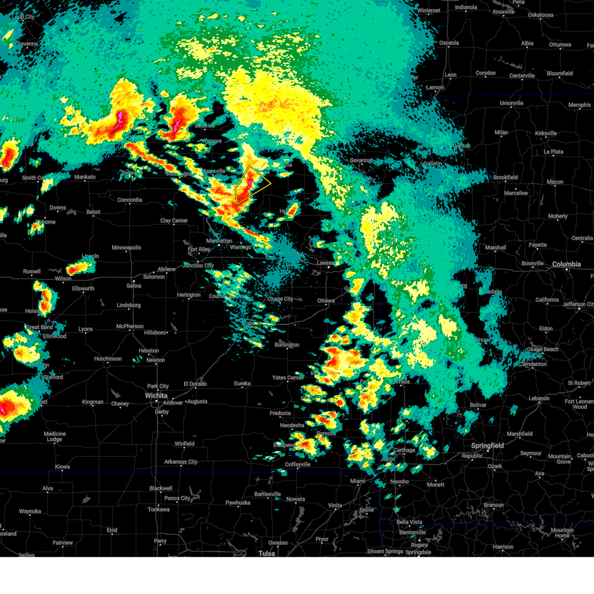
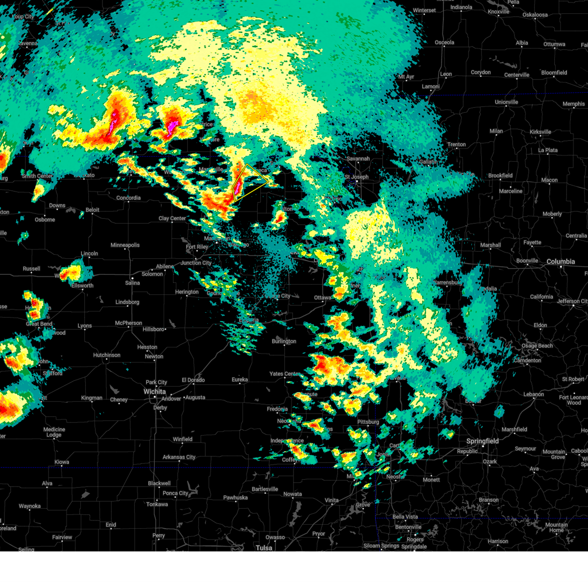
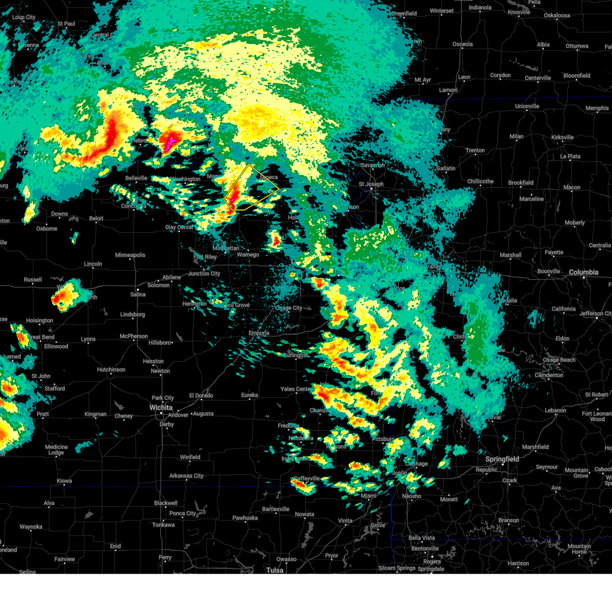
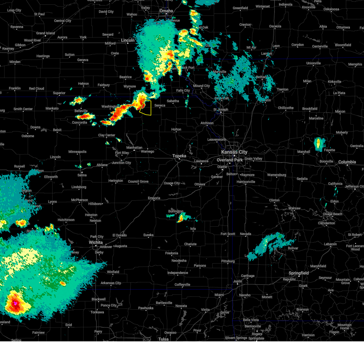
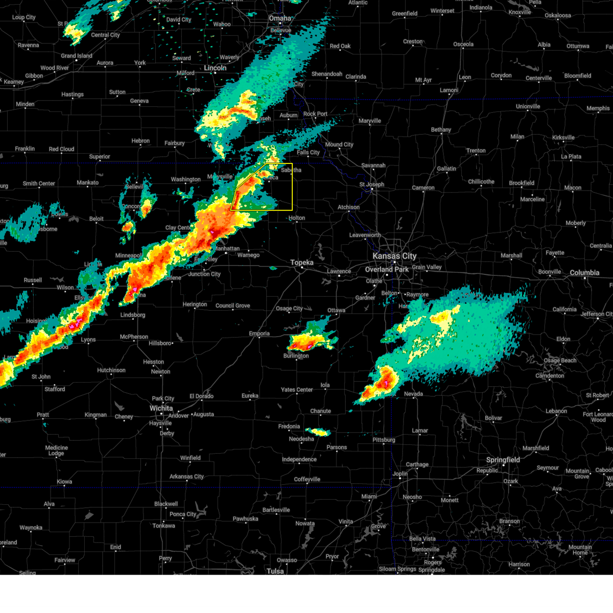
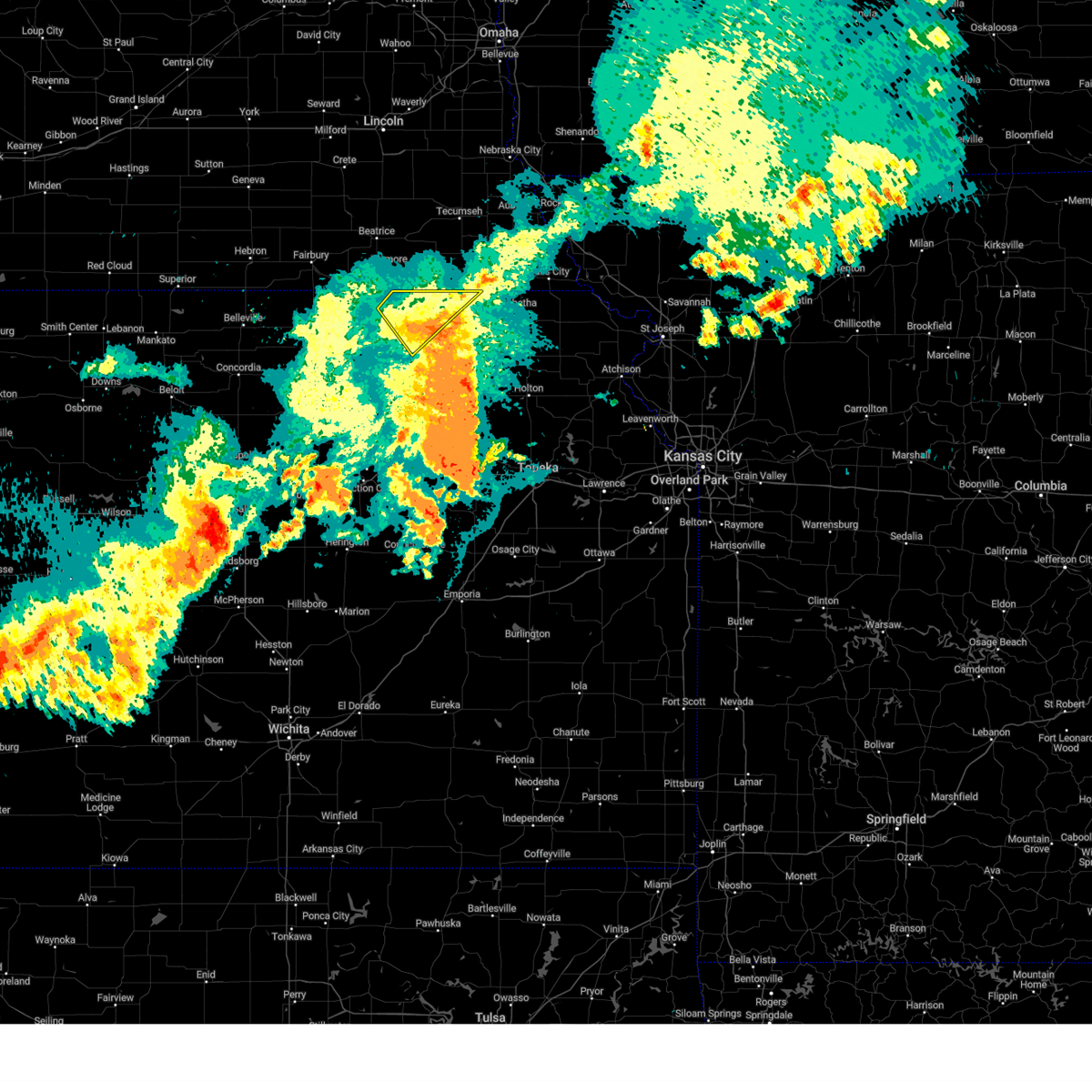
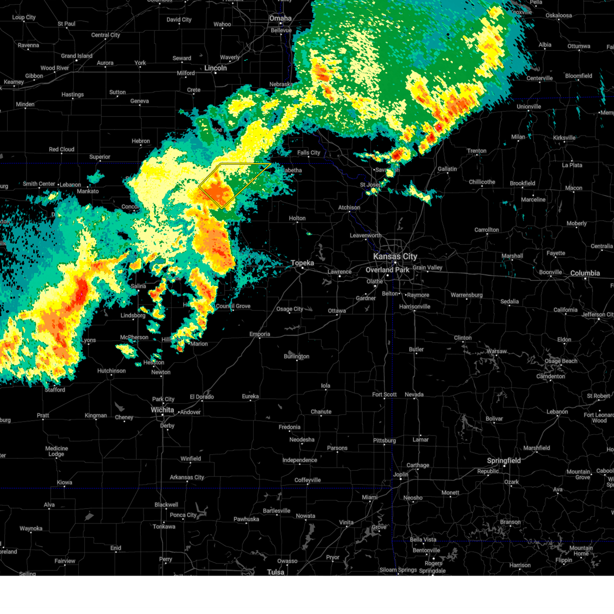
Hail Map for Axtell, KS
The Axtell, KS area has had 6 reports of on-the-ground hail by trained spotters, and has been under severe weather warnings 11 times during the past 12 months. Doppler radar has detected hail at or near Axtell, KS on 83 occasions, including 1 occasion during the past year.
| Name: | Axtell, KS |
| Where Located: | 50.5 miles NNE of Manhattan, KS |
| Map: | Google Map for Axtell, KS |
| Population: | 406 |
| Housing Units: | 194 |
| More Info: | Search Google for Axtell, KS |
0
The Top Recent Hail Date for Axtell, KS is Saturday, September 21, 2024 (53rd out of 83)

Hail and Wind Damage Spotted near Axtell, KS
| Date / Time | Report Details |
|---|---|
| 5/18/2025 10:00 PM CDT |
 the severe thunderstorm warning has been cancelled and is no longer in effect the severe thunderstorm warning has been cancelled and is no longer in effect
|
| 5/18/2025 9:48 PM CDT |
 At 948 pm cdt, a severe thunderstorm was located over vermillion, moving northeast at 35 mph (radar indicated). Hazards include 60 mph wind gusts and quarter size hail. Hail damage to vehicles is expected. expect wind damage to roofs, siding, and trees. Locations impacted include, seneca, centralia, axtell, vermillion, lillis, and baileyville. At 948 pm cdt, a severe thunderstorm was located over vermillion, moving northeast at 35 mph (radar indicated). Hazards include 60 mph wind gusts and quarter size hail. Hail damage to vehicles is expected. expect wind damage to roofs, siding, and trees. Locations impacted include, seneca, centralia, axtell, vermillion, lillis, and baileyville.
|
| 5/18/2025 9:34 PM CDT |
 Svrtop the national weather service in topeka has issued a * severe thunderstorm warning for, west central nemaha county in northeastern kansas, eastern marshall county in northeastern kansas, * until 1015 pm cdt. * at 934 pm cdt, a severe thunderstorm was located near frankfort, moving northeast at 25 mph (radar indicated). Hazards include 60 mph wind gusts and half dollar size hail. Hail damage to vehicles is expected. Expect wind damage to roofs, siding, and trees. Svrtop the national weather service in topeka has issued a * severe thunderstorm warning for, west central nemaha county in northeastern kansas, eastern marshall county in northeastern kansas, * until 1015 pm cdt. * at 934 pm cdt, a severe thunderstorm was located near frankfort, moving northeast at 25 mph (radar indicated). Hazards include 60 mph wind gusts and half dollar size hail. Hail damage to vehicles is expected. Expect wind damage to roofs, siding, and trees.
|
| 4/24/2025 8:28 PM CDT | The storm which prompted the warning has weakened below severe limits, and no longer poses an immediate threat to life or property. therefore, the warning will be allowed to expire. however, small hail is still possible with this thunderstorm. |
| 4/24/2025 8:03 PM CDT |
 Svrtop the national weather service in topeka has issued a * severe thunderstorm warning for, northeastern marshall county in northeastern kansas, * until 830 pm cdt. * at 802 pm cdt, a severe thunderstorm was located over beattie, moving east at 25 mph (trained weather spotters reported quarter size hail near home kansas at 755 pm cdt). Hazards include 60 mph wind gusts and quarter size hail. Hail damage to vehicles is expected. Expect wind damage to roofs, siding, and trees. Svrtop the national weather service in topeka has issued a * severe thunderstorm warning for, northeastern marshall county in northeastern kansas, * until 830 pm cdt. * at 802 pm cdt, a severe thunderstorm was located over beattie, moving east at 25 mph (trained weather spotters reported quarter size hail near home kansas at 755 pm cdt). Hazards include 60 mph wind gusts and quarter size hail. Hail damage to vehicles is expected. Expect wind damage to roofs, siding, and trees.
|
| 4/1/2025 10:17 PM CDT |
 Svrtop the national weather service in topeka has issued a * severe thunderstorm warning for, nemaha county in northeastern kansas, southeastern marshall county in northeastern kansas, * until 1115 pm cdt. * at 1017 pm cdt, severe thunderstorms were located along a line extending from 3 miles north of frankfort to 5 miles east of olsburg, moving northeast at 45 mph (radar indicated). Hazards include 60 mph wind gusts and quarter size hail. Hail damage to vehicles is expected. Expect wind damage to roofs, siding, and trees. Svrtop the national weather service in topeka has issued a * severe thunderstorm warning for, nemaha county in northeastern kansas, southeastern marshall county in northeastern kansas, * until 1115 pm cdt. * at 1017 pm cdt, severe thunderstorms were located along a line extending from 3 miles north of frankfort to 5 miles east of olsburg, moving northeast at 45 mph (radar indicated). Hazards include 60 mph wind gusts and quarter size hail. Hail damage to vehicles is expected. Expect wind damage to roofs, siding, and trees.
|
| 7/31/2024 9:11 PM CDT |
 The storm which prompted the warning has weakened below severe limits, and no longer poses an immediate threat to life or property. therefore, the warning will be allowed to expire. however, gusty winds are still possible with this thunderstorm. a severe thunderstorm watch remains in effect until 1000 pm cdt for northeastern kansas. a severe thunderstorm watch also remains in effect until 100 am cdt for northeastern kansas. The storm which prompted the warning has weakened below severe limits, and no longer poses an immediate threat to life or property. therefore, the warning will be allowed to expire. however, gusty winds are still possible with this thunderstorm. a severe thunderstorm watch remains in effect until 1000 pm cdt for northeastern kansas. a severe thunderstorm watch also remains in effect until 100 am cdt for northeastern kansas.
|
| 7/31/2024 8:56 PM CDT | At 856 pm cdt, a severe thunderstorm was located over beattie, moving northeast at 35 mph (radar indicated). Hazards include 60 mph wind gusts and penny size hail. Expect damage to roofs, siding, and trees. Locations impacted include, marysville, axtell, beattie, summerfield, and oketo. |
| 7/31/2024 8:56 PM CDT | the severe thunderstorm warning has been cancelled and is no longer in effect |
| 7/31/2024 8:42 PM CDT |
 At 841 pm cdt, a severe thunderstorm was located near marysville, moving northeast at 35 mph (public. public has reported strong wind gusts and some tree damage near blue rapids). Hazards include 60 mph wind gusts and penny size hail. Expect damage to roofs, siding, and trees. Locations impacted include, marysville, blue rapids, waterville, axtell, beattie, summerfield, and oketo. At 841 pm cdt, a severe thunderstorm was located near marysville, moving northeast at 35 mph (public. public has reported strong wind gusts and some tree damage near blue rapids). Hazards include 60 mph wind gusts and penny size hail. Expect damage to roofs, siding, and trees. Locations impacted include, marysville, blue rapids, waterville, axtell, beattie, summerfield, and oketo.
|
| 7/31/2024 8:37 PM CDT |
 Svrtop the national weather service in topeka has issued a * severe thunderstorm warning for, northwestern nemaha county in northeastern kansas, east central washington county in north central kansas, marshall county in northeastern kansas, * until 915 pm cdt. * at 837 pm cdt, a severe thunderstorm was located 5 miles north of waterville, moving northeast at 55 mph (radar indicated). Hazards include 60 mph wind gusts and penny size hail. expect damage to roofs, siding, and trees Svrtop the national weather service in topeka has issued a * severe thunderstorm warning for, northwestern nemaha county in northeastern kansas, east central washington county in north central kansas, marshall county in northeastern kansas, * until 915 pm cdt. * at 837 pm cdt, a severe thunderstorm was located 5 miles north of waterville, moving northeast at 55 mph (radar indicated). Hazards include 60 mph wind gusts and penny size hail. expect damage to roofs, siding, and trees
|
| 6/26/2024 2:45 AM CDT |
 At 244 am cdt, severe thunderstorms were located along a line extending from near woodlawn to 3 miles northwest of westmoreland to 3 miles west of longford, moving southeast at 45 mph (radar indicated). Hazards include 60 mph wind gusts. Expect damage to roofs, siding, and trees. Locations impacted include, clay center, sabetha, seneca, blue rapids, blaine, frankfort, waterville, miltonvale, centralia, axtell, wetmore, morganville, bern, corning, green, goff, vermillion, wheaton, oneida, and aurora. At 244 am cdt, severe thunderstorms were located along a line extending from near woodlawn to 3 miles northwest of westmoreland to 3 miles west of longford, moving southeast at 45 mph (radar indicated). Hazards include 60 mph wind gusts. Expect damage to roofs, siding, and trees. Locations impacted include, clay center, sabetha, seneca, blue rapids, blaine, frankfort, waterville, miltonvale, centralia, axtell, wetmore, morganville, bern, corning, green, goff, vermillion, wheaton, oneida, and aurora.
|
| 6/26/2024 2:35 AM CDT |
 the severe thunderstorm warning has been cancelled and is no longer in effect the severe thunderstorm warning has been cancelled and is no longer in effect
|
| 6/26/2024 2:35 AM CDT |
 At 234 am cdt, severe thunderstorms were located along a line extending from oneida to 7 miles north of olsburg to 4 miles southwest of miltonvale, moving southeast at 45 mph (radar indicated). Hazards include 60 mph wind gusts and nickel size hail. Expect damage to roofs, siding, and trees. Locations impacted include, concordia, clay center, sabetha, seneca, blue rapids, blaine, frankfort, clyde, waterville, clifton, miltonvale, centralia, linn, axtell, wetmore, greenleaf, beattie, morganville, bern, and barnes. At 234 am cdt, severe thunderstorms were located along a line extending from oneida to 7 miles north of olsburg to 4 miles southwest of miltonvale, moving southeast at 45 mph (radar indicated). Hazards include 60 mph wind gusts and nickel size hail. Expect damage to roofs, siding, and trees. Locations impacted include, concordia, clay center, sabetha, seneca, blue rapids, blaine, frankfort, clyde, waterville, clifton, miltonvale, centralia, linn, axtell, wetmore, greenleaf, beattie, morganville, bern, and barnes.
|
| 6/26/2024 2:19 AM CDT |
 At 218 am cdt, severe thunderstorms were located along a line extending from 6 miles northeast of bern to 7 miles northeast of glasco, moving southeast at 40 mph (radar indicated). Hazards include 60 mph wind gusts and nickel size hail. Expect damage to roofs, siding, and trees. Locations impacted include, concordia, marysville, washington, blue rapids, frankfort, clyde, hanover, waterville, clifton, linn, axtell, greenleaf, jamestown, beattie, barnes, summerfield, cuba, morrowville, norway, and vermillion. At 218 am cdt, severe thunderstorms were located along a line extending from 6 miles northeast of bern to 7 miles northeast of glasco, moving southeast at 40 mph (radar indicated). Hazards include 60 mph wind gusts and nickel size hail. Expect damage to roofs, siding, and trees. Locations impacted include, concordia, marysville, washington, blue rapids, frankfort, clyde, hanover, waterville, clifton, linn, axtell, greenleaf, jamestown, beattie, barnes, summerfield, cuba, morrowville, norway, and vermillion.
|
| 6/26/2024 2:15 AM CDT |
 Svrtop the national weather service in topeka has issued a * severe thunderstorm warning for, northwestern riley county in northeastern kansas, northwestern ottawa county in north central kansas, northern pottawatomie county in northeastern kansas, nemaha county in northeastern kansas, western brown county in northeastern kansas, southern washington county in north central kansas, northern clay county in north central kansas, cloud county in north central kansas, marshall county in northeastern kansas, * until 300 am cdt. * at 214 am cdt, severe thunderstorms were located along a line extending from near pawnee city to 4 miles north of waterville to 5 miles southwest of concordia, moving southeast at 40 mph (radar indicated). Hazards include 60 mph wind gusts and nickel size hail. expect damage to roofs, siding, and trees Svrtop the national weather service in topeka has issued a * severe thunderstorm warning for, northwestern riley county in northeastern kansas, northwestern ottawa county in north central kansas, northern pottawatomie county in northeastern kansas, nemaha county in northeastern kansas, western brown county in northeastern kansas, southern washington county in north central kansas, northern clay county in north central kansas, cloud county in north central kansas, marshall county in northeastern kansas, * until 300 am cdt. * at 214 am cdt, severe thunderstorms were located along a line extending from near pawnee city to 4 miles north of waterville to 5 miles southwest of concordia, moving southeast at 40 mph (radar indicated). Hazards include 60 mph wind gusts and nickel size hail. expect damage to roofs, siding, and trees
|
| 6/26/2024 1:48 AM CDT |
 Svrtop the national weather service in topeka has issued a * severe thunderstorm warning for, republic county in north central kansas, washington county in north central kansas, northern cloud county in north central kansas, marshall county in northeastern kansas, * until 230 am cdt. * at 148 am cdt, severe thunderstorms were located along a line extending from near johnson to near courtland, moving southeast at 35 mph (radar indicated). Hazards include 60 mph wind gusts and nickel size hail. expect damage to roofs, siding, and trees Svrtop the national weather service in topeka has issued a * severe thunderstorm warning for, republic county in north central kansas, washington county in north central kansas, northern cloud county in north central kansas, marshall county in northeastern kansas, * until 230 am cdt. * at 148 am cdt, severe thunderstorms were located along a line extending from near johnson to near courtland, moving southeast at 35 mph (radar indicated). Hazards include 60 mph wind gusts and nickel size hail. expect damage to roofs, siding, and trees
|
| 6/15/2024 6:58 PM CDT |
 At 658 pm cdt, severe thunderstorms were located along a line extending from pawnee city to near bern to 3 miles northwest of soldier, moving northeast at 45 mph (radar indicated). Hazards include 60 mph wind gusts and nickel size hail. Expect damage to roofs, siding, and trees. Locations impacted include, seneca, onaga, centralia, axtell, beattie, bern, corning, summerfield, soldier, havensville, goff, vermillion, oneida, and baileyville. At 658 pm cdt, severe thunderstorms were located along a line extending from pawnee city to near bern to 3 miles northwest of soldier, moving northeast at 45 mph (radar indicated). Hazards include 60 mph wind gusts and nickel size hail. Expect damage to roofs, siding, and trees. Locations impacted include, seneca, onaga, centralia, axtell, beattie, bern, corning, summerfield, soldier, havensville, goff, vermillion, oneida, and baileyville.
|
| 6/15/2024 6:42 PM CDT |
 At 639 pm cdt, severe thunderstorms were located along a line extending from 4 miles southwest of burchard to 3 miles south of baileyville to 5 miles south of onaga, moving northeast at 45 mph (trained weather spotters. spotters reported 60 mph winds 3 miles northwest of vermillion at 630 pm). Hazards include 60 mph wind gusts and nickel size hail. Expect damage to roofs, siding, and trees. Locations impacted include, seneca, frankfort, onaga, centralia, axtell, beattie, bern, corning, summerfield, soldier, havensville, goff, vermillion, wheaton, oneida, baileyville, and lillis. At 639 pm cdt, severe thunderstorms were located along a line extending from 4 miles southwest of burchard to 3 miles south of baileyville to 5 miles south of onaga, moving northeast at 45 mph (trained weather spotters. spotters reported 60 mph winds 3 miles northwest of vermillion at 630 pm). Hazards include 60 mph wind gusts and nickel size hail. Expect damage to roofs, siding, and trees. Locations impacted include, seneca, frankfort, onaga, centralia, axtell, beattie, bern, corning, summerfield, soldier, havensville, goff, vermillion, wheaton, oneida, baileyville, and lillis.
|
| 6/15/2024 6:24 PM CDT |
 Svrtop the national weather service in topeka has issued a * severe thunderstorm warning for, eastern pottawatomie county in northeastern kansas, nemaha county in northeastern kansas, northwestern jackson county in northeastern kansas, marshall county in northeastern kansas, * until 715 pm cdt. * at 623 pm cdt, severe thunderstorms were located along a line extending from 3 miles east of oketo to 4 miles northwest of lillis to 3 miles northwest of louisville, moving northeast at 45 mph (radar indicated). Hazards include 60 mph wind gusts and nickel size hail. expect damage to roofs, siding, and trees Svrtop the national weather service in topeka has issued a * severe thunderstorm warning for, eastern pottawatomie county in northeastern kansas, nemaha county in northeastern kansas, northwestern jackson county in northeastern kansas, marshall county in northeastern kansas, * until 715 pm cdt. * at 623 pm cdt, severe thunderstorms were located along a line extending from 3 miles east of oketo to 4 miles northwest of lillis to 3 miles northwest of louisville, moving northeast at 45 mph (radar indicated). Hazards include 60 mph wind gusts and nickel size hail. expect damage to roofs, siding, and trees
|
| 5/25/2024 10:08 PM CDT |
 At 1008 pm cdt, a severe thunderstorm was located near axtell, moving east at 30 mph (radar indicated). Hazards include 60 mph wind gusts and quarter size hail. Hail damage to vehicles is expected. expect wind damage to roofs, siding, and trees. Locations impacted include, seneca, centralia, axtell, beattie, summerfield, and baileyville. At 1008 pm cdt, a severe thunderstorm was located near axtell, moving east at 30 mph (radar indicated). Hazards include 60 mph wind gusts and quarter size hail. Hail damage to vehicles is expected. expect wind damage to roofs, siding, and trees. Locations impacted include, seneca, centralia, axtell, beattie, summerfield, and baileyville.
|
| 5/25/2024 9:52 PM CDT |
 Svrtop the national weather service in topeka has issued a * severe thunderstorm warning for, northwestern nemaha county in northeastern kansas, northeastern marshall county in northeastern kansas, * until 1030 pm cdt. * at 951 pm cdt, a severe thunderstorm was located near beattie, moving east at 40 mph (trained weather spotters). Hazards include 60 mph wind gusts and quarter size hail. Hail damage to vehicles is expected. Expect wind damage to roofs, siding, and trees. Svrtop the national weather service in topeka has issued a * severe thunderstorm warning for, northwestern nemaha county in northeastern kansas, northeastern marshall county in northeastern kansas, * until 1030 pm cdt. * at 951 pm cdt, a severe thunderstorm was located near beattie, moving east at 40 mph (trained weather spotters). Hazards include 60 mph wind gusts and quarter size hail. Hail damage to vehicles is expected. Expect wind damage to roofs, siding, and trees.
|
| 5/6/2024 8:35 PM CDT |
 At 835 pm cdt, severe thunderstorms were located along a line extending from 4 miles north of bern to near havensville, moving east at 35 mph (radar indicated). Hazards include golf ball size hail and 60 mph wind gusts. People and animals outdoors will be injured. expect hail damage to roofs, siding, windows, and vehicles. expect wind damage to roofs, siding, and trees. Locations impacted include, holton, sabetha, seneca, onaga, centralia, axtell, wetmore, fairview, morrill, circleville, bern, corning, netawaka, soldier, havensville, goff, vermillion, oneida, baileyville, and woodlawn. At 835 pm cdt, severe thunderstorms were located along a line extending from 4 miles north of bern to near havensville, moving east at 35 mph (radar indicated). Hazards include golf ball size hail and 60 mph wind gusts. People and animals outdoors will be injured. expect hail damage to roofs, siding, windows, and vehicles. expect wind damage to roofs, siding, and trees. Locations impacted include, holton, sabetha, seneca, onaga, centralia, axtell, wetmore, fairview, morrill, circleville, bern, corning, netawaka, soldier, havensville, goff, vermillion, oneida, baileyville, and woodlawn.
|
| 5/6/2024 8:30 PM CDT |
 At 829 pm cdt, severe thunderstorms were located along a line extending from near bern to 3 miles south of havensville, moving northeast at 60 mph (radar indicated). Hazards include golf ball size hail and 60 mph wind gusts. People and animals outdoors will be injured. expect hail damage to roofs, siding, windows, and vehicles. expect wind damage to roofs, siding, and trees. Locations impacted include, holton, sabetha, seneca, onaga, centralia, axtell, wetmore, fairview, morrill, circleville, bern, corning, netawaka, soldier, havensville, goff, vermillion, wheaton, oneida, and baileyville. At 829 pm cdt, severe thunderstorms were located along a line extending from near bern to 3 miles south of havensville, moving northeast at 60 mph (radar indicated). Hazards include golf ball size hail and 60 mph wind gusts. People and animals outdoors will be injured. expect hail damage to roofs, siding, windows, and vehicles. expect wind damage to roofs, siding, and trees. Locations impacted include, holton, sabetha, seneca, onaga, centralia, axtell, wetmore, fairview, morrill, circleville, bern, corning, netawaka, soldier, havensville, goff, vermillion, wheaton, oneida, and baileyville.
|
| 5/6/2024 8:22 PM CDT |
 Svrtop the national weather service in topeka has issued a * severe thunderstorm warning for, northeastern pottawatomie county in northeastern kansas, nemaha county in northeastern kansas, northwestern jackson county in northeastern kansas, western brown county in northeastern kansas, eastern marshall county in northeastern kansas, * until 845 pm cdt. * at 821 pm cdt, severe thunderstorms were located along a line extending from 5 miles west of bern to 4 miles south of onaga, moving northeast at 55 mph (radar indicated). Hazards include 60 mph wind gusts and quarter size hail. Hail damage to vehicles is expected. Expect wind damage to roofs, siding, and trees. Svrtop the national weather service in topeka has issued a * severe thunderstorm warning for, northeastern pottawatomie county in northeastern kansas, nemaha county in northeastern kansas, northwestern jackson county in northeastern kansas, western brown county in northeastern kansas, eastern marshall county in northeastern kansas, * until 845 pm cdt. * at 821 pm cdt, severe thunderstorms were located along a line extending from 5 miles west of bern to 4 miles south of onaga, moving northeast at 55 mph (radar indicated). Hazards include 60 mph wind gusts and quarter size hail. Hail damage to vehicles is expected. Expect wind damage to roofs, siding, and trees.
|
| 5/6/2024 8:00 PM CDT |
 Svrtop the national weather service in topeka has issued a * severe thunderstorm warning for, pottawatomie county in northeastern kansas, western nemaha county in northeastern kansas, west central jackson county in northeastern kansas, eastern marshall county in northeastern kansas, * until 830 pm cdt. * at 800 pm cdt, severe thunderstorms were located along a line extending from 4 miles northwest of beattie to near st. george, moving northeast at 45 mph (radar indicated). Hazards include 70 mph wind gusts and quarter size hail. Hail damage to vehicles is expected. expect considerable tree damage. Wind damage is also likely to mobile homes, roofs, and outbuildings. Svrtop the national weather service in topeka has issued a * severe thunderstorm warning for, pottawatomie county in northeastern kansas, western nemaha county in northeastern kansas, west central jackson county in northeastern kansas, eastern marshall county in northeastern kansas, * until 830 pm cdt. * at 800 pm cdt, severe thunderstorms were located along a line extending from 4 miles northwest of beattie to near st. george, moving northeast at 45 mph (radar indicated). Hazards include 70 mph wind gusts and quarter size hail. Hail damage to vehicles is expected. expect considerable tree damage. Wind damage is also likely to mobile homes, roofs, and outbuildings.
|
| 4/30/2024 3:59 PM CDT |
 Svrtop the national weather service in topeka has issued a * severe thunderstorm warning for, western nemaha county in northeastern kansas, east central marshall county in northeastern kansas, * until 430 pm cdt. * at 358 pm cdt, a severe thunderstorm was located near vermillion, moving east at 40 mph (radar indicated. trained spotters reported golf ball sized hail in frankfort at 358 pm). Hazards include two inch hail and 70 mph wind gusts. People and animals outdoors will be injured. expect hail damage to roofs, siding, windows, and vehicles. expect considerable tree damage. Wind damage is also likely to mobile homes, roofs, and outbuildings. Svrtop the national weather service in topeka has issued a * severe thunderstorm warning for, western nemaha county in northeastern kansas, east central marshall county in northeastern kansas, * until 430 pm cdt. * at 358 pm cdt, a severe thunderstorm was located near vermillion, moving east at 40 mph (radar indicated. trained spotters reported golf ball sized hail in frankfort at 358 pm). Hazards include two inch hail and 70 mph wind gusts. People and animals outdoors will be injured. expect hail damage to roofs, siding, windows, and vehicles. expect considerable tree damage. Wind damage is also likely to mobile homes, roofs, and outbuildings.
|
| 4/26/2024 3:49 PM CDT |
 At 349 pm cdt, severe thunderstorms were located along a line extending from 4 miles northeast of axtell to 4 miles southwest of baileyville to 3 miles northeast of lillis, moving northeast at 45 mph (radar indicated). Hazards include golf ball size hail and 60 mph wind gusts. People and animals outdoors will be injured. expect hail damage to roofs, siding, windows, and vehicles. expect wind damage to roofs, siding, and trees. Locations impacted include, seneca, centralia, axtell, bern, vermillion, oneida, baileyville, and lillis. At 349 pm cdt, severe thunderstorms were located along a line extending from 4 miles northeast of axtell to 4 miles southwest of baileyville to 3 miles northeast of lillis, moving northeast at 45 mph (radar indicated). Hazards include golf ball size hail and 60 mph wind gusts. People and animals outdoors will be injured. expect hail damage to roofs, siding, windows, and vehicles. expect wind damage to roofs, siding, and trees. Locations impacted include, seneca, centralia, axtell, bern, vermillion, oneida, baileyville, and lillis.
|
| 4/26/2024 3:29 PM CDT |
 Svrtop the national weather service in topeka has issued a * severe thunderstorm warning for, northwestern nemaha county in northeastern kansas, eastern marshall county in northeastern kansas, * until 415 pm cdt. * at 328 pm cdt, severe thunderstorms were located along a line extending from 4 miles southeast of summerfield to near frankfort to 6 miles west of lillis, moving northeast at 55 mph (radar indicated). Hazards include golf ball size hail and 60 mph wind gusts. People and animals outdoors will be injured. expect hail damage to roofs, siding, windows, and vehicles. Expect wind damage to roofs, siding, and trees. Svrtop the national weather service in topeka has issued a * severe thunderstorm warning for, northwestern nemaha county in northeastern kansas, eastern marshall county in northeastern kansas, * until 415 pm cdt. * at 328 pm cdt, severe thunderstorms were located along a line extending from 4 miles southeast of summerfield to near frankfort to 6 miles west of lillis, moving northeast at 55 mph (radar indicated). Hazards include golf ball size hail and 60 mph wind gusts. People and animals outdoors will be injured. expect hail damage to roofs, siding, windows, and vehicles. Expect wind damage to roofs, siding, and trees.
|
| 3/13/2024 9:06 PM CDT |
 The storms which prompted the warning have weakened below severe limits, and no longer pose an immediate threat to life or property. therefore, the warning will be allowed to expire. however, small hail and heavy rain are still possible with these thunderstorms. a severe thunderstorm watch remains in effect until midnight cdt for northeastern kansas. The storms which prompted the warning have weakened below severe limits, and no longer pose an immediate threat to life or property. therefore, the warning will be allowed to expire. however, small hail and heavy rain are still possible with these thunderstorms. a severe thunderstorm watch remains in effect until midnight cdt for northeastern kansas.
|
| 3/13/2024 9:02 PM CDT |
 At 902 pm cdt, severe thunderstorms were located along a line extending from near marysville to near baileyville, moving north at 40 mph (radar indicated). Hazards include 60 mph wind gusts and half dollar size hail. Hail damage to vehicles is expected. expect wind damage to roofs, siding, and trees. Locations impacted include, marysville, seneca, blue rapids, frankfort, waterville, centralia, axtell, beattie, bern, corning, summerfield, vermillion, oneida, oketo, and baileyville. At 902 pm cdt, severe thunderstorms were located along a line extending from near marysville to near baileyville, moving north at 40 mph (radar indicated). Hazards include 60 mph wind gusts and half dollar size hail. Hail damage to vehicles is expected. expect wind damage to roofs, siding, and trees. Locations impacted include, marysville, seneca, blue rapids, frankfort, waterville, centralia, axtell, beattie, bern, corning, summerfield, vermillion, oneida, oketo, and baileyville.
|
| 3/13/2024 8:53 PM CDT |
 At 853 pm cdt, severe thunderstorms were located along a line extending from 3 miles south of marysville to 3 miles south of baileyville, moving north at 40 mph (radar indicated). Hazards include golf ball size hail and 60 mph wind gusts. People and animals outdoors will be injured. expect hail damage to roofs, siding, windows, and vehicles. expect wind damage to roofs, siding, and trees. Locations impacted include, marysville, seneca, blue rapids, frankfort, waterville, centralia, axtell, beattie, bern, corning, summerfield, vermillion, oneida, oketo, and baileyville. At 853 pm cdt, severe thunderstorms were located along a line extending from 3 miles south of marysville to 3 miles south of baileyville, moving north at 40 mph (radar indicated). Hazards include golf ball size hail and 60 mph wind gusts. People and animals outdoors will be injured. expect hail damage to roofs, siding, windows, and vehicles. expect wind damage to roofs, siding, and trees. Locations impacted include, marysville, seneca, blue rapids, frankfort, waterville, centralia, axtell, beattie, bern, corning, summerfield, vermillion, oneida, oketo, and baileyville.
|
| 3/13/2024 8:36 PM CDT |
 Svrtop the national weather service in topeka has issued a * severe thunderstorm warning for, nemaha county in northeastern kansas, marshall county in northeastern kansas, * until 915 pm cdt. * at 835 pm cdt, severe thunderstorms were located along a line extending from near marysville to 3 miles east of lillis, moving north at 45 mph (radar indicated). Hazards include golf ball size hail and 60 mph wind gusts. People and animals outdoors will be injured. expect hail damage to roofs, siding, windows, and vehicles. Expect wind damage to roofs, siding, and trees. Svrtop the national weather service in topeka has issued a * severe thunderstorm warning for, nemaha county in northeastern kansas, marshall county in northeastern kansas, * until 915 pm cdt. * at 835 pm cdt, severe thunderstorms were located along a line extending from near marysville to 3 miles east of lillis, moving north at 45 mph (radar indicated). Hazards include golf ball size hail and 60 mph wind gusts. People and animals outdoors will be injured. expect hail damage to roofs, siding, windows, and vehicles. Expect wind damage to roofs, siding, and trees.
|
| 8/5/2023 11:41 PM CDT |
 At 1140 pm cdt, severe thunderstorms were located along a line extending from near oketo to 3 miles northeast of tuttle creek lake, moving east at 45 mph (radar indicated). Hazards include 60 mph wind gusts and penny size hail. expect damage to roofs, siding, and trees At 1140 pm cdt, severe thunderstorms were located along a line extending from near oketo to 3 miles northeast of tuttle creek lake, moving east at 45 mph (radar indicated). Hazards include 60 mph wind gusts and penny size hail. expect damage to roofs, siding, and trees
|
| 7/29/2023 9:09 AM CDT |
 The severe thunderstorm warning for northwestern nemaha and marshall counties will expire at 915 am cdt, the storms which prompted the warning have weakened below severe limits, and no longer pose an immediate threat to life or property. therefore, the warning will be allowed to expire. however gusty winds and heavy rain are still possible with these thunderstorms. a severe thunderstorm watch remains in effect until 200 pm cdt for northeastern kansas. The severe thunderstorm warning for northwestern nemaha and marshall counties will expire at 915 am cdt, the storms which prompted the warning have weakened below severe limits, and no longer pose an immediate threat to life or property. therefore, the warning will be allowed to expire. however gusty winds and heavy rain are still possible with these thunderstorms. a severe thunderstorm watch remains in effect until 200 pm cdt for northeastern kansas.
|
| 7/29/2023 9:04 AM CDT |
 At 902 am cdt, severe thunderstorms were located along a line extending from near humboldt to 5 miles west of bern to near beattie, moving east at 55 mph (trained weather spotter 5 miles east-northeast of oketo at 840 am cdt). Hazards include 60 mph wind gusts. Expect damage to roofs, siding, and trees. locations impacted include, marysville, frankfort, axtell, beattie, summerfield, vermillion, oketo, baileyville and bremen. hail threat, radar indicated max hail size, <. 75 in wind threat, radar indicated max wind gust, 60 mph. At 902 am cdt, severe thunderstorms were located along a line extending from near humboldt to 5 miles west of bern to near beattie, moving east at 55 mph (trained weather spotter 5 miles east-northeast of oketo at 840 am cdt). Hazards include 60 mph wind gusts. Expect damage to roofs, siding, and trees. locations impacted include, marysville, frankfort, axtell, beattie, summerfield, vermillion, oketo, baileyville and bremen. hail threat, radar indicated max hail size, <. 75 in wind threat, radar indicated max wind gust, 60 mph.
|
| 7/29/2023 8:52 AM CDT |
 At 851 am cdt, severe thunderstorms were located along a line extending from 3 miles west of table rock to 5 miles north of axtell to near marysville, moving east at 50 mph (radar indicated). Hazards include 60 mph wind gusts and penny size hail. Expect damage to roofs, siding, and trees. locations impacted include, marysville, frankfort, axtell, beattie, summerfield, vermillion, oketo, baileyville and bremen. hail threat, radar indicated max hail size, 0. 75 in wind threat, radar indicated max wind gust, 60 mph. At 851 am cdt, severe thunderstorms were located along a line extending from 3 miles west of table rock to 5 miles north of axtell to near marysville, moving east at 50 mph (radar indicated). Hazards include 60 mph wind gusts and penny size hail. Expect damage to roofs, siding, and trees. locations impacted include, marysville, frankfort, axtell, beattie, summerfield, vermillion, oketo, baileyville and bremen. hail threat, radar indicated max hail size, 0. 75 in wind threat, radar indicated max wind gust, 60 mph.
|
| 7/29/2023 8:33 AM CDT |
 At 831 am cdt, severe thunderstorms were located along a line extending from 7 miles east of blue springs to 3 miles southwest of hanover, moving east-southeast at 45 mph (radar indicated). Hazards include 60 mph wind gusts and penny size hail. expect damage to roofs, siding, and trees At 831 am cdt, severe thunderstorms were located along a line extending from 7 miles east of blue springs to 3 miles southwest of hanover, moving east-southeast at 45 mph (radar indicated). Hazards include 60 mph wind gusts and penny size hail. expect damage to roofs, siding, and trees
|
| 7/4/2023 10:31 PM CDT |
 At 1031 pm cdt, severe thunderstorms were located along a line extending from near white cloud to 4 miles southwest of whiting to 4 miles northwest of belvue, moving east at 55 mph (radar indicated). Hazards include 70 mph wind gusts and penny size hail. Expect considerable tree damage. damage is likely to mobile homes, roofs, and outbuildings. locations impacted include, holton, hiawatha, sabetha, seneca, horton, valley falls, westmoreland, blaine, meriden, onaga, hoyt, centralia, axtell, wetmore, mayetta, everest, fairview, robinson, morrill and emmett. thunderstorm damage threat, considerable hail threat, radar indicated max hail size, 0. 75 in wind threat, radar indicated max wind gust, 70 mph. At 1031 pm cdt, severe thunderstorms were located along a line extending from near white cloud to 4 miles southwest of whiting to 4 miles northwest of belvue, moving east at 55 mph (radar indicated). Hazards include 70 mph wind gusts and penny size hail. Expect considerable tree damage. damage is likely to mobile homes, roofs, and outbuildings. locations impacted include, holton, hiawatha, sabetha, seneca, horton, valley falls, westmoreland, blaine, meriden, onaga, hoyt, centralia, axtell, wetmore, mayetta, everest, fairview, robinson, morrill and emmett. thunderstorm damage threat, considerable hail threat, radar indicated max hail size, 0. 75 in wind threat, radar indicated max wind gust, 70 mph.
|
| 7/4/2023 10:22 PM CDT |
 At 1022 pm cdt, severe thunderstorms were located along a line extending from 4 miles east of reserve to 4 miles northeast of circleville to near louisville, moving east at 55 mph (radar indicated). Hazards include 70 mph wind gusts and penny size hail. Expect considerable tree damage. Damage is likely to mobile homes, roofs, and outbuildings. At 1022 pm cdt, severe thunderstorms were located along a line extending from 4 miles east of reserve to 4 miles northeast of circleville to near louisville, moving east at 55 mph (radar indicated). Hazards include 70 mph wind gusts and penny size hail. Expect considerable tree damage. Damage is likely to mobile homes, roofs, and outbuildings.
|
| 7/4/2023 9:40 PM CDT | Unio and pacific station reported gusts to 65 mp in marshall county KS, 0.2 miles NE of Axtell, KS |
| 7/4/2023 8:54 PM CDT |
 At 854 pm cdt, severe thunderstorms were located along a line extending from near shubert to 6 miles northeast of axtell to 3 miles northeast of bremen, moving southeast at 40 mph (radar indicated). Hazards include 60 mph wind gusts. Expect damage to roofs, siding, and trees. locations impacted include, marysville, sabetha, seneca, axtell, beattie, bern, summerfield, oneida, oketo, baileyville and woodlawn. hail threat, radar indicated max hail size, <. 75 in wind threat, radar indicated max wind gust, 60 mph. At 854 pm cdt, severe thunderstorms were located along a line extending from near shubert to 6 miles northeast of axtell to 3 miles northeast of bremen, moving southeast at 40 mph (radar indicated). Hazards include 60 mph wind gusts. Expect damage to roofs, siding, and trees. locations impacted include, marysville, sabetha, seneca, axtell, beattie, bern, summerfield, oneida, oketo, baileyville and woodlawn. hail threat, radar indicated max hail size, <. 75 in wind threat, radar indicated max wind gust, 60 mph.
|
| 7/4/2023 8:29 PM CDT |
 At 829 pm cdt, severe thunderstorms were located along a line extending from auburn to 9 miles north of summerfield to diller, moving southeast at 40 mph (mesonet). Hazards include 60 mph wind gusts. expect damage to roofs, siding, and trees At 829 pm cdt, severe thunderstorms were located along a line extending from auburn to 9 miles north of summerfield to diller, moving southeast at 40 mph (mesonet). Hazards include 60 mph wind gusts. expect damage to roofs, siding, and trees
|
| 6/5/2023 2:40 PM CDT |
 The severe thunderstorm warning for northeastern marshall county will expire at 245 pm cdt, the storm which prompted the warning has weakened below severe limits, and no longer poses an immediate threat to life or property. therefore, the warning will be allowed to expire. however gusty winds and heavy rain are still ongoing with this thunderstorm. The severe thunderstorm warning for northeastern marshall county will expire at 245 pm cdt, the storm which prompted the warning has weakened below severe limits, and no longer poses an immediate threat to life or property. therefore, the warning will be allowed to expire. however gusty winds and heavy rain are still ongoing with this thunderstorm.
|
| 6/5/2023 2:29 PM CDT |
 At 229 pm cdt, a severe thunderstorm was located 5 miles northeast of beattie, moving northwest at 15 mph (radar indicated). Hazards include 60 mph wind gusts and penny size hail. Expect damage to roofs, siding, and trees. locations impacted include, axtell, beattie and summerfield. hail threat, radar indicated max hail size, 0. 75 in wind threat, radar indicated max wind gust, 60 mph. At 229 pm cdt, a severe thunderstorm was located 5 miles northeast of beattie, moving northwest at 15 mph (radar indicated). Hazards include 60 mph wind gusts and penny size hail. Expect damage to roofs, siding, and trees. locations impacted include, axtell, beattie and summerfield. hail threat, radar indicated max hail size, 0. 75 in wind threat, radar indicated max wind gust, 60 mph.
|
| 6/5/2023 2:13 PM CDT |
 At 212 pm cdt, a severe thunderstorm was located near axtell, moving northwest at 15 mph (radar indicated). Hazards include 60 mph wind gusts and quarter size hail. Hail damage to vehicles is expected. Expect wind damage to roofs, siding, and trees. At 212 pm cdt, a severe thunderstorm was located near axtell, moving northwest at 15 mph (radar indicated). Hazards include 60 mph wind gusts and quarter size hail. Hail damage to vehicles is expected. Expect wind damage to roofs, siding, and trees.
|
| 5/7/2023 10:15 PM CDT |
 At 1015 pm cdt, severe thunderstorms were located along a line extending from 6 miles west of bern to 4 miles west of lillis, moving east at 50 mph (radar indicated). Hazards include 60 mph wind gusts and half dollar size hail. Hail damage to vehicles is expected. expect wind damage to roofs, siding, and trees. locations impacted include, marysville, seneca, blue rapids, frankfort, waterville, centralia, axtell, beattie, corning, summerfield, vermillion, oketo, baileyville and lillis. hail threat, radar indicated max hail size, 1. 25 in wind threat, radar indicated max wind gust, 60 mph. At 1015 pm cdt, severe thunderstorms were located along a line extending from 6 miles west of bern to 4 miles west of lillis, moving east at 50 mph (radar indicated). Hazards include 60 mph wind gusts and half dollar size hail. Hail damage to vehicles is expected. expect wind damage to roofs, siding, and trees. locations impacted include, marysville, seneca, blue rapids, frankfort, waterville, centralia, axtell, beattie, corning, summerfield, vermillion, oketo, baileyville and lillis. hail threat, radar indicated max hail size, 1. 25 in wind threat, radar indicated max wind gust, 60 mph.
|
| 5/7/2023 9:34 PM CDT |
 At 934 pm cdt, severe thunderstorms were located along a line extending from 4 miles southeast of oketo to 6 miles southwest of frankfort, moving east at 45 mph (radar indicated). Hazards include 60 mph wind gusts and half dollar size hail. Hail damage to vehicles is expected. Expect wind damage to roofs, siding, and trees. At 934 pm cdt, severe thunderstorms were located along a line extending from 4 miles southeast of oketo to 6 miles southwest of frankfort, moving east at 45 mph (radar indicated). Hazards include 60 mph wind gusts and half dollar size hail. Hail damage to vehicles is expected. Expect wind damage to roofs, siding, and trees.
|
| 5/7/2023 9:14 PM CDT |
 At 914 pm cdt, a severe thunderstorm was located 4 miles southwest of summerfield, moving northeast at 40 mph (trained weather spotters). Hazards include golf ball size hail and 60 mph wind gusts. People and animals outdoors will be injured. expect hail damage to roofs, siding, windows, and vehicles. Expect wind damage to roofs, siding, and trees. At 914 pm cdt, a severe thunderstorm was located 4 miles southwest of summerfield, moving northeast at 40 mph (trained weather spotters). Hazards include golf ball size hail and 60 mph wind gusts. People and animals outdoors will be injured. expect hail damage to roofs, siding, windows, and vehicles. Expect wind damage to roofs, siding, and trees.
|
| 5/7/2023 9:06 PM CDT |
 At 906 pm cdt, a severe thunderstorm was located 5 miles southeast of oketo, moving northeast at 35 mph (trained weather spotters). Hazards include two inch hail and 60 mph wind gusts. People and animals outdoors will be injured. expect hail damage to roofs, siding, windows, and vehicles. expect wind damage to roofs, siding, and trees. locations impacted include, marysville, axtell, beattie and summerfield. thunderstorm damage threat, considerable hail threat, observed max hail size, 2. 00 in wind threat, radar indicated max wind gust, 60 mph. At 906 pm cdt, a severe thunderstorm was located 5 miles southeast of oketo, moving northeast at 35 mph (trained weather spotters). Hazards include two inch hail and 60 mph wind gusts. People and animals outdoors will be injured. expect hail damage to roofs, siding, windows, and vehicles. expect wind damage to roofs, siding, and trees. locations impacted include, marysville, axtell, beattie and summerfield. thunderstorm damage threat, considerable hail threat, observed max hail size, 2. 00 in wind threat, radar indicated max wind gust, 60 mph.
|
| 5/7/2023 8:54 PM CDT |
 At 853 pm cdt, a severe thunderstorm was located over marysville, moving east at 30 mph (radar indicated). Hazards include ping pong ball size hail and 60 mph wind gusts. People and animals outdoors will be injured. expect hail damage to roofs, siding, windows, and vehicles. expect wind damage to roofs, siding, and trees. locations impacted include, marysville, axtell, beattie, summerfield and oketo. hail threat, radar indicated max hail size, 1. 50 in wind threat, radar indicated max wind gust, 60 mph. At 853 pm cdt, a severe thunderstorm was located over marysville, moving east at 30 mph (radar indicated). Hazards include ping pong ball size hail and 60 mph wind gusts. People and animals outdoors will be injured. expect hail damage to roofs, siding, windows, and vehicles. expect wind damage to roofs, siding, and trees. locations impacted include, marysville, axtell, beattie, summerfield and oketo. hail threat, radar indicated max hail size, 1. 50 in wind threat, radar indicated max wind gust, 60 mph.
|
| 5/7/2023 8:26 PM CDT |
 At 826 pm cdt, a severe thunderstorm was located near barnes, moving east at 30 mph (trained weather spotters). Hazards include ping pong ball size hail and 60 mph wind gusts. People and animals outdoors will be injured. expect hail damage to roofs, siding, windows, and vehicles. Expect wind damage to roofs, siding, and trees. At 826 pm cdt, a severe thunderstorm was located near barnes, moving east at 30 mph (trained weather spotters). Hazards include ping pong ball size hail and 60 mph wind gusts. People and animals outdoors will be injured. expect hail damage to roofs, siding, windows, and vehicles. Expect wind damage to roofs, siding, and trees.
|
| 4/20/2023 3:27 AM CDT |
 At 327 am cdt, severe thunderstorms were located along a line extending from 6 miles west of bern to near corning to near wamego, moving east at 55 mph (radar indicated). Hazards include 60 mph wind gusts and quarter size hail. Hail damage to vehicles is expected. expect wind damage to roofs, siding, and trees. locations impacted include, eastern manhattan, wamego, seneca, westmoreland, onaga, st. george, centralia, axtell, belvue, emmett, louisville, bern, corning, soldier, havensville, goff, vermillion, wheaton, oneida and baileyville. hail threat, radar indicated max hail size, 1. 00 in wind threat, radar indicated max wind gust, 60 mph. At 327 am cdt, severe thunderstorms were located along a line extending from 6 miles west of bern to near corning to near wamego, moving east at 55 mph (radar indicated). Hazards include 60 mph wind gusts and quarter size hail. Hail damage to vehicles is expected. expect wind damage to roofs, siding, and trees. locations impacted include, eastern manhattan, wamego, seneca, westmoreland, onaga, st. george, centralia, axtell, belvue, emmett, louisville, bern, corning, soldier, havensville, goff, vermillion, wheaton, oneida and baileyville. hail threat, radar indicated max hail size, 1. 00 in wind threat, radar indicated max wind gust, 60 mph.
|
| 4/20/2023 3:20 AM CDT |
 At 319 am cdt, severe thunderstorms were located along a line extending from 6 miles east of summerfield to 5 miles east of lillis to near wamego, moving east at 55 mph (trained weather spotters). Hazards include 70 mph wind gusts and quarter size hail. Hail damage to vehicles is expected. expect considerable tree damage. wind damage is also likely to mobile homes, roofs, and outbuildings. locations impacted include, manhattan, wamego, seneca, westmoreland, blaine, frankfort, onaga, st. George, centralia, axtell, belvue, beattie, emmett, louisville, bern, corning, summerfield, soldier, havensville and goff. At 319 am cdt, severe thunderstorms were located along a line extending from 6 miles east of summerfield to 5 miles east of lillis to near wamego, moving east at 55 mph (trained weather spotters). Hazards include 70 mph wind gusts and quarter size hail. Hail damage to vehicles is expected. expect considerable tree damage. wind damage is also likely to mobile homes, roofs, and outbuildings. locations impacted include, manhattan, wamego, seneca, westmoreland, blaine, frankfort, onaga, st. George, centralia, axtell, belvue, beattie, emmett, louisville, bern, corning, summerfield, soldier, havensville and goff.
|
| 4/20/2023 3:12 AM CDT |
 At 311 am cdt, severe thunderstorms were located along a line extending from near summerfield to near lillis to near st. george, moving east at 50 mph (trained weather spotters reported 60 to 70 mph winds in riley and nemaha counties). Hazards include 70 mph wind gusts and quarter size hail. Hail damage to vehicles is expected. expect considerable tree damage. wind damage is also likely to mobile homes, roofs, and outbuildings. locations impacted include, manhattan, junction city, wamego, marysville, seneca, blue rapids, westmoreland, blaine, ogden, riley, frankfort, onaga, waterville, st. George, centralia, axtell, olsburg, belvue, beattie and emmett. At 311 am cdt, severe thunderstorms were located along a line extending from near summerfield to near lillis to near st. george, moving east at 50 mph (trained weather spotters reported 60 to 70 mph winds in riley and nemaha counties). Hazards include 70 mph wind gusts and quarter size hail. Hail damage to vehicles is expected. expect considerable tree damage. wind damage is also likely to mobile homes, roofs, and outbuildings. locations impacted include, manhattan, junction city, wamego, marysville, seneca, blue rapids, westmoreland, blaine, ogden, riley, frankfort, onaga, waterville, st. George, centralia, axtell, olsburg, belvue, beattie and emmett.
|
| 4/20/2023 3:01 AM CDT |
 At 301 am cdt, severe thunderstorms were located along a line extending from 6 miles east of oketo to 6 miles northwest of blaine to manhattan, moving east at 55 mph (radar indicated). Hazards include 70 mph wind gusts and quarter size hail. Hail damage to vehicles is expected. expect considerable tree damage. Wind damage is also likely to mobile homes, roofs, and outbuildings. At 301 am cdt, severe thunderstorms were located along a line extending from 6 miles east of oketo to 6 miles northwest of blaine to manhattan, moving east at 55 mph (radar indicated). Hazards include 70 mph wind gusts and quarter size hail. Hail damage to vehicles is expected. expect considerable tree damage. Wind damage is also likely to mobile homes, roofs, and outbuildings.
|
| 4/20/2023 2:03 AM CDT |
 At 203 am cdt, a severe thunderstorm was located over blue rapids, moving northeast at 60 mph (radar indicated). Hazards include 60 mph wind gusts and quarter size hail. Hail damage to vehicles is expected. Expect wind damage to roofs, siding, and trees. At 203 am cdt, a severe thunderstorm was located over blue rapids, moving northeast at 60 mph (radar indicated). Hazards include 60 mph wind gusts and quarter size hail. Hail damage to vehicles is expected. Expect wind damage to roofs, siding, and trees.
|
| 4/19/2023 8:32 PM CDT |
 At 832 pm cdt, a severe thunderstorm was located 5 miles northwest of frankfort, moving northeast at 35 mph (radar indicated). Hazards include 60 mph wind gusts and quarter size hail. Hail damage to vehicles is expected. Expect wind damage to roofs, siding, and trees. At 832 pm cdt, a severe thunderstorm was located 5 miles northwest of frankfort, moving northeast at 35 mph (radar indicated). Hazards include 60 mph wind gusts and quarter size hail. Hail damage to vehicles is expected. Expect wind damage to roofs, siding, and trees.
|
| 4/19/2023 8:07 PM CDT |
 At 807 pm cdt, a severe thunderstorm was located near vermillion, moving northeast at 30 mph (radar indicated). Hazards include 60 mph wind gusts and quarter size hail. Hail damage to vehicles is expected. expect wind damage to roofs, siding, and trees. locations impacted include, sabetha, seneca, centralia, axtell, bern, vermillion, oneida and baileyville. hail threat, radar indicated max hail size, 1. 00 in wind threat, radar indicated max wind gust, 60 mph. At 807 pm cdt, a severe thunderstorm was located near vermillion, moving northeast at 30 mph (radar indicated). Hazards include 60 mph wind gusts and quarter size hail. Hail damage to vehicles is expected. expect wind damage to roofs, siding, and trees. locations impacted include, sabetha, seneca, centralia, axtell, bern, vermillion, oneida and baileyville. hail threat, radar indicated max hail size, 1. 00 in wind threat, radar indicated max wind gust, 60 mph.
|
| 4/19/2023 7:43 PM CDT |
 At 743 pm cdt, a severe thunderstorm was located near vermillion, moving northeast at 30 mph (radar indicated). Hazards include golf ball size hail and 60 mph wind gusts. People and animals outdoors will be injured. expect hail damage to roofs, siding, windows, and vehicles. Expect wind damage to roofs, siding, and trees. At 743 pm cdt, a severe thunderstorm was located near vermillion, moving northeast at 30 mph (radar indicated). Hazards include golf ball size hail and 60 mph wind gusts. People and animals outdoors will be injured. expect hail damage to roofs, siding, windows, and vehicles. Expect wind damage to roofs, siding, and trees.
|
| 4/19/2023 7:26 PM CDT |
 At 723 pm cdt, a severe thunderstorm was located near frankfort, moving northeast at 65 mph (trained weather spotters. at 718 pm cdt, half-dollar size hail was reported 10 miles south of frankfort). Hazards include golf ball size hail and 60 mph wind gusts. People and animals outdoors will be injured. expect hail damage to roofs, siding, windows, and vehicles. expect wind damage to roofs, siding, and trees. locations impacted include, seneca, blaine, frankfort, centralia, axtell, vermillion, wheaton, oneida, baileyville and lillis. thunderstorm damage threat, considerable hail threat, observed max hail size, 1. 75 in wind threat, radar indicated max wind gust, 60 mph. At 723 pm cdt, a severe thunderstorm was located near frankfort, moving northeast at 65 mph (trained weather spotters. at 718 pm cdt, half-dollar size hail was reported 10 miles south of frankfort). Hazards include golf ball size hail and 60 mph wind gusts. People and animals outdoors will be injured. expect hail damage to roofs, siding, windows, and vehicles. expect wind damage to roofs, siding, and trees. locations impacted include, seneca, blaine, frankfort, centralia, axtell, vermillion, wheaton, oneida, baileyville and lillis. thunderstorm damage threat, considerable hail threat, observed max hail size, 1. 75 in wind threat, radar indicated max wind gust, 60 mph.
|
| 4/19/2023 7:09 PM CDT |
 At 709 pm cdt, a severe thunderstorm was located near blaine, moving northeast at 55 mph (public reported golf ball size hail fostoria at 657 pm cdt). Hazards include golf ball size hail and 60 mph wind gusts. People and animals outdoors will be injured. expect hail damage to roofs, siding, windows, and vehicles. Expect wind damage to roofs, siding, and trees. At 709 pm cdt, a severe thunderstorm was located near blaine, moving northeast at 55 mph (public reported golf ball size hail fostoria at 657 pm cdt). Hazards include golf ball size hail and 60 mph wind gusts. People and animals outdoors will be injured. expect hail damage to roofs, siding, windows, and vehicles. Expect wind damage to roofs, siding, and trees.
|
| 4/19/2023 5:51 PM CDT |
 At 550 pm cdt, a severe thunderstorm was located 7 miles southwest of beattie, moving northeast at 30 mph (radar indicated. a trained spotter reported half-dollar size hail 5 miles east of marysville). Hazards include golf ball size hail and 60 mph wind gusts. People and animals outdoors will be injured. expect hail damage to roofs, siding, windows, and vehicles. Expect wind damage to roofs, siding, and trees. At 550 pm cdt, a severe thunderstorm was located 7 miles southwest of beattie, moving northeast at 30 mph (radar indicated. a trained spotter reported half-dollar size hail 5 miles east of marysville). Hazards include golf ball size hail and 60 mph wind gusts. People and animals outdoors will be injured. expect hail damage to roofs, siding, windows, and vehicles. Expect wind damage to roofs, siding, and trees.
|
| 4/19/2023 5:30 PM CDT |
 At 530 pm cdt, a severe thunderstorm was located over blue rapids, moving northeast at 50 mph (radar indicated). Hazards include 60 mph wind gusts and half dollar size hail. Hail damage to vehicles is expected. Expect wind damage to roofs, siding, and trees. At 530 pm cdt, a severe thunderstorm was located over blue rapids, moving northeast at 50 mph (radar indicated). Hazards include 60 mph wind gusts and half dollar size hail. Hail damage to vehicles is expected. Expect wind damage to roofs, siding, and trees.
|
| 6/12/2022 8:45 AM CDT |
 At 845 am cdt, a severe thunderstorm was located near axtell, moving east at 45 mph (radar indicated). Hazards include 60 mph wind gusts and half dollar size hail. Hail damage to vehicles is expected. expect wind damage to roofs, siding, and trees. locations impacted include, seneca, axtell, beattie, bern, summerfield and baileyville. hail threat, radar indicated max hail size, 1. 25 in wind threat, radar indicated max wind gust, 60 mph. At 845 am cdt, a severe thunderstorm was located near axtell, moving east at 45 mph (radar indicated). Hazards include 60 mph wind gusts and half dollar size hail. Hail damage to vehicles is expected. expect wind damage to roofs, siding, and trees. locations impacted include, seneca, axtell, beattie, bern, summerfield and baileyville. hail threat, radar indicated max hail size, 1. 25 in wind threat, radar indicated max wind gust, 60 mph.
|
| 6/12/2022 8:40 AM CDT |
 At 840 am cdt, a severe thunderstorm was located 4 miles south of summerfield, moving east at 45 mph (radar indicated). Hazards include 60 mph wind gusts and penny size hail. expect damage to roofs, siding, and trees At 840 am cdt, a severe thunderstorm was located 4 miles south of summerfield, moving east at 45 mph (radar indicated). Hazards include 60 mph wind gusts and penny size hail. expect damage to roofs, siding, and trees
|
| 6/7/2022 11:48 PM CDT |
 At 1147 pm cdt, severe thunderstorms were located along a line extending from 4 miles northeast of seneca to near goff to 5 miles northeast of emmett, moving east at 70 mph (emergency management reports 60 mph winds near corning). Hazards include 70 mph wind gusts. Expect considerable tree damage. damage is likely to mobile homes, roofs, and outbuildings. locations impacted include, sabetha, seneca, westmoreland, onaga, centralia, axtell, wetmore, circleville, bern, corning, summerfield, soldier, havensville, goff, vermillion, wheaton, oneida, baileyville, lillis and woodlawn. thunderstorm damage threat, considerable hail threat, radar indicated max hail size, <. 75 in wind threat, observed max wind gust, 70 mph. At 1147 pm cdt, severe thunderstorms were located along a line extending from 4 miles northeast of seneca to near goff to 5 miles northeast of emmett, moving east at 70 mph (emergency management reports 60 mph winds near corning). Hazards include 70 mph wind gusts. Expect considerable tree damage. damage is likely to mobile homes, roofs, and outbuildings. locations impacted include, sabetha, seneca, westmoreland, onaga, centralia, axtell, wetmore, circleville, bern, corning, summerfield, soldier, havensville, goff, vermillion, wheaton, oneida, baileyville, lillis and woodlawn. thunderstorm damage threat, considerable hail threat, radar indicated max hail size, <. 75 in wind threat, observed max wind gust, 70 mph.
|
| 6/7/2022 11:42 PM CDT |
 At 1142 pm cdt, severe thunderstorms were located along a line extending from 3 miles northwest of seneca to near corning to 3 miles north of emmett, moving east at 65 mph (radar indicated). Hazards include 70 mph wind gusts. Expect considerable tree damage. damage is likely to mobile homes, roofs, and outbuildings. locations impacted include, sabetha, seneca, westmoreland, blaine, onaga, centralia, axtell, wetmore, circleville, bern, corning, summerfield, soldier, havensville, goff, vermillion, wheaton, oneida, baileyville and lillis. thunderstorm damage threat, considerable hail threat, radar indicated max hail size, <. 75 in wind threat, radar indicated max wind gust, 70 mph. At 1142 pm cdt, severe thunderstorms were located along a line extending from 3 miles northwest of seneca to near corning to 3 miles north of emmett, moving east at 65 mph (radar indicated). Hazards include 70 mph wind gusts. Expect considerable tree damage. damage is likely to mobile homes, roofs, and outbuildings. locations impacted include, sabetha, seneca, westmoreland, blaine, onaga, centralia, axtell, wetmore, circleville, bern, corning, summerfield, soldier, havensville, goff, vermillion, wheaton, oneida, baileyville and lillis. thunderstorm damage threat, considerable hail threat, radar indicated max hail size, <. 75 in wind threat, radar indicated max wind gust, 70 mph.
|
| 6/7/2022 11:30 PM CDT |
 At 1130 pm cdt, severe thunderstorms were located along a line extending from 4 miles north of baileyville to near vermillion to near westmoreland, moving east at 60 mph (radar indicated). Hazards include 70 mph wind gusts and penny size hail. Expect considerable tree damage. damage is likely to mobile homes, roofs, and outbuildings. locations impacted include, sabetha, seneca, westmoreland, blaine, frankfort, onaga, centralia, axtell, wetmore, olsburg, beattie, circleville, bern, corning, summerfield, soldier, havensville, goff, vermillion and wheaton. thunderstorm damage threat, considerable hail threat, radar indicated max hail size, 0. 75 in wind threat, observed max wind gust, 70 mph. At 1130 pm cdt, severe thunderstorms were located along a line extending from 4 miles north of baileyville to near vermillion to near westmoreland, moving east at 60 mph (radar indicated). Hazards include 70 mph wind gusts and penny size hail. Expect considerable tree damage. damage is likely to mobile homes, roofs, and outbuildings. locations impacted include, sabetha, seneca, westmoreland, blaine, frankfort, onaga, centralia, axtell, wetmore, olsburg, beattie, circleville, bern, corning, summerfield, soldier, havensville, goff, vermillion and wheaton. thunderstorm damage threat, considerable hail threat, radar indicated max hail size, 0. 75 in wind threat, observed max wind gust, 70 mph.
|
| 6/7/2022 11:15 PM CDT |
 At 1114 pm cdt, severe thunderstorms were located along a line extending from 5 miles north of beattie to near frankfort to 3 miles southwest of olsburg, moving east at 60 mph. these are destructive storms for marshall county (emergency management reported 65 mph winds near blue rapids). Hazards include 80 mph wind gusts and nickel size hail. Flying debris will be dangerous to those caught without shelter. mobile homes will be heavily damaged. expect considerable damage to roofs, windows, and vehicles. Extensive tree damage and power outages are likely. At 1114 pm cdt, severe thunderstorms were located along a line extending from 5 miles north of beattie to near frankfort to 3 miles southwest of olsburg, moving east at 60 mph. these are destructive storms for marshall county (emergency management reported 65 mph winds near blue rapids). Hazards include 80 mph wind gusts and nickel size hail. Flying debris will be dangerous to those caught without shelter. mobile homes will be heavily damaged. expect considerable damage to roofs, windows, and vehicles. Extensive tree damage and power outages are likely.
|
| 4/12/2022 9:41 PM CDT |
 At 941 pm cdt, severe thunderstorms were located along a line extending from 3 miles southeast of summerfield to 7 miles southeast of blue rapids, moving east at 35 mph (radar indicated). Hazards include 60 mph wind gusts and quarter size hail. Hail damage to vehicles is expected. expect wind damage to roofs, siding, and trees. locations impacted include, marysville, seneca, blue rapids, frankfort, axtell, beattie, summerfield, vermillion, baileyville and lillis. hail threat, radar indicated max hail size, 1. 00 in wind threat, radar indicated max wind gust, 60 mph. At 941 pm cdt, severe thunderstorms were located along a line extending from 3 miles southeast of summerfield to 7 miles southeast of blue rapids, moving east at 35 mph (radar indicated). Hazards include 60 mph wind gusts and quarter size hail. Hail damage to vehicles is expected. expect wind damage to roofs, siding, and trees. locations impacted include, marysville, seneca, blue rapids, frankfort, axtell, beattie, summerfield, vermillion, baileyville and lillis. hail threat, radar indicated max hail size, 1. 00 in wind threat, radar indicated max wind gust, 60 mph.
|
| 4/12/2022 9:26 PM CDT |
 At 926 pm cdt, severe thunderstorms were located along a line extending from 4 miles southwest of summerfield to 5 miles south of blue rapids, moving east at 40 mph (radar indicated). Hazards include golf ball size hail and 60 mph wind gusts. People and animals outdoors will be injured. expect hail damage to roofs, siding, windows, and vehicles. Expect wind damage to roofs, siding, and trees. At 926 pm cdt, severe thunderstorms were located along a line extending from 4 miles southwest of summerfield to 5 miles south of blue rapids, moving east at 40 mph (radar indicated). Hazards include golf ball size hail and 60 mph wind gusts. People and animals outdoors will be injured. expect hail damage to roofs, siding, windows, and vehicles. Expect wind damage to roofs, siding, and trees.
|
| 12/15/2021 3:19 PM CST |
 At 318 pm cst, severe thunderstorms were located along a line extending from near odell to chapman, moving east at 55 mph. these are destructive storms for the warned area (radar indicated). Hazards include 80 mph wind gusts and nickel size hail. Flying debris will be dangerous to those caught without shelter. mobile homes will be heavily damaged. expect considerable damage to roofs, windows, and vehicles. Extensive tree damage and power outages are likely. At 318 pm cst, severe thunderstorms were located along a line extending from near odell to chapman, moving east at 55 mph. these are destructive storms for the warned area (radar indicated). Hazards include 80 mph wind gusts and nickel size hail. Flying debris will be dangerous to those caught without shelter. mobile homes will be heavily damaged. expect considerable damage to roofs, windows, and vehicles. Extensive tree damage and power outages are likely.
|
| 8/31/2021 7:30 AM CDT |
 At 730 am cdt, a severe thunderstorm was located 4 miles northeast of diller, moving southeast at 35 mph (radar indicated). Hazards include 60 mph wind gusts. expect damage to roofs, siding, and trees At 730 am cdt, a severe thunderstorm was located 4 miles northeast of diller, moving southeast at 35 mph (radar indicated). Hazards include 60 mph wind gusts. expect damage to roofs, siding, and trees
|
| 8/20/2021 7:25 PM CDT | Storm damage reported in marshall county KS, 0.4 miles WNW of Axtell, KS |
| 8/7/2021 10:23 PM CDT |
 The severe thunderstorm warning for north central riley, northwestern pottawatomie and marshall counties will expire at 1030 pm cdt, the storms which prompted the warning have weakened below severe limits, and no longer pose an immediate threat to life or property. therefore, the warning will be allowed to expire. however gusty winds are still possible with these thunderstorms. a severe thunderstorm watch remains in effect until 100 am cdt for north central and northeastern kansas. The severe thunderstorm warning for north central riley, northwestern pottawatomie and marshall counties will expire at 1030 pm cdt, the storms which prompted the warning have weakened below severe limits, and no longer pose an immediate threat to life or property. therefore, the warning will be allowed to expire. however gusty winds are still possible with these thunderstorms. a severe thunderstorm watch remains in effect until 100 am cdt for north central and northeastern kansas.
|
| 8/7/2021 10:08 PM CDT |
 At 1007 pm cdt, severe thunderstorms were located along a line extending from 5 miles northeast of oketo to olsburg, moving east at 45 mph (radar indicated). Hazards include 60 mph wind gusts. Expect damage to roofs, siding, and trees. locations impacted include, marysville, blue rapids, westmoreland, blaine, frankfort, waterville, axtell, olsburg, beattie, randolph, summerfield, vermillion, wheaton, oketo, lillis and bremen. hail threat, radar indicated max hail size, <. 75 in wind threat, radar indicated max wind gust, 60 mph. At 1007 pm cdt, severe thunderstorms were located along a line extending from 5 miles northeast of oketo to olsburg, moving east at 45 mph (radar indicated). Hazards include 60 mph wind gusts. Expect damage to roofs, siding, and trees. locations impacted include, marysville, blue rapids, westmoreland, blaine, frankfort, waterville, axtell, olsburg, beattie, randolph, summerfield, vermillion, wheaton, oketo, lillis and bremen. hail threat, radar indicated max hail size, <. 75 in wind threat, radar indicated max wind gust, 60 mph.
|
| 8/7/2021 9:41 PM CDT |
 At 940 pm cdt, severe thunderstorms were located along a line extending from 5 miles east of hollenberg to 4 miles southeast of green, moving east at 45 mph (radar indicated). Hazards include 60 mph wind gusts. expect damage to roofs, siding, and trees At 940 pm cdt, severe thunderstorms were located along a line extending from 5 miles east of hollenberg to 4 miles southeast of green, moving east at 45 mph (radar indicated). Hazards include 60 mph wind gusts. expect damage to roofs, siding, and trees
|
| 7/10/2021 1:26 AM CDT |
 The severe thunderstorm warning for northwestern riley, northwestern pottawatomie, northern clay and marshall counties will expire at 130 am cdt, the storms which prompted the warning have moved out of the area. therefore, the warning will be allowed to expire. a severe thunderstorm watch remains in effect until 500 am cdt for north central and northeastern kansas. The severe thunderstorm warning for northwestern riley, northwestern pottawatomie, northern clay and marshall counties will expire at 130 am cdt, the storms which prompted the warning have moved out of the area. therefore, the warning will be allowed to expire. a severe thunderstorm watch remains in effect until 500 am cdt for north central and northeastern kansas.
|
| 7/10/2021 1:10 AM CDT |
 At 109 am cdt, severe thunderstorms were located along a line extending from 4 miles southwest of centralia to 4 miles south of westmoreland to near riley to 3 miles north of oak hill, moving southeast at 50 mph (radar indicated). Hazards include 70 mph wind gusts. Expect considerable tree damage. damage is likely to mobile homes, roofs, and outbuildings. locations impacted include, manhattan, junction city, wamego, westmoreland, blaine, st. marys, ogden, grandview plaza, chapman, wakefield, riley, onaga, st. george, milford, centralia, axtell, belvue, emmett, louisville and havensville. This includes interstate 70 between mile markers 285 and 321. At 109 am cdt, severe thunderstorms were located along a line extending from 4 miles southwest of centralia to 4 miles south of westmoreland to near riley to 3 miles north of oak hill, moving southeast at 50 mph (radar indicated). Hazards include 70 mph wind gusts. Expect considerable tree damage. damage is likely to mobile homes, roofs, and outbuildings. locations impacted include, manhattan, junction city, wamego, westmoreland, blaine, st. marys, ogden, grandview plaza, chapman, wakefield, riley, onaga, st. george, milford, centralia, axtell, belvue, emmett, louisville and havensville. This includes interstate 70 between mile markers 285 and 321.
|
| 7/10/2021 1:04 AM CDT |
 At 103 am cdt, severe thunderstorms were located along a line extending from near vermillion to 4 miles west of westmoreland to 4 miles north of oak hill, moving southeast at 60 mph (radar indicated). Hazards include 70 mph wind gusts. Expect considerable tree damage. damage is likely to mobile homes, roofs, and outbuildings. Locations impacted include, clay center, marysville, blue rapids, blaine, riley, frankfort, waterville, leonardville, axtell, olsburg, beattie, morganville, randolph, green, vermillion, idana, lillis and tuttle creek lake. At 103 am cdt, severe thunderstorms were located along a line extending from near vermillion to 4 miles west of westmoreland to 4 miles north of oak hill, moving southeast at 60 mph (radar indicated). Hazards include 70 mph wind gusts. Expect considerable tree damage. damage is likely to mobile homes, roofs, and outbuildings. Locations impacted include, clay center, marysville, blue rapids, blaine, riley, frankfort, waterville, leonardville, axtell, olsburg, beattie, morganville, randolph, green, vermillion, idana, lillis and tuttle creek lake.
|
| 7/10/2021 12:57 AM CDT |
 At 1257 am cdt, severe thunderstorms were located along a line extending from 4 miles southwest of axtell to 3 miles northeast of olsburg to 3 miles south of idana, moving southeast at 50 mph (radar indicated). Hazards include 70 mph wind gusts. Expect considerable tree damage. Damage is likely to mobile homes, roofs, and outbuildings. At 1257 am cdt, severe thunderstorms were located along a line extending from 4 miles southwest of axtell to 3 miles northeast of olsburg to 3 miles south of idana, moving southeast at 50 mph (radar indicated). Hazards include 70 mph wind gusts. Expect considerable tree damage. Damage is likely to mobile homes, roofs, and outbuildings.
|
| 7/10/2021 12:40 AM CDT |
 At 1240 am cdt, severe thunderstorms were located along a line extending from 8 miles east of blue springs to 6 miles north of waterville to 4 miles east of aurora, moving east at 55 mph (radar indicated). Hazards include 70 mph wind gusts. Expect considerable tree damage. damage is likely to mobile homes, roofs, and outbuildings. Locations impacted include, clay center, marysville, blue rapids, blaine, riley, frankfort, waterville, clifton, leonardville, axtell, olsburg, beattie, morganville, randolph, barnes, summerfield, green, vermillion, oketo and vining. At 1240 am cdt, severe thunderstorms were located along a line extending from 8 miles east of blue springs to 6 miles north of waterville to 4 miles east of aurora, moving east at 55 mph (radar indicated). Hazards include 70 mph wind gusts. Expect considerable tree damage. damage is likely to mobile homes, roofs, and outbuildings. Locations impacted include, clay center, marysville, blue rapids, blaine, riley, frankfort, waterville, clifton, leonardville, axtell, olsburg, beattie, morganville, randolph, barnes, summerfield, green, vermillion, oketo and vining.
|
| 7/10/2021 12:34 AM CDT |
 At 1233 am cdt, severe thunderstorms were located along a line extending from near blue springs to 5 miles north of barnes to near aurora, moving east at 55 mph (radar indicated). Hazards include 60 mph wind gusts. expect damage to roofs, siding, and trees At 1233 am cdt, severe thunderstorms were located along a line extending from near blue springs to 5 miles north of barnes to near aurora, moving east at 55 mph (radar indicated). Hazards include 60 mph wind gusts. expect damage to roofs, siding, and trees
|
| 6/24/2021 7:34 PM CDT |
 At 733 pm cdt, a severe thunderstorm was located 5 miles north of axtell, moving east at 40 mph (radar indicated). Hazards include 70 mph wind gusts and half dollar size hail. Hail damage to vehicles is expected. expect considerable tree damage. wind damage is also likely to mobile homes, roofs, and outbuildings. Locations impacted include, axtell, beattie, summerfield and baileyville. At 733 pm cdt, a severe thunderstorm was located 5 miles north of axtell, moving east at 40 mph (radar indicated). Hazards include 70 mph wind gusts and half dollar size hail. Hail damage to vehicles is expected. expect considerable tree damage. wind damage is also likely to mobile homes, roofs, and outbuildings. Locations impacted include, axtell, beattie, summerfield and baileyville.
|
| 6/24/2021 7:17 PM CDT |
 At 716 pm cdt, a severe thunderstorm was located 4 miles northwest of beattie, moving east at 45 mph (radar indicated). Hazards include 60 mph wind gusts and half dollar size hail. Hail damage to vehicles is expected. Expect wind damage to roofs, siding, and trees. At 716 pm cdt, a severe thunderstorm was located 4 miles northwest of beattie, moving east at 45 mph (radar indicated). Hazards include 60 mph wind gusts and half dollar size hail. Hail damage to vehicles is expected. Expect wind damage to roofs, siding, and trees.
|
| 6/24/2021 6:13 PM CDT |
 At 613 pm cdt, a severe thunderstorm was located 5 miles north of axtell, moving east at 25 mph (radar indicated). Hazards include ping pong ball size hail and 60 mph wind gusts. People and animals outdoors will be injured. expect hail damage to roofs, siding, windows, and vehicles. expect wind damage to roofs, siding, and trees. Locations impacted include, axtell. At 613 pm cdt, a severe thunderstorm was located 5 miles north of axtell, moving east at 25 mph (radar indicated). Hazards include ping pong ball size hail and 60 mph wind gusts. People and animals outdoors will be injured. expect hail damage to roofs, siding, windows, and vehicles. expect wind damage to roofs, siding, and trees. Locations impacted include, axtell.
|
| 6/24/2021 6:01 PM CDT |
 At 600 pm cdt, a severe thunderstorm was located 4 miles northeast of beattie, moving east at 25 mph (radar indicated). Hazards include ping pong ball size hail and 60 mph wind gusts. People and animals outdoors will be injured. expect hail damage to roofs, siding, windows, and vehicles. Expect wind damage to roofs, siding, and trees. At 600 pm cdt, a severe thunderstorm was located 4 miles northeast of beattie, moving east at 25 mph (radar indicated). Hazards include ping pong ball size hail and 60 mph wind gusts. People and animals outdoors will be injured. expect hail damage to roofs, siding, windows, and vehicles. Expect wind damage to roofs, siding, and trees.
|
| 7/9/2020 1:42 AM CDT |
 At 141 am cdt, severe thunderstorms were located along a line extending from near axtell to 5 miles east of olsburg to near longford, moving east at 50 mph (automated weather station in marysville at 135 am cdt). Hazards include 70 mph wind gusts and penny size hail. Expect considerable tree damage. damage is likely to mobile homes, roofs, and outbuildings. Locations impacted include, marysville, minneapolis, blue rapids, wakefield, riley, frankfort, waterville, bennington, milford, leonardville, axtell, tescott, olsburg, beattie, randolph, summerfield, green, culver, wells and manchester. At 141 am cdt, severe thunderstorms were located along a line extending from near axtell to 5 miles east of olsburg to near longford, moving east at 50 mph (automated weather station in marysville at 135 am cdt). Hazards include 70 mph wind gusts and penny size hail. Expect considerable tree damage. damage is likely to mobile homes, roofs, and outbuildings. Locations impacted include, marysville, minneapolis, blue rapids, wakefield, riley, frankfort, waterville, bennington, milford, leonardville, axtell, tescott, olsburg, beattie, randolph, summerfield, green, culver, wells and manchester.
|
| 7/9/2020 1:07 AM CDT |
 At 107 am cdt, severe thunderstorms were located along a line extending from 5 miles southeast of odell to 4 miles north of green to 4 miles northeast of ada, moving east at 50 mph (radar indicated). Hazards include 60 mph wind gusts and penny size hail. expect damage to roofs, siding, and trees At 107 am cdt, severe thunderstorms were located along a line extending from 5 miles southeast of odell to 4 miles north of green to 4 miles northeast of ada, moving east at 50 mph (radar indicated). Hazards include 60 mph wind gusts and penny size hail. expect damage to roofs, siding, and trees
|
| 6/18/2020 9:03 PM CDT |
 At 903 pm cdt, severe thunderstorms were located along a line extending from near centralia to near lillis to 5 miles northeast of olsburg, moving southeast at 25 mph (trained weather spotters). Hazards include 60 mph wind gusts. Expect damage to roofs, siding, and trees. Locations impacted include, seneca, blaine, centralia, axtell, olsburg, vermillion, wheaton, baileyville and lillis. At 903 pm cdt, severe thunderstorms were located along a line extending from near centralia to near lillis to 5 miles northeast of olsburg, moving southeast at 25 mph (trained weather spotters). Hazards include 60 mph wind gusts. Expect damage to roofs, siding, and trees. Locations impacted include, seneca, blaine, centralia, axtell, olsburg, vermillion, wheaton, baileyville and lillis.
|
| 6/18/2020 8:45 PM CDT |
 At 844 pm cdt, severe thunderstorms were located along a line extending from 3 miles north of vermillion to 3 miles west of lillis to 4 miles north of olsburg, moving southeast at 35 mph (trained weather spotters). Hazards include 60 mph wind gusts and penny size hail. at 843 pm 50 mph winds were estimated in frankfort. Expect damage to roofs, siding, and trees. Locations impacted include, seneca, blaine, centralia, axtell, olsburg, vermillion, wheaton, baileyville and lillis. At 844 pm cdt, severe thunderstorms were located along a line extending from 3 miles north of vermillion to 3 miles west of lillis to 4 miles north of olsburg, moving southeast at 35 mph (trained weather spotters). Hazards include 60 mph wind gusts and penny size hail. at 843 pm 50 mph winds were estimated in frankfort. Expect damage to roofs, siding, and trees. Locations impacted include, seneca, blaine, centralia, axtell, olsburg, vermillion, wheaton, baileyville and lillis.
|
| 6/18/2020 8:43 PM CDT |
 At 843 pm cdt, severe thunderstorms were located along a line extending from 3 miles north of vermillion to 3 miles west of lillis to 4 miles north of olsburg, moving southeast at 35 mph (radar indicated). Hazards include 60 mph wind gusts and penny size hail. Expect damage to roofs, siding, and trees. Locations impacted include, seneca, blaine, centralia, axtell, olsburg, vermillion, wheaton, baileyville and lillis. At 843 pm cdt, severe thunderstorms were located along a line extending from 3 miles north of vermillion to 3 miles west of lillis to 4 miles north of olsburg, moving southeast at 35 mph (radar indicated). Hazards include 60 mph wind gusts and penny size hail. Expect damage to roofs, siding, and trees. Locations impacted include, seneca, blaine, centralia, axtell, olsburg, vermillion, wheaton, baileyville and lillis.
|
| 6/18/2020 8:41 PM CDT |
 At 841 pm cdt, severe thunderstorms were located along a line extending from 5 miles southwest of axtell to 3 miles south of frankfort to 8 miles southeast of blue rapids, moving southeast at 25 mph (trained weather spotters). Hazards include 60 mph wind gusts and nickel size hail. Expect damage to roofs, siding, and trees. Locations impacted include, blue rapids, frankfort, axtell, beattie and summerfield. At 841 pm cdt, severe thunderstorms were located along a line extending from 5 miles southwest of axtell to 3 miles south of frankfort to 8 miles southeast of blue rapids, moving southeast at 25 mph (trained weather spotters). Hazards include 60 mph wind gusts and nickel size hail. Expect damage to roofs, siding, and trees. Locations impacted include, blue rapids, frankfort, axtell, beattie and summerfield.
|
| 6/18/2020 8:27 PM CDT |
 At 826 pm cdt, severe thunderstorms were located along a line extending from beattie to 5 miles west of frankfort to 7 miles southwest of waterville, moving southeast at 25 mph (radar indicated). Hazards include 60 mph wind gusts and penny size hail. expect damage to roofs, siding, and trees At 826 pm cdt, severe thunderstorms were located along a line extending from beattie to 5 miles west of frankfort to 7 miles southwest of waterville, moving southeast at 25 mph (radar indicated). Hazards include 60 mph wind gusts and penny size hail. expect damage to roofs, siding, and trees
|
| 6/18/2020 8:22 PM CDT |
 At 821 pm cdt, severe thunderstorms were located along a line extending from near beattie to 6 miles northeast of blue rapids to 3 miles southeast of waterville, moving southeast at 25 mph (trained weather spotters). Hazards include 60 mph wind gusts and nickel size hail. at 815 pm 61 mph winds were measured at the marysville airport. Expect damage to roofs, siding, and trees. Locations impacted include, blue rapids, frankfort, axtell, beattie and summerfield. At 821 pm cdt, severe thunderstorms were located along a line extending from near beattie to 6 miles northeast of blue rapids to 3 miles southeast of waterville, moving southeast at 25 mph (trained weather spotters). Hazards include 60 mph wind gusts and nickel size hail. at 815 pm 61 mph winds were measured at the marysville airport. Expect damage to roofs, siding, and trees. Locations impacted include, blue rapids, frankfort, axtell, beattie and summerfield.
|
| 6/18/2020 8:16 PM CDT |
 At 815 pm cdt, severe thunderstorms were located along a line extending from 4 miles southeast of oketo to 4 miles south of marysville to near waterville, moving southeast at 25 mph (law enforcement). Hazards include 60 mph wind gusts and nickel size hail. at 814 pm law enforcement reported 56 mph winds 3 miles east of marysville. Expect damage to roofs, siding, and trees. Locations impacted include, blue rapids, frankfort, axtell, beattie and summerfield. At 815 pm cdt, severe thunderstorms were located along a line extending from 4 miles southeast of oketo to 4 miles south of marysville to near waterville, moving southeast at 25 mph (law enforcement). Hazards include 60 mph wind gusts and nickel size hail. at 814 pm law enforcement reported 56 mph winds 3 miles east of marysville. Expect damage to roofs, siding, and trees. Locations impacted include, blue rapids, frankfort, axtell, beattie and summerfield.
|
| 6/18/2020 8:06 PM CDT |
 At 806 pm cdt, severe thunderstorms were located along a line extending from near oketo to 3 miles southwest of marysville to near barnes, moving southeast at 20 mph (radar indicated). Hazards include 60 mph wind gusts and nickel size hail. expect damage to roofs, siding, and trees At 806 pm cdt, severe thunderstorms were located along a line extending from near oketo to 3 miles southwest of marysville to near barnes, moving southeast at 20 mph (radar indicated). Hazards include 60 mph wind gusts and nickel size hail. expect damage to roofs, siding, and trees
|
| 6/9/2020 6:45 PM CDT |
 At 645 pm cdt, a severe thunderstorm capable of producing a tornado was located near axtell, moving north at 30 mph (weather spotters reported a funnel cloud). Hazards include tornado and quarter size hail. Flying debris will be dangerous to those caught without shelter. mobile homes will be damaged or destroyed. damage to roofs, windows, and vehicles will occur. tree damage is likely. Locations impacted include, axtell and baileyville. At 645 pm cdt, a severe thunderstorm capable of producing a tornado was located near axtell, moving north at 30 mph (weather spotters reported a funnel cloud). Hazards include tornado and quarter size hail. Flying debris will be dangerous to those caught without shelter. mobile homes will be damaged or destroyed. damage to roofs, windows, and vehicles will occur. tree damage is likely. Locations impacted include, axtell and baileyville.
|
| 6/9/2020 6:39 PM CDT |
 At 638 pm cdt, a severe thunderstorm capable of producing a tornado was located over axtell, moving north at 25 mph (weather spotters reported a funnel cloud). Hazards include tornado and quarter size hail. Flying debris will be dangerous to those caught without shelter. mobile homes will be damaged or destroyed. damage to roofs, windows, and vehicles will occur. tree damage is likely. Locations impacted include, axtell and baileyville. At 638 pm cdt, a severe thunderstorm capable of producing a tornado was located over axtell, moving north at 25 mph (weather spotters reported a funnel cloud). Hazards include tornado and quarter size hail. Flying debris will be dangerous to those caught without shelter. mobile homes will be damaged or destroyed. damage to roofs, windows, and vehicles will occur. tree damage is likely. Locations impacted include, axtell and baileyville.
|
| 6/9/2020 6:33 PM CDT | Quarter sized hail reported 0.4 miles WNW of Axtell, KS, report from mping: quarter (1.00 in.). |
| 6/9/2020 6:31 PM CDT | Quarter sized hail reported 0.2 miles NE of Axtell, KS |
| 6/9/2020 6:31 PM CDT |
 At 631 pm cdt, a severe thunderstorm capable of producing a tornado was located over axtell, moving northeast at 50 mph (weather spotters reported a funnel cloud). Hazards include tornado and quarter size hail. Flying debris will be dangerous to those caught without shelter. mobile homes will be damaged or destroyed. damage to roofs, windows, and vehicles will occur. tree damage is likely. This tornadic thunderstorm will remain over mainly rural areas of northwestern nemaha and northeastern marshall counties. At 631 pm cdt, a severe thunderstorm capable of producing a tornado was located over axtell, moving northeast at 50 mph (weather spotters reported a funnel cloud). Hazards include tornado and quarter size hail. Flying debris will be dangerous to those caught without shelter. mobile homes will be damaged or destroyed. damage to roofs, windows, and vehicles will occur. tree damage is likely. This tornadic thunderstorm will remain over mainly rural areas of northwestern nemaha and northeastern marshall counties.
|
| 6/9/2020 6:26 PM CDT |
 At 626 pm cdt, a severe thunderstorm capable of producing a tornado was located near baileyville, moving north at 35 mph (radar indicated rotation). Hazards include tornado and quarter size hail. Flying debris will be dangerous to those caught without shelter. mobile homes will be damaged or destroyed. damage to roofs, windows, and vehicles will occur. tree damage is likely. this dangerous storm will be near, axtell and baileyville around 630 pm cdt. Seneca around 635 pm cdt. At 626 pm cdt, a severe thunderstorm capable of producing a tornado was located near baileyville, moving north at 35 mph (radar indicated rotation). Hazards include tornado and quarter size hail. Flying debris will be dangerous to those caught without shelter. mobile homes will be damaged or destroyed. damage to roofs, windows, and vehicles will occur. tree damage is likely. this dangerous storm will be near, axtell and baileyville around 630 pm cdt. Seneca around 635 pm cdt.
|
| 6/9/2020 6:04 PM CDT |
 At 604 pm cdt, a severe thunderstorm was located 5 miles southwest of axtell, moving north at 50 mph (radar indicated). Hazards include 60 mph wind gusts and quarter size hail. Hail damage to vehicles is expected. expect wind damage to roofs, siding, and trees. Locations impacted include, frankfort, axtell, beattie, summerfield, vermillion and baileyville. At 604 pm cdt, a severe thunderstorm was located 5 miles southwest of axtell, moving north at 50 mph (radar indicated). Hazards include 60 mph wind gusts and quarter size hail. Hail damage to vehicles is expected. expect wind damage to roofs, siding, and trees. Locations impacted include, frankfort, axtell, beattie, summerfield, vermillion and baileyville.
|
| 6/9/2020 5:47 PM CDT |
 At 546 pm cdt, a severe thunderstorm was located over lillis, moving north at 45 mph (radar indicated). Hazards include 60 mph wind gusts and half dollar size hail. Hail damage to vehicles is expected. Expect wind damage to roofs, siding, and trees. At 546 pm cdt, a severe thunderstorm was located over lillis, moving north at 45 mph (radar indicated). Hazards include 60 mph wind gusts and half dollar size hail. Hail damage to vehicles is expected. Expect wind damage to roofs, siding, and trees.
|
| 6/5/2020 1:02 AM CDT |
 At 101 am cdt, severe thunderstorms were located along a line extending from near oketo to 4 miles northeast of blue rapids to 3 miles south of waterville, moving southeast at 60 mph (radar indicated). Hazards include 70 mph wind gusts and nickel size hail. Expect considerable tree damage. Damage is likely to mobile homes, roofs, and outbuildings. At 101 am cdt, severe thunderstorms were located along a line extending from near oketo to 4 miles northeast of blue rapids to 3 miles south of waterville, moving southeast at 60 mph (radar indicated). Hazards include 70 mph wind gusts and nickel size hail. Expect considerable tree damage. Damage is likely to mobile homes, roofs, and outbuildings.
|
| 6/4/2020 12:32 AM CDT |
 At 1232 am cdt, severe thunderstorms were located along a line extending from 5 miles west of white cloud to near havensville to 5 miles northeast of chapman, moving east at 60 mph (radar indicated). Hazards include 60 mph wind gusts and nickel size hail. Expect damage to roofs, siding, and trees. Locations impacted include, manhattan, clay center, sabetha, seneca, westmoreland, blaine, ogden, wakefield, riley, frankfort, onaga, milford, centralia, leonardville, axtell, wetmore, olsburg, bern, randolph and corning. At 1232 am cdt, severe thunderstorms were located along a line extending from 5 miles west of white cloud to near havensville to 5 miles northeast of chapman, moving east at 60 mph (radar indicated). Hazards include 60 mph wind gusts and nickel size hail. Expect damage to roofs, siding, and trees. Locations impacted include, manhattan, clay center, sabetha, seneca, westmoreland, blaine, ogden, wakefield, riley, frankfort, onaga, milford, centralia, leonardville, axtell, wetmore, olsburg, bern, randolph and corning.
|
| 6/3/2020 11:58 PM CDT |
 At 1158 pm cdt, severe thunderstorms were located along a line extending from 6 miles north of bern to 5 miles southeast of blue rapids to near wells, moving east at 60 mph (radar indicated). Hazards include 70 mph wind gusts and nickel size hail. Expect considerable tree damage. Damage is likely to mobile homes, roofs, and outbuildings. At 1158 pm cdt, severe thunderstorms were located along a line extending from 6 miles north of bern to 5 miles southeast of blue rapids to near wells, moving east at 60 mph (radar indicated). Hazards include 70 mph wind gusts and nickel size hail. Expect considerable tree damage. Damage is likely to mobile homes, roofs, and outbuildings.
|
| 5/22/2020 7:15 PM CDT |
 At 714 pm cdt, a severe thunderstorm capable of producing a tornado was located between baileyville and axtell, moving northeast at 30 mph (radar indicated rotation). Hazards include tornado. Expect damage to mobile homes, roofs, and vehicles. Locations impacted include, axtell and baileyville. At 714 pm cdt, a severe thunderstorm capable of producing a tornado was located between baileyville and axtell, moving northeast at 30 mph (radar indicated rotation). Hazards include tornado. Expect damage to mobile homes, roofs, and vehicles. Locations impacted include, axtell and baileyville.
|
| 5/22/2020 7:00 PM CDT |
 At 700 pm cdt, a severe thunderstorm capable of producing a tornado was located near vermillion, moving northeast at 25 mph (radar indicated rotation). Hazards include tornado. Expect damage to mobile homes, roofs, and vehicles. Locations impacted include, axtell and baileyville. At 700 pm cdt, a severe thunderstorm capable of producing a tornado was located near vermillion, moving northeast at 25 mph (radar indicated rotation). Hazards include tornado. Expect damage to mobile homes, roofs, and vehicles. Locations impacted include, axtell and baileyville.
|
| 5/22/2020 6:45 PM CDT |
 At 644 pm cdt, a severe thunderstorm capable of producing a tornado was located 4 miles northeast of frankfort, moving northeast at 30 mph (radar indicated rotation). Hazards include tornado. expect damage to mobile homes, roofs, and vehicles At 644 pm cdt, a severe thunderstorm capable of producing a tornado was located 4 miles northeast of frankfort, moving northeast at 30 mph (radar indicated rotation). Hazards include tornado. expect damage to mobile homes, roofs, and vehicles
|
| 5/22/2020 4:58 PM CDT |
 At 458 pm cdt, a severe thunderstorm capable of producing a tornado was located 4 miles south of summerfield, moving north at 20 mph (radar indicated rotation). Hazards include tornado. expect damage to mobile homes, roofs, and vehicles At 458 pm cdt, a severe thunderstorm capable of producing a tornado was located 4 miles south of summerfield, moving north at 20 mph (radar indicated rotation). Hazards include tornado. expect damage to mobile homes, roofs, and vehicles
|
| 10/1/2019 4:47 PM CDT |
 At 447 pm cdt, a severe thunderstorm was located 4 miles south of summerfield, moving northeast at 55 mph (radar indicated). Hazards include 60 mph wind gusts and penny size hail. expect damage to roofs, siding, and trees At 447 pm cdt, a severe thunderstorm was located 4 miles south of summerfield, moving northeast at 55 mph (radar indicated). Hazards include 60 mph wind gusts and penny size hail. expect damage to roofs, siding, and trees
|
| 8/15/2019 6:54 PM CDT |
 At 654 pm cdt, a severe thunderstorm was located 6 miles southwest of beattie, moving southeast at 30 mph (radar indicated). Hazards include two inch hail and 60 mph wind gusts. People and animals outdoors will be injured. expect hail damage to roofs, siding, windows, and vehicles. expect wind damage to roofs, siding, and trees. Locations impacted include, marysville, seneca, centralia, axtell, beattie and baileyville. At 654 pm cdt, a severe thunderstorm was located 6 miles southwest of beattie, moving southeast at 30 mph (radar indicated). Hazards include two inch hail and 60 mph wind gusts. People and animals outdoors will be injured. expect hail damage to roofs, siding, windows, and vehicles. expect wind damage to roofs, siding, and trees. Locations impacted include, marysville, seneca, centralia, axtell, beattie and baileyville.
|
| 8/15/2019 6:40 PM CDT |
 At 639 pm cdt, a severe thunderstorm was located over marysville, moving southeast at 30 mph (radar indicated). Hazards include ping pong ball size hail and 60 mph wind gusts. People and animals outdoors will be injured. expect hail damage to roofs, siding, windows, and vehicles. Expect wind damage to roofs, siding, and trees. At 639 pm cdt, a severe thunderstorm was located over marysville, moving southeast at 30 mph (radar indicated). Hazards include ping pong ball size hail and 60 mph wind gusts. People and animals outdoors will be injured. expect hail damage to roofs, siding, windows, and vehicles. Expect wind damage to roofs, siding, and trees.
|
| 8/12/2019 2:37 AM CDT |
 The severe thunderstorm warning for northwestern riley, northwestern pottawatomie and marshall counties will expire at 245 am cdt, the storms which prompted the warning have weakened below severe limits, and no longer pose an immediate threat to life or property. therefore, the warning will be allowed to expire. however gusty winds are still possible with these thunderstorms. a severe thunderstorm watch remains in effect until 500 am cdt for northeastern kansas. The severe thunderstorm warning for northwestern riley, northwestern pottawatomie and marshall counties will expire at 245 am cdt, the storms which prompted the warning have weakened below severe limits, and no longer pose an immediate threat to life or property. therefore, the warning will be allowed to expire. however gusty winds are still possible with these thunderstorms. a severe thunderstorm watch remains in effect until 500 am cdt for northeastern kansas.
|
| 8/12/2019 2:26 AM CDT |
 At 225 am cdt, severe thunderstorms were located along a line extending from 3 miles north of oketo to 6 miles east of blue rapids to 3 miles south of randolph, moving east at 50 mph (radar indicated). Hazards include 60 mph wind gusts. Expect damage to roofs, siding, and trees. Locations impacted include, marysville, blue rapids, westmoreland, blaine, frankfort, axtell, olsburg, beattie, randolph, summerfield, vermillion, wheaton, oketo, lillis and tuttle creek lake. At 225 am cdt, severe thunderstorms were located along a line extending from 3 miles north of oketo to 6 miles east of blue rapids to 3 miles south of randolph, moving east at 50 mph (radar indicated). Hazards include 60 mph wind gusts. Expect damage to roofs, siding, and trees. Locations impacted include, marysville, blue rapids, westmoreland, blaine, frankfort, axtell, olsburg, beattie, randolph, summerfield, vermillion, wheaton, oketo, lillis and tuttle creek lake.
|
| 8/12/2019 2:08 AM CDT |
 At 206 am cdt, severe thunderstorms were located along a line extending from 5 miles southwest of odell to 3 miles southeast of barnes to 4 miles east of clay center, moving east at 50 mph (radar indicated. surface wind gusts reported so far have been around 40 to 50 mph). Hazards include 60 mph wind gusts. expect damage to roofs, siding, and trees At 206 am cdt, severe thunderstorms were located along a line extending from 5 miles southwest of odell to 3 miles southeast of barnes to 4 miles east of clay center, moving east at 50 mph (radar indicated. surface wind gusts reported so far have been around 40 to 50 mph). Hazards include 60 mph wind gusts. expect damage to roofs, siding, and trees
|
| 8/7/2019 5:42 AM CDT |
 At 541 am cdt, severe thunderstorms were located along a line extending from 3 miles southeast of woodlawn to near havensville to 4 miles northeast of westmoreland, moving southeast at 45 mph (radar indicated). Hazards include 60 mph wind gusts and penny size hail. Expect damage to roofs, siding, and trees. Locations impacted include, seneca, westmoreland, blaine, frankfort, onaga, centralia, axtell, wetmore, corning, soldier, havensville, goff, vermillion, wheaton, baileyville and lillis. At 541 am cdt, severe thunderstorms were located along a line extending from 3 miles southeast of woodlawn to near havensville to 4 miles northeast of westmoreland, moving southeast at 45 mph (radar indicated). Hazards include 60 mph wind gusts and penny size hail. Expect damage to roofs, siding, and trees. Locations impacted include, seneca, westmoreland, blaine, frankfort, onaga, centralia, axtell, wetmore, corning, soldier, havensville, goff, vermillion, wheaton, baileyville and lillis.
|
| 8/7/2019 5:22 AM CDT |
 At 521 am cdt, severe thunderstorms were located along a line extending from near seneca to 5 miles west of blaine, moving southeast at 35 mph (radar indicated). Hazards include 60 mph wind gusts and penny size hail. expect damage to roofs, siding, and trees At 521 am cdt, severe thunderstorms were located along a line extending from near seneca to 5 miles west of blaine, moving southeast at 35 mph (radar indicated). Hazards include 60 mph wind gusts and penny size hail. expect damage to roofs, siding, and trees
|
| 7/10/2019 7:15 AM CDT |
 At 714 am cdt, severe thunderstorms were located along a line extending from near goff to 5 miles north of emmett to near alma, moving east at 50 mph (radar indicated). Hazards include 60 mph wind gusts and quarter size hail. Hail damage to vehicles is expected. Expect wind damage to roofs, siding, and trees. At 714 am cdt, severe thunderstorms were located along a line extending from near goff to 5 miles north of emmett to near alma, moving east at 50 mph (radar indicated). Hazards include 60 mph wind gusts and quarter size hail. Hail damage to vehicles is expected. Expect wind damage to roofs, siding, and trees.
|
| 6/20/2019 7:14 PM CDT |
 At 713 pm cdt, a severe thunderstorm was located 4 miles northeast of vermillion, moving east at 20 mph (radar indicated. at 710 pm cdt...the public reported nickel size hail 2 and a half miles north of vermillion). Hazards include 60 mph wind gusts and half dollar size hail. Hail damage to vehicles is expected. expect wind damage to roofs, siding, and trees. Locations impacted include, seneca, centralia, axtell, corning, vermillion, oneida and baileyville. At 713 pm cdt, a severe thunderstorm was located 4 miles northeast of vermillion, moving east at 20 mph (radar indicated. at 710 pm cdt...the public reported nickel size hail 2 and a half miles north of vermillion). Hazards include 60 mph wind gusts and half dollar size hail. Hail damage to vehicles is expected. expect wind damage to roofs, siding, and trees. Locations impacted include, seneca, centralia, axtell, corning, vermillion, oneida and baileyville.
|
| 6/20/2019 6:56 PM CDT |
 The national weather service in topeka has issued a * severe thunderstorm warning for. southwestern nemaha county in northeastern kansas. east central marshall county in northeastern kansas. until 745 pm cdt. At 655 pm cdt, a severe thunderstorm was located 5 miles northwest. The national weather service in topeka has issued a * severe thunderstorm warning for. southwestern nemaha county in northeastern kansas. east central marshall county in northeastern kansas. until 745 pm cdt. At 655 pm cdt, a severe thunderstorm was located 5 miles northwest.
|
| 5/28/2019 9:23 PM CDT |
 The severe thunderstorm warning for eastern marshall county will expire at 930 pm cdt, the storms which prompted the warning have moved out of the area. therefore, the warning will be allowed to expire. however small hail, gusty winds and heavy rain are still possible with these thunderstorms. a severe thunderstorm watch remains in effect until 1000 pm cdt for northeastern kansas. The severe thunderstorm warning for eastern marshall county will expire at 930 pm cdt, the storms which prompted the warning have moved out of the area. therefore, the warning will be allowed to expire. however small hail, gusty winds and heavy rain are still possible with these thunderstorms. a severe thunderstorm watch remains in effect until 1000 pm cdt for northeastern kansas.
|
| 5/28/2019 9:09 PM CDT |
 At 909 pm cdt, severe thunderstorms were located along a line extending from near pawnee city to near baileyville to near lillis, moving northeast at 45 mph (radar indicated). Hazards include 70 mph wind gusts and quarter size hail. Hail damage to vehicles is expected. expect considerable tree damage. wind damage is also likely to mobile homes, roofs, and outbuildings. Locations impacted include, frankfort, axtell, beattie, summerfield, vermillion and lillis. At 909 pm cdt, severe thunderstorms were located along a line extending from near pawnee city to near baileyville to near lillis, moving northeast at 45 mph (radar indicated). Hazards include 70 mph wind gusts and quarter size hail. Hail damage to vehicles is expected. expect considerable tree damage. wind damage is also likely to mobile homes, roofs, and outbuildings. Locations impacted include, frankfort, axtell, beattie, summerfield, vermillion and lillis.
|
| 5/28/2019 9:02 PM CDT |
 At 901 pm cdt, severe thunderstorms were located along a line extending from 4 miles north of summerfield to 3 miles west of axtell to 8 miles north of olsburg, moving northeast at 45 mph (emergency management. at 859 pm 60 mph winds were reported on highway 36 near axtell). Hazards include 70 mph wind gusts and quarter size hail. Hail damage to vehicles is expected. expect considerable tree damage. wind damage is also likely to mobile homes, roofs, and outbuildings. Locations impacted include, frankfort, axtell, beattie, summerfield, vermillion and lillis. At 901 pm cdt, severe thunderstorms were located along a line extending from 4 miles north of summerfield to 3 miles west of axtell to 8 miles north of olsburg, moving northeast at 45 mph (emergency management. at 859 pm 60 mph winds were reported on highway 36 near axtell). Hazards include 70 mph wind gusts and quarter size hail. Hail damage to vehicles is expected. expect considerable tree damage. wind damage is also likely to mobile homes, roofs, and outbuildings. Locations impacted include, frankfort, axtell, beattie, summerfield, vermillion and lillis.
|
| 5/28/2019 8:54 PM CDT |
 At 854 pm cdt, severe thunderstorms were located along a line extending from 3 miles northwest of summerfield to near beattie to 8 miles southeast of blue rapids, moving northeast at 45 mph (radar indicated). Hazards include 70 mph wind gusts and quarter size hail. Hail damage to vehicles is expected. expect considerable tree damage. wind damage is also likely to mobile homes, roofs, and outbuildings. Locations impacted include, frankfort, axtell, beattie, summerfield, vermillion and lillis. At 854 pm cdt, severe thunderstorms were located along a line extending from 3 miles northwest of summerfield to near beattie to 8 miles southeast of blue rapids, moving northeast at 45 mph (radar indicated). Hazards include 70 mph wind gusts and quarter size hail. Hail damage to vehicles is expected. expect considerable tree damage. wind damage is also likely to mobile homes, roofs, and outbuildings. Locations impacted include, frankfort, axtell, beattie, summerfield, vermillion and lillis.
|
| 5/28/2019 8:50 PM CDT |
 At 849 pm cdt, severe thunderstorms were located along a line extending from 6 miles west of summerfield to 4 miles southwest of beattie to 8 miles southeast of blue rapids, moving northeast at 40 mph (radar indicated). Hazards include 70 mph wind gusts and ping pong ball size hail. People and animals outdoors will be injured. expect hail damage to roofs, siding, windows, and vehicles. expect considerable tree damage. wind damage is also likely to mobile homes, roofs, and outbuildings. Locations impacted include, marysville, blue rapids, frankfort, axtell, beattie, summerfield, vermillion, oketo and lillis. At 849 pm cdt, severe thunderstorms were located along a line extending from 6 miles west of summerfield to 4 miles southwest of beattie to 8 miles southeast of blue rapids, moving northeast at 40 mph (radar indicated). Hazards include 70 mph wind gusts and ping pong ball size hail. People and animals outdoors will be injured. expect hail damage to roofs, siding, windows, and vehicles. expect considerable tree damage. wind damage is also likely to mobile homes, roofs, and outbuildings. Locations impacted include, marysville, blue rapids, frankfort, axtell, beattie, summerfield, vermillion, oketo and lillis.
|
| 5/28/2019 8:44 PM CDT |
 At 844 pm cdt, severe thunderstorms were located along a line extending from 7 miles east of blue springs to 5 miles northwest of beattie to 6 miles north of olsburg, moving east at 40 mph (radar indicated). Hazards include two inch hail and 70 mph wind gusts. People and animals outdoors will be injured. expect hail damage to roofs, siding, windows, and vehicles. expect considerable tree damage. wind damage is also likely to mobile homes, roofs, and outbuildings. Locations impacted include, marysville, blue rapids, frankfort, axtell, beattie, randolph, summerfield, vermillion, oketo and lillis. At 844 pm cdt, severe thunderstorms were located along a line extending from 7 miles east of blue springs to 5 miles northwest of beattie to 6 miles north of olsburg, moving east at 40 mph (radar indicated). Hazards include two inch hail and 70 mph wind gusts. People and animals outdoors will be injured. expect hail damage to roofs, siding, windows, and vehicles. expect considerable tree damage. wind damage is also likely to mobile homes, roofs, and outbuildings. Locations impacted include, marysville, blue rapids, frankfort, axtell, beattie, randolph, summerfield, vermillion, oketo and lillis.
|
| 5/28/2019 8:39 PM CDT |
 At 839 pm cdt, severe thunderstorms were located along a line extending from 5 miles east of blue springs to 5 miles southeast of oketo to 5 miles north of olsburg, moving east at 40 mph (radar indicated). Hazards include 70 mph wind gusts and ping pong ball size hail. People and animals outdoors will be injured. expect hail damage to roofs, siding, windows, and vehicles. expect considerable tree damage. wind damage is also likely to mobile homes, roofs, and outbuildings. Locations impacted include, marysville, blue rapids, frankfort, axtell, beattie, randolph, summerfield, vermillion, oketo and lillis. At 839 pm cdt, severe thunderstorms were located along a line extending from 5 miles east of blue springs to 5 miles southeast of oketo to 5 miles north of olsburg, moving east at 40 mph (radar indicated). Hazards include 70 mph wind gusts and ping pong ball size hail. People and animals outdoors will be injured. expect hail damage to roofs, siding, windows, and vehicles. expect considerable tree damage. wind damage is also likely to mobile homes, roofs, and outbuildings. Locations impacted include, marysville, blue rapids, frankfort, axtell, beattie, randolph, summerfield, vermillion, oketo and lillis.
|
| 5/28/2019 8:25 PM CDT |
 At 825 pm cdt, severe thunderstorms were located along a line extending from 4 miles southwest of wymore to 4 miles west of marysville to 4 miles northwest of randolph, moving northeast at 45 mph (radar indicated). Hazards include golf ball size hail and 60 mph wind gusts. People and animals outdoors will be injured. expect hail damage to roofs, siding, windows, and vehicles. Expect wind damage to roofs, siding, and trees. At 825 pm cdt, severe thunderstorms were located along a line extending from 4 miles southwest of wymore to 4 miles west of marysville to 4 miles northwest of randolph, moving northeast at 45 mph (radar indicated). Hazards include golf ball size hail and 60 mph wind gusts. People and animals outdoors will be injured. expect hail damage to roofs, siding, windows, and vehicles. Expect wind damage to roofs, siding, and trees.
|
| 5/27/2019 3:22 AM CDT |
 The severe thunderstorm warning for southwestern nemaha and marshall counties will expire at 330 am cdt, the storms which prompted the warning have moved out of the area. therefore, the warning will be allowed to expire. however gusty winds are still possible with these thunderstorms. a severe thunderstorm watch remains in effect until 500 am cdt for northeastern kansas. a severe thunderstorm watch also remains in effect until 800 am cdt for northeastern kansas. The severe thunderstorm warning for southwestern nemaha and marshall counties will expire at 330 am cdt, the storms which prompted the warning have moved out of the area. therefore, the warning will be allowed to expire. however gusty winds are still possible with these thunderstorms. a severe thunderstorm watch remains in effect until 500 am cdt for northeastern kansas. a severe thunderstorm watch also remains in effect until 800 am cdt for northeastern kansas.
|
| 5/27/2019 2:32 AM CDT |
 At 231 am cdt, severe thunderstorms were located along a line extending from 4 miles northeast of mahaska to 3 miles southeast of randolph to 11 miles east of el dorado, moving east at 50 mph (radar indicated). Hazards include 70 mph wind gusts and penny size hail. Expect considerable tree damage. Damage is likely to mobile homes, roofs, and outbuildings. At 231 am cdt, severe thunderstorms were located along a line extending from 4 miles northeast of mahaska to 3 miles southeast of randolph to 11 miles east of el dorado, moving east at 50 mph (radar indicated). Hazards include 70 mph wind gusts and penny size hail. Expect considerable tree damage. Damage is likely to mobile homes, roofs, and outbuildings.
|
| 5/24/2019 4:04 AM CDT |
 At 404 am cdt, a severe thunderstorm was located 4 miles east of beattie, moving east at 40 mph (radar indicated). Hazards include 60 mph wind gusts and quarter size hail. Hail damage to vehicles is expected. Expect wind damage to roofs, siding, and trees. At 404 am cdt, a severe thunderstorm was located 4 miles east of beattie, moving east at 40 mph (radar indicated). Hazards include 60 mph wind gusts and quarter size hail. Hail damage to vehicles is expected. Expect wind damage to roofs, siding, and trees.
|
| 5/21/2019 2:00 PM CDT |
 At 700 pm cdt, a severe thunderstorm capable of producing a tornado was located near axtell, moving northeast at 40 mph (radar indicated rotation). Hazards include tornado and quarter size hail. Flying debris will be dangerous to those caught without shelter. mobile homes will be damaged or destroyed. damage to roofs, windows, and vehicles will occur. tree damage is likely. This dangerous storm will be near, axtell and baileyville around 705 pm cdt. At 700 pm cdt, a severe thunderstorm capable of producing a tornado was located near axtell, moving northeast at 40 mph (radar indicated rotation). Hazards include tornado and quarter size hail. Flying debris will be dangerous to those caught without shelter. mobile homes will be damaged or destroyed. damage to roofs, windows, and vehicles will occur. tree damage is likely. This dangerous storm will be near, axtell and baileyville around 705 pm cdt.
|
| 9/20/2018 9:05 PM CDT |
 The severe thunderstorm warning for northwestern riley, northwestern pottawatomie, western nemaha, eastern washington, northeastern clay and marshall counties will expire at 915 pm cdt, the storms which prompted the warning have weakened below severe limits, and no longer pose an immediate threat to life or property. therefore, the warning will be allowed to expire. however gusty winds are still possible with these thunderstorms. a severe thunderstorm watch remains in effect until 1100 pm cdt for north central and northeastern kansas. The severe thunderstorm warning for northwestern riley, northwestern pottawatomie, western nemaha, eastern washington, northeastern clay and marshall counties will expire at 915 pm cdt, the storms which prompted the warning have weakened below severe limits, and no longer pose an immediate threat to life or property. therefore, the warning will be allowed to expire. however gusty winds are still possible with these thunderstorms. a severe thunderstorm watch remains in effect until 1100 pm cdt for north central and northeastern kansas.
|
| 9/20/2018 8:48 PM CDT |
 At 837 pm cdt, severe thunderstorms were located along a line extending from near summerfield to near olsburg, moving east at 45 mph (radar indicated). Hazards include 60 mph wind gusts. Expect damage to roofs, siding, and trees. Locations impacted include, marysville, seneca, blue rapids, westmoreland, blaine, frankfort, hanover, waterville, centralia, axtell, olsburg, beattie, randolph, barnes, summerfield, green, vermillion, wheaton, oketo and baileyville. At 837 pm cdt, severe thunderstorms were located along a line extending from near summerfield to near olsburg, moving east at 45 mph (radar indicated). Hazards include 60 mph wind gusts. Expect damage to roofs, siding, and trees. Locations impacted include, marysville, seneca, blue rapids, westmoreland, blaine, frankfort, hanover, waterville, centralia, axtell, olsburg, beattie, randolph, barnes, summerfield, green, vermillion, wheaton, oketo and baileyville.
|
| 9/20/2018 8:37 PM CDT |
 At 837 pm cdt, severe thunderstorms were located along a line extending from near summerfield to near olsburg, moving east at 45 mph (radar indicated). Hazards include 60 mph wind gusts. Expect damage to roofs, siding, and trees. Locations impacted include, marysville, seneca, blue rapids, westmoreland, blaine, frankfort, hanover, waterville, centralia, axtell, olsburg, beattie, randolph, barnes, summerfield, green, vermillion, wheaton, oketo and baileyville. At 837 pm cdt, severe thunderstorms were located along a line extending from near summerfield to near olsburg, moving east at 45 mph (radar indicated). Hazards include 60 mph wind gusts. Expect damage to roofs, siding, and trees. Locations impacted include, marysville, seneca, blue rapids, westmoreland, blaine, frankfort, hanover, waterville, centralia, axtell, olsburg, beattie, randolph, barnes, summerfield, green, vermillion, wheaton, oketo and baileyville.
|
| 9/20/2018 8:12 PM CDT |
 The national weather service in topeka has issued a * severe thunderstorm warning for. northwestern riley county in northeastern kansas. northwestern pottawatomie county in northeastern kansas. western nemaha county in northeastern kansas. Eastern washington county in north central kansas. The national weather service in topeka has issued a * severe thunderstorm warning for. northwestern riley county in northeastern kansas. northwestern pottawatomie county in northeastern kansas. western nemaha county in northeastern kansas. Eastern washington county in north central kansas.
|
| 9/2/2018 8:28 PM CDT |
 At 828 pm cdt, severe thunderstorms were located along a line extending from 5 miles east of marysville to near blue rapids to 3 miles south of waterville, moving southeast at 5 mph (radar indicated). Hazards include 60 mph wind gusts and penny size hail. Expect damage to roofs, siding, and trees. Locations impacted include, marysville, blue rapids, frankfort, waterville, axtell, beattie, vermillion and lillis. At 828 pm cdt, severe thunderstorms were located along a line extending from 5 miles east of marysville to near blue rapids to 3 miles south of waterville, moving southeast at 5 mph (radar indicated). Hazards include 60 mph wind gusts and penny size hail. Expect damage to roofs, siding, and trees. Locations impacted include, marysville, blue rapids, frankfort, waterville, axtell, beattie, vermillion and lillis.
|
| 9/2/2018 8:11 PM CDT |
 At 759 pm cdt, severe thunderstorms were located along a line extending from 6 miles east of marysville to 3 miles east of blue rapids to 4 miles southwest of waterville, moving east at 10 mph (radar indicated). Hazards include 60 mph wind gusts and penny size hail. expect damage to roofs, siding, and trees At 759 pm cdt, severe thunderstorms were located along a line extending from 6 miles east of marysville to 3 miles east of blue rapids to 4 miles southwest of waterville, moving east at 10 mph (radar indicated). Hazards include 60 mph wind gusts and penny size hail. expect damage to roofs, siding, and trees
|
| 9/2/2018 8:00 PM CDT |
 The national weather service in topeka has issued a * severe thunderstorm warning for. marshall county in northeastern kansas. until 900 pm cdt. At 759 pm cdt, severe thunderstorms were located along a line extending from 6 miles east of marysville to 3 miles east of blue. The national weather service in topeka has issued a * severe thunderstorm warning for. marshall county in northeastern kansas. until 900 pm cdt. At 759 pm cdt, severe thunderstorms were located along a line extending from 6 miles east of marysville to 3 miles east of blue.
|
| 6/30/2018 5:27 PM CDT |
 At 526 pm cdt, severe thunderstorms were located along a line extending from 3 miles south of summerfield to 3 miles northwest of centralia, moving north at 30 mph (radar indicated). Hazards include 60 mph wind gusts. expect damage to roofs, siding, and trees At 526 pm cdt, severe thunderstorms were located along a line extending from 3 miles south of summerfield to 3 miles northwest of centralia, moving north at 30 mph (radar indicated). Hazards include 60 mph wind gusts. expect damage to roofs, siding, and trees
|
| 6/30/2018 5:22 PM CDT |
 At 522 pm cdt, severe thunderstorms were located along a line extending from 3 miles southwest of axtell to 5 miles east of lillis, moving northeast at 35 mph (radar indicated). Hazards include 60 mph wind gusts and penny size hail. Expect damage to roofs, siding, and trees. Locations impacted include, seneca, centralia, axtell, vermillion, lillis and baileyville. At 522 pm cdt, severe thunderstorms were located along a line extending from 3 miles southwest of axtell to 5 miles east of lillis, moving northeast at 35 mph (radar indicated). Hazards include 60 mph wind gusts and penny size hail. Expect damage to roofs, siding, and trees. Locations impacted include, seneca, centralia, axtell, vermillion, lillis and baileyville.
|
| 6/30/2018 5:08 PM CDT |
 At 505 pm cdt, severe thunderstorms were located along a line extending from 6 miles southeast of blue rapids to near lillis, moving northeast at 30 mph (radar indicated). Hazards include 60 mph wind gusts and penny size hail. Expect damage to roofs, siding, and trees. Locations impacted include, seneca, centralia, axtell, vermillion, lillis and baileyville. At 505 pm cdt, severe thunderstorms were located along a line extending from 6 miles southeast of blue rapids to near lillis, moving northeast at 30 mph (radar indicated). Hazards include 60 mph wind gusts and penny size hail. Expect damage to roofs, siding, and trees. Locations impacted include, seneca, centralia, axtell, vermillion, lillis and baileyville.
|
| 6/30/2018 4:53 PM CDT |
 At 453 pm cdt, a severe thunderstorm was located over blaine, moving north at 40 mph (radar indicated). Hazards include 60 mph wind gusts and penny size hail. expect damage to roofs, siding, and trees At 453 pm cdt, a severe thunderstorm was located over blaine, moving north at 40 mph (radar indicated). Hazards include 60 mph wind gusts and penny size hail. expect damage to roofs, siding, and trees
|
| 6/18/2018 5:14 PM CDT |
 At 514 pm cdt, severe thunderstorms were located along a line extending from 3 miles east of summerfield to 3 miles north of frankfort to 6 miles north of randolph, moving northeast at 25 mph (radar indicated). Hazards include 60 mph wind gusts. Expect damage to roofs, siding, and trees. Locations impacted include, marysville, blue rapids, frankfort, waterville, axtell, beattie, summerfield and oketo. At 514 pm cdt, severe thunderstorms were located along a line extending from 3 miles east of summerfield to 3 miles north of frankfort to 6 miles north of randolph, moving northeast at 25 mph (radar indicated). Hazards include 60 mph wind gusts. Expect damage to roofs, siding, and trees. Locations impacted include, marysville, blue rapids, frankfort, waterville, axtell, beattie, summerfield and oketo.
|
| 6/18/2018 5:04 PM CDT |
 At 504 pm cdt, severe thunderstorms were located along a line extending from near summerfield to 4 miles northwest of frankfort to 6 miles north of randolph, moving northeast at 25 mph (radar indicated). Hazards include 60 mph wind gusts. Expect damage to roofs, siding, and trees. Locations impacted include, marysville, blue rapids, frankfort, waterville, axtell, beattie, summerfield and oketo. At 504 pm cdt, severe thunderstorms were located along a line extending from near summerfield to 4 miles northwest of frankfort to 6 miles north of randolph, moving northeast at 25 mph (radar indicated). Hazards include 60 mph wind gusts. Expect damage to roofs, siding, and trees. Locations impacted include, marysville, blue rapids, frankfort, waterville, axtell, beattie, summerfield and oketo.
|
| 6/18/2018 4:43 PM CDT |
 At 443 pm cdt, severe thunderstorms were located along a line extending from 4 miles northeast of oketo to 4 miles east of blue rapids to 5 miles northwest of randolph, moving east at 30 mph (radar indicated). Hazards include 60 mph wind gusts. Expect damage to roofs, siding, and trees. Locations impacted include, marysville, blue rapids, frankfort, waterville, axtell, beattie, summerfield and oketo. At 443 pm cdt, severe thunderstorms were located along a line extending from 4 miles northeast of oketo to 4 miles east of blue rapids to 5 miles northwest of randolph, moving east at 30 mph (radar indicated). Hazards include 60 mph wind gusts. Expect damage to roofs, siding, and trees. Locations impacted include, marysville, blue rapids, frankfort, waterville, axtell, beattie, summerfield and oketo.
|
| 6/18/2018 4:25 PM CDT |
 At 425 pm cdt, severe thunderstorms were located along a line extending from 5 miles northwest of oketo to waterville to 4 miles north of green, moving northeast at 30 mph (radar indicated). Hazards include 60 mph wind gusts. expect damage to roofs, siding, and trees At 425 pm cdt, severe thunderstorms were located along a line extending from 5 miles northwest of oketo to waterville to 4 miles north of green, moving northeast at 30 mph (radar indicated). Hazards include 60 mph wind gusts. expect damage to roofs, siding, and trees
|
| 6/11/2018 9:07 PM CDT |
 At 855 pm cdt, severe thunderstorms were located along a line extending from near bern to 5 miles south of axtell, moving east at 40 mph (radar indicated). Hazards include two inch hail and 70 mph wind gusts. People and animals outdoors will be injured. expect hail damage to roofs, siding, windows, and vehicles. expect considerable tree damage. Wind damage is also likely to mobile homes, roofs, and outbuildings. At 855 pm cdt, severe thunderstorms were located along a line extending from near bern to 5 miles south of axtell, moving east at 40 mph (radar indicated). Hazards include two inch hail and 70 mph wind gusts. People and animals outdoors will be injured. expect hail damage to roofs, siding, windows, and vehicles. expect considerable tree damage. Wind damage is also likely to mobile homes, roofs, and outbuildings.
|
| 6/11/2018 9:00 PM CDT | Quarter sized hail reported 3.2 miles SW of Axtell, KS |
| 6/11/2018 8:57 PM CDT |
 The national weather service in topeka has issued a * severe thunderstorm warning for. nemaha county in northeastern kansas. northeastern marshall county in northeastern kansas. Until 945 pm cdt * at 855 pm cdt, severe thunderstorms were located along a line. The national weather service in topeka has issued a * severe thunderstorm warning for. nemaha county in northeastern kansas. northeastern marshall county in northeastern kansas. Until 945 pm cdt * at 855 pm cdt, severe thunderstorms were located along a line.
|
| 6/11/2018 8:54 PM CDT | Ping Pong Ball sized hail reported 0.2 miles NE of Axtell, KS, report received via a social media post on wibw. delayed report. |
| 6/11/2018 8:46 PM CDT |
 At 846 pm cdt, severe thunderstorms were located along a line extending from near verdon to 4 miles northwest of vermillion, moving east at 15 mph (radar indicated). Hazards include tennis ball size hail and 70 mph wind gusts. People and animals outdoors will be injured. expect hail damage to roofs, siding, windows, and vehicles. expect considerable tree damage. wind damage is also likely to mobile homes, roofs, and outbuildings. Locations impacted include, seneca, centralia, axtell, beattie, bern, summerfield, vermillion, oneida and baileyville. At 846 pm cdt, severe thunderstorms were located along a line extending from near verdon to 4 miles northwest of vermillion, moving east at 15 mph (radar indicated). Hazards include tennis ball size hail and 70 mph wind gusts. People and animals outdoors will be injured. expect hail damage to roofs, siding, windows, and vehicles. expect considerable tree damage. wind damage is also likely to mobile homes, roofs, and outbuildings. Locations impacted include, seneca, centralia, axtell, beattie, bern, summerfield, vermillion, oneida and baileyville.
|
| 6/11/2018 8:30 PM CDT |
 At 830 pm cdt, severe thunderstorms were located along a line extending from 3 miles southwest of stella to 5 miles north of frankfort, moving east at 15 mph. these are very dangerous storms (radar indicated). Hazards include baseball size hail and 70 mph wind gusts. People and animals outdoors will be severely injured. expect shattered windows, extensive damage to roofs, siding, and vehicles. Locations impacted include, seneca, centralia, axtell, beattie, bern, summerfield, vermillion, oneida and baileyville. At 830 pm cdt, severe thunderstorms were located along a line extending from 3 miles southwest of stella to 5 miles north of frankfort, moving east at 15 mph. these are very dangerous storms (radar indicated). Hazards include baseball size hail and 70 mph wind gusts. People and animals outdoors will be severely injured. expect shattered windows, extensive damage to roofs, siding, and vehicles. Locations impacted include, seneca, centralia, axtell, beattie, bern, summerfield, vermillion, oneida and baileyville.
|
| 6/11/2018 8:18 PM CDT |
 At 817 pm cdt, severe thunderstorms were located along a line extending from 4 miles northeast of humboldt to 4 miles northeast of frankfort, moving southeast at 15 mph. these are very dangerous storms (radar indicated). Hazards include baseball size hail and 60 mph wind gusts. People and animals outdoors will be severely injured. expect shattered windows, extensive damage to roofs, siding, and vehicles. Locations impacted include, seneca, centralia, axtell, beattie, bern, summerfield, vermillion, oneida and baileyville. At 817 pm cdt, severe thunderstorms were located along a line extending from 4 miles northeast of humboldt to 4 miles northeast of frankfort, moving southeast at 15 mph. these are very dangerous storms (radar indicated). Hazards include baseball size hail and 60 mph wind gusts. People and animals outdoors will be severely injured. expect shattered windows, extensive damage to roofs, siding, and vehicles. Locations impacted include, seneca, centralia, axtell, beattie, bern, summerfield, vermillion, oneida and baileyville.
|
| 6/11/2018 8:01 PM CDT |
 At 759 pm cdt, severe thunderstorms were located along a line extending from 3 miles east of peru to 5 miles northwest of frankfort, moving east at 20 mph (radar indicated. this storm has a history of producing baseball size hail in johnson county near cook at 745 pm cdt). Hazards include two inch hail and 60 mph wind gusts. People and animals outdoors will be injured. expect hail damage to roofs, siding, windows, and vehicles. Expect wind damage to roofs, siding, and trees. At 759 pm cdt, severe thunderstorms were located along a line extending from 3 miles east of peru to 5 miles northwest of frankfort, moving east at 20 mph (radar indicated. this storm has a history of producing baseball size hail in johnson county near cook at 745 pm cdt). Hazards include two inch hail and 60 mph wind gusts. People and animals outdoors will be injured. expect hail damage to roofs, siding, windows, and vehicles. Expect wind damage to roofs, siding, and trees.
|
| 5/16/2018 7:33 PM CDT |
 At 732 pm cdt, a severe thunderstorm was located over baileyville, moving south at 25 mph (trained weather spotters reported quarter sized hail north of baileyville). Hazards include 60 mph wind gusts and quarter size hail. Hail damage to vehicles is expected. Expect wind damage to roofs, siding, and trees. At 732 pm cdt, a severe thunderstorm was located over baileyville, moving south at 25 mph (trained weather spotters reported quarter sized hail north of baileyville). Hazards include 60 mph wind gusts and quarter size hail. Hail damage to vehicles is expected. Expect wind damage to roofs, siding, and trees.
|
| 5/3/2018 7:23 PM CDT |
 The severe thunderstorm warning for northwestern nemaha and northeastern marshall counties will expire at 730 pm cdt, the storm which prompted the warning has weakened below severe limits, and has exited the warned area. therefore, the warning will be allowed to expire. however heavy rain is still possible with this thunderstorm. a severe thunderstorm watch remains in effect until 800 pm cdt for northeastern kansas. The severe thunderstorm warning for northwestern nemaha and northeastern marshall counties will expire at 730 pm cdt, the storm which prompted the warning has weakened below severe limits, and has exited the warned area. therefore, the warning will be allowed to expire. however heavy rain is still possible with this thunderstorm. a severe thunderstorm watch remains in effect until 800 pm cdt for northeastern kansas.
|
| 5/3/2018 7:14 PM CDT |
 At 713 pm cdt, a severe thunderstorm was located 4 miles south of baileyville, moving northeast at 20 mph (radar indicated). Hazards include quarter size hail. Damage to vehicles is expected. this severe storm will be near, baileyville around 725 pm cdt. Axtell around 730 pm cdt. At 713 pm cdt, a severe thunderstorm was located 4 miles south of baileyville, moving northeast at 20 mph (radar indicated). Hazards include quarter size hail. Damage to vehicles is expected. this severe storm will be near, baileyville around 725 pm cdt. Axtell around 730 pm cdt.
|
| 5/3/2018 6:57 PM CDT |
 At 657 pm cdt, a severe thunderstorm was located near vermillion, moving north at 50 mph (radar indicated). Hazards include quarter size hail. Damage to vehicles is expected. this severe thunderstorm will be near, baileyville around 705 pm cdt. seneca and axtell around 710 pm cdt. Bern around 720 pm cdt. At 657 pm cdt, a severe thunderstorm was located near vermillion, moving north at 50 mph (radar indicated). Hazards include quarter size hail. Damage to vehicles is expected. this severe thunderstorm will be near, baileyville around 705 pm cdt. seneca and axtell around 710 pm cdt. Bern around 720 pm cdt.
|
| 5/2/2018 6:26 PM CDT |
 At 626 pm cdt, severe thunderstorms were located along a line extending from 3 miles west of bern to 4 miles north of goff to 3 miles southwest of delia, moving east at 40 mph (radar indicated). Hazards include 60 mph wind gusts and quarter size hail. Hail damage to vehicles is expected. expect wind damage to roofs, siding, and trees. locations impacted include, wamego, holton, sabetha, seneca, st. marys, horton, onaga, hoyt, centralia, axtell, wetmore, mayetta, fairview, morrill, belvue, emmett, louisville, whiting, denison and circleville. A tornado watch remains in effect until 1000 pm cdt for northeastern and east central kansas. At 626 pm cdt, severe thunderstorms were located along a line extending from 3 miles west of bern to 4 miles north of goff to 3 miles southwest of delia, moving east at 40 mph (radar indicated). Hazards include 60 mph wind gusts and quarter size hail. Hail damage to vehicles is expected. expect wind damage to roofs, siding, and trees. locations impacted include, wamego, holton, sabetha, seneca, st. marys, horton, onaga, hoyt, centralia, axtell, wetmore, mayetta, fairview, morrill, belvue, emmett, louisville, whiting, denison and circleville. A tornado watch remains in effect until 1000 pm cdt for northeastern and east central kansas.
|
| 5/2/2018 6:20 PM CDT |
 At 619 pm cdt, severe thunderstorms were located along a line extending from 6 miles northeast of axtell to 3 miles east of centralia to belvue, moving northeast at 45 mph (radar indicated). Hazards include 60 mph wind gusts and quarter size hail. Hail damage to vehicles is expected. expect wind damage to roofs, siding, and trees. locations impacted include, wamego, holton, sabetha, seneca, st. marys, horton, onaga, hoyt, centralia, axtell, wetmore, mayetta, fairview, morrill, belvue, emmett, louisville, whiting, denison and circleville. A tornado watch remains in effect until 1000 pm cdt for northeastern and east central kansas. At 619 pm cdt, severe thunderstorms were located along a line extending from 6 miles northeast of axtell to 3 miles east of centralia to belvue, moving northeast at 45 mph (radar indicated). Hazards include 60 mph wind gusts and quarter size hail. Hail damage to vehicles is expected. expect wind damage to roofs, siding, and trees. locations impacted include, wamego, holton, sabetha, seneca, st. marys, horton, onaga, hoyt, centralia, axtell, wetmore, mayetta, fairview, morrill, belvue, emmett, louisville, whiting, denison and circleville. A tornado watch remains in effect until 1000 pm cdt for northeastern and east central kansas.
|
| 5/2/2018 6:03 PM CDT |
 At 602 pm cdt, severe thunderstorms were located along a line extending from near beattie to near lillis to louisville, moving northeast at 45 mph (radar indicated). Hazards include 60 mph wind gusts and quarter size hail. Hail damage to vehicles is expected. Expect wind damage to roofs, siding, and trees. At 602 pm cdt, severe thunderstorms were located along a line extending from near beattie to near lillis to louisville, moving northeast at 45 mph (radar indicated). Hazards include 60 mph wind gusts and quarter size hail. Hail damage to vehicles is expected. Expect wind damage to roofs, siding, and trees.
|
| 5/2/2018 5:59 PM CDT |
 At 559 pm cdt, a severe squall line capable of producing both tornadoes and extensive straight line wind damage was located near frankfort, moving east at 45 mph (radar indicated rotation). Hazards include tornado and quarter size hail. Flying debris will be dangerous to those caught without shelter. mobile homes will be damaged or destroyed. damage to roofs, windows, and vehicles will occur. tree damage is likely. Locations impacted include, marysville, frankfort, axtell, beattie, vermillion and lillis. At 559 pm cdt, a severe squall line capable of producing both tornadoes and extensive straight line wind damage was located near frankfort, moving east at 45 mph (radar indicated rotation). Hazards include tornado and quarter size hail. Flying debris will be dangerous to those caught without shelter. mobile homes will be damaged or destroyed. damage to roofs, windows, and vehicles will occur. tree damage is likely. Locations impacted include, marysville, frankfort, axtell, beattie, vermillion and lillis.
|
| 5/2/2018 5:54 PM CDT |
 At 552 pm cdt, a severe squall line capable of producing both tornadoes and extensive straight line wind damage was located along a line extending from 3 miles east of marysville to near frankfort to 3 miles northwest of wheaton, moving east at 60 mph (radar indicated rotation). Hazards include tornado and quarter size hail. Flying debris will be dangerous to those caught without shelter. mobile homes will be damaged or destroyed. damage to roofs, windows, and vehicles will occur. tree damage is likely. these dangerous storms will be near, vermillion and lillis around 600 pm cdt. Axtell around 610 pm cdt. At 552 pm cdt, a severe squall line capable of producing both tornadoes and extensive straight line wind damage was located along a line extending from 3 miles east of marysville to near frankfort to 3 miles northwest of wheaton, moving east at 60 mph (radar indicated rotation). Hazards include tornado and quarter size hail. Flying debris will be dangerous to those caught without shelter. mobile homes will be damaged or destroyed. damage to roofs, windows, and vehicles will occur. tree damage is likely. these dangerous storms will be near, vermillion and lillis around 600 pm cdt. Axtell around 610 pm cdt.
|
| 5/2/2018 5:34 PM CDT |
 At 534 pm cdt, severe thunderstorms capable of producing both tornadoes and extensive straight line wind damage were located along a line extending from near waterville to 7 miles south of blue rapids, moving northeast at 55 mph (radar indicated rotation). Hazards include tornado and quarter size hail. Flying debris will be dangerous to those caught without shelter. mobile homes will be damaged or destroyed. damage to roofs, windows, and vehicles will occur. tree damage is likely. these dangerous storms will be near, marysville around 550 pm cdt. frankfort around 555 pm cdt. beattie and vermillion around 600 pm cdt. Axtell around 610 pm cdt. At 534 pm cdt, severe thunderstorms capable of producing both tornadoes and extensive straight line wind damage were located along a line extending from near waterville to 7 miles south of blue rapids, moving northeast at 55 mph (radar indicated rotation). Hazards include tornado and quarter size hail. Flying debris will be dangerous to those caught without shelter. mobile homes will be damaged or destroyed. damage to roofs, windows, and vehicles will occur. tree damage is likely. these dangerous storms will be near, marysville around 550 pm cdt. frankfort around 555 pm cdt. beattie and vermillion around 600 pm cdt. Axtell around 610 pm cdt.
|
| 4/13/2018 3:18 PM CDT |
 At 318 pm cdt, a severe thunderstorm was located 6 miles southwest of onaga, moving north at 60 mph (radar indicated). Hazards include 60 mph wind gusts and half dollar size hail. Hail damage to vehicles is expected. Expect wind damage to roofs, siding, and trees. At 318 pm cdt, a severe thunderstorm was located 6 miles southwest of onaga, moving north at 60 mph (radar indicated). Hazards include 60 mph wind gusts and half dollar size hail. Hail damage to vehicles is expected. Expect wind damage to roofs, siding, and trees.
|
| 4/19/2017 8:11 PM CDT |
 The severe thunderstorm warning for southern marshall county will expire at 815 pm cdt, the storm which prompted the warning has weakened below severe limits, and no longer pose an immediate threat to life or property. therefore the warning will be allowed to expire. however small hail, gusty winds and heavy rain are still possible with this thunderstorm. a severe thunderstorm watch remains in effect until 1100 pm cdt for northeastern kansas. The severe thunderstorm warning for southern marshall county will expire at 815 pm cdt, the storm which prompted the warning has weakened below severe limits, and no longer pose an immediate threat to life or property. therefore the warning will be allowed to expire. however small hail, gusty winds and heavy rain are still possible with this thunderstorm. a severe thunderstorm watch remains in effect until 1100 pm cdt for northeastern kansas.
|
| 4/19/2017 7:52 PM CDT |
 At 751 pm cdt, a severe thunderstorm was located 5 miles east of blue rapids, moving east at 40 mph (radar indicated). Hazards include 60 mph wind gusts and quarter size hail. Hail damage to vehicles is expected. expect wind damage to roofs, siding, and trees. this severe storm will be near, frankfort around 805 pm cdt. Vermillion around 815 pm cdt. At 751 pm cdt, a severe thunderstorm was located 5 miles east of blue rapids, moving east at 40 mph (radar indicated). Hazards include 60 mph wind gusts and quarter size hail. Hail damage to vehicles is expected. expect wind damage to roofs, siding, and trees. this severe storm will be near, frankfort around 805 pm cdt. Vermillion around 815 pm cdt.
|
| 4/19/2017 7:40 PM CDT |
 At 740 pm cdt, a severe thunderstorm was located over blue rapids, moving east at 45 mph (radar indicated). Hazards include ping pong ball size hail and 60 mph wind gusts. People and animals outdoors will be injured. expect hail damage to roofs, siding, windows, and vehicles. expect wind damage to roofs, siding, and trees. this severe storm will be near, frankfort around 800 pm cdt. beattie around 805 pm cdt. vermillion around 810 pm cdt. Axtell around 815 pm cdt. At 740 pm cdt, a severe thunderstorm was located over blue rapids, moving east at 45 mph (radar indicated). Hazards include ping pong ball size hail and 60 mph wind gusts. People and animals outdoors will be injured. expect hail damage to roofs, siding, windows, and vehicles. expect wind damage to roofs, siding, and trees. this severe storm will be near, frankfort around 800 pm cdt. beattie around 805 pm cdt. vermillion around 810 pm cdt. Axtell around 815 pm cdt.
|
| 4/19/2017 7:31 PM CDT |
 At 731 pm cdt, a severe thunderstorm was located 4 miles southwest of waterville, moving northeast at 45 mph (radar indicated). Hazards include ping pong ball size hail and 60 mph wind gusts. People and animals outdoors will be injured. expect hail damage to roofs, siding, windows, and vehicles. expect wind damage to roofs, siding, and trees. this severe thunderstorm will be near, waterville around 735 pm cdt. blue rapids around 745 pm cdt. frankfort around 800 pm cdt. beattie around 805 pm cdt. vermillion around 810 pm cdt. Axtell around 815 pm cdt. At 731 pm cdt, a severe thunderstorm was located 4 miles southwest of waterville, moving northeast at 45 mph (radar indicated). Hazards include ping pong ball size hail and 60 mph wind gusts. People and animals outdoors will be injured. expect hail damage to roofs, siding, windows, and vehicles. expect wind damage to roofs, siding, and trees. this severe thunderstorm will be near, waterville around 735 pm cdt. blue rapids around 745 pm cdt. frankfort around 800 pm cdt. beattie around 805 pm cdt. vermillion around 810 pm cdt. Axtell around 815 pm cdt.
|
| 3/6/2017 4:59 PM CST |
 At 457 pm cst, severe thunderstorms were located along a line extending from 4 miles southwest of summerfield to 7 miles southeast of blue rapids, moving northeast at 60 mph (trained weather spotters have reported nickel size hail and small limbs down with this storm). Hazards include 60 mph wind gusts and quarter size hail. Hail damage to vehicles is expected. expect wind damage to roofs, siding, and trees. Locations impacted include, blue rapids, frankfort, axtell, beattie, summerfield and vermillion. At 457 pm cst, severe thunderstorms were located along a line extending from 4 miles southwest of summerfield to 7 miles southeast of blue rapids, moving northeast at 60 mph (trained weather spotters have reported nickel size hail and small limbs down with this storm). Hazards include 60 mph wind gusts and quarter size hail. Hail damage to vehicles is expected. expect wind damage to roofs, siding, and trees. Locations impacted include, blue rapids, frankfort, axtell, beattie, summerfield and vermillion.
|
| 3/6/2017 4:44 PM CST |
 At 443 pm cst, severe thunderstorms were located along a line extending from 3 miles east of marysville to 8 miles north of randolph, moving northeast at 50 mph (radar indicated). Hazards include ping pong ball size hail and 60 mph wind gusts. People and animals outdoors will be injured. expect hail damage to roofs, siding, windows, and vehicles. expect wind damage to roofs, siding, and trees. Locations impacted include, marysville, blue rapids, frankfort, waterville, axtell, beattie, summerfield and vermillion. At 443 pm cst, severe thunderstorms were located along a line extending from 3 miles east of marysville to 8 miles north of randolph, moving northeast at 50 mph (radar indicated). Hazards include ping pong ball size hail and 60 mph wind gusts. People and animals outdoors will be injured. expect hail damage to roofs, siding, windows, and vehicles. expect wind damage to roofs, siding, and trees. Locations impacted include, marysville, blue rapids, frankfort, waterville, axtell, beattie, summerfield and vermillion.
|
| 3/6/2017 4:36 PM CST |
 At 436 pm cst, a severe thunderstorm was located near waterville, moving northeast at 60 mph (radar indicated). Hazards include 60 mph wind gusts and quarter size hail. Hail damage to vehicles is expected. Expect wind damage to roofs, siding, and trees. At 436 pm cst, a severe thunderstorm was located near waterville, moving northeast at 60 mph (radar indicated). Hazards include 60 mph wind gusts and quarter size hail. Hail damage to vehicles is expected. Expect wind damage to roofs, siding, and trees.
|
| 8/24/2016 5:35 PM CDT |
 At 534 pm cdt, a severe thunderstorm was located over oketo, moving east at 35 mph (radar indicated). Hazards include 60 mph wind gusts and half dollar size hail. Hail damage to vehicles is expected. expect wind damage to roofs, siding, and trees. this severe storm will be near, beattie around 550 pm cdt. Summerfield around 555 pm cdt. At 534 pm cdt, a severe thunderstorm was located over oketo, moving east at 35 mph (radar indicated). Hazards include 60 mph wind gusts and half dollar size hail. Hail damage to vehicles is expected. expect wind damage to roofs, siding, and trees. this severe storm will be near, beattie around 550 pm cdt. Summerfield around 555 pm cdt.
|
| 8/24/2016 5:25 PM CDT |
 At 524 pm cdt, a severe thunderstorm was located 4 miles east of bremen, moving east at 35 mph (trained weather spotters). Hazards include golf ball size hail and 60 mph wind gusts. People and animals outdoors will be injured. expect hail damage to roofs, siding, windows, and vehicles. expect wind damage to roofs, siding, and trees. this severe storm will be near, oketo around 535 pm cdt. beattie around 550 pm cdt. Axtell and summerfield around 600 pm cdt. At 524 pm cdt, a severe thunderstorm was located 4 miles east of bremen, moving east at 35 mph (trained weather spotters). Hazards include golf ball size hail and 60 mph wind gusts. People and animals outdoors will be injured. expect hail damage to roofs, siding, windows, and vehicles. expect wind damage to roofs, siding, and trees. this severe storm will be near, oketo around 535 pm cdt. beattie around 550 pm cdt. Axtell and summerfield around 600 pm cdt.
|
| 8/24/2016 5:16 PM CDT |
 At 515 pm cdt, a severe thunderstorm was located over bremen, moving east at 35 mph (trained weather spotters. at 510 pm...spotters reported hail up to the size of golfballs and 60 mph winds 1 miles east of hanover). Hazards include ping pong ball size hail and 60 mph wind gusts. People and animals outdoors will be injured. expect hail damage to roofs, siding, windows, and vehicles. expect wind damage to roofs, siding, and trees. this severe thunderstorm will be near, marysville around 530 pm cdt. oketo around 535 pm cdt. beattie around 550 pm cdt. Axtell, summerfield and summerfield around 600 pm cdt. At 515 pm cdt, a severe thunderstorm was located over bremen, moving east at 35 mph (trained weather spotters. at 510 pm...spotters reported hail up to the size of golfballs and 60 mph winds 1 miles east of hanover). Hazards include ping pong ball size hail and 60 mph wind gusts. People and animals outdoors will be injured. expect hail damage to roofs, siding, windows, and vehicles. expect wind damage to roofs, siding, and trees. this severe thunderstorm will be near, marysville around 530 pm cdt. oketo around 535 pm cdt. beattie around 550 pm cdt. Axtell, summerfield and summerfield around 600 pm cdt.
|
| 7/13/2016 9:14 AM CDT |
 At 913 am cdt, severe thunderstorms were located along a line extending from 6 miles west of bern to near centralia, moving northeast at 65 mph (radar indicated). Hazards include 60 mph wind gusts and nickel size hail. Expect damage to roofs. siding. and trees. Locations impacted include, sabetha, seneca, axtell, bern, summerfield, oneida and baileyville. At 913 am cdt, severe thunderstorms were located along a line extending from 6 miles west of bern to near centralia, moving northeast at 65 mph (radar indicated). Hazards include 60 mph wind gusts and nickel size hail. Expect damage to roofs. siding. and trees. Locations impacted include, sabetha, seneca, axtell, bern, summerfield, oneida and baileyville.
|
| 7/13/2016 9:02 AM CDT |
 At 901 am cdt, severe thunderstorms were located along a line extending from 6 miles west of bern to near lillis, moving northeast at 50 mph (radar indicated). Hazards include 60 mph wind gusts and nickel size hail. Expect damage to roofs. siding. and trees. Locations impacted include, sabetha, seneca, frankfort, centralia, axtell, bern, corning, summerfield, vermillion, oneida, lillis and baileyville. At 901 am cdt, severe thunderstorms were located along a line extending from 6 miles west of bern to near lillis, moving northeast at 50 mph (radar indicated). Hazards include 60 mph wind gusts and nickel size hail. Expect damage to roofs. siding. and trees. Locations impacted include, sabetha, seneca, frankfort, centralia, axtell, bern, corning, summerfield, vermillion, oneida, lillis and baileyville.
|
| 7/13/2016 8:48 AM CDT |
 At 847 am cdt, severe thunderstorms were located along a line extending from axtell to 6 miles northwest of blaine, moving northeast at 50 mph (radar indicated). Hazards include 60 mph wind gusts and quarter size hail. Hail damage to vehicles is expected. Expect wind damage to roofs, siding, and trees. At 847 am cdt, severe thunderstorms were located along a line extending from axtell to 6 miles northwest of blaine, moving northeast at 50 mph (radar indicated). Hazards include 60 mph wind gusts and quarter size hail. Hail damage to vehicles is expected. Expect wind damage to roofs, siding, and trees.
|
| 5/11/2016 4:58 AM CDT |
 At 457 am cdt, a severe thunderstorm was located over blue rapids, moving northeast at 35 mph (radar indicated). Hazards include 60 mph wind gusts. Expect damage to roofs. siding. And trees. At 457 am cdt, a severe thunderstorm was located over blue rapids, moving northeast at 35 mph (radar indicated). Hazards include 60 mph wind gusts. Expect damage to roofs. siding. And trees.
|
| 4/26/2016 6:11 AM CDT |
 At 610 am cdt, a severe thunderstorm was located over vermillion, moving east at 35 mph (trained weather spotters. at 608 am cdt...spotters reported 70 mph winds 2 miles west of frankfort). Hazards include 70 mph wind gusts and ping pong ball size hail. People and animals outdoors will be injured. expect hail damage to roofs, siding, windows, and vehicles. expect considerable tree damage. wind damage is also likely to mobile homes, roofs, and outbuildings. Locations impacted include, sabetha, seneca, frankfort, centralia, axtell, wetmore, corning, goff, vermillion, oneida, baileyville, woodlawn and lillis. At 610 am cdt, a severe thunderstorm was located over vermillion, moving east at 35 mph (trained weather spotters. at 608 am cdt...spotters reported 70 mph winds 2 miles west of frankfort). Hazards include 70 mph wind gusts and ping pong ball size hail. People and animals outdoors will be injured. expect hail damage to roofs, siding, windows, and vehicles. expect considerable tree damage. wind damage is also likely to mobile homes, roofs, and outbuildings. Locations impacted include, sabetha, seneca, frankfort, centralia, axtell, wetmore, corning, goff, vermillion, oneida, baileyville, woodlawn and lillis.
|
| 4/26/2016 5:53 AM CDT |
 At 552 am cdt, a severe thunderstorm was located over frankfort, moving east at 35 mph (trained weather spotters). Hazards include ping pong ball size hail and 60 mph wind gusts. People and animals outdoors will be injured. expect hail damage to roofs, siding, windows, and vehicles. Expect wind damage to roofs, siding, and trees. At 552 am cdt, a severe thunderstorm was located over frankfort, moving east at 35 mph (trained weather spotters). Hazards include ping pong ball size hail and 60 mph wind gusts. People and animals outdoors will be injured. expect hail damage to roofs, siding, windows, and vehicles. Expect wind damage to roofs, siding, and trees.
|
| 9/17/2015 7:04 PM CDT |
 At 702 pm cdt, a severe thunderstorm was located near beattie, moving southeast at 35 mph (radar indicated). Hazards include tennis ball size hail and 60 mph wind gusts. People and animals outdoors will be injured. expect hail damage to roofs, siding, windows and vehicles. Expect wind damage to roofs, siding and trees. At 702 pm cdt, a severe thunderstorm was located near beattie, moving southeast at 35 mph (radar indicated). Hazards include tennis ball size hail and 60 mph wind gusts. People and animals outdoors will be injured. expect hail damage to roofs, siding, windows and vehicles. Expect wind damage to roofs, siding and trees.
|
| 9/17/2015 6:57 PM CDT |
 At 656 pm cdt, a severe thunderstorm was located over beattie, moving east-southeast at 30 mph (radar indicated). Hazards include golf ball size hail and 60 mph wind gusts. People and animals outdoors will be injured. expect hail damage to roofs, siding, windows and vehicles. expect wind damage to roofs, siding and trees. Locations impacted include, seneca, axtell, beattie, bern and baileyville. At 656 pm cdt, a severe thunderstorm was located over beattie, moving east-southeast at 30 mph (radar indicated). Hazards include golf ball size hail and 60 mph wind gusts. People and animals outdoors will be injured. expect hail damage to roofs, siding, windows and vehicles. expect wind damage to roofs, siding and trees. Locations impacted include, seneca, axtell, beattie, bern and baileyville.
|
| 9/17/2015 6:42 PM CDT |
 At 641 pm cdt, a severe thunderstorm was located near marysville, moving east at 35 mph. a second severe thunderstorm was 4 miles north of bettie, .moving east at 35 mph (radar indicated). Hazards include 60 mph wind gusts and half dollar size hail. Hail damage to vehicles is expected. expect wind damage to roofs, siding and trees. Locations impacted include, marysville, seneca, axtell, beattie, bern, summerfield and baileyville. At 641 pm cdt, a severe thunderstorm was located near marysville, moving east at 35 mph. a second severe thunderstorm was 4 miles north of bettie, .moving east at 35 mph (radar indicated). Hazards include 60 mph wind gusts and half dollar size hail. Hail damage to vehicles is expected. expect wind damage to roofs, siding and trees. Locations impacted include, marysville, seneca, axtell, beattie, bern, summerfield and baileyville.
|
| 9/17/2015 6:36 PM CDT |
 At 636 pm cdt, a severe thunderstorm was located over marysville, moving east at 35 mph (radar indicated). Hazards include 60 mph wind gusts and quarter size hail. Hail damage to vehicles is expected. Expect wind damage to roofs, siding and trees. At 636 pm cdt, a severe thunderstorm was located over marysville, moving east at 35 mph (radar indicated). Hazards include 60 mph wind gusts and quarter size hail. Hail damage to vehicles is expected. Expect wind damage to roofs, siding and trees.
|
| 9/10/2015 1:45 AM CDT |
 At 145 am cdt, a severe thunderstorm was located over summerfield, moving east at 35 mph (radar indicated). Hazards include 60 mph wind gusts and quarter size hail. Hail damage to vehicles is expected. expect wind damage to roofs, siding and trees. Locations impacted include, axtell, summerfield and baileyville. At 145 am cdt, a severe thunderstorm was located over summerfield, moving east at 35 mph (radar indicated). Hazards include 60 mph wind gusts and quarter size hail. Hail damage to vehicles is expected. expect wind damage to roofs, siding and trees. Locations impacted include, axtell, summerfield and baileyville.
|
| 9/10/2015 1:30 AM CDT |
 At 130 am cdt, a severe thunderstorm was located near summerfield, moving east at 35 mph (radar indicated). Hazards include 60 mph wind gusts and quarter size hail. Hail damage to vehicles is expected. Expect wind damage to roofs, siding and trees. At 130 am cdt, a severe thunderstorm was located near summerfield, moving east at 35 mph (radar indicated). Hazards include 60 mph wind gusts and quarter size hail. Hail damage to vehicles is expected. Expect wind damage to roofs, siding and trees.
|
| 9/7/2015 5:08 PM CDT |
 The tornado warning for northeastern marshall county will expire at 515 pm cdt, the storm which prompted the warning has weakened below severe limits, and no longer appears capable of producing a tornado. therefore the warning will be allowed to expire. however gusty winds, small hail and heavy rain are still possible with this thunderstorm. a severe thunderstorm watch remains in effect until 900 pm cdt for northeastern kansas. The tornado warning for northeastern marshall county will expire at 515 pm cdt, the storm which prompted the warning has weakened below severe limits, and no longer appears capable of producing a tornado. therefore the warning will be allowed to expire. however gusty winds, small hail and heavy rain are still possible with this thunderstorm. a severe thunderstorm watch remains in effect until 900 pm cdt for northeastern kansas.
|
| 9/7/2015 5:00 PM CDT |
 At 500 pm cdt, a severe thunderstorm capable of producing a tornado was located near summerfield, moving east at 40 mph (radar indicated rotation). Hazards include tornado and two inch hail. Flying debris will be dangerous to those caught without shelter. mobile homes will be damaged or destroyed. damage to roofs, windows and vehicles will occur. tree damage is likely. This dangerous storm will be near, axtell around 505 pm cdt. At 500 pm cdt, a severe thunderstorm capable of producing a tornado was located near summerfield, moving east at 40 mph (radar indicated rotation). Hazards include tornado and two inch hail. Flying debris will be dangerous to those caught without shelter. mobile homes will be damaged or destroyed. damage to roofs, windows and vehicles will occur. tree damage is likely. This dangerous storm will be near, axtell around 505 pm cdt.
|
| 9/7/2015 4:49 PM CDT |
 At 449 pm cdt, a severe thunderstorm capable of producing a tornado was located near summerfield, moving east at 30 mph (radar indicated rotation. at 447 pm cdt...emergency manager reported large trees down in oketo). Hazards include tornado and golf ball size hail. Flying debris will be dangerous to those caught without shelter. mobile homes will be damaged or destroyed. damage to roofs, windows and vehicles will occur. tree damage is likely. this dangerous storm will be near, summerfield and summerfield around 500 pm cdt. Axtell around 510 pm cdt. At 449 pm cdt, a severe thunderstorm capable of producing a tornado was located near summerfield, moving east at 30 mph (radar indicated rotation. at 447 pm cdt...emergency manager reported large trees down in oketo). Hazards include tornado and golf ball size hail. Flying debris will be dangerous to those caught without shelter. mobile homes will be damaged or destroyed. damage to roofs, windows and vehicles will occur. tree damage is likely. this dangerous storm will be near, summerfield and summerfield around 500 pm cdt. Axtell around 510 pm cdt.
|
| 9/7/2015 4:44 PM CDT |
 At 442 pm cdt, a severe thunderstorm capable of producing a tornado was located near oketo, moving east at 30 mph (radar indicated rotation). Hazards include tornado and ping pong ball size hail. Flying debris will be dangerous to those caught without shelter. mobile homes will be damaged or destroyed. damage to roofs, windows and vehicles will occur. tree damage is likely. this storm has had a history of producing tornadoes. this dangerous storm will be near, beattie around 455 pm cdt. summerfield and summerfield around 500 pm cdt. Axtell around 515 pm cdt. At 442 pm cdt, a severe thunderstorm capable of producing a tornado was located near oketo, moving east at 30 mph (radar indicated rotation). Hazards include tornado and ping pong ball size hail. Flying debris will be dangerous to those caught without shelter. mobile homes will be damaged or destroyed. damage to roofs, windows and vehicles will occur. tree damage is likely. this storm has had a history of producing tornadoes. this dangerous storm will be near, beattie around 455 pm cdt. summerfield and summerfield around 500 pm cdt. Axtell around 515 pm cdt.
|
| 8/22/2015 8:54 PM CDT |
 The severe thunderstorm warning for marshall and southeastern washington counties will expire at 900 pm cdt, the storm which prompted the warning has weakened below severe limits, and no longer pose an immediate threat to life or property. therefore the warning will be allowed to expire. a tornado watch remains in effect until midnight cdt for northeastern kansas. The severe thunderstorm warning for marshall and southeastern washington counties will expire at 900 pm cdt, the storm which prompted the warning has weakened below severe limits, and no longer pose an immediate threat to life or property. therefore the warning will be allowed to expire. a tornado watch remains in effect until midnight cdt for northeastern kansas.
|
| 8/22/2015 8:13 PM CDT |
 At 812 pm cdt, a severe thunderstorm was located near marysville, moving east at 35 mph (trained weather spotters). Hazards include 60 mph wind gusts and quarter size hail. Hail damage to vehicles is expected. Expect wind damage to roofs, siding and trees. At 812 pm cdt, a severe thunderstorm was located near marysville, moving east at 35 mph (trained weather spotters). Hazards include 60 mph wind gusts and quarter size hail. Hail damage to vehicles is expected. Expect wind damage to roofs, siding and trees.
|
| 8/22/2015 7:53 PM CDT |
 At 753 pm cdt, a severe thunderstorm was located over marysville, moving east at 35 mph (radar indicated). Hazards include 60 mph wind gusts and quarter size hail. Hail damage to vehicles is expected. Expect wind damage to roofs, siding and trees. At 753 pm cdt, a severe thunderstorm was located over marysville, moving east at 35 mph (radar indicated). Hazards include 60 mph wind gusts and quarter size hail. Hail damage to vehicles is expected. Expect wind damage to roofs, siding and trees.
|
| 6/23/2015 2:01 PM CDT |
 At 201 pm cdt, a severe thunderstorm was located near beattie, moving east at 35 mph (radar indicated). Hazards include 60 mph wind gusts and quarter size hail. Hail damage to vehicles is expected. Expect wind damage to roofs, siding and trees. At 201 pm cdt, a severe thunderstorm was located near beattie, moving east at 35 mph (radar indicated). Hazards include 60 mph wind gusts and quarter size hail. Hail damage to vehicles is expected. Expect wind damage to roofs, siding and trees.
|
| 6/21/2015 12:04 PM CDT |
 At noon cdt, a severe thunderstorm was located near marysville, and moving east at 20 mph (trained weather spotters. at 11:57 am cdt...trained spotter reported quarter size hail west of marysville). Hazards include 60 mph wind gusts and quarter size hail. Hail damage to vehicles is expected. expect wind damage to roofs, siding and trees. Locations impacted include, marysville, beattie, frankfort, vermillion and axtell. At noon cdt, a severe thunderstorm was located near marysville, and moving east at 20 mph (trained weather spotters. at 11:57 am cdt...trained spotter reported quarter size hail west of marysville). Hazards include 60 mph wind gusts and quarter size hail. Hail damage to vehicles is expected. expect wind damage to roofs, siding and trees. Locations impacted include, marysville, beattie, frankfort, vermillion and axtell.
|
| 6/21/2015 11:45 AM CDT |
 At 1142 am cdt, a severe thunderstorm was located 5 miles west of beattie, and moving east at 25 mph (emergency management. at 1140 am cdt...emergency manager reported quarter size hail in marysville). Hazards include 60 mph wind gusts and quarter size hail. Hail damage to vehicles is expected. expect wind damage to roofs, siding and trees. Locations impacted include, beattie, frankfort, axtell and vermillion. At 1142 am cdt, a severe thunderstorm was located 5 miles west of beattie, and moving east at 25 mph (emergency management. at 1140 am cdt...emergency manager reported quarter size hail in marysville). Hazards include 60 mph wind gusts and quarter size hail. Hail damage to vehicles is expected. expect wind damage to roofs, siding and trees. Locations impacted include, beattie, frankfort, axtell and vermillion.
|
| 6/21/2015 11:39 AM CDT |
 At 1137 am cdt, a severe thunderstorm was located 5 miles east of marysville, and moving east at 30 mph (trained weather spotters. at 1137 am cdt...trained spotters reported quarter size hail 2 miles northwest of marysville). Hazards include 60 mph wind gusts and quarter size hail. Hail damage to vehicles is expected. expect wind damage to roofs, siding and trees. Locations impacted include, marysville, summerfield, beattie, frankfort, axtell and vermillion. At 1137 am cdt, a severe thunderstorm was located 5 miles east of marysville, and moving east at 30 mph (trained weather spotters. at 1137 am cdt...trained spotters reported quarter size hail 2 miles northwest of marysville). Hazards include 60 mph wind gusts and quarter size hail. Hail damage to vehicles is expected. expect wind damage to roofs, siding and trees. Locations impacted include, marysville, summerfield, beattie, frankfort, axtell and vermillion.
|
| 6/21/2015 11:25 AM CDT |
 At 1124 am cdt, a severe thunderstorm was located near marysville, and moving east at 30 mph (trained weather spotters. at 1120 am cdt...trained spotters reported quarter size hail 2 miles west of oketo). Hazards include golf ball size hail and 60 mph wind gusts. People and animals outdoors will be injured. expect hail damage to roofs, siding, windows and vehicles. Expect wind damage to roofs, siding and trees. At 1124 am cdt, a severe thunderstorm was located near marysville, and moving east at 30 mph (trained weather spotters. at 1120 am cdt...trained spotters reported quarter size hail 2 miles west of oketo). Hazards include golf ball size hail and 60 mph wind gusts. People and animals outdoors will be injured. expect hail damage to roofs, siding, windows and vehicles. Expect wind damage to roofs, siding and trees.
|
| 5/19/2013 3:18 PM CDT | Quarter sized hail reported 5.3 miles NE of Axtell, KS |
| 6/30/2012 7:29 PM CDT | Storm damage reported in marshall county KS, 2.3 miles NE of Axtell, KS |
| 1/1/0001 12:00 AM | Quarter sized hail reported 4.1 miles S of Axtell, KS |
Hail Maps for Axtell, KS


Connect with Interactive Hail Maps