

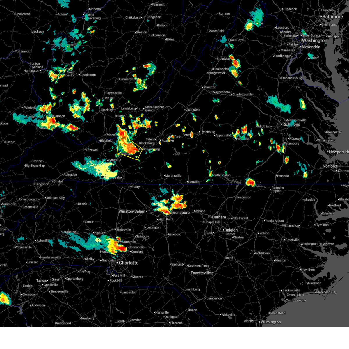
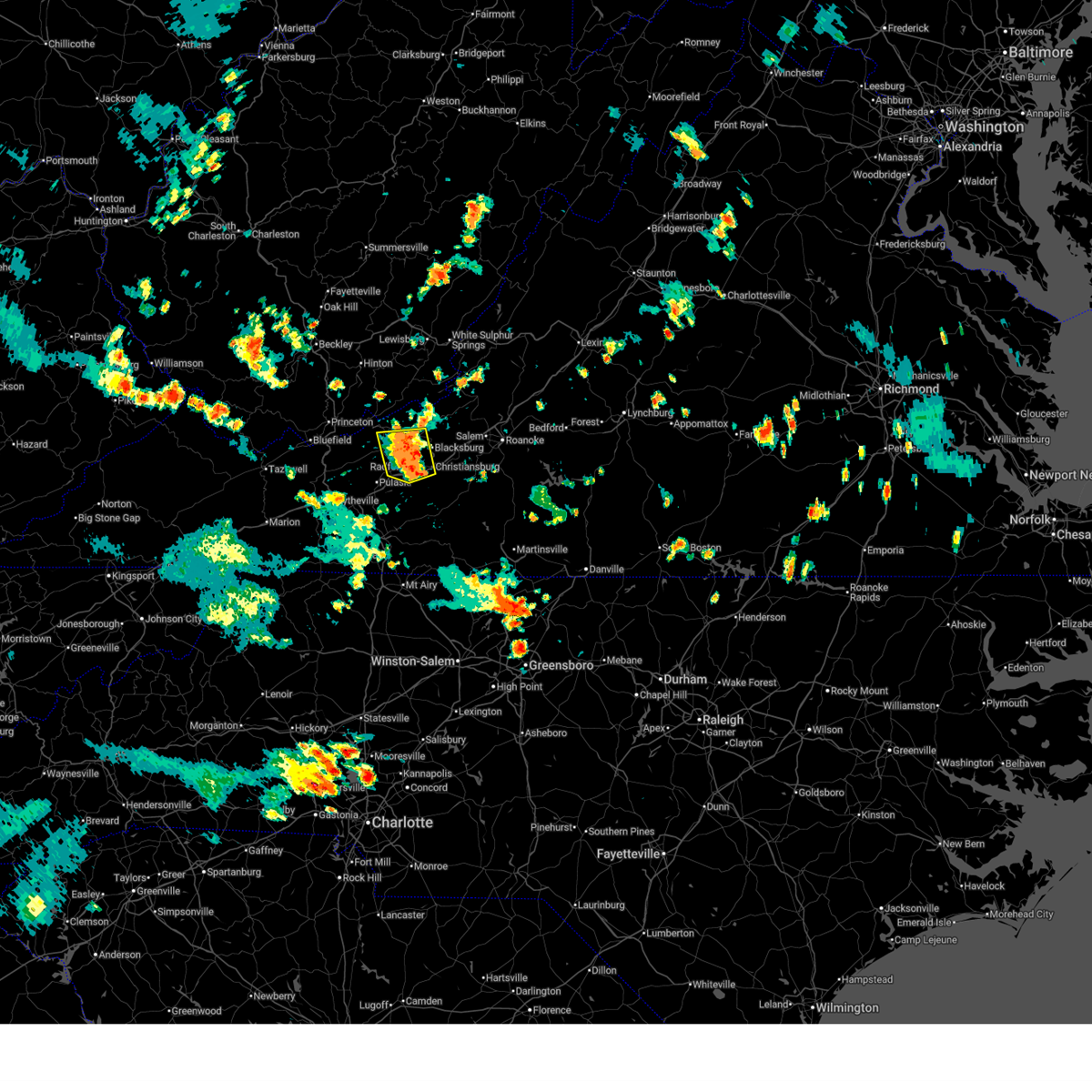
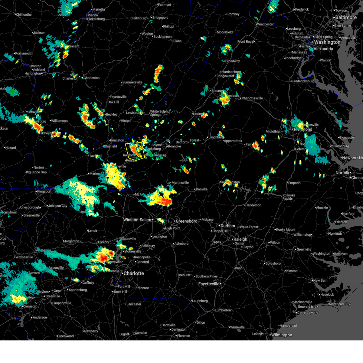
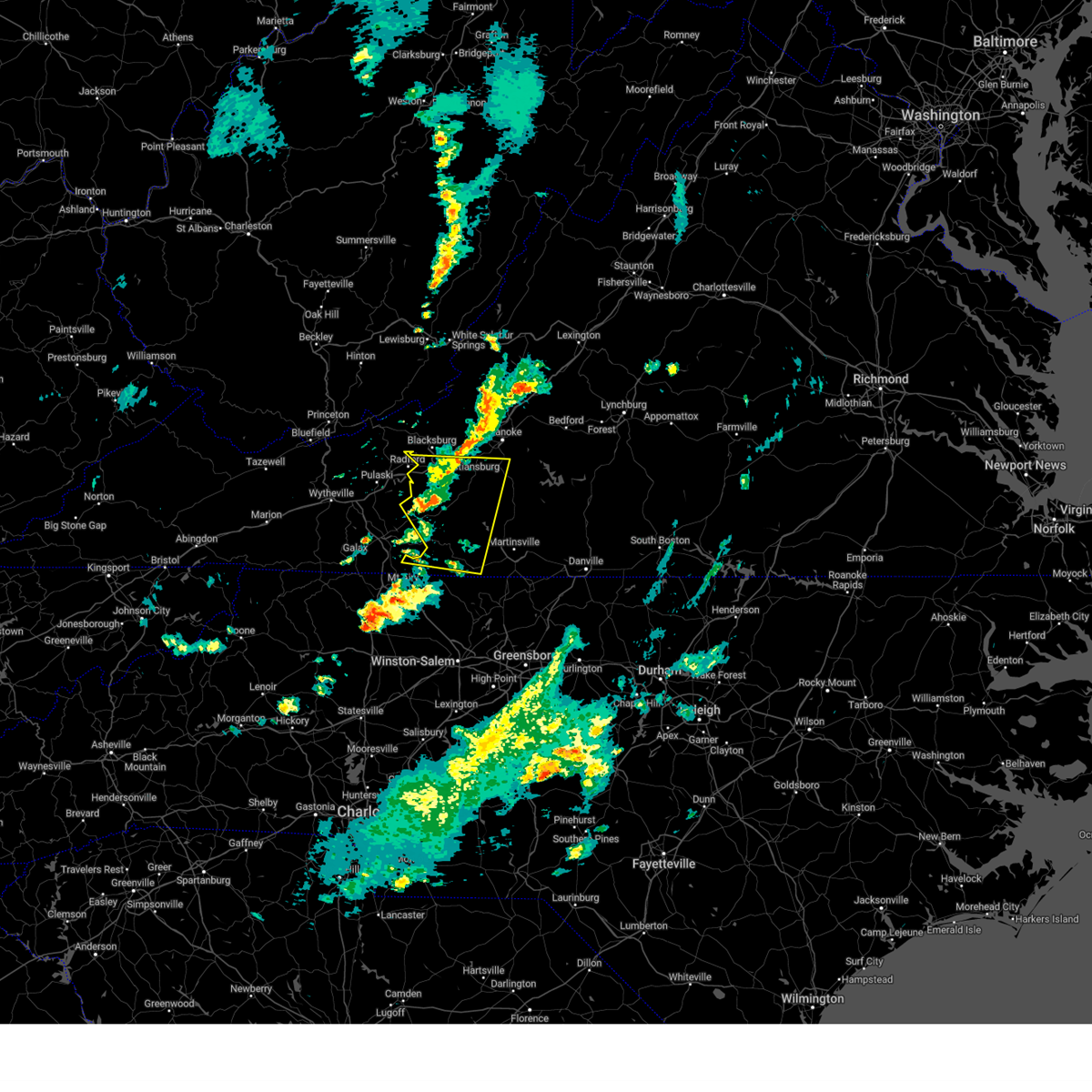
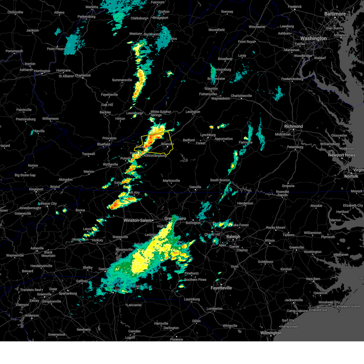
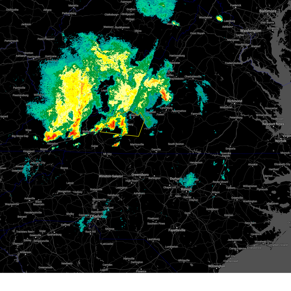
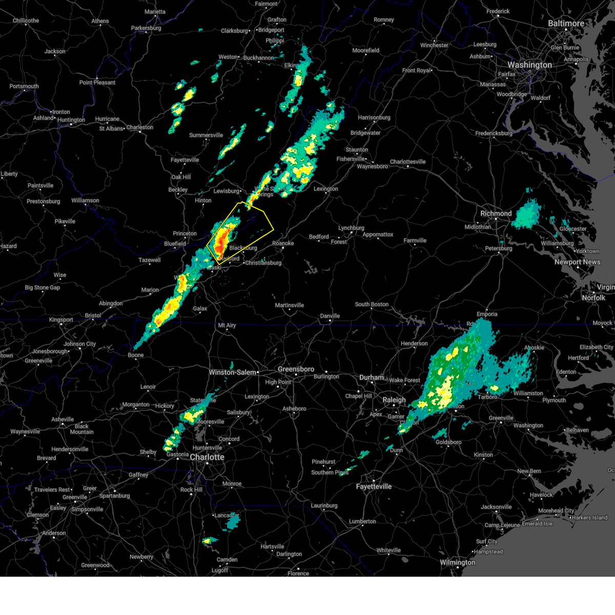
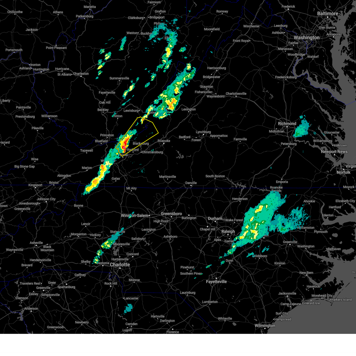
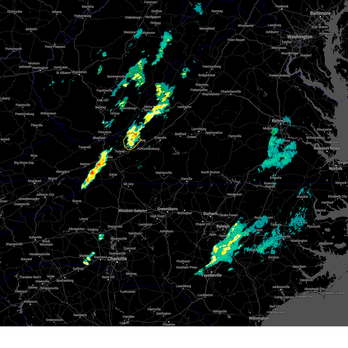
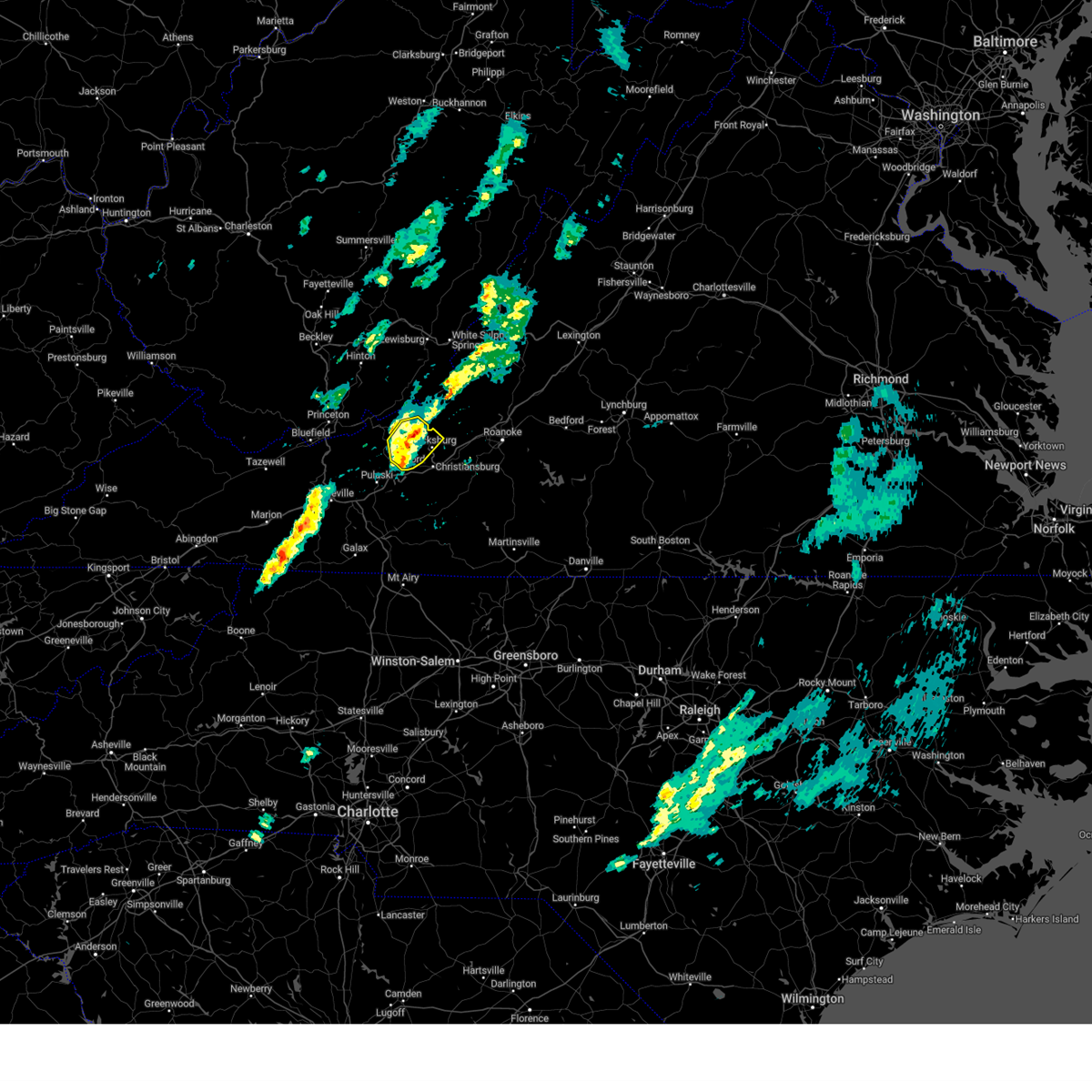
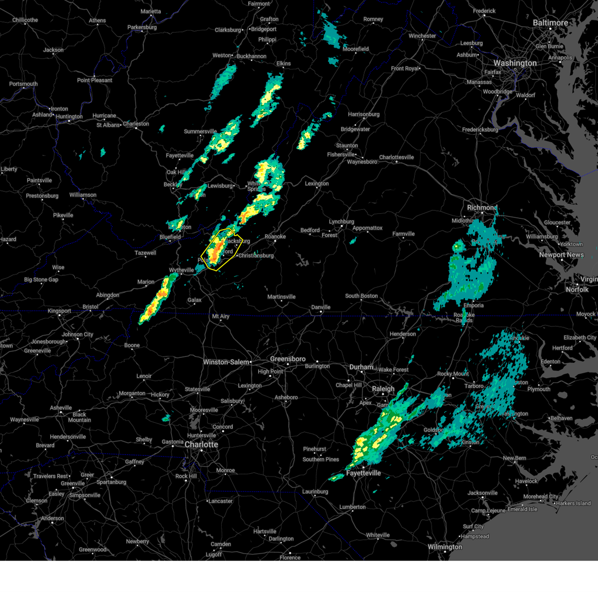
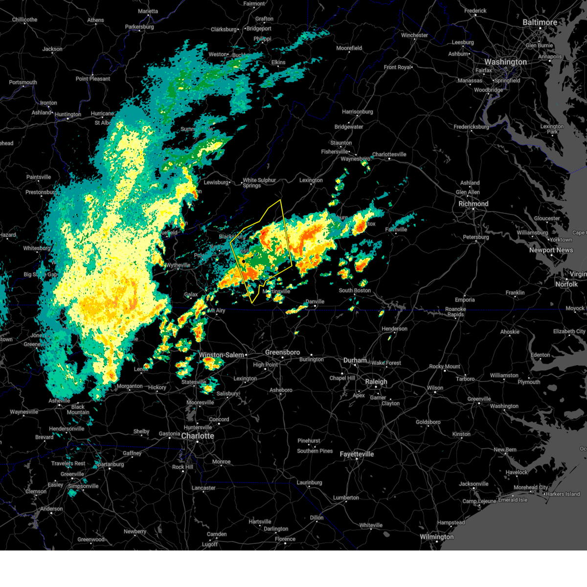
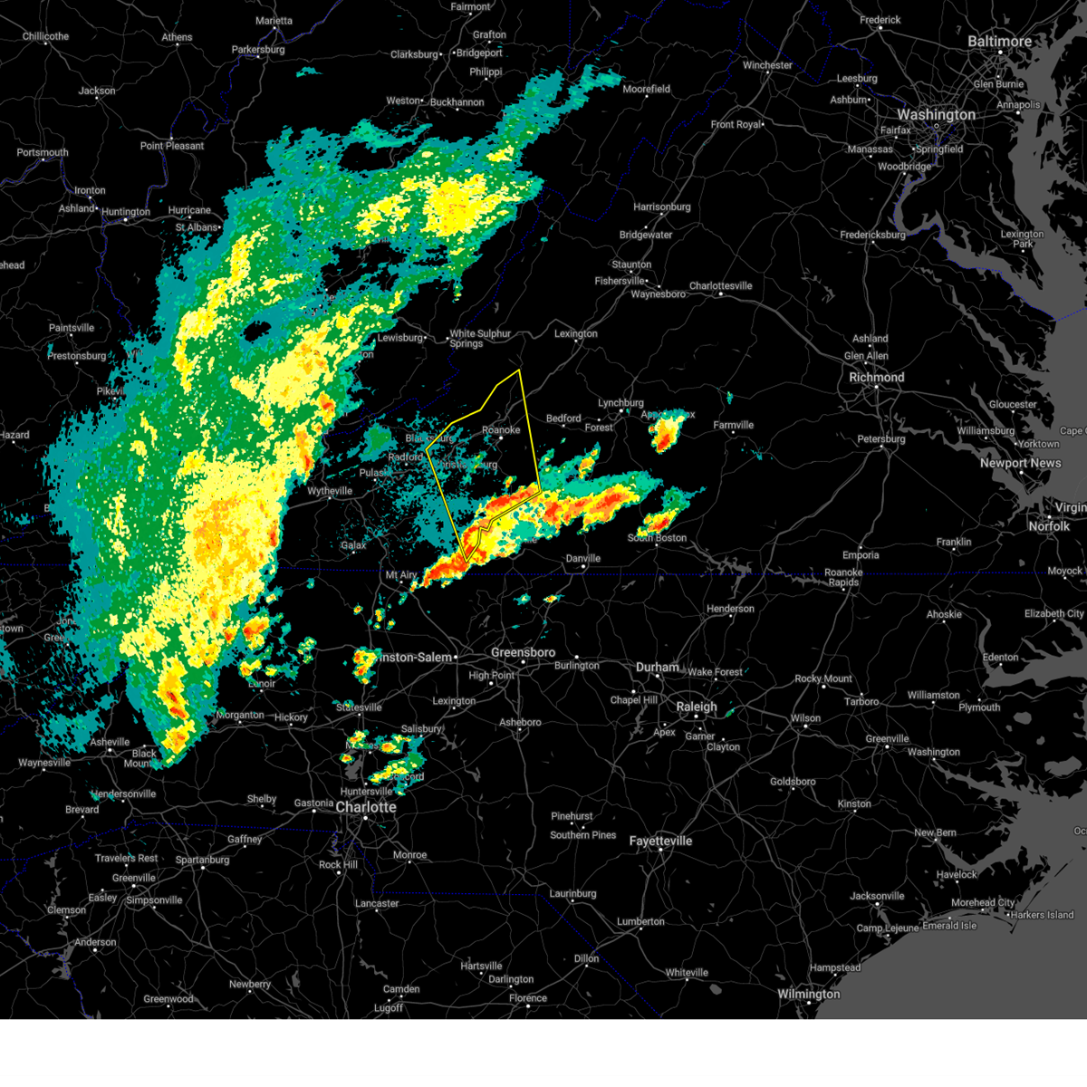
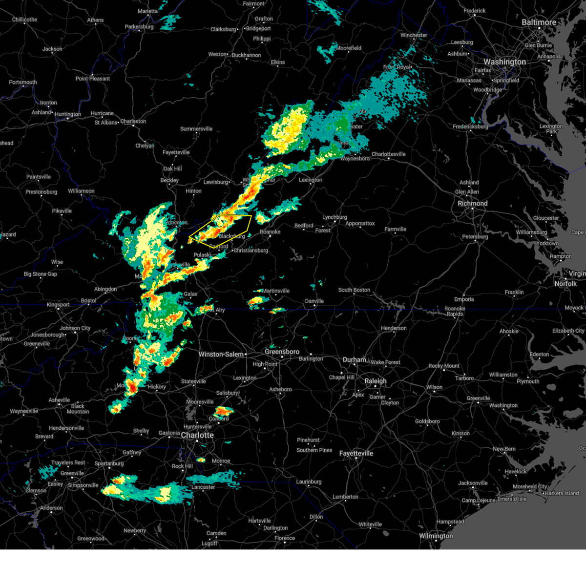
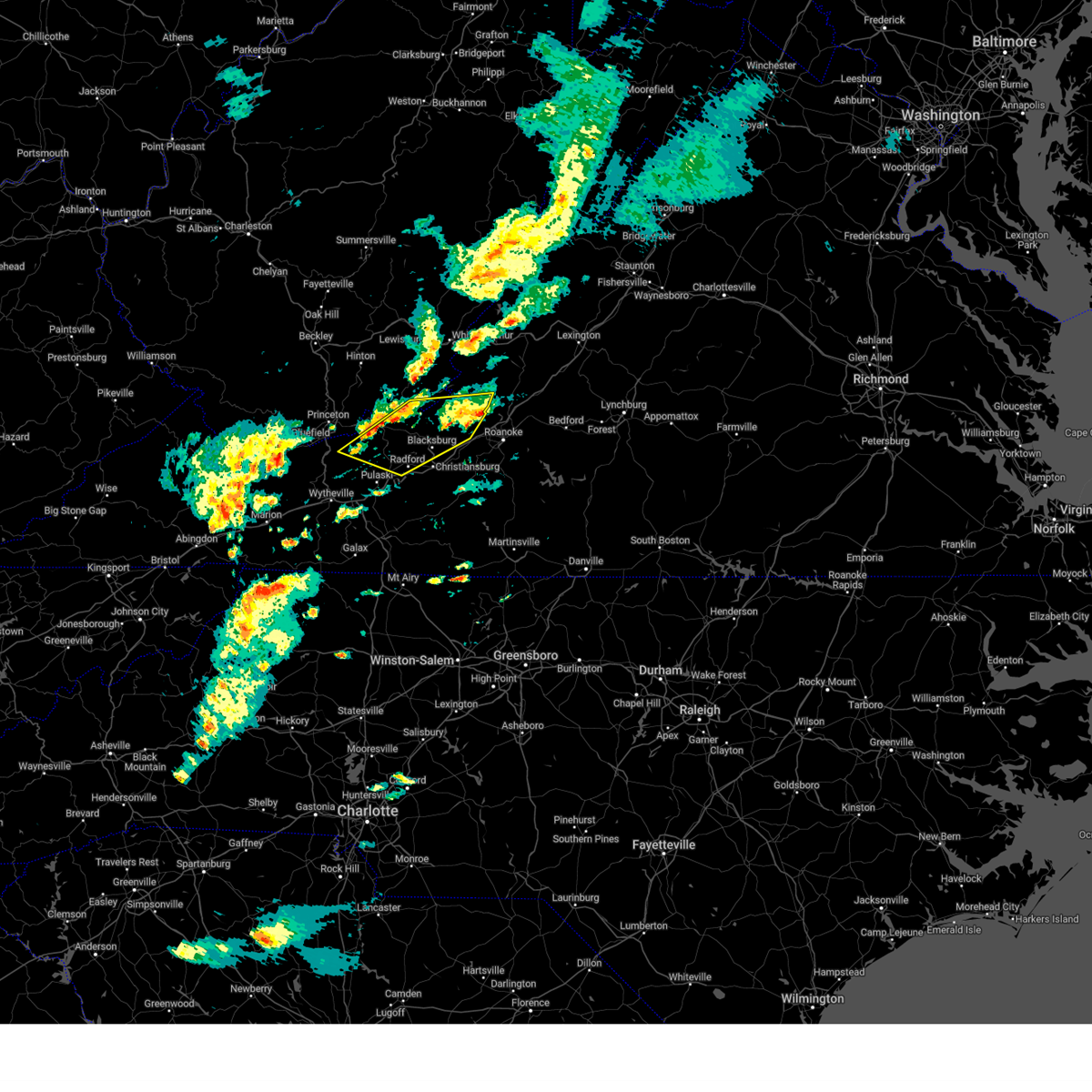
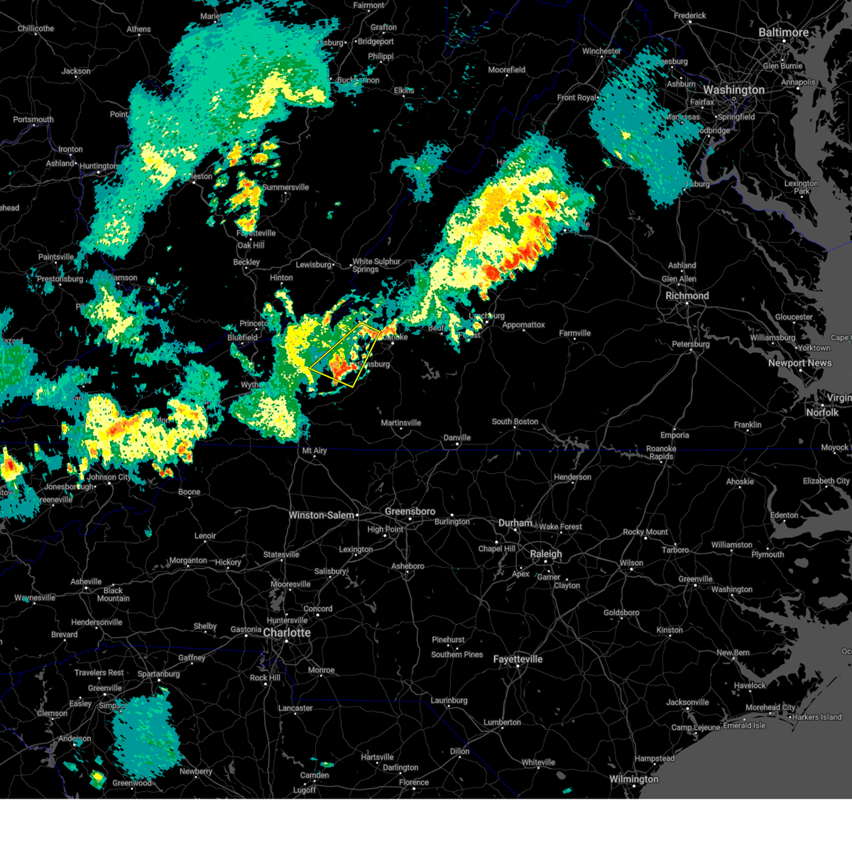
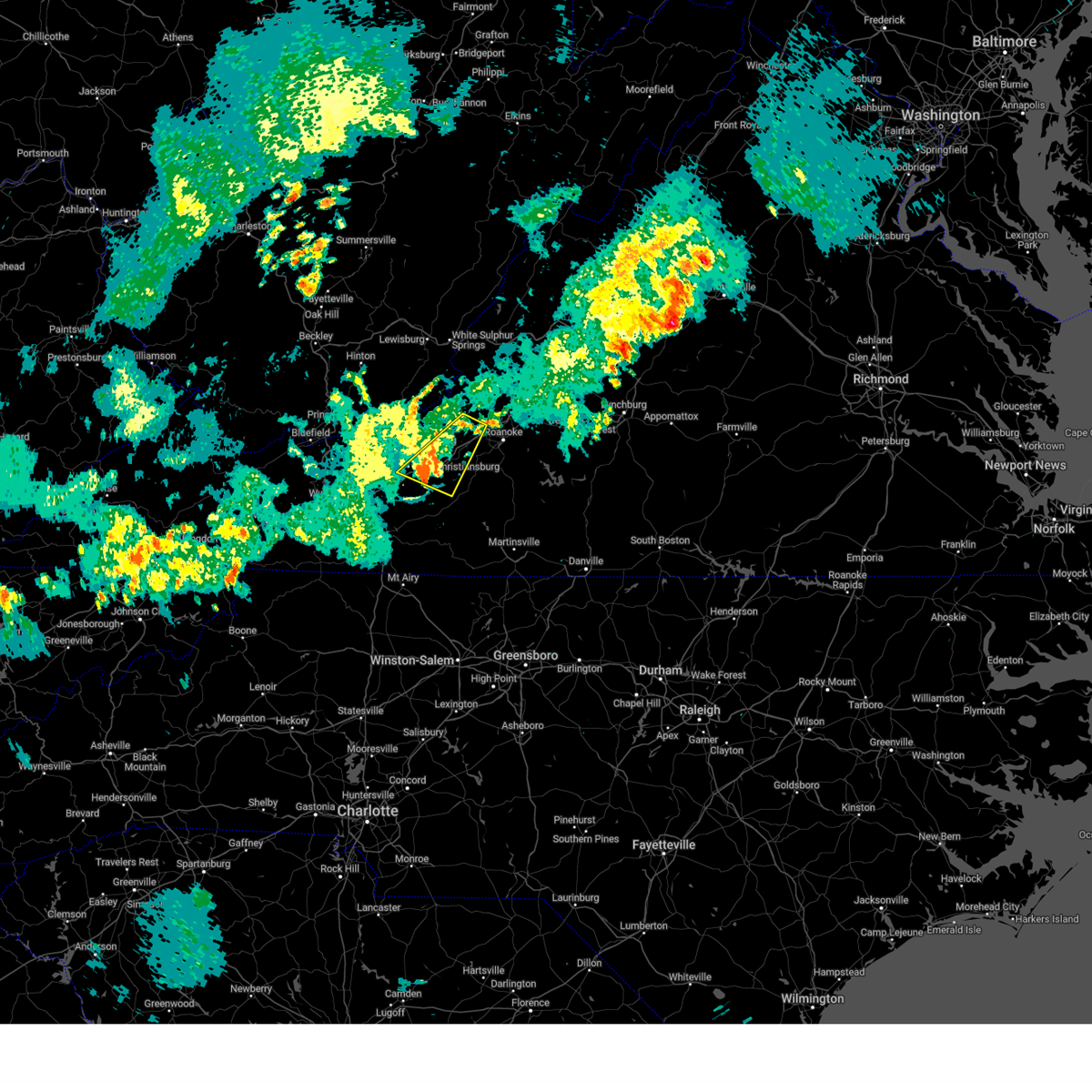
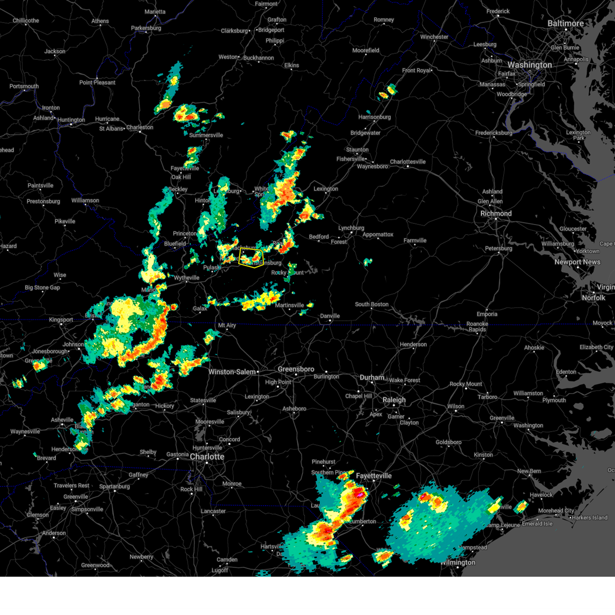
Hail Map for Blacksburg, VA
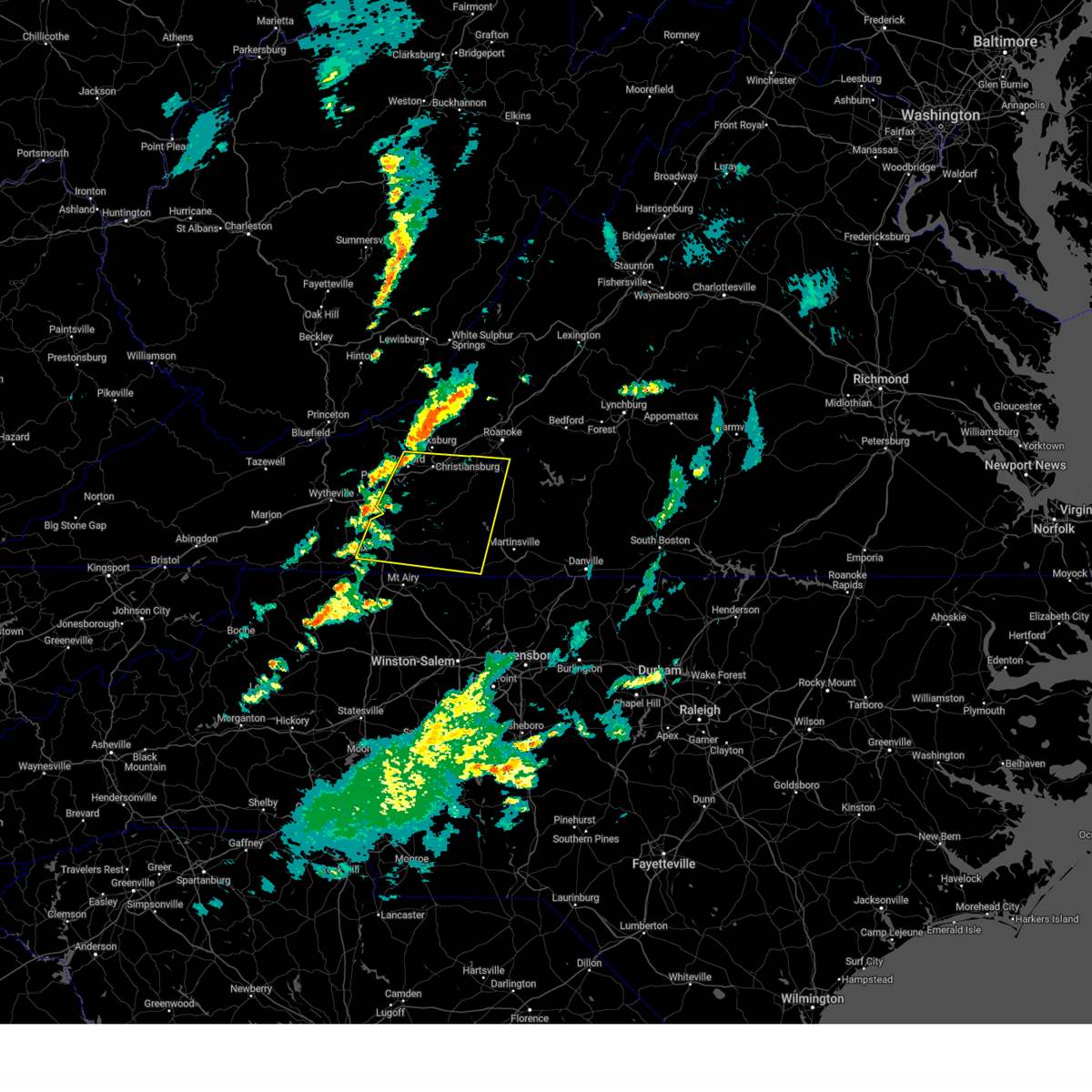
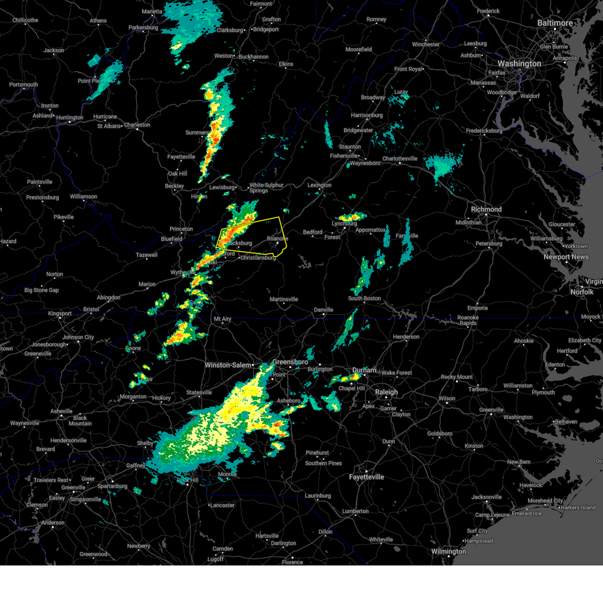
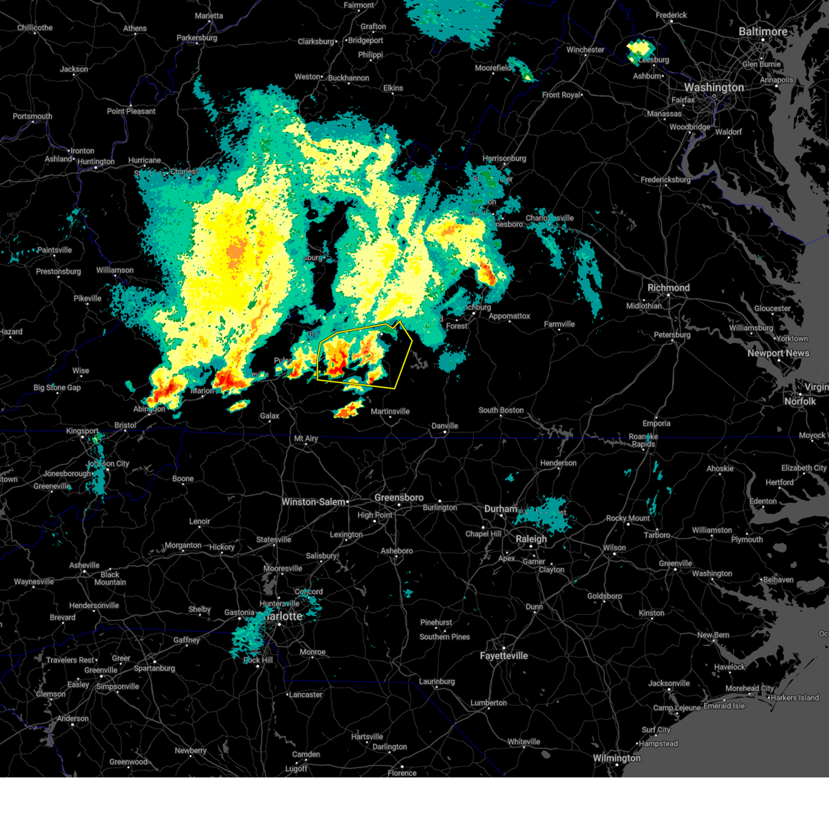
The Blacksburg, VA area has had 17 reports of on-the-ground hail by trained spotters, and has been under severe weather warnings 48 times during the past 12 months. Doppler radar has detected hail at or near Blacksburg, VA on 33 occasions, including 3 occasions during the past year.
| Name: | Blacksburg, VA |
| Where Located: | 27.2 miles W of Roanoke, VA |
| Map: | Google Map for Blacksburg, VA |
| Population: | 42620 |
| Housing Units: | 15342 |
| More Info: | Search Google for Blacksburg, VA |
1
The Top Recent Hail Date for Blacksburg, VA is Friday, August 2, 2024 (9th out of 33)

Hail and Wind Damage Spotted near Blacksburg, VA
| Date / Time | Report Details |
|---|---|
| 6/26/2025 6:18 PM EDT |
 Svrrnk the national weather service in blacksburg has issued a * severe thunderstorm warning for, central pulaski county in southwestern virginia, southeastern giles county in southwestern virginia, the city of radford in southwestern virginia, west central floyd county in southwestern virginia, southwestern montgomery county in southwestern virginia, * until 715 pm edt. * at 617 pm edt, a severe thunderstorm was located over claytor dam, or over radford, and is nearly stationary (radar indicated). Hazards include 60 mph wind gusts. expect damage to roofs, siding, and trees Svrrnk the national weather service in blacksburg has issued a * severe thunderstorm warning for, central pulaski county in southwestern virginia, southeastern giles county in southwestern virginia, the city of radford in southwestern virginia, west central floyd county in southwestern virginia, southwestern montgomery county in southwestern virginia, * until 715 pm edt. * at 617 pm edt, a severe thunderstorm was located over claytor dam, or over radford, and is nearly stationary (radar indicated). Hazards include 60 mph wind gusts. expect damage to roofs, siding, and trees
|
| 6/26/2025 5:59 PM EDT | At 558 pm edt, a severe thunderstorm was located over fairlawn, or over radford, moving south at 5 mph (radar indicated). Hazards include 60 mph wind gusts. Expect damage to roofs, siding, and trees. Locations impacted include, blacksburg, christiansburg, radford, dublin, pembroke, newport, and poplar hill. |
| 6/26/2025 5:38 PM EDT |
 At 538 pm edt, a severe thunderstorm was located over parrott, or near radford, and is nearly stationary (radar indicated). Hazards include 60 mph wind gusts. Expect damage to roofs, siding, and trees. Locations impacted include, blacksburg, christiansburg, radford, dublin, pembroke, newport, and poplar hill. At 538 pm edt, a severe thunderstorm was located over parrott, or near radford, and is nearly stationary (radar indicated). Hazards include 60 mph wind gusts. Expect damage to roofs, siding, and trees. Locations impacted include, blacksburg, christiansburg, radford, dublin, pembroke, newport, and poplar hill.
|
| 6/26/2025 5:28 PM EDT | 911 call center reported a downed tree blocking the entire roadway in the intersection of prices fork road and brightwood manor driv in montgomery county VA, 1.1 miles E of Blacksburg, VA |
| 6/26/2025 5:16 PM EDT |
 Svrrnk the national weather service in blacksburg has issued a * severe thunderstorm warning for, northeastern pulaski county in southwestern virginia, southeastern giles county in southwestern virginia, the city of radford in southwestern virginia, western montgomery county in southwestern virginia, * until 615 pm edt. * at 516 pm edt, a severe thunderstorm was located over mc coy, or near poplar hill, moving south at 5 mph (radar indicated). Hazards include 60 mph wind gusts. expect damage to roofs, siding, and trees Svrrnk the national weather service in blacksburg has issued a * severe thunderstorm warning for, northeastern pulaski county in southwestern virginia, southeastern giles county in southwestern virginia, the city of radford in southwestern virginia, western montgomery county in southwestern virginia, * until 615 pm edt. * at 516 pm edt, a severe thunderstorm was located over mc coy, or near poplar hill, moving south at 5 mph (radar indicated). Hazards include 60 mph wind gusts. expect damage to roofs, siding, and trees
|
| 5/30/2025 3:25 PM EDT |
 the severe thunderstorm warning has been cancelled and is no longer in effect the severe thunderstorm warning has been cancelled and is no longer in effect
|
| 5/30/2025 3:25 PM EDT |
 At 325 pm edt, severe thunderstorms were located along a line extending from shawsville to near childress to alum ridge to near gladesboro, moving east at 35 mph (radar indicated). Hazards include 60 mph wind gusts. Expect damage to roofs, siding, and trees. Locations impacted include, christiansburg, radford, stuart, floyd, boones mill, pilot, and copper hill. At 325 pm edt, severe thunderstorms were located along a line extending from shawsville to near childress to alum ridge to near gladesboro, moving east at 35 mph (radar indicated). Hazards include 60 mph wind gusts. Expect damage to roofs, siding, and trees. Locations impacted include, christiansburg, radford, stuart, floyd, boones mill, pilot, and copper hill.
|
| 5/30/2025 3:08 PM EDT |
 the severe thunderstorm warning has been cancelled and is no longer in effect the severe thunderstorm warning has been cancelled and is no longer in effect
|
| 5/30/2025 3:08 PM EDT |
 At 308 pm edt, a severe thunderstorm was located over mc donalds mill, or 7 miles northeast of blacksburg, moving east at 35 mph (radar indicated). Hazards include 60 mph wind gusts. Expect damage to roofs, siding, and trees. Locations impacted include, roanoke, blacksburg, salem, vinton, sinking creek, catawba, and shawsville. At 308 pm edt, a severe thunderstorm was located over mc donalds mill, or 7 miles northeast of blacksburg, moving east at 35 mph (radar indicated). Hazards include 60 mph wind gusts. Expect damage to roofs, siding, and trees. Locations impacted include, roanoke, blacksburg, salem, vinton, sinking creek, catawba, and shawsville.
|
| 5/30/2025 3:05 PM EDT |
 Svrrnk the national weather service in blacksburg has issued a * severe thunderstorm warning for, southern roanoke county in west central virginia, eastern pulaski county in southwestern virginia, the city of radford in southwestern virginia, floyd county in southwestern virginia, carroll county in southwestern virginia, west central henry county in south central virginia, the northeastern city of galax in southwestern virginia, patrick county in southwestern virginia, western franklin county in west central virginia, southern montgomery county in southwestern virginia, * until 400 pm edt. * at 305 pm edt, severe thunderstorms were located along a line extending from merrimac to claytor lake state park to near allisonia to woodlawn, moving east at 35 mph (radar indicated). Hazards include 60 mph wind gusts. expect damage to roofs, siding, and trees Svrrnk the national weather service in blacksburg has issued a * severe thunderstorm warning for, southern roanoke county in west central virginia, eastern pulaski county in southwestern virginia, the city of radford in southwestern virginia, floyd county in southwestern virginia, carroll county in southwestern virginia, west central henry county in south central virginia, the northeastern city of galax in southwestern virginia, patrick county in southwestern virginia, western franklin county in west central virginia, southern montgomery county in southwestern virginia, * until 400 pm edt. * at 305 pm edt, severe thunderstorms were located along a line extending from merrimac to claytor lake state park to near allisonia to woodlawn, moving east at 35 mph (radar indicated). Hazards include 60 mph wind gusts. expect damage to roofs, siding, and trees
|
| 5/30/2025 3:03 PM EDT | Multiple trees reported down throughout montgomery count in montgomery county VA, 2.9 miles SSW of Blacksburg, VA |
| 5/30/2025 2:46 PM EDT |
 Svrrnk the national weather service in blacksburg has issued a * severe thunderstorm warning for, roanoke county in west central virginia, southeastern giles county in southwestern virginia, southern craig county in southwestern virginia, the city of salem in west central virginia, the city of roanoke in west central virginia, southwestern botetourt county in west central virginia, northern montgomery county in southwestern virginia, * until 345 pm edt. * at 246 pm edt, a severe thunderstorm was located over newport, moving east at 35 mph (radar indicated). Hazards include 60 mph wind gusts. expect damage to roofs, siding, and trees Svrrnk the national weather service in blacksburg has issued a * severe thunderstorm warning for, roanoke county in west central virginia, southeastern giles county in southwestern virginia, southern craig county in southwestern virginia, the city of salem in west central virginia, the city of roanoke in west central virginia, southwestern botetourt county in west central virginia, northern montgomery county in southwestern virginia, * until 345 pm edt. * at 246 pm edt, a severe thunderstorm was located over newport, moving east at 35 mph (radar indicated). Hazards include 60 mph wind gusts. expect damage to roofs, siding, and trees
|
| 5/16/2025 3:30 PM EDT |
 At 330 pm edt, a severe thunderstorm was located over crockett springs, or near shawsville, moving east at 50 mph (radar indicated). Hazards include 70 mph wind gusts and quarter size hail. Hail damage to vehicles is expected. expect considerable tree damage. wind damage is also likely to mobile homes, roofs, and outbuildings. Locations impacted include, roanoke, blacksburg, salem, christiansburg, vinton, rocky mount, and boones mill. At 330 pm edt, a severe thunderstorm was located over crockett springs, or near shawsville, moving east at 50 mph (radar indicated). Hazards include 70 mph wind gusts and quarter size hail. Hail damage to vehicles is expected. expect considerable tree damage. wind damage is also likely to mobile homes, roofs, and outbuildings. Locations impacted include, roanoke, blacksburg, salem, christiansburg, vinton, rocky mount, and boones mill.
|
| 5/16/2025 3:30 PM EDT |
 the severe thunderstorm warning has been cancelled and is no longer in effect the severe thunderstorm warning has been cancelled and is no longer in effect
|
| 5/16/2025 3:22 PM EDT |
 the severe thunderstorm warning has been cancelled and is no longer in effect the severe thunderstorm warning has been cancelled and is no longer in effect
|
| 5/16/2025 3:22 PM EDT |
 At 321 pm edt, a severe thunderstorm was located near christiansburg, moving east at 55 mph (mesonet observation). Hazards include 70 mph wind gusts and quarter size hail. Hail damage to vehicles is expected. expect considerable tree damage. wind damage is also likely to mobile homes, roofs, and outbuildings. Locations impacted include, roanoke, blacksburg, salem, christiansburg, radford, vinton, and rocky mount. At 321 pm edt, a severe thunderstorm was located near christiansburg, moving east at 55 mph (mesonet observation). Hazards include 70 mph wind gusts and quarter size hail. Hail damage to vehicles is expected. expect considerable tree damage. wind damage is also likely to mobile homes, roofs, and outbuildings. Locations impacted include, roanoke, blacksburg, salem, christiansburg, radford, vinton, and rocky mount.
|
| 5/16/2025 3:11 PM EDT | 55 knot gust measured on rsois uni in montgomery county VA, 1.7 miles NW of Blacksburg, VA |
| 5/16/2025 3:05 PM EDT |
 Svrrnk the national weather service in blacksburg has issued a * severe thunderstorm warning for, roanoke county in west central virginia, northeastern pulaski county in southwestern virginia, east central giles county in southwestern virginia, southern craig county in southwestern virginia, the city of radford in southwestern virginia, the city of salem in west central virginia, northern floyd county in southwestern virginia, the city of roanoke in west central virginia, west central bedford county in south central virginia, southwestern botetourt county in west central virginia, central franklin county in west central virginia, montgomery county in southwestern virginia, * until 400 pm edt. * at 305 pm edt, severe thunderstorms were located along a line extending from huffman to near christiansburg to near copper valley, moving east at 40 mph (radar indicated). Hazards include 60 mph wind gusts and quarter size hail. Hail damage to vehicles is expected. Expect wind damage to roofs, siding, and trees. Svrrnk the national weather service in blacksburg has issued a * severe thunderstorm warning for, roanoke county in west central virginia, northeastern pulaski county in southwestern virginia, east central giles county in southwestern virginia, southern craig county in southwestern virginia, the city of radford in southwestern virginia, the city of salem in west central virginia, northern floyd county in southwestern virginia, the city of roanoke in west central virginia, west central bedford county in south central virginia, southwestern botetourt county in west central virginia, central franklin county in west central virginia, montgomery county in southwestern virginia, * until 400 pm edt. * at 305 pm edt, severe thunderstorms were located along a line extending from huffman to near christiansburg to near copper valley, moving east at 40 mph (radar indicated). Hazards include 60 mph wind gusts and quarter size hail. Hail damage to vehicles is expected. Expect wind damage to roofs, siding, and trees.
|
| 5/16/2025 2:54 PM EDT |
 At 254 pm edt, severe thunderstorms were located along a line extending from pembroke to near prices fork to near gunton park, moving east at 55 mph (radar indicated). Hazards include 70 mph wind gusts and half dollar size hail. Hail damage to vehicles is expected. expect considerable tree damage. wind damage is also likely to mobile homes, roofs, and outbuildings. Locations impacted include, blacksburg, christiansburg, radford, pulaski, pearisburg, dublin, and narrows. At 254 pm edt, severe thunderstorms were located along a line extending from pembroke to near prices fork to near gunton park, moving east at 55 mph (radar indicated). Hazards include 70 mph wind gusts and half dollar size hail. Hail damage to vehicles is expected. expect considerable tree damage. wind damage is also likely to mobile homes, roofs, and outbuildings. Locations impacted include, blacksburg, christiansburg, radford, pulaski, pearisburg, dublin, and narrows.
|
| 5/16/2025 2:37 PM EDT | At 236 pm edt, severe thunderstorms were located along a line extending from willowton to thessalia to near bland, moving east at 55 mph (radar indicated). Hazards include 70 mph wind gusts and half dollar size hail. Hail damage to vehicles is expected. expect considerable tree damage. wind damage is also likely to mobile homes, roofs, and outbuildings. Locations impacted include, blacksburg, christiansburg, radford, bluefield, pulaski, bland, and princeton. |
| 5/16/2025 2:37 PM EDT | the severe thunderstorm warning has been cancelled and is no longer in effect |
| 5/16/2025 2:11 PM EDT |
 Svrrnk the national weather service in blacksburg has issued a * severe thunderstorm warning for, pulaski county in southwestern virginia, giles county in southwestern virginia, southwestern craig county in southwestern virginia, the city of radford in southwestern virginia, bland county in southwestern virginia, northwestern wythe county in southwestern virginia, western montgomery county in southwestern virginia, south central summers county in southeastern west virginia, mercer county in southeastern west virginia, southwestern monroe county in southeastern west virginia, * until 315 pm edt. * at 211 pm edt, severe thunderstorms were located along a line extending from wenonah to bluefield to tazewell, moving east at 55 mph (radar indicated). Hazards include 70 mph wind gusts and half dollar size hail. Hail damage to vehicles is expected. expect considerable tree damage. Wind damage is also likely to mobile homes, roofs, and outbuildings. Svrrnk the national weather service in blacksburg has issued a * severe thunderstorm warning for, pulaski county in southwestern virginia, giles county in southwestern virginia, southwestern craig county in southwestern virginia, the city of radford in southwestern virginia, bland county in southwestern virginia, northwestern wythe county in southwestern virginia, western montgomery county in southwestern virginia, south central summers county in southeastern west virginia, mercer county in southeastern west virginia, southwestern monroe county in southeastern west virginia, * until 315 pm edt. * at 211 pm edt, severe thunderstorms were located along a line extending from wenonah to bluefield to tazewell, moving east at 55 mph (radar indicated). Hazards include 70 mph wind gusts and half dollar size hail. Hail damage to vehicles is expected. expect considerable tree damage. Wind damage is also likely to mobile homes, roofs, and outbuildings.
|
| 3/16/2025 5:22 PM EDT |
 At 522 pm edt, a severe thunderstorm was located over eggleston, or near pembroke, moving northeast at 50 mph (radar indicated). Hazards include 60 mph wind gusts and quarter size hail. Hail damage to vehicles is expected. expect wind damage to roofs, siding, and trees. Locations impacted include, blacksburg, pearisburg, narrows, pembroke, union, new castle, and newport. At 522 pm edt, a severe thunderstorm was located over eggleston, or near pembroke, moving northeast at 50 mph (radar indicated). Hazards include 60 mph wind gusts and quarter size hail. Hail damage to vehicles is expected. expect wind damage to roofs, siding, and trees. Locations impacted include, blacksburg, pearisburg, narrows, pembroke, union, new castle, and newport.
|
| 3/16/2025 5:14 PM EDT |
 Svrrnk the national weather service in blacksburg has issued a * severe thunderstorm warning for, northern pulaski county in southwestern virginia, giles county in southwestern virginia, craig county in southwestern virginia, northwestern montgomery county in southwestern virginia, central monroe county in southeastern west virginia, * until 615 pm edt. * at 513 pm edt, a severe thunderstorm was located near poplar hill, moving northeast at 45 mph (radar indicated). Hazards include 60 mph wind gusts. expect damage to roofs, siding, and trees Svrrnk the national weather service in blacksburg has issued a * severe thunderstorm warning for, northern pulaski county in southwestern virginia, giles county in southwestern virginia, craig county in southwestern virginia, northwestern montgomery county in southwestern virginia, central monroe county in southeastern west virginia, * until 615 pm edt. * at 513 pm edt, a severe thunderstorm was located near poplar hill, moving northeast at 45 mph (radar indicated). Hazards include 60 mph wind gusts. expect damage to roofs, siding, and trees
|
| 3/16/2025 4:38 PM EDT |
 the severe thunderstorm warning has been cancelled and is no longer in effect the severe thunderstorm warning has been cancelled and is no longer in effect
|
| 3/16/2025 4:35 PM EDT |
 At 435 pm edt, a severe thunderstorm was located over radford, moving northeast at 50 mph (radar indicated). Hazards include 60 mph wind gusts. Expect damage to roofs, siding, and trees. locations impacted include, blacksburg, radford, pembroke, newport, mountain lake, eggleston, and mc coy. This includes the following location virginia tech. At 435 pm edt, a severe thunderstorm was located over radford, moving northeast at 50 mph (radar indicated). Hazards include 60 mph wind gusts. Expect damage to roofs, siding, and trees. locations impacted include, blacksburg, radford, pembroke, newport, mountain lake, eggleston, and mc coy. This includes the following location virginia tech.
|
| 3/16/2025 4:26 PM EDT |
 the severe thunderstorm warning has been cancelled and is no longer in effect the severe thunderstorm warning has been cancelled and is no longer in effect
|
| 3/16/2025 4:26 PM EDT |
 At 426 pm edt, a severe thunderstorm was located over dublin, moving northeast at 50 mph (radar indicated). Hazards include 60 mph wind gusts. Expect damage to roofs, siding, and trees. locations impacted include, blacksburg, christiansburg, radford, pulaski, dublin, pembroke, and newport. This includes the following location virginia tech. At 426 pm edt, a severe thunderstorm was located over dublin, moving northeast at 50 mph (radar indicated). Hazards include 60 mph wind gusts. Expect damage to roofs, siding, and trees. locations impacted include, blacksburg, christiansburg, radford, pulaski, dublin, pembroke, and newport. This includes the following location virginia tech.
|
| 3/16/2025 4:17 PM EDT | Svrrnk the national weather service in blacksburg has issued a * severe thunderstorm warning for, pulaski county in southwestern virginia, southeastern giles county in southwestern virginia, the city of radford in southwestern virginia, northeastern wythe county in southwestern virginia, northwestern montgomery county in southwestern virginia, * until 500 pm edt. * at 417 pm edt, a severe thunderstorm was located over draper, or near pulaski, moving northeast at 50 mph (radar indicated). Hazards include 60 mph wind gusts. expect damage to roofs, siding, and trees |
| 9/25/2024 9:24 PM EDT |
 the severe thunderstorm warning has been cancelled and is no longer in effect the severe thunderstorm warning has been cancelled and is no longer in effect
|
| 9/25/2024 8:39 PM EDT |
 Svrrnk the national weather service in blacksburg has issued a * severe thunderstorm warning for, roanoke county in west central virginia, the city of salem in west central virginia, northeastern floyd county in southwestern virginia, the city of roanoke in west central virginia, west central bedford county in south central virginia, southwestern botetourt county in west central virginia, northeastern patrick county in southwestern virginia, franklin county in west central virginia, eastern montgomery county in southwestern virginia, * until 945 pm edt. * at 838 pm edt, severe thunderstorms were located along a line extending from near burnt chimney to near ferrum to endicott, moving north at 40 mph (radar indicated). Hazards include 60 mph wind gusts and quarter size hail. Hail damage to vehicles is expected. Expect wind damage to roofs, siding, and trees. Svrrnk the national weather service in blacksburg has issued a * severe thunderstorm warning for, roanoke county in west central virginia, the city of salem in west central virginia, northeastern floyd county in southwestern virginia, the city of roanoke in west central virginia, west central bedford county in south central virginia, southwestern botetourt county in west central virginia, northeastern patrick county in southwestern virginia, franklin county in west central virginia, eastern montgomery county in southwestern virginia, * until 945 pm edt. * at 838 pm edt, severe thunderstorms were located along a line extending from near burnt chimney to near ferrum to endicott, moving north at 40 mph (radar indicated). Hazards include 60 mph wind gusts and quarter size hail. Hail damage to vehicles is expected. Expect wind damage to roofs, siding, and trees.
|
| 9/24/2024 6:10 PM EDT | The severe thunderstorm which prompted the warning has weakened. therefore, the warning will be allowed to expire. however, heavy rain is still possible with this thunderstorm. |
| 9/24/2024 5:35 PM EDT | At 535 pm edt, a severe thunderstorm was located over graysontown, or near radford, moving northeast at 25 mph (radar indicated). Hazards include 60 mph wind gusts and quarter size hail. Hail damage to vehicles is expected. expect wind damage to roofs, siding, and trees. locations impacted include, blacksburg, christiansburg, radford, dublin, pilot, shawsville, and terrys fork. This includes the following location virginia tech. |
| 9/24/2024 5:21 PM EDT | Svrrnk the national weather service in blacksburg has issued a * severe thunderstorm warning for, southeastern pulaski county in southwestern virginia, the city of radford in southwestern virginia, northwestern floyd county in southwestern virginia, southern montgomery county in southwestern virginia, * until 615 pm edt. * at 521 pm edt, a severe thunderstorm was located over claytor lake state park, or near dublin, moving northeast at 25 mph (radar indicated). Hazards include 60 mph wind gusts and quarter size hail. Hail damage to vehicles is expected. Expect wind damage to roofs, siding, and trees. |
| 9/24/2024 4:56 PM EDT | The storms which prompted the warning have weakened below severe limits, and no longer pose an immediate threat to life or property. therefore, the warning will be allowed to expire. however, heavy rain is still possible with these thunderstorms. |
| 9/24/2024 4:29 PM EDT |
 At 429 pm edt, severe thunderstorms were located along a line extending from maggie to poplar hill, moving east at 25 mph (radar indicated). Hazards include 60 mph wind gusts and quarter size hail. Hail damage to vehicles is expected. expect wind damage to roofs, siding, and trees. Locations impacted include, blacksburg, pearisburg, narrows, pembroke, newport, mountain lake, and sinking creek. At 429 pm edt, severe thunderstorms were located along a line extending from maggie to poplar hill, moving east at 25 mph (radar indicated). Hazards include 60 mph wind gusts and quarter size hail. Hail damage to vehicles is expected. expect wind damage to roofs, siding, and trees. Locations impacted include, blacksburg, pearisburg, narrows, pembroke, newport, mountain lake, and sinking creek.
|
| 9/24/2024 4:29 PM EDT |
 the severe thunderstorm warning has been cancelled and is no longer in effect the severe thunderstorm warning has been cancelled and is no longer in effect
|
| 9/24/2024 4:02 PM EDT |
 Svrrnk the national weather service in blacksburg has issued a * severe thunderstorm warning for, northwestern roanoke county in west central virginia, northern pulaski county in southwestern virginia, giles county in southwestern virginia, craig county in southwestern virginia, the city of radford in southwestern virginia, northeastern bland county in southwestern virginia, northern montgomery county in southwestern virginia, southeastern monroe county in southeastern west virginia, * until 500 pm edt. * at 402 pm edt, severe thunderstorms were located along a line extending from kire to near white gate, moving east at 25 mph (radar indicated). Hazards include 60 mph wind gusts and quarter size hail. Hail damage to vehicles is expected. Expect wind damage to roofs, siding, and trees. Svrrnk the national weather service in blacksburg has issued a * severe thunderstorm warning for, northwestern roanoke county in west central virginia, northern pulaski county in southwestern virginia, giles county in southwestern virginia, craig county in southwestern virginia, the city of radford in southwestern virginia, northeastern bland county in southwestern virginia, northern montgomery county in southwestern virginia, southeastern monroe county in southeastern west virginia, * until 500 pm edt. * at 402 pm edt, severe thunderstorms were located along a line extending from kire to near white gate, moving east at 25 mph (radar indicated). Hazards include 60 mph wind gusts and quarter size hail. Hail damage to vehicles is expected. Expect wind damage to roofs, siding, and trees.
|
| 8/31/2024 7:22 PM EDT |
 The storm which prompted the warning has weakened below severe limits, and no longer poses an immediate threat to life or property. therefore, the warning will be allowed to expire. The storm which prompted the warning has weakened below severe limits, and no longer poses an immediate threat to life or property. therefore, the warning will be allowed to expire.
|
| 8/31/2024 7:09 PM EDT |
 At 709 pm edt, a severe thunderstorm was located near childress, or near christiansburg, moving southeast at 20 mph (radar indicated). Hazards include 60 mph wind gusts. Expect damage to roofs, siding, and trees. locations impacted include, blacksburg, salem, christiansburg, radford, pilot, shawsville, and terrys fork. This includes the following location virginia tech. At 709 pm edt, a severe thunderstorm was located near childress, or near christiansburg, moving southeast at 20 mph (radar indicated). Hazards include 60 mph wind gusts. Expect damage to roofs, siding, and trees. locations impacted include, blacksburg, salem, christiansburg, radford, pilot, shawsville, and terrys fork. This includes the following location virginia tech.
|
| 8/31/2024 7:09 PM EDT |
 the severe thunderstorm warning has been cancelled and is no longer in effect the severe thunderstorm warning has been cancelled and is no longer in effect
|
| 8/31/2024 6:53 PM EDT |
 At 653 pm edt, a severe thunderstorm was located over prices fork, or over blacksburg, moving southeast at 15 mph (radar indicated). Hazards include 60 mph wind gusts. Expect damage to roofs, siding, and trees. locations impacted include, blacksburg, salem, christiansburg, radford, newport, pilot, and shawsville. This includes the following location virginia tech. At 653 pm edt, a severe thunderstorm was located over prices fork, or over blacksburg, moving southeast at 15 mph (radar indicated). Hazards include 60 mph wind gusts. Expect damage to roofs, siding, and trees. locations impacted include, blacksburg, salem, christiansburg, radford, newport, pilot, and shawsville. This includes the following location virginia tech.
|
| 8/31/2024 6:53 PM EDT |
 the severe thunderstorm warning has been cancelled and is no longer in effect the severe thunderstorm warning has been cancelled and is no longer in effect
|
| 8/31/2024 6:36 PM EDT |
 Svrrnk the national weather service in blacksburg has issued a * severe thunderstorm warning for, western roanoke county in west central virginia, northeastern pulaski county in southwestern virginia, eastern giles county in southwestern virginia, southwestern craig county in southwestern virginia, the city of radford in southwestern virginia, the west central city of salem in west central virginia, north central floyd county in southwestern virginia, montgomery county in southwestern virginia, southeastern monroe county in southeastern west virginia, * until 730 pm edt. * at 636 pm edt, a severe thunderstorm was located over prices fork, or over newport, moving southeast at 10 mph (radar indicated). Hazards include 60 mph wind gusts. expect damage to roofs, siding, and trees Svrrnk the national weather service in blacksburg has issued a * severe thunderstorm warning for, western roanoke county in west central virginia, northeastern pulaski county in southwestern virginia, eastern giles county in southwestern virginia, southwestern craig county in southwestern virginia, the city of radford in southwestern virginia, the west central city of salem in west central virginia, north central floyd county in southwestern virginia, montgomery county in southwestern virginia, southeastern monroe county in southeastern west virginia, * until 730 pm edt. * at 636 pm edt, a severe thunderstorm was located over prices fork, or over newport, moving southeast at 10 mph (radar indicated). Hazards include 60 mph wind gusts. expect damage to roofs, siding, and trees
|
| 8/31/2024 2:38 PM EDT |
 the severe thunderstorm warning has been cancelled and is no longer in effect the severe thunderstorm warning has been cancelled and is no longer in effect
|
| 8/31/2024 2:32 PM EDT |
 At 232 pm edt, a severe thunderstorm was located near white gate, or near poplar hill, moving east at 10 mph (radar indicated). Hazards include 60 mph wind gusts. Expect damage to roofs, siding, and trees. Locations impacted include, radford, pulaski, dublin, poplar hill, prices fork, claytor dam, and fairlawn. At 232 pm edt, a severe thunderstorm was located near white gate, or near poplar hill, moving east at 10 mph (radar indicated). Hazards include 60 mph wind gusts. Expect damage to roofs, siding, and trees. Locations impacted include, radford, pulaski, dublin, poplar hill, prices fork, claytor dam, and fairlawn.
|
| 8/31/2024 2:17 PM EDT |
 Svrrnk the national weather service in blacksburg has issued a * severe thunderstorm warning for, pulaski county in southwestern virginia, southwestern giles county in southwestern virginia, the city of radford in southwestern virginia, east central bland county in southwestern virginia, southwestern montgomery county in southwestern virginia, * until 315 pm edt. * at 217 pm edt, a severe thunderstorm was located over white gate, or 8 miles southwest of poplar hill, moving east at 10 mph (radar indicated). Hazards include 60 mph wind gusts. expect damage to roofs, siding, and trees Svrrnk the national weather service in blacksburg has issued a * severe thunderstorm warning for, pulaski county in southwestern virginia, southwestern giles county in southwestern virginia, the city of radford in southwestern virginia, east central bland county in southwestern virginia, southwestern montgomery county in southwestern virginia, * until 315 pm edt. * at 217 pm edt, a severe thunderstorm was located over white gate, or 8 miles southwest of poplar hill, moving east at 10 mph (radar indicated). Hazards include 60 mph wind gusts. expect damage to roofs, siding, and trees
|
| 8/2/2024 2:42 PM EDT |
 the severe thunderstorm warning has been cancelled and is no longer in effect the severe thunderstorm warning has been cancelled and is no longer in effect
|
| 8/2/2024 2:18 PM EDT |
 Svrrnk the national weather service in blacksburg has issued a * severe thunderstorm warning for, east central montgomery county in southwestern virginia, * until 300 pm edt. * at 218 pm edt, a severe thunderstorm was located over merrimac, or over christiansburg, moving east at 15 mph (radar indicated). Hazards include 60 mph wind gusts and quarter size hail. Hail damage to vehicles is expected. Expect wind damage to roofs, siding, and trees. Svrrnk the national weather service in blacksburg has issued a * severe thunderstorm warning for, east central montgomery county in southwestern virginia, * until 300 pm edt. * at 218 pm edt, a severe thunderstorm was located over merrimac, or over christiansburg, moving east at 15 mph (radar indicated). Hazards include 60 mph wind gusts and quarter size hail. Hail damage to vehicles is expected. Expect wind damage to roofs, siding, and trees.
|
| 7/5/2024 4:31 PM EDT |
 Svrrnk the national weather service in blacksburg has issued a * severe thunderstorm warning for, southern roanoke county in west central virginia, northeastern floyd county in southwestern virginia, eastern montgomery county in southwestern virginia, * until 515 pm edt. * at 431 pm edt, a severe thunderstorm was located over crockett springs, or near christiansburg, moving northeast at 35 mph (radar indicated). Hazards include 60 mph wind gusts. expect damage to roofs, siding, and trees Svrrnk the national weather service in blacksburg has issued a * severe thunderstorm warning for, southern roanoke county in west central virginia, northeastern floyd county in southwestern virginia, eastern montgomery county in southwestern virginia, * until 515 pm edt. * at 431 pm edt, a severe thunderstorm was located over crockett springs, or near christiansburg, moving northeast at 35 mph (radar indicated). Hazards include 60 mph wind gusts. expect damage to roofs, siding, and trees
|
| 7/5/2024 4:30 PM EDT | Thunderstorm winds blew a few trees down in the blacksburg are in montgomery county VA, 1.3 miles ENE of Blacksburg, VA |
| 7/5/2024 4:04 PM EDT |
 Svrrnk the national weather service in blacksburg has issued a * severe thunderstorm warning for, northern pulaski county in southwestern virginia, southern giles county in southwestern virginia, the city of radford in southwestern virginia, east central bland county in southwestern virginia, southwestern montgomery county in southwestern virginia, * until 445 pm edt. * at 404 pm edt, a severe thunderstorm was located near white gate, or near pulaski, moving east at 30 mph (radar indicated). Hazards include 60 mph wind gusts. expect damage to roofs, siding, and trees Svrrnk the national weather service in blacksburg has issued a * severe thunderstorm warning for, northern pulaski county in southwestern virginia, southern giles county in southwestern virginia, the city of radford in southwestern virginia, east central bland county in southwestern virginia, southwestern montgomery county in southwestern virginia, * until 445 pm edt. * at 404 pm edt, a severe thunderstorm was located near white gate, or near pulaski, moving east at 30 mph (radar indicated). Hazards include 60 mph wind gusts. expect damage to roofs, siding, and trees
|
| 5/26/2024 6:01 PM EDT |
 At 600 pm edt, severe thunderstorms were located along a line extending from maggie to near christiansburg to willis, moving east at 50 mph (radar indicated). Hazards include 70 mph wind gusts and quarter size hail. Hail damage to vehicles is expected. expect considerable tree damage. wind damage is also likely to mobile homes, roofs, and outbuildings. locations impacted include, roanoke, blacksburg, salem, christiansburg, radford, vinton, and rocky mount. This includes the following locations virginia tech, the salem fairgrounds, and roanoke regional airport. At 600 pm edt, severe thunderstorms were located along a line extending from maggie to near christiansburg to willis, moving east at 50 mph (radar indicated). Hazards include 70 mph wind gusts and quarter size hail. Hail damage to vehicles is expected. expect considerable tree damage. wind damage is also likely to mobile homes, roofs, and outbuildings. locations impacted include, roanoke, blacksburg, salem, christiansburg, radford, vinton, and rocky mount. This includes the following locations virginia tech, the salem fairgrounds, and roanoke regional airport.
|
| 5/26/2024 6:01 PM EDT |
 the severe thunderstorm warning has been cancelled and is no longer in effect the severe thunderstorm warning has been cancelled and is no longer in effect
|
| 5/26/2024 5:53 PM EDT | Thunderstorm winds blew down multiple trees near the intersection of mount zion road and glade roa in montgomery county VA, 3.8 miles E of Blacksburg, VA |
| 5/26/2024 5:35 PM EDT |
 Svrrnk the national weather service in blacksburg has issued a * severe thunderstorm warning for, pulaski county in southwestern virginia, giles county in southwestern virginia, craig county in southwestern virginia, the city of radford in southwestern virginia, the city of salem in west central virginia, floyd county in southwestern virginia, northeastern carroll county in southwestern virginia, southwestern botetourt county in west central virginia, roanoke county in west central virginia, the city of roanoke in west central virginia, east central wythe county in southwestern virginia, western franklin county in west central virginia, montgomery county in southwestern virginia, * until 630 pm edt. * at 534 pm edt, severe thunderstorms were located along a line extending from pearisburg to near dublin to near ennice, moving east at 50 mph (radar indicated). Hazards include 70 mph wind gusts and quarter size hail. Hail damage to vehicles is expected. expect considerable tree damage. Wind damage is also likely to mobile homes, roofs, and outbuildings. Svrrnk the national weather service in blacksburg has issued a * severe thunderstorm warning for, pulaski county in southwestern virginia, giles county in southwestern virginia, craig county in southwestern virginia, the city of radford in southwestern virginia, the city of salem in west central virginia, floyd county in southwestern virginia, northeastern carroll county in southwestern virginia, southwestern botetourt county in west central virginia, roanoke county in west central virginia, the city of roanoke in west central virginia, east central wythe county in southwestern virginia, western franklin county in west central virginia, montgomery county in southwestern virginia, * until 630 pm edt. * at 534 pm edt, severe thunderstorms were located along a line extending from pearisburg to near dublin to near ennice, moving east at 50 mph (radar indicated). Hazards include 70 mph wind gusts and quarter size hail. Hail damage to vehicles is expected. expect considerable tree damage. Wind damage is also likely to mobile homes, roofs, and outbuildings.
|
| 5/15/2024 4:09 PM EDT | Tree down. time estimated from rada in montgomery county VA, 3.3 miles SSW of Blacksburg, VA |
| 2/28/2024 1:55 PM EST |
 The storm which prompted the warning has weakened below severe limits, and no longer poses an immediate threat to life or property. therefore, the warning will be allowed to expire. The storm which prompted the warning has weakened below severe limits, and no longer poses an immediate threat to life or property. therefore, the warning will be allowed to expire.
|
| 2/28/2024 1:36 PM EST |
 At 135 pm est, a severe thunderstorm was located near glenvar, or near salem, moving east at 65 mph (radar indicated). Hazards include 60 mph wind gusts. Expect damage to roofs, siding, and trees. locations impacted include, roanoke, blacksburg, salem, christiansburg, vinton, boones mill, and shawsville. This includes the following locations virginia tech, the salem fairgrounds, and roanoke regional airport. At 135 pm est, a severe thunderstorm was located near glenvar, or near salem, moving east at 65 mph (radar indicated). Hazards include 60 mph wind gusts. Expect damage to roofs, siding, and trees. locations impacted include, roanoke, blacksburg, salem, christiansburg, vinton, boones mill, and shawsville. This includes the following locations virginia tech, the salem fairgrounds, and roanoke regional airport.
|
| 2/28/2024 1:12 PM EST |
 Svrrnk the national weather service in blacksburg has issued a * severe thunderstorm warning for, roanoke county in west central virginia, northeastern pulaski county in southwestern virginia, southeastern giles county in southwestern virginia, southwestern craig county in southwestern virginia, the city of radford in southwestern virginia, the city of salem in west central virginia, the city of roanoke in west central virginia, northwestern franklin county in west central virginia, montgomery county in southwestern virginia, * until 200 pm est. * at 112 pm est, a severe thunderstorm was located near mc coy, or near newport, moving east at 65 mph (radar indicated). Hazards include 60 mph wind gusts. expect damage to roofs, siding, and trees Svrrnk the national weather service in blacksburg has issued a * severe thunderstorm warning for, roanoke county in west central virginia, northeastern pulaski county in southwestern virginia, southeastern giles county in southwestern virginia, southwestern craig county in southwestern virginia, the city of radford in southwestern virginia, the city of salem in west central virginia, the city of roanoke in west central virginia, northwestern franklin county in west central virginia, montgomery county in southwestern virginia, * until 200 pm est. * at 112 pm est, a severe thunderstorm was located near mc coy, or near newport, moving east at 65 mph (radar indicated). Hazards include 60 mph wind gusts. expect damage to roofs, siding, and trees
|
| 9/9/2023 1:23 PM EDT | Thunderstorm winds blew down one large tree limb near the intersection of grissom lane and park driv in montgomery county VA, 1.8 miles WNW of Blacksburg, VA |
| 9/9/2023 1:23 PM EDT |
 At 120 pm edt, a severe thunderstorm was located over blacksburg, moving northeast at 10 mph (radar indicated). Hazards include quarter size hail. frequent dangerous cloud-to-ground lightning. Damage to vehicles is expected. locations impacted include, blacksburg, christiansburg, sinking creek, shawsville, prices fork, mc donalds mill, and elliston-lafayette. this includes the following location virginia tech. hail threat, observed max hail size, 1. 00 in wind threat, radar indicated max wind gust, <50 mph. At 120 pm edt, a severe thunderstorm was located over blacksburg, moving northeast at 10 mph (radar indicated). Hazards include quarter size hail. frequent dangerous cloud-to-ground lightning. Damage to vehicles is expected. locations impacted include, blacksburg, christiansburg, sinking creek, shawsville, prices fork, mc donalds mill, and elliston-lafayette. this includes the following location virginia tech. hail threat, observed max hail size, 1. 00 in wind threat, radar indicated max wind gust, <50 mph.
|
| 9/9/2023 1:16 PM EDT |
 At 115 pm edt, a severe thunderstorm was located over blacksburg, moving northeast at 10 mph (radar indicated). Hazards include quarter size hail. damage to vehicles is expected At 115 pm edt, a severe thunderstorm was located over blacksburg, moving northeast at 10 mph (radar indicated). Hazards include quarter size hail. damage to vehicles is expected
|
| 9/7/2023 4:22 PM EDT |
 The severe thunderstorm warning for west central roanoke, south central craig and northeastern montgomery counties will expire at 430 pm edt, the storm which prompted the warning has moved out of the area. therefore, the warning will be allowed to expire. The severe thunderstorm warning for west central roanoke, south central craig and northeastern montgomery counties will expire at 430 pm edt, the storm which prompted the warning has moved out of the area. therefore, the warning will be allowed to expire.
|
| 9/7/2023 3:52 PM EDT |
 At 352 pm edt, a severe thunderstorm was located near mc donalds mill, or near shawsville, moving northeast at 20 mph (radar indicated). Hazards include 60 mph wind gusts and quarter size hail. Hail damage to vehicles is expected. expect wind damage to roofs, siding, and trees. locations impacted include, blacksburg, glenvar, mc donalds mill, elliston-lafayette, bradshaw, and elliston. hail threat, radar indicated max hail size, 1. 00 in wind threat, radar indicated max wind gust, 60 mph. At 352 pm edt, a severe thunderstorm was located near mc donalds mill, or near shawsville, moving northeast at 20 mph (radar indicated). Hazards include 60 mph wind gusts and quarter size hail. Hail damage to vehicles is expected. expect wind damage to roofs, siding, and trees. locations impacted include, blacksburg, glenvar, mc donalds mill, elliston-lafayette, bradshaw, and elliston. hail threat, radar indicated max hail size, 1. 00 in wind threat, radar indicated max wind gust, 60 mph.
|
| 9/7/2023 3:43 PM EDT |
 At 343 pm edt, a severe thunderstorm was located near blacksburg, moving northeast at 20 mph (radar indicated). Hazards include 60 mph wind gusts and quarter size hail. Hail damage to vehicles is expected. expect wind damage to roofs, siding, and trees. locations impacted include, blacksburg, christiansburg, shawsville, glenvar, mc donalds mill, elliston-lafayette, and merrimac. this includes the following location virginia tech. hail threat, radar indicated max hail size, 1. 00 in wind threat, radar indicated max wind gust, 60 mph. At 343 pm edt, a severe thunderstorm was located near blacksburg, moving northeast at 20 mph (radar indicated). Hazards include 60 mph wind gusts and quarter size hail. Hail damage to vehicles is expected. expect wind damage to roofs, siding, and trees. locations impacted include, blacksburg, christiansburg, shawsville, glenvar, mc donalds mill, elliston-lafayette, and merrimac. this includes the following location virginia tech. hail threat, radar indicated max hail size, 1. 00 in wind threat, radar indicated max wind gust, 60 mph.
|
| 9/7/2023 3:32 PM EDT |
 At 331 pm edt, a severe thunderstorm was located over merrimac, or over christiansburg, moving northeast at 20 mph (radar indicated). Hazards include 60 mph wind gusts and quarter size hail. Hail damage to vehicles is expected. Expect wind damage to roofs, siding, and trees. At 331 pm edt, a severe thunderstorm was located over merrimac, or over christiansburg, moving northeast at 20 mph (radar indicated). Hazards include 60 mph wind gusts and quarter size hail. Hail damage to vehicles is expected. Expect wind damage to roofs, siding, and trees.
|
| 7/28/2023 5:41 PM EDT |
 At 541 pm edt, severe thunderstorms were located along a line extending from near catawba to pilot to near grahams forge to near sugar grove, moving southeast at 25 mph (radar indicated). Hazards include 60 mph wind gusts. Expect damage to roofs, siding, and trees. locations impacted include, blacksburg, salem, christiansburg, radford, pulaski, wytheville, and marion. this includes the following location virginia tech. hail threat, radar indicated max hail size, <. 75 in wind threat, radar indicated max wind gust, 60 mph. At 541 pm edt, severe thunderstorms were located along a line extending from near catawba to pilot to near grahams forge to near sugar grove, moving southeast at 25 mph (radar indicated). Hazards include 60 mph wind gusts. Expect damage to roofs, siding, and trees. locations impacted include, blacksburg, salem, christiansburg, radford, pulaski, wytheville, and marion. this includes the following location virginia tech. hail threat, radar indicated max hail size, <. 75 in wind threat, radar indicated max wind gust, 60 mph.
|
| 7/28/2023 5:30 PM EDT | Tree down in the nws parking lo in montgomery county VA, 1.7 miles NW of Blacksburg, VA |
| 7/28/2023 5:30 PM EDT | Tree fell on a car at woodland drive and prices fork roa in montgomery county VA, 0.1 miles SSW of Blacksburg, VA |
| 7/28/2023 5:27 PM EDT | Multiple limbs down across the virginia tech campu in montgomery county VA, 0.6 miles W of Blacksburg, VA |
| 7/28/2023 5:20 PM EDT |
 At 520 pm edt, severe thunderstorms were located along a line extending from sinking creek to radford to near wytheville to marion, moving southeast at 35 mph (radar indicated). Hazards include 60 mph wind gusts. Expect damage to roofs, siding, and trees. locations impacted include, blacksburg, salem, christiansburg, radford, pulaski, wytheville, and bland. this includes the following location virginia tech. hail threat, radar indicated max hail size, <. 75 in wind threat, radar indicated max wind gust, 60 mph. At 520 pm edt, severe thunderstorms were located along a line extending from sinking creek to radford to near wytheville to marion, moving southeast at 35 mph (radar indicated). Hazards include 60 mph wind gusts. Expect damage to roofs, siding, and trees. locations impacted include, blacksburg, salem, christiansburg, radford, pulaski, wytheville, and bland. this includes the following location virginia tech. hail threat, radar indicated max hail size, <. 75 in wind threat, radar indicated max wind gust, 60 mph.
|
| 7/28/2023 5:10 PM EDT | Tree down on maybrook roa in giles county VA, 7.4 miles SE of Blacksburg, VA |
| 7/28/2023 4:51 PM EDT |
 At 451 pm edt, severe thunderstorms were located along a line extending from wolfcreek to near narrows to suiter to near broadford, moving southeast at 45 mph (radar indicated). Hazards include 60 mph wind gusts. expect damage to roofs, siding, and trees At 451 pm edt, severe thunderstorms were located along a line extending from wolfcreek to near narrows to suiter to near broadford, moving southeast at 45 mph (radar indicated). Hazards include 60 mph wind gusts. expect damage to roofs, siding, and trees
|
| 7/20/2023 5:38 PM EDT |
 At 537 pm edt, a severe thunderstorm was located near merrimac, or near christiansburg, moving northeast at 10 mph (radar indicated). Hazards include 60 mph wind gusts. Expect damage to roofs, siding, and trees. locations impacted include, blacksburg, christiansburg, shawsville, prices fork, mc donalds mill, merrimac, and walton. this includes the following location virginia tech. hail threat, radar indicated max hail size, <. 75 in wind threat, radar indicated max wind gust, 60 mph. At 537 pm edt, a severe thunderstorm was located near merrimac, or near christiansburg, moving northeast at 10 mph (radar indicated). Hazards include 60 mph wind gusts. Expect damage to roofs, siding, and trees. locations impacted include, blacksburg, christiansburg, shawsville, prices fork, mc donalds mill, merrimac, and walton. this includes the following location virginia tech. hail threat, radar indicated max hail size, <. 75 in wind threat, radar indicated max wind gust, 60 mph.
|
| 7/20/2023 5:22 PM EDT |
 At 522 pm edt, a severe thunderstorm was located over walton, or over radford, moving east at 20 mph (radar indicated). Hazards include 60 mph wind gusts. expect damage to roofs, siding, and trees At 522 pm edt, a severe thunderstorm was located over walton, or over radford, moving east at 20 mph (radar indicated). Hazards include 60 mph wind gusts. expect damage to roofs, siding, and trees
|
| 7/17/2023 7:57 PM EDT |
 The severe thunderstorm warning for northeastern giles, southwestern craig and central montgomery counties will expire at 800 pm edt, the storm which prompted the warning has moved out of the area. therefore, the warning will be allowed to expire. The severe thunderstorm warning for northeastern giles, southwestern craig and central montgomery counties will expire at 800 pm edt, the storm which prompted the warning has moved out of the area. therefore, the warning will be allowed to expire.
|
| 7/17/2023 7:42 PM EDT |
 At 741 pm edt, a severe thunderstorm was located near mc donalds mill, or near blacksburg, moving east at 35 mph (radar indicated). Hazards include 60 mph wind gusts and nickel size hail. Expect damage to roofs, siding, and trees. locations impacted include, blacksburg, christiansburg, newport, sinking creek, mountain lake, prices fork, and mc donalds mill. this includes the following location virginia tech. hail threat, radar indicated max hail size, 0. 88 in wind threat, radar indicated max wind gust, 60 mph. At 741 pm edt, a severe thunderstorm was located near mc donalds mill, or near blacksburg, moving east at 35 mph (radar indicated). Hazards include 60 mph wind gusts and nickel size hail. Expect damage to roofs, siding, and trees. locations impacted include, blacksburg, christiansburg, newport, sinking creek, mountain lake, prices fork, and mc donalds mill. this includes the following location virginia tech. hail threat, radar indicated max hail size, 0. 88 in wind threat, radar indicated max wind gust, 60 mph.
|
| 7/17/2023 7:40 PM EDT | Numerous large tree branches downed by thunderstorm winds on mount tabor road in happy hollow are in montgomery county VA, 2.7 miles SW of Blacksburg, VA |
| 7/17/2023 7:35 PM EDT |
 At 735 pm edt, severe thunderstorms were located along a line extending from waiteville to near blacksburg to radford, moving east at 30 mph (radar indicated). Hazards include 60 mph wind gusts. expect damage to roofs, siding, and trees At 735 pm edt, severe thunderstorms were located along a line extending from waiteville to near blacksburg to radford, moving east at 30 mph (radar indicated). Hazards include 60 mph wind gusts. expect damage to roofs, siding, and trees
|
| 7/17/2023 7:26 PM EDT | Tree downed by thunderstorm winds... and landed on power line on the forest service road in pandapas pon in montgomery county VA, 3.7 miles SSE of Blacksburg, VA |
| 7/17/2023 7:26 PM EDT | Two trees about ten inches in diameter downed by thunderstorm winds on placid lan in giles county VA, 6.8 miles SE of Blacksburg, VA |
| 7/17/2023 7:18 PM EDT |
 At 717 pm edt, a severe thunderstorm was located over mountain lake, moving east at 25 mph (radar indicated). Hazards include 60 mph wind gusts and nickel size hail. Expect damage to roofs, siding, and trees. locations impacted include, blacksburg, christiansburg, radford, pembroke, newport, mountain lake, and sinking creek. this includes the following location virginia tech. hail threat, radar indicated max hail size, 0. 88 in wind threat, radar indicated max wind gust, 60 mph. At 717 pm edt, a severe thunderstorm was located over mountain lake, moving east at 25 mph (radar indicated). Hazards include 60 mph wind gusts and nickel size hail. Expect damage to roofs, siding, and trees. locations impacted include, blacksburg, christiansburg, radford, pembroke, newport, mountain lake, and sinking creek. this includes the following location virginia tech. hail threat, radar indicated max hail size, 0. 88 in wind threat, radar indicated max wind gust, 60 mph.
|
| 7/17/2023 7:04 PM EDT |
 At 704 pm edt, a severe thunderstorm was located over pearisburg, moving east at 20 mph (radar indicated). Hazards include 60 mph wind gusts. expect damage to roofs, siding, and trees At 704 pm edt, a severe thunderstorm was located over pearisburg, moving east at 20 mph (radar indicated). Hazards include 60 mph wind gusts. expect damage to roofs, siding, and trees
|
| 7/13/2023 11:54 PM EDT |
 At 1153 pm edt, a severe thunderstorm was located over eggleston, or over pembroke, moving east at 20 mph (radar indicated). Hazards include 60 mph wind gusts and penny size hail. Expect damage to roofs, siding, and trees. locations impacted include, blacksburg, christiansburg, pembroke, newport, mountain lake, poplar hill, and eggleston. this includes the following location virginia tech. hail threat, radar indicated max hail size, 0. 75 in wind threat, radar indicated max wind gust, 60 mph. At 1153 pm edt, a severe thunderstorm was located over eggleston, or over pembroke, moving east at 20 mph (radar indicated). Hazards include 60 mph wind gusts and penny size hail. Expect damage to roofs, siding, and trees. locations impacted include, blacksburg, christiansburg, pembroke, newport, mountain lake, poplar hill, and eggleston. this includes the following location virginia tech. hail threat, radar indicated max hail size, 0. 75 in wind threat, radar indicated max wind gust, 60 mph.
|
| 7/13/2023 11:33 PM EDT |
 At 1132 pm edt, a severe thunderstorm was located over narrows, moving east at 20 mph (radar indicated). Hazards include 60 mph wind gusts and quarter size hail. Hail damage to vehicles is expected. expect wind damage to roofs, siding, and trees. locations impacted include, blacksburg, christiansburg, pearisburg, narrows, pembroke, peterstown, and newport. this includes the following location virginia tech. hail threat, radar indicated max hail size, 1. 00 in wind threat, radar indicated max wind gust, 60 mph. At 1132 pm edt, a severe thunderstorm was located over narrows, moving east at 20 mph (radar indicated). Hazards include 60 mph wind gusts and quarter size hail. Hail damage to vehicles is expected. expect wind damage to roofs, siding, and trees. locations impacted include, blacksburg, christiansburg, pearisburg, narrows, pembroke, peterstown, and newport. this includes the following location virginia tech. hail threat, radar indicated max hail size, 1. 00 in wind threat, radar indicated max wind gust, 60 mph.
|
| 7/13/2023 11:16 PM EDT |
 At 1116 pm edt, a severe thunderstorm was located over glen lyn, or near narrows, moving east at 20 mph (radar indicated). Hazards include 60 mph wind gusts and quarter size hail. Hail damage to vehicles is expected. Expect wind damage to roofs, siding, and trees. At 1116 pm edt, a severe thunderstorm was located over glen lyn, or near narrows, moving east at 20 mph (radar indicated). Hazards include 60 mph wind gusts and quarter size hail. Hail damage to vehicles is expected. Expect wind damage to roofs, siding, and trees.
|
| 7/13/2023 6:09 PM EDT |
 The severe thunderstorm warning for western roanoke, south central craig and northeastern montgomery counties will expire at 615 pm edt, the storm which prompted the warning has weakened below severe limits, and no longer poses an immediate threat to life or property. therefore, the warning will be allowed to expire. a severe thunderstorm watch remains in effect until 900 pm edt for southeastern west virginia. The severe thunderstorm warning for western roanoke, south central craig and northeastern montgomery counties will expire at 615 pm edt, the storm which prompted the warning has weakened below severe limits, and no longer poses an immediate threat to life or property. therefore, the warning will be allowed to expire. a severe thunderstorm watch remains in effect until 900 pm edt for southeastern west virginia.
|
| 7/13/2023 5:43 PM EDT |
 At 543 pm edt, a severe thunderstorm was located near mc donalds mill, or near blacksburg, moving east at 15 mph (radar indicated). Hazards include 60 mph wind gusts and quarter size hail. Hail damage to vehicles is expected. expect wind damage to roofs, siding, and trees. locations impacted include, blacksburg, shawsville, glenvar, mc donalds mill, elliston-lafayette, bradshaw, and elliston. hail threat, radar indicated max hail size, 1. 00 in wind threat, radar indicated max wind gust, 60 mph. At 543 pm edt, a severe thunderstorm was located near mc donalds mill, or near blacksburg, moving east at 15 mph (radar indicated). Hazards include 60 mph wind gusts and quarter size hail. Hail damage to vehicles is expected. expect wind damage to roofs, siding, and trees. locations impacted include, blacksburg, shawsville, glenvar, mc donalds mill, elliston-lafayette, bradshaw, and elliston. hail threat, radar indicated max hail size, 1. 00 in wind threat, radar indicated max wind gust, 60 mph.
|
| 1/1/0001 12:00 AM | Quarter sized hail reported 1.1 miles W of Blacksburg, VA, time estimated from radar. |
| 7/13/2023 5:12 PM EDT |
 At 512 pm edt, a severe thunderstorm was located over blacksburg, moving east at 10 mph (radar indicated). Hazards include 60 mph wind gusts and quarter size hail. Hail damage to vehicles is expected. Expect wind damage to roofs, siding, and trees. At 512 pm edt, a severe thunderstorm was located over blacksburg, moving east at 10 mph (radar indicated). Hazards include 60 mph wind gusts and quarter size hail. Hail damage to vehicles is expected. Expect wind damage to roofs, siding, and trees.
|
| 8/6/2022 1:44 PM EDT |
 At 142 pm edt, a severe thunderstorm was located over childress, or over radford, moving east at 15 mph (radar indicated). Hazards include 60 mph wind gusts. Expect damage to roofs, siding, and trees. locations impacted include, blacksburg, christiansburg, radford, prices fork, fairlawn, childress, and merrimac. hail threat, radar indicated max hail size, <. 75 in wind threat, radar indicated max wind gust, 60 mph. At 142 pm edt, a severe thunderstorm was located over childress, or over radford, moving east at 15 mph (radar indicated). Hazards include 60 mph wind gusts. Expect damage to roofs, siding, and trees. locations impacted include, blacksburg, christiansburg, radford, prices fork, fairlawn, childress, and merrimac. hail threat, radar indicated max hail size, <. 75 in wind threat, radar indicated max wind gust, 60 mph.
|
| 8/6/2022 1:28 PM EDT |
 At 128 pm edt, a severe thunderstorm was located over radford, moving northeast at 20 mph (radar indicated). Hazards include 60 mph wind gusts. expect damage to roofs, siding, and trees At 128 pm edt, a severe thunderstorm was located over radford, moving northeast at 20 mph (radar indicated). Hazards include 60 mph wind gusts. expect damage to roofs, siding, and trees
|
| 7/25/2022 1:52 PM EDT |
 The severe thunderstorm warning for western roanoke, northeastern pulaski, northeastern floyd and montgomery counties and the city of radford will expire at 200 pm edt, the storm which prompted the warning has moved out of the area. therefore, the warning will be allowed to expire. a severe thunderstorm watch remains in effect until 1000 pm edt for south central and west central virginia. remember, a severe thunderstorm warning still remains in effect for eastern montgomery, northern floyd, and southern roanoke counties until 230 pm edt. The severe thunderstorm warning for western roanoke, northeastern pulaski, northeastern floyd and montgomery counties and the city of radford will expire at 200 pm edt, the storm which prompted the warning has moved out of the area. therefore, the warning will be allowed to expire. a severe thunderstorm watch remains in effect until 1000 pm edt for south central and west central virginia. remember, a severe thunderstorm warning still remains in effect for eastern montgomery, northern floyd, and southern roanoke counties until 230 pm edt.
|
| 7/25/2022 1:29 PM EDT |
 At 127 pm edt, a severe thunderstorm was located over merrimac, or near blacksburg, moving east at 25 mph (radar indicated). Hazards include 60 mph wind gusts. a wind gust of 46 mph was measured at the virginia tech-montgomery executive airport. Expect damage to roofs, siding, and trees. locations impacted include, blacksburg, christiansburg, radford, pilot, copper hill, shawsville, and bent mountain. hail threat, radar indicated max hail size, <. 75 in wind threat, radar indicated max wind gust, 60 mph. At 127 pm edt, a severe thunderstorm was located over merrimac, or near blacksburg, moving east at 25 mph (radar indicated). Hazards include 60 mph wind gusts. a wind gust of 46 mph was measured at the virginia tech-montgomery executive airport. Expect damage to roofs, siding, and trees. locations impacted include, blacksburg, christiansburg, radford, pilot, copper hill, shawsville, and bent mountain. hail threat, radar indicated max hail size, <. 75 in wind threat, radar indicated max wind gust, 60 mph.
|
| 7/25/2022 1:23 PM EDT | Thunderstorm winds blew down one large tree branch near the intersection of industrial park road and south main stree in montgomery county VA, 3.2 miles NNW of Blacksburg, VA |
| 7/25/2022 1:15 PM EDT |
 At 114 pm edt, a severe thunderstorm was located over walton, or near radford, moving east at 25 mph (radar indicated). Hazards include 60 mph wind gusts. Expect damage to roofs, siding, and trees. locations impacted include, blacksburg, christiansburg, radford, pulaski, dublin, pilot, and copper hill. hail threat, radar indicated max hail size, <. 75 in wind threat, radar indicated max wind gust, 60 mph. At 114 pm edt, a severe thunderstorm was located over walton, or near radford, moving east at 25 mph (radar indicated). Hazards include 60 mph wind gusts. Expect damage to roofs, siding, and trees. locations impacted include, blacksburg, christiansburg, radford, pulaski, dublin, pilot, and copper hill. hail threat, radar indicated max hail size, <. 75 in wind threat, radar indicated max wind gust, 60 mph.
|
| 7/25/2022 12:55 PM EDT |
 At 1254 pm edt, a severe thunderstorm was located over poplar hill, moving east at 25 mph (radar indicated). Hazards include 60 mph wind gusts. expect damage to roofs, siding, and trees At 1254 pm edt, a severe thunderstorm was located over poplar hill, moving east at 25 mph (radar indicated). Hazards include 60 mph wind gusts. expect damage to roofs, siding, and trees
|
| 7/17/2022 2:20 PM EDT |
 The severe thunderstorm warning for northeastern pulaski, east central giles and western montgomery counties and the city of radford will expire at 230 pm edt, the storms which prompted the warning have weakened below severe limits, and have exited the warned area. therefore, the warning will be allowed to expire. The severe thunderstorm warning for northeastern pulaski, east central giles and western montgomery counties and the city of radford will expire at 230 pm edt, the storms which prompted the warning have weakened below severe limits, and have exited the warned area. therefore, the warning will be allowed to expire.
|
| 7/17/2022 2:05 PM EDT |
 At 204 pm edt, severe thunderstorms were located along a line extending from prices fork to near radford to near claytor dam, moving east at 15 mph (radar indicated). Hazards include 60 mph wind gusts. Expect damage to roofs, siding, and trees. locations impacted include, blacksburg, christiansburg, radford, dublin, newport, prices fork, and claytor dam. hail threat, radar indicated max hail size, <. 75 in wind threat, radar indicated max wind gust, 60 mph. At 204 pm edt, severe thunderstorms were located along a line extending from prices fork to near radford to near claytor dam, moving east at 15 mph (radar indicated). Hazards include 60 mph wind gusts. Expect damage to roofs, siding, and trees. locations impacted include, blacksburg, christiansburg, radford, dublin, newport, prices fork, and claytor dam. hail threat, radar indicated max hail size, <. 75 in wind threat, radar indicated max wind gust, 60 mph.
|
| 7/17/2022 2:02 PM EDT | One tree down due to thunderstorm winds at the intersection of glade road and meadowbrook roa in montgomery county VA, 2.3 miles ESE of Blacksburg, VA |
| 7/17/2022 1:59 PM EDT |
 At 158 pm edt, severe thunderstorms were located along a line extending from prices fork to fairlawn to claytor lake state park, moving southeast at 15 mph (radar indicated). Hazards include 60 mph wind gusts. Expect damage to roofs, siding, and trees. locations impacted include, blacksburg, christiansburg, radford, dublin, newport, claytor dam, and fairlawn. hail threat, radar indicated max hail size, <. 75 in wind threat, radar indicated max wind gust, 60 mph. At 158 pm edt, severe thunderstorms were located along a line extending from prices fork to fairlawn to claytor lake state park, moving southeast at 15 mph (radar indicated). Hazards include 60 mph wind gusts. Expect damage to roofs, siding, and trees. locations impacted include, blacksburg, christiansburg, radford, dublin, newport, claytor dam, and fairlawn. hail threat, radar indicated max hail size, <. 75 in wind threat, radar indicated max wind gust, 60 mph.
|
| 7/17/2022 1:57 PM EDT | Trees and power lines downed in the mt. zion are in montgomery county VA, 2.3 miles ESE of Blacksburg, VA |
| 7/17/2022 1:44 PM EDT |
 At 143 pm edt, severe thunderstorms were located along a line extending from near mc coy to near fairlawn to near pulaski, moving southeast at 15 mph (radar indicated). Hazards include 60 mph wind gusts. expect damage to roofs, siding, and trees At 143 pm edt, severe thunderstorms were located along a line extending from near mc coy to near fairlawn to near pulaski, moving southeast at 15 mph (radar indicated). Hazards include 60 mph wind gusts. expect damage to roofs, siding, and trees
|
| 7/12/2022 8:26 PM EDT |
 The severe thunderstorm warning for roanoke, northeastern pulaski, southeastern craig, southwestern rockbridge, southern botetourt and montgomery counties, the city of radford, the city of salem and the city of roanoke will expire at 830 pm edt, the storms which prompted the warning have moved out of the area. therefore, the warning will be allowed to expire. however gusty winds and heavy rain are still possible with these thunderstorms. a severe thunderstorm watch remains in effect until 1000 pm edt for central, south central, southwestern and west central virginia, and southeastern west virginia. The severe thunderstorm warning for roanoke, northeastern pulaski, southeastern craig, southwestern rockbridge, southern botetourt and montgomery counties, the city of radford, the city of salem and the city of roanoke will expire at 830 pm edt, the storms which prompted the warning have moved out of the area. therefore, the warning will be allowed to expire. however gusty winds and heavy rain are still possible with these thunderstorms. a severe thunderstorm watch remains in effect until 1000 pm edt for central, south central, southwestern and west central virginia, and southeastern west virginia.
|
| 7/12/2022 8:16 PM EDT |
 At 815 pm edt, severe thunderstorms were located along a line extending from near blue ridge to christiansburg, moving east at 35 mph (radar indicated). Hazards include 60 mph wind gusts and quarter size hail. Hail damage to vehicles is expected. expect wind damage to roofs, siding, and trees. locations impacted include, roanoke, blacksburg, salem, christiansburg, radford, vinton, and buchanan. hail threat, radar indicated max hail size, 1. 00 in wind threat, radar indicated max wind gust, 60 mph. At 815 pm edt, severe thunderstorms were located along a line extending from near blue ridge to christiansburg, moving east at 35 mph (radar indicated). Hazards include 60 mph wind gusts and quarter size hail. Hail damage to vehicles is expected. expect wind damage to roofs, siding, and trees. locations impacted include, roanoke, blacksburg, salem, christiansburg, radford, vinton, and buchanan. hail threat, radar indicated max hail size, 1. 00 in wind threat, radar indicated max wind gust, 60 mph.
|
| 7/12/2022 8:01 PM EDT |
 At 800 pm edt, severe thunderstorms were located along a line extending from near nace to walton, moving southeast at 30 mph (radar indicated). Hazards include 60 mph wind gusts and quarter size hail. Hail damage to vehicles is expected. expect wind damage to roofs, siding, and trees. locations impacted include, roanoke, blacksburg, salem, christiansburg, radford, pulaski, and vinton. hail threat, radar indicated max hail size, 1. 00 in wind threat, radar indicated max wind gust, 60 mph. At 800 pm edt, severe thunderstorms were located along a line extending from near nace to walton, moving southeast at 30 mph (radar indicated). Hazards include 60 mph wind gusts and quarter size hail. Hail damage to vehicles is expected. expect wind damage to roofs, siding, and trees. locations impacted include, roanoke, blacksburg, salem, christiansburg, radford, pulaski, and vinton. hail threat, radar indicated max hail size, 1. 00 in wind threat, radar indicated max wind gust, 60 mph.
|
| 7/12/2022 7:29 PM EDT |
 At 729 pm edt, severe thunderstorms were located along a line extending from eagle rock to oakvale, moving southeast at 20 mph (radar indicated). Hazards include 60 mph wind gusts and quarter size hail. Hail damage to vehicles is expected. Expect wind damage to roofs, siding, and trees. At 729 pm edt, severe thunderstorms were located along a line extending from eagle rock to oakvale, moving southeast at 20 mph (radar indicated). Hazards include 60 mph wind gusts and quarter size hail. Hail damage to vehicles is expected. Expect wind damage to roofs, siding, and trees.
|
| 7/1/2022 6:41 PM EDT | Several large trees blown down across cumberland gap road just south of the huffman area. one tree fell on a utility line and snapped a utility pole. time estimated fro in craig county VA, 7.7 miles S of Blacksburg, VA |
| 6/17/2022 4:15 PM EDT | Tree down and intermittent power outages on placid lan in giles county VA, 6.8 miles SE of Blacksburg, VA |
| 6/17/2022 4:00 PM EDT |
 At 400 pm edt, severe thunderstorms were located along a line extending from merrimac to near pulaski, moving southeast at 50 mph (radar indicated). Hazards include 60 mph wind gusts. expect damage to roofs, siding, and trees At 400 pm edt, severe thunderstorms were located along a line extending from merrimac to near pulaski, moving southeast at 50 mph (radar indicated). Hazards include 60 mph wind gusts. expect damage to roofs, siding, and trees
|
| 6/17/2022 3:58 PM EDT | Uprooted tree in montgomery county VA, 0.9 miles SW of Blacksburg, VA |
| 6/17/2022 3:58 PM EDT | Trees broke in montgomery county VA, 1.8 miles SW of Blacksburg, VA |
| 6/17/2022 3:58 PM EDT | Large tree branch broke in montgomery county VA, 2.3 miles NNW of Blacksburg, VA |
| 6/17/2022 3:50 PM EDT | Tree down blocking happy hollow road. power outages in woodbine/wyatt farms area also from downed trees/powerlines. wind gust of 39 mph recorded at the vt airport (bcb) in montgomery county VA, 3.1 miles SW of Blacksburg, VA |
| 6/17/2022 3:50 PM EDT | Storm damage reported in montgomery county VA, 1.3 miles WNW of Blacksburg, VA |
| 6/17/2022 2:28 AM EDT |
 At 227 am edt, a severe thunderstorm was located near christiansburg, moving southeast at 30 mph (radar indicated). Hazards include 60 mph wind gusts. Expect damage to roofs, siding, and trees. locations impacted include, blacksburg, christiansburg, radford, pilot, shawsville, bent mountain, and terrys fork. hail threat, radar indicated max hail size, <. 75 in wind threat, radar indicated max wind gust, 60 mph. At 227 am edt, a severe thunderstorm was located near christiansburg, moving southeast at 30 mph (radar indicated). Hazards include 60 mph wind gusts. Expect damage to roofs, siding, and trees. locations impacted include, blacksburg, christiansburg, radford, pilot, shawsville, bent mountain, and terrys fork. hail threat, radar indicated max hail size, <. 75 in wind threat, radar indicated max wind gust, 60 mph.
|
| 6/17/2022 2:19 AM EDT |
 At 219 am edt, a severe thunderstorm was located over merrimac, or over christiansburg, moving southeast at 20 mph (radar indicated). Hazards include 60 mph wind gusts. Expect damage to roofs, siding, and trees. locations impacted include, blacksburg, christiansburg, radford, pilot, shawsville, bent mountain, and terrys fork. this includes the following location virginia tech. hail threat, radar indicated max hail size, <. 75 in wind threat, radar indicated max wind gust, 60 mph. At 219 am edt, a severe thunderstorm was located over merrimac, or over christiansburg, moving southeast at 20 mph (radar indicated). Hazards include 60 mph wind gusts. Expect damage to roofs, siding, and trees. locations impacted include, blacksburg, christiansburg, radford, pilot, shawsville, bent mountain, and terrys fork. this includes the following location virginia tech. hail threat, radar indicated max hail size, <. 75 in wind threat, radar indicated max wind gust, 60 mph.
|
| 6/17/2022 1:59 AM EDT |
 At 158 am edt, a severe thunderstorm was located over blacksburg, moving southeast at 20 mph (radar indicated). Hazards include 60 mph wind gusts. expect damage to roofs, siding, and trees At 158 am edt, a severe thunderstorm was located over blacksburg, moving southeast at 20 mph (radar indicated). Hazards include 60 mph wind gusts. expect damage to roofs, siding, and trees
|
| 6/17/2022 1:48 AM EDT |
 At 147 am edt, a severe thunderstorm was located over huffman, or near newport, moving southeast at 30 mph (radar indicated). Hazards include 60 mph wind gusts. Expect damage to roofs, siding, and trees. locations impacted include, roanoke, blacksburg, salem, christiansburg, pembroke, boones mill, and newport. this includes the following locations virginia tech and the salem fairgrounds. hail threat, radar indicated max hail size, <. 75 in wind threat, radar indicated max wind gust, 60 mph. At 147 am edt, a severe thunderstorm was located over huffman, or near newport, moving southeast at 30 mph (radar indicated). Hazards include 60 mph wind gusts. Expect damage to roofs, siding, and trees. locations impacted include, roanoke, blacksburg, salem, christiansburg, pembroke, boones mill, and newport. this includes the following locations virginia tech and the salem fairgrounds. hail threat, radar indicated max hail size, <. 75 in wind threat, radar indicated max wind gust, 60 mph.
|
| 6/17/2022 1:00 AM EDT |
 At 100 am edt, a severe thunderstorm was located over catawba, moving southeast at 25 mph (radar indicated). Hazards include 60 mph wind gusts. expect damage to roofs, siding, and trees At 100 am edt, a severe thunderstorm was located over catawba, moving southeast at 25 mph (radar indicated). Hazards include 60 mph wind gusts. expect damage to roofs, siding, and trees
|
| 6/14/2022 12:36 AM EDT |
 The severe thunderstorm warning for roanoke, east central pulaski, southeastern craig, northeastern floyd, bedford, botetourt, franklin and montgomery counties, the city of radford, the city of salem and the city of roanoke will expire at 1245 am edt, the storms which prompted the warning have weakened below severe limits, and no longer pose an immediate threat to life or property. therefore, the warning will be allowed to expire. however gusty winds are still possible with these thunderstorms. The severe thunderstorm warning for roanoke, east central pulaski, southeastern craig, northeastern floyd, bedford, botetourt, franklin and montgomery counties, the city of radford, the city of salem and the city of roanoke will expire at 1245 am edt, the storms which prompted the warning have weakened below severe limits, and no longer pose an immediate threat to life or property. therefore, the warning will be allowed to expire. however gusty winds are still possible with these thunderstorms.
|
| 6/14/2022 12:15 AM EDT |
 At 1214 am edt, severe thunderstorms were located along a line extending from near bent mountain to fairfield, moving southeast at 45 mph (radar indicated). Hazards include 60 mph wind gusts. Expect damage to roofs, siding, and trees. locations impacted include, roanoke, blacksburg, salem, christiansburg, radford, vinton, and bedford. this includes the following locations virginia tech, the salem fairgrounds, the national d-day memorial, and roanoke regional airport. hail threat, radar indicated max hail size, <. 75 in wind threat, radar indicated max wind gust, 60 mph. At 1214 am edt, severe thunderstorms were located along a line extending from near bent mountain to fairfield, moving southeast at 45 mph (radar indicated). Hazards include 60 mph wind gusts. Expect damage to roofs, siding, and trees. locations impacted include, roanoke, blacksburg, salem, christiansburg, radford, vinton, and bedford. this includes the following locations virginia tech, the salem fairgrounds, the national d-day memorial, and roanoke regional airport. hail threat, radar indicated max hail size, <. 75 in wind threat, radar indicated max wind gust, 60 mph.
|
| 6/14/2022 12:06 AM EDT |
 The severe thunderstorm warning for alleghany county in west central virginia, northeastern giles and craig counties in southwestern virginia, bath and northwestern botetourt counties in west central virginia, northwestern montgomery county in southwestern virginia, southeastern greenbrier and eastern monroe counties in southeastern west virginia and the city of covington will expire at 1215 am edt, the storms which prompted the warning have moved out of the area. therefore, the warning will be allowed to expire. a severe thunderstorm watch remains in effect until 100 am edt for southwestern and west central virginia, and southeastern west virginia. The severe thunderstorm warning for alleghany county in west central virginia, northeastern giles and craig counties in southwestern virginia, bath and northwestern botetourt counties in west central virginia, northwestern montgomery county in southwestern virginia, southeastern greenbrier and eastern monroe counties in southeastern west virginia and the city of covington will expire at 1215 am edt, the storms which prompted the warning have moved out of the area. therefore, the warning will be allowed to expire. a severe thunderstorm watch remains in effect until 100 am edt for southwestern and west central virginia, and southeastern west virginia.
|
| 6/13/2022 11:55 PM EDT |
 At 1155 pm edt, severe thunderstorms were located along a line extending from near shawsville to goshen, moving southeast at 45 mph (radar indicated). Hazards include 60 mph wind gusts. Expect damage to roofs, siding, and trees. locations impacted include, roanoke, blacksburg, salem, christiansburg, radford, vinton, and lexington. this includes the following locations virginia tech, vmi, the salem fairgrounds, the national d-day memorial, and roanoke regional airport. hail threat, radar indicated max hail size, <. 75 in wind threat, radar indicated max wind gust, 60 mph. At 1155 pm edt, severe thunderstorms were located along a line extending from near shawsville to goshen, moving southeast at 45 mph (radar indicated). Hazards include 60 mph wind gusts. Expect damage to roofs, siding, and trees. locations impacted include, roanoke, blacksburg, salem, christiansburg, radford, vinton, and lexington. this includes the following locations virginia tech, vmi, the salem fairgrounds, the national d-day memorial, and roanoke regional airport. hail threat, radar indicated max hail size, <. 75 in wind threat, radar indicated max wind gust, 60 mph.
|
| 6/13/2022 11:45 PM EDT | A tree was blown down by thunderstorm winds along clover hollow roa in giles county VA, 6.8 miles SE of Blacksburg, VA |
| 6/13/2022 11:44 PM EDT |
 At 1144 pm edt, severe thunderstorms were located along a line extending from burnsville to near walton, moving southeast at 30 mph (radar indicated). Hazards include 70 mph wind gusts. Expect considerable tree damage. damage is likely to mobile homes, roofs, and outbuildings. locations impacted include, blacksburg, christiansburg, alleghany, covington, clifton forge, pearisburg, and pembroke. this includes the following location virginia tech. thunderstorm damage threat, considerable hail threat, radar indicated max hail size, <. 75 in wind threat, radar indicated max wind gust, 70 mph. At 1144 pm edt, severe thunderstorms were located along a line extending from burnsville to near walton, moving southeast at 30 mph (radar indicated). Hazards include 70 mph wind gusts. Expect considerable tree damage. damage is likely to mobile homes, roofs, and outbuildings. locations impacted include, blacksburg, christiansburg, alleghany, covington, clifton forge, pearisburg, and pembroke. this includes the following location virginia tech. thunderstorm damage threat, considerable hail threat, radar indicated max hail size, <. 75 in wind threat, radar indicated max wind gust, 70 mph.
|
| 6/13/2022 11:41 PM EDT |
 At 1140 pm edt, severe thunderstorms were located along a line extending from blacksburg to near millboro, moving southeast at 40 mph (radar indicated). Hazards include 70 mph wind gusts. Expect considerable tree damage. Damage is likely to mobile homes, roofs, and outbuildings. At 1140 pm edt, severe thunderstorms were located along a line extending from blacksburg to near millboro, moving southeast at 40 mph (radar indicated). Hazards include 70 mph wind gusts. Expect considerable tree damage. Damage is likely to mobile homes, roofs, and outbuildings.
|
| 6/13/2022 11:27 PM EDT |
 At 1126 pm edt, severe thunderstorms were located along a line extending from near burnsville to near bane, moving southeast at 30 mph (radar indicated). Hazards include 70 mph wind gusts. Expect considerable tree damage. damage is likely to mobile homes, roofs, and outbuildings. locations impacted include, blacksburg, christiansburg, alleghany, covington, clifton forge, lewisburg, and pearisburg. this includes the following locations virginia tech and the west virginia state fairgrounds. thunderstorm damage threat, considerable hail threat, radar indicated max hail size, <. 75 in wind threat, radar indicated max wind gust, 70 mph. At 1126 pm edt, severe thunderstorms were located along a line extending from near burnsville to near bane, moving southeast at 30 mph (radar indicated). Hazards include 70 mph wind gusts. Expect considerable tree damage. damage is likely to mobile homes, roofs, and outbuildings. locations impacted include, blacksburg, christiansburg, alleghany, covington, clifton forge, lewisburg, and pearisburg. this includes the following locations virginia tech and the west virginia state fairgrounds. thunderstorm damage threat, considerable hail threat, radar indicated max hail size, <. 75 in wind threat, radar indicated max wind gust, 70 mph.
|
| 6/13/2022 11:14 PM EDT |
 At 1111 pm edt, severe thunderstorms were located along a line extending from 9 miles southeast of cass scenic railroad to near pearisburg, moving southeast at 30 mph (radar indicated. at 10:45pm a downed tree was reported in rainelle, west virginia). Hazards include 70 mph wind gusts. Expect considerable tree damage. Damage is likely to mobile homes, roofs, and outbuildings. At 1111 pm edt, severe thunderstorms were located along a line extending from 9 miles southeast of cass scenic railroad to near pearisburg, moving southeast at 30 mph (radar indicated. at 10:45pm a downed tree was reported in rainelle, west virginia). Hazards include 70 mph wind gusts. Expect considerable tree damage. Damage is likely to mobile homes, roofs, and outbuildings.
|
| 5/6/2022 8:13 PM EDT |
 The severe thunderstorm warning for montgomery county and the east central city of radford will expire at 815 pm edt, the storms which prompted the warning have weakened below severe limits, and have exited the warned area. therefore, the warning will be allowed to expire. a tornado watch remains in effect until 1000 pm edt for south central, southwestern and west central virginia, and southeastern west virginia. additional statements will be issued as conditions warrant. The severe thunderstorm warning for montgomery county and the east central city of radford will expire at 815 pm edt, the storms which prompted the warning have weakened below severe limits, and have exited the warned area. therefore, the warning will be allowed to expire. a tornado watch remains in effect until 1000 pm edt for south central, southwestern and west central virginia, and southeastern west virginia. additional statements will be issued as conditions warrant.
|
| 5/6/2022 7:52 PM EDT |
 At 750 pm edt, severe thunderstorms were located along a line extending from 6 miles east of eagle rock to buchanan to near montvale to poages mill, moving east at 70 mph (radar indicated). Hazards include 60 mph wind gusts. Expect damage to roofs, siding, and trees. locations impacted include, blacksburg, christiansburg, radford, pilot, shawsville, mc donalds mill, and elliston-lafayette. hail threat, radar indicated max hail size, <. 75 in wind threat, radar indicated max wind gust, 60 mph. At 750 pm edt, severe thunderstorms were located along a line extending from 6 miles east of eagle rock to buchanan to near montvale to poages mill, moving east at 70 mph (radar indicated). Hazards include 60 mph wind gusts. Expect damage to roofs, siding, and trees. locations impacted include, blacksburg, christiansburg, radford, pilot, shawsville, mc donalds mill, and elliston-lafayette. hail threat, radar indicated max hail size, <. 75 in wind threat, radar indicated max wind gust, 60 mph.
|
| 5/6/2022 7:15 PM EDT |
 At 715 pm edt, severe thunderstorms were located along a line extending from near maggie to near blacksburg to merrimac to near draper, moving east at 65 mph (radar indicated). Hazards include 60 mph wind gusts and quarter size hail. Hail damage to vehicles is expected. Expect wind damage to roofs, siding, and trees. At 715 pm edt, severe thunderstorms were located along a line extending from near maggie to near blacksburg to merrimac to near draper, moving east at 65 mph (radar indicated). Hazards include 60 mph wind gusts and quarter size hail. Hail damage to vehicles is expected. Expect wind damage to roofs, siding, and trees.
|
| 5/3/2022 5:11 PM EDT |
 At 510 pm edt, a severe thunderstorm was located near blacksburg, moving northeast at 30 mph (radar indicated). Hazards include 60 mph wind gusts and quarter size hail. Hail damage to vehicles is expected. expect wind damage to roofs, siding, and trees. locations impacted include, blacksburg, newport, huffman, maggie, mc donalds mill, and simmonsville. this includes the following location virginia tech. hail threat, radar indicated max hail size, 1. 00 in wind threat, radar indicated max wind gust, 60 mph. At 510 pm edt, a severe thunderstorm was located near blacksburg, moving northeast at 30 mph (radar indicated). Hazards include 60 mph wind gusts and quarter size hail. Hail damage to vehicles is expected. expect wind damage to roofs, siding, and trees. locations impacted include, blacksburg, newport, huffman, maggie, mc donalds mill, and simmonsville. this includes the following location virginia tech. hail threat, radar indicated max hail size, 1. 00 in wind threat, radar indicated max wind gust, 60 mph.
|
| 5/3/2022 5:02 PM EDT |
 At 501 pm edt, a severe thunderstorm was located over prices fork, or over blacksburg, moving northeast at 30 mph (radar indicated). Hazards include 60 mph wind gusts and quarter size hail. Hail damage to vehicles is expected. Expect wind damage to roofs, siding, and trees. At 501 pm edt, a severe thunderstorm was located over prices fork, or over blacksburg, moving northeast at 30 mph (radar indicated). Hazards include 60 mph wind gusts and quarter size hail. Hail damage to vehicles is expected. Expect wind damage to roofs, siding, and trees.
|
| 12/11/2021 1:17 PM EST |
 At 116 pm est, severe storms were located along a line extending from eggleston to near pulaski, moving east at 45 mph (radar indicated). Hazards include 60 mph wind gusts. Expect damage to roofs, siding, and trees. locations impacted include, blacksburg, christiansburg, radford, pulaski, dublin, newport, and pilot. this includes the following location virginia tech. hail threat, radar indicated max hail size, <. 75 in wind threat, radar indicated max wind gust, 60 mph. At 116 pm est, severe storms were located along a line extending from eggleston to near pulaski, moving east at 45 mph (radar indicated). Hazards include 60 mph wind gusts. Expect damage to roofs, siding, and trees. locations impacted include, blacksburg, christiansburg, radford, pulaski, dublin, newport, and pilot. this includes the following location virginia tech. hail threat, radar indicated max hail size, <. 75 in wind threat, radar indicated max wind gust, 60 mph.
|
| 12/11/2021 1:03 PM EST |
 At 102 pm est, severe storms were located along a line extending from near chapel to near wytheville, moving east at 40 mph (radar indicated). Hazards include 60 mph wind gusts. expect damage to roofs, siding, and trees At 102 pm est, severe storms were located along a line extending from near chapel to near wytheville, moving east at 40 mph (radar indicated). Hazards include 60 mph wind gusts. expect damage to roofs, siding, and trees
|
| 8/31/2021 8:14 PM EDT | Tree down near intersection of roanoke and jefferson street... partially blocking the roadway. time estimated from rada in montgomery county VA, 1.1 miles W of Blacksburg, VA |
| 8/31/2021 8:13 PM EDT |
 The tornado warning for east central giles and northeastern montgomery counties will expire at 815 pm edt, the storm which prompted the warning has weakened below severe limits, and no longer appears capable of producing a tornado. therefore, the warning will be allowed to expire. however heavy rain is still possible with this thunderstorm. a tornado watch remains in effect until 300 am edt for southwestern and west central virginia. The tornado warning for east central giles and northeastern montgomery counties will expire at 815 pm edt, the storm which prompted the warning has weakened below severe limits, and no longer appears capable of producing a tornado. therefore, the warning will be allowed to expire. however heavy rain is still possible with this thunderstorm. a tornado watch remains in effect until 300 am edt for southwestern and west central virginia.
|
| 8/31/2021 8:02 PM EDT |
 At 802 pm edt, a severe thunderstorm capable of producing a tornado was located over blacksburg, moving northeast at 20 mph (radar indicated rotation). Hazards include tornado. Flying debris will be dangerous to those caught without shelter. mobile homes will be damaged or destroyed. damage to roofs, windows, and vehicles will occur. tree damage is likely. locations impacted include, blacksburg, and merrimac. This includes the following location virginia tech. At 802 pm edt, a severe thunderstorm capable of producing a tornado was located over blacksburg, moving northeast at 20 mph (radar indicated rotation). Hazards include tornado. Flying debris will be dangerous to those caught without shelter. mobile homes will be damaged or destroyed. damage to roofs, windows, and vehicles will occur. tree damage is likely. locations impacted include, blacksburg, and merrimac. This includes the following location virginia tech.
|
| 8/31/2021 7:50 PM EDT |
 At 749 pm edt, a severe thunderstorm capable of producing a tornado was located near merrimac, or near christiansburg, moving northeast at 15 mph (radar indicated rotation). Hazards include tornado. Flying debris will be dangerous to those caught without shelter. mobile homes will be damaged or destroyed. damage to roofs, windows, and vehicles will occur. Tree damage is likely. At 749 pm edt, a severe thunderstorm capable of producing a tornado was located near merrimac, or near christiansburg, moving northeast at 15 mph (radar indicated rotation). Hazards include tornado. Flying debris will be dangerous to those caught without shelter. mobile homes will be damaged or destroyed. damage to roofs, windows, and vehicles will occur. Tree damage is likely.
|
| 8/31/2021 7:18 PM EDT | Tree down partially blocking catawba road. time estimated from rada in montgomery county VA, 4.9 miles WSW of Blacksburg, VA |
| 8/31/2021 7:17 PM EDT | Large tree limb down on happy hollow road. time estimated from rada in montgomery county VA, 3.1 miles SW of Blacksburg, VA |
| 8/31/2021 7:11 PM EDT |
 At 711 pm edt, a severe thunderstorm capable of producing a tornado was located over blacksburg, moving northeast at 20 mph (radar indicated rotation). Hazards include tornado. Flying debris will be dangerous to those caught without shelter. mobile homes will be damaged or destroyed. damage to roofs, windows, and vehicles will occur. Tree damage is likely. At 711 pm edt, a severe thunderstorm capable of producing a tornado was located over blacksburg, moving northeast at 20 mph (radar indicated rotation). Hazards include tornado. Flying debris will be dangerous to those caught without shelter. mobile homes will be damaged or destroyed. damage to roofs, windows, and vehicles will occur. Tree damage is likely.
|
| 8/31/2021 7:07 PM EDT |
 At 707 pm edt, a confirmed tornado was located over blacksburg, moving north at 20 mph (weather spotters confirmed tornado). Hazards include damaging tornado. Flying debris will be dangerous to those caught without shelter. mobile homes will be damaged or destroyed. damage to roofs, windows, and vehicles will occur. tree damage is likely. locations impacted include, blacksburg. This includes the following location virginia tech. At 707 pm edt, a confirmed tornado was located over blacksburg, moving north at 20 mph (weather spotters confirmed tornado). Hazards include damaging tornado. Flying debris will be dangerous to those caught without shelter. mobile homes will be damaged or destroyed. damage to roofs, windows, and vehicles will occur. tree damage is likely. locations impacted include, blacksburg. This includes the following location virginia tech.
|
| 8/31/2021 7:05 PM EDT | Tree down onto a car on main street near the cellar restaurant. time estimated from rada in montgomery county VA, 0.6 miles W of Blacksburg, VA |
| 8/31/2021 6:59 PM EDT |
 At 659 pm edt, a confirmed tornado was located over merrimac, or near blacksburg, moving northeast at 20 mph (radar confirmed tornado). Hazards include damaging tornado. Flying debris will be dangerous to those caught without shelter. mobile homes will be damaged or destroyed. damage to roofs, windows, and vehicles will occur. tree damage is likely. locations impacted include, blacksburg, christiansburg, and merrimac. This includes the following location virginia tech. At 659 pm edt, a confirmed tornado was located over merrimac, or near blacksburg, moving northeast at 20 mph (radar confirmed tornado). Hazards include damaging tornado. Flying debris will be dangerous to those caught without shelter. mobile homes will be damaged or destroyed. damage to roofs, windows, and vehicles will occur. tree damage is likely. locations impacted include, blacksburg, christiansburg, and merrimac. This includes the following location virginia tech.
|
| 8/31/2021 6:50 PM EDT |
 At 650 pm edt, a confirmed tornado was located over walton, or near christiansburg, moving north at 20 mph (weather spotters confirmed tornado). Hazards include damaging tornado. Flying debris will be dangerous to those caught without shelter. mobile homes will be damaged or destroyed. damage to roofs, windows, and vehicles will occur. tree damage is likely. locations impacted include, blacksburg, christiansburg, prices fork, and merrimac. This includes the following location virginia tech. At 650 pm edt, a confirmed tornado was located over walton, or near christiansburg, moving north at 20 mph (weather spotters confirmed tornado). Hazards include damaging tornado. Flying debris will be dangerous to those caught without shelter. mobile homes will be damaged or destroyed. damage to roofs, windows, and vehicles will occur. tree damage is likely. locations impacted include, blacksburg, christiansburg, prices fork, and merrimac. This includes the following location virginia tech.
|
| 8/31/2021 6:39 PM EDT |
 At 638 pm edt, a severe thunderstorm capable of producing a tornado was located over childress, or near radford, moving north at 20 mph (radar indicated rotation). Hazards include tornado. Flying debris will be dangerous to those caught without shelter. mobile homes will be damaged or destroyed. damage to roofs, windows, and vehicles will occur. Tree damage is likely. At 638 pm edt, a severe thunderstorm capable of producing a tornado was located over childress, or near radford, moving north at 20 mph (radar indicated rotation). Hazards include tornado. Flying debris will be dangerous to those caught without shelter. mobile homes will be damaged or destroyed. damage to roofs, windows, and vehicles will occur. Tree damage is likely.
|
| 8/13/2021 5:50 PM EDT |
 At 549 pm edt, a severe thunderstorm was located over shawsville, moving northeast at 20 mph (radar indicated). Hazards include 60 mph wind gusts and quarter size hail. Hail damage to vehicles is expected. expect wind damage to roofs, siding, and trees. locations impacted include, blacksburg, christiansburg, shawsville, mc donalds mill, elliston-lafayette, merrimac, and crockett springs. hail threat, radar indicated max hail size, 1. 00 in wind threat, radar indicated max wind gust, 60 mph. At 549 pm edt, a severe thunderstorm was located over shawsville, moving northeast at 20 mph (radar indicated). Hazards include 60 mph wind gusts and quarter size hail. Hail damage to vehicles is expected. expect wind damage to roofs, siding, and trees. locations impacted include, blacksburg, christiansburg, shawsville, mc donalds mill, elliston-lafayette, merrimac, and crockett springs. hail threat, radar indicated max hail size, 1. 00 in wind threat, radar indicated max wind gust, 60 mph.
|
| 8/13/2021 5:40 PM EDT |
 At 540 pm edt, a severe thunderstorm was located over christiansburg, moving northeast at 15 mph (radar indicated). Hazards include 60 mph wind gusts and quarter size hail. Hail damage to vehicles is expected. expect wind damage to roofs, siding, and trees. locations impacted include, blacksburg, christiansburg, pilot, shawsville, mc donalds mill, elliston-lafayette, and merrimac. this includes the following location virginia tech. hail threat, radar indicated max hail size, 1. 00 in wind threat, radar indicated max wind gust, 60 mph. At 540 pm edt, a severe thunderstorm was located over christiansburg, moving northeast at 15 mph (radar indicated). Hazards include 60 mph wind gusts and quarter size hail. Hail damage to vehicles is expected. expect wind damage to roofs, siding, and trees. locations impacted include, blacksburg, christiansburg, pilot, shawsville, mc donalds mill, elliston-lafayette, and merrimac. this includes the following location virginia tech. hail threat, radar indicated max hail size, 1. 00 in wind threat, radar indicated max wind gust, 60 mph.
|
| 8/11/2021 7:06 PM EDT | Large tree down on giles road... with powerlines brought with i in montgomery county VA, 0.9 miles SW of Blacksburg, VA |
| 8/11/2021 7:06 PM EDT | Large limb down in blacksburg near new apartment in montgomery county VA, 1.5 miles SSW of Blacksburg, VA |
| 8/11/2021 7:06 PM EDT | Tree downed near blacksburg aquatic cente in montgomery county VA, 1.8 miles SW of Blacksburg, VA |
| 7/13/2021 3:55 PM EDT | Branch blown down... taking down a power line along grissom lan in montgomery county VA, 1.8 miles WNW of Blacksburg, VA |
| 7/13/2021 3:50 PM EDT | At least two trees down. several small limbs down as in the area as well. power out. pea-sized hail was also observe in montgomery county VA, 3.1 miles SW of Blacksburg, VA |
| 7/13/2021 3:50 PM EDT | At least two trees down. several small limbs down as in the area as well. power out. pea-sized hail was also observe in montgomery county VA, 3.1 miles SW of Blacksburg, VA |
| 7/13/2021 3:04 PM EDT |
 At 303 pm edt, a severe thunderstorm was located near mc donalds mill, or near blacksburg, moving northeast at 25 mph (radar indicated). Hazards include 60 mph wind gusts. Expect damage to roofs, siding, and trees. locations impacted include, blacksburg, mc donalds mill, elliston-lafayette, and elliston. In addition hail up to the size of nickels are possible. At 303 pm edt, a severe thunderstorm was located near mc donalds mill, or near blacksburg, moving northeast at 25 mph (radar indicated). Hazards include 60 mph wind gusts. Expect damage to roofs, siding, and trees. locations impacted include, blacksburg, mc donalds mill, elliston-lafayette, and elliston. In addition hail up to the size of nickels are possible.
|
| 7/13/2021 2:58 PM EDT | Tree down near intersection of mt. tabor and bishop roa in montgomery county VA, 3.3 miles SSW of Blacksburg, VA |
| 7/13/2021 2:54 PM EDT | Tree down blocking road... near intersection of houston and harrell stree in montgomery county VA, 1.3 miles WNW of Blacksburg, VA |
| 7/13/2021 2:51 PM EDT |
 At 251 pm edt, a severe thunderstorm was located over blacksburg, moving northeast at 25 mph (radar indicated). Hazards include 60 mph wind gusts. Expect damage to roofs, siding, and trees. locations impacted include, blacksburg, christiansburg, mc donalds mill, merrimac, elliston-lafayette, and elliston. This includes the following location virginia tech. At 251 pm edt, a severe thunderstorm was located over blacksburg, moving northeast at 25 mph (radar indicated). Hazards include 60 mph wind gusts. Expect damage to roofs, siding, and trees. locations impacted include, blacksburg, christiansburg, mc donalds mill, merrimac, elliston-lafayette, and elliston. This includes the following location virginia tech.
|
| 7/13/2021 2:50 PM EDT | Corrects previous tstm wnd dmg report from 2 ne blacksburg. corrects previous tstm wnd dmg report from 2 ne blacksburg. at least two trees down. several small limbs dow in montgomery county VA, 3.1 miles SW of Blacksburg, VA |
| 7/13/2021 2:37 PM EDT |
 At 237 pm edt, a severe thunderstorm was located over prices fork, or near blacksburg, moving northeast at 30 mph (radar indicated). Hazards include 60 mph wind gusts. expect damage to roofs, siding, and trees At 237 pm edt, a severe thunderstorm was located over prices fork, or near blacksburg, moving northeast at 30 mph (radar indicated). Hazards include 60 mph wind gusts. expect damage to roofs, siding, and trees
|
| 6/13/2021 9:06 PM EDT |
 At 903 pm edt, severe thunderstorms were located along a line extending from salem to near pulaski to riner, moving south at 35 to 40 mph (radar indicated). Hazards include 60 mph wind gusts. Expect damage to roofs, siding, and trees. locations impacted include, blacksburg, christiansburg, radford, pulaski, dublin, pilot, and shawsville. This includes the following location virginia tech. At 903 pm edt, severe thunderstorms were located along a line extending from salem to near pulaski to riner, moving south at 35 to 40 mph (radar indicated). Hazards include 60 mph wind gusts. Expect damage to roofs, siding, and trees. locations impacted include, blacksburg, christiansburg, radford, pulaski, dublin, pilot, and shawsville. This includes the following location virginia tech.
|
| 6/13/2021 8:47 PM EDT |
 At 844 pm edt, severe thunderstorms were located along a line extending from near princeton west virginia to near blacksburg virginia, moving south at 35 to 40 mph (radar indicated). Hazards include 60 mph wind gusts. Expect damage to trees and powerlines. locations impacted include, blacksburg, christiansburg, radford, bluefield, pulaski, princeton, and pearisburg. This includes the following locations virginia tech and mercer county airport. At 844 pm edt, severe thunderstorms were located along a line extending from near princeton west virginia to near blacksburg virginia, moving south at 35 to 40 mph (radar indicated). Hazards include 60 mph wind gusts. Expect damage to trees and powerlines. locations impacted include, blacksburg, christiansburg, radford, bluefield, pulaski, princeton, and pearisburg. This includes the following locations virginia tech and mercer county airport.
|
| 6/13/2021 8:42 PM EDT | Multiple trees down along glade roa in montgomery county VA, 1.8 miles ESE of Blacksburg, VA |
| 6/13/2021 8:17 PM EDT |
 At 816 pm edt, severe thunderstorms were located along a line extending from jordan mines to zenith to spanishburg, moving south at 35 mph (radar indicated). Hazards include 60 mph wind gusts and quarter size hail. Hail damage to vehicles is possible. Expect wind damage to trees and powerlines. At 816 pm edt, severe thunderstorms were located along a line extending from jordan mines to zenith to spanishburg, moving south at 35 mph (radar indicated). Hazards include 60 mph wind gusts and quarter size hail. Hail damage to vehicles is possible. Expect wind damage to trees and powerlines.
|
| 5/4/2021 2:26 PM EDT |
 The severe thunderstorm warning for northeastern floyd and montgomery counties will expire at 230 pm edt, the storm which prompted the warning has moved out of the area. therefore, the warning will be allowed to expire. a severe thunderstorm watch remains in effect until 800 pm edt for south central, southwestern and west central virginia. when it is safe to do so, please send your reports of hail of any size, as well as reports of any wind damage, including downed trees or large limbs, to the national weather service by calling toll free at 1, 8 6 6, 2 1 5, 4 3 2 4. reports and pictures can also be shared on the national weather service blacksburg facebook page and on twitter. remember, a severe thunderstorm warning still remains in effect for northern montgomery county until 315 pm. The severe thunderstorm warning for northeastern floyd and montgomery counties will expire at 230 pm edt, the storm which prompted the warning has moved out of the area. therefore, the warning will be allowed to expire. a severe thunderstorm watch remains in effect until 800 pm edt for south central, southwestern and west central virginia. when it is safe to do so, please send your reports of hail of any size, as well as reports of any wind damage, including downed trees or large limbs, to the national weather service by calling toll free at 1, 8 6 6, 2 1 5, 4 3 2 4. reports and pictures can also be shared on the national weather service blacksburg facebook page and on twitter. remember, a severe thunderstorm warning still remains in effect for northern montgomery county until 315 pm.
|
| 5/4/2021 2:22 PM EDT |
 At 222 pm edt, a severe thunderstorm was located over shawsville, moving northeast at 30 mph (radar indicated). Hazards include 60 mph wind gusts and quarter size hail. Hail damage to vehicles is expected. Expect wind damage to roofs, siding, and trees. At 222 pm edt, a severe thunderstorm was located over shawsville, moving northeast at 30 mph (radar indicated). Hazards include 60 mph wind gusts and quarter size hail. Hail damage to vehicles is expected. Expect wind damage to roofs, siding, and trees.
|
| 5/4/2021 2:11 PM EDT |
 At 211 pm edt, a severe thunderstorm was located near childress, or near christiansburg, moving northeast at 25 mph (radar indicated). Hazards include 60 mph wind gusts. Expect damage to roofs, siding, and trees. locations impacted include, blacksburg, christiansburg, pilot, shawsville, copper hill, terrys fork, and prices fork. This includes the following location virginia tech. At 211 pm edt, a severe thunderstorm was located near childress, or near christiansburg, moving northeast at 25 mph (radar indicated). Hazards include 60 mph wind gusts. Expect damage to roofs, siding, and trees. locations impacted include, blacksburg, christiansburg, pilot, shawsville, copper hill, terrys fork, and prices fork. This includes the following location virginia tech.
|
| 5/4/2021 2:05 PM EDT | Large tree downed on residence along hemlock stree in montgomery county VA, 1.3 miles WNW of Blacksburg, VA |
| 5/4/2021 1:55 PM EDT |
 At 155 pm edt, a severe thunderstorm was located over graysontown, or near radford, moving northeast at 25 mph (radar indicated). Hazards include 60 mph wind gusts. Expect damage to roofs, siding, and trees. locations impacted include, blacksburg, christiansburg, radford, pulaski, dublin, pilot, and shawsville. This includes the following location virginia tech. At 155 pm edt, a severe thunderstorm was located over graysontown, or near radford, moving northeast at 25 mph (radar indicated). Hazards include 60 mph wind gusts. Expect damage to roofs, siding, and trees. locations impacted include, blacksburg, christiansburg, radford, pulaski, dublin, pilot, and shawsville. This includes the following location virginia tech.
|
| 5/4/2021 1:41 PM EDT |
 At 141 pm edt, a severe thunderstorm was located near claytor lake state park, or near allisonia, moving northeast at 25 mph (radar indicated). Hazards include 60 mph wind gusts. expect damage to roofs, siding, and trees At 141 pm edt, a severe thunderstorm was located near claytor lake state park, or near allisonia, moving northeast at 25 mph (radar indicated). Hazards include 60 mph wind gusts. expect damage to roofs, siding, and trees
|
| 11/11/2020 7:28 PM EST |
 At 727 pm est, a severe thunderstorm was located near shawsville, moving northeast at 40 mph (radar indicated). Hazards include 60 mph wind gusts. Expect damage to roofs, siding, and trees. locations impacted include, blacksburg, christiansburg, newport, pilot, shawsville, sinking creek, and mc donalds mill. This includes the following location: virginia tech. At 727 pm est, a severe thunderstorm was located near shawsville, moving northeast at 40 mph (radar indicated). Hazards include 60 mph wind gusts. Expect damage to roofs, siding, and trees. locations impacted include, blacksburg, christiansburg, newport, pilot, shawsville, sinking creek, and mc donalds mill. This includes the following location: virginia tech.
|
| 11/11/2020 7:15 PM EST |
 At 714 pm est, a severe thunderstorm was located over blacksburg, moving northeast at 40 mph (radar indicated). Hazards include 60 mph wind gusts. Expect damage to roofs, siding, and trees. locations impacted include, blacksburg, christiansburg, radford, newport, pilot, shawsville, and sinking creek. This includes the following location: virginia tech. At 714 pm est, a severe thunderstorm was located over blacksburg, moving northeast at 40 mph (radar indicated). Hazards include 60 mph wind gusts. Expect damage to roofs, siding, and trees. locations impacted include, blacksburg, christiansburg, radford, newport, pilot, shawsville, and sinking creek. This includes the following location: virginia tech.
|
| 11/11/2020 6:57 PM EST |
 At 656 pm est, a severe thunderstorm was located over radford, moving northeast at 40 mph (radar indicated). Hazards include 60 mph wind gusts. expect damage to roofs, siding, and trees At 656 pm est, a severe thunderstorm was located over radford, moving northeast at 40 mph (radar indicated). Hazards include 60 mph wind gusts. expect damage to roofs, siding, and trees
|
| 8/5/2020 6:40 PM EDT |
 The severe thunderstorm warning for east central montgomery county will expire at 645 pm edt, the storms which prompted the warning have weakened below severe limits, and no longer pose an immediate threat to life or property. therefore, the warning will be allowed to expire. however gusty winds and heavy rain are still possible with these thunderstorms. when it is safe to do so, please send your reports of hail of any size, as well as reports of any wind damage, including downed trees or large limbs, to the national weather service by calling toll free at 1, 8 6 6, 2 1 5, 4 3 2 4. reports and pictures can also be shared on the national weather service blacksburg facebook page and on twitter. The severe thunderstorm warning for east central montgomery county will expire at 645 pm edt, the storms which prompted the warning have weakened below severe limits, and no longer pose an immediate threat to life or property. therefore, the warning will be allowed to expire. however gusty winds and heavy rain are still possible with these thunderstorms. when it is safe to do so, please send your reports of hail of any size, as well as reports of any wind damage, including downed trees or large limbs, to the national weather service by calling toll free at 1, 8 6 6, 2 1 5, 4 3 2 4. reports and pictures can also be shared on the national weather service blacksburg facebook page and on twitter.
|
| 8/5/2020 6:27 PM EDT |
 At 627 pm edt, severe thunderstorms were located along a line extending from blacksburg to crockett springs, moving northeast at 20 mph (radar indicated). Hazards include 60 mph wind gusts. Expect damage to roofs, siding, and trees. locations impacted include, blacksburg, and shawsville. This includes the following location virginia tech. At 627 pm edt, severe thunderstorms were located along a line extending from blacksburg to crockett springs, moving northeast at 20 mph (radar indicated). Hazards include 60 mph wind gusts. Expect damage to roofs, siding, and trees. locations impacted include, blacksburg, and shawsville. This includes the following location virginia tech.
|
| 8/5/2020 6:17 PM EDT |
 At 616 pm edt, a severe thunderstorm was located over christiansburg, moving northeast at 15 mph (radar indicated). Hazards include 60 mph wind gusts. Expect damage to roofs, siding, and trees. locations impacted include, blacksburg, christiansburg, shawsville, and merrimac. This includes the following location virginia tech. At 616 pm edt, a severe thunderstorm was located over christiansburg, moving northeast at 15 mph (radar indicated). Hazards include 60 mph wind gusts. Expect damage to roofs, siding, and trees. locations impacted include, blacksburg, christiansburg, shawsville, and merrimac. This includes the following location virginia tech.
|
| 8/5/2020 6:02 PM EDT |
 At 601 pm edt, a severe thunderstorm was located near childress, or near christiansburg, moving northeast at 15 mph (radar indicated). Hazards include 60 mph wind gusts. expect damage to roofs, siding, and trees At 601 pm edt, a severe thunderstorm was located near childress, or near christiansburg, moving northeast at 15 mph (radar indicated). Hazards include 60 mph wind gusts. expect damage to roofs, siding, and trees
|
| 7/19/2020 4:47 PM EDT |
 At 446 pm edt, a severe thunderstorm was located over claytor dam, or near radford, moving east at 20 mph (radar indicated). Hazards include 60 mph wind gusts. Expect damage to roofs, siding, and trees. Locations impacted include, christiansburg, radford, dublin, indian valley, pilot, claytor dam, and fairlawn. At 446 pm edt, a severe thunderstorm was located over claytor dam, or near radford, moving east at 20 mph (radar indicated). Hazards include 60 mph wind gusts. Expect damage to roofs, siding, and trees. Locations impacted include, christiansburg, radford, dublin, indian valley, pilot, claytor dam, and fairlawn.
|
| 7/19/2020 4:28 PM EDT |
 At 428 pm edt, a severe thunderstorm was located near claytor lake state park, or near dublin, moving east at 15 mph (radar indicated). Hazards include 60 mph wind gusts. Expect damage to roofs, siding, and trees. Locations impacted include, blacksburg, christiansburg, radford, pulaski, dublin, indian valley, and pilot. At 428 pm edt, a severe thunderstorm was located near claytor lake state park, or near dublin, moving east at 15 mph (radar indicated). Hazards include 60 mph wind gusts. Expect damage to roofs, siding, and trees. Locations impacted include, blacksburg, christiansburg, radford, pulaski, dublin, indian valley, and pilot.
|
| 7/19/2020 4:05 PM EDT |
 At 404 pm edt, a severe thunderstorm was located over pulaski, moving east at 20 mph (radar indicated). Hazards include 60 mph wind gusts. expect damage to roofs, siding, and trees At 404 pm edt, a severe thunderstorm was located over pulaski, moving east at 20 mph (radar indicated). Hazards include 60 mph wind gusts. expect damage to roofs, siding, and trees
|
| 5/28/2020 3:48 PM EDT |
 At 347 pm edt, a severe thunderstorm was located over long spur, or 8 miles northwest of pulaski, moving northeast at 25 mph (radar indicated). Hazards include 60 mph wind gusts. Expect damage to roofs, siding, and trees. Locations impacted include, blacksburg, pulaski, pearisburg, dublin, narrows, pembroke, and poplar hill. At 347 pm edt, a severe thunderstorm was located over long spur, or 8 miles northwest of pulaski, moving northeast at 25 mph (radar indicated). Hazards include 60 mph wind gusts. Expect damage to roofs, siding, and trees. Locations impacted include, blacksburg, pulaski, pearisburg, dublin, narrows, pembroke, and poplar hill.
|
| 5/28/2020 3:30 PM EDT |
 At 330 pm edt, a severe thunderstorm was located near bland, moving northeast at 25 mph (radar indicated). Hazards include 60 mph wind gusts. expect damage to roofs, siding, and trees At 330 pm edt, a severe thunderstorm was located near bland, moving northeast at 25 mph (radar indicated). Hazards include 60 mph wind gusts. expect damage to roofs, siding, and trees
|
| 4/8/2020 5:12 PM EDT |
 The severe thunderstorm warning for southwestern roanoke, eastern pulaski, east central giles, southwestern craig, northwestern floyd and montgomery counties and the city of radford will expire at 515 pm edt, the storms which prompted the warning have moved out of most of the area. therefore, the warning will be allowed to expire. a severe thunderstorm watch remains in effect until 800 pm edt for south central, southwestern and west central virginia, and southeastern west virginia. when it is safe to do so, please send your reports of hail of any size, as well as reports of any wind damage, including downed trees or large limbs, to the national weather service by calling toll free at 1, 8 6 6, 2 1 5, 4 3 2 4. reports and pictures can also be shared on the national weather service blacksburg facebook page and on twitter. remember, a severe thunderstorm warning still remains in effect for southeastern pulaski, southeastern montgomery, and all of floyd county until 530 pm edt. The severe thunderstorm warning for southwestern roanoke, eastern pulaski, east central giles, southwestern craig, northwestern floyd and montgomery counties and the city of radford will expire at 515 pm edt, the storms which prompted the warning have moved out of most of the area. therefore, the warning will be allowed to expire. a severe thunderstorm watch remains in effect until 800 pm edt for south central, southwestern and west central virginia, and southeastern west virginia. when it is safe to do so, please send your reports of hail of any size, as well as reports of any wind damage, including downed trees or large limbs, to the national weather service by calling toll free at 1, 8 6 6, 2 1 5, 4 3 2 4. reports and pictures can also be shared on the national weather service blacksburg facebook page and on twitter. remember, a severe thunderstorm warning still remains in effect for southeastern pulaski, southeastern montgomery, and all of floyd county until 530 pm edt.
|
| 4/8/2020 4:57 PM EDT |
 At 456 pm edt, severe thunderstorms were located along a line extending from near huffman to walton to near dublin, moving southeast at 55 mph (radar indicated). Hazards include 60 mph wind gusts and half dollar size hail. Hail damage to vehicles is expected. expect wind damage to roofs, siding, and trees. locations impacted include, blacksburg, christiansburg, radford, dublin, newport, pilot, and shawsville. This includes the following location virginia tech. At 456 pm edt, severe thunderstorms were located along a line extending from near huffman to walton to near dublin, moving southeast at 55 mph (radar indicated). Hazards include 60 mph wind gusts and half dollar size hail. Hail damage to vehicles is expected. expect wind damage to roofs, siding, and trees. locations impacted include, blacksburg, christiansburg, radford, dublin, newport, pilot, and shawsville. This includes the following location virginia tech.
|
| 4/8/2020 4:55 PM EDT | Power line down on broce and toms creek r in montgomery county VA, 0.7 miles S of Blacksburg, VA |
| 4/8/2020 4:42 PM EDT |
 At 442 pm edt, severe thunderstorms were located along a line extending from near kire to pembroke to white gate, moving southeast at 50 mph (radar indicated). Hazards include 60 mph wind gusts and half dollar size hail. Hail damage to vehicles is expected. Expect wind damage to roofs, siding, and trees. At 442 pm edt, severe thunderstorms were located along a line extending from near kire to pembroke to white gate, moving southeast at 50 mph (radar indicated). Hazards include 60 mph wind gusts and half dollar size hail. Hail damage to vehicles is expected. Expect wind damage to roofs, siding, and trees.
|
| 4/8/2020 4:37 PM EDT |
 At 436 pm edt, severe thunderstorms were located along a line extending from near interior to near cascades to near pearisburg to chapel, moving southeast at 60 mph (radar indicated). Hazards include 60 mph wind gusts and half dollar size hail. Hail damage to vehicles is expected. expect wind damage to roofs, siding, and trees. Locations impacted include, blacksburg, pearisburg, narrows, pembroke, peterstown, newport, and sinking creek. At 436 pm edt, severe thunderstorms were located along a line extending from near interior to near cascades to near pearisburg to chapel, moving southeast at 60 mph (radar indicated). Hazards include 60 mph wind gusts and half dollar size hail. Hail damage to vehicles is expected. expect wind damage to roofs, siding, and trees. Locations impacted include, blacksburg, pearisburg, narrows, pembroke, peterstown, newport, and sinking creek.
|
| 4/8/2020 4:22 PM EDT |
 At 422 pm edt, severe thunderstorms were located along a line extending from near wayside to near elgood to near kegley, moving southeast at 50 mph (radar indicated). Hazards include 60 mph wind gusts and half dollar size hail. Hail damage to vehicles is expected. Expect wind damage to roofs, siding, and trees. At 422 pm edt, severe thunderstorms were located along a line extending from near wayside to near elgood to near kegley, moving southeast at 50 mph (radar indicated). Hazards include 60 mph wind gusts and half dollar size hail. Hail damage to vehicles is expected. Expect wind damage to roofs, siding, and trees.
|
| 4/8/2020 4:09 PM EDT |
 The severe thunderstorm warning for east central giles, southwestern craig and montgomery counties will expire at 415 pm edt, the storm which prompted the warning has moved out of the area. therefore, the warning will be allowed to expire. a severe thunderstorm watch remains in effect until 800 pm edt for southwestern and west central virginia, and southeastern west virginia. when it is safe to do so, please send your reports of hail of any size, as well as reports of any wind damage, including downed trees or large limbs, to the national weather service by calling toll free at 1, 8 6 6, 2 1 5, 4 3 2 4. reports and pictures can also be shared on the national weather service blacksburg facebook page and on twitter. remember, a severe thunderstorm warning still remains in effect for southeast montgomery county until 500 pm edt. The severe thunderstorm warning for east central giles, southwestern craig and montgomery counties will expire at 415 pm edt, the storm which prompted the warning has moved out of the area. therefore, the warning will be allowed to expire. a severe thunderstorm watch remains in effect until 800 pm edt for southwestern and west central virginia, and southeastern west virginia. when it is safe to do so, please send your reports of hail of any size, as well as reports of any wind damage, including downed trees or large limbs, to the national weather service by calling toll free at 1, 8 6 6, 2 1 5, 4 3 2 4. reports and pictures can also be shared on the national weather service blacksburg facebook page and on twitter. remember, a severe thunderstorm warning still remains in effect for southeast montgomery county until 500 pm edt.
|
| 4/8/2020 4:02 PM EDT |
 At 402 pm edt, a severe thunderstorm was located over elliston-lafayette, or near shawsville, moving southeast at 35 mph (radar indicated). Hazards include ping pong ball size hail and 60 mph wind gusts. People and animals outdoors will be injured. expect hail damage to roofs, siding, windows, and vehicles. Expect wind damage to roofs, siding, and trees. At 402 pm edt, a severe thunderstorm was located over elliston-lafayette, or near shawsville, moving southeast at 35 mph (radar indicated). Hazards include ping pong ball size hail and 60 mph wind gusts. People and animals outdoors will be injured. expect hail damage to roofs, siding, windows, and vehicles. Expect wind damage to roofs, siding, and trees.
|
| 4/8/2020 3:50 PM EDT |
 At 350 pm edt, a severe thunderstorm capable of producing a tornado was located near blacksburg, moving southeast at 35 mph (radar indicated rotation). Hazards include tornado and golf ball size hail. Flying debris will be dangerous to those caught without shelter. mobile homes will be damaged or destroyed. damage to roofs, windows, and vehicles will occur. tree damage is likely. locations impacted include, blacksburg, mc donalds mill, elliston-lafayette, bradshaw, glenvar, and elliston. This includes the following location virginia tech. At 350 pm edt, a severe thunderstorm capable of producing a tornado was located near blacksburg, moving southeast at 35 mph (radar indicated rotation). Hazards include tornado and golf ball size hail. Flying debris will be dangerous to those caught without shelter. mobile homes will be damaged or destroyed. damage to roofs, windows, and vehicles will occur. tree damage is likely. locations impacted include, blacksburg, mc donalds mill, elliston-lafayette, bradshaw, glenvar, and elliston. This includes the following location virginia tech.
|
| 4/8/2020 3:45 PM EDT |
 At 345 pm edt, a severe thunderstorm was located over newport, moving southeast at 35 mph (radar indicated). Hazards include golf ball size hail and 60 mph wind gusts. People and animals outdoors will be injured. expect hail damage to roofs, siding, windows, and vehicles. expect wind damage to roofs, siding, and trees. locations impacted include, blacksburg, christiansburg, radford, newport, mountain lake, pilot, and shawsville. This includes the following location virginia tech. At 345 pm edt, a severe thunderstorm was located over newport, moving southeast at 35 mph (radar indicated). Hazards include golf ball size hail and 60 mph wind gusts. People and animals outdoors will be injured. expect hail damage to roofs, siding, windows, and vehicles. expect wind damage to roofs, siding, and trees. locations impacted include, blacksburg, christiansburg, radford, newport, mountain lake, pilot, and shawsville. This includes the following location virginia tech.
|
| 4/8/2020 3:37 PM EDT |
 At 337 pm edt, a severe thunderstorm capable of producing a tornado was located over huffman, or near mountain lake, moving southeast at 35 mph (radar indicated rotation). Hazards include tornado and golf ball size hail. Flying debris will be dangerous to those caught without shelter. mobile homes will be damaged or destroyed. damage to roofs, windows, and vehicles will occur. Tree damage is likely. At 337 pm edt, a severe thunderstorm capable of producing a tornado was located over huffman, or near mountain lake, moving southeast at 35 mph (radar indicated rotation). Hazards include tornado and golf ball size hail. Flying debris will be dangerous to those caught without shelter. mobile homes will be damaged or destroyed. damage to roofs, windows, and vehicles will occur. Tree damage is likely.
|
| 4/8/2020 3:25 PM EDT |
 At 324 pm edt, a severe thunderstorm was located over interior, or near mountain lake, moving southeast at 35 mph (radar indicated). Hazards include golf ball size hail and 60 mph wind gusts. People and animals outdoors will be injured. expect hail damage to roofs, siding, windows, and vehicles. expect wind damage to roofs, siding, and trees. locations impacted include, blacksburg, christiansburg, radford, pearisburg, pembroke, union, and newport. This includes the following location virginia tech. At 324 pm edt, a severe thunderstorm was located over interior, or near mountain lake, moving southeast at 35 mph (radar indicated). Hazards include golf ball size hail and 60 mph wind gusts. People and animals outdoors will be injured. expect hail damage to roofs, siding, windows, and vehicles. expect wind damage to roofs, siding, and trees. locations impacted include, blacksburg, christiansburg, radford, pearisburg, pembroke, union, and newport. This includes the following location virginia tech.
|
| 4/8/2020 3:09 PM EDT |
 At 308 pm edt, a severe thunderstorm was located over red sulphur spring, or 9 miles northeast of peterstown, moving southeast at 35 mph (radar indicated). Hazards include 60 mph wind gusts and half dollar size hail. Hail damage to vehicles is expected. Expect wind damage to roofs, siding, and trees. At 308 pm edt, a severe thunderstorm was located over red sulphur spring, or 9 miles northeast of peterstown, moving southeast at 35 mph (radar indicated). Hazards include 60 mph wind gusts and half dollar size hail. Hail damage to vehicles is expected. Expect wind damage to roofs, siding, and trees.
|
| 1/11/2020 9:36 PM EST |
 At 935 pm est, severe thunderstorms were located along a line extending from near cass scenic railroad to gala, moving northeast at 85 mph (radar indicated). Hazards include 60 mph wind gusts. Expect damage to roofs, siding, and trees. locations impacted include, blacksburg, christiansburg, radford, pulaski, dublin, pembroke, and new castle. This includes the following location virginia tech. At 935 pm est, severe thunderstorms were located along a line extending from near cass scenic railroad to gala, moving northeast at 85 mph (radar indicated). Hazards include 60 mph wind gusts. Expect damage to roofs, siding, and trees. locations impacted include, blacksburg, christiansburg, radford, pulaski, dublin, pembroke, and new castle. This includes the following location virginia tech.
|
| 1/11/2020 9:28 PM EST |
 At 927 pm est, severe thunderstorms were located along a line extending from near snowshoe to near oriskany, moving northeast at 85 mph (radar indicated). Hazards include 70 mph wind gusts. Expect considerable tree damage. damage is likely to mobile homes, roofs, and outbuildings. locations impacted include, blacksburg, christiansburg, radford, pulaski, covington, dublin, and pembroke. This includes the following location virginia tech. At 927 pm est, severe thunderstorms were located along a line extending from near snowshoe to near oriskany, moving northeast at 85 mph (radar indicated). Hazards include 70 mph wind gusts. Expect considerable tree damage. damage is likely to mobile homes, roofs, and outbuildings. locations impacted include, blacksburg, christiansburg, radford, pulaski, covington, dublin, and pembroke. This includes the following location virginia tech.
|
| 1/11/2020 9:11 PM EST |
 At 911 pm est, severe thunderstorms were located along a line extending from near beartown state park to near glenvar, moving east at 50 mph (radar indicated). Hazards include 70 mph wind gusts. Expect considerable tree damage. damage is likely to mobile homes, roofs, and outbuildings. locations impacted include, blacksburg, christiansburg, radford, alleghany, pulaski, covington, and lewisburg. This includes the following locations virginia tech and the west virginia state fairgrounds. At 911 pm est, severe thunderstorms were located along a line extending from near beartown state park to near glenvar, moving east at 50 mph (radar indicated). Hazards include 70 mph wind gusts. Expect considerable tree damage. damage is likely to mobile homes, roofs, and outbuildings. locations impacted include, blacksburg, christiansburg, radford, alleghany, pulaski, covington, and lewisburg. This includes the following locations virginia tech and the west virginia state fairgrounds.
|
| 1/11/2020 8:44 PM EST |
 At 844 pm est, severe thunderstorms were located along a line extending from near williamsburg to near copper valley, moving northeast at 85 mph (radar indicated). Hazards include 70 mph wind gusts. Expect considerable tree damage. Damage is likely to mobile homes, roofs, and outbuildings. At 844 pm est, severe thunderstorms were located along a line extending from near williamsburg to near copper valley, moving northeast at 85 mph (radar indicated). Hazards include 70 mph wind gusts. Expect considerable tree damage. Damage is likely to mobile homes, roofs, and outbuildings.
|
| 10/31/2019 5:21 PM EDT |
 At 429 pm edt, a severe thunderstorm was located over claytor lake state park, or near dublin, moving northeast at 60 mph (radar indicated). Hazards include 60 mph wind gusts. expect damage to roofs, siding, and trees At 429 pm edt, a severe thunderstorm was located over claytor lake state park, or near dublin, moving northeast at 60 mph (radar indicated). Hazards include 60 mph wind gusts. expect damage to roofs, siding, and trees
|
| 10/31/2019 4:30 PM EDT |
 At 429 pm edt, a severe thunderstorm was located over claytor lake state park, or near dublin, moving northeast at 60 mph (radar indicated). Hazards include 60 mph wind gusts. expect damage to roofs, siding, and trees At 429 pm edt, a severe thunderstorm was located over claytor lake state park, or near dublin, moving northeast at 60 mph (radar indicated). Hazards include 60 mph wind gusts. expect damage to roofs, siding, and trees
|
| 10/31/2019 4:23 PM EDT |
 The severe thunderstorm warning for northeastern pulaski, east central giles, southwestern craig and northwestern montgomery counties will expire at 430 pm edt, the storms which prompted the warning have weakened below severe limits, and no longer pose an immediate threat to life or property. therefore, the warning will be allowed to expire. however gusty winds are still possible. a tornado watch remains in effect until 700 pm edt for southwestern virginia, and southeastern west virginia. a tornado watch also remains in effect until 1100 pm edt for southwestern and west central virginia. when it is safe to do so, please send your reports of hail of any size, as well as reports of any wind damage, including downed trees or large limbs, to the national weather service by calling toll free at 1, 8 6 6, 2 1 5, 4 3 2 4. reports and pictures can also be shared on the national weather service blacksburg facebook page and on twitter. remember, a severe thunderstorm warning still remains in effect for craig county until 530 pm edt. The severe thunderstorm warning for northeastern pulaski, east central giles, southwestern craig and northwestern montgomery counties will expire at 430 pm edt, the storms which prompted the warning have weakened below severe limits, and no longer pose an immediate threat to life or property. therefore, the warning will be allowed to expire. however gusty winds are still possible. a tornado watch remains in effect until 700 pm edt for southwestern virginia, and southeastern west virginia. a tornado watch also remains in effect until 1100 pm edt for southwestern and west central virginia. when it is safe to do so, please send your reports of hail of any size, as well as reports of any wind damage, including downed trees or large limbs, to the national weather service by calling toll free at 1, 8 6 6, 2 1 5, 4 3 2 4. reports and pictures can also be shared on the national weather service blacksburg facebook page and on twitter. remember, a severe thunderstorm warning still remains in effect for craig county until 530 pm edt.
|
| 10/31/2019 4:10 PM EDT |
 At 409 pm edt, severe thunderstorms were located along a line extending from mountain lake to near parrott, moving northeast at 35 mph (radar indicated). Hazards include 60 mph wind gusts. Expect damage to roofs, siding, and trees. locations impacted include, blacksburg, pembroke, newport, mountain lake, sinking creek, eggleston, and mc coy. a tornado watch remains in effect until 700 pm edt for southwestern virginia, and southeastern west virginia. A tornado watch also remains in effect until 1100 pm edt for southwestern and west central virginia. At 409 pm edt, severe thunderstorms were located along a line extending from mountain lake to near parrott, moving northeast at 35 mph (radar indicated). Hazards include 60 mph wind gusts. Expect damage to roofs, siding, and trees. locations impacted include, blacksburg, pembroke, newport, mountain lake, sinking creek, eggleston, and mc coy. a tornado watch remains in effect until 700 pm edt for southwestern virginia, and southeastern west virginia. A tornado watch also remains in effect until 1100 pm edt for southwestern and west central virginia.
|
| 10/31/2019 3:50 PM EDT |
 At 349 pm edt, severe thunderstorms were located along a line extending from near poplar hill to near grahams forge, moving northeast at 50 mph (radar indicated). Hazards include 60 mph wind gusts. expect damage to roofs, siding, and trees At 349 pm edt, severe thunderstorms were located along a line extending from near poplar hill to near grahams forge, moving northeast at 50 mph (radar indicated). Hazards include 60 mph wind gusts. expect damage to roofs, siding, and trees
|
| 9/28/2019 1:48 PM EDT |
 At 147 pm edt, a severe thunderstorm was located over blacksburg, moving southeast at 20 mph (radar indicated). Hazards include 60 mph wind gusts. Expect damage to roofs, siding, and trees. locations impacted include, blacksburg, christiansburg, shawsville, prices fork, and mc donalds mill. This includes the following location virginia tech. At 147 pm edt, a severe thunderstorm was located over blacksburg, moving southeast at 20 mph (radar indicated). Hazards include 60 mph wind gusts. Expect damage to roofs, siding, and trees. locations impacted include, blacksburg, christiansburg, shawsville, prices fork, and mc donalds mill. This includes the following location virginia tech.
|
| 9/28/2019 1:40 PM EDT | Tree down across meadowbrook drive near intersection with glade road. time estimated from rada in montgomery county VA, 2.3 miles ESE of Blacksburg, VA |
| 9/28/2019 1:29 PM EDT | Three trees down along spruce run road near newport. time estimated from rada in giles county VA, 5.6 miles SE of Blacksburg, VA |
| 9/28/2019 1:25 PM EDT |
 At 125 pm edt, a severe thunderstorm was located over newport, moving southeast at 20 mph (radar indicated). Hazards include 60 mph wind gusts and quarter size hail. Hail damage to vehicles is expected. Expect wind damage to roofs, siding, and trees. At 125 pm edt, a severe thunderstorm was located over newport, moving southeast at 20 mph (radar indicated). Hazards include 60 mph wind gusts and quarter size hail. Hail damage to vehicles is expected. Expect wind damage to roofs, siding, and trees.
|
| 8/22/2019 1:40 PM EDT |
 At 139 pm edt, severe thunderstorms were located along a line extending from near bradshaw to near allisonia, moving southeast at 20 mph (radar indicated). Hazards include 60 mph wind gusts. Expect damage to roofs, siding, and trees. locations impacted include, blacksburg, christiansburg, radford, pilot, and prices fork. This includes the following location virginia tech. At 139 pm edt, severe thunderstorms were located along a line extending from near bradshaw to near allisonia, moving southeast at 20 mph (radar indicated). Hazards include 60 mph wind gusts. Expect damage to roofs, siding, and trees. locations impacted include, blacksburg, christiansburg, radford, pilot, and prices fork. This includes the following location virginia tech.
|
| 8/22/2019 1:12 PM EDT |
 At 111 pm edt, severe thunderstorms were located along a line extending from near newport to pulaski, moving southeast at 20 mph (radar indicated). Hazards include 60 mph wind gusts. expect damage to roofs, siding, and trees At 111 pm edt, severe thunderstorms were located along a line extending from near newport to pulaski, moving southeast at 20 mph (radar indicated). Hazards include 60 mph wind gusts. expect damage to roofs, siding, and trees
|
| 8/20/2019 2:01 PM EDT |
 At 200 pm edt, a severe thunderstorm was located over claytor lake state park, moving northeast at 15 mph (radar indicated). Hazards include 60 mph wind gusts and quarter size hail. Hail damage to vehicles is expected. Expect wind damage to roofs, siding, and trees. At 200 pm edt, a severe thunderstorm was located over claytor lake state park, moving northeast at 15 mph (radar indicated). Hazards include 60 mph wind gusts and quarter size hail. Hail damage to vehicles is expected. Expect wind damage to roofs, siding, and trees.
|
| 8/1/2019 5:22 PM EDT |
 The severe thunderstorm warning for northwestern roanoke, east central giles, southwestern craig and northern montgomery counties will expire at 530 pm edt, the storm which prompted the warning has weakened below severe limits, and no longer poses an immediate threat to life or property. therefore, the warning will be allowed to expire. however small hail is still possible with this thunderstorm. when it is safe to do so, please send your reports of hail of any size, as well as reports of any wind damage, including downed trees or large limbs, to the national weather service by calling toll free at 1, 8 6 6, 2 1 5, 4 3 2 4. reports and pictures can also be shared on the national weather service blacksburg facebook page and on twitter. The severe thunderstorm warning for northwestern roanoke, east central giles, southwestern craig and northern montgomery counties will expire at 530 pm edt, the storm which prompted the warning has weakened below severe limits, and no longer poses an immediate threat to life or property. therefore, the warning will be allowed to expire. however small hail is still possible with this thunderstorm. when it is safe to do so, please send your reports of hail of any size, as well as reports of any wind damage, including downed trees or large limbs, to the national weather service by calling toll free at 1, 8 6 6, 2 1 5, 4 3 2 4. reports and pictures can also be shared on the national weather service blacksburg facebook page and on twitter.
|
| 8/1/2019 4:57 PM EDT |
 At 442 pm edt, a severe thunderstorm was located over huffman, moving east at 15 mph (radar indicated). Hazards include 60 mph wind gusts and quarter size hail. Hail damage to vehicles is expected. expect wind damage to roofs, siding, and trees. locations impacted include, blacksburg, christiansburg, newport, mountain lake, and sinking creek. This includes the following location virginia tech. At 442 pm edt, a severe thunderstorm was located over huffman, moving east at 15 mph (radar indicated). Hazards include 60 mph wind gusts and quarter size hail. Hail damage to vehicles is expected. expect wind damage to roofs, siding, and trees. locations impacted include, blacksburg, christiansburg, newport, mountain lake, and sinking creek. This includes the following location virginia tech.
|
| 8/1/2019 4:48 PM EDT | Close to a dozen trees and other debris down along the length of cumberland gap road south of simmonsville. one tree blocking both lanes of traffic in the 5700 block. t in craig county VA, 10.9 miles SSW of Blacksburg, VA |
| 8/1/2019 4:42 PM EDT |
 At 442 pm edt, a severe thunderstorm was located over huffman, moving east at 15 mph (radar indicated). Hazards include 60 mph wind gusts and quarter size hail. Hail damage to vehicles is expected. expect wind damage to roofs, siding, and trees. locations impacted include, blacksburg, christiansburg, newport, mountain lake, and sinking creek. This includes the following location virginia tech. At 442 pm edt, a severe thunderstorm was located over huffman, moving east at 15 mph (radar indicated). Hazards include 60 mph wind gusts and quarter size hail. Hail damage to vehicles is expected. expect wind damage to roofs, siding, and trees. locations impacted include, blacksburg, christiansburg, newport, mountain lake, and sinking creek. This includes the following location virginia tech.
|
| 8/1/2019 4:28 PM EDT |
 At 428 pm edt, a severe thunderstorm was located near mc donalds mill, moving east at 10 mph (radar indicated). Hazards include 60 mph wind gusts and quarter size hail. Hail damage to vehicles is expected. Expect wind damage to roofs, siding, and trees. At 428 pm edt, a severe thunderstorm was located near mc donalds mill, moving east at 10 mph (radar indicated). Hazards include 60 mph wind gusts and quarter size hail. Hail damage to vehicles is expected. Expect wind damage to roofs, siding, and trees.
|
| 7/21/2019 2:00 PM EDT |
 At 200 pm edt, a severe thunderstorm was located over mc donalds mill, moving northeast at 15 mph (radar indicated). Hazards include 60 mph wind gusts. Expect damage to roofs, siding, and trees. Locations impacted include, blacksburg, christiansburg, shawsville, sinking creek, and catawba. At 200 pm edt, a severe thunderstorm was located over mc donalds mill, moving northeast at 15 mph (radar indicated). Hazards include 60 mph wind gusts. Expect damage to roofs, siding, and trees. Locations impacted include, blacksburg, christiansburg, shawsville, sinking creek, and catawba.
|
| 7/21/2019 1:47 PM EDT |
 At 147 pm edt, a severe thunderstorm was located over mc donalds mill, moving northeast at 15 mph (radar indicated). Hazards include 60 mph wind gusts. expect damage to roofs, siding, and trees At 147 pm edt, a severe thunderstorm was located over mc donalds mill, moving northeast at 15 mph (radar indicated). Hazards include 60 mph wind gusts. expect damage to roofs, siding, and trees
|
| 7/21/2019 1:34 PM EDT |
 At 134 pm edt, a severe thunderstorm was located over parrott, moving northeast at 10 mph (radar indicated). Hazards include 60 mph wind gusts. Expect damage to roofs, siding, and trees. locations impacted include, blacksburg, pembroke, newport, mountain lake, and poplar hill. This includes the following location virginia tech. At 134 pm edt, a severe thunderstorm was located over parrott, moving northeast at 10 mph (radar indicated). Hazards include 60 mph wind gusts. Expect damage to roofs, siding, and trees. locations impacted include, blacksburg, pembroke, newport, mountain lake, and poplar hill. This includes the following location virginia tech.
|
| 7/21/2019 1:16 PM EDT |
 At 116 pm edt, a severe thunderstorm was located over poplar hill, moving northeast at 10 mph (radar indicated). Hazards include 60 mph wind gusts. expect damage to roofs, siding, and trees At 116 pm edt, a severe thunderstorm was located over poplar hill, moving northeast at 10 mph (radar indicated). Hazards include 60 mph wind gusts. expect damage to roofs, siding, and trees
|
| 5/31/2019 4:14 PM EDT |
 At 414 pm edt, severe thunderstorms were located along a line extending from near gap mills to near mc donalds mill, moving east at 40 mph (radar indicated). Hazards include 60 mph wind gusts and quarter size hail. Hail damage to vehicles is expected. expect wind damage to roofs, siding, and trees. locations impacted include, roanoke, blacksburg, salem, vinton, and troutville. This includes the following locations virginia tech, the salem fairgrounds, and roanoke regional airport. At 414 pm edt, severe thunderstorms were located along a line extending from near gap mills to near mc donalds mill, moving east at 40 mph (radar indicated). Hazards include 60 mph wind gusts and quarter size hail. Hail damage to vehicles is expected. expect wind damage to roofs, siding, and trees. locations impacted include, roanoke, blacksburg, salem, vinton, and troutville. This includes the following locations virginia tech, the salem fairgrounds, and roanoke regional airport.
|
| 5/31/2019 4:05 PM EDT | Nws off-duty employee saw two trees down at olivers garage. time estimated from rada in montgomery county VA, 6.6 miles SW of Blacksburg, VA |
| 5/31/2019 3:59 PM EDT | Thunderstorm winds blew down a large tree branch on to route 460 just west of forest service roa in giles county VA, 5 miles SSE of Blacksburg, VA |
| 5/31/2019 3:45 PM EDT |
 At 345 pm edt, severe thunderstorms were located along a line extending from near zenith to walton, moving east at 40 mph (radar indicated). Hazards include 60 mph wind gusts and quarter size hail. Hail damage to vehicles is expected. Expect wind damage to roofs, siding, and trees. At 345 pm edt, severe thunderstorms were located along a line extending from near zenith to walton, moving east at 40 mph (radar indicated). Hazards include 60 mph wind gusts and quarter size hail. Hail damage to vehicles is expected. Expect wind damage to roofs, siding, and trees.
|
| 5/29/2019 5:35 PM EDT |
 At 534 pm edt, severe thunderstorms were located along a line extending from near blacksburg to near ivanhoe to near bridle creek, moving east at 45 mph (radar indicated). Hazards include 60 mph wind gusts and quarter size hail. Hail damage to vehicles is expected. Expect wind damage to roofs, siding, and trees. At 534 pm edt, severe thunderstorms were located along a line extending from near blacksburg to near ivanhoe to near bridle creek, moving east at 45 mph (radar indicated). Hazards include 60 mph wind gusts and quarter size hail. Hail damage to vehicles is expected. Expect wind damage to roofs, siding, and trees.
|
| 5/29/2019 5:05 PM EDT |
 At 456 pm edt, a severe thunderstorm was located near shawsville, moving east at 35 mph (radar indicated). Hazards include 60 mph wind gusts. Expect damage to roofs, siding, and trees. locations impacted include, blacksburg, christiansburg, shawsville, catawba, and glenvar. This includes the following location virginia tech. At 456 pm edt, a severe thunderstorm was located near shawsville, moving east at 35 mph (radar indicated). Hazards include 60 mph wind gusts. Expect damage to roofs, siding, and trees. locations impacted include, blacksburg, christiansburg, shawsville, catawba, and glenvar. This includes the following location virginia tech.
|
| 5/29/2019 4:56 PM EDT |
 At 456 pm edt, a severe thunderstorm was located near shawsville, moving east at 35 mph (radar indicated). Hazards include 60 mph wind gusts. Expect damage to roofs, siding, and trees. locations impacted include, blacksburg, christiansburg, shawsville, catawba, and glenvar. This includes the following location virginia tech. At 456 pm edt, a severe thunderstorm was located near shawsville, moving east at 35 mph (radar indicated). Hazards include 60 mph wind gusts. Expect damage to roofs, siding, and trees. locations impacted include, blacksburg, christiansburg, shawsville, catawba, and glenvar. This includes the following location virginia tech.
|
| 5/29/2019 4:55 PM EDT |
 At 454 pm edt, severe thunderstorms were located along a line extending from chapel to near thomas bridge, moving east at 30 mph. additional storms will be moring into the region from the west (radar indicated). Hazards include 60 mph wind gusts and quarter size hail. Hail damage to vehicles is expected. Expect wind damage to roofs, siding, and trees. At 454 pm edt, severe thunderstorms were located along a line extending from chapel to near thomas bridge, moving east at 30 mph. additional storms will be moring into the region from the west (radar indicated). Hazards include 60 mph wind gusts and quarter size hail. Hail damage to vehicles is expected. Expect wind damage to roofs, siding, and trees.
|
| 5/29/2019 4:45 PM EDT |
 At 445 pm edt, a severe thunderstorm was located over blacksburg, moving east at 35 mph (radar indicated). Hazards include 60 mph wind gusts and quarter size hail. Hail damage to vehicles is expected. expect wind damage to roofs, siding, and trees. locations impacted include, blacksburg, christiansburg, newport, mountain lake, and shawsville. This includes the following location virginia tech. At 445 pm edt, a severe thunderstorm was located over blacksburg, moving east at 35 mph (radar indicated). Hazards include 60 mph wind gusts and quarter size hail. Hail damage to vehicles is expected. expect wind damage to roofs, siding, and trees. locations impacted include, blacksburg, christiansburg, newport, mountain lake, and shawsville. This includes the following location virginia tech.
|
| 5/29/2019 4:31 PM EDT |
 At 430 pm edt, a severe thunderstorm was located over mc coy, moving east at 35 mph (radar indicated). Hazards include 60 mph wind gusts and quarter size hail. Hail damage to vehicles is expected. Expect wind damage to roofs, siding, and trees. At 430 pm edt, a severe thunderstorm was located over mc coy, moving east at 35 mph (radar indicated). Hazards include 60 mph wind gusts and quarter size hail. Hail damage to vehicles is expected. Expect wind damage to roofs, siding, and trees.
|
| 5/26/2019 10:39 PM EDT |
 The severe thunderstorm warning for roanoke, southeastern pulaski, east central giles, southern craig, floyd, northeastern carroll and montgomery counties, the city of salem and the city of roanoke will expire at 1045 pm edt, the storms which prompted the warning have weakened below severe limits, and no longer pose an immediate threat to life or property. therefore, the warning will be allowed to expire. when it is safe to do so, please send your reports of hail of any size, as well as reports of any wind damage, including downed trees or large limbs, to the national weather service by calling toll free at 1, 8 6 6, 2 1 5, 4 3 2 4. reports and pictures can also be shared on the national weather service blacksburg facebook page and on twitter. The severe thunderstorm warning for roanoke, southeastern pulaski, east central giles, southern craig, floyd, northeastern carroll and montgomery counties, the city of salem and the city of roanoke will expire at 1045 pm edt, the storms which prompted the warning have weakened below severe limits, and no longer pose an immediate threat to life or property. therefore, the warning will be allowed to expire. when it is safe to do so, please send your reports of hail of any size, as well as reports of any wind damage, including downed trees or large limbs, to the national weather service by calling toll free at 1, 8 6 6, 2 1 5, 4 3 2 4. reports and pictures can also be shared on the national weather service blacksburg facebook page and on twitter.
|
| 5/26/2019 10:33 PM EDT |
 At 1032 pm edt, severe thunderstorms were located along a line extending from near new castle to catawba to crockett springs to near gladesboro, moving east at 55 mph (radar indicated). Hazards include 60 mph wind gusts. Expect damage to roofs, siding, and trees. locations impacted include, roanoke, blacksburg, salem, christiansburg, and vinton. This includes the following locations virginia tech, the salem fairgrounds, and roanoke regional airport. At 1032 pm edt, severe thunderstorms were located along a line extending from near new castle to catawba to crockett springs to near gladesboro, moving east at 55 mph (radar indicated). Hazards include 60 mph wind gusts. Expect damage to roofs, siding, and trees. locations impacted include, roanoke, blacksburg, salem, christiansburg, and vinton. This includes the following locations virginia tech, the salem fairgrounds, and roanoke regional airport.
|
| 5/26/2019 10:13 PM EDT |
 At 1012 pm edt, severe thunderstorms were located along a line extending from laurel branch to near maggie to fairlawn to near byllesby, moving east at 60 mph (radar indicated). Hazards include 60 mph wind gusts. expect damage to roofs, siding, and trees At 1012 pm edt, severe thunderstorms were located along a line extending from laurel branch to near maggie to fairlawn to near byllesby, moving east at 60 mph (radar indicated). Hazards include 60 mph wind gusts. expect damage to roofs, siding, and trees
|
| 5/26/2019 9:58 PM EDT |
 At 956 pm edt, severe thunderstorms were located along a line extending from near bluestone dam to near lindside to near white gate to near crockett, moving east at 60 mph. this storm has a history of producing wind damage. trees have been reported down across tazewell and mercer counties (law enforcement). Hazards include 60 mph wind gusts. Expect damage to roofs, siding, and trees. Locations impacted include, radford, pulaski, wytheville, pearisburg, and dublin. At 956 pm edt, severe thunderstorms were located along a line extending from near bluestone dam to near lindside to near white gate to near crockett, moving east at 60 mph. this storm has a history of producing wind damage. trees have been reported down across tazewell and mercer counties (law enforcement). Hazards include 60 mph wind gusts. Expect damage to roofs, siding, and trees. Locations impacted include, radford, pulaski, wytheville, pearisburg, and dublin.
|
| 5/26/2019 9:40 PM EDT |
 At 939 pm edt, severe thunderstorms were located along a line extending from near flat top to near rocky gap to near atkins, moving east at 55 mph (radar indicated). Hazards include 60 mph wind gusts. expect damage to roofs, siding, and trees At 939 pm edt, severe thunderstorms were located along a line extending from near flat top to near rocky gap to near atkins, moving east at 55 mph (radar indicated). Hazards include 60 mph wind gusts. expect damage to roofs, siding, and trees
|
| 4/19/2019 5:54 PM EDT |
 At 553 pm edt, a severe thunderstorm was located over blacksburg, moving northeast at 50 mph (radar indicated). Hazards include 60 mph wind gusts. Expect damage to roofs, siding, and trees. locations impacted include, blacksburg, christiansburg, newport, paint bank, and shawsville. this includes the following location virginia tech. A tornado watch remains in effect until 800 pm edt for south central, southwestern and west central virginia. At 553 pm edt, a severe thunderstorm was located over blacksburg, moving northeast at 50 mph (radar indicated). Hazards include 60 mph wind gusts. Expect damage to roofs, siding, and trees. locations impacted include, blacksburg, christiansburg, newport, paint bank, and shawsville. this includes the following location virginia tech. A tornado watch remains in effect until 800 pm edt for south central, southwestern and west central virginia.
|
| 4/19/2019 5:36 PM EDT |
 At 536 pm edt, a severe thunderstorm was located over radford, moving northeast at 45 mph (radar indicated). Hazards include 60 mph wind gusts. expect damage to roofs, siding, and trees At 536 pm edt, a severe thunderstorm was located over radford, moving northeast at 45 mph (radar indicated). Hazards include 60 mph wind gusts. expect damage to roofs, siding, and trees
|
| 4/14/2019 11:17 PM EDT |
 At 1116 pm edt, severe thunderstorms were located along a line extending from near covington to pilot, moving northeast at 50 mph (radar indicated). Hazards include 60 mph wind gusts. Expect damage to roofs, siding, and trees. locations impacted include, blacksburg, christiansburg, new castle, indian valley, and paint bank. this includes the following location virginia tech. A tornado watch remains in effect until 500 am edt for northwestern north carolina, and south central, southwestern and west central virginia. At 1116 pm edt, severe thunderstorms were located along a line extending from near covington to pilot, moving northeast at 50 mph (radar indicated). Hazards include 60 mph wind gusts. Expect damage to roofs, siding, and trees. locations impacted include, blacksburg, christiansburg, new castle, indian valley, and paint bank. this includes the following location virginia tech. A tornado watch remains in effect until 500 am edt for northwestern north carolina, and south central, southwestern and west central virginia.
|
| 4/14/2019 10:46 PM EDT |
 At 1045 pm edt, severe thunderstorms were located along a line extending from near glace to sylvatus, moving east at 35 mph (radar indicated). Hazards include 60 mph wind gusts. Expect damage to roofs, siding, and trees. locations impacted include, blacksburg, christiansburg, radford, pulaski, and pearisburg. this includes the following location virginia tech. A tornado watch remains in effect until 500 am edt for northwestern north carolina, and south central, southwestern and west central virginia. At 1045 pm edt, severe thunderstorms were located along a line extending from near glace to sylvatus, moving east at 35 mph (radar indicated). Hazards include 60 mph wind gusts. Expect damage to roofs, siding, and trees. locations impacted include, blacksburg, christiansburg, radford, pulaski, and pearisburg. this includes the following location virginia tech. A tornado watch remains in effect until 500 am edt for northwestern north carolina, and south central, southwestern and west central virginia.
|
| 4/14/2019 10:27 PM EDT |
 At 1026 pm edt, severe thunderstorms were located along a line extending from near union to byllesby, moving northeast at 50 mph (radar indicated). Hazards include 60 mph wind gusts. expect damage to roofs, siding, and trees At 1026 pm edt, severe thunderstorms were located along a line extending from near union to byllesby, moving northeast at 50 mph (radar indicated). Hazards include 60 mph wind gusts. expect damage to roofs, siding, and trees
|
| 4/14/2019 10:27 PM EDT |
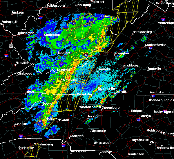 At 1026 pm edt, severe thunderstorms were located along a line extending from near union to byllesby, moving northeast at 50 mph (radar indicated). Hazards include 60 mph wind gusts. expect damage to roofs, siding, and trees At 1026 pm edt, severe thunderstorms were located along a line extending from near union to byllesby, moving northeast at 50 mph (radar indicated). Hazards include 60 mph wind gusts. expect damage to roofs, siding, and trees
|
| 4/8/2019 3:21 PM EDT |
 At 320 pm edt, severe thunderstorms were located along a line extending from near elliston-lafayette to copper valley, moving east at 40 mph (radar indicated). Hazards include 60 mph wind gusts and quarter size hail. Hail damage to vehicles is expected. Expect wind damage to roofs, siding, and trees. At 320 pm edt, severe thunderstorms were located along a line extending from near elliston-lafayette to copper valley, moving east at 40 mph (radar indicated). Hazards include 60 mph wind gusts and quarter size hail. Hail damage to vehicles is expected. Expect wind damage to roofs, siding, and trees.
|
| 4/8/2019 3:09 PM EDT |
 At 308 pm edt, severe thunderstorms were located along a line extending from prices fork to near ivanhoe, moving east at 20 mph (radar indicated). Hazards include 60 mph wind gusts and quarter size hail. Hail damage to vehicles is expected. expect wind damage to roofs, siding, and trees. locations impacted include, blacksburg, christiansburg, radford, pulaski, and dublin. This includes the following location virginia tech. At 308 pm edt, severe thunderstorms were located along a line extending from prices fork to near ivanhoe, moving east at 20 mph (radar indicated). Hazards include 60 mph wind gusts and quarter size hail. Hail damage to vehicles is expected. expect wind damage to roofs, siding, and trees. locations impacted include, blacksburg, christiansburg, radford, pulaski, and dublin. This includes the following location virginia tech.
|
| 4/8/2019 2:46 PM EDT |
 At 245 pm edt, severe thunderstorms were located along a line extending from near parrott to near cripple creek, moving east at 20 mph (radar indicated). Hazards include 60 mph wind gusts and quarter size hail. Hail damage to vehicles is expected. Expect wind damage to roofs, siding, and trees. At 245 pm edt, severe thunderstorms were located along a line extending from near parrott to near cripple creek, moving east at 20 mph (radar indicated). Hazards include 60 mph wind gusts and quarter size hail. Hail damage to vehicles is expected. Expect wind damage to roofs, siding, and trees.
|
| 8/30/2018 5:52 PM EDT |
 The severe thunderstorm warning for west central roanoke and northeastern montgomery counties will expire at 600 pm edt, the storm which prompted the warning has weakened below severe limits, and no longer poses an immediate threat to life or property. therefore, the warning will be allowed to expire. when it is safe to do so, please send your reports of hail of any size, as well as reports of any wind damage, including downed trees or large limbs, to the national weather service by calling toll free at 1, 8 6 6, 2 1 5, 4 3 2 4. reports and pictures can also be shared on the national weather service blacksburg facebook page and on twitter. The severe thunderstorm warning for west central roanoke and northeastern montgomery counties will expire at 600 pm edt, the storm which prompted the warning has weakened below severe limits, and no longer poses an immediate threat to life or property. therefore, the warning will be allowed to expire. when it is safe to do so, please send your reports of hail of any size, as well as reports of any wind damage, including downed trees or large limbs, to the national weather service by calling toll free at 1, 8 6 6, 2 1 5, 4 3 2 4. reports and pictures can also be shared on the national weather service blacksburg facebook page and on twitter.
|
| 8/30/2018 5:31 PM EDT |
 At 531 pm edt, a severe thunderstorm was located over merrimac, moving east at 5 mph (radar indicated). Hazards include 60 mph wind gusts and quarter size hail. Hail damage to vehicles is expected. expect wind damage to roofs, siding, and trees. locations impacted include, blacksburg, shawsville, mc donalds mill, elliston-lafayette, and merrimac. This includes the following location virginia tech. At 531 pm edt, a severe thunderstorm was located over merrimac, moving east at 5 mph (radar indicated). Hazards include 60 mph wind gusts and quarter size hail. Hail damage to vehicles is expected. expect wind damage to roofs, siding, and trees. locations impacted include, blacksburg, shawsville, mc donalds mill, elliston-lafayette, and merrimac. This includes the following location virginia tech.
|
| 8/30/2018 5:24 PM EDT | Large branch downed about the size of a wrist on hether drive in blacksburg. time radar estimate in montgomery county VA, 1.3 miles ENE of Blacksburg, VA |
| 8/30/2018 5:06 PM EDT |
 At 505 pm edt, a severe thunderstorm was located over blacksburg and prices fork, moving east at 15 mph (radar indicated). Hazards include 60 mph wind gusts and quarter size hail. Hail damage to vehicles is expected. Expect wind damage to roofs, siding, and trees. At 505 pm edt, a severe thunderstorm was located over blacksburg and prices fork, moving east at 15 mph (radar indicated). Hazards include 60 mph wind gusts and quarter size hail. Hail damage to vehicles is expected. Expect wind damage to roofs, siding, and trees.
|
| 8/12/2018 1:52 PM EDT |
 At 151 pm edt, a severe thunderstorm was located over shawsville, moving east at 30 mph (radar indicated. at 147 pm edt, an off duty nws employee reported large limbs down in christiansburg). Hazards include 60 mph wind gusts and quarter size hail. Hail damage to vehicles is expected. expect wind damage to roofs, siding, and trees. Locations impacted include, blacksburg, christiansburg, shawsville, elliston-lafayette, and elliston. At 151 pm edt, a severe thunderstorm was located over shawsville, moving east at 30 mph (radar indicated. at 147 pm edt, an off duty nws employee reported large limbs down in christiansburg). Hazards include 60 mph wind gusts and quarter size hail. Hail damage to vehicles is expected. expect wind damage to roofs, siding, and trees. Locations impacted include, blacksburg, christiansburg, shawsville, elliston-lafayette, and elliston.
|
| 8/12/2018 1:28 PM EDT |
 At 128 pm edt, a severe thunderstorm was located over walton, moving east at 20 mph (radar indicated). Hazards include 60 mph wind gusts and quarter size hail. Hail damage to vehicles is expected. Expect wind damage to roofs, siding, and trees. At 128 pm edt, a severe thunderstorm was located over walton, moving east at 20 mph (radar indicated). Hazards include 60 mph wind gusts and quarter size hail. Hail damage to vehicles is expected. Expect wind damage to roofs, siding, and trees.
|
| 7/30/2018 4:00 PM EDT |
 At 400 pm edt, a severe thunderstorm was located over mc coy, moving east at 15 mph (radar indicated). Hazards include 60 mph wind gusts and quarter size hail. Hail damage to vehicles is expected. expect wind damage to roofs, siding, and trees. Locations impacted include, radford, pembroke, newport, poplar hill, and prices fork. At 400 pm edt, a severe thunderstorm was located over mc coy, moving east at 15 mph (radar indicated). Hazards include 60 mph wind gusts and quarter size hail. Hail damage to vehicles is expected. expect wind damage to roofs, siding, and trees. Locations impacted include, radford, pembroke, newport, poplar hill, and prices fork.
|
| 7/30/2018 3:45 PM EDT |
 At 344 pm edt, a severe thunderstorm was located over bane, moving east at 15 mph (radar indicated). Hazards include 60 mph wind gusts and quarter size hail. Hail damage to vehicles is expected. Expect wind damage to roofs, siding, and trees. At 344 pm edt, a severe thunderstorm was located over bane, moving east at 15 mph (radar indicated). Hazards include 60 mph wind gusts and quarter size hail. Hail damage to vehicles is expected. Expect wind damage to roofs, siding, and trees.
|
| 4/15/2018 4:54 PM EDT |
 The severe thunderstorm warning for western roanoke, craig, southwestern botetourt, montgomery and southeastern monroe counties will expire at 500 pm edt, the storm which prompted the warning has weakened below severe limits, and no longer poses an immediate threat to life or property. therefore the warning will be allowed to expire. a tornado watch remains in effect until 700 pm edt for southwestern virginia. a tornado watch also remains in effect until 1100 pm edt for central, south central, southwestern and west central virginia. when it is safe to do so, please send your reports of hail of any size, as well as reports of any wind damage, including downed trees or large limbs, to the national weather service by calling toll free at 1, 8 6 6, 2 1 5, 4 3 2 4. reports and pictures can also be shared on the national weather service blacksburg facebook page and on twitter. The severe thunderstorm warning for western roanoke, craig, southwestern botetourt, montgomery and southeastern monroe counties will expire at 500 pm edt, the storm which prompted the warning has weakened below severe limits, and no longer poses an immediate threat to life or property. therefore the warning will be allowed to expire. a tornado watch remains in effect until 700 pm edt for southwestern virginia. a tornado watch also remains in effect until 1100 pm edt for central, south central, southwestern and west central virginia. when it is safe to do so, please send your reports of hail of any size, as well as reports of any wind damage, including downed trees or large limbs, to the national weather service by calling toll free at 1, 8 6 6, 2 1 5, 4 3 2 4. reports and pictures can also be shared on the national weather service blacksburg facebook page and on twitter.
|
| 4/15/2018 4:33 PM EDT |
 At 432 pm edt, a severe thunderstorm was located over sinking creek, moving north at 60 mph (radar indicated). Hazards include 60 mph wind gusts and quarter size hail. Hail damage to vehicles is expected. expect wind damage to roofs, siding, and trees. locations impacted include, blacksburg, christiansburg, troutville, new castle, and pilot. this includes the following location virginia tech. a tornado watch remains in effect until 700 pm edt for southwestern virginia. A tornado watch also remains in effect until 1100 pm edt for central, south central, southwestern and west central virginia. At 432 pm edt, a severe thunderstorm was located over sinking creek, moving north at 60 mph (radar indicated). Hazards include 60 mph wind gusts and quarter size hail. Hail damage to vehicles is expected. expect wind damage to roofs, siding, and trees. locations impacted include, blacksburg, christiansburg, troutville, new castle, and pilot. this includes the following location virginia tech. a tornado watch remains in effect until 700 pm edt for southwestern virginia. A tornado watch also remains in effect until 1100 pm edt for central, south central, southwestern and west central virginia.
|
| 4/15/2018 3:57 PM EDT |
 At 356 pm edt, a severe thunderstorm was located near copper valley, moving north at 60 mph (radar indicated). Hazards include 60 mph wind gusts and quarter size hail. Hail damage to vehicles is expected. Expect wind damage to roofs, siding, and trees. At 356 pm edt, a severe thunderstorm was located near copper valley, moving north at 60 mph (radar indicated). Hazards include 60 mph wind gusts and quarter size hail. Hail damage to vehicles is expected. Expect wind damage to roofs, siding, and trees.
|
| 10/23/2017 7:41 PM EDT |
 The severe thunderstorm warning for northeastern pulaski, giles, southwestern craig, montgomery and central monroe counties will expire at 745 pm edt, the storm which prompted the warning has moved out of the area. therefore the warning will be allowed to expire. a tornado watch remains in effect until 200 am edt for south central, southwestern and west central virginia. when it is safe to do so, please send your reports of hail of any size, as well as reports of any wind damage, including downed trees or large limbs, to the national weather service by calling toll free at 1, 8 6 6, 2 1 5, 4 3 2 4. reports and pictures can also be shared on the national weather service blacksburg facebook page and on twitter. The severe thunderstorm warning for northeastern pulaski, giles, southwestern craig, montgomery and central monroe counties will expire at 745 pm edt, the storm which prompted the warning has moved out of the area. therefore the warning will be allowed to expire. a tornado watch remains in effect until 200 am edt for south central, southwestern and west central virginia. when it is safe to do so, please send your reports of hail of any size, as well as reports of any wind damage, including downed trees or large limbs, to the national weather service by calling toll free at 1, 8 6 6, 2 1 5, 4 3 2 4. reports and pictures can also be shared on the national weather service blacksburg facebook page and on twitter.
|
| 10/23/2017 6:42 PM EDT |
 At 642 pm edt, a severe thunderstorm was located over parrott, moving northeast at 20 mph (radar indicated). Hazards include 60 mph wind gusts and quarter size hail. Hail damage to vehicles is expected. Expect wind damage to roofs, siding, and trees. At 642 pm edt, a severe thunderstorm was located over parrott, moving northeast at 20 mph (radar indicated). Hazards include 60 mph wind gusts and quarter size hail. Hail damage to vehicles is expected. Expect wind damage to roofs, siding, and trees.
|
| 10/23/2017 6:38 PM EDT | Strong thunderstorm winds produced damage to structures and trees outside of the community of mcco in montgomery county VA, 8.9 miles E of Blacksburg, VA |
| 6/15/2017 5:37 PM EDT | Trained spotter reports several small limbs and other debris down along catawba road in montgomery county VA, 5.9 miles WSW of Blacksburg, VA |
| 6/15/2017 5:21 PM EDT |
 At 521 pm edt, a severe thunderstorm was located over christiansburg, moving east at 20 mph (radar indicated). Hazards include 60 mph wind gusts and quarter size hail. Hail damage to vehicles is expected. Expect wind damage to roofs, siding, and trees. At 521 pm edt, a severe thunderstorm was located over christiansburg, moving east at 20 mph (radar indicated). Hazards include 60 mph wind gusts and quarter size hail. Hail damage to vehicles is expected. Expect wind damage to roofs, siding, and trees.
|
| 6/13/2017 2:09 PM EDT |
 The severe thunderstorm warning for southwestern roanoke, northeastern floyd and southeastern montgomery counties will expire at 215 pm edt, the storm which prompted the warning has weakened below severe limits, and has exited the warned area. therefore, the warning will be allowed to expire. however gusty winds and heavy rain are still possible with this thunderstorm. when it is safe to do so, please send your reports of hail of any size, as well as reports of any wind damage, including downed trees or large limbs, to the national weather service by calling toll free at 1, 8 6 6, 2 1 5, 4 3 2 4. reports and pictures can also be shared on the national weather service blacksburg facebook page and on twitter. The severe thunderstorm warning for southwestern roanoke, northeastern floyd and southeastern montgomery counties will expire at 215 pm edt, the storm which prompted the warning has weakened below severe limits, and has exited the warned area. therefore, the warning will be allowed to expire. however gusty winds and heavy rain are still possible with this thunderstorm. when it is safe to do so, please send your reports of hail of any size, as well as reports of any wind damage, including downed trees or large limbs, to the national weather service by calling toll free at 1, 8 6 6, 2 1 5, 4 3 2 4. reports and pictures can also be shared on the national weather service blacksburg facebook page and on twitter.
|
| 6/13/2017 1:54 PM EDT |
 At 154 pm edt, a severe thunderstorm was located near christiansburg, moving east at 15 mph (radar indicated). Hazards include 60 mph wind gusts and quarter size hail. Hail damage to vehicles is expected. expect wind damage to roofs, siding, and trees. Locations impacted include, christiansburg, pilot, shawsville, terrys fork, and check. At 154 pm edt, a severe thunderstorm was located near christiansburg, moving east at 15 mph (radar indicated). Hazards include 60 mph wind gusts and quarter size hail. Hail damage to vehicles is expected. expect wind damage to roofs, siding, and trees. Locations impacted include, christiansburg, pilot, shawsville, terrys fork, and check.
|
| 6/13/2017 1:31 PM EDT |
 At 131 pm edt, a severe thunderstorm was located over radford, moving east at 15 mph (radar indicated). Hazards include 60 mph wind gusts and quarter size hail. Hail damage to vehicles is expected. Expect wind damage to roofs, siding, and trees. At 131 pm edt, a severe thunderstorm was located over radford, moving east at 15 mph (radar indicated). Hazards include 60 mph wind gusts and quarter size hail. Hail damage to vehicles is expected. Expect wind damage to roofs, siding, and trees.
|
| 5/20/2017 4:06 PM EDT | Quarter sized hail reported 10 miles SSW of Blacksburg, VA, relayed from a trained spotter. |
| 3/1/2017 12:22 PM EST |
 The severe thunderstorm warning for northwestern roanoke, southeastern craig, western botetourt and northeastern montgomery counties will expire at 1230 pm est, the storms which prompted the warning have moved out of the warned area. therefore, the warning will be allowed to expire. however heavy rain is still possible with these thunderstorms. a severe thunderstorm watch remains in effect until 500 pm est for central, south central, southwestern and west central virginia, and southeastern west virginia. when it is safe to do so, please send your reports of hail of any size, as well as reports of any wind damage, including downed trees or large limbs, to the national weather service by calling toll free at 1, 8 6 6, 2 1 5, 4 3 2 4. reports and pictures can also be shared on the national weather service blacksburg facebook page and on twitter. The severe thunderstorm warning for northwestern roanoke, southeastern craig, western botetourt and northeastern montgomery counties will expire at 1230 pm est, the storms which prompted the warning have moved out of the warned area. therefore, the warning will be allowed to expire. however heavy rain is still possible with these thunderstorms. a severe thunderstorm watch remains in effect until 500 pm est for central, south central, southwestern and west central virginia, and southeastern west virginia. when it is safe to do so, please send your reports of hail of any size, as well as reports of any wind damage, including downed trees or large limbs, to the national weather service by calling toll free at 1, 8 6 6, 2 1 5, 4 3 2 4. reports and pictures can also be shared on the national weather service blacksburg facebook page and on twitter.
|
| 3/1/2017 12:10 PM EST | Tree down on road at tall oaks lane... foxridge. reported on twitte in montgomery county VA, 0.6 miles W of Blacksburg, VA |
| 3/1/2017 12:06 PM EST |
 At 1206 pm est, severe thunderstorms were located along a line extending from near fincastle to near new castle to near glenvar, moving east at 60 mph (radar indicated). Hazards include 60 mph wind gusts. Expect damage to roofs, siding, and trees. Locations impacted include, salem, catawba, eagle rock, shawsville, and fincastle. At 1206 pm est, severe thunderstorms were located along a line extending from near fincastle to near new castle to near glenvar, moving east at 60 mph (radar indicated). Hazards include 60 mph wind gusts. Expect damage to roofs, siding, and trees. Locations impacted include, salem, catawba, eagle rock, shawsville, and fincastle.
|
| 3/1/2017 12:00 PM EST | Pine tree down in hethwood area in montgomery county VA, 1.3 miles ENE of Blacksburg, VA |
| 3/1/2017 12:00 PM EST |
 At 1159 am est, severe thunderstorms were located along a line extending from abbott to near christiansburg to graysontown, moving east at 60 mph (radar indicated). Hazards include 60 mph wind gusts. expect damage to roofs, siding, and trees At 1159 am est, severe thunderstorms were located along a line extending from abbott to near christiansburg to graysontown, moving east at 60 mph (radar indicated). Hazards include 60 mph wind gusts. expect damage to roofs, siding, and trees
|
| 3/1/2017 11:55 AM EST | Tree aproximately 8-10 inch diameter snapped off mid-trun in montgomery county VA, 2.7 miles WSW of Blacksburg, VA |
| 3/1/2017 11:42 AM EST |
 At 1142 am est, severe thunderstorms were located along a line extending from paint bank to near waiteville to mountain lake, moving east at 65 mph (radar indicated). Hazards include 60 mph wind gusts. expect damage to roofs, siding, and trees At 1142 am est, severe thunderstorms were located along a line extending from paint bank to near waiteville to mountain lake, moving east at 65 mph (radar indicated). Hazards include 60 mph wind gusts. expect damage to roofs, siding, and trees
|
| 9/28/2016 4:18 PM EDT | Quarter sized hail reported 1.5 miles SSW of Blacksburg, VA |
| 9/28/2016 3:40 PM EDT | Quarter sized hail reported 2.2 miles SSW of Blacksburg, VA, dented cars |
| 9/28/2016 3:40 PM EDT | Quarter sized hail reported 0.9 miles SW of Blacksburg, VA, lasted 3-4 minutes |
| 9/28/2016 3:35 PM EDT | Quarter sized hail reported 0.6 miles W of Blacksburg, VA, largest hail fell 335pm to 340pm |
| 9/28/2016 3:35 PM EDT |
 At 334 pm edt, a severe thunderstorm was located over blacksburg, moving east at 20 mph (radar indicated). Hazards include 60 mph wind gusts and half dollar size hail. Hail damage to vehicles is expected. Expect wind damage to roofs, siding, and trees. At 334 pm edt, a severe thunderstorm was located over blacksburg, moving east at 20 mph (radar indicated). Hazards include 60 mph wind gusts and half dollar size hail. Hail damage to vehicles is expected. Expect wind damage to roofs, siding, and trees.
|
| 9/28/2016 3:00 PM EDT | Quarter sized hail reported 2.2 miles SSW of Blacksburg, VA, dented cars |
| 7/28/2016 9:29 PM EDT |
 At 929 pm edt, severe thunderstorms were located along a line extending from near paint bank to near mc donalds mill to near christiansburg, moving east at 35 mph (radar indicated). Hazards include 60 mph wind gusts. Expect damage to roofs. siding. and trees. locations impacted include, roanoke, blacksburg, salem, christiansburg, and vinton. This includes the following locations virginia tech, the salem fairgrounds, and roanoke regional airport. At 929 pm edt, severe thunderstorms were located along a line extending from near paint bank to near mc donalds mill to near christiansburg, moving east at 35 mph (radar indicated). Hazards include 60 mph wind gusts. Expect damage to roofs. siding. and trees. locations impacted include, roanoke, blacksburg, salem, christiansburg, and vinton. This includes the following locations virginia tech, the salem fairgrounds, and roanoke regional airport.
|
| 7/28/2016 9:19 PM EDT |
 At 919 pm edt, severe thunderstorms were located along a line extending from moncove lake state park to near blacksburg to near walton, moving east at 35 mph (radar indicated). Hazards include 60 mph wind gusts. Expect damage to roofs. siding. And trees. At 919 pm edt, severe thunderstorms were located along a line extending from moncove lake state park to near blacksburg to near walton, moving east at 35 mph (radar indicated). Hazards include 60 mph wind gusts. Expect damage to roofs. siding. And trees.
|
| 7/8/2016 4:41 PM EDT | One tree down near the intersection of prices fork road and merrimac road in montgomery county VA, 2.3 miles ENE of Blacksburg, VA |
| 7/4/2016 10:02 PM EDT |
 At 1002 pm edt, severe thunderstorms were located along a line extending from near sinking creek to near walton to near pulaski, moving east at 40 mph (radar indicated). Hazards include 60 mph wind gusts. Expect damage to roofs. siding. and trees. Locations impacted include, blacksburg, christiansburg, radford, shawsville, and pilot. At 1002 pm edt, severe thunderstorms were located along a line extending from near sinking creek to near walton to near pulaski, moving east at 40 mph (radar indicated). Hazards include 60 mph wind gusts. Expect damage to roofs. siding. and trees. Locations impacted include, blacksburg, christiansburg, radford, shawsville, and pilot.
|
| 7/4/2016 9:51 PM EDT |
 At 950 pm edt, severe thunderstorms were located along a line extending from huffman to near fairlawn to near gunton park, moving east at 40 mph (radar indicated). Hazards include 60 mph wind gusts. Expect damage to roofs. siding. and trees. locations impacted include, blacksburg, christiansburg, radford, shawsville, and pilot. This includes virginia tech. At 950 pm edt, severe thunderstorms were located along a line extending from huffman to near fairlawn to near gunton park, moving east at 40 mph (radar indicated). Hazards include 60 mph wind gusts. Expect damage to roofs. siding. and trees. locations impacted include, blacksburg, christiansburg, radford, shawsville, and pilot. This includes virginia tech.
|
| 7/4/2016 9:45 PM EDT |
 At 944 pm edt, severe thunderstorms were located along a line extending from near huffman to near parrott to near long spur, moving east at 40 mph (radar indicated). Hazards include 60 mph wind gusts. Expect damage to roofs. siding. and trees. locations impacted include, blacksburg, christiansburg, radford, shawsville, and catawba. This includes virginia tech. At 944 pm edt, severe thunderstorms were located along a line extending from near huffman to near parrott to near long spur, moving east at 40 mph (radar indicated). Hazards include 60 mph wind gusts. Expect damage to roofs. siding. and trees. locations impacted include, blacksburg, christiansburg, radford, shawsville, and catawba. This includes virginia tech.
|
| 7/4/2016 9:36 PM EDT |
 At 935 pm edt, severe thunderstorms were located along a line extending from mountain lake to near poplar hill to near long spur, moving east at 40 mph (radar indicated). Hazards include 60 mph wind gusts. Expect damage to roofs. siding. And trees. At 935 pm edt, severe thunderstorms were located along a line extending from mountain lake to near poplar hill to near long spur, moving east at 40 mph (radar indicated). Hazards include 60 mph wind gusts. Expect damage to roofs. siding. And trees.
|
| 6/23/2016 8:48 PM EDT |
 At 848 pm edt, severe thunderstorms were located along a line extending from near christiansburg to copper valley to near max meadows, moving east at 65 mph (radar indicated). Hazards include 60 mph wind gusts. Expect damage to roofs. siding. and trees. Locations impacted include, christiansburg, radford, pulaski, wytheville, and bland. At 848 pm edt, severe thunderstorms were located along a line extending from near christiansburg to copper valley to near max meadows, moving east at 65 mph (radar indicated). Hazards include 60 mph wind gusts. Expect damage to roofs. siding. and trees. Locations impacted include, christiansburg, radford, pulaski, wytheville, and bland.
|
| 6/23/2016 8:35 PM EDT |
 At 834 pm edt, severe thunderstorms were located along a line extending from near fairlawn to draper to near favonia, moving southeast at 45 mph (radar indicated). Hazards include 60 mph wind gusts. Expect damage to roofs. siding. and trees. Locations impacted include, blacksburg, christiansburg, radford, pulaski, and wytheville. At 834 pm edt, severe thunderstorms were located along a line extending from near fairlawn to draper to near favonia, moving southeast at 45 mph (radar indicated). Hazards include 60 mph wind gusts. Expect damage to roofs. siding. and trees. Locations impacted include, blacksburg, christiansburg, radford, pulaski, and wytheville.
|
| 6/23/2016 8:12 PM EDT |
 At 812 pm edt, severe thunderstorms were located along a line extending from narrows to mechanicsburg to gratton, moving southeast at 45 mph (radar indicated). Hazards include 60 mph wind gusts. Expect damage to roofs. siding. And trees. At 812 pm edt, severe thunderstorms were located along a line extending from narrows to mechanicsburg to gratton, moving southeast at 45 mph (radar indicated). Hazards include 60 mph wind gusts. Expect damage to roofs. siding. And trees.
|
| 6/23/2016 7:59 PM EDT |
 At 758 pm edt, severe thunderstorms were located along a line extending from near abbott to near huffman to near bane, moving southeast at 45 mph. other severe thunderstorms will be entering the warning area from near the princeton region (radar indicated). Hazards include 60 mph wind gusts. Expect damage to roofs. siding. and trees. locations impacted include, blacksburg, christiansburg, radford, pearisburg, and narrows. This includes virginia tech. At 758 pm edt, severe thunderstorms were located along a line extending from near abbott to near huffman to near bane, moving southeast at 45 mph. other severe thunderstorms will be entering the warning area from near the princeton region (radar indicated). Hazards include 60 mph wind gusts. Expect damage to roofs. siding. and trees. locations impacted include, blacksburg, christiansburg, radford, pearisburg, and narrows. This includes virginia tech.
|
| 6/23/2016 7:30 PM EDT |
 At 730 pm edt, severe thunderstorms were located along a line extending from near wayside to near peterstown to near athens, moving southeast at 45 mph (radar indicated). Hazards include 60 mph wind gusts. Expect damage to roofs. siding. And trees. At 730 pm edt, severe thunderstorms were located along a line extending from near wayside to near peterstown to near athens, moving southeast at 45 mph (radar indicated). Hazards include 60 mph wind gusts. Expect damage to roofs. siding. And trees.
|
| 6/23/2016 9:38 AM EDT |
 At 938 am edt, severe thunderstorms were located along a line extending from copper hill to copper valley, moving south at 30 mph (radar indicated). Hazards include 60 mph wind gusts. Expect damage to roofs. siding. and trees. locations impacted include, blacksburg, christiansburg, radford, shawsville, and pilot. This includes virginia tech. At 938 am edt, severe thunderstorms were located along a line extending from copper hill to copper valley, moving south at 30 mph (radar indicated). Hazards include 60 mph wind gusts. Expect damage to roofs. siding. and trees. locations impacted include, blacksburg, christiansburg, radford, shawsville, and pilot. This includes virginia tech.
|
| 6/23/2016 9:21 AM EDT |
 At 921 am edt, severe thunderstorms were located along a line extending from near shawsville to white gate, moving southeast at 40 mph (radar indicated). Hazards include 60 mph wind gusts. Expect damage to roofs. siding. and trees. locations impacted include, blacksburg, christiansburg, radford, pearisburg, and narrows. This includes virginia tech. At 921 am edt, severe thunderstorms were located along a line extending from near shawsville to white gate, moving southeast at 40 mph (radar indicated). Hazards include 60 mph wind gusts. Expect damage to roofs. siding. and trees. locations impacted include, blacksburg, christiansburg, radford, pearisburg, and narrows. This includes virginia tech.
|
| 6/23/2016 9:10 AM EDT | Large tree down. broke an antenn in montgomery county VA, 3.5 miles S of Blacksburg, VA |
| 6/23/2016 8:57 AM EDT |
 At 857 am edt, severe thunderstorms were located along a line extending from huffman to near chapel, moving south at 60 mph (radar indicated). Hazards include 60 mph wind gusts. Expect damage to roofs. siding. And trees. At 857 am edt, severe thunderstorms were located along a line extending from huffman to near chapel, moving south at 60 mph (radar indicated). Hazards include 60 mph wind gusts. Expect damage to roofs. siding. And trees.
|
| 6/16/2016 9:48 PM EDT |
 At 948 pm edt, severe thunderstorms were located along a line extending from near vinton to near bent mountain to near childress, moving southeast at 40 mph (radar indicated). Hazards include 60 mph wind gusts and quarter size hail. Hail damage to vehicles is expected. Expect wind damage to roofs, siding, and trees. At 948 pm edt, severe thunderstorms were located along a line extending from near vinton to near bent mountain to near childress, moving southeast at 40 mph (radar indicated). Hazards include 60 mph wind gusts and quarter size hail. Hail damage to vehicles is expected. Expect wind damage to roofs, siding, and trees.
|
| 2/24/2016 1:15 PM EST | Tree down on prices fork road near mccoy rd in montgomery county VA, 4.1 miles ENE of Blacksburg, VA |
| 2/24/2016 1:14 PM EST |
 At 114 pm est, severe thunderstorms were located along a line extending from glenvar to near endicott, moving east at 50 mph (radar indicated). Hazards include 60 mph wind gusts and quarter size hail. Hail damage to vehicles is expected. expect wind damage to roofs, siding, and trees. locations impacted include, blacksburg, salem, christiansburg, shawsville, and pilot. this includes virginia tech. A tornado watch remains in effect until 700 pm est for north central north carolina. At 114 pm est, severe thunderstorms were located along a line extending from glenvar to near endicott, moving east at 50 mph (radar indicated). Hazards include 60 mph wind gusts and quarter size hail. Hail damage to vehicles is expected. expect wind damage to roofs, siding, and trees. locations impacted include, blacksburg, salem, christiansburg, shawsville, and pilot. this includes virginia tech. A tornado watch remains in effect until 700 pm est for north central north carolina.
|
| 2/24/2016 12:57 PM EST |
 At 1257 pm est, severe thunderstorms were located along a line extending from prices fork to laurel fork, moving east at 15 mph (radar indicated). Hazards include 60 mph wind gusts and quarter size hail. Hail damage to vehicles is expected. Expect wind damage to roofs, siding, and trees. At 1257 pm est, severe thunderstorms were located along a line extending from prices fork to laurel fork, moving east at 15 mph (radar indicated). Hazards include 60 mph wind gusts and quarter size hail. Hail damage to vehicles is expected. Expect wind damage to roofs, siding, and trees.
|
| 7/13/2015 7:09 PM EDT |
 At 708 pm edt, severe thunderstorms were located along a line extending from near marlinton to near draper, moving east at 70 mph (radar indicated). Hazards include 60 mph wind gusts. Expect damage to roofs. Siding and trees. At 708 pm edt, severe thunderstorms were located along a line extending from near marlinton to near draper, moving east at 70 mph (radar indicated). Hazards include 60 mph wind gusts. Expect damage to roofs. Siding and trees.
|
| 6/30/2015 10:22 PM EDT |
 At 1021 pm edt, severe thunderstorms were located along a line extending from near paint bank to near simmonsville to near blacksburg, moving east at 40 mph (radar indicated). Hazards include 60 mph wind gusts and quarter size hail. Hail damage to vehicles is expected. Expect wind damage to roofs, siding and trees. At 1021 pm edt, severe thunderstorms were located along a line extending from near paint bank to near simmonsville to near blacksburg, moving east at 40 mph (radar indicated). Hazards include 60 mph wind gusts and quarter size hail. Hail damage to vehicles is expected. Expect wind damage to roofs, siding and trees.
|
| 6/21/2015 6:08 PM EDT |
 The severe thunderstorm warning for pulaski, northern floyd and southern montgomery counties and the city of radford will expire at 615 pm edt, the storm which prompted the warning has weakened below severe limits, and has exited the warned area. therefore the warning will be allowed to expire. a severe thunderstorm watch remains in effect until 800 pm edt for southwestern virginia and southeastern west virginia. when it is safe to do so, please send your reports of hail of any size, as well as any reports of wind damage, including downed trees or large limbs, to the national weather service by calling toll free at 1, 8 6 6, 2 1 5, 4 3 2 4. reports and pictures can also be shared on the national weather service blacksburg facebook page and on twitter. The severe thunderstorm warning for pulaski, northern floyd and southern montgomery counties and the city of radford will expire at 615 pm edt, the storm which prompted the warning has weakened below severe limits, and has exited the warned area. therefore the warning will be allowed to expire. a severe thunderstorm watch remains in effect until 800 pm edt for southwestern virginia and southeastern west virginia. when it is safe to do so, please send your reports of hail of any size, as well as any reports of wind damage, including downed trees or large limbs, to the national weather service by calling toll free at 1, 8 6 6, 2 1 5, 4 3 2 4. reports and pictures can also be shared on the national weather service blacksburg facebook page and on twitter.
|
| 6/21/2015 6:07 PM EDT |
 The severe thunderstorm warning for roanoke, east central giles, northwestern franklin and central montgomery counties, the city of salem and the city of roanoke will expire at 615 pm edt, the storm which prompted the warning has moved out of the area. therefore the warning will be allowed to expire. a severe thunderstorm watch remains in effect until 800 pm edt for southwestern virginia and southeastern west virginia. when it is safe to do so, please send your reports of hail of any size, as well as any reports of wind damage, including downed trees or large limbs, to the national weather service by calling toll free at 1, 8 6 6, 2 1 5, 4 3 2 4. reports and pictures can also be shared on the national weather service blacksburg facebook page and on twitter. The severe thunderstorm warning for roanoke, east central giles, northwestern franklin and central montgomery counties, the city of salem and the city of roanoke will expire at 615 pm edt, the storm which prompted the warning has moved out of the area. therefore the warning will be allowed to expire. a severe thunderstorm watch remains in effect until 800 pm edt for southwestern virginia and southeastern west virginia. when it is safe to do so, please send your reports of hail of any size, as well as any reports of wind damage, including downed trees or large limbs, to the national weather service by calling toll free at 1, 8 6 6, 2 1 5, 4 3 2 4. reports and pictures can also be shared on the national weather service blacksburg facebook page and on twitter.
|
| 6/21/2015 5:59 PM EDT |
 At 558 pm edt, a severe thunderstorm was located over crockett springs, moving east at 25 mph (radar indicated). Hazards include 60 mph wind gusts and quarter size hail. Hail damage to vehicles is expected. expect wind damage to roofs, siding and trees. Locations impacted include, blacksburg, christiansburg, radford, pulaski, and dublin. At 558 pm edt, a severe thunderstorm was located over crockett springs, moving east at 25 mph (radar indicated). Hazards include 60 mph wind gusts and quarter size hail. Hail damage to vehicles is expected. expect wind damage to roofs, siding and trees. Locations impacted include, blacksburg, christiansburg, radford, pulaski, and dublin.
|
| 6/21/2015 5:48 PM EDT |
 At 548 pm edt, a severe thunderstorm was located over christiansburg, moving east at 40 mph (radar indicated). Hazards include 60 mph wind gusts and quarter size hail. Hail damage to vehicles is expected. expect wind damage to roofs, siding and trees. Locations impacted include, blacksburg, christiansburg, radford, pulaski, and dublin. At 548 pm edt, a severe thunderstorm was located over christiansburg, moving east at 40 mph (radar indicated). Hazards include 60 mph wind gusts and quarter size hail. Hail damage to vehicles is expected. expect wind damage to roofs, siding and trees. Locations impacted include, blacksburg, christiansburg, radford, pulaski, and dublin.
|
| 6/21/2015 5:37 PM EDT |
 At 536 pm edt, a severe thunderstorm was located over salem, moving east at 25 mph (radar indicated). Hazards include 60 mph wind gusts and quarter size hail. Hail damage to vehicles is expected. expect wind damage to roofs, siding and trees. locations impacted include, roanoke, blacksburg, salem, christiansburg, and vinton. This includes the following locations virginia tech, the salem fairgrounds, and roanoke regional airport. At 536 pm edt, a severe thunderstorm was located over salem, moving east at 25 mph (radar indicated). Hazards include 60 mph wind gusts and quarter size hail. Hail damage to vehicles is expected. expect wind damage to roofs, siding and trees. locations impacted include, roanoke, blacksburg, salem, christiansburg, and vinton. This includes the following locations virginia tech, the salem fairgrounds, and roanoke regional airport.
|
| 6/21/2015 5:21 PM EDT |
 At 520 pm edt, a severe thunderstorm was located near dublin, moving east at 25 mph (radar indicated). Hazards include 60 mph wind gusts and quarter size hail. Hail damage to vehicles is expected. Expect wind damage to roofs, siding and trees. At 520 pm edt, a severe thunderstorm was located near dublin, moving east at 25 mph (radar indicated). Hazards include 60 mph wind gusts and quarter size hail. Hail damage to vehicles is expected. Expect wind damage to roofs, siding and trees.
|
| 6/21/2015 5:14 PM EDT |
 At 514 pm edt, a severe thunderstorm was located over bradshaw, moving east at 25 mph (radar indicated). Hazards include 60 mph wind gusts and quarter size hail. Hail damage to vehicles is expected. Expect wind damage to roofs, siding and trees. At 514 pm edt, a severe thunderstorm was located over bradshaw, moving east at 25 mph (radar indicated). Hazards include 60 mph wind gusts and quarter size hail. Hail damage to vehicles is expected. Expect wind damage to roofs, siding and trees.
|
| 6/21/2015 4:45 PM EDT | Tree down on clover hollow rd in giles county VA, 7.3 miles SSE of Blacksburg, VA |
| 6/21/2015 4:43 PM EDT | Tree down on givens lane in giles county VA, 6.8 miles SSE of Blacksburg, VA |
| 7/7/2013 3:19 PM EDT | *** 1 inj *** several trees down along summit lane in newport. one tree fell on a in giles county VA, 6.2 miles SE of Blacksburg, VA |
| 7/7/2013 3:19 PM EDT | Couple trees down in newport va with one tree down on a hous in giles county VA, 6.2 miles SE of Blacksburg, VA |
| 6/19/2013 5:23 PM EDT | Quarter sized hail reported 0.9 miles SE of Blacksburg, VA, along hwy 460 near glades road. |
| 6/13/2013 2:15 PM EDT | Trees down at drill field drive near the chapel on virginia tech campus in montgomery county VA, 0.6 miles W of Blacksburg, VA |
| 6/13/2013 2:08 PM EDT | Tree down on happy hollow rd in montgomery county VA, 0.6 miles W of Blacksburg, VA |
| 5/22/2013 3:27 PM EDT | Quarter sized hail reported 10.9 miles SSW of Blacksburg, VA |
| 5/22/2013 3:15 PM EDT | Quarter sized hail reported 6.6 miles SW of Blacksburg, VA |
| 1/30/2013 4:03 PM EST | 5 inch diameter tree limbs down on virginia tech golf course near prices fork roa in montgomery county VA, 0.7 miles S of Blacksburg, VA |
| 7/31/2012 10:47 PM EDT | A tree was blown down at the intersection of heather drive and tall oaks driv in montgomery county VA, 1.3 miles ENE of Blacksburg, VA |
| 7/31/2012 10:40 PM EDT | Several trees down off route 460 in jefferson national forest. numerous large tree limbs also dow in montgomery county VA, 4.7 miles SSE of Blacksburg, VA |
| 7/2/2012 12:26 AM EDT | Tree down at foxridge apartment in montgomery county VA, 1.3 miles ENE of Blacksburg, VA |
| 7/2/2012 12:25 AM EDT | Tree blocking research center drive at route 460 in montgomery county VA, 3.2 miles NNW of Blacksburg, VA |
| 7/2/2012 12:24 AM EDT | Storm damage reported in montgomery county VA, 1.7 miles NW of Blacksburg, VA |
| 7/2/2012 12:22 AM EDT | A large tree was blown down on broce driv in montgomery county VA, 0.7 miles S of Blacksburg, VA |
| 7/2/2012 12:20 AM EDT | Large tree snapped in hal in montgomery county VA, 1.4 miles S of Blacksburg, VA |
| 7/2/2012 12:20 AM EDT | Three trees down on westover drive in montgomery county VA, 1.3 miles SE of Blacksburg, VA |
| 6/29/2012 9:15 PM EDT | 3 trailers destroyed on pandapas pond roa in montgomery county VA, 3.5 miles S of Blacksburg, VA |
| 6/29/2012 9:10 PM EDT | Large limbs down in the north side of tow in montgomery county VA, 0.6 miles W of Blacksburg, VA |
| 6/29/2012 9:00 PM EDT | 20 inch diameter tree uprooted in montgomery county VA, 2.7 miles SW of Blacksburg, VA |
| 6/29/2012 9:00 PM EDT | Several trees snapped off 20-30 feet above the groun in montgomery county VA, 3.5 miles SW of Blacksburg, VA |
| 6/29/2012 8:55 PM EDT | Two trees blown down on eakin street southeas in montgomery county VA, 1.1 miles W of Blacksburg, VA |
| 6/29/2012 8:55 PM EDT | A large tree was blown down onto a house on broce driv in montgomery county VA, 0.7 miles S of Blacksburg, VA |
| 6/29/2012 8:55 PM EDT | Tree down on cambridge roa in montgomery county VA, 1.3 miles ENE of Blacksburg, VA |
| 6/29/2012 8:55 PM EDT | Several trees down in montgomery county VA, 3.9 miles SSW of Blacksburg, VA |
| 6/29/2012 8:54 PM EDT | Six or seven trees blown down blocking mt. tabor roa in montgomery county VA, 5.4 miles SW of Blacksburg, VA |
| 6/29/2012 8:53 PM EDT | Several trees down on high meadow drive. one tree fell on...and damaged...a vehicl in montgomery county VA, 4 miles WSW of Blacksburg, VA |
| 6/29/2012 8:52 PM EDT | A tree was blown down onto a ca in montgomery county VA, 2.7 miles SW of Blacksburg, VA |
| 6/29/2012 8:50 PM EDT | At least a dozen large trees and hundreds of medium to large size limbs down along pearman road in preston forest...especially at elevations above 2200 f in montgomery county VA, 6.5 miles SSW of Blacksburg, VA |
| 6/1/2012 4:45 PM EDT | Two large trees were blown down at 3866 south main stree in montgomery county VA, 2.9 miles NNW of Blacksburg, VA |
| 5/21/2012 5:20 PM EDT | Quarter sized hail reported 7.7 miles SSW of Blacksburg, VA, craig creek road |
| 1/1/0001 12:00 AM | Tree fell on trailor home in montgomery county VA, 0.6 miles W of Blacksburg, VA |
| 1/1/0001 12:00 AM | Half Dollar sized hail reported 2.3 miles WNW of Blacksburg, VA, on highand circle in southeast part of blacksburg |
| 1/1/0001 12:00 AM | Half Dollar sized hail reported 2.3 miles NNW of Blacksburg, VA, at nws blacksburg office |
| 1/1/0001 12:00 AM | Quarter sized hail reported 4.4 miles E of Blacksburg, VA, located on keisters branch road |
| 1/1/0001 12:00 AM | Quarter sized hail reported 7.3 miles E of Blacksburg, VA |
| 1/1/0001 12:00 AM | Quarter sized hail reported 0.6 miles W of Blacksburg, VA |
| 1/1/0001 12:00 AM | Quarter sized hail reported 5.2 miles SE of Blacksburg, VA |
Hail Maps for Blacksburg, VA


Connect with Interactive Hail Maps