

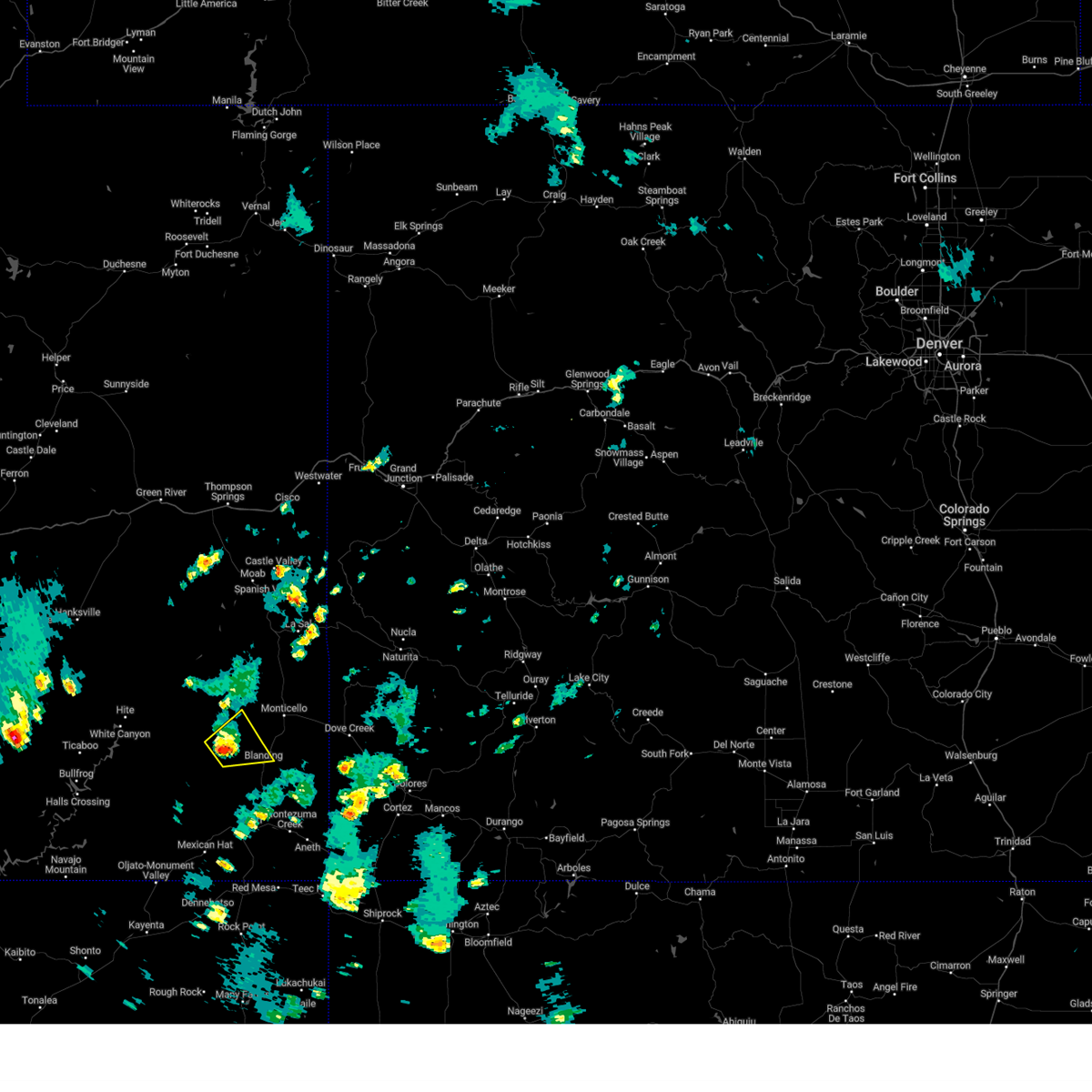
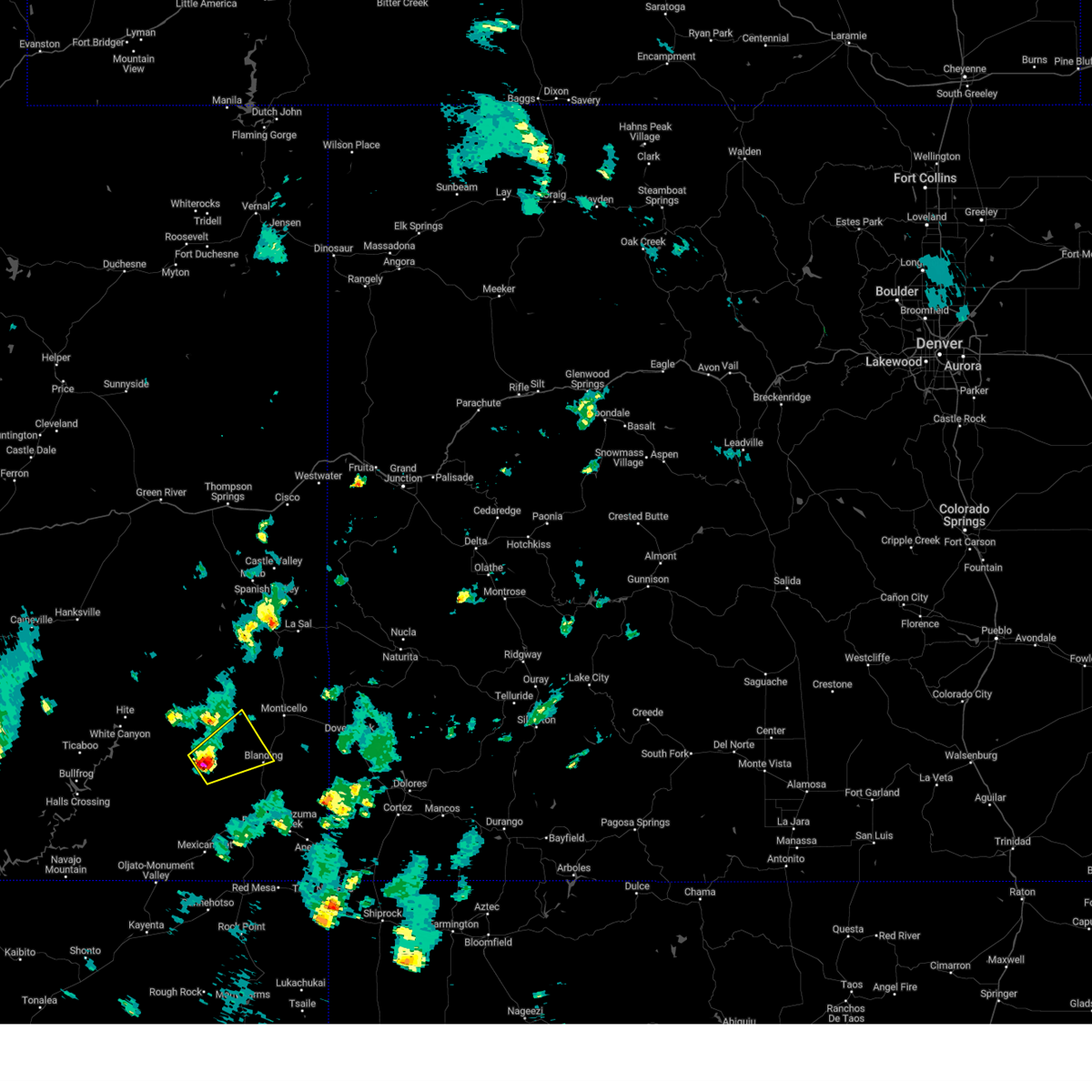
Hail Map for Blanding, UT
The Blanding, UT area has had 8 reports of on-the-ground hail by trained spotters, and has been under severe weather warnings 2 times during the past 12 months. Doppler radar has detected hail at or near Blanding, UT on 8 occasions.
| Name: | Blanding, UT |
| Where Located: | 93.8 miles NW of Farmington, NM |
| Map: | Google Map for Blanding, UT |
| Population: | 3375 |
| Housing Units: | 1110 |
| More Info: | Search Google for Blanding, UT |
0
The Top Recent Hail Date for Blanding, UT is Thursday, June 27, 2024 (5th out of 8)

Hail and Wind Damage Spotted near Blanding, UT
| Date / Time | Report Details |
|---|---|
| 8/23/2024 3:43 PM MDT |
 At 343 pm mdt, a severe thunderstorm was located 14 miles northwest of blanding, moving northeast at 30 mph (radar indicated). Hazards include 60 mph wind gusts and quarter size hail. Hail damage to vehicles is expected. expect wind damage to roofs, siding, and trees. Locations impacted include, blanding. At 343 pm mdt, a severe thunderstorm was located 14 miles northwest of blanding, moving northeast at 30 mph (radar indicated). Hazards include 60 mph wind gusts and quarter size hail. Hail damage to vehicles is expected. expect wind damage to roofs, siding, and trees. Locations impacted include, blanding.
|
| 8/23/2024 3:26 PM MDT |
 Svrgjt the national weather service in grand junction has issued a * severe thunderstorm warning for, east central san juan county in southeastern utah, * until 400 pm mdt. * at 326 pm mdt, a severe thunderstorm was located 17 miles east of fry canyon, or 19 miles west of blanding, moving northeast at 30 mph (radar indicated). Hazards include 60 mph wind gusts and quarter size hail. Hail damage to vehicles is expected. Expect wind damage to roofs, siding, and trees. Svrgjt the national weather service in grand junction has issued a * severe thunderstorm warning for, east central san juan county in southeastern utah, * until 400 pm mdt. * at 326 pm mdt, a severe thunderstorm was located 17 miles east of fry canyon, or 19 miles west of blanding, moving northeast at 30 mph (radar indicated). Hazards include 60 mph wind gusts and quarter size hail. Hail damage to vehicles is expected. Expect wind damage to roofs, siding, and trees.
|
| 6/27/2024 4:42 PM MDT |
 Svrgjt the national weather service in grand junction has issued a * severe thunderstorm warning for, east central san juan county in southeastern utah, * until 515 pm mdt. * at 442 pm mdt, a severe thunderstorm was located 8 miles east of blanding, moving northeast at 30 mph (radar indicated). Hazards include 70 mph wind gusts and half dollar size hail. Hail damage to vehicles is expected. expect considerable tree damage. Wind damage is also likely to mobile homes, roofs, and outbuildings. Svrgjt the national weather service in grand junction has issued a * severe thunderstorm warning for, east central san juan county in southeastern utah, * until 515 pm mdt. * at 442 pm mdt, a severe thunderstorm was located 8 miles east of blanding, moving northeast at 30 mph (radar indicated). Hazards include 70 mph wind gusts and half dollar size hail. Hail damage to vehicles is expected. expect considerable tree damage. Wind damage is also likely to mobile homes, roofs, and outbuildings.
|
| 6/27/2024 4:35 PM MDT | Awos station kbdg blandin in san juan county UT, 3 miles NNW of Blanding, UT |
| 6/21/2024 5:15 PM MDT |
 The severe thunderstorm which prompted the warning has weakened. therefore, the warning has been allowed to expire. a severe thunderstorm watch remains in effect until 700 pm mdt for southwestern colorado, and southeastern utah. The severe thunderstorm which prompted the warning has weakened. therefore, the warning has been allowed to expire. a severe thunderstorm watch remains in effect until 700 pm mdt for southwestern colorado, and southeastern utah.
|
| 6/21/2024 5:00 PM MDT |
 At 500 pm mdt, a severe thunderstorm was located 8 miles east of blanding, moving northeast at 20 mph (radar indicated). Hazards include 60 mph wind gusts and quarter size hail. Hail damage to vehicles is expected. expect wind damage to roofs, siding, and trees. Locations impacted include, blanding, white mesa, and montezuma creek. At 500 pm mdt, a severe thunderstorm was located 8 miles east of blanding, moving northeast at 20 mph (radar indicated). Hazards include 60 mph wind gusts and quarter size hail. Hail damage to vehicles is expected. expect wind damage to roofs, siding, and trees. Locations impacted include, blanding, white mesa, and montezuma creek.
|
| 6/21/2024 4:50 PM MDT |
 Svrgjt the national weather service in grand junction has issued a * severe thunderstorm warning for, southwestern dolores county in southwestern colorado, northwestern montezuma county in southwestern colorado, southeastern san juan county in southeastern utah, * until 515 pm mdt. * at 450 pm mdt, a severe thunderstorm was located 7 miles northeast of white mesa, or 8 miles southeast of blanding, moving northeast at 20 mph (radar indicated). Hazards include 60 mph wind gusts and quarter size hail. Hail damage to vehicles is expected. Expect wind damage to roofs, siding, and trees. Svrgjt the national weather service in grand junction has issued a * severe thunderstorm warning for, southwestern dolores county in southwestern colorado, northwestern montezuma county in southwestern colorado, southeastern san juan county in southeastern utah, * until 515 pm mdt. * at 450 pm mdt, a severe thunderstorm was located 7 miles northeast of white mesa, or 8 miles southeast of blanding, moving northeast at 20 mph (radar indicated). Hazards include 60 mph wind gusts and quarter size hail. Hail damage to vehicles is expected. Expect wind damage to roofs, siding, and trees.
|
| 6/6/2020 10:42 AM MDT |
 The severe thunderstorm warning for east central san juan county will expire at 1045 am mdt, the storm which prompted the warning has moved out of the area. therefore the warning will be allowed to expire. a severe thunderstorm watch remains in effect until 500 pm mdt for southeastern utah. to report severe weather, contact your nearest law enforcement agency. they will relay your report to the national weather service grand junction. remember, a severe thunderstorm warning still remains in effect for san juan county through 11am!. The severe thunderstorm warning for east central san juan county will expire at 1045 am mdt, the storm which prompted the warning has moved out of the area. therefore the warning will be allowed to expire. a severe thunderstorm watch remains in effect until 500 pm mdt for southeastern utah. to report severe weather, contact your nearest law enforcement agency. they will relay your report to the national weather service grand junction. remember, a severe thunderstorm warning still remains in effect for san juan county through 11am!.
|
| 6/6/2020 10:27 AM MDT | Storm damage reported in san juan county UT, 0.9 miles NNW of Blanding, UT |
| 6/6/2020 10:15 AM MDT | Golf Ball sized hail reported 0.9 miles NNW of Blanding, UT |
| 6/6/2020 10:10 AM MDT | Golf Ball sized hail reported 0.7 miles SW of Blanding, UT |
| 6/6/2020 10:09 AM MDT |
 At 1008 am mdt, a severe thunderstorm was located near blanding, moving north at 65 mph (radar indicated). Hazards include ping pong ball size hail and 70 mph wind gusts. People and animals outdoors will be injured. expect hail damage to roofs, siding, windows, and vehicles. Expect wind damage to roofs, siding, and trees. At 1008 am mdt, a severe thunderstorm was located near blanding, moving north at 65 mph (radar indicated). Hazards include ping pong ball size hail and 70 mph wind gusts. People and animals outdoors will be injured. expect hail damage to roofs, siding, windows, and vehicles. Expect wind damage to roofs, siding, and trees.
|
| 6/6/2020 10:04 AM MDT |
 At 1004 am mdt, a severe thunderstorm was located 11 miles southwest of blanding, moving north at 50 mph (trained weather spotters). Hazards include 70 mph wind gusts and half dollar size hail. Hail damage to vehicles is expected. expect considerable tree damage. wind damage is also likely to mobile homes, roofs, and outbuildings. locations impacted include, blanding and white mesa. this includes the following highways, u. s. highway 191 in utah between mile markers 33 and 51. Utah 95 between mile markers 98 and 121. At 1004 am mdt, a severe thunderstorm was located 11 miles southwest of blanding, moving north at 50 mph (trained weather spotters). Hazards include 70 mph wind gusts and half dollar size hail. Hail damage to vehicles is expected. expect considerable tree damage. wind damage is also likely to mobile homes, roofs, and outbuildings. locations impacted include, blanding and white mesa. this includes the following highways, u. s. highway 191 in utah between mile markers 33 and 51. Utah 95 between mile markers 98 and 121.
|
| 6/6/2020 9:52 AM MDT |
 At 952 am mdt, a severe thunderstorm was located 8 miles northwest of bluff, or 17 miles northeast of mexican hat, moving north at 50 mph (radar indicated). Hazards include 70 mph wind gusts and quarter size hail. Hail damage to vehicles is expected. expect considerable tree damage. wind damage is also likely to mobile homes, roofs, and outbuildings. locations impacted include, blanding, white mesa, bluff and tselakai dezza. this includes the following highways, u. s. highway 191 in utah between mile markers 18 and 51. u. s. highway 163 in utah between mile markers 32 and 41. utah 95 between mile markers 97 and 121. Utah 162 between mile markers 0 and 4. At 952 am mdt, a severe thunderstorm was located 8 miles northwest of bluff, or 17 miles northeast of mexican hat, moving north at 50 mph (radar indicated). Hazards include 70 mph wind gusts and quarter size hail. Hail damage to vehicles is expected. expect considerable tree damage. wind damage is also likely to mobile homes, roofs, and outbuildings. locations impacted include, blanding, white mesa, bluff and tselakai dezza. this includes the following highways, u. s. highway 191 in utah between mile markers 18 and 51. u. s. highway 163 in utah between mile markers 32 and 41. utah 95 between mile markers 97 and 121. Utah 162 between mile markers 0 and 4.
|
| 6/6/2020 9:39 AM MDT |
 At 937 am mdt, a severe thunderstorm was located near tselakai dezza, or 8 miles east of mexican hat, moving north at 50 mph (radar indicated). Hazards include 60 mph wind gusts and quarter size hail. Hail damage to vehicles is expected. Expect wind damage to roofs, siding, and trees. At 937 am mdt, a severe thunderstorm was located near tselakai dezza, or 8 miles east of mexican hat, moving north at 50 mph (radar indicated). Hazards include 60 mph wind gusts and quarter size hail. Hail damage to vehicles is expected. Expect wind damage to roofs, siding, and trees.
|
| 6/5/2020 6:15 PM MDT | Awos station kbdg blandin in san juan county UT, 3 miles NNW of Blanding, UT |
| 8/21/2018 1:55 PM MDT | Mesonet station bdg... blandin in san juan county UT, 2.9 miles N of Blanding, UT |
| 7/25/2017 5:52 PM MDT |
 The severe thunderstorm warning for east central san juan county will expire at 600 pm mdt, the storm which prompted the warning has weakened below severe limits, and no longer poses an immediate threat to life or property. therefore the warning will be allowed to expire. however heavy rain is still possible with this thunderstorm. The severe thunderstorm warning for east central san juan county will expire at 600 pm mdt, the storm which prompted the warning has weakened below severe limits, and no longer poses an immediate threat to life or property. therefore the warning will be allowed to expire. however heavy rain is still possible with this thunderstorm.
|
| 7/25/2017 5:37 PM MDT |
 At 536 pm mdt, a severe thunderstorm was located 12 miles west of blanding, moving northeast at 45 mph (radar indicated). Hazards include 60 mph wind gusts and quarter size hail. Hail damage to vehicles is expected. Expect wind damage to roofs, siding, and trees. At 536 pm mdt, a severe thunderstorm was located 12 miles west of blanding, moving northeast at 45 mph (radar indicated). Hazards include 60 mph wind gusts and quarter size hail. Hail damage to vehicles is expected. Expect wind damage to roofs, siding, and trees.
|
| 10/7/2015 4:57 PM MDT | The severe thunderstorm warning for east central san juan county will expire at 500 pm mdt, the storm which prompted the warning has weakened below severe limits, and no longer pose an immediate threat to life or property. therefore the warning will be allowed to expire. |
| 10/7/2015 4:24 PM MDT |
 At 423 pm mdt, a severe thunderstorm was located near blanding, moving west at 25 mph (public). Hazards include quarter size hail. damage to vehicles is possible At 423 pm mdt, a severe thunderstorm was located near blanding, moving west at 25 mph (public). Hazards include quarter size hail. damage to vehicles is possible
|
| 10/7/2015 4:19 PM MDT | Quarter sized hail reported 0.7 miles SW of Blanding, UT, estimated quarter-sized hail falling for approximately five minutes. no significant rainfall to report. |
| 6/6/2015 9:02 PM MDT | At 902 pm mdt, doppler radar indicated a severe thunderstorm capable of producing quarter size hail. this storm was located 7 miles east of blanding, and moving northeast at 35 mph. * this severe thunderstorm will be near, eastland around 930 pm mdt. other locations impacted by this severe thunderstorm include ucolo. |
| 6/6/2015 8:50 PM MDT | At 850 pm mdt, doppler radar indicated a severe thunderstorm capable of producing quarter size hail. this storm was located 7 miles southeast of blanding, moving east at 40 mph. locations impacted include, blanding and white mesa. |
| 6/6/2015 8:39 PM MDT | At 838 pm mdt, doppler radar indicated a severe thunderstorm capable of producing quarter size hail. this storm was located near blanding, moving east at 35 mph. locations impacted include, blanding and white mesa. |
| 6/6/2015 8:25 PM MDT | At 825 pm mdt, doppler radar indicated a severe thunderstorm capable of producing quarter size hail. this storm was located near white mesa, or 8 miles south of blanding, and moving east at 40 mph. * this severe thunderstorm will remain over mainly rural areas of east central san juan county. |
| 9/22/2013 12:50 PM MDT | Quarter sized hail reported 7.5 miles S of Blanding, UT, san juan county utah sheriff reported 1.0 inch diameter hail along highway 191 5 to 10 miles north of blanding. |
| 9/17/2013 4:45 PM MDT | Golf Ball sized hail reported 6.3 miles WNW of Blanding, UT, hail four inches deep on a county road. snow plows cleared the road. trees stripped of leaves and sagebrush flattened. |
| 9/17/2013 4:45 PM MDT | Golf Ball sized hail reported 5 miles WNW of Blanding, UT |
| 9/17/2013 4:40 PM MDT | Ping Pong Ball sized hail reported 3.6 miles N of Blanding, UT, blanding municipal airport. |
| 9/17/2013 4:40 PM MDT | Quarter sized hail reported 2.9 miles N of Blanding, UT, quarter sized hail near blanding airport...plows clearing hail off road |
Hail Maps for Blanding, UT


Connect with Interactive Hail Maps