

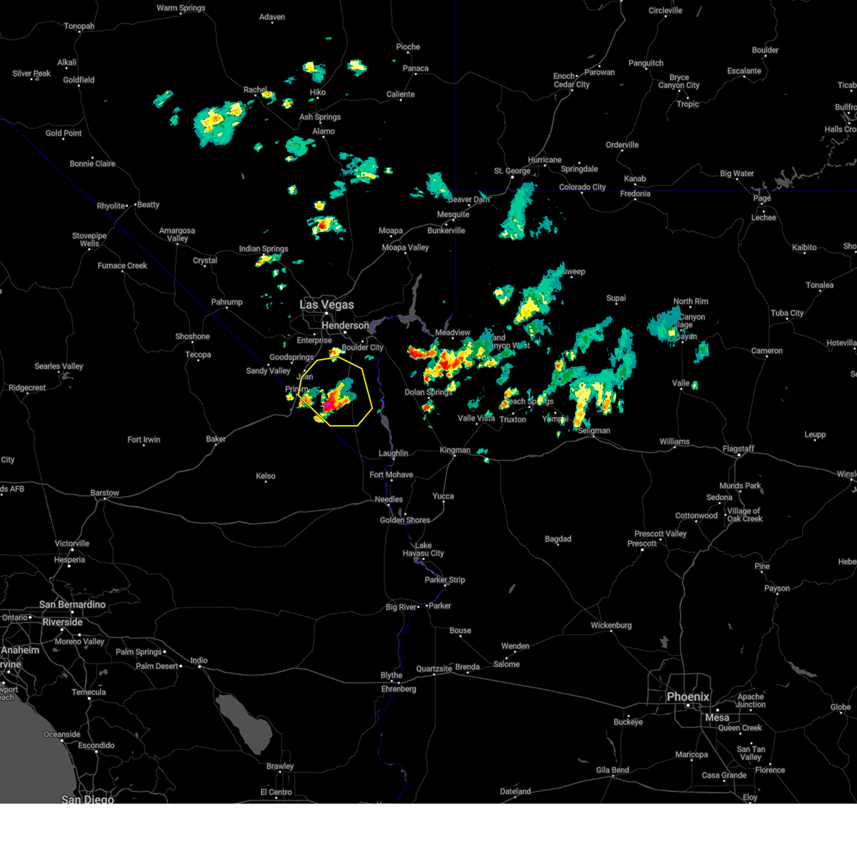
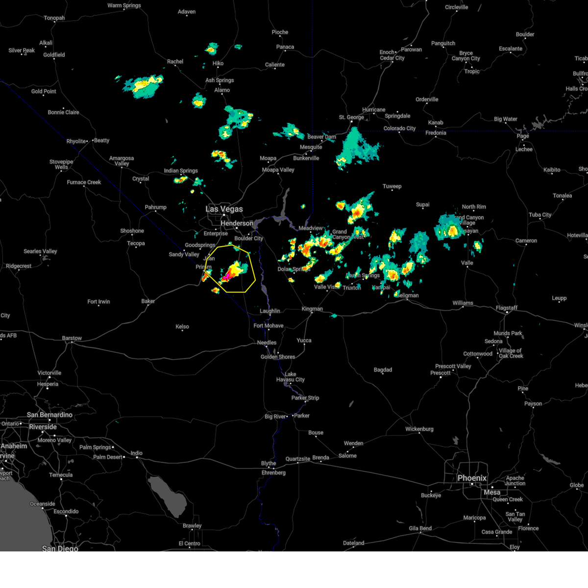
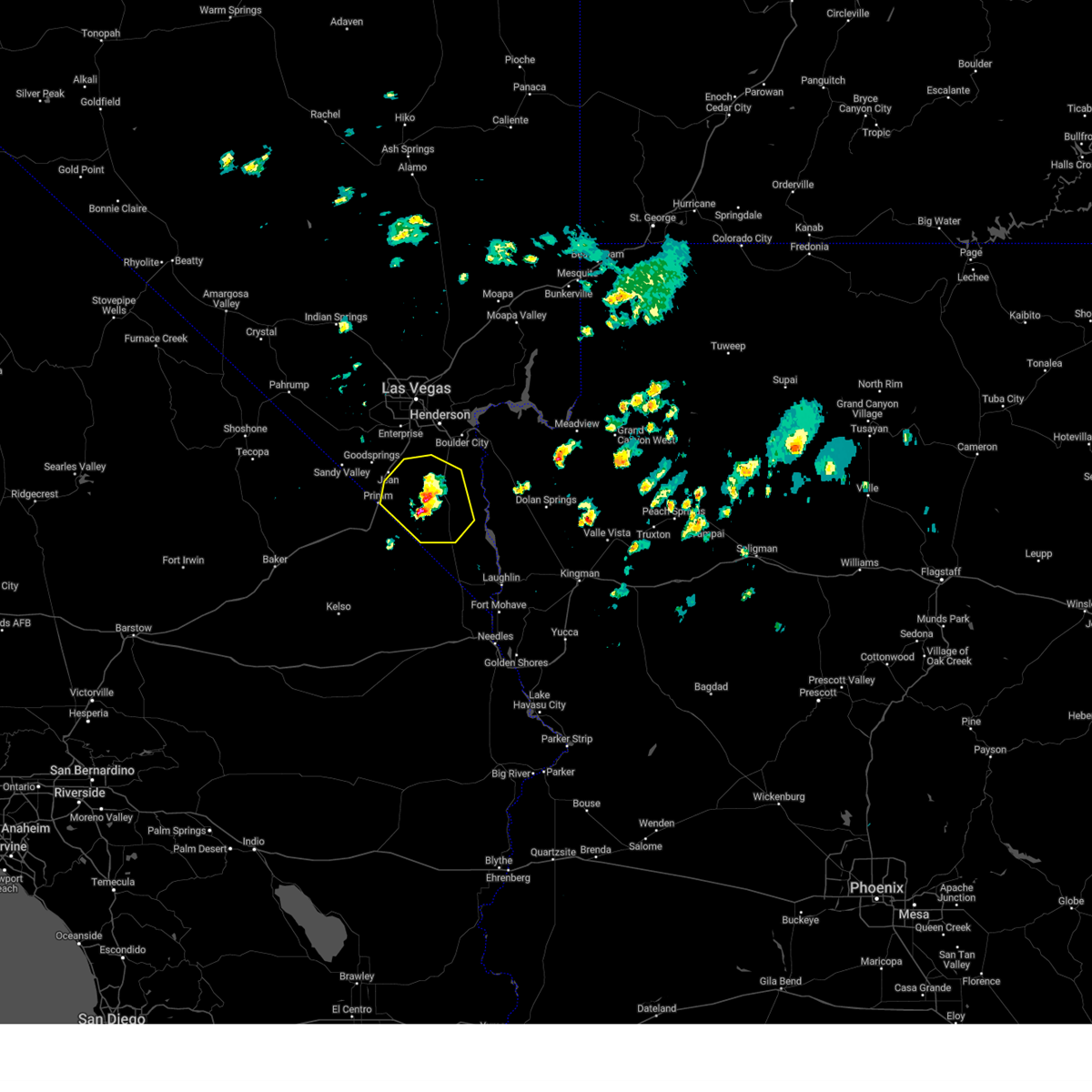
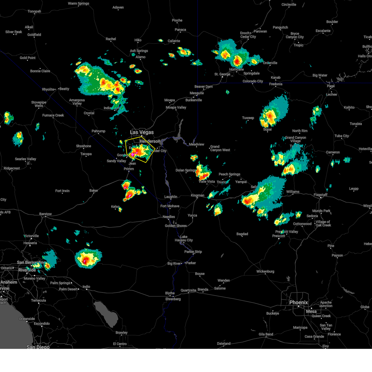
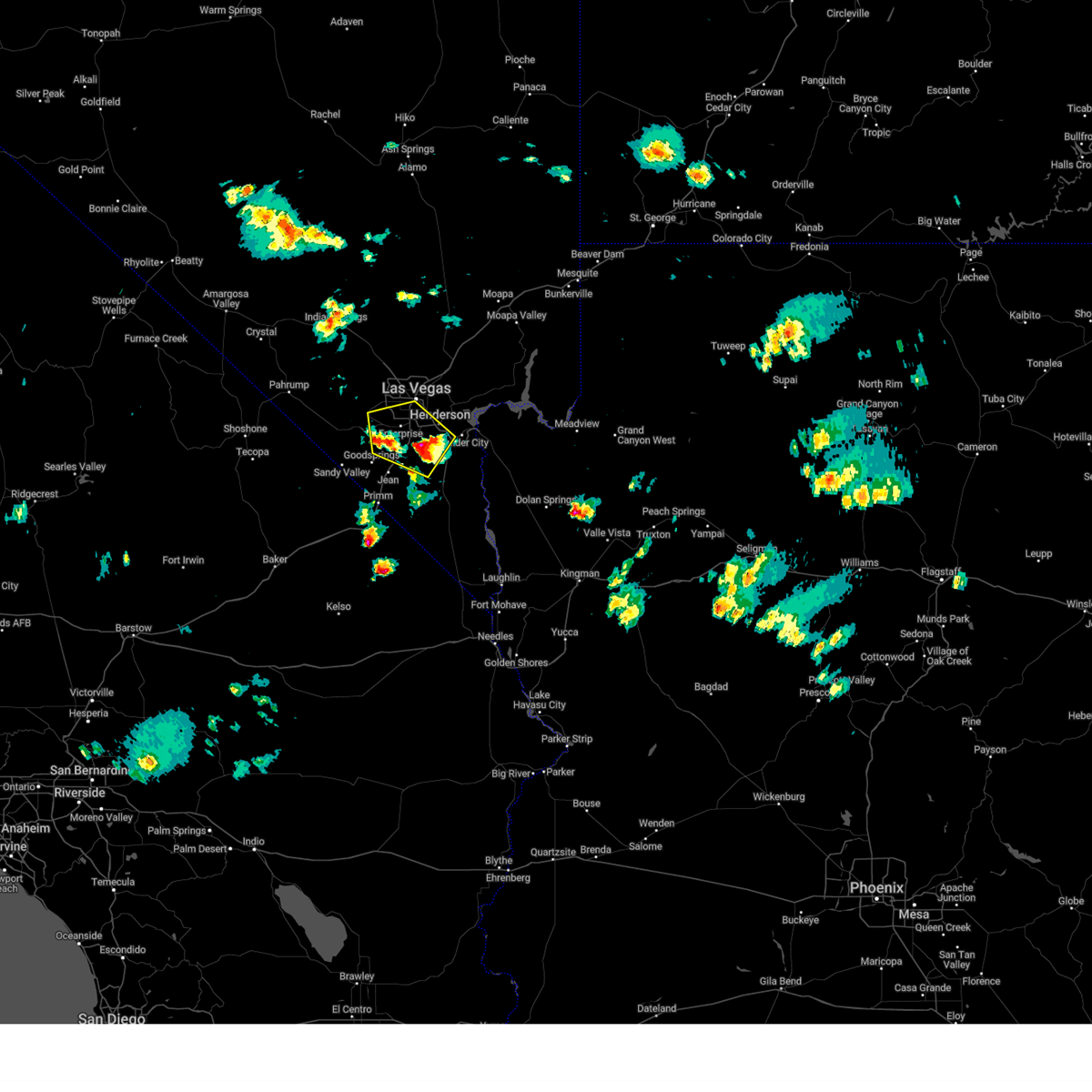
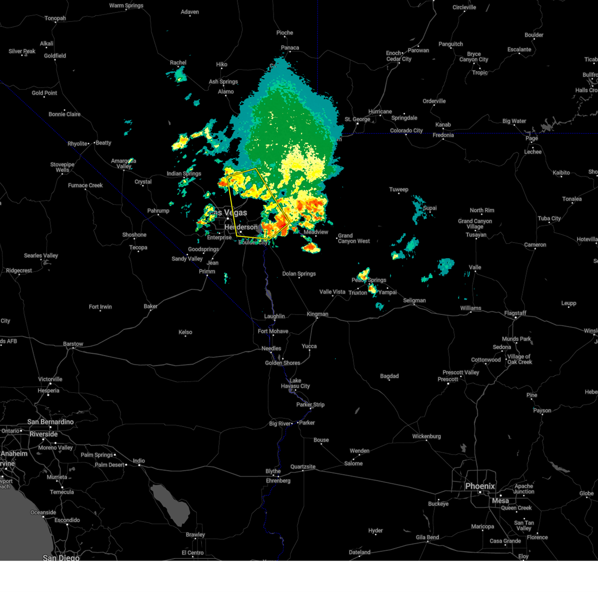
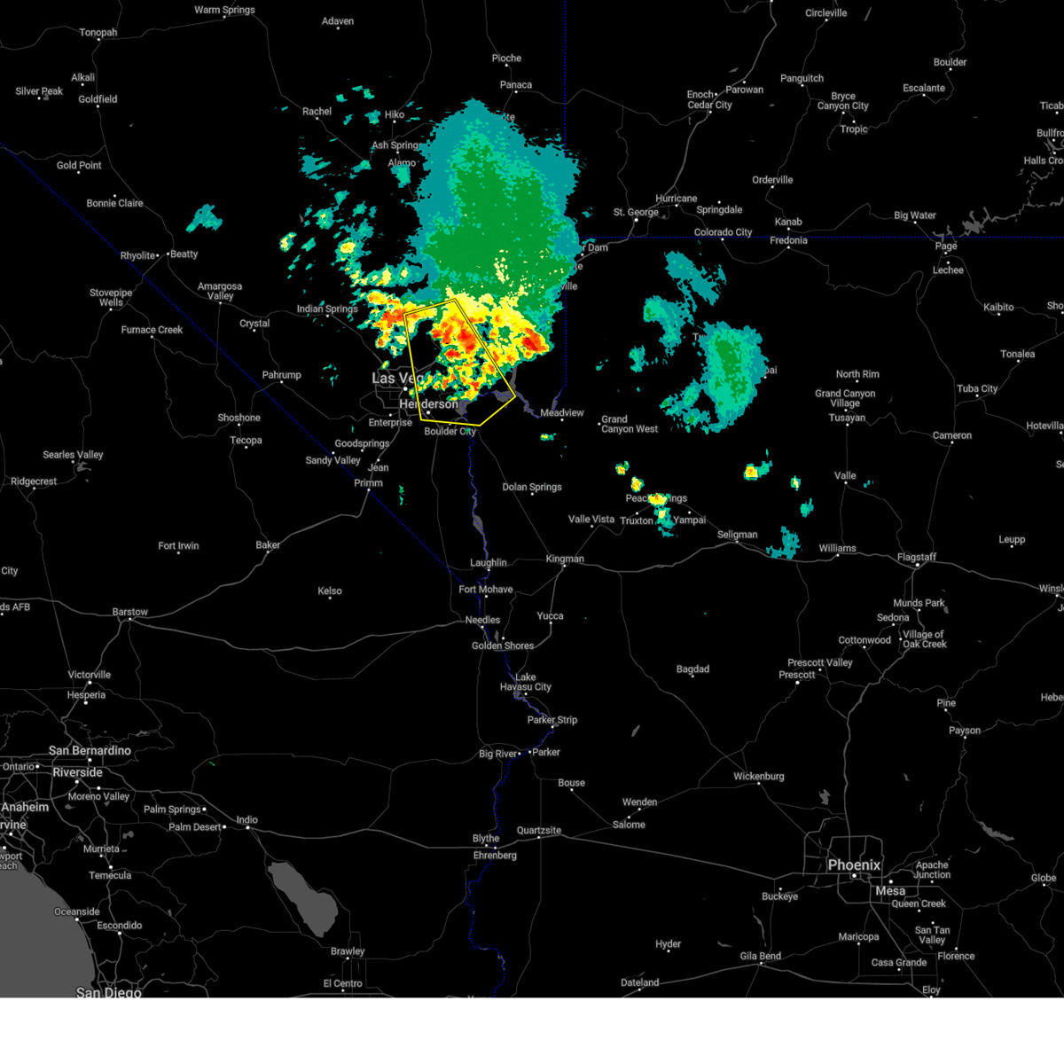
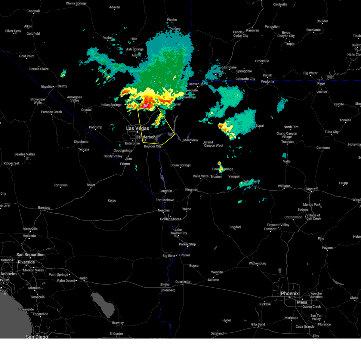
Hail Map for Boulder City, NV
The Boulder City, NV area has had 2 reports of on-the-ground hail by trained spotters, and has been under severe weather warnings 21 times during the past 12 months. Doppler radar has detected hail at or near Boulder City, NV on 52 occasions, including 5 occasions during the past year.
| Name: | Boulder City, NV |
| Where Located: | 24.5 miles SSE of Las Vegas, NV |
| Map: | Google Map for Boulder City, NV |
| Population: | 15023 |
| Housing Units: | 7412 |
| More Info: | Search Google for Boulder City, NV |
1
The Top Recent Hail Date for Boulder City, NV is Tuesday, May 6, 2025 (14th out of 52)
Hail and Wind Damage Spotted near Boulder City, NV
| Date / Time | Report Details |
|---|---|
| 7/1/2025 4:20 PM PDT | At 418 pm pdt, an area of showers and isolated thunderstorms was moving through the las vegas valley moving north at 15 mph (radar indicated). Hazards include 60 mph wind gusts. Expect damage to roofs and trees. visibilities may be reduced to less that 1/2 mile at times. locations impacted include, las vegas, henderson, north las vegas, anthem, the strip, nellis afb, east las vegas, sam boyd stadium, the motor speedway, southern highlands, aliante, lake las vegas, spring valley, green valley, enterprise, fremont street, paradise, lone mountain, centennial hills, and mountains edge. This includes interstate 15 in nevada between mile markers 22 and 25. |
| 7/1/2025 3:41 PM PDT | Svrvef the national weather service in las vegas has issued a * severe thunderstorm warning for, central clark county in southern nevada, * until 445 pm pdt. * at 339 pm pdt, an area of showers and isolated thunderstorms was moving through the las vegas valley moving north at 15 mph (radar indicated). Hazards include 60 mph wind gusts. expect damage to roofs and trees |
| 7/1/2025 2:44 PM PDT | Svrvef the national weather service in las vegas has issued a * severe thunderstorm warning for, central clark county in southern nevada, * until 345 pm pdt. * at 244 pm pdt, an area of showers and isolated thunderstorms was moving through the las vegas valley moving north at 15 mph (radar indicated). Hazards include 60 mph wind gusts. expect damage to roofs and trees |
| 7/1/2025 2:22 PM PDT |
 At 221 pm pdt, an area of showers and isolated thunderstorms was moving through the las vegas valley moving north at 15 mph (radar indicated). Hazards include 60 mph wind gusts. Expect damage to roofs and trees. locations impacted include, las vegas, henderson, north las vegas, anthem, the strip, nellis afb, east las vegas, sam boyd stadium, the motor speedway, southern highlands, aliante, lake las vegas, spring valley, green valley, enterprise, fremont street, paradise, lone mountain, centennial hills, and mountains edge. This includes interstate 15 in nevada between mile markers 22 and 25. At 221 pm pdt, an area of showers and isolated thunderstorms was moving through the las vegas valley moving north at 15 mph (radar indicated). Hazards include 60 mph wind gusts. Expect damage to roofs and trees. locations impacted include, las vegas, henderson, north las vegas, anthem, the strip, nellis afb, east las vegas, sam boyd stadium, the motor speedway, southern highlands, aliante, lake las vegas, spring valley, green valley, enterprise, fremont street, paradise, lone mountain, centennial hills, and mountains edge. This includes interstate 15 in nevada between mile markers 22 and 25.
|
| 7/1/2025 1:52 PM PDT | Svrvef the national weather service in las vegas has issued a * severe thunderstorm warning for, central clark county in southern nevada, * until 245 pm pdt. * at 150 pm pdt, an area of showers and isolated thunderstorms was moving through the las vegas valley moving north at 15 mph (radar indicated). Hazards include 60 mph wind gusts. expect damage to roofs and trees |
| 6/5/2025 1:12 PM PDT |
 The storm which prompted the warning has weakened, and no longer poses an immediate threat to life or property. therefore, the warning will be allowed to expire. pea-sized hail was noted along nipton road, also known as state route 164, also known as joshua tree highway, around 1:08 pm. The storm which prompted the warning has weakened, and no longer poses an immediate threat to life or property. therefore, the warning will be allowed to expire. pea-sized hail was noted along nipton road, also known as state route 164, also known as joshua tree highway, around 1:08 pm.
|
| 6/5/2025 12:37 PM PDT |
 At 1237 pm pdt, a severe thunderstorm was located 13 miles north of cottonwood cove campground, or 14 miles northeast of searchlight, moving east at 10 mph (radar indicated). Hazards include 60 mph wind gusts and quarter size hail. Hail damage to vehicles is expected. expect wind damage to roofs and trees. Locations impacted include, searchlight and nipton road mile marker 3. At 1237 pm pdt, a severe thunderstorm was located 13 miles north of cottonwood cove campground, or 14 miles northeast of searchlight, moving east at 10 mph (radar indicated). Hazards include 60 mph wind gusts and quarter size hail. Hail damage to vehicles is expected. expect wind damage to roofs and trees. Locations impacted include, searchlight and nipton road mile marker 3.
|
| 6/5/2025 12:15 PM PDT |
 Svrvef the national weather service in las vegas has issued a * severe thunderstorm warning for, south central clark county in southern nevada, * until 115 pm pdt. * at 1215 pm pdt, a severe thunderstorm was located 11 miles north of searchlight, moving east at 10 mph (radar indicated). Hazards include 60 mph wind gusts and quarter size hail. Hail damage to vehicles is expected. Expect wind damage to roofs and trees. Svrvef the national weather service in las vegas has issued a * severe thunderstorm warning for, south central clark county in southern nevada, * until 115 pm pdt. * at 1215 pm pdt, a severe thunderstorm was located 11 miles north of searchlight, moving east at 10 mph (radar indicated). Hazards include 60 mph wind gusts and quarter size hail. Hail damage to vehicles is expected. Expect wind damage to roofs and trees.
|
| 6/5/2025 11:49 AM PDT |
 At 1148 am pdt, a severe thunderstorm was located 9 miles north of searchlight, moving east at 10 mph (radar indicated). Hazards include 60 mph wind gusts. Expect damage to roofs and trees. Locations impacted include, searchlight and nipton road mile marker 3. At 1148 am pdt, a severe thunderstorm was located 9 miles north of searchlight, moving east at 10 mph (radar indicated). Hazards include 60 mph wind gusts. Expect damage to roofs and trees. Locations impacted include, searchlight and nipton road mile marker 3.
|
| 6/5/2025 11:09 AM PDT |
 Svrvef the national weather service in las vegas has issued a * severe thunderstorm warning for, south central clark county in southern nevada, * until 1215 pm pdt. * at 1108 am pdt, a severe thunderstorm was located 8 miles northeast of nipton road mile marker 3, or 10 miles northwest of searchlight, moving east at 10 mph (radar indicated). Hazards include 60 mph wind gusts. expect damage to roofs and trees Svrvef the national weather service in las vegas has issued a * severe thunderstorm warning for, south central clark county in southern nevada, * until 1215 pm pdt. * at 1108 am pdt, a severe thunderstorm was located 8 miles northeast of nipton road mile marker 3, or 10 miles northwest of searchlight, moving east at 10 mph (radar indicated). Hazards include 60 mph wind gusts. expect damage to roofs and trees
|
| 6/3/2025 2:43 PM PDT |
 The storm which prompted the warning has weakened, and no longer poses an immediate threat to life or property. therefore, the warning will be allowed to expire. however, gusty winds of 40 to 50 mph are still possible with this thunderstorm. The storm which prompted the warning has weakened, and no longer poses an immediate threat to life or property. therefore, the warning will be allowed to expire. however, gusty winds of 40 to 50 mph are still possible with this thunderstorm.
|
| 6/3/2025 2:27 PM PDT | At 226 pm pdt, a severe thunderstorm was located over sloan, or near southern highlands, moving northwest at 10 mph (radar indicated). Hazards include 60 mph wind gusts and quarter size hail. Hail damage to vehicles is expected. expect wind damage to roofs and trees. locations impacted include, las vegas, henderson, boulder city, anthem, mountains edge, the strip, blue diamond, southern highlands, spring valley, green valley, enterprise, paradise, red rock canyon, summerlin, east las vegas, sloan, railroad pass, seven hills, silverado ranch, and harry reid international airport. This includes interstate 15 in nevada between mile markers 17 and 25. |
| 6/3/2025 2:01 PM PDT |
 Svrvef the national weather service in las vegas has issued a * severe thunderstorm warning for, central clark county in southern nevada, * until 245 pm pdt. * at 201 pm pdt, a severe thunderstorm was located near sloan, or near anthem, moving northwest at 10 mph (radar indicated). Hazards include 60 mph wind gusts and quarter size hail. Hail damage to vehicles is expected. Expect wind damage to roofs and trees. Svrvef the national weather service in las vegas has issued a * severe thunderstorm warning for, central clark county in southern nevada, * until 245 pm pdt. * at 201 pm pdt, a severe thunderstorm was located near sloan, or near anthem, moving northwest at 10 mph (radar indicated). Hazards include 60 mph wind gusts and quarter size hail. Hail damage to vehicles is expected. Expect wind damage to roofs and trees.
|
| 6/2/2025 8:35 PM PDT |
 The storm which prompted the warning has weakened, and no longer poses an immediate threat to life or property. therefore, the warning will be allowed to expire. gusty winds remain possible across the lake mead area. The storm which prompted the warning has weakened, and no longer poses an immediate threat to life or property. therefore, the warning will be allowed to expire. gusty winds remain possible across the lake mead area.
|
| 6/2/2025 7:52 PM PDT |
 At 750 pm pdt/750 pm mst/, a severe thunderstorm was located 9 miles east of the motor speedway, moving south at 25 mph. numerous wind gusts of 40 to 50 mph have been recorded by local observations, and strong winds are entering the lake mead basins as well (radar indicated). Hazards include 60 mph wind gusts. Expect damage to roofs and trees. locations impacted include, henderson, north las vegas, boulder city, las vegas bay, lake las vegas, nellis afb, east las vegas, sam boyd stadium, the motor speedway, boulder beach, boulder beach campground, las vegas bay campground, callville bay, hoover dam, callville bay campground, sunrise mtn, and frenchman mtn. This includes interstate 15 in nevada between mile markers 60 and 79. At 750 pm pdt/750 pm mst/, a severe thunderstorm was located 9 miles east of the motor speedway, moving south at 25 mph. numerous wind gusts of 40 to 50 mph have been recorded by local observations, and strong winds are entering the lake mead basins as well (radar indicated). Hazards include 60 mph wind gusts. Expect damage to roofs and trees. locations impacted include, henderson, north las vegas, boulder city, las vegas bay, lake las vegas, nellis afb, east las vegas, sam boyd stadium, the motor speedway, boulder beach, boulder beach campground, las vegas bay campground, callville bay, hoover dam, callville bay campground, sunrise mtn, and frenchman mtn. This includes interstate 15 in nevada between mile markers 60 and 79.
|
| 6/2/2025 7:11 PM PDT |
 Svrvef the national weather service in las vegas has issued a * severe thunderstorm warning for, west central mohave county in northwestern arizona, northeastern clark county in southern nevada, * until 845 pm pdt/845 pm mst/. * at 710 pm pdt/710 pm mst/, a severe thunderstorm was located 17 miles south of sr 168 mile marker 21, or 19 miles north of the motor speedway, moving south at 25 mph (radar indicated). Hazards include 60 mph wind gusts. expect damage to roofs and trees Svrvef the national weather service in las vegas has issued a * severe thunderstorm warning for, west central mohave county in northwestern arizona, northeastern clark county in southern nevada, * until 845 pm pdt/845 pm mst/. * at 710 pm pdt/710 pm mst/, a severe thunderstorm was located 17 miles south of sr 168 mile marker 21, or 19 miles north of the motor speedway, moving south at 25 mph (radar indicated). Hazards include 60 mph wind gusts. expect damage to roofs and trees
|
| 5/6/2025 2:58 PM MST |
 Svrvef the national weather service in las vegas has issued a * severe thunderstorm warning for, west central mohave county in northwestern arizona, southeastern clark county in southern nevada, * until 345 pm pdt/345 pm mst/. * at 257 pm pdt/257 pm mst/, a severe thunderstorm was located 13 miles southeast of boulder city, moving southeast at 30 mph (radar indicated). Hazards include quarter size hail. damage to vehicles is expected Svrvef the national weather service in las vegas has issued a * severe thunderstorm warning for, west central mohave county in northwestern arizona, southeastern clark county in southern nevada, * until 345 pm pdt/345 pm mst/. * at 257 pm pdt/257 pm mst/, a severe thunderstorm was located 13 miles southeast of boulder city, moving southeast at 30 mph (radar indicated). Hazards include quarter size hail. damage to vehicles is expected
|
| 7/22/2024 8:13 PM PDT |
 The storm which prompted the warning has weakened, and has exited the warned area. therefore, the warning will be allowed to expire. The storm which prompted the warning has weakened, and has exited the warned area. therefore, the warning will be allowed to expire.
|
| 7/22/2024 8:08 PM PDT |
 At 807 pm pdt/807 pm mst/, a severe thunderstorm was located near boulder city, moving south at 20 mph (radar indicated). Hazards include 60 mph wind gusts. Expect damage to roofs, trees and boats. locations impacted include, henderson, boulder city, las vegas bay, boulder beach, railroad pass, boulder beach campground, las vegas bay campground, and hoover dam. this includes the following roads, highway 93 in mohave county between mile markers 1 and 13. State route 167 in clark county near mile marker 5. At 807 pm pdt/807 pm mst/, a severe thunderstorm was located near boulder city, moving south at 20 mph (radar indicated). Hazards include 60 mph wind gusts. Expect damage to roofs, trees and boats. locations impacted include, henderson, boulder city, las vegas bay, boulder beach, railroad pass, boulder beach campground, las vegas bay campground, and hoover dam. this includes the following roads, highway 93 in mohave county between mile markers 1 and 13. State route 167 in clark county near mile marker 5.
|
| 7/22/2024 7:44 PM PDT |
 At 744 pm pdt/744 pm mst/, a severe thunderstorm was located over boulder beach campground, or near boulder city, moving south at 20 mph (radar indicated). Hazards include 60 mph wind gusts. Expect damage to roofs, trees and boats. locations impacted include, henderson, boulder city, las vegas bay, lake las vegas, boulder beach, callville bay campground, railroad pass, boulder beach campground, las vegas bay campground, callville bay, and hoover dam. this includes the following roads, highway 93 in mohave county between mile markers 1 and 13. State route 167 in clark county between mile markers 1 and 21. At 744 pm pdt/744 pm mst/, a severe thunderstorm was located over boulder beach campground, or near boulder city, moving south at 20 mph (radar indicated). Hazards include 60 mph wind gusts. Expect damage to roofs, trees and boats. locations impacted include, henderson, boulder city, las vegas bay, lake las vegas, boulder beach, callville bay campground, railroad pass, boulder beach campground, las vegas bay campground, callville bay, and hoover dam. this includes the following roads, highway 93 in mohave county between mile markers 1 and 13. State route 167 in clark county between mile markers 1 and 21.
|
| 7/22/2024 7:29 PM PDT |
 Svrvef the national weather service in las vegas has issued a * severe thunderstorm warning for, northwestern mohave county in northwestern arizona, central clark county in southern nevada, * until 815 pm pdt/815 pm mst/. * at 728 pm pdt/728 pm mst/, a severe thunderstorm was located over callville bay, or near las vegas bay, moving south at 20 mph (radar indicated). Hazards include 60 mph wind gusts. expect damage to roofs, trees, and boats Svrvef the national weather service in las vegas has issued a * severe thunderstorm warning for, northwestern mohave county in northwestern arizona, central clark county in southern nevada, * until 815 pm pdt/815 pm mst/. * at 728 pm pdt/728 pm mst/, a severe thunderstorm was located over callville bay, or near las vegas bay, moving south at 20 mph (radar indicated). Hazards include 60 mph wind gusts. expect damage to roofs, trees, and boats
|
| 8/31/2023 7:36 PM PDT |
 The severe thunderstorm warning for central clark county will expire at 745 pm pdt, the storm which prompted the warning has moved out of the area. therefore, the warning will be allowed to expire. however, gusty winds of up to 50 mph are still possible with this thunderstorm. The severe thunderstorm warning for central clark county will expire at 745 pm pdt, the storm which prompted the warning has moved out of the area. therefore, the warning will be allowed to expire. however, gusty winds of up to 50 mph are still possible with this thunderstorm.
|
| 8/31/2023 7:27 PM PDT |
 At 725 pm pdt, thunderstorms with strong outflow winds were moving east at 25 mph, located about 5 miles northeast of nipton (radar indicated). Hazards include 60 mph wind gusts. Expect damage to roofs and trees and blowing dust. this severe thunderstorm will remain over mainly rural areas of central clark county. hail threat, radar indicated max hail size, <. 75 in wind threat, radar indicated max wind gust, 60 mph. At 725 pm pdt, thunderstorms with strong outflow winds were moving east at 25 mph, located about 5 miles northeast of nipton (radar indicated). Hazards include 60 mph wind gusts. Expect damage to roofs and trees and blowing dust. this severe thunderstorm will remain over mainly rural areas of central clark county. hail threat, radar indicated max hail size, <. 75 in wind threat, radar indicated max wind gust, 60 mph.
|
| 8/31/2023 7:03 PM PDT |
 At 701 pm pdt, a cluster of severe thunderstorms was located east of primm to sloan, moving north-northeast at 30 mph (radar indicated). Hazards include 60 mph wind gusts. Expect damage to roofs and trees. areas of blowing dust, and frequent cloud to ground lightning. locations impacted include, jean and primm. this includes the following roads, interstate 15 in nevada between mile markers 1 and 25. highway 95 in clark county between mile markers 43 and 53. hail threat, radar indicated max hail size, <. 75 in wind threat, radar indicated max wind gust, 60 mph. At 701 pm pdt, a cluster of severe thunderstorms was located east of primm to sloan, moving north-northeast at 30 mph (radar indicated). Hazards include 60 mph wind gusts. Expect damage to roofs and trees. areas of blowing dust, and frequent cloud to ground lightning. locations impacted include, jean and primm. this includes the following roads, interstate 15 in nevada between mile markers 1 and 25. highway 95 in clark county between mile markers 43 and 53. hail threat, radar indicated max hail size, <. 75 in wind threat, radar indicated max wind gust, 60 mph.
|
| 8/31/2023 6:45 PM PDT |
 At 643 pm pdt, a cluster of severe thunderstorms was located 7 miles southeast of jean, moving northeast at 15 mph (radar indicated). Hazards include 60 mph wind gusts and hail up to dime size. expect areas of blowing dust, possible tree damage, and downed power lines At 643 pm pdt, a cluster of severe thunderstorms was located 7 miles southeast of jean, moving northeast at 15 mph (radar indicated). Hazards include 60 mph wind gusts and hail up to dime size. expect areas of blowing dust, possible tree damage, and downed power lines
|
| 8/18/2023 6:30 PM PDT | National parks service reports docks separating at lake mead due to strong winds and waves. wind gust magnitude estimated to be around 50-55 mp in clark county NV, 14.3 miles SW of Boulder City, NV |
| 7/17/2023 3:58 PM PDT |
 The severe thunderstorm warning for northwestern mohave and central clark counties will expire at 400 pm pdt/400 pm mst/, the storm which prompted the warning has weakened below severe limits, and no longer poses an immediate threat to life or property. therefore, the warning will be allowed to expire. however gusty winds and heavy rain are still possible with this thunderstorm. The severe thunderstorm warning for northwestern mohave and central clark counties will expire at 400 pm pdt/400 pm mst/, the storm which prompted the warning has weakened below severe limits, and no longer poses an immediate threat to life or property. therefore, the warning will be allowed to expire. however gusty winds and heavy rain are still possible with this thunderstorm.
|
| 7/17/2023 3:39 PM PDT |
 At 337 pm pdt/337 pm mst/, a severe thunderstorm was located near lake las vegas, moving northeast at 15 mph (radar indicated). Hazards include 60 mph wind gusts. Expect damage to roofs and trees. locations impacted include, las vegas, henderson, boulder city, las vegas bay, anthem, lake las vegas, green valley, east las vegas, sam boyd stadium, the motor speedway, nellis afb, paradise, boulder beach, railroad pass, boulder beach campground, las vegas bay campground, callville bay, callville bay campground, black mtn and sunrise mtn. this includes highway 95 in clark county between mile markers 48 and 56. hail threat, radar indicated max hail size, <. 75 in wind threat, radar indicated max wind gust, 60 mph. At 337 pm pdt/337 pm mst/, a severe thunderstorm was located near lake las vegas, moving northeast at 15 mph (radar indicated). Hazards include 60 mph wind gusts. Expect damage to roofs and trees. locations impacted include, las vegas, henderson, boulder city, las vegas bay, anthem, lake las vegas, green valley, east las vegas, sam boyd stadium, the motor speedway, nellis afb, paradise, boulder beach, railroad pass, boulder beach campground, las vegas bay campground, callville bay, callville bay campground, black mtn and sunrise mtn. this includes highway 95 in clark county between mile markers 48 and 56. hail threat, radar indicated max hail size, <. 75 in wind threat, radar indicated max wind gust, 60 mph.
|
| 7/17/2023 3:13 PM PDT |
 The severe thunderstorm warning for northwestern mohave and central clark counties will expire at 315 pm pdt/315 pm mst/, the severe thunderstorm which prompted the warning remains in the area. a new warning has been issued for the same areas. The severe thunderstorm warning for northwestern mohave and central clark counties will expire at 315 pm pdt/315 pm mst/, the severe thunderstorm which prompted the warning remains in the area. a new warning has been issued for the same areas.
|
| 7/17/2023 3:11 PM PDT |
 At 310 pm pdt/310 pm mst/, a severe thunderstorm was located near railroad pass, or near henderson, moving northeast at 15 mph (radar indicated). Hazards include 60 mph wind gusts. expect damage to roofs and trees At 310 pm pdt/310 pm mst/, a severe thunderstorm was located near railroad pass, or near henderson, moving northeast at 15 mph (radar indicated). Hazards include 60 mph wind gusts. expect damage to roofs and trees
|
| 7/17/2023 2:54 PM PDT |
 At 253 pm pdt/253 pm mst/, a severe thunderstorm was located over railroad pass, or near henderson, moving northeast at 20 mph (radar indicated). Hazards include 60 mph wind gusts. Expect damage to roofs and trees. locations impacted include, henderson, boulder city, las vegas bay, anthem, lake las vegas, sam boyd stadium, green valley, east las vegas, boulder beach, railroad pass, boulder beach campground, las vegas bay campground, black mtn and frenchman mtn. this includes highway 95 in clark county between mile markers 48 and 56. hail threat, radar indicated max hail size, <. 75 in wind threat, radar indicated max wind gust, 60 mph. At 253 pm pdt/253 pm mst/, a severe thunderstorm was located over railroad pass, or near henderson, moving northeast at 20 mph (radar indicated). Hazards include 60 mph wind gusts. Expect damage to roofs and trees. locations impacted include, henderson, boulder city, las vegas bay, anthem, lake las vegas, sam boyd stadium, green valley, east las vegas, boulder beach, railroad pass, boulder beach campground, las vegas bay campground, black mtn and frenchman mtn. this includes highway 95 in clark county between mile markers 48 and 56. hail threat, radar indicated max hail size, <. 75 in wind threat, radar indicated max wind gust, 60 mph.
|
| 7/17/2023 2:36 PM PDT |
 At 234 pm pdt/234 pm mst/, a severe thunderstorm was located near railroad pass, or near henderson, moving northeast at 30 mph (radar indicated). Hazards include 60 mph wind gusts. expect damage to roofs and trees At 234 pm pdt/234 pm mst/, a severe thunderstorm was located near railroad pass, or near henderson, moving northeast at 30 mph (radar indicated). Hazards include 60 mph wind gusts. expect damage to roofs and trees
|
| 8/21/2022 8:25 PM MST | Arizona department of transportation reported a semi truck had been blown over on highway 93 by mile marker 14 in arizon in mohave county AZ, 17.5 miles W of Boulder City, NV |
| 8/21/2022 7:29 PM MST | At 728 pm pdt/728 pm mst/, a line of severe thunderstorm was located from near willow beach to peach springs, moving south at 30 mph (radar indicated). Hazards include 60 mph wind gusts and quarter size hail. Hail damage to vehicles is expected. expect wind damage to roofs and trees. locations impacted include, henderson, boulder city, las vegas bay, lake las vegas, boulder beach, grand canyon skywalk, diamond creek campground, railroad pass, boulder beach campground, las vegas bay campground, pierce ferry and antares roads, callville bay, meadview, hoover dam, grand canyon ranch, callville bay campground, lake mead national recreation area, temple bar campground, south cove and dolan springs. hail threat, radar indicated max hail size, 1. 00 in wind threat, observed max wind gust, 60 mph. |
| 8/21/2022 7:29 PM MST | At 728 pm pdt/728 pm mst/, a line of severe thunderstorm was located from near willow beach to peach springs, moving south at 30 mph (radar indicated). Hazards include 60 mph wind gusts and quarter size hail. Hail damage to vehicles is expected. expect wind damage to roofs and trees. locations impacted include, henderson, boulder city, las vegas bay, lake las vegas, boulder beach, grand canyon skywalk, diamond creek campground, railroad pass, boulder beach campground, las vegas bay campground, pierce ferry and antares roads, callville bay, meadview, hoover dam, grand canyon ranch, callville bay campground, lake mead national recreation area, temple bar campground, south cove and dolan springs. hail threat, radar indicated max hail size, 1. 00 in wind threat, observed max wind gust, 60 mph. |
| 8/21/2022 6:57 PM MST | The severe thunderstorm warning for northern mohave and northeastern clark counties will expire at 700 pm pdt/700 pm mst/, this severe thunderstorm warning has been replaced with a new warning. therefore, this warning will be allowed to expire. |
| 8/21/2022 6:57 PM MST | The severe thunderstorm warning for northern mohave and northeastern clark counties will expire at 700 pm pdt/700 pm mst/, this severe thunderstorm warning has been replaced with a new warning. therefore, this warning will be allowed to expire. |
| 8/21/2022 6:52 PM MST | At 651 pm pdt/651 pm mst/, a severe thunderstorm was located 11 miles west of temple bar campground, or 18 miles east of boulder city, moving south at 20 mph (radar indicated). Hazards include 70 mph wind gusts. Expect considerable tree damage. Damage is likely to mobile homes, roofs, and outbuildings. |
| 8/21/2022 6:52 PM MST | At 651 pm pdt/651 pm mst/, a severe thunderstorm was located 11 miles west of temple bar campground, or 18 miles east of boulder city, moving south at 20 mph (radar indicated). Hazards include 70 mph wind gusts. Expect considerable tree damage. Damage is likely to mobile homes, roofs, and outbuildings. |
| 8/21/2022 6:08 PM MST | At 604 pm pdt/604 pm mst/, a severe thunderstorm was located near apex and the i-15 in northeast clark county, moving south at 20 mph. a wind sensor located along the i-15 and highway 93 has reported a 70 mph wind gust (radar indicated). Hazards include 70 mph wind gusts. Expect considerable tree damage. damage is likely to mobile homes, roofs, and outbuildings. locations impacted include, henderson, north las vegas, mesquite, boulder city, nellis afb, the motor speedway, las vegas bay, lake las vegas, overton, moapa town, east las vegas, moapa valley, echo bay, grand canyon skywalk, sr 168 mile marker 21, boulder beach campground, las vegas bay campground, meadview, hoover dam and bunkerville. this includes interstate 15 in nevada between mile markers 60 and 116. thunderstorm damage threat, considerable hail threat, radar indicated max hail size, <. 75 in wind threat, radar indicated max wind gust, 70 mph. |
| 8/21/2022 6:08 PM MST | At 604 pm pdt/604 pm mst/, a severe thunderstorm was located near apex and the i-15 in northeast clark county, moving south at 20 mph. a wind sensor located along the i-15 and highway 93 has reported a 70 mph wind gust (radar indicated). Hazards include 70 mph wind gusts. Expect considerable tree damage. damage is likely to mobile homes, roofs, and outbuildings. locations impacted include, henderson, north las vegas, mesquite, boulder city, nellis afb, the motor speedway, las vegas bay, lake las vegas, overton, moapa town, east las vegas, moapa valley, echo bay, grand canyon skywalk, sr 168 mile marker 21, boulder beach campground, las vegas bay campground, meadview, hoover dam and bunkerville. this includes interstate 15 in nevada between mile markers 60 and 116. thunderstorm damage threat, considerable hail threat, radar indicated max hail size, <. 75 in wind threat, radar indicated max wind gust, 70 mph. |
| 8/21/2022 5:56 PM MST | At 555 pm pdt/555 pm mst/, a severe thunderstorm was located near las vegas bay campground, or near the motor speedway, moving south at 20 mph (radar indicated). Hazards include 60 mph wind gusts. expect damage to roofs and trees |
| 8/21/2022 5:56 PM MST | At 555 pm pdt/555 pm mst/, a severe thunderstorm was located near las vegas bay campground, or near the motor speedway, moving south at 20 mph (radar indicated). Hazards include 60 mph wind gusts. expect damage to roofs and trees |
| 8/20/2022 5:35 PM PDT |
 The severe thunderstorm warning for central clark county will expire at 545 pm pdt, the storm which prompted the warning has weakened below severe limits, and no longer poses an immediate threat to life or property. therefore, the warning will be allowed to expire. The severe thunderstorm warning for central clark county will expire at 545 pm pdt, the storm which prompted the warning has weakened below severe limits, and no longer poses an immediate threat to life or property. therefore, the warning will be allowed to expire.
|
| 8/20/2022 5:18 PM PDT |
 At 517 pm pdt, a severe thunderstorm was located near railroad pass, or near boulder city, moving east at 10 mph (radar indicated). Hazards include 60 mph wind gusts. Expect damage to roofs and trees. locations impacted include, henderson, boulder city, anthem, lake las vegas, railroad pass and black mtn. hail threat, radar indicated max hail size, <. 75 in wind threat, radar indicated max wind gust, 60 mph. At 517 pm pdt, a severe thunderstorm was located near railroad pass, or near boulder city, moving east at 10 mph (radar indicated). Hazards include 60 mph wind gusts. Expect damage to roofs and trees. locations impacted include, henderson, boulder city, anthem, lake las vegas, railroad pass and black mtn. hail threat, radar indicated max hail size, <. 75 in wind threat, radar indicated max wind gust, 60 mph.
|
| 8/20/2022 4:52 PM PDT |
 At 452 pm pdt, a severe thunderstorm was located near black mountain, or just south of anthem, moving east at 10 mph (radar indicated). Hazards include 60 mph wind gusts and quarter size hail. Hail damage to vehicles is expected. Expect wind damage to roofs and trees. At 452 pm pdt, a severe thunderstorm was located near black mountain, or just south of anthem, moving east at 10 mph (radar indicated). Hazards include 60 mph wind gusts and quarter size hail. Hail damage to vehicles is expected. Expect wind damage to roofs and trees.
|
| 8/19/2022 12:31 AM PDT |
 At 1230 am pdt/1230 am mst/, a severe thunderstorm was located over callville bay, or 9 miles east of las vegas bay, moving southeast at 25 mph (radar indicated). Hazards include 60 mph wind gusts. Expect damage to roofs and trees. locations impacted include, henderson, boulder city, las vegas bay, echo bay, boulder beach, railroad pass, boulder beach campground, echo bay campground, callville bay, hoover dam, valley of fire, callville bay campground, lake mead national recreation area, temple bar campground, overton beach, south cove and temple bar. hail threat, radar indicated max hail size, <. 75 in wind threat, radar indicated max wind gust, 60 mph. At 1230 am pdt/1230 am mst/, a severe thunderstorm was located over callville bay, or 9 miles east of las vegas bay, moving southeast at 25 mph (radar indicated). Hazards include 60 mph wind gusts. Expect damage to roofs and trees. locations impacted include, henderson, boulder city, las vegas bay, echo bay, boulder beach, railroad pass, boulder beach campground, echo bay campground, callville bay, hoover dam, valley of fire, callville bay campground, lake mead national recreation area, temple bar campground, overton beach, south cove and temple bar. hail threat, radar indicated max hail size, <. 75 in wind threat, radar indicated max wind gust, 60 mph.
|
| 8/18/2022 11:55 PM PDT |
 At 1153 pm pdt/1153 pm mst/, a severe thunderstorm was located 8 miles north of las vegas bay campground, or 9 miles north of las vegas bay, moving southeast at 20 mph (radar indicated). Hazards include 60 mph wind gusts. expect damage to roofs and trees At 1153 pm pdt/1153 pm mst/, a severe thunderstorm was located 8 miles north of las vegas bay campground, or 9 miles north of las vegas bay, moving southeast at 20 mph (radar indicated). Hazards include 60 mph wind gusts. expect damage to roofs and trees
|
| 8/18/2022 4:22 PM PDT |
 The severe thunderstorm warning for northwestern mohave and central clark counties will expire at 430 pm pdt/430 pm mst/, the storm which prompted the warning has weakened below severe limits, and no longer poses an immediate threat to life or property. therefore, the warning will be allowed to expire. The severe thunderstorm warning for northwestern mohave and central clark counties will expire at 430 pm pdt/430 pm mst/, the storm which prompted the warning has weakened below severe limits, and no longer poses an immediate threat to life or property. therefore, the warning will be allowed to expire.
|
| 8/18/2022 3:59 PM PDT |
 At 359 pm pdt/359 pm mst/, a severe thunderstorm was located near echo bay campground, or 19 miles south of overton, moving northeast at 10 mph (radar indicated). Hazards include 60 mph wind gusts. Expect damage to roofs and trees. locations impacted include, henderson, boulder city, las vegas bay, lake las vegas, sam boyd stadium, east las vegas, boulder beach, railroad pass, boulder beach campground, las vegas bay campground, callville bay, hoover dam, callville bay campground, lake mead national recreation area, black mtn and willow beach. hail threat, radar indicated max hail size, <. 75 in wind threat, radar indicated max wind gust, 60 mph. At 359 pm pdt/359 pm mst/, a severe thunderstorm was located near echo bay campground, or 19 miles south of overton, moving northeast at 10 mph (radar indicated). Hazards include 60 mph wind gusts. Expect damage to roofs and trees. locations impacted include, henderson, boulder city, las vegas bay, lake las vegas, sam boyd stadium, east las vegas, boulder beach, railroad pass, boulder beach campground, las vegas bay campground, callville bay, hoover dam, callville bay campground, lake mead national recreation area, black mtn and willow beach. hail threat, radar indicated max hail size, <. 75 in wind threat, radar indicated max wind gust, 60 mph.
|
| 8/18/2022 3:30 PM PDT |
 At 329 pm pdt/329 pm mst/, a severe thunderstorm was located over old henderson, moving northeast at 10 mph. this storm will impact far southern henderson and boulder beach through the upcoming hour (radar indicated). Hazards include 60 mph wind gusts. expect damage to roofs and trees At 329 pm pdt/329 pm mst/, a severe thunderstorm was located over old henderson, moving northeast at 10 mph. this storm will impact far southern henderson and boulder beach through the upcoming hour (radar indicated). Hazards include 60 mph wind gusts. expect damage to roofs and trees
|
| 7/31/2022 10:28 AM PDT |
 The severe thunderstorm warning for west central clark county will expire at 1030 am pdt, the storm which prompted the warning has weakened below severe limits, and no longer poses an immediate threat to life or property. therefore, the warning will be allowed to expire. however gusty winds are still possible with this thunderstorm. The severe thunderstorm warning for west central clark county will expire at 1030 am pdt, the storm which prompted the warning has weakened below severe limits, and no longer poses an immediate threat to life or property. therefore, the warning will be allowed to expire. however gusty winds are still possible with this thunderstorm.
|
| 7/31/2022 10:13 AM PDT |
 At 1013 am pdt, a severe thunderstorm was located near jean, moving north at 15 mph (radar indicated). Hazards include 60 mph wind gusts. Expect damage to roofs, trees, or power lines. patchy blowing dust may reduce visibility on area roadways. locations impacted include, primm, jean and goodsprings. this includes interstate 15 in nevada between mile markers 1 and 24. hail threat, radar indicated max hail size, <. 75 in wind threat, radar indicated max wind gust, 60 mph. At 1013 am pdt, a severe thunderstorm was located near jean, moving north at 15 mph (radar indicated). Hazards include 60 mph wind gusts. Expect damage to roofs, trees, or power lines. patchy blowing dust may reduce visibility on area roadways. locations impacted include, primm, jean and goodsprings. this includes interstate 15 in nevada between mile markers 1 and 24. hail threat, radar indicated max hail size, <. 75 in wind threat, radar indicated max wind gust, 60 mph.
|
| 7/31/2022 9:49 AM PDT |
 At 948 am pdt, a severe thunderstorm was located 7 miles southeast of jean, moving north at 15 mph (radar indicated). Hazards include 60 mph wind gusts. Expect damage to roofs, trees, or power lines. Patchy blowing dust may reduce visibility on area roadways. At 948 am pdt, a severe thunderstorm was located 7 miles southeast of jean, moving north at 15 mph (radar indicated). Hazards include 60 mph wind gusts. Expect damage to roofs, trees, or power lines. Patchy blowing dust may reduce visibility on area roadways.
|
| 7/29/2022 8:53 PM PDT |
 The severe thunderstorm warning for northwestern mohave and northeastern clark counties will expire at 900 pm pdt/900 pm mst/, the storm which prompted the warning has weakened below severe limits and begun to shift south of lake mead, and no longer poses an immediate threat to life or property. therefore, the warning will be allowed to expire. however gusty winds are still possible with this thunderstorm. The severe thunderstorm warning for northwestern mohave and northeastern clark counties will expire at 900 pm pdt/900 pm mst/, the storm which prompted the warning has weakened below severe limits and begun to shift south of lake mead, and no longer poses an immediate threat to life or property. therefore, the warning will be allowed to expire. however gusty winds are still possible with this thunderstorm.
|
| 7/29/2022 8:39 PM PDT |
 At 838 pm pdt/838 pm mst/, a severe thunderstorm was located 8 miles southwest of lake mead national recreation area, or 30 miles east of boulder city, moving southeast at 30 mph (radar indicated). Hazards include 60 mph wind gusts. Expect damage to roofs and trees. locations impacted include, las vegas, henderson, north las vegas, boulder city, anthem, the strip, nellis afb, downtown las vegas, east las vegas, sam boyd stadium, the motor speedway, las vegas bay, lake las vegas, green valley, paradise, enterprise, echo bay, railroad pass, boulder beach campground and las vegas bay campground. this includes interstate 15 in nevada between mile markers 60 and 63. hail threat, radar indicated max hail size, <. 75 in wind threat, radar indicated max wind gust, 60 mph. At 838 pm pdt/838 pm mst/, a severe thunderstorm was located 8 miles southwest of lake mead national recreation area, or 30 miles east of boulder city, moving southeast at 30 mph (radar indicated). Hazards include 60 mph wind gusts. Expect damage to roofs and trees. locations impacted include, las vegas, henderson, north las vegas, boulder city, anthem, the strip, nellis afb, downtown las vegas, east las vegas, sam boyd stadium, the motor speedway, las vegas bay, lake las vegas, green valley, paradise, enterprise, echo bay, railroad pass, boulder beach campground and las vegas bay campground. this includes interstate 15 in nevada between mile markers 60 and 63. hail threat, radar indicated max hail size, <. 75 in wind threat, radar indicated max wind gust, 60 mph.
|
| 7/29/2022 8:23 PM PDT |
 At 822 pm pdt/822 pm mst/, a severe thunderstorm was located near echo bay, or 22 miles east of boulder city, moving southeast at 30 mph (radar indicated). Hazards include 60 mph wind gusts. Expect damage to roofs and trees. locations impacted include, las vegas, henderson, north las vegas, mesquite, boulder city, anthem, the strip, nellis afb, downtown las vegas, east las vegas, sam boyd stadium, the motor speedway, las vegas bay, lake las vegas, overton, green valley, moapa town, paradise, enterprise and moapa valley. this includes interstate 15 in nevada between mile markers 60 and 117. hail threat, radar indicated max hail size, <. 75 in wind threat, radar indicated max wind gust, 60 mph. At 822 pm pdt/822 pm mst/, a severe thunderstorm was located near echo bay, or 22 miles east of boulder city, moving southeast at 30 mph (radar indicated). Hazards include 60 mph wind gusts. Expect damage to roofs and trees. locations impacted include, las vegas, henderson, north las vegas, mesquite, boulder city, anthem, the strip, nellis afb, downtown las vegas, east las vegas, sam boyd stadium, the motor speedway, las vegas bay, lake las vegas, overton, green valley, moapa town, paradise, enterprise and moapa valley. this includes interstate 15 in nevada between mile markers 60 and 117. hail threat, radar indicated max hail size, <. 75 in wind threat, radar indicated max wind gust, 60 mph.
|
| 7/29/2022 8:12 PM PDT |
 At 812 pm pdt, a severe thunderstorm was located over paradise, and is moving south at 15 mph (radar indicated). Hazards include 60 mph wind gusts. expect damage to roofs and trees At 812 pm pdt, a severe thunderstorm was located over paradise, and is moving south at 15 mph (radar indicated). Hazards include 60 mph wind gusts. expect damage to roofs and trees
|
| 7/29/2022 7:33 PM PDT |
 At 732 pm pdt/732 pm mst/, a severe thunderstorm was located near callville bay campground, or 8 miles northeast of las vegas bay, moving southeast at 30 mph (radar indicated). Hazards include 60 mph wind gusts. expect damage to roofs and trees At 732 pm pdt/732 pm mst/, a severe thunderstorm was located near callville bay campground, or 8 miles northeast of las vegas bay, moving southeast at 30 mph (radar indicated). Hazards include 60 mph wind gusts. expect damage to roofs and trees
|
| 7/28/2022 10:58 PM PDT |
 At 1054 pm pdt/1054 pm mst/, a cluster of severe thunderstorms were located along a line extending from mountain pass, to 10 miles north of searchlight, to golden valley. these storms were moving generally south-southwest at 35 mph (radar indicated). Hazards include 60 mph wind gusts. Possible wind damage to roofs and trees, power lines and periods of blowing dust near dry lake beds. locations impacted include, bullhead city, laughlin, searchlight, cima, katherine landing, primm, needles, mountain pass, oatman, mid hills campground, nipton, mojave ranch estates, mohave valley, cottonwood cove campground, big bend rec area, golden valley, mesquite creek, nipton and ivanpah roads, cottonwood cove and nipton road mile marker 3. this includes the following highways, interstate 15 in california between mile markers 146 and 186. interstate 15 in nevada between mile markers 1 and 9. hail threat, radar indicated max hail size, <. 75 in wind threat, observed max wind gust, 60 mph. At 1054 pm pdt/1054 pm mst/, a cluster of severe thunderstorms were located along a line extending from mountain pass, to 10 miles north of searchlight, to golden valley. these storms were moving generally south-southwest at 35 mph (radar indicated). Hazards include 60 mph wind gusts. Possible wind damage to roofs and trees, power lines and periods of blowing dust near dry lake beds. locations impacted include, bullhead city, laughlin, searchlight, cima, katherine landing, primm, needles, mountain pass, oatman, mid hills campground, nipton, mojave ranch estates, mohave valley, cottonwood cove campground, big bend rec area, golden valley, mesquite creek, nipton and ivanpah roads, cottonwood cove and nipton road mile marker 3. this includes the following highways, interstate 15 in california between mile markers 146 and 186. interstate 15 in nevada between mile markers 1 and 9. hail threat, radar indicated max hail size, <. 75 in wind threat, observed max wind gust, 60 mph.
|
| 7/28/2022 10:57 PM PDT |
 The severe thunderstorm warning for northwestern mohave and central clark counties will expire at 1100 pm pdt/1100 pm mst/, the storm which prompted the warning has moved out of the area. therefore, the warning will be allowed to expire. however heavy rain and gusty winds are still possible with this thunderstorm south of boulder city and along highway 95 toward searchlight. The severe thunderstorm warning for northwestern mohave and central clark counties will expire at 1100 pm pdt/1100 pm mst/, the storm which prompted the warning has moved out of the area. therefore, the warning will be allowed to expire. however heavy rain and gusty winds are still possible with this thunderstorm south of boulder city and along highway 95 toward searchlight.
|
| 7/28/2022 10:18 PM PDT |
 At 1013 pm pdt/1013 pm mst/, a cluster of severe thunderstorms was located along a line extending from sandy valley to the highway 93 corridor in arizona northwest of kingman. these storms were moving southwest at 30 mph (radar indicated). Hazards include 60 mph wind gusts and hail up to penny size. expect wind damage to roofs and trees, power lines and periods of blowing dust with the high winds At 1013 pm pdt/1013 pm mst/, a cluster of severe thunderstorms was located along a line extending from sandy valley to the highway 93 corridor in arizona northwest of kingman. these storms were moving southwest at 30 mph (radar indicated). Hazards include 60 mph wind gusts and hail up to penny size. expect wind damage to roofs and trees, power lines and periods of blowing dust with the high winds
|
| 7/28/2022 10:14 PM PDT |
 At 1013 pm pdt/1013 pm mst/, a severe thunderstorm was located near boulder city, moving southwest at 30 mph (radar indicated). Hazards include 60 mph wind gusts. Expect damage to roofs and trees. locations impacted include, henderson, boulder city, las vegas bay, lake las vegas, boulder beach, railroad pass, boulder beach campground, las vegas bay campground, callville bay, hoover dam, callville bay campground, lake mead national recreation area and willow beach. hail threat, radar indicated max hail size, <. 75 in wind threat, radar indicated max wind gust, 60 mph. At 1013 pm pdt/1013 pm mst/, a severe thunderstorm was located near boulder city, moving southwest at 30 mph (radar indicated). Hazards include 60 mph wind gusts. Expect damage to roofs and trees. locations impacted include, henderson, boulder city, las vegas bay, lake las vegas, boulder beach, railroad pass, boulder beach campground, las vegas bay campground, callville bay, hoover dam, callville bay campground, lake mead national recreation area and willow beach. hail threat, radar indicated max hail size, <. 75 in wind threat, radar indicated max wind gust, 60 mph.
|
| 7/28/2022 10:08 PM PDT |
 The severe thunderstorm warning for central clark county will expire at 1015 pm pdt, the storm which prompted the warning has weakened below severe limits in the warned area. gusty winds, small hail, and frequent cloud-to-ground lightning persist on the eastern side of the las vegas valley including lake mead as well as in the far southwest portion of the las vegas valley. additional severe thunderstorm warnings are likely with these storms. this warning will be allowed to expire. The severe thunderstorm warning for central clark county will expire at 1015 pm pdt, the storm which prompted the warning has weakened below severe limits in the warned area. gusty winds, small hail, and frequent cloud-to-ground lightning persist on the eastern side of the las vegas valley including lake mead as well as in the far southwest portion of the las vegas valley. additional severe thunderstorm warnings are likely with these storms. this warning will be allowed to expire.
|
| 7/28/2022 9:41 PM PDT |
 At 941 pm pdt/941 pm mst/, a severe thunderstorm was located near callville bay, or 10 miles east of las vegas bay, moving southwest at 30 mph (radar and surface wind observation indicated). Hazards include 60 mph wind gusts. expect damage to roofs and trees At 941 pm pdt/941 pm mst/, a severe thunderstorm was located near callville bay, or 10 miles east of las vegas bay, moving southwest at 30 mph (radar and surface wind observation indicated). Hazards include 60 mph wind gusts. expect damage to roofs and trees
|
| 7/28/2022 9:34 PM PDT |
 At 934 pm pdt, a severe thunderstorm was located over southern highlands, moving south at 20 mph (surface wind observations). Hazards include 70 mph wind gusts. Expect considerable tree damage. damage is likely to mobile homes, roofs, and outbuildings. locations impacted include, las vegas, henderson, north las vegas, anthem, summerlin, mountains edge, the strip, nellis afb, downtown las vegas, east las vegas, sam boyd stadium, southern highlands, spring valley, green valley, enterprise, paradise, lone mountain, lake las vegas, sloan and seven hills. this includes interstate 15 in nevada between mile markers 20 and 25. thunderstorm damage threat, considerable hail threat, radar indicated max hail size, <. 75 in wind threat, radar indicated max wind gust, 70 mph. At 934 pm pdt, a severe thunderstorm was located over southern highlands, moving south at 20 mph (surface wind observations). Hazards include 70 mph wind gusts. Expect considerable tree damage. damage is likely to mobile homes, roofs, and outbuildings. locations impacted include, las vegas, henderson, north las vegas, anthem, summerlin, mountains edge, the strip, nellis afb, downtown las vegas, east las vegas, sam boyd stadium, southern highlands, spring valley, green valley, enterprise, paradise, lone mountain, lake las vegas, sloan and seven hills. this includes interstate 15 in nevada between mile markers 20 and 25. thunderstorm damage threat, considerable hail threat, radar indicated max hail size, <. 75 in wind threat, radar indicated max wind gust, 70 mph.
|
| 7/28/2022 9:22 PM PDT |
 At 921 pm pdt, a severe thunderstorm was located over the las vegas valley, or over paradise, moving south at 20 mph (radar indicated). Hazards include 60 mph wind gusts. expect damage to roofs and trees At 921 pm pdt, a severe thunderstorm was located over the las vegas valley, or over paradise, moving south at 20 mph (radar indicated). Hazards include 60 mph wind gusts. expect damage to roofs and trees
|
| 7/27/2022 8:25 PM PDT |
 The severe thunderstorm warning for central clark county will expire at 830 pm pdt, the storm which prompted the warning has weakened below severe limits, and no longer poses an immediate threat to life or property. therefore, the warning will be allowed to expire. The severe thunderstorm warning for central clark county will expire at 830 pm pdt, the storm which prompted the warning has weakened below severe limits, and no longer poses an immediate threat to life or property. therefore, the warning will be allowed to expire.
|
| 7/27/2022 8:06 PM PDT |
 At 805 pm pdt, a severe thunderstorm was located near las vegas, moving southwest at 25 mph. widespread wind gusts of 45 to 60 mph have been observed within the las vegas valley (public). Hazards include 60 mph wind gusts. Expect damage to roofs and trees. locations impacted include, las vegas, henderson, north las vegas, boulder city, lone mountain, anthem, summerlin, mountains edge, the strip, nellis afb, blue diamond, downtown las vegas, east las vegas, sam boyd stadium, the motor speedway, southern highlands, aliante, lake las vegas, spring valley and centennial hills. this includes interstate 15 in nevada near mile marker 25. hail threat, radar indicated max hail size, <. 75 in wind threat, radar indicated max wind gust, 60 mph. At 805 pm pdt, a severe thunderstorm was located near las vegas, moving southwest at 25 mph. widespread wind gusts of 45 to 60 mph have been observed within the las vegas valley (public). Hazards include 60 mph wind gusts. Expect damage to roofs and trees. locations impacted include, las vegas, henderson, north las vegas, boulder city, lone mountain, anthem, summerlin, mountains edge, the strip, nellis afb, blue diamond, downtown las vegas, east las vegas, sam boyd stadium, the motor speedway, southern highlands, aliante, lake las vegas, spring valley and centennial hills. this includes interstate 15 in nevada near mile marker 25. hail threat, radar indicated max hail size, <. 75 in wind threat, radar indicated max wind gust, 60 mph.
|
| 7/27/2022 7:38 PM PDT |
 At 737 pm pdt, a severe thunderstorm was located over downtown las vegas, moving southwest at 55 mph (radar indicated). Hazards include 60 mph wind gusts. expect damage to roofs and trees At 737 pm pdt, a severe thunderstorm was located over downtown las vegas, moving southwest at 55 mph (radar indicated). Hazards include 60 mph wind gusts. expect damage to roofs and trees
|
| 7/16/2022 4:51 PM PDT |
 At 450 pm pdt, a severe thunderstorm was located over enterprise, and is nearly stationary. however, outflow is continuing to push into the eastern portion of the valley (radar indicated). Hazards include 60 mph wind gusts. Expect damage to roofs and trees. locations impacted include, las vegas, henderson, boulder city, southern highlands, anthem, mountains edge, the strip, spring valley, green valley, enterprise, east las vegas, sam boyd stadium, paradise, blue diamond, lake las vegas, summerlin, sloan, railroad pass, seven hills and silverado ranch. this includes interstate 15 in nevada near mile marker 25. hail threat, radar indicated max hail size, <. 75 in wind threat, observed max wind gust, 60 mph. At 450 pm pdt, a severe thunderstorm was located over enterprise, and is nearly stationary. however, outflow is continuing to push into the eastern portion of the valley (radar indicated). Hazards include 60 mph wind gusts. Expect damage to roofs and trees. locations impacted include, las vegas, henderson, boulder city, southern highlands, anthem, mountains edge, the strip, spring valley, green valley, enterprise, east las vegas, sam boyd stadium, paradise, blue diamond, lake las vegas, summerlin, sloan, railroad pass, seven hills and silverado ranch. this includes interstate 15 in nevada near mile marker 25. hail threat, radar indicated max hail size, <. 75 in wind threat, observed max wind gust, 60 mph.
|
| 7/16/2022 4:31 PM PDT |
 At 430 pm pdt, a severe thunderstorm was located over mountains edge, moving east at 40 mph (radar indicated). Hazards include 60 mph wind gusts. expect wind damage to roofs and trees At 430 pm pdt, a severe thunderstorm was located over mountains edge, moving east at 40 mph (radar indicated). Hazards include 60 mph wind gusts. expect wind damage to roofs and trees
|
| 7/14/2022 2:49 PM PDT |
 At 247 pm pdt/247 pm mst/, a severe thunderstorm was located near boulder beach, or near las vegas bay, moving northeast at 10 mph (radar indicated). Hazards include 50 to 60 mph wind gusts and pea size hail. expect damage to roofs and trees At 247 pm pdt/247 pm mst/, a severe thunderstorm was located near boulder beach, or near las vegas bay, moving northeast at 10 mph (radar indicated). Hazards include 50 to 60 mph wind gusts and pea size hail. expect damage to roofs and trees
|
| 10/5/2021 12:41 PM PDT |
 At 1240 pm pdt/1240 pm mst/, a severe thunderstorm was located over lake mead national recreation area, moving north at 25 mph (radar indicated). Hazards include 60 mph wind gusts. expect damage to roofs and trees At 1240 pm pdt/1240 pm mst/, a severe thunderstorm was located over lake mead national recreation area, moving north at 25 mph (radar indicated). Hazards include 60 mph wind gusts. expect damage to roofs and trees
|
| 10/5/2021 12:22 PM PDT |
 At 1214 pm pdt/1214 pm mst/, doppler radar continued to indicate a line of thunderstorms with severe winds moving into the lake mead national recreation area. anyone in the path of these storms should take cover and get off of the lake until the threat has ended (radar indicated). Hazards include 70 mph wind gusts. Expect considerable tree damage. damage is likely to mobile homes, roofs, and outbuildings. locations impacted include, boulder city, las vegas bay, overton, moapa valley, echo bay, grand canyon skywalk, boulder beach campground, las vegas bay campground, pierce ferry and antares roads, meadview, hoover dam, temple bar campground, south cove, logandale, boulder beach, echo bay campground, callville bay, grand canyon ranch, valley of fire and callville bay campground. thunderstorm damage threat, considerable hail threat, radar indicated max hail size, <. 75 in wind threat, radar indicated max wind gust, 70 mph. At 1214 pm pdt/1214 pm mst/, doppler radar continued to indicate a line of thunderstorms with severe winds moving into the lake mead national recreation area. anyone in the path of these storms should take cover and get off of the lake until the threat has ended (radar indicated). Hazards include 70 mph wind gusts. Expect considerable tree damage. damage is likely to mobile homes, roofs, and outbuildings. locations impacted include, boulder city, las vegas bay, overton, moapa valley, echo bay, grand canyon skywalk, boulder beach campground, las vegas bay campground, pierce ferry and antares roads, meadview, hoover dam, temple bar campground, south cove, logandale, boulder beach, echo bay campground, callville bay, grand canyon ranch, valley of fire and callville bay campground. thunderstorm damage threat, considerable hail threat, radar indicated max hail size, <. 75 in wind threat, radar indicated max wind gust, 70 mph.
|
| 10/5/2021 11:42 AM PDT |
 At 1139 am pdt/1139 am mst/, a line of severe thunderstorms were located 13 miles southwest of lake mead national recreation area, or 25 miles east of boulder city, moving north at 45 mph (radar indicated). Hazards include 70 mph wind gusts. Expect considerable tree damage. Damage is likely to mobile homes, roofs, and outbuildings. At 1139 am pdt/1139 am mst/, a line of severe thunderstorms were located 13 miles southwest of lake mead national recreation area, or 25 miles east of boulder city, moving north at 45 mph (radar indicated). Hazards include 70 mph wind gusts. Expect considerable tree damage. Damage is likely to mobile homes, roofs, and outbuildings.
|
| 9/10/2021 2:28 PM PDT |
 The severe thunderstorm warning for central clark county will expire at 230 pm pdt, the storm which prompted the warning has weakened below severe limits, and no longer poses an immediate threat to life or property. therefore, the warning will be allowed to expire. however gusty winds are still possible with these thunderstorm. The severe thunderstorm warning for central clark county will expire at 230 pm pdt, the storm which prompted the warning has weakened below severe limits, and no longer poses an immediate threat to life or property. therefore, the warning will be allowed to expire. however gusty winds are still possible with these thunderstorm.
|
| 9/10/2021 2:03 PM PDT |
 At 202 pm pdt, a severe thunderstorm was located over green valley, moving northeast at 20 mph. henderson executive airport observed at peak wind of 74 mph (radar indicated). Hazards include 60 mph wind gusts. Expect damage to roofs and trees. locations impacted include, las vegas, henderson, north las vegas, boulder city, anthem, mountains edge, the strip, nellis afb, downtown las vegas, east las vegas, sam boyd stadium, las vegas bay, southern highlands, aliante, lake las vegas, spring valley, green valley, enterprise, paradise and lone mountain. this includes interstate 15 in nevada between mile markers 24 and 25. hail threat, radar indicated max hail size, <. 75 in wind threat, observed max wind gust, 60 mph. At 202 pm pdt, a severe thunderstorm was located over green valley, moving northeast at 20 mph. henderson executive airport observed at peak wind of 74 mph (radar indicated). Hazards include 60 mph wind gusts. Expect damage to roofs and trees. locations impacted include, las vegas, henderson, north las vegas, boulder city, anthem, mountains edge, the strip, nellis afb, downtown las vegas, east las vegas, sam boyd stadium, las vegas bay, southern highlands, aliante, lake las vegas, spring valley, green valley, enterprise, paradise and lone mountain. this includes interstate 15 in nevada between mile markers 24 and 25. hail threat, radar indicated max hail size, <. 75 in wind threat, observed max wind gust, 60 mph.
|
| 9/10/2021 1:51 PM PDT |
 At 149 pm pdt, a severe thunderstorm was located over seven hills, or over anthem, moving northeast at 20 mph. so far peak wind gusts of 50 to 55 mph have been observed at henderson executive airport and along st. rose parkway between las vegas blvd. and eastern (radar indicated). Hazards include 60 mph wind gusts. Expect damage to roofs and trees. locations impacted include, las vegas, henderson, north las vegas, boulder city, anthem, mountains edge, the strip, nellis afb, downtown las vegas, east las vegas, sam boyd stadium, las vegas bay, southern highlands, aliante, lake las vegas, spring valley, green valley, enterprise, paradise and lone mountain. this includes interstate 15 in nevada between mile markers 24 and 25. hail threat, radar indicated max hail size, <. 75 in wind threat, radar indicated max wind gust, 60 mph. At 149 pm pdt, a severe thunderstorm was located over seven hills, or over anthem, moving northeast at 20 mph. so far peak wind gusts of 50 to 55 mph have been observed at henderson executive airport and along st. rose parkway between las vegas blvd. and eastern (radar indicated). Hazards include 60 mph wind gusts. Expect damage to roofs and trees. locations impacted include, las vegas, henderson, north las vegas, boulder city, anthem, mountains edge, the strip, nellis afb, downtown las vegas, east las vegas, sam boyd stadium, las vegas bay, southern highlands, aliante, lake las vegas, spring valley, green valley, enterprise, paradise and lone mountain. this includes interstate 15 in nevada between mile markers 24 and 25. hail threat, radar indicated max hail size, <. 75 in wind threat, radar indicated max wind gust, 60 mph.
|
| 9/10/2021 1:44 PM PDT |
 At 144 pm pdt, a severe thunderstorm was located over seven hills, or over anthem, moving northeast at 20 mph (radar indicated). Hazards include 60 mph wind gusts. expect damage to roofs and trees At 144 pm pdt, a severe thunderstorm was located over seven hills, or over anthem, moving northeast at 20 mph (radar indicated). Hazards include 60 mph wind gusts. expect damage to roofs and trees
|
| 8/12/2021 9:15 PM PDT | Peak wind gust of 63 mph reported at 915 pm with thunderstorm at boulder island. sustained wind with the ob was 30 mph out of the nort in clark county NV, 14.9 miles SW of Boulder City, NV |
| 8/12/2021 9:10 PM PDT |
 At 909 pm pdt/909 pm mst/, a severe thunderstorm was located near callville bay, or near las vegas bay, moving south at 20 mph (radar indicated). Hazards include 60 mph wind gusts. expect damage to roofs and trees At 909 pm pdt/909 pm mst/, a severe thunderstorm was located near callville bay, or near las vegas bay, moving south at 20 mph (radar indicated). Hazards include 60 mph wind gusts. expect damage to roofs and trees
|
| 7/29/2021 6:52 PM PDT |
 The severe thunderstorm warning for northwestern mohave and central clark counties will expire at 700 pm pdt/700 pm mst/, the storm which prompted the warning has weakened below severe limits, and no longer poses an immediate threat to life or property. therefore, the warning will be allowed to expire. however gusty winds up to 45 mph are still possible. The severe thunderstorm warning for northwestern mohave and central clark counties will expire at 700 pm pdt/700 pm mst/, the storm which prompted the warning has weakened below severe limits, and no longer poses an immediate threat to life or property. therefore, the warning will be allowed to expire. however gusty winds up to 45 mph are still possible.
|
| 7/29/2021 6:32 PM PDT |
 At 629 pm pdt/629 pm mst/, a severe thunderstorm was located near railroad pass, or near henderson, moving northwest at 10 mph. a thunderstorm has produced 62 mph. these thunderstorms are capable of producing isolated microburst winds up to 60 mph (radar indicated). Hazards include 60 mph wind gusts. Expect damage to roofs and trees. locations impacted include, henderson, boulder city, anthem, southern highlands, enterprise, boulder beach, sloan, railroad pass, boulder beach campground, seven hills, hoover dam, black mtn and willow beach. This includes interstate 15 in nevada between mile markers 13 and 25. At 629 pm pdt/629 pm mst/, a severe thunderstorm was located near railroad pass, or near henderson, moving northwest at 10 mph. a thunderstorm has produced 62 mph. these thunderstorms are capable of producing isolated microburst winds up to 60 mph (radar indicated). Hazards include 60 mph wind gusts. Expect damage to roofs and trees. locations impacted include, henderson, boulder city, anthem, southern highlands, enterprise, boulder beach, sloan, railroad pass, boulder beach campground, seven hills, hoover dam, black mtn and willow beach. This includes interstate 15 in nevada between mile markers 13 and 25.
|
| 7/29/2021 6:04 PM PDT |
 At 604 pm pdt/604 pm mst/, a severe thunderstorm was located near railroad pass, or near boulder city, moving northwest at 10 mph (radar indicated). Hazards include 60 mph wind gusts. expect damage to roofs and trees At 604 pm pdt/604 pm mst/, a severe thunderstorm was located near railroad pass, or near boulder city, moving northwest at 10 mph (radar indicated). Hazards include 60 mph wind gusts. expect damage to roofs and trees
|
| 7/29/2021 5:56 PM PDT | Nv dot weather station in the eldorado valley along highway 95... southwest of boulder city reported a peak wind gust of 62 mp in clark county NV, 1.9 miles SSE of Boulder City, NV |
| 7/25/2021 9:53 PM PDT |
 The severe thunderstorm warning for western mohave, western clark and southeastern nye counties will expire at 1000 pm pdt/1000 pm mst/, the storms which prompted the warning continue to move southwest through far southern clark county and southern nye county. additional, severe thunderstorm warnings will be issued. gusty winds are still possible with these thunderstorms. The severe thunderstorm warning for western mohave, western clark and southeastern nye counties will expire at 1000 pm pdt/1000 pm mst/, the storms which prompted the warning continue to move southwest through far southern clark county and southern nye county. additional, severe thunderstorm warnings will be issued. gusty winds are still possible with these thunderstorms.
|
| 7/25/2021 9:32 PM PDT |
 At 930 pm pdt/930 pm mst/, severe thunderstorms were located along a line extending from near cottonwood cove campground to near goodsprings to 6 miles west of indian springs, moving south at 35 mph (radar indicated). Hazards include 70 mph wind gusts. Expect considerable tree damage. damage is likely to mobile homes, roofs, and outbuildings. locations impacted include, henderson, pahrump, laughlin, rainbow canyon, mountains edge, blue diamond, southern highlands, jean, mt. charleston, red rock canyon, enterprise, searchlight, primm, spring mountains, mercury, summerlin, spring valley, paradise, kyle canyon campground and fletcher view campground. This includes interstate 15 in nevada between mile markers 1 and 25. At 930 pm pdt/930 pm mst/, severe thunderstorms were located along a line extending from near cottonwood cove campground to near goodsprings to 6 miles west of indian springs, moving south at 35 mph (radar indicated). Hazards include 70 mph wind gusts. Expect considerable tree damage. damage is likely to mobile homes, roofs, and outbuildings. locations impacted include, henderson, pahrump, laughlin, rainbow canyon, mountains edge, blue diamond, southern highlands, jean, mt. charleston, red rock canyon, enterprise, searchlight, primm, spring mountains, mercury, summerlin, spring valley, paradise, kyle canyon campground and fletcher view campground. This includes interstate 15 in nevada between mile markers 1 and 25.
|
| 7/25/2021 8:59 PM PDT |
 At 857 pm pdt/857 pm mst/, severe thunderstorms were located along a line extending from 13 miles north of cottonwood cove campground to spring valley to 15 miles north of indian springs, moving south at 35 mph (radar indicated). Hazards include 70 mph wind gusts. Expect considerable tree damage. Damage is likely to mobile homes, roofs, and outbuildings. At 857 pm pdt/857 pm mst/, severe thunderstorms were located along a line extending from 13 miles north of cottonwood cove campground to spring valley to 15 miles north of indian springs, moving south at 35 mph (radar indicated). Hazards include 70 mph wind gusts. Expect considerable tree damage. Damage is likely to mobile homes, roofs, and outbuildings.
|
| 7/25/2021 8:23 PM PDT |
 At 821 pm pdt/821 pm mst/, severe thunderstorms were located along a line extending from 10 miles north of centennial hills to near hoover dam to near grand canyon ranch, moving southwest at 30 mph (radar indicated). Hazards include 70 mph wind gusts. Expect considerable tree damage. damage is likely to mobile homes, roofs, and outbuildings. locations impacted include, las vegas, henderson, north las vegas, boulder city, rainbow canyon, summerlin, nellis afb, the motor speedway, red rock canyon, green valley, spring mountains, paradise, lone mountain, anthem, mountains edge, the strip, blue diamond, downtown las vegas, east las vegas and sam boyd stadium. This includes interstate 15 in nevada between mile markers 16 and 70. At 821 pm pdt/821 pm mst/, severe thunderstorms were located along a line extending from 10 miles north of centennial hills to near hoover dam to near grand canyon ranch, moving southwest at 30 mph (radar indicated). Hazards include 70 mph wind gusts. Expect considerable tree damage. damage is likely to mobile homes, roofs, and outbuildings. locations impacted include, las vegas, henderson, north las vegas, boulder city, rainbow canyon, summerlin, nellis afb, the motor speedway, red rock canyon, green valley, spring mountains, paradise, lone mountain, anthem, mountains edge, the strip, blue diamond, downtown las vegas, east las vegas and sam boyd stadium. This includes interstate 15 in nevada between mile markers 16 and 70.
|
| 7/25/2021 7:57 PM PDT |
 At 757 pm pdt/757 pm mst/, severe thunderstorms were located along a line extending from 18 miles north of the motor speedway to 7 miles southwest of echo bay campground to meadview, moving south at 20 mph (radar indicated). Hazards include 60 mph wind gusts. expect damage to roofs and trees At 757 pm pdt/757 pm mst/, severe thunderstorms were located along a line extending from 18 miles north of the motor speedway to 7 miles southwest of echo bay campground to meadview, moving south at 20 mph (radar indicated). Hazards include 60 mph wind gusts. expect damage to roofs and trees
|
| 7/25/2021 7:14 PM MST | Nevada dot hoover dam sensor at highway 93 measured a gust of 70 mp in clark county NV, 14.4 miles SW of Boulder City, NV |
| 7/25/2021 6:36 PM MST |
 At 635 pm pdt/635 pm mst/, severe thunderstorms were located along a line extending from 13 miles south of hoover dam to 7 miles north of cottonwood cove campground to near big bend rec area, moving west (radar indicated). Hazards include 60 mph wind gusts. Expect damage to roofs and trees. Locations impacted include, bullhead city, laughlin, katherine landing, searchlight, cottonwood cove, cottonwood cove campground, big bend rec area, cal-nev-ari, dolan springs and golden valley. At 635 pm pdt/635 pm mst/, severe thunderstorms were located along a line extending from 13 miles south of hoover dam to 7 miles north of cottonwood cove campground to near big bend rec area, moving west (radar indicated). Hazards include 60 mph wind gusts. Expect damage to roofs and trees. Locations impacted include, bullhead city, laughlin, katherine landing, searchlight, cottonwood cove, cottonwood cove campground, big bend rec area, cal-nev-ari, dolan springs and golden valley.
|
| 7/25/2021 6:01 PM MST |
 At 559 pm pdt/559 pm mst/, severe thunderstorms were located along a line extending from 16 miles southeast of grand canyon ranch to 13 miles northeast of packsaddle campground to near hualapai mountain park, moving west at 25 mph (radar indicated). Hazards include 40 to 60 mph wind gusts. This storm will produce sudden wind gusts over the colorado river from laughlin to willow beach which could exceed 40 mph. Possible damage to roofs and trees as well. At 559 pm pdt/559 pm mst/, severe thunderstorms were located along a line extending from 16 miles southeast of grand canyon ranch to 13 miles northeast of packsaddle campground to near hualapai mountain park, moving west at 25 mph (radar indicated). Hazards include 40 to 60 mph wind gusts. This storm will produce sudden wind gusts over the colorado river from laughlin to willow beach which could exceed 40 mph. Possible damage to roofs and trees as well.
|
| 7/22/2021 4:52 PM MST |
 The severe thunderstorm warning for west central mohave and east central clark counties will expire at 500 pm pdt/500 pm mst/, the storm which prompted the warning has weakened below severe limits. therefore, the warning will be allowed to expire. however gusty winds are still possible through 600 pm, particularly at temple bar. The severe thunderstorm warning for west central mohave and east central clark counties will expire at 500 pm pdt/500 pm mst/, the storm which prompted the warning has weakened below severe limits. therefore, the warning will be allowed to expire. however gusty winds are still possible through 600 pm, particularly at temple bar.
|
| 7/22/2021 4:37 PM MST |
 At 432 pm pdt/432 pm mst/, a line of severe winds was moving to the east across lake mead at 15 mph (radar indicated). Hazards include 50 to 60 mph wind gusts. Expect damage to roofs and trees. Locations impacted include, callville bay campground, temple bar campground, callville bay, hoover dam, lake mead national recreation area, willow beach and temple bar. At 432 pm pdt/432 pm mst/, a line of severe winds was moving to the east across lake mead at 15 mph (radar indicated). Hazards include 50 to 60 mph wind gusts. Expect damage to roofs and trees. Locations impacted include, callville bay campground, temple bar campground, callville bay, hoover dam, lake mead national recreation area, willow beach and temple bar.
|
| 7/22/2021 4:09 PM MST |
 At 409 pm pdt/409 pm mst/, a severe thunderstorm was located over hoover dam, or near boulder city, moving east at 10 mph (radar indicated). Hazards include 60 mph wind gusts. expect damage to roofs and trees At 409 pm pdt/409 pm mst/, a severe thunderstorm was located over hoover dam, or near boulder city, moving east at 10 mph (radar indicated). Hazards include 60 mph wind gusts. expect damage to roofs and trees
|
| 7/18/2021 5:52 PM PDT |
 At 551 pm pdt/551 pm mst/, a severe thunderstorm was located 10 miles southeast of echo bay, or 22 miles southeast of overton, moving north at 15 mph (radar indicated). Hazards include 60 mph wind gusts. Expect damage to roofs and trees. Locations impacted include, las vegas bay, echo bay, boulder beach, boulder beach campground, las vegas bay campground, echo bay campground, callville bay, meadview, hoover dam, grand canyon ranch, callville bay campground, lake mead national recreation area, temple bar campground, overton beach, south cove and temple bar. At 551 pm pdt/551 pm mst/, a severe thunderstorm was located 10 miles southeast of echo bay, or 22 miles southeast of overton, moving north at 15 mph (radar indicated). Hazards include 60 mph wind gusts. Expect damage to roofs and trees. Locations impacted include, las vegas bay, echo bay, boulder beach, boulder beach campground, las vegas bay campground, echo bay campground, callville bay, meadview, hoover dam, grand canyon ranch, callville bay campground, lake mead national recreation area, temple bar campground, overton beach, south cove and temple bar.
|
| 7/18/2021 5:50 PM PDT | Park service reports a house boat rescue just outside callville bay. boat was pushed up on to shoreline due to strong thunderstorm winds. incident time 5:45p in clark county NV, 21.6 miles SSW of Boulder City, NV |
| 7/18/2021 5:20 PM PDT |
 At 519 pm pdt/519 pm mst/, a severe thunderstorm was located near temple bar campground, or 31 miles south of overton, moving north at 15 mph. gust of 66 mph observed at temple bar marina (radar indicated). Hazards include 70 mph wind gusts. Expect considerable tree damage. Damage is likely to mobile homes, roofs, and outbuildings. At 519 pm pdt/519 pm mst/, a severe thunderstorm was located near temple bar campground, or 31 miles south of overton, moving north at 15 mph. gust of 66 mph observed at temple bar marina (radar indicated). Hazards include 70 mph wind gusts. Expect considerable tree damage. Damage is likely to mobile homes, roofs, and outbuildings.
|
| 7/13/2021 9:38 PM PDT |
 The severe thunderstorm warning for northwestern mohave and northeastern clark counties will expire at 945 pm pdt/945 pm mst/, the storm which prompted the warning has weakened below severe limits. therefore, the warning will be allowed to expire. however gusty winds up to 40 mph are still possible. The severe thunderstorm warning for northwestern mohave and northeastern clark counties will expire at 945 pm pdt/945 pm mst/, the storm which prompted the warning has weakened below severe limits. therefore, the warning will be allowed to expire. however gusty winds up to 40 mph are still possible.
|
| 7/13/2021 8:55 PM PDT |
 The severe thunderstorm warning for northwestern mohave and northeastern clark counties will expire at 900 pm pdt/900 pm mst/, this thunderstorm warning has been replaced with another warning. thunderstorms near lake mead are still capable of producing severe winds. The severe thunderstorm warning for northwestern mohave and northeastern clark counties will expire at 900 pm pdt/900 pm mst/, this thunderstorm warning has been replaced with another warning. thunderstorms near lake mead are still capable of producing severe winds.
|
| 7/13/2021 8:52 PM PDT |
 At 852 pm pdt/852 pm mst/, a severe thunderstorm was located over echo bay, or 13 miles south of overton, and is nearly stationary (radar indicated). Hazards include 60 mph wind gusts. expect damage to roofs and trees At 852 pm pdt/852 pm mst/, a severe thunderstorm was located over echo bay, or 13 miles south of overton, and is nearly stationary (radar indicated). Hazards include 60 mph wind gusts. expect damage to roofs and trees
|
| 7/13/2021 7:24 PM PDT |
 At 723 pm pdt/723 pm mst/, severe thunderstorms were located along a line extending from near bunkerville to near overton to 11 miles west of valley of fire, moving southeast at 25 mph (radar indicated). Hazards include 60 mph wind gusts. expect damage to roofs and trees At 723 pm pdt/723 pm mst/, severe thunderstorms were located along a line extending from near bunkerville to near overton to 11 miles west of valley of fire, moving southeast at 25 mph (radar indicated). Hazards include 60 mph wind gusts. expect damage to roofs and trees
|
| 7/13/2021 12:07 AM MST |
 The severe thunderstorm warning for northwestern mohave and southeastern clark counties will expire at 1215 am pdt/1215 am mst/, the storm which prompted the warning over the boulder basin of lake mead has weakened below severe limits, and no longer poses an immediate threat to life or property. therefore, the warning will be allowed to expire. The severe thunderstorm warning for northwestern mohave and southeastern clark counties will expire at 1215 am pdt/1215 am mst/, the storm which prompted the warning over the boulder basin of lake mead has weakened below severe limits, and no longer poses an immediate threat to life or property. therefore, the warning will be allowed to expire.
|
| 7/12/2021 11:27 PM MST |
 At 1124 pm pdt/1124 pm mst/, a severe thunderstorm was located over callville bay and the boulder basin of lake mead near hoover dam, moving southeast at 20 mph (radar indicated). Hazards include 70 mph wind gusts and quarter size hail. Hail damage to vehicles is expected. expect considerable tree damage. Wind damage is also likely to mobile homes, roofs, and outbuildings. At 1124 pm pdt/1124 pm mst/, a severe thunderstorm was located over callville bay and the boulder basin of lake mead near hoover dam, moving southeast at 20 mph (radar indicated). Hazards include 70 mph wind gusts and quarter size hail. Hail damage to vehicles is expected. expect considerable tree damage. Wind damage is also likely to mobile homes, roofs, and outbuildings.
|
| 7/12/2021 11:22 PM PDT |
 At 1119 pm pdt/1119 pm mst/, a severe thunderstorm was located over calville bay and the boudler basin of lake mead, moving southeast at 25 mph. gusts up to 59 mph have been observed in the las vegas valley. gusts up to 70 mph and quarter size hail are still likely over lake mead (radar indicated). Hazards include 70 mph wind gusts and quarter size hail. Hail damage to vehicles is expected. expect considerable tree damage. wind damage is also likely to mobile homes, roofs, and outbuildings. locations impacted include, henderson, north las vegas, boulder city, anthem, the strip, nellis afb, downtown las vegas, east las vegas, sam boyd stadium, the motor speedway, las vegas bay, southern highlands, lake las vegas, overton, green valley, paradise, enterprise, moapa valley and echo bay. This includes interstate 15 in nevada between mile markers 60 and 70. At 1119 pm pdt/1119 pm mst/, a severe thunderstorm was located over calville bay and the boudler basin of lake mead, moving southeast at 25 mph. gusts up to 59 mph have been observed in the las vegas valley. gusts up to 70 mph and quarter size hail are still likely over lake mead (radar indicated). Hazards include 70 mph wind gusts and quarter size hail. Hail damage to vehicles is expected. expect considerable tree damage. wind damage is also likely to mobile homes, roofs, and outbuildings. locations impacted include, henderson, north las vegas, boulder city, anthem, the strip, nellis afb, downtown las vegas, east las vegas, sam boyd stadium, the motor speedway, las vegas bay, southern highlands, lake las vegas, overton, green valley, paradise, enterprise, moapa valley and echo bay. This includes interstate 15 in nevada between mile markers 60 and 70.
|
| 7/12/2021 10:44 PM PDT |
 At 1043 pm pdt/1043 pm mst/, a severe thunderstorm was located over the east side of the las vegas valley to 10 miles north of callville bay campground, moving south at 20 mph (radar indicated). Hazards include 70 mph wind gusts and quarter size hail. Hail damage to vehicles is expected. expect considerable tree damage. Wind damage is also likely to mobile homes, roofs, and outbuildings. At 1043 pm pdt/1043 pm mst/, a severe thunderstorm was located over the east side of the las vegas valley to 10 miles north of callville bay campground, moving south at 20 mph (radar indicated). Hazards include 70 mph wind gusts and quarter size hail. Hail damage to vehicles is expected. expect considerable tree damage. Wind damage is also likely to mobile homes, roofs, and outbuildings.
|
| 7/12/2021 10:38 PM MST | Thunderstorm related wind gust measured in at hoover dam at us93 hdmnv. peak gust 59 mph at 1038pm loca in clark county NV, 14.4 miles SW of Boulder City, NV |
| 7/12/2021 10:19 PM PDT |
 At 1015 pm pdt/1015 pm mst/, a severe thunderstorm was located over the interstection of i-15 and valley of fire highway moving southeast at 25 mph. a gust front preceding the storm was moving across valley of fire state park, the overton arm of lake mead and was approaching the boulder basin and the narrows sections of lake mead (radar indicated). Hazards include 60 mph wind gusts. Expect damage to roofs and trees. locations impacted include, las vegas bay, overton, moapa town, moapa valley, echo bay, boulder beach, boulder beach campground, callville bay, echo bay campground, callville bay campground, valley of fire, overton beach, logandale, hoover dam and lake mead national recreation area. This includes interstate 15 in nevada between mile markers 66 and 105. At 1015 pm pdt/1015 pm mst/, a severe thunderstorm was located over the interstection of i-15 and valley of fire highway moving southeast at 25 mph. a gust front preceding the storm was moving across valley of fire state park, the overton arm of lake mead and was approaching the boulder basin and the narrows sections of lake mead (radar indicated). Hazards include 60 mph wind gusts. Expect damage to roofs and trees. locations impacted include, las vegas bay, overton, moapa town, moapa valley, echo bay, boulder beach, boulder beach campground, callville bay, echo bay campground, callville bay campground, valley of fire, overton beach, logandale, hoover dam and lake mead national recreation area. This includes interstate 15 in nevada between mile markers 66 and 105.
|
| 7/12/2021 9:50 PM PDT |
 At 949 pm pdt/949 pm mst/, a severe thunderstorm was located 10 miles west of valley of fire, or 14 miles south of moapa town, moving southeast at 25 mph (radar indicated). Hazards include 60 mph wind gusts. expect damage to roofs and trees At 949 pm pdt/949 pm mst/, a severe thunderstorm was located 10 miles west of valley of fire, or 14 miles south of moapa town, moving southeast at 25 mph (radar indicated). Hazards include 60 mph wind gusts. expect damage to roofs and trees
|
| 7/12/2021 12:15 AM PDT | Awos station kbvu boulder city airport gusted to 66 mph. likely heat burst as weak convection moved through with an associated temp increase from 86 to 97 at observatio in clark county NV, 6.7 miles SSW of Boulder City, NV |
| 2/13/2021 3:41 PM MST |
 The severe thunderstorm warning for northwestern mohave and northeastern clark counties will expire at 245 pm pst/345 pm mst/, the storm which prompted the warning has weakened below severe limits, and no longer poses an immediate threat to life or property. therefore, the warning will be allowed to expire. however, gusty north winds will remain likely through the evening and a wind advisory remains in effect through sunday morning. The severe thunderstorm warning for northwestern mohave and northeastern clark counties will expire at 245 pm pst/345 pm mst/, the storm which prompted the warning has weakened below severe limits, and no longer poses an immediate threat to life or property. therefore, the warning will be allowed to expire. however, gusty north winds will remain likely through the evening and a wind advisory remains in effect through sunday morning.
|
| 2/13/2021 3:18 PM MST |
 At 218 pm pst/318 pm mst/, a severe thunderstorm was located 9 miles west of temple bar campground, or 20 miles east of boulder city, moving southeast at 45 mph (radar indicated). Hazards include 60 mph wind gusts. Expect damage to roofs and trees. Locations impacted include, henderson, boulder city, las vegas bay, overton, lake las vegas, moapa valley, echo bay, boulder beach, railroad pass, boulder beach campground, las vegas bay campground, echo bay campground, callville bay, meadview, hoover dam, valley of fire, callville bay campground, lake mead national recreation area, temple bar campground and overton beach. At 218 pm pst/318 pm mst/, a severe thunderstorm was located 9 miles west of temple bar campground, or 20 miles east of boulder city, moving southeast at 45 mph (radar indicated). Hazards include 60 mph wind gusts. Expect damage to roofs and trees. Locations impacted include, henderson, boulder city, las vegas bay, overton, lake las vegas, moapa valley, echo bay, boulder beach, railroad pass, boulder beach campground, las vegas bay campground, echo bay campground, callville bay, meadview, hoover dam, valley of fire, callville bay campground, lake mead national recreation area, temple bar campground and overton beach.
|
| 2/13/2021 2:15 PM PST | Reported at boulder city airpor in clark county NV, 6.9 miles SSW of Boulder City, NV |
| 2/13/2021 2:51 PM MST |
 At 149 pm pst/249 pm mst/, a severe thunderstorm was located near las vegas , moving southeast at 55 mph (radar indicated). Hazards include 60 mph wind gusts. expect damage to roofs and trees At 149 pm pst/249 pm mst/, a severe thunderstorm was located near las vegas , moving southeast at 55 mph (radar indicated). Hazards include 60 mph wind gusts. expect damage to roofs and trees
|
| 8/29/2020 1:55 AM PDT | Boulder city... nv airpor in clark county NV, 6.9 miles SSW of Boulder City, NV |
| 4/12/2020 4:36 PM MST |
 The severe thunderstorm warning for west central mohave and south central clark counties will expire at 445 pm pdt/445 pm mst/, the storm which prompted the warning has weakened below severe limits, and no longer poses an immediate threat to life or property. therefore, the warning will be allowed to expire. however small hail, gusty winds and heavy rain are still ocurring with this thunderstorm. The severe thunderstorm warning for west central mohave and south central clark counties will expire at 445 pm pdt/445 pm mst/, the storm which prompted the warning has weakened below severe limits, and no longer poses an immediate threat to life or property. therefore, the warning will be allowed to expire. however small hail, gusty winds and heavy rain are still ocurring with this thunderstorm.
|
| 4/12/2020 4:23 PM MST |
 At 422 pm pdt/422 pm mst/, a severe thunderstorm was located 13 miles north of cottonwood cove campground, or 20 miles northeast of searchlight, moving southeast at 25 mph (radar indicated). Hazards include 60 mph wind gusts. Expect damage to roofs and trees. Locations impacted include, cottonwood cove and cottonwood cove campground, nelson, state route 165, and highway 93. At 422 pm pdt/422 pm mst/, a severe thunderstorm was located 13 miles north of cottonwood cove campground, or 20 miles northeast of searchlight, moving southeast at 25 mph (radar indicated). Hazards include 60 mph wind gusts. Expect damage to roofs and trees. Locations impacted include, cottonwood cove and cottonwood cove campground, nelson, state route 165, and highway 93.
|
| 4/12/2020 3:59 PM MST |
 At 358 pm pdt/358 pm mst/, a severe thunderstorm was located 15 miles south of boulder city, moving southeast at 25 mph (radar indicated). Hazards include 60 mph wind gusts. expect damage to roofs and trees At 358 pm pdt/358 pm mst/, a severe thunderstorm was located 15 miles south of boulder city, moving southeast at 25 mph (radar indicated). Hazards include 60 mph wind gusts. expect damage to roofs and trees
|
| 4/12/2020 3:47 PM PDT |
 At 347 pm pdt/347 pm mst/, a severe thunderstorm was located 10 miles south of boulder city, moving east at 20 mph (radar indicated). Hazards include 60 mph wind gusts and quarter size hail. Hail damage to vehicles is expected. expect wind damage to roofs and trees. Locations impacted include, willow beach and highway 93. At 347 pm pdt/347 pm mst/, a severe thunderstorm was located 10 miles south of boulder city, moving east at 20 mph (radar indicated). Hazards include 60 mph wind gusts and quarter size hail. Hail damage to vehicles is expected. expect wind damage to roofs and trees. Locations impacted include, willow beach and highway 93.
|
| 4/12/2020 3:26 PM PDT |
 At 325 pm pdt/325 pm mst/, a severe thunderstorm was located 9 miles south of railroad pass, or 10 miles southwest of boulder city, moving east at 20 mph (radar indicated). Hazards include 60 mph wind gusts and quarter size hail. Hail damage to vehicles is expected. Expect wind damage to roofs and trees. At 325 pm pdt/325 pm mst/, a severe thunderstorm was located 9 miles south of railroad pass, or 10 miles southwest of boulder city, moving east at 20 mph (radar indicated). Hazards include 60 mph wind gusts and quarter size hail. Hail damage to vehicles is expected. Expect wind damage to roofs and trees.
|
| 4/12/2020 2:40 PM PDT | Quarter sized hail reported 1.7 miles NNE of Boulder City, NV, twitter video of hail up to 1 inch in diameter... about 8 miles south of the 95/93 interchange. |
| 9/5/2019 5:45 PM PDT | A thunderstorm wind gust of 58 mph was measured by the sensor on boulder island in lake mead. the national park service reported that one pleasure boat was swamped and in clark county NV, 15.4 miles SSW of Boulder City, NV |
| 9/2/2019 12:42 AM PDT |
 The severe thunderstorm warning for northwestern mohave and central clark counties will expire at 1245 am pdt/1245 am mst/, the severe thunderstorm warning has been replaced with a new severe thunderstorm warning for the las vegas valley, valid until 130 am pdt, for severe winds up to 80 mph. The severe thunderstorm warning for northwestern mohave and central clark counties will expire at 1245 am pdt/1245 am mst/, the severe thunderstorm warning has been replaced with a new severe thunderstorm warning for the las vegas valley, valid until 130 am pdt, for severe winds up to 80 mph.
|
| 9/2/2019 12:40 AM PDT |
 At 1238 am pdt, severe outflow winds were covering much of the las vegas valley, and will continue through 130 am pdt. gusts as high as 78 mph have been reported. this is a very dangerous storm (radar indicated). Hazards include 80 mph wind gusts. Flying debris will be dangerous to those caught without shelter. mobile homes will be heavily damaged. expect considerable damage to roofs, windows, and vehicles. Extensive tree damage and power outages are likely. At 1238 am pdt, severe outflow winds were covering much of the las vegas valley, and will continue through 130 am pdt. gusts as high as 78 mph have been reported. this is a very dangerous storm (radar indicated). Hazards include 80 mph wind gusts. Flying debris will be dangerous to those caught without shelter. mobile homes will be heavily damaged. expect considerable damage to roofs, windows, and vehicles. Extensive tree damage and power outages are likely.
|
| 9/2/2019 12:25 AM PDT |
 At 1223 am pdt/1223 am mst/, severe outflow winds were spreading over the eastern half of the las vegas valley. multiple stations were reporting gusts of 50 to 70 mph. take shelter now! (radar indicated). Hazards include 70 mph wind gusts. Expect considerable tree damage. damage is likely to mobile homes, roofs, and outbuildings. Locations impacted include, las vegas, henderson, north las vegas, boulder city, anthem, the strip, downtown las vegas, east las vegas, sam boyd stadium, las vegas bay, lake las vegas, green valley, paradise, nellis afb, spring valley, summerlin, enterprise, railroad pass, boulder beach campground and las vegas bay campground. At 1223 am pdt/1223 am mst/, severe outflow winds were spreading over the eastern half of the las vegas valley. multiple stations were reporting gusts of 50 to 70 mph. take shelter now! (radar indicated). Hazards include 70 mph wind gusts. Expect considerable tree damage. damage is likely to mobile homes, roofs, and outbuildings. Locations impacted include, las vegas, henderson, north las vegas, boulder city, anthem, the strip, downtown las vegas, east las vegas, sam boyd stadium, las vegas bay, lake las vegas, green valley, paradise, nellis afb, spring valley, summerlin, enterprise, railroad pass, boulder beach campground and las vegas bay campground.
|
| 9/2/2019 12:04 AM PDT |
 At 1204 am pdt/1204 am mst/, a severe thunderstorm was located 14 miles south of boulder city, moving north at 40 mph (radar indicated). Hazards include 70 mph wind gusts. Expect considerable tree damage. Damage is likely to mobile homes, roofs, and outbuildings. At 1204 am pdt/1204 am mst/, a severe thunderstorm was located 14 miles south of boulder city, moving north at 40 mph (radar indicated). Hazards include 70 mph wind gusts. Expect considerable tree damage. Damage is likely to mobile homes, roofs, and outbuildings.
|
| 9/1/2019 11:48 PM MST | Measured wind gust of 70 mph along us 93 at the hoover dam bridge. gusts exceeding 58 mph began at 2337 pd in clark county NV, 14.4 miles SW of Boulder City, NV |
| 7/31/2019 3:51 PM PDT |
 The severe thunderstorm warning for central clark county will expire at 400 pm pdt, the storm which prompted the warning has weakened below severe limits, and no longer poses an immediate threat to life or property. therefore, the warning will be allowed to expire. gusty outflow winds of 40 to 50 mph are still possible with this storm. The severe thunderstorm warning for central clark county will expire at 400 pm pdt, the storm which prompted the warning has weakened below severe limits, and no longer poses an immediate threat to life or property. therefore, the warning will be allowed to expire. gusty outflow winds of 40 to 50 mph are still possible with this storm.
|
| 7/31/2019 3:29 PM PDT |
 A severe thunderstorm warning remains in effect until 400 pm pdt for central clark county. at 325 pm pdt, a severe thunderstorm was located near anthem, moving southeast at 20 mph. this storm has produced wind gusts to 55 mph. hazard. 60 mph wind gusts and quarter size hail. source. Radar indicated. A severe thunderstorm warning remains in effect until 400 pm pdt for central clark county. at 325 pm pdt, a severe thunderstorm was located near anthem, moving southeast at 20 mph. this storm has produced wind gusts to 55 mph. hazard. 60 mph wind gusts and quarter size hail. source. Radar indicated.
|
| 7/31/2019 2:49 PM PDT |
 At 248 pm pdt, a severe thunderstorm was located over sloan, or near southern highlands and interstate 15, moving southeast at 15 mph (radar indicated). Hazards include 60 mph wind gusts and quarter size hail. Hail damage to vehicles is expected. Expect wind damage to roofs and trees. At 248 pm pdt, a severe thunderstorm was located over sloan, or near southern highlands and interstate 15, moving southeast at 15 mph (radar indicated). Hazards include 60 mph wind gusts and quarter size hail. Hail damage to vehicles is expected. Expect wind damage to roofs and trees.
|
| 7/26/2019 3:26 PM MST |
 At 319 pm pdt/mst, a severe thunderstorm was located near callville bay, or 9 miles east of las vegas bay, moving north at 15 mph (radar indicated). Hazards include 40 to 50 mph wind gusts. expect increased waves and hazardous boating conditions At 319 pm pdt/mst, a severe thunderstorm was located near callville bay, or 9 miles east of las vegas bay, moving north at 15 mph (radar indicated). Hazards include 40 to 50 mph wind gusts. expect increased waves and hazardous boating conditions
|
| 7/24/2019 7:03 PM MST |
 At 700 pm pdt/700 pm mst/, strong outflow winds remained possible near boulder beach and boulder basin in the lake mead national recreation area. this will result in dangerous boating conditions (radar indicated). Hazards include 50 mph wind gusts. Strong winds may capsize vessels on lake mead. Locations impacted include, henderson, boulder city, las vegas bay, lake las vegas, boulder beach, callville bay campground, railroad pass, boulder beach campground, las vegas bay campground, callville bay, hoover dam and willow beach. At 700 pm pdt/700 pm mst/, strong outflow winds remained possible near boulder beach and boulder basin in the lake mead national recreation area. this will result in dangerous boating conditions (radar indicated). Hazards include 50 mph wind gusts. Strong winds may capsize vessels on lake mead. Locations impacted include, henderson, boulder city, las vegas bay, lake las vegas, boulder beach, callville bay campground, railroad pass, boulder beach campground, las vegas bay campground, callville bay, hoover dam and willow beach.
|
| 7/24/2019 6:42 PM MST |
 At 640 pm pdt/640 pm mst/, a severe thunderstorm was located over hoover dam, or near boulder city, moving north at 5 mph. a wind gust of 50 mph was recorded near boulder beach. strong winds will impact the lake mead national recreation area along with heavy rain and dangerous lightning (radar indicated). Hazards include 60 mph wind gusts. expect damage to roofs and trees At 640 pm pdt/640 pm mst/, a severe thunderstorm was located over hoover dam, or near boulder city, moving north at 5 mph. a wind gust of 50 mph was recorded near boulder beach. strong winds will impact the lake mead national recreation area along with heavy rain and dangerous lightning (radar indicated). Hazards include 60 mph wind gusts. expect damage to roofs and trees
|
| 4/29/2019 2:54 PM MST |
 At 251 pm pdt/251 pm mst/, a severe thunderstorm was located 10 miles north of nellis afb, moving northwest at 55 mph (radar indicated). Hazards include 60 mph wind gusts and quarter size hail. Hail damage to vehicles is expected. Expect wind damage to roofs and trees. At 251 pm pdt/251 pm mst/, a severe thunderstorm was located 10 miles north of nellis afb, moving northwest at 55 mph (radar indicated). Hazards include 60 mph wind gusts and quarter size hail. Hail damage to vehicles is expected. Expect wind damage to roofs and trees.
|
| 8/16/2018 1:47 PM PDT |
 At 147 pm pdt, a severe thunderstorm was located over anthem, moving north at 5 mph (radar indicated). Hazards include 60 mph wind gusts and quarter size hail. Hail damage to vehicles is expected. Expect wind damage to roofs and trees. At 147 pm pdt, a severe thunderstorm was located over anthem, moving north at 5 mph (radar indicated). Hazards include 60 mph wind gusts and quarter size hail. Hail damage to vehicles is expected. Expect wind damage to roofs and trees.
|
| 8/14/2018 3:22 PM PDT |
 The severe thunderstorm warning for northwestern mohave and central clark counties will expire at 330 pm pdt/330 pm mst/, the storm which prompted the warning has weakened below severe limits, and no longer poses an immediate threat to life or property. therefore, the warning will be allowed to expire. however gusty winds and heavy rain are still possible with this thunderstorm. The severe thunderstorm warning for northwestern mohave and central clark counties will expire at 330 pm pdt/330 pm mst/, the storm which prompted the warning has weakened below severe limits, and no longer poses an immediate threat to life or property. therefore, the warning will be allowed to expire. however gusty winds and heavy rain are still possible with this thunderstorm.
|
| 8/14/2018 3:14 PM PDT |
 At 311 pm pdt/311 pm mst/, a severe thunderstorm was located near railroad pass, or near henderson, and is nearly stationary. additional storms are also developing in and around henderson and boulder city (radar indicated). Hazards include 60 mph wind gusts. Expect damage to roofs and trees. Locations impacted include, henderson, boulder city, las vegas bay, lake las vegas, east las vegas, sam boyd stadium, boulder beach, railroad pass, boulder beach campground, las vegas bay campground, callville bay, hoover dam, callville bay campground, willow beach and frenchman mtn. At 311 pm pdt/311 pm mst/, a severe thunderstorm was located near railroad pass, or near henderson, and is nearly stationary. additional storms are also developing in and around henderson and boulder city (radar indicated). Hazards include 60 mph wind gusts. Expect damage to roofs and trees. Locations impacted include, henderson, boulder city, las vegas bay, lake las vegas, east las vegas, sam boyd stadium, boulder beach, railroad pass, boulder beach campground, las vegas bay campground, callville bay, hoover dam, callville bay campground, willow beach and frenchman mtn.
|
| 8/14/2018 2:39 PM PDT |
 At 238 pm pdt/238 pm mst/, a severe thunderstorm was located over railroad pass, or near boulder city, and is nearly stationary (radar indicated). Hazards include 60 mph wind gusts. expect damage to roofs and trees At 238 pm pdt/238 pm mst/, a severe thunderstorm was located over railroad pass, or near boulder city, and is nearly stationary (radar indicated). Hazards include 60 mph wind gusts. expect damage to roofs and trees
|
| 8/11/2018 10:25 PM PDT |
 The severe thunderstorm warning for north central san bernardino, southeastern inyo, southwestern clark and southeastern nye counties will expire at 1030 pm pdt, the storms and outflow which prompted the warning have weakened below severe limits, and no longer pose an immediate threat to life or property. therefore, the warning will be allowed to expire. however gusty winds are still possible with these thunderstorms. The severe thunderstorm warning for north central san bernardino, southeastern inyo, southwestern clark and southeastern nye counties will expire at 1030 pm pdt, the storms and outflow which prompted the warning have weakened below severe limits, and no longer pose an immediate threat to life or property. therefore, the warning will be allowed to expire. however gusty winds are still possible with these thunderstorms.
|
| 8/11/2018 10:25 PM PDT |
 At 925 pm pdt, severe thunderstorms were located along a line extending from 11 miles west of mountain springs to 17 miles south of railroad pass, moving southwest at 30 mph. these storms are producing very strong, damaging winds. blowing dust will accompany severe winds (radar indicated). Hazards include 70 mph wind gusts. Expect considerable tree damage. Damage is likely to mobile homes, roofs, and outbuildings. At 925 pm pdt, severe thunderstorms were located along a line extending from 11 miles west of mountain springs to 17 miles south of railroad pass, moving southwest at 30 mph. these storms are producing very strong, damaging winds. blowing dust will accompany severe winds (radar indicated). Hazards include 70 mph wind gusts. Expect considerable tree damage. Damage is likely to mobile homes, roofs, and outbuildings.
|
| 8/11/2018 9:36 PM PDT |
 At 837 pm pdt/837 pm mst/, severe thunderstorms were located along a line extending from the sheep mountains to willow beach, moving southwest at 30 mph (radar indicated). Hazards include 70 mph wind gusts. Expect considerable tree damage. Damage is likely to mobile homes, roofs, and outbuildings. At 837 pm pdt/837 pm mst/, severe thunderstorms were located along a line extending from the sheep mountains to willow beach, moving southwest at 30 mph (radar indicated). Hazards include 70 mph wind gusts. Expect considerable tree damage. Damage is likely to mobile homes, roofs, and outbuildings.
|
| 8/11/2018 9:36 PM PDT |
 The severe thunderstorm warning for west central mohave and northwestern clark counties will expire at 945 pm pdt/945 pm mst/, the storms which prompted the warning have weakened below severe limits, and have exited the warned area. therefore, the warning will be allowed to expire. however gusty winds will linger over the next hour or so. The severe thunderstorm warning for west central mohave and northwestern clark counties will expire at 945 pm pdt/945 pm mst/, the storms which prompted the warning have weakened below severe limits, and have exited the warned area. therefore, the warning will be allowed to expire. however gusty winds will linger over the next hour or so.
|
| 8/11/2018 9:25 PM PDT |
 At 925 pm pdt, severe thunderstorms were located along a line extending from 11 miles west of mountain springs to 17 miles south of railroad pass, moving southwest at 30 mph. these storms are producing very strong, damaging winds. blowing dust will accompany severe winds (radar indicated). Hazards include 70 mph wind gusts. Expect considerable tree damage. Damage is likely to mobile homes, roofs, and outbuildings. At 925 pm pdt, severe thunderstorms were located along a line extending from 11 miles west of mountain springs to 17 miles south of railroad pass, moving southwest at 30 mph. these storms are producing very strong, damaging winds. blowing dust will accompany severe winds (radar indicated). Hazards include 70 mph wind gusts. Expect considerable tree damage. Damage is likely to mobile homes, roofs, and outbuildings.
|
| 8/11/2018 9:25 PM PDT |
 The national weather service in las vegas has issued a * severe thunderstorm warning for. north central san bernardino county in southern california. southeastern inyo county in south central california. southwestern clark county in southern nevada. Southeastern nye county in south central nevada. The national weather service in las vegas has issued a * severe thunderstorm warning for. north central san bernardino county in southern california. southeastern inyo county in south central california. southwestern clark county in southern nevada. Southeastern nye county in south central nevada.
|
| 8/11/2018 8:53 PM PDT |
 The severe thunderstorm warning for west central mohave and northeastern clark counties will expire at 900 pm pdt/900 pm mst/, the storms which prompted the warning have moved out of the area. therefore, the warning will be allowed to expire. however gusty winds are still possible with these thunderstorms. The severe thunderstorm warning for west central mohave and northeastern clark counties will expire at 900 pm pdt/900 pm mst/, the storms which prompted the warning have moved out of the area. therefore, the warning will be allowed to expire. however gusty winds are still possible with these thunderstorms.
|
| 8/11/2018 8:39 PM PDT |
 At 837 pm pdt/837 pm mst/, severe thunderstorms were located along a line extending from the sheep mountains to willow beach, moving southwest at 30 mph (radar indicated). Hazards include 70 mph wind gusts. Expect considerable tree damage. Damage is likely to mobile homes, roofs, and outbuildings. At 837 pm pdt/837 pm mst/, severe thunderstorms were located along a line extending from the sheep mountains to willow beach, moving southwest at 30 mph (radar indicated). Hazards include 70 mph wind gusts. Expect considerable tree damage. Damage is likely to mobile homes, roofs, and outbuildings.
|
| 8/11/2018 8:36 PM PDT |
 At 836 pm pdt/836 pm mst/, wind gusts in excess of 70 mph are being reported in the warned area (radar indicated). Hazards include 70 mph wind gusts. Expect considerable tree damage. damage is likely to mobile homes, roofs, and outbuildings. locations impacted include, las vegas, henderson, north las vegas, boulder city, rainbow canyon, summerlin, nellis afb, red rock canyon, green valley, spring mountains, paradise, lone mountain, anthem, mountains edge, the strip, blue diamond, downtown las vegas, east las vegas, sam boyd stadium and southern highlands. This includes interstate 15 in nevada between mile markers 17 and 25. At 836 pm pdt/836 pm mst/, wind gusts in excess of 70 mph are being reported in the warned area (radar indicated). Hazards include 70 mph wind gusts. Expect considerable tree damage. damage is likely to mobile homes, roofs, and outbuildings. locations impacted include, las vegas, henderson, north las vegas, boulder city, rainbow canyon, summerlin, nellis afb, red rock canyon, green valley, spring mountains, paradise, lone mountain, anthem, mountains edge, the strip, blue diamond, downtown las vegas, east las vegas, sam boyd stadium and southern highlands. This includes interstate 15 in nevada between mile markers 17 and 25.
|
| 8/11/2018 8:35 PM PDT |
 At 834 pm pdt/834 pm mst/, wind gusts in excess of 70 mph are being reported in the warned area (observed). Hazards include 70 mph wind gusts. Expect damage to roofs and trees. locations impacted include, north las vegas, boulder city, las vegas bay, lake las vegas, nellis afb, the motor speedway, east las vegas, echo bay, boulder beach, boulder beach campground, las vegas bay campground, echo bay campground, callville bay, hoover dam, valley of fire, callville bay campground, temple bar campground, lake mead national recreation area, sunrise mtn and frenchman mtn. This includes interstate 15 in nevada between mile markers 60 and 82. At 834 pm pdt/834 pm mst/, wind gusts in excess of 70 mph are being reported in the warned area (observed). Hazards include 70 mph wind gusts. Expect damage to roofs and trees. locations impacted include, north las vegas, boulder city, las vegas bay, lake las vegas, nellis afb, the motor speedway, east las vegas, echo bay, boulder beach, boulder beach campground, las vegas bay campground, echo bay campground, callville bay, hoover dam, valley of fire, callville bay campground, temple bar campground, lake mead national recreation area, sunrise mtn and frenchman mtn. This includes interstate 15 in nevada between mile markers 60 and 82.
|
| 8/11/2018 8:13 PM PDT |
 At 812 pm pdt/812 pm mst/, severe thunderstorms and a strong outflow boundary were located along a line extending from near nellis afb to near callville bay, moving southwest at 30 mph (radar indicated). Hazards include 60 mph wind gusts. Expect damage to roofs and trees. locations impacted include, north las vegas, boulder city, las vegas bay, lake las vegas, nellis afb, the motor speedway, east las vegas, echo bay, boulder beach, callville bay, hoover dam, valley of fire, lake mead national recreation area, sunrise mtn and frenchman mtn. This includes interstate 15 in nevada between mile markers 60 and 82. At 812 pm pdt/812 pm mst/, severe thunderstorms and a strong outflow boundary were located along a line extending from near nellis afb to near callville bay, moving southwest at 30 mph (radar indicated). Hazards include 60 mph wind gusts. Expect damage to roofs and trees. locations impacted include, north las vegas, boulder city, las vegas bay, lake las vegas, nellis afb, the motor speedway, east las vegas, echo bay, boulder beach, callville bay, hoover dam, valley of fire, lake mead national recreation area, sunrise mtn and frenchman mtn. This includes interstate 15 in nevada between mile markers 60 and 82.
|
| 8/11/2018 8:07 PM PDT |
 At 806 pm pdt/806 pm mst/, severe thunderstorms were located along a line extending from 20 miles north of aliante to callville bay, moving southwest at 30 mph (radar indicated). Hazards include 60 mph wind gusts. expect damage to roofs and trees At 806 pm pdt/806 pm mst/, severe thunderstorms were located along a line extending from 20 miles north of aliante to callville bay, moving southwest at 30 mph (radar indicated). Hazards include 60 mph wind gusts. expect damage to roofs and trees
|
| 8/11/2018 7:40 PM PDT |
 At 738 pm pdt/738 pm mst/, severe thunderstorms were located along a line extending from 7 miles northwest of valley of fire to 6 miles east of echo bay, moving southwest at 25 mph (radar indicated). Hazards include 60 mph wind gusts. expect damage to roofs and trees At 738 pm pdt/738 pm mst/, severe thunderstorms were located along a line extending from 7 miles northwest of valley of fire to 6 miles east of echo bay, moving southwest at 25 mph (radar indicated). Hazards include 60 mph wind gusts. expect damage to roofs and trees
|
| 8/9/2018 9:20 PM PDT | South boulder basin buoy measured a gust to 58 mp in clark county NV, 16.1 miles SW of Boulder City, NV |
| 8/2/2018 3:12 PM MST |
 The severe thunderstorm warning for west central mohave and central clark counties will expire at 315 pm pdt/315 pm mst/. the storm which prompted the warning has weakened below severe limits. therefore, the warning will be allowed to expire. However heavy rain is still occurring with this thunderstorm and a flash flood warning remains in effect for willow beach and vicinity. The severe thunderstorm warning for west central mohave and central clark counties will expire at 315 pm pdt/315 pm mst/. the storm which prompted the warning has weakened below severe limits. therefore, the warning will be allowed to expire. However heavy rain is still occurring with this thunderstorm and a flash flood warning remains in effect for willow beach and vicinity.
|
| 8/2/2018 2:52 PM MST |
 At 250 pm pdt/250 pm mst/, a severe thunderstorm was located 11 miles south of hoover dam, or 12 miles southeast of boulder city, moving northeast at 10 mph (radar indicated). Hazards include 60 mph wind gusts. Expect damage to roofs and trees. Locations impacted include, lake mead national recreation area and willow beach. At 250 pm pdt/250 pm mst/, a severe thunderstorm was located 11 miles south of hoover dam, or 12 miles southeast of boulder city, moving northeast at 10 mph (radar indicated). Hazards include 60 mph wind gusts. Expect damage to roofs and trees. Locations impacted include, lake mead national recreation area and willow beach.
|
| 8/2/2018 2:26 PM MST |
 At 225 pm pdt/225 pm mst/, a severe thunderstorm was located 12 miles southeast of boulder city, moving northeast at 10 mph (radar indicated). Hazards include 60 mph wind gusts. expect damage to roofs and trees At 225 pm pdt/225 pm mst/, a severe thunderstorm was located 12 miles southeast of boulder city, moving northeast at 10 mph (radar indicated). Hazards include 60 mph wind gusts. expect damage to roofs and trees
|
| 8/2/2018 1:00 PM PDT |
 At 1238 pm pdt/1238 pm mst/, a severe thunderstorm was located near railroad pass, or 9 miles southwest of boulder city, moving northeast at 15 mph (radar indicated). Hazards include 50 to 60 mph wind gusts. expect damage to roofs and trees At 1238 pm pdt/1238 pm mst/, a severe thunderstorm was located near railroad pass, or 9 miles southwest of boulder city, moving northeast at 15 mph (radar indicated). Hazards include 50 to 60 mph wind gusts. expect damage to roofs and trees
|
| 8/2/2018 1:00 PM PDT |
 At 1258 pm pdt/1258 pm mst/, a severe thunderstorm was located over boulder city, moving northeast at 15 mph (radar indicated). Hazards include 50 to 60 mph wind gusts. Expect damage to roofs and trees. Locations impacted include, henderson, boulder city, las vegas bay, lake las vegas, boulder beach, callville bay campground, railroad pass, boulder beach campground, las vegas bay campground, callville bay, hoover dam and black mtn. At 1258 pm pdt/1258 pm mst/, a severe thunderstorm was located over boulder city, moving northeast at 15 mph (radar indicated). Hazards include 50 to 60 mph wind gusts. Expect damage to roofs and trees. Locations impacted include, henderson, boulder city, las vegas bay, lake las vegas, boulder beach, callville bay campground, railroad pass, boulder beach campground, las vegas bay campground, callville bay, hoover dam and black mtn.
|
| 8/2/2018 12:41 PM PDT |
 At 1238 pm pdt/1238 pm mst/, a severe thunderstorm was located near railroad pass, or 9 miles southwest of boulder city, moving northeast at 15 mph (radar indicated). Hazards include 50 to 60 mph wind gusts. expect damage to roofs and trees At 1238 pm pdt/1238 pm mst/, a severe thunderstorm was located near railroad pass, or 9 miles southwest of boulder city, moving northeast at 15 mph (radar indicated). Hazards include 50 to 60 mph wind gusts. expect damage to roofs and trees
|
| 7/27/2018 3:51 PM PDT |
 The severe thunderstorm warning for northwestern mohave and central clark counties will expire at 400 pm pdt/400 pm mst/, the storm which prompted the warning has weakened below severe limits, and no longer poses an immediate threat to life or property. therefore, the warning will be allowed to expire. The severe thunderstorm warning for northwestern mohave and central clark counties will expire at 400 pm pdt/400 pm mst/, the storm which prompted the warning has weakened below severe limits, and no longer poses an immediate threat to life or property. therefore, the warning will be allowed to expire.
|
| 7/27/2018 3:42 PM PDT |
 At 339 pm pdt/339 pm mst/, a severe thunderstorm was located over railroad pass, or near boulder city, moving northeast at 10 mph (radar indicated). Hazards include 60 mph wind gusts. Expect damage to roofs and trees. Locations impacted include, henderson, boulder city and railroad pass. At 339 pm pdt/339 pm mst/, a severe thunderstorm was located over railroad pass, or near boulder city, moving northeast at 10 mph (radar indicated). Hazards include 60 mph wind gusts. Expect damage to roofs and trees. Locations impacted include, henderson, boulder city and railroad pass.
|
| 7/27/2018 3:16 PM PDT |
 At 316 pm pdt/316 pm mst/, a severe thunderstorm was located near railroad pass, or near anthem, moving northeast at 10 mph (radar indicated). Hazards include 60 mph wind gusts. expect damage to roofs and trees At 316 pm pdt/316 pm mst/, a severe thunderstorm was located near railroad pass, or near anthem, moving northeast at 10 mph (radar indicated). Hazards include 60 mph wind gusts. expect damage to roofs and trees
|
| 7/26/2018 8:42 PM PDT |
 At 820 pm pdt/820 pm mst/, a severe thunderstorm was located over hoover dam, or near boulder city, moving east at 15 mph (radar indicated). Hazards include 50 to 60 mph wind gusts. Expect damage to roofs and trees. Locations impacted include, henderson, boulder city, las vegas bay, boulder beach, callville bay campground, boulder beach campground, las vegas bay campground, callville bay and hoover dam, highway 93. At 820 pm pdt/820 pm mst/, a severe thunderstorm was located over hoover dam, or near boulder city, moving east at 15 mph (radar indicated). Hazards include 50 to 60 mph wind gusts. Expect damage to roofs and trees. Locations impacted include, henderson, boulder city, las vegas bay, boulder beach, callville bay campground, boulder beach campground, las vegas bay campground, callville bay and hoover dam, highway 93.
|
| 7/26/2018 8:42 PM PDT |
 The severe thunderstorm warning for northwestern mohave and central clark counties will expire at 845 pm pdt/845 pm mst/, the storm which prompted the warning has weakened below severe limits, and no longer poses an immediate threat to life or property. therefore, the warning will be allowed to expire. however gusty winds are still possible with this thunderstorm. The severe thunderstorm warning for northwestern mohave and central clark counties will expire at 845 pm pdt/845 pm mst/, the storm which prompted the warning has weakened below severe limits, and no longer poses an immediate threat to life or property. therefore, the warning will be allowed to expire. however gusty winds are still possible with this thunderstorm.
|
| 7/26/2018 8:21 PM PDT |
 At 820 pm pdt/820 pm mst/, a severe thunderstorm was located over hoover dam, or near boulder city, moving east at 15 mph (radar indicated). Hazards include 50 to 60 mph wind gusts. Expect damage to roofs and trees. Locations impacted include, henderson, boulder city, las vegas bay, boulder beach, callville bay campground, boulder beach campground, las vegas bay campground, callville bay and hoover dam, highway 93. At 820 pm pdt/820 pm mst/, a severe thunderstorm was located over hoover dam, or near boulder city, moving east at 15 mph (radar indicated). Hazards include 50 to 60 mph wind gusts. Expect damage to roofs and trees. Locations impacted include, henderson, boulder city, las vegas bay, boulder beach, callville bay campground, boulder beach campground, las vegas bay campground, callville bay and hoover dam, highway 93.
|
| 7/26/2018 8:00 PM PDT |
 At 759 pm pdt/759 pm mst/, a severe thunderstorm was located over boulder city, moving east at 15 mph (radar indicated). Hazards include 60 mph wind gusts. expect damage to roofs and trees At 759 pm pdt/759 pm mst/, a severe thunderstorm was located over boulder city, moving east at 15 mph (radar indicated). Hazards include 60 mph wind gusts. expect damage to roofs and trees
|
| 7/21/2018 10:57 AM MST |
 At 1042 am pdt/1042 am mst/, national park service buoy data is reporting wind gusts 40 to 50 mph in boulder basin and virgin basin. wave heights will build to 3 to 4 feet (radar indicated). Hazards include 60 mph wind gusts. Expect damage to roofs and trees. Locations impacted include, boulder city, las vegas bay, echo bay, boulder beach, boulder beach campground, echo bay campground, callville bay, meadview, hoover dam, callville bay campground, lake mead national recreation area, temple bar campground, overton beach, south cove and temple bar. At 1042 am pdt/1042 am mst/, national park service buoy data is reporting wind gusts 40 to 50 mph in boulder basin and virgin basin. wave heights will build to 3 to 4 feet (radar indicated). Hazards include 60 mph wind gusts. Expect damage to roofs and trees. Locations impacted include, boulder city, las vegas bay, echo bay, boulder beach, boulder beach campground, echo bay campground, callville bay, meadview, hoover dam, callville bay campground, lake mead national recreation area, temple bar campground, overton beach, south cove and temple bar.
|
| 7/21/2018 10:57 AM MST |
 The severe thunderstorm warning for west central mohave and east central clark counties will expire at 1100 am pdt/1100 am mst/, the leading edge of the strongest winds has pushed across lake mead, including boulder basin, virgin basin and the overton arm. therefore, the warning will be allowed to expire. however gusty winds and wave heights up to 3 feet are still possible through noon pst/mst. The severe thunderstorm warning for west central mohave and east central clark counties will expire at 1100 am pdt/1100 am mst/, the leading edge of the strongest winds has pushed across lake mead, including boulder basin, virgin basin and the overton arm. therefore, the warning will be allowed to expire. however gusty winds and wave heights up to 3 feet are still possible through noon pst/mst.
|
| 7/21/2018 10:45 AM MST |
 At 1042 am pdt/1042 am mst/, national park service buoy data is reporting wind gusts 40 to 50 mph in boulder basin and virgin basin. wave heights will build to 3 to 4 feet (radar indicated). Hazards include 60 mph wind gusts. Expect damage to roofs and trees. Locations impacted include, boulder city, las vegas bay, echo bay, boulder beach, boulder beach campground, echo bay campground, callville bay, meadview, hoover dam, callville bay campground, lake mead national recreation area, temple bar campground, overton beach, south cove and temple bar. At 1042 am pdt/1042 am mst/, national park service buoy data is reporting wind gusts 40 to 50 mph in boulder basin and virgin basin. wave heights will build to 3 to 4 feet (radar indicated). Hazards include 60 mph wind gusts. Expect damage to roofs and trees. Locations impacted include, boulder city, las vegas bay, echo bay, boulder beach, boulder beach campground, echo bay campground, callville bay, meadview, hoover dam, callville bay campground, lake mead national recreation area, temple bar campground, overton beach, south cove and temple bar.
|
| 7/21/2018 10:10 AM MST |
 At 1007 am pdt/1007 am mst/, strong southerly wind associated with outflow from thunderstorms over northwest arizona has reached lake mead. it will continue to spread north across lake mead through 11 am. boulder city has reported winds gusts between 40 and 50 mph (radar indicated). Hazards include 60 mph wind gusts. Expect damage to roofs and trees. Locations impacted include, boulder city, las vegas bay, echo bay, boulder beach, boulder beach campground, echo bay campground, callville bay, meadview, hoover dam, callville bay campground, lake mead national recreation area, temple bar campground, overton beach, south cove and temple bar. At 1007 am pdt/1007 am mst/, strong southerly wind associated with outflow from thunderstorms over northwest arizona has reached lake mead. it will continue to spread north across lake mead through 11 am. boulder city has reported winds gusts between 40 and 50 mph (radar indicated). Hazards include 60 mph wind gusts. Expect damage to roofs and trees. Locations impacted include, boulder city, las vegas bay, echo bay, boulder beach, boulder beach campground, echo bay campground, callville bay, meadview, hoover dam, callville bay campground, lake mead national recreation area, temple bar campground, overton beach, south cove and temple bar.
|
| 7/21/2018 9:50 AM MST |
 At 947 am pdt/947 am mst/, national park service buoys reported peak wind gusts around 50 mph on lake mohave. thunderstorm continue to be located east of lake mohave in arizona. the strong winds are pushing north around 45 mph (radar indicated). Hazards include 60 mph wind gusts. Expect damage to roofs and trees. Locations impacted include, bullhead city, boulder city, katherine landing, cottonwood cove, cottonwood cove campground and willow beach. At 947 am pdt/947 am mst/, national park service buoys reported peak wind gusts around 50 mph on lake mohave. thunderstorm continue to be located east of lake mohave in arizona. the strong winds are pushing north around 45 mph (radar indicated). Hazards include 60 mph wind gusts. Expect damage to roofs and trees. Locations impacted include, bullhead city, boulder city, katherine landing, cottonwood cove, cottonwood cove campground and willow beach.
|
| 7/21/2018 9:41 AM MST |
 At 937 am pdt/937 am mst/, strong south wind associated with thunderstorms over northwest arizona will push north across lake mead through 11 am this morning. thunderstorms will be developing along the boundary of strong winds. the boundary is moving north around 45 mph (radar indicated). Hazards include 60 mph wind gusts. expect damage to roofs and trees At 937 am pdt/937 am mst/, strong south wind associated with thunderstorms over northwest arizona will push north across lake mead through 11 am this morning. thunderstorms will be developing along the boundary of strong winds. the boundary is moving north around 45 mph (radar indicated). Hazards include 60 mph wind gusts. expect damage to roofs and trees
|
| 7/21/2018 9:22 AM MST |
 At 921 am pdt/921 am mst/, a severe thunderstorm was located 8 miles southeast of cottonwood cove, or 16 miles northeast of katherine landing, moving northwest at 45 mph (radar indicated). Hazards include 60 mph wind gusts. expect damage to roofs and trees At 921 am pdt/921 am mst/, a severe thunderstorm was located 8 miles southeast of cottonwood cove, or 16 miles northeast of katherine landing, moving northwest at 45 mph (radar indicated). Hazards include 60 mph wind gusts. expect damage to roofs and trees
|
| 7/20/2018 7:35 PM PDT |
 The severe thunderstorm warning for central clark county will expire at 745 pm pdt, the storm which prompted the warning has weakened below severe limits, and no longer poses an immediate threat to life or property. therefore, the warning will be allowed to expire. beware of heavy rain and lightning for the next hour as the storm moves north. The severe thunderstorm warning for central clark county will expire at 745 pm pdt, the storm which prompted the warning has weakened below severe limits, and no longer poses an immediate threat to life or property. therefore, the warning will be allowed to expire. beware of heavy rain and lightning for the next hour as the storm moves north.
|
| 7/20/2018 7:17 PM PDT |
 At 716 pm pdt, a severe thunderstorm was located near paradise, moving north at 15 mph. significant wind damage including uprooted trees and snapped power lines has been reported with this storm in green valley (radar indicated). Hazards include 70 mph wind gusts and quarter size hail. Hail damage to vehicles is expected. expect considerable tree damage. wind damage is also likely to mobile homes, roofs, and outbuildings. locations impacted include, las vegas, henderson, north las vegas, anthem, the strip, downtown las vegas, east las vegas, sam boyd stadium, southern highlands, spring valley, green valley, enterprise, paradise, lake las vegas, mountains edge, nellis afb, summerlin, lone mountain, sloan and seven hills. This includes interstate 15 in nevada between mile markers 21 and 25. At 716 pm pdt, a severe thunderstorm was located near paradise, moving north at 15 mph. significant wind damage including uprooted trees and snapped power lines has been reported with this storm in green valley (radar indicated). Hazards include 70 mph wind gusts and quarter size hail. Hail damage to vehicles is expected. expect considerable tree damage. wind damage is also likely to mobile homes, roofs, and outbuildings. locations impacted include, las vegas, henderson, north las vegas, anthem, the strip, downtown las vegas, east las vegas, sam boyd stadium, southern highlands, spring valley, green valley, enterprise, paradise, lake las vegas, mountains edge, nellis afb, summerlin, lone mountain, sloan and seven hills. This includes interstate 15 in nevada between mile markers 21 and 25.
|
| 7/20/2018 6:59 PM PDT |
 At 658 pm pdt, a severe thunderstorm was located over silverado ranch, or over green valley, moving north at 15 mph. wind gusts in excess of 65 mph have been recorded with this storm (radar indicated). Hazards include 70 mph wind gusts and quarter size hail. Hail damage to vehicles is expected. expect considerable tree damage. wind damage is also likely to mobile homes, roofs, and outbuildings. locations impacted include, las vegas, henderson, north las vegas, anthem, the strip, downtown las vegas, east las vegas, sam boyd stadium, southern highlands, spring valley, green valley, enterprise, paradise, lake las vegas, mountains edge, nellis afb, summerlin, lone mountain, sloan and seven hills. This includes interstate 15 in nevada between mile markers 21 and 25. At 658 pm pdt, a severe thunderstorm was located over silverado ranch, or over green valley, moving north at 15 mph. wind gusts in excess of 65 mph have been recorded with this storm (radar indicated). Hazards include 70 mph wind gusts and quarter size hail. Hail damage to vehicles is expected. expect considerable tree damage. wind damage is also likely to mobile homes, roofs, and outbuildings. locations impacted include, las vegas, henderson, north las vegas, anthem, the strip, downtown las vegas, east las vegas, sam boyd stadium, southern highlands, spring valley, green valley, enterprise, paradise, lake las vegas, mountains edge, nellis afb, summerlin, lone mountain, sloan and seven hills. This includes interstate 15 in nevada between mile markers 21 and 25.
|
| 7/20/2018 6:54 PM PDT |
 At 654 pm pdt, a severe thunderstorm was located over seven hills, or over anthem, moving north at 15 mph (radar indicated). Hazards include 60 mph wind gusts and quarter size hail. Hail damage to vehicles is expected. Expect wind damage to roofs and trees. At 654 pm pdt, a severe thunderstorm was located over seven hills, or over anthem, moving north at 15 mph (radar indicated). Hazards include 60 mph wind gusts and quarter size hail. Hail damage to vehicles is expected. Expect wind damage to roofs and trees.
|
| 7/19/2018 9:38 PM PDT |
 The severe thunderstorm warning for northwestern clark county will expire at 945 pm pdt, the storm which prompted the warning has weakened below severe limits, and no longer poses an immediate threat to life or property. therefore, the warning will be allowed to expire. however gusty winds and heavy rain are still possible for another hour or two. The severe thunderstorm warning for northwestern clark county will expire at 945 pm pdt, the storm which prompted the warning has weakened below severe limits, and no longer poses an immediate threat to life or property. therefore, the warning will be allowed to expire. however gusty winds and heavy rain are still possible for another hour or two.
|
| 7/19/2018 9:20 PM PDT |
 At 919 pm pdt, severe thunderstorm winds were located over mountains edge, moving southwest at 35 mph. strong winds with gusts over 60 mph have been observed across parts of the las vegas valley, along with sporadic power outages (radar indicated). Hazards include 60 mph wind gusts. Expect damage to roofs and trees. locations impacted include, las vegas, henderson, north las vegas, boulder city, lone mountain, anthem, summerlin, mountains edge, the strip, nellis afb, blue diamond, downtown las vegas, east las vegas, sam boyd stadium, the motor speedway, southern highlands, las vegas bay, aliante, lake las vegas and spring valley. This includes interstate 15 in nevada between mile markers 22 and 25. At 919 pm pdt, severe thunderstorm winds were located over mountains edge, moving southwest at 35 mph. strong winds with gusts over 60 mph have been observed across parts of the las vegas valley, along with sporadic power outages (radar indicated). Hazards include 60 mph wind gusts. Expect damage to roofs and trees. locations impacted include, las vegas, henderson, north las vegas, boulder city, lone mountain, anthem, summerlin, mountains edge, the strip, nellis afb, blue diamond, downtown las vegas, east las vegas, sam boyd stadium, the motor speedway, southern highlands, las vegas bay, aliante, lake las vegas and spring valley. This includes interstate 15 in nevada between mile markers 22 and 25.
|
| 7/19/2018 9:08 PM PDT |
 The severe thunderstorm warning for northwestern mohave, south central lincoln and northeastern clark counties will expire at 915 pm pdt/915 pm mst/, the high winds which prompted the warning have moved out of the area. therefore, the warning will be allowed to expire. however gusty winds and heavy rain are still possible with these thunderstorms. remember, a severe thunderstorm warning still remains in effect for much of the las vegas valley and western lake mead area. The severe thunderstorm warning for northwestern mohave, south central lincoln and northeastern clark counties will expire at 915 pm pdt/915 pm mst/, the high winds which prompted the warning have moved out of the area. therefore, the warning will be allowed to expire. however gusty winds and heavy rain are still possible with these thunderstorms. remember, a severe thunderstorm warning still remains in effect for much of the las vegas valley and western lake mead area.
|
| 7/19/2018 8:57 PM PDT |
 At 856 pm pdt/856 pm mst/, numerous strong thunderstorms were ongoing across the moapa valley and developing across the lake mead area, moving southwest at 15 mph. strong thunderstorm wind gusts remain possible (radar indicated). Hazards include 60 mph wind gusts. Expect damage to roofs and trees. locations impacted include, north las vegas, mesquite, nellis afb, the motor speedway, las vegas bay, overton, moapa town, lake las vegas, east las vegas, moapa valley, echo bay, sr 168 mile marker 21, boulder beach campground, las vegas bay campground, hoover dam, temple bar campground, logandale, boulder beach, echo bay campground and callville bay. this includes the following highways, interstate 15 in arizona near mile marker 3. Interstate 15 in nevada between mile markers 60 and 83, and between mile markers 85 and 117. At 856 pm pdt/856 pm mst/, numerous strong thunderstorms were ongoing across the moapa valley and developing across the lake mead area, moving southwest at 15 mph. strong thunderstorm wind gusts remain possible (radar indicated). Hazards include 60 mph wind gusts. Expect damage to roofs and trees. locations impacted include, north las vegas, mesquite, nellis afb, the motor speedway, las vegas bay, overton, moapa town, lake las vegas, east las vegas, moapa valley, echo bay, sr 168 mile marker 21, boulder beach campground, las vegas bay campground, hoover dam, temple bar campground, logandale, boulder beach, echo bay campground and callville bay. this includes the following highways, interstate 15 in arizona near mile marker 3. Interstate 15 in nevada between mile markers 60 and 83, and between mile markers 85 and 117.
|
| 7/19/2018 8:47 PM PDT |
 The national weather service in las vegas has issued a * severe thunderstorm warning for. northwestern clark county in southern nevada. until 945 pm pdt. at 846 pm pdt, severe thunderstorm winds were located over nellis afb, moving southwest at 35 mph. Strong winds in excess of 60 mph. The national weather service in las vegas has issued a * severe thunderstorm warning for. northwestern clark county in southern nevada. until 945 pm pdt. at 846 pm pdt, severe thunderstorm winds were located over nellis afb, moving southwest at 35 mph. Strong winds in excess of 60 mph.
|
| 7/19/2018 8:16 PM PDT |
 At 814 pm pdt/814 pm mst/, severe thunderstorms were located near moapa, moving southwest at 15 mph. preceding thunderstorm outflow winds with gusts over 60 mph have reached near apex. strong winds may occur well ahead of any thunder or lightning (radar indicated). Hazards include 70 mph wind gusts. Expect considerable tree damage. damage is likely to mobile homes, roofs, and outbuildings. locations impacted include, north las vegas, mesquite, nellis afb, the motor speedway, las vegas bay, overton, moapa town, lake las vegas, east las vegas, moapa valley, echo bay, sr 168 mile marker 21, boulder beach campground, las vegas bay campground, hoover dam, temple bar campground, south cove, logandale, boulder beach and echo bay campground. this includes the following highways, interstate 15 in arizona near mile marker 3. Interstate 15 in nevada between mile markers 60 and 83, and between mile markers 85 and 117. At 814 pm pdt/814 pm mst/, severe thunderstorms were located near moapa, moving southwest at 15 mph. preceding thunderstorm outflow winds with gusts over 60 mph have reached near apex. strong winds may occur well ahead of any thunder or lightning (radar indicated). Hazards include 70 mph wind gusts. Expect considerable tree damage. damage is likely to mobile homes, roofs, and outbuildings. locations impacted include, north las vegas, mesquite, nellis afb, the motor speedway, las vegas bay, overton, moapa town, lake las vegas, east las vegas, moapa valley, echo bay, sr 168 mile marker 21, boulder beach campground, las vegas bay campground, hoover dam, temple bar campground, south cove, logandale, boulder beach and echo bay campground. this includes the following highways, interstate 15 in arizona near mile marker 3. Interstate 15 in nevada between mile markers 60 and 83, and between mile markers 85 and 117.
|
| 7/19/2018 7:55 PM PDT |
 At 752 pm pdt/752 pm mst/, severe thunderstorms were located along a line extending from 21 miles northeast of coyote springs to near moapa town to 16 miles northeast of south cove, moving southwest at 15 mph (radar indicated). Hazards include 60 to 70 mph wind gusts and quarter size hail. Hail damage to vehicles is expected. expect considerable tree damage. Wind damage is also likely to mobile homes, roofs, and outbuildings. At 752 pm pdt/752 pm mst/, severe thunderstorms were located along a line extending from 21 miles northeast of coyote springs to near moapa town to 16 miles northeast of south cove, moving southwest at 15 mph (radar indicated). Hazards include 60 to 70 mph wind gusts and quarter size hail. Hail damage to vehicles is expected. expect considerable tree damage. Wind damage is also likely to mobile homes, roofs, and outbuildings.
|
| 7/17/2018 10:41 PM PDT |
 The severe thunderstorm warning for north central clark county will expire at 1045 pm pdt, the storm which prompted the warning has weakened below severe limits, and no longer poses an immediate threat to life or property. therefore, the warning will be allowed to expire. however gusty winds to 50 mph are still possible, especially near lake mead through midnight. The severe thunderstorm warning for north central clark county will expire at 1045 pm pdt, the storm which prompted the warning has weakened below severe limits, and no longer poses an immediate threat to life or property. therefore, the warning will be allowed to expire. however gusty winds to 50 mph are still possible, especially near lake mead through midnight.
|
| 7/17/2018 10:23 PM PDT |
 At 1022 pm pdt, severe thunderstorm winds were pushing across the eastern half of the las vegas valley and approaching old henderson and lake mead area. a wind gust of 60 mph was recently reported at nellis air force base (radar indicated). Hazards include 60 mph wind gusts. Expect damage to roofs and trees. Locations impacted include, las vegas, henderson, north las vegas, boulder city, las vegas bay, aliante, lake las vegas, nellis afb, downtown las vegas, east las vegas, sam boyd stadium, the motor speedway, paradise, boulder beach, boulder beach campground, las vegas bay campground, callville bay, callville bay campground, gass pk and sunrise mtn. At 1022 pm pdt, severe thunderstorm winds were pushing across the eastern half of the las vegas valley and approaching old henderson and lake mead area. a wind gust of 60 mph was recently reported at nellis air force base (radar indicated). Hazards include 60 mph wind gusts. Expect damage to roofs and trees. Locations impacted include, las vegas, henderson, north las vegas, boulder city, las vegas bay, aliante, lake las vegas, nellis afb, downtown las vegas, east las vegas, sam boyd stadium, the motor speedway, paradise, boulder beach, boulder beach campground, las vegas bay campground, callville bay, callville bay campground, gass pk and sunrise mtn.
|
| 7/17/2018 9:53 PM PDT |
 At 952 pm pdt, a severe thunderstorm was located 15 miles northeast of nellis afb, moving south at 15 mph. strong winds may impact eastern parts of the las vegas valley shortly (radar indicated). Hazards include 60 mph wind gusts. expect damage to roofs and trees At 952 pm pdt, a severe thunderstorm was located 15 miles northeast of nellis afb, moving south at 15 mph. strong winds may impact eastern parts of the las vegas valley shortly (radar indicated). Hazards include 60 mph wind gusts. expect damage to roofs and trees
|
| 7/9/2018 10:10 PM PDT |
 The severe thunderstorm warning for northwestern mohave and central clark counties will expire at 1015 pm pdt/1015 pm mst/, the storm which prompted the warning has weakened below severe limits, and no longer poses an immediate threat to life or property. therefore, the warning will be allowed to expire. however gusty winds to 45 mph are still possible with this thunderstorm through at least 1045 pm. The severe thunderstorm warning for northwestern mohave and central clark counties will expire at 1015 pm pdt/1015 pm mst/, the storm which prompted the warning has weakened below severe limits, and no longer poses an immediate threat to life or property. therefore, the warning will be allowed to expire. however gusty winds to 45 mph are still possible with this thunderstorm through at least 1045 pm.
|
| 7/9/2018 9:41 PM PDT |
 At 936 pm pdt/936 pm mst/, a severe thunderstorm was located over the las vegas valley, with damaging winds extending to the west side of the vegas valley. a gust of 68 mph was recorded at mccarran airport at 930 pm. the thunderstorm was moving to southwest at 10 to 15 mph (radar indicated and official wind sensors). Hazards include 60 to 70 mph wind gusts. Expect considerable tree damage. damage is likely to mobile homes, roofs, and outbuildings. Locations impacted include, las vegas, henderson, north las vegas, boulder city, lone mountain, anthem, summerlin, the strip, nellis afb, downtown las vegas, east las vegas, sam boyd stadium, the motor speedway, las vegas bay, aliante, lake las vegas, spring valley, centennial hills, green valley and paradise. At 936 pm pdt/936 pm mst/, a severe thunderstorm was located over the las vegas valley, with damaging winds extending to the west side of the vegas valley. a gust of 68 mph was recorded at mccarran airport at 930 pm. the thunderstorm was moving to southwest at 10 to 15 mph (radar indicated and official wind sensors). Hazards include 60 to 70 mph wind gusts. Expect considerable tree damage. damage is likely to mobile homes, roofs, and outbuildings. Locations impacted include, las vegas, henderson, north las vegas, boulder city, lone mountain, anthem, summerlin, the strip, nellis afb, downtown las vegas, east las vegas, sam boyd stadium, the motor speedway, las vegas bay, aliante, lake las vegas, spring valley, centennial hills, green valley and paradise.
|
| 7/9/2018 9:21 PM PDT |
 At 920 pm pdt/920 pm mst/, a severe thunderstorm was located near east las vegas, moving southwest at 10 to 15 mph (radar indicated). Hazards include 60 mph wind gusts. expect damage to roofs and trees At 920 pm pdt/920 pm mst/, a severe thunderstorm was located near east las vegas, moving southwest at 10 to 15 mph (radar indicated). Hazards include 60 mph wind gusts. expect damage to roofs and trees
|
| 7/9/2018 9:21 PM PDT |
 The national weather service in las vegas has issued a * severe thunderstorm warning for. northwestern mohave county in northwestern arizona. central clark county in southern nevada. until 1015 pm pdt/1015 pm mst/. At 920 pm pdt/920 pm mst/, a severe thunderstorm was located near. The national weather service in las vegas has issued a * severe thunderstorm warning for. northwestern mohave county in northwestern arizona. central clark county in southern nevada. until 1015 pm pdt/1015 pm mst/. At 920 pm pdt/920 pm mst/, a severe thunderstorm was located near.
|
| 7/8/2018 2:08 PM PDT |
 The severe thunderstorm warning for northwestern mohave and central clark counties will expire at 215 pm pdt/215 pm mst/, the storm which prompted the warning has weakened below severe limits, and no longer poses an immediate threat to life or property. therefore, the warning will be allowed to expire. however gusty winds are still possible with this thunderstorm, especially over area lakes. The severe thunderstorm warning for northwestern mohave and central clark counties will expire at 215 pm pdt/215 pm mst/, the storm which prompted the warning has weakened below severe limits, and no longer poses an immediate threat to life or property. therefore, the warning will be allowed to expire. however gusty winds are still possible with this thunderstorm, especially over area lakes.
|
| 7/8/2018 1:56 PM PDT |
 At 155 pm pdt/155 pm mst/, a severe thunderstorm was located near anthem, moving north at 10 mph (radar indicated). Hazards include 60 mph wind gusts and quarter size hail. Hail damage to vehicles is expected. expect wind damage to roofs and trees. Locations impacted include, henderson, boulder city, las vegas bay, anthem, lake las vegas, green valley, sam boyd stadium, paradise, mountains edge, enterprise, southern highlands, east las vegas, boulder beach, railroad pass, boulder beach campground, las vegas bay campground, seven hills, hoover dam, silverado ranch and mccarran international airport. At 155 pm pdt/155 pm mst/, a severe thunderstorm was located near anthem, moving north at 10 mph (radar indicated). Hazards include 60 mph wind gusts and quarter size hail. Hail damage to vehicles is expected. expect wind damage to roofs and trees. Locations impacted include, henderson, boulder city, las vegas bay, anthem, lake las vegas, green valley, sam boyd stadium, paradise, mountains edge, enterprise, southern highlands, east las vegas, boulder beach, railroad pass, boulder beach campground, las vegas bay campground, seven hills, hoover dam, silverado ranch and mccarran international airport.
|
| 7/8/2018 1:27 PM PDT |
 At 127 pm pdt/127 pm mst/, a severe thunderstorm was located 12 miles south of anthem, moving north at 10 mph (radar indicated). Hazards include 60 mph wind gusts and quarter size hail. Hail damage to vehicles is expected. Expect wind damage to roofs and trees. At 127 pm pdt/127 pm mst/, a severe thunderstorm was located 12 miles south of anthem, moving north at 10 mph (radar indicated). Hazards include 60 mph wind gusts and quarter size hail. Hail damage to vehicles is expected. Expect wind damage to roofs and trees.
|
| 9/8/2017 4:54 PM PDT |
 At 451 pm pdt, a severe thunderstorm was located along nipton road or 11 miles southeast of primm, moving north at 10 mph (radar indicated). Hazards include 60 mph wind gusts and low visibility due to intense rain. Expect damage to roofs, siding, and trees. Locations impacted include, nipton and nipton road mile marker 3. At 451 pm pdt, a severe thunderstorm was located along nipton road or 11 miles southeast of primm, moving north at 10 mph (radar indicated). Hazards include 60 mph wind gusts and low visibility due to intense rain. Expect damage to roofs, siding, and trees. Locations impacted include, nipton and nipton road mile marker 3.
|
| 9/8/2017 4:25 PM PDT |
 At 424 pm pdt, a severe thunderstorm was located over nipton road mile marker 3, or 13 miles southeast of primm, moving north at 20 mph (radar indicated). Hazards include 60 mph wind gusts and dime sized hail. expect damage to roofs, siding, and trees At 424 pm pdt, a severe thunderstorm was located over nipton road mile marker 3, or 13 miles southeast of primm, moving north at 20 mph (radar indicated). Hazards include 60 mph wind gusts and dime sized hail. expect damage to roofs, siding, and trees
|
| 9/5/2017 8:11 PM MST |
 The severe thunderstorm warning for west central mohave and south central clark counties will expire at 815 pm pdt/815 pm mst/, the gust front from severe thunderstorms which prompted the warning has moved out of the area. therefore the warning will be allowed to expire. however gusty winds of 40 to 55 mph through 9 pm. The severe thunderstorm warning for west central mohave and south central clark counties will expire at 815 pm pdt/815 pm mst/, the gust front from severe thunderstorms which prompted the warning has moved out of the area. therefore the warning will be allowed to expire. however gusty winds of 40 to 55 mph through 9 pm.
|
| 9/5/2017 8:10 PM MST |
 The severe thunderstorm warning for west central mohave and east central clark counties will expire at 815 pm pdt/815 pm mst/, the gust front from severe thunderstorms which prompted the warning has moved out of the area. therefore the warning will be allowed to expire. however gusty winds of 35 to 45 mph through 9 pm. The severe thunderstorm warning for west central mohave and east central clark counties will expire at 815 pm pdt/815 pm mst/, the gust front from severe thunderstorms which prompted the warning has moved out of the area. therefore the warning will be allowed to expire. however gusty winds of 35 to 45 mph through 9 pm.
|
| 9/5/2017 7:54 PM MST |
 At 752 pm pdt/752 pm mst/, a strong outflow winds from severe thunderstorms were located over lake las vegas, moving northwest at 30 mph (radar indicated). Hazards include 60 mph wind gusts. Expect damage to roofs, siding, and trees. strong winds can create dangerous wave conditions on lakes. Locations impacted include, boulder city, las vegas bay, lake las vegas, echo bay, boulder beach, boulder beach campground, las vegas bay campground, echo bay campground, callville bay, meadview, hoover dam, grand canyon ranch, callville bay campground, lake mead national recreation area, temple bar campground, south cove and temple bar. At 752 pm pdt/752 pm mst/, a strong outflow winds from severe thunderstorms were located over lake las vegas, moving northwest at 30 mph (radar indicated). Hazards include 60 mph wind gusts. Expect damage to roofs, siding, and trees. strong winds can create dangerous wave conditions on lakes. Locations impacted include, boulder city, las vegas bay, lake las vegas, echo bay, boulder beach, boulder beach campground, las vegas bay campground, echo bay campground, callville bay, meadview, hoover dam, grand canyon ranch, callville bay campground, lake mead national recreation area, temple bar campground, south cove and temple bar.
|
| 9/5/2017 7:52 PM MST |
 At 750 pm pdt/750 pm mst/, severe thunderstorms were located near searchlight and lake mohave, moving west at 20 mph (radar indicated). Hazards include 60 mph wind gusts. Expect damage to roofs, siding, and trees. strong winds can create dangerous wave conditions on lakes. Locations impacted include, bullhead city, katherine landing, cottonwood cove, cottonwood cove campground and willow beach. At 750 pm pdt/750 pm mst/, severe thunderstorms were located near searchlight and lake mohave, moving west at 20 mph (radar indicated). Hazards include 60 mph wind gusts. Expect damage to roofs, siding, and trees. strong winds can create dangerous wave conditions on lakes. Locations impacted include, bullhead city, katherine landing, cottonwood cove, cottonwood cove campground and willow beach.
|
| 9/5/2017 7:28 PM MST |
 The severe thunderstorm warning for southwestern mohave and south central clark counties will expire at 730 pm pdt/730 pm mst/, the storms which prompted the warning have moved out of the area. therefore the warning will be allowed to expire. however gusty winds are still possible with these thunderstorms. remember, a severe thunderstorm warning still remains in effect for mohave county along the colorado river valley from lake mead to mohave valley. The severe thunderstorm warning for southwestern mohave and south central clark counties will expire at 730 pm pdt/730 pm mst/, the storms which prompted the warning have moved out of the area. therefore the warning will be allowed to expire. however gusty winds are still possible with these thunderstorms. remember, a severe thunderstorm warning still remains in effect for mohave county along the colorado river valley from lake mead to mohave valley.
|
| 9/5/2017 7:26 PM MST |
 At 724 pm pdt/724 pm mst/, a strong winds from severe thunderstorms were moving west across lake mohave at 20 mph (radar indicated). Hazards include 60 mph wind gusts. Expect damage to roofs, siding, and trees. Strong winds can create dangerous wave conditions on lakes. At 724 pm pdt/724 pm mst/, a strong winds from severe thunderstorms were moving west across lake mohave at 20 mph (radar indicated). Hazards include 60 mph wind gusts. Expect damage to roofs, siding, and trees. Strong winds can create dangerous wave conditions on lakes.
|
| 9/5/2017 7:12 PM MST |
 At 709 pm pdt/709 pm mst/, a strong winds from severe thunderstorm were located 8 miles southeast of hoover dam, or 13 miles east of boulder city, moving northwest at 25 mph. these winds will move across lake mead over the next hour (radar indicated). Hazards include 60 mph wind gusts. Expect damage to roofs, siding, and trees. Winds ahead of these storms may case damage and significant waves on lake mead as well as areas of blowing dust and reduced visibility. At 709 pm pdt/709 pm mst/, a strong winds from severe thunderstorm were located 8 miles southeast of hoover dam, or 13 miles east of boulder city, moving northwest at 25 mph. these winds will move across lake mead over the next hour (radar indicated). Hazards include 60 mph wind gusts. Expect damage to roofs, siding, and trees. Winds ahead of these storms may case damage and significant waves on lake mead as well as areas of blowing dust and reduced visibility.
|
| 9/5/2017 6:17 PM MST |
 At 611 pm pdt/611 pm mst/, severe thunderstorms were located along a line extending from near pierce ferry and antares roads to near new kingman-butler to 11 miles south of wild cow campground, moving west at 15 to 20 mph (radar indicated). Hazards include 60 mph wind gusts. Expect damage to roofs, siding, and trees. winds ahead of the storms may cause damage and significant waves on lake mohave. in addition, areas of blowing dust and low visibility may create dangerous driving conditions in the area. locations impacted include, kingman, bullhead city, oatman, golden valley, chloride, dolan springs, hualapai mountain park, hualapai peak, lake mead national recreation area including lake mohave, cottonwood cove, katherine landing, and willow beach. this includes the following roads, interstate 40 in arizona between mile markers 26 and 63. Highway 93 between kingman and willow beach, pierce ferry road, antares road, and dw ranch road. At 611 pm pdt/611 pm mst/, severe thunderstorms were located along a line extending from near pierce ferry and antares roads to near new kingman-butler to 11 miles south of wild cow campground, moving west at 15 to 20 mph (radar indicated). Hazards include 60 mph wind gusts. Expect damage to roofs, siding, and trees. winds ahead of the storms may cause damage and significant waves on lake mohave. in addition, areas of blowing dust and low visibility may create dangerous driving conditions in the area. locations impacted include, kingman, bullhead city, oatman, golden valley, chloride, dolan springs, hualapai mountain park, hualapai peak, lake mead national recreation area including lake mohave, cottonwood cove, katherine landing, and willow beach. this includes the following roads, interstate 40 in arizona between mile markers 26 and 63. Highway 93 between kingman and willow beach, pierce ferry road, antares road, and dw ranch road.
|
| 9/5/2017 6:02 PM MST |
 At 601 pm pdt/601 pm mst/, severe thunderstorms were located along a line extending from near pierce ferry and antares roads to 6 miles northwest of new kingman-butler to near wild cow campground, moving west at 20 mph (radar indicated). Hazards include 60 mph wind gusts. expect damage to roofs, siding, and trees At 601 pm pdt/601 pm mst/, severe thunderstorms were located along a line extending from near pierce ferry and antares roads to 6 miles northwest of new kingman-butler to near wild cow campground, moving west at 20 mph (radar indicated). Hazards include 60 mph wind gusts. expect damage to roofs, siding, and trees
|
| 9/2/2017 7:27 PM MST |
 At 724 pm pdt/724 pm mst/, an outflow boundary generated by thunderstorms over west central mohave county was pushing across the colorado river valley, including lake mohave, at around 715 pm and continued to move west at 30 mph (radar indicated). Hazards include 50 to 60 mph wind gusts. Dangerous boating conditions due to strong winds. Locations impacted include, lake mohave, bullhead city, laughlin, katherine landing, cottonwood cove, cottonwood cove campground, big bend rec area, mohave valley and willow beach. At 724 pm pdt/724 pm mst/, an outflow boundary generated by thunderstorms over west central mohave county was pushing across the colorado river valley, including lake mohave, at around 715 pm and continued to move west at 30 mph (radar indicated). Hazards include 50 to 60 mph wind gusts. Dangerous boating conditions due to strong winds. Locations impacted include, lake mohave, bullhead city, laughlin, katherine landing, cottonwood cove, cottonwood cove campground, big bend rec area, mohave valley and willow beach.
|
| 9/2/2017 6:58 PM MST |
 At 654 pm pdt/654 pm mst/, outflow from a severe thunderstorm was located 12 miles east of cottonwood cove, or 19 miles north of laughlin, moving west at 30 mph. strong winds are expected on lake mohave by 715 pm (radar indicated). Hazards include 50 to 60 mph wind gusts. dangerous boating conditions due to strong winds At 654 pm pdt/654 pm mst/, outflow from a severe thunderstorm was located 12 miles east of cottonwood cove, or 19 miles north of laughlin, moving west at 30 mph. strong winds are expected on lake mohave by 715 pm (radar indicated). Hazards include 50 to 60 mph wind gusts. dangerous boating conditions due to strong winds
|
| 8/2/2017 6:25 PM MST |
 The severe thunderstorm warning for northwestern mohave and central clark counties will expire at 630 pm pdt/630 pm mst/, the storm near hoover dam which prompted the warning has weakened below severe limits, and no longer poses an immediate threat to life or property. therefore the warning will be allowed to expire. The severe thunderstorm warning for northwestern mohave and central clark counties will expire at 630 pm pdt/630 pm mst/, the storm near hoover dam which prompted the warning has weakened below severe limits, and no longer poses an immediate threat to life or property. therefore the warning will be allowed to expire.
|
| 8/2/2017 6:19 PM MST |
 At 618 pm pdt/618 pm mst/, a severe thunderstorm was located near hoover dam, or 12 miles east of boulder city, and was nearly stationary (radar indicated). Hazards include 60 mph wind gusts and quarter size hail. Hail damage to vehicles is expected. expect wind damage to roofs, siding, and trees. Locations impacted include, boulder beach, callville bay campground, boulder beach campground, callville bay, hoover dam, lake mead national recreation area and willow beach. At 618 pm pdt/618 pm mst/, a severe thunderstorm was located near hoover dam, or 12 miles east of boulder city, and was nearly stationary (radar indicated). Hazards include 60 mph wind gusts and quarter size hail. Hail damage to vehicles is expected. expect wind damage to roofs, siding, and trees. Locations impacted include, boulder beach, callville bay campground, boulder beach campground, callville bay, hoover dam, lake mead national recreation area and willow beach.
|
| 8/2/2017 6:10 PM MST |
 The severe thunderstorm warning for west central mohave and south central clark counties will expire at 615 pm pdt/615 pm mst/, the thunderstorm outflow boundary which prompted the warning has weakened and exited the warned area. therefore the warning will be allowed to expire. storms which generated the outflow boundary will continue to move west into the area and may generate more gusty winds and heavy rain. The severe thunderstorm warning for west central mohave and south central clark counties will expire at 615 pm pdt/615 pm mst/, the thunderstorm outflow boundary which prompted the warning has weakened and exited the warned area. therefore the warning will be allowed to expire. storms which generated the outflow boundary will continue to move west into the area and may generate more gusty winds and heavy rain.
|
| 8/2/2017 6:02 PM MST |
 At 602 pm pdt/602 pm mst/, a severe thunderstorm was located 8 miles east of hoover dam, or 13 miles east of boulder city, and was nearly stationary (radar indicated). Hazards include 60 mph wind gusts and quarter size hail. Hail damage to vehicles is expected. Expect wind damage to roofs, siding, and trees. At 602 pm pdt/602 pm mst/, a severe thunderstorm was located 8 miles east of hoover dam, or 13 miles east of boulder city, and was nearly stationary (radar indicated). Hazards include 60 mph wind gusts and quarter size hail. Hail damage to vehicles is expected. Expect wind damage to roofs, siding, and trees.
|
| 8/2/2017 5:45 PM MST |
 At 542 pm pdt/542 pm mst/, a thunderstorm outflow boundary generating severe winds from thunderstorms to the east was located along a line extending from willow beach to near oatman, moving west at 25 mph (radar indicated). Hazards include 60 mph wind gusts. Expect damage to roofs, siding, and trees. Locations impacted include, bullhead city, laughlin, katherine landing, cottonwood cove, cottonwood cove campground, big bend rec area, golden valley, dolan springs and willow beach. At 542 pm pdt/542 pm mst/, a thunderstorm outflow boundary generating severe winds from thunderstorms to the east was located along a line extending from willow beach to near oatman, moving west at 25 mph (radar indicated). Hazards include 60 mph wind gusts. Expect damage to roofs, siding, and trees. Locations impacted include, bullhead city, laughlin, katherine landing, cottonwood cove, cottonwood cove campground, big bend rec area, golden valley, dolan springs and willow beach.
|
| 8/2/2017 5:14 PM MST |
 At 513 pm pdt/513 pm mst/, severe thunderstorms were located along a line extending from 11 miles southwest of temple bar campground to near kingman, moving west at 20 mph (radar indicated). Hazards include 60 mph wind gusts. expect damage to roofs, siding, and trees At 513 pm pdt/513 pm mst/, severe thunderstorms were located along a line extending from 11 miles southwest of temple bar campground to near kingman, moving west at 20 mph (radar indicated). Hazards include 60 mph wind gusts. expect damage to roofs, siding, and trees
|
| 7/18/2017 5:03 PM PDT |
 At 502 pm pdt/502 pm mst/, a severe thunderstorm was located 9 miles northeast of callville bay campground, or 16 miles east of las vegas bay, in the narrows on lake mead, moving northeast at 15 mph (radar indicated). Hazards include 60 mph wind gusts. Expect damage to roofs, siding, and trees. Locations impacted include, henderson, boulder city, las vegas bay, lake las vegas, the motor speedway, east las vegas, boulder beach, railroad pass, boulder beach campground, las vegas bay campground, callville bay, hoover dam, callville bay campground, willow beach, sunrise mtn and frenchman mtn. At 502 pm pdt/502 pm mst/, a severe thunderstorm was located 9 miles northeast of callville bay campground, or 16 miles east of las vegas bay, in the narrows on lake mead, moving northeast at 15 mph (radar indicated). Hazards include 60 mph wind gusts. Expect damage to roofs, siding, and trees. Locations impacted include, henderson, boulder city, las vegas bay, lake las vegas, the motor speedway, east las vegas, boulder beach, railroad pass, boulder beach campground, las vegas bay campground, callville bay, hoover dam, callville bay campground, willow beach, sunrise mtn and frenchman mtn.
|
| 7/18/2017 5:03 PM PDT |
 At 450 pm pdt/450 pm mst/, a severe thunderstorm was located near boulder beach, or near las vegas bay, moving northeast at 20 mph (radar indicated). Hazards include 60 mph wind gusts. Expect damage to roofs, siding, and trees. Locations impacted include, henderson, boulder city, las vegas bay, lake las vegas, east las vegas, boulder beach, railroad pass, boulder beach campground, las vegas bay campground, callville bay, hoover dam, callville bay campground, willow beach, sunrise mtn and frenchman mtn. At 450 pm pdt/450 pm mst/, a severe thunderstorm was located near boulder beach, or near las vegas bay, moving northeast at 20 mph (radar indicated). Hazards include 60 mph wind gusts. Expect damage to roofs, siding, and trees. Locations impacted include, henderson, boulder city, las vegas bay, lake las vegas, east las vegas, boulder beach, railroad pass, boulder beach campground, las vegas bay campground, callville bay, hoover dam, callville bay campground, willow beach, sunrise mtn and frenchman mtn.
|
| 7/18/2017 4:51 PM PDT |
 At 450 pm pdt/450 pm mst/, a severe thunderstorm was located near boulder beach, or near las vegas bay, moving northeast at 20 mph (radar indicated). Hazards include 60 mph wind gusts. Expect damage to roofs, siding, and trees. Locations impacted include, henderson, boulder city, las vegas bay, lake las vegas, east las vegas, boulder beach, railroad pass, boulder beach campground, las vegas bay campground, callville bay, hoover dam, callville bay campground, willow beach, sunrise mtn and frenchman mtn. At 450 pm pdt/450 pm mst/, a severe thunderstorm was located near boulder beach, or near las vegas bay, moving northeast at 20 mph (radar indicated). Hazards include 60 mph wind gusts. Expect damage to roofs, siding, and trees. Locations impacted include, henderson, boulder city, las vegas bay, lake las vegas, east las vegas, boulder beach, railroad pass, boulder beach campground, las vegas bay campground, callville bay, hoover dam, callville bay campground, willow beach, sunrise mtn and frenchman mtn.
|
| 7/18/2017 4:39 PM PDT |
 At 437 pm pdt/437 pm mst/, a severe thunderstorm was located over boulder beach campground, or near boulder city, moving north at 20 mph (radar indicated). Hazards include 70 mph wind gusts and quarter size hail. Hail damage to vehicles is expected. expect considerable tree damage. wind damage is also likely to mobile homes, roofs, and outbuildings. Locations impacted include, henderson, boulder city, las vegas bay, lake las vegas, the motor speedway, east las vegas, boulder beach, railroad pass, boulder beach campground, las vegas bay campground, callville bay, hoover dam, callville bay campground, willow beach, sunrise mtn and frenchman mtn. At 437 pm pdt/437 pm mst/, a severe thunderstorm was located over boulder beach campground, or near boulder city, moving north at 20 mph (radar indicated). Hazards include 70 mph wind gusts and quarter size hail. Hail damage to vehicles is expected. expect considerable tree damage. wind damage is also likely to mobile homes, roofs, and outbuildings. Locations impacted include, henderson, boulder city, las vegas bay, lake las vegas, the motor speedway, east las vegas, boulder beach, railroad pass, boulder beach campground, las vegas bay campground, callville bay, hoover dam, callville bay campground, willow beach, sunrise mtn and frenchman mtn.
|
| 7/18/2017 4:25 PM PDT |
 At 423 pm pdt/423 pm mst/, a severe thunderstorm was located near boulder city, moving north at 20 mph (radar indicated). Hazards include 70 mph wind gusts and quarter size hail. Expect considerable tree damage. Damage is likely to mobile homes, roofs, and outbuildings. At 423 pm pdt/423 pm mst/, a severe thunderstorm was located near boulder city, moving north at 20 mph (radar indicated). Hazards include 70 mph wind gusts and quarter size hail. Expect considerable tree damage. Damage is likely to mobile homes, roofs, and outbuildings.
|
| 7/17/2017 3:23 PM PDT |
 The severe thunderstorm warning for northwestern mohave and central clark counties will expire at 330 pm pdt/330 pm mst/, the storm which prompted the warning has weakened below severe limits, and no longer poses an immediate threat to life or property. therefore the warning will be allowed to expire. however gusty winds , small hail, and heavy rain are still possible with this thunderstorm. The severe thunderstorm warning for northwestern mohave and central clark counties will expire at 330 pm pdt/330 pm mst/, the storm which prompted the warning has weakened below severe limits, and no longer poses an immediate threat to life or property. therefore the warning will be allowed to expire. however gusty winds , small hail, and heavy rain are still possible with this thunderstorm.
|
| 7/17/2017 2:40 PM PDT |
 At 237 pm pdt, intense outflow winds continue to progress northward across the eastern las vegas valley and are currently located from near mccarran airport to near sam boyd stadium and moving north and east. strong winds will impact northeast las vegas and lake mead by 4 pm. be prepared for strong winds and blowing dust (radar indicated). Hazards include 60 mph wind gusts. Expect wind damage to roofs, siding, and trees. locations impacted include, las vegas, henderson, north las vegas, boulder city, anthem, nellis afb, east las vegas, sam boyd stadium, the motor speedway, las vegas bay, southern highlands, lake las vegas, green valley, paradise, enterprise, sloan, railroad pass, boulder beach campground, las vegas bay campground and seven hills. This includes interstate 15 in nevada between mile markers 21 and 62. At 237 pm pdt, intense outflow winds continue to progress northward across the eastern las vegas valley and are currently located from near mccarran airport to near sam boyd stadium and moving north and east. strong winds will impact northeast las vegas and lake mead by 4 pm. be prepared for strong winds and blowing dust (radar indicated). Hazards include 60 mph wind gusts. Expect wind damage to roofs, siding, and trees. locations impacted include, las vegas, henderson, north las vegas, boulder city, anthem, nellis afb, east las vegas, sam boyd stadium, the motor speedway, las vegas bay, southern highlands, lake las vegas, green valley, paradise, enterprise, sloan, railroad pass, boulder beach campground, las vegas bay campground and seven hills. This includes interstate 15 in nevada between mile markers 21 and 62.
|
| 7/17/2017 2:25 PM PDT |
 The national weather service in las vegas has issued a * severe thunderstorm warning for. northwestern mohave county in northwestern arizona. central clark county in southern nevada. Until 330 pm pdt/330 pm mst/ * at 224 pm pdt, a severe thunderstorm was located near anthem,. The national weather service in las vegas has issued a * severe thunderstorm warning for. northwestern mohave county in northwestern arizona. central clark county in southern nevada. Until 330 pm pdt/330 pm mst/ * at 224 pm pdt, a severe thunderstorm was located near anthem,.
|
| 7/17/2017 2:25 PM PDT |
 At 224 pm pdt, a severe thunderstorm was located near anthem, moving northeast at 30 mph. strong winds are occuring well ahead of the storm, and may impact henderson and east las vegas through 330 pm (radar indicated). Hazards include 60 mph wind gusts and quarter size hail. Hail damage to vehicles is expected. Expect wind damage to roofs, siding, and trees. At 224 pm pdt, a severe thunderstorm was located near anthem, moving northeast at 30 mph. strong winds are occuring well ahead of the storm, and may impact henderson and east las vegas through 330 pm (radar indicated). Hazards include 60 mph wind gusts and quarter size hail. Hail damage to vehicles is expected. Expect wind damage to roofs, siding, and trees.
|
| 7/12/2017 3:11 PM MST |
 The severe thunderstorm warning for central clark county will expire at 315 pm pdt, the storm which prompted the warning has weakened below severe limits, and no longer poses an immediate threat to life or property. therefore the warning will be allowed to expire. however gusty winds are still possible with this thunderstorm, especially over lake mead. boaters should exercise extreme caution. The severe thunderstorm warning for central clark county will expire at 315 pm pdt, the storm which prompted the warning has weakened below severe limits, and no longer poses an immediate threat to life or property. therefore the warning will be allowed to expire. however gusty winds are still possible with this thunderstorm, especially over lake mead. boaters should exercise extreme caution.
|
| 7/12/2017 2:49 PM MST |
 At 248 pm pdt, a severe thunderstorm was located over boulder beach, or near boulder city, moving northeast at 15 mph (radar indicated). Hazards include 60 mph wind gusts. Expect damage to roofs, siding, and trees. Locations impacted include, henderson, boulder city, las vegas bay, lake las vegas, sam boyd stadium, green valley, paradise, east las vegas, boulder beach, railroad pass, boulder beach campground, las vegas bay campground, callville bay, hoover dam and callville bay campground. At 248 pm pdt, a severe thunderstorm was located over boulder beach, or near boulder city, moving northeast at 15 mph (radar indicated). Hazards include 60 mph wind gusts. Expect damage to roofs, siding, and trees. Locations impacted include, henderson, boulder city, las vegas bay, lake las vegas, sam boyd stadium, green valley, paradise, east las vegas, boulder beach, railroad pass, boulder beach campground, las vegas bay campground, callville bay, hoover dam and callville bay campground.
|
| 7/12/2017 2:37 PM MST |
 At 236 pm pdt, a severe thunderstorm was located over railroad pass, or near boulder city, moving northeast at 20 mph (radar indicated). Hazards include 60 mph wind gusts. expect damage to roofs, siding, and trees At 236 pm pdt, a severe thunderstorm was located over railroad pass, or near boulder city, moving northeast at 20 mph (radar indicated). Hazards include 60 mph wind gusts. expect damage to roofs, siding, and trees
|
| 7/10/2017 1:55 PM PDT | Reported at boulder city municipal airport at 155 p in clark county NV, 6.9 miles SSW of Boulder City, NV |
| 7/10/2017 1:42 PM PDT |
 At 142 pm pdt/142 pm mst/, a severe thunderstorm was located over railroad pass, or near boulder city, moving north at 25 mph (radar indicated). Hazards include 60 mph wind gusts. expect damage to roofs, siding, and trees At 142 pm pdt/142 pm mst/, a severe thunderstorm was located over railroad pass, or near boulder city, moving north at 25 mph (radar indicated). Hazards include 60 mph wind gusts. expect damage to roofs, siding, and trees
|
| 9/1/2016 2:35 PM PDT |
 The severe thunderstorm warning for northwestern mohave and central clark counties will expire at 245 pm pdt/245 pm mst/, the storm which prompted the warning has weakened below severe limits, and no longer poses an immediate threat to life or property. therefore the warning will be allowed to expire. however gusty winds are still possible with this thunderstorm. The severe thunderstorm warning for northwestern mohave and central clark counties will expire at 245 pm pdt/245 pm mst/, the storm which prompted the warning has weakened below severe limits, and no longer poses an immediate threat to life or property. therefore the warning will be allowed to expire. however gusty winds are still possible with this thunderstorm.
|
| 9/1/2016 2:12 PM PDT |
 At 211 pm pdt/211 pm mst/, doppler radar indicated a severe thunderstorm capable of producing damaging winds in excess of 60 mph. this storm was located just north of lake las vegas moving northeast at 15 mph. locations impacted include, las vegas, henderson, north las vegas, boulder city, anthem, nellis afb, the motor speedway, east las vegas, green valley, las vegas bay, sam boyd stadium, lake las vegas, paradise, seven hills, boulder beach, boulder beach campground, callville bay campground, silverado ranch, hoover dam and callville bay. At 211 pm pdt/211 pm mst/, doppler radar indicated a severe thunderstorm capable of producing damaging winds in excess of 60 mph. this storm was located just north of lake las vegas moving northeast at 15 mph. locations impacted include, las vegas, henderson, north las vegas, boulder city, anthem, nellis afb, the motor speedway, east las vegas, green valley, las vegas bay, sam boyd stadium, lake las vegas, paradise, seven hills, boulder beach, boulder beach campground, callville bay campground, silverado ranch, hoover dam and callville bay.
|
| 9/1/2016 1:47 PM PDT |
 At 147 pm pdt/147 pm mst/, doppler radar indicated a severe thunderstorm capable of producing destructive winds in excess of 70 mph. this storm was located near sam boyd stadium, and moving northeast at 15 mph. At 147 pm pdt/147 pm mst/, doppler radar indicated a severe thunderstorm capable of producing destructive winds in excess of 70 mph. this storm was located near sam boyd stadium, and moving northeast at 15 mph.
|
| 8/22/2016 9:42 PM MST |
 At 941 pm pdt/941 pm mst/, doppler radar indicated a severe thunderstorm capable of producing damaging winds in excess of 60 mph. this storm was located near meadview, or 36 miles east of boulder city, and moving southeast at 35 mph. a wind gust of 61 mph was reported on boulder island as this storm passed. At 941 pm pdt/941 pm mst/, doppler radar indicated a severe thunderstorm capable of producing damaging winds in excess of 60 mph. this storm was located near meadview, or 36 miles east of boulder city, and moving southeast at 35 mph. a wind gust of 61 mph was reported on boulder island as this storm passed.
|
| 8/22/2016 9:18 PM PDT |
 At 917 pm pdt/917 pm mst/, doppler radar indicated a severe thunderstorm capable of producing damaging winds in excess of 60 mph. this storm was located 8 miles northwest of temple bar campground, or 21 miles east of boulder city, moving east at 25 mph. locations impacted include, boulder city, las vegas bay, callville bay, temple bar campground, echo bay, boulder beach, boulder beach campground, callville bay campground, overton beach, echo bay campground, hoover dam, valley of fire and temple bar. At 917 pm pdt/917 pm mst/, doppler radar indicated a severe thunderstorm capable of producing damaging winds in excess of 60 mph. this storm was located 8 miles northwest of temple bar campground, or 21 miles east of boulder city, moving east at 25 mph. locations impacted include, boulder city, las vegas bay, callville bay, temple bar campground, echo bay, boulder beach, boulder beach campground, callville bay campground, overton beach, echo bay campground, hoover dam, valley of fire and temple bar.
|
| 8/22/2016 8:54 PM PDT |
 At 852 pm pdt/852 pm mst/, doppler radar indicated a severe thunderstorm capable of producing damaging winds in excess of 60 mph. this storm was located near callville bay campground, or 12 miles east of las vegas bay, and moving east at 25 mph. this replaces the previous severe thunderstorm warning in effect for the area. At 852 pm pdt/852 pm mst/, doppler radar indicated a severe thunderstorm capable of producing damaging winds in excess of 60 mph. this storm was located near callville bay campground, or 12 miles east of las vegas bay, and moving east at 25 mph. this replaces the previous severe thunderstorm warning in effect for the area.
|
| 8/22/2016 8:47 PM PDT |
 At 846 pm pdt/846 pm mst/, doppler radar indicated a severe thunderstorm capable of producing quarter size hail and damaging winds in excess of 60 mph. this storm was located over las vegas bay, moving east at 25 mph. locations impacted include, las vegas, henderson, north las vegas, boulder city, las vegas bay, sam boyd stadium, lake las vegas, nellis afb, the motor speedway, east las vegas, downtown las vegas, the strip, paradise, callville bay, echo bay, boulder beach, las vegas bay campground, boulder beach campground, callville bay campground and hoover dam. At 846 pm pdt/846 pm mst/, doppler radar indicated a severe thunderstorm capable of producing quarter size hail and damaging winds in excess of 60 mph. this storm was located over las vegas bay, moving east at 25 mph. locations impacted include, las vegas, henderson, north las vegas, boulder city, las vegas bay, sam boyd stadium, lake las vegas, nellis afb, the motor speedway, east las vegas, downtown las vegas, the strip, paradise, callville bay, echo bay, boulder beach, las vegas bay campground, boulder beach campground, callville bay campground and hoover dam.
|
| 8/22/2016 8:45 PM PDT | Boulder island weather station measured a peak wind of 61 mph. in clark county NV, 15.2 miles SW of Boulder City, NV |
| 8/22/2016 8:19 PM PDT |
 At 818 pm pdt/818 pm mst/, the public reported a severe thunderstorm producing quarter size hail and destructive winds in excess of 70 mph. this storm produced a 67 mph wind gust at nellis air force base. this storm was located near east las vegas, and moving east at 25 mph. At 818 pm pdt/818 pm mst/, the public reported a severe thunderstorm producing quarter size hail and destructive winds in excess of 70 mph. this storm produced a 67 mph wind gust at nellis air force base. this storm was located near east las vegas, and moving east at 25 mph.
|
| 8/17/2016 2:30 PM PDT | Automated station near lake mead marina measured 59 mph gust; no damage/impacts reporte in clark county NV, 14 miles SW of Boulder City, NV |
| 8/3/2016 10:10 PM MST |
 The severe thunderstorm warning for west central mohave and east central clark counties will expire at 1015 pm pdt/1015 pm mst/, the storms which prompted the warning have moved out of the area. therefore the warning will be allowed to expire. there is still a chance of storms tonight with heavy rain and gusty winds. The severe thunderstorm warning for west central mohave and east central clark counties will expire at 1015 pm pdt/1015 pm mst/, the storms which prompted the warning have moved out of the area. therefore the warning will be allowed to expire. there is still a chance of storms tonight with heavy rain and gusty winds.
|
| 8/3/2016 9:53 PM MST |
 At 952 pm pdt/952 pm mst/, doppler radar indicated severe thunderstorms capable of producing damaging winds in excess of 40 mph. these storms were located along a line extending from boulder beach campground to near meadview, moving south at 20 mph. locations impacted include, boulder city, las vegas bay, boulder beach campground, callville bay, temple bar campground, callville bay campground, meadview, boulder beach, hoover dam, south cove and temple bar. At 952 pm pdt/952 pm mst/, doppler radar indicated severe thunderstorms capable of producing damaging winds in excess of 40 mph. these storms were located along a line extending from boulder beach campground to near meadview, moving south at 20 mph. locations impacted include, boulder city, las vegas bay, boulder beach campground, callville bay, temple bar campground, callville bay campground, meadview, boulder beach, hoover dam, south cove and temple bar.
|
| 8/3/2016 9:13 PM MST |
 At 910 pm pdt/910 pm mst/, doppler radar indicated a line of thunderstorms capable of producing winds in excess of 40 mph. these storms were located along a line extending from 7 miles north of las vegas bay campground to 8 miles northwest of south cove, and moving south at 20 mph. this warning is intended particularly for lake mead. At 910 pm pdt/910 pm mst/, doppler radar indicated a line of thunderstorms capable of producing winds in excess of 40 mph. these storms were located along a line extending from 7 miles north of las vegas bay campground to 8 miles northwest of south cove, and moving south at 20 mph. this warning is intended particularly for lake mead.
|
| 7/28/2016 7:52 PM PDT |
 The severe thunderstorm warning for central clark county will expire at 800 pm pdt, the storm which prompted the warning has weakened below severe limits and exited the warned area. therefore the warning will be allowed to expire. The severe thunderstorm warning for central clark county will expire at 800 pm pdt, the storm which prompted the warning has weakened below severe limits and exited the warned area. therefore the warning will be allowed to expire.
|
| 7/28/2016 7:29 PM PDT |
 At 726 pm pdt, doppler radar indicated the thunderstorm capable of producing damaging winds in excess of 60 mph has dissipated. the threat for damaging winds in boulder city and henderson has diminished. however, gusty winds remain a threat to boaters on boulder basin of lake mead. locations impacted include, henderson, boulder city, las vegas bay, lake las vegas, boulder beach campground, callville bay, callville bay campground, boulder beach, las vegas bay campground and railroad pass. At 726 pm pdt, doppler radar indicated the thunderstorm capable of producing damaging winds in excess of 60 mph has dissipated. the threat for damaging winds in boulder city and henderson has diminished. however, gusty winds remain a threat to boaters on boulder basin of lake mead. locations impacted include, henderson, boulder city, las vegas bay, lake las vegas, boulder beach campground, callville bay, callville bay campground, boulder beach, las vegas bay campground and railroad pass.
|
| 7/28/2016 7:05 PM PDT |
 At 702 pm pdt, doppler radar indicated the core of the severe thunderstorm has collapsed so expect the potential of damaging winds in excess of 60 mph through 730 pm. this storm was located near railroad pass, or near boulder city. this storm was nearly stationary. locations impacted include, henderson, boulder city, las vegas bay, lake las vegas, boulder beach campground, callville bay, callville bay campground, boulder beach, las vegas bay campground and railroad pass. At 702 pm pdt, doppler radar indicated the core of the severe thunderstorm has collapsed so expect the potential of damaging winds in excess of 60 mph through 730 pm. this storm was located near railroad pass, or near boulder city. this storm was nearly stationary. locations impacted include, henderson, boulder city, las vegas bay, lake las vegas, boulder beach campground, callville bay, callville bay campground, boulder beach, las vegas bay campground and railroad pass.
|
| 7/28/2016 6:55 PM PDT |
 At 653 pm pdt, doppler radar indicated a severe thunderstorm capable of producing damaging winds in excess of 60 mph. this storm was located over railroad pass, or near boulder city. this storm was nearly stationary. At 653 pm pdt, doppler radar indicated a severe thunderstorm capable of producing damaging winds in excess of 60 mph. this storm was located over railroad pass, or near boulder city. this storm was nearly stationary.
|
| 7/1/2016 10:51 PM MST |
 The severe thunderstorm warning for west central mohave and east central clark counties will expire at 1100 pm pdt/1100 pm mst/, the storm which prompted the warning has weakened below severe limits and exited the warned area. therefore the warning will be allowed to expire. The severe thunderstorm warning for west central mohave and east central clark counties will expire at 1100 pm pdt/1100 pm mst/, the storm which prompted the warning has weakened below severe limits and exited the warned area. therefore the warning will be allowed to expire.
|
| 7/1/2016 10:14 PM MST |
 At 1013 pm pdt/1013 pm mst/, doppler radar indicated a severe thunderstorm capable of producing damaging winds in excess of 60 mph. this storm was located near callville bay campground, or 14 miles east of las vegas bay, and moving east at 5 mph. At 1013 pm pdt/1013 pm mst/, doppler radar indicated a severe thunderstorm capable of producing damaging winds in excess of 60 mph. this storm was located near callville bay campground, or 14 miles east of las vegas bay, and moving east at 5 mph.
|
| 7/1/2016 9:38 PM PDT |
 At 935 pm pdt/935 pm mst/, doppler radar indicated a severe thunderstorm capable of producing damaging winds in excess of 60 mph. this storm was located 13 miles northeast of nellis afb, or 13 miles northeast of the motor speedway, and moving east at 10 mph. this is an extension of the previous severe thunderstorm warning for the area. At 935 pm pdt/935 pm mst/, doppler radar indicated a severe thunderstorm capable of producing damaging winds in excess of 60 mph. this storm was located 13 miles northeast of nellis afb, or 13 miles northeast of the motor speedway, and moving east at 10 mph. this is an extension of the previous severe thunderstorm warning for the area.
|
| 7/1/2016 9:10 PM PDT |
 At 908 pm pdt/908 pm mst/, doppler radar indicated a severe thunderstorm capable of producing damaging winds in excess of 60 mph. this storm was located 11 miles west of valley of fire, or 16 miles southwest of overton, moving southeast at 20 mph. strong north winds are nearing northshore road and will impact the boulder basin and virgin basin through 945 pm. locations impacted include, boulder city, las vegas bay, callville bay, temple bar campground, valley of fire, echo bay, boulder beach, boulder beach campground, callville bay campground, overton beach, hoover dam, south cove, echo bay campground, temple bar and willow beach. At 908 pm pdt/908 pm mst/, doppler radar indicated a severe thunderstorm capable of producing damaging winds in excess of 60 mph. this storm was located 11 miles west of valley of fire, or 16 miles southwest of overton, moving southeast at 20 mph. strong north winds are nearing northshore road and will impact the boulder basin and virgin basin through 945 pm. locations impacted include, boulder city, las vegas bay, callville bay, temple bar campground, valley of fire, echo bay, boulder beach, boulder beach campground, callville bay campground, overton beach, hoover dam, south cove, echo bay campground, temple bar and willow beach.
|
| 7/1/2016 8:50 PM PDT |
 At 848 pm pdt/848 pm mst/, doppler radar indicated a severe thunderstorm capable of producing damaging winds in excess of 60 mph. this storm was located 11 miles southwest of moapa town, and moving south at 15 mph. At 848 pm pdt/848 pm mst/, doppler radar indicated a severe thunderstorm capable of producing damaging winds in excess of 60 mph. this storm was located 11 miles southwest of moapa town, and moving south at 15 mph.
|
| 6/30/2016 4:13 PM PDT |
 At 412 pm pdt/410 pm mst/, doppler radar indicated a line of severe thunderstorms capable of producing quarter size hail and damaging winds in excess of 60 mph. these storms were located along a line extending from 12 miles southwest of valley of fire to boulder city, and moving east at 20 mph. this warning replaces the previously issued for lake mead warning. At 412 pm pdt/410 pm mst/, doppler radar indicated a line of severe thunderstorms capable of producing quarter size hail and damaging winds in excess of 60 mph. these storms were located along a line extending from 12 miles southwest of valley of fire to boulder city, and moving east at 20 mph. this warning replaces the previously issued for lake mead warning.
|
| 6/30/2016 4:00 PM PDT | Hads automated station /clbn2 in clark county NV, 21.3 miles SSW of Boulder City, NV |
| 6/30/2016 3:19 PM PDT |
 At 317 pm pdt/317 pm mst/, doppler radar indicated a severe thunderstorm capable of producing large damaging hail up to golf ball size and damaging winds in excess of 60 mph. this storm was approaching las vegas bay. high winds will likely precede thunderstorms, and damaging hail is also possible. locations impacted include, boulder city, las vegas bay, lake las vegas, callville bay, temple bar campground, echo bay, boulder beach, las vegas bay campground, boulder beach campground, callville bay campground, overton beach, hoover dam, south cove, echo bay campground, valley of fire and temple bar. At 317 pm pdt/317 pm mst/, doppler radar indicated a severe thunderstorm capable of producing large damaging hail up to golf ball size and damaging winds in excess of 60 mph. this storm was approaching las vegas bay. high winds will likely precede thunderstorms, and damaging hail is also possible. locations impacted include, boulder city, las vegas bay, lake las vegas, callville bay, temple bar campground, echo bay, boulder beach, las vegas bay campground, boulder beach campground, callville bay campground, overton beach, hoover dam, south cove, echo bay campground, valley of fire and temple bar.
|
| 6/30/2016 3:02 PM PDT |
 At 302 pm pdt, doppler radar contnued to indicate a severe thunderstorm capable of producing large damaging hail up to golf ball size and damaging winds in excess of 60 mph. this storm was located near sam boyd statium, moving east at 30 mph. this storm has a history of severe hail. locations impacted include, las vegas, henderson, north las vegas, boulder city, mountains edge, spring valley, paradise, anthem, east las vegas, green valley, downtown las vegas, the strip, sam boyd stadium, lake las vegas, enterprise, southern highlands, summerlin, seven hills, silverado ranch and sloan. At 302 pm pdt, doppler radar contnued to indicate a severe thunderstorm capable of producing large damaging hail up to golf ball size and damaging winds in excess of 60 mph. this storm was located near sam boyd statium, moving east at 30 mph. this storm has a history of severe hail. locations impacted include, las vegas, henderson, north las vegas, boulder city, mountains edge, spring valley, paradise, anthem, east las vegas, green valley, downtown las vegas, the strip, sam boyd stadium, lake las vegas, enterprise, southern highlands, summerlin, seven hills, silverado ranch and sloan.
|
| 6/30/2016 2:47 PM PDT |
 At 246 pm pdt/246 pm mst/, doppler radar indicated a severe thunderstorms capable of producing quarter size hail and damaging winds in excess of 60 mph. this storm will be impacting the lake mead national recreation area over the next hour. strong winds will likely preceed thunderstorms. At 246 pm pdt/246 pm mst/, doppler radar indicated a severe thunderstorms capable of producing quarter size hail and damaging winds in excess of 60 mph. this storm will be impacting the lake mead national recreation area over the next hour. strong winds will likely preceed thunderstorms.
|
| 6/30/2016 2:39 PM PDT |
 At 238 pm pdt, doppler radar indicated a severe thunderstorm capable of producing large damaging hail up to golf ball size and damaging winds in excess of 60 mph. this storm was located near mccarran airport. reports of 2 inch diameter hail near jones and the 215 have been received. this sized hail will cause severe damage. locations impacted include, las vegas, henderson, north las vegas, boulder city, mountains edge, spring valley, paradise, anthem, east las vegas, green valley, downtown las vegas, the strip, sam boyd stadium, lake las vegas, enterprise, southern highlands, summerlin, seven hills, silverado ranch and sloan. At 238 pm pdt, doppler radar indicated a severe thunderstorm capable of producing large damaging hail up to golf ball size and damaging winds in excess of 60 mph. this storm was located near mccarran airport. reports of 2 inch diameter hail near jones and the 215 have been received. this sized hail will cause severe damage. locations impacted include, las vegas, henderson, north las vegas, boulder city, mountains edge, spring valley, paradise, anthem, east las vegas, green valley, downtown las vegas, the strip, sam boyd stadium, lake las vegas, enterprise, southern highlands, summerlin, seven hills, silverado ranch and sloan.
|
| 6/30/2016 2:30 PM PDT |
 At 230 pm pdt, doppler radar indicated a severe thunderstorm capable of producing quarter size hail and damaging winds in excess of 60 mph. this storm was located near mccarran international airport, or over paradise, and moving east at 30 mph. At 230 pm pdt, doppler radar indicated a severe thunderstorm capable of producing quarter size hail and damaging winds in excess of 60 mph. this storm was located near mccarran international airport, or over paradise, and moving east at 30 mph.
|
| 6/28/2016 6:02 PM PDT |
 At 601 pm pdt, doppler radar continued to indicate a severe thunderstorm capable of producing damaging winds in excess of 60 mph. this storm was located near las vegas bay, moving northeast at 30 mph. locations impacted include, las vegas, henderson, north las vegas, boulder city, paradise, anthem, nellis afb, the motor speedway, east las vegas, green valley, downtown las vegas, las vegas bay, the strip, sam boyd stadium, lake las vegas, southern highlands, enterprise, seven hills, boulder beach and boulder beach campground. At 601 pm pdt, doppler radar continued to indicate a severe thunderstorm capable of producing damaging winds in excess of 60 mph. this storm was located near las vegas bay, moving northeast at 30 mph. locations impacted include, las vegas, henderson, north las vegas, boulder city, paradise, anthem, nellis afb, the motor speedway, east las vegas, green valley, downtown las vegas, las vegas bay, the strip, sam boyd stadium, lake las vegas, southern highlands, enterprise, seven hills, boulder beach and boulder beach campground.
|
| 6/28/2016 5:46 PM PDT |
 At 545 pm pdt, doppler radar indicated a severe thunderstorm capable of producing damaging winds in excess of 60 mph. this storm was located over green valley, and moving northeast at 60 mph. strong winds will also impact the lake mead area. At 545 pm pdt, doppler radar indicated a severe thunderstorm capable of producing damaging winds in excess of 60 mph. this storm was located over green valley, and moving northeast at 60 mph. strong winds will also impact the lake mead area.
|
| 8/14/2015 1:56 PM PDT | The severe thunderstorm warning for west central clark county will expire at 200 pm pdt, the storm which prompted the warning has weakened below severe limits, and no longer poses an immediate threat to life or property. therefore the warning will be allowed to expire. |
| 8/14/2015 1:41 PM PDT |
 At 140 pm pdt, doppler radar indicated a severe thunderstorm capable of producing quarter size hail and damaging winds in excess of 60 mph. this storm was located near jean, moving northeast at 30 mph. locations impacted include, jean, enterprise, sloan and goodsprings. this includes interstate 15 in nevada between mile markers 3 and 25. At 140 pm pdt, doppler radar indicated a severe thunderstorm capable of producing quarter size hail and damaging winds in excess of 60 mph. this storm was located near jean, moving northeast at 30 mph. locations impacted include, jean, enterprise, sloan and goodsprings. this includes interstate 15 in nevada between mile markers 3 and 25.
|
| 8/14/2015 1:25 PM PDT |
 At 124 pm pdt, doppler radar indicated a severe thunderstorm capable of producing quarter size hail and damaging winds in excess of 60 mph. this storm was located over jean, and moving northeast at 30 mph. At 124 pm pdt, doppler radar indicated a severe thunderstorm capable of producing quarter size hail and damaging winds in excess of 60 mph. this storm was located over jean, and moving northeast at 30 mph.
|
| 8/13/2015 4:57 PM PDT | The severe thunderstorm warning for central clark county will expire at 500 pm pdt, the storm which prompted the warning has weakened below severe limits, and no longer poses an immediate threat to life or property. therefore the warning will be allowed to expire. |
| 8/13/2015 4:25 PM PDT |
 At 424 pm pdt, doppler radar indicated a severe thunderstorm capable of producing damaging winds in excess of 60 mph. this storm was located near sam boyd stadium and lake las vegas, moving north at 20 mph. locations impacted include, las vegas, henderson, north las vegas, boulder city, las vegas bay, sam boyd stadium, paradise, lake las vegas, east las vegas, green valley, downtown las vegas, the strip, las vegas bay campground, railroad pass, silverado ranch, mccarran international airport, stratosphere tower, unlv and frenchman mtn. At 424 pm pdt, doppler radar indicated a severe thunderstorm capable of producing damaging winds in excess of 60 mph. this storm was located near sam boyd stadium and lake las vegas, moving north at 20 mph. locations impacted include, las vegas, henderson, north las vegas, boulder city, las vegas bay, sam boyd stadium, paradise, lake las vegas, east las vegas, green valley, downtown las vegas, the strip, las vegas bay campground, railroad pass, silverado ranch, mccarran international airport, stratosphere tower, unlv and frenchman mtn.
|
| 8/13/2015 4:10 PM PDT |
 At 410 pm pdt, doppler radar indicated a severe thunderstorm capable of producing damaging winds in excess of 60 mph. this storm was located over sam boyd stadium, and moving north at 35 mph. At 410 pm pdt, doppler radar indicated a severe thunderstorm capable of producing damaging winds in excess of 60 mph. this storm was located over sam boyd stadium, and moving north at 35 mph.
|
| 8/13/2015 4:03 PM PDT |
 At 403 pm pdt, doppler radar indicated a severe thunderstorm capable of producing damaging winds in excess of 60 mph. this storm was located over henderson, moving north at 20 mph. locations impacted include, las vegas, henderson, north las vegas, boulder city, las vegas bay, the strip, sam boyd stadium, paradise, lake las vegas, east las vegas, green valley, downtown las vegas, enterprise, seven hills, las vegas bay campground, railroad pass, silverado ranch, mccarran international airport, henderson executive airport and stratosphere tower. At 403 pm pdt, doppler radar indicated a severe thunderstorm capable of producing damaging winds in excess of 60 mph. this storm was located over henderson, moving north at 20 mph. locations impacted include, las vegas, henderson, north las vegas, boulder city, las vegas bay, the strip, sam boyd stadium, paradise, lake las vegas, east las vegas, green valley, downtown las vegas, enterprise, seven hills, las vegas bay campground, railroad pass, silverado ranch, mccarran international airport, henderson executive airport and stratosphere tower.
|
| 8/13/2015 3:55 PM PDT |
 The severe thunderstorm warning for northwestern mohave and central clark counties will expire at 400 pm pdt, the storm which prompted the warning has weakened below severe limits, and no longer poses an immediate threat to life or property. therefore the warning will be allowed to expire. The severe thunderstorm warning for northwestern mohave and central clark counties will expire at 400 pm pdt, the storm which prompted the warning has weakened below severe limits, and no longer poses an immediate threat to life or property. therefore the warning will be allowed to expire.
|
| 8/13/2015 3:40 PM PDT |
 At 338 pm pdt /338 pm mst/, a thunserstorm located near east las vegas was moving north at 20 mph. this storm was capable of producing wind gusts of up to 70 mph. a public report of trees down along with power line and roof damage was received from the area near boulder highway and lake mead. locations impacted include, las vegas, henderson, north las vegas, boulder city, las vegas bay, sam boyd stadium, lake las vegas, nellis afb, the motor speedway, east las vegas, paradise, callville bay, boulder beach, las vegas bay campground, railroad pass, callville bay campground, frenchman mtn and sunrise mtn. At 338 pm pdt /338 pm mst/, a thunserstorm located near east las vegas was moving north at 20 mph. this storm was capable of producing wind gusts of up to 70 mph. a public report of trees down along with power line and roof damage was received from the area near boulder highway and lake mead. locations impacted include, las vegas, henderson, north las vegas, boulder city, las vegas bay, sam boyd stadium, lake las vegas, nellis afb, the motor speedway, east las vegas, paradise, callville bay, boulder beach, las vegas bay campground, railroad pass, callville bay campground, frenchman mtn and sunrise mtn.
|
| 8/13/2015 3:26 PM PDT |
 At 326 pm pdt, doppler radar indicated a severe thunderstorm capable of producing damaging winds in excess of 60 mph. this storm was located over anthem, and moving north at 35 mph. At 326 pm pdt, doppler radar indicated a severe thunderstorm capable of producing damaging winds in excess of 60 mph. this storm was located over anthem, and moving north at 35 mph.
|
| 8/13/2015 3:16 PM PDT |
 At 316 pm pdt /316 pm mst/, doppler radar indicated a severe thunderstorm capable of producing destructive winds in excess of 70 mph. this storm was located over lake las vegas, and moving north at 20 mph. At 316 pm pdt /316 pm mst/, doppler radar indicated a severe thunderstorm capable of producing destructive winds in excess of 70 mph. this storm was located over lake las vegas, and moving north at 20 mph.
|
| 8/7/2015 2:16 PM MST |
 At 215 pm pdt /215 pm mst/, doppler radar indicated a severe thunderstorm capable of producing damaging winds in excess of 60 mph. this storm was located 17 miles southeast of boulder city, moving east-northeast at 20 mph. locations impacted include, willow beach and us-95. At 215 pm pdt /215 pm mst/, doppler radar indicated a severe thunderstorm capable of producing damaging winds in excess of 60 mph. this storm was located 17 miles southeast of boulder city, moving east-northeast at 20 mph. locations impacted include, willow beach and us-95.
|
| 8/7/2015 1:59 PM PDT |
 At 157 pm pdt /157 pm mst/, doppler radar indicated a severe thunderstorm capable of producing damaging winds in excess of 60 mph. this storm was located near nelson, or 16 miles north of cottonwood cove campground and moving northeast at 20 mph. this replaces the previous severe thunderstorm warning. At 157 pm pdt /157 pm mst/, doppler radar indicated a severe thunderstorm capable of producing damaging winds in excess of 60 mph. this storm was located near nelson, or 16 miles north of cottonwood cove campground and moving northeast at 20 mph. this replaces the previous severe thunderstorm warning.
|
| 8/7/2015 1:48 PM PDT |
 At 148 pm pdt /148 pm mst/, doppler radar indicated a severe thunderstorm capable of producing quarter size hail and destructive winds in excess of 70 mph. this storm was located 15 miles north of searchlight, moving northeast at 20 mph. this severe thunderstorm will remain over mainly rural areas of western mohave and southeastern clark counties. At 148 pm pdt /148 pm mst/, doppler radar indicated a severe thunderstorm capable of producing quarter size hail and destructive winds in excess of 70 mph. this storm was located 15 miles north of searchlight, moving northeast at 20 mph. this severe thunderstorm will remain over mainly rural areas of western mohave and southeastern clark counties.
|
| 8/7/2015 1:34 PM PDT |
 At 133 pm pdt /133 pm mst/, doppler radar indicated a severe thunderstorm capable of producing quarter size hail and destructive winds in excess of 70 mph. this storm was located over highway 95 11 miles north of searchlight, and moving northeast at 20 mph. At 133 pm pdt /133 pm mst/, doppler radar indicated a severe thunderstorm capable of producing quarter size hail and destructive winds in excess of 70 mph. this storm was located over highway 95 11 miles north of searchlight, and moving northeast at 20 mph.
|
| 8/6/2015 6:15 PM PDT | Awos station boulder city airport /bvu/ in clark county NV, 6.9 miles SSW of Boulder City, NV |
| 7/18/2015 1:07 PM PDT |
 At 104 pm pdt /104 pm mst/, several weather stations in the southern part of the las vegas valley reported wind gusts over 50 mph. this activity was occurring well ahead of any rain or thunder. in addition, localized blowing dust will reduce visibility below a quarter mile. blowing dust reduced visibility to near zero around 1 pm at the national weather service office in las vegas near blue diamond and dean martin. the main thunderstorm was located near anthem and black mountain and was moving northeast toward railroad pass. locations impacted include, henderson, boulder city, anthem, boulder beach campground, callville bay, callville bay campground, boulder beach, hoover dam, railroad pass and black mtn. this includes interstate 15 in nevada between mile markers 19 and 23. At 104 pm pdt /104 pm mst/, several weather stations in the southern part of the las vegas valley reported wind gusts over 50 mph. this activity was occurring well ahead of any rain or thunder. in addition, localized blowing dust will reduce visibility below a quarter mile. blowing dust reduced visibility to near zero around 1 pm at the national weather service office in las vegas near blue diamond and dean martin. the main thunderstorm was located near anthem and black mountain and was moving northeast toward railroad pass. locations impacted include, henderson, boulder city, anthem, boulder beach campground, callville bay, callville bay campground, boulder beach, hoover dam, railroad pass and black mtn. this includes interstate 15 in nevada between mile markers 19 and 23.
|
| 7/18/2015 12:45 PM PDT |
 At 1245 pm pdt /1245 pm mst/, doppler radar indicated a severe thunderstorm capable of producing damaging winds in excess of 60 mph. this storm was located near anthem, and moving northeast at 55 mph. At 1245 pm pdt /1245 pm mst/, doppler radar indicated a severe thunderstorm capable of producing damaging winds in excess of 60 mph. this storm was located near anthem, and moving northeast at 55 mph.
|
| 7/18/2015 12:43 PM PDT |
 At 1241 pm pdt, doppler radar indicated a severe thunderstorm capable of producing damaging winds in excess of 60 mph. this storm was located northeast of jean and was moving northeast at 55 mph. locations impacted include, jean goodsprings interstate 15 between mile markers 11 and 22. this includes interstate 15 in nevada between mile markers 4 and 22. At 1241 pm pdt, doppler radar indicated a severe thunderstorm capable of producing damaging winds in excess of 60 mph. this storm was located northeast of jean and was moving northeast at 55 mph. locations impacted include, jean goodsprings interstate 15 between mile markers 11 and 22. this includes interstate 15 in nevada between mile markers 4 and 22.
|
| 7/18/2015 12:28 PM PDT |
 At 1227 pm pdt, doppler radar indicated severe thunderstorms capable of producing damaging winds in excess of 60 mph. these storms were located near jean and primm, and moving northeast at 55 mph. At 1227 pm pdt, doppler radar indicated severe thunderstorms capable of producing damaging winds in excess of 60 mph. these storms were located near jean and primm, and moving northeast at 55 mph.
|
| 7/1/2015 1:58 AM MST | Mesonet station hoover dam bypass bridge /hdmnv/ in clark county NV, 14.4 miles SW of Boulder City, NV |
| 6/13/2015 10:00 PM PDT | The severe thunderstorm warning for central clark county has expired, the storm which prompted the warning has weakened below severe limits, and no longer poses an immediate threat to life or property. therefore the warning has been allowed to expire. however gusty winds are still possible with this thunderstorm. |
| 6/13/2015 9:50 PM PDT |
 At 950 pm pdt, doppler radar indicated a severe thunderstorm capable of producing damaging winds in excess of 60 mph. this storm was located over henderson, moving southeast at 20 mph. locations impacted include, henderson, boulder city, sam boyd stadium, anthem, green valley, paradise, enterprise, east las vegas, seven hills, railroad pass, black mtn and henderson executive airport. At 950 pm pdt, doppler radar indicated a severe thunderstorm capable of producing damaging winds in excess of 60 mph. this storm was located over henderson, moving southeast at 20 mph. locations impacted include, henderson, boulder city, sam boyd stadium, anthem, green valley, paradise, enterprise, east las vegas, seven hills, railroad pass, black mtn and henderson executive airport.
|
| 6/13/2015 9:31 PM PDT |
 At 931 pm pdt, doppler radar indicated a severe thunderstorm capable of producing damaging winds in excess of 60 mph. this storm was located over green valley, and moving southeast at 20 mph. At 931 pm pdt, doppler radar indicated a severe thunderstorm capable of producing damaging winds in excess of 60 mph. this storm was located over green valley, and moving southeast at 20 mph.
|
| 8/14/2014 11:45 AM PDT | Thunderstorm winds estimated at 60 mph damaged floating docks at the las vegas boat harbo in clark county NV, 14.3 miles SW of Boulder City, NV |
| 7/28/2013 8:18 PM PDT | Boulder city police dispatch reports two trees knocked down from strong winds. outflow winds from thunderstorms north of las vega in clark county NV, 9.6 miles SSW of Boulder City, NV |
| 1/1/0001 12:00 AM | The park service reported that 20 vehicles parked at the las vegas boat harbor had hail of an unknown size and debris such as rocks and mud hit them and break out their in clark county NV, 14 miles SW of Boulder City, NV |
| 1/1/0001 12:00 AM | Spotter reports very strong tstm wind gust at 301 pm. cars were swayed on the roadway. estimated 60 mp in mohave county AZ, 14.7 miles SW of Boulder City, NV |
| 1/1/0001 12:00 AM | Three docks were capsized or seperated at the callville bay marina by thunderstorm wind in clark county NV, 21.3 miles SSW of Boulder City, NV |
| 1/1/0001 12:00 AM | Quarter sized hail reported 6.3 miles NE of Boulder City, NV, an employee at the solar one power plant about 15 miles southwest of boulder city reported hail that was estimated to be the size of quarters. |
Hail Maps for Boulder City, NV


Connect with Interactive Hail Maps