

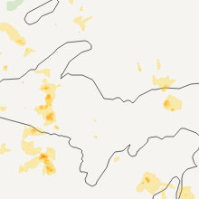
Hail Map for Calumet, MI
The Calumet, MI area has had 5 reports of on-the-ground hail by trained spotters, and has been under severe weather warnings 2 times during the past 12 months. Doppler radar has detected hail at or near Calumet, MI on 14 occasions.
| Name: | Calumet, MI |
| Where Located: | 69 miles NW of Marquette, MI |
| Map: | Google Map for Calumet, MI |
| Population: | 726 |
| Housing Units: | 512 |
| More Info: | Search Google for Calumet, MI |
0
The Top Recent Hail Date for Calumet, MI is Wednesday, June 5, 2024 (14th out of 14)

Hail and Wind Damage Spotted near Calumet, MI
| Date / Time | Report Details |
|---|---|
| 6/21/2025 6:25 AM EDT |
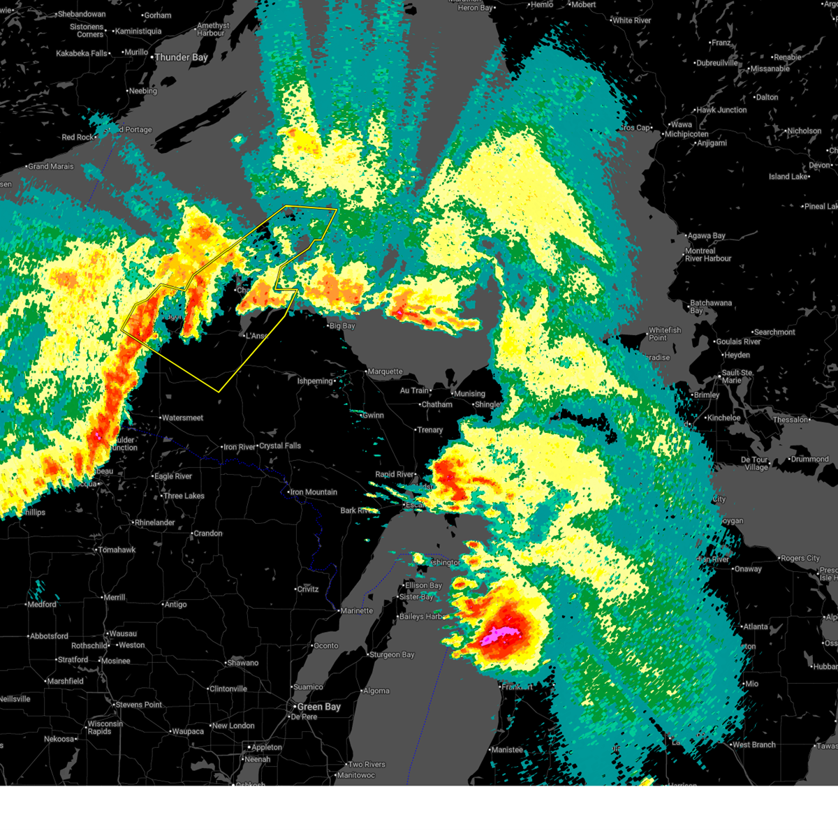 At 625 am edt, severe thunderstorms were located along a line extending from 17 miles west of eagle river to 7 miles southwest of south range to 6 miles northeast of mass city, moving east at 45 mph (radar indicated). Hazards include 60 mph wind gusts. Expect damage to roofs, siding, and trees. Locations impacted include, houghton, baraga, l'anse, ontonagon, calumet, eagle harbor, copper harbor, eagle river, hancock, laurium, chassell, and lake linden. At 625 am edt, severe thunderstorms were located along a line extending from 17 miles west of eagle river to 7 miles southwest of south range to 6 miles northeast of mass city, moving east at 45 mph (radar indicated). Hazards include 60 mph wind gusts. Expect damage to roofs, siding, and trees. Locations impacted include, houghton, baraga, l'anse, ontonagon, calumet, eagle harbor, copper harbor, eagle river, hancock, laurium, chassell, and lake linden.
|
| 6/21/2025 6:00 AM EDT |
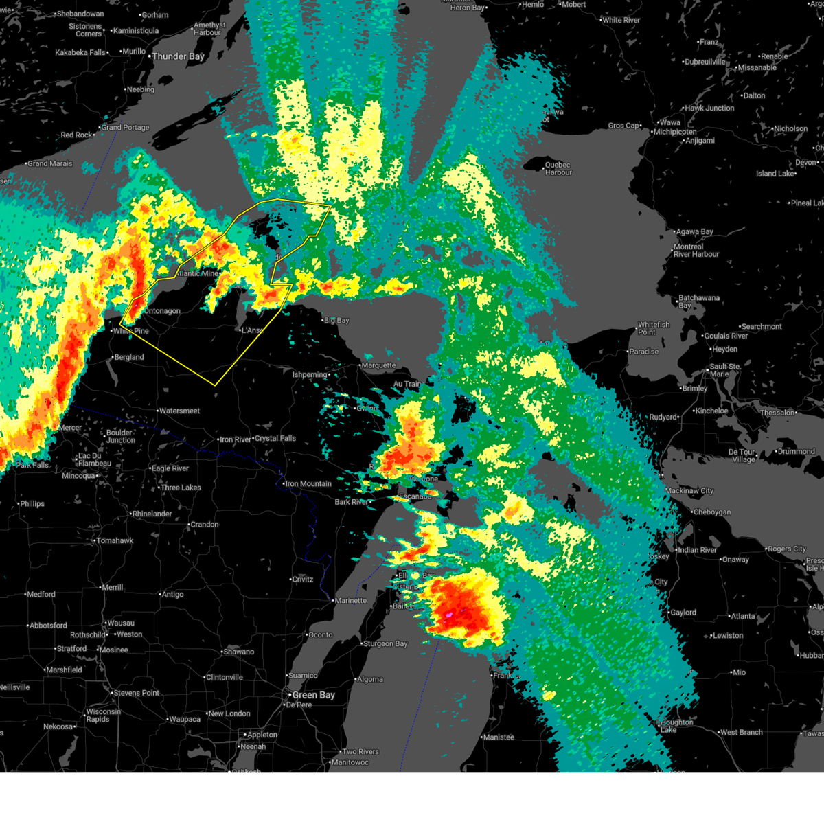 Svrmqt the national weather service in marquette has issued a * severe thunderstorm warning for, keweenaw county in western upper michigan, houghton county in western upper michigan, northeastern ontonagon county in western upper michigan, northwestern baraga county in north central upper michigan, * until 700 am edt. * at 559 am edt, severe thunderstorms were located along a line extending from 26 miles south of windigo to 21 miles west of redridge to near ontonagon, moving east at 45 mph (radar indicated). Hazards include 60 mph wind gusts. expect damage to roofs, siding, and trees Svrmqt the national weather service in marquette has issued a * severe thunderstorm warning for, keweenaw county in western upper michigan, houghton county in western upper michigan, northeastern ontonagon county in western upper michigan, northwestern baraga county in north central upper michigan, * until 700 am edt. * at 559 am edt, severe thunderstorms were located along a line extending from 26 miles south of windigo to 21 miles west of redridge to near ontonagon, moving east at 45 mph (radar indicated). Hazards include 60 mph wind gusts. expect damage to roofs, siding, and trees
|
| 5/18/2024 7:44 PM EDT | Quarter sized hail reported 0.3 miles SSW of Calumet, MI, facebook report with picture of 1 hail from calumet. time estimated by radar. size estimated by reporter. |
| 5/18/2024 7:39 PM EDT | Quarter sized hail reported 0.3 miles SSW of Calumet, MI, media partner forwarded photo of hailstones estimated to be quarter-sized. time estimated by radar. |
| 10/12/2022 8:15 AM EDT | Buoy station 45023 3 w portage cana in lsz243 county MI, 7.6 miles ESE of Calumet, MI |
| 5/25/2021 6:31 PM EDT |
 At 630 pm edt, a severe thunderstorm was located near hubbell, or 9 miles southeast of calumet, moving northeast at 50 mph (radar indicated). Hazards include 60 mph wind gusts and penny size hail. Expect damage to roofs, siding, and trees. This severe thunderstorm will be near, gay around 645 pm edt. At 630 pm edt, a severe thunderstorm was located near hubbell, or 9 miles southeast of calumet, moving northeast at 50 mph (radar indicated). Hazards include 60 mph wind gusts and penny size hail. Expect damage to roofs, siding, and trees. This severe thunderstorm will be near, gay around 645 pm edt.
|
| 5/25/2021 6:20 PM EDT | Caller reports a roadside stand that was strapped to the ground was blown over by a strong thunderstorm wind gus in houghton county MI, 2.2 miles SW of Calumet, MI |
| 5/25/2021 6:18 PM EDT | Asos station kcmx houghton co. airpor in houghton county MI, 5.5 miles NNE of Calumet, MI |
| 7/19/2020 12:40 AM EDT |
 At 1239 am edt, a severe thunderstorm was located over dollar bay, or near houghton, moving east at 45 mph (radar indicated). Hazards include ping pong ball size hail and 60 mph wind gusts. People and animals outdoors will be injured. expect hail damage to roofs, siding, windows, and vehicles. expect wind damage to roofs, siding, and trees. Locations impacted include, houghton, calumet, eagle river, hancock, laurium, chassell, lake linden, hubbell, houghton county airport, the upper entrance of portage canal, the lower entrance of portage canal and phoenix. At 1239 am edt, a severe thunderstorm was located over dollar bay, or near houghton, moving east at 45 mph (radar indicated). Hazards include ping pong ball size hail and 60 mph wind gusts. People and animals outdoors will be injured. expect hail damage to roofs, siding, windows, and vehicles. expect wind damage to roofs, siding, and trees. Locations impacted include, houghton, calumet, eagle river, hancock, laurium, chassell, lake linden, hubbell, houghton county airport, the upper entrance of portage canal, the lower entrance of portage canal and phoenix.
|
| 7/19/2020 12:34 AM EDT |
 At 1233 am edt, a severe thunderstorm was located over south range, or near houghton, moving east at 35 mph (radar indicated). Hazards include 60 mph wind gusts and quarter size hail. Hail damage to vehicles is expected. expect wind damage to roofs, siding, and trees. Locations impacted include, houghton, calumet, eagle river, hancock, laurium, chassell, lake linden, south range, hubbell, redridge, houghton county airport and the upper entrance of portage canal. At 1233 am edt, a severe thunderstorm was located over south range, or near houghton, moving east at 35 mph (radar indicated). Hazards include 60 mph wind gusts and quarter size hail. Hail damage to vehicles is expected. expect wind damage to roofs, siding, and trees. Locations impacted include, houghton, calumet, eagle river, hancock, laurium, chassell, lake linden, south range, hubbell, redridge, houghton county airport and the upper entrance of portage canal.
|
| 7/19/2020 12:08 AM EDT |
 At 1208 am edt, a severe thunderstorm was located 10 miles southwest of redridge, or 16 miles southwest of houghton, moving east at 45 mph (radar indicated). Hazards include 60 mph wind gusts and quarter size hail. Hail damage to vehicles is expected. Expect wind damage to roofs, siding, and trees. At 1208 am edt, a severe thunderstorm was located 10 miles southwest of redridge, or 16 miles southwest of houghton, moving east at 45 mph (radar indicated). Hazards include 60 mph wind gusts and quarter size hail. Hail damage to vehicles is expected. Expect wind damage to roofs, siding, and trees.
|
| 9/24/2019 9:58 PM EDT |
 The severe thunderstorm warning for keweenaw and northeastern houghton counties will expire at 1000 pm edt, the storm which prompted the warning has weakened below severe limits, and no longer poses an immediate threat to life or property. therefore, the warning will be allowed to expire. a tornado watch remains in effect until 100 am edt for western upper michigan. to report severe weather, contact your nearest law enforcement agency. they will relay your report to the national weather service marquette. The severe thunderstorm warning for keweenaw and northeastern houghton counties will expire at 1000 pm edt, the storm which prompted the warning has weakened below severe limits, and no longer poses an immediate threat to life or property. therefore, the warning will be allowed to expire. a tornado watch remains in effect until 100 am edt for western upper michigan. to report severe weather, contact your nearest law enforcement agency. they will relay your report to the national weather service marquette.
|
| 9/24/2019 9:29 PM EDT |
 At 929 pm edt, a severe thunderstorm was located near lake linden, or near calumet, moving east at 30 mph (radar indicated). Hazards include 60 mph wind gusts and quarter size hail. Hail damage to vehicles is expected. Expect wind damage to roofs, siding, and trees. At 929 pm edt, a severe thunderstorm was located near lake linden, or near calumet, moving east at 30 mph (radar indicated). Hazards include 60 mph wind gusts and quarter size hail. Hail damage to vehicles is expected. Expect wind damage to roofs, siding, and trees.
|
| 9/24/2019 9:11 PM EDT |
 At 911 pm edt, a severe thunderstorm was located over the upper entrance of portage canal, or near houghton, moving northeast at 20 mph (radar indicated). Hazards include 60 mph wind gusts and quarter size hail. Hail damage to vehicles is expected. expect wind damage to roofs, siding, and trees. locations impacted include, houghton, calumet, eagle harbor, eagle river, hancock, laurium, lake linden, hubbell, houghton county airport, the upper entrance of portage canal, phoenix and dollar bay. A tornado watch remains in effect until 100 am edt for western upper michigan. At 911 pm edt, a severe thunderstorm was located over the upper entrance of portage canal, or near houghton, moving northeast at 20 mph (radar indicated). Hazards include 60 mph wind gusts and quarter size hail. Hail damage to vehicles is expected. expect wind damage to roofs, siding, and trees. locations impacted include, houghton, calumet, eagle harbor, eagle river, hancock, laurium, lake linden, hubbell, houghton county airport, the upper entrance of portage canal, phoenix and dollar bay. A tornado watch remains in effect until 100 am edt for western upper michigan.
|
| 9/24/2019 8:48 PM EDT |
 At 848 pm edt, a severe thunderstorm was located over redridge, or 7 miles northwest of houghton, moving east at 35 mph (radar indicated). Hazards include 60 mph wind gusts and quarter size hail. Hail damage to vehicles is expected. Expect wind damage to roofs, siding, and trees. At 848 pm edt, a severe thunderstorm was located over redridge, or 7 miles northwest of houghton, moving east at 35 mph (radar indicated). Hazards include 60 mph wind gusts and quarter size hail. Hail damage to vehicles is expected. Expect wind damage to roofs, siding, and trees.
|
| 8/5/2019 2:17 PM EDT | Large branches of tall maple trees down in front yard of home in calumet. report via social media. time estimated by rada in houghton county MI, 0.5 miles NNW of Calumet, MI |
| 8/5/2019 2:11 PM EDT | Large tree down at calumet cemetery. report from social media. time estimated by rada in houghton county MI, 1.3 miles E of Calumet, MI |
| 8/27/2018 8:22 PM EDT |
 At 753 pm edt, a severe thunderstorm was located near redridge, or 12 miles west of houghton, moving east at 35 mph (radar indicated). Hazards include 60 mph wind gusts and nickel size hail. expect damage to roofs, siding, and trees At 753 pm edt, a severe thunderstorm was located near redridge, or 12 miles west of houghton, moving east at 35 mph (radar indicated). Hazards include 60 mph wind gusts and nickel size hail. expect damage to roofs, siding, and trees
|
| 8/27/2018 7:53 PM EDT |
 At 753 pm edt, a severe thunderstorm was located near redridge, or 12 miles west of houghton, moving east at 35 mph (radar indicated). Hazards include 60 mph wind gusts and nickel size hail. expect damage to roofs, siding, and trees At 753 pm edt, a severe thunderstorm was located near redridge, or 12 miles west of houghton, moving east at 35 mph (radar indicated). Hazards include 60 mph wind gusts and nickel size hail. expect damage to roofs, siding, and trees
|
| 6/29/2018 11:55 AM EDT | Houghton county airport observatio in houghton county MI, 5.5 miles NNE of Calumet, MI |
| 6/29/2018 11:45 AM EDT | Photos received of three trees downed at mcclain state park. time estimated by rada in houghton county MI, 7.4 miles E of Calumet, MI |
| 6/29/2018 11:35 AM EDT |
 At 1101 am edt, severe thunderstorms were located along a line extending from 29 miles northwest of redridge to 6 miles southwest of silver city, moving east-southeast at 50 mph (radar indicated). Hazards include 70 mph wind gusts and quarter size hail. Hail damage to vehicles is expected. expect considerable tree damage. Wind damage is also likely to mobile homes, roofs, and outbuildings. At 1101 am edt, severe thunderstorms were located along a line extending from 29 miles northwest of redridge to 6 miles southwest of silver city, moving east-southeast at 50 mph (radar indicated). Hazards include 70 mph wind gusts and quarter size hail. Hail damage to vehicles is expected. expect considerable tree damage. Wind damage is also likely to mobile homes, roofs, and outbuildings.
|
| 6/29/2018 11:03 AM EDT |
 At 1101 am edt, severe thunderstorms were located along a line extending from 29 miles northwest of redridge to 6 miles southwest of silver city, moving east-southeast at 50 mph (radar indicated). Hazards include 70 mph wind gusts and quarter size hail. Hail damage to vehicles is expected. expect considerable tree damage. Wind damage is also likely to mobile homes, roofs, and outbuildings. At 1101 am edt, severe thunderstorms were located along a line extending from 29 miles northwest of redridge to 6 miles southwest of silver city, moving east-southeast at 50 mph (radar indicated). Hazards include 70 mph wind gusts and quarter size hail. Hail damage to vehicles is expected. expect considerable tree damage. Wind damage is also likely to mobile homes, roofs, and outbuildings.
|
| 9/22/2017 11:37 AM EDT | Quarter sized hail reported 0.8 miles NW of Calumet, MI, hail up to quarter size falling. |
| 9/22/2017 11:31 AM EDT |
 At 1130 am edt, a severe thunderstorm was located near hubbell, or 7 miles east of houghton, moving east at 40 mph (radar indicated). Hazards include quarter size hail. damage to vehicles is expected At 1130 am edt, a severe thunderstorm was located near hubbell, or 7 miles east of houghton, moving east at 40 mph (radar indicated). Hazards include quarter size hail. damage to vehicles is expected
|
| 6/15/2017 2:55 PM EDT |
 The severe thunderstorm warning for keweenaw and northeastern houghton counties will expire at 300 pm edt, the storm which prompted the warning has weakened below severe limits, and no longer pose an immediate threat to life or property. therefore the warning will be allowed to expire. however gusty winds are still possible with this thunderstorm. The severe thunderstorm warning for keweenaw and northeastern houghton counties will expire at 300 pm edt, the storm which prompted the warning has weakened below severe limits, and no longer pose an immediate threat to life or property. therefore the warning will be allowed to expire. however gusty winds are still possible with this thunderstorm.
|
| 6/15/2017 2:37 PM EDT |
 At 237 pm edt, a severe thunderstorm was located near lake linden, or 7 miles east of calumet, moving northeast at 25 mph (radar indicated). Hazards include 60 mph wind gusts and penny size hail. Expect damage to roofs, siding, and trees. Locations impacted include, calumet, eagle harbor, eagle river, laurium, lake linden, bete grise, hubbell, lac la belle, phoenix, mohawk, gay, allouez, delaware, copper city, ahmeek, gratiot lake and betsy. At 237 pm edt, a severe thunderstorm was located near lake linden, or 7 miles east of calumet, moving northeast at 25 mph (radar indicated). Hazards include 60 mph wind gusts and penny size hail. Expect damage to roofs, siding, and trees. Locations impacted include, calumet, eagle harbor, eagle river, laurium, lake linden, bete grise, hubbell, lac la belle, phoenix, mohawk, gay, allouez, delaware, copper city, ahmeek, gratiot lake and betsy.
|
| 6/15/2017 2:21 PM EDT |
 At 221 pm edt, a severe thunderstorm was located over lake linden, or near calumet, moving northeast at 30 mph (radar indicated). Hazards include 60 mph wind gusts and quarter size hail. Hail damage to vehicles is expected. Expect wind damage to roofs, siding, and trees. At 221 pm edt, a severe thunderstorm was located over lake linden, or near calumet, moving northeast at 30 mph (radar indicated). Hazards include 60 mph wind gusts and quarter size hail. Hail damage to vehicles is expected. Expect wind damage to roofs, siding, and trees.
|
| 6/10/2017 9:07 PM EDT | Powerlines down in calumet. time estimated from rada in houghton county MI, 0.5 miles NNW of Calumet, MI |
| 6/10/2017 9:07 PM EDT | Metal shed was flipped over by thunderstorm winds. report received via social medi in houghton county MI, 0.3 miles SSW of Calumet, MI |
| 6/10/2017 9:06 PM EDT |
 At 906 pm edt, a severe thunderstorm was located over hubbell, or near calumet, moving east at 60 mph (radar indicated). Hazards include 60 mph wind gusts and quarter size hail. Hail damage to vehicles is expected. expect wind damage to roofs, siding, and trees. Locations impacted include, houghton, calumet, hancock, laurium, lake linden, hubbell, houghton county airport, dollar bay, gay and rabbit bay. At 906 pm edt, a severe thunderstorm was located over hubbell, or near calumet, moving east at 60 mph (radar indicated). Hazards include 60 mph wind gusts and quarter size hail. Hail damage to vehicles is expected. expect wind damage to roofs, siding, and trees. Locations impacted include, houghton, calumet, hancock, laurium, lake linden, hubbell, houghton county airport, dollar bay, gay and rabbit bay.
|
| 6/10/2017 8:55 PM EDT |
 At 855 pm edt, a severe thunderstorm was located near hancock, or near houghton, moving east at 60 mph (radar indicated). Hazards include 60 mph wind gusts and quarter size hail. Hail damage to vehicles is expected. Expect wind damage to roofs, siding, and trees. At 855 pm edt, a severe thunderstorm was located near hancock, or near houghton, moving east at 60 mph (radar indicated). Hazards include 60 mph wind gusts and quarter size hail. Hail damage to vehicles is expected. Expect wind damage to roofs, siding, and trees.
|
| 7/21/2016 7:30 AM EDT |
 At 727 am edt/627 am cdt/, severe thunderstorms were located along a line extending from near mclain state park to near rabbit bay to near skanee to 6 miles northwest of three lakes to near iron river, moving east at 60 mph (law enforcement. at 725 am edt/625 am cdt/ numerous trees were reported down over houghton and baraga counties, including over roadways). Hazards include 70 mph wind gusts and nickel size hail. Expect considerable tree damage. damage is likely to mobile homes, roofs and outbuildings. locations impacted include, houghton, iron river, l`anse, crystal falls, calumet, hancock, laurium, stambaugh, lake linden, covington, dollar bay, the lower entrance of portage canal, amasa, torch lake, mclain state park, u. s. 141 between covington and amasa, the upper entrance of portage canal, rabbit bay, alberta and point abbaye. At 727 am edt/627 am cdt/, severe thunderstorms were located along a line extending from near mclain state park to near rabbit bay to near skanee to 6 miles northwest of three lakes to near iron river, moving east at 60 mph (law enforcement. at 725 am edt/625 am cdt/ numerous trees were reported down over houghton and baraga counties, including over roadways). Hazards include 70 mph wind gusts and nickel size hail. Expect considerable tree damage. damage is likely to mobile homes, roofs and outbuildings. locations impacted include, houghton, iron river, l`anse, crystal falls, calumet, hancock, laurium, stambaugh, lake linden, covington, dollar bay, the lower entrance of portage canal, amasa, torch lake, mclain state park, u. s. 141 between covington and amasa, the upper entrance of portage canal, rabbit bay, alberta and point abbaye.
|
| 7/21/2016 6:56 AM EDT |
 At 654 am edt/554 am cdt/, severe thunderstorms were located along a line extending from 8 miles east of fourteen mile point to near nisula to 8 miles northwest of kenton to 10 miles southwest of watersmeet, moving east at 65 mph (law enforcement. these storms downed numerous trees and powerlines around mass city and over western gogebic county). Hazards include 70 mph wind gusts and nickel size hail. Expect considerable tree damage. damage is likely to mobile homes, roofs and outbuildings. locations impacted include, houghton, iron river, baraga, l`anse, crystal falls, calumet, hancock, laurium, chassell, stambaugh, lake linden, south range, covington, dollar bay, the lower entrance of portage canal, assinins, amasa, torch lake, mclain state park and u. s. 141 between covington and amasa. At 654 am edt/554 am cdt/, severe thunderstorms were located along a line extending from 8 miles east of fourteen mile point to near nisula to 8 miles northwest of kenton to 10 miles southwest of watersmeet, moving east at 65 mph (law enforcement. these storms downed numerous trees and powerlines around mass city and over western gogebic county). Hazards include 70 mph wind gusts and nickel size hail. Expect considerable tree damage. damage is likely to mobile homes, roofs and outbuildings. locations impacted include, houghton, iron river, baraga, l`anse, crystal falls, calumet, hancock, laurium, chassell, stambaugh, lake linden, south range, covington, dollar bay, the lower entrance of portage canal, assinins, amasa, torch lake, mclain state park and u. s. 141 between covington and amasa.
|
| 7/21/2016 6:46 AM EDT |
 At 645 am edt/545 am cdt/, severe thunderstorms were located along a line extending from near fourteen mile point to near bruce crossing to 7 miles northeast of boulder junction, moving east at 65 mph (radar indicated. this storm downed trees and powerlines it moved through western gogebic county). Hazards include 60 mph wind gusts and nickel size hail. Expect damage to roofs. Siding and trees. At 645 am edt/545 am cdt/, severe thunderstorms were located along a line extending from near fourteen mile point to near bruce crossing to 7 miles northeast of boulder junction, moving east at 65 mph (radar indicated. this storm downed trees and powerlines it moved through western gogebic county). Hazards include 60 mph wind gusts and nickel size hail. Expect damage to roofs. Siding and trees.
|
| 6/25/2016 10:19 PM EDT |
 At 1018 pm edt/918 pm cdt/, severe thunderstorms were located along a line extending from 6 miles southwest of south range to near nisula, moving east at 35 mph (radar indicated). Hazards include 60 mph wind gusts. Expect damage to roofs. siding and trees. Locations impacted include, houghton, baraga, l`anse, calumet, hancock, laurium, chassell, lake linden, south range, point abbaye, dollar bay, the lower entrance of portage canal, hubbell, sidnaw, keweenaw bay, assinins, kenton, redridge, houghton county airport and torch lake. At 1018 pm edt/918 pm cdt/, severe thunderstorms were located along a line extending from 6 miles southwest of south range to near nisula, moving east at 35 mph (radar indicated). Hazards include 60 mph wind gusts. Expect damage to roofs. siding and trees. Locations impacted include, houghton, baraga, l`anse, calumet, hancock, laurium, chassell, lake linden, south range, point abbaye, dollar bay, the lower entrance of portage canal, hubbell, sidnaw, keweenaw bay, assinins, kenton, redridge, houghton county airport and torch lake.
|
| 6/25/2016 10:10 PM EDT |
 At 1010 pm edt/910 pm cdt/, severe thunderstorms were located along a line extending from 8 miles south of freda to near nisula, moving east at 35 mph (radar indicated). Hazards include 60 mph wind gusts. Expect damage to roofs. Siding and trees. At 1010 pm edt/910 pm cdt/, severe thunderstorms were located along a line extending from 8 miles south of freda to near nisula, moving east at 35 mph (radar indicated). Hazards include 60 mph wind gusts. Expect damage to roofs. Siding and trees.
|
| 6/25/2016 12:36 PM EDT |
 At 1235 pm edt, a severe thunderstorm was located near calumet and mohawk, moving east at 30 mph (radar indicated). Hazards include 60 mph wind gusts and quarter size hail. Hail damage to vehicles is expected. expect wind damage to roofs, siding and trees. Locations impacted include, houghton, baraga, calumet, eagle river, hancock, laurium, chassell, lake linden, south range, phoenix, point abbaye, dollar bay, the lower entrance of portage canal, hubbell, gay, redridge, houghton county airport, torch lake, mclain state park and jacobsville. At 1235 pm edt, a severe thunderstorm was located near calumet and mohawk, moving east at 30 mph (radar indicated). Hazards include 60 mph wind gusts and quarter size hail. Hail damage to vehicles is expected. expect wind damage to roofs, siding and trees. Locations impacted include, houghton, baraga, calumet, eagle river, hancock, laurium, chassell, lake linden, south range, phoenix, point abbaye, dollar bay, the lower entrance of portage canal, hubbell, gay, redridge, houghton county airport, torch lake, mclain state park and jacobsville.
|
| 6/25/2016 12:25 PM EDT | Multiple trees down in the high terrain in northern houghton county. time estimated by rada in houghton county MI, 1.9 miles N of Calumet, MI |
| 6/25/2016 11:54 AM EDT |
 At 1153 am edt, severe thunderstorms were located along a line extending from 13 miles northwest of eagle river to 11 miles north of fourteen mile point, moving southeast at 35 mph (radar indicated). Hazards include quarter size hail and 60 mph wind gusts. Hail damage to vehicles is expected. Expect wind damage to roofs, siding and trees. At 1153 am edt, severe thunderstorms were located along a line extending from 13 miles northwest of eagle river to 11 miles north of fourteen mile point, moving southeast at 35 mph (radar indicated). Hazards include quarter size hail and 60 mph wind gusts. Hail damage to vehicles is expected. Expect wind damage to roofs, siding and trees.
|
| 6/29/2014 10:05 PM EDT | Quarter sized hail reported 0.3 miles SSW of Calumet, MI, quarter size hail. |
| 5/20/2012 1:45 PM EDT | Quarter sized hail reported 0.3 miles SSW of Calumet, MI |
| 1/1/0001 12:00 AM | Multiple locations along caledonia street had tree damage. one house had a tree branch at about 1.5 ft in diameter that fell onto his deck. various other 6 inch to 1 ft in houghton county MI, 0.6 miles WSW of Calumet, MI |
| 1/1/0001 12:00 AM | Metal building housing a travel trailer destroyed. several trees estimated to be between 1.5 to 2 feet in diameter were uprooted. damage began on mine street and contin in houghton county MI, 0.6 miles WSW of Calumet, MI |
| 1/1/0001 12:00 AM | Metal building housing a travel trailer destroyed. several trees estimated to be between 1.5 to 2 feet in diameter were uprooted. significant damage to a drill shop roo in houghton county MI, 0.6 miles WSW of Calumet, MI |
| 1/1/0001 12:00 AM | Damage to home. windows partially broken and garage door bowing inward. rollers blown off the garage door. garage was shifted 1 inch off foundation. garage door and dam in houghton county MI, 1.1 miles SSW of Calumet, MI |
| 1/1/0001 12:00 AM | Small wooden shed rolled once over a fence at calumet elementary school. shed was about 8 feet high and 12 feet wide made out of wood. heavy structure. rolled to the no in houghton county MI, 1.1 miles SSW of Calumet, MI |
| 1/1/0001 12:00 AM | Powerlines downed. trees down but dimensions unknow in houghton county MI, 0.3 miles SSW of Calumet, MI |
Hail Maps for Calumet, MI


Connect with Interactive Hail Maps