

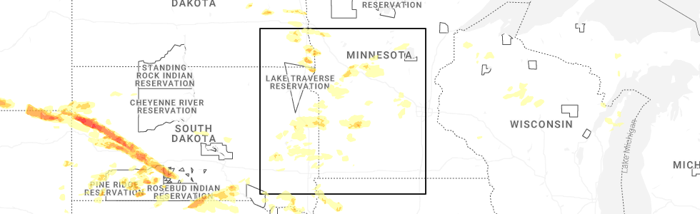
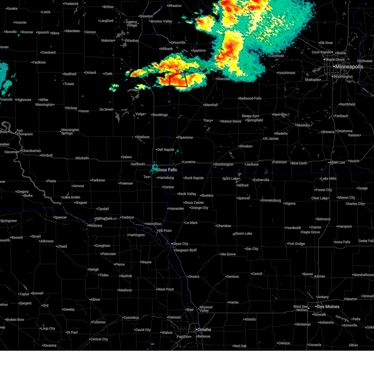
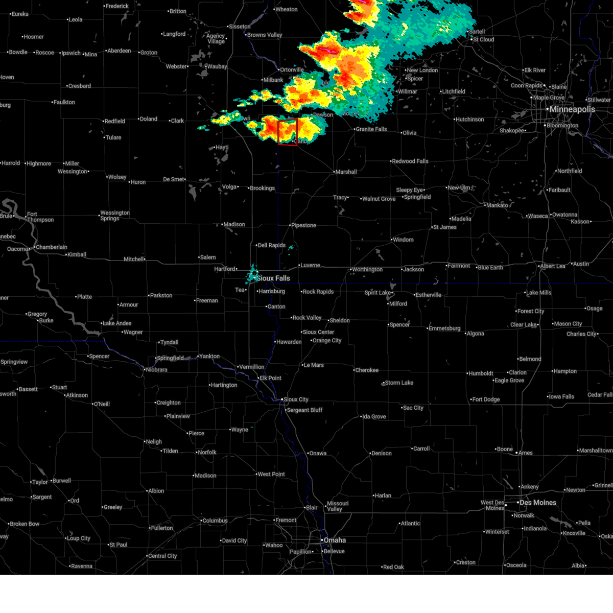
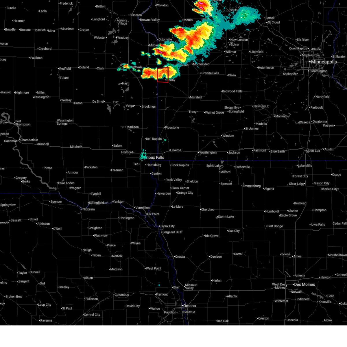
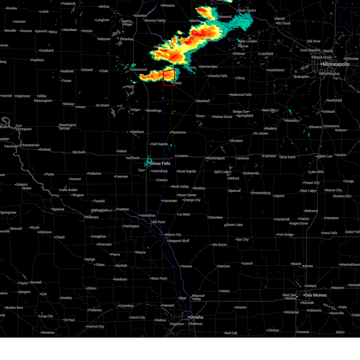
Hail Map for Canby, MN
The Canby, MN area has had 5 reports of on-the-ground hail by trained spotters, and has been under severe weather warnings 13 times during the past 12 months. Doppler radar has detected hail at or near Canby, MN on 46 occasions, including 2 occasions during the past year.
| Name: | Canby, MN |
| Where Located: | 32.2 miles WSW of Montevideo, MN |
| Map: | Google Map for Canby, MN |
| Population: | 1795 |
| Housing Units: | 892 |
| More Info: | Search Google for Canby, MN |
3
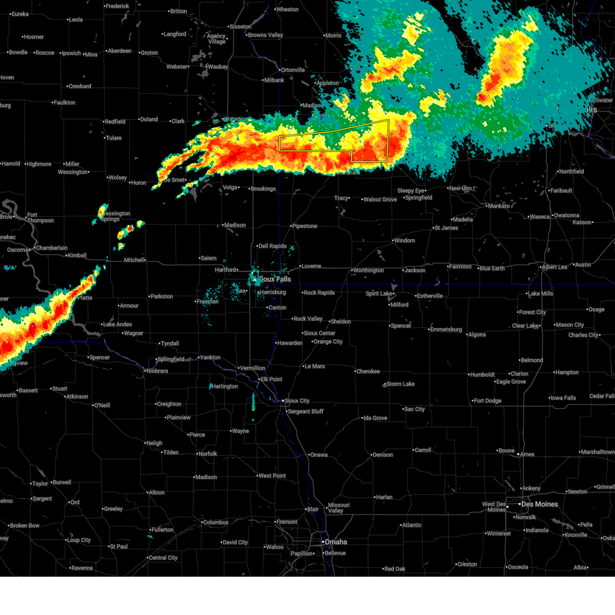
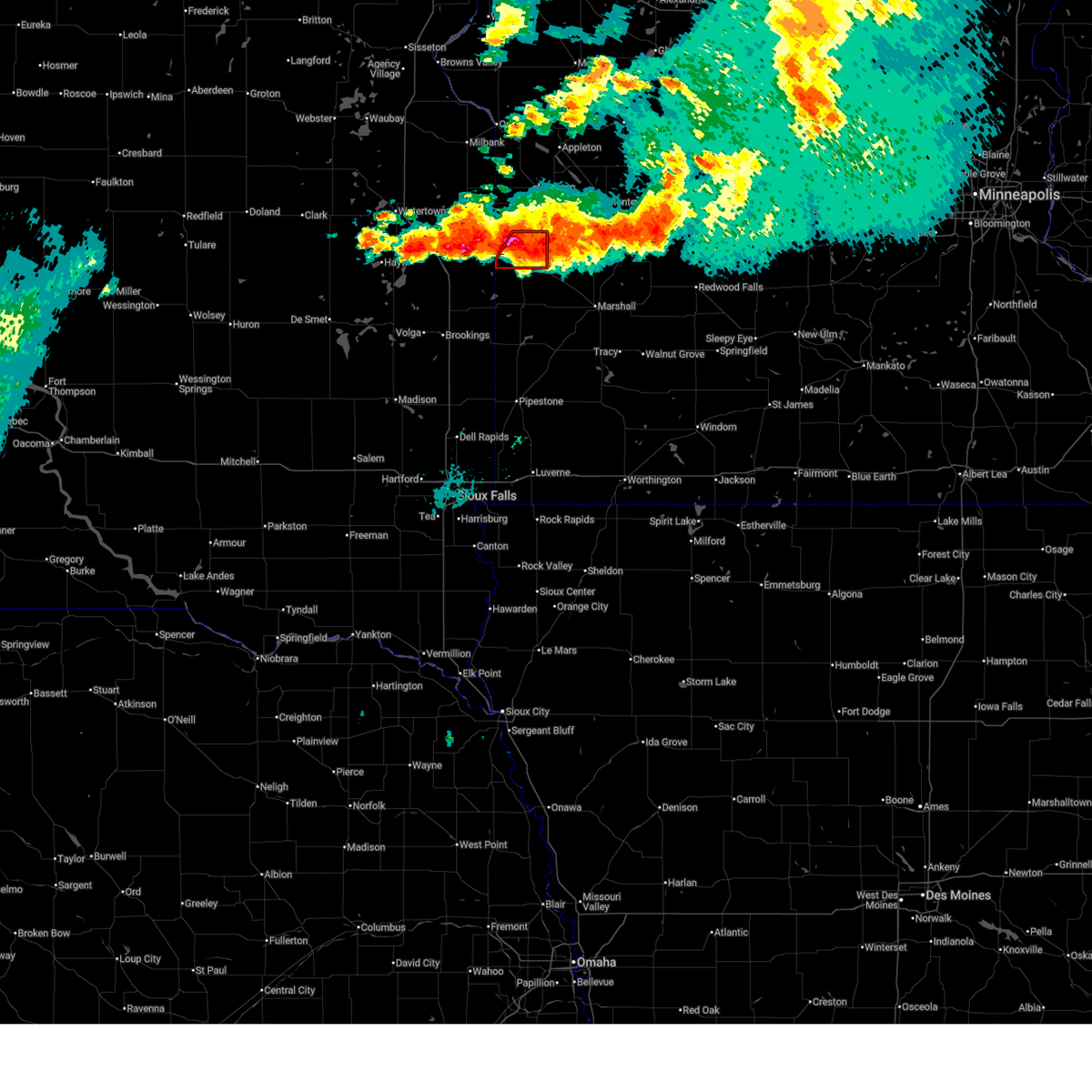
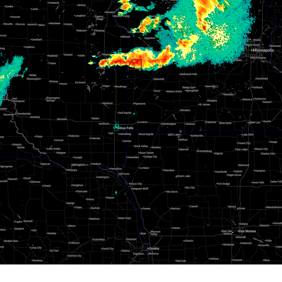
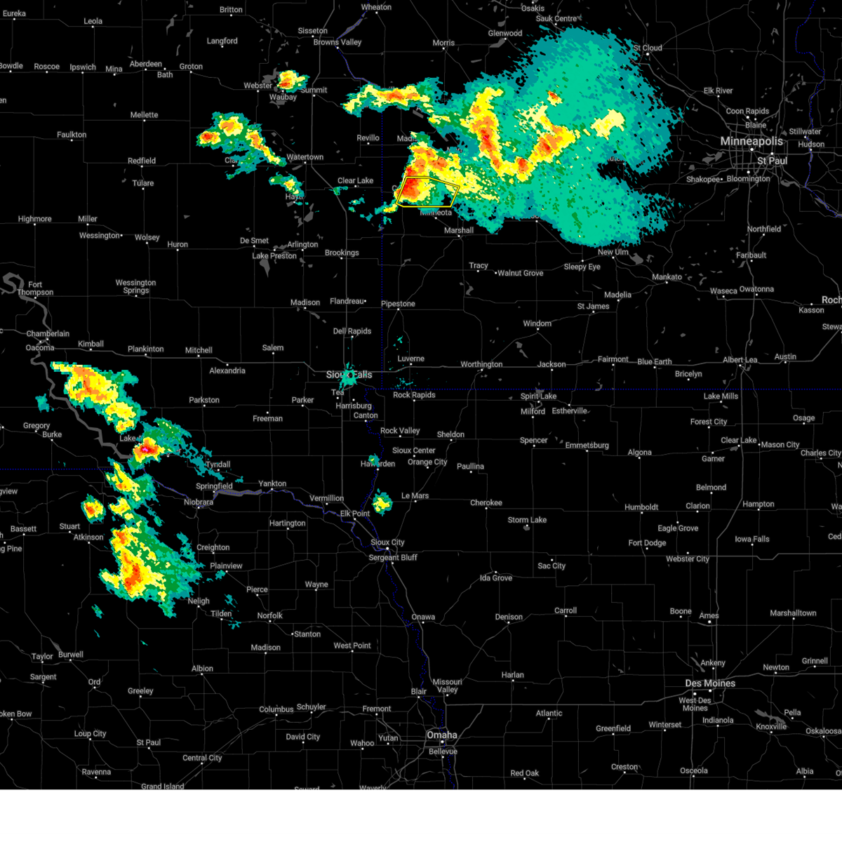
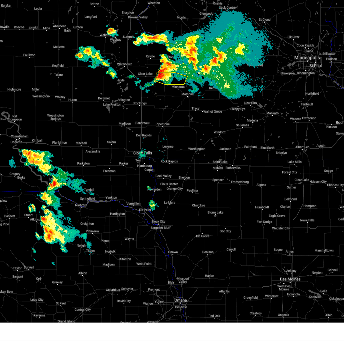
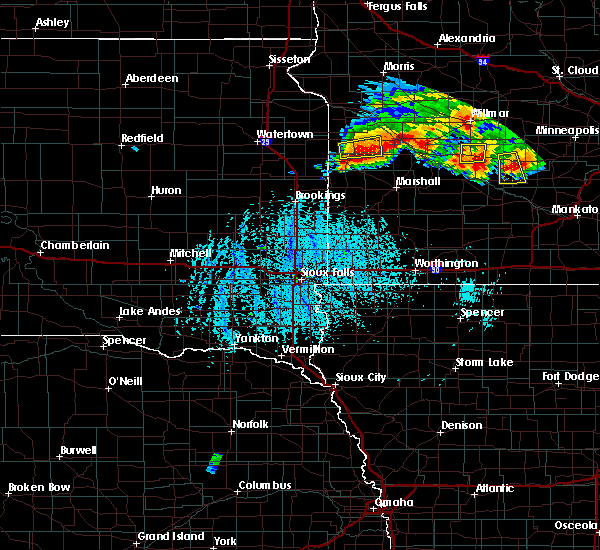
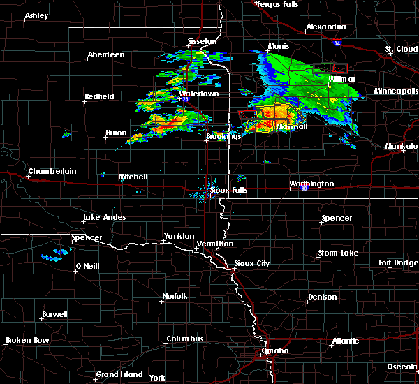
The Top Recent Hail Date for Canby, MN is Saturday, June 28, 2025 (2nd out of 46)
Hail and Wind Damage Spotted near Canby, MN
| Date / Time | Report Details |
|---|---|
| 6/28/2025 10:56 PM CDT |
 The storms which prompted the warning have moved out of the area. therefore, the warning will be allowed to expire. another severe thunderstorm warning still remains in effect for redwood county, renville county, and yellow medicine county until 1145 pm. The storms which prompted the warning have moved out of the area. therefore, the warning will be allowed to expire. another severe thunderstorm warning still remains in effect for redwood county, renville county, and yellow medicine county until 1145 pm.
|
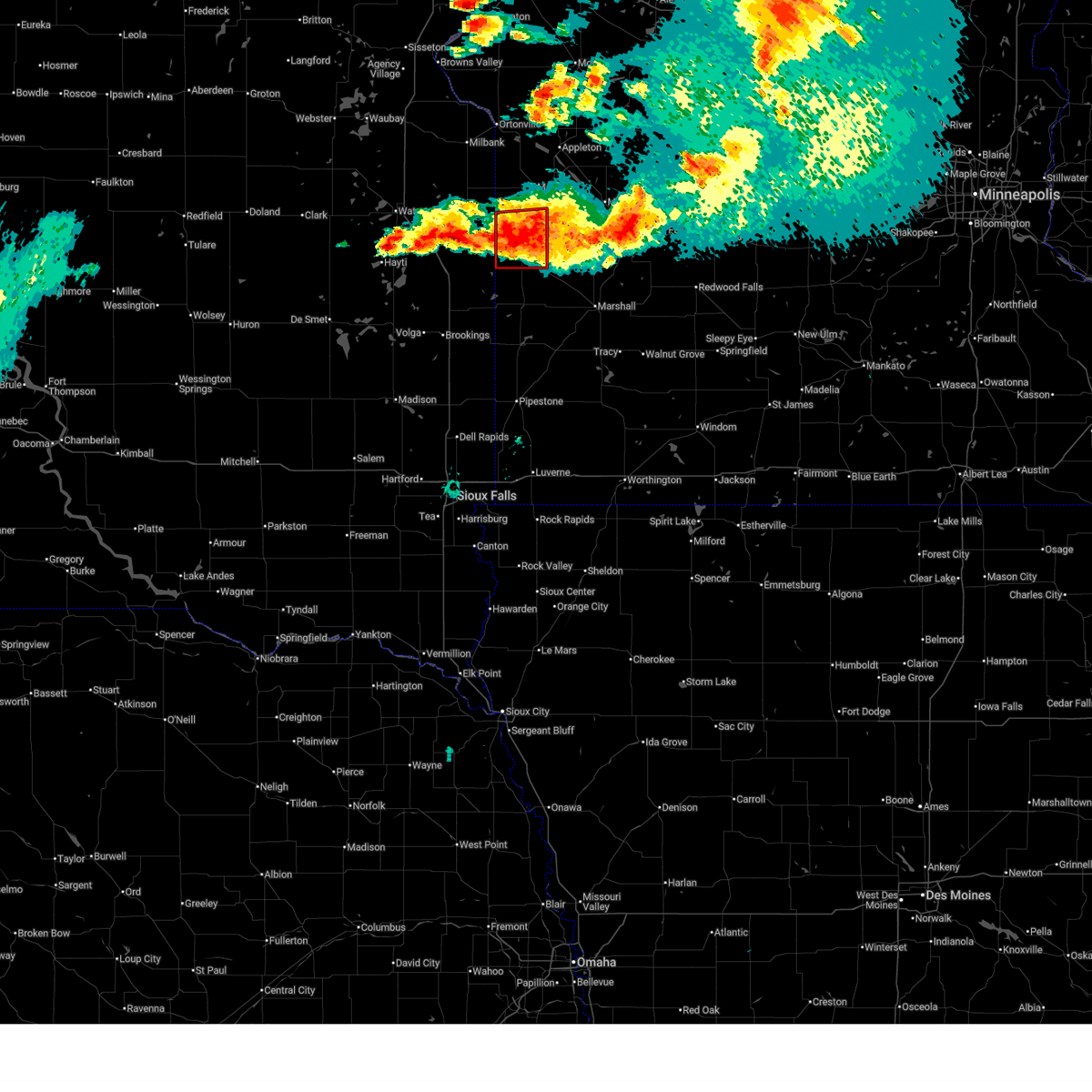
| 6/28/2025 10:35 PM CDT |
 At 1035 pm cdt, severe thunderstorms were located along a line from over renville to 9 miles southwest of canby, or along a line from 16 miles north of redwood falls to 40 miles southwest of montevideo, moving southeast at 25 mph (radar indicated). Hazards include 60 mph wind gusts and quarter size hail. Hail damage to vehicles is expected. expect wind damage to roofs, siding, and trees. locations impacted include, granite falls, canby, renville, clarkfield, sacred heart, wood lake, hanley falls, echo, porter, minnesota falls, belview, spring creek, delhi, hazel run, spellman lake, granite falls airport, upper sioux agency state park, st. Leo and burr. At 1035 pm cdt, severe thunderstorms were located along a line from over renville to 9 miles southwest of canby, or along a line from 16 miles north of redwood falls to 40 miles southwest of montevideo, moving southeast at 25 mph (radar indicated). Hazards include 60 mph wind gusts and quarter size hail. Hail damage to vehicles is expected. expect wind damage to roofs, siding, and trees. locations impacted include, granite falls, canby, renville, clarkfield, sacred heart, wood lake, hanley falls, echo, porter, minnesota falls, belview, spring creek, delhi, hazel run, spellman lake, granite falls airport, upper sioux agency state park, st. Leo and burr.
|
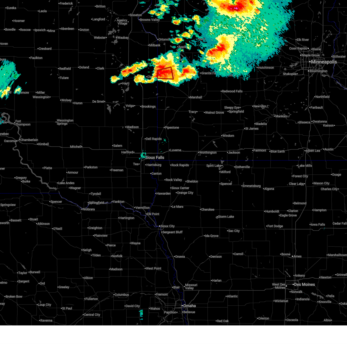
| 6/28/2025 10:21 PM CDT |
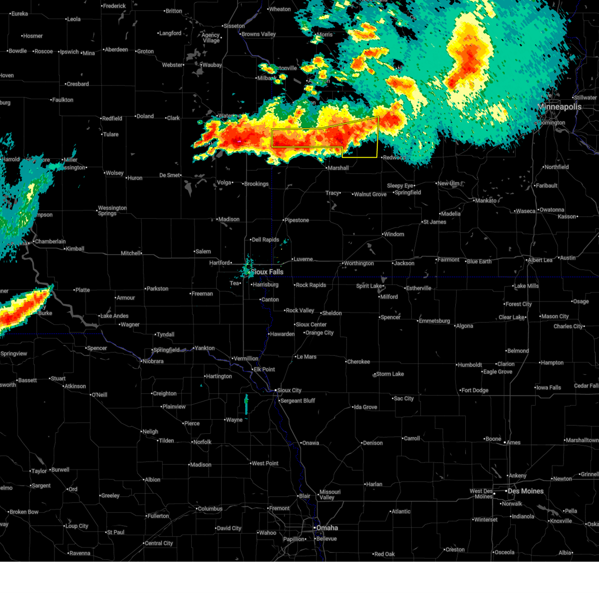 Svrmpx the national weather service in the twin cities has issued a * severe thunderstorm warning for, northwestern renville county in central minnesota, northwestern redwood county in southwestern minnesota, south central chippewa county in west central minnesota, yellow medicine county in west central minnesota, * until 1100 pm cdt. * at 1021 pm cdt, severe thunderstorms were located along a line from near renville to 9 miles southwest of canby, or along a line from 18 miles northwest of redwood falls to 40 miles southwest of montevideo, moving east at 30 mph (radar indicated). Hazards include 60 mph wind gusts and quarter size hail. Hail damage to vehicles is expected. Expect wind damage to roofs, siding, and trees. Svrmpx the national weather service in the twin cities has issued a * severe thunderstorm warning for, northwestern renville county in central minnesota, northwestern redwood county in southwestern minnesota, south central chippewa county in west central minnesota, yellow medicine county in west central minnesota, * until 1100 pm cdt. * at 1021 pm cdt, severe thunderstorms were located along a line from near renville to 9 miles southwest of canby, or along a line from 18 miles northwest of redwood falls to 40 miles southwest of montevideo, moving east at 30 mph (radar indicated). Hazards include 60 mph wind gusts and quarter size hail. Hail damage to vehicles is expected. Expect wind damage to roofs, siding, and trees.
|
| 6/28/2025 9:50 PM CDT |
 the tornado warning has been cancelled and is no longer in effect the tornado warning has been cancelled and is no longer in effect
|
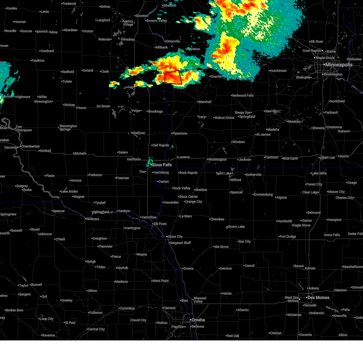
| 6/28/2025 9:40 PM CDT |
 At 940 pm cdt, a severe thunderstorm capable of producing a tornado was located over canby, or 33 miles southwest of montevideo, moving southeast at 10 mph (radar indicated rotation). Hazards include tornado and ping pong ball size hail. Flying debris will be dangerous to those caught without shelter. mobile homes will be damaged or destroyed. damage to roofs, windows and vehicles will occur. tree damage is likely. Locations impacted include, canby, porter and burr. At 940 pm cdt, a severe thunderstorm capable of producing a tornado was located over canby, or 33 miles southwest of montevideo, moving southeast at 10 mph (radar indicated rotation). Hazards include tornado and ping pong ball size hail. Flying debris will be dangerous to those caught without shelter. mobile homes will be damaged or destroyed. damage to roofs, windows and vehicles will occur. tree damage is likely. Locations impacted include, canby, porter and burr.
|
| 6/28/2025 9:40 PM CDT |
 the tornado warning has been cancelled and is no longer in effect the tornado warning has been cancelled and is no longer in effect
|
| 6/28/2025 9:34 PM CDT | Storm damage reported in yellow medicine county MN, 0.1 miles ESE of Canby, MN |
| 6/28/2025 9:31 PM CDT |
 Tormpx the national weather service in the twin cities has issued a * tornado warning for, southwestern lac qui parle county in west central minnesota, west central yellow medicine county in west central minnesota, * until 1015 pm cdt. * at 931 pm cdt, a severe thunderstorm capable of producing a tornado was located near canby, or 33 miles southwest of montevideo, moving east at 10 mph (radar indicated rotation). Hazards include tornado and ping pong ball size hail. Flying debris will be dangerous to those caught without shelter. mobile homes will be damaged or destroyed. damage to roofs, windows and vehicles will occur. Tree damage is likely. Tormpx the national weather service in the twin cities has issued a * tornado warning for, southwestern lac qui parle county in west central minnesota, west central yellow medicine county in west central minnesota, * until 1015 pm cdt. * at 931 pm cdt, a severe thunderstorm capable of producing a tornado was located near canby, or 33 miles southwest of montevideo, moving east at 10 mph (radar indicated rotation). Hazards include tornado and ping pong ball size hail. Flying debris will be dangerous to those caught without shelter. mobile homes will be damaged or destroyed. damage to roofs, windows and vehicles will occur. Tree damage is likely.
|
| 6/28/2025 9:08 PM CDT |
 At 908 pm cdt, a severe thunderstorm capable of producing a tornado was located 6 miles northwest of canby, or 32 miles west of montevideo, moving east at 10 mph (radar indicated rotation). Hazards include tornado and half dollar size hail. Flying debris will be dangerous to those caught without shelter. mobile homes will be damaged or destroyed. damage to roofs, windows and vehicles will occur. tree damage is likely. Locations impacted include, canby and burr. At 908 pm cdt, a severe thunderstorm capable of producing a tornado was located 6 miles northwest of canby, or 32 miles west of montevideo, moving east at 10 mph (radar indicated rotation). Hazards include tornado and half dollar size hail. Flying debris will be dangerous to those caught without shelter. mobile homes will be damaged or destroyed. damage to roofs, windows and vehicles will occur. tree damage is likely. Locations impacted include, canby and burr.
|
| 6/28/2025 8:58 PM CDT |
 At 858 pm cdt, a confirmed and extremely dangerous tornado was located 7 miles northwest of canby, or 33 miles west of montevideo, moving east at 15 mph. this is a particularly dangerous situation. take cover now! (weather spotters confirmed tornado). Hazards include damaging tornado and half dollar size hail. You are in a life-threatening situation. flying debris may be deadly to those caught without shelter. mobile homes will be destroyed. considerable damage to homes, businesses, and vehicles is likely and complete destruction is possible. Locations impacted include, canby and burr. At 858 pm cdt, a confirmed and extremely dangerous tornado was located 7 miles northwest of canby, or 33 miles west of montevideo, moving east at 15 mph. this is a particularly dangerous situation. take cover now! (weather spotters confirmed tornado). Hazards include damaging tornado and half dollar size hail. You are in a life-threatening situation. flying debris may be deadly to those caught without shelter. mobile homes will be destroyed. considerable damage to homes, businesses, and vehicles is likely and complete destruction is possible. Locations impacted include, canby and burr.
|
| 6/28/2025 8:46 PM CDT |
 Tormpx the national weather service in the twin cities has issued a * tornado warning for, southwestern lac qui parle county in west central minnesota, west central yellow medicine county in west central minnesota, * until 930 pm cdt. * at 846 pm cdt, a confirmed and extremely dangerous tornado was located 8 miles northwest of canby, or 36 miles west of montevideo, moving east at 15 mph. this is a particularly dangerous situation. take cover now! (weather spotters confirmed tornado). Hazards include damaging tornado and half dollar size hail. You are in a life-threatening situation. flying debris may be deadly to those caught without shelter. mobile homes will be destroyed. Considerable damage to homes, businesses, and vehicles is likely and complete destruction is possible. Tormpx the national weather service in the twin cities has issued a * tornado warning for, southwestern lac qui parle county in west central minnesota, west central yellow medicine county in west central minnesota, * until 930 pm cdt. * at 846 pm cdt, a confirmed and extremely dangerous tornado was located 8 miles northwest of canby, or 36 miles west of montevideo, moving east at 15 mph. this is a particularly dangerous situation. take cover now! (weather spotters confirmed tornado). Hazards include damaging tornado and half dollar size hail. You are in a life-threatening situation. flying debris may be deadly to those caught without shelter. mobile homes will be destroyed. Considerable damage to homes, businesses, and vehicles is likely and complete destruction is possible.
|
| 6/28/2025 8:10 PM CDT |
 The storm which prompted the warning has weakened below severe limits, and no longer appears capable of producing a tornado. therefore, the warning will be allowed to expire. a tornado watch remains in effect until 100 am cdt for a portion of west central minnesota. The storm which prompted the warning has weakened below severe limits, and no longer appears capable of producing a tornado. therefore, the warning will be allowed to expire. a tornado watch remains in effect until 100 am cdt for a portion of west central minnesota.
|
| 6/28/2025 7:51 PM CDT |
 At 751 pm cdt, a severe thunderstorm capable of producing a tornado was located 8 miles northwest of canby, or 33 miles west of montevideo, moving east at 20 mph (radar indicated rotation). Hazards include tornado. Flying debris will be dangerous to those caught without shelter. mobile homes will be damaged or destroyed. damage to roofs, windows and vehicles will occur. tree damage is likely. Locations impacted include, canby and burr. At 751 pm cdt, a severe thunderstorm capable of producing a tornado was located 8 miles northwest of canby, or 33 miles west of montevideo, moving east at 20 mph (radar indicated rotation). Hazards include tornado. Flying debris will be dangerous to those caught without shelter. mobile homes will be damaged or destroyed. damage to roofs, windows and vehicles will occur. tree damage is likely. Locations impacted include, canby and burr.
|
| 6/28/2025 7:29 PM CDT |
 Tormpx the national weather service in the twin cities has issued a * tornado warning for, southwestern lac qui parle county in west central minnesota, west central yellow medicine county in west central minnesota, * until 815 pm cdt. * at 729 pm cdt, a severe thunderstorm capable of producing a tornado was located 15 miles south of marietta, or 40 miles west of montevideo, moving east at 20 mph (radar indicated rotation). Hazards include tornado. Flying debris will be dangerous to those caught without shelter. mobile homes will be damaged or destroyed. damage to roofs, windows and vehicles will occur. Tree damage is likely. Tormpx the national weather service in the twin cities has issued a * tornado warning for, southwestern lac qui parle county in west central minnesota, west central yellow medicine county in west central minnesota, * until 815 pm cdt. * at 729 pm cdt, a severe thunderstorm capable of producing a tornado was located 15 miles south of marietta, or 40 miles west of montevideo, moving east at 20 mph (radar indicated rotation). Hazards include tornado. Flying debris will be dangerous to those caught without shelter. mobile homes will be damaged or destroyed. damage to roofs, windows and vehicles will occur. Tree damage is likely.
|
| 6/12/2024 7:59 AM CDT |
 At 759 am cdt, a severe thunderstorm was located near canby, or 24 miles east of clear lake, moving east at 40 mph (radar indicated). Hazards include 60 mph wind gusts and quarter size hail. Hail damage to vehicles is expected. expect wind damage to roofs, siding, and trees. locations impacted include, canby, porter, spring creek, and st. Leo. At 759 am cdt, a severe thunderstorm was located near canby, or 24 miles east of clear lake, moving east at 40 mph (radar indicated). Hazards include 60 mph wind gusts and quarter size hail. Hail damage to vehicles is expected. expect wind damage to roofs, siding, and trees. locations impacted include, canby, porter, spring creek, and st. Leo.
|
| 6/12/2024 7:44 AM CDT |
 Svrmpx the national weather service in the twin cities has issued a * severe thunderstorm warning for, southwestern yellow medicine county in west central minnesota, * until 830 am cdt. * at 743 am cdt, a severe thunderstorm was located near gary, or 15 miles east of clear lake, moving east at 40 mph (radar indicated). Hazards include 60 mph wind gusts and half dollar size hail. Hail damage to vehicles is expected. Expect wind damage to roofs, siding, and trees. Svrmpx the national weather service in the twin cities has issued a * severe thunderstorm warning for, southwestern yellow medicine county in west central minnesota, * until 830 am cdt. * at 743 am cdt, a severe thunderstorm was located near gary, or 15 miles east of clear lake, moving east at 40 mph (radar indicated). Hazards include 60 mph wind gusts and half dollar size hail. Hail damage to vehicles is expected. Expect wind damage to roofs, siding, and trees.
|
| 7/19/2023 3:28 PM CDT | Hen Egg sized hail reported 11.2 miles N of Canby, MN, social media picture. |
| 9/8/2022 11:11 PM CDT |
 At 1111 pm cdt, a severe thunderstorm was located over clear lake, moving east at 40 mph (radar indicated). Hazards include 60 mph wind gusts and quarter size hail. Hail damage to vehicles is expected. expect wind damage to roofs, siding, and trees. this severe thunderstorm will be near, gary around 1125 pm cdt. other locations in the path of this severe thunderstorm include canby. hail threat, radar indicated max hail size, 1. 00 in wind threat, radar indicated max wind gust, 60 mph. At 1111 pm cdt, a severe thunderstorm was located over clear lake, moving east at 40 mph (radar indicated). Hazards include 60 mph wind gusts and quarter size hail. Hail damage to vehicles is expected. expect wind damage to roofs, siding, and trees. this severe thunderstorm will be near, gary around 1125 pm cdt. other locations in the path of this severe thunderstorm include canby. hail threat, radar indicated max hail size, 1. 00 in wind threat, radar indicated max wind gust, 60 mph.
|
| 8/2/2022 10:23 PM CDT |
 The severe thunderstorm warning for southwestern lac qui parle and southwestern yellow medicine counties will expire at 1030 pm cdt, the storms which prompted the warning is moving out of the area. therefore, the warning will be allowed to expire. to report severe weather, contact your nearest law enforcement agency. they will relay your report to the national weather service the twin cities. The severe thunderstorm warning for southwestern lac qui parle and southwestern yellow medicine counties will expire at 1030 pm cdt, the storms which prompted the warning is moving out of the area. therefore, the warning will be allowed to expire. to report severe weather, contact your nearest law enforcement agency. they will relay your report to the national weather service the twin cities.
|
| 8/2/2022 9:54 PM CDT |
 At 954 pm cdt, severe thunderstorms were located along a line extending from 5 miles northwest of canby to near arco, moving east at 55 mph (radar indicated). Hazards include 60 mph wind gusts. Expect damage to roofs, siding, and trees. these severe storms will be near, dawson around 1015 pm cdt. other locations impacted by these severe thunderstorms include burr, st. leo and providence. hail threat, radar indicated max hail size, <. 75 in wind threat, radar indicated max wind gust, 60 mph. At 954 pm cdt, severe thunderstorms were located along a line extending from 5 miles northwest of canby to near arco, moving east at 55 mph (radar indicated). Hazards include 60 mph wind gusts. Expect damage to roofs, siding, and trees. these severe storms will be near, dawson around 1015 pm cdt. other locations impacted by these severe thunderstorms include burr, st. leo and providence. hail threat, radar indicated max hail size, <. 75 in wind threat, radar indicated max wind gust, 60 mph.
|
| 8/2/2022 9:39 PM CDT |
 At 938 pm cdt, a severe thunderstorm was located over lake cochrane rec area, or 9 miles southeast of clear lake, moving east at 45 mph (radar indicated). Hazards include 60 mph wind gusts. Expect damage to roofs, siding, and trees. this severe storm will be near, canby around 955 pm cdt. other locations impacted by this severe thunderstorm include burr, st. leo and providence. hail threat, radar indicated max hail size, <. 75 in wind threat, radar indicated max wind gust, 60 mph. At 938 pm cdt, a severe thunderstorm was located over lake cochrane rec area, or 9 miles southeast of clear lake, moving east at 45 mph (radar indicated). Hazards include 60 mph wind gusts. Expect damage to roofs, siding, and trees. this severe storm will be near, canby around 955 pm cdt. other locations impacted by this severe thunderstorm include burr, st. leo and providence. hail threat, radar indicated max hail size, <. 75 in wind threat, radar indicated max wind gust, 60 mph.
|
| 8/2/2022 9:24 PM CDT |
 At 923 pm cdt, a severe thunderstorm was located over brandt, or 8 miles south of clear lake, moving east at 50 mph (radar indicated). Hazards include 60 mph wind gusts. expect damage to roofs, siding, and trees At 923 pm cdt, a severe thunderstorm was located over brandt, or 8 miles south of clear lake, moving east at 50 mph (radar indicated). Hazards include 60 mph wind gusts. expect damage to roofs, siding, and trees
|
| 6/20/2022 11:24 PM CDT |
 At 1124 pm cdt, severe thunderstorms were located along a line extending from near milan to 7 miles south of madison to 6 miles north of hendricks, moving east at 35 mph (radar indicated). Hazards include 60 mph wind gusts. Expect damage to roofs, siding, and trees. these severe storms will be near, dawson around 1140 pm cdt. porter around 1145 pm cdt. clarkfield and boyd around 1215 am cdt. other locations impacted by these severe thunderstorms include spring creek, providence, burr, st. leo, cerro gordo and madison airport. hail threat, radar indicated max hail size, <. 75 in wind threat, radar indicated max wind gust, 60 mph. At 1124 pm cdt, severe thunderstorms were located along a line extending from near milan to 7 miles south of madison to 6 miles north of hendricks, moving east at 35 mph (radar indicated). Hazards include 60 mph wind gusts. Expect damage to roofs, siding, and trees. these severe storms will be near, dawson around 1140 pm cdt. porter around 1145 pm cdt. clarkfield and boyd around 1215 am cdt. other locations impacted by these severe thunderstorms include spring creek, providence, burr, st. leo, cerro gordo and madison airport. hail threat, radar indicated max hail size, <. 75 in wind threat, radar indicated max wind gust, 60 mph.
|
| 6/20/2022 11:06 PM CDT |
 At 1106 pm cdt, severe thunderstorms were located along a line extending from 6 miles southwest of milan to 5 miles northeast of gary to astoria, moving east at 35 mph (radar indicated). Hazards include 60 mph wind gusts. Expect damage to roofs, siding, and trees. severe thunderstorms will be near, madison around 1130 pm cdt. canby around 1135 pm cdt. dawson around 1140 pm cdt. porter around 1145 pm cdt. other locations impacted by these severe thunderstorms include providence, madison airport, spring creek, burr, st. leo, cerro gordo and florida creek wildlife management area. hail threat, radar indicated max hail size, <. 75 in wind threat, radar indicated max wind gust, 60 mph. At 1106 pm cdt, severe thunderstorms were located along a line extending from 6 miles southwest of milan to 5 miles northeast of gary to astoria, moving east at 35 mph (radar indicated). Hazards include 60 mph wind gusts. Expect damage to roofs, siding, and trees. severe thunderstorms will be near, madison around 1130 pm cdt. canby around 1135 pm cdt. dawson around 1140 pm cdt. porter around 1145 pm cdt. other locations impacted by these severe thunderstorms include providence, madison airport, spring creek, burr, st. leo, cerro gordo and florida creek wildlife management area. hail threat, radar indicated max hail size, <. 75 in wind threat, radar indicated max wind gust, 60 mph.
|
| 5/30/2022 7:12 PM CDT |
 At 711 pm cdt, severe thunderstorms were located along a line extending from 5 miles northeast of gary to 9 miles northeast of taunton to marshall, moving northeast at 75 mph (radar indicated). Hazards include 60 mph wind gusts. Expect damage to roofs, siding, and trees. these severe storms will be near, clarkfield and boyd around 720 pm cdt. madison, wood lake, hanley falls and echo around 725 pm cdt. granite falls around 730 pm cdt. other locations impacted by these severe thunderstorms include granite falls airport, nassau, providence, big stone national wildlife refuge, burr, st. leo, madison airport, hazel run, louisburg and spring creek. hail threat, radar indicated max hail size, <. 75 in wind threat, radar indicated max wind gust, 60 mph. At 711 pm cdt, severe thunderstorms were located along a line extending from 5 miles northeast of gary to 9 miles northeast of taunton to marshall, moving northeast at 75 mph (radar indicated). Hazards include 60 mph wind gusts. Expect damage to roofs, siding, and trees. these severe storms will be near, clarkfield and boyd around 720 pm cdt. madison, wood lake, hanley falls and echo around 725 pm cdt. granite falls around 730 pm cdt. other locations impacted by these severe thunderstorms include granite falls airport, nassau, providence, big stone national wildlife refuge, burr, st. leo, madison airport, hazel run, louisburg and spring creek. hail threat, radar indicated max hail size, <. 75 in wind threat, radar indicated max wind gust, 60 mph.
|
| 5/30/2022 6:56 PM CDT |
 At 655 pm cdt, severe thunderstorms were located along a line extending from near brandt to ivanhoe to near balaton, moving northeast at 75 mph (radar indicated). Hazards include 60 mph wind gusts. Expect damage to roofs, siding, and trees. severe thunderstorms will be near, porter around 705 pm cdt. clarkfield and boyd around 720 pm cdt. madison, wood lake and echo around 725 pm cdt. other locations impacted by these severe thunderstorms include granite falls airport, nassau, providence, big stone national wildlife refuge, burr, st. leo, madison airport, hazel run, louisburg and spring creek. hail threat, radar indicated max hail size, <. 75 in wind threat, radar indicated max wind gust, 60 mph. At 655 pm cdt, severe thunderstorms were located along a line extending from near brandt to ivanhoe to near balaton, moving northeast at 75 mph (radar indicated). Hazards include 60 mph wind gusts. Expect damage to roofs, siding, and trees. severe thunderstorms will be near, porter around 705 pm cdt. clarkfield and boyd around 720 pm cdt. madison, wood lake and echo around 725 pm cdt. other locations impacted by these severe thunderstorms include granite falls airport, nassau, providence, big stone national wildlife refuge, burr, st. leo, madison airport, hazel run, louisburg and spring creek. hail threat, radar indicated max hail size, <. 75 in wind threat, radar indicated max wind gust, 60 mph.
|
| 5/30/2022 3:13 PM CDT |
 At 313 pm cdt, a severe thunderstorm was located near gary, or 15 miles east of clear lake, moving north at 60 mph (radar indicated). Hazards include 60 mph wind gusts and half dollar size hail. Hail damage to vehicles is expected. expect wind damage to roofs, siding, and trees. this severe storm will be near, marietta around 325 pm cdt. madison around 330 pm cdt. Other locations impacted by this severe thunderstorm include nassau, providence, burr, cerro gordo, madison airport and florida creek wildlife management area. At 313 pm cdt, a severe thunderstorm was located near gary, or 15 miles east of clear lake, moving north at 60 mph (radar indicated). Hazards include 60 mph wind gusts and half dollar size hail. Hail damage to vehicles is expected. expect wind damage to roofs, siding, and trees. this severe storm will be near, marietta around 325 pm cdt. madison around 330 pm cdt. Other locations impacted by this severe thunderstorm include nassau, providence, burr, cerro gordo, madison airport and florida creek wildlife management area.
|
| 5/30/2022 3:00 PM CDT |
 At 259 pm cdt, a severe thunderstorm was located 7 miles southeast of lake cochrane rec area, or 16 miles southeast of clear lake, moving north at 55 mph (radar indicated). Hazards include 60 mph wind gusts and half dollar size hail. Hail damage to vehicles is expected. expect wind damage to roofs, siding, and trees. this severe thunderstorm will be near, canby and gary around 310 pm cdt. marietta around 325 pm cdt. madison around 330 pm cdt. Other locations impacted by this severe thunderstorm include nassau, providence, burr, cerro gordo, madison airport and florida creek wildlife management area. At 259 pm cdt, a severe thunderstorm was located 7 miles southeast of lake cochrane rec area, or 16 miles southeast of clear lake, moving north at 55 mph (radar indicated). Hazards include 60 mph wind gusts and half dollar size hail. Hail damage to vehicles is expected. expect wind damage to roofs, siding, and trees. this severe thunderstorm will be near, canby and gary around 310 pm cdt. marietta around 325 pm cdt. madison around 330 pm cdt. Other locations impacted by this severe thunderstorm include nassau, providence, burr, cerro gordo, madison airport and florida creek wildlife management area.
|
| 5/12/2022 6:23 PM CDT | Reported by canby airport awo in yellow medicine county MN, 1.7 miles SSW of Canby, MN |
| 5/12/2022 6:12 PM CDT |
 At 612 pm cdt, severe thunderstorms were located along a line extending from near twin brooks to 6 miles northeast of madison to 5 miles south of wood lake, moving northeast at 95 mph. these are destructive storms for madison, montevideo, and granite falls (radar indicated). Hazards include 100 mph wind gusts and quarter size hail. a 94 mph gust was measured in madison!. You are in a life-threatening situation. flying debris may be deadly to those caught without shelter. mobile homes will be destroyed. expect considerable damage to homes and businesses. expect extensive tree damage and power outages. these severe storms will be near, appleton around 620 pm cdt. lake oliver around 625 pm cdt. other locations impacted by these severe thunderstorms include granite falls airport, nassau, asbury, providence, big stone national wildlife refuge, montevideo airport, burr, st. leo, hagen and big bend city. thunderstorm damage threat, destructive hail threat, radar indicated max hail size, 1. 00 in wind threat, observed max wind gust, 100 mph. At 612 pm cdt, severe thunderstorms were located along a line extending from near twin brooks to 6 miles northeast of madison to 5 miles south of wood lake, moving northeast at 95 mph. these are destructive storms for madison, montevideo, and granite falls (radar indicated). Hazards include 100 mph wind gusts and quarter size hail. a 94 mph gust was measured in madison!. You are in a life-threatening situation. flying debris may be deadly to those caught without shelter. mobile homes will be destroyed. expect considerable damage to homes and businesses. expect extensive tree damage and power outages. these severe storms will be near, appleton around 620 pm cdt. lake oliver around 625 pm cdt. other locations impacted by these severe thunderstorms include granite falls airport, nassau, asbury, providence, big stone national wildlife refuge, montevideo airport, burr, st. leo, hagen and big bend city. thunderstorm damage threat, destructive hail threat, radar indicated max hail size, 1. 00 in wind threat, observed max wind gust, 100 mph.
|
| 5/12/2022 6:00 PM CDT | Storm damage reported in yellow medicine county MN, 0.4 miles W of Canby, MN |
| 5/12/2022 5:54 PM CDT |
 At 553 pm cdt, severe thunderstorms were located along a line extending from 6 miles southeast of pelican lake to lake cochrane rec area to near ruthton, moving northeast at 85 mph. these are destructive storms for canby and madison (trained weather spotters). Hazards include 90 mph wind gusts and quarter size hail. You are in a life-threatening situation. flying debris may be deadly to those caught without shelter. mobile homes will be heavily damaged or destroyed. homes and businesses will have substantial roof and window damage. expect extensive tree damage and power outages. these severe storms will be near, marietta around 605 pm cdt. madison around 610 pm cdt. bellingham around 615 pm cdt. appleton around 620 pm cdt. clarkfield, hanley falls and lake oliver around 625 pm cdt. granite falls around 630 pm cdt. other locations impacted by these severe thunderstorms include granite falls airport, nassau, asbury, providence, big stone national wildlife refuge, montevideo airport, burr, st. leo, hagen and big bend city. thunderstorm damage threat, destructive hail threat, radar indicated max hail size, 1. 00 in wind threat, observed max wind gust, 90 mph. At 553 pm cdt, severe thunderstorms were located along a line extending from 6 miles southeast of pelican lake to lake cochrane rec area to near ruthton, moving northeast at 85 mph. these are destructive storms for canby and madison (trained weather spotters). Hazards include 90 mph wind gusts and quarter size hail. You are in a life-threatening situation. flying debris may be deadly to those caught without shelter. mobile homes will be heavily damaged or destroyed. homes and businesses will have substantial roof and window damage. expect extensive tree damage and power outages. these severe storms will be near, marietta around 605 pm cdt. madison around 610 pm cdt. bellingham around 615 pm cdt. appleton around 620 pm cdt. clarkfield, hanley falls and lake oliver around 625 pm cdt. granite falls around 630 pm cdt. other locations impacted by these severe thunderstorms include granite falls airport, nassau, asbury, providence, big stone national wildlife refuge, montevideo airport, burr, st. leo, hagen and big bend city. thunderstorm damage threat, destructive hail threat, radar indicated max hail size, 1. 00 in wind threat, observed max wind gust, 90 mph.
|
| 5/12/2022 5:41 PM CDT |
 At 540 pm cdt, severe thunderstorms were located along a line extending from near hayti to near toronto to near pipestone, moving north at 90 mph. these are destructive storms for canby and madison (trained weather spotters). Hazards include 90 mph wind gusts and quarter size hail. You are in a life-threatening situation. flying debris may be deadly to those caught without shelter. mobile homes will be heavily damaged or destroyed. homes and businesses will have substantial roof and window damage. expect extensive tree damage and power outages. severe thunderstorms will be near, marietta around 605 pm cdt. porter and bellingham around 610 pm cdt. boyd around 620 pm cdt. dawson around 625 pm cdt. milan and watson around 630 pm cdt. other locations impacted by these severe thunderstorms include granite falls airport, nassau, asbury, providence, big stone national wildlife refuge, montevideo airport, burr, st. leo, hagen and big bend city. thunderstorm damage threat, destructive hail threat, radar indicated max hail size, 1. 00 in wind threat, observed max wind gust, 90 mph. At 540 pm cdt, severe thunderstorms were located along a line extending from near hayti to near toronto to near pipestone, moving north at 90 mph. these are destructive storms for canby and madison (trained weather spotters). Hazards include 90 mph wind gusts and quarter size hail. You are in a life-threatening situation. flying debris may be deadly to those caught without shelter. mobile homes will be heavily damaged or destroyed. homes and businesses will have substantial roof and window damage. expect extensive tree damage and power outages. severe thunderstorms will be near, marietta around 605 pm cdt. porter and bellingham around 610 pm cdt. boyd around 620 pm cdt. dawson around 625 pm cdt. milan and watson around 630 pm cdt. other locations impacted by these severe thunderstorms include granite falls airport, nassau, asbury, providence, big stone national wildlife refuge, montevideo airport, burr, st. leo, hagen and big bend city. thunderstorm damage threat, destructive hail threat, radar indicated max hail size, 1. 00 in wind threat, observed max wind gust, 90 mph.
|
| 5/12/2022 4:25 AM CDT |
 At 424 am cdt, a severe thunderstorm was located over moritz, or 6 miles northeast of clear lake, moving northeast at 50 mph (radar indicated). Hazards include ping pong ball size hail and 60 mph wind gusts. People and animals outdoors will be injured. expect hail damage to roofs, siding, windows, and vehicles. expect wind damage to roofs, siding, and trees. this severe thunderstorm will be near, marietta around 440 am cdt. other locations in the path of this severe thunderstorm include madison. hail threat, radar indicated max hail size, 1. 50 in wind threat, radar indicated max wind gust, 60 mph. At 424 am cdt, a severe thunderstorm was located over moritz, or 6 miles northeast of clear lake, moving northeast at 50 mph (radar indicated). Hazards include ping pong ball size hail and 60 mph wind gusts. People and animals outdoors will be injured. expect hail damage to roofs, siding, windows, and vehicles. expect wind damage to roofs, siding, and trees. this severe thunderstorm will be near, marietta around 440 am cdt. other locations in the path of this severe thunderstorm include madison. hail threat, radar indicated max hail size, 1. 50 in wind threat, radar indicated max wind gust, 60 mph.
|
| 5/9/2022 7:06 AM CDT | Golf Ball sized hail reported 6.4 miles SSW of Canby, MN |
| 5/9/2022 6:49 AM CDT |
 At 648 am cdt, severe thunderstorms were located along a line extending from near gary to 6 miles southwest of canby to near ivanhoe, moving northeast at 70 mph. these are destructive storms for canby and porter (radar indicated). Hazards include softball size hail and 60 mph wind gusts. People and animals outdoors will be severely injured. expect shattered windows, extensive damage to roofs, siding, and vehicles. these severe storms will be near, porter around 700 am cdt. madison around 705 am cdt. dawson and boyd around 710 am cdt. clarkfield around 715 am cdt. other locations impacted by these severe thunderstorms include providence, madison airport, spring creek, burr, spellman lake, st. leo and florida creek wildlife management area. thunderstorm damage threat, destructive hail threat, radar indicated max hail size, 4. 00 in wind threat, radar indicated max wind gust, 60 mph. At 648 am cdt, severe thunderstorms were located along a line extending from near gary to 6 miles southwest of canby to near ivanhoe, moving northeast at 70 mph. these are destructive storms for canby and porter (radar indicated). Hazards include softball size hail and 60 mph wind gusts. People and animals outdoors will be severely injured. expect shattered windows, extensive damage to roofs, siding, and vehicles. these severe storms will be near, porter around 700 am cdt. madison around 705 am cdt. dawson and boyd around 710 am cdt. clarkfield around 715 am cdt. other locations impacted by these severe thunderstorms include providence, madison airport, spring creek, burr, spellman lake, st. leo and florida creek wildlife management area. thunderstorm damage threat, destructive hail threat, radar indicated max hail size, 4. 00 in wind threat, radar indicated max wind gust, 60 mph.
|
| 5/9/2022 6:39 AM CDT |
 At 638 am cdt, severe thunderstorms were located along a line extending from near brandt to 6 miles southwest of hendricks, moving northeast at 60 mph. these are destructive storms for canby and porter (radar indicated). Hazards include baseball size hail and 60 mph wind gusts. People and animals outdoors will be severely injured. expect shattered windows, extensive damage to roofs, siding, and vehicles. severe thunderstorms will be near, canby around 655 am cdt. porter around 700 am cdt. madison around 710 am cdt. dawson around 715 am cdt. clarkfield around 720 am cdt. other locations impacted by these severe thunderstorms include providence, madison airport, spring creek, burr, spellman lake, st. leo and florida creek wildlife management area. thunderstorm damage threat, destructive hail threat, radar indicated max hail size, 2. 75 in wind threat, radar indicated max wind gust, 60 mph. At 638 am cdt, severe thunderstorms were located along a line extending from near brandt to 6 miles southwest of hendricks, moving northeast at 60 mph. these are destructive storms for canby and porter (radar indicated). Hazards include baseball size hail and 60 mph wind gusts. People and animals outdoors will be severely injured. expect shattered windows, extensive damage to roofs, siding, and vehicles. severe thunderstorms will be near, canby around 655 am cdt. porter around 700 am cdt. madison around 710 am cdt. dawson around 715 am cdt. clarkfield around 720 am cdt. other locations impacted by these severe thunderstorms include providence, madison airport, spring creek, burr, spellman lake, st. leo and florida creek wildlife management area. thunderstorm damage threat, destructive hail threat, radar indicated max hail size, 2. 75 in wind threat, radar indicated max wind gust, 60 mph.
|
| 8/26/2021 11:22 AM CDT |
 The severe thunderstorm warning for southeastern lac qui parle and central yellow medicine counties will expire at 1130 am cdt, the storm which prompted the warning has weakened below severe limits, and has exited the warned area. therefore, the warning will be allowed to expire. however gusty winds and heavy rain are still possible with this thunderstorm. a severe thunderstorm watch remains in effect until 300 pm cdt for west central minnesota. The severe thunderstorm warning for southeastern lac qui parle and central yellow medicine counties will expire at 1130 am cdt, the storm which prompted the warning has weakened below severe limits, and has exited the warned area. therefore, the warning will be allowed to expire. however gusty winds and heavy rain are still possible with this thunderstorm. a severe thunderstorm watch remains in effect until 300 pm cdt for west central minnesota.
|
| 8/26/2021 11:17 AM CDT |
 At 1117 am cdt, a severe thunderstorm was located near montevideo, moving east at 45 mph (radar indicated). Hazards include 60 mph wind gusts and penny size hail. Expect damage to roofs, siding, and trees. locations impacted include, canby, madison, dawson, clarkfield, porter, boyd, bellingham, cerro gordo, providence, spring creek, st. leo and madison airport. hail threat, radar indicated max hail size, 0. 75 in wind threat, radar indicated max wind gust, 60 mph. At 1117 am cdt, a severe thunderstorm was located near montevideo, moving east at 45 mph (radar indicated). Hazards include 60 mph wind gusts and penny size hail. Expect damage to roofs, siding, and trees. locations impacted include, canby, madison, dawson, clarkfield, porter, boyd, bellingham, cerro gordo, providence, spring creek, st. leo and madison airport. hail threat, radar indicated max hail size, 0. 75 in wind threat, radar indicated max wind gust, 60 mph.
|
| 8/26/2021 10:39 AM CDT |
 At 1038 am cdt, a severe thunderstorm was located 7 miles north of gary, or 16 miles northeast of clear lake, moving east at 45 mph (radar indicated). Hazards include 60 mph wind gusts and quarter size hail. Hail damage to vehicles is expected. Expect wind damage to roofs, siding, and trees. At 1038 am cdt, a severe thunderstorm was located 7 miles north of gary, or 16 miles northeast of clear lake, moving east at 45 mph (radar indicated). Hazards include 60 mph wind gusts and quarter size hail. Hail damage to vehicles is expected. Expect wind damage to roofs, siding, and trees.
|
| 6/11/2021 6:39 AM CDT |
 The severe thunderstorm warning for lac qui parle and southwestern yellow medicine counties will expire at 645 am cdt, the storms which prompted the warning have weakened below severe limits, and no longer pose an immediate threat to life or property. therefore, the warning will be allowed to expire. however gusty winds are still possible with these thunderstorms. The severe thunderstorm warning for lac qui parle and southwestern yellow medicine counties will expire at 645 am cdt, the storms which prompted the warning have weakened below severe limits, and no longer pose an immediate threat to life or property. therefore, the warning will be allowed to expire. however gusty winds are still possible with these thunderstorms.
|
| 6/11/2021 5:50 AM CDT |
 At 546 am cdt, severe thunderstorms were located along a line extending from near dumont to 5 miles south of goodwin, moving east at 40 mph (radar indicated). Hazards include 60 mph wind gusts. expect damage to roofs, siding, and trees At 546 am cdt, severe thunderstorms were located along a line extending from near dumont to 5 miles south of goodwin, moving east at 40 mph (radar indicated). Hazards include 60 mph wind gusts. expect damage to roofs, siding, and trees
|
| 10/11/2020 6:55 PM CDT | Awos station kcnb canby a in yellow medicine county MN, 1.5 miles SSW of Canby, MN |
| 10/11/2020 6:55 PM CDT | Few power poles down in canb in yellow medicine county MN, 0.4 miles W of Canby, MN |
| 8/28/2020 2:30 AM CDT |
 At 228 am cdt, severe thunderstorms were located along a line extending from near goodwin to near brandt to toronto, moving east at 45 mph. at 213 am a 67 mph gust was observed at brandt, sd (observation). Hazards include 70 mph wind gusts. Expect considerable tree damage. damage is likely to mobile homes, roofs, and outbuildings. these severe storms will be near, canby around 250 am cdt. porter around 300 am cdt. dawson and clarkfield around 320 am cdt. boyd around 330 am cdt. other locations impacted by these severe thunderstorms include spring creek, providence, burr, spellman lake, st. Leo and florida creek wildlife management area. At 228 am cdt, severe thunderstorms were located along a line extending from near goodwin to near brandt to toronto, moving east at 45 mph. at 213 am a 67 mph gust was observed at brandt, sd (observation). Hazards include 70 mph wind gusts. Expect considerable tree damage. damage is likely to mobile homes, roofs, and outbuildings. these severe storms will be near, canby around 250 am cdt. porter around 300 am cdt. dawson and clarkfield around 320 am cdt. boyd around 330 am cdt. other locations impacted by these severe thunderstorms include spring creek, providence, burr, spellman lake, st. Leo and florida creek wildlife management area.
|
| 8/28/2020 2:14 AM CDT |
 At 213 am cdt, severe thunderstorms were located along a line extending from near castlewood to near poinsett colony to near estelline, moving east at 45 mph (radar indicated). Hazards include 60 mph wind gusts. Expect damage to roofs, siding, and trees. severe thunderstorms will be near, canby around 250 am cdt. porter around 300 am cdt. dawson and clarkfield around 315 am cdt. other locations impacted by these severe thunderstorms include spring creek, providence, burr, spellman lake, st. Leo and florida creek wildlife management area. At 213 am cdt, severe thunderstorms were located along a line extending from near castlewood to near poinsett colony to near estelline, moving east at 45 mph (radar indicated). Hazards include 60 mph wind gusts. Expect damage to roofs, siding, and trees. severe thunderstorms will be near, canby around 250 am cdt. porter around 300 am cdt. dawson and clarkfield around 315 am cdt. other locations impacted by these severe thunderstorms include spring creek, providence, burr, spellman lake, st. Leo and florida creek wildlife management area.
|
| 8/8/2020 12:53 PM CDT |
 At 1251 pm cdt, a severe thunderstorm was located near porter, or 23 miles northwest of marshall, moving east at 40 mph. at 1243 pm cdt, a 72 mph wind gust was measured at the canby airport. a trained weather spotter also reported large trees down in canby (trained weather spotters). Hazards include 70 mph wind gusts and nickel size hail. Expect considerable tree damage. damage is likely to mobile homes, roofs, and outbuildings. locations impacted include, canby, clarkfield, porter, boyd, providence, spring creek, hazel run, burr, spellman lake and st. Leo. At 1251 pm cdt, a severe thunderstorm was located near porter, or 23 miles northwest of marshall, moving east at 40 mph. at 1243 pm cdt, a 72 mph wind gust was measured at the canby airport. a trained weather spotter also reported large trees down in canby (trained weather spotters). Hazards include 70 mph wind gusts and nickel size hail. Expect considerable tree damage. damage is likely to mobile homes, roofs, and outbuildings. locations impacted include, canby, clarkfield, porter, boyd, providence, spring creek, hazel run, burr, spellman lake and st. Leo.
|
| 8/8/2020 12:45 PM CDT |
 At 1245 pm cdt, a severe thunderstorm was located near canby, or 23 miles east of clear lake, moving east at 40 mph (radar indicated). Hazards include 70 mph wind gusts and nickel size hail. Expect considerable tree damage. Damage is likely to mobile homes, roofs, and outbuildings. At 1245 pm cdt, a severe thunderstorm was located near canby, or 23 miles east of clear lake, moving east at 40 mph (radar indicated). Hazards include 70 mph wind gusts and nickel size hail. Expect considerable tree damage. Damage is likely to mobile homes, roofs, and outbuildings.
|
| 8/8/2020 12:43 PM CDT | Awos station kcnb canb in yellow medicine county MN, 0.1 miles ESE of Canby, MN |
| 8/8/2020 12:42 PM CDT | Large trees down... uproote in yellow medicine county MN, 0.1 miles ESE of Canby, MN |
| 7/18/2020 1:21 AM CDT |
 At 120 am cdt, severe thunderstorms were located along a line extending from near canby to near granite falls to spicer, moving southeast at 45 mph (radar indicated). Hazards include 60 mph wind gusts. Expect damage to roofs, siding, and trees. these severe storms will be near, granite falls, new london, spicer and maynard around 125 am cdt. atwater around 135 am cdt. sacred heart around 140 am cdt. Renville around 145 am cdt. At 120 am cdt, severe thunderstorms were located along a line extending from near canby to near granite falls to spicer, moving southeast at 45 mph (radar indicated). Hazards include 60 mph wind gusts. Expect damage to roofs, siding, and trees. these severe storms will be near, granite falls, new london, spicer and maynard around 125 am cdt. atwater around 135 am cdt. sacred heart around 140 am cdt. Renville around 145 am cdt.
|
| 7/18/2020 12:44 AM CDT |
 At 1244 am cdt, severe thunderstorms were located along a line extending from near revillo to 7 miles west of milan to 8 miles northeast of kerkhoven, moving southeast at 55 mph (radar indicated). Hazards include 70 mph wind gusts. Expect considerable tree damage. damage is likely to mobile homes, roofs, and outbuildings. severe thunderstorms will be near, willmar, new london and spicer around 1255 am cdt. watson around 100 am cdt. montevideo around 105 am cdt. canby and atwater around 110 am cdt. granite falls, maynard and porter around 120 am cdt. sacred heart around 130 am cdt. renville around 135 am cdt. other locations impacted by these severe thunderstorms include nassau, asbury, willmar airport, blomkest, st. leo, lake lillian, green lake, madison airport, hazel run and cerro gordo. This also includes prairies edge casino resort. At 1244 am cdt, severe thunderstorms were located along a line extending from near revillo to 7 miles west of milan to 8 miles northeast of kerkhoven, moving southeast at 55 mph (radar indicated). Hazards include 70 mph wind gusts. Expect considerable tree damage. damage is likely to mobile homes, roofs, and outbuildings. severe thunderstorms will be near, willmar, new london and spicer around 1255 am cdt. watson around 100 am cdt. montevideo around 105 am cdt. canby and atwater around 110 am cdt. granite falls, maynard and porter around 120 am cdt. sacred heart around 130 am cdt. renville around 135 am cdt. other locations impacted by these severe thunderstorms include nassau, asbury, willmar airport, blomkest, st. leo, lake lillian, green lake, madison airport, hazel run and cerro gordo. This also includes prairies edge casino resort.
|
| 6/4/2020 9:57 PM CDT |
 At 945 pm cdt, a severe thunderstorm was located over porter, or 24 miles northwest of marshall, moving east at 40 mph (radar indicated). Hazards include 60 mph wind gusts. Expect damage to roofs, siding, and trees. Locations impacted include, canby, porter and burr. At 945 pm cdt, a severe thunderstorm was located over porter, or 24 miles northwest of marshall, moving east at 40 mph (radar indicated). Hazards include 60 mph wind gusts. Expect damage to roofs, siding, and trees. Locations impacted include, canby, porter and burr.
|
| 6/4/2020 9:46 PM CDT |
 At 945 pm cdt, a severe thunderstorm was located over porter, or 24 miles northwest of marshall, moving east at 40 mph (radar indicated). Hazards include 60 mph wind gusts. Expect damage to roofs, siding, and trees. Locations impacted include, canby, porter and burr. At 945 pm cdt, a severe thunderstorm was located over porter, or 24 miles northwest of marshall, moving east at 40 mph (radar indicated). Hazards include 60 mph wind gusts. Expect damage to roofs, siding, and trees. Locations impacted include, canby, porter and burr.
|
| 6/4/2020 9:30 PM CDT |
 At 930 pm cdt, a severe thunderstorm was located near canby, or 15 miles east of clear lake, moving east at 40 mph (radar indicated). Hazards include 60 mph wind gusts. expect damage to roofs, siding, and trees At 930 pm cdt, a severe thunderstorm was located near canby, or 15 miles east of clear lake, moving east at 40 mph (radar indicated). Hazards include 60 mph wind gusts. expect damage to roofs, siding, and trees
|
| 6/27/2019 6:57 AM CDT |
 The severe thunderstorm warning for southeastern lac qui parle and central yellow medicine counties will expire at 700 am cdt, the storms which prompted the warning have weakened below severe limits, and no longer pose an immediate threat to life or property. therefore, the warning will be allowed to expire. a severe thunderstorm watch remains in effect until 100 pm cdt for west central minnesota. to report severe weather, contact your nearest law enforcement agency. they will relay your report to the national weather service the twin cities. The severe thunderstorm warning for southeastern lac qui parle and central yellow medicine counties will expire at 700 am cdt, the storms which prompted the warning have weakened below severe limits, and no longer pose an immediate threat to life or property. therefore, the warning will be allowed to expire. a severe thunderstorm watch remains in effect until 100 pm cdt for west central minnesota. to report severe weather, contact your nearest law enforcement agency. they will relay your report to the national weather service the twin cities.
|
| 6/27/2019 6:41 AM CDT |
 At 641 am cdt, severe thunderstorms were located along a line extending from 7 miles north of canby to near taunton, moving northeast at 30 mph (radar indicated). Hazards include 60 mph wind gusts and half dollar size hail. Hail damage to vehicles is expected. expect wind damage to roofs, siding, and trees. locations impacted include, canby, dawson, clarkfield, boyd, providence, spring creek and st. Leo. At 641 am cdt, severe thunderstorms were located along a line extending from 7 miles north of canby to near taunton, moving northeast at 30 mph (radar indicated). Hazards include 60 mph wind gusts and half dollar size hail. Hail damage to vehicles is expected. expect wind damage to roofs, siding, and trees. locations impacted include, canby, dawson, clarkfield, boyd, providence, spring creek and st. Leo.
|
| 6/27/2019 6:22 AM CDT |
 At 622 am cdt, a severe thunderstorm was located over canby, or 19 miles east of clear lake, moving northeast at 25 mph (radar indicated). Hazards include 60 mph wind gusts and half dollar size hail. Hail damage to vehicles is expected. Expect wind damage to roofs, siding, and trees. At 622 am cdt, a severe thunderstorm was located over canby, or 19 miles east of clear lake, moving northeast at 25 mph (radar indicated). Hazards include 60 mph wind gusts and half dollar size hail. Hail damage to vehicles is expected. Expect wind damage to roofs, siding, and trees.
|
| 7/10/2018 7:55 AM CDT |
 At 754 am cdt, severe thunderstorms were located along a line extending from near dawson to near providence to near canby, moving southeast at 45 mph (radar indicated). Hazards include 60 mph wind gusts and quarter size hail. Hail damage to vehicles is expected. expect wind damage to roofs, siding, and trees. these severe storms will be near, porter around 805 am cdt. other locations impacted by these severe thunderstorms include providence, burr, madison airport and st. Leo. At 754 am cdt, severe thunderstorms were located along a line extending from near dawson to near providence to near canby, moving southeast at 45 mph (radar indicated). Hazards include 60 mph wind gusts and quarter size hail. Hail damage to vehicles is expected. expect wind damage to roofs, siding, and trees. these severe storms will be near, porter around 805 am cdt. other locations impacted by these severe thunderstorms include providence, burr, madison airport and st. Leo.
|
| 7/10/2018 7:37 AM CDT |
 At 737 am cdt, severe thunderstorms were located along a line extending from near providence to near florida creek wildlife management area to gary, moving southeast at 50 mph (radar indicated). Hazards include 60 mph wind gusts and quarter size hail. Hail damage to vehicles is expected. expect wind damage to roofs, siding, and trees. these severe storms will be near, dawson around 740 am cdt. canby around 750 am cdt. porter around 800 am cdt. other locations impacted by these severe thunderstorms include nassau, providence, burr, madison airport, florida creek wildlife management area and st. Leo. At 737 am cdt, severe thunderstorms were located along a line extending from near providence to near florida creek wildlife management area to gary, moving southeast at 50 mph (radar indicated). Hazards include 60 mph wind gusts and quarter size hail. Hail damage to vehicles is expected. expect wind damage to roofs, siding, and trees. these severe storms will be near, dawson around 740 am cdt. canby around 750 am cdt. porter around 800 am cdt. other locations impacted by these severe thunderstorms include nassau, providence, burr, madison airport, florida creek wildlife management area and st. Leo.
|
| 7/10/2018 7:20 AM CDT |
 At 718 am cdt, severe thunderstorms were located along a line extending from 6 miles northwest of nassau to tunerville, moving southeast at 35 mph (radar indicated). Hazards include 60 mph wind gusts and quarter size hail. Hail damage to vehicles is expected. expect wind damage to roofs, siding, and trees. severe thunderstorms will be near, marietta around 735 am cdt. madison around 755 am cdt. canby around 805 am cdt. dawson around 810 am cdt. porter around 815 am cdt. other locations impacted by these severe thunderstorms include nassau, providence, burr, madison airport, florida creek wildlife management area and st. Leo. At 718 am cdt, severe thunderstorms were located along a line extending from 6 miles northwest of nassau to tunerville, moving southeast at 35 mph (radar indicated). Hazards include 60 mph wind gusts and quarter size hail. Hail damage to vehicles is expected. expect wind damage to roofs, siding, and trees. severe thunderstorms will be near, marietta around 735 am cdt. madison around 755 am cdt. canby around 805 am cdt. dawson around 810 am cdt. porter around 815 am cdt. other locations impacted by these severe thunderstorms include nassau, providence, burr, madison airport, florida creek wildlife management area and st. Leo.
|
| 6/6/2018 2:46 AM CDT |
 At 246 am cdt, severe thunderstorms were located along a line extending from near morris to near cerro gordo to near porter, moving east at 60 mph (radar indicated). Hazards include 60 mph wind gusts and penny size hail. Expect damage to roofs, siding, and trees. these severe storms will be near, milan around 250 am cdt. watson around 255 am cdt. montevideo around 300 am cdt. maynard around 315 am cdt. other locations impacted by these severe thunderstorms include asbury, providence, burr, st. Leo, gluek, big bend city, and hazel run. At 246 am cdt, severe thunderstorms were located along a line extending from near morris to near cerro gordo to near porter, moving east at 60 mph (radar indicated). Hazards include 60 mph wind gusts and penny size hail. Expect damage to roofs, siding, and trees. these severe storms will be near, milan around 250 am cdt. watson around 255 am cdt. montevideo around 300 am cdt. maynard around 315 am cdt. other locations impacted by these severe thunderstorms include asbury, providence, burr, st. Leo, gluek, big bend city, and hazel run.
|
| 6/6/2018 2:20 AM CDT |
 At 220 am cdt, severe thunderstorms were located along a line extending from graceville to near albee to toronto, moving east at 60 mph (radar indicated). Hazards include 60 mph wind gusts and penny size hail. Expect damage to roofs, siding, and trees. severe thunderstorms will be near, marietta around 225 am cdt. bellingham around 230 am cdt. madison around 235 am cdt. dawson and porter around 245 am cdt. milan around 250 am cdt. watson around 255 am cdt. other locations impacted by these severe thunderstorms include nassau, asbury, providence, big stone national wildlife refuge, burr, st. leo, gluek and big bend city. This includes prairies edge casino resort. At 220 am cdt, severe thunderstorms were located along a line extending from graceville to near albee to toronto, moving east at 60 mph (radar indicated). Hazards include 60 mph wind gusts and penny size hail. Expect damage to roofs, siding, and trees. severe thunderstorms will be near, marietta around 225 am cdt. bellingham around 230 am cdt. madison around 235 am cdt. dawson and porter around 245 am cdt. milan around 250 am cdt. watson around 255 am cdt. other locations impacted by these severe thunderstorms include nassau, asbury, providence, big stone national wildlife refuge, burr, st. leo, gluek and big bend city. This includes prairies edge casino resort.
|
| 9/22/2017 9:27 PM CDT |
 At 927 pm cdt, severe thunderstorms were located along a line extending from near madison to near madison airport to near canby, moving northeast at 55 mph (radar indicated). Hazards include 60 mph wind gusts and quarter size hail. Hail damage to vehicles is expected. expect wind damage to roofs, siding, and trees. these severe storms will be near, dawson around 945 pm cdt. Other locations impacted by these severe thunderstorms include providence, cerro gordo, madison airport and louisburg. At 927 pm cdt, severe thunderstorms were located along a line extending from near madison to near madison airport to near canby, moving northeast at 55 mph (radar indicated). Hazards include 60 mph wind gusts and quarter size hail. Hail damage to vehicles is expected. expect wind damage to roofs, siding, and trees. these severe storms will be near, dawson around 945 pm cdt. Other locations impacted by these severe thunderstorms include providence, cerro gordo, madison airport and louisburg.
|
| 9/22/2017 9:11 PM CDT |
 At 911 pm cdt, a severe thunderstorm was located over burr, or 13 miles east of clear lake, moving northeast at 45 mph (radar indicated). Hazards include 60 mph wind gusts and quarter size hail. Hail damage to vehicles is expected. expect wind damage to roofs, siding, and trees. this severe thunderstorm will be near, madison and dawson around 940 pm cdt. other locations impacted by this severe thunderstorm include providence, burr, cerro gordo, madison airport, florida creek wildlife management area and louisburg. this includes the following highways, u. s. highway 212 between mile markers 1 and 31. u. s. Highway 75 between mile markers 95 and 115. At 911 pm cdt, a severe thunderstorm was located over burr, or 13 miles east of clear lake, moving northeast at 45 mph (radar indicated). Hazards include 60 mph wind gusts and quarter size hail. Hail damage to vehicles is expected. expect wind damage to roofs, siding, and trees. this severe thunderstorm will be near, madison and dawson around 940 pm cdt. other locations impacted by this severe thunderstorm include providence, burr, cerro gordo, madison airport, florida creek wildlife management area and louisburg. this includes the following highways, u. s. highway 212 between mile markers 1 and 31. u. s. Highway 75 between mile markers 95 and 115.
|
| 8/18/2017 5:09 PM CDT |
 At 508 pm cdt, a severe thunderstorm was located near canby, or 20 miles east of clear lake, moving east at 20 mph (radar indicated). Hazards include 60 mph wind gusts and quarter size hail. Hail damage to vehicles is expected. expect wind damage to roofs, siding, and trees. this severe thunderstorm will remain over mainly rural areas of south central lac qui parle and west central yellow medicine counties, including the following locations: providence. this includes the following highways, u. s. highway 212 between mile markers 13 and 21. u. s. Highway 75 between mile markers 95 and 104. At 508 pm cdt, a severe thunderstorm was located near canby, or 20 miles east of clear lake, moving east at 20 mph (radar indicated). Hazards include 60 mph wind gusts and quarter size hail. Hail damage to vehicles is expected. expect wind damage to roofs, siding, and trees. this severe thunderstorm will remain over mainly rural areas of south central lac qui parle and west central yellow medicine counties, including the following locations: providence. this includes the following highways, u. s. highway 212 between mile markers 13 and 21. u. s. Highway 75 between mile markers 95 and 104.
|
| 8/18/2017 5:07 PM CDT |
 At 506 pm cdt, a severe thunderstorm was located near st. leo, or 24 miles southwest of montevideo, moving east at 30 mph (radar indicated). Hazards include 60 mph wind gusts and quarter size hail. Hail damage to vehicles is expected. expect wind damage to roofs, siding, and trees. this severe thunderstorm will be near, clarkfield around 530 pm cdt. other locations impacted by this severe thunderstorm include spring creek, providence, spellman lake, st. leo and hazel run. this includes the following highways, u. s. highway 212 between mile markers 12 and 21, and between mile markers 39 and 47. u. s. highway 75 between mile markers 95 and 104. u. s. Highway 59 between mile markers 87 and 106. At 506 pm cdt, a severe thunderstorm was located near st. leo, or 24 miles southwest of montevideo, moving east at 30 mph (radar indicated). Hazards include 60 mph wind gusts and quarter size hail. Hail damage to vehicles is expected. expect wind damage to roofs, siding, and trees. this severe thunderstorm will be near, clarkfield around 530 pm cdt. other locations impacted by this severe thunderstorm include spring creek, providence, spellman lake, st. leo and hazel run. this includes the following highways, u. s. highway 212 between mile markers 12 and 21, and between mile markers 39 and 47. u. s. highway 75 between mile markers 95 and 104. u. s. Highway 59 between mile markers 87 and 106.
|
| 8/18/2017 4:44 PM CDT |
 At 444 pm cdt, a severe thunderstorm was located over gary, or 13 miles east of clear lake, moving east at 20 mph (radar indicated). Hazards include 60 mph wind gusts and quarter size hail. Hail damage to vehicles is expected. expect wind damage to roofs, siding, and trees. this severe thunderstorm will be near, canby around 510 pm cdt. other locations impacted by this severe thunderstorm include burr, florida creek wildlife management area and providence. this includes the following highways, u. s. highway 212 between mile markers 4 and 21. u. s. Highway 75 between mile markers 95 and 107. At 444 pm cdt, a severe thunderstorm was located over gary, or 13 miles east of clear lake, moving east at 20 mph (radar indicated). Hazards include 60 mph wind gusts and quarter size hail. Hail damage to vehicles is expected. expect wind damage to roofs, siding, and trees. this severe thunderstorm will be near, canby around 510 pm cdt. other locations impacted by this severe thunderstorm include burr, florida creek wildlife management area and providence. this includes the following highways, u. s. highway 212 between mile markers 4 and 21. u. s. Highway 75 between mile markers 95 and 107.
|
| 6/11/2017 6:35 AM CDT | Power lines dow in yellow medicine county MN, 5.9 miles SSE of Canby, MN |
| 6/11/2017 6:29 AM CDT |
 At 628 am cdt, severe thunderstorms were located along a line extending from near appleton to near boyd, moving northeast at 60 mph (radar indicated). Hazards include 70 mph wind gusts and quarter size hail. Hail damage to vehicles is expected. expect considerable tree damage. wind damage is also likely to mobile homes, roofs, and outbuildings. these severe storms will be near, montevideo around 640 am cdt. granite falls around 645 am cdt. other locations impacted by these severe thunderstorms include providence, madison airport, hazel run, louisburg, spring creek, montevideo airport, st. Leo and cerro gordo. At 628 am cdt, severe thunderstorms were located along a line extending from near appleton to near boyd, moving northeast at 60 mph (radar indicated). Hazards include 70 mph wind gusts and quarter size hail. Hail damage to vehicles is expected. expect considerable tree damage. wind damage is also likely to mobile homes, roofs, and outbuildings. these severe storms will be near, montevideo around 640 am cdt. granite falls around 645 am cdt. other locations impacted by these severe thunderstorms include providence, madison airport, hazel run, louisburg, spring creek, montevideo airport, st. Leo and cerro gordo.
|
| 6/11/2017 6:19 AM CDT |
 At 619 am cdt, severe thunderstorms were located along a line extending from near louisburg to near st. leo, moving east at 60 mph (radar indicated). Hazards include 70 mph wind gusts and quarter size hail. Hail damage to vehicles is expected. expect considerable tree damage. wind damage is also likely to mobile homes, roofs, and outbuildings. these severe storms will be near, appleton around 625 am cdt. clarkfield, milan and boyd around 630 am cdt. granite falls around 645 am cdt. other locations impacted by these severe thunderstorms include nassau, providence, madison airport, hazel run, louisburg, spring creek, montevideo airport, burr, st. Leo and cerro gordo. At 619 am cdt, severe thunderstorms were located along a line extending from near louisburg to near st. leo, moving east at 60 mph (radar indicated). Hazards include 70 mph wind gusts and quarter size hail. Hail damage to vehicles is expected. expect considerable tree damage. wind damage is also likely to mobile homes, roofs, and outbuildings. these severe storms will be near, appleton around 625 am cdt. clarkfield, milan and boyd around 630 am cdt. granite falls around 645 am cdt. other locations impacted by these severe thunderstorms include nassau, providence, madison airport, hazel run, louisburg, spring creek, montevideo airport, burr, st. Leo and cerro gordo.
|
| 6/11/2017 5:56 AM CDT |
 At 554 am cdt, severe thunderstorms were located along a line extending from near la bolt to near lake cochrane rec area, moving northeast at 55 mph (radar indicated). Hazards include 60 mph wind gusts. Expect damage to roofs, siding, and trees. severe thunderstorms will be near, canby around 605 am cdt. bellingham around 615 am cdt. dawson around 625 am cdt. appleton, clarkfield and boyd around 630 am cdt. montevideo and watson around 640 am cdt. other locations impacted by these severe thunderstorms include nassau, providence, madison airport, hazel run, louisburg, spring creek, montevideo airport, burr, st. leo and cerro gordo. this includes the following highways, u. s. highway 212 between mile markers 0 and 52. u. s. highway 75 between mile markers 95 and 121. u. s. Highway 59 between mile markers 91 and 107. At 554 am cdt, severe thunderstorms were located along a line extending from near la bolt to near lake cochrane rec area, moving northeast at 55 mph (radar indicated). Hazards include 60 mph wind gusts. Expect damage to roofs, siding, and trees. severe thunderstorms will be near, canby around 605 am cdt. bellingham around 615 am cdt. dawson around 625 am cdt. appleton, clarkfield and boyd around 630 am cdt. montevideo and watson around 640 am cdt. other locations impacted by these severe thunderstorms include nassau, providence, madison airport, hazel run, louisburg, spring creek, montevideo airport, burr, st. leo and cerro gordo. this includes the following highways, u. s. highway 212 between mile markers 0 and 52. u. s. highway 75 between mile markers 95 and 121. u. s. Highway 59 between mile markers 91 and 107.
|
| 6/17/2016 4:30 PM CDT |
 At 430 pm cdt, a severe thunderstorm was located over canby, or 21 miles east of clear lake, moving east at 35 mph (radar indicated). Hazards include 60 mph wind gusts and quarter size hail. Hail damage to vehicles is expected. expect wind damage to roofs, siding, and trees. this severe thunderstorm will be near, porter around 435 pm cdt. clarkfield around 505 pm cdt. other locations impacted by this severe thunderstorm include spellman lake, st. leo, spring creek and burr. this includes u. s. Highway 59 between mile markers 87 and 98. At 430 pm cdt, a severe thunderstorm was located over canby, or 21 miles east of clear lake, moving east at 35 mph (radar indicated). Hazards include 60 mph wind gusts and quarter size hail. Hail damage to vehicles is expected. expect wind damage to roofs, siding, and trees. this severe thunderstorm will be near, porter around 435 pm cdt. clarkfield around 505 pm cdt. other locations impacted by this severe thunderstorm include spellman lake, st. leo, spring creek and burr. this includes u. s. Highway 59 between mile markers 87 and 98.
|
| 8/6/2015 5:54 PM CDT |
 The tornado warning for southwestern yellow medicine county will expire at 600 pm cdt, the storm which prompted the warning has moved out of the area. therefore the warning will be allowed to expire. a severe thunderstorm watch remains in effect until 1000 pm cdt for west central minnesota. remember, a severe thunderstorm warning still remains in effect for a large portion of yellow medicine county. The tornado warning for southwestern yellow medicine county will expire at 600 pm cdt, the storm which prompted the warning has moved out of the area. therefore the warning will be allowed to expire. a severe thunderstorm watch remains in effect until 1000 pm cdt for west central minnesota. remember, a severe thunderstorm warning still remains in effect for a large portion of yellow medicine county.
|
| 8/6/2015 5:23 PM CDT |
 At 523 pm cdt, a severe thunderstorm capable of producing a tornado was located over porter, or 23 miles east of clear lake, moving east at 35 mph (radar indicated rotation). Hazards include tornado and quarter size hail. Flying debris will be dangerous to those caught without shelter. mobile homes will be damaged or destroyed. damage to roofs, windows and vehicles will occur. tree damage is likely. this tornadic thunderstorm will remain over mainly rural areas of southwestern yellow medicine county, including the following locations, st. Leo. At 523 pm cdt, a severe thunderstorm capable of producing a tornado was located over porter, or 23 miles east of clear lake, moving east at 35 mph (radar indicated rotation). Hazards include tornado and quarter size hail. Flying debris will be dangerous to those caught without shelter. mobile homes will be damaged or destroyed. damage to roofs, windows and vehicles will occur. tree damage is likely. this tornadic thunderstorm will remain over mainly rural areas of southwestern yellow medicine county, including the following locations, st. Leo.
|
| 8/6/2015 5:22 PM CDT | Barn and silo blown down in yellow medicine county MN, 0.4 miles W of Canby, MN |
| 8/6/2015 5:13 PM CDT |
 At 513 pm cdt, a severe thunderstorm was located near canby, or 18 miles east of clear lake, moving east at 25 mph (radar indicated). Hazards include 70 mph wind gusts and quarter size hail. Hail damage to vehicles is expected. expect considerable tree damage. wind damage is also likely to mobile homes, roofs and outbuildings. this severe thunderstorm will be near, porter around 535 pm cdt. other locations impacted by this severe thunderstorm include burr and st. Leo. At 513 pm cdt, a severe thunderstorm was located near canby, or 18 miles east of clear lake, moving east at 25 mph (radar indicated). Hazards include 70 mph wind gusts and quarter size hail. Hail damage to vehicles is expected. expect considerable tree damage. wind damage is also likely to mobile homes, roofs and outbuildings. this severe thunderstorm will be near, porter around 535 pm cdt. other locations impacted by this severe thunderstorm include burr and st. Leo.
|
| 7/17/2015 10:17 PM CDT |
 At 1017 pm cdt, severe thunderstorms were located along a line extending from montevideo to near clarkfield to canby, moving southeast at 35 mph (radar indicated). Hazards include 70 mph wind gusts and quarter size hail. Hail damage to vehicles is expected. expect considerable tree damage. wind damage is also likely to mobile homes, roofs and outbuildings. severe thunderstorms will be near, clarkfield around 1025 pm cdt. granite falls and maynard around 1035 pm cdt. hanley falls around 1040 pm cdt. sacred heart and wood lake around 1045 pm cdt. other locations impacted by these severe thunderstorms include minnesota falls, hazel run, spellman lake, st. leo, spring creek, granite falls airport and burr. this includes the following highways, u. s. highway 212 between mile markers 37 and 63. u. s. Highway 59 between mile markers 87 and 104. At 1017 pm cdt, severe thunderstorms were located along a line extending from montevideo to near clarkfield to canby, moving southeast at 35 mph (radar indicated). Hazards include 70 mph wind gusts and quarter size hail. Hail damage to vehicles is expected. expect considerable tree damage. wind damage is also likely to mobile homes, roofs and outbuildings. severe thunderstorms will be near, clarkfield around 1025 pm cdt. granite falls and maynard around 1035 pm cdt. hanley falls around 1040 pm cdt. sacred heart and wood lake around 1045 pm cdt. other locations impacted by these severe thunderstorms include minnesota falls, hazel run, spellman lake, st. leo, spring creek, granite falls airport and burr. this includes the following highways, u. s. highway 212 between mile markers 37 and 63. u. s. Highway 59 between mile markers 87 and 104.
|
| 7/17/2015 9:37 PM CDT |
 At 937 pm cdt, severe thunderstorms were located along a line extending from near appleton to near florida creek wildlife management area to near clear lake, moving east at 45 mph (radar indicated). Hazards include 70 mph wind gusts and quarter size hail. Hail damage to vehicles is expected. expect considerable tree damage. wind damage is also likely to mobile homes, roofs and outbuildings. locations impacted include, montevideo, canby, madison, dawson, appleton, clarkfield, milan, watson, boyd, bellingham, marietta and cerro gordo. this includes the following highways, u. s. highway 12 near mile marker 18, and between mile markers 20 and 23. u. s. highway 212 between mile markers 1 and 36. u. s. highway 75 between mile markers 95 and 127. u. s. Highway 59 between mile markers 96 and 143. At 937 pm cdt, severe thunderstorms were located along a line extending from near appleton to near florida creek wildlife management area to near clear lake, moving east at 45 mph (radar indicated). Hazards include 70 mph wind gusts and quarter size hail. Hail damage to vehicles is expected. expect considerable tree damage. wind damage is also likely to mobile homes, roofs and outbuildings. locations impacted include, montevideo, canby, madison, dawson, appleton, clarkfield, milan, watson, boyd, bellingham, marietta and cerro gordo. this includes the following highways, u. s. highway 12 near mile marker 18, and between mile markers 20 and 23. u. s. highway 212 between mile markers 1 and 36. u. s. highway 75 between mile markers 95 and 127. u. s. Highway 59 between mile markers 96 and 143.
|
| 7/17/2015 9:17 PM CDT |
 At 916 pm cdt, severe thunderstorms were located along a line extending from near odessa to near revillo to 6 miles northeast of castlewood, moving east at 40 mph (radar indicated). Hazards include 70 mph wind gusts and quarter size hail. Hail damage to vehicles is expected. expect considerable tree damage. wind damage is also likely to mobile homes, roofs and outbuildings. these severe thunderstorms will remain over mainly rural areas of northwestern yellow medicine, northwestern chippewa, southwestern swift and lac qui parle counties, including the following locations, louisburg, spring creek, burr, montevideo airport, hagen, florida creek wildlife management area, nassau, holloway, st. leo and madison airport. this includes the following highways, u. s. highway 12 near mile marker 18, and between mile markers 20 and 23. u. s. highway 212 between mile markers 1 and 36. u. s. highway 75 between mile markers 95 and 127. u. s. Highway 59 between mile markers 96 and 143. At 916 pm cdt, severe thunderstorms were located along a line extending from near odessa to near revillo to 6 miles northeast of castlewood, moving east at 40 mph (radar indicated). Hazards include 70 mph wind gusts and quarter size hail. Hail damage to vehicles is expected. expect considerable tree damage. wind damage is also likely to mobile homes, roofs and outbuildings. these severe thunderstorms will remain over mainly rural areas of northwestern yellow medicine, northwestern chippewa, southwestern swift and lac qui parle counties, including the following locations, louisburg, spring creek, burr, montevideo airport, hagen, florida creek wildlife management area, nassau, holloway, st. leo and madison airport. this includes the following highways, u. s. highway 12 near mile marker 18, and between mile markers 20 and 23. u. s. highway 212 between mile markers 1 and 36. u. s. highway 75 between mile markers 95 and 127. u. s. Highway 59 between mile markers 96 and 143.
|
| 7/17/2015 9:08 PM CDT |
 At 907 pm cdt, severe thunderstorms were located along a line extending from near big stone city to near la bolt to 6 miles southeast of watertown, moving east at 40 mph (radar indicated). Hazards include golf ball size hail and 70 mph wind gusts. People and animals outdoors will be injured. expect hail damage to roofs, siding, windows and vehicles. expect considerable tree damage. wind damage is also likely to mobile homes, roofs and outbuildings. these severe storms will be near, bellingham around 920 pm cdt. marietta around 925 pm cdt. madison and appleton around 940 pm cdt. dawson and milan around 945 pm cdt. other locations impacted by these severe thunderstorms include louisburg, spring creek, burr, montevideo airport, hagen, florida creek wildlife management area, nassau, holloway, st. leo and madison airport. this includes the following highways, u. s. highway 12 near mile marker 18, and between mile markers 20 and 23. u. s. highway 212 between mile markers 1 and 36. u. s. highway 75 between mile markers 95 and 127. u. s. Highway 59 between mile markers 96 and 143. At 907 pm cdt, severe thunderstorms were located along a line extending from near big stone city to near la bolt to 6 miles southeast of watertown, moving east at 40 mph (radar indicated). Hazards include golf ball size hail and 70 mph wind gusts. People and animals outdoors will be injured. expect hail damage to roofs, siding, windows and vehicles. expect considerable tree damage. wind damage is also likely to mobile homes, roofs and outbuildings. these severe storms will be near, bellingham around 920 pm cdt. marietta around 925 pm cdt. madison and appleton around 940 pm cdt. dawson and milan around 945 pm cdt. other locations impacted by these severe thunderstorms include louisburg, spring creek, burr, montevideo airport, hagen, florida creek wildlife management area, nassau, holloway, st. leo and madison airport. this includes the following highways, u. s. highway 12 near mile marker 18, and between mile markers 20 and 23. u. s. highway 212 between mile markers 1 and 36. u. s. highway 75 between mile markers 95 and 127. u. s. Highway 59 between mile markers 96 and 143.
|
| 7/17/2015 8:59 PM CDT |
 At 858 pm cdt, severe thunderstorms were located along a line extending from near big stone city to near la bolt to near thomas, moving east at 45 mph (radar indicated). Hazards include golf ball size hail and 70 mph wind gusts. People and animals outdoors will be injured. expect hail damage to roofs, siding, windows and vehicles. expect considerable tree damage. wind damage is also likely to mobile homes, roofs and outbuildings. these severe storms will be near, bellingham and marietta around 915 pm cdt. appleton around 930 pm cdt. milan around 940 pm cdt. watson around 945 pm cdt. other locations impacted by these severe thunderstorms include louisburg, spring creek, burr, montevideo airport, hagen, florida creek wildlife management area, nassau, holloway, st. leo and madison airport. this includes the following highways, u. s. highway 12 near mile marker 18, and between mile markers 20 and 23. u. s. highway 212 between mile markers 1 and 36. u. s. highway 75 between mile markers 95 and 127. u. s. Highway 59 between mile markers 96 and 143. At 858 pm cdt, severe thunderstorms were located along a line extending from near big stone city to near la bolt to near thomas, moving east at 45 mph (radar indicated). Hazards include golf ball size hail and 70 mph wind gusts. People and animals outdoors will be injured. expect hail damage to roofs, siding, windows and vehicles. expect considerable tree damage. wind damage is also likely to mobile homes, roofs and outbuildings. these severe storms will be near, bellingham and marietta around 915 pm cdt. appleton around 930 pm cdt. milan around 940 pm cdt. watson around 945 pm cdt. other locations impacted by these severe thunderstorms include louisburg, spring creek, burr, montevideo airport, hagen, florida creek wildlife management area, nassau, holloway, st. leo and madison airport. this includes the following highways, u. s. highway 12 near mile marker 18, and between mile markers 20 and 23. u. s. highway 212 between mile markers 1 and 36. u. s. highway 75 between mile markers 95 and 127. u. s. Highway 59 between mile markers 96 and 143.
|
| 7/17/2015 8:48 PM CDT |
 At 848 pm cdt, severe thunderstorms were located along a line extending from near milbank to near troy to near sandy shore state park, moving southeast at 45 mph (radar indicated). Hazards include golf ball size hail and 70 mph wind gusts. People and animals outdoors will be injured. expect hail damage to roofs, siding, windows and vehicles. expect considerable tree damage. wind damage is also likely to mobile homes, roofs and outbuildings. severe thunderstorms will be near, bellingham and marietta around 915 pm cdt. appleton around 930 pm cdt. milan around 935 pm cdt. watson around 945 pm cdt. other locations impacted by these severe thunderstorms include louisburg, spring creek, burr, montevideo airport, hagen, florida creek wildlife management area, nassau, holloway, st. leo and madison airport. this includes the following highways, u. s. highway 12 near mile marker 18, and between mile markers 20 and 23. u. s. highway 212 between mile markers 1 and 36. u. s. highway 75 between mile markers 95 and 127. u. s. Highway 59 between mile markers 96 and 143. At 848 pm cdt, severe thunderstorms were located along a line extending from near milbank to near troy to near sandy shore state park, moving southeast at 45 mph (radar indicated). Hazards include golf ball size hail and 70 mph wind gusts. People and animals outdoors will be injured. expect hail damage to roofs, siding, windows and vehicles. expect considerable tree damage. wind damage is also likely to mobile homes, roofs and outbuildings. severe thunderstorms will be near, bellingham and marietta around 915 pm cdt. appleton around 930 pm cdt. milan around 935 pm cdt. watson around 945 pm cdt. other locations impacted by these severe thunderstorms include louisburg, spring creek, burr, montevideo airport, hagen, florida creek wildlife management area, nassau, holloway, st. leo and madison airport. this includes the following highways, u. s. highway 12 near mile marker 18, and between mile markers 20 and 23. u. s. highway 212 between mile markers 1 and 36. u. s. highway 75 between mile markers 95 and 127. u. s. Highway 59 between mile markers 96 and 143.
|
| 6/9/2015 5:30 PM CDT | Quarter sized hail reported 2.8 miles N of Canby, MN, nssl shave project relayed this storm report. initial time of 555 pm was listed as questionable and did not line up with radar... best estimate of event time is 530 pm. |
| 6/9/2015 5:21 PM CDT |
 At 520 pm cdt, a severe thunderstorm was located 5 miles southwest of canby, moving southeast at 35 mph (radar indicated). Hazards include 60 mph wind gusts and quarter size hail. Hail damage to vehicles is expected. expect wind damage to roofs, siding and trees. This severe thunderstorm will remain over mainly rural areas of west central yellow medicine and southwestern lac qui parle counties, including the following locations, burr. At 520 pm cdt, a severe thunderstorm was located 5 miles southwest of canby, moving southeast at 35 mph (radar indicated). Hazards include 60 mph wind gusts and quarter size hail. Hail damage to vehicles is expected. expect wind damage to roofs, siding and trees. This severe thunderstorm will remain over mainly rural areas of west central yellow medicine and southwestern lac qui parle counties, including the following locations, burr.
|
| 6/9/2015 4:41 PM CDT |
 At 441 pm cdt, a severe thunderstorm was located near moritz, or 13 miles northeast of clear lake, moving southeast at 35 mph (radar indicated). Hazards include 60 mph wind gusts and quarter size hail. Hail damage to vehicles is expected. expect wind damage to roofs, siding and trees. this severe thunderstorm will be near, canby around 510 pm cdt. Other locations impacted by this severe thunderstorm include nassau, florida creek wildlife management area, burr, providence and madison airport. At 441 pm cdt, a severe thunderstorm was located near moritz, or 13 miles northeast of clear lake, moving southeast at 35 mph (radar indicated). Hazards include 60 mph wind gusts and quarter size hail. Hail damage to vehicles is expected. expect wind damage to roofs, siding and trees. this severe thunderstorm will be near, canby around 510 pm cdt. Other locations impacted by this severe thunderstorm include nassau, florida creek wildlife management area, burr, providence and madison airport.
|
| 6/5/2014 4:05 PM CDT | Quarter sized hail reported 8.6 miles SSW of Canby, MN |
| 8/1/2012 5:00 PM CDT | Quarter sized hail reported 8.6 miles E of Canby, MN, very flat hail - some with a diameter to one inch. |
Hail Maps for Canby, MN


Connect with Interactive Hail Maps