

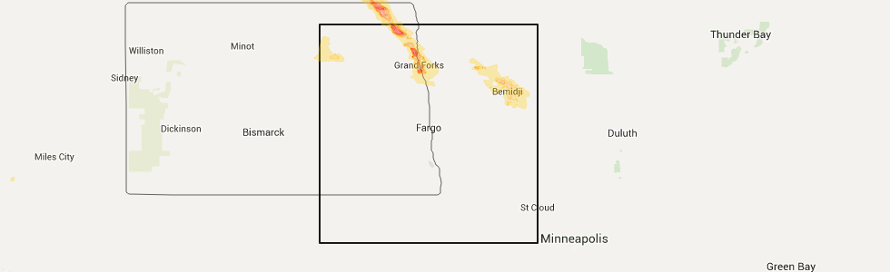
Hail Map for Canton City, ND
The Canton City, ND area has had 1 report of on-the-ground hail by trained spotters, and has been under severe weather warnings 4 times during the past 12 months. Doppler radar has detected hail at or near Canton City, ND on 21 occasions.
| Name: | Canton City, ND |
| Where Located: | 67.6 miles NE of Devils Lake, ND |
| Map: | Google Map for Canton City, ND |
| Population: | 45 |
| Housing Units: | 32 |
| More Info: | Search Google for Canton City, ND |
5
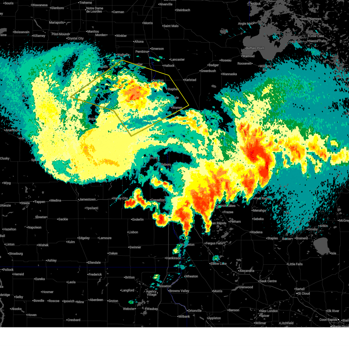
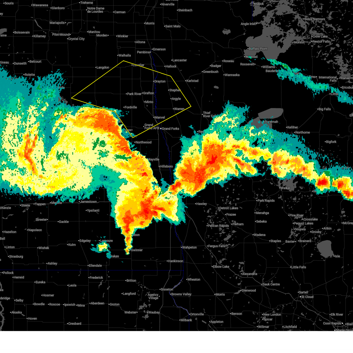
The Top Recent Hail Date for Canton City, ND is Tuesday, July 19, 2016 (1st out of 21)
Hail and Wind Damage Spotted near Canton City, ND
| Date / Time | Report Details |
|---|---|
| 6/21/2025 12:45 AM CDT |
 The storms which prompted the warning have weakened below severe limits, and no longer pose an immediate threat to life or property. therefore, the warning has been allowed to expire. however, gusty winds are still possible with these thunderstorms. a tornado watch remains in effect until 300 am cdt for northwestern minnesota, and northeastern north dakota. The storms which prompted the warning have weakened below severe limits, and no longer pose an immediate threat to life or property. therefore, the warning has been allowed to expire. however, gusty winds are still possible with these thunderstorms. a tornado watch remains in effect until 300 am cdt for northwestern minnesota, and northeastern north dakota.
|
| 6/20/2025 11:48 PM CDT |
 Svrfgf the national weather service in grand forks has issued a * severe thunderstorm warning for, western marshall county in northwestern minnesota, northwestern polk county in northwestern minnesota, southwestern kittson county in northwestern minnesota, northern grand forks county in northeastern north dakota, southeastern cavalier county in northeastern north dakota, northeastern nelson county in northeastern north dakota, northeastern ramsey county in northeastern north dakota, walsh county in northeastern north dakota, southern pembina county in northeastern north dakota, * until 1245 am cdt. * at 1147 pm cdt, severe thunderstorms were located along a line extending from near webster to near whitman to near logan center, moving northeast at 55 mph (public). Hazards include 70 mph wind gusts. Expect considerable tree damage. damage is likely to mobile homes, roofs, and outbuildings. severe thunderstorms will be near, larimore, dahlen, and lawton around 1150 pm cdt. fordville, arvilla, and orr around 1155 pm cdt. grand forks afb, edmore, and lankin around 1200 am cdt. emerado, gilby, and mekinock around 1205 am cdt. park river, forest river, and adams around 1210 am cdt. other locations impacted by these severe thunderstorms include grand forks airport. This includes interstate 29 between mile markers 145 and 197. Svrfgf the national weather service in grand forks has issued a * severe thunderstorm warning for, western marshall county in northwestern minnesota, northwestern polk county in northwestern minnesota, southwestern kittson county in northwestern minnesota, northern grand forks county in northeastern north dakota, southeastern cavalier county in northeastern north dakota, northeastern nelson county in northeastern north dakota, northeastern ramsey county in northeastern north dakota, walsh county in northeastern north dakota, southern pembina county in northeastern north dakota, * until 1245 am cdt. * at 1147 pm cdt, severe thunderstorms were located along a line extending from near webster to near whitman to near logan center, moving northeast at 55 mph (public). Hazards include 70 mph wind gusts. Expect considerable tree damage. damage is likely to mobile homes, roofs, and outbuildings. severe thunderstorms will be near, larimore, dahlen, and lawton around 1150 pm cdt. fordville, arvilla, and orr around 1155 pm cdt. grand forks afb, edmore, and lankin around 1200 am cdt. emerado, gilby, and mekinock around 1205 am cdt. park river, forest river, and adams around 1210 am cdt. other locations impacted by these severe thunderstorms include grand forks airport. This includes interstate 29 between mile markers 145 and 197.
|
| 7/22/2024 3:51 PM CDT |
 At 351 pm cdt, a severe thunderstorm was located near gardar, or 23 miles northwest of grafton, moving south at 10 mph (public). Hazards include two inch hail and 60 mph wind gusts. People and animals outdoors will be injured. expect hail damage to roofs, siding, windows, and vehicles. expect wind damage to roofs, siding, and trees. Locations impacted include, crystal, mountain, hensel, milton, olga, gardar, and union. At 351 pm cdt, a severe thunderstorm was located near gardar, or 23 miles northwest of grafton, moving south at 10 mph (public). Hazards include two inch hail and 60 mph wind gusts. People and animals outdoors will be injured. expect hail damage to roofs, siding, windows, and vehicles. expect wind damage to roofs, siding, and trees. Locations impacted include, crystal, mountain, hensel, milton, olga, gardar, and union.
|
| 7/22/2024 3:12 PM CDT |
 Svrfgf the national weather service in grand forks has issued a * severe thunderstorm warning for, southeastern cavalier county in northeastern north dakota, southwestern pembina county in northeastern north dakota, * until 415 pm cdt. * at 312 pm cdt, a severe thunderstorm was located over mountain, or 23 miles east of langdon, moving south at 10 mph (radar indicated). Hazards include 60 mph wind gusts and quarter size hail. Hail damage to vehicles is expected. Expect wind damage to roofs, siding, and trees. Svrfgf the national weather service in grand forks has issued a * severe thunderstorm warning for, southeastern cavalier county in northeastern north dakota, southwestern pembina county in northeastern north dakota, * until 415 pm cdt. * at 312 pm cdt, a severe thunderstorm was located over mountain, or 23 miles east of langdon, moving south at 10 mph (radar indicated). Hazards include 60 mph wind gusts and quarter size hail. Hail damage to vehicles is expected. Expect wind damage to roofs, siding, and trees.
|
| 6/12/2024 6:16 PM CDT |
 the tornado warning has been cancelled and is no longer in effect the tornado warning has been cancelled and is no longer in effect
|
| 6/12/2024 5:39 PM CDT |
 Torfgf the national weather service in grand forks has issued a * tornado warning for, southeastern pembina county in northeastern north dakota, * until 630 pm cdt. * at 539 pm cdt, a severe thunderstorm capable of producing a tornado was located near hensel, or 22 miles north of grafton, moving east at 25 mph (radar indicated rotation). Hazards include tornado and quarter size hail. Flying debris will be dangerous to those caught without shelter. mobile homes will be damaged or destroyed. damage to roofs, windows, and vehicles will occur. Tree damage is likely. Torfgf the national weather service in grand forks has issued a * tornado warning for, southeastern pembina county in northeastern north dakota, * until 630 pm cdt. * at 539 pm cdt, a severe thunderstorm capable of producing a tornado was located near hensel, or 22 miles north of grafton, moving east at 25 mph (radar indicated rotation). Hazards include tornado and quarter size hail. Flying debris will be dangerous to those caught without shelter. mobile homes will be damaged or destroyed. damage to roofs, windows, and vehicles will occur. Tree damage is likely.
|
| 6/2/2024 6:50 PM CDT |
 At 650 pm cdt, a severe thunderstorm was located over park river, or 12 miles west of grafton, moving east at 35 mph (radar indicated). Hazards include 60 mph wind gusts and nickel size hail. Expect damage to roofs, siding, and trees. Locations impacted include, grafton, park river, hoople, edinburg, crystal, pisek, and lankin. At 650 pm cdt, a severe thunderstorm was located over park river, or 12 miles west of grafton, moving east at 35 mph (radar indicated). Hazards include 60 mph wind gusts and nickel size hail. Expect damage to roofs, siding, and trees. Locations impacted include, grafton, park river, hoople, edinburg, crystal, pisek, and lankin.
|
| 6/2/2024 6:50 PM CDT |
 the severe thunderstorm warning has been cancelled and is no longer in effect the severe thunderstorm warning has been cancelled and is no longer in effect
|
| 6/2/2024 6:16 PM CDT |
 Svrfgf the national weather service in grand forks has issued a * severe thunderstorm warning for, southeastern cavalier county in northeastern north dakota, walsh county in northeastern north dakota, southwestern pembina county in northeastern north dakota, * until 700 pm cdt. * at 615 pm cdt, a severe thunderstorm was located over adams, or 27 miles southeast of langdon, moving northeast at 35 mph (radar indicated). Hazards include 60 mph wind gusts and quarter size hail. Hail damage to vehicles is expected. Expect wind damage to roofs, siding, and trees. Svrfgf the national weather service in grand forks has issued a * severe thunderstorm warning for, southeastern cavalier county in northeastern north dakota, walsh county in northeastern north dakota, southwestern pembina county in northeastern north dakota, * until 700 pm cdt. * at 615 pm cdt, a severe thunderstorm was located over adams, or 27 miles southeast of langdon, moving northeast at 35 mph (radar indicated). Hazards include 60 mph wind gusts and quarter size hail. Hail damage to vehicles is expected. Expect wind damage to roofs, siding, and trees.
|
| 9/5/2023 1:06 AM CDT | At 106 am cdt, severe thunderstorms were located along a line extending from 16 miles northwest of neche to near hallock to near warren, moving east at 55 mph (radar indicated). Hazards include 60 mph wind gusts. Expect damage to roofs, siding, and trees. locations impacted include, thief river falls, grafton, warren, cavalier, hallock, drayton and karlstad. this includes interstate 29 between mile markers 161 and 217. hail threat, radar indicated max hail size, <. 75 in wind threat, observed max wind gust, 60 mph. |
| 9/5/2023 1:06 AM CDT | At 106 am cdt, severe thunderstorms were located along a line extending from 16 miles northwest of neche to near hallock to near warren, moving east at 55 mph (radar indicated). Hazards include 60 mph wind gusts. Expect damage to roofs, siding, and trees. locations impacted include, thief river falls, grafton, warren, cavalier, hallock, drayton and karlstad. this includes interstate 29 between mile markers 161 and 217. hail threat, radar indicated max hail size, <. 75 in wind threat, observed max wind gust, 60 mph. |
| 9/5/2023 12:24 AM CDT |
 At 1224 am cdt, severe thunderstorms were located along a line extending from near olga to near grafton to near thompson, moving northeast at 55 mph (radar indicated). Hazards include 60 mph wind gusts. expect damage to roofs, siding, and trees At 1224 am cdt, severe thunderstorms were located along a line extending from near olga to near grafton to near thompson, moving northeast at 55 mph (radar indicated). Hazards include 60 mph wind gusts. expect damage to roofs, siding, and trees
|
| 9/4/2023 11:39 PM CDT |
 At 1139 pm cdt, severe thunderstorms were located along a line extending from near derrick to near whitman to near finley, moving northeast at 45 mph (radar indicated). Hazards include 60 mph wind gusts. expect damage to roofs, siding, and trees At 1139 pm cdt, severe thunderstorms were located along a line extending from near derrick to near whitman to near finley, moving northeast at 45 mph (radar indicated). Hazards include 60 mph wind gusts. expect damage to roofs, siding, and trees
|
| 7/25/2023 5:46 PM CDT |
 At 545 pm cdt, a severe thunderstorm was located over gardar, or 21 miles northwest of grafton, moving east at 20 mph (radar indicated). Hazards include ping pong ball size hail and 60 mph wind gusts. People and animals outdoors will be injured. expect hail damage to roofs, siding, windows, and vehicles. expect wind damage to roofs, siding, and trees. locations impacted include, st. thomas, hoople, edinburg, crystal, mountain, nash and gardar. hail threat, radar indicated max hail size, 1. 50 in wind threat, radar indicated max wind gust, 60 mph. At 545 pm cdt, a severe thunderstorm was located over gardar, or 21 miles northwest of grafton, moving east at 20 mph (radar indicated). Hazards include ping pong ball size hail and 60 mph wind gusts. People and animals outdoors will be injured. expect hail damage to roofs, siding, windows, and vehicles. expect wind damage to roofs, siding, and trees. locations impacted include, st. thomas, hoople, edinburg, crystal, mountain, nash and gardar. hail threat, radar indicated max hail size, 1. 50 in wind threat, radar indicated max wind gust, 60 mph.
|
| 7/25/2023 5:23 PM CDT |
 At 523 pm cdt, a severe thunderstorm was located over union, or 21 miles southeast of langdon, moving east at 20 mph (radar indicated). Hazards include ping pong ball size hail and 60 mph wind gusts. People and animals outdoors will be injured. expect hail damage to roofs, siding, windows, and vehicles. Expect wind damage to roofs, siding, and trees. At 523 pm cdt, a severe thunderstorm was located over union, or 21 miles southeast of langdon, moving east at 20 mph (radar indicated). Hazards include ping pong ball size hail and 60 mph wind gusts. People and animals outdoors will be injured. expect hail damage to roofs, siding, windows, and vehicles. Expect wind damage to roofs, siding, and trees.
|
| 7/22/2022 11:29 PM CDT |
 At 1129 pm cdt, severe thunderstorms were located along a line extending from near akra to spirit lake nation, moving east at 55 mph (radar indicated). Hazards include 70 mph wind gusts and ping pong ball size hail. People and animals outdoors will be injured. expect hail damage to roofs, siding, windows, and vehicles. expect considerable tree damage. wind damage is also likely to mobile homes, roofs, and outbuildings. these severe storms will be near, akra, mountain and backoo around 1130 pm cdt. hensel and cavalier around 1135 pm cdt. other locations in the path of these severe thunderstorms include hamar, tolna, hamilton and pekin. thunderstorm damage threat, considerable hail threat, radar indicated max hail size, 1. 50 in wind threat, observed max wind gust, 70 mph. At 1129 pm cdt, severe thunderstorms were located along a line extending from near akra to spirit lake nation, moving east at 55 mph (radar indicated). Hazards include 70 mph wind gusts and ping pong ball size hail. People and animals outdoors will be injured. expect hail damage to roofs, siding, windows, and vehicles. expect considerable tree damage. wind damage is also likely to mobile homes, roofs, and outbuildings. these severe storms will be near, akra, mountain and backoo around 1130 pm cdt. hensel and cavalier around 1135 pm cdt. other locations in the path of these severe thunderstorms include hamar, tolna, hamilton and pekin. thunderstorm damage threat, considerable hail threat, radar indicated max hail size, 1. 50 in wind threat, observed max wind gust, 70 mph.
|
| 7/22/2022 11:16 PM CDT |
 At 1112 pm cdt, severe thunderstorms were located along a line extending from olga to spirit lake nation, moving southeast at 55 mph. at 1104 pm cdt, a 60 mph wind gust was reported near webster (radar indicated). Hazards include 70 mph wind gusts and ping pong ball size hail. People and animals outdoors will be injured. expect hail damage to roofs, siding, windows, and vehicles. expect considerable tree damage. wind damage is also likely to mobile homes, roofs, and outbuildings. these severe storms will be near, olga around 1115 pm cdt. concrete and tokio around 1120 pm cdt. other locations in the path of these severe thunderstorms include mountain, akra, backoo, warwick, hensel, hamar and crystal. thunderstorm damage threat, considerable hail threat, radar indicated max hail size, 1. 50 in wind threat, observed max wind gust, 70 mph. At 1112 pm cdt, severe thunderstorms were located along a line extending from olga to spirit lake nation, moving southeast at 55 mph. at 1104 pm cdt, a 60 mph wind gust was reported near webster (radar indicated). Hazards include 70 mph wind gusts and ping pong ball size hail. People and animals outdoors will be injured. expect hail damage to roofs, siding, windows, and vehicles. expect considerable tree damage. wind damage is also likely to mobile homes, roofs, and outbuildings. these severe storms will be near, olga around 1115 pm cdt. concrete and tokio around 1120 pm cdt. other locations in the path of these severe thunderstorms include mountain, akra, backoo, warwick, hensel, hamar and crystal. thunderstorm damage threat, considerable hail threat, radar indicated max hail size, 1. 50 in wind threat, observed max wind gust, 70 mph.
|
| 7/22/2022 11:03 PM CDT |
 At 1102 pm cdt, severe thunderstorms were located along a line extending from near vang to oberon, moving southeast at 55 mph. at 1100 pm cdt, a mesonet reported a 62 mph wind gust near maddock (radar indicated). Hazards include 70 mph wind gusts and quarter size hail. Hail damage to vehicles is expected. expect considerable tree damage. wind damage is also likely to mobile homes, roofs, and outbuildings. severe thunderstorms will be near, vang around 1105 pm cdt. olga and fort totten around 1110 pm cdt. concrete and tokio around 1120 pm cdt. other locations in the path of these severe thunderstorms include mountain, akra and warwick. thunderstorm damage threat, considerable hail threat, radar indicated max hail size, 1. 00 in wind threat, observed max wind gust, 70 mph. At 1102 pm cdt, severe thunderstorms were located along a line extending from near vang to oberon, moving southeast at 55 mph. at 1100 pm cdt, a mesonet reported a 62 mph wind gust near maddock (radar indicated). Hazards include 70 mph wind gusts and quarter size hail. Hail damage to vehicles is expected. expect considerable tree damage. wind damage is also likely to mobile homes, roofs, and outbuildings. severe thunderstorms will be near, vang around 1105 pm cdt. olga and fort totten around 1110 pm cdt. concrete and tokio around 1120 pm cdt. other locations in the path of these severe thunderstorms include mountain, akra and warwick. thunderstorm damage threat, considerable hail threat, radar indicated max hail size, 1. 00 in wind threat, observed max wind gust, 70 mph.
|
| 7/19/2022 5:49 AM CDT |
 At 548 am cdt, severe thunderstorms were located along a line extending from near noyes to near bowesmont to near grafton, moving east at 60 mph (radar indicated). Hazards include 70 mph wind gusts and quarter size hail. Hail damage to vehicles is expected. expect considerable tree damage. wind damage is also likely to mobile homes, roofs, and outbuildings. locations impacted include, noyes, mattson, bowesmont, cashel, northcote, hallock, herrick, kennedy, lancaster and lake bronson. this includes interstate 29 between mile markers 170 and 217. thunderstorm damage threat, considerable hail threat, radar indicated max hail size, 1. 00 in wind threat, observed max wind gust, 70 mph. At 548 am cdt, severe thunderstorms were located along a line extending from near noyes to near bowesmont to near grafton, moving east at 60 mph (radar indicated). Hazards include 70 mph wind gusts and quarter size hail. Hail damage to vehicles is expected. expect considerable tree damage. wind damage is also likely to mobile homes, roofs, and outbuildings. locations impacted include, noyes, mattson, bowesmont, cashel, northcote, hallock, herrick, kennedy, lancaster and lake bronson. this includes interstate 29 between mile markers 170 and 217. thunderstorm damage threat, considerable hail threat, radar indicated max hail size, 1. 00 in wind threat, observed max wind gust, 70 mph.
|
| 7/19/2022 5:21 AM CDT |
 At 521 am cdt, severe thunderstorms were located along a line extending from 6 miles north of leroy to near hensel to near adams, moving east at 65 mph (radar indicated). Hazards include 70 mph wind gusts and penny size hail. Expect considerable tree damage. damage is likely to mobile homes, roofs, and outbuildings. severe thunderstorms will be near, hensel, akra and leroy around 525 am cdt. neche, cavalier and edinburg around 530 am cdt. park river, glasston and hamilton around 535 am cdt. mandt and hoople around 540 am cdt. other locations in the path of these severe thunderstorms include nash, joliette and noyes. this includes interstate 29 between mile markers 170 and 217. thunderstorm damage threat, considerable hail threat, radar indicated max hail size, 0. 75 in wind threat, observed max wind gust, 70 mph. At 521 am cdt, severe thunderstorms were located along a line extending from 6 miles north of leroy to near hensel to near adams, moving east at 65 mph (radar indicated). Hazards include 70 mph wind gusts and penny size hail. Expect considerable tree damage. damage is likely to mobile homes, roofs, and outbuildings. severe thunderstorms will be near, hensel, akra and leroy around 525 am cdt. neche, cavalier and edinburg around 530 am cdt. park river, glasston and hamilton around 535 am cdt. mandt and hoople around 540 am cdt. other locations in the path of these severe thunderstorms include nash, joliette and noyes. this includes interstate 29 between mile markers 170 and 217. thunderstorm damage threat, considerable hail threat, radar indicated max hail size, 0. 75 in wind threat, observed max wind gust, 70 mph.
|
| 7/19/2022 5:02 AM CDT |
 At 501 am cdt, severe thunderstorms were located along a line extending from near vang to osnabrock to near edmore, moving east at 60 mph (radar indicated). Hazards include 70 mph wind gusts and penny size hail. Expect considerable tree damage. damage is likely to mobile homes, roofs, and outbuildings. locations impacted include, osnabrock, milton, vang, walhalla, concrete, union, mountain, gardar, leroy, adams, backoo, hensel, lankin and crystal. thunderstorm damage threat, considerable hail threat, radar indicated max hail size, 0. 75 in wind threat, observed max wind gust, 70 mph. At 501 am cdt, severe thunderstorms were located along a line extending from near vang to osnabrock to near edmore, moving east at 60 mph (radar indicated). Hazards include 70 mph wind gusts and penny size hail. Expect considerable tree damage. damage is likely to mobile homes, roofs, and outbuildings. locations impacted include, osnabrock, milton, vang, walhalla, concrete, union, mountain, gardar, leroy, adams, backoo, hensel, lankin and crystal. thunderstorm damage threat, considerable hail threat, radar indicated max hail size, 0. 75 in wind threat, observed max wind gust, 70 mph.
|
| 7/19/2022 4:42 AM CDT |
 At 440 am cdt, severe thunderstorms were located along a line extending from near wales to near loma to near garske, moving east at 60 mph (radar indicated). Hazards include 60 mph wind gusts and penny size hail. Expect damage to roofs, siding, and trees. severe thunderstorms will be near, loma around 445 am cdt. mount carmel, maida and nekoma around 450 am cdt. vang, osnabrock and edmore around 500 am cdt. other locations in the path of these severe thunderstorms include milton, lawton, walhalla, union and concrete. hail threat, radar indicated max hail size, 0. 75 in wind threat, radar indicated max wind gust, 60 mph. At 440 am cdt, severe thunderstorms were located along a line extending from near wales to near loma to near garske, moving east at 60 mph (radar indicated). Hazards include 60 mph wind gusts and penny size hail. Expect damage to roofs, siding, and trees. severe thunderstorms will be near, loma around 445 am cdt. mount carmel, maida and nekoma around 450 am cdt. vang, osnabrock and edmore around 500 am cdt. other locations in the path of these severe thunderstorms include milton, lawton, walhalla, union and concrete. hail threat, radar indicated max hail size, 0. 75 in wind threat, radar indicated max wind gust, 60 mph.
|
| 6/24/2022 3:40 PM CDT |
 At 340 pm cdt, severe thunderstorms were located along a line extending from near st. thomas to near southam, moving east at 30 mph (radar indicated). Hazards include 70 mph wind gusts and half dollar size hail. Hail damage to vehicles is expected. expect considerable tree damage. wind damage is also likely to mobile homes, roofs, and outbuildings. severe thunderstorms will be near, auburn and st. thomas around 345 pm cdt. cashel around 350 pm cdt. drayton and herrick around 400 pm cdt. other locations in the path of these severe thunderstorms include robbin, mapes and whitman. this includes interstate 29 between mile markers 183 and 208. thunderstorm damage threat, considerable hail threat, radar indicated max hail size, 1. 25 in wind threat, radar indicated max wind gust, 70 mph. At 340 pm cdt, severe thunderstorms were located along a line extending from near st. thomas to near southam, moving east at 30 mph (radar indicated). Hazards include 70 mph wind gusts and half dollar size hail. Hail damage to vehicles is expected. expect considerable tree damage. wind damage is also likely to mobile homes, roofs, and outbuildings. severe thunderstorms will be near, auburn and st. thomas around 345 pm cdt. cashel around 350 pm cdt. drayton and herrick around 400 pm cdt. other locations in the path of these severe thunderstorms include robbin, mapes and whitman. this includes interstate 29 between mile markers 183 and 208. thunderstorm damage threat, considerable hail threat, radar indicated max hail size, 1. 25 in wind threat, radar indicated max wind gust, 70 mph.
|
| 6/24/2022 3:33 PM CDT |
 At 333 pm cdt, severe thunderstorms were located along a line extending from akra to near lawton, moving northeast at 40 mph (radar indicated). Hazards include 70 mph wind gusts and ping pong ball size hail. People and animals outdoors will be injured. expect hail damage to roofs, siding, windows, and vehicles. expect considerable tree damage. wind damage is also likely to mobile homes, roofs, and outbuildings. Locations impacted include, cavalier, walhalla, edmore, osnabrock, adams, mountain and hensel. At 333 pm cdt, severe thunderstorms were located along a line extending from akra to near lawton, moving northeast at 40 mph (radar indicated). Hazards include 70 mph wind gusts and ping pong ball size hail. People and animals outdoors will be injured. expect hail damage to roofs, siding, windows, and vehicles. expect considerable tree damage. wind damage is also likely to mobile homes, roofs, and outbuildings. Locations impacted include, cavalier, walhalla, edmore, osnabrock, adams, mountain and hensel.
|
| 6/24/2022 3:06 PM CDT |
 At 305 pm cdt, severe thunderstorms were located along a line extending from walhalla to near derrick, moving northwest at 30 mph (radar indicated). Hazards include 70 mph wind gusts and half dollar size hail. Hail damage to vehicles is expected. expect considerable tree damage. wind damage is also likely to mobile homes, roofs, and outbuildings. Locations impacted include, hampden, vang, alsen, munich and calio. At 305 pm cdt, severe thunderstorms were located along a line extending from walhalla to near derrick, moving northwest at 30 mph (radar indicated). Hazards include 70 mph wind gusts and half dollar size hail. Hail damage to vehicles is expected. expect considerable tree damage. wind damage is also likely to mobile homes, roofs, and outbuildings. Locations impacted include, hampden, vang, alsen, munich and calio.
|
| 6/24/2022 2:52 PM CDT |
 At 251 pm cdt, severe thunderstorms were located along a line extending from 6 miles west of backoo to 7 miles southwest of edmore, moving northwest at 30 mph (radar indicated). Hazards include golf ball size hail and 70 mph wind gusts. People and animals outdoors will be injured. expect hail damage to roofs, siding, windows, and vehicles. expect considerable tree damage. wind damage is also likely to mobile homes, roofs, and outbuildings. severe thunderstorms will be near, walhalla and derrick around 305 pm cdt. Other locations in the path of these severe thunderstorms include vang, hampden, alsen, munich and calio. At 251 pm cdt, severe thunderstorms were located along a line extending from 6 miles west of backoo to 7 miles southwest of edmore, moving northwest at 30 mph (radar indicated). Hazards include golf ball size hail and 70 mph wind gusts. People and animals outdoors will be injured. expect hail damage to roofs, siding, windows, and vehicles. expect considerable tree damage. wind damage is also likely to mobile homes, roofs, and outbuildings. severe thunderstorms will be near, walhalla and derrick around 305 pm cdt. Other locations in the path of these severe thunderstorms include vang, hampden, alsen, munich and calio.
|
| 6/11/2021 5:25 AM CDT |
 The severe thunderstorm warning for northwestern marshall, southwestern kittson, eastern towner, cavalier, north central nelson, ramsey, walsh and pembina counties will expire at 530 am cdt, the storms which prompted the warning have weakened below severe limits, and no longer pose an immediate threat to life or property. therefore, the warning will be allowed to expire. however gusty winds are still possible with these thunderstorms. a severe thunderstorm watch remains in effect until 700 am cdt for northeastern north dakota. The severe thunderstorm warning for northwestern marshall, southwestern kittson, eastern towner, cavalier, north central nelson, ramsey, walsh and pembina counties will expire at 530 am cdt, the storms which prompted the warning have weakened below severe limits, and no longer pose an immediate threat to life or property. therefore, the warning will be allowed to expire. however gusty winds are still possible with these thunderstorms. a severe thunderstorm watch remains in effect until 700 am cdt for northeastern north dakota.
|
| 6/11/2021 4:36 AM CDT |
 At 435 am cdt, severe thunderstorms were located along a line extending from near sarles to near brocket, moving east at 75 mph (radar indicated. a 60 mph wind gust was reported at clyde, nd in cavalier county). Hazards include 60 mph wind gusts. expect damage to roofs, siding, and trees At 435 am cdt, severe thunderstorms were located along a line extending from near sarles to near brocket, moving east at 75 mph (radar indicated. a 60 mph wind gust was reported at clyde, nd in cavalier county). Hazards include 60 mph wind gusts. expect damage to roofs, siding, and trees
|
| 6/9/2021 12:35 PM CDT |
 At 1234 pm cdt, a severe thunderstorm was located near hoople, or 13 miles northwest of grafton, moving northeast at 40 mph (radar indicated). Hazards include quarter size hail. Damage to vehicles is expected. this severe thunderstorm will be near, st. thomas around 1245 pm cdt. Glasston around 1250 pm cdt. At 1234 pm cdt, a severe thunderstorm was located near hoople, or 13 miles northwest of grafton, moving northeast at 40 mph (radar indicated). Hazards include quarter size hail. Damage to vehicles is expected. this severe thunderstorm will be near, st. thomas around 1245 pm cdt. Glasston around 1250 pm cdt.
|
| 6/6/2021 4:20 AM CDT |
 The severe thunderstorm warning for kittson and pembina counties will expire at 430 am cdt, the storms which prompted the warning have weakened below severe limits, and no longer pose an immediate threat to life or property. therefore, the warning will be allowed to expire. however gusty winds are still possible with these thunderstorms. a severe thunderstorm watch remains in effect until 700 am cdt for northwestern minnesota, and northeastern north dakota. The severe thunderstorm warning for kittson and pembina counties will expire at 430 am cdt, the storms which prompted the warning have weakened below severe limits, and no longer pose an immediate threat to life or property. therefore, the warning will be allowed to expire. however gusty winds are still possible with these thunderstorms. a severe thunderstorm watch remains in effect until 700 am cdt for northwestern minnesota, and northeastern north dakota.
|
| 6/6/2021 3:58 AM CDT |
 At 358 am cdt, severe thunderstorms were located along a line extending from 26 miles north of walhalla to near poland, moving northeast at 55 mph (radar indicated). Hazards include 60 mph wind gusts. Expect damage to roofs, siding, and trees. Locations impacted include, cavalier, walhalla, hallock, drayton, pembina, neche and lancaster. At 358 am cdt, severe thunderstorms were located along a line extending from 26 miles north of walhalla to near poland, moving northeast at 55 mph (radar indicated). Hazards include 60 mph wind gusts. Expect damage to roofs, siding, and trees. Locations impacted include, cavalier, walhalla, hallock, drayton, pembina, neche and lancaster.
|
| 6/6/2021 3:24 AM CDT |
 At 324 am cdt, severe thunderstorms were located along a line extending from 7 miles northwest of maida to near niagara, moving northeast at 55 mph (radar indicated). Hazards include 60 mph wind gusts. expect damage to roofs, siding, and trees At 324 am cdt, severe thunderstorms were located along a line extending from 7 miles northwest of maida to near niagara, moving northeast at 55 mph (radar indicated). Hazards include 60 mph wind gusts. expect damage to roofs, siding, and trees
|
| 6/5/2021 8:12 PM CDT |
 At 812 pm cdt, a severe thunderstorm was located over leroy, or 27 miles northeast of langdon, moving northeast at 45 mph (radar indicated). Hazards include 60 mph wind gusts and quarter size hail. Hail damage to vehicles is expected. expect wind damage to roofs, siding, and trees. Locations impacted include, leroy and neche. At 812 pm cdt, a severe thunderstorm was located over leroy, or 27 miles northeast of langdon, moving northeast at 45 mph (radar indicated). Hazards include 60 mph wind gusts and quarter size hail. Hail damage to vehicles is expected. expect wind damage to roofs, siding, and trees. Locations impacted include, leroy and neche.
|
| 6/5/2021 7:47 PM CDT |
 At 746 pm cdt, a severe thunderstorm was located near olga, or 11 miles east of langdon, moving northeast at 45 mph (radar indicated). Hazards include 60 mph wind gusts and quarter size hail. Hail damage to vehicles is expected. expect wind damage to roofs, siding, and trees. this severe thunderstorm will be near, olga and concrete around 755 pm cdt. Other locations in the path of this severe thunderstorm include walhalla, backoo, leroy and neche. At 746 pm cdt, a severe thunderstorm was located near olga, or 11 miles east of langdon, moving northeast at 45 mph (radar indicated). Hazards include 60 mph wind gusts and quarter size hail. Hail damage to vehicles is expected. expect wind damage to roofs, siding, and trees. this severe thunderstorm will be near, olga and concrete around 755 pm cdt. Other locations in the path of this severe thunderstorm include walhalla, backoo, leroy and neche.
|
| 8/9/2020 12:21 PM CDT |
 At 1220 pm cdt, severe thunderstorms were located along a line extending from 15 miles north of neche to near adams, moving east at 35 mph (radar indicated). Hazards include 60 mph wind gusts and half dollar size hail. Hail damage to vehicles is expected. Expect wind damage to roofs, siding, and trees. At 1220 pm cdt, severe thunderstorms were located along a line extending from 15 miles north of neche to near adams, moving east at 35 mph (radar indicated). Hazards include 60 mph wind gusts and half dollar size hail. Hail damage to vehicles is expected. Expect wind damage to roofs, siding, and trees.
|
| 8/9/2020 12:03 PM CDT |
 At 1203 pm cdt, a severe thunderstorm capable of producing a tornado was located over gardar, or 23 miles northwest of grafton, moving east at 40 mph (radar indicated rotation). Hazards include tornado and half dollar size hail. Expect damage to mobile homes, roofs, and vehicles. Locations impacted include, hoople, edinburg, crystal, mountain, hensel, milton and gardar. At 1203 pm cdt, a severe thunderstorm capable of producing a tornado was located over gardar, or 23 miles northwest of grafton, moving east at 40 mph (radar indicated rotation). Hazards include tornado and half dollar size hail. Expect damage to mobile homes, roofs, and vehicles. Locations impacted include, hoople, edinburg, crystal, mountain, hensel, milton and gardar.
|
| 8/9/2020 11:58 AM CDT |
 At 1157 am cdt, a severe thunderstorm was located near concrete, or 19 miles east of langdon, moving east at 40 mph (radar indicated). Hazards include 60 mph wind gusts and half dollar size hail. Hail damage to vehicles is expected. expect wind damage to roofs, siding, and trees. Locations impacted include, cavalier, hoople, edinburg, crystal, osnabrock, mountain and hensel. At 1157 am cdt, a severe thunderstorm was located near concrete, or 19 miles east of langdon, moving east at 40 mph (radar indicated). Hazards include 60 mph wind gusts and half dollar size hail. Hail damage to vehicles is expected. expect wind damage to roofs, siding, and trees. Locations impacted include, cavalier, hoople, edinburg, crystal, osnabrock, mountain and hensel.
|
| 8/9/2020 11:42 AM CDT |
 At 1141 am cdt, a severe thunderstorm capable of producing a tornado was located over osnabrock, or 13 miles southeast of langdon, moving east at 40 mph (radar indicated rotation). Hazards include tornado and quarter size hail. expect damage to mobile homes, roofs, and vehicles At 1141 am cdt, a severe thunderstorm capable of producing a tornado was located over osnabrock, or 13 miles southeast of langdon, moving east at 40 mph (radar indicated rotation). Hazards include tornado and quarter size hail. expect damage to mobile homes, roofs, and vehicles
|
| 8/9/2020 11:28 AM CDT |
 At 1127 am cdt, a severe thunderstorm was located near langdon, moving east at 40 mph (radar indicated). Hazards include 60 mph wind gusts and quarter size hail. Hail damage to vehicles is expected. Expect wind damage to roofs, siding, and trees. At 1127 am cdt, a severe thunderstorm was located near langdon, moving east at 40 mph (radar indicated). Hazards include 60 mph wind gusts and quarter size hail. Hail damage to vehicles is expected. Expect wind damage to roofs, siding, and trees.
|
| 6/20/2020 4:27 PM CDT |
 At 426 pm cdt, a severe thunderstorm was located over cavalier, or 28 miles north of grafton, moving east at 25 mph (public). Hazards include quarter size hail. Damage to vehicles is expected. this severe storm will be near, hamilton, bathgate and glasston around 440 pm cdt. This includes interstate 29 between mile markers 212 and 216. At 426 pm cdt, a severe thunderstorm was located over cavalier, or 28 miles north of grafton, moving east at 25 mph (public). Hazards include quarter size hail. Damage to vehicles is expected. this severe storm will be near, hamilton, bathgate and glasston around 440 pm cdt. This includes interstate 29 between mile markers 212 and 216.
|
| 6/20/2020 4:15 PM CDT | Quarter sized hail reported 3.6 miles SE of Canton City, ND, quarters and nickels. |
| 6/20/2020 4:08 PM CDT |
 At 408 pm cdt, a severe thunderstorm was located over akra, or 27 miles east of langdon, moving east at 30 mph (radar indicated). Hazards include ping pong ball size hail. People and animals outdoors will be injured. expect damage to roofs, siding, windows, and vehicles. this severe thunderstorm will be near, akra around 410 pm cdt. backoo around 415 pm cdt. cavalier around 420 pm cdt. hamilton and bathgate around 435 pm cdt. This includes interstate 29 between mile markers 212 and 216. At 408 pm cdt, a severe thunderstorm was located over akra, or 27 miles east of langdon, moving east at 30 mph (radar indicated). Hazards include ping pong ball size hail. People and animals outdoors will be injured. expect damage to roofs, siding, windows, and vehicles. this severe thunderstorm will be near, akra around 410 pm cdt. backoo around 415 pm cdt. cavalier around 420 pm cdt. hamilton and bathgate around 435 pm cdt. This includes interstate 29 between mile markers 212 and 216.
|
| 6/17/2020 6:55 PM CDT |
 At 655 pm cdt, a severe thunderstorm was located near union, or 25 miles southeast of langdon, moving northeast at 40 mph (radar indicated). Hazards include 60 mph wind gusts and half dollar size hail. Hail damage to vehicles is expected. expect wind damage to roofs, siding, and trees. Locations impacted include, hoople, edinburg, crystal, adams, mountain, hensel and akra. At 655 pm cdt, a severe thunderstorm was located near union, or 25 miles southeast of langdon, moving northeast at 40 mph (radar indicated). Hazards include 60 mph wind gusts and half dollar size hail. Hail damage to vehicles is expected. expect wind damage to roofs, siding, and trees. Locations impacted include, hoople, edinburg, crystal, adams, mountain, hensel and akra.
|
| 6/17/2020 6:38 PM CDT |
 At 637 pm cdt, a severe thunderstorm was located near adams, or 29 miles south of langdon, moving northeast at 40 mph. this storm has a history of producing large hail (radar indicated). Hazards include two inch hail and 70 mph wind gusts. People and animals outdoors will be injured. expect hail damage to roofs, siding, windows, and vehicles. expect considerable tree damage. Wind damage is also likely to mobile homes, roofs, and outbuildings. At 637 pm cdt, a severe thunderstorm was located near adams, or 29 miles south of langdon, moving northeast at 40 mph. this storm has a history of producing large hail (radar indicated). Hazards include two inch hail and 70 mph wind gusts. People and animals outdoors will be injured. expect hail damage to roofs, siding, windows, and vehicles. expect considerable tree damage. Wind damage is also likely to mobile homes, roofs, and outbuildings.
|
| 9/20/2019 5:37 PM CDT |
 At 536 pm cdt, severe thunderstorms were located along a line extending from near cavalier to near gardar, moving north at 15 mph (radar indicated). Hazards include 60 mph wind gusts and quarter size hail. Hail damage to vehicles is expected. expect wind damage to roofs, siding, and trees. These severe storms will be near, cavalier, akra and mountain around 545 pm cdt. At 536 pm cdt, severe thunderstorms were located along a line extending from near cavalier to near gardar, moving north at 15 mph (radar indicated). Hazards include 60 mph wind gusts and quarter size hail. Hail damage to vehicles is expected. expect wind damage to roofs, siding, and trees. These severe storms will be near, cavalier, akra and mountain around 545 pm cdt.
|
| 9/20/2019 5:18 PM CDT |
 At 518 pm cdt, severe thunderstorms were located along a line extending from hensel to near edinburg, moving north at 35 mph (radar indicated). Hazards include 60 mph wind gusts and quarter size hail. Hail damage to vehicles is expected. expect wind damage to roofs, siding, and trees. these severe storms will be near, hensel and crystal around 520 pm cdt. cavalier around 530 pm cdt. mountain around 535 pm cdt. Icelandic state park and akra around 545 pm cdt. At 518 pm cdt, severe thunderstorms were located along a line extending from hensel to near edinburg, moving north at 35 mph (radar indicated). Hazards include 60 mph wind gusts and quarter size hail. Hail damage to vehicles is expected. expect wind damage to roofs, siding, and trees. these severe storms will be near, hensel and crystal around 520 pm cdt. cavalier around 530 pm cdt. mountain around 535 pm cdt. Icelandic state park and akra around 545 pm cdt.
|
| 9/20/2019 4:59 PM CDT |
 At 458 pm cdt, severe thunderstorms were located along a line extending from crystal to near lankin, moving north at 15 mph (radar indicated). Hazards include 60 mph wind gusts and quarter size hail. Hail damage to vehicles is expected. expect wind damage to roofs, siding, and trees. severe thunderstorms will be near, crystal and hoople around 500 pm cdt. hensel around 520 pm cdt. edinburg around 535 pm cdt. Akra, union and cavalier around 545 pm cdt. At 458 pm cdt, severe thunderstorms were located along a line extending from crystal to near lankin, moving north at 15 mph (radar indicated). Hazards include 60 mph wind gusts and quarter size hail. Hail damage to vehicles is expected. expect wind damage to roofs, siding, and trees. severe thunderstorms will be near, crystal and hoople around 500 pm cdt. hensel around 520 pm cdt. edinburg around 535 pm cdt. Akra, union and cavalier around 545 pm cdt.
|
| 8/26/2018 10:17 PM CDT |
 At 1016 pm cdt, severe thunderstorms were located along a line extending from bathgate to near logan center, moving east at 50 mph (radar indicated). Hazards include 70 mph wind gusts and quarter size hail. Expect considerable tree damage. wind damage is also likely to mobile homes, roofs, and outbuildings. locations impacted include, grand forks, grafton, east grand forks, grand forks afb, park river, larimore and cavalier. This includes interstate 29 between mile markers 128 and 217. At 1016 pm cdt, severe thunderstorms were located along a line extending from bathgate to near logan center, moving east at 50 mph (radar indicated). Hazards include 70 mph wind gusts and quarter size hail. Expect considerable tree damage. wind damage is also likely to mobile homes, roofs, and outbuildings. locations impacted include, grand forks, grafton, east grand forks, grand forks afb, park river, larimore and cavalier. This includes interstate 29 between mile markers 128 and 217.
|
| 8/26/2018 9:58 PM CDT |
 The national weather service in grand forks has issued a * severe thunderstorm warning for. western marshall county in northwestern minnesota. northwestern polk county in northwestern minnesota. western kittson county in northwestern minnesota. Grand forks county in northeastern north dakota. The national weather service in grand forks has issued a * severe thunderstorm warning for. western marshall county in northwestern minnesota. northwestern polk county in northwestern minnesota. western kittson county in northwestern minnesota. Grand forks county in northeastern north dakota.
|
| 8/26/2018 9:45 PM CDT |
 At 945 pm cdt, severe thunderstorms were located along a line extending from near walhalla to near pekin, moving east at 50 mph (radar indicated). Hazards include 70 mph wind gusts and penny size hail. Expect considerable tree damage. damage is likely to mobile homes, roofs, and outbuildings. these severe storms will be near, walhalla around 950 pm cdt. Leroy, kloten and backoo around 1000 pm cdt. At 945 pm cdt, severe thunderstorms were located along a line extending from near walhalla to near pekin, moving east at 50 mph (radar indicated). Hazards include 70 mph wind gusts and penny size hail. Expect considerable tree damage. damage is likely to mobile homes, roofs, and outbuildings. these severe storms will be near, walhalla around 950 pm cdt. Leroy, kloten and backoo around 1000 pm cdt.
|
| 8/26/2018 9:15 PM CDT |
 At 915 pm cdt, severe thunderstorms were located along a line extending from near mount carmel to 8 miles southwest of warwick, moving east at 50 mph (radar indicated). Hazards include 60 mph wind gusts and penny size hail. Expect damage to roofs, siding, and trees. severe thunderstorms will be near, mount carmel and maida around 920 pm cdt. hamar around 930 pm cdt. vang around 935 pm cdt. tolna around 940 pm cdt. Pekin around 945 pm cdt. At 915 pm cdt, severe thunderstorms were located along a line extending from near mount carmel to 8 miles southwest of warwick, moving east at 50 mph (radar indicated). Hazards include 60 mph wind gusts and penny size hail. Expect damage to roofs, siding, and trees. severe thunderstorms will be near, mount carmel and maida around 920 pm cdt. hamar around 930 pm cdt. vang around 935 pm cdt. tolna around 940 pm cdt. Pekin around 945 pm cdt.
|
| 7/4/2018 4:20 AM CDT |
 At 419 am cdt, severe thunderstorms were located along a line extending from near pembina to 6 miles southwest of halma to near radium, moving northeast at 65 mph (radar indicated). Hazards include 70 mph wind gusts and nickel size hail. Expect considerable tree damage. damage is likely to mobile homes, roofs, and outbuildings. these severe storms will be near, radium and old mill state park around 420 am cdt. halma, viking and karlstad around 425 am cdt. other locations impacted by these severe thunderstorms include american crystal sugar. This includes interstate 29 between mile markers 163 and 216. At 419 am cdt, severe thunderstorms were located along a line extending from near pembina to 6 miles southwest of halma to near radium, moving northeast at 65 mph (radar indicated). Hazards include 70 mph wind gusts and nickel size hail. Expect considerable tree damage. damage is likely to mobile homes, roofs, and outbuildings. these severe storms will be near, radium and old mill state park around 420 am cdt. halma, viking and karlstad around 425 am cdt. other locations impacted by these severe thunderstorms include american crystal sugar. This includes interstate 29 between mile markers 163 and 216.
|
| 7/4/2018 4:02 AM CDT |
 At 401 am cdt, severe thunderstorms were located along a line extending from near backoo to near robbin to march, moving northeast at 60 mph (radar indicated). Hazards include 60 mph wind gusts and nickel size hail. Expect damage to roofs, siding, and trees. these severe storms will be near, march and robbin around 405 am cdt. donaldson, warren and kennedy around 410 am cdt. radium around 415 am cdt. old mill state park around 420 am cdt. halma, pembina and st. vincent around 425 am cdt. other locations impacted by these severe thunderstorms include american crystal sugar and grand forks airport. This includes interstate 29 between mile markers 144 and 216. At 401 am cdt, severe thunderstorms were located along a line extending from near backoo to near robbin to march, moving northeast at 60 mph (radar indicated). Hazards include 60 mph wind gusts and nickel size hail. Expect damage to roofs, siding, and trees. these severe storms will be near, march and robbin around 405 am cdt. donaldson, warren and kennedy around 410 am cdt. radium around 415 am cdt. old mill state park around 420 am cdt. halma, pembina and st. vincent around 425 am cdt. other locations impacted by these severe thunderstorms include american crystal sugar and grand forks airport. This includes interstate 29 between mile markers 144 and 216.
|
| 7/4/2018 3:27 AM CDT |
 At 326 am cdt, severe thunderstorms were located along a line extending from near loma to near pisek to honeyford, moving northeast at 65 mph (radar indicated). Hazards include 60 mph wind gusts and nickel size hail. Expect damage to roofs, siding, and trees. severe thunderstorms will be near, pisek, gilby and honeyford around 330 am cdt. veseleyville, mandt and ardoch around 335 am cdt. manvel, poland and nash around 340 am cdt. grafton, olga and oslo around 345 am cdt. alvarado, oakwood and cashel around 350 am cdt. other locations impacted by these severe thunderstorms include american crystal sugar and grand forks airport. This includes interstate 29 between mile markers 144 and 216. At 326 am cdt, severe thunderstorms were located along a line extending from near loma to near pisek to honeyford, moving northeast at 65 mph (radar indicated). Hazards include 60 mph wind gusts and nickel size hail. Expect damage to roofs, siding, and trees. severe thunderstorms will be near, pisek, gilby and honeyford around 330 am cdt. veseleyville, mandt and ardoch around 335 am cdt. manvel, poland and nash around 340 am cdt. grafton, olga and oslo around 345 am cdt. alvarado, oakwood and cashel around 350 am cdt. other locations impacted by these severe thunderstorms include american crystal sugar and grand forks airport. This includes interstate 29 between mile markers 144 and 216.
|
| 6/15/2018 12:40 AM CDT |
 At 1240 am cdt, severe thunderstorms were located along a line extending from near icelandic state park to near fairdale to 7 miles northwest of southam, moving east at 35 mph (radar indicated). Hazards include 60 mph wind gusts and quarter size hail. Hail damage to vehicles is expected. expect wind damage to roofs, siding, and trees. severe thunderstorms will be near, hensel around 1250 am cdt. milton and lawton around 105 am cdt. union around 110 am cdt. edinburg and gardar around 115 am cdt. mountain around 120 am cdt. A tornado watch remains in effect until 200 am cdt for northeastern north dakota. At 1240 am cdt, severe thunderstorms were located along a line extending from near icelandic state park to near fairdale to 7 miles northwest of southam, moving east at 35 mph (radar indicated). Hazards include 60 mph wind gusts and quarter size hail. Hail damage to vehicles is expected. expect wind damage to roofs, siding, and trees. severe thunderstorms will be near, hensel around 1250 am cdt. milton and lawton around 105 am cdt. union around 110 am cdt. edinburg and gardar around 115 am cdt. mountain around 120 am cdt. A tornado watch remains in effect until 200 am cdt for northeastern north dakota.
|
| 6/14/2018 11:59 PM CDT |
 The national weather service in grand forks has issued a * severe thunderstorm warning for. southeastern cavalier county in northeastern north dakota. northeastern ramsey county in northeastern north dakota. northwestern walsh county in northeastern north dakota. Southwestern pembina county in northeastern north dakota. The national weather service in grand forks has issued a * severe thunderstorm warning for. southeastern cavalier county in northeastern north dakota. northeastern ramsey county in northeastern north dakota. northwestern walsh county in northeastern north dakota. Southwestern pembina county in northeastern north dakota.
|
| 7/6/2017 12:45 AM CDT |
 At 1245 am cdt, a severe thunderstorm was located near mountain, or 21 miles southeast of langdon, moving southeast at 55 mph (radar indicated). Hazards include 70 mph wind gusts and penny size hail. Expect considerable tree damage. damage is likely to mobile homes, roofs, and outbuildings. this severe thunderstorm will be near, gardar around 1250 am cdt. edinburg around 1255 am cdt. hoople and crystal around 100 am cdt. nash, mandt and auburn around 110 am cdt. grafton, oakwood and veseleyville around 115 am cdt. This includes interstate 29 between mile markers 182 and 184. At 1245 am cdt, a severe thunderstorm was located near mountain, or 21 miles southeast of langdon, moving southeast at 55 mph (radar indicated). Hazards include 70 mph wind gusts and penny size hail. Expect considerable tree damage. damage is likely to mobile homes, roofs, and outbuildings. this severe thunderstorm will be near, gardar around 1250 am cdt. edinburg around 1255 am cdt. hoople and crystal around 100 am cdt. nash, mandt and auburn around 110 am cdt. grafton, oakwood and veseleyville around 115 am cdt. This includes interstate 29 between mile markers 182 and 184.
|
| 6/10/2017 6:42 AM CDT |
 The severe thunderstorm warning for western marshall, northwestern polk, grand forks, southeastern cavalier, northeastern nelson, walsh and pembina counties will expire at 645 am cdt, the storms which prompted the warning have weakened below severe limits, and no longer poses an immediate threat to life or property. therefore the warning will be allowed to expire. however small hail and gusty winds are still possible with these thunderstorms. The severe thunderstorm warning for western marshall, northwestern polk, grand forks, southeastern cavalier, northeastern nelson, walsh and pembina counties will expire at 645 am cdt, the storms which prompted the warning have weakened below severe limits, and no longer poses an immediate threat to life or property. therefore the warning will be allowed to expire. however small hail and gusty winds are still possible with these thunderstorms.
|
| 6/10/2017 6:33 AM CDT |
 At 633 am cdt, severe thunderstorms were located along a line extending from near mountain to near northwood, moving northeast at 20 mph (radar indicated). Hazards include 60 mph wind gusts and penny size hail. Expect damage to roofs, siding, and trees. locations impacted include, grand forks, grafton, east grand forks, grand forks afb, park river, larimore and cavalier. This includes interstate 29 between mile markers 132 and 209. At 633 am cdt, severe thunderstorms were located along a line extending from near mountain to near northwood, moving northeast at 20 mph (radar indicated). Hazards include 60 mph wind gusts and penny size hail. Expect damage to roofs, siding, and trees. locations impacted include, grand forks, grafton, east grand forks, grand forks afb, park river, larimore and cavalier. This includes interstate 29 between mile markers 132 and 209.
|
| 6/10/2017 6:20 AM CDT |
 At 620 am cdt, severe thunderstorms were located along a line extending from near milton to near northwood, moving northeast at 45 mph (radar indicated). Hazards include 60 mph wind gusts and penny size hail. Expect damage to roofs, siding, and trees. locations impacted include, grand forks, grafton, east grand forks, grand forks afb, park river, larimore and cavalier. This includes interstate 29 between mile markers 124 and 209. At 620 am cdt, severe thunderstorms were located along a line extending from near milton to near northwood, moving northeast at 45 mph (radar indicated). Hazards include 60 mph wind gusts and penny size hail. Expect damage to roofs, siding, and trees. locations impacted include, grand forks, grafton, east grand forks, grand forks afb, park river, larimore and cavalier. This includes interstate 29 between mile markers 124 and 209.
|
| 6/10/2017 6:20 AM CDT |
 A severe thunderstorm warning remains in effect until 645 am cdt for western marshall. northwestern polk. grand forks. southeastern cavalier. northeastern nelson. walsh and pembina counties. At 620 am cdt, severe thunderstorms were located along a line extending from near milton to near northwood, moving northeast at 45 mph. A severe thunderstorm warning remains in effect until 645 am cdt for western marshall. northwestern polk. grand forks. southeastern cavalier. northeastern nelson. walsh and pembina counties. At 620 am cdt, severe thunderstorms were located along a line extending from near milton to near northwood, moving northeast at 45 mph.
|
| 6/10/2017 6:20 AM CDT |
 At 620 am cdt, severe thunderstorms were located along a line extending from near milton to near northwood, moving northeast at 45 mph (radar indicated). Hazards include 60 mph wind gusts and penny size hail. Expect damage to roofs, siding, and trees. locations impacted include, grand forks, grafton, east grand forks, grand forks afb, park river, larimore and cavalier. This includes interstate 29 between mile markers 124 and 209. At 620 am cdt, severe thunderstorms were located along a line extending from near milton to near northwood, moving northeast at 45 mph (radar indicated). Hazards include 60 mph wind gusts and penny size hail. Expect damage to roofs, siding, and trees. locations impacted include, grand forks, grafton, east grand forks, grand forks afb, park river, larimore and cavalier. This includes interstate 29 between mile markers 124 and 209.
|
| 6/10/2017 6:07 AM CDT |
 At 607 am cdt, severe thunderstorms were located along a line extending from near fairdale to near golden lake, moving northeast at 50 mph (radar indicated). Hazards include 60 mph wind gusts and penny size hail. expect damage to roofs, siding, and trees At 607 am cdt, severe thunderstorms were located along a line extending from near fairdale to near golden lake, moving northeast at 50 mph (radar indicated). Hazards include 60 mph wind gusts and penny size hail. expect damage to roofs, siding, and trees
|
| 6/9/2017 7:49 PM CDT |
 At 749 pm cdt, a severe thunderstorm was located near auburn, or 9 miles north of grafton, moving southeast at 35 mph. this is a very dangerous storm (public). Hazards include 90 mph wind gusts and quarter size hail. You are in a life-threatening situation. flying debris may be deadly to those caught without shelter. mobile homes will be heavily damaged or destroyed. homes and businesses will have substantial roof and window damage. expect extensive tree damage and power outages. this severe storm will be near, cashel around 755 pm cdt. drayton around 800 pm cdt. This includes interstate 29 between mile markers 187 and 197. At 749 pm cdt, a severe thunderstorm was located near auburn, or 9 miles north of grafton, moving southeast at 35 mph. this is a very dangerous storm (public). Hazards include 90 mph wind gusts and quarter size hail. You are in a life-threatening situation. flying debris may be deadly to those caught without shelter. mobile homes will be heavily damaged or destroyed. homes and businesses will have substantial roof and window damage. expect extensive tree damage and power outages. this severe storm will be near, cashel around 755 pm cdt. drayton around 800 pm cdt. This includes interstate 29 between mile markers 187 and 197.
|
| 6/9/2017 7:34 PM CDT |
 At 734 pm cdt, a severe thunderstorm was located near st. thomas, or 14 miles northwest of grafton, moving southeast at 35 mph (radar indicated). Hazards include 70 mph wind gusts and quarter size hail. Hail damage to vehicles is expected. expect considerable tree damage. wind damage is also likely to mobile homes, roofs, and outbuildings. this severe storm will be near, glasston around 735 pm cdt. st. thomas and nash around 740 pm cdt. auburn around 745 pm cdt. cashel around 755 pm cdt. drayton around 800 pm cdt. This includes interstate 29 between mile markers 187 and 197. At 734 pm cdt, a severe thunderstorm was located near st. thomas, or 14 miles northwest of grafton, moving southeast at 35 mph (radar indicated). Hazards include 70 mph wind gusts and quarter size hail. Hail damage to vehicles is expected. expect considerable tree damage. wind damage is also likely to mobile homes, roofs, and outbuildings. this severe storm will be near, glasston around 735 pm cdt. st. thomas and nash around 740 pm cdt. auburn around 745 pm cdt. cashel around 755 pm cdt. drayton around 800 pm cdt. This includes interstate 29 between mile markers 187 and 197.
|
| 6/9/2017 7:22 PM CDT |
 At 721 pm cdt, a severe thunderstorm was located over hensel, or 20 miles northwest of grafton, moving southeast at 35 mph (radar indicated). Hazards include 70 mph wind gusts and quarter size hail. Hail damage to vehicles is expected. expect considerable tree damage. wind damage is also likely to mobile homes, roofs, and outbuildings. this severe storm will be near, crystal around 725 pm cdt. hoople around 735 pm cdt. st. thomas around 740 pm cdt. auburn and nash around 745 pm cdt. grafton around 755 pm cdt. This includes interstate 29 between mile markers 187 and 197. At 721 pm cdt, a severe thunderstorm was located over hensel, or 20 miles northwest of grafton, moving southeast at 35 mph (radar indicated). Hazards include 70 mph wind gusts and quarter size hail. Hail damage to vehicles is expected. expect considerable tree damage. wind damage is also likely to mobile homes, roofs, and outbuildings. this severe storm will be near, crystal around 725 pm cdt. hoople around 735 pm cdt. st. thomas around 740 pm cdt. auburn and nash around 745 pm cdt. grafton around 755 pm cdt. This includes interstate 29 between mile markers 187 and 197.
|
| 6/9/2017 7:08 PM CDT |
 At 707 pm cdt, a severe thunderstorm was located over mountain, or 24 miles east of langdon, moving southeast at 35 mph (radar indicated). Hazards include 70 mph wind gusts and quarter size hail. Hail damage to vehicles is expected. expect considerable tree damage. wind damage is also likely to mobile homes, roofs, and outbuildings. this severe thunderstorm will be near, akra around 710 pm cdt. hensel around 720 pm cdt. crystal around 725 pm cdt. hoople around 730 pm cdt. glasston around 735 pm cdt. This includes interstate 29 between mile markers 187 and 198. At 707 pm cdt, a severe thunderstorm was located over mountain, or 24 miles east of langdon, moving southeast at 35 mph (radar indicated). Hazards include 70 mph wind gusts and quarter size hail. Hail damage to vehicles is expected. expect considerable tree damage. wind damage is also likely to mobile homes, roofs, and outbuildings. this severe thunderstorm will be near, akra around 710 pm cdt. hensel around 720 pm cdt. crystal around 725 pm cdt. hoople around 730 pm cdt. glasston around 735 pm cdt. This includes interstate 29 between mile markers 187 and 198.
|
| 8/29/2016 12:18 AM CDT |
 At 1217 am cdt, a severe thunderstorm was located near bathgate, or 30 miles north of grafton, moving east at 35 mph (radar indicated). Hazards include 60 mph wind gusts and quarter size hail. Hail damage to vehicles is expected. expect wind damage to roofs, siding, and trees. this severe storm will be near, hamilton and bathgate around 1225 am cdt. joliette around 1245 am cdt. This includes interstate 29 between mile markers 186 and 187, and between mile markers 200 and 217. At 1217 am cdt, a severe thunderstorm was located near bathgate, or 30 miles north of grafton, moving east at 35 mph (radar indicated). Hazards include 60 mph wind gusts and quarter size hail. Hail damage to vehicles is expected. expect wind damage to roofs, siding, and trees. this severe storm will be near, hamilton and bathgate around 1225 am cdt. joliette around 1245 am cdt. This includes interstate 29 between mile markers 186 and 187, and between mile markers 200 and 217.
|
| 8/28/2016 11:47 PM CDT |
 At 1146 pm cdt, a severe thunderstorm was located over walhalla, or 21 miles northeast of langdon, moving east at 35 mph (radar indicated). Hazards include 60 mph wind gusts and quarter size hail. Hail damage to vehicles is expected. expect wind damage to roofs, siding, and trees. this severe thunderstorm will be near, leroy around 1200 am cdt. backoo and akra around 1205 am cdt. cavalier around 1215 am cdt. bathgate and hamilton around 1225 am cdt. joliette around 1245 am cdt. This includes interstate 29 between mile markers 186 and 187, and between mile markers 200 and 217. At 1146 pm cdt, a severe thunderstorm was located over walhalla, or 21 miles northeast of langdon, moving east at 35 mph (radar indicated). Hazards include 60 mph wind gusts and quarter size hail. Hail damage to vehicles is expected. expect wind damage to roofs, siding, and trees. this severe thunderstorm will be near, leroy around 1200 am cdt. backoo and akra around 1205 am cdt. cavalier around 1215 am cdt. bathgate and hamilton around 1225 am cdt. joliette around 1245 am cdt. This includes interstate 29 between mile markers 186 and 187, and between mile markers 200 and 217.
|
| 8/3/2016 7:55 PM CDT |
 At 754 pm cdt, severe thunderstorms were located along a line extending from near pembina to near gardar, moving east at 50 mph (radar indicated). Hazards include 60 mph wind gusts and quarter size hail. Hail damage to vehicles is expected. expect wind damage to roofs, siding, and trees. severe thunderstorms will be near, pembina and st. vincent around 800 pm cdt. noyes around 805 pm cdt. st. thomas, auburn and humboldt around 810 pm cdt. orleans around 815 pm cdt. cashel around 820 pm cdt. also includes interstate 29 between mile markers 176 and 217. A tornado watch remains in effect until 1100 pm cdt for northwestern minnesota, and northeastern north dakota. At 754 pm cdt, severe thunderstorms were located along a line extending from near pembina to near gardar, moving east at 50 mph (radar indicated). Hazards include 60 mph wind gusts and quarter size hail. Hail damage to vehicles is expected. expect wind damage to roofs, siding, and trees. severe thunderstorms will be near, pembina and st. vincent around 800 pm cdt. noyes around 805 pm cdt. st. thomas, auburn and humboldt around 810 pm cdt. orleans around 815 pm cdt. cashel around 820 pm cdt. also includes interstate 29 between mile markers 176 and 217. A tornado watch remains in effect until 1100 pm cdt for northwestern minnesota, and northeastern north dakota.
|
| 8/3/2016 7:40 PM CDT |
 At 740 pm cdt, severe thunderstorms were located along a line extending from near leroy to mountain to near hove mobile park, moving east at 45 mph (radar indicated). Hazards include 60 mph wind gusts and quarter size hail. Hail damage to vehicles is expected. expect wind damage to roofs, siding, and trees. these severe storms will be near, leroy around 745 pm cdt. hensel and akra around 750 pm cdt. neche, edinburg and cavalier around 755 pm cdt. bathgate around 800 pm cdt. st. thomas, glasston and hamilton around 805 pm cdt. also includes interstate 29 between mile markers 214 and 217. A tornado watch remains in effect until 1100 pm cdt for northwestern minnesota, and northeastern north dakota. At 740 pm cdt, severe thunderstorms were located along a line extending from near leroy to mountain to near hove mobile park, moving east at 45 mph (radar indicated). Hazards include 60 mph wind gusts and quarter size hail. Hail damage to vehicles is expected. expect wind damage to roofs, siding, and trees. these severe storms will be near, leroy around 745 pm cdt. hensel and akra around 750 pm cdt. neche, edinburg and cavalier around 755 pm cdt. bathgate around 800 pm cdt. st. thomas, glasston and hamilton around 805 pm cdt. also includes interstate 29 between mile markers 214 and 217. A tornado watch remains in effect until 1100 pm cdt for northwestern minnesota, and northeastern north dakota.
|
| 8/3/2016 7:23 PM CDT |
 At 723 pm cdt, severe thunderstorms were located along a line extending from near vang to near osnabrock to nekoma, moving east at 40 mph (radar indicated). Hazards include 60 mph wind gusts and quarter size hail. Hail damage to vehicles is expected. expect wind damage to roofs, siding, and trees. these severe storms will be near, osnabrock and vang around 725 pm cdt. olga around 730 pm cdt. walhalla and milton around 735 pm cdt. concrete around 740 pm cdt. mountain, leroy and gardar around 745 pm cdt. also includes interstate 29 between mile markers 214 and 217. A tornado watch remains in effect until 1100 pm cdt for northwestern minnesota, and northeastern north dakota. At 723 pm cdt, severe thunderstorms were located along a line extending from near vang to near osnabrock to nekoma, moving east at 40 mph (radar indicated). Hazards include 60 mph wind gusts and quarter size hail. Hail damage to vehicles is expected. expect wind damage to roofs, siding, and trees. these severe storms will be near, osnabrock and vang around 725 pm cdt. olga around 730 pm cdt. walhalla and milton around 735 pm cdt. concrete around 740 pm cdt. mountain, leroy and gardar around 745 pm cdt. also includes interstate 29 between mile markers 214 and 217. A tornado watch remains in effect until 1100 pm cdt for northwestern minnesota, and northeastern north dakota.
|
| 8/3/2016 7:15 PM CDT |
 At 714 pm cdt, severe thunderstorms were located along a line extending from near maida to near langdon to near loma, moving east at 40 mph (radar indicated). Hazards include 60 mph wind gusts and quarter size hail. Hail damage to vehicles is expected. expect wind damage to roofs, siding, and trees. severe thunderstorms will be near, vang around 725 pm cdt. osnabrock around 730 pm cdt. fairdale, hove mobile park and olga around 735 pm cdt. walhalla and milton around 740 pm cdt. concrete around 745 pm cdt. also includes interstate 29 between mile markers 214 and 217. A tornado watch remains in effect until 1100 pm cdt for northwestern minnesota, and northeastern north dakota. At 714 pm cdt, severe thunderstorms were located along a line extending from near maida to near langdon to near loma, moving east at 40 mph (radar indicated). Hazards include 60 mph wind gusts and quarter size hail. Hail damage to vehicles is expected. expect wind damage to roofs, siding, and trees. severe thunderstorms will be near, vang around 725 pm cdt. osnabrock around 730 pm cdt. fairdale, hove mobile park and olga around 735 pm cdt. walhalla and milton around 740 pm cdt. concrete around 745 pm cdt. also includes interstate 29 between mile markers 214 and 217. A tornado watch remains in effect until 1100 pm cdt for northwestern minnesota, and northeastern north dakota.
|
| 7/20/2016 8:55 PM CDT |
 At 854 pm cdt, a severe thunderstorm was located over bathgate, or 32 miles north of grafton, moving east at 60 mph (radar indicated). Hazards include 60 mph wind gusts and nickel size hail. Expect damage to roofs. siding. and trees. This severe thunderstorm will remain over mainly rural areas of western pembina county. At 854 pm cdt, a severe thunderstorm was located over bathgate, or 32 miles north of grafton, moving east at 60 mph (radar indicated). Hazards include 60 mph wind gusts and nickel size hail. Expect damage to roofs. siding. and trees. This severe thunderstorm will remain over mainly rural areas of western pembina county.
|
| 7/20/2016 8:25 PM CDT |
 At 825 pm cdt, a severe thunderstorm was located 7 miles southwest of vang, or 8 miles northeast of langdon, moving east at 55 mph (radar indicated). Hazards include 60 mph wind gusts and nickel size hail. Expect damage to roofs. siding. and trees. this severe thunderstorm will be near, vang around 830 pm cdt. olga around 835 pm cdt. walhalla around 845 pm cdt. leroy and akra around 850 pm cdt. backoo around 855 pm cdt. A tornado watch remains in effect until 1100 pm cdt for northeastern north dakota. At 825 pm cdt, a severe thunderstorm was located 7 miles southwest of vang, or 8 miles northeast of langdon, moving east at 55 mph (radar indicated). Hazards include 60 mph wind gusts and nickel size hail. Expect damage to roofs. siding. and trees. this severe thunderstorm will be near, vang around 830 pm cdt. olga around 835 pm cdt. walhalla around 845 pm cdt. leroy and akra around 850 pm cdt. backoo around 855 pm cdt. A tornado watch remains in effect until 1100 pm cdt for northeastern north dakota.
|
| 7/19/2016 6:08 PM CDT |
 The tornado warning for southwestern pembina county will expire at 615 pm cdt, the tornado threat has diminished and the tornado warning has been cancelled. however, large hail and damaging winds remain likely and a severe thunderstorm warning will be reissued for the area. a severe thunderstorm watch remains in effect until 1100 pm cdt for northeastern north dakota. The tornado warning for southwestern pembina county will expire at 615 pm cdt, the tornado threat has diminished and the tornado warning has been cancelled. however, large hail and damaging winds remain likely and a severe thunderstorm warning will be reissued for the area. a severe thunderstorm watch remains in effect until 1100 pm cdt for northeastern north dakota.
|
| 7/19/2016 5:44 PM CDT |
 At 543 pm cdt, a severe thunderstorm capable of producing a tornado was located near hensel, or 24 miles northwest of grafton, moving southeast at 20 mph (radar indicated rotation). Hazards include tornado and baseball size hail. Flying debris will be dangerous to those caught without shelter. mobile homes will be damaged or destroyed. damage to roofs, windows, and vehicles will occur. tree damage is likely. this dangerous storm will be near, hensel around 550 pm cdt. crystal around 605 pm cdt. st. Thomas around 615 pm cdt. At 543 pm cdt, a severe thunderstorm capable of producing a tornado was located near hensel, or 24 miles northwest of grafton, moving southeast at 20 mph (radar indicated rotation). Hazards include tornado and baseball size hail. Flying debris will be dangerous to those caught without shelter. mobile homes will be damaged or destroyed. damage to roofs, windows, and vehicles will occur. tree damage is likely. this dangerous storm will be near, hensel around 550 pm cdt. crystal around 605 pm cdt. st. Thomas around 615 pm cdt.
|
| 7/19/2016 5:24 PM CDT |
 At 524 pm cdt, a severe thunderstorm capable of producing a tornado was located near concrete, or 21 miles east of langdon, moving southeast at 35 mph (radar indicated rotation). Hazards include tornado and baseball size hail. Flying debris will be dangerous to those caught without shelter. mobile homes will be damaged or destroyed. damage to roofs, windows, and vehicles will occur. tree damage is likely. this dangerous storm will be near, concrete around 525 pm cdt. akra around 530 pm cdt. mountain around 535 pm cdt. hensel around 540 pm cdt. Gardar around 545 pm cdt. At 524 pm cdt, a severe thunderstorm capable of producing a tornado was located near concrete, or 21 miles east of langdon, moving southeast at 35 mph (radar indicated rotation). Hazards include tornado and baseball size hail. Flying debris will be dangerous to those caught without shelter. mobile homes will be damaged or destroyed. damage to roofs, windows, and vehicles will occur. tree damage is likely. this dangerous storm will be near, concrete around 525 pm cdt. akra around 530 pm cdt. mountain around 535 pm cdt. hensel around 540 pm cdt. Gardar around 545 pm cdt.
|
| 7/19/2016 4:57 PM CDT |
 At 455 pm cdt, a severe thunderstorm was located near walhalla, or 20 miles northeast of langdon, moving southeast at 20 mph. this is a very dangerous storm (public. this storm has had a history of producing baseball hail in southern manitoba). Hazards include baseball size hail. People and animals outdoors will be severely injured. expect shattered windows, extensive damage to roofs, siding, and vehicles. this severe thunderstorm will be near, walhalla around 500 pm cdt. olga around 515 pm cdt. concrete around 530 pm cdt. akra around 535 pm cdt. Mountain around 545 pm cdt. At 455 pm cdt, a severe thunderstorm was located near walhalla, or 20 miles northeast of langdon, moving southeast at 20 mph. this is a very dangerous storm (public. this storm has had a history of producing baseball hail in southern manitoba). Hazards include baseball size hail. People and animals outdoors will be severely injured. expect shattered windows, extensive damage to roofs, siding, and vehicles. this severe thunderstorm will be near, walhalla around 500 pm cdt. olga around 515 pm cdt. concrete around 530 pm cdt. akra around 535 pm cdt. Mountain around 545 pm cdt.
|
| 6/19/2016 5:17 AM CDT |
 At 516 am cdt, a severe thunderstorm was located over mandt, or 7 miles west of grafton, moving east at 60 mph (radar indicated). Hazards include quarter size hail. Damage to vehicles is expected. this severe storm will be near, grafton and auburn around 525 am cdt. oakwood and cashel around 530 am cdt. herrick around 535 am cdt. stephen around 550 am cdt. Also includes interstate 29 between mile markers 161 and 197. At 516 am cdt, a severe thunderstorm was located over mandt, or 7 miles west of grafton, moving east at 60 mph (radar indicated). Hazards include quarter size hail. Damage to vehicles is expected. this severe storm will be near, grafton and auburn around 525 am cdt. oakwood and cashel around 530 am cdt. herrick around 535 am cdt. stephen around 550 am cdt. Also includes interstate 29 between mile markers 161 and 197.
|
| 6/19/2016 4:58 AM CDT |
 At 458 am cdt, a severe thunderstorm was located near adams, or 26 miles west of grafton, moving east at 60 mph (radar indicated). Hazards include quarter size hail. Damage to vehicles is expected. this severe thunderstorm will be near, lankin around 500 am cdt. edinburg around 505 am cdt. park river and pisek around 510 am cdt. mandt and veseleyville around 515 am cdt. nash around 520 am cdt. Also includes interstate 29 between mile markers 161 and 197. At 458 am cdt, a severe thunderstorm was located near adams, or 26 miles west of grafton, moving east at 60 mph (radar indicated). Hazards include quarter size hail. Damage to vehicles is expected. this severe thunderstorm will be near, lankin around 500 am cdt. edinburg around 505 am cdt. park river and pisek around 510 am cdt. mandt and veseleyville around 515 am cdt. nash around 520 am cdt. Also includes interstate 29 between mile markers 161 and 197.
|
| 9/4/2015 11:49 AM CDT |
 At 1148 am cdt, a severe thunderstorm was located over gardar, or 23 miles northwest of grafton, moving north at 35 mph (radar indicated). Hazards include quarter size hail. Damage to vehicles is expected. this severe storm will be near, mountain around 1200 pm cdt. concrete around 1205 pm cdt. akra around 1210 pm cdt. Backoo around 1215 pm cdt. At 1148 am cdt, a severe thunderstorm was located over gardar, or 23 miles northwest of grafton, moving north at 35 mph (radar indicated). Hazards include quarter size hail. Damage to vehicles is expected. this severe storm will be near, mountain around 1200 pm cdt. concrete around 1205 pm cdt. akra around 1210 pm cdt. Backoo around 1215 pm cdt.
|
| 9/4/2015 11:28 AM CDT |
 At 1127 am cdt, a severe thunderstorm was located near park river, or 19 miles west of grafton, moving north at 35 mph (radar indicated). Hazards include quarter size hail. Damage to vehicles is expected. this severe thunderstorm will be near, edinburg around 1140 am cdt. union around 1145 am cdt. crystal and gardar around 1150 am cdt. mountain and hensel around 1200 pm cdt. Concrete around 1205 pm cdt. At 1127 am cdt, a severe thunderstorm was located near park river, or 19 miles west of grafton, moving north at 35 mph (radar indicated). Hazards include quarter size hail. Damage to vehicles is expected. this severe thunderstorm will be near, edinburg around 1140 am cdt. union around 1145 am cdt. crystal and gardar around 1150 am cdt. mountain and hensel around 1200 pm cdt. Concrete around 1205 pm cdt.
|
| 8/22/2015 10:42 AM CDT |
 At 1042 am cdt, a severe thunderstorm was located near concrete, or 23 miles east of langdon, moving northeast at 30 mph (radar indicated). Hazards include 60 mph wind gusts and quarter size hail. Hail damage to vehicles is expected. expect wind damage to roofs, siding and trees. this severe storm will be near, akra around 1050 am cdt. backoo around 1055 am cdt. cavalier and leroy around 1100 am cdt. neche and bathgate around 1115 am cdt. Also includes interstate 29 between mile markers 211 and 217. At 1042 am cdt, a severe thunderstorm was located near concrete, or 23 miles east of langdon, moving northeast at 30 mph (radar indicated). Hazards include 60 mph wind gusts and quarter size hail. Hail damage to vehicles is expected. expect wind damage to roofs, siding and trees. this severe storm will be near, akra around 1050 am cdt. backoo around 1055 am cdt. cavalier and leroy around 1100 am cdt. neche and bathgate around 1115 am cdt. Also includes interstate 29 between mile markers 211 and 217.
|
| 8/22/2015 10:17 AM CDT |
 At 1016 am cdt, a severe thunderstorm was located over osnabrock, or 13 miles southeast of langdon, moving northeast at 35 mph (radar indicated). Hazards include 60 mph wind gusts and quarter size hail. Hail damage to vehicles is expected. expect wind damage to roofs, siding and trees. this severe thunderstorm will be near, milton around 1020 am cdt. olga around 1025 am cdt. concrete and mountain around 1030 am cdt. akra and backoo around 1040 am cdt. cavalier around 1045 am cdt. Also includes interstate 29 between mile markers 211 and 217. At 1016 am cdt, a severe thunderstorm was located over osnabrock, or 13 miles southeast of langdon, moving northeast at 35 mph (radar indicated). Hazards include 60 mph wind gusts and quarter size hail. Hail damage to vehicles is expected. expect wind damage to roofs, siding and trees. this severe thunderstorm will be near, milton around 1020 am cdt. olga around 1025 am cdt. concrete and mountain around 1030 am cdt. akra and backoo around 1040 am cdt. cavalier around 1045 am cdt. Also includes interstate 29 between mile markers 211 and 217.
|
| 7/23/2015 10:09 PM CDT |
 At 1008 pm cdt, severe thunderstorms were located along a line extending from near loma to lawton to near devils lake to near warwick, moving east at 30 mph (radar indicated). Hazards include 60 mph wind gusts and nickel size hail. Expect damage to roofs. siding and trees. severe thunderstorms will be near, edmore, lawton and loma around 1010 pm cdt. nekoma around 1015 pm cdt. southam around 1025 pm cdt. hamar, hove mobile park and doyon around 1030 pm cdt. Adams around 1035 pm cdt. At 1008 pm cdt, severe thunderstorms were located along a line extending from near loma to lawton to near devils lake to near warwick, moving east at 30 mph (radar indicated). Hazards include 60 mph wind gusts and nickel size hail. Expect damage to roofs. siding and trees. severe thunderstorms will be near, edmore, lawton and loma around 1010 pm cdt. nekoma around 1015 pm cdt. southam around 1025 pm cdt. hamar, hove mobile park and doyon around 1030 pm cdt. Adams around 1035 pm cdt.
|
| 7/23/2015 9:51 PM CDT |
 The severe thunderstorm warning for northwestern kittson, southeastern cavalier, pembina and western walsh counties will expire at 1000 pm cdt, the storms which prompted the warning have weakened below severe limits, and no longer pose an immediate threat to life or property. therefore the warning will be allowed to expire. a severe thunderstorm watch remains in effect until 100 am cdt for northwestern minnesota and northeastern north dakota. The severe thunderstorm warning for northwestern kittson, southeastern cavalier, pembina and western walsh counties will expire at 1000 pm cdt, the storms which prompted the warning have weakened below severe limits, and no longer pose an immediate threat to life or property. therefore the warning will be allowed to expire. a severe thunderstorm watch remains in effect until 100 am cdt for northwestern minnesota and northeastern north dakota.
|
| 7/23/2015 9:29 PM CDT |
 At 927 pm cdt, severe thunderstorms were located along a line extending from near humboldt to near joliette to fairdale, moving east at 40 mph (radar indicated). Hazards include 60 mph wind gusts and penny size hail. Expect damage to roofs. siding and trees. these severe storms will be near, pembina, humboldt, joliette, noyes and st. vincent around 930 pm cdt. northcote and orleans around 940 pm cdt. hallock and union around 945 pm cdt. edinburg and lancaster around 950 pm cdt. park river around 1000 pm cdt. also includes interstate 29 between mile markers 191 and 217. This line of storms produced a 64 mph wind gust in cavalier. At 927 pm cdt, severe thunderstorms were located along a line extending from near humboldt to near joliette to fairdale, moving east at 40 mph (radar indicated). Hazards include 60 mph wind gusts and penny size hail. Expect damage to roofs. siding and trees. these severe storms will be near, pembina, humboldt, joliette, noyes and st. vincent around 930 pm cdt. northcote and orleans around 940 pm cdt. hallock and union around 945 pm cdt. edinburg and lancaster around 950 pm cdt. park river around 1000 pm cdt. also includes interstate 29 between mile markers 191 and 217. This line of storms produced a 64 mph wind gust in cavalier.
|
| 7/23/2015 9:07 PM CDT |
 At 906 pm cdt, severe thunderstorms were located along a line extending from near neche to near nekoma, moving southeast at 20 mph (radar indicated). Hazards include 60 mph wind gusts and penny size hail. Expect damage to roofs. siding and trees. severe thunderstorms will be near, neche around 910 pm cdt. bathgate around 920 pm cdt. pembina and st. vincent around 935 pm cdt. adams and joliette around 1000 pm cdt. Also includes interstate 29 between mile markers 191 and 217. At 906 pm cdt, severe thunderstorms were located along a line extending from near neche to near nekoma, moving southeast at 20 mph (radar indicated). Hazards include 60 mph wind gusts and penny size hail. Expect damage to roofs. siding and trees. severe thunderstorms will be near, neche around 910 pm cdt. bathgate around 920 pm cdt. pembina and st. vincent around 935 pm cdt. adams and joliette around 1000 pm cdt. Also includes interstate 29 between mile markers 191 and 217.
|
| 6/27/2015 4:08 PM CDT |
 At 407 pm cdt, a confirmed tornado was located near union, or 21 miles southeast of langdon, moving southeast at 55 mph (weather spotters confirmed tornado). Hazards include tornado and golf ball size hail. Expect damage to mobile homes. roofs and vehicles. this tornado will be near, union and gardar around 410 pm cdt. Edinburg around 415 pm cdt. At 407 pm cdt, a confirmed tornado was located near union, or 21 miles southeast of langdon, moving southeast at 55 mph (weather spotters confirmed tornado). Hazards include tornado and golf ball size hail. Expect damage to mobile homes. roofs and vehicles. this tornado will be near, union and gardar around 410 pm cdt. Edinburg around 415 pm cdt.
|
| 6/27/2015 3:54 PM CDT |
 At 353 pm cdt, a severe thunderstorm capable of producing a tornado was located near concrete, or 23 miles east of langdon, moving southeast at 40 mph (radar indicated rotation). Hazards include tornado and golf ball size hail. Expect damage to mobile homes. roofs and vehicles. this dangerous storm will be near, backoo around 400 pm cdt. akra and mountain around 405 pm cdt. Crystal and hensel around 415 pm cdt. At 353 pm cdt, a severe thunderstorm capable of producing a tornado was located near concrete, or 23 miles east of langdon, moving southeast at 40 mph (radar indicated rotation). Hazards include tornado and golf ball size hail. Expect damage to mobile homes. roofs and vehicles. this dangerous storm will be near, backoo around 400 pm cdt. akra and mountain around 405 pm cdt. Crystal and hensel around 415 pm cdt.
|
| 6/27/2015 3:34 PM CDT |
 At 334 pm cdt, a severe thunderstorm capable of producing a tornado was located near walhalla, or 19 miles northeast of langdon, moving southeast at 40 mph (radar indicated rotation). Hazards include tornado and tennis ball size hail. Expect damage to mobile homes. roofs and vehicles. this dangerous storm will be near, walhalla around 335 pm cdt. olga around 340 pm cdt. concrete and akra around 350 pm cdt. mountain around 355 pm cdt. Gardar and hensel around 400 pm cdt. At 334 pm cdt, a severe thunderstorm capable of producing a tornado was located near walhalla, or 19 miles northeast of langdon, moving southeast at 40 mph (radar indicated rotation). Hazards include tornado and tennis ball size hail. Expect damage to mobile homes. roofs and vehicles. this dangerous storm will be near, walhalla around 335 pm cdt. olga around 340 pm cdt. concrete and akra around 350 pm cdt. mountain around 355 pm cdt. Gardar and hensel around 400 pm cdt.
|
| 6/7/2015 8:26 PM CDT | At 826 pm cdt, severe thunderstorms were located along a line extending from near hensel to near herrick, moving south at 20 mph (radar indicated). Hazards include 60 mph wind gusts and quarter size hail. Hail damage to vehicles is expected. expect wind damage to roofs, siding and trees. these severe storms will be near, drayton and auburn around 830 pm cdt. herrick around 840 pm cdt. grafton, st. Thomas, hoople, cashel and oakwood around 845 pm cdt. |
| 6/7/2015 8:26 PM CDT | At 826 pm cdt, severe thunderstorms were located along a line extending from near hensel to near herrick, moving south at 20 mph (radar indicated). Hazards include 60 mph wind gusts and quarter size hail. Hail damage to vehicles is expected. expect wind damage to roofs, siding and trees. these severe storms will be near, drayton and auburn around 830 pm cdt. herrick around 840 pm cdt. grafton, st. Thomas, hoople, cashel and oakwood around 845 pm cdt. |
| 6/7/2015 8:09 PM CDT | At 809 pm cdt, severe thunderstorms were located along a line extending from cavalier to near st. thomas, moving south at 25 mph (radar indicated). Hazards include quarter size hail. Damage to vehicles is expected. these severe storms will be near, st. thomas, glasston and bowesmont around 810 pm cdt. drayton and robbin around 825 pm cdt. herrick around 830 pm cdt. crystal and cashel around 835 pm cdt. Grafton, hoople, oakwood, nash and auburn around 845 pm cdt. |
| 6/7/2015 8:09 PM CDT | At 809 pm cdt, severe thunderstorms were located along a line extending from cavalier to near st. thomas, moving south at 25 mph (radar indicated). Hazards include quarter size hail. Damage to vehicles is expected. these severe storms will be near, st. thomas, glasston and bowesmont around 810 pm cdt. drayton and robbin around 825 pm cdt. herrick around 830 pm cdt. crystal and cashel around 835 pm cdt. Grafton, hoople, oakwood, nash and auburn around 845 pm cdt. |
| 6/7/2015 7:51 PM CDT | At 751 pm cdt, severe thunderstorms were located along a line extending from akra to near bowesmont, moving south at 20 mph (radar indicated). Hazards include quarter size hail. Damage to vehicles is expected. severe thunderstorms will be near, bowesmont around 755 pm cdt. drayton and robbin around 810 pm cdt. herrick around 820 pm cdt. crystal and cashel around 825 pm cdt. st. Thomas around 830 pm cdt. |
| 6/7/2015 7:51 PM CDT | At 751 pm cdt, severe thunderstorms were located along a line extending from akra to near bowesmont, moving south at 20 mph (radar indicated). Hazards include quarter size hail. Damage to vehicles is expected. severe thunderstorms will be near, bowesmont around 755 pm cdt. drayton and robbin around 810 pm cdt. herrick around 820 pm cdt. crystal and cashel around 825 pm cdt. st. Thomas around 830 pm cdt. |
| 7/4/2012 8:22 AM CDT | Trees down in hensel ... local farmer lost a pole barn and garage while some farm equipment was damaged ... public post on kvly facebook page in pembina county ND, 0.2 miles SSE of Canton City, ND |
Hail Maps for Canton City, ND


Connect with Interactive Hail Maps