

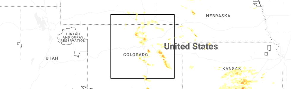
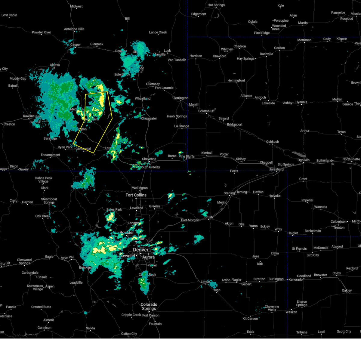
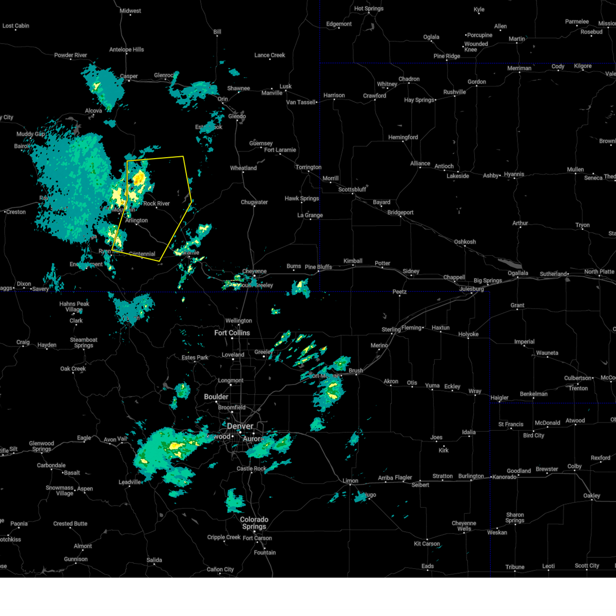
Hail Map for Centennial, WY
The Centennial, WY area has had 0 reports of on-the-ground hail by trained spotters, and has been under severe weather warnings 5 times during the past 12 months. Doppler radar has detected hail at or near Centennial, WY on 11 occasions, including 1 occasion during the past year.
| Name: | Centennial, WY |
| Where Located: | 28 miles W of Laramie, WY |
| Map: | Google Map for Centennial, WY |
| Population: | 270 |
| Housing Units: | 357 |
| More Info: | Search Google for Centennial, WY |
0
The Top Recent Hail Date for Centennial, WY is Tuesday, June 17, 2025 (5th out of 11)
Hail and Wind Damage Spotted near Centennial, WY
| Date / Time | Report Details |
|---|---|
| 6/17/2025 4:17 PM MDT |
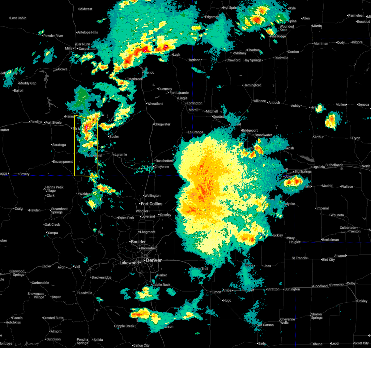 At 417 pm mdt, severe thunderstorms were located along a line extending from medicine bow to miller lake campground, moving east at 30 mph (radar indicated). Hazards include 70 mph wind gusts. Expect considerable tree damage. damage is likely to mobile homes, roofs, and outbuildings. Locations impacted include, albany, rock river, pelton creek campground, brooklyn lake campground, woods landing-jelm, mcfadden, rambler, nash fork campground, keystone, boswell creek campground, wold, rob roy reservoir, lake owen, bobbie thompson campground, arlington, wyocolo, brooklyn lake, sugar loaf campground, libby creek campground, and miller lake campground. At 417 pm mdt, severe thunderstorms were located along a line extending from medicine bow to miller lake campground, moving east at 30 mph (radar indicated). Hazards include 70 mph wind gusts. Expect considerable tree damage. damage is likely to mobile homes, roofs, and outbuildings. Locations impacted include, albany, rock river, pelton creek campground, brooklyn lake campground, woods landing-jelm, mcfadden, rambler, nash fork campground, keystone, boswell creek campground, wold, rob roy reservoir, lake owen, bobbie thompson campground, arlington, wyocolo, brooklyn lake, sugar loaf campground, libby creek campground, and miller lake campground.
|
| 6/17/2025 3:41 PM MDT |
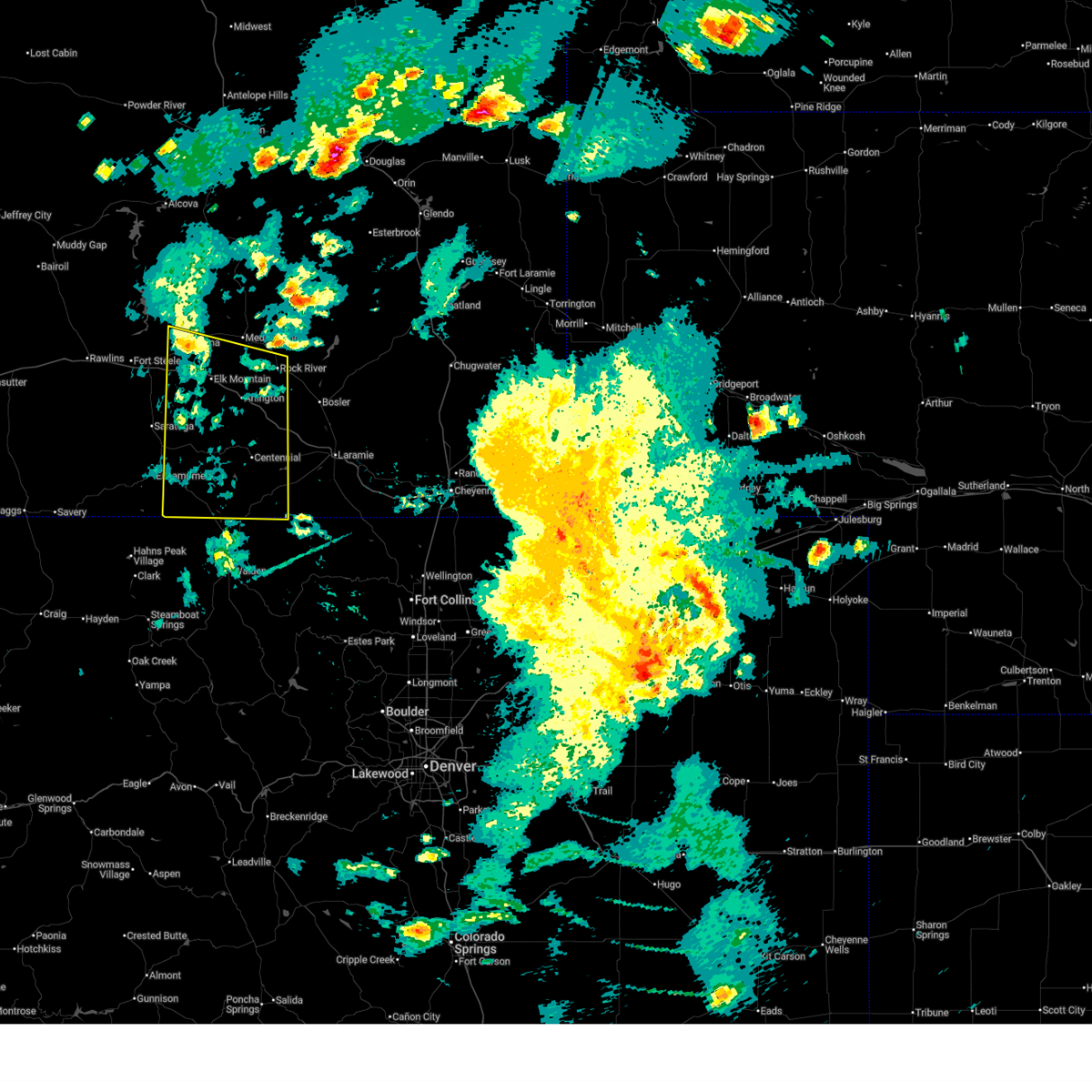 Svrcys the national weather service in cheyenne has issued a * severe thunderstorm warning for, southeastern carbon county in south central wyoming, southwestern albany county in southeastern wyoming, * until 445 pm mdt. * at 341 pm mdt, severe thunderstorms were located along a line extending from near hanna to near pickaroon campground, moving east at 30 mph (radar indicated). Hazards include 70 mph wind gusts. Expect considerable tree damage. Damage is likely to mobile homes, roofs, and outbuildings. Svrcys the national weather service in cheyenne has issued a * severe thunderstorm warning for, southeastern carbon county in south central wyoming, southwestern albany county in southeastern wyoming, * until 445 pm mdt. * at 341 pm mdt, severe thunderstorms were located along a line extending from near hanna to near pickaroon campground, moving east at 30 mph (radar indicated). Hazards include 70 mph wind gusts. Expect considerable tree damage. Damage is likely to mobile homes, roofs, and outbuildings.
|
| 8/25/2024 7:34 PM MDT |
 the severe thunderstorm warning has been cancelled and is no longer in effect the severe thunderstorm warning has been cancelled and is no longer in effect
|
| 8/25/2024 7:23 PM MDT |
 At 722 pm mdt, severe thunderstorms were located along a line extending from 8 miles northwest of garrett to wheatland reservoir number 3 to 12 miles southeast of mcfadden, moving east at 40 mph (radar indicated). Hazards include 60 mph wind gusts. Expect damage to roofs, siding, and trees. Locations impacted include, rock river, mcfadden, wheatland reservoir number 3, deep creek campground, north fork campground, arlington, brooklyn lake campground, and wild horse ranch. At 722 pm mdt, severe thunderstorms were located along a line extending from 8 miles northwest of garrett to wheatland reservoir number 3 to 12 miles southeast of mcfadden, moving east at 40 mph (radar indicated). Hazards include 60 mph wind gusts. Expect damage to roofs, siding, and trees. Locations impacted include, rock river, mcfadden, wheatland reservoir number 3, deep creek campground, north fork campground, arlington, brooklyn lake campground, and wild horse ranch.
|
| 8/25/2024 6:56 PM MDT |
 Svrcys the national weather service in cheyenne has issued a * severe thunderstorm warning for, east central carbon county in south central wyoming, central albany county in southeastern wyoming, * until 745 pm mdt. * at 656 pm mdt, severe thunderstorms were located along a line extending from 9 miles northeast of battle mountain to 8 miles northwest of rock river to near deep creek campground, moving east at 40 mph (radar indicated). Hazards include 60 mph wind gusts. expect damage to roofs, siding, and trees Svrcys the national weather service in cheyenne has issued a * severe thunderstorm warning for, east central carbon county in south central wyoming, central albany county in southeastern wyoming, * until 745 pm mdt. * at 656 pm mdt, severe thunderstorms were located along a line extending from 9 miles northeast of battle mountain to 8 miles northwest of rock river to near deep creek campground, moving east at 40 mph (radar indicated). Hazards include 60 mph wind gusts. expect damage to roofs, siding, and trees
|
| 7/26/2023 4:50 PM MDT |
 At 449 pm mdt, outflow winds from severe thunderstorms were located along a line extending from 12 miles east of seminoe campground to near elk mountain to near lincoln park campground, moving east at 35 mph (wyoming dot road sensors reported wind gusts 55-60 mph). Hazards include 60 mph wind gusts. expect damage to roofs, siding, and trees At 449 pm mdt, outflow winds from severe thunderstorms were located along a line extending from 12 miles east of seminoe campground to near elk mountain to near lincoln park campground, moving east at 35 mph (wyoming dot road sensors reported wind gusts 55-60 mph). Hazards include 60 mph wind gusts. expect damage to roofs, siding, and trees
|
| 7/4/2023 5:25 PM MDT |
 At 525 pm mdt, severe thunderstorms were located along a line extending from 9 miles north of arlington to 9 miles south of rock river to 12 miles north of lake hattie reservoir to 9 miles south of hutton lake, moving northeast at 40 mph (radar indicated). Hazards include 70 mph wind gusts and quarter size hail. Hail damage to vehicles is expected. expect considerable tree damage. Wind damage is also likely to mobile homes, roofs, and outbuildings. At 525 pm mdt, severe thunderstorms were located along a line extending from 9 miles north of arlington to 9 miles south of rock river to 12 miles north of lake hattie reservoir to 9 miles south of hutton lake, moving northeast at 40 mph (radar indicated). Hazards include 70 mph wind gusts and quarter size hail. Hail damage to vehicles is expected. expect considerable tree damage. Wind damage is also likely to mobile homes, roofs, and outbuildings.
|
| 7/4/2023 5:10 PM MDT |
 The severe thunderstorm warning for southeastern carbon and southwestern albany counties will expire at 515 pm mdt, the storms which prompted the warning have weakened below severe limits, and no longer pose an immediate threat to life or property. therefore, the warning will be allowed to expire. however gusty winds near 55 mph are still possible with these thunderstorms. to report severe weather, contact your nearest law enforcement agency. they will relay your report to the national weather service cheyenne. The severe thunderstorm warning for southeastern carbon and southwestern albany counties will expire at 515 pm mdt, the storms which prompted the warning have weakened below severe limits, and no longer pose an immediate threat to life or property. therefore, the warning will be allowed to expire. however gusty winds near 55 mph are still possible with these thunderstorms. to report severe weather, contact your nearest law enforcement agency. they will relay your report to the national weather service cheyenne.
|
| 7/4/2023 4:38 PM MDT |
 At 438 pm mdt, severe thunderstorms were located along a line extending from 8 miles north of saratoga to near ryan park to near pearl, moving east at 30 mph (radar indicated). Hazards include 60 mph wind gusts and penny size hail. Expect damage to roofs, siding, and trees. locations impacted include, albany, saratoga, encampment, elk mountain, grand encampment, six mile campground, brooklyn lake campground, nash fork campground, ryan park campground, bottle creek campground, rob roy reservoir, bobbie thompson campground, arlington, hog park reservoir, french creek campground, skyline, ryan park, brooklyn lake, sugar loaf campground and libby creek campground. this includes interstate 80 in wyoming between mile markers 257 and 275. hail threat, radar indicated max hail size, 0. 75 in wind threat, radar indicated max wind gust, 60 mph. At 438 pm mdt, severe thunderstorms were located along a line extending from 8 miles north of saratoga to near ryan park to near pearl, moving east at 30 mph (radar indicated). Hazards include 60 mph wind gusts and penny size hail. Expect damage to roofs, siding, and trees. locations impacted include, albany, saratoga, encampment, elk mountain, grand encampment, six mile campground, brooklyn lake campground, nash fork campground, ryan park campground, bottle creek campground, rob roy reservoir, bobbie thompson campground, arlington, hog park reservoir, french creek campground, skyline, ryan park, brooklyn lake, sugar loaf campground and libby creek campground. this includes interstate 80 in wyoming between mile markers 257 and 275. hail threat, radar indicated max hail size, 0. 75 in wind threat, radar indicated max wind gust, 60 mph.
|
| 7/4/2023 4:08 PM MDT |
 At 408 pm mdt, severe thunderstorms were located along a line extending from 12 miles east of teton reservoir to 8 miles northwest of grand encampment to hog park reservoir, moving east at 30 mph (radar indicated). Hazards include 60 mph wind gusts and penny size hail. expect damage to roofs, siding, and trees At 408 pm mdt, severe thunderstorms were located along a line extending from 12 miles east of teton reservoir to 8 miles northwest of grand encampment to hog park reservoir, moving east at 30 mph (radar indicated). Hazards include 60 mph wind gusts and penny size hail. expect damage to roofs, siding, and trees
|
| 7/3/2023 6:55 PM MDT |
 The severe thunderstorm warning for carbon and southwestern albany counties will expire at 700 pm mdt, the storms which prompted the warning have weakened below severe limits, and no longer pose an immediate threat to life or property. therefore, the warning will be allowed to expire. however gusty winds near 50 to 55 mph are still possible with these thunderstorms. to report severe weather, contact your nearest law enforcement agency. they will relay your report to the national weather service cheyenne. The severe thunderstorm warning for carbon and southwestern albany counties will expire at 700 pm mdt, the storms which prompted the warning have weakened below severe limits, and no longer pose an immediate threat to life or property. therefore, the warning will be allowed to expire. however gusty winds near 50 to 55 mph are still possible with these thunderstorms. to report severe weather, contact your nearest law enforcement agency. they will relay your report to the national weather service cheyenne.
|
| 7/3/2023 6:37 PM MDT |
 At 637 pm mdt, severe thunderstorms were located along a line extending from near shirley basin to 8 miles northeast of elk mountain to 7 miles north of encampment, moving east at 30 mph (trained weather spotters). Hazards include 70 mph wind gusts. Expect considerable tree damage. damage is likely to mobile homes, roofs, and outbuildings. locations impacted include, albany, saratoga, hanna, encampment, sinclair, medicine bow, elk mountain, battle mountain, grand encampment, battle lake, six mile campground, brooklyn lake campground, nash fork campground, seminoe dam, ryan park campground, boswell creek campground, bottle creek campground, rob roy reservoir, lake owen and bobbie thompson campground. this includes interstate 80 in wyoming between mile markers 217 and 281. thunderstorm damage threat, considerable hail threat, radar indicated max hail size, <. 75 in wind threat, radar indicated max wind gust, 70 mph. At 637 pm mdt, severe thunderstorms were located along a line extending from near shirley basin to 8 miles northeast of elk mountain to 7 miles north of encampment, moving east at 30 mph (trained weather spotters). Hazards include 70 mph wind gusts. Expect considerable tree damage. damage is likely to mobile homes, roofs, and outbuildings. locations impacted include, albany, saratoga, hanna, encampment, sinclair, medicine bow, elk mountain, battle mountain, grand encampment, battle lake, six mile campground, brooklyn lake campground, nash fork campground, seminoe dam, ryan park campground, boswell creek campground, bottle creek campground, rob roy reservoir, lake owen and bobbie thompson campground. this includes interstate 80 in wyoming between mile markers 217 and 281. thunderstorm damage threat, considerable hail threat, radar indicated max hail size, <. 75 in wind threat, radar indicated max wind gust, 70 mph.
|
| 7/3/2023 6:13 PM MDT |
 At 612 pm mdt, severe thunderstorms were located along a line extending from 13 miles southwest of bates hole to 7 miles southwest of hanna to near jack creek campground, moving east at 30 mph (trained weather spotters. these storms have a history of producing wind gusts in excess of 65 mph across northern carbon and southern natrona counties). Hazards include 70 mph wind gusts. Expect considerable tree damage. damage is likely to mobile homes, roofs, and outbuildings. locations impacted include, rawlins, albany, saratoga, hanna, encampment, sinclair, medicine bow, elk mountain, battle mountain, grand encampment, six mile campground, teton reservoir, separation lake, rob roy reservoir, lake owen, arlington, hog park reservoir, french creek campground, jack creek campground and bow river campground. this includes interstate 80 in wyoming between mile markers 205 and 281. thunderstorm damage threat, considerable hail threat, radar indicated max hail size, <. 75 in wind threat, radar indicated max wind gust, 70 mph. At 612 pm mdt, severe thunderstorms were located along a line extending from 13 miles southwest of bates hole to 7 miles southwest of hanna to near jack creek campground, moving east at 30 mph (trained weather spotters. these storms have a history of producing wind gusts in excess of 65 mph across northern carbon and southern natrona counties). Hazards include 70 mph wind gusts. Expect considerable tree damage. damage is likely to mobile homes, roofs, and outbuildings. locations impacted include, rawlins, albany, saratoga, hanna, encampment, sinclair, medicine bow, elk mountain, battle mountain, grand encampment, six mile campground, teton reservoir, separation lake, rob roy reservoir, lake owen, arlington, hog park reservoir, french creek campground, jack creek campground and bow river campground. this includes interstate 80 in wyoming between mile markers 205 and 281. thunderstorm damage threat, considerable hail threat, radar indicated max hail size, <. 75 in wind threat, radar indicated max wind gust, 70 mph.
|
| 7/3/2023 5:54 PM MDT |
 At 553 pm mdt, severe thunderstorms were located along a line extending from 13 miles north of seminoe dam to near sinclair to 15 miles northwest of little sandstone creek campground, moving east at 25 mph (trained weather spotters. wind gusts in excess of 65 mph have been confirmed from rawlins to muddy gap). Hazards include 70 mph wind gusts. Expect considerable tree damage. Damage is likely to mobile homes, roofs, and outbuildings. At 553 pm mdt, severe thunderstorms were located along a line extending from 13 miles north of seminoe dam to near sinclair to 15 miles northwest of little sandstone creek campground, moving east at 25 mph (trained weather spotters. wind gusts in excess of 65 mph have been confirmed from rawlins to muddy gap). Hazards include 70 mph wind gusts. Expect considerable tree damage. Damage is likely to mobile homes, roofs, and outbuildings.
|
| 7/28/2022 7:27 PM MDT |
 The severe thunderstorm warning for southeastern carbon and southwestern albany counties will expire at 730 pm mdt, the storm which prompted the warning has moved out of the area. therefore, the warning will be allowed to expire. remember, a severe thunderstorm warning still remains in effect for southwest albany county. The severe thunderstorm warning for southeastern carbon and southwestern albany counties will expire at 730 pm mdt, the storm which prompted the warning has moved out of the area. therefore, the warning will be allowed to expire. remember, a severe thunderstorm warning still remains in effect for southwest albany county.
|
| 7/28/2022 7:20 PM MDT |
 At 719 pm mdt, a severe thunderstorm was located over libby creek campground, or 29 miles west of laramie, moving south at 30 mph (radar indicated). Hazards include 60 mph wind gusts and quarter size hail. Hail damage to vehicles is expected. Expect wind damage to roofs, siding, and trees. At 719 pm mdt, a severe thunderstorm was located over libby creek campground, or 29 miles west of laramie, moving south at 30 mph (radar indicated). Hazards include 60 mph wind gusts and quarter size hail. Hail damage to vehicles is expected. Expect wind damage to roofs, siding, and trees.
|
| 7/28/2022 7:07 PM MDT |
 At 707 pm mdt, a severe thunderstorm was located near north fork campground, or 31 miles west of laramie, moving south at 20 mph (radar indicated). Hazards include 60 mph wind gusts and quarter size hail. Hail damage to vehicles is expected. expect wind damage to roofs, siding, and trees. locations impacted include, nash fork campground, brooklyn lake, brooklyn lake campground and north fork campground. hail threat, radar indicated max hail size, 1. 00 in wind threat, radar indicated max wind gust, 60 mph. At 707 pm mdt, a severe thunderstorm was located near north fork campground, or 31 miles west of laramie, moving south at 20 mph (radar indicated). Hazards include 60 mph wind gusts and quarter size hail. Hail damage to vehicles is expected. expect wind damage to roofs, siding, and trees. locations impacted include, nash fork campground, brooklyn lake, brooklyn lake campground and north fork campground. hail threat, radar indicated max hail size, 1. 00 in wind threat, radar indicated max wind gust, 60 mph.
|
| 7/28/2022 6:38 PM MDT |
 At 638 pm mdt, a severe thunderstorm was located near arlington, or 32 miles northwest of laramie, moving south at 20 mph (radar indicated). Hazards include 60 mph wind gusts and quarter size hail. Hail damage to vehicles is expected. Expect wind damage to roofs, siding, and trees. At 638 pm mdt, a severe thunderstorm was located near arlington, or 32 miles northwest of laramie, moving south at 20 mph (radar indicated). Hazards include 60 mph wind gusts and quarter size hail. Hail damage to vehicles is expected. Expect wind damage to roofs, siding, and trees.
|
| 7/29/2021 3:12 PM MDT |
 At 311 pm mdt, a severe thunderstorm was located over libby creek campground, or 28 miles west of laramie, moving east at 20 mph (radar indicated). Hazards include 60 mph wind gusts and quarter size hail. Hail damage to vehicles is expected. Expect wind damage to roofs, siding, and trees. At 311 pm mdt, a severe thunderstorm was located over libby creek campground, or 28 miles west of laramie, moving east at 20 mph (radar indicated). Hazards include 60 mph wind gusts and quarter size hail. Hail damage to vehicles is expected. Expect wind damage to roofs, siding, and trees.
|
| 7/29/2021 2:27 PM MDT |
 At 227 pm mdt, a severe thunderstorm was located over brooklyn lake campground, or 36 miles west of laramie, moving northeast at 20 mph (radar indicated). Hazards include 60 mph wind gusts and half dollar size hail. Hail damage to vehicles is expected. Expect wind damage to roofs, siding, and trees. At 227 pm mdt, a severe thunderstorm was located over brooklyn lake campground, or 36 miles west of laramie, moving northeast at 20 mph (radar indicated). Hazards include 60 mph wind gusts and half dollar size hail. Hail damage to vehicles is expected. Expect wind damage to roofs, siding, and trees.
|
| 7/13/2020 3:16 PM MDT |
 At 316 pm mdt, severe thunderstorms were located along a line extending from near rock river to 8 miles northeast of north fork campground to near lake owen, moving east at 45 mph (radar indicated). Hazards include 60 mph wind gusts. expect damage to roofs, siding, and trees At 316 pm mdt, severe thunderstorms were located along a line extending from near rock river to 8 miles northeast of north fork campground to near lake owen, moving east at 45 mph (radar indicated). Hazards include 60 mph wind gusts. expect damage to roofs, siding, and trees
|
| 6/6/2020 3:34 PM MDT |
 At 333 pm mdt, severe thunderstorms were located along a line extending from near shirley basin to 6 miles southeast of rock river, moving northeast at 60 mph (radar indicated). Hazards include 70 mph wind gusts. Expect considerable tree damage. damage is likely to mobile homes, roofs, and outbuildings. locations impacted include, hanna, medicine bow, rock river, elk mountain, battle mountain, shirley basin, brooklyn lake, brooklyn lake campground, libby creek campground, deep creek campground, centennial, nash fork campground, little medicine school, north fork campground and arlington. This includes interstate 80 in wyoming between mile markers 252 and 303. At 333 pm mdt, severe thunderstorms were located along a line extending from near shirley basin to 6 miles southeast of rock river, moving northeast at 60 mph (radar indicated). Hazards include 70 mph wind gusts. Expect considerable tree damage. damage is likely to mobile homes, roofs, and outbuildings. locations impacted include, hanna, medicine bow, rock river, elk mountain, battle mountain, shirley basin, brooklyn lake, brooklyn lake campground, libby creek campground, deep creek campground, centennial, nash fork campground, little medicine school, north fork campground and arlington. This includes interstate 80 in wyoming between mile markers 252 and 303.
|
| 6/6/2020 3:18 PM MDT |
 At 316 pm mdt, severe thunderstorms were located along a line extending from 8 miles west of battle mountain to 7 miles northeast of north fork campground, moving northeast at 70 mph. at 312 pm mdt, 77 mph wind gust was reported at arlington along interstate 80. these are very dangerous storms (trained weather spotters). Hazards include 80 mph wind gusts. Flying debris will be dangerous to those caught without shelter. mobile homes will be heavily damaged. expect considerable damage to roofs, windows, and vehicles. extensive tree damage and power outages are likely. locations impacted include, albany, hanna, medicine bow, rock river, elk mountain, battle mountain, brooklyn lake campground, woods landing-jelm, nash fork campground, boswell creek campground, rob roy reservoir, lake owen, arlington, bobbie thompson campground, shirley basin, brooklyn lake, sugar loaf campground, libby creek campground, bow river campground and illinois creek campground. This includes interstate 80 in wyoming between mile markers 246 and 303. At 316 pm mdt, severe thunderstorms were located along a line extending from 8 miles west of battle mountain to 7 miles northeast of north fork campground, moving northeast at 70 mph. at 312 pm mdt, 77 mph wind gust was reported at arlington along interstate 80. these are very dangerous storms (trained weather spotters). Hazards include 80 mph wind gusts. Flying debris will be dangerous to those caught without shelter. mobile homes will be heavily damaged. expect considerable damage to roofs, windows, and vehicles. extensive tree damage and power outages are likely. locations impacted include, albany, hanna, medicine bow, rock river, elk mountain, battle mountain, brooklyn lake campground, woods landing-jelm, nash fork campground, boswell creek campground, rob roy reservoir, lake owen, arlington, bobbie thompson campground, shirley basin, brooklyn lake, sugar loaf campground, libby creek campground, bow river campground and illinois creek campground. This includes interstate 80 in wyoming between mile markers 246 and 303.
|
| 6/6/2020 2:53 PM MDT |
 At 253 pm mdt, severe thunderstorms were located along a line extending from 12 miles southwest of hanna to near skyline, moving northeast at 60 mph (radar indicated). Hazards include 70 mph wind gusts. Expect considerable tree damage. Damage is likely to mobile homes, roofs, and outbuildings. At 253 pm mdt, severe thunderstorms were located along a line extending from 12 miles southwest of hanna to near skyline, moving northeast at 60 mph (radar indicated). Hazards include 70 mph wind gusts. Expect considerable tree damage. Damage is likely to mobile homes, roofs, and outbuildings.
|
| 4/26/2019 7:10 PM MDT |
 The severe thunderstorm warning for east central carbon and southwestern albany counties will expire at 715 pm mdt, the storm which prompted the warning has weakened below severe limits, and no longer poses an immediate threat to life or property. therefore, the warning will be allowed to expire. however gusty winds up to 50 mph are still possible with this thunderstorm. The severe thunderstorm warning for east central carbon and southwestern albany counties will expire at 715 pm mdt, the storm which prompted the warning has weakened below severe limits, and no longer poses an immediate threat to life or property. therefore, the warning will be allowed to expire. however gusty winds up to 50 mph are still possible with this thunderstorm.
|
| 4/26/2019 6:55 PM MDT |
 At 655 pm mdt, a severe thunderstorm was located 9 miles east of arlington, or 29 miles northwest of laramie, moving southeast at 50 mph (radar indicated). Hazards include 60 mph wind gusts. Expect damage to roofs, siding, and trees. locations impacted include, medicine bow, rock river, bosler, brooklyn lake, sugar loaf campground, brooklyn lake campground, libby creek campground, bow river campground, deep creek campground, centennial, lincoln park campground, nash fork campground, north fork campground and arlington. This includes interstate 80 in wyoming between mile markers 261 and 303. At 655 pm mdt, a severe thunderstorm was located 9 miles east of arlington, or 29 miles northwest of laramie, moving southeast at 50 mph (radar indicated). Hazards include 60 mph wind gusts. Expect damage to roofs, siding, and trees. locations impacted include, medicine bow, rock river, bosler, brooklyn lake, sugar loaf campground, brooklyn lake campground, libby creek campground, bow river campground, deep creek campground, centennial, lincoln park campground, nash fork campground, north fork campground and arlington. This includes interstate 80 in wyoming between mile markers 261 and 303.
|
| 4/26/2019 6:35 PM MDT |
 At 634 pm mdt, a severe thunderstorm was located near elk mountain, or 45 miles east of rawlins, moving southeast at 50 mph (radar indicated). Hazards include 70 mph wind gusts. Expect considerable tree damage. Damage is likely to mobile homes, roofs, and outbuildings. At 634 pm mdt, a severe thunderstorm was located near elk mountain, or 45 miles east of rawlins, moving southeast at 50 mph (radar indicated). Hazards include 70 mph wind gusts. Expect considerable tree damage. Damage is likely to mobile homes, roofs, and outbuildings.
|
| 10/4/2018 1:05 PM MDT |
 At 104 pm mdt, severe thunderstorms were located along a line extending from near illinois creek campground to 8 miles west of glendevey, moving northeast at 60 mph (radar indicated). Hazards include 60 mph wind gusts. Expect damage to roofs, siding, and trees. severe thunderstorms will be near, rob roy reservoir, rob roy campground, miller lake campground and evans creek campground around 110 pm mdt. albany, lake owen and lake owen campground around 115 pm mdt. centennial, libby creek campground and woods landing-jelm around 120 pm mdt. lake hattie reservoir around 125 pm mdt. the buttes around 145 pm mdt. This includes interstate 80 in wyoming between mile markers 297 and 304. At 104 pm mdt, severe thunderstorms were located along a line extending from near illinois creek campground to 8 miles west of glendevey, moving northeast at 60 mph (radar indicated). Hazards include 60 mph wind gusts. Expect damage to roofs, siding, and trees. severe thunderstorms will be near, rob roy reservoir, rob roy campground, miller lake campground and evans creek campground around 110 pm mdt. albany, lake owen and lake owen campground around 115 pm mdt. centennial, libby creek campground and woods landing-jelm around 120 pm mdt. lake hattie reservoir around 125 pm mdt. the buttes around 145 pm mdt. This includes interstate 80 in wyoming between mile markers 297 and 304.
|
| 7/3/2016 5:39 PM MDT |
 The severe thunderstorm warning for west central albany and east central carbon counties will expire at 545 pm mdt, the storms which prompted the warning have weakened below severe limits, and no longer pose an immediate threat to life or property. therefore the warning will be allowed to expire. however gusty winds are still possible with these thunderstorms. The severe thunderstorm warning for west central albany and east central carbon counties will expire at 545 pm mdt, the storms which prompted the warning have weakened below severe limits, and no longer pose an immediate threat to life or property. therefore the warning will be allowed to expire. however gusty winds are still possible with these thunderstorms.
|
| 7/3/2016 5:21 PM MDT |
 At 520 pm mdt, severe thunderstorms were located along a line extending from 6 miles northwest of arlington to near bow river campground, moving east at 30 mph (radar indicated). Hazards include 60 mph wind gusts. Expect damage to roofs. siding. and trees. locations impacted include, rock river, elk mountain, nash fork campground, sugar loaf campground, brooklyn lake, deep creek campground, libby creek campground, brooklyn lake campground, bow river campground, arlington, north fork campground and centennial. This includes interstate 80 in wyoming between mile markers 259 and 285. At 520 pm mdt, severe thunderstorms were located along a line extending from 6 miles northwest of arlington to near bow river campground, moving east at 30 mph (radar indicated). Hazards include 60 mph wind gusts. Expect damage to roofs. siding. and trees. locations impacted include, rock river, elk mountain, nash fork campground, sugar loaf campground, brooklyn lake, deep creek campground, libby creek campground, brooklyn lake campground, bow river campground, arlington, north fork campground and centennial. This includes interstate 80 in wyoming between mile markers 259 and 285.
|
| 7/3/2016 5:07 PM MDT |
 At 506 pm mdt, severe thunderstorms were located along a line extending from elk mountain to 9 miles west of bow river campground, moving southeast at 25 mph (radar indicated). Hazards include 60 mph wind gusts. Expect damage to roofs. siding. And trees. At 506 pm mdt, severe thunderstorms were located along a line extending from elk mountain to 9 miles west of bow river campground, moving southeast at 25 mph (radar indicated). Hazards include 60 mph wind gusts. Expect damage to roofs. siding. And trees.
|
| 7/15/2015 6:17 PM MDT |
 At 616 pm mdt, severe thunderstorms were located along a line extending from near little medicine school to near six mile campground, moving east at 25 mph (radar indicated). Hazards include 60 mph wind gusts. these severe thunderstorms have a history of producing wind gusts of 55 to 63 mph. Expect damage to roofs. siding and trees. locations impacted include, albany, medicine bow, rock river, elk mountain, bobbie thompson campground, french creek campground, centennial, ryan park campground, bow river campground, little medicine school, ryan park, woods landing-jelm, lake owen campground, battle mountain, sugar loaf campground, brooklyn lake, deep creek campground, brooklyn lake campground, arlington and evans creek campground. This includes interstate 80 in wyoming between mile markers 259 and 301. At 616 pm mdt, severe thunderstorms were located along a line extending from near little medicine school to near six mile campground, moving east at 25 mph (radar indicated). Hazards include 60 mph wind gusts. these severe thunderstorms have a history of producing wind gusts of 55 to 63 mph. Expect damage to roofs. siding and trees. locations impacted include, albany, medicine bow, rock river, elk mountain, bobbie thompson campground, french creek campground, centennial, ryan park campground, bow river campground, little medicine school, ryan park, woods landing-jelm, lake owen campground, battle mountain, sugar loaf campground, brooklyn lake, deep creek campground, brooklyn lake campground, arlington and evans creek campground. This includes interstate 80 in wyoming between mile markers 259 and 301.
|
| 7/15/2015 5:53 PM MDT |
 At 551 pm mdt, severe thunderstorms were located along a line extending from near shirley basin to near pearl, moving east at 30 mph (radar indicated). Hazards include 60 mph wind gusts. these storms have a history of producing wind gusts of 55 to 63 mph. Expect damage to roofs. Siding and trees. At 551 pm mdt, severe thunderstorms were located along a line extending from near shirley basin to near pearl, moving east at 30 mph (radar indicated). Hazards include 60 mph wind gusts. these storms have a history of producing wind gusts of 55 to 63 mph. Expect damage to roofs. Siding and trees.
|
| 1/1/0001 12:00 AM | This is quealy dom in albany county WY, 14.5 miles SW of Centennial, WY |
Hail Maps for Centennial, WY


Connect with Interactive Hail Maps