

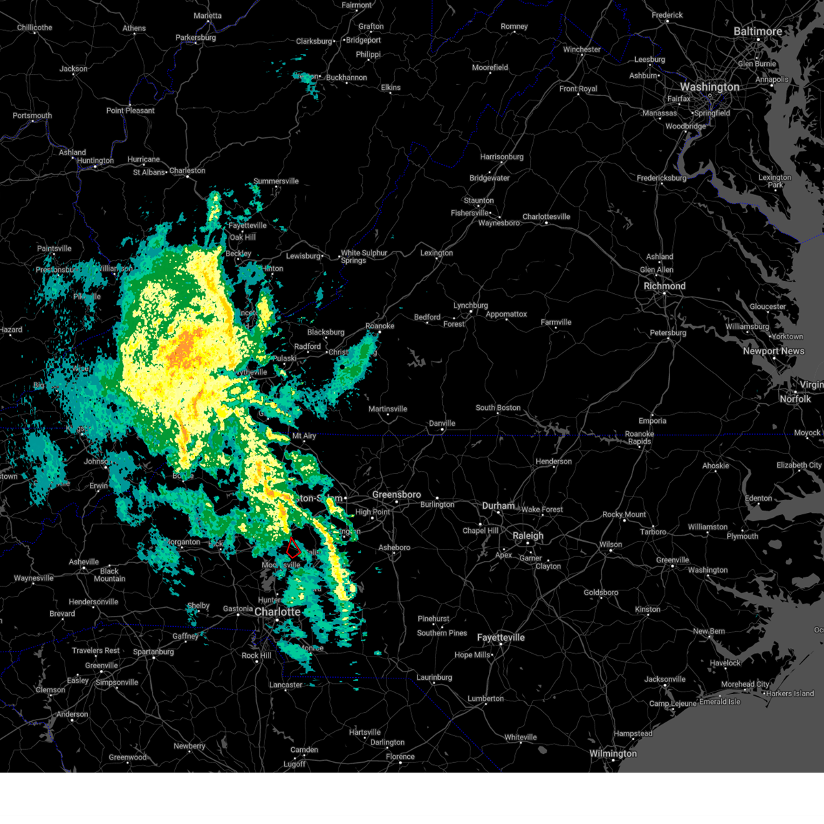
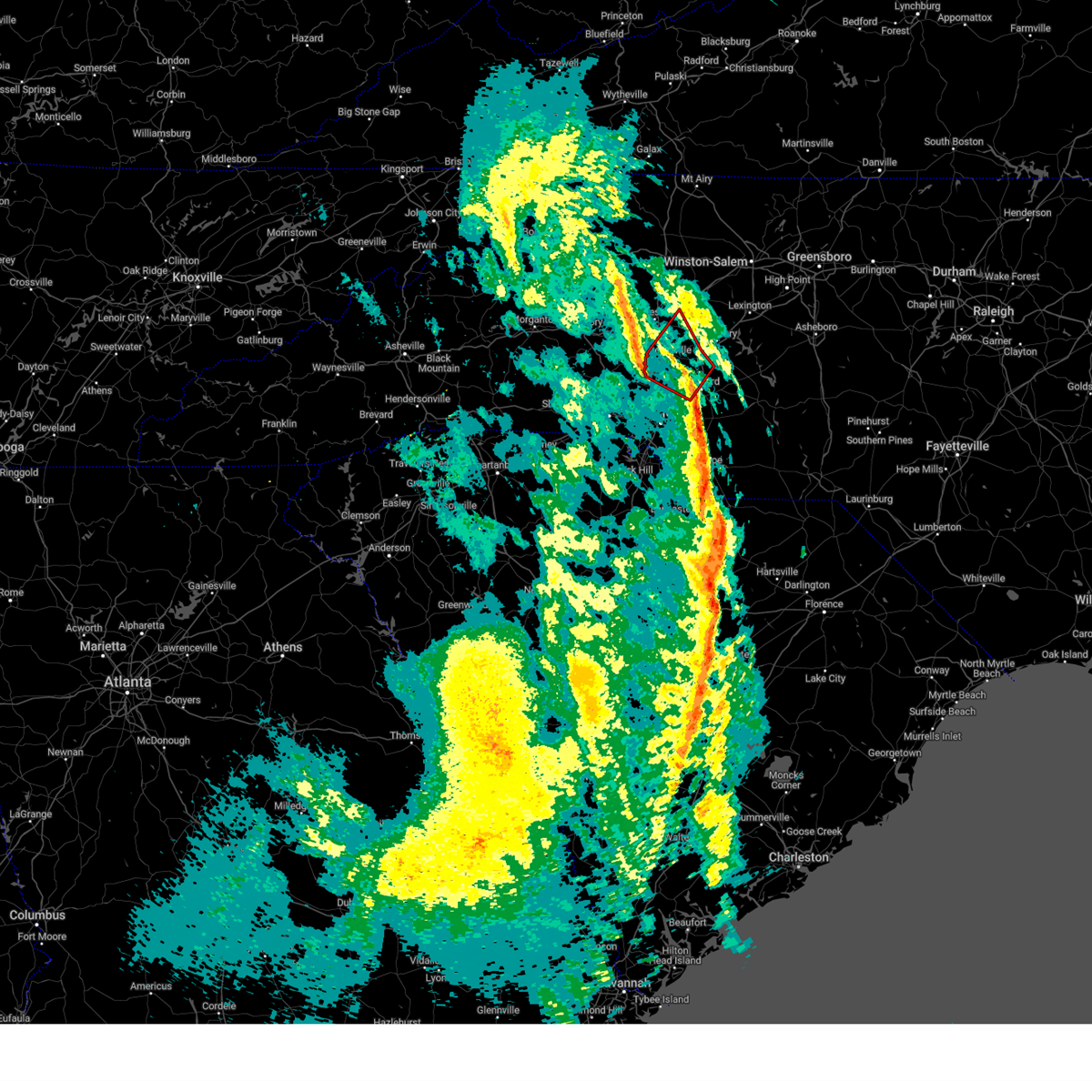
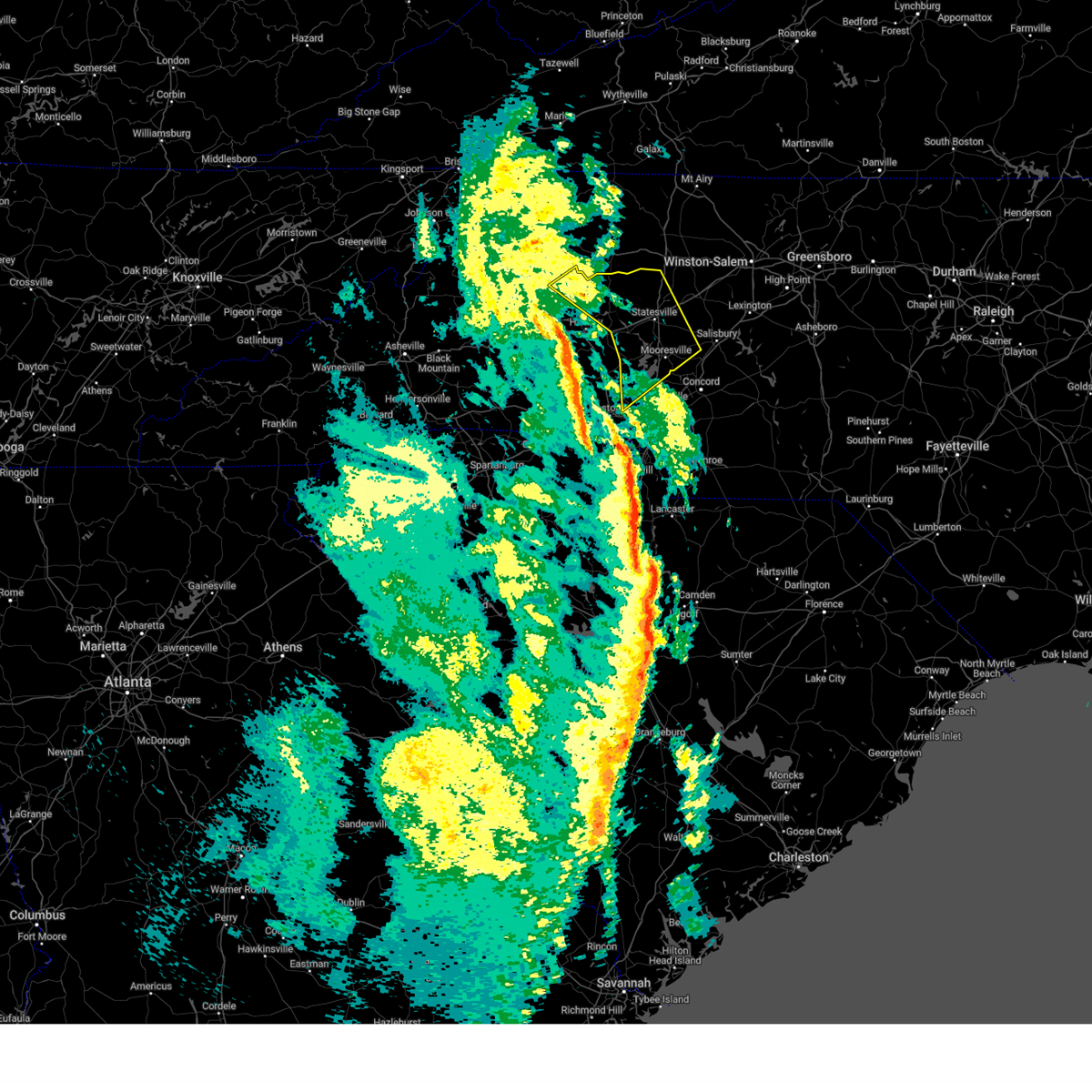
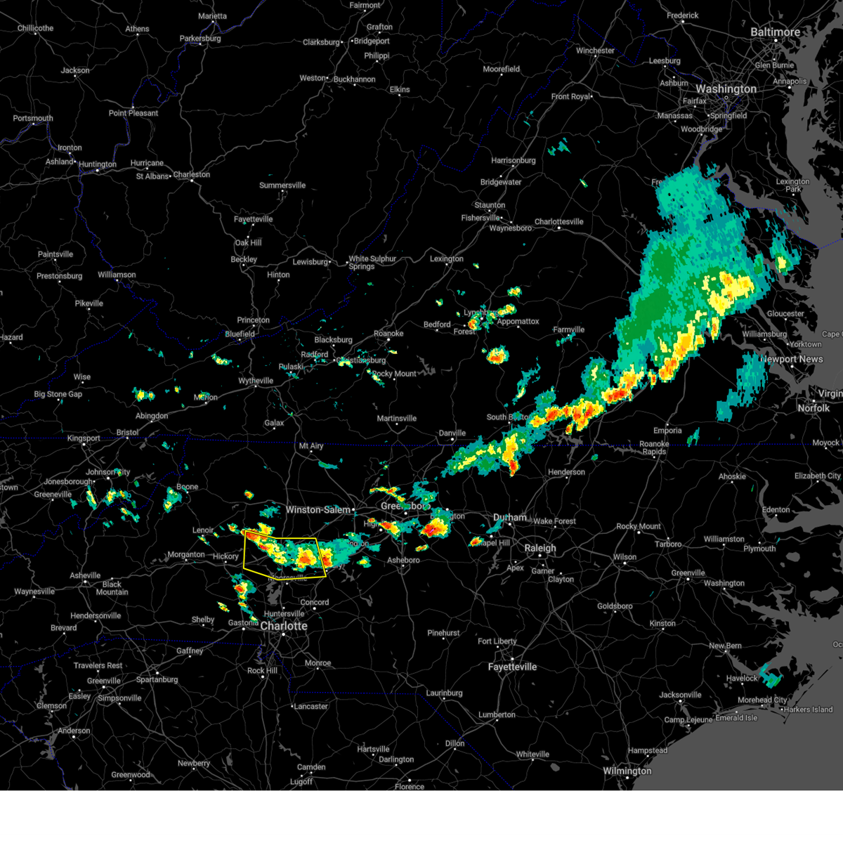
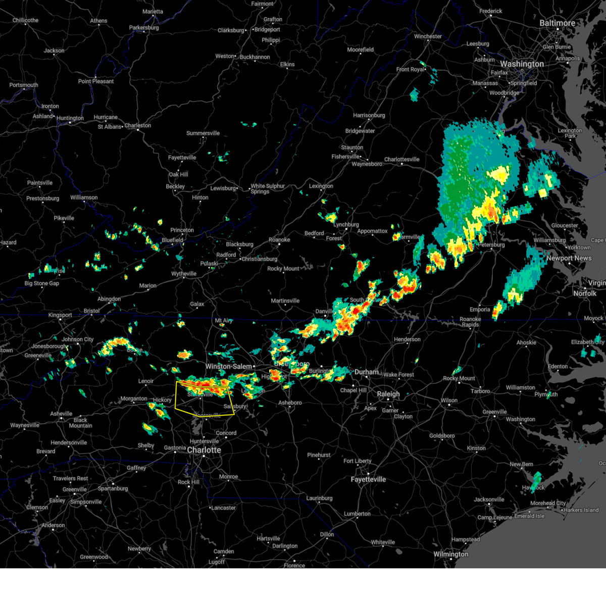
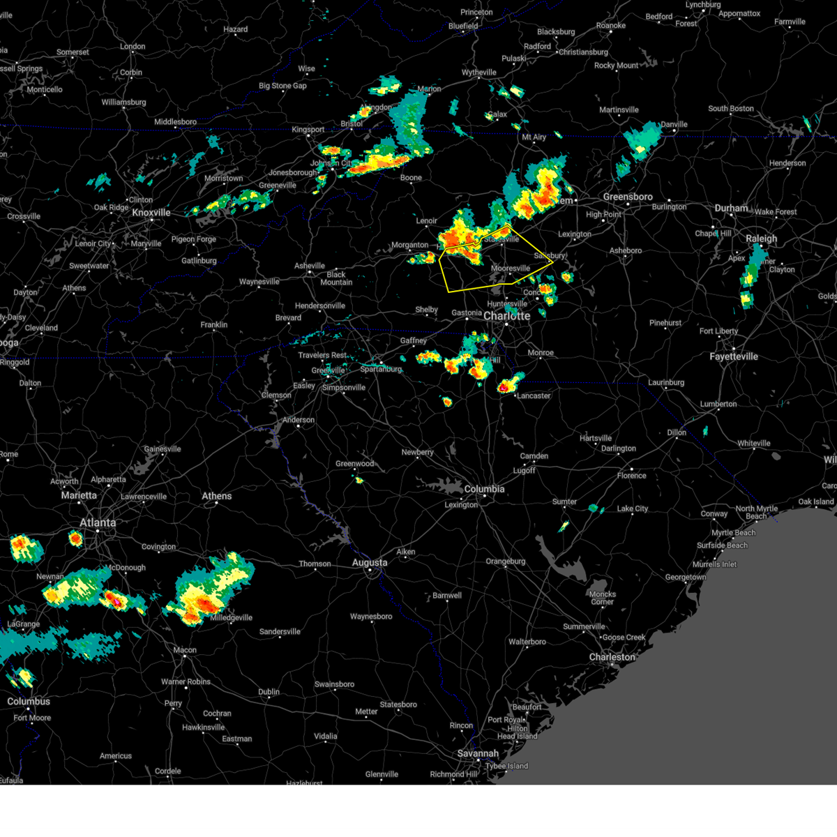
Hail Map for Cleveland, NC
The Cleveland, NC area has had 2 reports of on-the-ground hail by trained spotters, and has been under severe weather warnings 26 times during the past 12 months. Doppler radar has detected hail at or near Cleveland, NC on 35 occasions.
| Name: | Cleveland, NC |
| Where Located: | 36.3 miles NNE of Charlotte, NC |
| Map: | Google Map for Cleveland, NC |
| Population: | 871 |
| Housing Units: | 377 |
| More Info: | Search Google for Cleveland, NC |
5
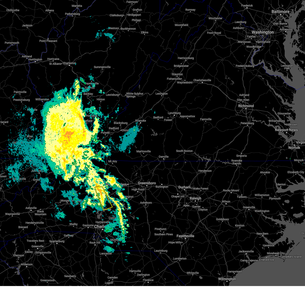
The Top Recent Hail Date for Cleveland, NC is Thursday, July 13, 2023 (4th out of 35)
Hail and Wind Damage Spotted near Cleveland, NC
| Date / Time | Report Details |
|---|---|
| 5/4/2025 1:39 AM EDT |
 The storms which prompted the warning have weakened below severe limits, and have exited the warned area. therefore, the warning will be allowed to expire. to report severe weather to the national weather service greenville-spartanburg, call toll free, 1, 800, 2 6 7, 8 1 0 1, or post on our facebook page, or tweet it using hashtag nwsgsp. your message should describe the event and the specific location where it occurred. The storms which prompted the warning have weakened below severe limits, and have exited the warned area. therefore, the warning will be allowed to expire. to report severe weather to the national weather service greenville-spartanburg, call toll free, 1, 800, 2 6 7, 8 1 0 1, or post on our facebook page, or tweet it using hashtag nwsgsp. your message should describe the event and the specific location where it occurred.
|
| 5/4/2025 1:21 AM EDT |
 the severe thunderstorm warning has been cancelled and is no longer in effect the severe thunderstorm warning has been cancelled and is no longer in effect
|
| 5/4/2025 1:21 AM EDT |
 At 120 am edt, severe thunderstorms were located along a line extending from 9 miles southwest of mocksville to near kannapolis, moving northeast at 35 mph (radar indicated). Hazards include 60 mph wind gusts. Expect damage to trees and power lines. Locations impacted include, fork church, advance, piedmont research station, faith, spencer, cooleemee, cleveland, landis, salisbury, and china grove. At 120 am edt, severe thunderstorms were located along a line extending from 9 miles southwest of mocksville to near kannapolis, moving northeast at 35 mph (radar indicated). Hazards include 60 mph wind gusts. Expect damage to trees and power lines. Locations impacted include, fork church, advance, piedmont research station, faith, spencer, cooleemee, cleveland, landis, salisbury, and china grove.
|
| 5/4/2025 1:05 AM EDT |
 Svrgsp the national weather service in greenville-spartanburg has issued a * severe thunderstorm warning for, northwestern cabarrus county in the piedmont of north carolina, southeastern davie county in the piedmont of north carolina, southeastern iredell county in the piedmont of north carolina, north central mecklenburg county in the piedmont of north carolina, rowan county in the piedmont of north carolina, * until 145 am edt. * at 105 am edt, severe thunderstorms were located along a line extending from 10 miles southeast of statesville to 5 miles east of huntersville, moving northeast at 35 mph (radar indicated). Hazards include 60 mph wind gusts. expect damage to trees and power lines Svrgsp the national weather service in greenville-spartanburg has issued a * severe thunderstorm warning for, northwestern cabarrus county in the piedmont of north carolina, southeastern davie county in the piedmont of north carolina, southeastern iredell county in the piedmont of north carolina, north central mecklenburg county in the piedmont of north carolina, rowan county in the piedmont of north carolina, * until 145 am edt. * at 105 am edt, severe thunderstorms were located along a line extending from 10 miles southeast of statesville to 5 miles east of huntersville, moving northeast at 35 mph (radar indicated). Hazards include 60 mph wind gusts. expect damage to trees and power lines
|
| 3/5/2025 7:59 AM EST |
 Svrgsp the national weather service in greenville-spartanburg has issued a * severe thunderstorm warning for, davie county in the piedmont of north carolina, southeastern iredell county in the piedmont of north carolina, rowan county in the piedmont of north carolina, * until 830 am est. * at 758 am est, severe thunderstorms were located along a line extending from 3 miles north of mocksville to 9 miles northwest of kannapolis, moving northeast at 45 mph (radar indicated). Hazards include 60 mph wind gusts. expect damage to trees and power lines Svrgsp the national weather service in greenville-spartanburg has issued a * severe thunderstorm warning for, davie county in the piedmont of north carolina, southeastern iredell county in the piedmont of north carolina, rowan county in the piedmont of north carolina, * until 830 am est. * at 758 am est, severe thunderstorms were located along a line extending from 3 miles north of mocksville to 9 miles northwest of kannapolis, moving northeast at 45 mph (radar indicated). Hazards include 60 mph wind gusts. expect damage to trees and power lines
|
| 12/29/2024 10:20 AM EST |
 The storms which prompted the warning have moved out of the area. therefore, the warning will be allowed to expire. a tornado watch remains in effect until 100 pm est for the piedmont of north carolina. The storms which prompted the warning have moved out of the area. therefore, the warning will be allowed to expire. a tornado watch remains in effect until 100 pm est for the piedmont of north carolina.
|
| 12/29/2024 10:19 AM EST |
 the tornado warning has been cancelled and is no longer in effect the tornado warning has been cancelled and is no longer in effect
|
| 12/29/2024 10:13 AM EST |
 the tornado warning has been cancelled and is no longer in effect the tornado warning has been cancelled and is no longer in effect
|
| 12/29/2024 10:13 AM EST |
 At 1012 am est, a severe thunderstorm capable of producing a tornado was located 11 miles east of statesville, or over cleveland, moving northeast at 45 mph (radar indicated rotation). Hazards include tornado. Flying debris will be dangerous to those caught without shelter. mobile homes will be damaged or destroyed. damage to roofs, windows, and vehicles will occur. tree damage is likely. This tornadic thunderstorm will remain over mainly rural areas of west central rowan county. At 1012 am est, a severe thunderstorm capable of producing a tornado was located 11 miles east of statesville, or over cleveland, moving northeast at 45 mph (radar indicated rotation). Hazards include tornado. Flying debris will be dangerous to those caught without shelter. mobile homes will be damaged or destroyed. damage to roofs, windows, and vehicles will occur. tree damage is likely. This tornadic thunderstorm will remain over mainly rural areas of west central rowan county.
|
| 12/29/2024 10:04 AM EST |
 At 1004 am est, a severe thunderstorm capable of producing a tornado was located 11 miles southeast of statesville, or 5 miles northeast of mooresville, moving northeast at 45 mph (radar indicated rotation). Hazards include tornado. Flying debris will be dangerous to those caught without shelter. mobile homes will be damaged or destroyed. damage to roofs, windows, and vehicles will occur. tree damage is likely. this dangerous storm will be near, cleveland around 1010 am est. Other locations impacted by this tornadic thunderstorm include mount ulla. At 1004 am est, a severe thunderstorm capable of producing a tornado was located 11 miles southeast of statesville, or 5 miles northeast of mooresville, moving northeast at 45 mph (radar indicated rotation). Hazards include tornado. Flying debris will be dangerous to those caught without shelter. mobile homes will be damaged or destroyed. damage to roofs, windows, and vehicles will occur. tree damage is likely. this dangerous storm will be near, cleveland around 1010 am est. Other locations impacted by this tornadic thunderstorm include mount ulla.
|
| 12/29/2024 10:03 AM EST |
 the severe thunderstorm warning has been cancelled and is no longer in effect the severe thunderstorm warning has been cancelled and is no longer in effect
|
| 12/29/2024 10:03 AM EST |
 At 1003 am est, severe thunderstorms were located along a line extending from 5 miles northeast of north wilkesboro to 10 miles south of ronda to 4 miles east of statesville to 7 miles southeast of huntersville, moving east at 45 mph (radar indicated). Hazards include 60 mph wind gusts. Expect damage to trees and power lines. Locations impacted include, statesville, cleveland, love valley, mount ulla, turnersburg, olin, union grove, cool springs, and mooresville. At 1003 am est, severe thunderstorms were located along a line extending from 5 miles northeast of north wilkesboro to 10 miles south of ronda to 4 miles east of statesville to 7 miles southeast of huntersville, moving east at 45 mph (radar indicated). Hazards include 60 mph wind gusts. Expect damage to trees and power lines. Locations impacted include, statesville, cleveland, love valley, mount ulla, turnersburg, olin, union grove, cool springs, and mooresville.
|
| 12/29/2024 9:59 AM EST |
 the tornado warning has been cancelled and is no longer in effect the tornado warning has been cancelled and is no longer in effect
|
| 12/29/2024 9:59 AM EST |
 At 959 am est, a severe thunderstorm capable of producing a tornado was located 11 miles northwest of kannapolis, or near mooresville, moving northeast at 45 mph (radar indicated rotation). Hazards include tornado. Flying debris will be dangerous to those caught without shelter. mobile homes will be damaged or destroyed. damage to roofs, windows, and vehicles will occur. tree damage is likely. this dangerous storm will be near, mooresville around 1000 am est. cleveland around 1010 am est. Other locations impacted by this tornadic thunderstorm include mount ulla and doolie. At 959 am est, a severe thunderstorm capable of producing a tornado was located 11 miles northwest of kannapolis, or near mooresville, moving northeast at 45 mph (radar indicated rotation). Hazards include tornado. Flying debris will be dangerous to those caught without shelter. mobile homes will be damaged or destroyed. damage to roofs, windows, and vehicles will occur. tree damage is likely. this dangerous storm will be near, mooresville around 1000 am est. cleveland around 1010 am est. Other locations impacted by this tornadic thunderstorm include mount ulla and doolie.
|
| 12/29/2024 9:53 AM EST |
 At 953 am est, a severe thunderstorm capable of producing a tornado was located 7 miles north of huntersville, or near davidson, moving northeast at 45 mph (radar indicated rotation). Hazards include tornado. Flying debris will be dangerous to those caught without shelter. mobile homes will be damaged or destroyed. damage to roofs, windows, and vehicles will occur. tree damage is likely. this dangerous storm will be near, mooresville around 1000 am est. cleveland around 1010 am est. Other locations impacted by this tornadic thunderstorm include mount ulla and doolie. At 953 am est, a severe thunderstorm capable of producing a tornado was located 7 miles north of huntersville, or near davidson, moving northeast at 45 mph (radar indicated rotation). Hazards include tornado. Flying debris will be dangerous to those caught without shelter. mobile homes will be damaged or destroyed. damage to roofs, windows, and vehicles will occur. tree damage is likely. this dangerous storm will be near, mooresville around 1000 am est. cleveland around 1010 am est. Other locations impacted by this tornadic thunderstorm include mount ulla and doolie.
|
| 12/29/2024 9:48 AM EST |
 the severe thunderstorm warning has been cancelled and is no longer in effect the severe thunderstorm warning has been cancelled and is no longer in effect
|
| 12/29/2024 9:48 AM EST |
 At 947 am est, severe thunderstorms were located along a line extending from near wilkesboro to 8 miles northeast of taylorsville to 8 miles south of statesville to 3 miles north of uptown charlotte, moving northeast at 45 mph (radar indicated). Hazards include 60 mph wind gusts. Expect damage to trees and power lines. Locations impacted include, statesville, mooresville, troutman, stony point, cleveland, catawba, love valley, lake norman, lake norman state park, and lookout shoals lake. At 947 am est, severe thunderstorms were located along a line extending from near wilkesboro to 8 miles northeast of taylorsville to 8 miles south of statesville to 3 miles north of uptown charlotte, moving northeast at 45 mph (radar indicated). Hazards include 60 mph wind gusts. Expect damage to trees and power lines. Locations impacted include, statesville, mooresville, troutman, stony point, cleveland, catawba, love valley, lake norman, lake norman state park, and lookout shoals lake.
|
| 12/29/2024 9:44 AM EST |
 Torgsp the national weather service in greenville-spartanburg has issued a * tornado warning for, northwestern cabarrus county in the piedmont of north carolina, southeastern iredell county in the piedmont of north carolina, north central mecklenburg county in the piedmont of north carolina, southwestern rowan county in the piedmont of north carolina, * until 1030 am est. * at 944 am est, a severe thunderstorm capable of producing a tornado was located 5 miles northwest of huntersville, or near ramsey creek park, moving northeast at 45 mph (radar indicated rotation). Hazards include tornado. Flying debris will be dangerous to those caught without shelter. mobile homes will be damaged or destroyed. damage to roofs, windows, and vehicles will occur. tree damage is likely. this dangerous storm will be near, cornelius, mooresville, davidson, lake norman, and ramsey creek park around 950 am est. cleveland around 1010 am est. Other locations impacted by this dangerous thunderstorm include mount ulla and doolie. Torgsp the national weather service in greenville-spartanburg has issued a * tornado warning for, northwestern cabarrus county in the piedmont of north carolina, southeastern iredell county in the piedmont of north carolina, north central mecklenburg county in the piedmont of north carolina, southwestern rowan county in the piedmont of north carolina, * until 1030 am est. * at 944 am est, a severe thunderstorm capable of producing a tornado was located 5 miles northwest of huntersville, or near ramsey creek park, moving northeast at 45 mph (radar indicated rotation). Hazards include tornado. Flying debris will be dangerous to those caught without shelter. mobile homes will be damaged or destroyed. damage to roofs, windows, and vehicles will occur. tree damage is likely. this dangerous storm will be near, cornelius, mooresville, davidson, lake norman, and ramsey creek park around 950 am est. cleveland around 1010 am est. Other locations impacted by this dangerous thunderstorm include mount ulla and doolie.
|
| 12/29/2024 9:11 AM EST |
 Svrgsp the national weather service in greenville-spartanburg has issued a * severe thunderstorm warning for, eastern catawba county in the piedmont of north carolina, alexander county in the piedmont of north carolina, eastern lincoln county in the piedmont of north carolina, iredell county in the piedmont of north carolina, northeastern caldwell county in western north carolina, northwestern mecklenburg county in the piedmont of north carolina, western rowan county in the piedmont of north carolina, northeastern gaston county in the piedmont of north carolina, * until 1030 am est. * at 911 am est, severe thunderstorms were located along a line extending from 4 miles southwest of lenoir to 5 miles west of hickory to 4 miles southwest of lincolnton to 3 miles north of york, moving northeast at 45 mph (radar indicated). Hazards include 60 mph wind gusts. expect damage to trees and power lines Svrgsp the national weather service in greenville-spartanburg has issued a * severe thunderstorm warning for, eastern catawba county in the piedmont of north carolina, alexander county in the piedmont of north carolina, eastern lincoln county in the piedmont of north carolina, iredell county in the piedmont of north carolina, northeastern caldwell county in western north carolina, northwestern mecklenburg county in the piedmont of north carolina, western rowan county in the piedmont of north carolina, northeastern gaston county in the piedmont of north carolina, * until 1030 am est. * at 911 am est, severe thunderstorms were located along a line extending from 4 miles southwest of lenoir to 5 miles west of hickory to 4 miles southwest of lincolnton to 3 miles north of york, moving northeast at 45 mph (radar indicated). Hazards include 60 mph wind gusts. expect damage to trees and power lines
|
| 8/19/2024 4:45 PM EDT |
 The storms which prompted the warning have weakened below severe limits, and no longer pose an immediate threat to life or property. therefore, the warning has been allowed to expire. however, gusty winds and heavy rain are still possible with these thunderstorms. to report severe weather to the national weather service greenville-spartanburg, call toll free, 1, 800, 2 6 7, 8 1 0 1, or post on our facebook page, or tweet it using hashtag nwsgsp. your message should describe the event and the specific location where it occurred. The storms which prompted the warning have weakened below severe limits, and no longer pose an immediate threat to life or property. therefore, the warning has been allowed to expire. however, gusty winds and heavy rain are still possible with these thunderstorms. to report severe weather to the national weather service greenville-spartanburg, call toll free, 1, 800, 2 6 7, 8 1 0 1, or post on our facebook page, or tweet it using hashtag nwsgsp. your message should describe the event and the specific location where it occurred.
|
| 8/19/2024 4:07 PM EDT |
 Svrgsp the national weather service in greenville-spartanburg has issued a * severe thunderstorm warning for, northeastern catawba county in the piedmont of north carolina, southwestern davie county in the piedmont of north carolina, southeastern alexander county in the piedmont of north carolina, central iredell county in the piedmont of north carolina, northwestern rowan county in the piedmont of north carolina, * until 445 pm edt. * at 406 pm edt, severe thunderstorms were located along a line extending from 4 miles east of taylorsville to 4 miles north of statesville to 7 miles southwest of mocksville, moving south at 20 mph (radar indicated). Hazards include 60 mph wind gusts and nickel size hail. expect damage to trees and power lines Svrgsp the national weather service in greenville-spartanburg has issued a * severe thunderstorm warning for, northeastern catawba county in the piedmont of north carolina, southwestern davie county in the piedmont of north carolina, southeastern alexander county in the piedmont of north carolina, central iredell county in the piedmont of north carolina, northwestern rowan county in the piedmont of north carolina, * until 445 pm edt. * at 406 pm edt, severe thunderstorms were located along a line extending from 4 miles east of taylorsville to 4 miles north of statesville to 7 miles southwest of mocksville, moving south at 20 mph (radar indicated). Hazards include 60 mph wind gusts and nickel size hail. expect damage to trees and power lines
|
| 8/18/2024 5:42 PM EDT |
 Svrgsp the national weather service in greenville-spartanburg has issued a * severe thunderstorm warning for, catawba county in the piedmont of north carolina, northeastern lincoln county in the piedmont of north carolina, iredell county in the piedmont of north carolina, western rowan county in the piedmont of north carolina, * until 630 pm edt. * at 542 pm edt, severe thunderstorms were located along a line extending from 5 miles north of statesville to 8 miles northeast of newton to 4 miles west of hickory, moving southeast at 30 mph (radar indicated). Hazards include 60 mph wind gusts and penny size hail. expect damage to trees and power lines Svrgsp the national weather service in greenville-spartanburg has issued a * severe thunderstorm warning for, catawba county in the piedmont of north carolina, northeastern lincoln county in the piedmont of north carolina, iredell county in the piedmont of north carolina, western rowan county in the piedmont of north carolina, * until 630 pm edt. * at 542 pm edt, severe thunderstorms were located along a line extending from 5 miles north of statesville to 8 miles northeast of newton to 4 miles west of hickory, moving southeast at 30 mph (radar indicated). Hazards include 60 mph wind gusts and penny size hail. expect damage to trees and power lines
|
| 7/30/2024 8:35 PM EDT |
 Svrgsp the national weather service in greenville-spartanburg has issued a * severe thunderstorm warning for, northwestern cabarrus county in the piedmont of north carolina, southeastern catawba county in the piedmont of north carolina, southwestern davie county in the piedmont of north carolina, southeastern lincoln county in the piedmont of north carolina, central iredell county in the piedmont of north carolina, northwestern mecklenburg county in the piedmont of north carolina, western rowan county in the piedmont of north carolina, * until 915 pm edt. * at 835 pm edt, a severe thunderstorm was located near statesville, moving east at 30 mph (radar indicated). Hazards include 60 mph wind gusts. expect damage to trees and power lines Svrgsp the national weather service in greenville-spartanburg has issued a * severe thunderstorm warning for, northwestern cabarrus county in the piedmont of north carolina, southeastern catawba county in the piedmont of north carolina, southwestern davie county in the piedmont of north carolina, southeastern lincoln county in the piedmont of north carolina, central iredell county in the piedmont of north carolina, northwestern mecklenburg county in the piedmont of north carolina, western rowan county in the piedmont of north carolina, * until 915 pm edt. * at 835 pm edt, a severe thunderstorm was located near statesville, moving east at 30 mph (radar indicated). Hazards include 60 mph wind gusts. expect damage to trees and power lines
|
| 7/18/2024 5:02 PM EDT |
 the severe thunderstorm warning has been cancelled and is no longer in effect the severe thunderstorm warning has been cancelled and is no longer in effect
|
| 7/18/2024 5:02 PM EDT |
 At 502 pm edt, a severe thunderstorm was located 9 miles south of lexington, or near high rock lake, moving east at 35 mph (radar indicated). Hazards include 60 mph wind gusts and penny size hail. Expect damage to trees and power lines. Locations impacted include, salisbury, china grove, spencer, granite quarry, rockwell, cleveland, faith, mount ulla, gold hill, and piedmont research station. At 502 pm edt, a severe thunderstorm was located 9 miles south of lexington, or near high rock lake, moving east at 35 mph (radar indicated). Hazards include 60 mph wind gusts and penny size hail. Expect damage to trees and power lines. Locations impacted include, salisbury, china grove, spencer, granite quarry, rockwell, cleveland, faith, mount ulla, gold hill, and piedmont research station.
|
| 7/18/2024 4:14 PM EDT |
 Svrgsp the national weather service in greenville-spartanburg has issued a * severe thunderstorm warning for, southeastern iredell county in the piedmont of north carolina, rowan county in the piedmont of north carolina, * until 515 pm edt. * at 414 pm edt, a severe thunderstorm was located 11 miles southeast of statesville, or 6 miles northeast of mooresville, moving east at 35 mph (radar indicated). Hazards include 60 mph wind gusts and penny size hail. expect damage to trees and power lines Svrgsp the national weather service in greenville-spartanburg has issued a * severe thunderstorm warning for, southeastern iredell county in the piedmont of north carolina, rowan county in the piedmont of north carolina, * until 515 pm edt. * at 414 pm edt, a severe thunderstorm was located 11 miles southeast of statesville, or 6 miles northeast of mooresville, moving east at 35 mph (radar indicated). Hazards include 60 mph wind gusts and penny size hail. expect damage to trees and power lines
|
| 5/26/2024 9:29 PM EDT |
 The storms which prompted the warning have weakened below severe limits, and no longer pose an immediate threat to life or property. therefore, the warning will be allowed to expire. however, gusty winds and heavy rain are still possible with these thunderstorms. a severe thunderstorm watch remains in effect until 1100 pm edt for the piedmont of north carolina. The storms which prompted the warning have weakened below severe limits, and no longer pose an immediate threat to life or property. therefore, the warning will be allowed to expire. however, gusty winds and heavy rain are still possible with these thunderstorms. a severe thunderstorm watch remains in effect until 1100 pm edt for the piedmont of north carolina.
|
| 5/26/2024 8:59 PM EDT |
 At 859 pm edt, severe thunderstorms were located along a line extending from near mocksville to 10 miles east of newton, moving east at 40 mph (radar indicated). Hazards include 60 mph wind gusts. Expect damage to trees and power lines. Locations impacted include, statesville, mocksville, china grove, troutman, bermuda run, claremont, cooleemee, cleveland, catawba, and harmony. At 859 pm edt, severe thunderstorms were located along a line extending from near mocksville to 10 miles east of newton, moving east at 40 mph (radar indicated). Hazards include 60 mph wind gusts. Expect damage to trees and power lines. Locations impacted include, statesville, mocksville, china grove, troutman, bermuda run, claremont, cooleemee, cleveland, catawba, and harmony.
|
| 5/26/2024 8:59 PM EDT |
 the severe thunderstorm warning has been cancelled and is no longer in effect the severe thunderstorm warning has been cancelled and is no longer in effect
|
| 5/26/2024 8:53 PM EDT | Trees down in the cleveland are in rowan county NC, 0.8 miles WNW of Cleveland, NC |
| 5/26/2024 8:37 PM EDT |
 Svrgsp the national weather service in greenville-spartanburg has issued a * severe thunderstorm warning for, northeastern catawba county in the piedmont of north carolina, davie county in the piedmont of north carolina, alexander county in the piedmont of north carolina, iredell county in the piedmont of north carolina, southeastern caldwell county in western north carolina, western rowan county in the piedmont of north carolina, * until 930 pm edt. * at 837 pm edt, a severe thunderstorm was located 9 miles east of taylorsville, or near stony point, moving east at 40 mph (radar indicated). Hazards include 60 mph wind gusts and penny size hail. expect damage to trees and power lines Svrgsp the national weather service in greenville-spartanburg has issued a * severe thunderstorm warning for, northeastern catawba county in the piedmont of north carolina, davie county in the piedmont of north carolina, alexander county in the piedmont of north carolina, iredell county in the piedmont of north carolina, southeastern caldwell county in western north carolina, western rowan county in the piedmont of north carolina, * until 930 pm edt. * at 837 pm edt, a severe thunderstorm was located 9 miles east of taylorsville, or near stony point, moving east at 40 mph (radar indicated). Hazards include 60 mph wind gusts and penny size hail. expect damage to trees and power lines
|
| 5/6/2024 10:46 PM EDT |
 The storm which prompted the warning has weakened below severe limits, and no longer poses an immediate threat to life or property. therefore, the warning has been allowed to expire. however, heavy rain is still possible with this thunderstorm. to report severe weather to the national weather service greenville-spartanburg, call toll free, 1, 800, 2 6 7, 8 1 0 1, or post on our facebook page, or tweet it using hashtag nwsgsp. your message should describe the event and the specific location where it occurred. The storm which prompted the warning has weakened below severe limits, and no longer poses an immediate threat to life or property. therefore, the warning has been allowed to expire. however, heavy rain is still possible with this thunderstorm. to report severe weather to the national weather service greenville-spartanburg, call toll free, 1, 800, 2 6 7, 8 1 0 1, or post on our facebook page, or tweet it using hashtag nwsgsp. your message should describe the event and the specific location where it occurred.
|
| 5/6/2024 9:48 PM EDT |
 Svrgsp the national weather service in greenville-spartanburg has issued a * severe thunderstorm warning for, western davie county in the piedmont of north carolina, northeastern iredell county in the piedmont of north carolina, northwestern rowan county in the piedmont of north carolina, * until 1045 pm edt. * at 947 pm edt, a severe thunderstorm was located 5 miles north of statesville, moving east at 10 mph (radar indicated). Hazards include 60 mph wind gusts and quarter size hail. Minor hail damage to vehicles is expected. Expect wind damage to trees and power lines. Svrgsp the national weather service in greenville-spartanburg has issued a * severe thunderstorm warning for, western davie county in the piedmont of north carolina, northeastern iredell county in the piedmont of north carolina, northwestern rowan county in the piedmont of north carolina, * until 1045 pm edt. * at 947 pm edt, a severe thunderstorm was located 5 miles north of statesville, moving east at 10 mph (radar indicated). Hazards include 60 mph wind gusts and quarter size hail. Minor hail damage to vehicles is expected. Expect wind damage to trees and power lines.
|
| 4/11/2024 8:07 PM EDT |
 Svrgsp the national weather service in greenville-spartanburg has issued a * severe thunderstorm warning for, davie county in the piedmont of north carolina, rowan county in the piedmont of north carolina, * until 845 pm edt. * at 806 pm edt, a severe thunderstorm was located 4 miles south of mocksville, or near cooleemee, moving northeast at 45 mph (radar indicated). Hazards include 60 mph wind gusts. expect damage to trees and power lines Svrgsp the national weather service in greenville-spartanburg has issued a * severe thunderstorm warning for, davie county in the piedmont of north carolina, rowan county in the piedmont of north carolina, * until 845 pm edt. * at 806 pm edt, a severe thunderstorm was located 4 miles south of mocksville, or near cooleemee, moving northeast at 45 mph (radar indicated). Hazards include 60 mph wind gusts. expect damage to trees and power lines
|
| 1/9/2024 1:28 PM EST |
 At 128 pm est, severe thunderstorms were located along a line extending from 7 miles northeast of mocksville to 7 miles southeast of uptown charlotte, moving northeast at 85 mph (radar indicated). Hazards include 60 mph wind gusts. Expect damage to trees and power lines. locations impacted include, kannapolis, downtown concord, salisbury, mocksville, northeast charlotte, east charlotte, west concord, mint hill, pineville, and harrisburg. hail threat, radar indicated max hail size, <. 75 in wind threat, radar indicated max wind gust, 60 mph. At 128 pm est, severe thunderstorms were located along a line extending from 7 miles northeast of mocksville to 7 miles southeast of uptown charlotte, moving northeast at 85 mph (radar indicated). Hazards include 60 mph wind gusts. Expect damage to trees and power lines. locations impacted include, kannapolis, downtown concord, salisbury, mocksville, northeast charlotte, east charlotte, west concord, mint hill, pineville, and harrisburg. hail threat, radar indicated max hail size, <. 75 in wind threat, radar indicated max wind gust, 60 mph.
|
| 1/9/2024 1:10 PM EST |
 At 110 pm est, severe thunderstorms were located along a line extending from 8 miles southeast of statesville to 3 miles southwest of rock hill, moving northeast at 85 mph (radar indicated). Hazards include 60 mph wind gusts. expect damage to trees and power lines At 110 pm est, severe thunderstorms were located along a line extending from 8 miles southeast of statesville to 3 miles southwest of rock hill, moving northeast at 85 mph (radar indicated). Hazards include 60 mph wind gusts. expect damage to trees and power lines
|
| 8/7/2023 5:20 PM EDT |
 At 519 pm edt, severe thunderstorms were located along a line extending from 8 miles south of yadkinville to 3 miles south of mocksville to 4 miles west of salisbury to 3 miles south of downtown concord, moving east at 45 mph (radar indicated). Hazards include 70 mph wind gusts and penny size hail. Expect considerable tree damage. Damage is likely to mobile homes, roofs, and outbuildings. At 519 pm edt, severe thunderstorms were located along a line extending from 8 miles south of yadkinville to 3 miles south of mocksville to 4 miles west of salisbury to 3 miles south of downtown concord, moving east at 45 mph (radar indicated). Hazards include 70 mph wind gusts and penny size hail. Expect considerable tree damage. Damage is likely to mobile homes, roofs, and outbuildings.
|
| 8/7/2023 4:52 PM EDT |
 At 451 pm edt, severe thunderstorms were located along a line extending from 6 miles northwest of statesville to 12 miles southeast of newton to 7 miles southeast of lincolnton, moving east at 50 mph (radar indicated). Hazards include 70 mph wind gusts and quarter size hail. Minor hail damage to vehicles is expected. expect considerable tree damage. Wind damage is also likely to mobile homes, roofs, and outbuildings. At 451 pm edt, severe thunderstorms were located along a line extending from 6 miles northwest of statesville to 12 miles southeast of newton to 7 miles southeast of lincolnton, moving east at 50 mph (radar indicated). Hazards include 70 mph wind gusts and quarter size hail. Minor hail damage to vehicles is expected. expect considerable tree damage. Wind damage is also likely to mobile homes, roofs, and outbuildings.
|
| 7/29/2023 8:08 PM EDT |
 At 807 pm edt, severe thunderstorms were located along a line extending from 12 miles southwest of mocksville to 8 miles south of statesville, moving east at 20 mph (radar indicated). Hazards include 60 mph wind gusts and nickel size hail. expect damage to trees and power lines At 807 pm edt, severe thunderstorms were located along a line extending from 12 miles southwest of mocksville to 8 miles south of statesville, moving east at 20 mph (radar indicated). Hazards include 60 mph wind gusts and nickel size hail. expect damage to trees and power lines
|
| 7/15/2023 5:52 PM EDT |
 The severe thunderstorm warning for western davie, northeastern iredell and northwestern rowan counties will expire at 600 pm edt, the storm which prompted the warning has weakened below severe limits, and no longer poses an immediate threat to life or property. therefore, the warning will be allowed to expire. The severe thunderstorm warning for western davie, northeastern iredell and northwestern rowan counties will expire at 600 pm edt, the storm which prompted the warning has weakened below severe limits, and no longer poses an immediate threat to life or property. therefore, the warning will be allowed to expire.
|
| 7/15/2023 5:35 PM EDT |
 At 535 pm edt, a severe thunderstorm was located 6 miles west of mocksville, or 6 miles southeast of harmony, moving north at 30 mph (radar indicated). Hazards include 60 mph wind gusts and penny size hail. Expect damage to trees and power lines. locations impacted include, mocksville, harmony, sheffield, cool springs, cleveland, woodleaf, turnersburg and statesville. hail threat, radar indicated max hail size, 0. 75 in wind threat, radar indicated max wind gust, 60 mph. At 535 pm edt, a severe thunderstorm was located 6 miles west of mocksville, or 6 miles southeast of harmony, moving north at 30 mph (radar indicated). Hazards include 60 mph wind gusts and penny size hail. Expect damage to trees and power lines. locations impacted include, mocksville, harmony, sheffield, cool springs, cleveland, woodleaf, turnersburg and statesville. hail threat, radar indicated max hail size, 0. 75 in wind threat, radar indicated max wind gust, 60 mph.
|
| 7/15/2023 5:20 PM EDT | Spotter relayed report of utility lines downed along academy s in rowan county NC, 0.9 miles WSW of Cleveland, NC |
| 7/15/2023 5:16 PM EDT |
 At 515 pm edt, a severe thunderstorm was located 9 miles east of statesville, or near cleveland, moving north at 30 mph (radar indicated). Hazards include 60 mph wind gusts. expect damage to trees and power lines At 515 pm edt, a severe thunderstorm was located 9 miles east of statesville, or near cleveland, moving north at 30 mph (radar indicated). Hazards include 60 mph wind gusts. expect damage to trees and power lines
|
| 7/14/2023 7:20 PM EDT | Trees down in roadway near cool springs rd and foster r in rowan county NC, 4.1 miles SSW of Cleveland, NC |
| 7/13/2023 9:11 PM EDT |
 The severe thunderstorm warning for east central iredell and northwestern rowan counties will expire at 915 pm edt, the storm which prompted the warning has weakened below severe limits, and no longer poses an immediate threat to life or property. therefore, the warning will be allowed to expire. however small hail, gusty winds and heavy rain are still possible with this thunderstorm. The severe thunderstorm warning for east central iredell and northwestern rowan counties will expire at 915 pm edt, the storm which prompted the warning has weakened below severe limits, and no longer poses an immediate threat to life or property. therefore, the warning will be allowed to expire. however small hail, gusty winds and heavy rain are still possible with this thunderstorm.
|
| 7/13/2023 8:50 PM EDT | Multiple trees down near glenn faust r in rowan county NC, 2.3 miles ESE of Cleveland, NC |
| 7/13/2023 8:50 PM EDT | Multiple trees down near glenn faust r in rowan county NC, 2.3 miles ESE of Cleveland, NC |
| 1/1/0001 12:00 AM | Trees down near foster rd and cool springs r in rowan county NC, 4.1 miles SSW of Cleveland, NC |
| 7/13/2023 8:27 PM EDT |
 At 826 pm edt, a severe thunderstorm was located 11 miles east of statesville, or over cleveland, moving northeast at 15 mph (radar indicated). Hazards include 60 mph wind gusts and quarter size hail. Minor hail damage to vehicles is expected. Expect wind damage to trees and power lines. At 826 pm edt, a severe thunderstorm was located 11 miles east of statesville, or over cleveland, moving northeast at 15 mph (radar indicated). Hazards include 60 mph wind gusts and quarter size hail. Minor hail damage to vehicles is expected. Expect wind damage to trees and power lines.
|
| 1/1/0001 12:00 AM | Powerlines down in drivewa in rowan county NC, 5.1 miles N of Cleveland, NC |
| 6/26/2023 9:44 PM EDT |
 At 944 pm edt, a severe thunderstorm was located 8 miles west of salisbury, or 4 miles southeast of cleveland, moving east at 25 mph (radar indicated). Hazards include 60 mph wind gusts and quarter size hail. Minor hail damage to vehicles is expected. Expect wind damage to trees and power lines. At 944 pm edt, a severe thunderstorm was located 8 miles west of salisbury, or 4 miles southeast of cleveland, moving east at 25 mph (radar indicated). Hazards include 60 mph wind gusts and quarter size hail. Minor hail damage to vehicles is expected. Expect wind damage to trees and power lines.
|
| 6/26/2023 8:10 PM EDT |
 At 810 pm edt, a severe thunderstorm was located 6 miles west of salisbury, moving east at 25 mph (radar indicated). Hazards include 60 mph wind gusts and quarter size hail. Minor hail damage to vehicles is expected. Expect wind damage to trees and power lines. At 810 pm edt, a severe thunderstorm was located 6 miles west of salisbury, moving east at 25 mph (radar indicated). Hazards include 60 mph wind gusts and quarter size hail. Minor hail damage to vehicles is expected. Expect wind damage to trees and power lines.
|
| 6/19/2023 6:04 PM EDT |
 At 604 pm edt, a severe thunderstorm capable of producing a tornado was located 8 miles northwest of kannapolis, or near mooresville, moving northeast at 10 mph (radar indicated rotation). Hazards include tornado. Flying debris will be dangerous to those caught without shelter. mobile homes will be damaged or destroyed. damage to roofs, windows, and vehicles will occur. tree damage is likely. this dangerous storm will be near, enochville around 620 pm edt. landis around 630 pm edt. china grove around 640 pm edt. Other locations impacted by this tornadic thunderstorm include mount ulla and piedmont research station. At 604 pm edt, a severe thunderstorm capable of producing a tornado was located 8 miles northwest of kannapolis, or near mooresville, moving northeast at 10 mph (radar indicated rotation). Hazards include tornado. Flying debris will be dangerous to those caught without shelter. mobile homes will be damaged or destroyed. damage to roofs, windows, and vehicles will occur. tree damage is likely. this dangerous storm will be near, enochville around 620 pm edt. landis around 630 pm edt. china grove around 640 pm edt. Other locations impacted by this tornadic thunderstorm include mount ulla and piedmont research station.
|
| 6/19/2023 5:53 PM EDT |
 At 553 pm edt, a severe thunderstorm capable of producing a tornado was located 9 miles northwest of kannapolis, or near mooresville, moving east at 10 mph (radar indicated rotation). Hazards include tornado. Flying debris will be dangerous to those caught without shelter. mobile homes will be damaged or destroyed. damage to roofs, windows, and vehicles will occur. tree damage is likely. this dangerous storm will be near, enochville around 620 pm edt. kannapolis, china grove and landis around 630 pm edt. Other locations impacted by this tornadic thunderstorm include mount ulla and piedmont research station. At 553 pm edt, a severe thunderstorm capable of producing a tornado was located 9 miles northwest of kannapolis, or near mooresville, moving east at 10 mph (radar indicated rotation). Hazards include tornado. Flying debris will be dangerous to those caught without shelter. mobile homes will be damaged or destroyed. damage to roofs, windows, and vehicles will occur. tree damage is likely. this dangerous storm will be near, enochville around 620 pm edt. kannapolis, china grove and landis around 630 pm edt. Other locations impacted by this tornadic thunderstorm include mount ulla and piedmont research station.
|
| 6/19/2023 5:39 PM EDT |
 At 538 pm edt, a severe thunderstorm capable of producing a tornado was located 10 miles north of huntersville, or near mooresville, moving east at 15 mph (radar indicated rotation). Hazards include tornado. Flying debris will be dangerous to those caught without shelter. mobile homes will be damaged or destroyed. damage to roofs, windows, and vehicles will occur. tree damage is likely. this dangerous storm will be near, kannapolis, enochville, landis and china grove around 610 pm edt. Other locations impacted by this dangerous thunderstorm include mount ulla, doolie and piedmont research station. At 538 pm edt, a severe thunderstorm capable of producing a tornado was located 10 miles north of huntersville, or near mooresville, moving east at 15 mph (radar indicated rotation). Hazards include tornado. Flying debris will be dangerous to those caught without shelter. mobile homes will be damaged or destroyed. damage to roofs, windows, and vehicles will occur. tree damage is likely. this dangerous storm will be near, kannapolis, enochville, landis and china grove around 610 pm edt. Other locations impacted by this dangerous thunderstorm include mount ulla, doolie and piedmont research station.
|
| 4/6/2023 8:57 PM EDT |
 At 857 pm edt, a severe thunderstorm was located 11 miles southeast of statesville, or near mooresville, moving northeast at 30 mph (radar indicated). Hazards include 60 mph wind gusts and quarter size hail. Minor hail damage to vehicles is expected. expect wind damage to trees and power lines. locations impacted include, salisbury, mooresville, china grove, spencer, granite quarry, cooleemee, cleveland, lake norman state park, mount ulla and piedmont research station. hail threat, radar indicated max hail size, 1. 00 in wind threat, radar indicated max wind gust, 60 mph. At 857 pm edt, a severe thunderstorm was located 11 miles southeast of statesville, or near mooresville, moving northeast at 30 mph (radar indicated). Hazards include 60 mph wind gusts and quarter size hail. Minor hail damage to vehicles is expected. expect wind damage to trees and power lines. locations impacted include, salisbury, mooresville, china grove, spencer, granite quarry, cooleemee, cleveland, lake norman state park, mount ulla and piedmont research station. hail threat, radar indicated max hail size, 1. 00 in wind threat, radar indicated max wind gust, 60 mph.
|
| 4/6/2023 8:44 PM EDT |
 At 844 pm edt, a severe thunderstorm was located 12 miles north of huntersville, or near lake norman, moving northeast at 30 mph (radar indicated). Hazards include 60 mph wind gusts and quarter size hail. Minor hail damage to vehicles is expected. Expect wind damage to trees and power lines. At 844 pm edt, a severe thunderstorm was located 12 miles north of huntersville, or near lake norman, moving northeast at 30 mph (radar indicated). Hazards include 60 mph wind gusts and quarter size hail. Minor hail damage to vehicles is expected. Expect wind damage to trees and power lines.
|
| 1/12/2023 6:18 PM EST |
 At 618 pm est, severe thunderstorms were located along a line extending from 13 miles east of taylorsville to 6 miles southwest of statesville to 13 miles northwest of huntersville, moving northeast at 65 mph (radar indicated). Hazards include 60 mph wind gusts and quarter size hail. Minor hail damage to vehicles is expected. Expect wind damage to trees and power lines. At 618 pm est, severe thunderstorms were located along a line extending from 13 miles east of taylorsville to 6 miles southwest of statesville to 13 miles northwest of huntersville, moving northeast at 65 mph (radar indicated). Hazards include 60 mph wind gusts and quarter size hail. Minor hail damage to vehicles is expected. Expect wind damage to trees and power lines.
|
| 8/6/2022 5:29 PM EDT |
 At 529 pm edt, a severe thunderstorm was located 5 miles east of statesville, and is nearly stationary (radar indicated). Hazards include 60 mph wind gusts and penny size hail. Expect damage to trees and power lines. locations impacted include, statesville, cleveland, mount ulla, woodleaf, cool springs and piedmont research station. hail threat, radar indicated max hail size, 0. 75 in wind threat, radar indicated max wind gust, 60 mph. At 529 pm edt, a severe thunderstorm was located 5 miles east of statesville, and is nearly stationary (radar indicated). Hazards include 60 mph wind gusts and penny size hail. Expect damage to trees and power lines. locations impacted include, statesville, cleveland, mount ulla, woodleaf, cool springs and piedmont research station. hail threat, radar indicated max hail size, 0. 75 in wind threat, radar indicated max wind gust, 60 mph.
|
| 8/6/2022 4:59 PM EDT |
 At 459 pm edt, a severe thunderstorm was located 6 miles east of statesville, or 5 miles northwest of cleveland, moving northeast at 5 mph (radar indicated). Hazards include 60 mph wind gusts and penny size hail. expect damage to trees and power lines At 459 pm edt, a severe thunderstorm was located 6 miles east of statesville, or 5 miles northwest of cleveland, moving northeast at 5 mph (radar indicated). Hazards include 60 mph wind gusts and penny size hail. expect damage to trees and power lines
|
| 8/6/2022 4:35 PM EDT | Tree on power lines on white r in rowan county NC, 5 miles NNW of Cleveland, NC |
| 7/24/2022 4:26 PM EDT |
 The severe thunderstorm warning for southeastern iredell and southwestern rowan counties will expire at 430 pm edt, the storm which prompted the warning has weakened below severe limits, and has exited the warned area. therefore, the warning will be allowed to expire at 430 pm edt. however, gusty winds and heavy rain are still possible with this thunderstorm. The severe thunderstorm warning for southeastern iredell and southwestern rowan counties will expire at 430 pm edt, the storm which prompted the warning has weakened below severe limits, and has exited the warned area. therefore, the warning will be allowed to expire at 430 pm edt. however, gusty winds and heavy rain are still possible with this thunderstorm.
|
| 7/24/2022 4:08 PM EDT |
 At 408 pm edt, a severe thunderstorm was located 12 miles southeast of statesville, or 6 miles southwest of cleveland, moving north at 10 mph (radar indicated). Hazards include 60 mph wind gusts and penny size hail. Expect damage to trees and power lines. locations impacted include, mooresville, landis, cleveland, mount ulla, piedmont research station, china grove and enochville. hail threat, radar indicated max hail size, 0. 75 in wind threat, radar indicated max wind gust, 60 mph. At 408 pm edt, a severe thunderstorm was located 12 miles southeast of statesville, or 6 miles southwest of cleveland, moving north at 10 mph (radar indicated). Hazards include 60 mph wind gusts and penny size hail. Expect damage to trees and power lines. locations impacted include, mooresville, landis, cleveland, mount ulla, piedmont research station, china grove and enochville. hail threat, radar indicated max hail size, 0. 75 in wind threat, radar indicated max wind gust, 60 mph.
|
| 7/24/2022 4:00 PM EDT |
 At 400 pm edt, a severe thunderstorm was located 11 miles northwest of kannapolis, or 4 miles northeast of mooresville, and is nearly stationary (radar indicated). Hazards include 60 mph wind gusts and penny size hail. Expect damage to trees and power lines. locations impacted include, mooresville, china grove, landis, cleveland, mount ulla, piedmont research station, enochville, kannapolis and salisbury. hail threat, radar indicated max hail size, 0. 75 in wind threat, radar indicated max wind gust, 60 mph. At 400 pm edt, a severe thunderstorm was located 11 miles northwest of kannapolis, or 4 miles northeast of mooresville, and is nearly stationary (radar indicated). Hazards include 60 mph wind gusts and penny size hail. Expect damage to trees and power lines. locations impacted include, mooresville, china grove, landis, cleveland, mount ulla, piedmont research station, enochville, kannapolis and salisbury. hail threat, radar indicated max hail size, 0. 75 in wind threat, radar indicated max wind gust, 60 mph.
|
| 7/24/2022 3:48 PM EDT |
 At 347 pm edt, a severe thunderstorm was located 10 miles north of kannapolis, or 6 miles northwest of landis, and is nearly stationary (radar indicated). Hazards include 60 mph wind gusts and penny size hail. expect damage to trees and power lines At 347 pm edt, a severe thunderstorm was located 10 miles north of kannapolis, or 6 miles northwest of landis, and is nearly stationary (radar indicated). Hazards include 60 mph wind gusts and penny size hail. expect damage to trees and power lines
|
| 7/24/2022 3:42 PM EDT |
 The severe thunderstorm warning for southwestern rowan county will expire at 345 pm edt, the first storm which prompted the warning for rowan county has weakened below severe limits, and no longer poses an immediate threat to life or property. therefore, the warning will be allowed to expire. however, gusty winds and heavy rain are still possible with this thunderstorm. The severe thunderstorm warning for southwestern rowan county will expire at 345 pm edt, the first storm which prompted the warning for rowan county has weakened below severe limits, and no longer poses an immediate threat to life or property. therefore, the warning will be allowed to expire. however, gusty winds and heavy rain are still possible with this thunderstorm.
|
| 7/24/2022 3:25 PM EDT |
 At 325 pm edt, a severe thunderstorm was located 7 miles northwest of kannapolis, or 4 miles northwest of landis, and is nearly stationary (radar indicated). Hazards include 60 mph wind gusts and penny size hail. Expect damage to trees and power lines. locations impacted include, salisbury, china grove, landis, granite quarry, cleveland, faith, piedmont research station, spencer, enochville and kannapolis. hail threat, radar indicated max hail size, 0. 75 in wind threat, radar indicated max wind gust, 60 mph. At 325 pm edt, a severe thunderstorm was located 7 miles northwest of kannapolis, or 4 miles northwest of landis, and is nearly stationary (radar indicated). Hazards include 60 mph wind gusts and penny size hail. Expect damage to trees and power lines. locations impacted include, salisbury, china grove, landis, granite quarry, cleveland, faith, piedmont research station, spencer, enochville and kannapolis. hail threat, radar indicated max hail size, 0. 75 in wind threat, radar indicated max wind gust, 60 mph.
|
| 7/24/2022 3:03 PM EDT |
 At 302 pm edt, a severe thunderstorm was located 7 miles north of kannapolis, or near china grove, and is nearly stationary (radar indicated). Hazards include 60 mph wind gusts and quarter size hail. Minor hail damage to vehicles is expected. Expect wind damage to trees and power lines. At 302 pm edt, a severe thunderstorm was located 7 miles north of kannapolis, or near china grove, and is nearly stationary (radar indicated). Hazards include 60 mph wind gusts and quarter size hail. Minor hail damage to vehicles is expected. Expect wind damage to trees and power lines.
|
| 7/23/2022 10:52 PM EDT |
 The severe thunderstorm warning for eastern catawba, davie, iredell and rowan counties will expire at 1100 pm edt, the storms which prompted the warning have weakened below severe limits, and no longer pose an immediate threat to life or property. therefore, the warning will be allowed to expire. however gusty winds to 35 mph are still possible with the lingering thunderstorm outflows. The severe thunderstorm warning for eastern catawba, davie, iredell and rowan counties will expire at 1100 pm edt, the storms which prompted the warning have weakened below severe limits, and no longer pose an immediate threat to life or property. therefore, the warning will be allowed to expire. however gusty winds to 35 mph are still possible with the lingering thunderstorm outflows.
|
| 7/23/2022 10:31 PM EDT |
 At 1031 pm edt, severe thunderstorms were located along a line extending from 7 miles northwest of lexington to 11 miles west of salisbury to 10 miles southwest of statesville, moving south at 30 mph (radar indicated). Hazards include 60 mph wind gusts. Expect damage to trees and power lines. locations impacted include, salisbury, statesville, mocksville, mooresville, china grove, spencer, landis, enochville, granite quarry and rockwell. hail threat, radar indicated max hail size, <. 75 in wind threat, radar indicated max wind gust, 60 mph. At 1031 pm edt, severe thunderstorms were located along a line extending from 7 miles northwest of lexington to 11 miles west of salisbury to 10 miles southwest of statesville, moving south at 30 mph (radar indicated). Hazards include 60 mph wind gusts. Expect damage to trees and power lines. locations impacted include, salisbury, statesville, mocksville, mooresville, china grove, spencer, landis, enochville, granite quarry and rockwell. hail threat, radar indicated max hail size, <. 75 in wind threat, radar indicated max wind gust, 60 mph.
|
| 7/23/2022 10:11 PM EDT |
 At 1011 pm edt, severe thunderstorms were located along a line extending from 10 miles southwest of winston-salem to 11 miles southwest of mocksville to 8 miles west of statesville, moving south at 35 mph (radar indicated). Hazards include 60 mph wind gusts and penny size hail. expect damage to trees and power lines At 1011 pm edt, severe thunderstorms were located along a line extending from 10 miles southwest of winston-salem to 11 miles southwest of mocksville to 8 miles west of statesville, moving south at 35 mph (radar indicated). Hazards include 60 mph wind gusts and penny size hail. expect damage to trees and power lines
|
| 7/5/2022 7:24 PM EDT |
 At 723 pm edt, severe thunderstorms were located along a line extending from 15 miles southwest of hickory to 5 miles northwest of salisbury, moving south at 15 mph (radar indicated). Hazards include 60 mph wind gusts and quarter size hail. Minor hail damage to vehicles is expected. Expect wind damage to trees and power lines. At 723 pm edt, severe thunderstorms were located along a line extending from 15 miles southwest of hickory to 5 miles northwest of salisbury, moving south at 15 mph (radar indicated). Hazards include 60 mph wind gusts and quarter size hail. Minor hail damage to vehicles is expected. Expect wind damage to trees and power lines.
|
| 7/5/2022 7:18 PM EDT |
 At 718 pm edt, a severe thunderstorm was located 8 miles southeast of statesville, or 5 miles east of troutman, moving southeast at 35 mph (radar indicated). Hazards include 60 mph wind gusts and penny size hail. Expect damage to trees and power lines. locations impacted include, mooresville, troutman, cleveland, mount ulla, piedmont research station, cool springs and statesville. hail threat, radar indicated max hail size, 0. 75 in wind threat, radar indicated max wind gust, 60 mph. At 718 pm edt, a severe thunderstorm was located 8 miles southeast of statesville, or 5 miles east of troutman, moving southeast at 35 mph (radar indicated). Hazards include 60 mph wind gusts and penny size hail. Expect damage to trees and power lines. locations impacted include, mooresville, troutman, cleveland, mount ulla, piedmont research station, cool springs and statesville. hail threat, radar indicated max hail size, 0. 75 in wind threat, radar indicated max wind gust, 60 mph.
|
| 7/5/2022 6:43 PM EDT |
 At 643 pm edt, a severe thunderstorm was located 4 miles north of statesville, moving southeast at 30 mph (radar indicated). Hazards include 60 mph wind gusts and quarter size hail. Minor hail damage to vehicles is expected. Expect wind damage to trees and power lines. At 643 pm edt, a severe thunderstorm was located 4 miles north of statesville, moving southeast at 30 mph (radar indicated). Hazards include 60 mph wind gusts and quarter size hail. Minor hail damage to vehicles is expected. Expect wind damage to trees and power lines.
|
| 7/2/2022 8:34 PM EDT |
 At 834 pm edt, a severe thunderstorm was located 7 miles northeast of statesville, moving southeast at 10 mph (radar indicated). Hazards include 60 mph wind gusts and quarter size hail. Minor hail damage to vehicles is expected. Expect wind damage to trees and power lines. At 834 pm edt, a severe thunderstorm was located 7 miles northeast of statesville, moving southeast at 10 mph (radar indicated). Hazards include 60 mph wind gusts and quarter size hail. Minor hail damage to vehicles is expected. Expect wind damage to trees and power lines.
|
| 6/17/2022 4:58 PM EDT |
 At 458 pm edt, a severe thunderstorm was located 6 miles southwest of mocksville, moving southeast at 30 mph (radar indicated). Hazards include 60 mph wind gusts and quarter size hail. Minor hail damage to vehicles is expected. Expect wind damage to trees and power lines. At 458 pm edt, a severe thunderstorm was located 6 miles southwest of mocksville, moving southeast at 30 mph (radar indicated). Hazards include 60 mph wind gusts and quarter size hail. Minor hail damage to vehicles is expected. Expect wind damage to trees and power lines.
|
| 6/16/2022 2:48 PM EDT |
 At 248 pm edt, a severe thunderstorm was located 4 miles east of statesville, moving southeast at 15 mph (radar indicated). Hazards include 60 mph wind gusts and quarter size hail. Minor hail damage to vehicles is expected. expect wind damage to trees and power lines. locations impacted include, statesville, troutman, turnersburg, olin, scotts, cool springs, cleveland, cooleemee and stony point. hail threat, radar indicated max hail size, 1. 00 in wind threat, radar indicated max wind gust, 60 mph. At 248 pm edt, a severe thunderstorm was located 4 miles east of statesville, moving southeast at 15 mph (radar indicated). Hazards include 60 mph wind gusts and quarter size hail. Minor hail damage to vehicles is expected. expect wind damage to trees and power lines. locations impacted include, statesville, troutman, turnersburg, olin, scotts, cool springs, cleveland, cooleemee and stony point. hail threat, radar indicated max hail size, 1. 00 in wind threat, radar indicated max wind gust, 60 mph.
|
| 6/16/2022 2:32 PM EDT |
 At 232 pm edt, a severe thunderstorm was located near statesville, moving southeast at 15 mph (radar indicated). Hazards include 60 mph wind gusts and quarter size hail. Minor hail damage to vehicles is expected. Expect wind damage to trees and power lines. At 232 pm edt, a severe thunderstorm was located near statesville, moving southeast at 15 mph (radar indicated). Hazards include 60 mph wind gusts and quarter size hail. Minor hail damage to vehicles is expected. Expect wind damage to trees and power lines.
|
| 6/14/2022 6:55 AM EDT |
 At 655 am edt, severe thunderstorms were located along a line extending from 6 miles southeast of erwin to 12 miles north of morganton to 4 miles southwest of kannapolis, moving south at 25 mph (radar indicated). Hazards include 60 mph wind gusts. expect damage to trees and power lines At 655 am edt, severe thunderstorms were located along a line extending from 6 miles southeast of erwin to 12 miles north of morganton to 4 miles southwest of kannapolis, moving south at 25 mph (radar indicated). Hazards include 60 mph wind gusts. expect damage to trees and power lines
|
| 5/26/2022 9:41 PM EDT |
 The severe thunderstorm warning for cabarrus, davie, southeastern iredell, mecklenburg, rowan and northeastern york counties will expire at 945 pm edt, the storms which prompted the warning have weakened below severe limits, and no longer pose an immediate threat to life or property. therefore, the warning will be allowed to expire. a severe thunderstorm watch remains in effect until 1000 pm edt for the piedmont of north carolina, and upstate south carolina. The severe thunderstorm warning for cabarrus, davie, southeastern iredell, mecklenburg, rowan and northeastern york counties will expire at 945 pm edt, the storms which prompted the warning have weakened below severe limits, and no longer pose an immediate threat to life or property. therefore, the warning will be allowed to expire. a severe thunderstorm watch remains in effect until 1000 pm edt for the piedmont of north carolina, and upstate south carolina.
|
| 5/26/2022 9:17 PM EDT |
 At 916 pm edt, severe thunderstorms were located along a line extending from near east bend to near mocksville to 8 miles northwest of kannapolis to 10 miles northwest of indian land, moving northeast at 35 mph (radar indicated). Hazards include 60 mph wind gusts and quarter size hail. Minor hail damage to vehicles is expected. expect wind damage to trees and power lines. locations impacted include, uptown charlotte, huntersville, kannapolis, downtown concord, salisbury, mocksville, central charlotte, northeast charlotte, southwest charlotte and east charlotte. hail threat, radar indicated max hail size, 1. 00 in wind threat, radar indicated max wind gust, 60 mph. At 916 pm edt, severe thunderstorms were located along a line extending from near east bend to near mocksville to 8 miles northwest of kannapolis to 10 miles northwest of indian land, moving northeast at 35 mph (radar indicated). Hazards include 60 mph wind gusts and quarter size hail. Minor hail damage to vehicles is expected. expect wind damage to trees and power lines. locations impacted include, uptown charlotte, huntersville, kannapolis, downtown concord, salisbury, mocksville, central charlotte, northeast charlotte, southwest charlotte and east charlotte. hail threat, radar indicated max hail size, 1. 00 in wind threat, radar indicated max wind gust, 60 mph.
|
| 5/26/2022 8:45 PM EDT |
 At 845 pm edt, severe thunderstorms were located along a line extending from 6 miles south of yadkinville to 7 miles west of mocksville to 9 miles north of huntersville to 11 miles southwest of uptown charlotte, moving northeast at 30 mph (radar indicated). Hazards include 60 mph wind gusts and quarter size hail. Minor hail damage to vehicles is expected. Expect wind damage to trees and power lines. At 845 pm edt, severe thunderstorms were located along a line extending from 6 miles south of yadkinville to 7 miles west of mocksville to 9 miles north of huntersville to 11 miles southwest of uptown charlotte, moving northeast at 30 mph (radar indicated). Hazards include 60 mph wind gusts and quarter size hail. Minor hail damage to vehicles is expected. Expect wind damage to trees and power lines.
|
| 5/26/2022 8:31 PM EDT |
 At 831 pm edt, a severe thunderstorm was located 10 miles northwest of huntersville, or near lake norman, moving northeast at 40 mph (radar indicated). Hazards include 60 mph wind gusts and quarter size hail. Minor hail damage to vehicles is expected. expect wind damage to trees and power lines. Locations impacted include, statesville, cornelius, mooresville, mt holly, davidson, belmont, westport, troutman, cleveland and lake norman. At 831 pm edt, a severe thunderstorm was located 10 miles northwest of huntersville, or near lake norman, moving northeast at 40 mph (radar indicated). Hazards include 60 mph wind gusts and quarter size hail. Minor hail damage to vehicles is expected. expect wind damage to trees and power lines. Locations impacted include, statesville, cornelius, mooresville, mt holly, davidson, belmont, westport, troutman, cleveland and lake norman.
|
| 5/26/2022 8:16 PM EDT |
 At 816 pm edt, a severe thunderstorm was located 11 miles west of huntersville, or 6 miles southwest of westport, moving northeast at 40 mph (radar indicated). Hazards include 60 mph wind gusts and quarter size hail. Minor hail damage to vehicles is expected. expect wind damage to trees and power lines. Locations impacted include, gastonia, statesville, lincolnton, cornelius, mooresville, mt holly, davidson, belmont, bessemer city and south gastonia. At 816 pm edt, a severe thunderstorm was located 11 miles west of huntersville, or 6 miles southwest of westport, moving northeast at 40 mph (radar indicated). Hazards include 60 mph wind gusts and quarter size hail. Minor hail damage to vehicles is expected. expect wind damage to trees and power lines. Locations impacted include, gastonia, statesville, lincolnton, cornelius, mooresville, mt holly, davidson, belmont, bessemer city and south gastonia.
|
| 5/26/2022 7:58 PM EDT |
 At 758 pm edt, a severe thunderstorm was located 6 miles southeast of lincolnton, or over iron station, moving northeast at 40 mph (radar indicated). Hazards include 60 mph wind gusts and quarter size hail. Minor hail damage to vehicles is expected. Expect wind damage to trees and power lines. At 758 pm edt, a severe thunderstorm was located 6 miles southeast of lincolnton, or over iron station, moving northeast at 40 mph (radar indicated). Hazards include 60 mph wind gusts and quarter size hail. Minor hail damage to vehicles is expected. Expect wind damage to trees and power lines.
|
| 5/6/2022 2:47 PM EDT |
 At 246 pm edt, a severe thunderstorm was located 9 miles west of salisbury, or 5 miles northwest of china grove, moving northeast at 30 mph (radar indicated). Hazards include 60 mph wind gusts and quarter size hail. Minor hail damage to vehicles is expected. expect wind damage to trees and power lines. locations impacted include, mocksville, cooleemee, cleveland, fork church, mount ulla, piedmont research station, woodleaf and salisbury. hail threat, radar indicated max hail size, 1. 00 in wind threat, radar indicated max wind gust, 60 mph. At 246 pm edt, a severe thunderstorm was located 9 miles west of salisbury, or 5 miles northwest of china grove, moving northeast at 30 mph (radar indicated). Hazards include 60 mph wind gusts and quarter size hail. Minor hail damage to vehicles is expected. expect wind damage to trees and power lines. locations impacted include, mocksville, cooleemee, cleveland, fork church, mount ulla, piedmont research station, woodleaf and salisbury. hail threat, radar indicated max hail size, 1. 00 in wind threat, radar indicated max wind gust, 60 mph.
|
| 5/6/2022 2:36 PM EDT |
 At 236 pm edt, a severe thunderstorm was located 11 miles northwest of kannapolis, or 5 miles northeast of mooresville, moving northeast at 30 mph (radar indicated). Hazards include 60 mph wind gusts and quarter size hail. Minor hail damage to vehicles is expected. Expect wind damage to trees and power lines. At 236 pm edt, a severe thunderstorm was located 11 miles northwest of kannapolis, or 5 miles northeast of mooresville, moving northeast at 30 mph (radar indicated). Hazards include 60 mph wind gusts and quarter size hail. Minor hail damage to vehicles is expected. Expect wind damage to trees and power lines.
|
| 5/4/2022 3:46 PM EDT |
 At 345 pm edt, a severe thunderstorm was located 11 miles northwest of kannapolis, or near mooresville, moving southeast at 15 mph (radar indicated). Hazards include 60 mph wind gusts and quarter size hail. Minor hail damage to vehicles is expected. expect wind damage to trees and power lines. locations impacted include, kannapolis, west concord, mooresville, china grove, landis, enochville, cleveland, faith, coddle creek reservoir and mount ulla. hail threat, radar indicated max hail size, 1. 00 in wind threat, radar indicated max wind gust, 60 mph. At 345 pm edt, a severe thunderstorm was located 11 miles northwest of kannapolis, or near mooresville, moving southeast at 15 mph (radar indicated). Hazards include 60 mph wind gusts and quarter size hail. Minor hail damage to vehicles is expected. expect wind damage to trees and power lines. locations impacted include, kannapolis, west concord, mooresville, china grove, landis, enochville, cleveland, faith, coddle creek reservoir and mount ulla. hail threat, radar indicated max hail size, 1. 00 in wind threat, radar indicated max wind gust, 60 mph.
|
| 5/4/2022 3:25 PM EDT |
 At 325 pm edt, a severe thunderstorm was located 8 miles southeast of statesville, or 5 miles east of troutman, moving southeast at 20 mph (radar indicated). Hazards include 60 mph wind gusts and quarter size hail. Minor hail damage to vehicles is expected. Expect wind damage to trees and power lines. At 325 pm edt, a severe thunderstorm was located 8 miles southeast of statesville, or 5 miles east of troutman, moving southeast at 20 mph (radar indicated). Hazards include 60 mph wind gusts and quarter size hail. Minor hail damage to vehicles is expected. Expect wind damage to trees and power lines.
|
| 12/11/2021 4:40 PM EST | 911 call center reported multiple trees down in the western part of rowan county. time estimated from rada in rowan county NC, 0.3 miles NW of Cleveland, NC |
| 8/15/2021 6:52 PM EDT |
 The severe thunderstorm warning for southeastern iredell and southwestern rowan counties will expire at 700 pm edt, the storm which prompted the warning has weakened below severe limits across rowan county and no longer poses an immediate threat to life or property. therefore, the warning will be allowed to expire. however gusty winds and heavy rain are still possible with these thunderstorms. The severe thunderstorm warning for southeastern iredell and southwestern rowan counties will expire at 700 pm edt, the storm which prompted the warning has weakened below severe limits across rowan county and no longer poses an immediate threat to life or property. therefore, the warning will be allowed to expire. however gusty winds and heavy rain are still possible with these thunderstorms.
|
| 8/15/2021 6:33 PM EDT |
 At 632 pm edt, a severe thunderstorm was located 4 miles north of kannapolis, or near landis, moving north at 15 mph (radar indicated). Hazards include 60 mph wind gusts and quarter size hail. Minor hail damage to vehicles is expected. expect wind damage to trees and power lines. locations impacted include, salisbury, china grove, landis, enochville, cleveland, faith, mount ulla, piedmont research station, woodleaf and kannapolis. hail threat, radar indicated max hail size, 1. 00 in wind threat, radar indicated max wind gust, 60 mph. At 632 pm edt, a severe thunderstorm was located 4 miles north of kannapolis, or near landis, moving north at 15 mph (radar indicated). Hazards include 60 mph wind gusts and quarter size hail. Minor hail damage to vehicles is expected. expect wind damage to trees and power lines. locations impacted include, salisbury, china grove, landis, enochville, cleveland, faith, mount ulla, piedmont research station, woodleaf and kannapolis. hail threat, radar indicated max hail size, 1. 00 in wind threat, radar indicated max wind gust, 60 mph.
|
| 8/15/2021 6:18 PM EDT |
 At 617 pm edt, a severe thunderstorm was located over kannapolis, moving north at 15 mph (radar indicated). Hazards include 60 mph wind gusts and quarter size hail. Minor hail damage to vehicles is expected. Expect wind damage to trees and power lines. At 617 pm edt, a severe thunderstorm was located over kannapolis, moving north at 15 mph (radar indicated). Hazards include 60 mph wind gusts and quarter size hail. Minor hail damage to vehicles is expected. Expect wind damage to trees and power lines.
|
| 8/13/2021 11:56 PM EDT |
 The severe thunderstorm warning for eastern davie and western rowan counties will expire at midnight edt, the storm which prompted the warning has weakened below severe limits, and no longer poses an immediate threat to life or property. therefore, the warning will be allowed to expire. however, additional thunderstorms are redeveloping to the southwest of the area, and these may pose a threat of hail, gusty winds, and heavy rainfall over the next hour. The severe thunderstorm warning for eastern davie and western rowan counties will expire at midnight edt, the storm which prompted the warning has weakened below severe limits, and no longer poses an immediate threat to life or property. therefore, the warning will be allowed to expire. however, additional thunderstorms are redeveloping to the southwest of the area, and these may pose a threat of hail, gusty winds, and heavy rainfall over the next hour.
|
| 8/13/2021 11:37 PM EDT |
 At 1136 pm edt, a severe thunderstorm was located 5 miles northwest of salisbury, moving northeast at 15 mph (radar indicated). Hazards include 60 mph wind gusts and quarter size hail. Minor hail damage to vehicles is expected. expect wind damage to trees and power lines. locations impacted include, salisbury, mocksville, spencer, bermuda run, cooleemee, cleveland, fork church, advance, piedmont research station and woodleaf. hail threat, radar indicated max hail size, 1. 00 in wind threat, radar indicated max wind gust, 60 mph. At 1136 pm edt, a severe thunderstorm was located 5 miles northwest of salisbury, moving northeast at 15 mph (radar indicated). Hazards include 60 mph wind gusts and quarter size hail. Minor hail damage to vehicles is expected. expect wind damage to trees and power lines. locations impacted include, salisbury, mocksville, spencer, bermuda run, cooleemee, cleveland, fork church, advance, piedmont research station and woodleaf. hail threat, radar indicated max hail size, 1. 00 in wind threat, radar indicated max wind gust, 60 mph.
|
| 8/13/2021 11:15 PM EDT |
 At 1115 pm edt, a severe thunderstorm was located 7 miles west of salisbury, or 6 miles southeast of cleveland, moving northeast at 35 mph (radar indicated). Hazards include 60 mph wind gusts and quarter size hail. Minor hail damage to vehicles is expected. Expect wind damage to trees and power lines. At 1115 pm edt, a severe thunderstorm was located 7 miles west of salisbury, or 6 miles southeast of cleveland, moving northeast at 35 mph (radar indicated). Hazards include 60 mph wind gusts and quarter size hail. Minor hail damage to vehicles is expected. Expect wind damage to trees and power lines.
|
| 8/12/2021 5:06 PM EDT |
 The national weather service in greenville-spartanburg has issued a * severe thunderstorm warning for. southeastern iredell county in the piedmont of north carolina. southwestern rowan county in the piedmont of north carolina. until 545 pm edt. At 505 pm edt, a severe thunderstorm was located 12 miles southeast. The national weather service in greenville-spartanburg has issued a * severe thunderstorm warning for. southeastern iredell county in the piedmont of north carolina. southwestern rowan county in the piedmont of north carolina. until 545 pm edt. At 505 pm edt, a severe thunderstorm was located 12 miles southeast.
|
| 8/11/2021 5:26 PM EDT |
 At 525 pm edt, a severe thunderstorm was located 12 miles southeast of statesville, or 4 miles southwest of cleveland, moving south at 5 mph (radar indicated). Hazards include 60 mph wind gusts and quarter size hail. Minor hail damage to vehicles is expected. expect wind damage to trees and power lines. locations impacted include, cleveland, piedmont research station, mount ulla and mooresville. hail threat, radar indicated max hail size, 1. 00 in wind threat, radar indicated max wind gust, 60 mph. At 525 pm edt, a severe thunderstorm was located 12 miles southeast of statesville, or 4 miles southwest of cleveland, moving south at 5 mph (radar indicated). Hazards include 60 mph wind gusts and quarter size hail. Minor hail damage to vehicles is expected. expect wind damage to trees and power lines. locations impacted include, cleveland, piedmont research station, mount ulla and mooresville. hail threat, radar indicated max hail size, 1. 00 in wind threat, radar indicated max wind gust, 60 mph.
|
| 8/11/2021 5:08 PM EDT |
 At 507 pm edt, a severe thunderstorm was located 9 miles southeast of statesville, or near cleveland, and is nearly stationary (radar indicated). Hazards include 60 mph wind gusts and quarter size hail. Minor hail damage to vehicles is expected. Expect wind damage to trees and power lines. At 507 pm edt, a severe thunderstorm was located 9 miles southeast of statesville, or near cleveland, and is nearly stationary (radar indicated). Hazards include 60 mph wind gusts and quarter size hail. Minor hail damage to vehicles is expected. Expect wind damage to trees and power lines.
|
| 7/26/2021 4:07 PM EDT |
 The severe thunderstorm warning for east central catawba, southern iredell and west central rowan counties will expire at 415 pm edt, the storm which prompted the warning has weakened below severe limits, and no longer poses an immediate threat to life or property. therefore the warning will be allowed to expire. however gusty winds and heavy rain are still possible with this thunderstorm. if you observed large hail or wind damage, please report it to the national weather service greenville-spartanburg by calling toll free, 1, 800, 2 6 7, 8 1 0 1, or by posting on our facebook page, or tweet it using hashtag nwsgsp. your message should describe the event and the specific location where it occurred. The severe thunderstorm warning for east central catawba, southern iredell and west central rowan counties will expire at 415 pm edt, the storm which prompted the warning has weakened below severe limits, and no longer poses an immediate threat to life or property. therefore the warning will be allowed to expire. however gusty winds and heavy rain are still possible with this thunderstorm. if you observed large hail or wind damage, please report it to the national weather service greenville-spartanburg by calling toll free, 1, 800, 2 6 7, 8 1 0 1, or by posting on our facebook page, or tweet it using hashtag nwsgsp. your message should describe the event and the specific location where it occurred.
|
| 7/26/2021 3:44 PM EDT |
 At 343 pm edt, a severe thunderstorm was located 8 miles southwest of statesville, or near lake norman state park, moving east at 10 mph (radar indicated). Hazards include 60 mph wind gusts and penny size hail. Expect damage to trees and power lines. Locations impacted include, statesville, mooresville, troutman, cleveland, lake norman state park, mount ulla, doolie, sherrills ford and lake norman. At 343 pm edt, a severe thunderstorm was located 8 miles southwest of statesville, or near lake norman state park, moving east at 10 mph (radar indicated). Hazards include 60 mph wind gusts and penny size hail. Expect damage to trees and power lines. Locations impacted include, statesville, mooresville, troutman, cleveland, lake norman state park, mount ulla, doolie, sherrills ford and lake norman.
|
| 7/26/2021 3:28 PM EDT |
 At 327 pm edt, a severe thunderstorm was located 5 miles southwest of statesville, or near troutman, moving east at 20 mph (radar indicated). Hazards include 60 mph wind gusts and penny size hail. expect damage to trees and power lines At 327 pm edt, a severe thunderstorm was located 5 miles southwest of statesville, or near troutman, moving east at 20 mph (radar indicated). Hazards include 60 mph wind gusts and penny size hail. expect damage to trees and power lines
|
| 6/6/2021 4:01 PM EDT |
 At 400 pm edt, a severe thunderstorm was located 11 miles west of salisbury, or near cleveland, moving north at 5 mph (radar indicated). Hazards include 60 mph wind gusts and penny size hail. Expect damage to trees and power lines. Locations impacted include, cooleemee, cleveland, mount ulla, piedmont research station, woodleaf, cool springs and statesville. At 400 pm edt, a severe thunderstorm was located 11 miles west of salisbury, or near cleveland, moving north at 5 mph (radar indicated). Hazards include 60 mph wind gusts and penny size hail. Expect damage to trees and power lines. Locations impacted include, cooleemee, cleveland, mount ulla, piedmont research station, woodleaf, cool springs and statesville.
|
| 6/6/2021 3:42 PM EDT |
 At 341 pm edt, a severe thunderstorm was located 9 miles west of salisbury, or near cleveland, moving north at 5 mph (radar indicated). Hazards include 60 mph wind gusts and quarter size hail. Minor hail damage to vehicles is expected. Expect wind damage to trees and power lines. At 341 pm edt, a severe thunderstorm was located 9 miles west of salisbury, or near cleveland, moving north at 5 mph (radar indicated). Hazards include 60 mph wind gusts and quarter size hail. Minor hail damage to vehicles is expected. Expect wind damage to trees and power lines.
|
| 5/10/2021 7:09 PM EDT |
 A severe thunderstorm warning remains in effect until 730 pm edt for southwestern rowan county. at 709 pm edt, a severe thunderstorm was located 11 miles west of salisbury, or near cleveland, moving east at 15 mph. hazard. 60 mph wind gusts and quarter size hail. source. Radar indicated. A severe thunderstorm warning remains in effect until 730 pm edt for southwestern rowan county. at 709 pm edt, a severe thunderstorm was located 11 miles west of salisbury, or near cleveland, moving east at 15 mph. hazard. 60 mph wind gusts and quarter size hail. source. Radar indicated.
|
| 5/10/2021 6:45 PM EDT |
 At 645 pm edt, a severe thunderstorm was located 9 miles south of statesville, or 4 miles southeast of troutman, moving east at 15 mph (radar indicated). Hazards include 60 mph wind gusts and quarter size hail. Minor hail damage to vehicles is expected. Expect wind damage to trees and power lines. At 645 pm edt, a severe thunderstorm was located 9 miles south of statesville, or 4 miles southeast of troutman, moving east at 15 mph (radar indicated). Hazards include 60 mph wind gusts and quarter size hail. Minor hail damage to vehicles is expected. Expect wind damage to trees and power lines.
|
| 8/17/2020 3:53 PM EDT |
 The severe thunderstorm warning for southeastern iredell and west central rowan counties will expire at 400 pm edt, the storm which prompted the warning has weakened below severe limits, and no longer poses an immediate threat to life or property. therefore the warning will be allowed to expire. if you observed large hail or wind damage, please report it to the national weather service greenville-spartanburg by calling toll free, 1, 800, 2 6 7, 8 1 0 1, or by posting on our facebook page, or tweet it using hashtag nwsgsp. your message should describe the event and the specific location where it occurred. The severe thunderstorm warning for southeastern iredell and west central rowan counties will expire at 400 pm edt, the storm which prompted the warning has weakened below severe limits, and no longer poses an immediate threat to life or property. therefore the warning will be allowed to expire. if you observed large hail or wind damage, please report it to the national weather service greenville-spartanburg by calling toll free, 1, 800, 2 6 7, 8 1 0 1, or by posting on our facebook page, or tweet it using hashtag nwsgsp. your message should describe the event and the specific location where it occurred.
|
| 8/17/2020 3:28 PM EDT |
 At 328 pm edt, a severe thunderstorm was located near statesville, or near troutman, moving southeast at 20 mph (radar indicated). Hazards include 60 mph wind gusts and quarter size hail. Minor hail damage to vehicles is expected. Expect wind damage to trees and power lines. At 328 pm edt, a severe thunderstorm was located near statesville, or near troutman, moving southeast at 20 mph (radar indicated). Hazards include 60 mph wind gusts and quarter size hail. Minor hail damage to vehicles is expected. Expect wind damage to trees and power lines.
|
| 7/23/2020 4:14 PM EDT |
 At 413 pm edt, a severe thunderstorm was located 9 miles west of mocksville, or 8 miles southeast of harmony, moving northeast at 25 mph (radar indicated). Hazards include 60 mph wind gusts and quarter size hail. Minor hail damage to vehicles is expected. expect wind damage to trees and power lines. Locations impacted include, mocksville, bermuda run, cooleemee, cleveland, fork church, advance, turnersburg, sheffield, farmington and woodleaf. At 413 pm edt, a severe thunderstorm was located 9 miles west of mocksville, or 8 miles southeast of harmony, moving northeast at 25 mph (radar indicated). Hazards include 60 mph wind gusts and quarter size hail. Minor hail damage to vehicles is expected. expect wind damage to trees and power lines. Locations impacted include, mocksville, bermuda run, cooleemee, cleveland, fork church, advance, turnersburg, sheffield, farmington and woodleaf.
|
| 7/23/2020 3:58 PM EDT |
 At 358 pm edt, a severe thunderstorm was located 6 miles east of statesville, moving northeast at 30 mph (radar indicated). Hazards include 60 mph wind gusts and quarter size hail. Minor hail damage to vehicles is expected. Expect wind damage to trees and power lines. At 358 pm edt, a severe thunderstorm was located 6 miles east of statesville, moving northeast at 30 mph (radar indicated). Hazards include 60 mph wind gusts and quarter size hail. Minor hail damage to vehicles is expected. Expect wind damage to trees and power lines.
|
| 7/21/2020 5:43 PM EDT |
 At 543 pm edt, a severe thunderstorm was located 10 miles northwest of kannapolis, or 5 miles northeast of mooresville, moving northeast at 10 mph (radar indicated). Hazards include 60 mph wind gusts and penny size hail. Expect damage to trees and power lines. Locations impacted include, china grove, landis, enochville, mount ulla, piedmont research station, mooresville, granite quarry, cleveland and kannapolis. At 543 pm edt, a severe thunderstorm was located 10 miles northwest of kannapolis, or 5 miles northeast of mooresville, moving northeast at 10 mph (radar indicated). Hazards include 60 mph wind gusts and penny size hail. Expect damage to trees and power lines. Locations impacted include, china grove, landis, enochville, mount ulla, piedmont research station, mooresville, granite quarry, cleveland and kannapolis.
|
| 7/21/2020 5:23 PM EDT |
 At 523 pm edt, a severe thunderstorm was located 9 miles northwest of kannapolis, or near mooresville, moving northeast at 10 mph (radar indicated). Hazards include 60 mph wind gusts and penny size hail. expect damage to trees and power lines At 523 pm edt, a severe thunderstorm was located 9 miles northwest of kannapolis, or near mooresville, moving northeast at 10 mph (radar indicated). Hazards include 60 mph wind gusts and penny size hail. expect damage to trees and power lines
|
| 7/19/2020 6:35 PM EDT |
 At 635 pm edt, a severe thunderstorm was located 9 miles southwest of mocksville, or 7 miles north of cleveland, moving east at 10 mph (radar indicated). Hazards include 60 mph wind gusts and quarter size hail. Minor hail damage to vehicles is expected. Expect wind damage to trees and power lines. At 635 pm edt, a severe thunderstorm was located 9 miles southwest of mocksville, or 7 miles north of cleveland, moving east at 10 mph (radar indicated). Hazards include 60 mph wind gusts and quarter size hail. Minor hail damage to vehicles is expected. Expect wind damage to trees and power lines.
|
| 7/16/2020 3:38 PM EDT |
 At 337 pm edt, a severe thunderstorm was located 4 miles southwest of mocksville, moving south at 15 mph (radar indicated). Hazards include 60 mph wind gusts and quarter size hail. Minor hail damage to vehicles is expected. Expect wind damage to trees and power lines. At 337 pm edt, a severe thunderstorm was located 4 miles southwest of mocksville, moving south at 15 mph (radar indicated). Hazards include 60 mph wind gusts and quarter size hail. Minor hail damage to vehicles is expected. Expect wind damage to trees and power lines.
|
| 5/24/2020 6:57 PM EDT |
 The severe thunderstorm warning for western rowan county will expire at 700 pm edt, the storm which prompted the warning has weakened below severe limits, and no longer poses an immediate threat to life or property. therefore the warning will be allowed to expire. however heavy rain is still possible with this thunderstorm. The severe thunderstorm warning for western rowan county will expire at 700 pm edt, the storm which prompted the warning has weakened below severe limits, and no longer poses an immediate threat to life or property. therefore the warning will be allowed to expire. however heavy rain is still possible with this thunderstorm.
|
| 5/24/2020 6:36 PM EDT |
 At 635 pm edt, a severe thunderstorm was located 6 miles west of salisbury, or 6 miles north of china grove, moving northwest at 10 mph (radar indicated). Hazards include 60 mph wind gusts and quarter size hail. Minor hail damage to vehicles is expected. expect wind damage to trees and power lines. Locations impacted include, china grove, cleveland, piedmont research station, mount ulla, woodleaf and salisbury. At 635 pm edt, a severe thunderstorm was located 6 miles west of salisbury, or 6 miles north of china grove, moving northwest at 10 mph (radar indicated). Hazards include 60 mph wind gusts and quarter size hail. Minor hail damage to vehicles is expected. expect wind damage to trees and power lines. Locations impacted include, china grove, cleveland, piedmont research station, mount ulla, woodleaf and salisbury.
|
| 5/24/2020 6:24 PM EDT |
 At 624 pm edt, a severe thunderstorm was located 6 miles west of salisbury, or 4 miles north of china grove, moving northwest at 10 mph (radar indicated). Hazards include 60 mph wind gusts and quarter size hail. Minor hail damage to vehicles is expected. expect wind damage to trees and power lines. Locations impacted include, mooresville, china grove, troutman, cleveland, mount ulla, piedmont research station, woodleaf, doolie, landis and lake norman state park. At 624 pm edt, a severe thunderstorm was located 6 miles west of salisbury, or 4 miles north of china grove, moving northwest at 10 mph (radar indicated). Hazards include 60 mph wind gusts and quarter size hail. Minor hail damage to vehicles is expected. expect wind damage to trees and power lines. Locations impacted include, mooresville, china grove, troutman, cleveland, mount ulla, piedmont research station, woodleaf, doolie, landis and lake norman state park.
|
| 5/24/2020 6:08 PM EDT |
 At 608 pm edt, a severe thunderstorm was located 8 miles west of salisbury, or 5 miles northwest of china grove, moving north at 10 mph (radar indicated). Hazards include 60 mph wind gusts and quarter size hail. Minor hail damage to vehicles is expected. Expect wind damage to trees and power lines. At 608 pm edt, a severe thunderstorm was located 8 miles west of salisbury, or 5 miles northwest of china grove, moving north at 10 mph (radar indicated). Hazards include 60 mph wind gusts and quarter size hail. Minor hail damage to vehicles is expected. Expect wind damage to trees and power lines.
|
| 4/13/2020 5:51 AM EDT |
 The severe thunderstorm warning for cabarrus, central davie, mecklenburg, rowan, union, chester and southeastern york counties will expire at 600 am edt, the storms which prompted the warning have moved out of the area. therefore the warning will be allowed to expire. a tornado watch remains in effect until 800 am edt for the piedmont of north carolina, and upstate south carolina. if you observed large hail or wind damage, please report it to the national weather service greenville-spartanburg by calling toll free, 1, 800, 2 6 7, 8 1 0 1, or by posting on our facebook page, or tweet it using hashtag nwsgsp. your message should describe the event and the specific location where it occurred. remember, a severe thunderstorm warning still remains in effect for central and eastern union county in north carolina until 630 am edt. The severe thunderstorm warning for cabarrus, central davie, mecklenburg, rowan, union, chester and southeastern york counties will expire at 600 am edt, the storms which prompted the warning have moved out of the area. therefore the warning will be allowed to expire. a tornado watch remains in effect until 800 am edt for the piedmont of north carolina, and upstate south carolina. if you observed large hail or wind damage, please report it to the national weather service greenville-spartanburg by calling toll free, 1, 800, 2 6 7, 8 1 0 1, or by posting on our facebook page, or tweet it using hashtag nwsgsp. your message should describe the event and the specific location where it occurred. remember, a severe thunderstorm warning still remains in effect for central and eastern union county in north carolina until 630 am edt.
|
| 4/13/2020 5:10 AM EDT |
 At 509 am edt, severe thunderstorms were located along a line extending from 5 miles east of mocksville to 9 miles southeast of chester, moving northeast at 60 mph (radar indicated). Hazards include 60 mph wind gusts. expect damage to trees and power lines At 509 am edt, severe thunderstorms were located along a line extending from 5 miles east of mocksville to 9 miles southeast of chester, moving northeast at 60 mph (radar indicated). Hazards include 60 mph wind gusts. expect damage to trees and power lines
|
| 4/13/2020 4:52 AM EDT |
 At 450 am edt, a line of strong to severe thunderstorms was located along a line extending from 9 miles west of mocksville to 5 miles northeast of york, moving northeast at 70 mph (radar indicated). Hazards include 60 mph wind gusts. Expect damage to trees and power lines. Locations impacted include, charlotte, huntersville, kannapolis, concord, salisbury, and mocksville. At 450 am edt, a line of strong to severe thunderstorms was located along a line extending from 9 miles west of mocksville to 5 miles northeast of york, moving northeast at 70 mph (radar indicated). Hazards include 60 mph wind gusts. Expect damage to trees and power lines. Locations impacted include, charlotte, huntersville, kannapolis, concord, salisbury, and mocksville.
|
| 4/13/2020 4:13 AM EDT |
 At 411 am edt, strong to severe thunderstorms were located along a line extending from 11 miles southeast of wilkesboro to 7 miles southeast of shelby, moving northeast at 70 mph. scattered pockets of wind damage will occur across the north carolina piedmont early this morning, including portions of the charlotte metropolitan area (radar indicated). Hazards include 60 mph wind gusts. expect damage to trees and power lines At 411 am edt, strong to severe thunderstorms were located along a line extending from 11 miles southeast of wilkesboro to 7 miles southeast of shelby, moving northeast at 70 mph. scattered pockets of wind damage will occur across the north carolina piedmont early this morning, including portions of the charlotte metropolitan area (radar indicated). Hazards include 60 mph wind gusts. expect damage to trees and power lines
|
| 2/6/2020 10:47 AM EST |
 At 1047 am est, a severe thunderstorm capable of producing a tornado was located 12 miles west of salisbury, or near cleveland, moving east at 60 mph (radar indicated rotation). Hazards include tornado. Flying debris will be dangerous to those caught without shelter. mobile homes will be damaged or destroyed. damage to roofs, windows, and vehicles will occur. tree damage is likely. this dangerous storm will be near, salisbury, spencer and cooleemee around 1100 am est. high rock lake around 1110 am est. Other locations impacted by this dangerous thunderstorm include mount ulla, woodleaf and piedmont research station. At 1047 am est, a severe thunderstorm capable of producing a tornado was located 12 miles west of salisbury, or near cleveland, moving east at 60 mph (radar indicated rotation). Hazards include tornado. Flying debris will be dangerous to those caught without shelter. mobile homes will be damaged or destroyed. damage to roofs, windows, and vehicles will occur. tree damage is likely. this dangerous storm will be near, salisbury, spencer and cooleemee around 1100 am est. high rock lake around 1110 am est. Other locations impacted by this dangerous thunderstorm include mount ulla, woodleaf and piedmont research station.
|
| 2/6/2020 10:43 AM EST |
 At 1042 am est, a severe thunderstorm was located 9 miles northeast of statesville, or 7 miles south of harmony, moving northeast at 50 mph (radar indicated). Hazards include 60 mph wind gusts. expect damage to trees and power lines At 1042 am est, a severe thunderstorm was located 9 miles northeast of statesville, or 7 miles south of harmony, moving northeast at 50 mph (radar indicated). Hazards include 60 mph wind gusts. expect damage to trees and power lines
|
| 1/11/2020 10:22 PM EST |
 At 1021 pm est, severe thunderstorms were located along a line extending from 3 miles west of yadkinville to 5 miles east of statesville to 5 miles west of gastonia, moving northeast at 25 mph (radar indicated). Hazards include 60 mph wind gusts. Expect damage to trees and power lines. locations impacted include, uptown charlotte, huntersville, kannapolis, mocksville, central charlotte, northeast charlotte, east charlotte, northwest charlotte, west concord and cornelius. A tornado watch remains in effect until midnight est for the piedmont of north carolina. At 1021 pm est, severe thunderstorms were located along a line extending from 3 miles west of yadkinville to 5 miles east of statesville to 5 miles west of gastonia, moving northeast at 25 mph (radar indicated). Hazards include 60 mph wind gusts. Expect damage to trees and power lines. locations impacted include, uptown charlotte, huntersville, kannapolis, mocksville, central charlotte, northeast charlotte, east charlotte, northwest charlotte, west concord and cornelius. A tornado watch remains in effect until midnight est for the piedmont of north carolina.
|
| 1/11/2020 9:41 PM EST |
 At 941 pm est, severe thunderstorms were located along a line extending from 12 miles northeast of taylorsville to 9 miles east of newton to 8 miles northeast of gaffney, moving northeast at 25 mph (radar indicated). Hazards include 60 mph wind gusts. expect damage to trees and power lines At 941 pm est, severe thunderstorms were located along a line extending from 12 miles northeast of taylorsville to 9 miles east of newton to 8 miles northeast of gaffney, moving northeast at 25 mph (radar indicated). Hazards include 60 mph wind gusts. expect damage to trees and power lines
|
| 10/31/2019 5:35 PM EDT |
 At 534 pm edt, severe thunderstorms were located along a line extending from 6 miles south of mocksville to 8 miles northeast of uptown charlotte to 7 miles north of indian land, moving northeast at 50 mph (radar indicated). Hazards include 60 mph wind gusts. expect damage to trees and power lines At 534 pm edt, severe thunderstorms were located along a line extending from 6 miles south of mocksville to 8 miles northeast of uptown charlotte to 7 miles north of indian land, moving northeast at 50 mph (radar indicated). Hazards include 60 mph wind gusts. expect damage to trees and power lines
|
| 10/31/2019 5:31 PM EDT |
 At 531 pm edt, severe thunderstorms were located along a line extending from 7 miles northeast of huntersville to 3 miles south of uptown charlotte, moving northeast at 65 mph (radar indicated). Hazards include 60 mph wind gusts. Expect damage to trees and power lines. locations impacted include, rock hill, uptown charlotte, huntersville, kannapolis, downtown concord, salisbury, york, central charlotte, south charlotte and northeast charlotte. A tornado watch remains in effect until 1100 pm edt for the piedmont of north carolina, and upstate south carolina. At 531 pm edt, severe thunderstorms were located along a line extending from 7 miles northeast of huntersville to 3 miles south of uptown charlotte, moving northeast at 65 mph (radar indicated). Hazards include 60 mph wind gusts. Expect damage to trees and power lines. locations impacted include, rock hill, uptown charlotte, huntersville, kannapolis, downtown concord, salisbury, york, central charlotte, south charlotte and northeast charlotte. A tornado watch remains in effect until 1100 pm edt for the piedmont of north carolina, and upstate south carolina.
|
| 10/31/2019 5:10 PM EDT |
 At 509 pm edt, severe thunderstorms were located along a line extending from 5 miles east of gastonia to 13 miles north of rock hill to 4 miles east of york, moving northeast at 55 mph. another line of severe storms was located in southern iredell and northern mecklenburg counties, also moving northeast at 50-55 mph (radar indicated). Hazards include 60 mph wind gusts. Expect damage to trees and power lines. locations impacted include, gastonia, rock hill, uptown charlotte, huntersville, kannapolis, downtown concord, salisbury, york, central charlotte and south charlotte. A tornado watch remains in effect until 1100 pm edt for the piedmont of north carolina, and upstate south carolina. At 509 pm edt, severe thunderstorms were located along a line extending from 5 miles east of gastonia to 13 miles north of rock hill to 4 miles east of york, moving northeast at 55 mph. another line of severe storms was located in southern iredell and northern mecklenburg counties, also moving northeast at 50-55 mph (radar indicated). Hazards include 60 mph wind gusts. Expect damage to trees and power lines. locations impacted include, gastonia, rock hill, uptown charlotte, huntersville, kannapolis, downtown concord, salisbury, york, central charlotte and south charlotte. A tornado watch remains in effect until 1100 pm edt for the piedmont of north carolina, and upstate south carolina.
|
| 10/31/2019 4:58 PM EDT |
 At 457 pm edt, severe thunderstorms were located along a line extending from 10 miles east of lincolnton to 3 miles southeast of gastonia to 13 miles northwest of chester, moving northeast at 55 mph (radar indicated). Hazards include 60 mph wind gusts. expect damage to trees and power lines At 457 pm edt, severe thunderstorms were located along a line extending from 10 miles east of lincolnton to 3 miles southeast of gastonia to 13 miles northwest of chester, moving northeast at 55 mph (radar indicated). Hazards include 60 mph wind gusts. expect damage to trees and power lines
|
| 8/13/2019 4:38 PM EDT |
 The severe thunderstorm warning for davie, east central iredell and northwestern rowan counties will expire at 445 pm edt, the storm which prompted the warning has weakened below severe limits, and no longer poses an immediate threat to life or property. therefore the warning will be allowed to expire. however gusty winds are still possible with this thunderstorm. a severe thunderstorm watch remains in effect until 700 pm edt for the piedmont of north carolina. if you observed large hail or wind damage, please report it to the national weather service greenville-spartanburg by calling toll free, 1, 800, 2 6 7, 8 1 0 1, or by posting on our facebook page, or tweet it using hashtag nwsgsp. your message should describe the event and the specific location where it occurred. The severe thunderstorm warning for davie, east central iredell and northwestern rowan counties will expire at 445 pm edt, the storm which prompted the warning has weakened below severe limits, and no longer poses an immediate threat to life or property. therefore the warning will be allowed to expire. however gusty winds are still possible with this thunderstorm. a severe thunderstorm watch remains in effect until 700 pm edt for the piedmont of north carolina. if you observed large hail or wind damage, please report it to the national weather service greenville-spartanburg by calling toll free, 1, 800, 2 6 7, 8 1 0 1, or by posting on our facebook page, or tweet it using hashtag nwsgsp. your message should describe the event and the specific location where it occurred.
|
| 8/13/2019 4:23 PM EDT |
 At 403 pm edt, severe thunderstorms were located along a line extending from 7 miles southwest of yadkinville to 6 miles west of statesville, moving east at 35 mph (radar indicated). Hazards include 60 mph wind gusts. expect damage to trees and power lines At 403 pm edt, severe thunderstorms were located along a line extending from 7 miles southwest of yadkinville to 6 miles west of statesville, moving east at 35 mph (radar indicated). Hazards include 60 mph wind gusts. expect damage to trees and power lines
|
| 8/13/2019 4:03 PM EDT |
 The national weather service in greenville-spartanburg has issued a * severe thunderstorm warning for. davie county in the piedmont of north carolina. northern iredell county in the piedmont of north carolina. western rowan county in the piedmont of north carolina. Until 445 pm edt. The national weather service in greenville-spartanburg has issued a * severe thunderstorm warning for. davie county in the piedmont of north carolina. northern iredell county in the piedmont of north carolina. western rowan county in the piedmont of north carolina. Until 445 pm edt.
|
| 8/1/2019 7:10 PM EDT |
 The severe thunderstorm warning for central iredell and northwestern rowan counties will expire at 715 pm edt, the storm which prompted the warning has weakened below severe limits, and no longer poses an immediate threat to life or property. therefore the warning will be allowed to expire. however small hail and gusty winds are still possible with this thunderstorm. The severe thunderstorm warning for central iredell and northwestern rowan counties will expire at 715 pm edt, the storm which prompted the warning has weakened below severe limits, and no longer poses an immediate threat to life or property. therefore the warning will be allowed to expire. however small hail and gusty winds are still possible with this thunderstorm.
|
| 8/1/2019 6:28 PM EDT |
 The national weather service in greenville-spartanburg has issued a * severe thunderstorm warning for. central iredell county in the piedmont of north carolina. northwestern rowan county in the piedmont of north carolina. until 715 pm edt. At 628 pm edt, a severe thunderstorm was located near statesville,. The national weather service in greenville-spartanburg has issued a * severe thunderstorm warning for. central iredell county in the piedmont of north carolina. northwestern rowan county in the piedmont of north carolina. until 715 pm edt. At 628 pm edt, a severe thunderstorm was located near statesville,.
|
| 7/22/2019 6:54 PM EDT |
 At 652 pm edt, severe thunderstorms were located along a line extending from 8 miles south of east bend to 8 miles east of mocksville to 9 miles east of statesville, moving east at 30 mph (radar indicated). Hazards include 60 mph wind gusts. Expect damage to trees and power lines. Locations impacted include, mocksville, bermuda run, cooleemee, cleveland, fork church, advance, farmington and woodleaf. At 652 pm edt, severe thunderstorms were located along a line extending from 8 miles south of east bend to 8 miles east of mocksville to 9 miles east of statesville, moving east at 30 mph (radar indicated). Hazards include 60 mph wind gusts. Expect damage to trees and power lines. Locations impacted include, mocksville, bermuda run, cooleemee, cleveland, fork church, advance, farmington and woodleaf.
|
| 7/22/2019 6:28 PM EDT |
 At 626 pm edt, severe thunderstorms were located along a line extending from 7 miles south of yadkinville to 6 miles west of mocksville to 7 miles south of statesville, moving east at 30 mph (radar indicated). Hazards include 60 mph wind gusts. Expect damage to trees and power lines. Locations impacted include, statesville, mocksville, troutman, bermuda run, cooleemee, cleveland, harmony, lake norman state park, fork church and advance. At 626 pm edt, severe thunderstorms were located along a line extending from 7 miles south of yadkinville to 6 miles west of mocksville to 7 miles south of statesville, moving east at 30 mph (radar indicated). Hazards include 60 mph wind gusts. Expect damage to trees and power lines. Locations impacted include, statesville, mocksville, troutman, bermuda run, cooleemee, cleveland, harmony, lake norman state park, fork church and advance.
|
| 7/22/2019 6:12 PM EDT |
 At 611 pm edt, severe thunderstorms were located along a line extending from 13 miles southwest of yadkinville to 5 miles northeast of statesville to 10 miles east of newton, moving east at 30 mph (radar indicated). Hazards include 60 mph wind gusts. expect damage to trees and power lines At 611 pm edt, severe thunderstorms were located along a line extending from 13 miles southwest of yadkinville to 5 miles northeast of statesville to 10 miles east of newton, moving east at 30 mph (radar indicated). Hazards include 60 mph wind gusts. expect damage to trees and power lines
|
| 7/20/2019 2:38 PM EDT |
 At 238 pm edt, a severe thunderstorm was located 4 miles southwest of mocksville, moving south at 5 mph (radar indicated). Hazards include 60 mph wind gusts and up to nickel size hail. Expect damage to trees and power lines. Locations impacted include, mocksville, cooleemee, harmony, woodleaf, cool springs, sheffield, turnersburg and statesville. At 238 pm edt, a severe thunderstorm was located 4 miles southwest of mocksville, moving south at 5 mph (radar indicated). Hazards include 60 mph wind gusts and up to nickel size hail. Expect damage to trees and power lines. Locations impacted include, mocksville, cooleemee, harmony, woodleaf, cool springs, sheffield, turnersburg and statesville.
|
| 7/20/2019 2:12 PM EDT |
 At 212 pm edt, a severe thunderstorm was located 4 miles west of mocksville, moving south at 5 mph (radar indicated). Hazards include 60 mph wind gusts and penny size hail. expect damage to trees and power lines At 212 pm edt, a severe thunderstorm was located 4 miles west of mocksville, moving south at 5 mph (radar indicated). Hazards include 60 mph wind gusts and penny size hail. expect damage to trees and power lines
|
| 6/24/2019 10:03 PM EDT |
 At 1003 pm edt, severe thunderstorms were located along a line extending from 12 miles southwest of winston-salem to 5 miles southeast of mocksville to 12 miles south of lexington to near downtown concord to 16 miles southwest of albemarle to 11 miles southwest of monroe to 13 miles south of lancaster, moving east at 40 mph (radar indicated). Hazards include 60 mph wind gusts. Expect damage to trees and power lines. Locations impacted include, rock hill, kannapolis, downtown concord, monroe, salisbury, mocksville, central charlotte, south charlotte, southwest charlotte and east charlotte. At 1003 pm edt, severe thunderstorms were located along a line extending from 12 miles southwest of winston-salem to 5 miles southeast of mocksville to 12 miles south of lexington to near downtown concord to 16 miles southwest of albemarle to 11 miles southwest of monroe to 13 miles south of lancaster, moving east at 40 mph (radar indicated). Hazards include 60 mph wind gusts. Expect damage to trees and power lines. Locations impacted include, rock hill, kannapolis, downtown concord, monroe, salisbury, mocksville, central charlotte, south charlotte, southwest charlotte and east charlotte.
|
| 6/24/2019 9:48 PM EDT |
 At 948 pm edt, severe thunderstorms were located along a line extending from 7 miles south of yadkinville to 7 miles southwest of mocksville to 4 miles east of salisbury to 6 miles east of huntersville to 14 miles north of monroe to 8 miles south of indian land to 14 miles southwest of lancaster, moving east at 25 mph (radar indicated). Hazards include 60 mph wind gusts. Expect damage to trees and power lines. Locations impacted include, rock hill, uptown charlotte, huntersville, kannapolis, downtown concord, monroe, salisbury, chester, mocksville and central charlotte. At 948 pm edt, severe thunderstorms were located along a line extending from 7 miles south of yadkinville to 7 miles southwest of mocksville to 4 miles east of salisbury to 6 miles east of huntersville to 14 miles north of monroe to 8 miles south of indian land to 14 miles southwest of lancaster, moving east at 25 mph (radar indicated). Hazards include 60 mph wind gusts. Expect damage to trees and power lines. Locations impacted include, rock hill, uptown charlotte, huntersville, kannapolis, downtown concord, monroe, salisbury, chester, mocksville and central charlotte.
|
| 6/24/2019 9:35 PM EDT | Partial roofing of house blown off on springway lan in rowan county NC, 2.3 miles ESE of Cleveland, NC |
| 6/24/2019 9:27 PM EDT |
 At 927 pm edt, severe thunderstorms were located along a line extending from 6 miles south of yadkinville to 4 miles north of statesville to 8 miles north of kannapolis to near huntersville to 7 miles northeast of indian land to 4 miles southwest of rock hill to 11 miles north of winnsboro, moving east at 40 mph (radar indicated). Hazards include 70 mph wind gusts. Expect considerable tree damage. Damage is likely to mobile homes, roofs, and outbuildings. At 927 pm edt, severe thunderstorms were located along a line extending from 6 miles south of yadkinville to 4 miles north of statesville to 8 miles north of kannapolis to near huntersville to 7 miles northeast of indian land to 4 miles southwest of rock hill to 11 miles north of winnsboro, moving east at 40 mph (radar indicated). Hazards include 70 mph wind gusts. Expect considerable tree damage. Damage is likely to mobile homes, roofs, and outbuildings.
|
| 6/24/2019 9:16 PM EDT |
 At 916 pm edt, severe thunderstorms were located along a line extending from 15 miles east of taylorsville to 7 miles northwest of statesville to 14 miles northwest of kannapolis to 5 miles west of huntersville to 6 miles southwest of uptown charlotte to 7 miles south of york to 6 miles south of chester, moving northeast at 70 mph (radar indicated). Hazards include 70 mph wind gusts. Expect considerable tree damage. damage is likely to mobile homes, roofs, and outbuildings. Locations impacted include, gastonia, rock hill, uptown charlotte, huntersville, statesville, lincolnton, york, chester, mocksville and central charlotte. At 916 pm edt, severe thunderstorms were located along a line extending from 15 miles east of taylorsville to 7 miles northwest of statesville to 14 miles northwest of kannapolis to 5 miles west of huntersville to 6 miles southwest of uptown charlotte to 7 miles south of york to 6 miles south of chester, moving northeast at 70 mph (radar indicated). Hazards include 70 mph wind gusts. Expect considerable tree damage. damage is likely to mobile homes, roofs, and outbuildings. Locations impacted include, gastonia, rock hill, uptown charlotte, huntersville, statesville, lincolnton, york, chester, mocksville and central charlotte.
|
| 6/24/2019 9:00 PM EDT |
 At 859 pm edt, severe thunderstorms were located along a line extending from 4 miles southeast of taylorsville to 10 miles southwest of statesville to 7 miles southeast of lincolnton to 8 miles southeast of gastonia to 7 miles southwest of york to 16 miles southeast of union, moving northeast at 50 mph (radar indicated). Hazards include 70 mph wind gusts. Expect considerable tree damage. Damage is likely to mobile homes, roofs, and outbuildings. At 859 pm edt, severe thunderstorms were located along a line extending from 4 miles southeast of taylorsville to 10 miles southwest of statesville to 7 miles southeast of lincolnton to 8 miles southeast of gastonia to 7 miles southwest of york to 16 miles southeast of union, moving northeast at 50 mph (radar indicated). Hazards include 70 mph wind gusts. Expect considerable tree damage. Damage is likely to mobile homes, roofs, and outbuildings.
|
| 5/31/2019 4:17 PM EDT |
 At 417 pm edt, a severe thunderstorm was located 4 miles southwest of statesville, or near troutman, moving east at 25 mph (radar indicated). Hazards include 60 mph wind gusts and quarter size hail. Minor hail damage to vehicles is expected. expect wind damage to trees and power lines. Locations impacted include, statesville, troutman, cleveland, lake norman state park, mount ulla, piedmont research station, cool springs and lake norman. At 417 pm edt, a severe thunderstorm was located 4 miles southwest of statesville, or near troutman, moving east at 25 mph (radar indicated). Hazards include 60 mph wind gusts and quarter size hail. Minor hail damage to vehicles is expected. expect wind damage to trees and power lines. Locations impacted include, statesville, troutman, cleveland, lake norman state park, mount ulla, piedmont research station, cool springs and lake norman.
|
| 5/31/2019 4:02 PM EDT |
 At 402 pm edt, a severe thunderstorm was located 9 miles southwest of statesville, or near catawba, moving east at 20 mph (radar indicated). Hazards include 60 mph wind gusts and quarter size hail. Minor hail damage to vehicles is expected. Expect wind damage to trees and power lines. At 402 pm edt, a severe thunderstorm was located 9 miles southwest of statesville, or near catawba, moving east at 20 mph (radar indicated). Hazards include 60 mph wind gusts and quarter size hail. Minor hail damage to vehicles is expected. Expect wind damage to trees and power lines.
|
| 4/15/2019 12:26 AM EDT |
 At 1226 am edt, a severe thunderstorm capable of producing a tornado was located 11 miles northwest of kannapolis, or 6 miles south of cleveland, moving northeast at 55 mph (radar indicated rotation). Hazards include tornado. Flying debris will be dangerous to those caught without shelter. mobile homes will be damaged or destroyed. damage to roofs, windows, and vehicles will occur. tree damage is likely. this dangerous storm will be near, cleveland around 1230 am edt. salisbury and cooleemee around 1240 am edt. Other locations impacted by this dangerous storm include fork church, piedmont research station, mount ulla and woodleaf. At 1226 am edt, a severe thunderstorm capable of producing a tornado was located 11 miles northwest of kannapolis, or 6 miles south of cleveland, moving northeast at 55 mph (radar indicated rotation). Hazards include tornado. Flying debris will be dangerous to those caught without shelter. mobile homes will be damaged or destroyed. damage to roofs, windows, and vehicles will occur. tree damage is likely. this dangerous storm will be near, cleveland around 1230 am edt. salisbury and cooleemee around 1240 am edt. Other locations impacted by this dangerous storm include fork church, piedmont research station, mount ulla and woodleaf.
|
| 4/15/2019 12:15 AM EDT |
 At 1215 am edt, a severe thunderstorm capable of producing a tornado was located 12 miles south of statesville, or near mooresville, moving northeast at 50 mph (radar indicated rotation). Hazards include tornado. Flying debris will be dangerous to those caught without shelter. mobile homes will be damaged or destroyed. damage to roofs, windows, and vehicles will occur. tree damage is likely. this dangerous storm will be near, cleveland around 1230 am edt. salisbury and cooleemee around 1240 am edt. Other locations impacted by this dangerous thunderstorm include fork church, piedmont research station, mount ulla, woodleaf and doolie. At 1215 am edt, a severe thunderstorm capable of producing a tornado was located 12 miles south of statesville, or near mooresville, moving northeast at 50 mph (radar indicated rotation). Hazards include tornado. Flying debris will be dangerous to those caught without shelter. mobile homes will be damaged or destroyed. damage to roofs, windows, and vehicles will occur. tree damage is likely. this dangerous storm will be near, cleveland around 1230 am edt. salisbury and cooleemee around 1240 am edt. Other locations impacted by this dangerous thunderstorm include fork church, piedmont research station, mount ulla, woodleaf and doolie.
|
| 4/8/2019 4:24 PM EDT |
 At 424 pm edt, a severe thunderstorm was located 7 miles northwest of kannapolis, or 4 miles northwest of enochville, moving northeast at 45 mph (radar indicated). Hazards include 60 mph wind gusts and quarter size hail. Minor hail damage to vehicles is expected. expect wind damage to trees and power lines. Locations impacted include, kannapolis, downtown concord, west concord, cornelius, mooresville, davidson, china grove, landis, enochville and rockwell. At 424 pm edt, a severe thunderstorm was located 7 miles northwest of kannapolis, or 4 miles northwest of enochville, moving northeast at 45 mph (radar indicated). Hazards include 60 mph wind gusts and quarter size hail. Minor hail damage to vehicles is expected. expect wind damage to trees and power lines. Locations impacted include, kannapolis, downtown concord, west concord, cornelius, mooresville, davidson, china grove, landis, enochville and rockwell.
|
| 4/8/2019 4:16 PM EDT |
 At 416 pm edt, a severe thunderstorm was located 5 miles northeast of huntersville, or near davidson, moving northeast at 45 mph (radar indicated). Hazards include 60 mph wind gusts and quarter size hail. Minor hail damage to vehicles is expected. expect wind damage to trees and power lines. Locations impacted include, huntersville, kannapolis, downtown concord, northeast charlotte, west concord, cornelius, mooresville, davidson, china grove and landis. At 416 pm edt, a severe thunderstorm was located 5 miles northeast of huntersville, or near davidson, moving northeast at 45 mph (radar indicated). Hazards include 60 mph wind gusts and quarter size hail. Minor hail damage to vehicles is expected. expect wind damage to trees and power lines. Locations impacted include, huntersville, kannapolis, downtown concord, northeast charlotte, west concord, cornelius, mooresville, davidson, china grove and landis.
|
| 4/8/2019 4:05 PM EDT |
 At 404 pm edt, a severe thunderstorm was located near huntersville, moving northeast at 45 mph (radar indicated). Hazards include 60 mph wind gusts and quarter size hail. Minor hail damage to vehicles is expected. Expect wind damage to trees and power lines. At 404 pm edt, a severe thunderstorm was located near huntersville, moving northeast at 45 mph (radar indicated). Hazards include 60 mph wind gusts and quarter size hail. Minor hail damage to vehicles is expected. Expect wind damage to trees and power lines.
|
| 9/1/2018 8:33 PM EDT |
 At 832 pm edt, a severe thunderstorm was located 10 miles southeast of statesville, or near cleveland, moving west at 5 mph (radar indicated). Hazards include 60 mph wind gusts and quarter size hail. Minor hail damage to vehicles is expected. expect wind damage to trees and power lines. Locations impacted include, cleveland, mount ulla, cool springs and statesville. At 832 pm edt, a severe thunderstorm was located 10 miles southeast of statesville, or near cleveland, moving west at 5 mph (radar indicated). Hazards include 60 mph wind gusts and quarter size hail. Minor hail damage to vehicles is expected. expect wind damage to trees and power lines. Locations impacted include, cleveland, mount ulla, cool springs and statesville.
|
| 9/1/2018 8:08 PM EDT |
 At 808 pm edt, a severe thunderstorm was located 9 miles east of statesville, or near cleveland, moving west at 10 mph (radar indicated). Hazards include 60 mph wind gusts and quarter size hail. Minor hail damage to vehicles is expected. Expect wind damage to trees and power lines. At 808 pm edt, a severe thunderstorm was located 9 miles east of statesville, or near cleveland, moving west at 10 mph (radar indicated). Hazards include 60 mph wind gusts and quarter size hail. Minor hail damage to vehicles is expected. Expect wind damage to trees and power lines.
|
| 8/30/2018 10:45 PM EDT |
 At 1044 pm edt, a severe thunderstorm was located 6 miles north of salisbury, or 4 miles southeast of cooleemee, moving northeast at 15 mph. another strong thunderstorm was located near faith, also moving northeast at 10 mph (radar indicated). Hazards include 60 mph wind gusts and quarter size hail. Minor hail damage to vehicles is expected. expect wind damage to trees and power lines. Locations impacted include, salisbury, china grove, spencer, granite quarry, rockwell, cooleemee, cleveland, faith, gold hill and piedmont research station. At 1044 pm edt, a severe thunderstorm was located 6 miles north of salisbury, or 4 miles southeast of cooleemee, moving northeast at 15 mph. another strong thunderstorm was located near faith, also moving northeast at 10 mph (radar indicated). Hazards include 60 mph wind gusts and quarter size hail. Minor hail damage to vehicles is expected. expect wind damage to trees and power lines. Locations impacted include, salisbury, china grove, spencer, granite quarry, rockwell, cooleemee, cleveland, faith, gold hill and piedmont research station.
|
| 8/30/2018 10:30 PM EDT |
 At 1029 pm edt, a severe thunderstorm was located 4 miles northwest of salisbury, moving northeast at 10 mph. other thunderstorms within the warned area near rockwell may also become severe (radar indicated). Hazards include 60 mph wind gusts and quarter size hail. Minor hail damage to vehicles is expected. Expect wind damage to trees and power lines. At 1029 pm edt, a severe thunderstorm was located 4 miles northwest of salisbury, moving northeast at 10 mph. other thunderstorms within the warned area near rockwell may also become severe (radar indicated). Hazards include 60 mph wind gusts and quarter size hail. Minor hail damage to vehicles is expected. Expect wind damage to trees and power lines.
|
| 8/21/2018 7:30 PM EDT | Trained spotter reported a tree down on an apartment building on academy s in rowan county NC, 0.5 miles SSW of Cleveland, NC |
| 8/8/2018 6:36 PM EDT |
 At 636 pm edt, severe thunderstorms were located along a line extending from 7 miles east of statesville to near kannapolis to 9 miles southeast of uptown charlotte, moving east at 30 mph (radar indicated). Hazards include 60 mph wind gusts and penny size hail. Expect damage to trees and power lines. Locations impacted include, kannapolis, concord, east charlotte, matthews, harrisburg, landis, enochville and cleveland. At 636 pm edt, severe thunderstorms were located along a line extending from 7 miles east of statesville to near kannapolis to 9 miles southeast of uptown charlotte, moving east at 30 mph (radar indicated). Hazards include 60 mph wind gusts and penny size hail. Expect damage to trees and power lines. Locations impacted include, kannapolis, concord, east charlotte, matthews, harrisburg, landis, enochville and cleveland.
|
| 8/8/2018 6:30 PM EDT |
 At 629 pm edt, severe thunderstorms were located along a line extending from 12 miles southeast of statesville to 3 miles southwest of kannapolis to 6 miles east of uptown charlotte, moving east at 45 mph (radar indicated). Hazards include 60 mph wind gusts and penny size hail. expect damage to trees and power lines At 629 pm edt, severe thunderstorms were located along a line extending from 12 miles southeast of statesville to 3 miles southwest of kannapolis to 6 miles east of uptown charlotte, moving east at 45 mph (radar indicated). Hazards include 60 mph wind gusts and penny size hail. expect damage to trees and power lines
|
| 8/8/2018 6:18 PM EDT |
 At 617 pm edt, severe thunderstorms were located along a line extending from near statesville to 4 miles northeast of huntersville to 5 miles south of uptown charlotte, moving east at 35 mph (radar indicated). Hazards include 60 mph wind gusts and quarter size hail. Minor hail damage to vehicles is expected. expect wind damage to trees and power lines. Locations impacted include, charlotte, huntersville, kannapolis, concord, and statesville. At 617 pm edt, severe thunderstorms were located along a line extending from near statesville to 4 miles northeast of huntersville to 5 miles south of uptown charlotte, moving east at 35 mph (radar indicated). Hazards include 60 mph wind gusts and quarter size hail. Minor hail damage to vehicles is expected. expect wind damage to trees and power lines. Locations impacted include, charlotte, huntersville, kannapolis, concord, and statesville.
|
| 8/8/2018 5:48 PM EDT |
 At 547 pm edt, severe thunderstorms were located along a line extending from 7 miles southeast of taylorsville to 9 miles south of gastonia, moving east at 20 mph (radar indicated). Hazards include 70 mph wind gusts and quarter size hail. Minor hail damage to vehicles is expected. expect considerable tree damage. Wind damage is also likely to mobile homes, roofs, and outbuildings. At 547 pm edt, severe thunderstorms were located along a line extending from 7 miles southeast of taylorsville to 9 miles south of gastonia, moving east at 20 mph (radar indicated). Hazards include 70 mph wind gusts and quarter size hail. Minor hail damage to vehicles is expected. expect considerable tree damage. Wind damage is also likely to mobile homes, roofs, and outbuildings.
|
| 6/25/2018 7:00 PM EDT |
 At 700 pm edt, severe thunderstorms were located along a line extending from 8 miles south of winston-salem to 5 miles southwest of kannapolis, moving east at 30 mph (radar indicated). Hazards include 60 mph wind gusts and quarter size hail. Minor hail damage to vehicles is expected. expect wind damage to trees and power lines. Locations impacted include, kannapolis, downtown concord, salisbury, mocksville, west concord, china grove, spencer, landis, enochville and granite quarry. At 700 pm edt, severe thunderstorms were located along a line extending from 8 miles south of winston-salem to 5 miles southwest of kannapolis, moving east at 30 mph (radar indicated). Hazards include 60 mph wind gusts and quarter size hail. Minor hail damage to vehicles is expected. expect wind damage to trees and power lines. Locations impacted include, kannapolis, downtown concord, salisbury, mocksville, west concord, china grove, spencer, landis, enochville and granite quarry.
|
| 6/25/2018 6:43 PM EDT |
 At 643 pm edt, severe thunderstorms were located along a line extending from 9 miles northeast of mocksville to 3 miles northeast of huntersville, moving east at 30 mph (radar indicated). Hazards include 60 mph wind gusts and quarter size hail. Minor hail damage to vehicles is expected. Expect wind damage to trees and power lines. At 643 pm edt, severe thunderstorms were located along a line extending from 9 miles northeast of mocksville to 3 miles northeast of huntersville, moving east at 30 mph (radar indicated). Hazards include 60 mph wind gusts and quarter size hail. Minor hail damage to vehicles is expected. Expect wind damage to trees and power lines.
|
| 6/25/2018 6:24 PM EDT |
 At 623 pm edt, severe thunderstorms were located along a line extending from near winston-salem to 10 miles west of huntersville, moving east at 50 mph (radar indicated). Hazards include 60 mph wind gusts and quarter size hail. Minor hail damage to vehicles is expected. expect wind damage to trees and power lines. Locations impacted include, huntersville, statesville, lincolnton, mocksville, cornelius, mooresville, davidson, china grove, maiden and landis. At 623 pm edt, severe thunderstorms were located along a line extending from near winston-salem to 10 miles west of huntersville, moving east at 50 mph (radar indicated). Hazards include 60 mph wind gusts and quarter size hail. Minor hail damage to vehicles is expected. expect wind damage to trees and power lines. Locations impacted include, huntersville, statesville, lincolnton, mocksville, cornelius, mooresville, davidson, china grove, maiden and landis.
|
| 6/25/2018 5:57 PM EDT |
 The national weather service in greenville-spartanburg has issued a * severe thunderstorm warning for. northwestern cabarrus county in the piedmont of north carolina. catawba county in the piedmont of north carolina. davie county in the piedmont of north carolina. Alexander county in the piedmont of north carolina. The national weather service in greenville-spartanburg has issued a * severe thunderstorm warning for. northwestern cabarrus county in the piedmont of north carolina. catawba county in the piedmont of north carolina. davie county in the piedmont of north carolina. Alexander county in the piedmont of north carolina.
|
| 6/3/2018 8:39 PM EDT |
 At 839 pm edt, a severe thunderstorm was located 7 miles south of salisbury, or near faith, moving southeast at 30 mph (radar indicated). Hazards include 60 mph wind gusts and quarter size hail. Minor hail damage to vehicles is expected. expect wind damage to trees and power lines. Locations impacted include, kannapolis, downtown concord, salisbury, west concord, mooresville, davidson, harrisburg, china grove, landis and enochville. At 839 pm edt, a severe thunderstorm was located 7 miles south of salisbury, or near faith, moving southeast at 30 mph (radar indicated). Hazards include 60 mph wind gusts and quarter size hail. Minor hail damage to vehicles is expected. expect wind damage to trees and power lines. Locations impacted include, kannapolis, downtown concord, salisbury, west concord, mooresville, davidson, harrisburg, china grove, landis and enochville.
|
| 6/3/2018 8:25 PM EDT |
 At 825 pm edt, a severe thunderstorm was located 12 miles southeast of statesville, or near mooresville, moving southeast at 25 mph (radar indicated). Hazards include 60 mph wind gusts and quarter size hail. Minor hail damage to vehicles is expected. Expect wind damage to trees and power lines. At 825 pm edt, a severe thunderstorm was located 12 miles southeast of statesville, or near mooresville, moving southeast at 25 mph (radar indicated). Hazards include 60 mph wind gusts and quarter size hail. Minor hail damage to vehicles is expected. Expect wind damage to trees and power lines.
|
| 6/2/2018 6:19 PM EDT |
 The national weather service in greenville-spartanburg has issued a * severe thunderstorm warning for. southwestern davie county in the piedmont of north carolina. central rowan county in the piedmont of north carolina. until 700 pm edt. At 619 pm edt, a severe thunderstorm was located near salisbury,. The national weather service in greenville-spartanburg has issued a * severe thunderstorm warning for. southwestern davie county in the piedmont of north carolina. central rowan county in the piedmont of north carolina. until 700 pm edt. At 619 pm edt, a severe thunderstorm was located near salisbury,.
|
| 6/1/2018 5:52 PM EDT |
 At 552 pm edt, a severe thunderstorm was located 6 miles south of mocksville, or near cooleemee, moving east at 25 mph (radar indicated). Hazards include 60 mph wind gusts. Expect damage to trees and power lines. Locations impacted include, salisbury, mocksville, spencer, granite quarry, cooleemee, cleveland, fork church, piedmont research station and woodleaf. At 552 pm edt, a severe thunderstorm was located 6 miles south of mocksville, or near cooleemee, moving east at 25 mph (radar indicated). Hazards include 60 mph wind gusts. Expect damage to trees and power lines. Locations impacted include, salisbury, mocksville, spencer, granite quarry, cooleemee, cleveland, fork church, piedmont research station and woodleaf.
|
| 6/1/2018 5:24 PM EDT |
 The national weather service in greenville-spartanburg has issued a * severe thunderstorm warning for. southern davie county in the piedmont of north carolina. northeastern iredell county in the piedmont of north carolina. western rowan county in the piedmont of north carolina. Until 630 pm edt. The national weather service in greenville-spartanburg has issued a * severe thunderstorm warning for. southern davie county in the piedmont of north carolina. northeastern iredell county in the piedmont of north carolina. western rowan county in the piedmont of north carolina. Until 630 pm edt.
|
| 5/10/2018 5:58 PM EDT |
 The severe thunderstorm warning for central davie, northeastern iredell and rowan counties will expire at 600 pm edt, the storm which prompted the warning has weakened below severe limits, and no longer poses an immediate threat to life or property. therefore the warning will be allowed to expire. however gusty winds and heavy rain are still possible with this thunderstorm. a severe thunderstorm watch remains in effect until 1000 pm edt for the piedmont of north carolina. The severe thunderstorm warning for central davie, northeastern iredell and rowan counties will expire at 600 pm edt, the storm which prompted the warning has weakened below severe limits, and no longer poses an immediate threat to life or property. therefore the warning will be allowed to expire. however gusty winds and heavy rain are still possible with this thunderstorm. a severe thunderstorm watch remains in effect until 1000 pm edt for the piedmont of north carolina.
|
| 5/10/2018 5:43 PM EDT |
 At 543 pm edt, a severe thunderstorm was located 6 miles northwest of salisbury, or near cooleemee, moving east at 30 mph (radar indicated). Hazards include 60 mph wind gusts and quarter size hail. Minor hail damage to vehicles is expected. expect wind damage to trees and power lines. Locations impacted include, salisbury, statesville, mocksville, spencer, granite quarry, rockwell, cooleemee, cleveland, faith and harmony. At 543 pm edt, a severe thunderstorm was located 6 miles northwest of salisbury, or near cooleemee, moving east at 30 mph (radar indicated). Hazards include 60 mph wind gusts and quarter size hail. Minor hail damage to vehicles is expected. expect wind damage to trees and power lines. Locations impacted include, salisbury, statesville, mocksville, spencer, granite quarry, rockwell, cooleemee, cleveland, faith and harmony.
|
| 5/10/2018 5:15 PM EDT |
 At 514 pm edt, a severe thunderstorm was located 4 miles east of statesville, moving east at 30 mph (radar indicated). Hazards include 60 mph wind gusts and quarter size hail. Minor hail damage to vehicles is expected. Expect wind damage to trees and power lines. At 514 pm edt, a severe thunderstorm was located 4 miles east of statesville, moving east at 30 mph (radar indicated). Hazards include 60 mph wind gusts and quarter size hail. Minor hail damage to vehicles is expected. Expect wind damage to trees and power lines.
|
| 4/15/2018 3:55 PM EDT |
 At 354 pm edt, a severe thunderstorm was located 9 miles east of statesville, or 6 miles north of cleveland, moving northeast at 55 mph (radar indicated). Hazards include 60 mph wind gusts and quarter size hail. Minor hail damage to vehicles is expected. Expect wind damage to trees and power lines. At 354 pm edt, a severe thunderstorm was located 9 miles east of statesville, or 6 miles north of cleveland, moving northeast at 55 mph (radar indicated). Hazards include 60 mph wind gusts and quarter size hail. Minor hail damage to vehicles is expected. Expect wind damage to trees and power lines.
|
| 4/15/2018 3:25 PM EDT |
 At 324 pm edt, a severe thunderstorm was located 4 miles southwest of huntersville, moving northeast at 50 mph (radar indicated). Hazards include 60 mph wind gusts and quarter size hail. Minor hail damage to vehicles is expected. Expect wind damage to trees and power lines. At 324 pm edt, a severe thunderstorm was located 4 miles southwest of huntersville, moving northeast at 50 mph (radar indicated). Hazards include 60 mph wind gusts and quarter size hail. Minor hail damage to vehicles is expected. Expect wind damage to trees and power lines.
|
| 10/23/2017 5:40 PM EDT |
 At 540 pm edt, a severe thunderstorm was located near mocksville, moving northeast at 40 mph (radar indicated). Hazards include 60 mph wind gusts. Expect damage to trees and power lines. locations impacted include, cooleemee, cleveland, piedmont research station and woodleaf. A tornado watch remains in effect until 900 pm edt for the piedmont of north carolina. At 540 pm edt, a severe thunderstorm was located near mocksville, moving northeast at 40 mph (radar indicated). Hazards include 60 mph wind gusts. Expect damage to trees and power lines. locations impacted include, cooleemee, cleveland, piedmont research station and woodleaf. A tornado watch remains in effect until 900 pm edt for the piedmont of north carolina.
|
| 10/23/2017 5:14 PM EDT |
 At 514 pm edt, a severe thunderstorm was located 7 miles southeast of statesville, or 5 miles west of cleveland, moving northeast at 40 mph (radar indicated). Hazards include 60 mph wind gusts. expect damage to trees and power lines At 514 pm edt, a severe thunderstorm was located 7 miles southeast of statesville, or 5 miles west of cleveland, moving northeast at 40 mph (radar indicated). Hazards include 60 mph wind gusts. expect damage to trees and power lines
|
| 9/1/2017 7:18 PM EDT |
 At 717 pm edt, a severe thunderstorm was located 6 miles northwest of salisbury, or 5 miles east of cleveland, moving northeast at 50 mph (radar indicated). Hazards include 60 mph wind gusts and quarter size hail. Minor hail damage to vehicles is expected. expect wind damage to trees and power lines. locations impacted include, huntersville, kannapolis, salisbury, northeast charlotte, cornelius, mooresville, davidson, china grove, spencer and landis. A tornado watch remains in effect until 1000 pm edt for the piedmont of north carolina. At 717 pm edt, a severe thunderstorm was located 6 miles northwest of salisbury, or 5 miles east of cleveland, moving northeast at 50 mph (radar indicated). Hazards include 60 mph wind gusts and quarter size hail. Minor hail damage to vehicles is expected. expect wind damage to trees and power lines. locations impacted include, huntersville, kannapolis, salisbury, northeast charlotte, cornelius, mooresville, davidson, china grove, spencer and landis. A tornado watch remains in effect until 1000 pm edt for the piedmont of north carolina.
|
| 9/1/2017 6:49 PM EDT |
 At 648 pm edt, a severe thunderstorm was located near huntersville, moving northeast at 50 mph (radar indicated). Hazards include 60 mph wind gusts and quarter size hail. Minor hail damage to vehicles is expected. Expect wind damage to trees and power lines. At 648 pm edt, a severe thunderstorm was located near huntersville, moving northeast at 50 mph (radar indicated). Hazards include 60 mph wind gusts and quarter size hail. Minor hail damage to vehicles is expected. Expect wind damage to trees and power lines.
|
| 9/1/2017 5:54 PM EDT |
 The severe thunderstorm warning for southeastern catawba, western davie, eastern iredell and northwestern rowan counties will expire at 600 pm edt, the storms which prompted the warning have weakened below severe limits, and no longer pose an immediate threat to life or property. therefore the warning will be allowed to expire. however gusty winds and heavy rain are still possible with these thunderstorms. a tornado watch remains in effect until 1000 pm edt for the piedmont of north carolina. if you observed large hail or wind damage, please report it to the national weather service greenville-spartanburg by calling toll free, 1, 800, 2 6 7, 8 1 0 1, or by posting on our facebook page, or tweet it using hashtag nwsgsp. your message should describe the event and the specific location where it occurred. The severe thunderstorm warning for southeastern catawba, western davie, eastern iredell and northwestern rowan counties will expire at 600 pm edt, the storms which prompted the warning have weakened below severe limits, and no longer pose an immediate threat to life or property. therefore the warning will be allowed to expire. however gusty winds and heavy rain are still possible with these thunderstorms. a tornado watch remains in effect until 1000 pm edt for the piedmont of north carolina. if you observed large hail or wind damage, please report it to the national weather service greenville-spartanburg by calling toll free, 1, 800, 2 6 7, 8 1 0 1, or by posting on our facebook page, or tweet it using hashtag nwsgsp. your message should describe the event and the specific location where it occurred.
|
| 9/1/2017 5:45 PM EDT |
 At 544 pm edt, severe thunderstorms were located along a line extending from 13 miles southwest of yadkinville, to 3 miles east of statesville, to 14 miles north of huntersville, moving east at 30 mph (radar indicated). Hazards include 60 mph wind gusts and quarter size hail. Minor hail damage to vehicles is expected. expect wind damage to trees and power lines. locations impacted include, statesville, mooresville, troutman, cleveland, lake norman, lake norman state park, sherrills ford, mount ulla, turnersburg and cool springs. A tornado watch remains in effect until 1000 pm edt for the piedmont of north carolina. At 544 pm edt, severe thunderstorms were located along a line extending from 13 miles southwest of yadkinville, to 3 miles east of statesville, to 14 miles north of huntersville, moving east at 30 mph (radar indicated). Hazards include 60 mph wind gusts and quarter size hail. Minor hail damage to vehicles is expected. expect wind damage to trees and power lines. locations impacted include, statesville, mooresville, troutman, cleveland, lake norman, lake norman state park, sherrills ford, mount ulla, turnersburg and cool springs. A tornado watch remains in effect until 1000 pm edt for the piedmont of north carolina.
|
| 9/1/2017 5:30 PM EDT |
 At 530 pm edt, severe thunderstorms were located along a line extending from 12 miles east of taylorsville to 4 miles southwest of statesville to 11 miles southeast of newton, moving east at 25 mph (radar indicated). Hazards include 60 mph wind gusts and quarter size hail. Minor hail damage to vehicles is expected. expect wind damage to trees and power lines. locations impacted include, statesville, mooresville, troutman, cleveland, harmony, lake norman, lake norman state park, sherrills ford, mount ulla and bandys. A tornado watch remains in effect until 1000 pm edt for the piedmont of north carolina. At 530 pm edt, severe thunderstorms were located along a line extending from 12 miles east of taylorsville to 4 miles southwest of statesville to 11 miles southeast of newton, moving east at 25 mph (radar indicated). Hazards include 60 mph wind gusts and quarter size hail. Minor hail damage to vehicles is expected. expect wind damage to trees and power lines. locations impacted include, statesville, mooresville, troutman, cleveland, harmony, lake norman, lake norman state park, sherrills ford, mount ulla and bandys. A tornado watch remains in effect until 1000 pm edt for the piedmont of north carolina.
|
| 9/1/2017 5:16 PM EDT |
 At 516 pm edt, severe thunderstorms were located along a line extending from 6 miles east of taylorsville to 9 miles west of statesville to 8 miles southeast of newton, moving east at 30 mph (radar indicated). Hazards include 60 mph wind gusts and quarter size hail. Minor hail damage to vehicles is expected. Expect wind damage to trees and power lines. At 516 pm edt, severe thunderstorms were located along a line extending from 6 miles east of taylorsville to 9 miles west of statesville to 8 miles southeast of newton, moving east at 30 mph (radar indicated). Hazards include 60 mph wind gusts and quarter size hail. Minor hail damage to vehicles is expected. Expect wind damage to trees and power lines.
|
| 7/28/2017 5:28 PM EDT |
 At 528 pm edt, severe thunderstorms were located along a line extending from 6 miles south of yadkinville to 7 miles south of mocksville to 3 miles east of kannapolis, moving east at 25 mph (radar indicated). Hazards include 70 mph wind gusts. Expect considerable tree damage. damage is likely to mobile homes, roofs, and outbuildings. Locations impacted include, salisbury, mocksville, china grove, spencer, landis, enochville, granite quarry, rockwell, bermuda run and cooleemee. At 528 pm edt, severe thunderstorms were located along a line extending from 6 miles south of yadkinville to 7 miles south of mocksville to 3 miles east of kannapolis, moving east at 25 mph (radar indicated). Hazards include 70 mph wind gusts. Expect considerable tree damage. damage is likely to mobile homes, roofs, and outbuildings. Locations impacted include, salisbury, mocksville, china grove, spencer, landis, enochville, granite quarry, rockwell, bermuda run and cooleemee.
|
| 7/28/2017 5:12 PM EDT |
 At 511 pm edt, severe thunderstorms were located along a line extending from 9 miles southwest of yadkinville to 9 miles southwest of mocksville to 3 miles west of kannapolis, moving east at 25 mph (radar indicated). Hazards include 70 mph wind gusts. Expect considerable tree damage. Damage is likely to mobile homes, roofs, and outbuildings. At 511 pm edt, severe thunderstorms were located along a line extending from 9 miles southwest of yadkinville to 9 miles southwest of mocksville to 3 miles west of kannapolis, moving east at 25 mph (radar indicated). Hazards include 70 mph wind gusts. Expect considerable tree damage. Damage is likely to mobile homes, roofs, and outbuildings.
|
| 7/15/2017 5:27 PM EDT |
 At 527 pm edt, severe thunderstorms were located along a line extending from 8 miles south of mocksville to 8 miles northeast of huntersville, moving southeast at 20 mph (radar indicated). Hazards include 60 mph wind gusts. Expect damage to trees and power lines. Locations impacted include, kannapolis, salisbury, cornelius, mooresville, davidson, china grove, spencer, landis, enochville and cooleemee. At 527 pm edt, severe thunderstorms were located along a line extending from 8 miles south of mocksville to 8 miles northeast of huntersville, moving southeast at 20 mph (radar indicated). Hazards include 60 mph wind gusts. Expect damage to trees and power lines. Locations impacted include, kannapolis, salisbury, cornelius, mooresville, davidson, china grove, spencer, landis, enochville and cooleemee.
|
| 7/15/2017 5:22 PM EDT | Tree down along chenault roa in rowan county NC, 3.3 miles SSE of Cleveland, NC |
| 7/15/2017 5:05 PM EDT |
 At 505 pm edt, severe thunderstorms were located along a line extending from 9 miles southwest of mocksville to 12 miles north of huntersville, moving southeast at 25 mph (radar indicated). Hazards include 60 mph wind gusts and quarter size hail. Minor hail damage to vehicles is expected. Expect wind damage to trees and power lines. At 505 pm edt, severe thunderstorms were located along a line extending from 9 miles southwest of mocksville to 12 miles north of huntersville, moving southeast at 25 mph (radar indicated). Hazards include 60 mph wind gusts and quarter size hail. Minor hail damage to vehicles is expected. Expect wind damage to trees and power lines.
|
| 6/13/2017 5:23 PM EDT |
 At 523 pm edt, a severe thunderstorm was located 7 miles northeast of kannapolis, or 4 miles southwest of faith, moving southeast at 15 mph (radar indicated). Hazards include 60 mph wind gusts and quarter size hail. Minor hail damage to vehicles is expected. expect wind damage to trees and power lines. Locations impacted include, kannapolis, salisbury, west concord, mooresville, china grove, spencer, landis, enochville, granite quarry and cleveland. At 523 pm edt, a severe thunderstorm was located 7 miles northeast of kannapolis, or 4 miles southwest of faith, moving southeast at 15 mph (radar indicated). Hazards include 60 mph wind gusts and quarter size hail. Minor hail damage to vehicles is expected. expect wind damage to trees and power lines. Locations impacted include, kannapolis, salisbury, west concord, mooresville, china grove, spencer, landis, enochville, granite quarry and cleveland.
|
| 6/13/2017 4:56 PM EDT |
 At 455 pm edt, a severe thunderstorm was located 9 miles north of kannapolis, or 5 miles northwest of china grove, moving southeast at 10 mph. another severe storm was located east of woodleaf. additional severe storms will develop toward kannapolis and concord (radar indicated). Hazards include 60 mph wind gusts and quarter size hail. Minor hail damage to vehicles is expected. Expect wind damage to trees and power lines. At 455 pm edt, a severe thunderstorm was located 9 miles north of kannapolis, or 5 miles northwest of china grove, moving southeast at 10 mph. another severe storm was located east of woodleaf. additional severe storms will develop toward kannapolis and concord (radar indicated). Hazards include 60 mph wind gusts and quarter size hail. Minor hail damage to vehicles is expected. Expect wind damage to trees and power lines.
|
| 6/13/2017 4:46 PM EDT |
 At 444 pm edt, a severe thunderstorm was located 11 miles west of salisbury, or near cleveland, moving southeast at 10 mph. another severe storm was located over troutman, and a third was located between bandys and catawba (radar indicated). Hazards include 60 mph wind gusts and quarter size hail. Minor hail damage to vehicles is expected. expect wind damage to trees and power lines. Locations impacted include, statesville, troutman, cleveland, catawba, lake norman state park, sherrills ford, mount ulla, bandys, cool springs and doolie. At 444 pm edt, a severe thunderstorm was located 11 miles west of salisbury, or near cleveland, moving southeast at 10 mph. another severe storm was located over troutman, and a third was located between bandys and catawba (radar indicated). Hazards include 60 mph wind gusts and quarter size hail. Minor hail damage to vehicles is expected. expect wind damage to trees and power lines. Locations impacted include, statesville, troutman, cleveland, catawba, lake norman state park, sherrills ford, mount ulla, bandys, cool springs and doolie.
|
| 6/13/2017 4:25 PM EDT |
 At 424 pm edt, a severe thunderstorm was located 9 miles west of statesville, or near lake wylie, moving southeast at 15 mph. several other storms will probably produce severe weather as well, including one near claremont in catawba county, one east of troutman in iredell county, and another developing in western rowan county near mount ulla (radar indicated). Hazards include 60 mph wind gusts and quarter size hail. Minor hail damage to vehicles is expected. Expect wind damage to trees and power lines. At 424 pm edt, a severe thunderstorm was located 9 miles west of statesville, or near lake wylie, moving southeast at 15 mph. several other storms will probably produce severe weather as well, including one near claremont in catawba county, one east of troutman in iredell county, and another developing in western rowan county near mount ulla (radar indicated). Hazards include 60 mph wind gusts and quarter size hail. Minor hail damage to vehicles is expected. Expect wind damage to trees and power lines.
|
| 6/4/2017 4:58 PM EDT |
 At 457 pm edt, severe thunderstorms were located along a line extending from near statesville to 7 miles southeast of huntersville, moving northeast at 25 mph (radar indicated). Hazards include 60 mph wind gusts and nickel size hail. Expect damage to trees and power lines. Locations impacted include, huntersville, kannapolis, downtown concord, statesville, northeast charlotte, west concord, cornelius, mooresville, davidson and harrisburg. At 457 pm edt, severe thunderstorms were located along a line extending from near statesville to 7 miles southeast of huntersville, moving northeast at 25 mph (radar indicated). Hazards include 60 mph wind gusts and nickel size hail. Expect damage to trees and power lines. Locations impacted include, huntersville, kannapolis, downtown concord, statesville, northeast charlotte, west concord, cornelius, mooresville, davidson and harrisburg.
|
| 6/4/2017 4:30 PM EDT |
 At 430 pm edt, severe thunderstorms were located along a line extending from 8 miles southwest of statesville to 4 miles northwest of uptown charlotte, moving northeast at 25 mph (radar indicated). Hazards include 60 mph wind gusts and nickel size hail. expect damage to trees and power lines At 430 pm edt, severe thunderstorms were located along a line extending from 8 miles southwest of statesville to 4 miles northwest of uptown charlotte, moving northeast at 25 mph (radar indicated). Hazards include 60 mph wind gusts and nickel size hail. expect damage to trees and power lines
|
| 5/28/2017 2:38 AM EDT |
 At 238 am edt, severe thunderstorms were located along a line extending from 6 miles south of yadkinville to 6 miles southwest of uptown charlotte, moving east at 40 mph (radar indicated). Hazards include 60 mph wind gusts. Expect damage to trees and power lines. Locations impacted include, kannapolis, downtown concord, salisbury, mocksville, west concord, harrisburg, china grove, spencer, landis and enochville. At 238 am edt, severe thunderstorms were located along a line extending from 6 miles south of yadkinville to 6 miles southwest of uptown charlotte, moving east at 40 mph (radar indicated). Hazards include 60 mph wind gusts. Expect damage to trees and power lines. Locations impacted include, kannapolis, downtown concord, salisbury, mocksville, west concord, harrisburg, china grove, spencer, landis and enochville.
|
| 5/28/2017 2:05 AM EDT |
 At 204 am edt, severe thunderstorms were located along a line extending from 10 miles southeast of wilkesboro to 9 miles southwest of gastonia, moving east at 40 mph (radar indicated). Hazards include 60 mph wind gusts. expect damage to trees and power lines At 204 am edt, severe thunderstorms were located along a line extending from 10 miles southeast of wilkesboro to 9 miles southwest of gastonia, moving east at 40 mph (radar indicated). Hazards include 60 mph wind gusts. expect damage to trees and power lines
|
| 5/24/2017 3:20 PM EDT | Trees and powerlines down at ostwalt amity rd and triplett r in iredell county NC, 5.9 miles ENE of Cleveland, NC |
| 4/3/2017 4:40 PM EDT | Trees down on cool springs roa in rowan county NC, 4 miles SSW of Cleveland, NC |
| 3/1/2017 5:55 PM EST |
 At 554 pm est, a severe thunderstorm was located 6 miles southwest of mocksville, or near cooleemee, moving east at 50 mph (radar indicated). Hazards include 60 mph wind gusts and quarter size hail. Hail damage to vehicles is expected. expect wind damage to roofs, siding and trees. Locations impacted include, spencer, cooleemee, cleveland, fork church, advance, piedmont research station, woodleaf, mocksville, salisbury and high rock lake. At 554 pm est, a severe thunderstorm was located 6 miles southwest of mocksville, or near cooleemee, moving east at 50 mph (radar indicated). Hazards include 60 mph wind gusts and quarter size hail. Hail damage to vehicles is expected. expect wind damage to roofs, siding and trees. Locations impacted include, spencer, cooleemee, cleveland, fork church, advance, piedmont research station, woodleaf, mocksville, salisbury and high rock lake.
|
| 3/1/2017 5:40 PM EST |
 At 540 pm est, a severe thunderstorm was located near statesville, moving east at 50 mph (radar indicated). Hazards include 60 mph wind gusts and half dollar size hail. Hail damage to vehicles is expected. Expect wind damage to roofs, siding and trees. At 540 pm est, a severe thunderstorm was located near statesville, moving east at 50 mph (radar indicated). Hazards include 60 mph wind gusts and half dollar size hail. Hail damage to vehicles is expected. Expect wind damage to roofs, siding and trees.
|
| 11/30/2016 6:56 PM EST |
 At 656 pm est, severe thunderstorms were located along a line extending from 5 miles northeast of mocksville to 12 miles south of monroe, moving northeast at 60 mph (radar indicated). Hazards include 60 mph wind gusts. Expect damage to roofs. Siding and trees. At 656 pm est, severe thunderstorms were located along a line extending from 5 miles northeast of mocksville to 12 miles south of monroe, moving northeast at 60 mph (radar indicated). Hazards include 60 mph wind gusts. Expect damage to roofs. Siding and trees.
|
| 11/30/2016 6:40 PM EST |
 At 639 pm est, severe thunderstorms were located along a line extending from 9 miles southeast of yadkinville to 7 miles southeast of statesville to 10 miles north of huntersville to 10 miles southeast of uptown charlotte to 13 miles south of lancaster, moving east at 25 mph (radar indicated). Hazards include 60 mph wind gusts. Expect damage to roofs. siding and trees. Locations impacted include, uptown charlotte, huntersville, kannapolis, downtown concord, monroe, salisbury, statesville, mocksville, central charlotte and south charlotte. At 639 pm est, severe thunderstorms were located along a line extending from 9 miles southeast of yadkinville to 7 miles southeast of statesville to 10 miles north of huntersville to 10 miles southeast of uptown charlotte to 13 miles south of lancaster, moving east at 25 mph (radar indicated). Hazards include 60 mph wind gusts. Expect damage to roofs. siding and trees. Locations impacted include, uptown charlotte, huntersville, kannapolis, downtown concord, monroe, salisbury, statesville, mocksville, central charlotte and south charlotte.
|
| 11/30/2016 6:13 PM EST |
 At 613 pm est, severe thunderstorms were located along a line extending from 6 miles north of mocksville to 9 miles southwest of statesville to 10 miles northeast of lincolnton to 9 miles north of winnsboro, moving east at 35 mph (radar indicated). Hazards include 60 mph wind gusts. Expect damage to roofs. Siding and trees. At 613 pm est, severe thunderstorms were located along a line extending from 6 miles north of mocksville to 9 miles southwest of statesville to 10 miles northeast of lincolnton to 9 miles north of winnsboro, moving east at 35 mph (radar indicated). Hazards include 60 mph wind gusts. Expect damage to roofs. Siding and trees.
|
| 9/28/2016 3:26 PM EDT |
 At 326 pm edt, a severe thunderstorm was located 7 miles southwest of mocksville, or 7 miles west of cooleemee, moving northeast at 25 mph (radar indicated). Hazards include 60 mph wind gusts and quarter size hail. Hail damage to vehicles is expected. Expect wind damage to roofs, siding and trees. At 326 pm edt, a severe thunderstorm was located 7 miles southwest of mocksville, or 7 miles west of cooleemee, moving northeast at 25 mph (radar indicated). Hazards include 60 mph wind gusts and quarter size hail. Hail damage to vehicles is expected. Expect wind damage to roofs, siding and trees.
|
| 8/27/2016 3:46 PM EDT |
 At 345 pm edt, a severe thunderstorm was located 7 miles southeast of statesville, or 5 miles east of troutman, moving west at 25 mph (radar indicated). Hazards include 60 mph wind gusts. Expect damage to roofs. siding and trees. Locations impacted include, statesville, mocksville, troutman, bermuda run, cooleemee, cleveland, harmony, lake norman state park, woodleaf and sheffield. At 345 pm edt, a severe thunderstorm was located 7 miles southeast of statesville, or 5 miles east of troutman, moving west at 25 mph (radar indicated). Hazards include 60 mph wind gusts. Expect damage to roofs. siding and trees. Locations impacted include, statesville, mocksville, troutman, bermuda run, cooleemee, cleveland, harmony, lake norman state park, woodleaf and sheffield.
|
| 8/27/2016 3:24 PM EDT |
 At 323 pm edt, a severe thunderstorm was located 10 miles southwest of mocksville, or near cleveland, moving west at 15 mph (radar indicated). Hazards include 60 mph wind gusts. Expect damage to roofs. Siding and trees. At 323 pm edt, a severe thunderstorm was located 10 miles southwest of mocksville, or near cleveland, moving west at 15 mph (radar indicated). Hazards include 60 mph wind gusts. Expect damage to roofs. Siding and trees.
|
| 6/15/2016 4:45 PM EDT |
 At 444 pm edt, a severe thunderstorm was located 10 miles north of kannapolis, or 6 miles south of cleveland, moving northeast at 20 mph (radar indicated). Hazards include 60 mph wind gusts and quarter size hail. Hail damage to vehicles is expected. Expect wind damage to roofs, siding and trees. At 444 pm edt, a severe thunderstorm was located 10 miles north of kannapolis, or 6 miles south of cleveland, moving northeast at 20 mph (radar indicated). Hazards include 60 mph wind gusts and quarter size hail. Hail damage to vehicles is expected. Expect wind damage to roofs, siding and trees.
|
| 5/2/2016 6:36 PM EDT |
 At 636 pm edt, a severe thunderstorm was located 6 miles southwest of mocksville, or near cooleemee, moving east at 25 mph (radar indicated). Hazards include 60 mph wind gusts and quarter size hail. Hail damage to vehicles is expected. expect wind damage to roofs, siding and trees. Locations impacted include, mocksville, cooleemee, cleveland, advance, fork church, woodleaf and bermuda run. At 636 pm edt, a severe thunderstorm was located 6 miles southwest of mocksville, or near cooleemee, moving east at 25 mph (radar indicated). Hazards include 60 mph wind gusts and quarter size hail. Hail damage to vehicles is expected. expect wind damage to roofs, siding and trees. Locations impacted include, mocksville, cooleemee, cleveland, advance, fork church, woodleaf and bermuda run.
|
| 5/2/2016 6:11 PM EDT |
 At 611 pm edt, a severe thunderstorm was located 6 miles northeast of statesville, moving east at 30 mph (radar indicated). Hazards include 60 mph wind gusts and quarter size hail. Hail damage to vehicles is expected. Expect wind damage to roofs, siding and trees. At 611 pm edt, a severe thunderstorm was located 6 miles northeast of statesville, moving east at 30 mph (radar indicated). Hazards include 60 mph wind gusts and quarter size hail. Hail damage to vehicles is expected. Expect wind damage to roofs, siding and trees.
|
| 4/28/2016 4:45 PM EDT |
 At 444 pm edt, a severe thunderstorm was located 10 miles northeast of statesville, or near harmony, moving southeast at 35 mph (radar indicated). Hazards include 60 mph wind gusts and half dollar size hail. Hail damage to vehicles is expected. expect wind damage to roofs, siding and trees. Locations impacted include, mocksville, cooleemee, harmony, turnersburg, olin, cool springs, sheffield and woodleaf. At 444 pm edt, a severe thunderstorm was located 10 miles northeast of statesville, or near harmony, moving southeast at 35 mph (radar indicated). Hazards include 60 mph wind gusts and half dollar size hail. Hail damage to vehicles is expected. expect wind damage to roofs, siding and trees. Locations impacted include, mocksville, cooleemee, harmony, turnersburg, olin, cool springs, sheffield and woodleaf.
|
| 4/28/2016 4:24 PM EDT |
 At 424 pm edt, a severe thunderstorm was located 9 miles north of statesville, or 6 miles southeast of love valley, moving east at 20 mph (radar indicated). Hazards include 60 mph wind gusts and quarter size hail. Hail damage to vehicles is expected. Expect wind damage to roofs, siding and trees. At 424 pm edt, a severe thunderstorm was located 9 miles north of statesville, or 6 miles southeast of love valley, moving east at 20 mph (radar indicated). Hazards include 60 mph wind gusts and quarter size hail. Hail damage to vehicles is expected. Expect wind damage to roofs, siding and trees.
|
| 2/24/2016 1:03 PM EST |
 At 102 pm est, doppler radar indicated a line of severe thunderstorms with a history of producing hurricane force winds in excess of 70 mph, along with downing numerous trees. these storms were located along a line extending from 8 miles northeast of mocksville to 6 miles northeast of kannapolis to 11 miles east of rock hill, moving northeast at 85 mph. locations impacted include, uptown charlotte, huntersville, kannapolis, downtown concord, monroe, salisbury, mocksville, central charlotte, south charlotte and southwest charlotte. a tornado watch remains in effect until 700 pm est for central north carolina and central south carolina. At 102 pm est, doppler radar indicated a line of severe thunderstorms with a history of producing hurricane force winds in excess of 70 mph, along with downing numerous trees. these storms were located along a line extending from 8 miles northeast of mocksville to 6 miles northeast of kannapolis to 11 miles east of rock hill, moving northeast at 85 mph. locations impacted include, uptown charlotte, huntersville, kannapolis, downtown concord, monroe, salisbury, mocksville, central charlotte, south charlotte and southwest charlotte. a tornado watch remains in effect until 700 pm est for central north carolina and central south carolina.
|
| 2/24/2016 12:55 PM EST |
 At 1255 pm est, doppler radar indicated a line of severe thunderstorms capable of producing damaging winds in excess of 60 mph. these storms were located along a line extending from 4 miles southeast of mocksville to near downtown concord to 7 miles southeast of rock hill, moving northeast at 70 mph. locations impacted include, rock hill, uptown charlotte, huntersville, kannapolis, downtown concord, monroe, salisbury, york, chester and mocksville. a tornado watch remains in effect until 700 pm est for central north carolina and central south carolina. At 1255 pm est, doppler radar indicated a line of severe thunderstorms capable of producing damaging winds in excess of 60 mph. these storms were located along a line extending from 4 miles southeast of mocksville to near downtown concord to 7 miles southeast of rock hill, moving northeast at 70 mph. locations impacted include, rock hill, uptown charlotte, huntersville, kannapolis, downtown concord, monroe, salisbury, york, chester and mocksville. a tornado watch remains in effect until 700 pm est for central north carolina and central south carolina.
|
| 2/24/2016 12:35 PM EST |
 At 1234 pm est, doppler radar indicated a line of severe thunderstorms with a history of producing damaging winds in excess of 60 mph. these storms were located along a line extending from near yadkinville to 6 miles southeast of statesville, moving northeast at 50 mph. locations impacted include, statesville, mocksville, cornelius, mooresville, davidson, troutman, bermuda run, cooleemee, cleveland and harmony. a tornado watch remains in effect until 700 pm est for central north carolina. At 1234 pm est, doppler radar indicated a line of severe thunderstorms with a history of producing damaging winds in excess of 60 mph. these storms were located along a line extending from near yadkinville to 6 miles southeast of statesville, moving northeast at 50 mph. locations impacted include, statesville, mocksville, cornelius, mooresville, davidson, troutman, bermuda run, cooleemee, cleveland and harmony. a tornado watch remains in effect until 700 pm est for central north carolina.
|
| 2/24/2016 12:13 PM EST |
 At 1212 pm est, doppler radar indicated a line of severe thunderstorms capable of producing damaging winds in excess of 60 mph. these storms were located along a line extending from 8 miles east of gastonia to 15 miles west of winnsboro, and moving northeast at 85 mph. * locations in the warning include, rock hill, uptown charlotte, huntersville, kannapolis, downtown concord, monroe, salisbury, york, chester and mocksville. At 1212 pm est, doppler radar indicated a line of severe thunderstorms capable of producing damaging winds in excess of 60 mph. these storms were located along a line extending from 8 miles east of gastonia to 15 miles west of winnsboro, and moving northeast at 85 mph. * locations in the warning include, rock hill, uptown charlotte, huntersville, kannapolis, downtown concord, monroe, salisbury, york, chester and mocksville.
|
| 2/24/2016 11:51 AM EST |
 At 1150 am est, doppler radar indicated a line of severe thunderstorms with a history of producing damaging winds in excess of 60 mph. these storms were located along a line extending from 6 miles southeast of newton to 10 miles southwest of gastonia, and moving northeast at 75 mph. * locations in the warning include, gastonia, statesville, lincolnton, mocksville, cornelius, mooresville, davidson, bessemer city, south gastonia and dallas. At 1150 am est, doppler radar indicated a line of severe thunderstorms with a history of producing damaging winds in excess of 60 mph. these storms were located along a line extending from 6 miles southeast of newton to 10 miles southwest of gastonia, and moving northeast at 75 mph. * locations in the warning include, gastonia, statesville, lincolnton, mocksville, cornelius, mooresville, davidson, bessemer city, south gastonia and dallas.
|
| 8/19/2015 3:49 PM EDT |
 At 348 pm edt, doppler radar indicated a severe thunderstorm capable of producing damaging winds in excess of 60 mph. this storm was located 10 miles east of statesville, or near cleveland, moving southeast at 15 mph. locations impacted include, cooleemee, cleveland, cool springs, woodleaf, mocksville and statesville. At 348 pm edt, doppler radar indicated a severe thunderstorm capable of producing damaging winds in excess of 60 mph. this storm was located 10 miles east of statesville, or near cleveland, moving southeast at 15 mph. locations impacted include, cooleemee, cleveland, cool springs, woodleaf, mocksville and statesville.
|
| 8/19/2015 3:32 PM EDT |
 At 332 pm edt, doppler radar indicated a severe thunderstorm capable of producing quarter size hail and damaging winds in excess of 60 mph. this storm was located 7 miles east of statesville, or 5 miles northwest of cleveland, moving southeast at 15 mph. locations impacted include, statesville, cooleemee, cleveland, turnersburg, cool springs, mount ulla, woodleaf, mocksville and olin. At 332 pm edt, doppler radar indicated a severe thunderstorm capable of producing quarter size hail and damaging winds in excess of 60 mph. this storm was located 7 miles east of statesville, or 5 miles northwest of cleveland, moving southeast at 15 mph. locations impacted include, statesville, cooleemee, cleveland, turnersburg, cool springs, mount ulla, woodleaf, mocksville and olin.
|
| 8/19/2015 2:59 PM EDT |
 At 259 pm edt, doppler radar indicated a severe thunderstorm capable of producing quarter size hail and damaging winds in excess of 60 mph. this storm was located 4 miles north of statesville, and moving southeast at 15 mph. * locations in the warning include, statesville, cooleemee, cleveland, turnersburg, olin, cool springs, scotts, mount ulla, woodleaf and mocksville. At 259 pm edt, doppler radar indicated a severe thunderstorm capable of producing quarter size hail and damaging winds in excess of 60 mph. this storm was located 4 miles north of statesville, and moving southeast at 15 mph. * locations in the warning include, statesville, cooleemee, cleveland, turnersburg, olin, cool springs, scotts, mount ulla, woodleaf and mocksville.
|
| 7/21/2015 4:30 PM EDT |
 At 429 pm edt, doppler radar indicated a severe thunderstorm capable of producing damaging winds in excess of 60 mph. this storm was located 11 miles southeast of statesville, or 4 miles northeast of mooresville, moving southeast at 20 mph. locations impacted include, kannapolis, salisbury, mooresville, china grove, landis, enochville, mount ulla, piedmont research station, doolie and east concord. At 429 pm edt, doppler radar indicated a severe thunderstorm capable of producing damaging winds in excess of 60 mph. this storm was located 11 miles southeast of statesville, or 4 miles northeast of mooresville, moving southeast at 20 mph. locations impacted include, kannapolis, salisbury, mooresville, china grove, landis, enochville, mount ulla, piedmont research station, doolie and east concord.
|
| 7/21/2015 4:07 PM EDT |
 At 406 pm edt, doppler radar indicated a severe thunderstorm capable of producing damaging winds in excess of 60 mph. this storm was located 6 miles south of statesville, or near troutman, and moving southeast at 20 mph. * locations in the warning include, kannapolis, salisbury, statesville, mooresville, china grove, landis, enochville, troutman, cleveland and lake norman state park. At 406 pm edt, doppler radar indicated a severe thunderstorm capable of producing damaging winds in excess of 60 mph. this storm was located 6 miles south of statesville, or near troutman, and moving southeast at 20 mph. * locations in the warning include, kannapolis, salisbury, statesville, mooresville, china grove, landis, enochville, troutman, cleveland and lake norman state park.
|
| 6/26/2015 7:11 PM EDT | The severe thunderstorm warning for northwestern rowan and northeastern iredell counties will expire at 715 pm edt, the storm which prompted the warning has weakened below severe limits, and no longer poses an immediate threat to life or property. therefore the warning will be allowed to expire. however gusty winds and heavy rain are still possible with this thunderstorm. |
| 6/26/2015 6:50 PM EDT | At 650 pm edt, doppler radar indicated a severe thunderstorm capable of producing quarter size hail and damaging winds in excess of 60 mph. this storm was located near statesville, moving east at 15 mph. locations impacted include, statesville, troutman, cleveland, turnersburg, cool springs, mount ulla and piedmont research station. |
| 6/26/2015 6:30 PM EDT | At 630 pm edt, doppler radar indicated a severe thunderstorm capable of producing quarter size hail and damaging winds in excess of 60 mph. this storm was located 4 miles south of statesville, or near troutman, and moving east at 15 mph. |
| 6/19/2015 5:03 PM EDT |
 At 503 pm edt, doppler radar indicated a severe thunderstorm capable of producing quarter size hail and damaging winds in excess of 60 mph. this storm was located 4 miles southwest of mocksville, or near cooleemee, and moving east at 35 mph. At 503 pm edt, doppler radar indicated a severe thunderstorm capable of producing quarter size hail and damaging winds in excess of 60 mph. this storm was located 4 miles southwest of mocksville, or near cooleemee, and moving east at 35 mph.
|
| 6/19/2015 4:37 PM EDT |
 At 437 pm edt, doppler radar indicated a severe thunderstorm capable of producing quarter size hail and damaging winds in excess of 60 mph. this storm was located 5 miles west of salisbury, moving east at 10 mph. locations impacted include, salisbury, spencer, granite quarry, cooleemee, cleveland, mount ulla, piedmont research station, woodleaf, high rock lake and high rock lake. At 437 pm edt, doppler radar indicated a severe thunderstorm capable of producing quarter size hail and damaging winds in excess of 60 mph. this storm was located 5 miles west of salisbury, moving east at 10 mph. locations impacted include, salisbury, spencer, granite quarry, cooleemee, cleveland, mount ulla, piedmont research station, woodleaf, high rock lake and high rock lake.
|
| 6/19/2015 4:19 PM EDT |
 At 419 pm edt, doppler radar indicated a severe thunderstorm capable of producing quarter size hail and damaging winds in excess of 60 mph. this storm was located 8 miles west of salisbury, or 4 miles southeast of cleveland, and moving east at 15 mph. At 419 pm edt, doppler radar indicated a severe thunderstorm capable of producing quarter size hail and damaging winds in excess of 60 mph. this storm was located 8 miles west of salisbury, or 4 miles southeast of cleveland, and moving east at 15 mph.
|
| 4/25/2014 3:50 PM EDT | Tree down near intersection of needmore rd and cool springs r in rowan county NC, 5.3 miles S of Cleveland, NC |
| 7/9/2013 10:08 PM EDT | Half Dollar sized hail reported 8 miles ENE of Cleveland, NC |
| 6/24/2013 5:10 PM EDT | Tree blown down at redmon road and gum tree driv in rowan county NC, 1.8 miles NNW of Cleveland, NC |
| 6/13/2013 4:42 PM EDT | Tree down across bear poplar roa in rowan county NC, 0.4 miles NE of Cleveland, NC |
| 3/25/2012 4:17 AM EDT | Golf Ball sized hail reported 0.3 miles NW of Cleveland, NC, deputy reported hail up to golf ball size. |
| 1/1/0001 12:00 AM | A few trees down in nw part of count in rowan county NC, 0.3 miles NW of Cleveland, NC |
Hail Maps for Cleveland, NC


Connect with Interactive Hail Maps