

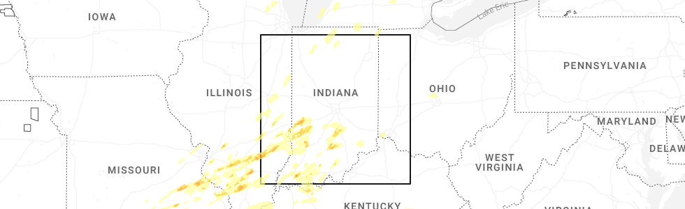
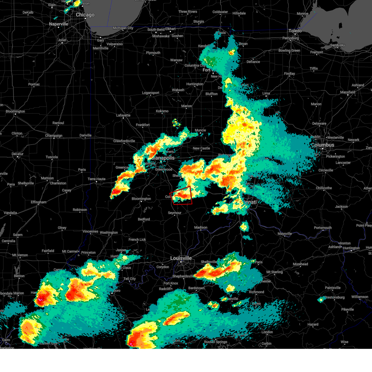
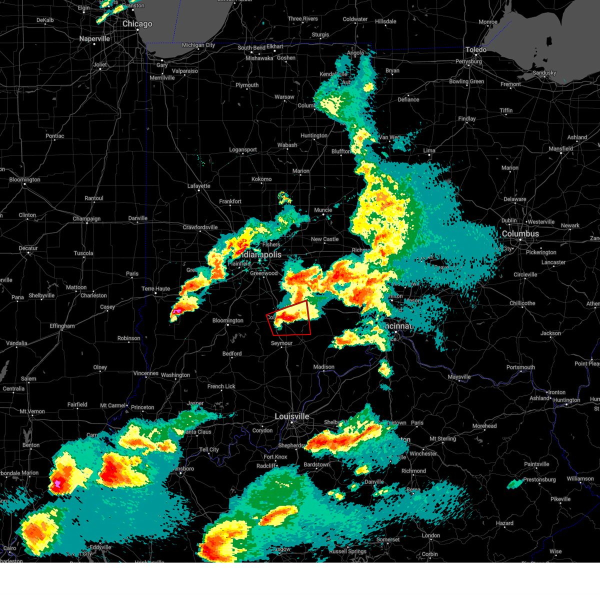
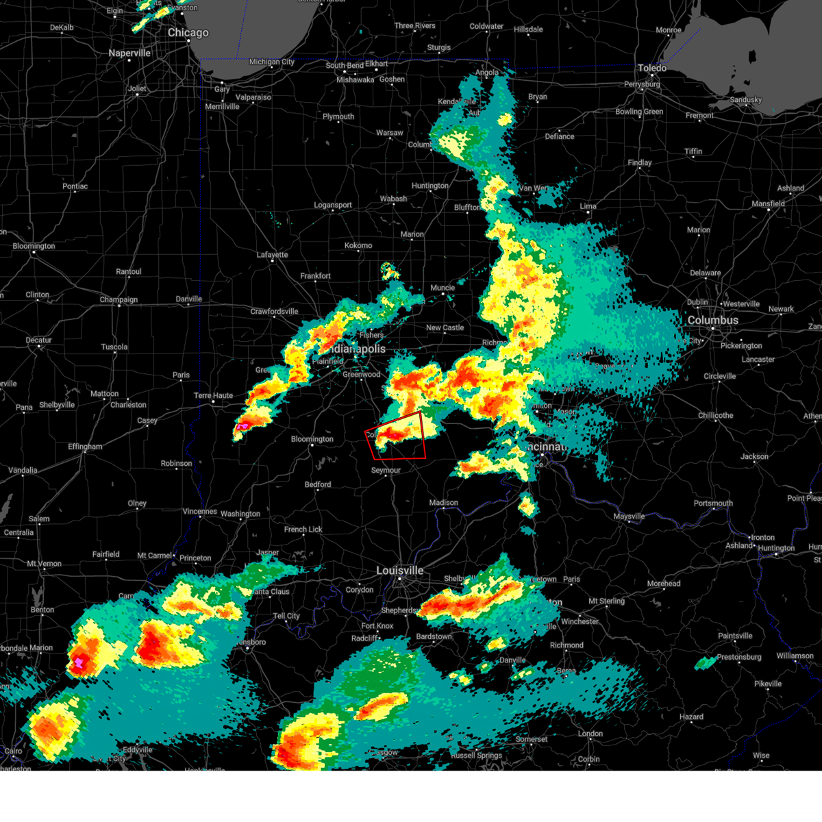
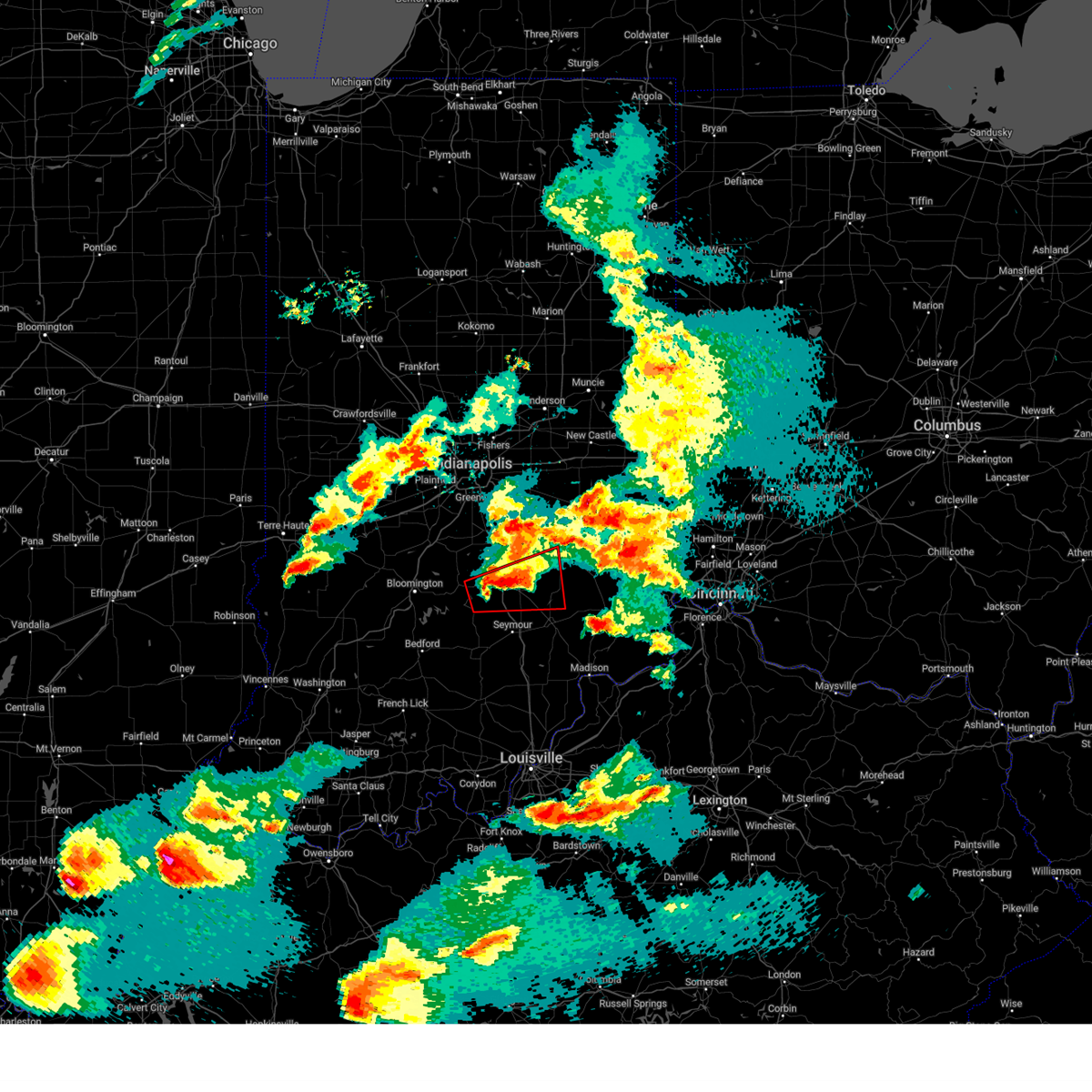
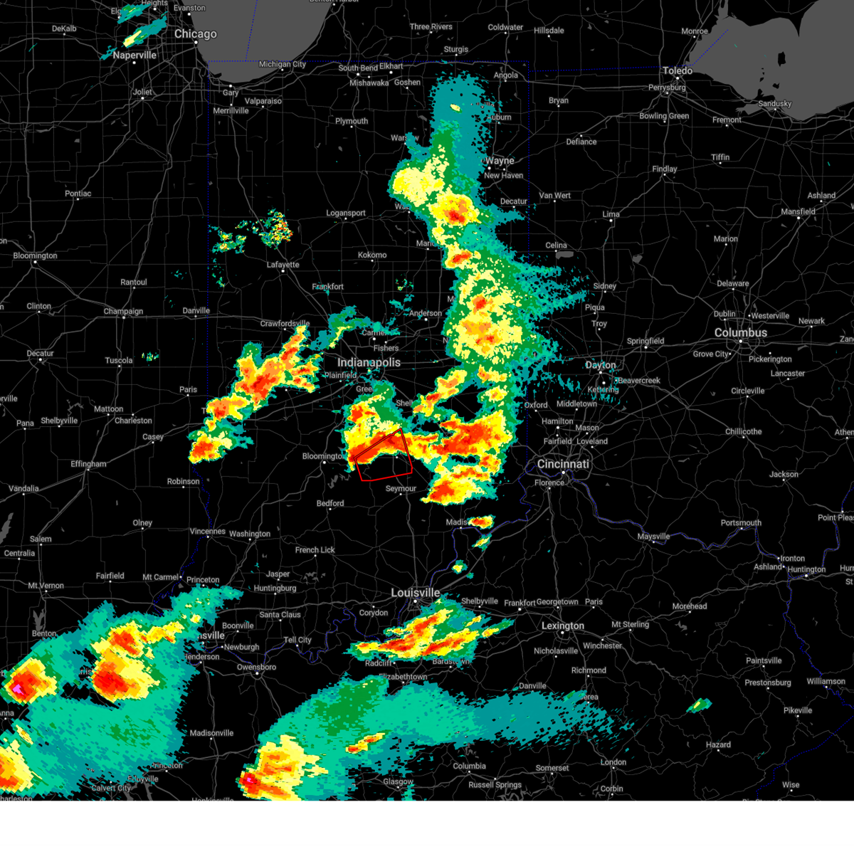
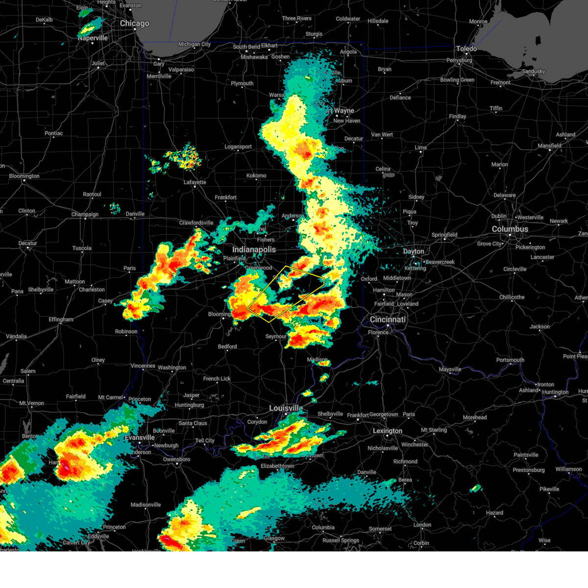
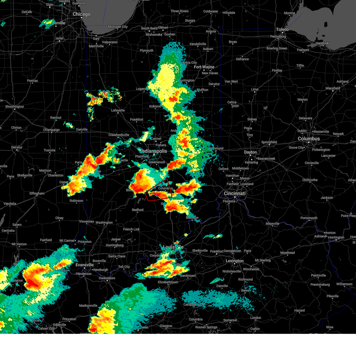
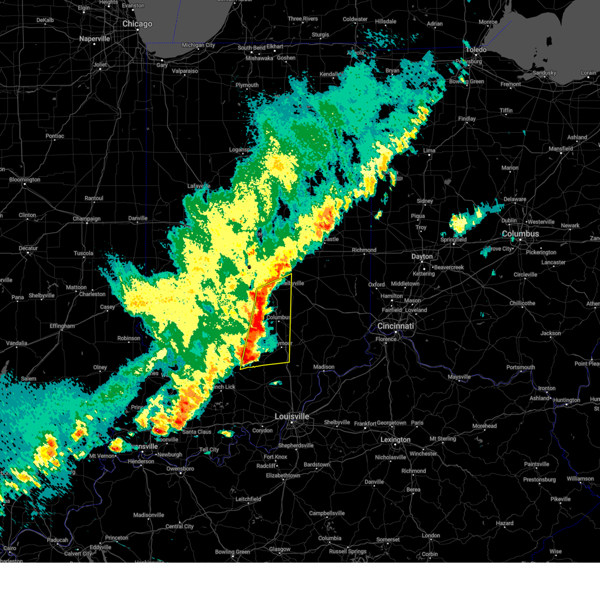
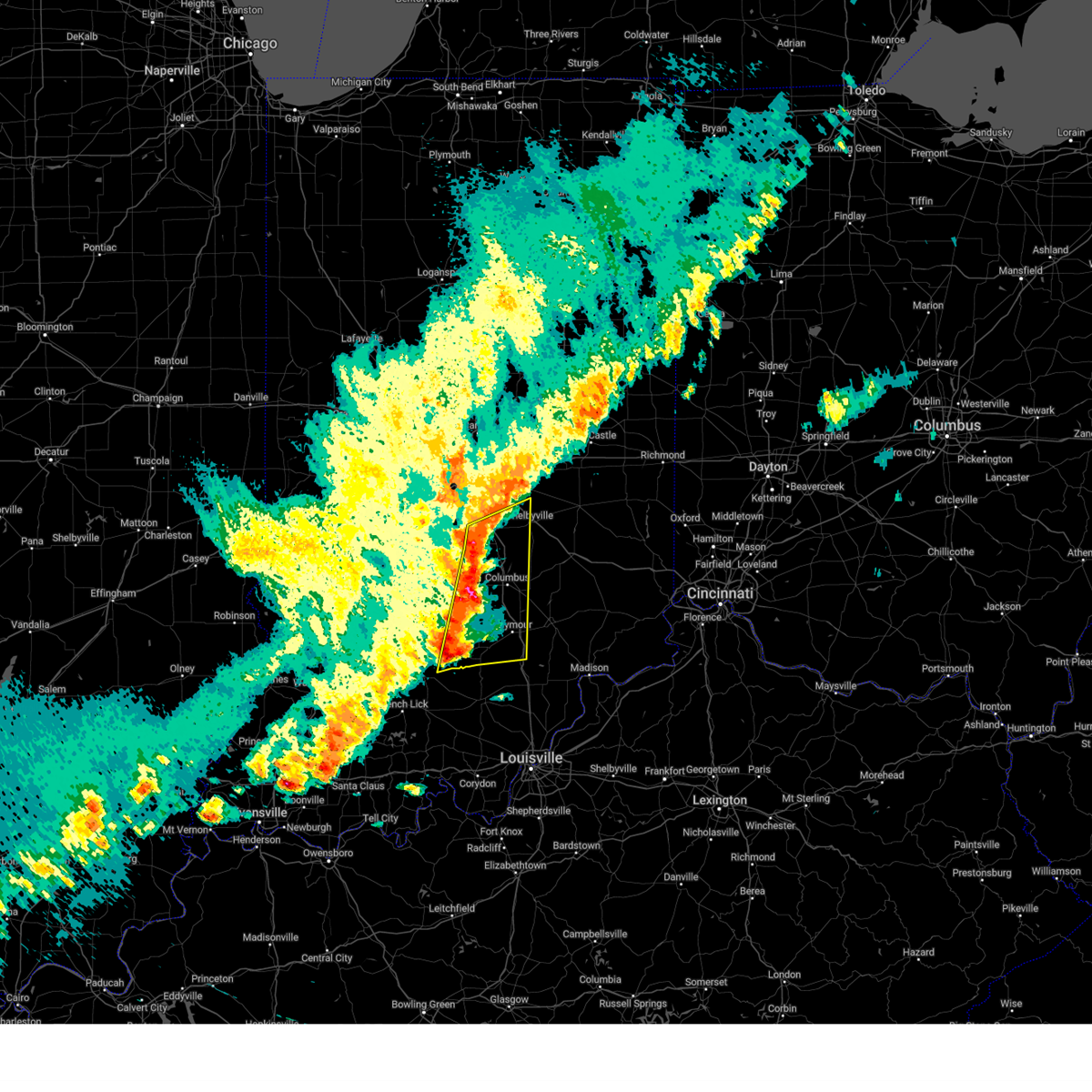
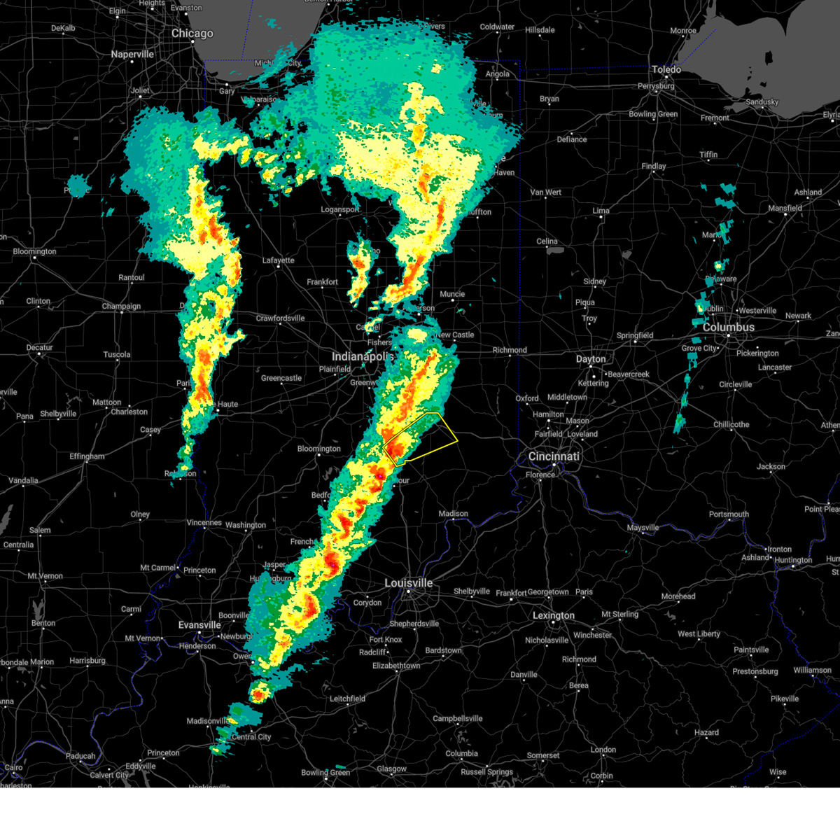
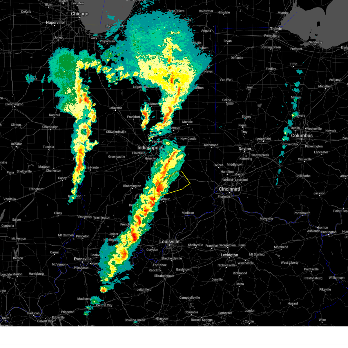
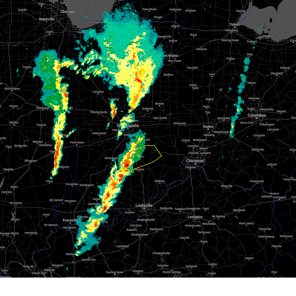
Hail Map for Clifford, IN
The Clifford, IN area has had 0 reports of on-the-ground hail by trained spotters, and has been under severe weather warnings 36 times during the past 12 months. Doppler radar has detected hail at or near Clifford, IN on 35 occasions, including 2 occasions during the past year.
| Name: | Clifford, IN |
| Where Located: | 36.7 miles SSE of Indianapolis, IN |
| Map: | Google Map for Clifford, IN |
| Population: | 233 |
| Housing Units: | 114 |
| More Info: | Search Google for Clifford, IN |
1
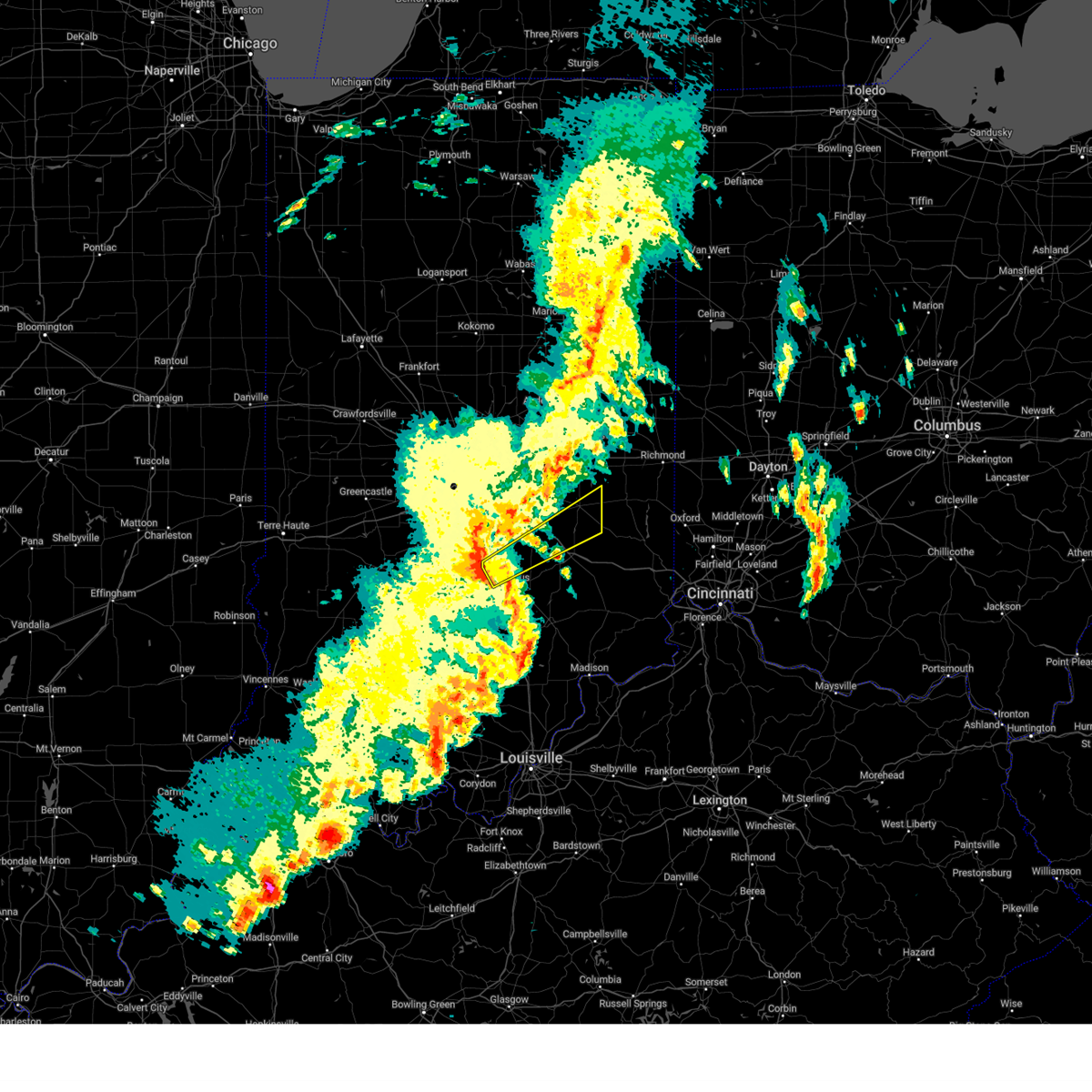
The Top Recent Hail Date for Clifford, IN is Sunday, March 30, 2025 (9th out of 35)
Hail and Wind Damage Spotted near Clifford, IN
| Date / Time | Report Details |
|---|---|
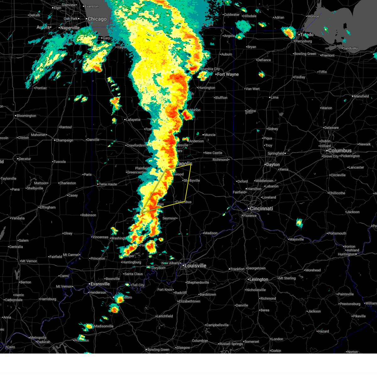
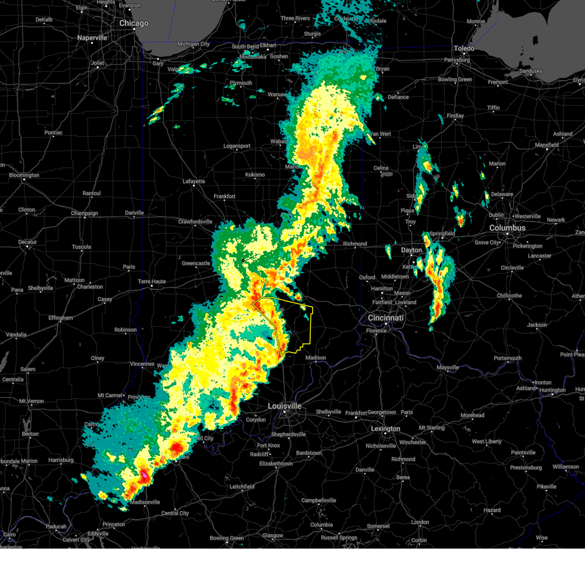
| 6/18/2025 5:37 PM EDT | At 537 pm edt, severe thunderstorms were located along a line extending from 6 miles northwest of rushville to 10 miles north of north vernon, moving east at 65 mph (radar indicated). Hazards include 60 mph wind gusts and penny size hail. Expect damage to roofs, siding, and trees. locations impacted include, columbus, shelbyville, greensburg, rushville, adams, hope, flat rock, milford, geneva, morristown, st. paul, carthage, lewisville, hartsville, milroy, glenwood, clifford, straughn, dunreith, and millhousen. this includes the following highways, interstate 65 between mile markers 65 and 74. Interstate 74 between mile markers 112 and 144. |
| 6/18/2025 5:37 PM EDT | the severe thunderstorm warning has been cancelled and is no longer in effect |
| 6/18/2025 5:27 PM EDT | the severe thunderstorm warning has been cancelled and is no longer in effect |
| 6/18/2025 5:27 PM EDT | At 527 pm edt, a severe thunderstorm was located over columbus, moving northeast at 60 mph (radar indicated). Hazards include 70 mph wind gusts. Expect considerable tree damage. damage is likely to mobile homes, roofs, and outbuildings. locations impacted include, columbus, edinburgh, elizabethtown, clifford, newbern, and taylorsville. This includes interstate 65 between mile markers 62 and 78. |
| 6/18/2025 5:14 PM EDT |
 Svrind the national weather service in indianapolis has issued a * severe thunderstorm warning for, southeastern hancock county in central indiana, shelby county in central indiana, rush county in central indiana, decatur county in central indiana, southeastern brown county in south central indiana, southeastern johnson county in central indiana, bartholomew county in central indiana, southeastern henry county in east central indiana, * until 600 pm edt. * at 513 pm edt, severe thunderstorms were located along a line extending from 7 miles south of greenfield to 11 miles north of brownstown, moving east at 45 mph (radar indicated). Hazards include 60 mph wind gusts and penny size hail. expect damage to roofs, siding, and trees Svrind the national weather service in indianapolis has issued a * severe thunderstorm warning for, southeastern hancock county in central indiana, shelby county in central indiana, rush county in central indiana, decatur county in central indiana, southeastern brown county in south central indiana, southeastern johnson county in central indiana, bartholomew county in central indiana, southeastern henry county in east central indiana, * until 600 pm edt. * at 513 pm edt, severe thunderstorms were located along a line extending from 7 miles south of greenfield to 11 miles north of brownstown, moving east at 45 mph (radar indicated). Hazards include 60 mph wind gusts and penny size hail. expect damage to roofs, siding, and trees
|
| 6/18/2025 5:13 PM EDT |
 Svrind the national weather service in indianapolis has issued a * severe thunderstorm warning for, southeastern brown county in south central indiana, bartholomew county in central indiana, * until 545 pm edt. * at 512 pm edt, a severe thunderstorm was located 8 miles southeast of nashville, or 12 miles southwest of columbus, moving northeast at 55 mph (radar indicated). Hazards include 70 mph wind gusts. Expect considerable tree damage. Damage is likely to mobile homes, roofs, and outbuildings. Svrind the national weather service in indianapolis has issued a * severe thunderstorm warning for, southeastern brown county in south central indiana, bartholomew county in central indiana, * until 545 pm edt. * at 512 pm edt, a severe thunderstorm was located 8 miles southeast of nashville, or 12 miles southwest of columbus, moving northeast at 55 mph (radar indicated). Hazards include 70 mph wind gusts. Expect considerable tree damage. Damage is likely to mobile homes, roofs, and outbuildings.
|
| 6/18/2025 5:06 PM EDT |
 At 506 pm edt, severe thunderstorms were located along a line extending from near greenfield to 7 miles southeast of nashville, moving east at 45 mph (radar indicated). Hazards include 60 mph wind gusts and penny size hail. Expect damage to roofs, siding, and trees. locations impacted include, indianapolis, bloomington, columbus, shelbyville, greenwood, franklin, southport, nashville, new whiteland, edinburgh, whiteland, bargersville, hope, flat rock, princes lakes, geneva, morristown, trafalgar, morgantown, and fairland. this includes the following highways, interstate 65 between mile markers 66 and 103. Interstate 74 between mile markers 98 and 119. At 506 pm edt, severe thunderstorms were located along a line extending from near greenfield to 7 miles southeast of nashville, moving east at 45 mph (radar indicated). Hazards include 60 mph wind gusts and penny size hail. Expect damage to roofs, siding, and trees. locations impacted include, indianapolis, bloomington, columbus, shelbyville, greenwood, franklin, southport, nashville, new whiteland, edinburgh, whiteland, bargersville, hope, flat rock, princes lakes, geneva, morristown, trafalgar, morgantown, and fairland. this includes the following highways, interstate 65 between mile markers 66 and 103. Interstate 74 between mile markers 98 and 119.
|
| 6/18/2025 4:32 PM EDT |
 Svrind the national weather service in indianapolis has issued a * severe thunderstorm warning for, southern hancock county in central indiana, shelby county in central indiana, central monroe county in south central indiana, eastern morgan county in central indiana, brown county in south central indiana, johnson county in central indiana, northern bartholomew county in central indiana, southern marion county in central indiana, * until 515 pm edt. * at 431 pm edt, severe thunderstorms were located along a line extending from mooresville to 12 miles southwest of bloomington, moving east at 55 mph (radar indicated). Hazards include 70 mph wind gusts and penny size hail. Expect considerable tree damage. Damage is likely to mobile homes, roofs, and outbuildings. Svrind the national weather service in indianapolis has issued a * severe thunderstorm warning for, southern hancock county in central indiana, shelby county in central indiana, central monroe county in south central indiana, eastern morgan county in central indiana, brown county in south central indiana, johnson county in central indiana, northern bartholomew county in central indiana, southern marion county in central indiana, * until 515 pm edt. * at 431 pm edt, severe thunderstorms were located along a line extending from mooresville to 12 miles southwest of bloomington, moving east at 55 mph (radar indicated). Hazards include 70 mph wind gusts and penny size hail. Expect considerable tree damage. Damage is likely to mobile homes, roofs, and outbuildings.
|
| 5/16/2025 8:33 PM EDT | the tornado warning has been cancelled and is no longer in effect |
| 5/16/2025 8:26 PM EDT |
 At 826 pm edt, a severe thunderstorm capable of producing a tornado was located 7 miles east of columbus, moving east at 45 mph (radar indicated rotation). Hazards include tornado and ping pong ball size hail. Flying debris will be dangerous to those caught without shelter. mobile homes will be damaged or destroyed. damage to roofs, windows, and vehicles will occur. tree damage is likely. locations impacted include, columbus, hope, milford, westport, elizabethtown, hartsville, clifford, newbern, burney, grammer, taylorsville, and letts. This includes interstate 65 between mile markers 70 and 75. At 826 pm edt, a severe thunderstorm capable of producing a tornado was located 7 miles east of columbus, moving east at 45 mph (radar indicated rotation). Hazards include tornado and ping pong ball size hail. Flying debris will be dangerous to those caught without shelter. mobile homes will be damaged or destroyed. damage to roofs, windows, and vehicles will occur. tree damage is likely. locations impacted include, columbus, hope, milford, westport, elizabethtown, hartsville, clifford, newbern, burney, grammer, taylorsville, and letts. This includes interstate 65 between mile markers 70 and 75.
|
| 5/16/2025 8:19 PM EDT |
 At 818 pm edt, a severe thunderstorm capable of producing a tornado was located over columbus, moving east at 45 mph (radar indicated rotation). Hazards include tornado and ping pong ball size hail. Flying debris will be dangerous to those caught without shelter. mobile homes will be damaged or destroyed. damage to roofs, windows, and vehicles will occur. tree damage is likely. locations impacted include, columbus, hope, milford, westport, elizabethtown, hartsville, clifford, letts, newbern, burney, grammer, azalia, and taylorsville. This includes interstate 65 between mile markers 59 and 74. At 818 pm edt, a severe thunderstorm capable of producing a tornado was located over columbus, moving east at 45 mph (radar indicated rotation). Hazards include tornado and ping pong ball size hail. Flying debris will be dangerous to those caught without shelter. mobile homes will be damaged or destroyed. damage to roofs, windows, and vehicles will occur. tree damage is likely. locations impacted include, columbus, hope, milford, westport, elizabethtown, hartsville, clifford, letts, newbern, burney, grammer, azalia, and taylorsville. This includes interstate 65 between mile markers 59 and 74.
|
| 5/16/2025 8:19 PM EDT |
 the tornado warning has been cancelled and is no longer in effect the tornado warning has been cancelled and is no longer in effect
|
| 5/16/2025 8:08 PM EDT |
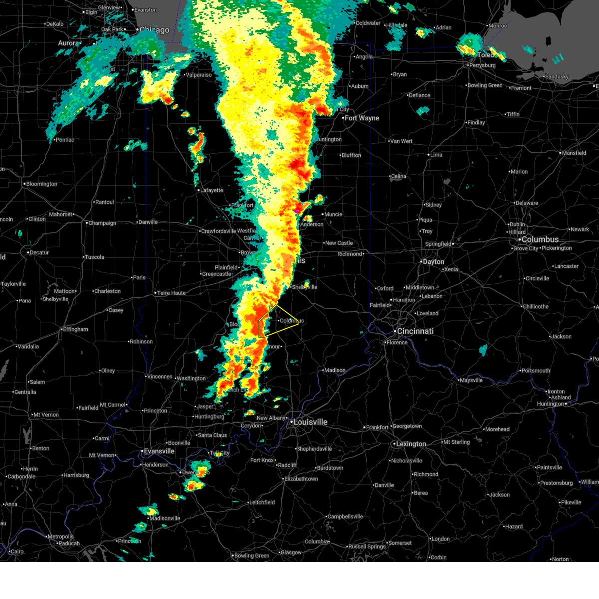
 Torind the national weather service in indianapolis has issued a * tornado warning for, southeastern shelby county in central indiana, western decatur county in central indiana, southeastern brown county in south central indiana, bartholomew county in central indiana, northwestern jennings county in southeastern indiana, * until 845 pm edt. * at 807 pm edt, a confirmed large and extremely dangerous tornado was located 9 miles southwest of columbus, moving east at 45 mph. this is a particularly dangerous situation. confirmed torndao headed towards grand view lake neighborhood. take cover now! (radar confirmed tornado). Hazards include damaging tornado. You are in a life-threatening situation. flying debris may be deadly to those caught without shelter. mobile homes will be destroyed. Considerable damage to homes, businesses, and vehicles is likely and complete destruction is possible. Torind the national weather service in indianapolis has issued a * tornado warning for, southeastern shelby county in central indiana, western decatur county in central indiana, southeastern brown county in south central indiana, bartholomew county in central indiana, northwestern jennings county in southeastern indiana, * until 845 pm edt. * at 807 pm edt, a confirmed large and extremely dangerous tornado was located 9 miles southwest of columbus, moving east at 45 mph. this is a particularly dangerous situation. confirmed torndao headed towards grand view lake neighborhood. take cover now! (radar confirmed tornado). Hazards include damaging tornado. You are in a life-threatening situation. flying debris may be deadly to those caught without shelter. mobile homes will be destroyed. Considerable damage to homes, businesses, and vehicles is likely and complete destruction is possible.
|
| 5/16/2025 8:01 PM EDT |
 At 801 pm edt, a confirmed large and extremely dangerous tornado was located near columbus, moving east at 50 mph. this is a particularly dangerous situation. take cover now! (radar confirmed tornado). Hazards include damaging tornado. You are in a life-threatening situation. flying debris may be deadly to those caught without shelter. mobile homes will be destroyed. considerable damage to homes, businesses, and vehicles is likely and complete destruction is possible. locations impacted include, columbus, nashville, edinburgh, elizabethtown, clifford, spurgeons corner, stone head, gnaw bone, story, and taylorsville. This includes interstate 65 between mile markers 60 and 80. At 801 pm edt, a confirmed large and extremely dangerous tornado was located near columbus, moving east at 50 mph. this is a particularly dangerous situation. take cover now! (radar confirmed tornado). Hazards include damaging tornado. You are in a life-threatening situation. flying debris may be deadly to those caught without shelter. mobile homes will be destroyed. considerable damage to homes, businesses, and vehicles is likely and complete destruction is possible. locations impacted include, columbus, nashville, edinburgh, elizabethtown, clifford, spurgeons corner, stone head, gnaw bone, story, and taylorsville. This includes interstate 65 between mile markers 60 and 80.
|
| 5/16/2025 7:48 PM EDT |
 Svrind the national weather service in indianapolis has issued a * severe thunderstorm warning for, shelby county in central indiana, southern rush county in central indiana, northwestern decatur county in central indiana, northeastern brown county in south central indiana, southeastern johnson county in central indiana, northern bartholomew county in central indiana, * until 830 pm edt. * at 747 pm edt, a severe thunderstorm was located 9 miles northwest of columbus, moving northeast at 60 mph (radar indicated). Hazards include golf ball size hail and 60 mph wind gusts. People and animals outdoors will be injured. expect hail damage to roofs, siding, windows, and vehicles. Expect wind damage to roofs, siding, and trees. Svrind the national weather service in indianapolis has issued a * severe thunderstorm warning for, shelby county in central indiana, southern rush county in central indiana, northwestern decatur county in central indiana, northeastern brown county in south central indiana, southeastern johnson county in central indiana, northern bartholomew county in central indiana, * until 830 pm edt. * at 747 pm edt, a severe thunderstorm was located 9 miles northwest of columbus, moving northeast at 60 mph (radar indicated). Hazards include golf ball size hail and 60 mph wind gusts. People and animals outdoors will be injured. expect hail damage to roofs, siding, windows, and vehicles. Expect wind damage to roofs, siding, and trees.
|
| 5/16/2025 7:36 PM EDT |
 Torind the national weather service in indianapolis has issued a * tornado warning for, southwestern shelby county in central indiana, southern brown county in south central indiana, western bartholomew county in central indiana, * until 815 pm edt. * at 736 pm edt, a severe thunderstorm capable of producing a tornado was located near nashville, or 15 miles west of columbus, moving east at 50 mph (radar indicated rotation). Hazards include tornado. Flying debris will be dangerous to those caught without shelter. mobile homes will be damaged or destroyed. damage to roofs, windows, and vehicles will occur. Tree damage is likely. Torind the national weather service in indianapolis has issued a * tornado warning for, southwestern shelby county in central indiana, southern brown county in south central indiana, western bartholomew county in central indiana, * until 815 pm edt. * at 736 pm edt, a severe thunderstorm capable of producing a tornado was located near nashville, or 15 miles west of columbus, moving east at 50 mph (radar indicated rotation). Hazards include tornado. Flying debris will be dangerous to those caught without shelter. mobile homes will be damaged or destroyed. damage to roofs, windows, and vehicles will occur. Tree damage is likely.
|
| 4/2/2025 11:39 PM EDT | At 1138 pm edt, severe thunderstorms were located along a line extending from 6 miles east of columbus to 8 miles north of scottsburg, moving east at 55 mph (radar indicated). Hazards include 70 mph wind gusts and penny size hail. Expect considerable tree damage. damage is likely to mobile homes, roofs, and outbuildings. locations impacted include, north vernon, greensburg, newbern, paris crossing, hartsville, crothersville, nebraska, azalia, millhousen, cortland, country squire lakes, elizabethtown, seymour, westport, hayden, letts, burney, milford, clifford, and butlerville. this includes the following highways, interstate 65 between mile markers 37 and 74. Interstate 74 between mile markers 132 and 144. |
| 4/2/2025 11:39 PM EDT | the severe thunderstorm warning has been cancelled and is no longer in effect |
| 4/2/2025 11:18 PM EDT | Svrind the national weather service in indianapolis has issued a * severe thunderstorm warning for, decatur county in central indiana, southeastern brown county in south central indiana, bartholomew county in central indiana, jackson county in south central indiana, jennings county in southeastern indiana, * until 1215 am edt. * at 1118 pm edt, severe thunderstorms were located along a line extending from 6 miles northeast of nashville to 7 miles southwest of brownstown, moving northeast at 60 mph (radar indicated). Hazards include 70 mph wind gusts and penny size hail. Expect considerable tree damage. Damage is likely to mobile homes, roofs, and outbuildings. |
| 3/30/2025 7:36 PM EDT | At 736 pm edt, severe thunderstorms were located along a line extending from 7 miles east of shelbyville to near seymour, moving east at 65 mph (radar indicated). Hazards include 60 mph wind gusts and quarter size hail. Hail damage to vehicles is expected. expect wind damage to roofs, siding, and trees. locations impacted include, greensburg, newbern, paris crossing, hartsville, crothersville, vallonia, azalia, manilla, millhousen, sandusky, arlington, clarksburg, burney, waymansville, clifford, butlerville, boggstown, marietta, rushville, and shelbyville. this includes the following highways, interstate 65 between mile markers 37 and 84. Interstate 74 between mile markers 108 and 144. |
| 3/30/2025 7:22 PM EDT | Svrind the national weather service in indianapolis has issued a * severe thunderstorm warning for, shelby county in central indiana, rush county in central indiana, decatur county in central indiana, southeastern johnson county in central indiana, bartholomew county in central indiana, jackson county in south central indiana, jennings county in southeastern indiana, * until 800 pm edt. * at 721 pm edt, severe thunderstorms were located along a line extending from 7 miles east of franklin to near brownstown, moving east at 40 mph (radar indicated). Hazards include 60 mph wind gusts and quarter size hail. Hail damage to vehicles is expected. Expect wind damage to roofs, siding, and trees. |
| 3/30/2025 7:22 PM EDT | the tornado warning has been cancelled and is no longer in effect |
| 3/30/2025 7:22 PM EDT | At 722 pm edt, a severe thunderstorm capable of producing a tornado was located 7 miles northeast of columbus, moving east at 65 mph (radar indicated rotation). Hazards include tornado. Flying debris will be dangerous to those caught without shelter. mobile homes will be damaged or destroyed. damage to roofs, windows, and vehicles will occur. tree damage is likely. Locations impacted include, geneva, clifford, newbern, hartsville, hope, and columbus. |
| 3/30/2025 7:13 PM EDT |
 the severe thunderstorm warning has been cancelled and is no longer in effect the severe thunderstorm warning has been cancelled and is no longer in effect
|
| 3/30/2025 7:13 PM EDT |
 At 713 pm edt, severe thunderstorms were located along a line extending from near franklin to 7 miles southwest of brownstown, moving east at 50 mph (radar indicated). Hazards include 60 mph wind gusts and quarter size hail. Hail damage to vehicles is expected. expect wind damage to roofs, siding, and trees. locations impacted include, franklin, peoga, gnaw bone, vallonia, spurgeons corner, medora, azalia, pleasant view, elkinsville, cortland, elizabethtown, edinburgh, fairland, stone head, story, seymour, taylorsville, flat rock, norman, and trafalgar. this includes the following highways, interstate 65 between mile markers 40 and 95. Interstate 74 between mile markers 107 and 112. At 713 pm edt, severe thunderstorms were located along a line extending from near franklin to 7 miles southwest of brownstown, moving east at 50 mph (radar indicated). Hazards include 60 mph wind gusts and quarter size hail. Hail damage to vehicles is expected. expect wind damage to roofs, siding, and trees. locations impacted include, franklin, peoga, gnaw bone, vallonia, spurgeons corner, medora, azalia, pleasant view, elkinsville, cortland, elizabethtown, edinburgh, fairland, stone head, story, seymour, taylorsville, flat rock, norman, and trafalgar. this includes the following highways, interstate 65 between mile markers 40 and 95. Interstate 74 between mile markers 107 and 112.
|
| 3/30/2025 7:08 PM EDT | Torind the national weather service in indianapolis has issued a * tornado warning for, southeastern shelby county in central indiana, southwestern decatur county in central indiana, eastern brown county in south central indiana, bartholomew county in central indiana, * until 730 pm edt. * at 707 pm edt, a severe thunderstorm capable of producing a tornado was located 7 miles east of nashville, or 9 miles west of columbus, moving east at 65 mph (radar indicated rotation). Hazards include tornado and damaging winds in excess of 70 mph. Flying debris will be dangerous to those caught without shelter. mobile homes will be damaged or destroyed. damage to roofs, windows, and vehicles will occur. Tree damage is likely. |
| 3/30/2025 7:03 PM EDT | Svrind the national weather service in indianapolis has issued a * severe thunderstorm warning for, western shelby county in central indiana, southeastern monroe county in south central indiana, southeastern morgan county in central indiana, brown county in south central indiana, johnson county in central indiana, bartholomew county in central indiana, eastern lawrence county in south central indiana, jackson county in south central indiana, west central jennings county in southeastern indiana, * until 730 pm edt. * at 703 pm edt, a severe thunderstorm was located 8 miles south of nashville, or 14 miles east of bloomington, moving east at 50 mph (radar indicated). Hazards include 60 mph wind gusts and quarter size hail. Hail damage to vehicles is expected. Expect wind damage to roofs, siding, and trees. |
| 3/19/2025 8:52 PM EDT |
 At 852 pm edt, a severe thunderstorm was located near columbus, moving northeast at 50 mph (radar indicated). Hazards include 60 mph wind gusts and quarter size hail. Hail damage to vehicles is expected. expect wind damage to roofs, siding, and trees. locations impacted include, greensburg, letts, burney, newbern, milford, hartsville, adams, st. Paul, clifford, grammer, columbus, elizabethtown, hope, and westport. At 852 pm edt, a severe thunderstorm was located near columbus, moving northeast at 50 mph (radar indicated). Hazards include 60 mph wind gusts and quarter size hail. Hail damage to vehicles is expected. expect wind damage to roofs, siding, and trees. locations impacted include, greensburg, letts, burney, newbern, milford, hartsville, adams, st. Paul, clifford, grammer, columbus, elizabethtown, hope, and westport.
|
| 3/19/2025 8:52 PM EDT |
 the severe thunderstorm warning has been cancelled and is no longer in effect the severe thunderstorm warning has been cancelled and is no longer in effect
|
| 3/19/2025 8:44 PM EDT |
 At 844 pm edt, a severe thunderstorm was located near columbus, moving northeast at 50 mph (radar indicated). Hazards include 60 mph wind gusts and quarter size hail. Hail damage to vehicles is expected. expect wind damage to roofs, siding, and trees. locations impacted include, westport, greensburg, letts, burney, newbern, milford, hartsville, adams, waymansville, st. Paul, clifford, grammer, azalia, millhousen, columbus, elizabethtown, and hope. At 844 pm edt, a severe thunderstorm was located near columbus, moving northeast at 50 mph (radar indicated). Hazards include 60 mph wind gusts and quarter size hail. Hail damage to vehicles is expected. expect wind damage to roofs, siding, and trees. locations impacted include, westport, greensburg, letts, burney, newbern, milford, hartsville, adams, waymansville, st. Paul, clifford, grammer, azalia, millhousen, columbus, elizabethtown, and hope.
|
| 3/19/2025 8:44 PM EDT |
 the severe thunderstorm warning has been cancelled and is no longer in effect the severe thunderstorm warning has been cancelled and is no longer in effect
|
| 3/19/2025 8:28 PM EDT |
 Svrind the national weather service in indianapolis has issued a * severe thunderstorm warning for, southeastern shelby county in central indiana, decatur county in central indiana, southeastern brown county in south central indiana, bartholomew county in central indiana, northern jackson county in south central indiana, northern jennings county in southeastern indiana, * until 900 pm edt. * at 828 pm edt, a severe thunderstorm was located 10 miles southeast of nashville, or 15 miles southwest of columbus, moving northeast at 50 mph (radar indicated). Hazards include 60 mph wind gusts and quarter size hail. Hail damage to vehicles is expected. Expect wind damage to roofs, siding, and trees. Svrind the national weather service in indianapolis has issued a * severe thunderstorm warning for, southeastern shelby county in central indiana, decatur county in central indiana, southeastern brown county in south central indiana, bartholomew county in central indiana, northern jackson county in south central indiana, northern jennings county in southeastern indiana, * until 900 pm edt. * at 828 pm edt, a severe thunderstorm was located 10 miles southeast of nashville, or 15 miles southwest of columbus, moving northeast at 50 mph (radar indicated). Hazards include 60 mph wind gusts and quarter size hail. Hail damage to vehicles is expected. Expect wind damage to roofs, siding, and trees.
|
| 3/15/2025 5:33 AM EDT |
 Svrind the national weather service in indianapolis has issued a * severe thunderstorm warning for, southern shelby county in central indiana, southern rush county in central indiana, northwestern decatur county in central indiana, southeastern johnson county in central indiana, northern bartholomew county in central indiana, * until 615 am edt. * at 532 am edt, a severe thunderstorm was located near columbus, moving northeast at 80 mph (radar indicated). Hazards include 60 mph wind gusts. expect damage to roofs, siding, and trees Svrind the national weather service in indianapolis has issued a * severe thunderstorm warning for, southern shelby county in central indiana, southern rush county in central indiana, northwestern decatur county in central indiana, southeastern johnson county in central indiana, northern bartholomew county in central indiana, * until 615 am edt. * at 532 am edt, a severe thunderstorm was located near columbus, moving northeast at 80 mph (radar indicated). Hazards include 60 mph wind gusts. expect damage to roofs, siding, and trees
|
| 3/15/2025 5:33 AM EDT |
 the severe thunderstorm warning has been cancelled and is no longer in effect the severe thunderstorm warning has been cancelled and is no longer in effect
|
| 3/15/2025 5:33 AM EDT |
 At 532 am edt, severe thunderstorms were located along a line extending from 12 miles northeast of nashville to 7 miles southeast of columbus to 10 miles southwest of vernon, moving northeast at 70 mph (radar indicated). Hazards include 60 mph wind gusts and penny size hail. Expect damage to roofs, siding, and trees. locations impacted include, westport, hayden, north vernon, letts, newbern, paris crossing, hartsville, clifford, butlerville, grammer, nebraska, vernon, azalia, millhousen, columbus, country squire lakes, elizabethtown, hope, taylorsville, and edinburgh. This includes interstate 65 between mile markers 40 and 53, and between mile markers 64 and 79. At 532 am edt, severe thunderstorms were located along a line extending from 12 miles northeast of nashville to 7 miles southeast of columbus to 10 miles southwest of vernon, moving northeast at 70 mph (radar indicated). Hazards include 60 mph wind gusts and penny size hail. Expect damage to roofs, siding, and trees. locations impacted include, westport, hayden, north vernon, letts, newbern, paris crossing, hartsville, clifford, butlerville, grammer, nebraska, vernon, azalia, millhousen, columbus, country squire lakes, elizabethtown, hope, taylorsville, and edinburgh. This includes interstate 65 between mile markers 40 and 53, and between mile markers 64 and 79.
|
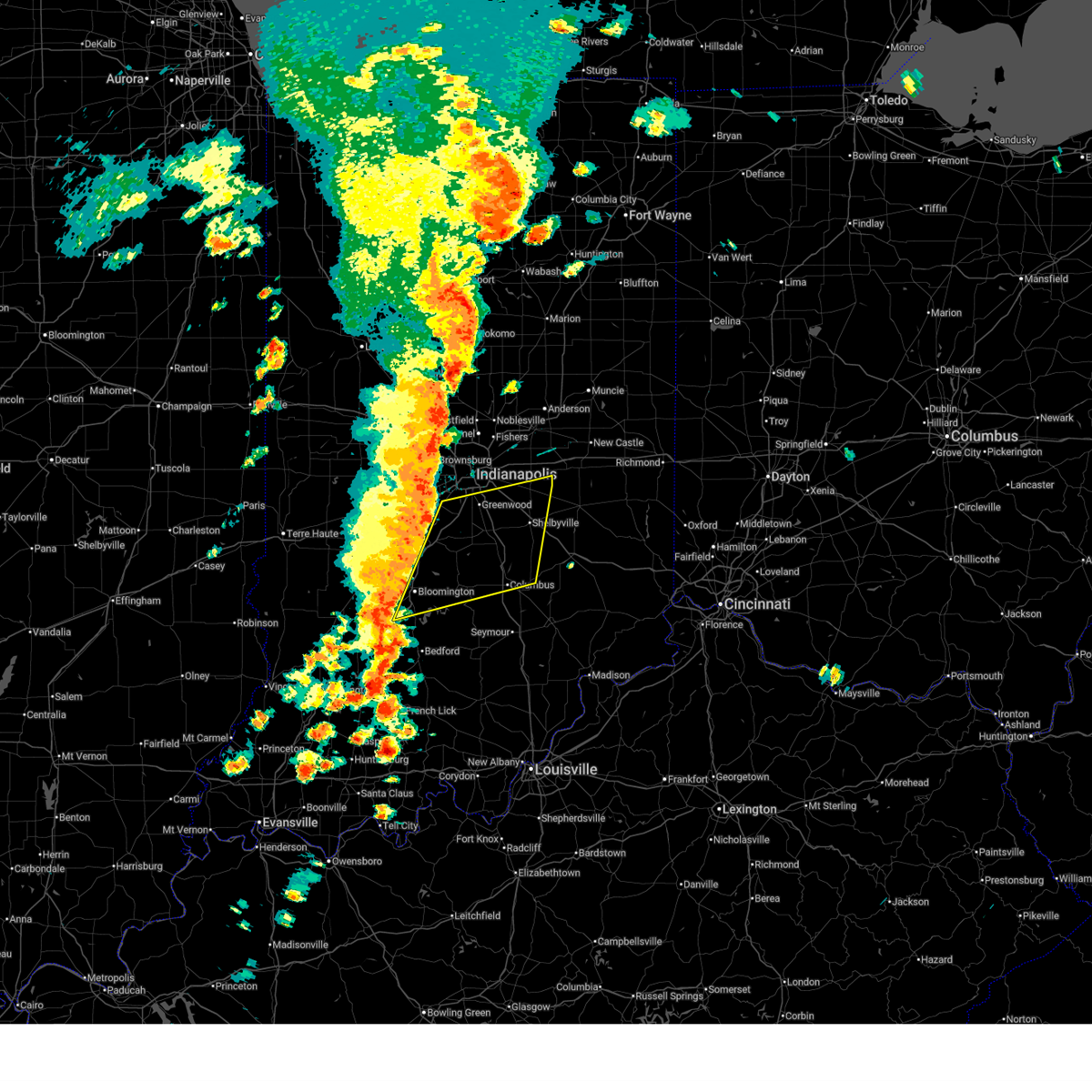
| 3/15/2025 5:09 AM EDT | Svrind the national weather service in indianapolis has issued a * severe thunderstorm warning for, southeastern monroe county in south central indiana, southwestern decatur county in central indiana, brown county in south central indiana, bartholomew county in central indiana, jackson county in south central indiana, jennings county in southeastern indiana, * until 600 am edt. * at 509 am edt, severe thunderstorms were located along a line extending from near bloomington to 10 miles northwest of brownstown to near salem, moving northeast at 75 mph (radar indicated). Hazards include 60 mph wind gusts and penny size hail. expect damage to roofs, siding, and trees |
| 5/7/2024 11:55 PM EDT |
 The storm which prompted the warning has weakened below severe limits, and no longer poses an immediate threat to life or property. therefore, the warning will be allowed to expire. however, gusty winds are still possible with this thunderstorm. a tornado watch remains in effect until 200 am edt for central and south central indiana. a tornado watch also remains in effect until 200 am edt for central and southeastern indiana. The storm which prompted the warning has weakened below severe limits, and no longer poses an immediate threat to life or property. therefore, the warning will be allowed to expire. however, gusty winds are still possible with this thunderstorm. a tornado watch remains in effect until 200 am edt for central and south central indiana. a tornado watch also remains in effect until 200 am edt for central and southeastern indiana.
|
| 5/7/2024 11:45 PM EDT |
 At 1145 pm edt, a severe thunderstorm was located near columbus, moving east at 45 mph (radar indicated). Hazards include 60 mph wind gusts and quarter size hail. Hail damage to vehicles is expected. expect wind damage to roofs, siding, and trees. locations impacted include, columbus, hope, elizabethtown, hartsville, clifford, azalia, newbern, stone head, story, grammer, and taylorsville. This includes interstate 65 between mile markers 60 and 76. At 1145 pm edt, a severe thunderstorm was located near columbus, moving east at 45 mph (radar indicated). Hazards include 60 mph wind gusts and quarter size hail. Hail damage to vehicles is expected. expect wind damage to roofs, siding, and trees. locations impacted include, columbus, hope, elizabethtown, hartsville, clifford, azalia, newbern, stone head, story, grammer, and taylorsville. This includes interstate 65 between mile markers 60 and 76.
|
| 5/7/2024 11:29 PM EDT |
 At 1129 pm edt, a severe thunderstorm was located 8 miles southeast of nashville, or 9 miles west of columbus, moving east at 45 mph (radar indicated). Hazards include 60 mph wind gusts and quarter size hail. Hail damage to vehicles is expected. expect wind damage to roofs, siding, and trees. locations impacted include, columbus, nashville, edinburgh, hope, elizabethtown, hartsville, clifford, newbern, gnaw bone, grammer, azalia, stone head, story, and taylorsville. This includes interstate 65 between mile markers 60 and 78. At 1129 pm edt, a severe thunderstorm was located 8 miles southeast of nashville, or 9 miles west of columbus, moving east at 45 mph (radar indicated). Hazards include 60 mph wind gusts and quarter size hail. Hail damage to vehicles is expected. expect wind damage to roofs, siding, and trees. locations impacted include, columbus, nashville, edinburgh, hope, elizabethtown, hartsville, clifford, newbern, gnaw bone, grammer, azalia, stone head, story, and taylorsville. This includes interstate 65 between mile markers 60 and 78.
|
| 5/7/2024 11:14 PM EDT |
 Svrind the national weather service in indianapolis has issued a * severe thunderstorm warning for, brown county in south central indiana, bartholomew county in central indiana, * until midnight edt. * at 1113 pm edt, a severe thunderstorm was located near nashville, or 10 miles east of bloomington, moving east at 50 mph (radar indicated). Hazards include 60 mph wind gusts and quarter size hail. Hail damage to vehicles is expected. Expect wind damage to roofs, siding, and trees. Svrind the national weather service in indianapolis has issued a * severe thunderstorm warning for, brown county in south central indiana, bartholomew county in central indiana, * until midnight edt. * at 1113 pm edt, a severe thunderstorm was located near nashville, or 10 miles east of bloomington, moving east at 50 mph (radar indicated). Hazards include 60 mph wind gusts and quarter size hail. Hail damage to vehicles is expected. Expect wind damage to roofs, siding, and trees.
|
| 4/2/2024 4:46 PM EDT |
 At 445 pm edt, a severe thunderstorm was located 7 miles northwest of columbus, moving northeast at 50 mph (radar indicated). Hazards include 60 mph wind gusts and quarter size hail. Hail damage to vehicles is expected. expect wind damage to roofs, siding, and trees. locations impacted include, columbus, edinburgh, hope, flat rock, hartsville, clifford, marietta, and taylorsville. This includes interstate 65 between mile markers 68 and 86. At 445 pm edt, a severe thunderstorm was located 7 miles northwest of columbus, moving northeast at 50 mph (radar indicated). Hazards include 60 mph wind gusts and quarter size hail. Hail damage to vehicles is expected. expect wind damage to roofs, siding, and trees. locations impacted include, columbus, edinburgh, hope, flat rock, hartsville, clifford, marietta, and taylorsville. This includes interstate 65 between mile markers 68 and 86.
|
| 4/2/2024 4:46 PM EDT |
 the severe thunderstorm warning has been cancelled and is no longer in effect the severe thunderstorm warning has been cancelled and is no longer in effect
|
| 4/2/2024 4:31 PM EDT |
 Svrind the national weather service in indianapolis has issued a * severe thunderstorm warning for, southwestern shelby county in central indiana, west central decatur county in central indiana, southeastern johnson county in central indiana, northeastern brown county in south central indiana, northern bartholomew county in central indiana, * until 500 pm edt. * at 430 pm edt, a severe thunderstorm was located over nashville, or 14 miles west of columbus, moving northeast at 50 mph (radar indicated). Hazards include 60 mph wind gusts and quarter size hail. Hail damage to vehicles is expected. Expect wind damage to roofs, siding, and trees. Svrind the national weather service in indianapolis has issued a * severe thunderstorm warning for, southwestern shelby county in central indiana, west central decatur county in central indiana, southeastern johnson county in central indiana, northeastern brown county in south central indiana, northern bartholomew county in central indiana, * until 500 pm edt. * at 430 pm edt, a severe thunderstorm was located over nashville, or 14 miles west of columbus, moving northeast at 50 mph (radar indicated). Hazards include 60 mph wind gusts and quarter size hail. Hail damage to vehicles is expected. Expect wind damage to roofs, siding, and trees.
|
| 4/2/2024 4:02 AM EDT |
 Svrind the national weather service in indianapolis has issued a * severe thunderstorm warning for, southern shelby county in central indiana, southwestern rush county in central indiana, northwestern decatur county in central indiana, southeastern johnson county in central indiana, northern brown county in south central indiana, northern bartholomew county in central indiana, * until 430 am edt. * at 402 am edt, severe thunderstorms were located along a line extending from franklin to 14 miles northwest of columbus to near nashville, moving east at 55 mph (radar indicated). Hazards include 60 mph wind gusts and penny size hail. expect damage to roofs, siding, and trees Svrind the national weather service in indianapolis has issued a * severe thunderstorm warning for, southern shelby county in central indiana, southwestern rush county in central indiana, northwestern decatur county in central indiana, southeastern johnson county in central indiana, northern brown county in south central indiana, northern bartholomew county in central indiana, * until 430 am edt. * at 402 am edt, severe thunderstorms were located along a line extending from franklin to 14 miles northwest of columbus to near nashville, moving east at 55 mph (radar indicated). Hazards include 60 mph wind gusts and penny size hail. expect damage to roofs, siding, and trees
|
| 8/12/2023 9:27 AM EDT |
 At 927 am edt, a severe thunderstorm was located over columbus, moving east at 25 mph (radar indicated). Hazards include 60 mph wind gusts and quarter size hail. Hail damage to vehicles is expected. expect wind damage to roofs, siding, and trees. this severe thunderstorm will be near, columbus around 930 am edt. newbern around 945 am edt. this includes interstate 65 between mile markers 67 and 74. hail threat, radar indicated max hail size, 1. 00 in wind threat, radar indicated max wind gust, 60 mph. At 927 am edt, a severe thunderstorm was located over columbus, moving east at 25 mph (radar indicated). Hazards include 60 mph wind gusts and quarter size hail. Hail damage to vehicles is expected. expect wind damage to roofs, siding, and trees. this severe thunderstorm will be near, columbus around 930 am edt. newbern around 945 am edt. this includes interstate 65 between mile markers 67 and 74. hail threat, radar indicated max hail size, 1. 00 in wind threat, radar indicated max wind gust, 60 mph.
|
| 8/8/2023 6:06 PM EDT |
 At 606 pm edt, a severe thunderstorm was located 8 miles west of columbus, moving east at 35 mph (radar indicated). Hazards include 60 mph wind gusts and quarter size hail. Hail damage to vehicles is expected. expect wind damage to roofs, siding, and trees. this severe thunderstorm will be near, columbus around 610 pm edt. this includes interstate 65 between mile markers 61 and 74. hail threat, radar indicated max hail size, 1. 00 in wind threat, radar indicated max wind gust, 60 mph. At 606 pm edt, a severe thunderstorm was located 8 miles west of columbus, moving east at 35 mph (radar indicated). Hazards include 60 mph wind gusts and quarter size hail. Hail damage to vehicles is expected. expect wind damage to roofs, siding, and trees. this severe thunderstorm will be near, columbus around 610 pm edt. this includes interstate 65 between mile markers 61 and 74. hail threat, radar indicated max hail size, 1. 00 in wind threat, radar indicated max wind gust, 60 mph.
|
| 7/2/2023 4:44 PM EDT |
 At 443 pm edt, a severe thunderstorm was located 9 miles north of columbus, moving northeast at 40 mph (radar indicated). Hazards include golf ball size hail and 60 mph wind gusts. People and animals outdoors will be injured. expect hail damage to roofs, siding, windows, and vehicles. expect wind damage to roofs, siding, and trees. this severe thunderstorm will be near, marietta around 450 pm edt. geneva around 455 pm edt. other locations in the path of this severe thunderstorm include shelbyville, st. paul, waldron and moscow. this includes the following highways, interstate 65 between mile markers 78 and 84. interstate 74 between mile markers 111 and 123. thunderstorm damage threat, considerable hail threat, radar indicated max hail size, 1. 75 in wind threat, radar indicated max wind gust, 60 mph. At 443 pm edt, a severe thunderstorm was located 9 miles north of columbus, moving northeast at 40 mph (radar indicated). Hazards include golf ball size hail and 60 mph wind gusts. People and animals outdoors will be injured. expect hail damage to roofs, siding, windows, and vehicles. expect wind damage to roofs, siding, and trees. this severe thunderstorm will be near, marietta around 450 pm edt. geneva around 455 pm edt. other locations in the path of this severe thunderstorm include shelbyville, st. paul, waldron and moscow. this includes the following highways, interstate 65 between mile markers 78 and 84. interstate 74 between mile markers 111 and 123. thunderstorm damage threat, considerable hail threat, radar indicated max hail size, 1. 75 in wind threat, radar indicated max wind gust, 60 mph.
|
| 6/29/2023 3:27 PM EDT |
 At 327 pm edt, severe thunderstorms were located along a line extending from 6 miles west of lebanon to spencer, moving east at 70 mph (radar indicated). Hazards include 70 mph wind gusts. Expect considerable tree damage. damage is likely to mobile homes, roofs, and outbuildings. severe thunderstorms will be near, zionsville and eagle creek reservoir around 340 pm edt. wynnedale, spring hill and helmsburg around 345 pm edt. other locations in the path of these severe thunderstorms include carmel, nashville, meridian hills, rocky ripple, williams creek, crows nest, north crows nest, castleton, broad ripple, indiana state fairgrounds, indianapolis, fishers, lawrence, mccordsville, warren park, geist reservoir, gnaw bone, cumberland, fortville, spring lake, greenfield and elizabethtown. this includes the following highways, interstate 65 between mile markers 65 and 127. interstate 69 between mile markers 200 and 210. interstate 70 between mile markers 68 and 111. interstate 74 between mile markers 70 and 117. thunderstorm damage threat, considerable hail threat, radar indicated max hail size, <. 75 in wind threat, radar indicated max wind gust, 70 mph. At 327 pm edt, severe thunderstorms were located along a line extending from 6 miles west of lebanon to spencer, moving east at 70 mph (radar indicated). Hazards include 70 mph wind gusts. Expect considerable tree damage. damage is likely to mobile homes, roofs, and outbuildings. severe thunderstorms will be near, zionsville and eagle creek reservoir around 340 pm edt. wynnedale, spring hill and helmsburg around 345 pm edt. other locations in the path of these severe thunderstorms include carmel, nashville, meridian hills, rocky ripple, williams creek, crows nest, north crows nest, castleton, broad ripple, indiana state fairgrounds, indianapolis, fishers, lawrence, mccordsville, warren park, geist reservoir, gnaw bone, cumberland, fortville, spring lake, greenfield and elizabethtown. this includes the following highways, interstate 65 between mile markers 65 and 127. interstate 69 between mile markers 200 and 210. interstate 70 between mile markers 68 and 111. interstate 74 between mile markers 70 and 117. thunderstorm damage threat, considerable hail threat, radar indicated max hail size, <. 75 in wind threat, radar indicated max wind gust, 70 mph.
|
| 2/27/2023 1:43 PM EST |
 The severe thunderstorm warning for southern shelby and northern bartholomew counties will expire at 145 pm est, the storm which prompted the warning has moved out of the area. therefore, the warning will be allowed to expire. a tornado watch remains in effect until 400 pm est for central indiana. The severe thunderstorm warning for southern shelby and northern bartholomew counties will expire at 145 pm est, the storm which prompted the warning has moved out of the area. therefore, the warning will be allowed to expire. a tornado watch remains in effect until 400 pm est for central indiana.
|
| 2/27/2023 1:09 PM EST |
 At 109 pm est, a severe thunderstorm was located near columbus, moving northeast at 55 mph (radar indicated). Hazards include 60 mph wind gusts and quarter size hail. Hail damage to vehicles is expected. expect wind damage to roofs, siding, and trees. this severe thunderstorm will be near, edinburgh around 115 pm est. clifford around 120 pm est. hope and flat rock around 125 pm est. other locations in the path of this severe thunderstorm include geneva, st. paul and waldron. this includes the following highways, interstate 65 between mile markers 71 and 81. Interstate 74 between mile markers 115 and 122. At 109 pm est, a severe thunderstorm was located near columbus, moving northeast at 55 mph (radar indicated). Hazards include 60 mph wind gusts and quarter size hail. Hail damage to vehicles is expected. expect wind damage to roofs, siding, and trees. this severe thunderstorm will be near, edinburgh around 115 pm est. clifford around 120 pm est. hope and flat rock around 125 pm est. other locations in the path of this severe thunderstorm include geneva, st. paul and waldron. this includes the following highways, interstate 65 between mile markers 71 and 81. Interstate 74 between mile markers 115 and 122.
|
| 5/21/2022 4:14 PM EDT |
 At 414 pm edt, a severe thunderstorm was located 9 miles southeast of shelbyville, moving northeast at 45 mph (radar indicated). Hazards include 60 mph wind gusts. Expect damage to roofs, siding, and trees. locations impacted include, adams. this includes the following highways, interstate 65 near mile marker 82. interstate 74 between mile markers 122 and 133. hail threat, radar indicated max hail size, <. 75 in wind threat, radar indicated max wind gust, 60 mph. At 414 pm edt, a severe thunderstorm was located 9 miles southeast of shelbyville, moving northeast at 45 mph (radar indicated). Hazards include 60 mph wind gusts. Expect damage to roofs, siding, and trees. locations impacted include, adams. this includes the following highways, interstate 65 near mile marker 82. interstate 74 between mile markers 122 and 133. hail threat, radar indicated max hail size, <. 75 in wind threat, radar indicated max wind gust, 60 mph.
|
| 5/21/2022 3:53 PM EDT |
 At 353 pm edt, a severe thunderstorm was located near columbus, moving northeast at 50 mph (radar indicated). Hazards include 60 mph wind gusts. Expect damage to roofs, siding, and trees. this severe thunderstorm will be near, hope, flat rock and newbern around 400 pm edt. hartsville around 405 pm edt. milford, geneva and burney around 410 pm edt. other locations in the path of this severe thunderstorm include adams, st. paul, waldron and greensburg. this includes the following highways, interstate 65 between mile markers 58 and 82. interstate 74 between mile markers 122 and 133. hail threat, radar indicated max hail size, <. 75 in wind threat, radar indicated max wind gust, 60 mph. At 353 pm edt, a severe thunderstorm was located near columbus, moving northeast at 50 mph (radar indicated). Hazards include 60 mph wind gusts. Expect damage to roofs, siding, and trees. this severe thunderstorm will be near, hope, flat rock and newbern around 400 pm edt. hartsville around 405 pm edt. milford, geneva and burney around 410 pm edt. other locations in the path of this severe thunderstorm include adams, st. paul, waldron and greensburg. this includes the following highways, interstate 65 between mile markers 58 and 82. interstate 74 between mile markers 122 and 133. hail threat, radar indicated max hail size, <. 75 in wind threat, radar indicated max wind gust, 60 mph.
|
| 4/13/2022 7:33 PM EDT |
 At 732 pm edt, a severe thunderstorm was located 8 miles southwest of columbus, moving northeast at 45 mph (radar indicated). Hazards include 70 mph wind gusts and nickel size hail. Expect considerable tree damage. damage is likely to mobile homes, roofs, and outbuildings. locations impacted include, azalia, elizabethtown, taylorsville, columbus, clifford and newbern. This includes interstate 65 between mile markers 37 and 94. At 732 pm edt, a severe thunderstorm was located 8 miles southwest of columbus, moving northeast at 45 mph (radar indicated). Hazards include 70 mph wind gusts and nickel size hail. Expect considerable tree damage. damage is likely to mobile homes, roofs, and outbuildings. locations impacted include, azalia, elizabethtown, taylorsville, columbus, clifford and newbern. This includes interstate 65 between mile markers 37 and 94.
|
| 4/13/2022 7:17 PM EDT |
 At 716 pm edt, a severe thunderstorm was located 12 miles northwest of brownstown, or 17 miles west of seymour, moving northeast at 45 mph (radar indicated). Hazards include 70 mph wind gusts and nickel size hail. Expect considerable tree damage. damage is likely to mobile homes, roofs, and outbuildings. this severe thunderstorm will be near, story around 720 pm edt. spurgeons corner and stone head around 725 pm edt. waymansville and gnaw bone around 730 pm edt. other locations in the path of this severe thunderstorm include azalia, elizabethtown, columbus, clifford, taylorsville and newbern. This includes interstate 65 between mile markers 37 and 94. At 716 pm edt, a severe thunderstorm was located 12 miles northwest of brownstown, or 17 miles west of seymour, moving northeast at 45 mph (radar indicated). Hazards include 70 mph wind gusts and nickel size hail. Expect considerable tree damage. damage is likely to mobile homes, roofs, and outbuildings. this severe thunderstorm will be near, story around 720 pm edt. spurgeons corner and stone head around 725 pm edt. waymansville and gnaw bone around 730 pm edt. other locations in the path of this severe thunderstorm include azalia, elizabethtown, columbus, clifford, taylorsville and newbern. This includes interstate 65 between mile markers 37 and 94.
|
| 3/7/2022 2:29 AM EST |
 At 228 am est, a severe thunderstorm was located 9 miles northwest of greensburg, or 11 miles southeast of shelbyville, moving east at 50 mph (radar indicated). Hazards include 60 mph wind gusts. Expect damage to roofs, siding, and trees. this severe thunderstorm will be near, greensburg and sandusky around 235 am est. milroy around 240 am est. clarksburg and new salem around 245 am est. other locations in the path of this severe thunderstorm include lake santee. this includes the following highways, interstate 65 between mile markers 66 and 68. interstate 74 between mile markers 118 and 144. hail threat, radar indicated max hail size, <. 75 in wind threat, radar indicated max wind gust, 60 mph. At 228 am est, a severe thunderstorm was located 9 miles northwest of greensburg, or 11 miles southeast of shelbyville, moving east at 50 mph (radar indicated). Hazards include 60 mph wind gusts. Expect damage to roofs, siding, and trees. this severe thunderstorm will be near, greensburg and sandusky around 235 am est. milroy around 240 am est. clarksburg and new salem around 245 am est. other locations in the path of this severe thunderstorm include lake santee. this includes the following highways, interstate 65 between mile markers 66 and 68. interstate 74 between mile markers 118 and 144. hail threat, radar indicated max hail size, <. 75 in wind threat, radar indicated max wind gust, 60 mph.
|
| 12/11/2021 3:09 AM EST |
 At 309 am est, severe thunderstorms were located along a line extending from near franklin to near nashville, moving northeast at 65 mph (radar indicated). Hazards include 60 mph wind gusts. Expect damage to roofs, siding, and trees. these severe storms will be near, franklin around 315 am est. other locations in the path of these severe thunderstorms include marietta, peoga, shelbyville, edinburgh, taylorsville, flat rock and clifford. this includes the following highways, interstate 65 between mile markers 62 and 89. interstate 74 between mile markers 115 and 117. hail threat, radar indicated max hail size, <. 75 in wind threat, radar indicated max wind gust, 60 mph. At 309 am est, severe thunderstorms were located along a line extending from near franklin to near nashville, moving northeast at 65 mph (radar indicated). Hazards include 60 mph wind gusts. Expect damage to roofs, siding, and trees. these severe storms will be near, franklin around 315 am est. other locations in the path of these severe thunderstorms include marietta, peoga, shelbyville, edinburgh, taylorsville, flat rock and clifford. this includes the following highways, interstate 65 between mile markers 62 and 89. interstate 74 between mile markers 115 and 117. hail threat, radar indicated max hail size, <. 75 in wind threat, radar indicated max wind gust, 60 mph.
|
| 8/25/2021 12:55 PM EDT |
 The severe thunderstorm warning for southwestern shelby, southeastern johnson, northeastern brown and northern bartholomew counties will expire at 100 pm edt, the storm which prompted the warning has weakened below severe limits, and no longer poses an immediate threat to life or property. therefore, the warning will be allowed to expire. however gusty winds are still possible with this thunderstorm. The severe thunderstorm warning for southwestern shelby, southeastern johnson, northeastern brown and northern bartholomew counties will expire at 100 pm edt, the storm which prompted the warning has weakened below severe limits, and no longer poses an immediate threat to life or property. therefore, the warning will be allowed to expire. however gusty winds are still possible with this thunderstorm.
|
| 8/25/2021 12:44 PM EDT |
 At 1243 pm edt, a severe thunderstorm was located near columbus, moving southeast at 30 mph (radar indicated). Hazards include 60 mph wind gusts. Expect damage to roofs, siding, and trees. locations impacted include, columbus. this includes interstate 65 between mile markers 69 and 84. hail threat, radar indicated max hail size, <. 75 in wind threat, radar indicated max wind gust, 60 mph. At 1243 pm edt, a severe thunderstorm was located near columbus, moving southeast at 30 mph (radar indicated). Hazards include 60 mph wind gusts. Expect damage to roofs, siding, and trees. locations impacted include, columbus. this includes interstate 65 between mile markers 69 and 84. hail threat, radar indicated max hail size, <. 75 in wind threat, radar indicated max wind gust, 60 mph.
|
| 8/25/2021 12:24 PM EDT |
 At 1224 pm edt, a severe thunderstorm was located 7 miles south of franklin, or 13 miles northwest of columbus, moving southeast at 30 mph (radar indicated). Hazards include 60 mph wind gusts. Expect damage to roofs, siding, and trees. this severe thunderstorm will be near, edinburgh around 1230 pm edt. taylorsville around 1240 pm edt. other locations in the path of this severe thunderstorm include clifford and columbus. this includes interstate 65 between mile markers 69 and 90. hail threat, radar indicated max hail size, <. 75 in wind threat, radar indicated max wind gust, 60 mph. At 1224 pm edt, a severe thunderstorm was located 7 miles south of franklin, or 13 miles northwest of columbus, moving southeast at 30 mph (radar indicated). Hazards include 60 mph wind gusts. Expect damage to roofs, siding, and trees. this severe thunderstorm will be near, edinburgh around 1230 pm edt. taylorsville around 1240 pm edt. other locations in the path of this severe thunderstorm include clifford and columbus. this includes interstate 65 between mile markers 69 and 90. hail threat, radar indicated max hail size, <. 75 in wind threat, radar indicated max wind gust, 60 mph.
|
| 6/18/2021 10:00 PM EDT |
 At 959 pm edt, a severe thunderstorm was located 11 miles northeast of columbus, moving east at 30 mph (radar indicated). Hazards include half dollar size hail. Damage to vehicles is expected. this severe thunderstorm will remain over mainly rural areas of southwestern shelby and north central bartholomew counties. This includes interstate 65 between mile markers 78 and 83. At 959 pm edt, a severe thunderstorm was located 11 miles northeast of columbus, moving east at 30 mph (radar indicated). Hazards include half dollar size hail. Damage to vehicles is expected. this severe thunderstorm will remain over mainly rural areas of southwestern shelby and north central bartholomew counties. This includes interstate 65 between mile markers 78 and 83.
|
| 6/18/2021 9:45 PM EDT |
 At 944 pm edt, a severe thunderstorm was located 7 miles southeast of franklin, or 13 miles north of columbus, moving east at 20 mph (radar indicated). Hazards include half dollar size hail. Damage to vehicles is expected. this severe thunderstorm will be near, edinburgh around 950 pm edt. taylorsville around 955 pm edt. marietta around 1000 pm edt. other locations in the path of this severe thunderstorm include flat rock and clifford. This includes interstate 65 between mile markers 76 and 86. At 944 pm edt, a severe thunderstorm was located 7 miles southeast of franklin, or 13 miles north of columbus, moving east at 20 mph (radar indicated). Hazards include half dollar size hail. Damage to vehicles is expected. this severe thunderstorm will be near, edinburgh around 950 pm edt. taylorsville around 955 pm edt. marietta around 1000 pm edt. other locations in the path of this severe thunderstorm include flat rock and clifford. This includes interstate 65 between mile markers 76 and 86.
|
| 6/18/2021 8:48 PM EDT |
 At 848 pm edt, a severe thunderstorm was located near lake santee, or 10 miles northwest of batesville, moving southeast at 15 mph (radar indicated). Hazards include 60 mph wind gusts and quarter size hail. Hail damage to vehicles is expected. expect wind damage to roofs, siding, and trees. locations impacted include, columbus, shelbyville, greensburg, adams, hope, milford, westport, geneva, st. paul, hartsville, milroy, clifford, millhousen, newbern, waldron, moscow, new salem, manilla, sandusky and clarksburg. This includes interstate 74 between mile markers 113 and 144. At 848 pm edt, a severe thunderstorm was located near lake santee, or 10 miles northwest of batesville, moving southeast at 15 mph (radar indicated). Hazards include 60 mph wind gusts and quarter size hail. Hail damage to vehicles is expected. expect wind damage to roofs, siding, and trees. locations impacted include, columbus, shelbyville, greensburg, adams, hope, milford, westport, geneva, st. paul, hartsville, milroy, clifford, millhousen, newbern, waldron, moscow, new salem, manilla, sandusky and clarksburg. This includes interstate 74 between mile markers 113 and 144.
|
| 6/18/2021 8:28 PM EDT |
 At 828 pm edt, a severe thunderstorm was located near lake santee, or 12 miles northwest of batesville, moving southeast at 30 mph (radar indicated). Hazards include 60 mph wind gusts and quarter size hail. Hail damage to vehicles is expected. expect wind damage to roofs, siding, and trees. locations impacted include, lake santee and newpoint. This includes interstate 74 between mile markers 109 and 144. At 828 pm edt, a severe thunderstorm was located near lake santee, or 12 miles northwest of batesville, moving southeast at 30 mph (radar indicated). Hazards include 60 mph wind gusts and quarter size hail. Hail damage to vehicles is expected. expect wind damage to roofs, siding, and trees. locations impacted include, lake santee and newpoint. This includes interstate 74 between mile markers 109 and 144.
|
| 6/18/2021 8:08 PM EDT |
 At 808 pm edt, a severe thunderstorm was located over shelbyville, moving southeast at 30 mph (radar indicated). Hazards include 60 mph wind gusts and quarter size hail. Hail damage to vehicles is expected. expect wind damage to roofs, siding, and trees. this severe thunderstorm will be near, waldron around 820 pm edt. geneva around 825 pm edt. other locations in the path of this severe thunderstorm include st. paul, moscow, milford, burney, adams, greensburg, sandusky, millhousen and newpoint. this includes the following highways, interstate 65 between mile markers 77 and 83. Interstate 74 between mile markers 108 and 144. At 808 pm edt, a severe thunderstorm was located over shelbyville, moving southeast at 30 mph (radar indicated). Hazards include 60 mph wind gusts and quarter size hail. Hail damage to vehicles is expected. expect wind damage to roofs, siding, and trees. this severe thunderstorm will be near, waldron around 820 pm edt. geneva around 825 pm edt. other locations in the path of this severe thunderstorm include st. paul, moscow, milford, burney, adams, greensburg, sandusky, millhousen and newpoint. this includes the following highways, interstate 65 between mile markers 77 and 83. Interstate 74 between mile markers 108 and 144.
|
| 11/25/2020 6:09 PM EST |
 The severe thunderstorm warning for southeastern shelby and northeastern bartholomew counties will expire at 615 pm est, the storm which prompted the warning has moved out of the area. therefore, the warning will be allowed to expire. however heavy rain is still possible with this thunderstorm. remember, a severe thunderstorm warning still remains in effect for eastern portions of shelby county. The severe thunderstorm warning for southeastern shelby and northeastern bartholomew counties will expire at 615 pm est, the storm which prompted the warning has moved out of the area. therefore, the warning will be allowed to expire. however heavy rain is still possible with this thunderstorm. remember, a severe thunderstorm warning still remains in effect for eastern portions of shelby county.
|
| 11/25/2020 5:52 PM EST |
 At 552 pm est, a severe thunderstorm was located 11 miles northeast of columbus, moving northeast at 30 mph (radar indicated). Hazards include 60 mph wind gusts. Expect damage to roofs, siding, and trees. Locations impacted include, columbus, hope, flat rock, geneva, hartsville and clifford. At 552 pm est, a severe thunderstorm was located 11 miles northeast of columbus, moving northeast at 30 mph (radar indicated). Hazards include 60 mph wind gusts. Expect damage to roofs, siding, and trees. Locations impacted include, columbus, hope, flat rock, geneva, hartsville and clifford.
|
| 11/25/2020 5:40 PM EST |
 At 540 pm est, a severe thunderstorm was located near columbus, moving northeast at 30 mph (radar indicated). Hazards include 60 mph wind gusts. expect damage to roofs, siding, and trees At 540 pm est, a severe thunderstorm was located near columbus, moving northeast at 30 mph (radar indicated). Hazards include 60 mph wind gusts. expect damage to roofs, siding, and trees
|
| 8/10/2020 8:43 PM EDT |
 At 842 pm edt, severe thunderstorms were located along a line extending from columbus to near bedford, moving southeast at 25 mph (radar indicated). Hazards include 60 mph wind gusts. Expect damage to roofs, siding, and trees. locations impacted include, columbus, seymour, bedford, brownstown, nashville, edinburgh, mitchell, hope, crothersville, oolitic, medora, elizabethtown, hartsville, clifford, jonesville, newbern, tunnelton, gnaw bone, bartlettsville and vallonia. This includes interstate 65 between mile markers 37 and 78. At 842 pm edt, severe thunderstorms were located along a line extending from columbus to near bedford, moving southeast at 25 mph (radar indicated). Hazards include 60 mph wind gusts. Expect damage to roofs, siding, and trees. locations impacted include, columbus, seymour, bedford, brownstown, nashville, edinburgh, mitchell, hope, crothersville, oolitic, medora, elizabethtown, hartsville, clifford, jonesville, newbern, tunnelton, gnaw bone, bartlettsville and vallonia. This includes interstate 65 between mile markers 37 and 78.
|
| 8/10/2020 8:32 PM EDT |
 At 832 pm edt, severe thunderstorms were located along a line extending from near columbus to near bedford, moving southeast at 30 mph (radar indicated). Hazards include 70 mph wind gusts. Expect considerable tree damage. damage is likely to mobile homes, roofs, and outbuildings. locations impacted include, columbus, seymour, bedford, brownstown, nashville, edinburgh, mitchell, hope, crothersville, oolitic, medora, elizabethtown, hartsville, clifford, jonesville, peoga, newbern, smithville, tunnelton and gnaw bone. This includes interstate 65 between mile markers 37 and 78. At 832 pm edt, severe thunderstorms were located along a line extending from near columbus to near bedford, moving southeast at 30 mph (radar indicated). Hazards include 70 mph wind gusts. Expect considerable tree damage. damage is likely to mobile homes, roofs, and outbuildings. locations impacted include, columbus, seymour, bedford, brownstown, nashville, edinburgh, mitchell, hope, crothersville, oolitic, medora, elizabethtown, hartsville, clifford, jonesville, peoga, newbern, smithville, tunnelton and gnaw bone. This includes interstate 65 between mile markers 37 and 78.
|
| 8/10/2020 8:01 PM EDT |
 At 801 pm edt, severe thunderstorms were located along a line extending from 9 miles north of nashville to 12 miles east of bloomfield, moving southeast at 35 mph (radar indicated). Hazards include 70 mph wind gusts. Expect considerable tree damage. Damage is likely to mobile homes, roofs, and outbuildings. At 801 pm edt, severe thunderstorms were located along a line extending from 9 miles north of nashville to 12 miles east of bloomfield, moving southeast at 35 mph (radar indicated). Hazards include 70 mph wind gusts. Expect considerable tree damage. Damage is likely to mobile homes, roofs, and outbuildings.
|
| 5/23/2020 5:42 PM EDT |
 At 542 pm edt, a severe thunderstorm was located near columbus, moving east at 25 mph (radar indicated). Hazards include 60 mph wind gusts and quarter size hail. Hail damage to vehicles is expected. Expect wind damage to roofs, siding, and trees. At 542 pm edt, a severe thunderstorm was located near columbus, moving east at 25 mph (radar indicated). Hazards include 60 mph wind gusts and quarter size hail. Hail damage to vehicles is expected. Expect wind damage to roofs, siding, and trees.
|
| 4/8/2020 9:46 PM EDT |
 At 945 pm edt, a severe thunderstorm was located 7 miles southwest of batesville, moving southeast at 55 mph (radar indicated). Hazards include 70 mph wind gusts. Expect considerable tree damage. damage is likely to mobile homes, roofs, and outbuildings. locations impacted include, columbus, greensburg, adams, hope, flat rock, milford, westport, geneva, st. paul, hartsville, milroy, clifford, millhousen, newbern, waldron, moscow, nebraska, sandusky, taylorsville and clarksburg. this includes the following highways, interstate 65 between mile markers 68 and 74. Interstate 74 between mile markers 121 and 144. At 945 pm edt, a severe thunderstorm was located 7 miles southwest of batesville, moving southeast at 55 mph (radar indicated). Hazards include 70 mph wind gusts. Expect considerable tree damage. damage is likely to mobile homes, roofs, and outbuildings. locations impacted include, columbus, greensburg, adams, hope, flat rock, milford, westport, geneva, st. paul, hartsville, milroy, clifford, millhousen, newbern, waldron, moscow, nebraska, sandusky, taylorsville and clarksburg. this includes the following highways, interstate 65 between mile markers 68 and 74. Interstate 74 between mile markers 121 and 144.
|
| 4/8/2020 9:27 PM EDT |
 At 926 pm edt, a severe thunderstorm was located 9 miles west of greensburg, or 11 miles southeast of shelbyville, moving southeast at 55 mph (trained weather spotters). Hazards include 60 mph wind gusts. Expect damage to roofs, siding, and trees. locations impacted include, columbus, shelbyville, franklin, greensburg, adams, edinburgh, hope, flat rock, milford, westport, princes lakes, geneva, morristown, trafalgar, st. paul, hartsville, fairland, milroy, clifford and millhousen. this includes the following highways, interstate 65 between mile markers 68 and 90. Interstate 74 between mile markers 109 and 144. At 926 pm edt, a severe thunderstorm was located 9 miles west of greensburg, or 11 miles southeast of shelbyville, moving southeast at 55 mph (trained weather spotters). Hazards include 60 mph wind gusts. Expect damage to roofs, siding, and trees. locations impacted include, columbus, shelbyville, franklin, greensburg, adams, edinburgh, hope, flat rock, milford, westport, princes lakes, geneva, morristown, trafalgar, st. paul, hartsville, fairland, milroy, clifford and millhousen. this includes the following highways, interstate 65 between mile markers 68 and 90. Interstate 74 between mile markers 109 and 144.
|
| 4/8/2020 9:06 PM EDT |
 At 905 pm edt, a severe thunderstorm was located near franklin, or 11 miles west of shelbyville, moving southeast at 55 mph (radar indicated). Hazards include 70 mph wind gusts. Expect considerable tree damage. Damage is likely to mobile homes, roofs, and outbuildings. At 905 pm edt, a severe thunderstorm was located near franklin, or 11 miles west of shelbyville, moving southeast at 55 mph (radar indicated). Hazards include 70 mph wind gusts. Expect considerable tree damage. Damage is likely to mobile homes, roofs, and outbuildings.
|
| 8/20/2019 3:26 PM EDT |
 At 326 pm edt, severe thunderstorms were located along a line extending from 9 miles south of greenfield to 7 miles northeast of columbus, moving east at 30 mph (radar indicated). Hazards include 60 mph wind gusts. expect damage to roofs, siding, and trees At 326 pm edt, severe thunderstorms were located along a line extending from 9 miles south of greenfield to 7 miles northeast of columbus, moving east at 30 mph (radar indicated). Hazards include 60 mph wind gusts. expect damage to roofs, siding, and trees
|
| 8/20/2019 3:22 PM EDT |
 A severe thunderstorm warning remains in effect until 330 pm edt for shelby. southern hancock. northeastern brown. eastern johnson. bartholomew and southeastern marion counties. At 322 pm edt, severe thunderstorms were located along a line extending from greenfield to shelbyville to columbus, moving east at 35 mph. A severe thunderstorm warning remains in effect until 330 pm edt for shelby. southern hancock. northeastern brown. eastern johnson. bartholomew and southeastern marion counties. At 322 pm edt, severe thunderstorms were located along a line extending from greenfield to shelbyville to columbus, moving east at 35 mph.
|
| 8/20/2019 3:01 PM EDT |
 A severe thunderstorm warning remains in effect until 315 pm edt for southwestern shelby. southeastern morgan. northern brown. southern johnson and northwestern bartholomew counties. at 300 pm edt, a severe thunderstorm was located near franklin, or 15 miles northwest of columbus, moving east at 40 mph. hazard. 60 mph wind gusts and penny size hail. A severe thunderstorm warning remains in effect until 315 pm edt for southwestern shelby. southeastern morgan. northern brown. southern johnson and northwestern bartholomew counties. at 300 pm edt, a severe thunderstorm was located near franklin, or 15 miles northwest of columbus, moving east at 40 mph. hazard. 60 mph wind gusts and penny size hail.
|
| 8/20/2019 2:58 PM EDT |
 The national weather service in indianapolis has issued a * severe thunderstorm warning for. shelby county in central indiana. southern hancock county in central indiana. eastern morgan county in central indiana. Northern brown county in south central indiana. The national weather service in indianapolis has issued a * severe thunderstorm warning for. shelby county in central indiana. southern hancock county in central indiana. eastern morgan county in central indiana. Northern brown county in south central indiana.
|
| 8/20/2019 2:45 PM EDT |
 The national weather service in indianapolis has issued a * severe thunderstorm warning for. southwestern shelby county in central indiana. northeastern monroe county in south central indiana. southeastern morgan county in central indiana. Northern brown county in south central indiana. The national weather service in indianapolis has issued a * severe thunderstorm warning for. southwestern shelby county in central indiana. northeastern monroe county in south central indiana. southeastern morgan county in central indiana. Northern brown county in south central indiana.
|
| 6/23/2019 3:58 PM EDT |
 The severe thunderstorm warning for southwestern shelby, southwestern decatur, southeastern johnson, bartholomew, eastern jackson and jennings counties will expire at 400 pm edt, the storms which prompted the warning have weakened below severe limits, and no longer pose an immediate threat to life or property. therefore, the warning will be allowed to expire. a severe thunderstorm watch remains in effect until 800 pm edt for central, south central and southeastern indiana. The severe thunderstorm warning for southwestern shelby, southwestern decatur, southeastern johnson, bartholomew, eastern jackson and jennings counties will expire at 400 pm edt, the storms which prompted the warning have weakened below severe limits, and no longer pose an immediate threat to life or property. therefore, the warning will be allowed to expire. a severe thunderstorm watch remains in effect until 800 pm edt for central, south central and southeastern indiana.
|
| 6/23/2019 3:43 PM EDT |
 At 342 pm edt, severe thunderstorms were located along a line extending from 12 miles southeast of franklin to 8 miles southeast of columbus to 8 miles south of seymour, moving east at 45 mph (radar indicated). Hazards include 60 mph wind gusts. Expect damage to roofs, siding, and trees. locations impacted include, columbus, seymour, north vernon, brownstown, vernon, edinburgh, hope, crothersville, flat rock, westport, geneva, elizabethtown, hartsville, clifford, jonesville, newbern, paris crossing, azalia, cortland and country squire lakes. This includes interstate 65 between mile markers 37 and 83. At 342 pm edt, severe thunderstorms were located along a line extending from 12 miles southeast of franklin to 8 miles southeast of columbus to 8 miles south of seymour, moving east at 45 mph (radar indicated). Hazards include 60 mph wind gusts. Expect damage to roofs, siding, and trees. locations impacted include, columbus, seymour, north vernon, brownstown, vernon, edinburgh, hope, crothersville, flat rock, westport, geneva, elizabethtown, hartsville, clifford, jonesville, newbern, paris crossing, azalia, cortland and country squire lakes. This includes interstate 65 between mile markers 37 and 83.
|
| 6/23/2019 3:27 PM EDT |
 At 327 pm edt, severe thunderstorms were located along a line extending from 8 miles northeast of nashville to 7 miles south of columbus to 6 miles south of brownstown, moving east at 45 mph (radar indicated). Hazards include 60 mph wind gusts. Expect damage to roofs, siding, and trees. locations impacted include, columbus, seymour, north vernon, brownstown, nashville, vernon, edinburgh, hope, crothersville, flat rock, westport, princes lakes, geneva, medora, elizabethtown, hartsville, clifford, jonesville, newbern and paris crossing. This includes interstate 65 between mile markers 37 and 84. At 327 pm edt, severe thunderstorms were located along a line extending from 8 miles northeast of nashville to 7 miles south of columbus to 6 miles south of brownstown, moving east at 45 mph (radar indicated). Hazards include 60 mph wind gusts. Expect damage to roofs, siding, and trees. locations impacted include, columbus, seymour, north vernon, brownstown, nashville, vernon, edinburgh, hope, crothersville, flat rock, westport, princes lakes, geneva, medora, elizabethtown, hartsville, clifford, jonesville, newbern and paris crossing. This includes interstate 65 between mile markers 37 and 84.
|
| 6/23/2019 3:14 PM EDT |
 At 313 pm edt, severe thunderstorms were located along a line extending from near nashville to 13 miles north of brownstown to 11 miles northwest of salem, moving east at 45 mph. this storm has a history of causing tree damage (radar indicated). Hazards include 60 mph wind gusts. expect damage to roofs, siding, and trees At 313 pm edt, severe thunderstorms were located along a line extending from near nashville to 13 miles north of brownstown to 11 miles northwest of salem, moving east at 45 mph. this storm has a history of causing tree damage (radar indicated). Hazards include 60 mph wind gusts. expect damage to roofs, siding, and trees
|
| 6/15/2019 8:20 PM EDT |
 At 820 pm edt, a severe thunderstorm capable of producing a tornado was located near columbus, moving northeast at 25 mph (radar indicated rotation). Hazards include tornado. Flying debris will be dangerous to those caught without shelter. mobile homes will be damaged or destroyed. damage to roofs, windows, and vehicles will occur. tree damage is likely. this dangerous storm will be near, elizabethtown around 835 pm edt. newbern around 845 pm edt. hope around 850 pm edt. hartsville around 855 pm edt. westport and letts around 900 pm edt. This includes interstate 65 between mile markers 65 and 71. At 820 pm edt, a severe thunderstorm capable of producing a tornado was located near columbus, moving northeast at 25 mph (radar indicated rotation). Hazards include tornado. Flying debris will be dangerous to those caught without shelter. mobile homes will be damaged or destroyed. damage to roofs, windows, and vehicles will occur. tree damage is likely. this dangerous storm will be near, elizabethtown around 835 pm edt. newbern around 845 pm edt. hope around 850 pm edt. hartsville around 855 pm edt. westport and letts around 900 pm edt. This includes interstate 65 between mile markers 65 and 71.
|
| 6/15/2019 8:18 PM EDT |
 At 817 pm edt, a severe thunderstorm was located over columbus, moving east at 30 mph (radar indicated). Hazards include 70 mph wind gusts. Expect considerable tree damage. Damage is likely to mobile homes, roofs, and outbuildings. At 817 pm edt, a severe thunderstorm was located over columbus, moving east at 30 mph (radar indicated). Hazards include 70 mph wind gusts. Expect considerable tree damage. Damage is likely to mobile homes, roofs, and outbuildings.
|
| 5/16/2019 6:36 PM EDT |
 The severe thunderstorm warning for southern shelby, southern rush, decatur, southern johnson and northern bartholomew counties will expire at 645 pm edt, the storms which prompted the warning have moved out of the area. therefore, the warning will be allowed to expire. a severe thunderstorm watch remains in effect until 900 pm edt for central and south central indiana. The severe thunderstorm warning for southern shelby, southern rush, decatur, southern johnson and northern bartholomew counties will expire at 645 pm edt, the storms which prompted the warning have moved out of the area. therefore, the warning will be allowed to expire. a severe thunderstorm watch remains in effect until 900 pm edt for central and south central indiana.
|
| 5/16/2019 6:23 PM EDT |
 At 623 pm edt, severe thunderstorms were located along a line extending from 7 miles west of lake santee to near greensburg to 6 miles northeast of columbus, moving southeast at 50 mph (radar indicated). Hazards include 60 mph wind gusts. Expect damage to roofs, siding, and trees. locations impacted include, columbus, greensburg, adams, edinburgh, hope, flat rock, milford, princes lakes, geneva, trafalgar, st. paul, hartsville, milroy, clifford, newbern, waldron, moscow, sandusky, taylorsville and clarksburg. this includes the following highways, interstate 65 between mile markers 73 and 86. Interstate 74 between mile markers 120 and 144. At 623 pm edt, severe thunderstorms were located along a line extending from 7 miles west of lake santee to near greensburg to 6 miles northeast of columbus, moving southeast at 50 mph (radar indicated). Hazards include 60 mph wind gusts. Expect damage to roofs, siding, and trees. locations impacted include, columbus, greensburg, adams, edinburgh, hope, flat rock, milford, princes lakes, geneva, trafalgar, st. paul, hartsville, milroy, clifford, newbern, waldron, moscow, sandusky, taylorsville and clarksburg. this includes the following highways, interstate 65 between mile markers 73 and 86. Interstate 74 between mile markers 120 and 144.
|
| 5/16/2019 6:08 PM EDT |
 At 608 pm edt, severe thunderstorms were located along a line extending from 8 miles east of shelbyville to near franklin, moving southeast at 35 mph (radar indicated). Hazards include 60 mph wind gusts. expect damage to roofs, siding, and trees At 608 pm edt, severe thunderstorms were located along a line extending from 8 miles east of shelbyville to near franklin, moving southeast at 35 mph (radar indicated). Hazards include 60 mph wind gusts. expect damage to roofs, siding, and trees
|
| 3/14/2019 2:11 PM EDT |
 At 211 pm edt, a severe thunderstorm capable of producing a tornado was located 10 miles south of shelbyville, moving northeast at 40 mph (radar indicated rotation). Hazards include tornado. Flying debris will be dangerous to those caught without shelter. mobile homes will be damaged or destroyed. damage to roofs, windows, and vehicles will occur. tree damage is likely. This dangerous storm will be near, geneva around 220 pm edt. At 211 pm edt, a severe thunderstorm capable of producing a tornado was located 10 miles south of shelbyville, moving northeast at 40 mph (radar indicated rotation). Hazards include tornado. Flying debris will be dangerous to those caught without shelter. mobile homes will be damaged or destroyed. damage to roofs, windows, and vehicles will occur. tree damage is likely. This dangerous storm will be near, geneva around 220 pm edt.
|
| 3/14/2019 2:04 PM EDT |
 At 204 pm edt, a severe thunderstorm capable of producing a tornado was located near columbus, moving northeast at 50 mph (radar indicated rotation). Hazards include tornado. Flying debris will be dangerous to those caught without shelter. mobile homes will be damaged or destroyed. damage to roofs, windows, and vehicles will occur. tree damage is likely. this dangerous storm will be near, hartsville around 210 pm edt. geneva and burney around 215 pm edt. milford around 220 pm edt. This includes interstate 65 between mile markers 66 and 74, and between mile markers 76 and 78. At 204 pm edt, a severe thunderstorm capable of producing a tornado was located near columbus, moving northeast at 50 mph (radar indicated rotation). Hazards include tornado. Flying debris will be dangerous to those caught without shelter. mobile homes will be damaged or destroyed. damage to roofs, windows, and vehicles will occur. tree damage is likely. this dangerous storm will be near, hartsville around 210 pm edt. geneva and burney around 215 pm edt. milford around 220 pm edt. This includes interstate 65 between mile markers 66 and 74, and between mile markers 76 and 78.
|
| 3/14/2019 1:54 PM EDT |
 At 154 pm edt, a severe thunderstorm capable of producing a tornado was located near columbus, moving northeast at 45 mph (radar indicated rotation). Hazards include tornado. Flying debris will be dangerous to those caught without shelter. mobile homes will be damaged or destroyed. damage to roofs, windows, and vehicles will occur. tree damage is likely. this dangerous storm will be near, taylorsville around 200 pm edt. clifford around 205 pm edt. hope and flat rock around 210 pm edt. hartsville around 215 pm edt. milford, geneva and burney around 220 pm edt. This includes interstate 65 between mile markers 66 and 78. At 154 pm edt, a severe thunderstorm capable of producing a tornado was located near columbus, moving northeast at 45 mph (radar indicated rotation). Hazards include tornado. Flying debris will be dangerous to those caught without shelter. mobile homes will be damaged or destroyed. damage to roofs, windows, and vehicles will occur. tree damage is likely. this dangerous storm will be near, taylorsville around 200 pm edt. clifford around 205 pm edt. hope and flat rock around 210 pm edt. hartsville around 215 pm edt. milford, geneva and burney around 220 pm edt. This includes interstate 65 between mile markers 66 and 78.
|
| 2/7/2019 1:24 PM EST |
 At 123 pm est, a severe thunderstorm was located over columbus, moving east at 60 mph (radar indicated). Hazards include 60 mph wind gusts. Expect damage to roofs, siding, and trees. locations impacted include, columbus, edinburgh, elizabethtown, clifford, azalia and taylorsville. This includes interstate 65 between mile markers 59 and 79. At 123 pm est, a severe thunderstorm was located over columbus, moving east at 60 mph (radar indicated). Hazards include 60 mph wind gusts. Expect damage to roofs, siding, and trees. locations impacted include, columbus, edinburgh, elizabethtown, clifford, azalia and taylorsville. This includes interstate 65 between mile markers 59 and 79.
|
| 2/7/2019 1:12 PM EST |
 At 111 pm est, a severe thunderstorm was located 7 miles northeast of nashville, or 13 miles northwest of columbus, moving northeast at 65 mph (radar indicated). Hazards include 60 mph wind gusts. Expect damage to roofs, siding, and trees. locations impacted include, columbus, franklin, nashville, edinburgh, princes lakes, trafalgar, elizabethtown, clifford, peoga, waymansville, gnaw bone, spurgeons corner, azalia, spearsville, elkinsville, stone head, story and taylorsville. This includes interstate 65 between mile markers 59 and 79, and between mile markers 84 and 90. At 111 pm est, a severe thunderstorm was located 7 miles northeast of nashville, or 13 miles northwest of columbus, moving northeast at 65 mph (radar indicated). Hazards include 60 mph wind gusts. Expect damage to roofs, siding, and trees. locations impacted include, columbus, franklin, nashville, edinburgh, princes lakes, trafalgar, elizabethtown, clifford, peoga, waymansville, gnaw bone, spurgeons corner, azalia, spearsville, elkinsville, stone head, story and taylorsville. This includes interstate 65 between mile markers 59 and 79, and between mile markers 84 and 90.
|
| 2/7/2019 12:56 PM EST |
 At 1256 pm est, a severe thunderstorm was located near nashville, or 10 miles east of bloomington, moving northeast at 65 mph (radar indicated). Hazards include 60 mph wind gusts. expect damage to roofs, siding, and trees At 1256 pm est, a severe thunderstorm was located near nashville, or 10 miles east of bloomington, moving northeast at 65 mph (radar indicated). Hazards include 60 mph wind gusts. expect damage to roofs, siding, and trees
|
| 6/13/2018 5:49 PM EDT |
 At 548 pm edt, a severe thunderstorm was located near north vernon, or 15 miles northeast of seymour, moving southeast at 20 mph (radar indicated). Hazards include 60 mph wind gusts and quarter size hail. Hail damage to vehicles is expected. Expect wind damage to roofs, siding, and trees. At 548 pm edt, a severe thunderstorm was located near north vernon, or 15 miles northeast of seymour, moving southeast at 20 mph (radar indicated). Hazards include 60 mph wind gusts and quarter size hail. Hail damage to vehicles is expected. Expect wind damage to roofs, siding, and trees.
|
| 6/1/2018 6:41 PM EDT |
 At 641 pm edt, a severe thunderstorm was located near columbus, moving south at 20 mph (radar indicated). Hazards include ping pong ball size hail and 60 mph wind gusts. People and animals outdoors will be injured. expect hail damage to roofs, siding, windows, and vehicles. Expect wind damage to roofs, siding, and trees. At 641 pm edt, a severe thunderstorm was located near columbus, moving south at 20 mph (radar indicated). Hazards include ping pong ball size hail and 60 mph wind gusts. People and animals outdoors will be injured. expect hail damage to roofs, siding, windows, and vehicles. Expect wind damage to roofs, siding, and trees.
|
| 6/1/2018 6:28 PM EDT |
 At 627 pm edt, a severe thunderstorm was located 7 miles northeast of columbus, moving south at 15 mph (radar indicated). Hazards include 60 mph wind gusts and quarter size hail. Hail damage to vehicles is expected. expect wind damage to roofs, siding, and trees. locations impacted include, columbus, edinburgh, hope, flat rock, elizabethtown, hartsville, clifford, marietta, newbern, grammer and taylorsville. This includes interstate 65 between mile markers 64 and 86. At 627 pm edt, a severe thunderstorm was located 7 miles northeast of columbus, moving south at 15 mph (radar indicated). Hazards include 60 mph wind gusts and quarter size hail. Hail damage to vehicles is expected. expect wind damage to roofs, siding, and trees. locations impacted include, columbus, edinburgh, hope, flat rock, elizabethtown, hartsville, clifford, marietta, newbern, grammer and taylorsville. This includes interstate 65 between mile markers 64 and 86.
|
| 6/1/2018 6:10 PM EDT |
 At 609 pm edt, a severe thunderstorm was located 11 miles north of columbus, moving south at 15 mph (radar indicated). Hazards include 60 mph wind gusts and quarter size hail. Hail damage to vehicles is expected. Expect wind damage to roofs, siding, and trees. At 609 pm edt, a severe thunderstorm was located 11 miles north of columbus, moving south at 15 mph (radar indicated). Hazards include 60 mph wind gusts and quarter size hail. Hail damage to vehicles is expected. Expect wind damage to roofs, siding, and trees.
|
| 7/11/2017 1:58 PM EDT |
 The severe thunderstorm warning for southeastern shelby, southwestern rush, decatur and northeastern bartholomew counties will expire at 200 pm edt, the storms which prompted the warning have moved out of the area. therefore the warning will be allowed to expire. however gusty winds are still possible with these thunderstorms. The severe thunderstorm warning for southeastern shelby, southwestern rush, decatur and northeastern bartholomew counties will expire at 200 pm edt, the storms which prompted the warning have moved out of the area. therefore the warning will be allowed to expire. however gusty winds are still possible with these thunderstorms.
|
| 7/11/2017 1:51 PM EDT |
 At 150 pm edt, severe thunderstorms were located along a line extending from 7 miles northwest of lake santee to 12 miles west of greensburg, moving east at 45 mph. this storm has a history of winds in excess of 60 mph (law enforcement). Hazards include 60 mph wind gusts. Expect damage to roofs, siding, and trees. locations impacted include, columbus, greensburg, adams, hope, flat rock, milford, westport, geneva, st. paul, hartsville, clifford, millhousen, clarksburg, letts, burney, newbern, waldron, moscow, newpoint and sandusky. this includes the following highways, interstate 65 between mile markers 73 and 74. Interstate 74 between mile markers 119 and 144. At 150 pm edt, severe thunderstorms were located along a line extending from 7 miles northwest of lake santee to 12 miles west of greensburg, moving east at 45 mph. this storm has a history of winds in excess of 60 mph (law enforcement). Hazards include 60 mph wind gusts. Expect damage to roofs, siding, and trees. locations impacted include, columbus, greensburg, adams, hope, flat rock, milford, westport, geneva, st. paul, hartsville, clifford, millhousen, clarksburg, letts, burney, newbern, waldron, moscow, newpoint and sandusky. this includes the following highways, interstate 65 between mile markers 73 and 74. Interstate 74 between mile markers 119 and 144.
|
| 7/11/2017 1:38 PM EDT |
 At 137 pm edt, severe thunderstorms were located along a line extending from 9 miles east of shelbyville to 9 miles north of columbus, moving east at 45 mph. at 119 pm the roof of a barn was partially blown off 2 miles west of fairland (law enforcement). Hazards include 60 mph wind gusts. Expect damage to roofs, siding, and trees. locations impacted include, columbus, shelbyville, greensburg, adams, edinburgh, hope, flat rock, milford, westport, geneva, st. paul, hartsville, clifford, millhousen, newbern, waldron, moscow, sandusky, taylorsville and clarksburg. this includes the following highways, interstate 65 between mile markers 72 and 85. Interstate 74 between mile markers 113 and 144. At 137 pm edt, severe thunderstorms were located along a line extending from 9 miles east of shelbyville to 9 miles north of columbus, moving east at 45 mph. at 119 pm the roof of a barn was partially blown off 2 miles west of fairland (law enforcement). Hazards include 60 mph wind gusts. Expect damage to roofs, siding, and trees. locations impacted include, columbus, shelbyville, greensburg, adams, edinburgh, hope, flat rock, milford, westport, geneva, st. paul, hartsville, clifford, millhousen, newbern, waldron, moscow, sandusky, taylorsville and clarksburg. this includes the following highways, interstate 65 between mile markers 72 and 85. Interstate 74 between mile markers 113 and 144.
|
| 7/11/2017 1:22 PM EDT |
 At 121 pm edt, severe thunderstorms were located along a line extending from near shelbyville to 6 miles south of franklin, moving east at 45 mph (radar indicated). Hazards include 60 mph wind gusts. expect damage to roofs, siding, and trees At 121 pm edt, severe thunderstorms were located along a line extending from near shelbyville to 6 miles south of franklin, moving east at 45 mph (radar indicated). Hazards include 60 mph wind gusts. expect damage to roofs, siding, and trees
|
| 7/7/2017 6:39 PM EDT |
 At 638 pm edt, a severe thunderstorm was located near franklin, or 16 miles southwest of shelbyville, moving southeast at 25 mph (radar indicated). Hazards include 60 mph wind gusts and quarter size hail. Hail damage to vehicles is expected. expect wind damage to roofs, siding, and trees. locations impacted include, columbus, edinburgh, flat rock, princes lakes, clifford, marietta, peoga and taylorsville. This includes interstate 65 between mile markers 67 and 88. At 638 pm edt, a severe thunderstorm was located near franklin, or 16 miles southwest of shelbyville, moving southeast at 25 mph (radar indicated). Hazards include 60 mph wind gusts and quarter size hail. Hail damage to vehicles is expected. expect wind damage to roofs, siding, and trees. locations impacted include, columbus, edinburgh, flat rock, princes lakes, clifford, marietta, peoga and taylorsville. This includes interstate 65 between mile markers 67 and 88.
|
| 7/7/2017 6:29 PM EDT |
 At 628 pm edt, a severe thunderstorm was located near franklin, or 18 miles west of shelbyville, moving southeast at 25 mph. this storm has a history of 65 mph winds (radar indicated). Hazards include 60 mph wind gusts and quarter size hail. Hail damage to vehicles is expected. Expect wind damage to roofs, siding, and trees. At 628 pm edt, a severe thunderstorm was located near franklin, or 18 miles west of shelbyville, moving southeast at 25 mph. this storm has a history of 65 mph winds (radar indicated). Hazards include 60 mph wind gusts and quarter size hail. Hail damage to vehicles is expected. Expect wind damage to roofs, siding, and trees.
|
| 5/11/2017 12:11 AM EDT |
 The severe thunderstorm warning for shelby, bartholomew and northeastern jackson counties will expire at 1215 am edt, the storms which prompted the warning have moved out of the area. therefore the warning will be allowed to expire. a severe thunderstorm watch remains in effect until 100 am edt for central, south central and southeastern indiana. The severe thunderstorm warning for shelby, bartholomew and northeastern jackson counties will expire at 1215 am edt, the storms which prompted the warning have moved out of the area. therefore the warning will be allowed to expire. a severe thunderstorm watch remains in effect until 100 am edt for central, south central and southeastern indiana.
|
| 5/11/2017 12:00 AM EDT |
 At 1200 am edt, severe thunderstorms were located along a line extending from near shelbyville to 12 miles west of greensburg to near seymour, moving east at 60 mph (radar indicated). Hazards include 60 mph wind gusts. Expect damage to roofs, siding, and trees. locations impacted include, columbus, shelbyville, seymour, hope, flat rock, geneva, elizabethtown, hartsville, fairland, clifford, jonesville, newbern, waymansville, waldron, grammer, marietta, azalia, cortland and taylorsville. this includes the following highways, interstate 65 between mile markers 44 and 73. Interstate 74 between mile markers 109 and 122. At 1200 am edt, severe thunderstorms were located along a line extending from near shelbyville to 12 miles west of greensburg to near seymour, moving east at 60 mph (radar indicated). Hazards include 60 mph wind gusts. Expect damage to roofs, siding, and trees. locations impacted include, columbus, shelbyville, seymour, hope, flat rock, geneva, elizabethtown, hartsville, fairland, clifford, jonesville, newbern, waymansville, waldron, grammer, marietta, azalia, cortland and taylorsville. this includes the following highways, interstate 65 between mile markers 44 and 73. Interstate 74 between mile markers 109 and 122.
|
| 5/10/2017 11:49 PM EDT |
 At 1148 pm edt, severe thunderstorms were located along a line extending from 8 miles northwest of shelbyville to 6 miles north of columbus to 8 miles northwest of brownstown, moving east at 60 mph (radar indicated). Hazards include 60 mph wind gusts. Expect damage to roofs, siding, and trees. locations impacted include, columbus, shelbyville, seymour, franklin, nashville, edinburgh, hope, flat rock, princes lakes, geneva, elizabethtown, hartsville, fairland, clifford, jonesville, newbern, waldron, gnaw bone, spurgeons corner and azalia. this includes the following highways, interstate 65 between mile markers 44 and 93. Interstate 74 between mile markers 101 and 122. At 1148 pm edt, severe thunderstorms were located along a line extending from 8 miles northwest of shelbyville to 6 miles north of columbus to 8 miles northwest of brownstown, moving east at 60 mph (radar indicated). Hazards include 60 mph wind gusts. Expect damage to roofs, siding, and trees. locations impacted include, columbus, shelbyville, seymour, franklin, nashville, edinburgh, hope, flat rock, princes lakes, geneva, elizabethtown, hartsville, fairland, clifford, jonesville, newbern, waldron, gnaw bone, spurgeons corner and azalia. this includes the following highways, interstate 65 between mile markers 44 and 93. Interstate 74 between mile markers 101 and 122.
|
| 5/10/2017 11:41 PM EDT |
 At 1141 pm edt, severe thunderstorms were located along a line extending from near greenwood to 10 miles northwest of columbus to 13 miles south of nashville, moving east at 60 mph (radar indicated). Hazards include 60 mph wind gusts. Expect damage to roofs, siding, and trees. locations impacted include, indianapolis, columbus, shelbyville, seymour, greenwood, franklin, beech grove, southport, nashville, new whiteland, edinburgh, whiteland, bargersville, hope, flat rock, princes lakes, geneva, morristown, trafalgar and homecroft. this includes the following highways, interstate 65 between mile markers 44 and 107. Interstate 74 between mile markers 98 and 122. At 1141 pm edt, severe thunderstorms were located along a line extending from near greenwood to 10 miles northwest of columbus to 13 miles south of nashville, moving east at 60 mph (radar indicated). Hazards include 60 mph wind gusts. Expect damage to roofs, siding, and trees. locations impacted include, indianapolis, columbus, shelbyville, seymour, greenwood, franklin, beech grove, southport, nashville, new whiteland, edinburgh, whiteland, bargersville, hope, flat rock, princes lakes, geneva, morristown, trafalgar and homecroft. this includes the following highways, interstate 65 between mile markers 44 and 107. Interstate 74 between mile markers 98 and 122.
|
| 5/10/2017 11:34 PM EDT |
 At 1134 pm edt, severe thunderstorms were located along a line extending from greenwood to 11 miles southwest of franklin to 12 miles southeast of bloomington, moving east at 60 mph (radar indicated). Hazards include 70 mph wind gusts. Expect considerable tree damage. damage is likely to mobile homes, roofs, and outbuildings. locations impacted include, indianapolis, bloomington, columbus, shelbyville, seymour, greenwood, franklin, beech grove, southport, nashville, new whiteland, edinburgh, whiteland, bargersville, hope, flat rock, princes lakes, geneva, morristown and trafalgar. this includes the following highways, interstate 65 between mile markers 44 and 108. interstate 70 between mile markers 70 and 75. Interstate 74 between mile markers 97 and 122. At 1134 pm edt, severe thunderstorms were located along a line extending from greenwood to 11 miles southwest of franklin to 12 miles southeast of bloomington, moving east at 60 mph (radar indicated). Hazards include 70 mph wind gusts. Expect considerable tree damage. damage is likely to mobile homes, roofs, and outbuildings. locations impacted include, indianapolis, bloomington, columbus, shelbyville, seymour, greenwood, franklin, beech grove, southport, nashville, new whiteland, edinburgh, whiteland, bargersville, hope, flat rock, princes lakes, geneva, morristown and trafalgar. this includes the following highways, interstate 65 between mile markers 44 and 108. interstate 70 between mile markers 70 and 75. Interstate 74 between mile markers 97 and 122.
|
| 5/10/2017 11:23 PM EDT |
 At 1122 pm edt, severe thunderstorms were located along a line extending from near plainfield to near martinsville to 7 miles southwest of bloomington, moving east at 60 mph (radar indicated). Hazards include 70 mph wind gusts. Expect considerable tree damage. Damage is likely to mobile homes, roofs, and outbuildings. At 1122 pm edt, severe thunderstorms were located along a line extending from near plainfield to near martinsville to 7 miles southwest of bloomington, moving east at 60 mph (radar indicated). Hazards include 70 mph wind gusts. Expect considerable tree damage. Damage is likely to mobile homes, roofs, and outbuildings.
|
| 4/28/2017 7:47 PM EDT |
 At 747 pm edt, a severe thunderstorm capable of producing a tornado was located near columbus, moving east at 45 mph (radar indicated rotation). Hazards include tornado. Flying debris will be dangerous to those caught without shelter. mobile homes will be damaged or destroyed. damage to roofs, windows, and vehicles will occur. tree damage is likely. this dangerous storm will be near, elizabethtown and clifford around 755 pm edt. columbus and newbern around 800 pm edt. hartsville and grammer around 805 pm edt. westport and burney around 810 pm edt. letts around 815 pm edt. This includes interstate 65 between mile markers 60 and 73. At 747 pm edt, a severe thunderstorm capable of producing a tornado was located near columbus, moving east at 45 mph (radar indicated rotation). Hazards include tornado. Flying debris will be dangerous to those caught without shelter. mobile homes will be damaged or destroyed. damage to roofs, windows, and vehicles will occur. tree damage is likely. this dangerous storm will be near, elizabethtown and clifford around 755 pm edt. columbus and newbern around 800 pm edt. hartsville and grammer around 805 pm edt. westport and burney around 810 pm edt. letts around 815 pm edt. This includes interstate 65 between mile markers 60 and 73.
|
| 4/28/2017 7:43 PM EDT |
 At 742 pm edt, a severe thunderstorm was located 11 miles southeast of franklin, or 11 miles north of columbus, moving northeast at 55 mph (radar indicated). Hazards include 60 mph wind gusts. expect damage to roofs, siding, and trees At 742 pm edt, a severe thunderstorm was located 11 miles southeast of franklin, or 11 miles north of columbus, moving northeast at 55 mph (radar indicated). Hazards include 60 mph wind gusts. expect damage to roofs, siding, and trees
|
| 3/1/2017 6:13 AM EST |
 The severe thunderstorm warning for southern shelby. rush. decatur. eastern bartholomew and northern jennings counties will expire at 615 am est. the storm which prompted the warning has moved out of the area. therefore the warning will be allowed to expire. A tornado watch remains in effect until 900 am est for central,. The severe thunderstorm warning for southern shelby. rush. decatur. eastern bartholomew and northern jennings counties will expire at 615 am est. the storm which prompted the warning has moved out of the area. therefore the warning will be allowed to expire. A tornado watch remains in effect until 900 am est for central,.
|
| 3/1/2017 5:52 AM EST |
 At 551 am est, a severe thunderstorm was located 7 miles south of rushville, or 18 miles southwest of connersville, moving northeast at 65 mph (radar indicated). Hazards include 60 mph wind gusts. Expect damage to roofs, siding, and trees. locations impacted include, columbus, shelbyville, greensburg, rushville, adams, hope, flat rock, milford, westport, geneva, st. paul, elizabethtown, hartsville, milroy, glenwood, clifford, millhousen, newbern, waldron and moscow. this includes interstate 74 between mile markers 113 and 144. A tornado watch remains in effect until 900 am est for central, southeastern and east central indiana. At 551 am est, a severe thunderstorm was located 7 miles south of rushville, or 18 miles southwest of connersville, moving northeast at 65 mph (radar indicated). Hazards include 60 mph wind gusts. Expect damage to roofs, siding, and trees. locations impacted include, columbus, shelbyville, greensburg, rushville, adams, hope, flat rock, milford, westport, geneva, st. paul, elizabethtown, hartsville, milroy, glenwood, clifford, millhousen, newbern, waldron and moscow. this includes interstate 74 between mile markers 113 and 144. A tornado watch remains in effect until 900 am est for central, southeastern and east central indiana.
|
| 3/1/2017 5:36 AM EST |
 At 536 am est, a severe thunderstorm was located 9 miles southeast of shelbyville, moving northeast at 65 mph (radar indicated). Hazards include 60 mph wind gusts. expect damage to roofs, siding, and trees At 536 am est, a severe thunderstorm was located 9 miles southeast of shelbyville, moving northeast at 65 mph (radar indicated). Hazards include 60 mph wind gusts. expect damage to roofs, siding, and trees
|
| 1/10/2017 8:31 PM EST |
 At 830 pm est, severe thunderstorms were located along a line extending from glenwood to 10 miles southeast of nashville, moving southeast at 45 mph (radar indicated). Hazards include 60 mph wind gusts. Expect damage to roofs, siding, and trees. locations impacted include, columbus, seymour, greensburg, north vernon, rushville, vernon, adams, hope, crothersville, milford, westport, geneva, st. paul, elizabethtown, hartsville, milroy, glenwood, clifford, jonesville and millhousen. this includes the following highways, interstate 65 between mile markers 37 and 71. Interstate 74 between mile markers 123 and 144. At 830 pm est, severe thunderstorms were located along a line extending from glenwood to 10 miles southeast of nashville, moving southeast at 45 mph (radar indicated). Hazards include 60 mph wind gusts. Expect damage to roofs, siding, and trees. locations impacted include, columbus, seymour, greensburg, north vernon, rushville, vernon, adams, hope, crothersville, milford, westport, geneva, st. paul, elizabethtown, hartsville, milroy, glenwood, clifford, jonesville and millhousen. this includes the following highways, interstate 65 between mile markers 37 and 71. Interstate 74 between mile markers 123 and 144.
|
| 1/10/2017 8:14 PM EST |
 At 814 pm est, severe thunderstorms were located along a line extending from 11 miles north of rushville to near nashville, moving southeast at 45 mph (radar indicated). Hazards include 60 mph wind gusts. expect damage to roofs, siding, and trees At 814 pm est, severe thunderstorms were located along a line extending from 11 miles north of rushville to near nashville, moving southeast at 45 mph (radar indicated). Hazards include 60 mph wind gusts. expect damage to roofs, siding, and trees
|
| 1/10/2017 7:56 PM EST |
 At 756 pm est, severe thunderstorms were located along a line extending from greenfield to 9 miles east of martinsville, moving southeast at 50 mph (trained weather spotters). Hazards include 60 mph wind gusts. Expect damage to roofs, siding, and trees. locations impacted include, indianapolis, columbus, shelbyville, greenwood, franklin, greenfield, rushville, new whiteland, edinburgh, whiteland, bargersville, knightstown, new palestine, flat rock, princes lakes, morristown, trafalgar, morgantown, carthage and fairland. this includes the following highways, interstate 65 between mile markers 70 and 101. interstate 70 between mile markers 98 and 111. Interstate 74 between mile markers 97 and 122. At 756 pm est, severe thunderstorms were located along a line extending from greenfield to 9 miles east of martinsville, moving southeast at 50 mph (trained weather spotters). Hazards include 60 mph wind gusts. Expect damage to roofs, siding, and trees. locations impacted include, indianapolis, columbus, shelbyville, greenwood, franklin, greenfield, rushville, new whiteland, edinburgh, whiteland, bargersville, knightstown, new palestine, flat rock, princes lakes, morristown, trafalgar, morgantown, carthage and fairland. this includes the following highways, interstate 65 between mile markers 70 and 101. interstate 70 between mile markers 98 and 111. Interstate 74 between mile markers 97 and 122.
|
| 1/10/2017 7:40 PM EST |
 At 740 pm est, severe thunderstorms were located along a line extending from lawrence to 6 miles north of martinsville, moving southeast at 50 mph (trained weather spotters). Hazards include 60 mph wind gusts. expect damage to roofs, siding, and trees At 740 pm est, severe thunderstorms were located along a line extending from lawrence to 6 miles north of martinsville, moving southeast at 50 mph (trained weather spotters). Hazards include 60 mph wind gusts. expect damage to roofs, siding, and trees
|
| 7/6/2016 10:50 AM EDT |
 At 1050 am edt, a severe thunderstorm was located 8 miles northeast of columbus, moving southeast at 40 mph (radar indicated). Hazards include 60 mph wind gusts. Expect damage to roofs. siding. and trees. locations impacted include, columbus, hope, hartsville, clifford, grammer, taylorsville and newbern. This includes interstate 65 between mile markers 66 and 78. At 1050 am edt, a severe thunderstorm was located 8 miles northeast of columbus, moving southeast at 40 mph (radar indicated). Hazards include 60 mph wind gusts. Expect damage to roofs. siding. and trees. locations impacted include, columbus, hope, hartsville, clifford, grammer, taylorsville and newbern. This includes interstate 65 between mile markers 66 and 78.
|
| 7/6/2016 10:37 AM EDT |
 At 1037 am edt, a severe thunderstorm was located over columbus, moving east at 30 mph (radar indicated). Hazards include 60 mph wind gusts. Expect damage to roofs. siding. And trees. At 1037 am edt, a severe thunderstorm was located over columbus, moving east at 30 mph (radar indicated). Hazards include 60 mph wind gusts. Expect damage to roofs. siding. And trees.
|
| 3/27/2016 9:22 PM EDT |
 At 922 pm edt, severe thunderstorms were located along a line extending from 7 miles west of rushville to 9 miles northwest of greensburg to 10 miles northeast of columbus, moving east at 45 mph (radar indicated). Hazards include 70 mph wind gusts and quarter size hail. Hail damage to vehicles is expected. expect considerable tree damage. wind damage is also likely to mobile homes, roofs, and outbuildings. locations impacted include, columbus, shelbyville, greensburg, rushville, glenwood, adams, hope, flat rock, milford, geneva, st. paul, hartsville, milroy, clifford, moscow, taylorsville, sandusky, clarksburg, letts and arlington. this includes the following highways, interstate 65 between mile markers 67 and 73. Interstate 74 between mile markers 110 and 144. At 922 pm edt, severe thunderstorms were located along a line extending from 7 miles west of rushville to 9 miles northwest of greensburg to 10 miles northeast of columbus, moving east at 45 mph (radar indicated). Hazards include 70 mph wind gusts and quarter size hail. Hail damage to vehicles is expected. expect considerable tree damage. wind damage is also likely to mobile homes, roofs, and outbuildings. locations impacted include, columbus, shelbyville, greensburg, rushville, glenwood, adams, hope, flat rock, milford, geneva, st. paul, hartsville, milroy, clifford, moscow, taylorsville, sandusky, clarksburg, letts and arlington. this includes the following highways, interstate 65 between mile markers 67 and 73. Interstate 74 between mile markers 110 and 144.
|
| 3/27/2016 9:07 PM EDT |
 At 906 pm edt, severe thunderstorms were located along a line extending from near shelbyville to 15 miles east of franklin to near columbus, moving east at 45 mph (radar indicated). Hazards include 70 mph wind gusts and quarter size hail. Hail damage to vehicles is expected. expect considerable tree damage. wind damage is also likely to mobile homes, roofs, and outbuildings. locations impacted include, columbus, shelbyville, franklin, greensburg, rushville, nashville, glenwood, adams, edinburgh, whiteland, bargersville, hope, flat rock, milford, princes lakes, geneva, trafalgar, st. paul, hartsville and fairland. this includes the following highways, interstate 65 between mile markers 67 and 94. Interstate 74 between mile markers 109 and 144. At 906 pm edt, severe thunderstorms were located along a line extending from near shelbyville to 15 miles east of franklin to near columbus, moving east at 45 mph (radar indicated). Hazards include 70 mph wind gusts and quarter size hail. Hail damage to vehicles is expected. expect considerable tree damage. wind damage is also likely to mobile homes, roofs, and outbuildings. locations impacted include, columbus, shelbyville, franklin, greensburg, rushville, nashville, glenwood, adams, edinburgh, whiteland, bargersville, hope, flat rock, milford, princes lakes, geneva, trafalgar, st. paul, hartsville and fairland. this includes the following highways, interstate 65 between mile markers 67 and 94. Interstate 74 between mile markers 109 and 144.
|
| 3/27/2016 8:47 PM EDT |
 At 847 pm edt, severe thunderstorms were located along a line extending from near greenwood to 8 miles south of franklin to near nashville, moving east at 45 mph (radar indicated). Hazards include 60 mph wind gusts and quarter size hail. Hail damage to vehicles is expected. Expect wind damage to roofs, siding, and trees. At 847 pm edt, severe thunderstorms were located along a line extending from near greenwood to 8 miles south of franklin to near nashville, moving east at 45 mph (radar indicated). Hazards include 60 mph wind gusts and quarter size hail. Hail damage to vehicles is expected. Expect wind damage to roofs, siding, and trees.
|
| 12/23/2015 3:57 PM EST | At 357 pm est, severe thunderstorms were located along a line extending from near noblesville to near shelbyville to near columbus to 7 miles southeast of brownstown, moving east at 65 mph (radar indicated). Hazards include 70 mph wind gusts. Expect considerable tree damage. Damage is likely to mobile homes, roofs and outbuildings. |
| 12/23/2015 3:44 PM EST | At 344 pm est, severe thunderstorms were located along a line extending from greenwood to 10 miles southwest of columbus to 7 miles northwest of salem, moving east at 50 mph (radar indicated). Hazards include 60 mph wind gusts. Expect damage to roofs. siding and trees. locations impacted include, columbus, shelbyville, seymour, greenwood, franklin, brownstown, new whiteland, edinburgh, whiteland, bargersville, crothersville, flat rock, princes lakes, trafalgar, medora, elizabethtown, fairland, clifford, jonesville and freetown. this includes the following highways, interstate 65 between mile markers 37 and 100. interstate 74 between mile markers 101 and 111. A tornado watch remains in effect until 900 pm est for south central indiana. |
| 12/23/2015 3:25 PM EST | The national weather service in indianapolis has issued a * severe thunderstorm warning for. bartholomew county in central indiana. eastern lawrence county in south central indiana. brown county in south central indiana. Johnson county in central indiana. |
| 7/13/2015 11:16 PM EDT |
 At 1107 pm edt, a severe thunderstorm was located over columbus, moving southeast at 25 mph (trained weather spotters. sixty mph winds were reported on central avenue in columbus). Hazards include 70 mph wind gusts and quarter size hail. Hail damage to vehicles is expected. expect considerable tree damage. wind damage is also likely to mobile homes, roofs and outbuildings. Locations impacted include, this includes interstate 65 between mile markers 60 and 79. At 1107 pm edt, a severe thunderstorm was located over columbus, moving southeast at 25 mph (trained weather spotters. sixty mph winds were reported on central avenue in columbus). Hazards include 70 mph wind gusts and quarter size hail. Hail damage to vehicles is expected. expect considerable tree damage. wind damage is also likely to mobile homes, roofs and outbuildings. Locations impacted include, this includes interstate 65 between mile markers 60 and 79.
|
| 7/13/2015 11:07 PM EDT |
 At 1056 pm edt, a severe thunderstorm was located near columbus vernon, and moving southeast at 25 mph (radar indicated). Hazards include 70 mph wind gusts and quarter size hail. Hail damage to vehicles is expected. expect considerable tree damage. Wind damage is also likely to mobile homes, roofs and outbuildings. At 1056 pm edt, a severe thunderstorm was located near columbus vernon, and moving southeast at 25 mph (radar indicated). Hazards include 70 mph wind gusts and quarter size hail. Hail damage to vehicles is expected. expect considerable tree damage. Wind damage is also likely to mobile homes, roofs and outbuildings.
|
| 7/13/2015 10:52 PM EDT |
 At 1048 pm edt, a severe thunderstorm was located 6 miles northwest of north vernon, and moving southeast at 85 mph (trained weather spotters. trees downed in northwest brown county). Hazards include 70 mph wind gusts and quarter size hail. Hail damage to vehicles is expected. expect considerable tree damage. wind damage is also likely to mobile homes, roofs and outbuildings. Locations impacted include, this includes interstate 65 between mile markers 60 and 78. At 1048 pm edt, a severe thunderstorm was located 6 miles northwest of north vernon, and moving southeast at 85 mph (trained weather spotters. trees downed in northwest brown county). Hazards include 70 mph wind gusts and quarter size hail. Hail damage to vehicles is expected. expect considerable tree damage. wind damage is also likely to mobile homes, roofs and outbuildings. Locations impacted include, this includes interstate 65 between mile markers 60 and 78.
|
| 7/13/2015 10:37 PM EDT |
 At 1035 pm edt, a severe thunderstorm was located near columbus, and moving southeast at 25 mph (radar indicated). Hazards include 70 mph wind gusts and quarter size hail. Hail damage to vehicles is expected. expect considerable tree damage. wind damage is also likely to mobile homes, roofs and outbuildings. locations impacted include, hope, newbern, elizabethtown and azalia. This includes interstate 65 between mile markers 60 and 79. At 1035 pm edt, a severe thunderstorm was located near columbus, and moving southeast at 25 mph (radar indicated). Hazards include 70 mph wind gusts and quarter size hail. Hail damage to vehicles is expected. expect considerable tree damage. wind damage is also likely to mobile homes, roofs and outbuildings. locations impacted include, hope, newbern, elizabethtown and azalia. This includes interstate 65 between mile markers 60 and 79.
|
| 7/13/2015 10:31 PM EDT |
 At 1030 pm edt, a severe thunderstorm was located 10 miles northwest of columbus, and moving southeast at 25 mph (radar indicated). Hazards include 70 mph wind gusts and quarter size hail. Hail damage to vehicles is expected. expect considerable tree damage. Wind damage is also likely to mobile homes, roofs and outbuildings. At 1030 pm edt, a severe thunderstorm was located 10 miles northwest of columbus, and moving southeast at 25 mph (radar indicated). Hazards include 70 mph wind gusts and quarter size hail. Hail damage to vehicles is expected. expect considerable tree damage. Wind damage is also likely to mobile homes, roofs and outbuildings.
|
| 7/13/2015 1:02 PM EDT |
 At 1258 pm edt, severe thunderstorms were located along a line extending from 10 miles southwest of greensburg to 7 miles north of seymour to 10 miles south of nashville, and moving southeast at 40 mph (radar indicated). Hazards include 70 mph wind gusts and penny size hail. Expect considerable tree damage. damage is likely to mobile homes, roofs and outbuildings. locations impacted include, seymour, north vernon, vernon, brownstown, westport, scipio, cortland, kurtz, freetown, country squire lakes, hayden, pleasant view, butlerville, nebraska, vallonia, medora, crothersville and paris crossing. This includes interstate 65 between mile markers 37 and 79. At 1258 pm edt, severe thunderstorms were located along a line extending from 10 miles southwest of greensburg to 7 miles north of seymour to 10 miles south of nashville, and moving southeast at 40 mph (radar indicated). Hazards include 70 mph wind gusts and penny size hail. Expect considerable tree damage. damage is likely to mobile homes, roofs and outbuildings. locations impacted include, seymour, north vernon, vernon, brownstown, westport, scipio, cortland, kurtz, freetown, country squire lakes, hayden, pleasant view, butlerville, nebraska, vallonia, medora, crothersville and paris crossing. This includes interstate 65 between mile markers 37 and 79.
|
| 7/13/2015 12:48 PM EDT |
 At 1245 pm edt, severe thunderstorms were located along a line extending from 11 miles west of greensburg to columbus to nashville, and moving southeast at 45 mph (radar indicated). Hazards include 70 mph wind gusts and penny size hail. Expect considerable tree damage. damage is likely to mobile homes, roofs and outbuildings. locations impacted include, seymour, north vernon, vernon, brownstown, burney, stone head, hartsville, newbern, story, elkinsville, elizabethtown, azalia, grammer, spurgeons corner, jonesville, waymansville, letts, norman, scipio and westport. this includes interstate 65 between mile markers 37 and 84. This includes interstate 74 between mile markers 121 and 124. At 1245 pm edt, severe thunderstorms were located along a line extending from 11 miles west of greensburg to columbus to nashville, and moving southeast at 45 mph (radar indicated). Hazards include 70 mph wind gusts and penny size hail. Expect considerable tree damage. damage is likely to mobile homes, roofs and outbuildings. locations impacted include, seymour, north vernon, vernon, brownstown, burney, stone head, hartsville, newbern, story, elkinsville, elizabethtown, azalia, grammer, spurgeons corner, jonesville, waymansville, letts, norman, scipio and westport. this includes interstate 65 between mile markers 37 and 84. This includes interstate 74 between mile markers 121 and 124.
|
| 7/13/2015 12:21 PM EDT |
 At 1218 pm edt, severe thunderstorms were located along a line extending from shelbyville to 6 miles south of franklin to martinsville, and moving southeast at 45 mph (radar indicated). Hazards include 70 mph wind gusts and penny size hail. Expect considerable tree damage. Damage is likely to mobile homes, roofs and outbuildings. At 1218 pm edt, severe thunderstorms were located along a line extending from shelbyville to 6 miles south of franklin to martinsville, and moving southeast at 45 mph (radar indicated). Hazards include 70 mph wind gusts and penny size hail. Expect considerable tree damage. Damage is likely to mobile homes, roofs and outbuildings.
|
| 7/12/2015 4:07 AM EDT |
 At 404 am edt, a severe thunderstorm was located near columbus, and moving southeast at 40 mph (radar indicated). Hazards include 70 mph wind gusts. Expect considerable tree damage. damage is likely to mobile homes, roofs and outbuildings. locations impacted include, hope, newbern, hartsville, elizabethtown, jonesville, azalia, grammer and scipio. This includes interstate 65 between mile markers 50 and 84. At 404 am edt, a severe thunderstorm was located near columbus, and moving southeast at 40 mph (radar indicated). Hazards include 70 mph wind gusts. Expect considerable tree damage. damage is likely to mobile homes, roofs and outbuildings. locations impacted include, hope, newbern, hartsville, elizabethtown, jonesville, azalia, grammer and scipio. This includes interstate 65 between mile markers 50 and 84.
|
| 7/12/2015 3:48 AM EDT |
 At 345 am edt, a severe thunderstorm was located 11 miles south of franklin, and moving southeast at 40 mph (radar indicated). Hazards include 70 mph wind gusts. Expect considerable tree damage. Damage is likely to mobile homes, roofs and outbuildings. At 345 am edt, a severe thunderstorm was located 11 miles south of franklin, and moving southeast at 40 mph (radar indicated). Hazards include 70 mph wind gusts. Expect considerable tree damage. Damage is likely to mobile homes, roofs and outbuildings.
|
| 4/8/2015 5:01 PM EDT | A severe thunderstorm warning remains in effect for eastern brown. northwestern bartholomew and southeastern johnson counties until 515 pm edt. at 500 pm edt. a severe thunderstorm was located 9 miles west of columbus. and moving east at 25 mph. hazard. 60 mph wind gusts and quarter size hail. |
| 4/8/2015 4:47 PM EDT | The national weather service in indianapolis has issued a * severe thunderstorm warning for. northwestern bartholomew county in central indiana. brown county in south central indiana. southern johnson county in central indiana. Until 515 pm edt. |
| 4/8/2015 9:46 AM EDT | A severe thunderstorm warning remains in effect for decatur. northeastern brown. northern bartholomew. southeastern henry. southeastern johnson. southeastern rush and southern shelby counties until 1000 am edt. at 944 am edt. Severe thunderstorms were located along a line extending from 11 miles southeast of rushville to greensburg to 7. |
| 4/8/2015 9:34 AM EDT | A severe thunderstorm warning remains in effect for decatur. northeastern brown. northern bartholomew. southeastern henry. southern johnson. rush and southern shelby counties until 1000 am edt. at 933 am edt. Severe thunderstorms were located along a line extending from dublin to 8 miles east of rushville to 12 miles west. |
| 4/8/2015 9:14 AM EDT | A severe thunderstorm warning remains in effect for decatur. northeastern brown. northern bartholomew. eastern hancock. southern henry. johnson. southeastern madison. southern morgan. rush and shelby counties until 1000 am edt. at 911 am edt. Severe thunderstorms were located along a line extending from 12 miles south of anderson to 9 miles northeast of. |
| 4/8/2015 9:11 AM EDT | The national weather service in indianapolis has issued a * severe thunderstorm warning for. northern bartholomew county in central indiana. northeastern brown county in south central indiana. decatur county in central indiana. Eastern hancock county in central indiana. |
Hail Maps for Clifford, IN


Connect with Interactive Hail Maps