

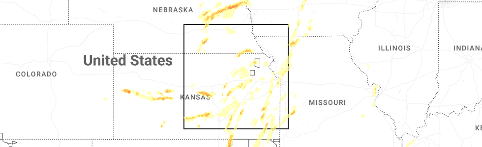
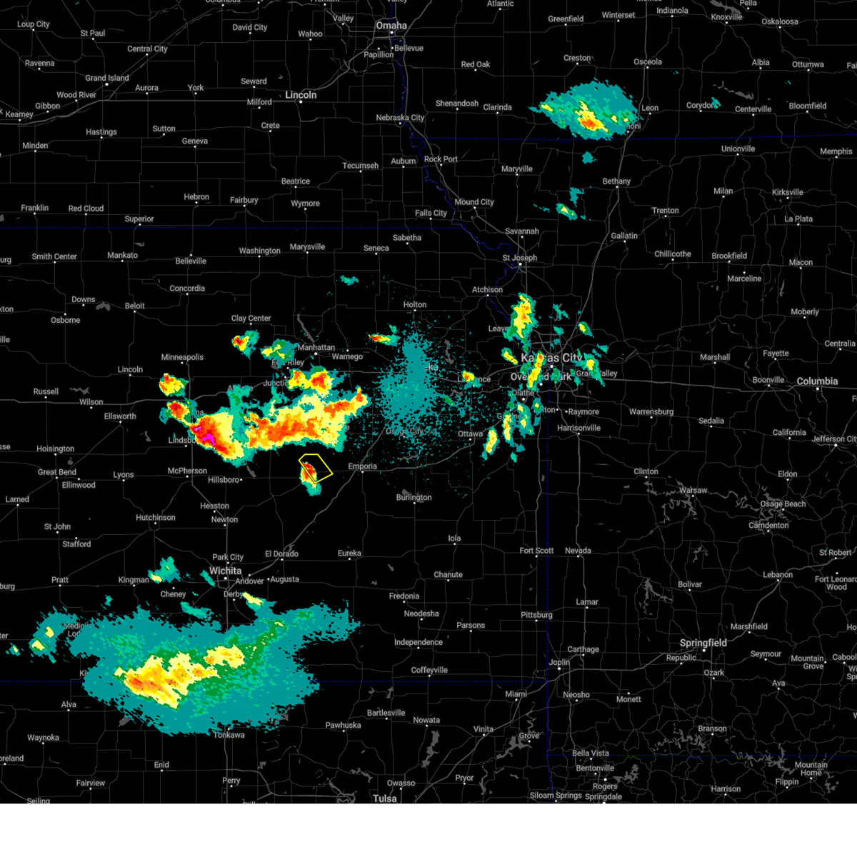
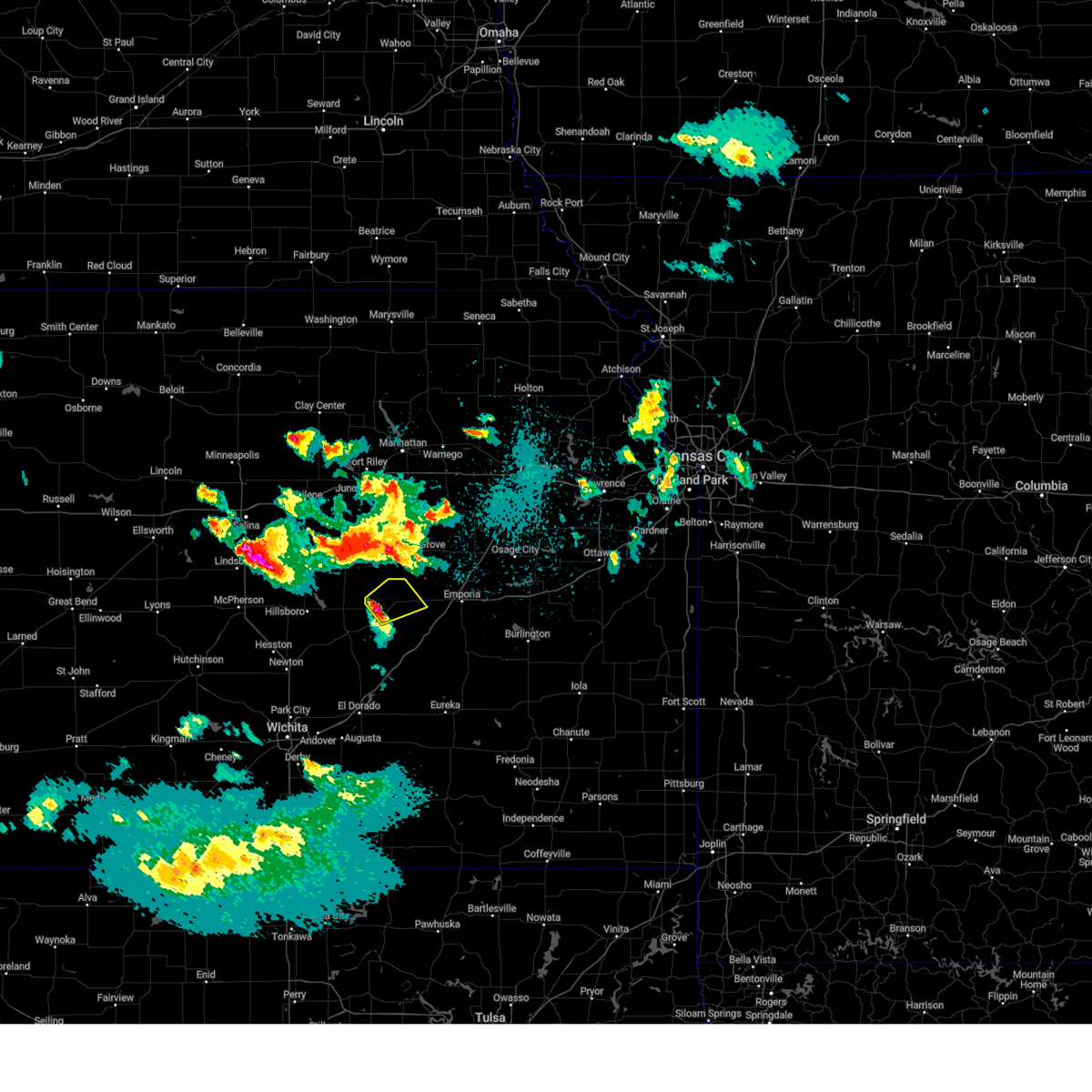
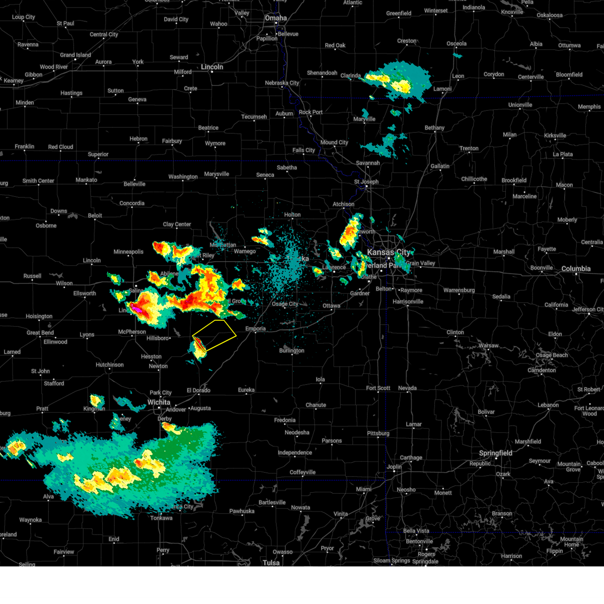
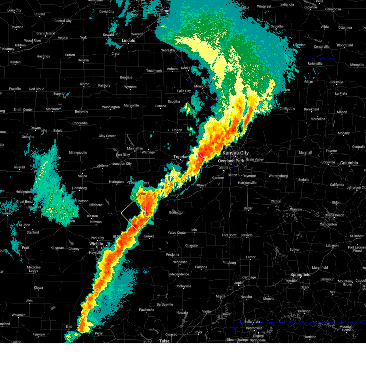
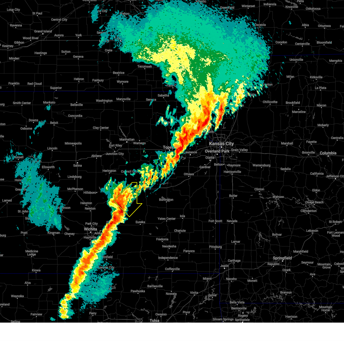
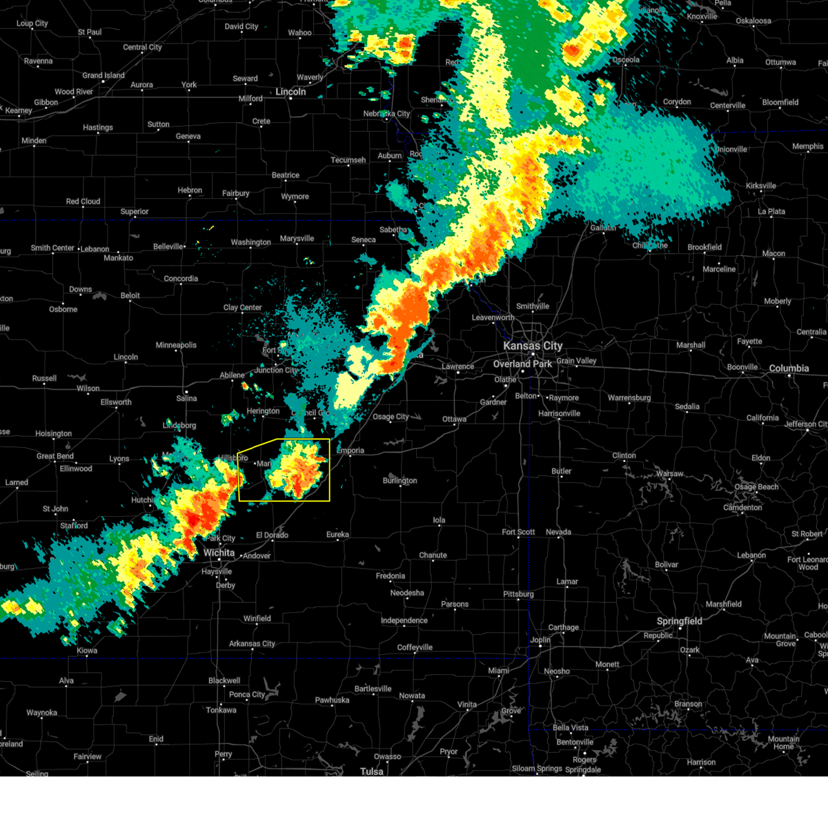
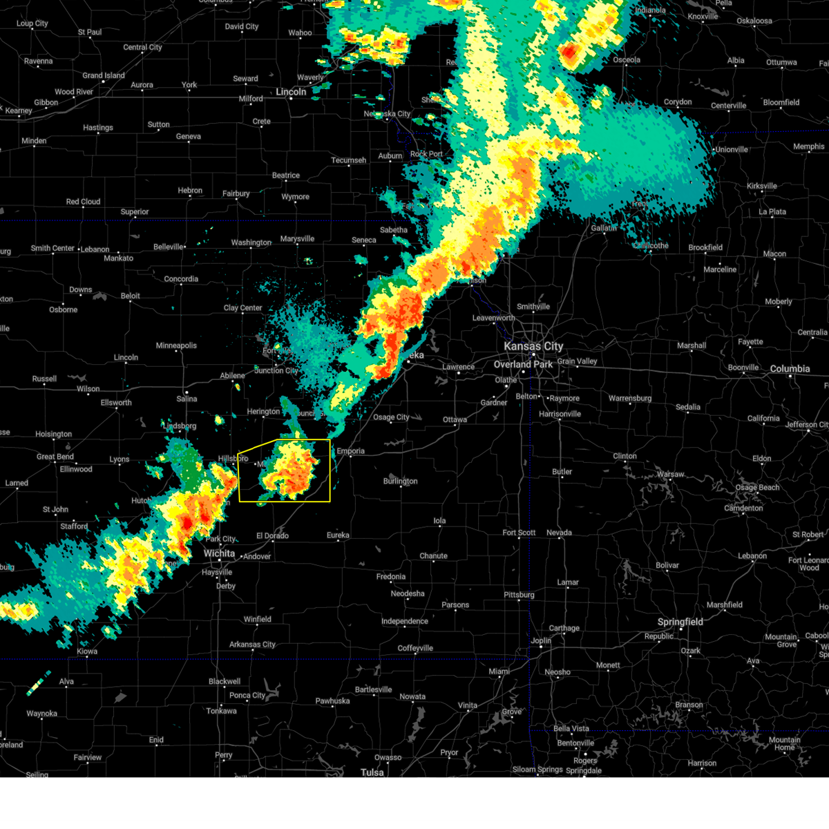
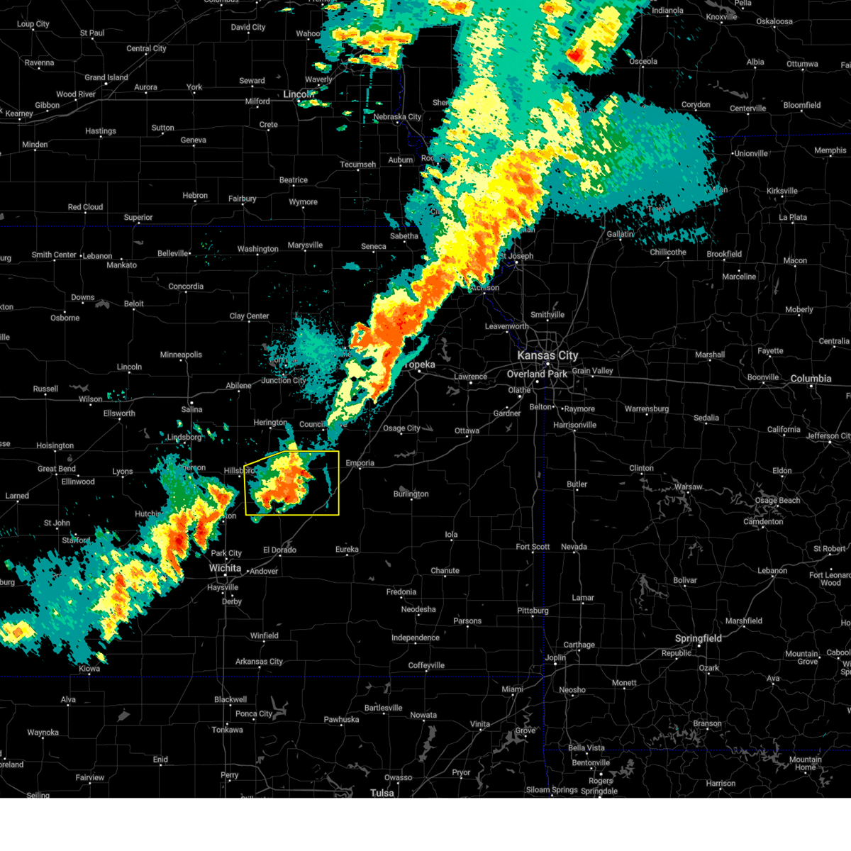
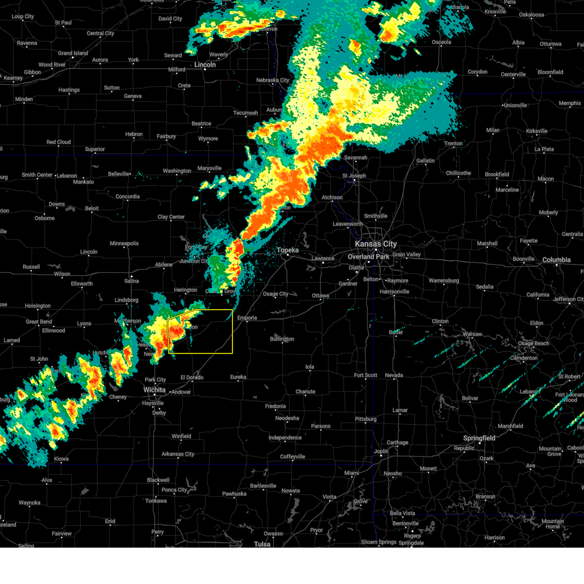
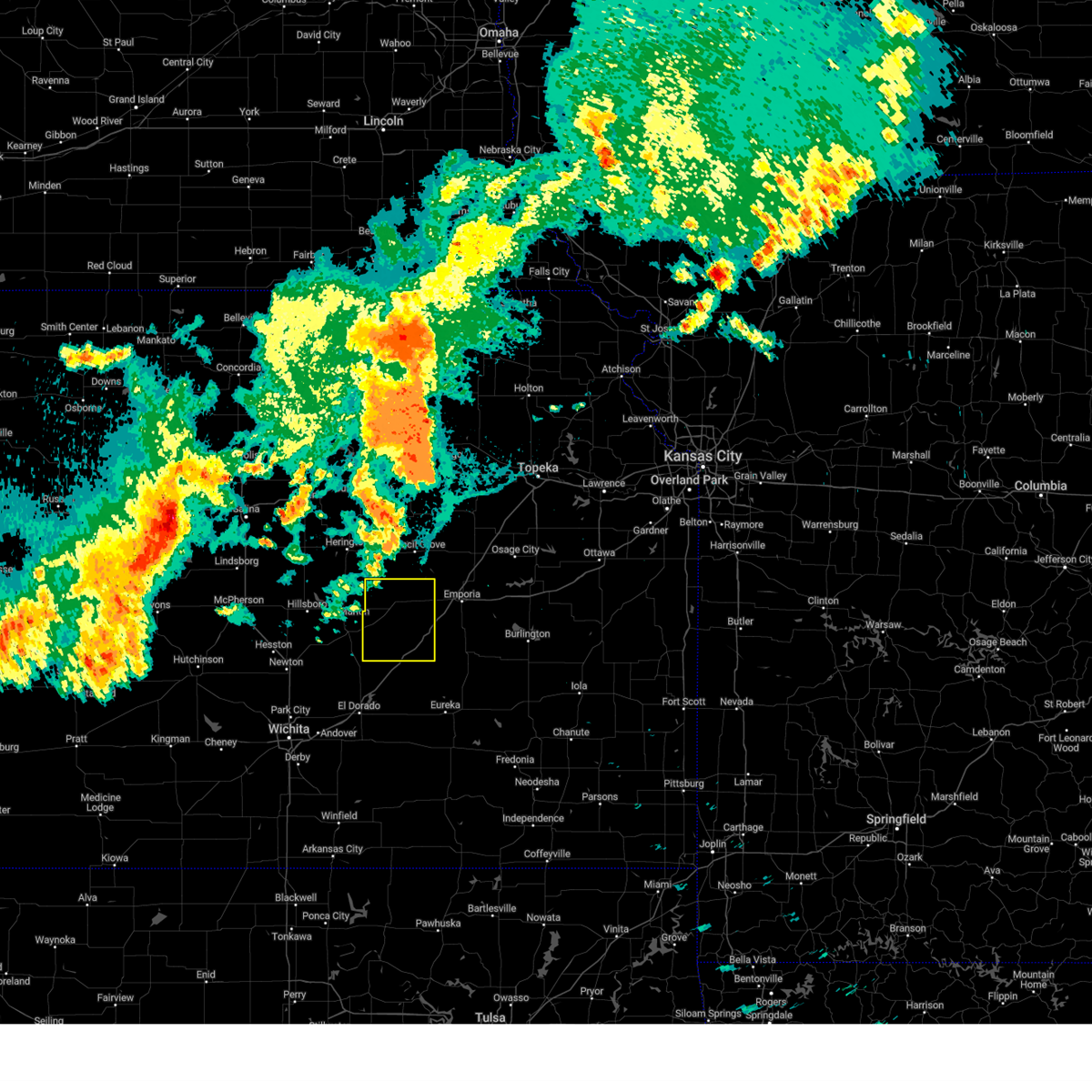
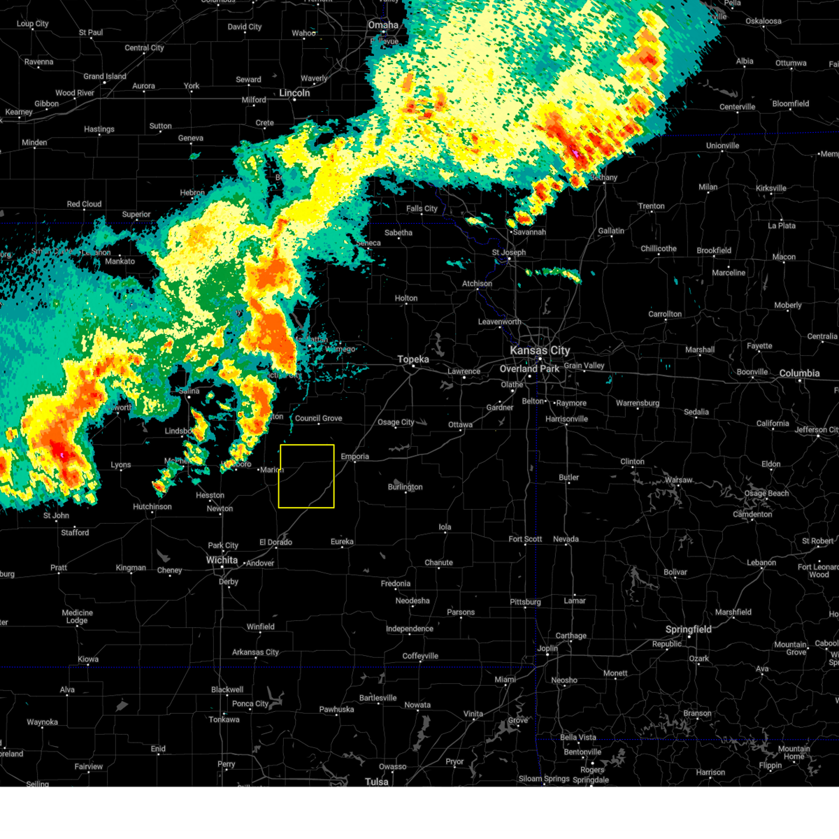
Hail Map for Cottonwood Falls, KS
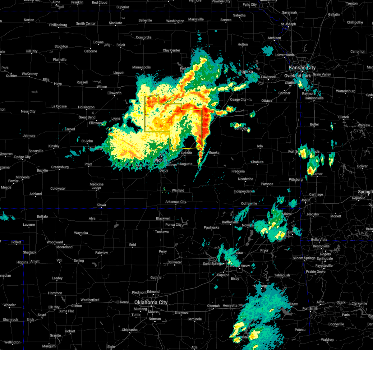
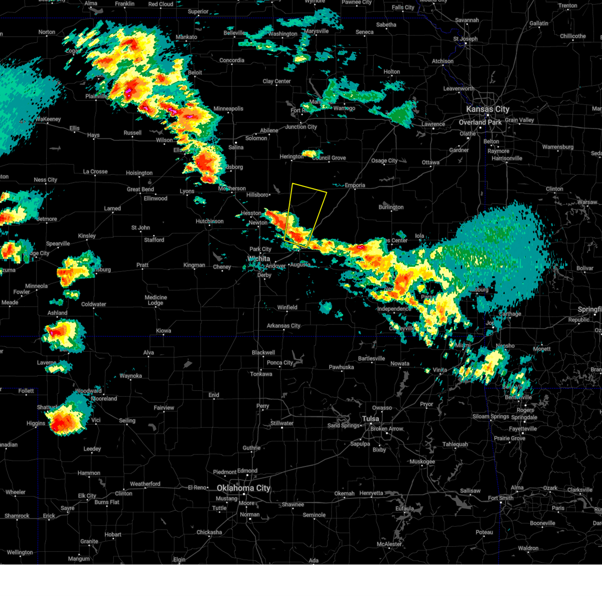
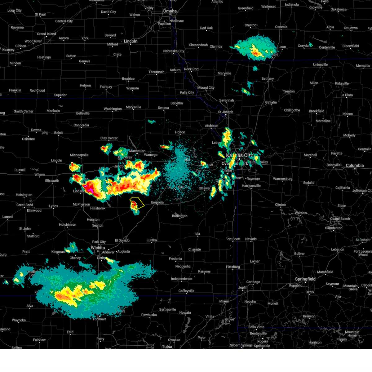
The Cottonwood Falls, KS area has had 12 reports of on-the-ground hail by trained spotters, and has been under severe weather warnings 32 times during the past 12 months. Doppler radar has detected hail at or near Cottonwood Falls, KS on 74 occasions, including 5 occasions during the past year.
| Name: | Cottonwood Falls, KS |
| Where Located: | 55.8 miles S of Manhattan, KS |
| Map: | Google Map for Cottonwood Falls, KS |
| Population: | 903 |
| Housing Units: | 414 |
| More Info: | Search Google for Cottonwood Falls, KS |
1
The Top Recent Hail Date for Cottonwood Falls, KS is Monday, May 19, 2025 (20th out of 74)
Hail and Wind Damage Spotted near Cottonwood Falls, KS
| Date / Time | Report Details |
|---|---|
| 5/20/2025 12:55 AM CDT |
 The storms which prompted the warning have weakened below severe limits, and no longer pose an immediate threat to life or property. therefore, the warning will be allowed to expire. however, gusty winds are still possible with these thunderstorms. The storms which prompted the warning have weakened below severe limits, and no longer pose an immediate threat to life or property. therefore, the warning will be allowed to expire. however, gusty winds are still possible with these thunderstorms.
|
| 5/20/2025 12:39 AM CDT | the severe thunderstorm warning has been cancelled and is no longer in effect |
| 5/20/2025 12:39 AM CDT | At 1238 am cdt, severe thunderstorms were located along a line extending from near enterprise to near tampa to 11 miles south of cottonwood falls, moving northeast at 45 mph (numerous reports of trees down). Hazards include 70 mph wind gusts. Expect considerable tree damage. damage is likely to mobile homes, roofs, and outbuildings. locations impacted include, mcpherson, hillsboro, marion, moundridge, peabody, cottonwood falls, galva, canton, whitewater, strong city, florence, goessel, potwin, assaria, gypsum, elbing, burns, lincolnville, ramona, and lehigh. this includes the following highways, interstate 135 between mile markers 44 and 84. Interstate 35 between mile markers 81 and 101. |
| 5/20/2025 12:05 AM CDT | At 1204 am cdt, severe thunderstorms were located along a line extending from near gypsum to galva to 6 miles south of burns, moving northeast at 45 mph (a measured wind gust of 67 mph was recorded in newton). Hazards include 70 mph wind gusts and quarter size hail. Hail damage to vehicles is expected. expect considerable tree damage. wind damage is also likely to mobile homes, roofs, and outbuildings. locations impacted include, newton, mcpherson, hesston, hillsboro, halstead, marion, north newton, moundridge, sedgwick, peabody, cottonwood falls, galva, canton, whitewater, strong city, florence, goessel, potwin, assaria, and gypsum. this includes the following highways, interstate 135 between mile markers 23 and 84. Interstate 35 between mile markers 81 and 101. |
| 5/19/2025 11:57 PM CDT | Svrict the national weather service in wichita has issued a * severe thunderstorm warning for, eastern mcpherson county in central kansas, harvey county in south central kansas, chase county in east central kansas, northern butler county in south central kansas, marion county in central kansas, southeastern saline county in central kansas, * until 100 am cdt. * at 1156 pm cdt, severe thunderstorms were located along a line extending from near assaria to near galva to near potwin, moving northeast at 45 mph (trained weather spotters have reported numerous gusts to 60 mph and hail up to quarter size). Hazards include 60 mph wind gusts and quarter size hail. Hail damage to vehicles is expected. Expect wind damage to roofs, siding, and trees. |
| 5/19/2025 7:38 PM CDT | At 738 pm cdt, a severe thunderstorm was located near cottonwood falls, moving northeast at 15 mph (radar indicated). Hazards include 60 mph wind gusts and quarter size hail. Hail damage to vehicles is expected. expect wind damage to roofs, siding, and trees. locations impacted include, cottonwood falls, strong city, bazaar, elmdale, saffordville, tallgrass prairie, and tallgrass prairie preserve. This includes interstate 35 between mile markers 112 and 115. |
| 5/19/2025 7:07 PM CDT | Svrict the national weather service in wichita has issued a * severe thunderstorm warning for, central chase county in east central kansas, * until 815 pm cdt. * at 707 pm cdt, a severe thunderstorm was located near strong city, moving northeast at 25 mph (radar indicated). Hazards include 60 mph wind gusts and quarter size hail. Hail damage to vehicles is expected. Expect wind damage to roofs, siding, and trees. |
| 5/18/2025 6:26 PM CDT | the severe thunderstorm warning has been cancelled and is no longer in effect |
| 5/18/2025 6:18 PM CDT | the severe thunderstorm warning has been cancelled and is no longer in effect |
| 5/18/2025 6:18 PM CDT | At 617 pm cdt, a severe thunderstorm was located near florence, moving north at 50 mph (radar indicated). Hazards include quarter size hail. Damage to vehicles is expected. Locations impacted include, cottonwood falls, florence, elmdale, cedar point, and wonsevu. |
| 5/18/2025 5:55 PM CDT |
 Svrict the national weather service in wichita has issued a * severe thunderstorm warning for, southwestern chase county in east central kansas, northwestern butler county in south central kansas, southeastern marion county in central kansas, * until 645 pm cdt. * at 555 pm cdt, a severe thunderstorm was located 7 miles south of burns, or 11 miles north of el dorado, moving north at 45 mph (radar indicated). Hazards include quarter size hail. damage to vehicles is expected Svrict the national weather service in wichita has issued a * severe thunderstorm warning for, southwestern chase county in east central kansas, northwestern butler county in south central kansas, southeastern marion county in central kansas, * until 645 pm cdt. * at 555 pm cdt, a severe thunderstorm was located 7 miles south of burns, or 11 miles north of el dorado, moving north at 45 mph (radar indicated). Hazards include quarter size hail. damage to vehicles is expected
|
| 4/22/2025 10:08 PM CDT |
 The storm which prompted the warning has weakened below severe limits, and no longer poses an immediate threat to life or property. therefore, the warning will be allowed to expire. The storm which prompted the warning has weakened below severe limits, and no longer poses an immediate threat to life or property. therefore, the warning will be allowed to expire.
|
| 4/22/2025 10:01 PM CDT |
 At 1000 pm cdt, a severe thunderstorm was located near strong city, moving northeast at 40 mph (radar indicated). Hazards include 60 mph wind gusts and quarter size hail. Hail damage to vehicles is expected. expect wind damage to roofs, siding, and trees. Locations impacted include, strong city, cottonwood falls, tallgrass prairie, hymer, and tallgrass prairie preserve. At 1000 pm cdt, a severe thunderstorm was located near strong city, moving northeast at 40 mph (radar indicated). Hazards include 60 mph wind gusts and quarter size hail. Hail damage to vehicles is expected. expect wind damage to roofs, siding, and trees. Locations impacted include, strong city, cottonwood falls, tallgrass prairie, hymer, and tallgrass prairie preserve.
|
| 4/22/2025 9:48 PM CDT |
 the severe thunderstorm warning has been cancelled and is no longer in effect the severe thunderstorm warning has been cancelled and is no longer in effect
|
| 4/22/2025 9:48 PM CDT |
 At 948 pm cdt, a severe thunderstorm was located 9 miles west of cottonwood falls, moving northeast at 40 mph (radar indicated). Hazards include 60 mph wind gusts and quarter size hail. Hail damage to vehicles is expected. expect wind damage to roofs, siding, and trees. Locations impacted include, strong city, elmdale, cottonwood falls, tallgrass prairie, hymer, and tallgrass prairie preserve. At 948 pm cdt, a severe thunderstorm was located 9 miles west of cottonwood falls, moving northeast at 40 mph (radar indicated). Hazards include 60 mph wind gusts and quarter size hail. Hail damage to vehicles is expected. expect wind damage to roofs, siding, and trees. Locations impacted include, strong city, elmdale, cottonwood falls, tallgrass prairie, hymer, and tallgrass prairie preserve.
|
| 4/22/2025 9:39 PM CDT |
 Svrict the national weather service in wichita has issued a * severe thunderstorm warning for, northern chase county in east central kansas, east central marion county in central kansas, * until 1015 pm cdt. * at 939 pm cdt, a severe thunderstorm was located 8 miles northeast of florence, moving northeast at 40 mph (radar indicated). Hazards include 60 mph wind gusts and quarter size hail. Hail damage to vehicles is expected. Expect wind damage to roofs, siding, and trees. Svrict the national weather service in wichita has issued a * severe thunderstorm warning for, northern chase county in east central kansas, east central marion county in central kansas, * until 1015 pm cdt. * at 939 pm cdt, a severe thunderstorm was located 8 miles northeast of florence, moving northeast at 40 mph (radar indicated). Hazards include 60 mph wind gusts and quarter size hail. Hail damage to vehicles is expected. Expect wind damage to roofs, siding, and trees.
|
| 4/2/2025 3:50 AM CDT |
 The storm which prompted the warning has moved out of the area. therefore, the warning will be allowed to expire. a tornado watch remains in effect until 700 am cdt for south central, southeastern and east central kansas. The storm which prompted the warning has moved out of the area. therefore, the warning will be allowed to expire. a tornado watch remains in effect until 700 am cdt for south central, southeastern and east central kansas.
|
| 4/2/2025 3:35 AM CDT |
 Svrict the national weather service in wichita has issued a * severe thunderstorm warning for, chase county in east central kansas, northeastern butler county in south central kansas, northwestern greenwood county in southeastern kansas, * until 400 am cdt. * at 334 am cdt, a severe thunderstorm was located 13 miles south of cottonwood falls, moving northeast at 65 mph (radar indicated). Hazards include 60 mph wind gusts and quarter size hail. Hail damage to vehicles is expected. Expect wind damage to roofs, siding, and trees. Svrict the national weather service in wichita has issued a * severe thunderstorm warning for, chase county in east central kansas, northeastern butler county in south central kansas, northwestern greenwood county in southeastern kansas, * until 400 am cdt. * at 334 am cdt, a severe thunderstorm was located 13 miles south of cottonwood falls, moving northeast at 65 mph (radar indicated). Hazards include 60 mph wind gusts and quarter size hail. Hail damage to vehicles is expected. Expect wind damage to roofs, siding, and trees.
|
| 9/20/2024 10:33 PM CDT |
 At 1033 pm cdt, severe thunderstorms were located along a line extending from 10 miles east of burns to 19 miles southeast of florence to 19 miles northeast of el dorado, moving northeast at 40 mph (radar indicated). Hazards include 60 mph wind gusts and penny size hail. Expect damage to roofs, siding, and trees. Locations impacted include, cottonwood falls, cassoday, bazaar, matfield green, and saffordville. At 1033 pm cdt, severe thunderstorms were located along a line extending from 10 miles east of burns to 19 miles southeast of florence to 19 miles northeast of el dorado, moving northeast at 40 mph (radar indicated). Hazards include 60 mph wind gusts and penny size hail. Expect damage to roofs, siding, and trees. Locations impacted include, cottonwood falls, cassoday, bazaar, matfield green, and saffordville.
|
| 9/20/2024 10:17 PM CDT |
 Svrict the national weather service in wichita has issued a * severe thunderstorm warning for, southeastern chase county in east central kansas, northeastern butler county in south central kansas, northwestern greenwood county in southeastern kansas, * until 1115 pm cdt. * at 1017 pm cdt, severe thunderstorms were located along a line extending from near burns to 13 miles northeast of potwin to 11 miles northeast of el dorado, moving northeast at 40 mph (radar indicated). Hazards include 70 mph wind gusts and quarter size hail. Hail damage to vehicles is expected. expect considerable tree damage. Wind damage is also likely to mobile homes, roofs, and outbuildings. Svrict the national weather service in wichita has issued a * severe thunderstorm warning for, southeastern chase county in east central kansas, northeastern butler county in south central kansas, northwestern greenwood county in southeastern kansas, * until 1115 pm cdt. * at 1017 pm cdt, severe thunderstorms were located along a line extending from near burns to 13 miles northeast of potwin to 11 miles northeast of el dorado, moving northeast at 40 mph (radar indicated). Hazards include 70 mph wind gusts and quarter size hail. Hail damage to vehicles is expected. expect considerable tree damage. Wind damage is also likely to mobile homes, roofs, and outbuildings.
|
| 9/20/2024 8:36 PM CDT |
 At 835 pm cdt, severe thunderstorms were located along a line extending from near cottonwood falls to 15 miles west of olpe to 15 miles northwest of eureka, moving east at 40 mph (radar indicated). Hazards include 60 mph wind gusts. Expect damage to roofs, siding, and trees. Locations impacted include, cottonwood falls, cassoday, bazaar, matfield green, and saffordville. At 835 pm cdt, severe thunderstorms were located along a line extending from near cottonwood falls to 15 miles west of olpe to 15 miles northwest of eureka, moving east at 40 mph (radar indicated). Hazards include 60 mph wind gusts. Expect damage to roofs, siding, and trees. Locations impacted include, cottonwood falls, cassoday, bazaar, matfield green, and saffordville.
|
| 9/20/2024 8:23 PM CDT |
 At 822 pm cdt, severe thunderstorms were located along a line extending from near cottonwood falls to 13 miles south of strong city to 12 miles northeast of el dorado, moving east at 45 mph (radar indicated). Hazards include 60 mph wind gusts. Expect damage to roofs, siding, and trees. Locations impacted include, cottonwood falls, strong city, cassoday, bazaar, elmdale, matfield green, cedar point, saffordville, wonsevu, and tallgrass prairie preserve. At 822 pm cdt, severe thunderstorms were located along a line extending from near cottonwood falls to 13 miles south of strong city to 12 miles northeast of el dorado, moving east at 45 mph (radar indicated). Hazards include 60 mph wind gusts. Expect damage to roofs, siding, and trees. Locations impacted include, cottonwood falls, strong city, cassoday, bazaar, elmdale, matfield green, cedar point, saffordville, wonsevu, and tallgrass prairie preserve.
|
| 9/20/2024 8:03 PM CDT |
 At 803 pm cdt, severe thunderstorms were located along a line extending from 9 miles south of burdick to 7 miles northeast of burns to near potwin, moving east at 45 mph (radar indicated). Hazards include 60 mph wind gusts. Expect damage to roofs, siding, and trees. Locations impacted include, cottonwood falls, strong city, cassoday, bazaar, elmdale, matfield green, cedar point, wonsevu, tallgrass prairie, el dorado lake, saffordville, tallgrass prairie preserve, and el dorado state park. At 803 pm cdt, severe thunderstorms were located along a line extending from 9 miles south of burdick to 7 miles northeast of burns to near potwin, moving east at 45 mph (radar indicated). Hazards include 60 mph wind gusts. Expect damage to roofs, siding, and trees. Locations impacted include, cottonwood falls, strong city, cassoday, bazaar, elmdale, matfield green, cedar point, wonsevu, tallgrass prairie, el dorado lake, saffordville, tallgrass prairie preserve, and el dorado state park.
|
| 9/20/2024 7:55 PM CDT |
 At 755 pm cdt, severe thunderstorms were located along a line extending from 6 miles southeast of lincolnville to near burns to near potwin, moving east at 45 mph (law enforcement reported 60 mph wind gusts in marion at 753 pm ). Hazards include 60 mph wind gusts. Expect damage to roofs, siding, and trees. Locations impacted include, cottonwood falls, strong city, rosalia, cassoday, bazaar, elmdale, matfield green, cedar point, el dorado state park, wonsevu, tallgrass prairie, el dorado lake, saffordville, and tallgrass prairie preserve. At 755 pm cdt, severe thunderstorms were located along a line extending from 6 miles southeast of lincolnville to near burns to near potwin, moving east at 45 mph (law enforcement reported 60 mph wind gusts in marion at 753 pm ). Hazards include 60 mph wind gusts. Expect damage to roofs, siding, and trees. Locations impacted include, cottonwood falls, strong city, rosalia, cassoday, bazaar, elmdale, matfield green, cedar point, el dorado state park, wonsevu, tallgrass prairie, el dorado lake, saffordville, and tallgrass prairie preserve.
|
| 9/20/2024 7:42 PM CDT |
 Svrict the national weather service in wichita has issued a * severe thunderstorm warning for, chase county in east central kansas, northeastern butler county in south central kansas, northwestern greenwood county in southeastern kansas, * until 900 pm cdt. * at 742 pm cdt, severe thunderstorms were located along a line extending from 5 miles northwest of marion to near peabody to 6 miles southwest of whitewater, moving east at 45 mph (radar indicated). Hazards include 60 mph wind gusts. expect damage to roofs, siding, and trees Svrict the national weather service in wichita has issued a * severe thunderstorm warning for, chase county in east central kansas, northeastern butler county in south central kansas, northwestern greenwood county in southeastern kansas, * until 900 pm cdt. * at 742 pm cdt, severe thunderstorms were located along a line extending from 5 miles northwest of marion to near peabody to 6 miles southwest of whitewater, moving east at 45 mph (radar indicated). Hazards include 60 mph wind gusts. expect damage to roofs, siding, and trees
|
| 8/14/2024 10:28 PM CDT |
 The storms which prompted the warning have weakened below severe limits, and no longer pose an immediate threat to life or property. therefore, the warning will be allowed to expire. however, gusty winds are still possible with these thunderstorms. a severe thunderstorm watch remains in effect until 100 am cdt for central and east central kansas. The storms which prompted the warning have weakened below severe limits, and no longer pose an immediate threat to life or property. therefore, the warning will be allowed to expire. however, gusty winds are still possible with these thunderstorms. a severe thunderstorm watch remains in effect until 100 am cdt for central and east central kansas.
|
| 8/14/2024 10:22 PM CDT |
 At 1021 pm cdt, severe thunderstorms were located along a line extending from 7 miles northeast of strong city to 8 miles southeast of cottonwood falls to 13 miles east of burns, moving east at 35 mph (radar indicated). Hazards include 60 mph wind gusts. Expect damage to roofs, siding, and trees. locations impacted include, marion, peabody, cottonwood falls, strong city, florence, burns, bazaar, elmdale, matfield green, cedar point, hymer, marion lake, wonsevu, tallgrass prairie, saffordville, and tallgrass prairie preserve. Travelers along the kansas turnpike in chase county will be affected as well. At 1021 pm cdt, severe thunderstorms were located along a line extending from 7 miles northeast of strong city to 8 miles southeast of cottonwood falls to 13 miles east of burns, moving east at 35 mph (radar indicated). Hazards include 60 mph wind gusts. Expect damage to roofs, siding, and trees. locations impacted include, marion, peabody, cottonwood falls, strong city, florence, burns, bazaar, elmdale, matfield green, cedar point, hymer, marion lake, wonsevu, tallgrass prairie, saffordville, and tallgrass prairie preserve. Travelers along the kansas turnpike in chase county will be affected as well.
|
| 8/14/2024 10:08 PM CDT |
 At 1008 pm cdt, severe thunderstorms were located along a line extending from 7 miles northwest of strong city to 6 miles southwest of cottonwood falls to 5 miles northeast of burns, moving east at 45 mph (radar indicated). Hazards include 60 mph wind gusts. Expect damage to roofs, siding, and trees. Locations impacted include, marion, peabody, cottonwood falls, strong city, florence, burns, bazaar, elmdale, matfield green, cedar point, hymer, marion lake, wonsevu, tallgrass prairie, saffordville, and tallgrass prairie preserve. At 1008 pm cdt, severe thunderstorms were located along a line extending from 7 miles northwest of strong city to 6 miles southwest of cottonwood falls to 5 miles northeast of burns, moving east at 45 mph (radar indicated). Hazards include 60 mph wind gusts. Expect damage to roofs, siding, and trees. Locations impacted include, marion, peabody, cottonwood falls, strong city, florence, burns, bazaar, elmdale, matfield green, cedar point, hymer, marion lake, wonsevu, tallgrass prairie, saffordville, and tallgrass prairie preserve.
|
| 8/14/2024 9:42 PM CDT |
 Svrict the national weather service in wichita has issued a * severe thunderstorm warning for, chase county in east central kansas, southeastern marion county in central kansas, * until 1030 pm cdt. * at 940 pm cdt, severe thunderstorms were located along a line extending from 5 miles southeast of lincolnville to 6 miles west of burns, moving east at 35 mph (radar indicated). Hazards include 60 mph wind gusts. expect damage to roofs, siding, and trees Svrict the national weather service in wichita has issued a * severe thunderstorm warning for, chase county in east central kansas, southeastern marion county in central kansas, * until 1030 pm cdt. * at 940 pm cdt, severe thunderstorms were located along a line extending from 5 miles southeast of lincolnville to 6 miles west of burns, moving east at 35 mph (radar indicated). Hazards include 60 mph wind gusts. expect damage to roofs, siding, and trees
|
| 7/31/2024 9:01 PM CDT | the severe thunderstorm warning has been cancelled and is no longer in effect |
| 7/31/2024 8:47 PM CDT |
 At 847 pm cdt, severe thunderstorms were located along a line extending from dunlap to cottonwood falls to 10 miles east of florence, moving east at 50 mph (radar indicated). Hazards include 60 mph wind gusts. Expect damage to roofs, siding, and trees. Locations impacted include, cottonwood falls, strong city, bazaar, elmdale, matfield green, cedar point, hymer, saffordville, wonsevu, tallgrass prairie, and tallgrass prairie preserve. At 847 pm cdt, severe thunderstorms were located along a line extending from dunlap to cottonwood falls to 10 miles east of florence, moving east at 50 mph (radar indicated). Hazards include 60 mph wind gusts. Expect damage to roofs, siding, and trees. Locations impacted include, cottonwood falls, strong city, bazaar, elmdale, matfield green, cedar point, hymer, saffordville, wonsevu, tallgrass prairie, and tallgrass prairie preserve.
|
| 7/31/2024 8:22 PM CDT |
 Svrict the national weather service in wichita has issued a * severe thunderstorm warning for, chase county in east central kansas, * until 915 pm cdt. * at 821 pm cdt, severe thunderstorms were located along a line extending from near wilsey to 6 miles northeast of marion to 6 miles north of peabody, moving east at 50 mph (law enforcement). Hazards include 70 mph wind gusts. Expect considerable tree damage. Damage is likely to mobile homes, roofs, and outbuildings. Svrict the national weather service in wichita has issued a * severe thunderstorm warning for, chase county in east central kansas, * until 915 pm cdt. * at 821 pm cdt, severe thunderstorms were located along a line extending from near wilsey to 6 miles northeast of marion to 6 miles north of peabody, moving east at 50 mph (law enforcement). Hazards include 70 mph wind gusts. Expect considerable tree damage. Damage is likely to mobile homes, roofs, and outbuildings.
|
| 7/2/2024 6:53 PM CDT |
 At 653 pm cdt, severe thunderstorms were located along a line extending from 9 miles northwest of cottonwood falls to 5 miles north of strong city to 8 miles southwest of americus to 8 miles southwest of emporia, moving northeast at 45 mph (radar indicated). Hazards include 60 mph wind gusts. Expect damage to roofs, siding, and trees. Locations impacted include, cottonwood falls, strong city, elmdale, tallgrass prairie, and tallgrass prairie preserve. At 653 pm cdt, severe thunderstorms were located along a line extending from 9 miles northwest of cottonwood falls to 5 miles north of strong city to 8 miles southwest of americus to 8 miles southwest of emporia, moving northeast at 45 mph (radar indicated). Hazards include 60 mph wind gusts. Expect damage to roofs, siding, and trees. Locations impacted include, cottonwood falls, strong city, elmdale, tallgrass prairie, and tallgrass prairie preserve.
|
| 7/2/2024 6:53 PM CDT |
 the severe thunderstorm warning has been cancelled and is no longer in effect the severe thunderstorm warning has been cancelled and is no longer in effect
|
| 7/2/2024 6:28 PM CDT |
 At 628 pm cdt, severe thunderstorms were located along a line extending from near marion to 6 miles north of florence to 12 miles southwest of cottonwood falls to 13 miles northeast of burns, moving northeast at 45 mph (radar indicated). Hazards include 60 mph wind gusts. Expect damage to roofs, siding, and trees. Locations impacted include, marion, cottonwood falls, strong city, florence, burns, lincolnville, bazaar, elmdale, matfield green, cedar point, hymer, wonsevu, tallgrass prairie, and tallgrass prairie preserve. At 628 pm cdt, severe thunderstorms were located along a line extending from near marion to 6 miles north of florence to 12 miles southwest of cottonwood falls to 13 miles northeast of burns, moving northeast at 45 mph (radar indicated). Hazards include 60 mph wind gusts. Expect damage to roofs, siding, and trees. Locations impacted include, marion, cottonwood falls, strong city, florence, burns, lincolnville, bazaar, elmdale, matfield green, cedar point, hymer, wonsevu, tallgrass prairie, and tallgrass prairie preserve.
|
| 7/2/2024 6:17 PM CDT |
 the severe thunderstorm warning has been cancelled and is no longer in effect the severe thunderstorm warning has been cancelled and is no longer in effect
|
| 7/2/2024 6:17 PM CDT |
 At 616 pm cdt, severe thunderstorms were located along a line extending from 6 miles northwest of peabody to near burns, moving northeast at 45 mph (radar indicated). Hazards include 60 mph wind gusts. Expect damage to roofs, siding, and trees. Locations impacted include, marion, peabody, cottonwood falls, strong city, florence, burns, lincolnville, bazaar, elmdale, matfield green, cedar point, hymer, wonsevu, tallgrass prairie, and tallgrass prairie preserve. At 616 pm cdt, severe thunderstorms were located along a line extending from 6 miles northwest of peabody to near burns, moving northeast at 45 mph (radar indicated). Hazards include 60 mph wind gusts. Expect damage to roofs, siding, and trees. Locations impacted include, marion, peabody, cottonwood falls, strong city, florence, burns, lincolnville, bazaar, elmdale, matfield green, cedar point, hymer, wonsevu, tallgrass prairie, and tallgrass prairie preserve.
|
| 7/2/2024 6:05 PM CDT |
 Svrict the national weather service in wichita has issued a * severe thunderstorm warning for, northeastern harvey county in south central kansas, chase county in east central kansas, marion county in central kansas, * until 700 pm cdt. * at 605 pm cdt, severe thunderstorms were located along a line extending from 5 miles north of walton to near elbing, moving northeast at 40 mph (radar indicated). Hazards include 60 mph wind gusts. expect damage to roofs, siding, and trees Svrict the national weather service in wichita has issued a * severe thunderstorm warning for, northeastern harvey county in south central kansas, chase county in east central kansas, marion county in central kansas, * until 700 pm cdt. * at 605 pm cdt, severe thunderstorms were located along a line extending from 5 miles north of walton to near elbing, moving northeast at 40 mph (radar indicated). Hazards include 60 mph wind gusts. expect damage to roofs, siding, and trees
|
| 6/13/2024 8:50 PM CDT |
 The storm which prompted the warning has moved out of the area. therefore, the warning will be allowed to expire. however, gusty winds are still possible with this thunderstorm. a severe thunderstorm watch remains in effect until 1100 pm cdt for east central kansas. The storm which prompted the warning has moved out of the area. therefore, the warning will be allowed to expire. however, gusty winds are still possible with this thunderstorm. a severe thunderstorm watch remains in effect until 1100 pm cdt for east central kansas.
|
| 6/13/2024 8:42 PM CDT |
 At 841 pm cdt, a severe thunderstorm was located 8 miles southeast of cottonwood falls, moving southeast at 30 mph (radar indicated). Hazards include 60 mph wind gusts and penny size hail. Expect damage to roofs, siding, and trees. Locations impacted include, cottonwood falls, strong city, bazaar, and saffordville. At 841 pm cdt, a severe thunderstorm was located 8 miles southeast of cottonwood falls, moving southeast at 30 mph (radar indicated). Hazards include 60 mph wind gusts and penny size hail. Expect damage to roofs, siding, and trees. Locations impacted include, cottonwood falls, strong city, bazaar, and saffordville.
|
| 6/13/2024 8:22 PM CDT |
 At 821 pm cdt, a severe thunderstorm was located over cottonwood falls, moving southeast at 30 mph (kansas state mesonet. at 814 pm cdt, a 62 mph wind gust was reported 1 mile southeast of elmdale). Hazards include 60 mph wind gusts and quarter size hail. Hail damage to vehicles is expected. expect wind damage to roofs, siding, and trees. Locations impacted include, cottonwood falls, strong city, bazaar, elmdale, saffordville, tallgrass prairie, and tallgrass prairie preserve. At 821 pm cdt, a severe thunderstorm was located over cottonwood falls, moving southeast at 30 mph (kansas state mesonet. at 814 pm cdt, a 62 mph wind gust was reported 1 mile southeast of elmdale). Hazards include 60 mph wind gusts and quarter size hail. Hail damage to vehicles is expected. expect wind damage to roofs, siding, and trees. Locations impacted include, cottonwood falls, strong city, bazaar, elmdale, saffordville, tallgrass prairie, and tallgrass prairie preserve.
|
| 6/13/2024 8:01 PM CDT |
 Svrict the national weather service in wichita has issued a * severe thunderstorm warning for, chase county in east central kansas, * until 900 pm cdt. * at 801 pm cdt, a severe thunderstorm was located 8 miles southeast of burdick, or 11 miles northwest of strong city, moving southeast at 30 mph (radar indicated). Hazards include 60 mph wind gusts and quarter size hail. Hail damage to vehicles is expected. Expect wind damage to roofs, siding, and trees. Svrict the national weather service in wichita has issued a * severe thunderstorm warning for, chase county in east central kansas, * until 900 pm cdt. * at 801 pm cdt, a severe thunderstorm was located 8 miles southeast of burdick, or 11 miles northwest of strong city, moving southeast at 30 mph (radar indicated). Hazards include 60 mph wind gusts and quarter size hail. Hail damage to vehicles is expected. Expect wind damage to roofs, siding, and trees.
|
| 6/9/2024 12:42 AM CDT |
 The storms which prompted the warning have weakened below severe limits, and no longer pose an immediate threat to life or property. therefore, the warning will be allowed to expire. however, heavy rain is still possible with these thunderstorms. The storms which prompted the warning have weakened below severe limits, and no longer pose an immediate threat to life or property. therefore, the warning will be allowed to expire. however, heavy rain is still possible with these thunderstorms.
|
| 6/9/2024 12:13 AM CDT |
 At 1213 am cdt, severe thunderstorms were located along a line extending from 7 miles southwest of americus to 5 miles northeast of canton, moving east at 15 mph (radar indicated). Hazards include 60 mph wind gusts and quarter size hail. Hail damage to vehicles is expected. expect wind damage to roofs, siding, and trees. Locations impacted include, hillsboro, marion, cottonwood falls, strong city, florence, lincolnville, ramona, lehigh, tampa, durham, bazaar, lost springs, elmdale, cedar point, hymer, marion lake, tallgrass prairie, pilsen, saffordville, and tallgrass prairie preserve. At 1213 am cdt, severe thunderstorms were located along a line extending from 7 miles southwest of americus to 5 miles northeast of canton, moving east at 15 mph (radar indicated). Hazards include 60 mph wind gusts and quarter size hail. Hail damage to vehicles is expected. expect wind damage to roofs, siding, and trees. Locations impacted include, hillsboro, marion, cottonwood falls, strong city, florence, lincolnville, ramona, lehigh, tampa, durham, bazaar, lost springs, elmdale, cedar point, hymer, marion lake, tallgrass prairie, pilsen, saffordville, and tallgrass prairie preserve.
|
| 6/8/2024 11:50 PM CDT |
 Svrict the national weather service in wichita has issued a * severe thunderstorm warning for, chase county in east central kansas, marion county in central kansas, * until 1245 am cdt. * at 1150 pm cdt, severe thunderstorms were located along a line extending from americus to near durham, moving east at 35 mph (radar indicated). Hazards include 60 mph wind gusts and quarter size hail. Hail damage to vehicles is expected. Expect wind damage to roofs, siding, and trees. Svrict the national weather service in wichita has issued a * severe thunderstorm warning for, chase county in east central kansas, marion county in central kansas, * until 1245 am cdt. * at 1150 pm cdt, severe thunderstorms were located along a line extending from americus to near durham, moving east at 35 mph (radar indicated). Hazards include 60 mph wind gusts and quarter size hail. Hail damage to vehicles is expected. Expect wind damage to roofs, siding, and trees.
|
| 6/8/2024 12:42 AM CDT |
 The storm which prompted the warning has weakened below severe limits, and no longer poses an immediate threat to life or property. therefore, the warning will be allowed to expire. however, gusty winds are still possible with this thunderstorm. a severe thunderstorm watch remains in effect until 100 am cdt for central and east central kansas. The storm which prompted the warning has weakened below severe limits, and no longer poses an immediate threat to life or property. therefore, the warning will be allowed to expire. however, gusty winds are still possible with this thunderstorm. a severe thunderstorm watch remains in effect until 100 am cdt for central and east central kansas.
|
| 6/8/2024 12:18 AM CDT |
 At 1217 am cdt, a severe thunderstorm was located 8 miles west of emporia, moving east at 45 mph (trained weather spotters have reported 62 mph winds in elmdale). Hazards include 60 mph wind gusts and nickel size hail. Expect damage to roofs, siding, and trees. Locations impacted include, cottonwood falls, strong city, cassoday, bazaar, elmdale, matfield green, cedar point, hymer, thrall, wonsevu, tallgrass prairie, saffordville, and tallgrass prairie preserve. At 1217 am cdt, a severe thunderstorm was located 8 miles west of emporia, moving east at 45 mph (trained weather spotters have reported 62 mph winds in elmdale). Hazards include 60 mph wind gusts and nickel size hail. Expect damage to roofs, siding, and trees. Locations impacted include, cottonwood falls, strong city, cassoday, bazaar, elmdale, matfield green, cedar point, hymer, thrall, wonsevu, tallgrass prairie, saffordville, and tallgrass prairie preserve.
|
| 6/8/2024 12:18 AM CDT |
 the severe thunderstorm warning has been cancelled and is no longer in effect the severe thunderstorm warning has been cancelled and is no longer in effect
|
| 6/7/2024 11:48 PM CDT |
 Svrict the national weather service in wichita has issued a * severe thunderstorm warning for, chase county in east central kansas, northeastern butler county in south central kansas, southeastern marion county in central kansas, northwestern greenwood county in southeastern kansas, * until 1245 am cdt. * at 1148 pm cdt, a severe thunderstorm was located 11 miles south of burdick, or 12 miles west of strong city, moving east at 45 mph (radar indicated). Hazards include 60 mph wind gusts and nickel size hail. expect damage to roofs, siding, and trees Svrict the national weather service in wichita has issued a * severe thunderstorm warning for, chase county in east central kansas, northeastern butler county in south central kansas, southeastern marion county in central kansas, northwestern greenwood county in southeastern kansas, * until 1245 am cdt. * at 1148 pm cdt, a severe thunderstorm was located 11 miles south of burdick, or 12 miles west of strong city, moving east at 45 mph (radar indicated). Hazards include 60 mph wind gusts and nickel size hail. expect damage to roofs, siding, and trees
|
| 6/4/2024 6:59 PM CDT |
 At 659 pm cdt, a severe thunderstorm was located 8 miles south of cottonwood falls, moving east at 15 mph (trained weather spotters). Hazards include golf ball size hail and 70 mph wind gusts. People and animals outdoors will be injured. expect hail damage to roofs, siding, windows, and vehicles. expect considerable tree damage. wind damage is also likely to mobile homes, roofs, and outbuildings. Locations impacted include, cottonwood falls, strong city, bazaar, elmdale, matfield green, and saffordville. At 659 pm cdt, a severe thunderstorm was located 8 miles south of cottonwood falls, moving east at 15 mph (trained weather spotters). Hazards include golf ball size hail and 70 mph wind gusts. People and animals outdoors will be injured. expect hail damage to roofs, siding, windows, and vehicles. expect considerable tree damage. wind damage is also likely to mobile homes, roofs, and outbuildings. Locations impacted include, cottonwood falls, strong city, bazaar, elmdale, matfield green, and saffordville.
|
| 6/4/2024 6:58 PM CDT |
 Svrict the national weather service in wichita has issued a * severe thunderstorm warning for, southern chase county in east central kansas, * until 800 pm cdt. * at 658 pm cdt, a severe thunderstorm was located 10 miles south of cottonwood falls, moving east at 20 mph (trained weather spotters). Hazards include golf ball size hail and 70 mph wind gusts. People and animals outdoors will be injured. expect hail damage to roofs, siding, windows, and vehicles. expect considerable tree damage. Wind damage is also likely to mobile homes, roofs, and outbuildings. Svrict the national weather service in wichita has issued a * severe thunderstorm warning for, southern chase county in east central kansas, * until 800 pm cdt. * at 658 pm cdt, a severe thunderstorm was located 10 miles south of cottonwood falls, moving east at 20 mph (trained weather spotters). Hazards include golf ball size hail and 70 mph wind gusts. People and animals outdoors will be injured. expect hail damage to roofs, siding, windows, and vehicles. expect considerable tree damage. Wind damage is also likely to mobile homes, roofs, and outbuildings.
|
| 6/4/2024 6:44 PM CDT |
 At 644 pm cdt, a severe thunderstorm was located 9 miles south of cottonwood falls, moving east at 15 mph (trained weather spotters). Hazards include 70 mph wind gusts and quarter size hail. Hail damage to vehicles is expected. expect considerable tree damage. wind damage is also likely to mobile homes, roofs, and outbuildings. Locations impacted include, cottonwood falls, strong city, bazaar, elmdale, matfield green, cedar point, saffordville, and wonsevu. At 644 pm cdt, a severe thunderstorm was located 9 miles south of cottonwood falls, moving east at 15 mph (trained weather spotters). Hazards include 70 mph wind gusts and quarter size hail. Hail damage to vehicles is expected. expect considerable tree damage. wind damage is also likely to mobile homes, roofs, and outbuildings. Locations impacted include, cottonwood falls, strong city, bazaar, elmdale, matfield green, cedar point, saffordville, and wonsevu.
|
| 6/4/2024 6:28 PM CDT |
 At 628 pm cdt, a severe thunderstorm was located 10 miles southwest of cottonwood falls, moving east at 15 mph (radar indicated). Hazards include 60 mph wind gusts and quarter size hail. Hail damage to vehicles is expected. expect wind damage to roofs, siding, and trees. Locations impacted include, cottonwood falls, strong city, bazaar, elmdale, matfield green, cedar point, saffordville, wonsevu, tallgrass prairie, and tallgrass prairie preserve. At 628 pm cdt, a severe thunderstorm was located 10 miles southwest of cottonwood falls, moving east at 15 mph (radar indicated). Hazards include 60 mph wind gusts and quarter size hail. Hail damage to vehicles is expected. expect wind damage to roofs, siding, and trees. Locations impacted include, cottonwood falls, strong city, bazaar, elmdale, matfield green, cedar point, saffordville, wonsevu, tallgrass prairie, and tallgrass prairie preserve.
|
| 6/4/2024 6:28 PM CDT |
 the severe thunderstorm warning has been cancelled and is no longer in effect the severe thunderstorm warning has been cancelled and is no longer in effect
|
| 6/4/2024 6:14 PM CDT |
 Svrict the national weather service in wichita has issued a * severe thunderstorm warning for, chase county in east central kansas, southeastern marion county in central kansas, * until 715 pm cdt. * at 614 pm cdt, a severe thunderstorm was located 9 miles east of florence, moving east at 15 mph (radar indicated). Hazards include 60 mph wind gusts and quarter size hail. Hail damage to vehicles is expected. Expect wind damage to roofs, siding, and trees. Svrict the national weather service in wichita has issued a * severe thunderstorm warning for, chase county in east central kansas, southeastern marion county in central kansas, * until 715 pm cdt. * at 614 pm cdt, a severe thunderstorm was located 9 miles east of florence, moving east at 15 mph (radar indicated). Hazards include 60 mph wind gusts and quarter size hail. Hail damage to vehicles is expected. Expect wind damage to roofs, siding, and trees.
|
| 5/19/2024 8:38 PM CDT |
 Svrict the national weather service in wichita has issued a * severe thunderstorm warning for, chase county in east central kansas, northeastern butler county in south central kansas, greenwood county in southeastern kansas, * until 945 pm cdt. * at 838 pm cdt, severe thunderstorms were located along a line extending from 10 miles south of cottonwood falls to 18 miles east of burns to 5 miles east of el dorado, moving east at 65 mph (radar indicated). Hazards include 70 mph wind gusts and quarter size hail. Hail damage to vehicles is expected. expect considerable tree damage. Wind damage is also likely to mobile homes, roofs, and outbuildings. Svrict the national weather service in wichita has issued a * severe thunderstorm warning for, chase county in east central kansas, northeastern butler county in south central kansas, greenwood county in southeastern kansas, * until 945 pm cdt. * at 838 pm cdt, severe thunderstorms were located along a line extending from 10 miles south of cottonwood falls to 18 miles east of burns to 5 miles east of el dorado, moving east at 65 mph (radar indicated). Hazards include 70 mph wind gusts and quarter size hail. Hail damage to vehicles is expected. expect considerable tree damage. Wind damage is also likely to mobile homes, roofs, and outbuildings.
|
| 5/19/2024 7:45 PM CDT |
 Svrict the national weather service in wichita has issued a * severe thunderstorm warning for, chase county in east central kansas, * until 845 pm cdt. * at 745 pm cdt, severe thunderstorms were located along a line extending from 6 miles south of wilsey to near marion, moving east at 35 mph (radar indicated). Hazards include 70 mph wind gusts and penny size hail. Expect considerable tree damage. Damage is likely to mobile homes, roofs, and outbuildings. Svrict the national weather service in wichita has issued a * severe thunderstorm warning for, chase county in east central kansas, * until 845 pm cdt. * at 745 pm cdt, severe thunderstorms were located along a line extending from 6 miles south of wilsey to near marion, moving east at 35 mph (radar indicated). Hazards include 70 mph wind gusts and penny size hail. Expect considerable tree damage. Damage is likely to mobile homes, roofs, and outbuildings.
|
| 4/30/2024 6:10 PM CDT |
 The storms which prompted the warning have weakened below severe limits, and no longer pose an immediate threat to life or property. therefore, the warning will be allowed to expire. a tornado watch remains in effect until 1100 pm cdt for central and east central kansas. The storms which prompted the warning have weakened below severe limits, and no longer pose an immediate threat to life or property. therefore, the warning will be allowed to expire. a tornado watch remains in effect until 1100 pm cdt for central and east central kansas.
|
| 4/30/2024 5:39 PM CDT |
 At 539 pm cdt, severe thunderstorms were located along a line extending from 6 miles south of wilsey to near peabody, moving east at 20 mph (radar indicated). Hazards include 60 mph wind gusts and half dollar size hail. Hail damage to vehicles is expected. expect wind damage to roofs, siding, and trees. Locations impacted include, marion, peabody, cottonwood falls, strong city, florence, elmdale, cedar point, hymer, wonsevu, tallgrass prairie, and tallgrass prairie preserve. At 539 pm cdt, severe thunderstorms were located along a line extending from 6 miles south of wilsey to near peabody, moving east at 20 mph (radar indicated). Hazards include 60 mph wind gusts and half dollar size hail. Hail damage to vehicles is expected. expect wind damage to roofs, siding, and trees. Locations impacted include, marion, peabody, cottonwood falls, strong city, florence, elmdale, cedar point, hymer, wonsevu, tallgrass prairie, and tallgrass prairie preserve.
|
| 4/30/2024 5:07 PM CDT |
 Svrict the national weather service in wichita has issued a * severe thunderstorm warning for, chase county in east central kansas, southeastern marion county in central kansas, * until 615 pm cdt. * at 507 pm cdt, severe thunderstorms were located along a line extending from burdick to 7 miles northwest of peabody, moving east at 20 mph (radar indicated). Hazards include 60 mph wind gusts and half dollar size hail. Hail damage to vehicles is expected. Expect wind damage to roofs, siding, and trees. Svrict the national weather service in wichita has issued a * severe thunderstorm warning for, chase county in east central kansas, southeastern marion county in central kansas, * until 615 pm cdt. * at 507 pm cdt, severe thunderstorms were located along a line extending from burdick to 7 miles northwest of peabody, moving east at 20 mph (radar indicated). Hazards include 60 mph wind gusts and half dollar size hail. Hail damage to vehicles is expected. Expect wind damage to roofs, siding, and trees.
|
| 4/27/2024 3:10 PM CDT |
 the severe thunderstorm warning has been cancelled and is no longer in effect the severe thunderstorm warning has been cancelled and is no longer in effect
|
| 4/27/2024 2:52 PM CDT |
 At 251 pm cdt, a severe thunderstorm was located 8 miles east of cottonwood falls, moving northeast at 30 mph (radar indicated). Hazards include 60 mph wind gusts and penny size hail. Expect damage to roofs, siding, and trees. Locations impacted include, cottonwood falls, strong city, bazaar, saffordville, and tallgrass prairie preserve. At 251 pm cdt, a severe thunderstorm was located 8 miles east of cottonwood falls, moving northeast at 30 mph (radar indicated). Hazards include 60 mph wind gusts and penny size hail. Expect damage to roofs, siding, and trees. Locations impacted include, cottonwood falls, strong city, bazaar, saffordville, and tallgrass prairie preserve.
|
| 4/27/2024 2:40 PM CDT |
 Svrict the national weather service in wichita has issued a * severe thunderstorm warning for, eastern chase county in east central kansas, * until 345 pm cdt. * at 240 pm cdt, a severe thunderstorm was located 8 miles southeast of cottonwood falls, moving northeast at 30 mph (radar indicated). Hazards include 60 mph wind gusts and quarter size hail. Hail damage to vehicles is expected. Expect wind damage to roofs, siding, and trees. Svrict the national weather service in wichita has issued a * severe thunderstorm warning for, eastern chase county in east central kansas, * until 345 pm cdt. * at 240 pm cdt, a severe thunderstorm was located 8 miles southeast of cottonwood falls, moving northeast at 30 mph (radar indicated). Hazards include 60 mph wind gusts and quarter size hail. Hail damage to vehicles is expected. Expect wind damage to roofs, siding, and trees.
|
| 9/21/2023 5:51 PM CDT |
 At 551 pm cdt, a severe thunderstorm was located 7 miles south of dunlap, or 8 miles northeast of strong city, and is nearly stationary (radar indicated). Hazards include ping pong ball size hail and 60 mph wind gusts. People and animals outdoors will be injured. expect hail damage to roofs, siding, windows, and vehicles. Expect wind damage to roofs, siding, and trees. At 551 pm cdt, a severe thunderstorm was located 7 miles south of dunlap, or 8 miles northeast of strong city, and is nearly stationary (radar indicated). Hazards include ping pong ball size hail and 60 mph wind gusts. People and animals outdoors will be injured. expect hail damage to roofs, siding, windows, and vehicles. Expect wind damage to roofs, siding, and trees.
|
| 9/21/2023 5:36 PM CDT |
 At 536 pm cdt, a severe thunderstorm was located 7 miles northeast of strong city, moving east at 10 mph (radar indicated). Hazards include ping pong ball size hail and 60 mph wind gusts. People and animals outdoors will be injured. expect hail damage to roofs, siding, windows, and vehicles. expect wind damage to roofs, siding, and trees. locations impacted include, cottonwood falls, strong city, and tallgrass prairie preserve. hail threat, radar indicated max hail size, 1. 50 in wind threat, radar indicated max wind gust, 60 mph. At 536 pm cdt, a severe thunderstorm was located 7 miles northeast of strong city, moving east at 10 mph (radar indicated). Hazards include ping pong ball size hail and 60 mph wind gusts. People and animals outdoors will be injured. expect hail damage to roofs, siding, windows, and vehicles. expect wind damage to roofs, siding, and trees. locations impacted include, cottonwood falls, strong city, and tallgrass prairie preserve. hail threat, radar indicated max hail size, 1. 50 in wind threat, radar indicated max wind gust, 60 mph.
|
| 9/21/2023 5:10 PM CDT |
 At 510 pm cdt, a severe thunderstorm was located near strong city, moving northeast at 10 mph (radar indicated). Hazards include 60 mph wind gusts and half dollar size hail. Hail damage to vehicles is expected. Expect wind damage to roofs, siding, and trees. At 510 pm cdt, a severe thunderstorm was located near strong city, moving northeast at 10 mph (radar indicated). Hazards include 60 mph wind gusts and half dollar size hail. Hail damage to vehicles is expected. Expect wind damage to roofs, siding, and trees.
|
| 8/13/2023 5:40 PM CDT |
 At 539 pm cdt, a severe thunderstorm was located 9 miles northwest of strong city, moving east at 40 mph (radar indicated). Hazards include 70 mph wind gusts and half dollar size hail. Hail damage to vehicles is expected. expect considerable tree damage. wind damage is also likely to mobile homes, roofs, and outbuildings. locations impacted include, cottonwood falls, strong city, hymer, tallgrass prairie, and tallgrass prairie preserve. thunderstorm damage threat, considerable hail threat, radar indicated max hail size, 1. 25 in wind threat, radar indicated max wind gust, 70 mph. At 539 pm cdt, a severe thunderstorm was located 9 miles northwest of strong city, moving east at 40 mph (radar indicated). Hazards include 70 mph wind gusts and half dollar size hail. Hail damage to vehicles is expected. expect considerable tree damage. wind damage is also likely to mobile homes, roofs, and outbuildings. locations impacted include, cottonwood falls, strong city, hymer, tallgrass prairie, and tallgrass prairie preserve. thunderstorm damage threat, considerable hail threat, radar indicated max hail size, 1. 25 in wind threat, radar indicated max wind gust, 70 mph.
|
| 8/13/2023 5:33 PM CDT |
 At 533 pm cdt, a severe thunderstorm was located near burdick, or 13 miles southeast of herington, moving east at 20 mph (radar indicated). Hazards include 60 mph wind gusts and quarter size hail. Hail damage to vehicles is expected. expect wind damage to roofs, siding, and trees. locations impacted include, cottonwood falls, strong city, hymer, tallgrass prairie, and tallgrass prairie preserve. hail threat, radar indicated max hail size, 1. 00 in wind threat, radar indicated max wind gust, 60 mph. At 533 pm cdt, a severe thunderstorm was located near burdick, or 13 miles southeast of herington, moving east at 20 mph (radar indicated). Hazards include 60 mph wind gusts and quarter size hail. Hail damage to vehicles is expected. expect wind damage to roofs, siding, and trees. locations impacted include, cottonwood falls, strong city, hymer, tallgrass prairie, and tallgrass prairie preserve. hail threat, radar indicated max hail size, 1. 00 in wind threat, radar indicated max wind gust, 60 mph.
|
| 8/13/2023 5:28 PM CDT |
 At 527 pm cdt, a severe thunderstorm was located over burdick, or 12 miles southeast of herington, moving east at 20 mph (radar indicated). Hazards include 60 mph wind gusts. expect damage to roofs, siding, and trees At 527 pm cdt, a severe thunderstorm was located over burdick, or 12 miles southeast of herington, moving east at 20 mph (radar indicated). Hazards include 60 mph wind gusts. expect damage to roofs, siding, and trees
|
| 8/6/2023 12:29 AM CDT |
 At 1228 am cdt, severe thunderstorms were located along a line extending from near hamilton to latham to near oxford, moving southeast at 50 mph (radar indicated). Hazards include 70 mph wind gusts and nickel size hail. Expect considerable tree damage. damage is likely to mobile homes, roofs, and outbuildings. locations impacted include, el dorado, winfield, augusta, eureka, douglass, towanda, cottonwood falls, udall, leon, madison, howard, burden, hamilton, severy, grenola, atlanta, latham, rosalia, rock and cassoday. thunderstorm damage threat, considerable hail threat, radar indicated max hail size, 0. 88 in wind threat, radar indicated max wind gust, 70 mph. At 1228 am cdt, severe thunderstorms were located along a line extending from near hamilton to latham to near oxford, moving southeast at 50 mph (radar indicated). Hazards include 70 mph wind gusts and nickel size hail. Expect considerable tree damage. damage is likely to mobile homes, roofs, and outbuildings. locations impacted include, el dorado, winfield, augusta, eureka, douglass, towanda, cottonwood falls, udall, leon, madison, howard, burden, hamilton, severy, grenola, atlanta, latham, rosalia, rock and cassoday. thunderstorm damage threat, considerable hail threat, radar indicated max hail size, 0. 88 in wind threat, radar indicated max wind gust, 70 mph.
|
| 8/6/2023 12:15 AM CDT |
 At 1215 am cdt, severe thunderstorms were located along a line extending from 10 miles south of cottonwood falls to 7 miles south of leon to near wellington, moving southeast at 60 mph (radar indicated). Hazards include 70 mph wind gusts and nickel size hail. Expect considerable tree damage. damage is likely to mobile homes, roofs, and outbuildings. locations impacted include, el dorado, winfield, augusta, wellington, mulvane, eureka, douglass, belle plaine, towanda, conway springs, oxford, cottonwood falls, udall, leon, madison, howard, burden, argonia, hamilton and severy. thunderstorm damage threat, considerable hail threat, radar indicated max hail size, 0. 88 in wind threat, radar indicated max wind gust, 70 mph. At 1215 am cdt, severe thunderstorms were located along a line extending from 10 miles south of cottonwood falls to 7 miles south of leon to near wellington, moving southeast at 60 mph (radar indicated). Hazards include 70 mph wind gusts and nickel size hail. Expect considerable tree damage. damage is likely to mobile homes, roofs, and outbuildings. locations impacted include, el dorado, winfield, augusta, wellington, mulvane, eureka, douglass, belle plaine, towanda, conway springs, oxford, cottonwood falls, udall, leon, madison, howard, burden, argonia, hamilton and severy. thunderstorm damage threat, considerable hail threat, radar indicated max hail size, 0. 88 in wind threat, radar indicated max wind gust, 70 mph.
|
| 8/5/2023 11:56 PM CDT |
 At 1155 pm cdt, severe thunderstorms were located along a line extending from near florence to near benton to near norwich, moving southeast at 50 mph (radar indicated). Hazards include 70 mph wind gusts and nickel size hail. Expect considerable tree damage. Damage is likely to mobile homes, roofs, and outbuildings. At 1155 pm cdt, severe thunderstorms were located along a line extending from near florence to near benton to near norwich, moving southeast at 50 mph (radar indicated). Hazards include 70 mph wind gusts and nickel size hail. Expect considerable tree damage. Damage is likely to mobile homes, roofs, and outbuildings.
|
| 7/14/2023 4:39 PM CDT |
 The severe thunderstorm warning for eastern chase, northern butler and northwestern greenwood counties will expire at 445 pm cdt, the storms which prompted the warning have weakened below severe limits, and have exited the warned area. therefore, the warning will be allowed to expire. however gusty winds and heavy rain are still possible with these thunderstorms. a severe thunderstorm watch remains in effect until 700 pm cdt for south central, southeastern and east central kansas. The severe thunderstorm warning for eastern chase, northern butler and northwestern greenwood counties will expire at 445 pm cdt, the storms which prompted the warning have weakened below severe limits, and have exited the warned area. therefore, the warning will be allowed to expire. however gusty winds and heavy rain are still possible with these thunderstorms. a severe thunderstorm watch remains in effect until 700 pm cdt for south central, southeastern and east central kansas.
|
| 7/14/2023 4:31 PM CDT |
 At 430 pm cdt, severe thunderstorms were located along a line extending from 6 miles southwest of emporia to 10 miles northwest of eureka to 12 miles east of leon, moving east at 45 mph (radar indicated). Hazards include 60 mph wind gusts. Expect damage to roofs, siding, and trees. locations impacted include, cottonwood falls, strong city, potwin, cassoday, bazaar, matfield green, el dorado lake, saffordville, el dorado state park and tallgrass prairie preserve. hail threat, radar indicated max hail size, <. 75 in wind threat, observed max wind gust, 60 mph. At 430 pm cdt, severe thunderstorms were located along a line extending from 6 miles southwest of emporia to 10 miles northwest of eureka to 12 miles east of leon, moving east at 45 mph (radar indicated). Hazards include 60 mph wind gusts. Expect damage to roofs, siding, and trees. locations impacted include, cottonwood falls, strong city, potwin, cassoday, bazaar, matfield green, el dorado lake, saffordville, el dorado state park and tallgrass prairie preserve. hail threat, radar indicated max hail size, <. 75 in wind threat, observed max wind gust, 60 mph.
|
| 7/14/2023 4:12 PM CDT |
 At 411 pm cdt, severe thunderstorms were located along a line extending from near strong city to 13 miles east of burns to 5 miles northeast of el dorado, moving southeast at 45 mph (radar indicated). Hazards include 60 mph wind gusts. Expect damage to roofs, siding, and trees. locations impacted include, cottonwood falls, strong city, potwin, burns, cassoday, bazaar, elmdale, matfield green, cedar point, hymer, wonsevu, tallgrass prairie, el dorado lake, saffordville, tallgrass prairie preserve and el dorado state park. hail threat, radar indicated max hail size, <. 75 in wind threat, observed max wind gust, 60 mph. At 411 pm cdt, severe thunderstorms were located along a line extending from near strong city to 13 miles east of burns to 5 miles northeast of el dorado, moving southeast at 45 mph (radar indicated). Hazards include 60 mph wind gusts. Expect damage to roofs, siding, and trees. locations impacted include, cottonwood falls, strong city, potwin, burns, cassoday, bazaar, elmdale, matfield green, cedar point, hymer, wonsevu, tallgrass prairie, el dorado lake, saffordville, tallgrass prairie preserve and el dorado state park. hail threat, radar indicated max hail size, <. 75 in wind threat, observed max wind gust, 60 mph.
|
| 7/14/2023 3:53 PM CDT |
 At 353 pm cdt, severe thunderstorms were located along a line extending from 9 miles southeast of burdick to near burns to potwin, moving southeast at 45 mph (radar indicated). Hazards include 60 mph wind gusts. Expect damage to roofs, siding, and trees. locations impacted include, cottonwood falls, whitewater, strong city, florence, potwin, burns, cassoday, bazaar, elmdale, matfield green, cedar point, hymer, wonsevu, tallgrass prairie, el dorado lake, saffordville, tallgrass prairie preserve and el dorado state park. hail threat, radar indicated max hail size, <. 75 in wind threat, observed max wind gust, 60 mph. At 353 pm cdt, severe thunderstorms were located along a line extending from 9 miles southeast of burdick to near burns to potwin, moving southeast at 45 mph (radar indicated). Hazards include 60 mph wind gusts. Expect damage to roofs, siding, and trees. locations impacted include, cottonwood falls, whitewater, strong city, florence, potwin, burns, cassoday, bazaar, elmdale, matfield green, cedar point, hymer, wonsevu, tallgrass prairie, el dorado lake, saffordville, tallgrass prairie preserve and el dorado state park. hail threat, radar indicated max hail size, <. 75 in wind threat, observed max wind gust, 60 mph.
|
| 7/14/2023 3:45 PM CDT |
 At 345 pm cdt, severe thunderstorms were located along a line extending from 7 miles southeast of lincolnville to 6 miles southwest of florence to near whitewater, moving southeast at 45 mph (radar indicated). Hazards include 60 mph wind gusts. expect damage to roofs, siding, and trees At 345 pm cdt, severe thunderstorms were located along a line extending from 7 miles southeast of lincolnville to 6 miles southwest of florence to near whitewater, moving southeast at 45 mph (radar indicated). Hazards include 60 mph wind gusts. expect damage to roofs, siding, and trees
|
| 7/4/2023 11:56 PM CDT |
 At 1155 pm cdt, severe thunderstorms were located along a line extending from 9 miles west of emporia to near walton, moving south at 25 mph (radar indicated). Hazards include 50 to 60 mph wind gusts, and pea to penny size hail. Expect damage to roofs, siding, and trees. locations impacted include, newton, hesston, hillsboro, marion, north newton, peabody, cottonwood falls, whitewater, madison, strong city, florence, goessel, potwin, hamilton, walton, elbing, burns, lehigh, cassoday and bazaar. hail threat, radar indicated max hail size, 0. 75 in wind threat, radar indicated max wind gust, 60 mph. At 1155 pm cdt, severe thunderstorms were located along a line extending from 9 miles west of emporia to near walton, moving south at 25 mph (radar indicated). Hazards include 50 to 60 mph wind gusts, and pea to penny size hail. Expect damage to roofs, siding, and trees. locations impacted include, newton, hesston, hillsboro, marion, north newton, peabody, cottonwood falls, whitewater, madison, strong city, florence, goessel, potwin, hamilton, walton, elbing, burns, lehigh, cassoday and bazaar. hail threat, radar indicated max hail size, 0. 75 in wind threat, radar indicated max wind gust, 60 mph.
|
| 7/4/2023 11:44 PM CDT |
 At 1144 pm cdt, severe thunderstorms were located along a line extending from 5 miles southwest of americus to near goessel, moving southeast at 25 mph (radar indicated). Hazards include 60 mph wind gusts and penny size hail. expect damage to roofs, siding, and trees At 1144 pm cdt, severe thunderstorms were located along a line extending from 5 miles southwest of americus to near goessel, moving southeast at 25 mph (radar indicated). Hazards include 60 mph wind gusts and penny size hail. expect damage to roofs, siding, and trees
|
| 7/4/2023 11:21 PM CDT |
 At 1121 pm cdt, severe thunderstorms were located along a line extending from near dunlap to 7 miles southeast of durham to 5 miles southwest of windom, moving southeast at 30 mph (radar indicated). Hazards include 50 to 60 mph wind gusts. expect damage to roofs, siding, and trees At 1121 pm cdt, severe thunderstorms were located along a line extending from near dunlap to 7 miles southeast of durham to 5 miles southwest of windom, moving southeast at 30 mph (radar indicated). Hazards include 50 to 60 mph wind gusts. expect damage to roofs, siding, and trees
|
| 6/5/2023 6:09 PM CDT |
 The severe thunderstorm warning for northeastern chase county will expire at 615 pm cdt, the storm which prompted the warning has weakened below severe limits, and no longer poses an immediate threat to life or property. therefore, the warning will be allowed to expire. The severe thunderstorm warning for northeastern chase county will expire at 615 pm cdt, the storm which prompted the warning has weakened below severe limits, and no longer poses an immediate threat to life or property. therefore, the warning will be allowed to expire.
|
| 6/5/2023 6:00 PM CDT |
 At 600 pm cdt, a severe thunderstorm was located 6 miles southwest of americus, or 7 miles west of emporia, moving west at 15 mph (radar indicated). Hazards include 60 mph wind gusts and quarter size hail. Hail damage to vehicles is expected. expect wind damage to roofs, siding, and trees. locations impacted include, cottonwood falls, strong city, bazaar, saffordville and tallgrass prairie preserve. hail threat, radar indicated max hail size, 1. 00 in wind threat, radar indicated max wind gust, 60 mph. At 600 pm cdt, a severe thunderstorm was located 6 miles southwest of americus, or 7 miles west of emporia, moving west at 15 mph (radar indicated). Hazards include 60 mph wind gusts and quarter size hail. Hail damage to vehicles is expected. expect wind damage to roofs, siding, and trees. locations impacted include, cottonwood falls, strong city, bazaar, saffordville and tallgrass prairie preserve. hail threat, radar indicated max hail size, 1. 00 in wind threat, radar indicated max wind gust, 60 mph.
|
| 6/5/2023 5:34 PM CDT |
 At 534 pm cdt, a severe thunderstorm was located 6 miles east of cottonwood falls, moving west at 10 mph (radar indicated). Hazards include 60 mph wind gusts and nickel size hail. Expect damage to roofs, siding, and trees. locations impacted include, cottonwood falls, strong city, bazaar, saffordville and tallgrass prairie preserve. hail threat, radar indicated max hail size, 0. 88 in wind threat, radar indicated max wind gust, 60 mph. At 534 pm cdt, a severe thunderstorm was located 6 miles east of cottonwood falls, moving west at 10 mph (radar indicated). Hazards include 60 mph wind gusts and nickel size hail. Expect damage to roofs, siding, and trees. locations impacted include, cottonwood falls, strong city, bazaar, saffordville and tallgrass prairie preserve. hail threat, radar indicated max hail size, 0. 88 in wind threat, radar indicated max wind gust, 60 mph.
|
| 6/5/2023 5:16 PM CDT |
 At 515 pm cdt, a severe thunderstorm was located 9 miles east of strong city, moving west at 10 mph (radar indicated). Hazards include 60 mph wind gusts and quarter size hail. Hail damage to vehicles is expected. Expect wind damage to roofs, siding, and trees. At 515 pm cdt, a severe thunderstorm was located 9 miles east of strong city, moving west at 10 mph (radar indicated). Hazards include 60 mph wind gusts and quarter size hail. Hail damage to vehicles is expected. Expect wind damage to roofs, siding, and trees.
|
| 5/30/2023 5:26 PM CDT |
 The severe thunderstorm warning for chase county will expire at 530 pm cdt, the storms which prompted the warning have weakened below severe limits, and no longer pose an immediate threat to life or property. therefore, the warning will be allowed to expire. however small hail is still possible with these thunderstorms. The severe thunderstorm warning for chase county will expire at 530 pm cdt, the storms which prompted the warning have weakened below severe limits, and no longer pose an immediate threat to life or property. therefore, the warning will be allowed to expire. however small hail is still possible with these thunderstorms.
|
| 5/30/2023 5:03 PM CDT |
 At 503 pm cdt, severe thunderstorms were located along a line extending from 6 miles east of cottonwood falls to 8 miles east of florence, moving southeast at 10 mph (radar indicated). Hazards include 60 mph wind gusts and quarter size hail. Hail damage to vehicles is expected. expect wind damage to roofs, siding, and trees. locations impacted include, cottonwood falls, strong city, bazaar, elmdale, matfield green, cedar point, tallgrass prairie and tallgrass prairie preserve. hail threat, radar indicated max hail size, 1. 00 in wind threat, radar indicated max wind gust, 60 mph. At 503 pm cdt, severe thunderstorms were located along a line extending from 6 miles east of cottonwood falls to 8 miles east of florence, moving southeast at 10 mph (radar indicated). Hazards include 60 mph wind gusts and quarter size hail. Hail damage to vehicles is expected. expect wind damage to roofs, siding, and trees. locations impacted include, cottonwood falls, strong city, bazaar, elmdale, matfield green, cedar point, tallgrass prairie and tallgrass prairie preserve. hail threat, radar indicated max hail size, 1. 00 in wind threat, radar indicated max wind gust, 60 mph.
|
| 5/30/2023 4:34 PM CDT |
 At 434 pm cdt, severe thunderstorms were located along a line extending from near strong city to 5 miles east of florence, moving southeast at 10 mph (radar indicated). Hazards include 60 mph wind gusts and quarter size hail. Hail damage to vehicles is expected. Expect wind damage to roofs, siding, and trees. At 434 pm cdt, severe thunderstorms were located along a line extending from near strong city to 5 miles east of florence, moving southeast at 10 mph (radar indicated). Hazards include 60 mph wind gusts and quarter size hail. Hail damage to vehicles is expected. Expect wind damage to roofs, siding, and trees.
|
| 5/9/2023 3:56 PM CDT |
 The severe thunderstorm warning for northern chase and east central marion counties will expire at 400 pm cdt, the storm which prompted the warning has moved out of the area. therefore, the warning will be allowed to expire. however small hail and gusty winds are still possible with this thunderstorm. a severe thunderstorm watch remains in effect until 600 pm cdt for central and east central kansas. remember, a severe thunderstorm warning still remains in effect for southern marion county. The severe thunderstorm warning for northern chase and east central marion counties will expire at 400 pm cdt, the storm which prompted the warning has moved out of the area. therefore, the warning will be allowed to expire. however small hail and gusty winds are still possible with this thunderstorm. a severe thunderstorm watch remains in effect until 600 pm cdt for central and east central kansas. remember, a severe thunderstorm warning still remains in effect for southern marion county.
|
| 5/9/2023 3:48 PM CDT | Powerlines were reported dow in chase county KS, 0.1 miles W of Cottonwood Falls, KS |
| 5/9/2023 3:29 PM CDT |
 At 328 pm cdt, a severe thunderstorm was located 7 miles northwest of strong city, moving east at 20 mph (radar indicated). Hazards include 60 mph wind gusts and half dollar size hail. Hail damage to vehicles is expected. expect wind damage to roofs, siding, and trees. locations impacted include, cottonwood falls, strong city, elmdale, hymer, tallgrass prairie and tallgrass prairie preserve. hail threat, radar indicated max hail size, 1. 25 in wind threat, radar indicated max wind gust, 60 mph. At 328 pm cdt, a severe thunderstorm was located 7 miles northwest of strong city, moving east at 20 mph (radar indicated). Hazards include 60 mph wind gusts and half dollar size hail. Hail damage to vehicles is expected. expect wind damage to roofs, siding, and trees. locations impacted include, cottonwood falls, strong city, elmdale, hymer, tallgrass prairie and tallgrass prairie preserve. hail threat, radar indicated max hail size, 1. 25 in wind threat, radar indicated max wind gust, 60 mph.
|
| 5/9/2023 2:58 PM CDT |
 At 258 pm cdt, a severe thunderstorm was located near burdick, or 13 miles southeast of herington, moving east at 20 mph (radar indicated). Hazards include 70 mph wind gusts and half dollar size hail. Hail damage to vehicles is expected. expect considerable tree damage. wind damage is also likely to mobile homes, roofs, and outbuildings. locations impacted include, cottonwood falls, strong city, lincolnville, lost springs, elmdale, hymer, tallgrass prairie and tallgrass prairie preserve. thunderstorm damage threat, considerable hail threat, radar indicated max hail size, 1. 25 in wind threat, observed max wind gust, 70 mph. At 258 pm cdt, a severe thunderstorm was located near burdick, or 13 miles southeast of herington, moving east at 20 mph (radar indicated). Hazards include 70 mph wind gusts and half dollar size hail. Hail damage to vehicles is expected. expect considerable tree damage. wind damage is also likely to mobile homes, roofs, and outbuildings. locations impacted include, cottonwood falls, strong city, lincolnville, lost springs, elmdale, hymer, tallgrass prairie and tallgrass prairie preserve. thunderstorm damage threat, considerable hail threat, radar indicated max hail size, 1. 25 in wind threat, observed max wind gust, 70 mph.
|
| 5/9/2023 2:51 PM CDT |
 At 251 pm cdt, a severe thunderstorm was located near lincolnville, or 11 miles south of herington, moving east at 20 mph (radar indicated). Hazards include 60 mph wind gusts and half dollar size hail. Hail damage to vehicles is expected. Expect wind damage to roofs, siding, and trees. At 251 pm cdt, a severe thunderstorm was located near lincolnville, or 11 miles south of herington, moving east at 20 mph (radar indicated). Hazards include 60 mph wind gusts and half dollar size hail. Hail damage to vehicles is expected. Expect wind damage to roofs, siding, and trees.
|
| 4/20/2023 12:49 AM CDT |
 At 1248 am cdt, a severe thunderstorm was located near strong city, moving northeast at 50 mph (radar indicated). Hazards include 60 mph wind gusts and quarter size hail. Hail damage to vehicles is expected. Expect wind damage to roofs, siding, and trees. At 1248 am cdt, a severe thunderstorm was located near strong city, moving northeast at 50 mph (radar indicated). Hazards include 60 mph wind gusts and quarter size hail. Hail damage to vehicles is expected. Expect wind damage to roofs, siding, and trees.
|
| 4/20/2023 12:28 AM CDT |
 At 1228 am cdt, a severe thunderstorm was located 7 miles southeast of cottonwood falls, moving northeast at 60 mph (radar indicated). Hazards include 70 mph wind gusts and half dollar size hail. Hail damage to vehicles is expected. expect considerable tree damage. wind damage is also likely to mobile homes, roofs, and outbuildings. locations impacted include, cottonwood falls, bazaar, matfield green and saffordville. thunderstorm damage threat, considerable hail threat, radar indicated max hail size, 1. 25 in wind threat, radar indicated max wind gust, 70 mph. At 1228 am cdt, a severe thunderstorm was located 7 miles southeast of cottonwood falls, moving northeast at 60 mph (radar indicated). Hazards include 70 mph wind gusts and half dollar size hail. Hail damage to vehicles is expected. expect considerable tree damage. wind damage is also likely to mobile homes, roofs, and outbuildings. locations impacted include, cottonwood falls, bazaar, matfield green and saffordville. thunderstorm damage threat, considerable hail threat, radar indicated max hail size, 1. 25 in wind threat, radar indicated max wind gust, 70 mph.
|
| 4/20/2023 12:11 AM CDT |
 At 1210 am cdt, a severe thunderstorm was located 8 miles east of burns, or 13 miles southeast of florence, moving northeast at 55 mph (radar indicated). Hazards include 70 mph wind gusts and quarter size hail. Hail damage to vehicles is expected. expect considerable tree damage. wind damage is also likely to mobile homes, roofs, and outbuildings. locations impacted include, cottonwood falls, burns, bazaar, matfield green, saffordville and wonsevu. thunderstorm damage threat, considerable hail threat, radar indicated max hail size, 1. 00 in wind threat, radar indicated max wind gust, 70 mph. At 1210 am cdt, a severe thunderstorm was located 8 miles east of burns, or 13 miles southeast of florence, moving northeast at 55 mph (radar indicated). Hazards include 70 mph wind gusts and quarter size hail. Hail damage to vehicles is expected. expect considerable tree damage. wind damage is also likely to mobile homes, roofs, and outbuildings. locations impacted include, cottonwood falls, burns, bazaar, matfield green, saffordville and wonsevu. thunderstorm damage threat, considerable hail threat, radar indicated max hail size, 1. 00 in wind threat, radar indicated max wind gust, 70 mph.
|
| 4/20/2023 12:03 AM CDT |
 At 1202 am cdt, a severe thunderstorm was located over burns, or 12 miles southeast of florence, moving northeast at 60 mph (radar indicated). Hazards include 60 mph wind gusts and quarter size hail. Hail damage to vehicles is expected. Expect wind damage to roofs, siding, and trees. At 1202 am cdt, a severe thunderstorm was located over burns, or 12 miles southeast of florence, moving northeast at 60 mph (radar indicated). Hazards include 60 mph wind gusts and quarter size hail. Hail damage to vehicles is expected. Expect wind damage to roofs, siding, and trees.
|
| 4/19/2023 8:41 PM CDT |
 At 840 pm cdt, a confirmed tornado was located over strong city, moving northeast at 30 mph (law enforcement confirmed tornado). Hazards include damaging tornado and baseball size hail. Flying debris will be dangerous to those caught without shelter. mobile homes will be damaged or destroyed. damage to roofs, windows, and vehicles will occur. tree damage is likely. This tornadic thunderstorm will remain over mainly rural areas of northeastern chase county, including the following locations, tallgrass prairie, saffordville and tallgrass prairie preserve. At 840 pm cdt, a confirmed tornado was located over strong city, moving northeast at 30 mph (law enforcement confirmed tornado). Hazards include damaging tornado and baseball size hail. Flying debris will be dangerous to those caught without shelter. mobile homes will be damaged or destroyed. damage to roofs, windows, and vehicles will occur. tree damage is likely. This tornadic thunderstorm will remain over mainly rural areas of northeastern chase county, including the following locations, tallgrass prairie, saffordville and tallgrass prairie preserve.
|
| 4/19/2023 8:28 PM CDT |
 At 828 pm cdt, a confirmed tornado was located over strong city, moving east at 30 mph (law enforcement confirmed tornado). Hazards include damaging tornado and three inch hail. Flying debris will be dangerous to those caught without shelter. mobile homes will be damaged or destroyed. damage to roofs, windows, and vehicles will occur. tree damage is likely. This tornadic thunderstorm will remain over mainly rural areas of northeastern chase county, including the following locations, saffordville, elmdale, hymer, tallgrass prairie and tallgrass prairie preserve. At 828 pm cdt, a confirmed tornado was located over strong city, moving east at 30 mph (law enforcement confirmed tornado). Hazards include damaging tornado and three inch hail. Flying debris will be dangerous to those caught without shelter. mobile homes will be damaged or destroyed. damage to roofs, windows, and vehicles will occur. tree damage is likely. This tornadic thunderstorm will remain over mainly rural areas of northeastern chase county, including the following locations, saffordville, elmdale, hymer, tallgrass prairie and tallgrass prairie preserve.
|
| 4/19/2023 8:25 PM CDT | Delayed report and radar estimated tree damage via twitter damage to building reported via chat reports from chace county lak in chase county KS, 2.6 miles E of Cottonwood Falls, KS |
| 4/19/2023 8:18 PM CDT |
 At 818 pm cdt, a severe thunderstorm capable of producing a tornado was located near cottonwood falls, moving east at 30 mph (weather spotters reported a funnel cloud). Hazards include tornado and three inch hail. Flying debris will be dangerous to those caught without shelter. mobile homes will be damaged or destroyed. damage to roofs, windows, and vehicles will occur. tree damage is likely. this dangerous storm will be near, cottonwood falls and strong city around 830 pm cdt. Other locations impacted by this tornadic thunderstorm include saffordville, elmdale, hymer, tallgrass prairie and tallgrass prairie preserve. At 818 pm cdt, a severe thunderstorm capable of producing a tornado was located near cottonwood falls, moving east at 30 mph (weather spotters reported a funnel cloud). Hazards include tornado and three inch hail. Flying debris will be dangerous to those caught without shelter. mobile homes will be damaged or destroyed. damage to roofs, windows, and vehicles will occur. tree damage is likely. this dangerous storm will be near, cottonwood falls and strong city around 830 pm cdt. Other locations impacted by this tornadic thunderstorm include saffordville, elmdale, hymer, tallgrass prairie and tallgrass prairie preserve.
|
| 4/19/2023 8:17 PM CDT |
 At 816 pm cdt, a severe thunderstorm was located over strong city, moving east at 50 mph. this is a destructive storm for chase county (radar indicated). Hazards include three inch hail and 70 mph wind gusts. People and animals outdoors will be severely injured. expect shattered windows, extensive damage to roofs, siding, and vehicles. Locations impacted include, cottonwood falls, strong city, elmdale, hymer, saffordville, tallgrass prairie and tallgrass prairie preserve. At 816 pm cdt, a severe thunderstorm was located over strong city, moving east at 50 mph. this is a destructive storm for chase county (radar indicated). Hazards include three inch hail and 70 mph wind gusts. People and animals outdoors will be severely injured. expect shattered windows, extensive damage to roofs, siding, and vehicles. Locations impacted include, cottonwood falls, strong city, elmdale, hymer, saffordville, tallgrass prairie and tallgrass prairie preserve.
|
| 4/19/2023 8:06 PM CDT |
 At 805 pm cdt, a severe thunderstorm capable of producing a tornado was located 11 miles northeast of florence, moving east at 30 mph (weather spotters reported funnel cloud). Hazards include tornado and hail up to three inches in diameter. Flying debris will be dangerous to those caught without shelter. mobile homes will be damaged or destroyed. damage to roofs, windows, and vehicles will occur. tree damage is likely. this dangerous storm will be near, cottonwood falls and strong city around 830 pm cdt. Other locations impacted by this tornadic thunderstorm include saffordville, elmdale, hymer, tallgrass prairie and tallgrass prairie preserve. At 805 pm cdt, a severe thunderstorm capable of producing a tornado was located 11 miles northeast of florence, moving east at 30 mph (weather spotters reported funnel cloud). Hazards include tornado and hail up to three inches in diameter. Flying debris will be dangerous to those caught without shelter. mobile homes will be damaged or destroyed. damage to roofs, windows, and vehicles will occur. tree damage is likely. this dangerous storm will be near, cottonwood falls and strong city around 830 pm cdt. Other locations impacted by this tornadic thunderstorm include saffordville, elmdale, hymer, tallgrass prairie and tallgrass prairie preserve.
|
| 4/19/2023 8:01 PM CDT |
 At 801 pm cdt, a severe thunderstorm was located over strong city, moving northeast at 35 mph. this is a destructive storm for marion and chase counties (radar indicated). Hazards include three inch hail and 70 mph wind gusts. People and animals outdoors will be severely injured. expect shattered windows, extensive damage to roofs, siding, and vehicles. Locations impacted include, cottonwood falls, strong city, elmdale, cedar point, hymer, saffordville, tallgrass prairie and tallgrass prairie preserve. At 801 pm cdt, a severe thunderstorm was located over strong city, moving northeast at 35 mph. this is a destructive storm for marion and chase counties (radar indicated). Hazards include three inch hail and 70 mph wind gusts. People and animals outdoors will be severely injured. expect shattered windows, extensive damage to roofs, siding, and vehicles. Locations impacted include, cottonwood falls, strong city, elmdale, cedar point, hymer, saffordville, tallgrass prairie and tallgrass prairie preserve.
|
| 4/19/2023 7:44 PM CDT |
 At 740 pm cdt, a severe thunderstorm was located 11 miles northeast of florence, moving northeast at 35 mph. this is a destructive storm for marion and chase counties (trained weather spotters). Hazards include three inch hail and 70 mph wind gusts. People and animals outdoors will be severely injured. Expect shattered windows, extensive damage to roofs, siding, and vehicles. At 740 pm cdt, a severe thunderstorm was located 11 miles northeast of florence, moving northeast at 35 mph. this is a destructive storm for marion and chase counties (trained weather spotters). Hazards include three inch hail and 70 mph wind gusts. People and animals outdoors will be severely injured. Expect shattered windows, extensive damage to roofs, siding, and vehicles.
|
| 4/19/2023 7:25 PM CDT |
 At 725 pm cdt, a severe thunderstorm was located 11 miles west of cottonwood falls, moving northeast at 45 mph. this is a destructive storm for marion and chase counties (trained weather spotters). Hazards include three inch hail and 70 mph wind gusts. People and animals outdoors will be severely injured. expect shattered windows, extensive damage to roofs, siding, and vehicles. locations impacted include, marion, cottonwood falls, strong city, florence, elmdale, cedar point and tallgrass prairie preserve. thunderstorm damage threat, destructive hail threat, radar indicated max hail size, 3. 00 in wind threat, radar indicated max wind gust, 70 mph. At 725 pm cdt, a severe thunderstorm was located 11 miles west of cottonwood falls, moving northeast at 45 mph. this is a destructive storm for marion and chase counties (trained weather spotters). Hazards include three inch hail and 70 mph wind gusts. People and animals outdoors will be severely injured. expect shattered windows, extensive damage to roofs, siding, and vehicles. locations impacted include, marion, cottonwood falls, strong city, florence, elmdale, cedar point and tallgrass prairie preserve. thunderstorm damage threat, destructive hail threat, radar indicated max hail size, 3. 00 in wind threat, radar indicated max wind gust, 70 mph.
|
| 4/19/2023 7:17 PM CDT |
 At 715 pm cdt, a severe thunderstorm was located near florence, moving northeast at 45 mph. this is a destructive storm for marion and chace counties (radar indicated). Hazards include baseball size hail and 60 mph wind gusts. People and animals outdoors will be severely injured. expect shattered windows, extensive damage to roofs, siding, and vehicles. locations impacted include, marion, peabody, cottonwood falls, strong city, florence, elmdale, cedar point and tallgrass prairie preserve. thunderstorm damage threat, destructive hail threat, radar indicated max hail size, 2. 75 in wind threat, radar indicated max wind gust, 60 mph. At 715 pm cdt, a severe thunderstorm was located near florence, moving northeast at 45 mph. this is a destructive storm for marion and chace counties (radar indicated). Hazards include baseball size hail and 60 mph wind gusts. People and animals outdoors will be severely injured. expect shattered windows, extensive damage to roofs, siding, and vehicles. locations impacted include, marion, peabody, cottonwood falls, strong city, florence, elmdale, cedar point and tallgrass prairie preserve. thunderstorm damage threat, destructive hail threat, radar indicated max hail size, 2. 75 in wind threat, radar indicated max wind gust, 60 mph.
|
| 4/19/2023 7:04 PM CDT |
 At 704 pm cdt, a severe thunderstorm was located near florence, moving northeast at 45 mph (radar indicated). Hazards include two inch hail and 60 mph wind gusts. People and animals outdoors will be injured. expect hail damage to roofs, siding, windows, and vehicles. expect wind damage to roofs, siding, and trees. locations impacted include, marion, peabody, cottonwood falls, strong city, florence, elmdale, cedar point and tallgrass prairie preserve. thunderstorm damage threat, considerable hail threat, radar indicated max hail size, 2. 00 in wind threat, radar indicated max wind gust, 60 mph. At 704 pm cdt, a severe thunderstorm was located near florence, moving northeast at 45 mph (radar indicated). Hazards include two inch hail and 60 mph wind gusts. People and animals outdoors will be injured. expect hail damage to roofs, siding, windows, and vehicles. expect wind damage to roofs, siding, and trees. locations impacted include, marion, peabody, cottonwood falls, strong city, florence, elmdale, cedar point and tallgrass prairie preserve. thunderstorm damage threat, considerable hail threat, radar indicated max hail size, 2. 00 in wind threat, radar indicated max wind gust, 60 mph.
|
| 4/19/2023 6:53 PM CDT |
 At 653 pm cdt, a severe thunderstorm was located over peabody, moving northeast at 45 mph (radar indicated). Hazards include ping pong ball size hail and 60 mph wind gusts. People and animals outdoors will be injured. expect hail damage to roofs, siding, windows, and vehicles. Expect wind damage to roofs, siding, and trees. At 653 pm cdt, a severe thunderstorm was located over peabody, moving northeast at 45 mph (radar indicated). Hazards include ping pong ball size hail and 60 mph wind gusts. People and animals outdoors will be injured. expect hail damage to roofs, siding, windows, and vehicles. Expect wind damage to roofs, siding, and trees.
|
| 4/14/2023 6:04 PM CDT |
 At 604 pm cdt, severe thunderstorms were located along a line extending from 6 miles northeast of strong city to 7 miles southwest of emporia to 6 miles west of olpe to 12 miles northwest of madison, moving northeast at 40 mph (radar indicated). Hazards include 60 mph wind gusts and nickel size hail. Expect damage to roofs, siding, and trees. locations impacted include, cottonwood falls, strong city, saffordville and tallgrass prairie preserve. hail threat, radar indicated max hail size, 0. 88 in wind threat, radar indicated max wind gust, 60 mph. At 604 pm cdt, severe thunderstorms were located along a line extending from 6 miles northeast of strong city to 7 miles southwest of emporia to 6 miles west of olpe to 12 miles northwest of madison, moving northeast at 40 mph (radar indicated). Hazards include 60 mph wind gusts and nickel size hail. Expect damage to roofs, siding, and trees. locations impacted include, cottonwood falls, strong city, saffordville and tallgrass prairie preserve. hail threat, radar indicated max hail size, 0. 88 in wind threat, radar indicated max wind gust, 60 mph.
|
| 4/14/2023 5:58 PM CDT |
 At 557 pm cdt, severe thunderstorms were located along a line extending from near strong city to 10 miles east of cottonwood falls to 8 miles west of olpe to 13 miles west of madison, moving northeast at 40 mph (trained spotters reported quarter size hail in cottonwood falls at 555 pm). Hazards include 70 mph wind gusts and quarter size hail. Hail damage to vehicles is expected. expect considerable tree damage. wind damage is also likely to mobile homes, roofs, and outbuildings. locations impacted include, cottonwood falls, strong city, saffordville and tallgrass prairie preserve. thunderstorm damage threat, considerable hail threat, radar indicated max hail size, 1. 00 in wind threat, radar indicated max wind gust, 70 mph. At 557 pm cdt, severe thunderstorms were located along a line extending from near strong city to 10 miles east of cottonwood falls to 8 miles west of olpe to 13 miles west of madison, moving northeast at 40 mph (trained spotters reported quarter size hail in cottonwood falls at 555 pm). Hazards include 70 mph wind gusts and quarter size hail. Hail damage to vehicles is expected. expect considerable tree damage. wind damage is also likely to mobile homes, roofs, and outbuildings. locations impacted include, cottonwood falls, strong city, saffordville and tallgrass prairie preserve. thunderstorm damage threat, considerable hail threat, radar indicated max hail size, 1. 00 in wind threat, radar indicated max wind gust, 70 mph.
|
| 4/14/2023 5:56 PM CDT |
 At 556 pm cdt, severe thunderstorms were located along a line extending from strong city to 10 miles southeast of cottonwood falls to 10 miles west of olpe to 14 miles west of madison, moving northeast at 40 mph (trained spotters reported quarter size hail in cottonwood falls at 555 pm). Hazards include 70 mph wind gusts and quarter size hail. Hail damage to vehicles is expected. expect considerable tree damage. wind damage is also likely to mobile homes, roofs, and outbuildings. locations impacted include, cottonwood falls, strong city, bazaar, saffordville and tallgrass prairie preserve. thunderstorm damage threat, considerable hail threat, radar indicated max hail size, 1. 00 in wind threat, radar indicated max wind gust, 70 mph. At 556 pm cdt, severe thunderstorms were located along a line extending from strong city to 10 miles southeast of cottonwood falls to 10 miles west of olpe to 14 miles west of madison, moving northeast at 40 mph (trained spotters reported quarter size hail in cottonwood falls at 555 pm). Hazards include 70 mph wind gusts and quarter size hail. Hail damage to vehicles is expected. expect considerable tree damage. wind damage is also likely to mobile homes, roofs, and outbuildings. locations impacted include, cottonwood falls, strong city, bazaar, saffordville and tallgrass prairie preserve. thunderstorm damage threat, considerable hail threat, radar indicated max hail size, 1. 00 in wind threat, radar indicated max wind gust, 70 mph.
|
| 4/14/2023 5:54 PM CDT | Quarter sized hail reported 0.1 miles W of Cottonwood Falls, KS |
| 4/14/2023 5:52 PM CDT |
 At 551 pm cdt, severe thunderstorms were located along a line extending from strong city to 9 miles southeast of cottonwood falls to 11 miles west of olpe to 15 miles west of madison, moving northeast at 40 mph (radar indicated). Hazards include 70 mph wind gusts and quarter size hail. Hail damage to vehicles is expected. expect considerable tree damage. wind damage is also likely to mobile homes, roofs, and outbuildings. locations impacted include, cottonwood falls, strong city, bazaar, saffordville and tallgrass prairie preserve. thunderstorm damage threat, considerable hail threat, radar indicated max hail size, 1. 00 in wind threat, radar indicated max wind gust, 70 mph. At 551 pm cdt, severe thunderstorms were located along a line extending from strong city to 9 miles southeast of cottonwood falls to 11 miles west of olpe to 15 miles west of madison, moving northeast at 40 mph (radar indicated). Hazards include 70 mph wind gusts and quarter size hail. Hail damage to vehicles is expected. expect considerable tree damage. wind damage is also likely to mobile homes, roofs, and outbuildings. locations impacted include, cottonwood falls, strong city, bazaar, saffordville and tallgrass prairie preserve. thunderstorm damage threat, considerable hail threat, radar indicated max hail size, 1. 00 in wind threat, radar indicated max wind gust, 70 mph.
|
| 4/14/2023 5:45 PM CDT |
 At 545 pm cdt, severe thunderstorms were located along a line extending from 5 miles south of cottonwood falls to 12 miles south of strong city to 16 miles southwest of olpe to 18 miles west of madison, moving northeast at 40 mph (radar indicated). Hazards include 70 mph wind gusts and quarter size hail. Hail damage to vehicles is expected. expect considerable tree damage. wind damage is also likely to mobile homes, roofs, and outbuildings. locations impacted include, cottonwood falls, strong city, bazaar, saffordville and tallgrass prairie preserve. thunderstorm damage threat, considerable hail threat, radar indicated max hail size, 1. 00 in wind threat, radar indicated max wind gust, 70 mph. At 545 pm cdt, severe thunderstorms were located along a line extending from 5 miles south of cottonwood falls to 12 miles south of strong city to 16 miles southwest of olpe to 18 miles west of madison, moving northeast at 40 mph (radar indicated). Hazards include 70 mph wind gusts and quarter size hail. Hail damage to vehicles is expected. expect considerable tree damage. wind damage is also likely to mobile homes, roofs, and outbuildings. locations impacted include, cottonwood falls, strong city, bazaar, saffordville and tallgrass prairie preserve. thunderstorm damage threat, considerable hail threat, radar indicated max hail size, 1. 00 in wind threat, radar indicated max wind gust, 70 mph.
|
| 4/14/2023 5:37 PM CDT |
 At 536 pm cdt, severe thunderstorms were located along a line extending from 9 miles south of cottonwood falls to 14 miles south of strong city to 19 miles west of madison to 19 miles east of burns, moving northeast at 40 mph (trained weather spotters in matfield green reported quarter size hail covering the ground and estimated wind speeds of 50 mph at 536 pm). Hazards include 70 mph wind gusts and quarter size hail. Hail damage to vehicles is expected. expect considerable tree damage. wind damage is also likely to mobile homes, roofs, and outbuildings. locations impacted include, cottonwood falls, strong city, bazaar, saffordville and tallgrass prairie preserve. thunderstorm damage threat, considerable hail threat, radar indicated max hail size, 1. 00 in wind threat, radar indicated max wind gust, 70 mph. At 536 pm cdt, severe thunderstorms were located along a line extending from 9 miles south of cottonwood falls to 14 miles south of strong city to 19 miles west of madison to 19 miles east of burns, moving northeast at 40 mph (trained weather spotters in matfield green reported quarter size hail covering the ground and estimated wind speeds of 50 mph at 536 pm). Hazards include 70 mph wind gusts and quarter size hail. Hail damage to vehicles is expected. expect considerable tree damage. wind damage is also likely to mobile homes, roofs, and outbuildings. locations impacted include, cottonwood falls, strong city, bazaar, saffordville and tallgrass prairie preserve. thunderstorm damage threat, considerable hail threat, radar indicated max hail size, 1. 00 in wind threat, radar indicated max wind gust, 70 mph.
|
| 4/14/2023 5:31 PM CDT |
 At 531 pm cdt, severe thunderstorms were located along a line extending from 12 miles southwest of cottonwood falls to 16 miles south of strong city to 17 miles east of burns, moving northeast at 40 mph (radar indicated). Hazards include 70 mph wind gusts and quarter size hail. Hail damage to vehicles is expected. expect considerable tree damage. wind damage is also likely to mobile homes, roofs, and outbuildings. locations impacted include, cottonwood falls, strong city, bazaar, saffordville and tallgrass prairie preserve. thunderstorm damage threat, considerable hail threat, radar indicated max hail size, 1. 00 in wind threat, radar indicated max wind gust, 70 mph. At 531 pm cdt, severe thunderstorms were located along a line extending from 12 miles southwest of cottonwood falls to 16 miles south of strong city to 17 miles east of burns, moving northeast at 40 mph (radar indicated). Hazards include 70 mph wind gusts and quarter size hail. Hail damage to vehicles is expected. expect considerable tree damage. wind damage is also likely to mobile homes, roofs, and outbuildings. locations impacted include, cottonwood falls, strong city, bazaar, saffordville and tallgrass prairie preserve. thunderstorm damage threat, considerable hail threat, radar indicated max hail size, 1. 00 in wind threat, radar indicated max wind gust, 70 mph.
|
| 4/14/2023 5:27 PM CDT |
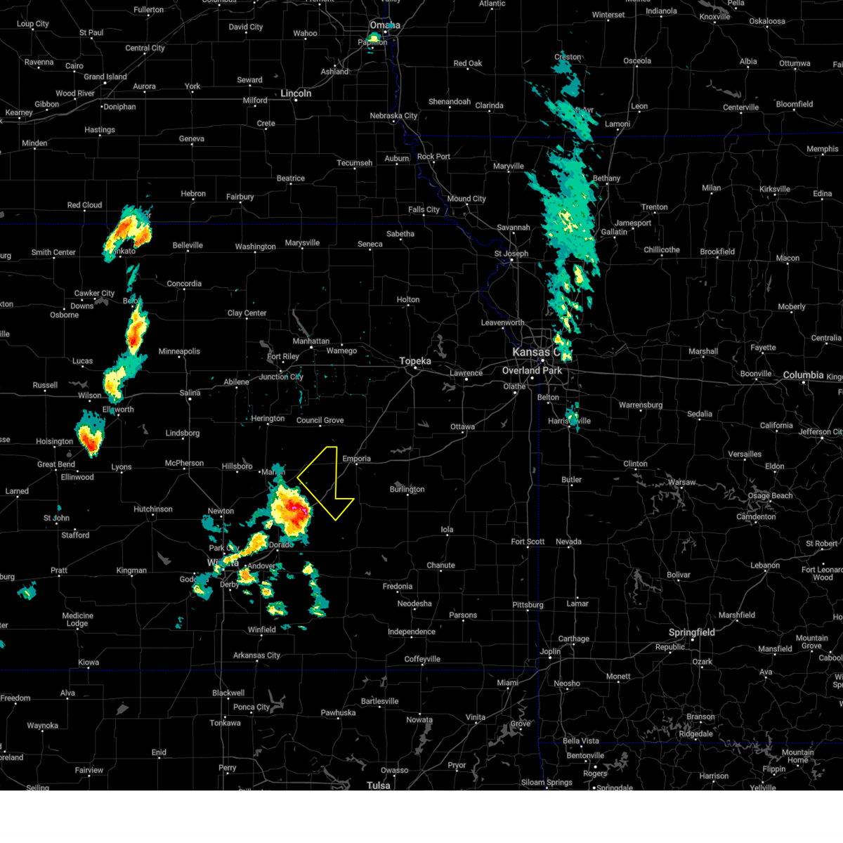 At 526 pm cdt, severe thunderstorms were located along a line extending from 10 miles northeast of burns to 18 miles southeast of florence to 15 miles northeast of el dorado, moving northeast at 40 mph (radar indicated). Hazards include 60 mph wind gusts and quarter size hail. Hail damage to vehicles is expected. Expect wind damage to roofs, siding, and trees. At 526 pm cdt, severe thunderstorms were located along a line extending from 10 miles northeast of burns to 18 miles southeast of florence to 15 miles northeast of el dorado, moving northeast at 40 mph (radar indicated). Hazards include 60 mph wind gusts and quarter size hail. Hail damage to vehicles is expected. Expect wind damage to roofs, siding, and trees.
|
| 6/11/2022 9:20 PM CDT | Storm damage reported in chase county KS, 7.6 miles N of Cottonwood Falls, KS |
| 6/11/2022 9:14 PM CDT |
 At 913 pm cdt, severe thunderstorms were located along a line extending from 7 miles southwest of olpe to 12 miles south of cottonwood falls to 5 miles east of florence, moving south at 50 mph (radar indicated). Hazards include 60 mph wind gusts and half dollar size hail. Hail damage to vehicles is expected. Expect wind damage to roofs, siding, and trees. At 913 pm cdt, severe thunderstorms were located along a line extending from 7 miles southwest of olpe to 12 miles south of cottonwood falls to 5 miles east of florence, moving south at 50 mph (radar indicated). Hazards include 60 mph wind gusts and half dollar size hail. Hail damage to vehicles is expected. Expect wind damage to roofs, siding, and trees.
|
| 6/11/2022 8:58 PM CDT |
 At 858 pm cdt, severe thunderstorms were located along a line extending from 7 miles southwest of americus to 7 miles west of cottonwood falls to 5 miles southwest of lincolnville, moving south at 30 mph (radar indicated). Hazards include 70 mph wind gusts and half dollar size hail. Hail damage to vehicles is expected. expect considerable tree damage. wind damage is also likely to mobile homes, roofs, and outbuildings. Locations impacted include, marion, cottonwood falls, strong city, florence, burns, lincolnville, bazaar, lost springs, elmdale, matfield green, cedar point, hymer, wonsevu, tallgrass prairie, saffordville and tallgrass prairie preserve. At 858 pm cdt, severe thunderstorms were located along a line extending from 7 miles southwest of americus to 7 miles west of cottonwood falls to 5 miles southwest of lincolnville, moving south at 30 mph (radar indicated). Hazards include 70 mph wind gusts and half dollar size hail. Hail damage to vehicles is expected. expect considerable tree damage. wind damage is also likely to mobile homes, roofs, and outbuildings. Locations impacted include, marion, cottonwood falls, strong city, florence, burns, lincolnville, bazaar, lost springs, elmdale, matfield green, cedar point, hymer, wonsevu, tallgrass prairie, saffordville and tallgrass prairie preserve.
|
| 6/11/2022 8:28 PM CDT |
 At 827 pm cdt, severe thunderstorms were located along a line extending from dunlap to 9 miles northwest of strong city to ramona, moving south at 40 mph (radar indicated). Hazards include 70 mph wind gusts and ping pong ball size hail. People and animals outdoors will be injured. expect hail damage to roofs, siding, windows, and vehicles. expect considerable tree damage. wind damage is also likely to mobile homes, roofs, and outbuildings. locations impacted include, marion, cottonwood falls, strong city, florence, burns, lincolnville, bazaar, lost springs, elmdale, matfield green, cedar point, hymer, wonsevu, tallgrass prairie, saffordville and tallgrass prairie preserve. thunderstorm damage threat, considerable hail threat, radar indicated max hail size, 1. 50 in wind threat, radar indicated max wind gust, 70 mph. At 827 pm cdt, severe thunderstorms were located along a line extending from dunlap to 9 miles northwest of strong city to ramona, moving south at 40 mph (radar indicated). Hazards include 70 mph wind gusts and ping pong ball size hail. People and animals outdoors will be injured. expect hail damage to roofs, siding, windows, and vehicles. expect considerable tree damage. wind damage is also likely to mobile homes, roofs, and outbuildings. locations impacted include, marion, cottonwood falls, strong city, florence, burns, lincolnville, bazaar, lost springs, elmdale, matfield green, cedar point, hymer, wonsevu, tallgrass prairie, saffordville and tallgrass prairie preserve. thunderstorm damage threat, considerable hail threat, radar indicated max hail size, 1. 50 in wind threat, radar indicated max wind gust, 70 mph.
|
| 6/11/2022 8:09 PM CDT |
 At 809 pm cdt, severe thunderstorms were located along a line extending from 9 miles northwest of bushong to wilsey to near woodbine, moving south at 45 mph (radar indicated). Hazards include 70 mph wind gusts and ping pong ball size hail. People and animals outdoors will be injured. expect hail damage to roofs, siding, windows, and vehicles. expect considerable tree damage. Wind damage is also likely to mobile homes, roofs, and outbuildings. At 809 pm cdt, severe thunderstorms were located along a line extending from 9 miles northwest of bushong to wilsey to near woodbine, moving south at 45 mph (radar indicated). Hazards include 70 mph wind gusts and ping pong ball size hail. People and animals outdoors will be injured. expect hail damage to roofs, siding, windows, and vehicles. expect considerable tree damage. Wind damage is also likely to mobile homes, roofs, and outbuildings.
|
| 5/31/2022 7:04 PM CDT |
 At 703 pm cdt, a severe thunderstorm was located 13 miles northeast of burns, or 14 miles southwest of cottonwood falls, moving northeast at 35 mph (radar indicated). Hazards include quarter size hail. damage to vehicles is expected At 703 pm cdt, a severe thunderstorm was located 13 miles northeast of burns, or 14 miles southwest of cottonwood falls, moving northeast at 35 mph (radar indicated). Hazards include quarter size hail. damage to vehicles is expected
|
| 5/31/2022 6:40 PM CDT |
 At 639 pm cdt, a severe thunderstorm was located 11 miles southeast of cottonwood falls, moving north to northeast at 35 mph (radar indicated). Hazards include ping pong ball size hail and 60 mph wind gusts. People and animals outdoors will be injured. expect hail damage to roofs, siding, windows, and vehicles. expect wind damage to roofs, siding, and trees. locations impacted include, el dorado, towanda, cottonwood falls, benton, whitewater, strong city, potwin, elbing, burns, rosalia, cassoday, bazaar, elmdale, matfield green, cedar point, el dorado state park, wonsevu, tallgrass prairie, el dorado lake and saffordville. hail threat, radar indicated max hail size, 1. 50 in wind threat, radar indicated max wind gust, 60 mph. At 639 pm cdt, a severe thunderstorm was located 11 miles southeast of cottonwood falls, moving north to northeast at 35 mph (radar indicated). Hazards include ping pong ball size hail and 60 mph wind gusts. People and animals outdoors will be injured. expect hail damage to roofs, siding, windows, and vehicles. expect wind damage to roofs, siding, and trees. locations impacted include, el dorado, towanda, cottonwood falls, benton, whitewater, strong city, potwin, elbing, burns, rosalia, cassoday, bazaar, elmdale, matfield green, cedar point, el dorado state park, wonsevu, tallgrass prairie, el dorado lake and saffordville. hail threat, radar indicated max hail size, 1. 50 in wind threat, radar indicated max wind gust, 60 mph.
|
| 5/31/2022 6:18 PM CDT |
 At 618 pm cdt, a severe thunderstorm was located just west of el dorado, moving northeast at 35 mph (radar indicated). Hazards include ping pong ball size hail and 60 mph wind gusts. People and animals outdoors will be injured. expect hail damage to roofs, siding, windows, and vehicles. expect wind damage to roofs, siding, and trees. locations impacted include, el dorado, andover, augusta, rose hill, douglass, towanda, cottonwood falls, benton, whitewater, leon, strong city, potwin, elbing, burns, latham, rosalia, cassoday, bazaar, elmdale and matfield green. hail threat, radar indicated max hail size, 1. 50 in wind threat, radar indicated max wind gust, 60 mph. At 618 pm cdt, a severe thunderstorm was located just west of el dorado, moving northeast at 35 mph (radar indicated). Hazards include ping pong ball size hail and 60 mph wind gusts. People and animals outdoors will be injured. expect hail damage to roofs, siding, windows, and vehicles. expect wind damage to roofs, siding, and trees. locations impacted include, el dorado, andover, augusta, rose hill, douglass, towanda, cottonwood falls, benton, whitewater, leon, strong city, potwin, elbing, burns, latham, rosalia, cassoday, bazaar, elmdale and matfield green. hail threat, radar indicated max hail size, 1. 50 in wind threat, radar indicated max wind gust, 60 mph.
|
| 5/31/2022 5:57 PM CDT |
 At 557 pm cdt, a severe thunderstorm was located 13 miles northeast of el dorado, moving northeast at 35 mph (radar indicated). Hazards include 60 mph wind gusts and quarter size hail. Hail damage to vehicles is expected. Expect wind damage to roofs, siding, and trees. At 557 pm cdt, a severe thunderstorm was located 13 miles northeast of el dorado, moving northeast at 35 mph (radar indicated). Hazards include 60 mph wind gusts and quarter size hail. Hail damage to vehicles is expected. Expect wind damage to roofs, siding, and trees.
|
| 5/30/2022 7:37 PM CDT |
 At 736 pm cdt, a severe thunderstorm was located 8 miles southeast of cottonwood falls, moving northeast at 30 mph. this warning replaces the previous warning in effect for the area (radar indicated). Hazards include 60 mph wind gusts and quarter size hail. Hail damage to vehicles is expected. Expect wind damage to roofs, siding, and trees. At 736 pm cdt, a severe thunderstorm was located 8 miles southeast of cottonwood falls, moving northeast at 30 mph. this warning replaces the previous warning in effect for the area (radar indicated). Hazards include 60 mph wind gusts and quarter size hail. Hail damage to vehicles is expected. Expect wind damage to roofs, siding, and trees.
|
| 5/30/2022 7:20 PM CDT |
 At 720 pm cdt, a severe thunderstorm was located 9 miles south of cottonwood falls, moving northeast at 30 mph (radar indicated). Hazards include 60 mph wind gusts and quarter size hail. Hail damage to vehicles is expected. expect wind damage to roofs, siding, and trees. locations impacted include, cottonwood falls, strong city, bazaar, elmdale, matfield green, saffordville, wonsevu, tallgrass prairie and tallgrass prairie preserve. hail threat, radar indicated max hail size, 1. 00 in wind threat, radar indicated max wind gust, 60 mph. At 720 pm cdt, a severe thunderstorm was located 9 miles south of cottonwood falls, moving northeast at 30 mph (radar indicated). Hazards include 60 mph wind gusts and quarter size hail. Hail damage to vehicles is expected. expect wind damage to roofs, siding, and trees. locations impacted include, cottonwood falls, strong city, bazaar, elmdale, matfield green, saffordville, wonsevu, tallgrass prairie and tallgrass prairie preserve. hail threat, radar indicated max hail size, 1. 00 in wind threat, radar indicated max wind gust, 60 mph.
|
| 5/30/2022 6:59 PM CDT |
 At 657 pm cdt, severe thunderstorms were located along a line extending from 7 miles east of strong city to near burns, moving northeast at 30 mph (radar indicated). Hazards include 60 mph wind gusts and quarter size hail. Hail damage to vehicles is expected. expect wind damage to roofs, siding, and trees. locations impacted include, cottonwood falls, strong city, florence, burns, bazaar, elmdale, matfield green, cedar point, saffordville, wonsevu, tallgrass prairie and tallgrass prairie preserve. hail threat, radar indicated max hail size, 1. 00 in wind threat, radar indicated max wind gust, 60 mph. At 657 pm cdt, severe thunderstorms were located along a line extending from 7 miles east of strong city to near burns, moving northeast at 30 mph (radar indicated). Hazards include 60 mph wind gusts and quarter size hail. Hail damage to vehicles is expected. expect wind damage to roofs, siding, and trees. locations impacted include, cottonwood falls, strong city, florence, burns, bazaar, elmdale, matfield green, cedar point, saffordville, wonsevu, tallgrass prairie and tallgrass prairie preserve. hail threat, radar indicated max hail size, 1. 00 in wind threat, radar indicated max wind gust, 60 mph.
|
| 5/30/2022 6:40 PM CDT | Quarter sized hail reported 0.1 miles W of Cottonwood Falls, KS, 60 to 70 mph winds occurred with the hail. tree limbs down. |
| 5/30/2022 6:40 PM CDT | Quarter size hail occurred with the win in chase county KS, 0.1 miles W of Cottonwood Falls, KS |
| 5/30/2022 6:39 PM CDT |
 At 638 pm cdt, severe thunderstorms were located along a line extending from cottonwood falls to near elbing, moving northeast at 30 mph. this warning replaces the previous warning that was in effect for the area (radar indicated). Hazards include 70 mph wind gusts and ping pong ball size hail. People and animals outdoors will be injured. expect hail damage to roofs, siding, windows, and vehicles. expect considerable tree damage. Wind damage is also likely to mobile homes, roofs, and outbuildings. At 638 pm cdt, severe thunderstorms were located along a line extending from cottonwood falls to near elbing, moving northeast at 30 mph. this warning replaces the previous warning that was in effect for the area (radar indicated). Hazards include 70 mph wind gusts and ping pong ball size hail. People and animals outdoors will be injured. expect hail damage to roofs, siding, windows, and vehicles. expect considerable tree damage. Wind damage is also likely to mobile homes, roofs, and outbuildings.
|
| 5/30/2022 6:30 PM CDT |
 At 629 pm cdt, severe thunderstorms were located along a line extending from 5 miles north of strong city to 6 miles east of elbing, moving northeast at 55 mph (radar indicated). Hazards include 60 mph wind gusts and quarter size hail. Hail damage to vehicles is expected. expect wind damage to roofs, siding, and trees. locations impacted include, marion, peabody, cottonwood falls, whitewater, strong city, florence, elbing, burns, bazaar, elmdale, cedar point, newton airport, hymer, wonsevu, tallgrass prairie and tallgrass prairie preserve. hail threat, radar indicated max hail size, 1. 00 in wind threat, radar indicated max wind gust, 60 mph. At 629 pm cdt, severe thunderstorms were located along a line extending from 5 miles north of strong city to 6 miles east of elbing, moving northeast at 55 mph (radar indicated). Hazards include 60 mph wind gusts and quarter size hail. Hail damage to vehicles is expected. expect wind damage to roofs, siding, and trees. locations impacted include, marion, peabody, cottonwood falls, whitewater, strong city, florence, elbing, burns, bazaar, elmdale, cedar point, newton airport, hymer, wonsevu, tallgrass prairie and tallgrass prairie preserve. hail threat, radar indicated max hail size, 1. 00 in wind threat, radar indicated max wind gust, 60 mph.
|
| 5/30/2022 6:19 PM CDT |
 At 618 pm cdt, severe thunderstorms were located along a line extending from near strong city to whitewater, moving northeast at 40 mph (radar indicated). Hazards include 60 mph wind gusts and quarter size hail. Hail damage to vehicles is expected. expect wind damage to roofs, siding, and trees. locations impacted include, newton, park city, valley center, marion, north newton, sedgwick, peabody, cottonwood falls, whitewater, strong city, florence, bentley, potwin, walton, elbing, burns, lincolnville, bazaar, elmdale and cedar point. hail threat, radar indicated max hail size, 1. 00 in wind threat, radar indicated max wind gust, 60 mph. At 618 pm cdt, severe thunderstorms were located along a line extending from near strong city to whitewater, moving northeast at 40 mph (radar indicated). Hazards include 60 mph wind gusts and quarter size hail. Hail damage to vehicles is expected. expect wind damage to roofs, siding, and trees. locations impacted include, newton, park city, valley center, marion, north newton, sedgwick, peabody, cottonwood falls, whitewater, strong city, florence, bentley, potwin, walton, elbing, burns, lincolnville, bazaar, elmdale and cedar point. hail threat, radar indicated max hail size, 1. 00 in wind threat, radar indicated max wind gust, 60 mph.
|
| 5/30/2022 5:55 PM CDT |
 At 555 pm cdt, severe thunderstorms were located along a line extending from near florence to near valley center, moving northeast at 55 mph (radar indicated). Hazards include 60 mph wind gusts and quarter size hail. Hail damage to vehicles is expected. expect wind damage to roofs, siding, and trees. locations impacted include, wichita, newton, park city, valley center, bel aire, maize, marion, north newton, sedgwick, colwich, peabody, cottonwood falls, whitewater, strong city, florence, kechi, andale, bentley, potwin and walton. hail threat, radar indicated max hail size, 1. 00 in wind threat, radar indicated max wind gust, 60 mph. At 555 pm cdt, severe thunderstorms were located along a line extending from near florence to near valley center, moving northeast at 55 mph (radar indicated). Hazards include 60 mph wind gusts and quarter size hail. Hail damage to vehicles is expected. expect wind damage to roofs, siding, and trees. locations impacted include, wichita, newton, park city, valley center, bel aire, maize, marion, north newton, sedgwick, colwich, peabody, cottonwood falls, whitewater, strong city, florence, kechi, andale, bentley, potwin and walton. hail threat, radar indicated max hail size, 1. 00 in wind threat, radar indicated max wind gust, 60 mph.
|
| 5/30/2022 5:42 PM CDT |
 At 542 pm cdt, severe thunderstorms were located along a line extending from near peabody to colwich, moving northeast at 55 mph (radar indicated). Hazards include 60 mph wind gusts and quarter size hail. Hail damage to vehicles is expected. Expect wind damage to roofs, siding, and trees. At 542 pm cdt, severe thunderstorms were located along a line extending from near peabody to colwich, moving northeast at 55 mph (radar indicated). Hazards include 60 mph wind gusts and quarter size hail. Hail damage to vehicles is expected. Expect wind damage to roofs, siding, and trees.
|
| 5/17/2022 11:53 PM CDT |
 At 1153 pm cdt, a severe thunderstorm was located over strong city, moving east at 35 mph (radar indicated). Hazards include 60 mph wind gusts and penny size hail. Expect damage to roofs, siding, and trees. locations impacted include, cottonwood falls, strong city, bazaar, matfield green, saffordville, tallgrass prairie and tallgrass prairie preserve. hail threat, radar indicated max hail size, 0. 75 in wind threat, radar indicated max wind gust, 60 mph. At 1153 pm cdt, a severe thunderstorm was located over strong city, moving east at 35 mph (radar indicated). Hazards include 60 mph wind gusts and penny size hail. Expect damage to roofs, siding, and trees. locations impacted include, cottonwood falls, strong city, bazaar, matfield green, saffordville, tallgrass prairie and tallgrass prairie preserve. hail threat, radar indicated max hail size, 0. 75 in wind threat, radar indicated max wind gust, 60 mph.
|
| 5/17/2022 11:40 PM CDT |
 At 1140 pm cdt, a severe thunderstorm was located 8 miles west of cottonwood falls, moving east at 35 mph (radar indicated). Hazards include 60 mph wind gusts and nickel size hail. expect damage to roofs, siding, and trees At 1140 pm cdt, a severe thunderstorm was located 8 miles west of cottonwood falls, moving east at 35 mph (radar indicated). Hazards include 60 mph wind gusts and nickel size hail. expect damage to roofs, siding, and trees
|
| 4/29/2022 9:30 PM CDT | Delayed report. semi truck flipped over on the kansas turnpike. time estimated from rada in chase county KS, 12 miles NW of Cottonwood Falls, KS |
| 4/29/2022 9:19 PM CDT |
 At 918 pm cdt, severe thunderstorms were located along a line extending from strong city to near el dorado, moving east at 30 mph (radar indicated). Hazards include 60 mph wind gusts and penny size hail. Expect damage to roofs, siding, and trees. locations impacted include, cottonwood falls, strong city, potwin, burns, cassoday, bazaar, elmdale, matfield green, cedar point, hymer, wonsevu, tallgrass prairie, saffordville and tallgrass prairie preserve. hail threat, radar indicated max hail size, 0. 75 in wind threat, radar indicated max wind gust, 60 mph. At 918 pm cdt, severe thunderstorms were located along a line extending from strong city to near el dorado, moving east at 30 mph (radar indicated). Hazards include 60 mph wind gusts and penny size hail. Expect damage to roofs, siding, and trees. locations impacted include, cottonwood falls, strong city, potwin, burns, cassoday, bazaar, elmdale, matfield green, cedar point, hymer, wonsevu, tallgrass prairie, saffordville and tallgrass prairie preserve. hail threat, radar indicated max hail size, 0. 75 in wind threat, radar indicated max wind gust, 60 mph.
|
| 4/29/2022 8:53 PM CDT |
 At 852 pm cdt, severe thunderstorms were located along a line extending from 7 miles southeast of burdick to potwin, moving southeast at 30 mph (radar indicated). Hazards include 60 mph wind gusts and quarter size hail. Hail damage to vehicles is expected. Expect wind damage to roofs, siding, and trees. At 852 pm cdt, severe thunderstorms were located along a line extending from 7 miles southeast of burdick to potwin, moving southeast at 30 mph (radar indicated). Hazards include 60 mph wind gusts and quarter size hail. Hail damage to vehicles is expected. Expect wind damage to roofs, siding, and trees.
|
| 4/29/2022 8:21 PM CDT |
 At 820 pm cdt, a severe thunderstorm was located 6 miles south of cottonwood falls, moving northeast at 35 mph (radar indicated). Hazards include 60 mph wind gusts and quarter size hail. Hail damage to vehicles is expected. Expect wind damage to roofs, siding, and trees. At 820 pm cdt, a severe thunderstorm was located 6 miles south of cottonwood falls, moving northeast at 35 mph (radar indicated). Hazards include 60 mph wind gusts and quarter size hail. Hail damage to vehicles is expected. Expect wind damage to roofs, siding, and trees.
|
| 4/29/2022 7:37 PM CDT |
 At 737 pm cdt, a severe thunderstorm was located 8 miles west of strong city, moving northeast at 60 mph (radar indicated). Hazards include 60 mph wind gusts and quarter size hail. Hail damage to vehicles is expected. expect wind damage to roofs, siding, and trees. locations impacted include, cottonwood falls, strong city, florence, elmdale, cedar point, hymer, tallgrass prairie and tallgrass prairie preserve. hail threat, radar indicated max hail size, 1. 00 in wind threat, radar indicated max wind gust, 60 mph. At 737 pm cdt, a severe thunderstorm was located 8 miles west of strong city, moving northeast at 60 mph (radar indicated). Hazards include 60 mph wind gusts and quarter size hail. Hail damage to vehicles is expected. expect wind damage to roofs, siding, and trees. locations impacted include, cottonwood falls, strong city, florence, elmdale, cedar point, hymer, tallgrass prairie and tallgrass prairie preserve. hail threat, radar indicated max hail size, 1. 00 in wind threat, radar indicated max wind gust, 60 mph.
|
| 4/29/2022 7:23 PM CDT |
 At 723 pm cdt, a severe thunderstorm was located over florence, moving northeast at 45 mph (radar indicated). Hazards include 60 mph wind gusts and quarter size hail. Hail damage to vehicles is expected. Expect wind damage to roofs, siding, and trees. At 723 pm cdt, a severe thunderstorm was located over florence, moving northeast at 45 mph (radar indicated). Hazards include 60 mph wind gusts and quarter size hail. Hail damage to vehicles is expected. Expect wind damage to roofs, siding, and trees.
|
| 4/23/2022 7:22 PM CDT |
 At 721 pm cdt, a severe thunderstorm was located near strong city, moving northeast at 30 mph (radar indicated). Hazards include 60 mph wind gusts and quarter size hail. Hail damage to vehicles is expected. Expect wind damage to roofs, siding, and trees. At 721 pm cdt, a severe thunderstorm was located near strong city, moving northeast at 30 mph (radar indicated). Hazards include 60 mph wind gusts and quarter size hail. Hail damage to vehicles is expected. Expect wind damage to roofs, siding, and trees.
|
| 3/29/2022 7:36 PM CDT | 1 inch and larger tree limbs downed by thunderstorm wind gus in chase county KS, 3.4 miles N of Cottonwood Falls, KS |
| 3/29/2022 7:34 PM CDT |
 At 733 pm cdt, a severe thunderstorm was located 8 miles southwest of cottonwood falls, moving northeast at 55 mph (radar indicated). Hazards include 60 mph wind gusts and penny size hail. Expect damage to roofs, siding, and trees. locations impacted include, cottonwood falls, strong city, bazaar, elmdale, hymer, saffordville, tallgrass prairie and tallgrass prairie preserve. hail threat, radar indicated max hail size, 0. 75 in wind threat, radar indicated max wind gust, 60 mph. At 733 pm cdt, a severe thunderstorm was located 8 miles southwest of cottonwood falls, moving northeast at 55 mph (radar indicated). Hazards include 60 mph wind gusts and penny size hail. Expect damage to roofs, siding, and trees. locations impacted include, cottonwood falls, strong city, bazaar, elmdale, hymer, saffordville, tallgrass prairie and tallgrass prairie preserve. hail threat, radar indicated max hail size, 0. 75 in wind threat, radar indicated max wind gust, 60 mph.
|
| 3/29/2022 7:16 PM CDT |
 At 715 pm cdt, a severe thunderstorm was located 6 miles south of florence, moving northeast at 50 mph (radar indicated). Hazards include 60 mph wind gusts and penny size hail. expect damage to roofs, siding, and trees At 715 pm cdt, a severe thunderstorm was located 6 miles south of florence, moving northeast at 50 mph (radar indicated). Hazards include 60 mph wind gusts and penny size hail. expect damage to roofs, siding, and trees
|
| 10/10/2021 6:50 PM CDT |
 The severe thunderstorm warning for eastern chase county will expire at 700 pm cdt, the storms which prompted the warning have moved out of the area. therefore, the warning will be allowed to expire. The severe thunderstorm warning for eastern chase county will expire at 700 pm cdt, the storms which prompted the warning have moved out of the area. therefore, the warning will be allowed to expire.
|
| 10/10/2021 6:36 PM CDT |
 At 636 pm cdt, severe thunderstorms were located along a line extending from 6 miles northwest of strong city to 5 miles east of cottonwood falls to 16 miles west of madison, moving northeast at 60 mph (radar indicated). Hazards include 60 mph wind gusts and quarter size hail. Hail damage to vehicles is expected. expect wind damage to roofs, siding, and trees. locations impacted include, cottonwood falls, strong city, bazaar, hymer, saffordville, tallgrass prairie and tallgrass prairie preserve. hail threat, radar indicated max hail size, 1. 00 in wind threat, radar indicated max wind gust, 60 mph. At 636 pm cdt, severe thunderstorms were located along a line extending from 6 miles northwest of strong city to 5 miles east of cottonwood falls to 16 miles west of madison, moving northeast at 60 mph (radar indicated). Hazards include 60 mph wind gusts and quarter size hail. Hail damage to vehicles is expected. expect wind damage to roofs, siding, and trees. locations impacted include, cottonwood falls, strong city, bazaar, hymer, saffordville, tallgrass prairie and tallgrass prairie preserve. hail threat, radar indicated max hail size, 1. 00 in wind threat, radar indicated max wind gust, 60 mph.
|
| 10/10/2021 6:21 PM CDT |
 At 621 pm cdt, severe thunderstorms were located along a line extending from 11 miles northeast of florence to 11 miles south of cottonwood falls to 17 miles southeast of burns, moving northeast at 60 mph (radar indicated). Hazards include 60 mph wind gusts and quarter size hail. Hail damage to vehicles is expected. expect wind damage to roofs, siding, and trees. locations impacted include, cottonwood falls, strong city, cassoday, bazaar, elmdale, matfield green, cedar point, hymer, saffordville, wonsevu, tallgrass prairie and tallgrass prairie preserve. hail threat, radar indicated max hail size, 1. 00 in wind threat, radar indicated max wind gust, 60 mph. At 621 pm cdt, severe thunderstorms were located along a line extending from 11 miles northeast of florence to 11 miles south of cottonwood falls to 17 miles southeast of burns, moving northeast at 60 mph (radar indicated). Hazards include 60 mph wind gusts and quarter size hail. Hail damage to vehicles is expected. expect wind damage to roofs, siding, and trees. locations impacted include, cottonwood falls, strong city, cassoday, bazaar, elmdale, matfield green, cedar point, hymer, saffordville, wonsevu, tallgrass prairie and tallgrass prairie preserve. hail threat, radar indicated max hail size, 1. 00 in wind threat, radar indicated max wind gust, 60 mph.
|
| 10/10/2021 6:07 PM CDT |
 At 607 pm cdt, severe thunderstorms were located along a line extending from near florence to 7 miles east of burns to 5 miles east of el dorado, moving northeast at 60 mph (radar indicated). Hazards include 60 mph wind gusts and quarter size hail. Hail damage to vehicles is expected. expect wind damage to roofs, siding, and trees. locations impacted include, cottonwood falls, strong city, florence, burns, cassoday, bazaar, elmdale, matfield green, cedar point, el dorado state park, hymer, wonsevu, tallgrass prairie, el dorado lake, saffordville and tallgrass prairie preserve. hail threat, radar indicated max hail size, 1. 00 in wind threat, radar indicated max wind gust, 60 mph. At 607 pm cdt, severe thunderstorms were located along a line extending from near florence to 7 miles east of burns to 5 miles east of el dorado, moving northeast at 60 mph (radar indicated). Hazards include 60 mph wind gusts and quarter size hail. Hail damage to vehicles is expected. expect wind damage to roofs, siding, and trees. locations impacted include, cottonwood falls, strong city, florence, burns, cassoday, bazaar, elmdale, matfield green, cedar point, el dorado state park, hymer, wonsevu, tallgrass prairie, el dorado lake, saffordville and tallgrass prairie preserve. hail threat, radar indicated max hail size, 1. 00 in wind threat, radar indicated max wind gust, 60 mph.
|
| 10/10/2021 5:55 PM CDT |
 At 555 pm cdt, severe thunderstorms were located along a line extending from 5 miles northeast of elbing to 7 miles east of potwin to 5 miles northwest of leon, moving northeast at 60 mph (radar indicated). Hazards include 60 mph wind gusts and quarter size hail. Hail damage to vehicles is expected. Expect wind damage to roofs, siding, and trees. At 555 pm cdt, severe thunderstorms were located along a line extending from 5 miles northeast of elbing to 7 miles east of potwin to 5 miles northwest of leon, moving northeast at 60 mph (radar indicated). Hazards include 60 mph wind gusts and quarter size hail. Hail damage to vehicles is expected. Expect wind damage to roofs, siding, and trees.
|
| 8/20/2021 9:25 PM CDT |
 The severe thunderstorm warning for southern mcpherson, northwestern chase and marion counties will expire at 930 pm cdt, the storms which prompted the warning have weakened below severe limits, and have exited the warned area. therefore, the warning will be allowed to expire. however very small hail, gusty winds and heavy rain are still possible with these thunderstorms. The severe thunderstorm warning for southern mcpherson, northwestern chase and marion counties will expire at 930 pm cdt, the storms which prompted the warning have weakened below severe limits, and have exited the warned area. therefore, the warning will be allowed to expire. however very small hail, gusty winds and heavy rain are still possible with these thunderstorms.
|
| 8/20/2021 8:41 PM CDT |
 At 839 pm cdt, severe thunderstorms were located along a line extending from 5 miles south of burdick to near moundridge, moving east at 25 mph. the strongest storms were located across southern mcpherson county, and also over far northeast marion county (radar indicated). Hazards include 60 mph wind gusts and quarter size hail. Hail damage to vehicles is expected. expect wind damage to roofs, siding, and trees. locations impacted include, mcpherson, hillsboro, marion, moundridge, inman, peabody, cottonwood falls, galva, canton, strong city, florence, goessel, lincolnville, lehigh, elmdale, cedar point, hymer, marion lake, tallgrass prairie and pilsen. hail threat, radar indicated max hail size, 1. 00 in wind threat, radar indicated max wind gust, 60 mph. At 839 pm cdt, severe thunderstorms were located along a line extending from 5 miles south of burdick to near moundridge, moving east at 25 mph. the strongest storms were located across southern mcpherson county, and also over far northeast marion county (radar indicated). Hazards include 60 mph wind gusts and quarter size hail. Hail damage to vehicles is expected. expect wind damage to roofs, siding, and trees. locations impacted include, mcpherson, hillsboro, marion, moundridge, inman, peabody, cottonwood falls, galva, canton, strong city, florence, goessel, lincolnville, lehigh, elmdale, cedar point, hymer, marion lake, tallgrass prairie and pilsen. hail threat, radar indicated max hail size, 1. 00 in wind threat, radar indicated max wind gust, 60 mph.
|
| 8/20/2021 8:22 PM CDT |
 At 822 pm cdt, severe thunderstorms were located along a line extending from near burdick to near inman, moving east at 25 mph (radar indicated). Hazards include 60 mph wind gusts and quarter size hail. Hail damage to vehicles is expected. Expect wind damage to roofs, siding, and trees. At 822 pm cdt, severe thunderstorms were located along a line extending from near burdick to near inman, moving east at 25 mph (radar indicated). Hazards include 60 mph wind gusts and quarter size hail. Hail damage to vehicles is expected. Expect wind damage to roofs, siding, and trees.
|
| 6/25/2021 8:35 PM CDT |
 At 835 pm cdt, severe thunderstorms were located along a line extending from near hillsboro to 6 miles northeast of burns to 16 miles northeast of el dorado, moving northeast at 45 mph (radar indicated). Hazards include 60 mph wind gusts and penny size hail. expect damage to roofs, siding, and trees At 835 pm cdt, severe thunderstorms were located along a line extending from near hillsboro to 6 miles northeast of burns to 16 miles northeast of el dorado, moving northeast at 45 mph (radar indicated). Hazards include 60 mph wind gusts and penny size hail. expect damage to roofs, siding, and trees
|
| 6/25/2021 2:37 PM CDT |
 The severe thunderstorm warning for central chase county will expire at 245 pm cdt, the storms which prompted the warning have weakened below severe limits, and no longer pose an immediate threat to life or property. therefore, the warning will be allowed to expire. however gusty winds up to 50 mph and heavy rain are still possible with these thunderstorms. a severe thunderstorm watch remains in effect until 900 pm cdt for central and east central kansas. The severe thunderstorm warning for central chase county will expire at 245 pm cdt, the storms which prompted the warning have weakened below severe limits, and no longer pose an immediate threat to life or property. therefore, the warning will be allowed to expire. however gusty winds up to 50 mph and heavy rain are still possible with these thunderstorms. a severe thunderstorm watch remains in effect until 900 pm cdt for central and east central kansas.
|
| 6/25/2021 2:19 PM CDT |
 At 219 pm cdt, severe thunderstorms were located along a line extending from 10 miles west of strong city to 6 miles southwest of cottonwood falls, moving northeast at 40 mph (radar indicated). Hazards include 60 mph wind gusts and nickel size hail. Expect damage to roofs, siding, and trees. Locations impacted include, cottonwood falls, strong city, bazaar, elmdale and tallgrass prairie preserve. At 219 pm cdt, severe thunderstorms were located along a line extending from 10 miles west of strong city to 6 miles southwest of cottonwood falls, moving northeast at 40 mph (radar indicated). Hazards include 60 mph wind gusts and nickel size hail. Expect damage to roofs, siding, and trees. Locations impacted include, cottonwood falls, strong city, bazaar, elmdale and tallgrass prairie preserve.
|
| 6/25/2021 2:04 PM CDT |
 At 204 pm cdt, severe thunderstorms were located along a line extending from near florence to 11 miles northeast of burns, moving northeast at 35 mph (radar indicated). Hazards include 60 mph wind gusts and nickel size hail. expect damage to roofs, siding, and trees At 204 pm cdt, severe thunderstorms were located along a line extending from near florence to 11 miles northeast of burns, moving northeast at 35 mph (radar indicated). Hazards include 60 mph wind gusts and nickel size hail. expect damage to roofs, siding, and trees
|
| 4/7/2021 1:35 AM CDT |
 At 134 am cdt, a severe thunderstorm was located just west of marion, moving east at 35 mph (radar indicated). Hazards include 60 mph wind gusts and nickel size hail. expect damage to roofs, siding, and trees At 134 am cdt, a severe thunderstorm was located just west of marion, moving east at 35 mph (radar indicated). Hazards include 60 mph wind gusts and nickel size hail. expect damage to roofs, siding, and trees
|
| 7/15/2020 3:43 AM CDT |
 The severe thunderstorm warning for chase county will expire at 345 am cdt, the storms which prompted the warning have weakened below severe limits, and no longer pose an immediate threat to life or property. therefore, the warning will be allowed to expire. however gusty winds and heavy rain are still possible with these thunderstorms. a severe thunderstorm watch remains in effect until 600 am cdt for east central kansas. The severe thunderstorm warning for chase county will expire at 345 am cdt, the storms which prompted the warning have weakened below severe limits, and no longer pose an immediate threat to life or property. therefore, the warning will be allowed to expire. however gusty winds and heavy rain are still possible with these thunderstorms. a severe thunderstorm watch remains in effect until 600 am cdt for east central kansas.
|
| 7/15/2020 3:18 AM CDT |
 At 317 am cdt, severe thunderstorms were located along a line extending from 7 miles southeast of burdick to 8 miles southwest of cottonwood falls to 9 miles east of burns, moving east at 45 mph (radar indicated). Hazards include 60 mph wind gusts. Expect damage to roofs, siding, and trees. Locations impacted include, cottonwood falls, strong city, bazaar, elmdale, matfield green, cedar point, hymer, saffordville, wonsevu, tallgrass prairie and tallgrass prairie preserve. At 317 am cdt, severe thunderstorms were located along a line extending from 7 miles southeast of burdick to 8 miles southwest of cottonwood falls to 9 miles east of burns, moving east at 45 mph (radar indicated). Hazards include 60 mph wind gusts. Expect damage to roofs, siding, and trees. Locations impacted include, cottonwood falls, strong city, bazaar, elmdale, matfield green, cedar point, hymer, saffordville, wonsevu, tallgrass prairie and tallgrass prairie preserve.
|
| 7/15/2020 2:57 AM CDT |
 At 257 am cdt, a severe thunderstorm was located over florence, moving east at 45 mph (radar indicated). Hazards include 60 mph wind gusts. expect damage to roofs, siding, and trees At 257 am cdt, a severe thunderstorm was located over florence, moving east at 45 mph (radar indicated). Hazards include 60 mph wind gusts. expect damage to roofs, siding, and trees
|
| 5/14/2020 10:18 PM CDT | Quarter sized hail reported 0.1 miles W of Cottonwood Falls, KS, lots of hail. mainly quarters |
| 5/14/2020 10:15 PM CDT |
 At 1015 pm cdt, a severe thunderstorm was located near cottonwood falls, moving east at 25 mph (radar indicated). Hazards include 60 mph wind gusts and quarter size hail. Hail damage to vehicles is expected. expect wind damage to roofs, siding, and trees. Locations impacted include, cottonwood falls, strong city, elmdale, wonsevu, tallgrass prairie and tallgrass prairie preserve. At 1015 pm cdt, a severe thunderstorm was located near cottonwood falls, moving east at 25 mph (radar indicated). Hazards include 60 mph wind gusts and quarter size hail. Hail damage to vehicles is expected. expect wind damage to roofs, siding, and trees. Locations impacted include, cottonwood falls, strong city, elmdale, wonsevu, tallgrass prairie and tallgrass prairie preserve.
|
| 5/14/2020 9:51 PM CDT |
 At 950 pm cdt, a severe thunderstorm was located near cottonwood falls, moving east at 35 mph (radar indicated). Hazards include 60 mph wind gusts and half dollar size hail. Hail damage to vehicles is expected. expect wind damage to roofs, siding, and trees. Locations impacted include, cottonwood falls, strong city, florence, burns, elmdale, cedar point, hymer, wonsevu, tallgrass prairie and tallgrass prairie preserve. At 950 pm cdt, a severe thunderstorm was located near cottonwood falls, moving east at 35 mph (radar indicated). Hazards include 60 mph wind gusts and half dollar size hail. Hail damage to vehicles is expected. expect wind damage to roofs, siding, and trees. Locations impacted include, cottonwood falls, strong city, florence, burns, elmdale, cedar point, hymer, wonsevu, tallgrass prairie and tallgrass prairie preserve.
|
| 5/14/2020 9:25 PM CDT |
 At 924 pm cdt, severe thunderstorms were located along a line extending from 5 miles southeast of burdick to near florence, moving east at 25 mph (radar indicated). Hazards include 60 mph wind gusts and quarter size hail. Hail damage to vehicles is expected. Expect wind damage to roofs, siding, and trees. At 924 pm cdt, severe thunderstorms were located along a line extending from 5 miles southeast of burdick to near florence, moving east at 25 mph (radar indicated). Hazards include 60 mph wind gusts and quarter size hail. Hail damage to vehicles is expected. Expect wind damage to roofs, siding, and trees.
|
| 5/4/2020 10:17 AM CDT |
 At 1016 am cdt, severe thunderstorms were located along a line extending from 5 miles southwest of dunlap to 6 miles east of strong city to near cottonwood falls, moving east at 50 mph (radar indicated). Hazards include ping pong ball size hail and 60 mph wind gusts. People and animals outdoors will be injured. expect hail damage to roofs, siding, windows, and vehicles. expect wind damage to roofs, siding, and trees. Locations impacted include, cottonwood falls, strong city, saffordville, tallgrass prairie and tallgrass prairie preserve. At 1016 am cdt, severe thunderstorms were located along a line extending from 5 miles southwest of dunlap to 6 miles east of strong city to near cottonwood falls, moving east at 50 mph (radar indicated). Hazards include ping pong ball size hail and 60 mph wind gusts. People and animals outdoors will be injured. expect hail damage to roofs, siding, windows, and vehicles. expect wind damage to roofs, siding, and trees. Locations impacted include, cottonwood falls, strong city, saffordville, tallgrass prairie and tallgrass prairie preserve.
|
| 5/4/2020 10:01 AM CDT |
 At 1000 am cdt, severe thunderstorms were located along a line extending from 5 miles east of wilsey to 6 miles northwest of strong city to 8 miles northeast of florence, moving east at 50 mph (radar indicated). Hazards include 60 mph wind gusts and half dollar size hail. Hail damage to vehicles is expected. Expect wind damage to roofs, siding, and trees. At 1000 am cdt, severe thunderstorms were located along a line extending from 5 miles east of wilsey to 6 miles northwest of strong city to 8 miles northeast of florence, moving east at 50 mph (radar indicated). Hazards include 60 mph wind gusts and half dollar size hail. Hail damage to vehicles is expected. Expect wind damage to roofs, siding, and trees.
|
| 5/3/2020 6:26 AM CDT |
 At 626 am cdt, a severe thunderstorm was located 12 miles south of cottonwood falls, moving east at 30 mph (radar indicated). Hazards include ping pong ball size hail. People and animals outdoors will be injured. expect damage to roofs, siding, windows, and vehicles. Locations impacted include, cottonwood falls, strong city, bazaar, elmdale, matfield green, cedar point, hymer, saffordville, wonsevu, tallgrass prairie and tallgrass prairie preserve. At 626 am cdt, a severe thunderstorm was located 12 miles south of cottonwood falls, moving east at 30 mph (radar indicated). Hazards include ping pong ball size hail. People and animals outdoors will be injured. expect damage to roofs, siding, windows, and vehicles. Locations impacted include, cottonwood falls, strong city, bazaar, elmdale, matfield green, cedar point, hymer, saffordville, wonsevu, tallgrass prairie and tallgrass prairie preserve.
|
| 5/3/2020 5:58 AM CDT |
 At 558 am cdt, a severe thunderstorm was located 7 miles east of florence, moving east at 35 mph (radar indicated). Hazards include half dollar size hail. Damage to vehicles is expected. Locations impacted include, hillsboro, marion, peabody, cottonwood falls, strong city, florence, goessel, burns, lincolnville, lehigh, durham, bazaar, elmdale, matfield green, cedar point, hymer, marion lake, wonsevu, tallgrass prairie and pilsen. At 558 am cdt, a severe thunderstorm was located 7 miles east of florence, moving east at 35 mph (radar indicated). Hazards include half dollar size hail. Damage to vehicles is expected. Locations impacted include, hillsboro, marion, peabody, cottonwood falls, strong city, florence, goessel, burns, lincolnville, lehigh, durham, bazaar, elmdale, matfield green, cedar point, hymer, marion lake, wonsevu, tallgrass prairie and pilsen.
|
| 5/3/2020 5:41 AM CDT |
 At 541 am cdt, a severe thunderstorm was located over florence, moving east at 40 mph (radar indicated). Hazards include half dollar size hail. damage to vehicles is expected At 541 am cdt, a severe thunderstorm was located over florence, moving east at 40 mph (radar indicated). Hazards include half dollar size hail. damage to vehicles is expected
|
| 4/11/2020 7:56 PM CDT |
 The severe thunderstorm warning for chase county will expire at 800 pm cdt, the storm which prompted the warning has weakened below severe limits, and no longer poses an immediate threat to life or property. therefore, the warning will be allowed to expire. however small hail, gusty winds, and heavy rain are still possible with this thunderstorm. a severe thunderstorm watch remains in effect until 1100 pm cdt for east central kansas. The severe thunderstorm warning for chase county will expire at 800 pm cdt, the storm which prompted the warning has weakened below severe limits, and no longer poses an immediate threat to life or property. therefore, the warning will be allowed to expire. however small hail, gusty winds, and heavy rain are still possible with this thunderstorm. a severe thunderstorm watch remains in effect until 1100 pm cdt for east central kansas.
|
| 4/11/2020 7:37 PM CDT |
 At 736 pm cdt, a severe thunderstorm was located over cottonwood falls, moving east at 15 mph (radar indicated). Hazards include quarter size hail. Damage to vehicles is expected. Locations impacted include, cottonwood falls, strong city, bazaar, elmdale, matfield green, saffordville, wonsevu, tallgrass prairie and tallgrass prairie preserve. At 736 pm cdt, a severe thunderstorm was located over cottonwood falls, moving east at 15 mph (radar indicated). Hazards include quarter size hail. Damage to vehicles is expected. Locations impacted include, cottonwood falls, strong city, bazaar, elmdale, matfield green, saffordville, wonsevu, tallgrass prairie and tallgrass prairie preserve.
|
| 4/11/2020 7:23 PM CDT |
 At 722 pm cdt, a severe thunderstorm was located just west of cottonwood falls, moving east at 20 mph (radar indicated). Hazards include 60 mph wind gusts and quarter size hail. Hail damage to vehicles is expected. expect wind damage to roofs, siding, and trees. Locations impacted include, cottonwood falls, strong city, burns, bazaar, elmdale, matfield green, hymer, saffordville, wonsevu, tallgrass prairie and tallgrass prairie preserve. At 722 pm cdt, a severe thunderstorm was located just west of cottonwood falls, moving east at 20 mph (radar indicated). Hazards include 60 mph wind gusts and quarter size hail. Hail damage to vehicles is expected. expect wind damage to roofs, siding, and trees. Locations impacted include, cottonwood falls, strong city, burns, bazaar, elmdale, matfield green, hymer, saffordville, wonsevu, tallgrass prairie and tallgrass prairie preserve.
|
| 4/11/2020 7:07 PM CDT |
 At 707 pm cdt, a severe thunderstorm was located 8 miles west of cottonwood falls, moving east at 25 mph (radar indicated). Hazards include two inch hail and 60 mph wind gusts. People and animals outdoors will be injured. expect hail damage to roofs, siding, windows, and vehicles. expect wind damage to roofs, siding, and trees. Locations impacted include, peabody, cottonwood falls, strong city, florence, burns, cassoday, bazaar, elmdale, matfield green, cedar point, hymer, wonsevu, tallgrass prairie, saffordville and tallgrass prairie preserve. At 707 pm cdt, a severe thunderstorm was located 8 miles west of cottonwood falls, moving east at 25 mph (radar indicated). Hazards include two inch hail and 60 mph wind gusts. People and animals outdoors will be injured. expect hail damage to roofs, siding, windows, and vehicles. expect wind damage to roofs, siding, and trees. Locations impacted include, peabody, cottonwood falls, strong city, florence, burns, cassoday, bazaar, elmdale, matfield green, cedar point, hymer, wonsevu, tallgrass prairie, saffordville and tallgrass prairie preserve.
|
| 4/11/2020 6:54 PM CDT |
 At 654 pm cdt, a severe thunderstorm was located 7 miles northeast of florence, moving east at 15 mph (radar indicated). Hazards include golf ball size hail and 60 mph wind gusts. People and animals outdoors will be injured. expect hail damage to roofs, siding, windows, and vehicles. Expect wind damage to roofs, siding, and trees. At 654 pm cdt, a severe thunderstorm was located 7 miles northeast of florence, moving east at 15 mph (radar indicated). Hazards include golf ball size hail and 60 mph wind gusts. People and animals outdoors will be injured. expect hail damage to roofs, siding, windows, and vehicles. Expect wind damage to roofs, siding, and trees.
|
| 4/11/2020 6:38 PM CDT |
 At 638 pm cdt, a severe thunderstorm was located 6 miles northeast of florence, moving east at 15 mph (radar indicated). Hazards include two inch hail and 60 mph wind gusts. People and animals outdoors will be injured. expect hail damage to roofs, siding, windows, and vehicles. expect wind damage to roofs, siding, and trees. Locations impacted include, marion, peabody, cottonwood falls, strong city, florence, burns, lincolnville, bazaar, elmdale, matfield green, cedar point, hymer, marion lake, wonsevu, tallgrass prairie, saffordville and tallgrass prairie preserve. At 638 pm cdt, a severe thunderstorm was located 6 miles northeast of florence, moving east at 15 mph (radar indicated). Hazards include two inch hail and 60 mph wind gusts. People and animals outdoors will be injured. expect hail damage to roofs, siding, windows, and vehicles. expect wind damage to roofs, siding, and trees. Locations impacted include, marion, peabody, cottonwood falls, strong city, florence, burns, lincolnville, bazaar, elmdale, matfield green, cedar point, hymer, marion lake, wonsevu, tallgrass prairie, saffordville and tallgrass prairie preserve.
|
| 4/11/2020 6:24 PM CDT |
 At 623 pm cdt, a severe thunderstorm was located near florence, moving east at 25 mph (radar indicated). Hazards include golf ball size hail and 60 mph wind gusts. People and animals outdoors will be injured. expect hail damage to roofs, siding, windows, and vehicles. expect wind damage to roofs, siding, and trees. Locations impacted include, marion, peabody, cottonwood falls, strong city, florence, burns, lincolnville, bazaar, elmdale, matfield green, cedar point, hymer, marion lake, wonsevu, tallgrass prairie, saffordville and tallgrass prairie preserve. At 623 pm cdt, a severe thunderstorm was located near florence, moving east at 25 mph (radar indicated). Hazards include golf ball size hail and 60 mph wind gusts. People and animals outdoors will be injured. expect hail damage to roofs, siding, windows, and vehicles. expect wind damage to roofs, siding, and trees. Locations impacted include, marion, peabody, cottonwood falls, strong city, florence, burns, lincolnville, bazaar, elmdale, matfield green, cedar point, hymer, marion lake, wonsevu, tallgrass prairie, saffordville and tallgrass prairie preserve.
|
| 4/11/2020 6:11 PM CDT |
 At 610 pm cdt, a severe thunderstorm was located near marion, moving east at 25 mph (radar indicated). Hazards include ping pong ball size hail and 60 mph wind gusts. People and animals outdoors will be injured. expect hail damage to roofs, siding, windows, and vehicles. expect wind damage to roofs, siding, and trees. Locations impacted include, hillsboro, marion, peabody, cottonwood falls, strong city, florence, burns, lincolnville, bazaar, elmdale, matfield green, cedar point, hymer, marion lake, wonsevu, tallgrass prairie, saffordville and tallgrass prairie preserve. At 610 pm cdt, a severe thunderstorm was located near marion, moving east at 25 mph (radar indicated). Hazards include ping pong ball size hail and 60 mph wind gusts. People and animals outdoors will be injured. expect hail damage to roofs, siding, windows, and vehicles. expect wind damage to roofs, siding, and trees. Locations impacted include, hillsboro, marion, peabody, cottonwood falls, strong city, florence, burns, lincolnville, bazaar, elmdale, matfield green, cedar point, hymer, marion lake, wonsevu, tallgrass prairie, saffordville and tallgrass prairie preserve.
|
| 4/11/2020 6:06 PM CDT |
 At 605 pm cdt, a severe thunderstorm was located over marion, moving east at 30 mph (radar indicated). Hazards include 60 mph wind gusts and half dollar size hail. Hail damage to vehicles is expected. expect wind damage to roofs, siding, and trees. Locations impacted include, hillsboro, marion, peabody, cottonwood falls, strong city, florence, burns, lincolnville, bazaar, elmdale, matfield green, cedar point, hymer, marion lake, wonsevu, tallgrass prairie, saffordville and tallgrass prairie preserve. At 605 pm cdt, a severe thunderstorm was located over marion, moving east at 30 mph (radar indicated). Hazards include 60 mph wind gusts and half dollar size hail. Hail damage to vehicles is expected. expect wind damage to roofs, siding, and trees. Locations impacted include, hillsboro, marion, peabody, cottonwood falls, strong city, florence, burns, lincolnville, bazaar, elmdale, matfield green, cedar point, hymer, marion lake, wonsevu, tallgrass prairie, saffordville and tallgrass prairie preserve.
|
| 4/11/2020 5:55 PM CDT |
 At 554 pm cdt, a severe thunderstorm was located over marion, moving east at 30 mph (radar indicated). Hazards include 60 mph wind gusts and half dollar size hail. Hail damage to vehicles is expected. Expect wind damage to roofs, siding, and trees. At 554 pm cdt, a severe thunderstorm was located over marion, moving east at 30 mph (radar indicated). Hazards include 60 mph wind gusts and half dollar size hail. Hail damage to vehicles is expected. Expect wind damage to roofs, siding, and trees.
|
| 1/10/2020 12:16 PM CST |
 At 1212 pm cst, a severe thunderstorm was located near florence, moving northeast at 55 mph (radar indicated). Hazards include 60 mph wind gusts and half dollar size hail. Hail damage to vehicles is expected. Expect wind damage to roofs, siding, and trees. At 1212 pm cst, a severe thunderstorm was located near florence, moving northeast at 55 mph (radar indicated). Hazards include 60 mph wind gusts and half dollar size hail. Hail damage to vehicles is expected. Expect wind damage to roofs, siding, and trees.
|
| 9/27/2019 10:43 PM CDT |
 At 1043 pm cdt, a severe thunderstorm was located 8 miles north of strong city, moving east at 35 mph (radar indicated). Hazards include quarter size hail. Damage to vehicles is expected. Locations impacted include, cottonwood falls, strong city, elmdale, hymer, saffordville, tallgrass prairie and tallgrass prairie preserve. At 1043 pm cdt, a severe thunderstorm was located 8 miles north of strong city, moving east at 35 mph (radar indicated). Hazards include quarter size hail. Damage to vehicles is expected. Locations impacted include, cottonwood falls, strong city, elmdale, hymer, saffordville, tallgrass prairie and tallgrass prairie preserve.
|
| 9/27/2019 10:33 PM CDT |
 At 1032 pm cdt, a severe thunderstorm was located 8 miles southeast of burdick, or 12 miles northwest of strong city, moving east at 35 mph (radar indicated). Hazards include quarter size hail. Damage to vehicles is expected. Locations impacted include, cottonwood falls, strong city, elmdale, hymer, saffordville, tallgrass prairie and tallgrass prairie preserve. At 1032 pm cdt, a severe thunderstorm was located 8 miles southeast of burdick, or 12 miles northwest of strong city, moving east at 35 mph (radar indicated). Hazards include quarter size hail. Damage to vehicles is expected. Locations impacted include, cottonwood falls, strong city, elmdale, hymer, saffordville, tallgrass prairie and tallgrass prairie preserve.
|
| 9/27/2019 10:20 PM CDT |
 At 1020 pm cdt, a severe thunderstorm was located near burdick, or 12 miles southeast of herington, moving east at 35 mph (radar indicated). Hazards include quarter size hail. damage to vehicles is expected At 1020 pm cdt, a severe thunderstorm was located near burdick, or 12 miles southeast of herington, moving east at 35 mph (radar indicated). Hazards include quarter size hail. damage to vehicles is expected
|
| 9/27/2019 8:21 PM CDT |
 At 821 pm cdt, a severe thunderstorm was located over strong city, moving east at 35 mph (radar indicated). Hazards include golf ball size hail and 60 mph wind gusts. People and animals outdoors will be injured. expect hail damage to roofs, siding, windows, and vehicles. expect wind damage to roofs, siding, and trees. Locations impacted include, cottonwood falls, strong city, saffordville, tallgrass prairie and tallgrass prairie preserve. At 821 pm cdt, a severe thunderstorm was located over strong city, moving east at 35 mph (radar indicated). Hazards include golf ball size hail and 60 mph wind gusts. People and animals outdoors will be injured. expect hail damage to roofs, siding, windows, and vehicles. expect wind damage to roofs, siding, and trees. Locations impacted include, cottonwood falls, strong city, saffordville, tallgrass prairie and tallgrass prairie preserve.
|
| 9/27/2019 7:48 PM CDT |
 At 748 pm cdt, a severe thunderstorm was located 6 miles northeast of florence, moving northeast at 30 mph (radar indicated). Hazards include golf ball size hail and 60 mph wind gusts. People and animals outdoors will be injured. expect hail damage to roofs, siding, windows, and vehicles. expect wind damage to roofs, siding, and trees. Locations impacted include, cottonwood falls, strong city, bazaar, elmdale, cedar point, hymer, saffordville, tallgrass prairie and tallgrass prairie preserve. At 748 pm cdt, a severe thunderstorm was located 6 miles northeast of florence, moving northeast at 30 mph (radar indicated). Hazards include golf ball size hail and 60 mph wind gusts. People and animals outdoors will be injured. expect hail damage to roofs, siding, windows, and vehicles. expect wind damage to roofs, siding, and trees. Locations impacted include, cottonwood falls, strong city, bazaar, elmdale, cedar point, hymer, saffordville, tallgrass prairie and tallgrass prairie preserve.
|
| 9/27/2019 7:30 PM CDT |
 At 729 pm cdt, a severe thunderstorm was located over florence, moving east at 30 mph. a second thunderstorm was located 2 miles west of elmdale, moving east at 30 mph (radar indicated). Hazards include golf ball size hail and 60 mph wind gusts. People and animals outdoors will be injured. expect hail damage to roofs, siding, windows, and vehicles. expect wind damage to roofs, siding, and trees. Locations impacted include, marion, cottonwood falls, strong city, florence, bazaar, elmdale, matfield green, cedar point, hymer, wonsevu, tallgrass prairie, saffordville and tallgrass prairie preserve. At 729 pm cdt, a severe thunderstorm was located over florence, moving east at 30 mph. a second thunderstorm was located 2 miles west of elmdale, moving east at 30 mph (radar indicated). Hazards include golf ball size hail and 60 mph wind gusts. People and animals outdoors will be injured. expect hail damage to roofs, siding, windows, and vehicles. expect wind damage to roofs, siding, and trees. Locations impacted include, marion, cottonwood falls, strong city, florence, bazaar, elmdale, matfield green, cedar point, hymer, wonsevu, tallgrass prairie, saffordville and tallgrass prairie preserve.
|
| 9/27/2019 7:02 PM CDT |
 At 702 pm cdt, a severe thunderstorm was located over peabody, moving east at 25 mph (radar indicated). Hazards include golf ball size hail and 60 mph wind gusts. People and animals outdoors will be injured. expect hail damage to roofs, siding, windows, and vehicles. Expect wind damage to roofs, siding, and trees. At 702 pm cdt, a severe thunderstorm was located over peabody, moving east at 25 mph (radar indicated). Hazards include golf ball size hail and 60 mph wind gusts. People and animals outdoors will be injured. expect hail damage to roofs, siding, windows, and vehicles. Expect wind damage to roofs, siding, and trees.
|
| 8/18/2019 12:26 AM CDT |
 At 1226 am cdt, severe thunderstorms were located along a line extending from near burdick to 5 miles southeast of florence to near elbing, moving east at 30 mph (radar indicated). Hazards include 70 mph wind gusts. Expect considerable tree damage. Damage is likely to mobile homes, roofs, and outbuildings. At 1226 am cdt, severe thunderstorms were located along a line extending from near burdick to 5 miles southeast of florence to near elbing, moving east at 30 mph (radar indicated). Hazards include 70 mph wind gusts. Expect considerable tree damage. Damage is likely to mobile homes, roofs, and outbuildings.
|
| 6/23/2019 12:47 AM CDT |
 At 1247 am cdt, a severe thunderstorm was located near cottonwood falls, moving northeast at 40 mph (radar indicated). Hazards include ping pong ball size hail and 60 mph wind gusts. People and animals outdoors will be injured. expect hail damage to roofs, siding, windows, and vehicles. Expect wind damage to roofs, siding, and trees. At 1247 am cdt, a severe thunderstorm was located near cottonwood falls, moving northeast at 40 mph (radar indicated). Hazards include ping pong ball size hail and 60 mph wind gusts. People and animals outdoors will be injured. expect hail damage to roofs, siding, windows, and vehicles. Expect wind damage to roofs, siding, and trees.
|
| 6/15/2019 11:28 PM CDT |
 The severe thunderstorm warning for chase and southeastern marion counties will expire at 1130 pm cdt, the storms which prompted the warning have weakened below severe limits, and no longer pose an immediate threat to life or property. therefore, the warning will be allowed to expire. however gusty winds and heavy rain are still possible with these thunderstorms. a severe thunderstorm watch remains in effect until 400 am cdt for south central, central and east central kansas. The severe thunderstorm warning for chase and southeastern marion counties will expire at 1130 pm cdt, the storms which prompted the warning have weakened below severe limits, and no longer pose an immediate threat to life or property. therefore, the warning will be allowed to expire. however gusty winds and heavy rain are still possible with these thunderstorms. a severe thunderstorm watch remains in effect until 400 am cdt for south central, central and east central kansas.
|
| 6/15/2019 10:57 PM CDT |
 At 1056 pm cdt, severe thunderstorms were located along a line extending from near saffordville to near florence, moving southeast at 10 mph (radar indicated). Hazards include 60 mph wind gusts and quarter size hail. Hail damage to vehicles is expected. expect wind damage to roofs, siding, and trees. Locations impacted include, cottonwood falls, strong city, florence, burns, bazaar, elmdale, matfield green, cedar point, saffordville, wonsevu and tallgrass prairie preserve. At 1056 pm cdt, severe thunderstorms were located along a line extending from near saffordville to near florence, moving southeast at 10 mph (radar indicated). Hazards include 60 mph wind gusts and quarter size hail. Hail damage to vehicles is expected. expect wind damage to roofs, siding, and trees. Locations impacted include, cottonwood falls, strong city, florence, burns, bazaar, elmdale, matfield green, cedar point, saffordville, wonsevu and tallgrass prairie preserve.
|
| 6/15/2019 10:47 PM CDT |
 At 1047 pm cdt, severe thunderstorms were located along a line extending from 6 miles southwest of americus to florence, moving east at 15 mph (radar indicated). Hazards include 60 mph wind gusts and quarter size hail. Hail damage to vehicles is expected. Expect wind damage to roofs, siding, and trees. At 1047 pm cdt, severe thunderstorms were located along a line extending from 6 miles southwest of americus to florence, moving east at 15 mph (radar indicated). Hazards include 60 mph wind gusts and quarter size hail. Hail damage to vehicles is expected. Expect wind damage to roofs, siding, and trees.
|
| 6/15/2019 12:41 AM CDT |
 At 1240 am cdt, severe thunderstorms were located along a line extending from near tampa to near walton, moving east at 45 mph (radar indicated). Hazards include 60 mph wind gusts and penny size hail. Expect damage to roofs, siding, and trees. Locations impacted include, hillsboro, marion, peabody, cottonwood falls, strong city, florence, goessel, walton, lincolnville, ramona, lehigh, durham, tampa, bazaar, lost springs, elmdale, matfield green, cedar point, hymer and marion lake. At 1240 am cdt, severe thunderstorms were located along a line extending from near tampa to near walton, moving east at 45 mph (radar indicated). Hazards include 60 mph wind gusts and penny size hail. Expect damage to roofs, siding, and trees. Locations impacted include, hillsboro, marion, peabody, cottonwood falls, strong city, florence, goessel, walton, lincolnville, ramona, lehigh, durham, tampa, bazaar, lost springs, elmdale, matfield green, cedar point, hymer and marion lake.
|
| 6/15/2019 12:26 AM CDT |
 At 1226 am cdt, severe thunderstorms were located along a line extending from 6 miles southwest of carlton to near hesston, moving east at 40 mph (radar indicated). Hazards include 60 mph wind gusts and quarter size hail. Hail damage to vehicles is expected. Expect wind damage to roofs, siding, and trees. At 1226 am cdt, severe thunderstorms were located along a line extending from 6 miles southwest of carlton to near hesston, moving east at 40 mph (radar indicated). Hazards include 60 mph wind gusts and quarter size hail. Hail damage to vehicles is expected. Expect wind damage to roofs, siding, and trees.
|
| 5/28/2019 8:49 PM CDT |
 At 849 pm cdt, a severe thunderstorm was located 10 miles southwest of cottonwood falls, moving northeast at 20 mph (law enforcement). Hazards include 60 mph wind gusts and quarter size hail. Hail damage to vehicles is expected. expect wind damage to roofs, siding, and trees. Locations impacted include, cottonwood falls, strong city, bazaar, elmdale, matfield green, cedar point, hymer, saffordville, wonsevu, tallgrass prairie and tallgrass prairie preserve. At 849 pm cdt, a severe thunderstorm was located 10 miles southwest of cottonwood falls, moving northeast at 20 mph (law enforcement). Hazards include 60 mph wind gusts and quarter size hail. Hail damage to vehicles is expected. expect wind damage to roofs, siding, and trees. Locations impacted include, cottonwood falls, strong city, bazaar, elmdale, matfield green, cedar point, hymer, saffordville, wonsevu, tallgrass prairie and tallgrass prairie preserve.
|
| 5/28/2019 8:21 PM CDT |
 At 821 pm cdt, a severe thunderstorm was located 6 miles east of florence, moving northeast at 30 mph (law enforcement). Hazards include 60 mph wind gusts and quarter size hail. Hail damage to vehicles is expected. expect wind damage to roofs, siding, and trees. Locations impacted include, cottonwood falls, strong city, bazaar, elmdale, matfield green, cedar point, hymer, saffordville, wonsevu, tallgrass prairie and tallgrass prairie preserve. At 821 pm cdt, a severe thunderstorm was located 6 miles east of florence, moving northeast at 30 mph (law enforcement). Hazards include 60 mph wind gusts and quarter size hail. Hail damage to vehicles is expected. expect wind damage to roofs, siding, and trees. Locations impacted include, cottonwood falls, strong city, bazaar, elmdale, matfield green, cedar point, hymer, saffordville, wonsevu, tallgrass prairie and tallgrass prairie preserve.
|
| 5/28/2019 8:09 PM CDT |
 At 808 pm cdt, a severe thunderstorm was located near florence, moving northeast at 30 mph (law enforcement has reported 60 mph winds and quarter sized hail in burns). Hazards include 60 mph wind gusts and quarter size hail. Hail damage to vehicles is expected. Expect wind damage to roofs, siding, and trees. At 808 pm cdt, a severe thunderstorm was located near florence, moving northeast at 30 mph (law enforcement has reported 60 mph winds and quarter sized hail in burns). Hazards include 60 mph wind gusts and quarter size hail. Hail damage to vehicles is expected. Expect wind damage to roofs, siding, and trees.
|
| 5/27/2019 2:53 AM CDT |
 The severe thunderstorm warning for western elk, cowley, eastern sedgwick, southeastern harvey, chase, butler, southeastern marion, eastern sumner, western chautauqua and western greenwood counties will expire at 300 am cdt, the storms which prompted the warning have moved out of the area. therefore, the warning will be allowed to expire. however gusty winds are still possible with these thunderstorms. a severe thunderstorm watch remains in effect until 500 am cdt for south central, central, southeastern and east central kansas. The severe thunderstorm warning for western elk, cowley, eastern sedgwick, southeastern harvey, chase, butler, southeastern marion, eastern sumner, western chautauqua and western greenwood counties will expire at 300 am cdt, the storms which prompted the warning have moved out of the area. therefore, the warning will be allowed to expire. however gusty winds are still possible with these thunderstorms. a severe thunderstorm watch remains in effect until 500 am cdt for south central, central, southeastern and east central kansas.
|
| 5/27/2019 2:29 AM CDT |
 At 229 am cdt, severe thunderstorms were located along a line extending from 10 miles west of cottonwood falls to near leon to 6 miles north of arkansas city, moving east at 40 mph (radar indicated). Hazards include 60 mph wind gusts and penny size hail. Expect damage to roofs, siding, and trees. Locations impacted include, wichita, derby, el dorado, arkansas city, winfield, andover, augusta, bel aire, mulvane, rose hill, douglass, towanda, oxford, cottonwood falls, benton, udall, whitewater, leon, cedar vale and strong city. At 229 am cdt, severe thunderstorms were located along a line extending from 10 miles west of cottonwood falls to near leon to 6 miles north of arkansas city, moving east at 40 mph (radar indicated). Hazards include 60 mph wind gusts and penny size hail. Expect damage to roofs, siding, and trees. Locations impacted include, wichita, derby, el dorado, arkansas city, winfield, andover, augusta, bel aire, mulvane, rose hill, douglass, towanda, oxford, cottonwood falls, benton, udall, whitewater, leon, cedar vale and strong city.
|
| 5/27/2019 1:43 AM CDT |
 At 142 am cdt, severe thunderstorms were located along a line extending from near north newton to near eisenhower national airport to 5 miles northwest of caldwell, moving east at 55 mph (radar indicated). Hazards include 70 mph wind gusts and penny size hail. Expect considerable tree damage. Damage is likely to mobile homes, roofs, and outbuildings. At 142 am cdt, severe thunderstorms were located along a line extending from near north newton to near eisenhower national airport to 5 miles northwest of caldwell, moving east at 55 mph (radar indicated). Hazards include 70 mph wind gusts and penny size hail. Expect considerable tree damage. Damage is likely to mobile homes, roofs, and outbuildings.
|
| 5/24/2019 6:13 PM CDT |
 At 609 pm cdt, severe thunderstorms were located along a line extending from 15 miles east of burns to near leon, moving east at 30 mph (radar indicated). Hazards include 60 mph wind gusts and nickel size hail. Expect damage to roofs, siding, and trees. Locations impacted include, el dorado, augusta, eureka, towanda, cottonwood falls, benton, leon, madison, strong city, potwin, hamilton, burns, rosalia, cassoday, bazaar, virgil, matfield green, eureka city lake, el dorado state park and thrall. At 609 pm cdt, severe thunderstorms were located along a line extending from 15 miles east of burns to near leon, moving east at 30 mph (radar indicated). Hazards include 60 mph wind gusts and nickel size hail. Expect damage to roofs, siding, and trees. Locations impacted include, el dorado, augusta, eureka, towanda, cottonwood falls, benton, leon, madison, strong city, potwin, hamilton, burns, rosalia, cassoday, bazaar, virgil, matfield green, eureka city lake, el dorado state park and thrall.
|
| 5/24/2019 5:46 PM CDT |
 At 546 pm cdt, severe thunderstorms were located along a line extending from 6 miles southwest of burns to 5 miles west of leon, moving northeast at 55 mph (radar indicated). Hazards include 70 mph wind gusts and nickel size hail. Expect considerable tree damage. Damage is likely to mobile homes, roofs, and outbuildings. At 546 pm cdt, severe thunderstorms were located along a line extending from 6 miles southwest of burns to 5 miles west of leon, moving northeast at 55 mph (radar indicated). Hazards include 70 mph wind gusts and nickel size hail. Expect considerable tree damage. Damage is likely to mobile homes, roofs, and outbuildings.
|
| 5/24/2019 3:15 PM CDT |
 At 315 pm cdt, a severe thunderstorm was located over florence, moving northeast at 50 mph (radar indicated). Hazards include 60 mph wind gusts and quarter size hail. Hail damage to vehicles is expected. Expect wind damage to roofs, siding, and trees. At 315 pm cdt, a severe thunderstorm was located over florence, moving northeast at 50 mph (radar indicated). Hazards include 60 mph wind gusts and quarter size hail. Hail damage to vehicles is expected. Expect wind damage to roofs, siding, and trees.
|
| 5/24/2019 2:45 PM CDT |
 At 245 pm cdt, a severe thunderstorm was located 8 miles south of cottonwood falls, moving northeast at 35 mph (radar indicated). Hazards include 60 mph wind gusts and quarter size hail. Hail damage to vehicles is expected. expect wind damage to roofs, siding, and trees. Locations impacted include, cottonwood falls, strong city, florence, cassoday, bazaar, elmdale, matfield green, cedar point, hymer, wonsevu, tallgrass prairie, saffordville and tallgrass prairie preserve. At 245 pm cdt, a severe thunderstorm was located 8 miles south of cottonwood falls, moving northeast at 35 mph (radar indicated). Hazards include 60 mph wind gusts and quarter size hail. Hail damage to vehicles is expected. expect wind damage to roofs, siding, and trees. Locations impacted include, cottonwood falls, strong city, florence, cassoday, bazaar, elmdale, matfield green, cedar point, hymer, wonsevu, tallgrass prairie, saffordville and tallgrass prairie preserve.
|
| 5/24/2019 2:09 PM CDT |
 At 207 pm cdt, severe thunderstorms were located over benton in butler county and 2 miles southwest of wonsevu in chase county, moving northeast at 35 mph (radar indicated). Hazards include 60 mph wind gusts and quarter size hail. Hail damage to vehicles is expected. Expect wind damage to roofs, siding, and trees. At 207 pm cdt, severe thunderstorms were located over benton in butler county and 2 miles southwest of wonsevu in chase county, moving northeast at 35 mph (radar indicated). Hazards include 60 mph wind gusts and quarter size hail. Hail damage to vehicles is expected. Expect wind damage to roofs, siding, and trees.
|
| 5/6/2019 9:13 PM CDT |
 At 912 pm cdt, a severe thunderstorm was located near florence, moving northeast at 30 mph (radar indicated). Hazards include 60 mph wind gusts and half dollar size hail. Hail damage to vehicles is expected. Expect wind damage to roofs, siding, and trees. At 912 pm cdt, a severe thunderstorm was located near florence, moving northeast at 30 mph (radar indicated). Hazards include 60 mph wind gusts and half dollar size hail. Hail damage to vehicles is expected. Expect wind damage to roofs, siding, and trees.
|
| 3/28/2019 9:12 AM CDT |
 At 912 am cdt, a severe thunderstorm was located near peabody, moving northeast at 35 mph (radar indicated). Hazards include quarter size hail. damage to vehicles is expected At 912 am cdt, a severe thunderstorm was located near peabody, moving northeast at 35 mph (radar indicated). Hazards include quarter size hail. damage to vehicles is expected
|
| 8/28/2018 9:54 AM CDT | Wind reducing visibity to zero with heavy rai in chase county KS, 0.1 miles W of Cottonwood Falls, KS |
| 8/28/2018 9:49 AM CDT | Half Dollar sized hail reported 0.1 miles W of Cottonwood Falls, KS, leaves and twigs being stripped from trees. |
| 8/28/2018 9:49 AM CDT | Storm damage reported in chase county KS, 0.1 miles W of Cottonwood Falls, KS |
| 8/28/2018 9:48 AM CDT |
 At 947 am cdt, a severe thunderstorm was located near cottonwood falls, moving northeast at 25 mph (radar indicated). Hazards include 60 to 70 mph winds and half dollar size hail. Hail damage to vehicles is expected. expect wind damage to roofs, siding, and trees. Locations impacted include, cottonwood falls, strong city, bazaar, elmdale, matfield green, saffordville, tallgrass prairie and tallgrass prairie preserve. At 947 am cdt, a severe thunderstorm was located near cottonwood falls, moving northeast at 25 mph (radar indicated). Hazards include 60 to 70 mph winds and half dollar size hail. Hail damage to vehicles is expected. expect wind damage to roofs, siding, and trees. Locations impacted include, cottonwood falls, strong city, bazaar, elmdale, matfield green, saffordville, tallgrass prairie and tallgrass prairie preserve.
|
| 8/28/2018 9:32 AM CDT |
 At 930 am cdt, a severe thunderstorm was located near cottonwood falls, moving northeast at 30 mph (radar indicated). Hazards include 70 mph wind gusts and half dollar size hail. Hail damage to vehicles is expected. expect considerable tree damage. wind damage is also likely to mobile homes, roofs, and outbuildings. Locations impacted include, cottonwood falls, strong city, bazaar, elmdale, matfield green, saffordville, tallgrass prairie and tallgrass prairie preserve. At 930 am cdt, a severe thunderstorm was located near cottonwood falls, moving northeast at 30 mph (radar indicated). Hazards include 70 mph wind gusts and half dollar size hail. Hail damage to vehicles is expected. expect considerable tree damage. wind damage is also likely to mobile homes, roofs, and outbuildings. Locations impacted include, cottonwood falls, strong city, bazaar, elmdale, matfield green, saffordville, tallgrass prairie and tallgrass prairie preserve.
|
| 8/28/2018 9:27 AM CDT |
 At 926 am cdt, a severe thunderstorm was located near cottonwood falls, moving northeast at 30 mph (radar indicated). Hazards include 60 mph wind gusts and half dollar size hail. Hail damage to vehicles is expected. Expect wind damage to roofs, siding, and trees. At 926 am cdt, a severe thunderstorm was located near cottonwood falls, moving northeast at 30 mph (radar indicated). Hazards include 60 mph wind gusts and half dollar size hail. Hail damage to vehicles is expected. Expect wind damage to roofs, siding, and trees.
|
| 8/16/2018 8:21 PM CDT |
 At 820 pm cdt, a severe thunderstorm was located 6 miles east of florence, moving southeast at 20 mph (radar indicated). Hazards include golf ball size hail and 60 mph wind gusts. People and animals outdoors will be injured. expect hail damage to roofs, siding, windows, and vehicles. expect wind damage to roofs, siding, and trees. Locations impacted include, cottonwood falls, strong city, elmdale, cedar point, tallgrass prairie and tallgrass prairie preserve. At 820 pm cdt, a severe thunderstorm was located 6 miles east of florence, moving southeast at 20 mph (radar indicated). Hazards include golf ball size hail and 60 mph wind gusts. People and animals outdoors will be injured. expect hail damage to roofs, siding, windows, and vehicles. expect wind damage to roofs, siding, and trees. Locations impacted include, cottonwood falls, strong city, elmdale, cedar point, tallgrass prairie and tallgrass prairie preserve.
|
| 8/16/2018 7:54 PM CDT |
 At 754 pm cdt, a severe thunderstorm was located 7 miles northeast of florence, moving southeast at 20 mph (radar indicated). Hazards include golf ball size hail and 60 mph wind gusts. People and animals outdoors will be injured. expect hail damage to roofs, siding, windows, and vehicles. expect wind damage to roofs, siding, and trees. Locations impacted include, marion, cottonwood falls, strong city, elmdale, cedar point, tallgrass prairie and tallgrass prairie preserve. At 754 pm cdt, a severe thunderstorm was located 7 miles northeast of florence, moving southeast at 20 mph (radar indicated). Hazards include golf ball size hail and 60 mph wind gusts. People and animals outdoors will be injured. expect hail damage to roofs, siding, windows, and vehicles. expect wind damage to roofs, siding, and trees. Locations impacted include, marion, cottonwood falls, strong city, elmdale, cedar point, tallgrass prairie and tallgrass prairie preserve.
|
| 8/16/2018 7:49 PM CDT |
 At 749 pm cdt, a severe thunderstorm was located 7 miles northeast of florence, moving southeast at 20 mph (radar indicated). Hazards include 60 mph wind gusts and quarter size hail. Hail damage to vehicles is expected. Expect wind damage to roofs, siding, and trees. At 749 pm cdt, a severe thunderstorm was located 7 miles northeast of florence, moving southeast at 20 mph (radar indicated). Hazards include 60 mph wind gusts and quarter size hail. Hail damage to vehicles is expected. Expect wind damage to roofs, siding, and trees.
|
| 8/16/2018 6:44 PM CDT |
 At 643 pm cdt, a severe thunderstorm was located 6 miles north of strong city, moving east at 20 mph (radar indicated). Hazards include golf ball size hail and 60 mph wind gusts. People and animals outdoors will be injured. expect hail damage to roofs, siding, windows, and vehicles. Expect wind damage to roofs, siding, and trees. At 643 pm cdt, a severe thunderstorm was located 6 miles north of strong city, moving east at 20 mph (radar indicated). Hazards include golf ball size hail and 60 mph wind gusts. People and animals outdoors will be injured. expect hail damage to roofs, siding, windows, and vehicles. Expect wind damage to roofs, siding, and trees.
|
| 7/15/2018 3:32 PM CDT |
 At 331 pm cdt, a cluster of severe thunderstorms was located over strong city, moving southeast at 5 mph (radar indicated). Hazards include 60 mph wind gusts. Expect damage to roofs, siding, and trees. Locations impacted include, cottonwood falls, strong city, bazaar, elmdale, hymer, saffordville, tallgrass prairie and tallgrass prairie preserve. At 331 pm cdt, a cluster of severe thunderstorms was located over strong city, moving southeast at 5 mph (radar indicated). Hazards include 60 mph wind gusts. Expect damage to roofs, siding, and trees. Locations impacted include, cottonwood falls, strong city, bazaar, elmdale, hymer, saffordville, tallgrass prairie and tallgrass prairie preserve.
|
| 7/15/2018 3:15 PM CDT |
 At 315 pm cdt, a severe thunderstorm was located over strong city, moving southeast at 5 mph (radar indicated). Hazards include 60 mph wind gusts. expect damage to roofs, siding, and trees At 315 pm cdt, a severe thunderstorm was located over strong city, moving southeast at 5 mph (radar indicated). Hazards include 60 mph wind gusts. expect damage to roofs, siding, and trees
|
| 6/30/2018 8:09 PM CDT |
 The severe thunderstorm warning for chase, butler, eastern marion and northwestern greenwood counties will expire at 815 pm cdt, the storms which prompted the warning have weakened below severe limits, and no longer pose an immediate threat to life or property. therefore, the warning will be allowed to expire. however gusty winds are still possible with these thunderstorms. severe thunderstorm watch 248 remains in effect until 900 pm cdt for south central, central, southeastern and east central kansas. The severe thunderstorm warning for chase, butler, eastern marion and northwestern greenwood counties will expire at 815 pm cdt, the storms which prompted the warning have weakened below severe limits, and no longer pose an immediate threat to life or property. therefore, the warning will be allowed to expire. however gusty winds are still possible with these thunderstorms. severe thunderstorm watch 248 remains in effect until 900 pm cdt for south central, central, southeastern and east central kansas.
|
| 6/30/2018 8:01 PM CDT |
 At 800 pm cdt, severe thunderstorms were located along a line extending from near florence to 14 miles east of burns to 14 miles northwest of eureka, moving east at 40 mph (radar indicated). Hazards include 60 mph wind gusts. Expect damage to roofs, siding, and trees. Locations impacted include, el dorado, augusta, marion, towanda, peabody, cottonwood falls, benton, whitewater, leon, strong city, florence, potwin, elbing, burns, lincolnville, rosalia, cassoday, bazaar, elmdale and matfield green. At 800 pm cdt, severe thunderstorms were located along a line extending from near florence to 14 miles east of burns to 14 miles northwest of eureka, moving east at 40 mph (radar indicated). Hazards include 60 mph wind gusts. Expect damage to roofs, siding, and trees. Locations impacted include, el dorado, augusta, marion, towanda, peabody, cottonwood falls, benton, whitewater, leon, strong city, florence, potwin, elbing, burns, lincolnville, rosalia, cassoday, bazaar, elmdale and matfield green.
|
| 6/30/2018 7:32 PM CDT |
 At 730 pm cdt, severe thunderstorms were located along a line extending from elbing to 8 miles north of el dorado to 6 miles northeast of leon, moving northeast at 40 mph (radar indicated). Hazards include 60 mph winds and nickel size hail. Expect damage to roofs, siding, and trees. Locations impacted include, el dorado, augusta, marion, towanda, peabody, cottonwood falls, benton, whitewater, leon, strong city, florence, potwin, elbing, burns, lincolnville, rosalia, cassoday, bazaar, elmdale and matfield green. At 730 pm cdt, severe thunderstorms were located along a line extending from elbing to 8 miles north of el dorado to 6 miles northeast of leon, moving northeast at 40 mph (radar indicated). Hazards include 60 mph winds and nickel size hail. Expect damage to roofs, siding, and trees. Locations impacted include, el dorado, augusta, marion, towanda, peabody, cottonwood falls, benton, whitewater, leon, strong city, florence, potwin, elbing, burns, lincolnville, rosalia, cassoday, bazaar, elmdale and matfield green.
|
| 6/30/2018 7:16 PM CDT |
 At 715 pm cdt, severe thunderstorms were located along a line extending from 5 miles north of kechi to towanda to 8 miles east of douglass, moving northeast at 40 mph (radar indicated). Hazards include 60 to 70 mph winds and nickel size hail. expect damage to roofs, siding, and trees At 715 pm cdt, severe thunderstorms were located along a line extending from 5 miles north of kechi to towanda to 8 miles east of douglass, moving northeast at 40 mph (radar indicated). Hazards include 60 to 70 mph winds and nickel size hail. expect damage to roofs, siding, and trees
|
| 6/11/2018 11:43 PM CDT |
 At 1143 pm cdt, a severe thunderstorm was located 7 miles west of cottonwood falls, moving east at 30 mph (radar indicated). Hazards include 60 mph wind gusts and nickel size hail. Expect damage to roofs, siding, and trees. Locations impacted include, cottonwood falls, strong city, bazaar, elmdale, matfield green, cedar point, hymer, saffordville, wonsevu, tallgrass prairie and tallgrass prairie preserve. At 1143 pm cdt, a severe thunderstorm was located 7 miles west of cottonwood falls, moving east at 30 mph (radar indicated). Hazards include 60 mph wind gusts and nickel size hail. Expect damage to roofs, siding, and trees. Locations impacted include, cottonwood falls, strong city, bazaar, elmdale, matfield green, cedar point, hymer, saffordville, wonsevu, tallgrass prairie and tallgrass prairie preserve.
|
| 6/11/2018 11:34 PM CDT |
 At 1134 pm cdt, a severe thunderstorm was located 12 miles west of cottonwood falls, moving east at 30 mph (radar indicated). Hazards include 60 mph wind gusts and nickel size hail. Expect damage to roofs, siding, and trees. Locations impacted include, marion, cottonwood falls, strong city, florence, lincolnville, bazaar, elmdale, matfield green, cedar point, hymer, wonsevu, tallgrass prairie, saffordville and tallgrass prairie preserve. At 1134 pm cdt, a severe thunderstorm was located 12 miles west of cottonwood falls, moving east at 30 mph (radar indicated). Hazards include 60 mph wind gusts and nickel size hail. Expect damage to roofs, siding, and trees. Locations impacted include, marion, cottonwood falls, strong city, florence, lincolnville, bazaar, elmdale, matfield green, cedar point, hymer, wonsevu, tallgrass prairie, saffordville and tallgrass prairie preserve.
|
| 6/11/2018 11:15 PM CDT |
 At 1115 pm cdt, a severe thunderstorm was located near lincolnville, or 7 miles northeast of marion, moving east at 30 mph (radar indicated). Hazards include 60 mph wind gusts and quarter size hail. Hail damage to vehicles is expected. Expect wind damage to roofs, siding, and trees. At 1115 pm cdt, a severe thunderstorm was located near lincolnville, or 7 miles northeast of marion, moving east at 30 mph (radar indicated). Hazards include 60 mph wind gusts and quarter size hail. Hail damage to vehicles is expected. Expect wind damage to roofs, siding, and trees.
|
| 5/14/2018 7:08 PM CDT |
 At 708 pm cdt, a severe thunderstorm was located 14 miles southeast of cottonwood falls, moving northeast at 35 mph (radar indicated). Hazards include 60 mph wind gusts and half dollar size hail. Hail damage to vehicles is expected. Expect wind damage to roofs, siding, and trees. At 708 pm cdt, a severe thunderstorm was located 14 miles southeast of cottonwood falls, moving northeast at 35 mph (radar indicated). Hazards include 60 mph wind gusts and half dollar size hail. Hail damage to vehicles is expected. Expect wind damage to roofs, siding, and trees.
|
| 5/2/2018 7:03 PM CDT |
 At 702 pm cdt, a severe thunderstorm was located 11 miles southwest of cottonwood falls, moving northeast at 50 mph (radar indicated). Hazards include 70 mph wind gusts and quarter size hail. Hail damage to vehicles is expected. expect considerable tree damage. Wind damage is also likely to mobile homes, roofs, and outbuildings. At 702 pm cdt, a severe thunderstorm was located 11 miles southwest of cottonwood falls, moving northeast at 50 mph (radar indicated). Hazards include 70 mph wind gusts and quarter size hail. Hail damage to vehicles is expected. expect considerable tree damage. Wind damage is also likely to mobile homes, roofs, and outbuildings.
|
| 10/14/2017 4:18 PM CDT |
 At 418 pm cdt, a severe thunderstorm was located 14 miles south of cottonwood falls, moving northeast at 55 mph (radar indicated). Hazards include 70 mph wind gusts and penny size hail. Expect considerable tree damage. damage is likely to mobile homes, roofs, and outbuildings. Locations impacted include, cottonwood falls, strong city, cassoday, bazaar and matfield green. At 418 pm cdt, a severe thunderstorm was located 14 miles south of cottonwood falls, moving northeast at 55 mph (radar indicated). Hazards include 70 mph wind gusts and penny size hail. Expect considerable tree damage. damage is likely to mobile homes, roofs, and outbuildings. Locations impacted include, cottonwood falls, strong city, cassoday, bazaar and matfield green.
|
| 10/14/2017 4:01 PM CDT |
 At 401 pm cdt, a severe thunderstorm was located near burns, or 14 miles southeast of florence, moving northeast at 50 mph (radar indicated). Hazards include 60 mph wind gusts and penny size hail. Expect damage to roofs, siding, and trees. Locations impacted include, el dorado, cottonwood falls, strong city, burns, cassoday, bazaar, matfield green, el dorado lake, el dorado state park and wonsevu. At 401 pm cdt, a severe thunderstorm was located near burns, or 14 miles southeast of florence, moving northeast at 50 mph (radar indicated). Hazards include 60 mph wind gusts and penny size hail. Expect damage to roofs, siding, and trees. Locations impacted include, el dorado, cottonwood falls, strong city, burns, cassoday, bazaar, matfield green, el dorado lake, el dorado state park and wonsevu.
|
| 10/14/2017 3:51 PM CDT |
 At 351 pm cdt, a severe thunderstorm was located near burns, or 13 miles east of whitewater, moving northeast at 55 mph (radar indicated). Hazards include 60 mph wind gusts and penny size hail. expect damage to roofs, siding, and trees At 351 pm cdt, a severe thunderstorm was located near burns, or 13 miles east of whitewater, moving northeast at 55 mph (radar indicated). Hazards include 60 mph wind gusts and penny size hail. expect damage to roofs, siding, and trees
|
| 10/9/2017 4:00 PM CDT |
 At 400 pm cdt, a severe thunderstorm was located 9 miles southeast of cottonwood falls, moving northeast at 25 mph (radar indicated). Hazards include 60 mph wind gusts and nickel size hail. Expect damage to roofs, siding, and trees. Locations impacted include, cottonwood falls, strong city, bazaar, matfield green and saffordville. At 400 pm cdt, a severe thunderstorm was located 9 miles southeast of cottonwood falls, moving northeast at 25 mph (radar indicated). Hazards include 60 mph wind gusts and nickel size hail. Expect damage to roofs, siding, and trees. Locations impacted include, cottonwood falls, strong city, bazaar, matfield green and saffordville.
|
| 10/9/2017 3:49 PM CDT |
 At 348 pm cdt, a severe thunderstorm was located 10 miles south of cottonwood falls, moving northeast at 25 mph (radar indicated). Hazards include 60 mph wind gusts and quarter size hail. Hail damage to vehicles is expected. Expect wind damage to roofs, siding, and trees. At 348 pm cdt, a severe thunderstorm was located 10 miles south of cottonwood falls, moving northeast at 25 mph (radar indicated). Hazards include 60 mph wind gusts and quarter size hail. Hail damage to vehicles is expected. Expect wind damage to roofs, siding, and trees.
|
| 6/17/2017 8:48 PM CDT |
 At 848 pm cdt, severe thunderstorms were located along a line extending from 10 miles west of olpe to 12 miles south of cottonwood falls to near elbing, moving southeast at 30 mph (radar indicated). Hazards include 70 mph wind gusts and quarter size hail. Hail damage to vehicles is expected. expect considerable tree damage. wind damage is also likely to mobile homes, roofs, and outbuildings. Locations impacted include, el dorado, eureka, towanda, peabody, cottonwood falls, benton, whitewater, madison, strong city, florence, potwin, hamilton, elbing, burns, rosalia, cassoday, bazaar, virgil, elmdale and matfield green. At 848 pm cdt, severe thunderstorms were located along a line extending from 10 miles west of olpe to 12 miles south of cottonwood falls to near elbing, moving southeast at 30 mph (radar indicated). Hazards include 70 mph wind gusts and quarter size hail. Hail damage to vehicles is expected. expect considerable tree damage. wind damage is also likely to mobile homes, roofs, and outbuildings. Locations impacted include, el dorado, eureka, towanda, peabody, cottonwood falls, benton, whitewater, madison, strong city, florence, potwin, hamilton, elbing, burns, rosalia, cassoday, bazaar, virgil, elmdale and matfield green.
|
| 6/17/2017 8:36 PM CDT |
 At 835 pm cdt, severe thunderstorms were located along a line extending from 7 miles east of strong city to 11 miles south of cottonwood falls to near peabody, moving southeast at 35 mph (radar indicated). Hazards include 60 mph wind gusts and quarter size hail. Hail damage to vehicles is expected. expect wind damage to roofs, siding, and trees. This warning replaces the previous severe thunderstorm warning that was in effect. At 835 pm cdt, severe thunderstorms were located along a line extending from 7 miles east of strong city to 11 miles south of cottonwood falls to near peabody, moving southeast at 35 mph (radar indicated). Hazards include 60 mph wind gusts and quarter size hail. Hail damage to vehicles is expected. expect wind damage to roofs, siding, and trees. This warning replaces the previous severe thunderstorm warning that was in effect.
|
| 6/17/2017 8:29 PM CDT |
 At 828 pm cdt, severe thunderstorms were located along a line extending from 6 miles north of strong city to 8 miles west of cottonwood falls to near florence, moving southeast at 30 mph (radar indicated). Hazards include 60 mph wind gusts and quarter size hail. Hail damage to vehicles is expected. expect wind damage to roofs, siding, and trees. Locations impacted include, cottonwood falls, strong city, florence, bazaar, elmdale, matfield green, cedar point, hymer, tallgrass prairie and tallgrass prairie preserve. At 828 pm cdt, severe thunderstorms were located along a line extending from 6 miles north of strong city to 8 miles west of cottonwood falls to near florence, moving southeast at 30 mph (radar indicated). Hazards include 60 mph wind gusts and quarter size hail. Hail damage to vehicles is expected. expect wind damage to roofs, siding, and trees. Locations impacted include, cottonwood falls, strong city, florence, bazaar, elmdale, matfield green, cedar point, hymer, tallgrass prairie and tallgrass prairie preserve.
|
| 6/17/2017 7:55 PM CDT |
 At 755 pm cdt, a severe thunderstorm was located 9 miles southeast of lincolnville, or 10 miles east of marion, moving east at 20 mph (radar indicated). Hazards include 60 mph wind gusts and quarter size hail. Hail damage to vehicles is expected. expect wind damage to roofs, siding, and trees. Locations impacted include, marion, cottonwood falls, strong city, florence, lincolnville, bazaar, lost springs, elmdale, matfield green, cedar point, hymer, marion lake, tallgrass prairie, pilsen and tallgrass prairie preserve. At 755 pm cdt, a severe thunderstorm was located 9 miles southeast of lincolnville, or 10 miles east of marion, moving east at 20 mph (radar indicated). Hazards include 60 mph wind gusts and quarter size hail. Hail damage to vehicles is expected. expect wind damage to roofs, siding, and trees. Locations impacted include, marion, cottonwood falls, strong city, florence, lincolnville, bazaar, lost springs, elmdale, matfield green, cedar point, hymer, marion lake, tallgrass prairie, pilsen and tallgrass prairie preserve.
|
| 6/17/2017 7:45 PM CDT |
 At 744 pm cdt, a severe thunderstorm was located 6 miles east of marion, moving east at 25 mph (radar indicated). Hazards include 60 mph wind gusts and quarter size hail. Hail damage to vehicles is expected. Expect wind damage to roofs, siding, and trees. At 744 pm cdt, a severe thunderstorm was located 6 miles east of marion, moving east at 25 mph (radar indicated). Hazards include 60 mph wind gusts and quarter size hail. Hail damage to vehicles is expected. Expect wind damage to roofs, siding, and trees.
|
| 6/15/2017 7:38 PM CDT |
 The severe thunderstorm warning for chase and southern marion counties will expire at 745 pm cdt, the storms which prompted the warning have weakened below severe limits, and no longer pose an immediate threat to life or property. therefore the warning will be allowed to expire. a severe thunderstorm watch remains in effect until 200 am cdt for south central, central and east central kansas. The severe thunderstorm warning for chase and southern marion counties will expire at 745 pm cdt, the storms which prompted the warning have weakened below severe limits, and no longer pose an immediate threat to life or property. therefore the warning will be allowed to expire. a severe thunderstorm watch remains in effect until 200 am cdt for south central, central and east central kansas.
|
| 6/15/2017 7:19 PM CDT |
 At 719 pm cdt, severe thunderstorms were located along a line extending from near madison to 18 miles west of hamilton to 5 miles west of burns, moving southeast at 30 mph (radar indicated). Hazards include 60 mph wind gusts and quarter size hail. Hail damage to vehicles is expected. expect wind damage to roofs, siding, and trees. Locations impacted include, hillsboro, marion, peabody, cottonwood falls, strong city, florence, bazaar, elmdale, matfield green, cedar point, wonsevu, tallgrass prairie, saffordville, tallgrass prairie preserve and marion lake. At 719 pm cdt, severe thunderstorms were located along a line extending from near madison to 18 miles west of hamilton to 5 miles west of burns, moving southeast at 30 mph (radar indicated). Hazards include 60 mph wind gusts and quarter size hail. Hail damage to vehicles is expected. expect wind damage to roofs, siding, and trees. Locations impacted include, hillsboro, marion, peabody, cottonwood falls, strong city, florence, bazaar, elmdale, matfield green, cedar point, wonsevu, tallgrass prairie, saffordville, tallgrass prairie preserve and marion lake.
|
| 6/15/2017 6:53 PM CDT |
 At 653 pm cdt, severe thunderstorms were located along a line extending from 7 miles northwest of olpe to 13 miles southwest of cottonwood falls to near peabody, moving southeast at 30 mph (radar indicated). Hazards include 60 mph wind gusts and quarter size hail. Hail damage to vehicles is expected. Expect wind damage to roofs, siding, and trees. At 653 pm cdt, severe thunderstorms were located along a line extending from 7 miles northwest of olpe to 13 miles southwest of cottonwood falls to near peabody, moving southeast at 30 mph (radar indicated). Hazards include 60 mph wind gusts and quarter size hail. Hail damage to vehicles is expected. Expect wind damage to roofs, siding, and trees.
|
| 6/15/2017 6:28 PM CDT |
 At 625 pm cdt, a severe thunderstorm was located 8 miles east of marion, moving southeast at 55 mph (law enforcement). Hazards include 70 mph wind gusts and quarter size hail. Hail damage to vehicles is expected. expect considerable tree damage. wind damage is also likely to mobile homes, roofs, and outbuildings. Locations impacted include, hillsboro, marion, peabody, cottonwood falls, strong city, florence, goessel, lincolnville, ramona, tampa, bazaar, lost springs, elmdale, matfield green, cedar point, hymer, marion lake, wonsevu, tallgrass prairie and pilsen. At 625 pm cdt, a severe thunderstorm was located 8 miles east of marion, moving southeast at 55 mph (law enforcement). Hazards include 70 mph wind gusts and quarter size hail. Hail damage to vehicles is expected. expect considerable tree damage. wind damage is also likely to mobile homes, roofs, and outbuildings. Locations impacted include, hillsboro, marion, peabody, cottonwood falls, strong city, florence, goessel, lincolnville, ramona, tampa, bazaar, lost springs, elmdale, matfield green, cedar point, hymer, marion lake, wonsevu, tallgrass prairie and pilsen.
|
| 6/15/2017 6:08 PM CDT |
 At 607 pm cdt, a severe thunderstorm was located near lincolnville, or 7 miles south of herington, moving east at 40 mph (radar indicated). Hazards include 70 mph wind gusts and quarter size hail. Hail damage to vehicles is expected. expect considerable tree damage. wind damage is also likely to mobile homes, roofs, and outbuildings. Locations impacted include, hillsboro, marion, peabody, cottonwood falls, strong city, florence, goessel, lincolnville, ramona, tampa, bazaar, lost springs, elmdale, matfield green, cedar point, hymer, marion lake, wonsevu, tallgrass prairie and pilsen. At 607 pm cdt, a severe thunderstorm was located near lincolnville, or 7 miles south of herington, moving east at 40 mph (radar indicated). Hazards include 70 mph wind gusts and quarter size hail. Hail damage to vehicles is expected. expect considerable tree damage. wind damage is also likely to mobile homes, roofs, and outbuildings. Locations impacted include, hillsboro, marion, peabody, cottonwood falls, strong city, florence, goessel, lincolnville, ramona, tampa, bazaar, lost springs, elmdale, matfield green, cedar point, hymer, marion lake, wonsevu, tallgrass prairie and pilsen.
|
| 6/15/2017 5:53 PM CDT |
 At 552 pm cdt, a severe thunderstorm was located near ramona, or 8 miles southwest of herington, moving east at 50 mph (radar indicated). Hazards include 70 mph wind gusts and quarter size hail. Hail damage to vehicles is expected. expect considerable tree damage. Wind damage is also likely to mobile homes, roofs, and outbuildings. At 552 pm cdt, a severe thunderstorm was located near ramona, or 8 miles southwest of herington, moving east at 50 mph (radar indicated). Hazards include 70 mph wind gusts and quarter size hail. Hail damage to vehicles is expected. expect considerable tree damage. Wind damage is also likely to mobile homes, roofs, and outbuildings.
|
| 5/27/2017 3:38 PM CDT |
 The severe thunderstorm warning for southeastern chase county will expire at 345 pm cdt, the storm which prompted the warning has moved out of the area. therefore the warning will be allowed to expire. The severe thunderstorm warning for southeastern chase county will expire at 345 pm cdt, the storm which prompted the warning has moved out of the area. therefore the warning will be allowed to expire.
|
| 5/27/2017 3:24 PM CDT |
 At 323 pm cdt, a severe thunderstorm was located 6 miles southeast of cottonwood falls, moving east at 35 mph (radar indicated). Hazards include 60 mph wind gusts and quarter size hail. Hail damage to vehicles is expected. expect wind damage to roofs, siding, and trees. Locations impacted include, cottonwood falls, strong city, bazaar and saffordville. At 323 pm cdt, a severe thunderstorm was located 6 miles southeast of cottonwood falls, moving east at 35 mph (radar indicated). Hazards include 60 mph wind gusts and quarter size hail. Hail damage to vehicles is expected. expect wind damage to roofs, siding, and trees. Locations impacted include, cottonwood falls, strong city, bazaar and saffordville.
|
| 5/27/2017 3:09 PM CDT |
 At 309 pm cdt, a severe thunderstorm was located 8 miles southwest of cottonwood falls, moving east at 35 mph (radar indicated). Hazards include 60 mph wind gusts and quarter size hail. Hail damage to vehicles is expected. expect wind damage to roofs, siding, and trees. Locations impacted include, cottonwood falls, strong city, bazaar, elmdale and saffordville. At 309 pm cdt, a severe thunderstorm was located 8 miles southwest of cottonwood falls, moving east at 35 mph (radar indicated). Hazards include 60 mph wind gusts and quarter size hail. Hail damage to vehicles is expected. expect wind damage to roofs, siding, and trees. Locations impacted include, cottonwood falls, strong city, bazaar, elmdale and saffordville.
|
| 5/27/2017 2:51 PM CDT |
 At 251 pm cdt, a severe thunderstorm was located near florence, moving east at 35 mph (radar indicated). Hazards include 60 mph wind gusts and quarter size hail. Hail damage to vehicles is expected. Expect wind damage to roofs, siding, and trees. At 251 pm cdt, a severe thunderstorm was located near florence, moving east at 35 mph (radar indicated). Hazards include 60 mph wind gusts and quarter size hail. Hail damage to vehicles is expected. Expect wind damage to roofs, siding, and trees.
|
| 5/26/2017 1:40 AM CDT |
 The severe thunderstorm warning for northern chase county will expire at 145 am cdt, the storm which prompted the warning has moved out of the area. therefore the warning will be allowed to expire. however small hail and gusty winds are still possible with this thunderstorm. The severe thunderstorm warning for northern chase county will expire at 145 am cdt, the storm which prompted the warning has moved out of the area. therefore the warning will be allowed to expire. however small hail and gusty winds are still possible with this thunderstorm.
|
| 5/26/2017 1:24 AM CDT |
 At 124 am cdt, a severe thunderstorm was located 7 miles north of strong city, moving east at 50 mph (radar indicated). Hazards include 60 mph wind gusts and quarter size hail. Hail damage to vehicles is expected. expect wind damage to roofs, siding, and trees. Locations impacted include, cottonwood falls, strong city, elmdale, hymer, saffordville, tallgrass prairie preserve and tallgrass prairie. At 124 am cdt, a severe thunderstorm was located 7 miles north of strong city, moving east at 50 mph (radar indicated). Hazards include 60 mph wind gusts and quarter size hail. Hail damage to vehicles is expected. expect wind damage to roofs, siding, and trees. Locations impacted include, cottonwood falls, strong city, elmdale, hymer, saffordville, tallgrass prairie preserve and tallgrass prairie.
|
| 5/26/2017 1:01 AM CDT |
 At 100 am cdt, a severe thunderstorm was located near lincolnville, or 10 miles northeast of marion, moving east at 50 mph (radar indicated). Hazards include 60 mph wind gusts and quarter size hail. Hail damage to vehicles is expected. expect wind damage to roofs, siding, and trees. Locations impacted include, marion, cottonwood falls, strong city, lincolnville, ramona, lost springs, elmdale, hymer, pilsen, saffordville, tallgrass prairie and tallgrass prairie preserve. At 100 am cdt, a severe thunderstorm was located near lincolnville, or 10 miles northeast of marion, moving east at 50 mph (radar indicated). Hazards include 60 mph wind gusts and quarter size hail. Hail damage to vehicles is expected. expect wind damage to roofs, siding, and trees. Locations impacted include, marion, cottonwood falls, strong city, lincolnville, ramona, lost springs, elmdale, hymer, pilsen, saffordville, tallgrass prairie and tallgrass prairie preserve.
|
| 5/26/2017 12:43 AM CDT |
 At 1243 am cdt, a severe thunderstorm was located near durham, or 6 miles northeast of hillsboro, moving east at 50 mph (radar indicated). Hazards include half dollar size hail. damage to vehicles is expected At 1243 am cdt, a severe thunderstorm was located near durham, or 6 miles northeast of hillsboro, moving east at 50 mph (radar indicated). Hazards include half dollar size hail. damage to vehicles is expected
|
| 5/19/2017 8:28 PM CDT |
 The severe thunderstorm warning for northeastern chase county will expire at 830 pm cdt, the storm which prompted the warning has weakened below severe limits, and has exited the warned area. therefore, the warning will be allowed to expire. however gusty winds are still possible with this thunderstorm. a tornado watch remains in effect until 1000 pm cdt for east central kansas. The severe thunderstorm warning for northeastern chase county will expire at 830 pm cdt, the storm which prompted the warning has weakened below severe limits, and has exited the warned area. therefore, the warning will be allowed to expire. however gusty winds are still possible with this thunderstorm. a tornado watch remains in effect until 1000 pm cdt for east central kansas.
|
| 5/19/2017 8:13 PM CDT |
 At 813 pm cdt, a severe thunderstorm was located near strong city, moving northeast at 40 mph (radar indicated). Hazards include 70 mph wind gusts and penny size hail. Expect considerable tree damage. Damage is likely to mobile homes, roofs, and outbuildings. At 813 pm cdt, a severe thunderstorm was located near strong city, moving northeast at 40 mph (radar indicated). Hazards include 70 mph wind gusts and penny size hail. Expect considerable tree damage. Damage is likely to mobile homes, roofs, and outbuildings.
|
| 5/19/2017 7:59 PM CDT |
 At 759 pm cdt, severe thunderstorms were located along a line extending from 5 miles southeast of burdick to 8 miles west of strong city to 9 miles west of cottonwood falls, moving northeast at 50 mph (radar indicated). Hazards include 60 mph wind gusts and quarter size hail. Hail damage to vehicles is expected. expect wind damage to roofs, siding, and trees. locations impacted include, cottonwood falls, strong city, elmdale, tallgrass prairie preserve, tallgrass prairie and hymer. A tornado watch remains in effect until 1000 pm cdt for central and east central kansas. At 759 pm cdt, severe thunderstorms were located along a line extending from 5 miles southeast of burdick to 8 miles west of strong city to 9 miles west of cottonwood falls, moving northeast at 50 mph (radar indicated). Hazards include 60 mph wind gusts and quarter size hail. Hail damage to vehicles is expected. expect wind damage to roofs, siding, and trees. locations impacted include, cottonwood falls, strong city, elmdale, tallgrass prairie preserve, tallgrass prairie and hymer. A tornado watch remains in effect until 1000 pm cdt for central and east central kansas.
|
| 5/19/2017 7:47 PM CDT |
 At 747 pm cdt, a severe thunderstorm was located 7 miles north of strong city, moving northeast at 35 mph (radar indicated). Hazards include 70 mph wind gusts and quarter size hail. Hail damage to vehicles is expected. expect considerable tree damage. wind damage is also likely to mobile homes, roofs, and outbuildings. locations impacted include, cottonwood falls, strong city, elmdale, tallgrass prairie preserve, tallgrass prairie and hymer. A tornado watch remains in effect until 1000 pm cdt for central and east central kansas. At 747 pm cdt, a severe thunderstorm was located 7 miles north of strong city, moving northeast at 35 mph (radar indicated). Hazards include 70 mph wind gusts and quarter size hail. Hail damage to vehicles is expected. expect considerable tree damage. wind damage is also likely to mobile homes, roofs, and outbuildings. locations impacted include, cottonwood falls, strong city, elmdale, tallgrass prairie preserve, tallgrass prairie and hymer. A tornado watch remains in effect until 1000 pm cdt for central and east central kansas.
|
| 5/19/2017 7:38 PM CDT |
 At 737 pm cdt, a severe thunderstorm was located 7 miles northwest of strong city, moving northeast at 45 mph (radar indicated). Hazards include 70 mph wind gusts and quarter size hail. Hail damage to vehicles is expected. expect considerable tree damage. wind damage is also likely to mobile homes, roofs, and outbuildings. locations impacted include, cottonwood falls, strong city, elmdale, tallgrass prairie preserve, tallgrass prairie and hymer. A tornado watch remains in effect until 1000 pm cdt for central and east central kansas. At 737 pm cdt, a severe thunderstorm was located 7 miles northwest of strong city, moving northeast at 45 mph (radar indicated). Hazards include 70 mph wind gusts and quarter size hail. Hail damage to vehicles is expected. expect considerable tree damage. wind damage is also likely to mobile homes, roofs, and outbuildings. locations impacted include, cottonwood falls, strong city, elmdale, tallgrass prairie preserve, tallgrass prairie and hymer. A tornado watch remains in effect until 1000 pm cdt for central and east central kansas.
|
| 5/19/2017 7:27 PM CDT |
 At 727 pm cdt, a severe thunderstorm was located 11 miles west of cottonwood falls, moving northeast at 45 mph (radar indicated). Hazards include 70 mph wind gusts and quarter size hail. Hail damage to vehicles is expected. expect considerable tree damage. Wind damage is also likely to mobile homes, roofs, and outbuildings. At 727 pm cdt, a severe thunderstorm was located 11 miles west of cottonwood falls, moving northeast at 45 mph (radar indicated). Hazards include 70 mph wind gusts and quarter size hail. Hail damage to vehicles is expected. expect considerable tree damage. Wind damage is also likely to mobile homes, roofs, and outbuildings.
|
| 5/18/2017 8:12 PM CDT |
 At 812 pm cdt, severe thunderstorms were located along a line extending from near cottonwood falls to near madison to 8 miles southeast of eureka, moving northeast at 60 mph (radar indicated). Hazards include 70 mph wind gusts and penny size hail. Expect considerable tree damage. damage is likely to mobile homes, roofs, and outbuildings. locations impacted include, eureka, cottonwood falls, madison, strong city, hamilton, severy, bazaar, climax, virgil, eureka city lake, thrall, eureka airport, saffordville, piedmont and tallgrass prairie preserve. A tornado watch remains in effect until 1100 pm cdt for southeastern and east central kansas. At 812 pm cdt, severe thunderstorms were located along a line extending from near cottonwood falls to near madison to 8 miles southeast of eureka, moving northeast at 60 mph (radar indicated). Hazards include 70 mph wind gusts and penny size hail. Expect considerable tree damage. damage is likely to mobile homes, roofs, and outbuildings. locations impacted include, eureka, cottonwood falls, madison, strong city, hamilton, severy, bazaar, climax, virgil, eureka city lake, thrall, eureka airport, saffordville, piedmont and tallgrass prairie preserve. A tornado watch remains in effect until 1100 pm cdt for southeastern and east central kansas.
|
| 5/18/2017 7:58 PM CDT |
 At 758 pm cdt, severe thunderstorms were located along a line extending from 12 miles south of cottonwood falls to 9 miles north of eureka to near severy, moving northeast at 60 mph (radar indicated). Hazards include 60 mph wind gusts and nickel size hail. Expect damage to roofs, siding, and trees. locations impacted include, eureka, cottonwood falls, madison, strong city, hamilton, severy, rosalia, cassoday, bazaar, climax, virgil, matfield green, eureka city lake, thrall, eureka airport, beaumont, saffordville, piedmont and tallgrass prairie preserve. A tornado watch remains in effect until 1100 pm cdt for south central, southeastern and east central kansas. At 758 pm cdt, severe thunderstorms were located along a line extending from 12 miles south of cottonwood falls to 9 miles north of eureka to near severy, moving northeast at 60 mph (radar indicated). Hazards include 60 mph wind gusts and nickel size hail. Expect damage to roofs, siding, and trees. locations impacted include, eureka, cottonwood falls, madison, strong city, hamilton, severy, rosalia, cassoday, bazaar, climax, virgil, matfield green, eureka city lake, thrall, eureka airport, beaumont, saffordville, piedmont and tallgrass prairie preserve. A tornado watch remains in effect until 1100 pm cdt for south central, southeastern and east central kansas.
|
| 5/18/2017 7:40 PM CDT |
 At 740 pm cdt, severe thunderstorms were located along a line extending from near el dorado to 13 miles northeast of leon to 5 miles west of grenola, moving northeast at 60 mph (radar indicated). Hazards include 60 mph wind gusts and nickel size hail. expect damage to roofs, siding, and trees At 740 pm cdt, severe thunderstorms were located along a line extending from near el dorado to 13 miles northeast of leon to 5 miles west of grenola, moving northeast at 60 mph (radar indicated). Hazards include 60 mph wind gusts and nickel size hail. expect damage to roofs, siding, and trees
|
| 3/24/2017 5:23 PM CDT |
 At 522 pm cdt, a severe thunderstorm was located 7 miles north of strong city, moving north at 20 mph (trained weather spotters). Hazards include 60 mph wind gusts and quarter size hail. Hail damage to vehicles is expected. expect wind damage to roofs, siding, and trees. Locations impacted include, cottonwood falls, strong city, saffordville, tallgrass prairie preserve and tallgrass prairie. At 522 pm cdt, a severe thunderstorm was located 7 miles north of strong city, moving north at 20 mph (trained weather spotters). Hazards include 60 mph wind gusts and quarter size hail. Hail damage to vehicles is expected. expect wind damage to roofs, siding, and trees. Locations impacted include, cottonwood falls, strong city, saffordville, tallgrass prairie preserve and tallgrass prairie.
|
| 3/24/2017 5:08 PM CDT | Quarter sized hail reported 0.1 miles W of Cottonwood Falls, KS |
| 3/24/2017 5:08 PM CDT |
 At 508 pm cdt, a severe thunderstorm was located near strong city, moving north at 20 mph (radar indicated). Hazards include quarter size hail. damage to vehicles is expected At 508 pm cdt, a severe thunderstorm was located near strong city, moving north at 20 mph (radar indicated). Hazards include quarter size hail. damage to vehicles is expected
|
| 3/6/2017 6:56 PM CST |
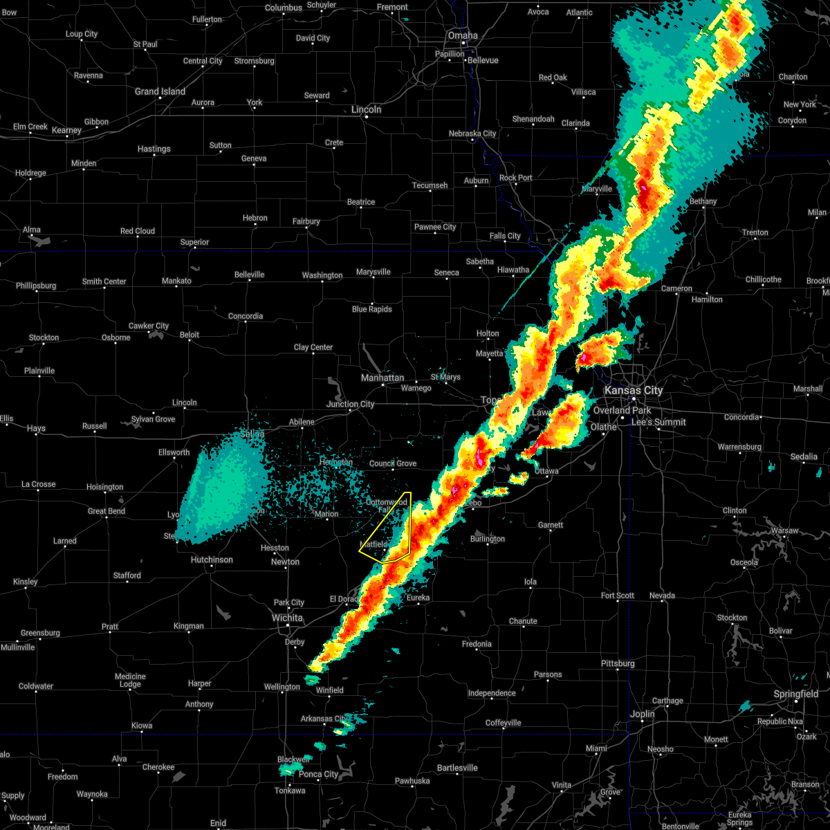 The severe thunderstorm warning for eastern chase county will expire at 700 pm cst, the storms which prompted the warning have moved out of the area. therefore the warning will be allowed to expire. however small hail and gusty winds are still possible with these thunderstorms. a tornado watch remains in effect until 300 am cst for south central and southeastern kansas. The severe thunderstorm warning for eastern chase county will expire at 700 pm cst, the storms which prompted the warning have moved out of the area. therefore the warning will be allowed to expire. however small hail and gusty winds are still possible with these thunderstorms. a tornado watch remains in effect until 300 am cst for south central and southeastern kansas.
|
| 3/6/2017 6:42 PM CST |
 At 641 pm cst, severe thunderstorms were located along a line extending from near americus to 14 miles south of cottonwood falls, moving southeast at 35 mph (radar indicated). Hazards include 60 mph wind gusts and quarter size hail. Hail damage to vehicles is expected. expect wind damage to roofs, siding, and trees. Locations impacted include, cottonwood falls, bazaar, matfield green and saffordville. At 641 pm cst, severe thunderstorms were located along a line extending from near americus to 14 miles south of cottonwood falls, moving southeast at 35 mph (radar indicated). Hazards include 60 mph wind gusts and quarter size hail. Hail damage to vehicles is expected. expect wind damage to roofs, siding, and trees. Locations impacted include, cottonwood falls, bazaar, matfield green and saffordville.
|
| 3/6/2017 6:34 PM CST |
 At 633 pm cst, severe thunderstorms were located along a line extending from near bushong to 13 miles southwest of cottonwood falls, moving southeast at 35 mph (radar indicated). Hazards include 60 mph wind gusts and quarter size hail. Hail damage to vehicles is expected. expect wind damage to roofs, siding, and trees. Locations impacted include, cottonwood falls, strong city, bazaar, matfield green, saffordville, tallgrass prairie and tallgrass prairie preserve. At 633 pm cst, severe thunderstorms were located along a line extending from near bushong to 13 miles southwest of cottonwood falls, moving southeast at 35 mph (radar indicated). Hazards include 60 mph wind gusts and quarter size hail. Hail damage to vehicles is expected. expect wind damage to roofs, siding, and trees. Locations impacted include, cottonwood falls, strong city, bazaar, matfield green, saffordville, tallgrass prairie and tallgrass prairie preserve.
|
| 3/6/2017 6:30 PM CST | Power poles down in cottonwood fall in chase county KS, 0.1 miles W of Cottonwood Falls, KS |
| 3/6/2017 6:29 PM CST |
 At 629 pm cst, severe thunderstorms were located along a line extending from near bushong to 13 miles southwest of cottonwood falls, moving southeast at 35 mph (radar indicated). Hazards include 60 mph wind gusts and quarter size hail. Hail damage to vehicles is expected. expect wind damage to roofs, siding, and trees. Locations impacted include, cottonwood falls, strong city, bazaar, elmdale, matfield green, cedar point, saffordville, tallgrass prairie and tallgrass prairie preserve. At 629 pm cst, severe thunderstorms were located along a line extending from near bushong to 13 miles southwest of cottonwood falls, moving southeast at 35 mph (radar indicated). Hazards include 60 mph wind gusts and quarter size hail. Hail damage to vehicles is expected. expect wind damage to roofs, siding, and trees. Locations impacted include, cottonwood falls, strong city, bazaar, elmdale, matfield green, cedar point, saffordville, tallgrass prairie and tallgrass prairie preserve.
|
| 3/6/2017 6:20 PM CST |
 At 619 pm cst, severe thunderstorms were located along a line extending from near dunlap to 8 miles east of florence, moving southeast at 35 mph (radar indicated). Hazards include 60 mph wind gusts and quarter size hail. Hail damage to vehicles is expected. Expect wind damage to roofs, siding, and trees. At 619 pm cst, severe thunderstorms were located along a line extending from near dunlap to 8 miles east of florence, moving southeast at 35 mph (radar indicated). Hazards include 60 mph wind gusts and quarter size hail. Hail damage to vehicles is expected. Expect wind damage to roofs, siding, and trees.
|
| 8/24/2016 6:11 PM CDT |
 At 610 pm cdt, a severe thunderstorm was located 16 miles east of burns, or 17 miles south of cottonwood falls, moving northeast at 25 mph (radar indicated). Hazards include 70 mph wind gusts and half dollar size hail. Hail damage to vehicles is expected. expect considerable tree damage. wind damage is also likely to mobile homes, roofs, and outbuildings. Locations impacted include, cottonwood falls, strong city, bazaar, matfield green, saffordville and tallgrass prairie preserve. At 610 pm cdt, a severe thunderstorm was located 16 miles east of burns, or 17 miles south of cottonwood falls, moving northeast at 25 mph (radar indicated). Hazards include 70 mph wind gusts and half dollar size hail. Hail damage to vehicles is expected. expect considerable tree damage. wind damage is also likely to mobile homes, roofs, and outbuildings. Locations impacted include, cottonwood falls, strong city, bazaar, matfield green, saffordville and tallgrass prairie preserve.
|
| 8/24/2016 6:04 PM CDT |
 At 603 pm cdt, a severe thunderstorm was located 17 miles south of cottonwood falls, moving northeast at 35 mph (radar indicated). Hazards include 70 mph wind gusts and quarter size hail. Hail damage to vehicles is expected. expect considerable tree damage. Wind damage is also likely to mobile homes, roofs, and outbuildings. At 603 pm cdt, a severe thunderstorm was located 17 miles south of cottonwood falls, moving northeast at 35 mph (radar indicated). Hazards include 70 mph wind gusts and quarter size hail. Hail damage to vehicles is expected. expect considerable tree damage. Wind damage is also likely to mobile homes, roofs, and outbuildings.
|
| 7/12/2016 4:22 AM CDT |
 The severe thunderstorm warning for chase and marion counties will expire at 430 am cdt, the storm which prompted the warning has weakened below severe limits, and no longer pose an immediate threat to life or property. therefore the warning will be allowed to expire. however gusty winds are still possible with this thunderstorm. The severe thunderstorm warning for chase and marion counties will expire at 430 am cdt, the storm which prompted the warning has weakened below severe limits, and no longer pose an immediate threat to life or property. therefore the warning will be allowed to expire. however gusty winds are still possible with this thunderstorm.
|
| 7/12/2016 4:09 AM CDT |
 At 409 am cdt, a severe thunderstorm was located 7 miles northeast of florence, moving east at 25 mph (radar indicated). Hazards include 60 mph wind gusts. Expect damage to roofs. siding. and trees. Locations impacted include, marion, peabody, cottonwood falls, strong city, florence, burns, lincolnville, ramona, tampa, bazaar, lost springs, elmdale, matfield green, cedar point, hymer, wonsevu, marion lake, tallgrass prairie preserve, pilsen and tallgrass prairie. At 409 am cdt, a severe thunderstorm was located 7 miles northeast of florence, moving east at 25 mph (radar indicated). Hazards include 60 mph wind gusts. Expect damage to roofs. siding. and trees. Locations impacted include, marion, peabody, cottonwood falls, strong city, florence, burns, lincolnville, ramona, tampa, bazaar, lost springs, elmdale, matfield green, cedar point, hymer, wonsevu, marion lake, tallgrass prairie preserve, pilsen and tallgrass prairie.
|
| 7/12/2016 3:55 AM CDT |
 At 355 am cdt, a severe thunderstorm was located over marion, moving east at 25 mph (radar indicated). Hazards include 60 mph wind gusts. Expect damage to roofs. siding. and trees. Locations impacted include, marion, peabody, cottonwood falls, strong city, florence, burns, lincolnville, ramona, tampa, bazaar, lost springs, elmdale, matfield green, cedar point, hymer, wonsevu, marion lake, tallgrass prairie preserve, pilsen and tallgrass prairie. At 355 am cdt, a severe thunderstorm was located over marion, moving east at 25 mph (radar indicated). Hazards include 60 mph wind gusts. Expect damage to roofs. siding. and trees. Locations impacted include, marion, peabody, cottonwood falls, strong city, florence, burns, lincolnville, ramona, tampa, bazaar, lost springs, elmdale, matfield green, cedar point, hymer, wonsevu, marion lake, tallgrass prairie preserve, pilsen and tallgrass prairie.
|
| 7/12/2016 3:36 AM CDT |
 At 336 am cdt, a severe thunderstorm was located near hillsboro, moving east at 25 mph (radar indicated). Hazards include 60 mph wind gusts. Expect damage to roofs. siding. And trees. At 336 am cdt, a severe thunderstorm was located near hillsboro, moving east at 25 mph (radar indicated). Hazards include 60 mph wind gusts. Expect damage to roofs. siding. And trees.
|
| 7/6/2016 2:56 AM CDT |
 The severe thunderstorm warning for northern butler, chase, northeastern sedgwick, eastern harvey and marion counties will expire at 300 am cdt, the storms which prompted the warning have weakened below severe limits, and no longer pose an immediate threat to life or property. therefore the warning will be allowed to expire. however heavy rain is still possible with these thunderstorms. a severe thunderstorm watch remains in effect until 400 am cdt for south central and central kansas. a severe thunderstorm watch also remains in effect until 900 am cdt for south central, central and east central kansas. The severe thunderstorm warning for northern butler, chase, northeastern sedgwick, eastern harvey and marion counties will expire at 300 am cdt, the storms which prompted the warning have weakened below severe limits, and no longer pose an immediate threat to life or property. therefore the warning will be allowed to expire. however heavy rain is still possible with these thunderstorms. a severe thunderstorm watch remains in effect until 400 am cdt for south central and central kansas. a severe thunderstorm watch also remains in effect until 900 am cdt for south central, central and east central kansas.
|
| 7/6/2016 2:32 AM CDT |
 At 231 am cdt, severe thunderstorms were located along a line extending from near marion to near whitewater to eastborough, moving east at 55 mph (radar indicated). Hazards include 70 mph wind gusts and nickel size hail. Expect considerable tree damage. damage is likely to mobile homes, roofs, and outbuildings. Locations impacted include, wichita, newton, el dorado, andover, augusta, park city, valley center, bel aire, maize, hillsboro, marion, north newton, sedgwick, towanda, colwich, peabody, cottonwood falls, benton, whitewater and leon. At 231 am cdt, severe thunderstorms were located along a line extending from near marion to near whitewater to eastborough, moving east at 55 mph (radar indicated). Hazards include 70 mph wind gusts and nickel size hail. Expect considerable tree damage. damage is likely to mobile homes, roofs, and outbuildings. Locations impacted include, wichita, newton, el dorado, andover, augusta, park city, valley center, bel aire, maize, hillsboro, marion, north newton, sedgwick, towanda, colwich, peabody, cottonwood falls, benton, whitewater and leon.
|
| 7/6/2016 2:04 AM CDT |
 At 204 am cdt, severe thunderstorms were located along a line extending from 5 miles northwest of tampa to near walton to near colwich, moving east at 50 mph (radar indicated). Hazards include 70 mph wind gusts and nickel size hail. Expect considerable tree damage. Damage is likely to mobile homes, roofs, and outbuildings. At 204 am cdt, severe thunderstorms were located along a line extending from 5 miles northwest of tampa to near walton to near colwich, moving east at 50 mph (radar indicated). Hazards include 70 mph wind gusts and nickel size hail. Expect considerable tree damage. Damage is likely to mobile homes, roofs, and outbuildings.
|
| 4/26/2016 8:16 PM CDT |
 At 816 pm cdt, a severe thunderstorm was located 11 miles southwest of cottonwood falls, moving northeast at 25 mph (radar indicated). Hazards include 60 mph wind gusts and quarter size hail. Hail damage to vehicles is expected. expect wind damage to roofs, siding, and trees. locations impacted include, cottonwood falls, strong city, burns, bazaar, elmdale, matfield green, cedar point, saffordville, wonsevu, tallgrass prairie preserve and hymer. A tornado watch remains in effect until 900 pm cdt for east central kansas. At 816 pm cdt, a severe thunderstorm was located 11 miles southwest of cottonwood falls, moving northeast at 25 mph (radar indicated). Hazards include 60 mph wind gusts and quarter size hail. Hail damage to vehicles is expected. expect wind damage to roofs, siding, and trees. locations impacted include, cottonwood falls, strong city, burns, bazaar, elmdale, matfield green, cedar point, saffordville, wonsevu, tallgrass prairie preserve and hymer. A tornado watch remains in effect until 900 pm cdt for east central kansas.
|
| 4/26/2016 8:13 PM CDT | Quarter sized hail reported 0.1 miles W of Cottonwood Falls, KS |
| 4/26/2016 7:58 PM CDT |
 At 758 pm cdt, a severe thunderstorm was located 9 miles east of burns, or 13 miles southeast of florence, moving northeast at 40 mph (radar indicated). Hazards include 60 mph wind gusts and quarter size hail. Hail damage to vehicles is expected. expect wind damage to roofs, siding, and trees. locations impacted include, el dorado, towanda, cottonwood falls, strong city, potwin, burns, cassoday, bazaar, elmdale, matfield green, cedar point, saffordville, wonsevu, tallgrass prairie preserve, hymer, el dorado airport and el dorado lake. A tornado watch remains in effect until 900 pm cdt for southeastern kansas. At 758 pm cdt, a severe thunderstorm was located 9 miles east of burns, or 13 miles southeast of florence, moving northeast at 40 mph (radar indicated). Hazards include 60 mph wind gusts and quarter size hail. Hail damage to vehicles is expected. expect wind damage to roofs, siding, and trees. locations impacted include, el dorado, towanda, cottonwood falls, strong city, potwin, burns, cassoday, bazaar, elmdale, matfield green, cedar point, saffordville, wonsevu, tallgrass prairie preserve, hymer, el dorado airport and el dorado lake. A tornado watch remains in effect until 900 pm cdt for southeastern kansas.
|
| 4/26/2016 7:52 PM CDT |
 At 752 pm cdt, a severe thunderstorm was located near burns, or 14 miles north of el dorado, moving northeast at 35 mph (radar indicated). Hazards include 60 mph wind gusts and quarter size hail. Hail damage to vehicles is expected. expect wind damage to roofs, siding, and trees. locations impacted include, el dorado, towanda, cottonwood falls, strong city, potwin, burns, cassoday, bazaar, elmdale, matfield green, cedar point, saffordville, wonsevu, tallgrass prairie preserve, hymer, el dorado airport and el dorado lake. A tornado watch remains in effect until 900 pm cdt for southeastern kansas. At 752 pm cdt, a severe thunderstorm was located near burns, or 14 miles north of el dorado, moving northeast at 35 mph (radar indicated). Hazards include 60 mph wind gusts and quarter size hail. Hail damage to vehicles is expected. expect wind damage to roofs, siding, and trees. locations impacted include, el dorado, towanda, cottonwood falls, strong city, potwin, burns, cassoday, bazaar, elmdale, matfield green, cedar point, saffordville, wonsevu, tallgrass prairie preserve, hymer, el dorado airport and el dorado lake. A tornado watch remains in effect until 900 pm cdt for southeastern kansas.
|
| 4/26/2016 7:39 PM CDT |
 At 738 pm cdt, a severe thunderstorm was located near potwin, or near towanda, moving northeast at 25 mph (radar indicated). Hazards include 60 mph wind gusts and quarter size hail. Hail damage to vehicles is expected. Expect wind damage to roofs, siding, and trees. At 738 pm cdt, a severe thunderstorm was located near potwin, or near towanda, moving northeast at 25 mph (radar indicated). Hazards include 60 mph wind gusts and quarter size hail. Hail damage to vehicles is expected. Expect wind damage to roofs, siding, and trees.
|
| 4/26/2016 7:09 PM CDT |
 The severe thunderstorm warning for northeastern chase county will expire at 715 pm cdt, the storm which prompted the warning has moved out of the area. therefore the warning will be allowed to expire. however small hail is still possible with this thunderstorm. a tornado watch remains in effect until 900 pm cdt for east central kansas. The severe thunderstorm warning for northeastern chase county will expire at 715 pm cdt, the storm which prompted the warning has moved out of the area. therefore the warning will be allowed to expire. however small hail is still possible with this thunderstorm. a tornado watch remains in effect until 900 pm cdt for east central kansas.
|
| 4/26/2016 7:00 PM CDT |
 At 700 pm cdt, a severe thunderstorm was located 8 miles northeast of strong city, moving northeast at 25 mph (radar indicated). Hazards include 60 mph wind gusts and quarter size hail. Hail damage to vehicles is expected. expect wind damage to roofs, siding, and trees. locations impacted include, cottonwood falls, strong city, elmdale, saffordville and tallgrass prairie preserve. A tornado watch remains in effect until 900 pm cdt for east central kansas. At 700 pm cdt, a severe thunderstorm was located 8 miles northeast of strong city, moving northeast at 25 mph (radar indicated). Hazards include 60 mph wind gusts and quarter size hail. Hail damage to vehicles is expected. expect wind damage to roofs, siding, and trees. locations impacted include, cottonwood falls, strong city, elmdale, saffordville and tallgrass prairie preserve. A tornado watch remains in effect until 900 pm cdt for east central kansas.
|
| 4/26/2016 6:51 PM CDT |
 At 651 pm cdt, a severe thunderstorm was located near strong city, moving northeast at 25 mph (radar indicated). Hazards include 60 mph wind gusts and quarter size hail. Hail damage to vehicles is expected. expect wind damage to roofs, siding, and trees. locations impacted include, cottonwood falls, strong city, bazaar, elmdale, saffordville, tallgrass prairie preserve and hymer. A tornado watch remains in effect until 900 pm cdt for east central kansas. At 651 pm cdt, a severe thunderstorm was located near strong city, moving northeast at 25 mph (radar indicated). Hazards include 60 mph wind gusts and quarter size hail. Hail damage to vehicles is expected. expect wind damage to roofs, siding, and trees. locations impacted include, cottonwood falls, strong city, bazaar, elmdale, saffordville, tallgrass prairie preserve and hymer. A tornado watch remains in effect until 900 pm cdt for east central kansas.
|
| 4/26/2016 6:32 PM CDT |
 At 632 pm cdt, a severe thunderstorm was located over cottonwood falls, moving northeast at 25 mph (radar indicated). Hazards include 60 mph wind gusts and half dollar size hail. Hail damage to vehicles is expected. expect wind damage to roofs, siding, and trees. locations impacted include, cottonwood falls, strong city, bazaar, elmdale, saffordville, tallgrass prairie preserve and hymer. A tornado watch remains in effect until 900 pm cdt for east central kansas. At 632 pm cdt, a severe thunderstorm was located over cottonwood falls, moving northeast at 25 mph (radar indicated). Hazards include 60 mph wind gusts and half dollar size hail. Hail damage to vehicles is expected. expect wind damage to roofs, siding, and trees. locations impacted include, cottonwood falls, strong city, bazaar, elmdale, saffordville, tallgrass prairie preserve and hymer. A tornado watch remains in effect until 900 pm cdt for east central kansas.
|
| 4/26/2016 6:26 PM CDT |
 At 625 pm cdt, a severe thunderstorm was located near cottonwood falls, moving northeast at 25 mph (radar indicated). Hazards include 60 mph wind gusts and half dollar size hail. Hail damage to vehicles is expected. Expect wind damage to roofs, siding, and trees. At 625 pm cdt, a severe thunderstorm was located near cottonwood falls, moving northeast at 25 mph (radar indicated). Hazards include 60 mph wind gusts and half dollar size hail. Hail damage to vehicles is expected. Expect wind damage to roofs, siding, and trees.
|
| 3/30/2016 3:39 PM CDT | Half Dollar sized hail reported 10.4 miles NNW of Cottonwood Falls, KS, on the ks turnpike at mm107 |
| 7/10/2015 2:57 PM CDT | The severe thunderstorm warning for northeastern chase county will expire at 300 pm cdt, the storm which prompted the warning has moved out of the area. therefore the warning will be allowed to expire. however gusty winds and heavy rain are still possible with this thunderstorm. |
| 7/10/2015 2:50 PM CDT |
 At 250 pm cdt, a severe thunderstorm was located 8 miles east of cottonwood falls, moving east at 25 mph (radar indicated). Hazards include 60 mph wind gusts and penny size hail. Expect damage to roofs. siding and trees. Locations impacted include, cottonwood falls, strong city, bazaar, saffordville, tallgrass prairie preserve and tallgrass prairie. At 250 pm cdt, a severe thunderstorm was located 8 miles east of cottonwood falls, moving east at 25 mph (radar indicated). Hazards include 60 mph wind gusts and penny size hail. Expect damage to roofs. siding and trees. Locations impacted include, cottonwood falls, strong city, bazaar, saffordville, tallgrass prairie preserve and tallgrass prairie.
|
| 7/10/2015 2:39 PM CDT | Quarter sized hail reported 0.1 miles W of Cottonwood Falls, KS, pea to quarter hail. |
| 7/10/2015 2:36 PM CDT |
 At 235 pm cdt, a severe thunderstorm was located over cottonwood falls, moving east at 20 mph (radar indicated). Hazards include 60 mph wind gusts and penny size hail. Expect damage to roofs. Siding and trees. At 235 pm cdt, a severe thunderstorm was located over cottonwood falls, moving east at 20 mph (radar indicated). Hazards include 60 mph wind gusts and penny size hail. Expect damage to roofs. Siding and trees.
|
| 7/10/2015 2:22 PM CDT |
 At 221 pm cdt, a severe thunderstorm was located near cottonwood falls, moving northeast at 20 mph (radar indicated). Hazards include 60 mph wind gusts and penny size hail. Expect damage to roofs. siding and trees. Locations impacted include, cottonwood falls, strong city, elmdale, tallgrass prairie preserve and tallgrass prairie. At 221 pm cdt, a severe thunderstorm was located near cottonwood falls, moving northeast at 20 mph (radar indicated). Hazards include 60 mph wind gusts and penny size hail. Expect damage to roofs. siding and trees. Locations impacted include, cottonwood falls, strong city, elmdale, tallgrass prairie preserve and tallgrass prairie.
|
| 7/10/2015 2:11 PM CDT |
 At 211 pm cdt, a severe thunderstorm was located near elmdale , moving northeast at 25 mph (radar indicated). Hazards include 60 mph wind gusts and penny size hail. Expect damage to roofs. Siding and trees. At 211 pm cdt, a severe thunderstorm was located near elmdale , moving northeast at 25 mph (radar indicated). Hazards include 60 mph wind gusts and penny size hail. Expect damage to roofs. Siding and trees.
|
| 7/6/2015 4:28 PM CDT |
 At 427 pm cdt, severe thunderstorms were located along a line extending from 5 miles south of dunlap to 10 miles south of cottonwood falls to near burns, moving southeast at 25 mph (radar indicated). Hazards include 60 mph wind gusts. Expect damage to roofs. siding and trees. Locations impacted include, cottonwood falls, strong city, burns, bazaar, elmdale, cedar point, tallgrass prairie preserve, tallgrass prairie and wonsevu. At 427 pm cdt, severe thunderstorms were located along a line extending from 5 miles south of dunlap to 10 miles south of cottonwood falls to near burns, moving southeast at 25 mph (radar indicated). Hazards include 60 mph wind gusts. Expect damage to roofs. siding and trees. Locations impacted include, cottonwood falls, strong city, burns, bazaar, elmdale, cedar point, tallgrass prairie preserve, tallgrass prairie and wonsevu.
|
| 7/6/2015 4:04 PM CDT |
 At 404 pm cdt, severe thunderstorms were located along a line extending from near dunlap to 5 miles southwest of cottonwood falls to 6 miles west of burns, moving east at 30 mph (radar indicated). Hazards include 60 mph wind gusts. Expect damage to roofs. siding and trees. Locations impacted include, marion, cottonwood falls, strong city, florence, burns, bazaar, elmdale, cedar point, tallgrass prairie preserve, hymer, tallgrass prairie and wonsevu. At 404 pm cdt, severe thunderstorms were located along a line extending from near dunlap to 5 miles southwest of cottonwood falls to 6 miles west of burns, moving east at 30 mph (radar indicated). Hazards include 60 mph wind gusts. Expect damage to roofs. siding and trees. Locations impacted include, marion, cottonwood falls, strong city, florence, burns, bazaar, elmdale, cedar point, tallgrass prairie preserve, hymer, tallgrass prairie and wonsevu.
|
| 7/6/2015 3:52 PM CDT |
 At 352 pm cdt, severe thunderstorms were located along a line extending from 11 miles northeast of florence to 5 miles northwest of burns to near elbing, moving east at 20 mph (radar indicated). Hazards include 60 mph wind gusts. Expect damage to roofs. Siding and trees. At 352 pm cdt, severe thunderstorms were located along a line extending from 11 miles northeast of florence to 5 miles northwest of burns to near elbing, moving east at 20 mph (radar indicated). Hazards include 60 mph wind gusts. Expect damage to roofs. Siding and trees.
|
| 6/7/2015 9:37 PM CDT | The severe thunderstorm warning for northeastern chase county will expire at 945 pm cdt, the thunderstorm that prompted the warning has moved out of the area. therefore the warning will be allowed to expire. a severe thunderstorm watch, number 272, remains in effect until 300 am cdt for east central kansas. |
| 6/7/2015 9:19 PM CDT | At 918 pm cdt, a severe thunderstorm was located 6 miles east of strong city, moving southeast at 35 mph (radar indicated). Hazards include half dollar size hail. Damage to vehicles is expected. Locations impacted include, cottonwood falls, strong city, saffordville, tallgrass prairie preserve and tallgrass prairie. |
| 6/7/2015 9:12 PM CDT | At 911 pm cdt, a severe thunderstorm was located near strong city, moving southeast at 35 mph (radar indicated). Hazards include golf ball size hail. People and animals outdoors will be injured. Expect damage to roofs, siding, windows and vehicles. |
| 6/7/2015 8:59 PM CDT | At 858 pm cdt, a severe thunderstorm was located 6 miles north of strong city, moving southeast at 35 mph. this is a very dangerous thunderstorm that is intensifying (radar indicated). Hazards include baseball size hail and 60 mph wind gusts. People and animals outdoors will be severely injured. expect shattered windows, extensive damage to roofs, siding and vehicles. Locations impacted include, cottonwood falls, strong city, saffordville, tallgrass prairie preserve, tallgrass prairie and hymer. |
| 6/7/2015 8:52 PM CDT | At 850 pm cdt, a severe thunderstorm was located 8 miles south of wilsey, or 9 miles northwest of strong city, moving southeast at 35 mph (radar indicated). Hazards include two inch hail and 60 mph winds. People and animals outdoors will be injured. expect hail damage to roofs, siding, windows and vehicles. expect wind damage to roofs, siding and trees. Locations impacted include, cottonwood falls, strong city, saffordville, tallgrass prairie preserve, tallgrass prairie and hymer. |
| 6/7/2015 8:40 PM CDT | At 838 pm cdt, a severe thunderstorm was located 5 miles southwest of wilsey, or 13 miles southeast of herington moving southeast at 45 mph (radar indicated). Hazards include golf ball size hail and 60 mph wind gusts. People and animals outdoors will be injured. expect hail damage to roofs, siding, windows and vehicles. Expect wind damage to roofs, siding and trees. |
| 4/3/2015 12:58 AM CDT | A severe thunderstorm warning remains in effect until 130 am cdt for chase county. at 1257 am cdt. severe thunderstorms were located along a line extending from 6 miles southeast of florence to 13 miles southeast of burns. moving east at 60 mph. hazard. Quarter size hail and 60 mph wind gusts. |
| 4/3/2015 12:46 AM CDT | A severe thunderstorm warning remains in effect until 130 am cdt for chase and southeastern marion counties. at 1245 am cdt. severe thunderstorms were located along a line extending from near peabody to near burns. moving east at 60 mph. hazard. quarter size hail and 70 mph wind gusts. source. Radar indicated. |
| 4/3/2015 12:34 AM CDT | The national weather service in wichita has issued a * severe thunderstorm warning for. northeastern harvey county in south central kansas. chase county in east central kansas. southern marion county in central kansas. Until 130 am cdt. |
| 1/1/0001 12:00 AM | 50 to 60 mph wind gust in chase county KS, 3.4 miles N of Cottonwood Falls, KS |
| 1/1/0001 12:00 AM | Delayed report. strong winds destroyed a greenhouse...and downed several tree limbs. time estimated from rada in chase county KS, 3.1 miles NW of Cottonwood Falls, KS |
| 1/1/0001 12:00 AM | Delayed report. strong winds derailed a train southeast of cottonwood falls. time is estimated from rada in chase county KS, 3.2 miles WNW of Cottonwood Falls, KS |
| 1/1/0001 12:00 AM | Storm damage reported in chase county KS, 0.1 miles W of Cottonwood Falls, KS |
| 1/1/0001 12:00 AM | Quarter sized hail reported 0.1 miles W of Cottonwood Falls, KS |
| 1/1/0001 12:00 AM | Golf Ball sized hail reported 0.1 miles W of Cottonwood Falls, KS |
| 1/1/0001 12:00 AM | Ping Pong Ball sized hail reported 0.1 miles W of Cottonwood Falls, KS |
| 1/1/0001 12:00 AM | Quarter sized hail reported 3.4 miles N of Cottonwood Falls, KS |
Hail Maps for Cottonwood Falls, KS


Connect with Interactive Hail Maps