

Hail Map for Cow Creek, SD
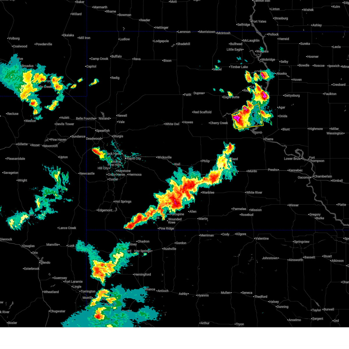
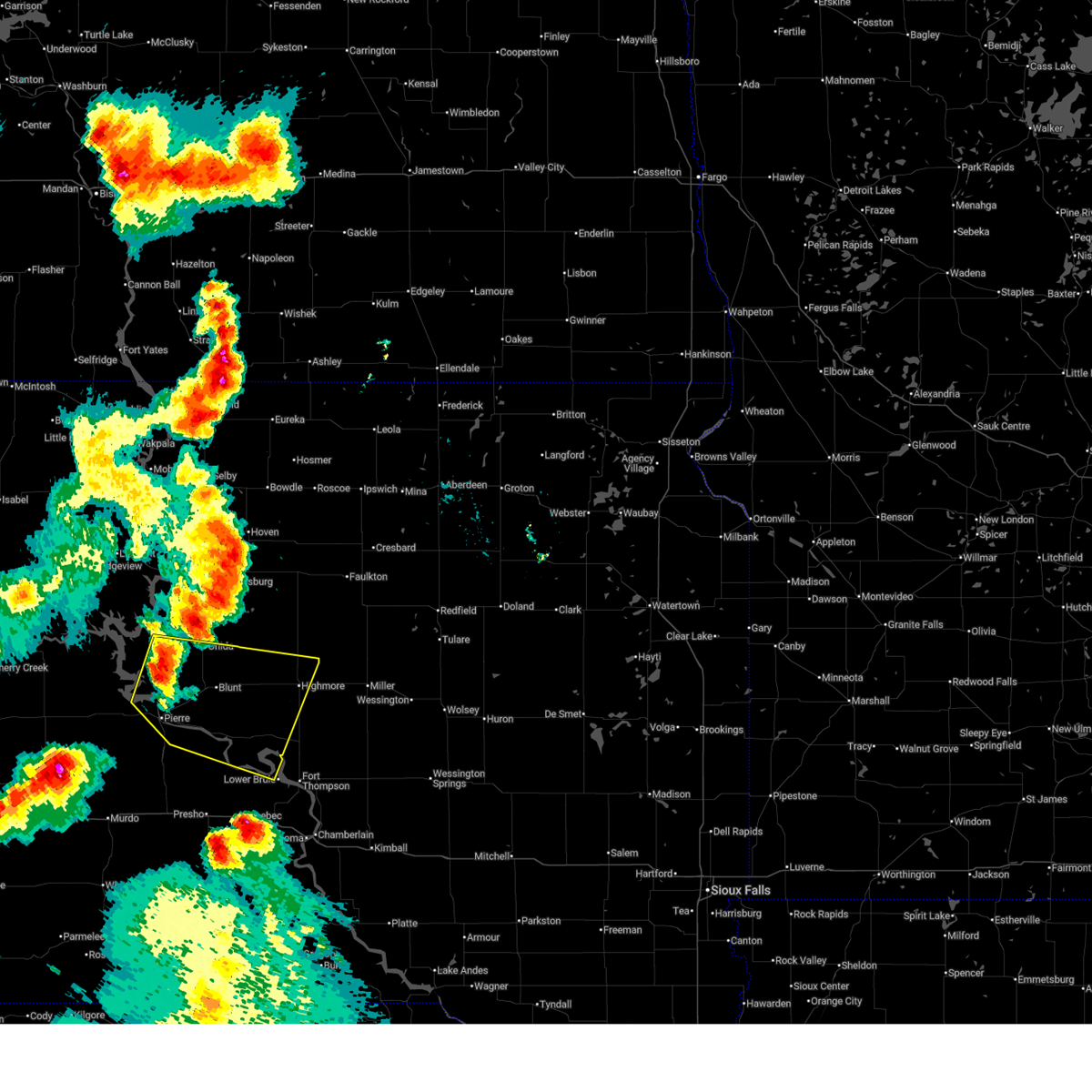
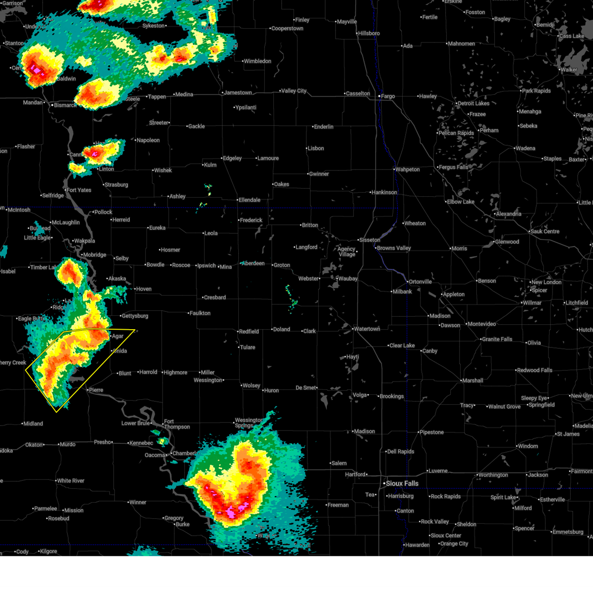
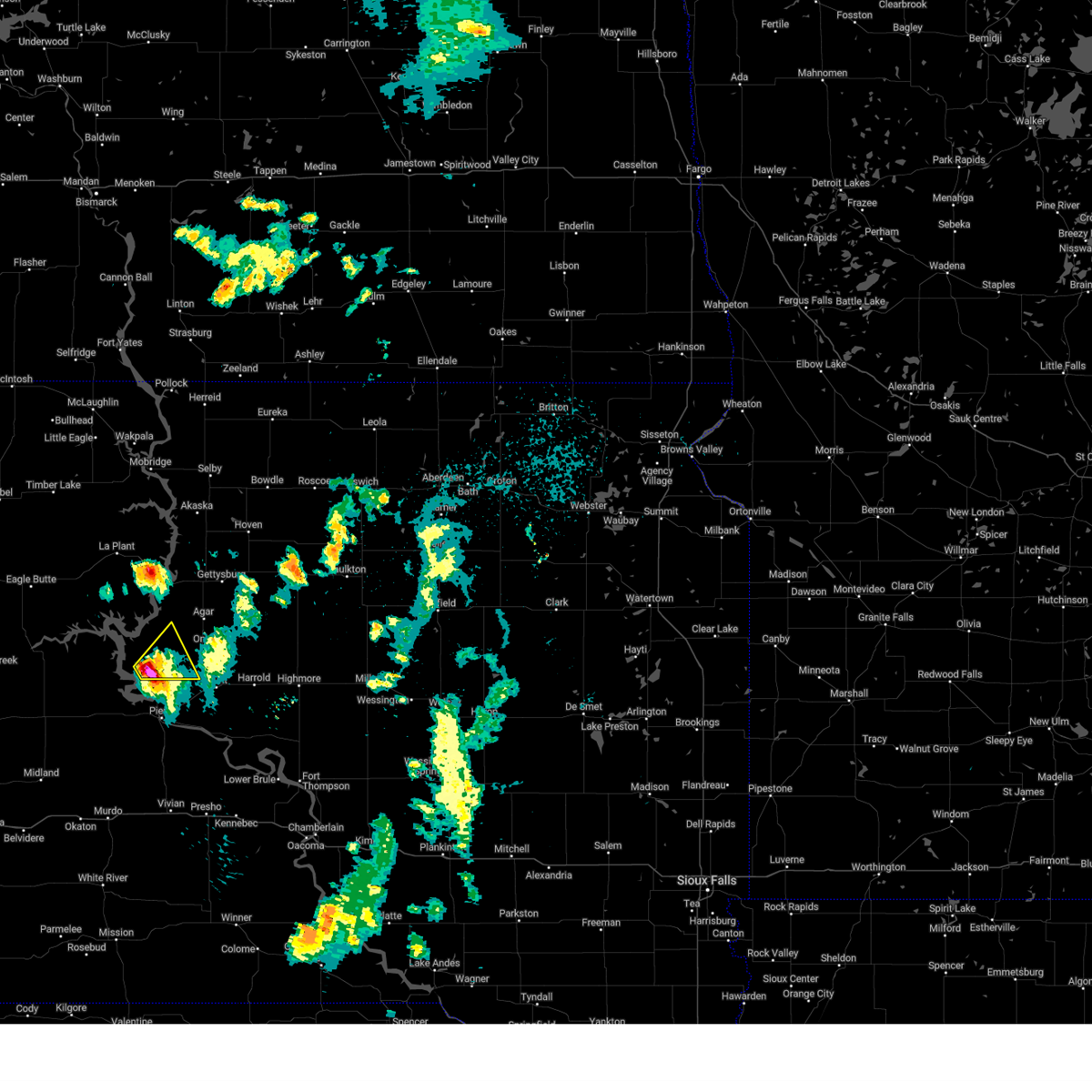
The Cow Creek, SD area has had 0 reports of on-the-ground hail by trained spotters, and has been under severe weather warnings 8 times during the past 12 months. Doppler radar has detected hail at or near Cow Creek, SD on 57 occasions, including 4 occasions during the past year.
| Name: | Cow Creek, SD |
| Where Located: | 14.3 miles NNW of Pierre, SD |
| Map: | Google Map for Cow Creek, SD |
| Population: | 30 |
| Housing Units: | 44 |
| More Info: | Search Google for Cow Creek, SD |
1
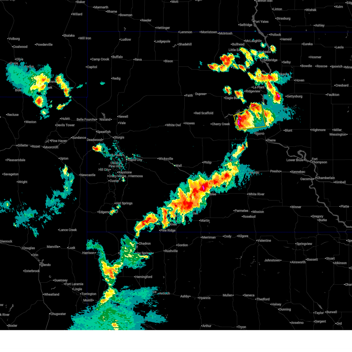
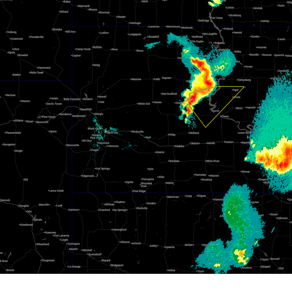
The Top Recent Hail Date for Cow Creek, SD is Saturday, September 14, 2024 (20th out of 57)

Hail and Wind Damage Spotted near Cow Creek, SD
| Date / Time | Report Details |
|---|---|
| 7/14/2025 6:14 PM MDT |
 At 713 pm cdt/613 pm mdt/, a severe thunderstorm was located near mission ridge, or 26 miles northwest of fort pierre, moving east at 15 mph (radar indicated). Hazards include 60 mph wind gusts and quarter size hail. Hail damage to vehicles is expected. expect wind damage to roofs, siding, and trees. Locations impacted include, little bend rec area and bush's landing. At 713 pm cdt/613 pm mdt/, a severe thunderstorm was located near mission ridge, or 26 miles northwest of fort pierre, moving east at 15 mph (radar indicated). Hazards include 60 mph wind gusts and quarter size hail. Hail damage to vehicles is expected. expect wind damage to roofs, siding, and trees. Locations impacted include, little bend rec area and bush's landing.
|
| 7/14/2025 5:53 PM MDT |
 Svrabr the national weather service in aberdeen has issued a * severe thunderstorm warning for, western sully county in central south dakota, northwestern stanley county in central south dakota, southeastern dewey county in north central south dakota, * until 745 pm cdt/645 pm mdt/. * at 653 pm cdt/553 pm mdt/, a severe thunderstorm was located near mission ridge, or 29 miles southeast of eagle butte, moving east at 20 mph (radar indicated). Hazards include 60 mph wind gusts and quarter size hail. Hail damage to vehicles is expected. expect wind damage to roofs, siding, and trees. this severe thunderstorm will be near, mission ridge around 600 pm mdt. Other locations in the path of this severe thunderstorm include little bend rec area. Svrabr the national weather service in aberdeen has issued a * severe thunderstorm warning for, western sully county in central south dakota, northwestern stanley county in central south dakota, southeastern dewey county in north central south dakota, * until 745 pm cdt/645 pm mdt/. * at 653 pm cdt/553 pm mdt/, a severe thunderstorm was located near mission ridge, or 29 miles southeast of eagle butte, moving east at 20 mph (radar indicated). Hazards include 60 mph wind gusts and quarter size hail. Hail damage to vehicles is expected. expect wind damage to roofs, siding, and trees. this severe thunderstorm will be near, mission ridge around 600 pm mdt. Other locations in the path of this severe thunderstorm include little bend rec area.
|
| 7/9/2025 8:00 PM CDT |
 Svrabr the national weather service in aberdeen has issued a * severe thunderstorm warning for, southeastern sully county in central south dakota, southern hyde county in central south dakota, southeastern stanley county in central south dakota, hughes county in central south dakota, north central lyman county in central south dakota, * until 845 pm cdt. * at 759 pm cdt, a severe thunderstorm was located near grey goose, or 14 miles north of pierre, moving east at 35 mph (trained weather spotters). Hazards include 60 mph wind gusts and quarter size hail. Hail damage to vehicles is expected. expect wind damage to roofs, siding, and trees. this severe thunderstorm will be near, blunt around 815 pm cdt. Other locations in the path of this severe thunderstorm include harrold. Svrabr the national weather service in aberdeen has issued a * severe thunderstorm warning for, southeastern sully county in central south dakota, southern hyde county in central south dakota, southeastern stanley county in central south dakota, hughes county in central south dakota, north central lyman county in central south dakota, * until 845 pm cdt. * at 759 pm cdt, a severe thunderstorm was located near grey goose, or 14 miles north of pierre, moving east at 35 mph (trained weather spotters). Hazards include 60 mph wind gusts and quarter size hail. Hail damage to vehicles is expected. expect wind damage to roofs, siding, and trees. this severe thunderstorm will be near, blunt around 815 pm cdt. Other locations in the path of this severe thunderstorm include harrold.
|
| 6/27/2025 9:55 PM CDT |
 At 955 pm cdt/855 pm mdt/, severe thunderstorms were located along a line extending from near bush's landing to near hayes, moving southeast at 30 mph (radar indicated). Hazards include 60 mph wind gusts and quarter size hail. Hail damage to vehicles is expected. expect wind damage to roofs, siding, and trees. Locations impacted include, spring creek rec area, cow creek rec area, oahe mission rec area, okobojo point rec area, chantier creek recreation area, grey goose, sully lake, west shore rec area, lake sharpe, overlook rec area and wendte. At 955 pm cdt/855 pm mdt/, severe thunderstorms were located along a line extending from near bush's landing to near hayes, moving southeast at 30 mph (radar indicated). Hazards include 60 mph wind gusts and quarter size hail. Hail damage to vehicles is expected. expect wind damage to roofs, siding, and trees. Locations impacted include, spring creek rec area, cow creek rec area, oahe mission rec area, okobojo point rec area, chantier creek recreation area, grey goose, sully lake, west shore rec area, lake sharpe, overlook rec area and wendte.
|
| 6/27/2025 8:19 PM MDT |
 Svrabr the national weather service in aberdeen has issued a * severe thunderstorm warning for, sully county in central south dakota, western stanley county in central south dakota, southeastern dewey county in north central south dakota, northwestern hughes county in central south dakota, * until 1015 pm cdt/915 pm mdt/. * at 918 pm cdt/818 pm mdt/, severe thunderstorms were located along a line extending from 6 miles northwest of little bend rec area to 6 miles west of sansarc, moving southeast at 30 mph (radar indicated). Hazards include 60 mph wind gusts and quarter size hail. Hail damage to vehicles is expected. expect wind damage to roofs, siding, and trees. severe thunderstorms will be near, little bend rec area and bush's landing around 925 pm cdt. mission ridge and sansarc around 825 pm mdt. Other locations in the path of these severe thunderstorms include okobojo point rec area, spring creek rec area, cow creek rec area, chantier creek recreation area and oahe mission rec area. Svrabr the national weather service in aberdeen has issued a * severe thunderstorm warning for, sully county in central south dakota, western stanley county in central south dakota, southeastern dewey county in north central south dakota, northwestern hughes county in central south dakota, * until 1015 pm cdt/915 pm mdt/. * at 918 pm cdt/818 pm mdt/, severe thunderstorms were located along a line extending from 6 miles northwest of little bend rec area to 6 miles west of sansarc, moving southeast at 30 mph (radar indicated). Hazards include 60 mph wind gusts and quarter size hail. Hail damage to vehicles is expected. expect wind damage to roofs, siding, and trees. severe thunderstorms will be near, little bend rec area and bush's landing around 925 pm cdt. mission ridge and sansarc around 825 pm mdt. Other locations in the path of these severe thunderstorms include okobojo point rec area, spring creek rec area, cow creek rec area, chantier creek recreation area and oahe mission rec area.
|
| 9/14/2024 9:36 PM CDT |
 Svrabr the national weather service in aberdeen has issued a * severe thunderstorm warning for, southwestern sully county in central south dakota, * until 1030 pm cdt. * at 936 pm cdt, a severe thunderstorm was located near cow creek rec area, or 15 miles north of fort pierre, moving northeast at 10 mph (radar indicated). Hazards include ping pong ball size hail and 60 mph wind gusts. People and animals outdoors will be injured. expect hail damage to roofs, siding, windows, and vehicles. expect wind damage to roofs, siding, and trees. This severe thunderstorm will remain over mainly rural areas of southwestern sully county. Svrabr the national weather service in aberdeen has issued a * severe thunderstorm warning for, southwestern sully county in central south dakota, * until 1030 pm cdt. * at 936 pm cdt, a severe thunderstorm was located near cow creek rec area, or 15 miles north of fort pierre, moving northeast at 10 mph (radar indicated). Hazards include ping pong ball size hail and 60 mph wind gusts. People and animals outdoors will be injured. expect hail damage to roofs, siding, windows, and vehicles. expect wind damage to roofs, siding, and trees. This severe thunderstorm will remain over mainly rural areas of southwestern sully county.
|
| 8/14/2024 5:43 PM CDT |
 the severe thunderstorm warning has been cancelled and is no longer in effect the severe thunderstorm warning has been cancelled and is no longer in effect
|
| 8/14/2024 5:16 PM CDT |
 Svrabr the national weather service in aberdeen has issued a * severe thunderstorm warning for, southwestern sully county in central south dakota, north central stanley county in central south dakota, * until 600 pm cdt. * at 516 pm cdt, a severe thunderstorm was located near mission ridge, or 23 miles northwest of fort pierre, moving east at 25 mph (radar indicated). Hazards include 60 mph wind gusts and quarter size hail. Hail damage to vehicles is expected. expect wind damage to roofs, siding, and trees. this severe thunderstorm will be near, okobojo point rec area around 525 pm cdt. Cow creek rec area around 530 pm cdt. Svrabr the national weather service in aberdeen has issued a * severe thunderstorm warning for, southwestern sully county in central south dakota, north central stanley county in central south dakota, * until 600 pm cdt. * at 516 pm cdt, a severe thunderstorm was located near mission ridge, or 23 miles northwest of fort pierre, moving east at 25 mph (radar indicated). Hazards include 60 mph wind gusts and quarter size hail. Hail damage to vehicles is expected. expect wind damage to roofs, siding, and trees. this severe thunderstorm will be near, okobojo point rec area around 525 pm cdt. Cow creek rec area around 530 pm cdt.
|
| 7/14/2024 1:50 AM CDT |
 At 148 am cdt/1248 am mdt/, severe thunderstorms were located along a line extending from 8 miles south of lowry to 9 miles south of earling hill, moving east at 50 mph (radar indicated). Hazards include 70 mph wind gusts. Expect considerable tree damage. damage is likely to mobile homes, roofs, and outbuildings. Locations impacted include, kennebec, harrold, lebanon, lake sharpe, joe creek rec area, lyman, west bend rec area, stone lake, byre lake, holabird, lower brule, reliance, seneca, medicine butte, fort thompson, highmore, stephan, onaka, lake francis case, counselor creek boat access area, tailrace rec area, oacoma, dude ranch, brentwood colony, thunderbird colony, burkmere, lees corner, shelby, ree heights, norbeck, crow creek housing and etbauer hill. At 148 am cdt/1248 am mdt/, severe thunderstorms were located along a line extending from 8 miles south of lowry to 9 miles south of earling hill, moving east at 50 mph (radar indicated). Hazards include 70 mph wind gusts. Expect considerable tree damage. damage is likely to mobile homes, roofs, and outbuildings. Locations impacted include, kennebec, harrold, lebanon, lake sharpe, joe creek rec area, lyman, west bend rec area, stone lake, byre lake, holabird, lower brule, reliance, seneca, medicine butte, fort thompson, highmore, stephan, onaka, lake francis case, counselor creek boat access area, tailrace rec area, oacoma, dude ranch, brentwood colony, thunderbird colony, burkmere, lees corner, shelby, ree heights, norbeck, crow creek housing and etbauer hill.
|
| 7/14/2024 1:27 AM CDT |
 Svrabr the national weather service in aberdeen has issued a * severe thunderstorm warning for, jones county in central south dakota, western hand county in central south dakota, sully county in central south dakota, hyde county in central south dakota, western faulk county in north central south dakota, potter county in north central south dakota, stanley county in central south dakota, southeastern dewey county in north central south dakota, hughes county in central south dakota, lyman county in central south dakota, western buffalo county in central south dakota, * until 230 am cdt/130 am mdt/. * at 126 am cdt/1226 am mdt/, severe thunderstorms were located along a line extending from 6 miles south of swan creek rec area to 12 miles south of 5 mile corner, moving east at 50 mph. these are destructive storms (radar indicated). Hazards include 80 mph wind gusts. Flying debris will be dangerous to those caught without shelter. mobile homes will be heavily damaged. expect considerable damage to roofs, windows, and vehicles. extensive tree damage and power outages are likely. severe thunderstorms will be near, onida, presho, agar, lake sharpe, rousseau, gorman, canning, earling hill, sully lake, and 5 mile corner around 130 am cdt. gettysburg, blunt, cedar creek rec area, cottonwood lake near agar, degrey rec area, and fate dam around 135 am cdt. kennebec and byre lake around 140 am cdt. harrold, lebanon, joe creek rec area, and stone lake around 145 am cdt. Other locations in the path of these severe thunderstorms include lyman, west bend rec area, lower brule, reliance, holabird, medicine butte, seneca, onaka, lake francis case, counselor creek boat access area, fort thompson, highmore, stephan, tailrace rec area and dude ranch. Svrabr the national weather service in aberdeen has issued a * severe thunderstorm warning for, jones county in central south dakota, western hand county in central south dakota, sully county in central south dakota, hyde county in central south dakota, western faulk county in north central south dakota, potter county in north central south dakota, stanley county in central south dakota, southeastern dewey county in north central south dakota, hughes county in central south dakota, lyman county in central south dakota, western buffalo county in central south dakota, * until 230 am cdt/130 am mdt/. * at 126 am cdt/1226 am mdt/, severe thunderstorms were located along a line extending from 6 miles south of swan creek rec area to 12 miles south of 5 mile corner, moving east at 50 mph. these are destructive storms (radar indicated). Hazards include 80 mph wind gusts. Flying debris will be dangerous to those caught without shelter. mobile homes will be heavily damaged. expect considerable damage to roofs, windows, and vehicles. extensive tree damage and power outages are likely. severe thunderstorms will be near, onida, presho, agar, lake sharpe, rousseau, gorman, canning, earling hill, sully lake, and 5 mile corner around 130 am cdt. gettysburg, blunt, cedar creek rec area, cottonwood lake near agar, degrey rec area, and fate dam around 135 am cdt. kennebec and byre lake around 140 am cdt. harrold, lebanon, joe creek rec area, and stone lake around 145 am cdt. Other locations in the path of these severe thunderstorms include lyman, west bend rec area, lower brule, reliance, holabird, medicine butte, seneca, onaka, lake francis case, counselor creek boat access area, fort thompson, highmore, stephan, tailrace rec area and dude ranch.
|
| 7/13/2024 11:57 PM MDT |
 At 1257 am cdt/1157 pm mdt/, severe thunderstorms were located along a line extending from white horse to 10 miles northwest of little bend rec area to 7 miles south of mission ridge, moving east at 70 mph. these are destructive storms (radar indicated). Hazards include 80 mph wind gusts. Flying debris will be dangerous to those caught without shelter. mobile homes will be heavily damaged. expect considerable damage to roofs, windows, and vehicles. extensive tree damage and power outages are likely. Locations impacted include, little bend rec area, mission ridge, laplant, ridgeview, tiospaye topa school, cow creek rec area, okobojo point rec area, bush's landing, chantier creek recreation area, spring creek rec area, oahe mission rec area, sutton bay rec area, swiftbird, swiftbird day school, grey goose, whitlocks bay rec area, overlook rec area, agar, sully lake, onida, gorman and blunt. At 1257 am cdt/1157 pm mdt/, severe thunderstorms were located along a line extending from white horse to 10 miles northwest of little bend rec area to 7 miles south of mission ridge, moving east at 70 mph. these are destructive storms (radar indicated). Hazards include 80 mph wind gusts. Flying debris will be dangerous to those caught without shelter. mobile homes will be heavily damaged. expect considerable damage to roofs, windows, and vehicles. extensive tree damage and power outages are likely. Locations impacted include, little bend rec area, mission ridge, laplant, ridgeview, tiospaye topa school, cow creek rec area, okobojo point rec area, bush's landing, chantier creek recreation area, spring creek rec area, oahe mission rec area, sutton bay rec area, swiftbird, swiftbird day school, grey goose, whitlocks bay rec area, overlook rec area, agar, sully lake, onida, gorman and blunt.
|
| 7/13/2024 11:32 PM MDT |
 Svrabr the national weather service in aberdeen has issued a * severe thunderstorm warning for, sully county in central south dakota, western potter county in north central south dakota, northwestern stanley county in central south dakota, dewey county in north central south dakota, northwestern hughes county in central south dakota, * until 130 am cdt/1230 am mdt/. * at 1231 am cdt/1131 pm mdt/, severe thunderstorms were located along a line extending from near isabel to near south eagle butte to 6 miles east of cherry creek, moving east at 70 mph (radar indicated). Hazards include 70 mph wind gusts. Expect considerable tree damage. damage is likely to mobile homes, roofs, and outbuildings. severe thunderstorms will be near, eagle butte, green grass, and parade around 1135 pm mdt. white horse around 1145 pm mdt. mission ridge and ridgeview around 1150 pm mdt. Other locations in the path of these severe thunderstorms include little bend rec area, laplant, tiospaye topa school, bush's landing, chantier creek recreation area, spring creek rec area, cow creek rec area, oahe mission rec area, okobojo point rec area, sutton bay rec area, swiftbird day school, grey goose, whitlocks bay rec area, overlook rec area, swiftbird, west shore rec area and sully lake. Svrabr the national weather service in aberdeen has issued a * severe thunderstorm warning for, sully county in central south dakota, western potter county in north central south dakota, northwestern stanley county in central south dakota, dewey county in north central south dakota, northwestern hughes county in central south dakota, * until 130 am cdt/1230 am mdt/. * at 1231 am cdt/1131 pm mdt/, severe thunderstorms were located along a line extending from near isabel to near south eagle butte to 6 miles east of cherry creek, moving east at 70 mph (radar indicated). Hazards include 70 mph wind gusts. Expect considerable tree damage. damage is likely to mobile homes, roofs, and outbuildings. severe thunderstorms will be near, eagle butte, green grass, and parade around 1135 pm mdt. white horse around 1145 pm mdt. mission ridge and ridgeview around 1150 pm mdt. Other locations in the path of these severe thunderstorms include little bend rec area, laplant, tiospaye topa school, bush's landing, chantier creek recreation area, spring creek rec area, cow creek rec area, oahe mission rec area, okobojo point rec area, sutton bay rec area, swiftbird day school, grey goose, whitlocks bay rec area, overlook rec area, swiftbird, west shore rec area and sully lake.
|
| 6/28/2024 12:02 AM CDT |
 Svrabr the national weather service in aberdeen has issued a * severe thunderstorm warning for, southern sully county in central south dakota, southwestern hyde county in central south dakota, central stanley county in central south dakota, hughes county in central south dakota, north central lyman county in central south dakota, * until 115 am cdt. * at 1202 am cdt, a severe thunderstorm was located over spring creek rec area, or 13 miles north of fort pierre, moving east at 40 mph (radar indicated). Hazards include 60 mph wind gusts and quarter size hail. Hail damage to vehicles is expected. expect wind damage to roofs, siding, and trees. this severe thunderstorm will be near, spring creek rec area, grey goose, lake sharpe, and overlook rec area around 1205 am cdt. west shore rec area around 1105 pm mdt. pierre around 1220 am cdt. Other locations in the path of this severe thunderstorm include canning. Svrabr the national weather service in aberdeen has issued a * severe thunderstorm warning for, southern sully county in central south dakota, southwestern hyde county in central south dakota, central stanley county in central south dakota, hughes county in central south dakota, north central lyman county in central south dakota, * until 115 am cdt. * at 1202 am cdt, a severe thunderstorm was located over spring creek rec area, or 13 miles north of fort pierre, moving east at 40 mph (radar indicated). Hazards include 60 mph wind gusts and quarter size hail. Hail damage to vehicles is expected. expect wind damage to roofs, siding, and trees. this severe thunderstorm will be near, spring creek rec area, grey goose, lake sharpe, and overlook rec area around 1205 am cdt. west shore rec area around 1105 pm mdt. pierre around 1220 am cdt. Other locations in the path of this severe thunderstorm include canning.
|
| 6/27/2024 11:07 PM CDT |
 Svrabr the national weather service in aberdeen has issued a * severe thunderstorm warning for, sully county in central south dakota, west central hyde county in central south dakota, stanley county in central south dakota, south central dewey county in north central south dakota, hughes county in central south dakota, * until midnight cdt/1100 pm mdt/. * at 1106 pm cdt/1006 pm mdt/, a severe thunderstorm was located near cow creek rec area, or 16 miles north of fort pierre, moving east at 45 mph (radar indicated). Hazards include 60 mph wind gusts and quarter size hail. Hail damage to vehicles is expected. expect wind damage to roofs, siding, and trees. this severe thunderstorm will be near, grey goose around 1110 pm cdt. Other locations in the path of this severe thunderstorm include blunt and harrold. Svrabr the national weather service in aberdeen has issued a * severe thunderstorm warning for, sully county in central south dakota, west central hyde county in central south dakota, stanley county in central south dakota, south central dewey county in north central south dakota, hughes county in central south dakota, * until midnight cdt/1100 pm mdt/. * at 1106 pm cdt/1006 pm mdt/, a severe thunderstorm was located near cow creek rec area, or 16 miles north of fort pierre, moving east at 45 mph (radar indicated). Hazards include 60 mph wind gusts and quarter size hail. Hail damage to vehicles is expected. expect wind damage to roofs, siding, and trees. this severe thunderstorm will be near, grey goose around 1110 pm cdt. Other locations in the path of this severe thunderstorm include blunt and harrold.
|
| 6/27/2024 10:59 PM CDT |
 Svrabr the national weather service in aberdeen has issued a * severe thunderstorm warning for, western edmunds county in north central south dakota, sully county in central south dakota, northern hyde county in central south dakota, western faulk county in north central south dakota, southeastern campbell county in north central south dakota, potter county in north central south dakota, northeastern hughes county in central south dakota, southwestern mcpherson county in north central south dakota, walworth county in north central south dakota, * until midnight cdt. * at 1059 pm cdt, severe thunderstorms were located along a line extending from near lake hiddenwood rec area to 7 miles northeast of cow creek rec area, moving east at 45 mph (radar indicated). Hazards include 60 mph wind gusts and quarter size hail. Hail damage to vehicles is expected. expect wind damage to roofs, siding, and trees. severe thunderstorms will be near, gettysburg, onida, java, agar, lowry, gorman, lake hiddenwood rec area, and sully lake around 1105 pm cdt. bowdle, hoven, and cottonwood lake near agar around 1115 pm cdt. Other locations in the path of these severe thunderstorms include blunt, lebanon, hosmer, tolstoy, stone lake, harrold, roscoe, seneca, onaka, holabird, brentwood colony, thunderbird colony, burkmere and loyalton. Svrabr the national weather service in aberdeen has issued a * severe thunderstorm warning for, western edmunds county in north central south dakota, sully county in central south dakota, northern hyde county in central south dakota, western faulk county in north central south dakota, southeastern campbell county in north central south dakota, potter county in north central south dakota, northeastern hughes county in central south dakota, southwestern mcpherson county in north central south dakota, walworth county in north central south dakota, * until midnight cdt. * at 1059 pm cdt, severe thunderstorms were located along a line extending from near lake hiddenwood rec area to 7 miles northeast of cow creek rec area, moving east at 45 mph (radar indicated). Hazards include 60 mph wind gusts and quarter size hail. Hail damage to vehicles is expected. expect wind damage to roofs, siding, and trees. severe thunderstorms will be near, gettysburg, onida, java, agar, lowry, gorman, lake hiddenwood rec area, and sully lake around 1105 pm cdt. bowdle, hoven, and cottonwood lake near agar around 1115 pm cdt. Other locations in the path of these severe thunderstorms include blunt, lebanon, hosmer, tolstoy, stone lake, harrold, roscoe, seneca, onaka, holabird, brentwood colony, thunderbird colony, burkmere and loyalton.
|
| 6/27/2024 9:46 PM MDT |
 At 1046 pm cdt/946 pm mdt/, a severe thunderstorm was located over bush's landing, or 21 miles west of onida, moving east at 60 mph (radar indicated). Hazards include 60 mph wind gusts and quarter size hail. Hail damage to vehicles is expected. expect wind damage to roofs, siding, and trees. This severe thunderstorm will remain over mainly rural areas of southwestern sully, northwestern stanley, south central dewey and northwestern hughes counties. At 1046 pm cdt/946 pm mdt/, a severe thunderstorm was located over bush's landing, or 21 miles west of onida, moving east at 60 mph (radar indicated). Hazards include 60 mph wind gusts and quarter size hail. Hail damage to vehicles is expected. expect wind damage to roofs, siding, and trees. This severe thunderstorm will remain over mainly rural areas of southwestern sully, northwestern stanley, south central dewey and northwestern hughes counties.
|
| 6/27/2024 9:27 PM MDT |
 At 1027 pm cdt/927 pm mdt/, a severe thunderstorm was located near mission ridge, or 26 miles southeast of eagle butte, moving east at 60 mph (radar indicated). Hazards include ping pong ball size hail and 60 mph wind gusts. People and animals outdoors will be injured. expect hail damage to roofs, siding, windows, and vehicles. expect wind damage to roofs, siding, and trees. this severe storm will be near, mission ridge around 930 pm mdt. little bend rec area around 1035 pm cdt. Other locations in the path of this severe thunderstorm include bush's landing. At 1027 pm cdt/927 pm mdt/, a severe thunderstorm was located near mission ridge, or 26 miles southeast of eagle butte, moving east at 60 mph (radar indicated). Hazards include ping pong ball size hail and 60 mph wind gusts. People and animals outdoors will be injured. expect hail damage to roofs, siding, windows, and vehicles. expect wind damage to roofs, siding, and trees. this severe storm will be near, mission ridge around 930 pm mdt. little bend rec area around 1035 pm cdt. Other locations in the path of this severe thunderstorm include bush's landing.
|
| 6/27/2024 9:15 PM MDT |
 Svrabr the national weather service in aberdeen has issued a * severe thunderstorm warning for, southwestern sully county in central south dakota, northwestern stanley county in central south dakota, south central dewey county in north central south dakota, northwestern hughes county in central south dakota, * until 1100 pm cdt/1000 pm mdt/. * at 1015 pm cdt/915 pm mdt/, a severe thunderstorm was located 13 miles southeast of intersection of highway 63 and bia road 8, or 21 miles south of eagle butte, moving east at 60 mph (radar indicated). Hazards include 60 mph wind gusts and quarter size hail. Hail damage to vehicles is expected. expect wind damage to roofs, siding, and trees. this severe thunderstorm will be near, mission ridge around 925 pm mdt. little bend rec area around 1035 pm cdt. Other locations in the path of this severe thunderstorm include bush's landing. Svrabr the national weather service in aberdeen has issued a * severe thunderstorm warning for, southwestern sully county in central south dakota, northwestern stanley county in central south dakota, south central dewey county in north central south dakota, northwestern hughes county in central south dakota, * until 1100 pm cdt/1000 pm mdt/. * at 1015 pm cdt/915 pm mdt/, a severe thunderstorm was located 13 miles southeast of intersection of highway 63 and bia road 8, or 21 miles south of eagle butte, moving east at 60 mph (radar indicated). Hazards include 60 mph wind gusts and quarter size hail. Hail damage to vehicles is expected. expect wind damage to roofs, siding, and trees. this severe thunderstorm will be near, mission ridge around 925 pm mdt. little bend rec area around 1035 pm cdt. Other locations in the path of this severe thunderstorm include bush's landing.
|
| 8/1/2023 6:13 PM CDT |
 The severe thunderstorm warning for southwestern sully, northwestern stanley, southeastern dewey and northwestern hughes counties will expire at 615 pm cdt/515 pm mdt/, the storm which prompted the warning has weakened below severe limits, and no longer poses an immediate threat to life or property. therefore, the warning will be allowed to expire. The severe thunderstorm warning for southwestern sully, northwestern stanley, southeastern dewey and northwestern hughes counties will expire at 615 pm cdt/515 pm mdt/, the storm which prompted the warning has weakened below severe limits, and no longer poses an immediate threat to life or property. therefore, the warning will be allowed to expire.
|
| 8/1/2023 5:30 PM CDT |
 At 530 pm cdt/430 pm mdt/, a severe thunderstorm was located near chantier creek recreation area, or 17 miles northwest of fort pierre, moving northeast at 30 mph (radar indicated). Hazards include 60 mph wind gusts and quarter size hail. Hail damage to vehicles is expected. expect wind damage to roofs, siding, and trees. this severe thunderstorm will be near, oahe mission rec area around 540 pm cdt. spring creek rec area, okobojo point rec area and cow creek rec area around 550 pm cdt. other locations in the path of this severe thunderstorm include bush`s landing. hail threat, radar indicated max hail size, 1. 00 in wind threat, radar indicated max wind gust, 60 mph. At 530 pm cdt/430 pm mdt/, a severe thunderstorm was located near chantier creek recreation area, or 17 miles northwest of fort pierre, moving northeast at 30 mph (radar indicated). Hazards include 60 mph wind gusts and quarter size hail. Hail damage to vehicles is expected. expect wind damage to roofs, siding, and trees. this severe thunderstorm will be near, oahe mission rec area around 540 pm cdt. spring creek rec area, okobojo point rec area and cow creek rec area around 550 pm cdt. other locations in the path of this severe thunderstorm include bush`s landing. hail threat, radar indicated max hail size, 1. 00 in wind threat, radar indicated max wind gust, 60 mph.
|
| 7/26/2023 5:13 PM MDT |
 At 613 pm cdt, a severe thunderstorm was located over chantier creek recreation area, or 13 miles northwest of fort pierre, moving east at 25 mph (radar indicated). Hazards include two inch hail and 70 mph wind gusts. People and animals outdoors will be injured. expect hail damage to roofs, siding, windows, and vehicles. expect considerable tree damage. wind damage is also likely to mobile homes, roofs, and outbuildings. this severe thunderstorm will be near, oahe mission rec area around 620 pm cdt. west shore rec area around 530 pm mdt. other locations in the path of this severe thunderstorm include overlook rec area, fort pierre and pierre. thunderstorm damage threat, considerable hail threat, radar indicated max hail size, 2. 00 in wind threat, radar indicated max wind gust, 70 mph. At 613 pm cdt, a severe thunderstorm was located over chantier creek recreation area, or 13 miles northwest of fort pierre, moving east at 25 mph (radar indicated). Hazards include two inch hail and 70 mph wind gusts. People and animals outdoors will be injured. expect hail damage to roofs, siding, windows, and vehicles. expect considerable tree damage. wind damage is also likely to mobile homes, roofs, and outbuildings. this severe thunderstorm will be near, oahe mission rec area around 620 pm cdt. west shore rec area around 530 pm mdt. other locations in the path of this severe thunderstorm include overlook rec area, fort pierre and pierre. thunderstorm damage threat, considerable hail threat, radar indicated max hail size, 2. 00 in wind threat, radar indicated max wind gust, 70 mph.
|
| 7/26/2023 4:53 PM MDT |
 At 552 pm cdt, a severe thunderstorm was located 9 miles west of chantier creek recreation area, or 23 miles northwest of fort pierre, moving east at 25 mph (radar indicated). Hazards include two inch hail and 70 mph wind gusts. People and animals outdoors will be injured. expect hail damage to roofs, siding, windows, and vehicles. expect considerable tree damage. wind damage is also likely to mobile homes, roofs, and outbuildings. locations impacted include, spring creek rec area, okobojo point rec area, mission ridge, west shore rec area, oahe mission rec area, chantier creek recreation area and cow creek rec area. thunderstorm damage threat, considerable hail threat, radar indicated max hail size, 2. 00 in wind threat, radar indicated max wind gust, 70 mph. At 552 pm cdt, a severe thunderstorm was located 9 miles west of chantier creek recreation area, or 23 miles northwest of fort pierre, moving east at 25 mph (radar indicated). Hazards include two inch hail and 70 mph wind gusts. People and animals outdoors will be injured. expect hail damage to roofs, siding, windows, and vehicles. expect considerable tree damage. wind damage is also likely to mobile homes, roofs, and outbuildings. locations impacted include, spring creek rec area, okobojo point rec area, mission ridge, west shore rec area, oahe mission rec area, chantier creek recreation area and cow creek rec area. thunderstorm damage threat, considerable hail threat, radar indicated max hail size, 2. 00 in wind threat, radar indicated max wind gust, 70 mph.
|
| 7/26/2023 4:28 PM MDT |
 At 527 pm cdt/427 pm mdt/, a severe thunderstorm was located over sansarc, or 32 miles west of fort pierre, moving east at 35 mph (radar indicated). Hazards include 60 mph wind gusts and quarter size hail. Hail damage to vehicles is expected. Expect wind damage to roofs, siding, and trees. At 527 pm cdt/427 pm mdt/, a severe thunderstorm was located over sansarc, or 32 miles west of fort pierre, moving east at 35 mph (radar indicated). Hazards include 60 mph wind gusts and quarter size hail. Hail damage to vehicles is expected. Expect wind damage to roofs, siding, and trees.
|
| 7/18/2023 6:08 PM CDT |
 At 608 pm cdt, a severe thunderstorm was located over overlook rec area, or near fort pierre, moving east at 45 mph (radar indicated). Hazards include 60 mph wind gusts and quarter size hail. Hail damage to vehicles is expected. expect wind damage to roofs, siding, and trees. this severe thunderstorm will be near, pierre around 615 pm cdt. other locations in the path of this severe thunderstorm include rousseau, canning and degrey rec area. hail threat, radar indicated max hail size, 1. 00 in wind threat, radar indicated max wind gust, 60 mph. At 608 pm cdt, a severe thunderstorm was located over overlook rec area, or near fort pierre, moving east at 45 mph (radar indicated). Hazards include 60 mph wind gusts and quarter size hail. Hail damage to vehicles is expected. expect wind damage to roofs, siding, and trees. this severe thunderstorm will be near, pierre around 615 pm cdt. other locations in the path of this severe thunderstorm include rousseau, canning and degrey rec area. hail threat, radar indicated max hail size, 1. 00 in wind threat, radar indicated max wind gust, 60 mph.
|
| 7/5/2022 11:37 AM CDT |
 At 1137 am cdt/1037 am mdt/, severe thunderstorms were located along a line extending from 9 miles northeast of blunt to near west shore rec area, moving southeast at 40 mph (trained weather spotters. at 1115 am cdt, a 60 mph wind gust was reported at the lake oahe dam). Hazards include 70 mph wind gusts and quarter size hail. Hail damage to vehicles is expected. expect considerable tree damage. wind damage is also likely to mobile homes, roofs, and outbuildings. locations impacted include, harrold and holabird. thunderstorm damage threat, considerable hail threat, radar indicated max hail size, 1. 00 in wind threat, observed max wind gust, 70 mph. At 1137 am cdt/1037 am mdt/, severe thunderstorms were located along a line extending from 9 miles northeast of blunt to near west shore rec area, moving southeast at 40 mph (trained weather spotters. at 1115 am cdt, a 60 mph wind gust was reported at the lake oahe dam). Hazards include 70 mph wind gusts and quarter size hail. Hail damage to vehicles is expected. expect considerable tree damage. wind damage is also likely to mobile homes, roofs, and outbuildings. locations impacted include, harrold and holabird. thunderstorm damage threat, considerable hail threat, radar indicated max hail size, 1. 00 in wind threat, observed max wind gust, 70 mph.
|
| 7/5/2022 11:12 AM CDT |
 At 1111 am cdt/1011 am mdt/, severe thunderstorms were located along a line extending from near sully lake to 6 miles northwest of okobojo point rec area, moving southeast at 50 mph (radar indicated). Hazards include 70 mph wind gusts and quarter size hail. Hail damage to vehicles is expected. expect considerable tree damage. wind damage is also likely to mobile homes, roofs, and outbuildings. severe thunderstorms will be near, sully lake around 1115 am cdt. onida and oahe mission rec area around 1120 am cdt. grey goose and overlook rec area around 1130 am cdt. southern lake oahe around 1030 am mdt. other locations in the path of these severe thunderstorms include harrold, blunt, canning and holabird. thunderstorm damage threat, considerable hail threat, radar indicated max hail size, 1. 00 in wind threat, radar indicated max wind gust, 70 mph. At 1111 am cdt/1011 am mdt/, severe thunderstorms were located along a line extending from near sully lake to 6 miles northwest of okobojo point rec area, moving southeast at 50 mph (radar indicated). Hazards include 70 mph wind gusts and quarter size hail. Hail damage to vehicles is expected. expect considerable tree damage. wind damage is also likely to mobile homes, roofs, and outbuildings. severe thunderstorms will be near, sully lake around 1115 am cdt. onida and oahe mission rec area around 1120 am cdt. grey goose and overlook rec area around 1130 am cdt. southern lake oahe around 1030 am mdt. other locations in the path of these severe thunderstorms include harrold, blunt, canning and holabird. thunderstorm damage threat, considerable hail threat, radar indicated max hail size, 1. 00 in wind threat, radar indicated max wind gust, 70 mph.
|
| 6/24/2022 7:16 PM CDT |
 At 715 pm cdt, a severe thunderstorm was located near sully lake, or 9 miles west of onida, moving east at 30 mph (radar indicated). Hazards include 60 mph wind gusts and half dollar size hail. Hail damage to vehicles is expected. expect wind damage to roofs, siding, and trees. this severe thunderstorm will be near, sully lake around 720 pm cdt. onida around 735 pm cdt. hail threat, radar indicated max hail size, 1. 25 in wind threat, radar indicated max wind gust, 60 mph. At 715 pm cdt, a severe thunderstorm was located near sully lake, or 9 miles west of onida, moving east at 30 mph (radar indicated). Hazards include 60 mph wind gusts and half dollar size hail. Hail damage to vehicles is expected. expect wind damage to roofs, siding, and trees. this severe thunderstorm will be near, sully lake around 720 pm cdt. onida around 735 pm cdt. hail threat, radar indicated max hail size, 1. 25 in wind threat, radar indicated max wind gust, 60 mph.
|
| 6/20/2022 7:33 PM CDT |
 At 733 pm cdt/633 pm mdt/, a severe thunderstorm was located near pierre, moving northeast at 55 mph (trained weather spotters). Hazards include 80 mph wind gusts. Flying debris will be dangerous to those caught without shelter. mobile homes will be heavily damaged. expect considerable damage to roofs, windows, and vehicles. extensive tree damage and power outages are likely. this severe thunderstorm will be near, canning around 740 pm cdt. blunt around 750 pm cdt. Other locations in the path of this severe thunderstorm include harrold and holabird. At 733 pm cdt/633 pm mdt/, a severe thunderstorm was located near pierre, moving northeast at 55 mph (trained weather spotters). Hazards include 80 mph wind gusts. Flying debris will be dangerous to those caught without shelter. mobile homes will be heavily damaged. expect considerable damage to roofs, windows, and vehicles. extensive tree damage and power outages are likely. this severe thunderstorm will be near, canning around 740 pm cdt. blunt around 750 pm cdt. Other locations in the path of this severe thunderstorm include harrold and holabird.
|
| 6/20/2022 6:30 PM MDT |
 At 729 pm cdt/629 pm mdt/, a severe thunderstorm was located over fort pierre, moving northeast at 50 mph (trained weather spotters). Hazards include 80 mph wind gusts and quarter size hail. Flying debris will be dangerous to those caught without shelter. mobile homes will be heavily damaged. expect considerable damage to roofs, windows, and vehicles. extensive tree damage and power outages are likely. Locations impacted include, pierre, fort pierre, grey goose, spring creek rec area, oahe mission rec area, wendte, chantier creek recreation area, overlook rec area, okobojo point rec area, cow creek rec area and west shore rec area. At 729 pm cdt/629 pm mdt/, a severe thunderstorm was located over fort pierre, moving northeast at 50 mph (trained weather spotters). Hazards include 80 mph wind gusts and quarter size hail. Flying debris will be dangerous to those caught without shelter. mobile homes will be heavily damaged. expect considerable damage to roofs, windows, and vehicles. extensive tree damage and power outages are likely. Locations impacted include, pierre, fort pierre, grey goose, spring creek rec area, oahe mission rec area, wendte, chantier creek recreation area, overlook rec area, okobojo point rec area, cow creek rec area and west shore rec area.
|
| 6/20/2022 6:21 PM MDT |
 At 720 pm cdt/620 pm mdt/, a severe thunderstorm was located 7 miles west of fort pierre, moving northeast at 45 mph. this is a destructive storm for the pierre area (trained weather spotters). Hazards include 80 mph wind gusts and quarter size hail. Flying debris will be dangerous to those caught without shelter. mobile homes will be heavily damaged. expect considerable damage to roofs, windows, and vehicles. extensive tree damage and power outages are likely. Locations impacted include, pierre, fort pierre, west shore rec area, overlook rec area, grey goose and southern lake oahe. At 720 pm cdt/620 pm mdt/, a severe thunderstorm was located 7 miles west of fort pierre, moving northeast at 45 mph. this is a destructive storm for the pierre area (trained weather spotters). Hazards include 80 mph wind gusts and quarter size hail. Flying debris will be dangerous to those caught without shelter. mobile homes will be heavily damaged. expect considerable damage to roofs, windows, and vehicles. extensive tree damage and power outages are likely. Locations impacted include, pierre, fort pierre, west shore rec area, overlook rec area, grey goose and southern lake oahe.
|
| 6/20/2022 6:03 PM MDT |
 At 703 pm cdt/603 pm mdt/, a severe thunderstorm was located near van metre, or 21 miles west of fort pierre, moving northeast at 50 mph (radar indicated). Hazards include 80 mph wind gusts and quarter size hail. Flying debris will be dangerous to those caught without shelter. mobile homes will be heavily damaged. expect considerable damage to roofs, windows, and vehicles. extensive tree damage and power outages are likely. this severe thunderstorm will be near, wendte around 610 pm mdt. Other locations in the path of this severe thunderstorm include pierre, fort pierre, west shore rec area, overlook rec area and southern lake oahe. At 703 pm cdt/603 pm mdt/, a severe thunderstorm was located near van metre, or 21 miles west of fort pierre, moving northeast at 50 mph (radar indicated). Hazards include 80 mph wind gusts and quarter size hail. Flying debris will be dangerous to those caught without shelter. mobile homes will be heavily damaged. expect considerable damage to roofs, windows, and vehicles. extensive tree damage and power outages are likely. this severe thunderstorm will be near, wendte around 610 pm mdt. Other locations in the path of this severe thunderstorm include pierre, fort pierre, west shore rec area, overlook rec area and southern lake oahe.
|
| 8/27/2021 1:25 AM CDT |
 At 125 am cdt, a severe thunderstorm was located 8 miles southwest of sully lake, or 12 miles west of onida, moving northeast at 45 mph (radar indicated). Hazards include 60 mph wind gusts and quarter size hail. Hail damage to vehicles is expected. expect wind damage to roofs, siding, and trees. locations impacted include, sully lake, onida and agar. hail threat, radar indicated max hail size, 1. 00 in wind threat, radar indicated max wind gust, 60 mph. At 125 am cdt, a severe thunderstorm was located 8 miles southwest of sully lake, or 12 miles west of onida, moving northeast at 45 mph (radar indicated). Hazards include 60 mph wind gusts and quarter size hail. Hail damage to vehicles is expected. expect wind damage to roofs, siding, and trees. locations impacted include, sully lake, onida and agar. hail threat, radar indicated max hail size, 1. 00 in wind threat, radar indicated max wind gust, 60 mph.
|
| 8/27/2021 1:06 AM CDT |
 At 106 am cdt/1206 am mdt/, a severe thunderstorm was located near okobojo point rec area, or 14 miles northwest of fort pierre, moving northeast at 40 mph (radar indicated). Hazards include 60 mph wind gusts and quarter size hail. Hail damage to vehicles is expected. expect wind damage to roofs, siding, and trees. this severe thunderstorm will be near, cow creek rec area, okobojo point rec area and spring creek rec area around 110 am cdt. grey goose around 115 am cdt. other locations in the path of this severe thunderstorm include sully lake, onida and agar. hail threat, radar indicated max hail size, 1. 00 in wind threat, radar indicated max wind gust, 60 mph. At 106 am cdt/1206 am mdt/, a severe thunderstorm was located near okobojo point rec area, or 14 miles northwest of fort pierre, moving northeast at 40 mph (radar indicated). Hazards include 60 mph wind gusts and quarter size hail. Hail damage to vehicles is expected. expect wind damage to roofs, siding, and trees. this severe thunderstorm will be near, cow creek rec area, okobojo point rec area and spring creek rec area around 110 am cdt. grey goose around 115 am cdt. other locations in the path of this severe thunderstorm include sully lake, onida and agar. hail threat, radar indicated max hail size, 1. 00 in wind threat, radar indicated max wind gust, 60 mph.
|
| 7/5/2021 12:54 PM CDT |
 The severe thunderstorm warning for south central sully, central stanley and northwestern hughes counties will expire at 100 pm cdt/noon mdt/, the storm which prompted the warning has weakened below severe limits, and no longer poses an immediate threat to life or property. therefore, the warning will be allowed to expire. however small hail and heavy rain are still possible with this thunderstorm. The severe thunderstorm warning for south central sully, central stanley and northwestern hughes counties will expire at 100 pm cdt/noon mdt/, the storm which prompted the warning has weakened below severe limits, and no longer poses an immediate threat to life or property. therefore, the warning will be allowed to expire. however small hail and heavy rain are still possible with this thunderstorm.
|
| 7/5/2021 12:34 PM CDT |
 At 1233 pm cdt/1133 am mdt/, a severe thunderstorm was located over southern lake oahe, or 10 miles northwest of fort pierre, moving east at 15 mph (radar indicated). Hazards include 60 mph wind gusts and half dollar size hail. Hail damage to vehicles is expected. expect wind damage to roofs, siding, and trees. Locations impacted include, okobojo point rec area, spring creek rec area, cow creek rec area, west shore rec area, oahe mission rec area and chantier creek recreation area. At 1233 pm cdt/1133 am mdt/, a severe thunderstorm was located over southern lake oahe, or 10 miles northwest of fort pierre, moving east at 15 mph (radar indicated). Hazards include 60 mph wind gusts and half dollar size hail. Hail damage to vehicles is expected. expect wind damage to roofs, siding, and trees. Locations impacted include, okobojo point rec area, spring creek rec area, cow creek rec area, west shore rec area, oahe mission rec area and chantier creek recreation area.
|
| 7/5/2021 12:14 PM CDT |
 At 1214 pm cdt/1114 am mdt/, a severe thunderstorm was located over southern lake oahe, or 14 miles northwest of fort pierre, moving east at 15 mph (radar indicated). Hazards include 60 mph wind gusts and quarter size hail. Hail damage to vehicles is expected. Expect wind damage to roofs, siding, and trees. At 1214 pm cdt/1114 am mdt/, a severe thunderstorm was located over southern lake oahe, or 14 miles northwest of fort pierre, moving east at 15 mph (radar indicated). Hazards include 60 mph wind gusts and quarter size hail. Hail damage to vehicles is expected. Expect wind damage to roofs, siding, and trees.
|
| 5/21/2021 3:12 AM CDT |
 The severe thunderstorm warning for south central sully and northwestern hughes counties will expire at 315 am cdt, the storm which prompted the warning has weakened below severe limits, and no longer poses an immediate threat to life or property. therefore, the warning will be allowed to expire. however small hail is still possible with this thunderstorm. The severe thunderstorm warning for south central sully and northwestern hughes counties will expire at 315 am cdt, the storm which prompted the warning has weakened below severe limits, and no longer poses an immediate threat to life or property. therefore, the warning will be allowed to expire. however small hail is still possible with this thunderstorm.
|
| 5/21/2021 2:52 AM CDT |
 At 251 am cdt, a severe thunderstorm was located over overlook rec area, or 8 miles north of fort pierre, moving northeast at 25 mph (radar indicated). Hazards include 60 mph wind gusts and quarter size hail. Hail damage to vehicles is expected. expect wind damage to roofs, siding, and trees. Locations impacted include, grey goose. At 251 am cdt, a severe thunderstorm was located over overlook rec area, or 8 miles north of fort pierre, moving northeast at 25 mph (radar indicated). Hazards include 60 mph wind gusts and quarter size hail. Hail damage to vehicles is expected. expect wind damage to roofs, siding, and trees. Locations impacted include, grey goose.
|
| 5/21/2021 2:33 AM CDT |
 At 233 am cdt/133 am mdt/, a severe thunderstorm was located over southern lake oahe, or 7 miles northwest of fort pierre, moving northeast at 35 mph (radar indicated). Hazards include 60 mph wind gusts and quarter size hail. Hail damage to vehicles is expected. expect wind damage to roofs, siding, and trees. this severe thunderstorm will be near, southern lake oahe and overlook rec area around 240 am cdt. Grey goose, spring creek rec area, cow creek rec area and okobojo point rec area around 245 am cdt. At 233 am cdt/133 am mdt/, a severe thunderstorm was located over southern lake oahe, or 7 miles northwest of fort pierre, moving northeast at 35 mph (radar indicated). Hazards include 60 mph wind gusts and quarter size hail. Hail damage to vehicles is expected. expect wind damage to roofs, siding, and trees. this severe thunderstorm will be near, southern lake oahe and overlook rec area around 240 am cdt. Grey goose, spring creek rec area, cow creek rec area and okobojo point rec area around 245 am cdt.
|
| 8/27/2020 10:31 PM MDT |
 At 1129 pm cdt/1029 pm mdt/, a severe thunderstorm was located over pierre, moving east at 70 mph. this is a very dangerous storm (public. at 1100 pm cdt, 97 mph winds were reported 2 miles east northeast of bunker. additional winds greater than 70 mph were reported near hayes). Hazards include 80 mph wind gusts and penny size hail. Flying debris will be dangerous to those caught without shelter. mobile homes will be heavily damaged. expect considerable damage to roofs, windows, and vehicles. extensive tree damage and power outages are likely. Locations impacted include, pierre, fort pierre, onida, presho, blunt, kennebec, vivian, harrold, draper, cedar creek rec area, fate dam, spring creek rec area, van metre, lake sharpe, west shore rec area, degrey rec area, west bend rec area, grey goose, rousseau and mission ridge. At 1129 pm cdt/1029 pm mdt/, a severe thunderstorm was located over pierre, moving east at 70 mph. this is a very dangerous storm (public. at 1100 pm cdt, 97 mph winds were reported 2 miles east northeast of bunker. additional winds greater than 70 mph were reported near hayes). Hazards include 80 mph wind gusts and penny size hail. Flying debris will be dangerous to those caught without shelter. mobile homes will be heavily damaged. expect considerable damage to roofs, windows, and vehicles. extensive tree damage and power outages are likely. Locations impacted include, pierre, fort pierre, onida, presho, blunt, kennebec, vivian, harrold, draper, cedar creek rec area, fate dam, spring creek rec area, van metre, lake sharpe, west shore rec area, degrey rec area, west bend rec area, grey goose, rousseau and mission ridge.
|
| 8/27/2020 10:12 PM MDT |
 At 1112 pm cdt/1012 pm mdt/, a severe thunderstorm was located 7 miles southwest of chantier creek recreation area, or 15 miles west of fort pierre, moving east at 70 mph. this is a very dangerous storm (radar indicated). Hazards include 80 mph wind gusts and quarter size hail. Flying debris will be dangerous to those caught without shelter. mobile homes will be heavily damaged. expect considerable damage to roofs, windows, and vehicles. Extensive tree damage and power outages are likely. At 1112 pm cdt/1012 pm mdt/, a severe thunderstorm was located 7 miles southwest of chantier creek recreation area, or 15 miles west of fort pierre, moving east at 70 mph. this is a very dangerous storm (radar indicated). Hazards include 80 mph wind gusts and quarter size hail. Flying debris will be dangerous to those caught without shelter. mobile homes will be heavily damaged. expect considerable damage to roofs, windows, and vehicles. Extensive tree damage and power outages are likely.
|
| 8/26/2020 4:22 PM MDT |
 The severe thunderstorm warning for southwestern sully, central stanley and northwestern hughes counties will expire at 530 pm cdt/430 pm mdt/, the storm which prompted the warning has weakened below severe limits, and no longer poses an immediate threat to life or property. therefore, the warning will be allowed to expire. The severe thunderstorm warning for southwestern sully, central stanley and northwestern hughes counties will expire at 530 pm cdt/430 pm mdt/, the storm which prompted the warning has weakened below severe limits, and no longer poses an immediate threat to life or property. therefore, the warning will be allowed to expire.
|
| 8/26/2020 3:45 PM MDT |
 At 444 pm cdt/344 pm mdt/, a severe thunderstorm was located 9 miles south of mission ridge, or 23 miles northwest of fort pierre, moving southeast at 30 mph (radar indicated). Hazards include ping pong ball size hail and 60 mph wind gusts. People and animals outdoors will be injured. expect hail damage to roofs, siding, windows, and vehicles. Expect wind damage to roofs, siding, and trees. At 444 pm cdt/344 pm mdt/, a severe thunderstorm was located 9 miles south of mission ridge, or 23 miles northwest of fort pierre, moving southeast at 30 mph (radar indicated). Hazards include ping pong ball size hail and 60 mph wind gusts. People and animals outdoors will be injured. expect hail damage to roofs, siding, windows, and vehicles. Expect wind damage to roofs, siding, and trees.
|
| 8/7/2020 1:50 AM CDT |
 The severe thunderstorm warning for southwestern sully, eastern stanley, southeastern dewey and northwestern hughes counties will expire at 200 am cdt/100 am mdt/, the storm which prompted the warning has weakened below severe limits, and no longer poses an immediate threat to life or property. therefore, the warning will be allowed to expire. however gusty winds and heavy rain are still possible with this thunderstorm. The severe thunderstorm warning for southwestern sully, eastern stanley, southeastern dewey and northwestern hughes counties will expire at 200 am cdt/100 am mdt/, the storm which prompted the warning has weakened below severe limits, and no longer poses an immediate threat to life or property. therefore, the warning will be allowed to expire. however gusty winds and heavy rain are still possible with this thunderstorm.
|
| 8/7/2020 1:34 AM CDT |
 At 134 am cdt/1234 am mdt/, a severe thunderstorm was located 7 miles east of grey goose, or 12 miles northeast of pierre, moving east at 40 mph (radar indicated). Hazards include 60 mph wind gusts. Expect damage to roofs, siding, and trees. Locations impacted include, pierre, fort pierre, onida, blunt, grey goose, bush`s landing, rousseau, spring creek rec area, little bend rec area, oahe mission rec area, canning, wendte, chantier creek recreation area, sully lake, okobojo point rec area, overlook rec area, cow creek rec area and west shore rec area. At 134 am cdt/1234 am mdt/, a severe thunderstorm was located 7 miles east of grey goose, or 12 miles northeast of pierre, moving east at 40 mph (radar indicated). Hazards include 60 mph wind gusts. Expect damage to roofs, siding, and trees. Locations impacted include, pierre, fort pierre, onida, blunt, grey goose, bush`s landing, rousseau, spring creek rec area, little bend rec area, oahe mission rec area, canning, wendte, chantier creek recreation area, sully lake, okobojo point rec area, overlook rec area, cow creek rec area and west shore rec area.
|
| 8/7/2020 1:10 AM CDT |
 At 110 am cdt/1210 am mdt/, a severe thunderstorm was located over southern lake oahe, or 13 miles northwest of fort pierre, moving east at 40 mph (radar indicated). Hazards include 60 mph wind gusts. expect damage to roofs, siding, and trees At 110 am cdt/1210 am mdt/, a severe thunderstorm was located over southern lake oahe, or 13 miles northwest of fort pierre, moving east at 40 mph (radar indicated). Hazards include 60 mph wind gusts. expect damage to roofs, siding, and trees
|
| 7/20/2020 2:21 PM CDT |
 At 220 pm cdt/120 pm mdt/, severe thunderstorms were located along a line extending from 9 miles southwest of swiftbird day school to lake oahe to 7 miles southeast of bush`s landing to near spring creek rec area to near oahe mission rec area, moving east at 40 mph (radar indicated). Hazards include 70 mph wind gusts and quarter size hail. Expect considerable tree damage. Wind damage is also likely to mobile homes, roofs, and outbuildings. At 220 pm cdt/120 pm mdt/, severe thunderstorms were located along a line extending from 9 miles southwest of swiftbird day school to lake oahe to 7 miles southeast of bush`s landing to near spring creek rec area to near oahe mission rec area, moving east at 40 mph (radar indicated). Hazards include 70 mph wind gusts and quarter size hail. Expect considerable tree damage. Wind damage is also likely to mobile homes, roofs, and outbuildings.
|
| 7/20/2020 12:57 PM MDT |
 At 154 pm cdt/1254 pm mdt/, severe thunderstorms were located along a line extending from 10 miles southwest of lake oahe to near mission ridge to near brown church, moving east at 40 mph (observation indicated. at 138 pm cdt, 58 mph wind was recorded at the foster bay mesonet site 23 miles south- southeast of eagle butte). Hazards include 70 mph wind gusts and penny size hail. Expect considerable tree damage. damage is likely to mobile homes, roofs, and outbuildings. Locations impacted include, bush`s landing, mission ridge, spring creek rec area, little bend rec area, oahe mission rec area, parade, sutton bay rec area, chantier creek recreation area, sansarc, okobojo point rec area, cow creek rec area, west shore rec area, whitlocks bay rec area and southern lake oahe. At 154 pm cdt/1254 pm mdt/, severe thunderstorms were located along a line extending from 10 miles southwest of lake oahe to near mission ridge to near brown church, moving east at 40 mph (observation indicated. at 138 pm cdt, 58 mph wind was recorded at the foster bay mesonet site 23 miles south- southeast of eagle butte). Hazards include 70 mph wind gusts and penny size hail. Expect considerable tree damage. damage is likely to mobile homes, roofs, and outbuildings. Locations impacted include, bush`s landing, mission ridge, spring creek rec area, little bend rec area, oahe mission rec area, parade, sutton bay rec area, chantier creek recreation area, sansarc, okobojo point rec area, cow creek rec area, west shore rec area, whitlocks bay rec area and southern lake oahe.
|
| 7/20/2020 12:28 PM MDT |
 At 127 pm cdt/1227 pm mdt/, severe thunderstorms were located along a line extending from near parade to 9 miles north of sansarc to 8 miles southwest of kirley, moving southeast at 40 mph (radar indicated). Hazards include 70 mph wind gusts and half dollar size hail. Hail damage to vehicles is expected. expect considerable tree damage. Wind damage is also likely to mobile homes, roofs, and outbuildings. At 127 pm cdt/1227 pm mdt/, severe thunderstorms were located along a line extending from near parade to 9 miles north of sansarc to 8 miles southwest of kirley, moving southeast at 40 mph (radar indicated). Hazards include 70 mph wind gusts and half dollar size hail. Hail damage to vehicles is expected. expect considerable tree damage. Wind damage is also likely to mobile homes, roofs, and outbuildings.
|
| 7/7/2020 10:48 PM CDT |
 At 1048 pm cdt/948 pm mdt/, a severe thunderstorm was located over southern lake oahe, or 13 miles northwest of fort pierre, moving northeast at 45 mph (radar indicated). Hazards include 60 mph wind gusts and quarter size hail. Hail damage to vehicles is expected. expect wind damage to roofs, siding, and trees. this severe thunderstorm will be near, spring creek rec area, cow creek rec area, okobojo point rec area, southern lake oahe and overlook rec area around 1055 pm cdt. grey goose around 1100 pm cdt. sully lake around 1120 pm cdt. Onida around 1130 pm cdt. At 1048 pm cdt/948 pm mdt/, a severe thunderstorm was located over southern lake oahe, or 13 miles northwest of fort pierre, moving northeast at 45 mph (radar indicated). Hazards include 60 mph wind gusts and quarter size hail. Hail damage to vehicles is expected. expect wind damage to roofs, siding, and trees. this severe thunderstorm will be near, spring creek rec area, cow creek rec area, okobojo point rec area, southern lake oahe and overlook rec area around 1055 pm cdt. grey goose around 1100 pm cdt. sully lake around 1120 pm cdt. Onida around 1130 pm cdt.
|
| 7/2/2020 9:07 PM CDT |
 The severe thunderstorm warning for southwestern sully, southwestern stanley and northwestern hughes counties will expire at 915 pm cdt/815 pm mdt/, the storms which prompted the warning have weakened below severe limits, and have exited the warned area. therefore, the warning will be allowed to expire. however gusty winds are still possible with these thunderstorms. a severe thunderstorm watch remains in effect until 1100 pm cdt/1000 pm mdt/ for central south dakota. remember, a severe thunderstorm warning still remains in effect for portions of stanley county until 945pm cdt. The severe thunderstorm warning for southwestern sully, southwestern stanley and northwestern hughes counties will expire at 915 pm cdt/815 pm mdt/, the storms which prompted the warning have weakened below severe limits, and have exited the warned area. therefore, the warning will be allowed to expire. however gusty winds are still possible with these thunderstorms. a severe thunderstorm watch remains in effect until 1100 pm cdt/1000 pm mdt/ for central south dakota. remember, a severe thunderstorm warning still remains in effect for portions of stanley county until 945pm cdt.
|
| 7/2/2020 8:57 PM CDT |
 At 857 pm cdt/757 pm mdt/, severe thunderstorms were located along a line extending from 6 miles southwest of sully lake to near wendte, moving southeast at 30 mph (radar indicated). Hazards include 60 mph wind gusts and nickel size hail. Expect damage to roofs, siding, and trees. These severe thunderstorms will remain over mainly rural areas of southwestern sully, southwestern stanley and northwestern hughes counties. At 857 pm cdt/757 pm mdt/, severe thunderstorms were located along a line extending from 6 miles southwest of sully lake to near wendte, moving southeast at 30 mph (radar indicated). Hazards include 60 mph wind gusts and nickel size hail. Expect damage to roofs, siding, and trees. These severe thunderstorms will remain over mainly rural areas of southwestern sully, southwestern stanley and northwestern hughes counties.
|
| 7/2/2020 7:33 PM MDT |
 At 833 pm cdt/733 pm mdt/, severe thunderstorms were located along a line extending from near bush`s landing to 7 miles northwest of van metre, moving east at 30 mph (radar indicated). Hazards include 60 mph wind gusts and nickel size hail. Expect damage to roofs, siding, and trees. Severe thunderstorms will be near, wendte around 755 pm mdt. At 833 pm cdt/733 pm mdt/, severe thunderstorms were located along a line extending from near bush`s landing to 7 miles northwest of van metre, moving east at 30 mph (radar indicated). Hazards include 60 mph wind gusts and nickel size hail. Expect damage to roofs, siding, and trees. Severe thunderstorms will be near, wendte around 755 pm mdt.
|
| 7/2/2020 7:07 PM MDT |
 At 807 pm cdt/707 pm mdt/, severe thunderstorms were located along a line extending from 8 miles northwest of little bend rec area to near bunker, moving east at 30 mph (radar indicated). Hazards include 60 mph wind gusts and nickel size hail. Expect damage to roofs, siding, and trees. severe thunderstorms will be near, little bend rec area around 720 pm mdt. bush`s landing around 730 pm mdt. Sutton bay rec area and wendte around 845 pm cdt. At 807 pm cdt/707 pm mdt/, severe thunderstorms were located along a line extending from 8 miles northwest of little bend rec area to near bunker, moving east at 30 mph (radar indicated). Hazards include 60 mph wind gusts and nickel size hail. Expect damage to roofs, siding, and trees. severe thunderstorms will be near, little bend rec area around 720 pm mdt. bush`s landing around 730 pm mdt. Sutton bay rec area and wendte around 845 pm cdt.
|
| 6/6/2020 10:38 PM CDT |
 The severe thunderstorm warning for sully, southwestern hyde, southwestern potter, central stanley, hughes, lyman and western buffalo counties will expire at 1045 pm cdt/945 pm mdt/, the storms which prompted the warning have weakened below severe limits, and no longer pose an immediate threat to life or property. therefore, the warning will be allowed to expire. however gusty winds are still possible with these thunderstorms. a severe thunderstorm watch remains in effect until 100 am cdt/midnight mdt/ for central and north central south dakota. a severe thunderstorm watch also remains in effect until 400 am cdt/300 am mdt/ for central south dakota. The severe thunderstorm warning for sully, southwestern hyde, southwestern potter, central stanley, hughes, lyman and western buffalo counties will expire at 1045 pm cdt/945 pm mdt/, the storms which prompted the warning have weakened below severe limits, and no longer pose an immediate threat to life or property. therefore, the warning will be allowed to expire. however gusty winds are still possible with these thunderstorms. a severe thunderstorm watch remains in effect until 100 am cdt/midnight mdt/ for central and north central south dakota. a severe thunderstorm watch also remains in effect until 400 am cdt/300 am mdt/ for central south dakota.
|
| 6/6/2020 10:23 PM CDT |
 At 1022 pm cdt/922 pm mdt/, severe thunderstorms were located along a line extending from 7 miles southwest of sully lake to near degrey rec area to near joe creek rec area to 8 miles southeast of earling hills, moving northeast at 70 mph (radar indicated). Hazards include 60 mph wind gusts and penny size hail. Expect damage to roofs, siding, and trees. Locations impacted include, pierre, fort pierre, lower brule, onida, presho, fort thompson, lyman, oacoma, blunt, kennebec, reliance, vivian, harrold, iona, agar, cedar creek rec area, fate dam, bush`s landing, spring creek rec area and little bend rec area. At 1022 pm cdt/922 pm mdt/, severe thunderstorms were located along a line extending from 7 miles southwest of sully lake to near degrey rec area to near joe creek rec area to 8 miles southeast of earling hills, moving northeast at 70 mph (radar indicated). Hazards include 60 mph wind gusts and penny size hail. Expect damage to roofs, siding, and trees. Locations impacted include, pierre, fort pierre, lower brule, onida, presho, fort thompson, lyman, oacoma, blunt, kennebec, reliance, vivian, harrold, iona, agar, cedar creek rec area, fate dam, bush`s landing, spring creek rec area and little bend rec area.
|
| 6/6/2020 9:59 PM CDT |
 The national weather service in aberdeen has issued a * severe thunderstorm warning for. northeastern jones county in central south dakota. sully county in central south dakota. southwestern hyde county in central south dakota. Southwestern potter county in north central south dakota. The national weather service in aberdeen has issued a * severe thunderstorm warning for. northeastern jones county in central south dakota. sully county in central south dakota. southwestern hyde county in central south dakota. Southwestern potter county in north central south dakota.
|
| 8/17/2019 3:50 PM CDT |
 At 349 pm cdt, a severe thunderstorm was located 7 miles southwest of sully lake, or 12 miles west of onida, moving northeast at 20 mph (radar indicated). Hazards include golf ball size hail and 60 mph wind gusts. People and animals outdoors will be injured. expect hail damage to roofs, siding, windows, and vehicles. expect wind damage to roofs, siding, and trees. This severe thunderstorm will remain over mainly rural areas of south central sully and northern hughes counties. At 349 pm cdt, a severe thunderstorm was located 7 miles southwest of sully lake, or 12 miles west of onida, moving northeast at 20 mph (radar indicated). Hazards include golf ball size hail and 60 mph wind gusts. People and animals outdoors will be injured. expect hail damage to roofs, siding, windows, and vehicles. expect wind damage to roofs, siding, and trees. This severe thunderstorm will remain over mainly rural areas of south central sully and northern hughes counties.
|
| 8/17/2019 3:48 PM CDT |
 The national weather service in aberdeen has issued a * severe thunderstorm warning for. south central sully county in central south dakota. north central hughes county in central south dakota. until 430 pm cdt. At 348 pm cdt, a severe thunderstorm was located over grey goose,. The national weather service in aberdeen has issued a * severe thunderstorm warning for. south central sully county in central south dakota. north central hughes county in central south dakota. until 430 pm cdt. At 348 pm cdt, a severe thunderstorm was located over grey goose,.
|
| 8/17/2019 3:34 PM CDT |
 At 333 pm cdt, a severe thunderstorm was located near okobojo point rec area, or 18 miles west of onida, moving northeast at 20 mph (radar indicated). Hazards include golf ball size hail and 60 mph wind gusts. People and animals outdoors will be injured. expect hail damage to roofs, siding, windows, and vehicles. expect wind damage to roofs, siding, and trees. Locations impacted include, cow creek rec area, okobojo point rec area and spring creek rec area. At 333 pm cdt, a severe thunderstorm was located near okobojo point rec area, or 18 miles west of onida, moving northeast at 20 mph (radar indicated). Hazards include golf ball size hail and 60 mph wind gusts. People and animals outdoors will be injured. expect hail damage to roofs, siding, windows, and vehicles. expect wind damage to roofs, siding, and trees. Locations impacted include, cow creek rec area, okobojo point rec area and spring creek rec area.
|
| 8/17/2019 3:17 PM CDT |
 The national weather service in aberdeen has issued a * severe thunderstorm warning for. southwestern sully county in central south dakota. central stanley county in central south dakota. northwestern hughes county in central south dakota. Until 400 pm cdt/300 pm mdt/. The national weather service in aberdeen has issued a * severe thunderstorm warning for. southwestern sully county in central south dakota. central stanley county in central south dakota. northwestern hughes county in central south dakota. Until 400 pm cdt/300 pm mdt/.
|
| 8/9/2019 3:28 PM CDT |
 At 327 pm cdt, a severe thunderstorm was located near spring creek rec area, or 10 miles north of fort pierre, moving east at 15 mph (radar indicated). Hazards include 60 mph wind gusts and half dollar size hail. Hail damage to vehicles is expected. expect wind damage to roofs, siding, and trees. Locations impacted include, grey goose, cow creek rec area, oahe mission rec area and spring creek rec area. At 327 pm cdt, a severe thunderstorm was located near spring creek rec area, or 10 miles north of fort pierre, moving east at 15 mph (radar indicated). Hazards include 60 mph wind gusts and half dollar size hail. Hail damage to vehicles is expected. expect wind damage to roofs, siding, and trees. Locations impacted include, grey goose, cow creek rec area, oahe mission rec area and spring creek rec area.
|
| 8/9/2019 3:02 PM CDT |
 At 302 pm cdt/202 pm mdt/, a severe thunderstorm was located over southern lake oahe, or 16 miles northwest of fort pierre, moving east at 25 mph (radar indicated). Hazards include 60 mph wind gusts and half dollar size hail. Hail damage to vehicles is expected. Expect wind damage to roofs, siding, and trees. At 302 pm cdt/202 pm mdt/, a severe thunderstorm was located over southern lake oahe, or 16 miles northwest of fort pierre, moving east at 25 mph (radar indicated). Hazards include 60 mph wind gusts and half dollar size hail. Hail damage to vehicles is expected. Expect wind damage to roofs, siding, and trees.
|
| 7/5/2019 1:28 AM CDT |
 At 128 am cdt/1228 am mdt/, a severe thunderstorm was located near pierre, moving northeast at 40 mph (radar indicated). Hazards include 60 mph wind gusts. expect damage to roofs, siding, and trees At 128 am cdt/1228 am mdt/, a severe thunderstorm was located near pierre, moving northeast at 40 mph (radar indicated). Hazards include 60 mph wind gusts. expect damage to roofs, siding, and trees
|
| 7/5/2019 12:08 AM MDT |
 At 106 am cdt/1206 am mdt/, a severe thunderstorm was located 8 miles south of fort pierre, moving east at 60 mph (trained weather spotters). Hazards include 70 mph wind gusts. Expect considerable tree damage. damage is likely to mobile homes, roofs, and outbuildings. Locations impacted include, pierre, fort pierre, draper, grey goose, rousseau, spring creek rec area, oahe mission rec area, canning, wendte, chantier creek recreation area, okobojo point rec area, overlook rec area, van metre, cow creek rec area, west shore rec area and lake sharpe. At 106 am cdt/1206 am mdt/, a severe thunderstorm was located 8 miles south of fort pierre, moving east at 60 mph (trained weather spotters). Hazards include 70 mph wind gusts. Expect considerable tree damage. damage is likely to mobile homes, roofs, and outbuildings. Locations impacted include, pierre, fort pierre, draper, grey goose, rousseau, spring creek rec area, oahe mission rec area, canning, wendte, chantier creek recreation area, okobojo point rec area, overlook rec area, van metre, cow creek rec area, west shore rec area and lake sharpe.
|
| 7/5/2019 12:44 AM CDT |
 The national weather service in aberdeen has issued a * severe thunderstorm warning for. jones county in central south dakota. southwestern sully county in central south dakota. stanley county in central south dakota. Northwestern hughes county in central south dakota. The national weather service in aberdeen has issued a * severe thunderstorm warning for. jones county in central south dakota. southwestern sully county in central south dakota. stanley county in central south dakota. Northwestern hughes county in central south dakota.
|
| 8/26/2018 7:39 PM CDT |
 At 738 pm cdt/638 pm mdt/, a severe thunderstorm was located over southern lake oahe, or 7 miles northwest of fort pierre, moving east at 40 mph (radar indicated). Hazards include 70 mph wind gusts and ping pong ball size hail. People and animals outdoors will be injured. expect hail damage to roofs, siding, windows, and vehicles. expect considerable tree damage. Wind damage is also likely to mobile homes, roofs, and outbuildings. At 738 pm cdt/638 pm mdt/, a severe thunderstorm was located over southern lake oahe, or 7 miles northwest of fort pierre, moving east at 40 mph (radar indicated). Hazards include 70 mph wind gusts and ping pong ball size hail. People and animals outdoors will be injured. expect hail damage to roofs, siding, windows, and vehicles. expect considerable tree damage. Wind damage is also likely to mobile homes, roofs, and outbuildings.
|
| 8/26/2018 7:18 PM CDT |
 At 717 pm cdt/617 pm mdt/, a severe thunderstorm was located 7 miles northwest of chantier creek recreation area, or 21 miles northwest of fort pierre, moving northeast at 40 mph (radar indicated). Hazards include 60 mph wind gusts and half dollar size hail. Hail damage to vehicles is expected. Expect wind damage to roofs, siding, and trees. At 717 pm cdt/617 pm mdt/, a severe thunderstorm was located 7 miles northwest of chantier creek recreation area, or 21 miles northwest of fort pierre, moving northeast at 40 mph (radar indicated). Hazards include 60 mph wind gusts and half dollar size hail. Hail damage to vehicles is expected. Expect wind damage to roofs, siding, and trees.
|
| 8/4/2018 9:37 PM CDT |
 At 937 pm cdt/837 pm mdt/, a severe thunderstorm was located over oahe mission rec area, or 10 miles northwest of fort pierre, moving southeast at 40 mph (radar indicated). Hazards include 60 mph wind gusts and quarter size hail. Hail damage to vehicles is expected. Expect wind damage to roofs, siding, and trees. At 937 pm cdt/837 pm mdt/, a severe thunderstorm was located over oahe mission rec area, or 10 miles northwest of fort pierre, moving southeast at 40 mph (radar indicated). Hazards include 60 mph wind gusts and quarter size hail. Hail damage to vehicles is expected. Expect wind damage to roofs, siding, and trees.
|
| 6/29/2018 9:07 PM CDT |
 At 906 pm cdt/806 pm mdt/, a severe thunderstorm was located over bush`s landing, or 22 miles west of onida, moving east at 45 mph. this is a very dangerous storm (trained weather spotters. winds to 80 mph and ping pong ball hail has been reported with this storm over western stanley and dewey counties). Hazards include 80 mph wind gusts and baseball size hail. Flying debris will be dangerous to those caught without shelter. mobile homes will be heavily damaged. expect considerable damage to roofs, windows, and vehicles. extensive tree damage and power outages are likely. Locations impacted include, grey goose, bush`s landing, spring creek rec area, little bend rec area, oahe mission rec area, sutton bay rec area, chantier creek recreation area, overlook rec area, cow creek rec area, west shore rec area and southern lake oahe. At 906 pm cdt/806 pm mdt/, a severe thunderstorm was located over bush`s landing, or 22 miles west of onida, moving east at 45 mph. this is a very dangerous storm (trained weather spotters. winds to 80 mph and ping pong ball hail has been reported with this storm over western stanley and dewey counties). Hazards include 80 mph wind gusts and baseball size hail. Flying debris will be dangerous to those caught without shelter. mobile homes will be heavily damaged. expect considerable damage to roofs, windows, and vehicles. extensive tree damage and power outages are likely. Locations impacted include, grey goose, bush`s landing, spring creek rec area, little bend rec area, oahe mission rec area, sutton bay rec area, chantier creek recreation area, overlook rec area, cow creek rec area, west shore rec area and southern lake oahe.
|
| 6/29/2018 8:52 PM CDT |
 At 851 pm cdt/751 pm mdt/, a severe thunderstorm was located over mission ridge, or 30 miles southeast of eagle butte, moving east at 30 mph. this is a very dangerous storm (trained weather spotters. winds to 80 mph and ping pong ball hail has been reported with this storm over western stanley and dewey counties). Hazards include 80 mph wind gusts and baseball size hail. Flying debris will be dangerous to those caught without shelter. mobile homes will be heavily damaged. expect considerable damage to roofs, windows, and vehicles. Extensive tree damage and power outages are likely. At 851 pm cdt/751 pm mdt/, a severe thunderstorm was located over mission ridge, or 30 miles southeast of eagle butte, moving east at 30 mph. this is a very dangerous storm (trained weather spotters. winds to 80 mph and ping pong ball hail has been reported with this storm over western stanley and dewey counties). Hazards include 80 mph wind gusts and baseball size hail. Flying debris will be dangerous to those caught without shelter. mobile homes will be heavily damaged. expect considerable damage to roofs, windows, and vehicles. Extensive tree damage and power outages are likely.
|
| 6/27/2018 3:38 AM CDT |
 At 338 am cdt/238 am mdt/, a severe thunderstorm was located near cow creek rec area, or 16 miles north of pierre, moving southeast at 40 mph (radar indicated). Hazards include golf ball size hail and 60 mph wind gusts. People and animals outdoors will be injured. expect hail damage to roofs, siding, windows, and vehicles. expect wind damage to roofs, siding, and trees. Locations impacted include, pierre, fort pierre, blunt, harrold, grey goose, rousseau, spring creek rec area, oahe mission rec area, canning, sully lake, okobojo point rec area, overlook rec area, cow creek rec area and west shore rec area. At 338 am cdt/238 am mdt/, a severe thunderstorm was located near cow creek rec area, or 16 miles north of pierre, moving southeast at 40 mph (radar indicated). Hazards include golf ball size hail and 60 mph wind gusts. People and animals outdoors will be injured. expect hail damage to roofs, siding, windows, and vehicles. expect wind damage to roofs, siding, and trees. Locations impacted include, pierre, fort pierre, blunt, harrold, grey goose, rousseau, spring creek rec area, oahe mission rec area, canning, sully lake, okobojo point rec area, overlook rec area, cow creek rec area and west shore rec area.
|
| 6/27/2018 3:28 AM CDT |
 At 327 am cdt/227 am mdt/, a severe thunderstorm was located near okobojo point rec area, or 18 miles north of fort pierre, moving southeast at 50 mph (radar indicated). Hazards include ping pong ball size hail and 60 mph wind gusts. People and animals outdoors will be injured. expect hail damage to roofs, siding, windows, and vehicles. Expect wind damage to roofs, siding, and trees. At 327 am cdt/227 am mdt/, a severe thunderstorm was located near okobojo point rec area, or 18 miles north of fort pierre, moving southeast at 50 mph (radar indicated). Hazards include ping pong ball size hail and 60 mph wind gusts. People and animals outdoors will be injured. expect hail damage to roofs, siding, windows, and vehicles. Expect wind damage to roofs, siding, and trees.
|
| 5/17/2018 9:55 PM CDT |
 At 955 pm cdt/855 pm mdt/, severe thunderstorms were located along a line extending from oahe mission rec area to 6 miles east of draper, moving east at 35 mph (radar indicated. at 920 pm cdt, winds of 61 mph were reported in pierre). Hazards include 60 mph wind gusts and nickel size hail. expect damage to roofs, siding, and trees At 955 pm cdt/855 pm mdt/, severe thunderstorms were located along a line extending from oahe mission rec area to 6 miles east of draper, moving east at 35 mph (radar indicated. at 920 pm cdt, winds of 61 mph were reported in pierre). Hazards include 60 mph wind gusts and nickel size hail. expect damage to roofs, siding, and trees
|
| 8/21/2017 8:14 AM CDT |
 At 813 am cdt/713 am mdt/, a severe thunderstorm was located 7 miles south of chantier creek recreation area, or 12 miles west of fort pierre, moving east at 35 mph (radar indicated). Hazards include golf ball size hail and 60 mph wind gusts. People and animals outdoors will be injured. expect hail damage to roofs, siding, windows, and vehicles. expect wind damage to roofs, siding, and trees. Locations impacted include, pierre, fort pierre, blunt, grey goose, rousseau, spring creek rec area, oahe mission rec area, canning, chantier creek recreation area, overlook rec area, west shore rec area, degrey rec area and lake sharpe. At 813 am cdt/713 am mdt/, a severe thunderstorm was located 7 miles south of chantier creek recreation area, or 12 miles west of fort pierre, moving east at 35 mph (radar indicated). Hazards include golf ball size hail and 60 mph wind gusts. People and animals outdoors will be injured. expect hail damage to roofs, siding, windows, and vehicles. expect wind damage to roofs, siding, and trees. Locations impacted include, pierre, fort pierre, blunt, grey goose, rousseau, spring creek rec area, oahe mission rec area, canning, chantier creek recreation area, overlook rec area, west shore rec area, degrey rec area and lake sharpe.
|
| 8/21/2017 6:54 AM MDT |
 At 753 am cdt/653 am mdt/, a severe thunderstorm was located near chantier creek recreation area, or 16 miles west of fort pierre, moving east at 35 mph (radar indicated). Hazards include 60 mph wind gusts and half dollar size hail. Hail damage to vehicles is expected. Expect wind damage to roofs, siding, and trees. At 753 am cdt/653 am mdt/, a severe thunderstorm was located near chantier creek recreation area, or 16 miles west of fort pierre, moving east at 35 mph (radar indicated). Hazards include 60 mph wind gusts and half dollar size hail. Hail damage to vehicles is expected. Expect wind damage to roofs, siding, and trees.
|
| 8/1/2017 10:24 AM CDT |
 At 1024 am cdt/924 am mdt/, a severe thunderstorm was located near bush`s landing, or 17 miles west of onida, moving southeast at 30 mph (radar indicated). Hazards include quarter size hail. Damage to vehicles is expected. Locations impacted include, cow creek rec area, bush`s landing and okobojo point rec area. At 1024 am cdt/924 am mdt/, a severe thunderstorm was located near bush`s landing, or 17 miles west of onida, moving southeast at 30 mph (radar indicated). Hazards include quarter size hail. Damage to vehicles is expected. Locations impacted include, cow creek rec area, bush`s landing and okobojo point rec area.
|
| 8/1/2017 10:15 AM CDT |
 At 1015 am cdt/915 am mdt/, a severe thunderstorm was located near bush`s landing, or 19 miles west of onida, moving southeast at 25 mph (radar indicated). Hazards include ping pong ball size hail. People and animals outdoors will be injured. expect damage to roofs, siding, windows, and vehicles. Locations impacted include, cow creek rec area, bush`s landing and okobojo point rec area. At 1015 am cdt/915 am mdt/, a severe thunderstorm was located near bush`s landing, or 19 miles west of onida, moving southeast at 25 mph (radar indicated). Hazards include ping pong ball size hail. People and animals outdoors will be injured. expect damage to roofs, siding, windows, and vehicles. Locations impacted include, cow creek rec area, bush`s landing and okobojo point rec area.
|
| 8/1/2017 10:07 AM CDT |
 At 1007 am cdt/907 am mdt/, a severe thunderstorm was located over southeastern lake oahe, or 21 miles west of onida, moving southeast at 30 mph (radar indicated). Hazards include quarter size hail. damage to vehicles is expected At 1007 am cdt/907 am mdt/, a severe thunderstorm was located over southeastern lake oahe, or 21 miles west of onida, moving southeast at 30 mph (radar indicated). Hazards include quarter size hail. damage to vehicles is expected
|
| 7/5/2017 7:41 PM MDT |
 At 839 pm cdt/739 pm mdt/, a severe thunderstorm was located over west shore rec area moving southeast at 35 mph (public). Hazards include 70 mph wind gusts. Expect considerable tree damage. damage is likely to mobile homes, roofs, and outbuildings. Locations impacted include, pierre, fort pierre, grey goose, spring creek rec area, hayes, oahe mission rec area, wendte, chantier creek recreation area, overlook rec area, okobojo point rec area, cow creek rec area and west shore rec area. At 839 pm cdt/739 pm mdt/, a severe thunderstorm was located over west shore rec area moving southeast at 35 mph (public). Hazards include 70 mph wind gusts. Expect considerable tree damage. damage is likely to mobile homes, roofs, and outbuildings. Locations impacted include, pierre, fort pierre, grey goose, spring creek rec area, hayes, oahe mission rec area, wendte, chantier creek recreation area, overlook rec area, okobojo point rec area, cow creek rec area and west shore rec area.
|
| 7/5/2017 7:20 PM MDT |
 The national weather service in aberdeen has issued a * severe thunderstorm warning for. southwestern sully county in central south dakota. stanley county in central south dakota. southeastern dewey county in north central south dakota. Northwestern hughes county in central south dakota. The national weather service in aberdeen has issued a * severe thunderstorm warning for. southwestern sully county in central south dakota. stanley county in central south dakota. southeastern dewey county in north central south dakota. Northwestern hughes county in central south dakota.
|
| 6/27/2017 3:11 PM MDT |
 The severe thunderstorm warning for southwestern sully, western stanley, southeastern dewey and northwestern hughes counties will expire at 915 pm cdt/815 pm mdt/, the storm which prompted the warning has weakened below severe limits, and no longer poses an immediate threat to life or property. therefore the warning will be allowed to expire. however gusty winds are still possible with this thunderstorm. a severe thunderstorm watch remains in effect until 100 am cdt/midnight mdt/ for central south dakota. The severe thunderstorm warning for southwestern sully, western stanley, southeastern dewey and northwestern hughes counties will expire at 915 pm cdt/815 pm mdt/, the storm which prompted the warning has weakened below severe limits, and no longer poses an immediate threat to life or property. therefore the warning will be allowed to expire. however gusty winds are still possible with this thunderstorm. a severe thunderstorm watch remains in effect until 100 am cdt/midnight mdt/ for central south dakota.
|
| 6/27/2017 3:08 PM MDT |
 At 907 pm cdt/807 pm mdt/, a severe thunderstorm was located over southern lake oahe, or 18 miles northwest of fort pierre, moving northeast at 50 mph (radar indicated). Hazards include 60 mph wind gusts and penny size hail. Expect damage to roofs, siding, and trees. Locations impacted include, sansarc, grey goose, overlook rec area, okobojo point rec area, bush`s landing, spring creek rec area, little bend rec area, cow creek rec area, west shore rec area, oahe mission rec area and chantier creek recreation area. At 907 pm cdt/807 pm mdt/, a severe thunderstorm was located over southern lake oahe, or 18 miles northwest of fort pierre, moving northeast at 50 mph (radar indicated). Hazards include 60 mph wind gusts and penny size hail. Expect damage to roofs, siding, and trees. Locations impacted include, sansarc, grey goose, overlook rec area, okobojo point rec area, bush`s landing, spring creek rec area, little bend rec area, cow creek rec area, west shore rec area, oahe mission rec area and chantier creek recreation area.
|
| 6/27/2017 2:54 PM MDT |
 At 854 pm cdt/754 pm mdt/, a severe thunderstorm was located near chantier creek recreation area, or 20 miles northwest of fort pierre, moving northeast at 45 mph (trained weather spotters). Hazards include 70 mph wind gusts and nickel size hail. Expect considerable tree damage. damage is likely to mobile homes, roofs, and outbuildings. Locations impacted include, grey goose, bush`s landing, spring creek rec area, little bend rec area, brown church, hayes, oahe mission rec area, chantier creek recreation area, sansarc, overlook rec area, okobojo point rec area, cow creek rec area and west shore rec area. At 854 pm cdt/754 pm mdt/, a severe thunderstorm was located near chantier creek recreation area, or 20 miles northwest of fort pierre, moving northeast at 45 mph (trained weather spotters). Hazards include 70 mph wind gusts and nickel size hail. Expect considerable tree damage. damage is likely to mobile homes, roofs, and outbuildings. Locations impacted include, grey goose, bush`s landing, spring creek rec area, little bend rec area, brown church, hayes, oahe mission rec area, chantier creek recreation area, sansarc, overlook rec area, okobojo point rec area, cow creek rec area and west shore rec area.
|
| 6/27/2017 2:36 PM MDT |
 At 836 pm cdt/736 pm mdt/, a severe thunderstorm was located near hayes, or 29 miles west of fort pierre, moving northeast at 55 mph (trained weather spotters). Hazards include 70 mph wind gusts and quarter size hail. Hail damage to vehicles is expected. expect considerable tree damage. wind damage is also likely to mobile homes, roofs, and outbuildings. Locations impacted include, grey goose, bush`s landing, spring creek rec area, little bend rec area, brown church, hayes, oahe mission rec area, chantier creek recreation area, sansarc, overlook rec area, okobojo point rec area, cow creek rec area, bunker and west shore rec area. At 836 pm cdt/736 pm mdt/, a severe thunderstorm was located near hayes, or 29 miles west of fort pierre, moving northeast at 55 mph (trained weather spotters). Hazards include 70 mph wind gusts and quarter size hail. Hail damage to vehicles is expected. expect considerable tree damage. wind damage is also likely to mobile homes, roofs, and outbuildings. Locations impacted include, grey goose, bush`s landing, spring creek rec area, little bend rec area, brown church, hayes, oahe mission rec area, chantier creek recreation area, sansarc, overlook rec area, okobojo point rec area, cow creek rec area, bunker and west shore rec area.
|
| 6/27/2017 2:29 PM MDT |
 At 828 pm cdt/728 pm mdt/, a severe thunderstorm was located over brown church, or 34 miles west of fort pierre, moving northeast at 55 mph (radar indicated). Hazards include 60 mph wind gusts and half dollar size hail. Hail damage to vehicles is expected. Expect wind damage to roofs, siding, and trees. At 828 pm cdt/728 pm mdt/, a severe thunderstorm was located over brown church, or 34 miles west of fort pierre, moving northeast at 55 mph (radar indicated). Hazards include 60 mph wind gusts and half dollar size hail. Hail damage to vehicles is expected. Expect wind damage to roofs, siding, and trees.
|
| 6/22/2017 4:20 AM MDT |
 The severe thunderstorm warning for southwestern sully, central stanley and northwestern hughes counties will expire at 530 am cdt/430 am mdt/, the storm which prompted the warning has moved out of the area. therefore the warning will be allowed to expire. however gusty winds are still possible with this thunderstorm. The severe thunderstorm warning for southwestern sully, central stanley and northwestern hughes counties will expire at 530 am cdt/430 am mdt/, the storm which prompted the warning has moved out of the area. therefore the warning will be allowed to expire. however gusty winds are still possible with this thunderstorm.
|
| 6/22/2017 3:51 AM MDT |
 At 451 am cdt/351 am mdt/, a severe thunderstorm was located near chantier creek recreation area, or 17 miles northwest of fort pierre, moving east at 45 mph (radar indicated). Hazards include 60 mph wind gusts and half dollar size hail. Hail damage to vehicles is expected. expect wind damage to roofs, siding, and trees. Locations impacted include, okobojo point rec area, spring creek rec area, cow creek rec area, west shore rec area, oahe mission rec area and chantier creek recreation area. At 451 am cdt/351 am mdt/, a severe thunderstorm was located near chantier creek recreation area, or 17 miles northwest of fort pierre, moving east at 45 mph (radar indicated). Hazards include 60 mph wind gusts and half dollar size hail. Hail damage to vehicles is expected. expect wind damage to roofs, siding, and trees. Locations impacted include, okobojo point rec area, spring creek rec area, cow creek rec area, west shore rec area, oahe mission rec area and chantier creek recreation area.
|
| 6/22/2017 3:38 AM MDT |
 At 438 am cdt/338 am mdt/, a severe thunderstorm was located near sansarc, or 27 miles west of fort pierre, moving east at 45 mph (radar indicated). Hazards include 60 mph wind gusts and half dollar size hail. Hail damage to vehicles is expected. Expect wind damage to roofs, siding, and trees. At 438 am cdt/338 am mdt/, a severe thunderstorm was located near sansarc, or 27 miles west of fort pierre, moving east at 45 mph (radar indicated). Hazards include 60 mph wind gusts and half dollar size hail. Hail damage to vehicles is expected. Expect wind damage to roofs, siding, and trees.
|
| 6/13/2017 1:22 AM CDT |
 At 122 am cdt/1222 am mdt/, a severe thunderstorm was located near grey goose, or 7 miles north of pierre, moving northeast at 45 mph (radar indicated). Hazards include 70 mph wind gusts and penny size hail. Expect considerable tree damage. Damage is likely to mobile homes, roofs, and outbuildings. At 122 am cdt/1222 am mdt/, a severe thunderstorm was located near grey goose, or 7 miles north of pierre, moving northeast at 45 mph (radar indicated). Hazards include 70 mph wind gusts and penny size hail. Expect considerable tree damage. Damage is likely to mobile homes, roofs, and outbuildings.
|
| 9/4/2016 6:39 PM CDT |
 The severe thunderstorm warning for southwestern sully and northwestern hughes counties will expire at 645 pm cdt, the storm which prompted the warning has weakened below severe limits, and no longer pose an immediate threat to life or property. therefore, the warning will be allowed to expire. a severe thunderstorm watch remains in effect until midnight cdt for central south dakota. The severe thunderstorm warning for southwestern sully and northwestern hughes counties will expire at 645 pm cdt, the storm which prompted the warning has weakened below severe limits, and no longer pose an immediate threat to life or property. therefore, the warning will be allowed to expire. a severe thunderstorm watch remains in effect until midnight cdt for central south dakota.
|
| 9/4/2016 6:34 PM CDT |
 At 633 pm cdt, a severe thunderstorm was located near bush landing, or 21 miles west of onida, moving north at 20 mph (radar indicated). Hazards include quarter size hail. Damage to vehicles is expected. This severe storm will be near, bush landing around 645 pm cdt. At 633 pm cdt, a severe thunderstorm was located near bush landing, or 21 miles west of onida, moving north at 20 mph (radar indicated). Hazards include quarter size hail. Damage to vehicles is expected. This severe storm will be near, bush landing around 645 pm cdt.
|
| 9/4/2016 6:04 PM CDT |
 At 604 pm cdt/504 pm mdt/, a severe thunderstorm was located over southern lake oahe, or 8 miles northwest of fort pierre, moving north at 30 mph (radar indicated). Hazards include ping pong ball size hail and 60 mph wind gusts. People and animals outdoors will be injured. expect hail damage to roofs, siding, windows, and vehicles. expect wind damage to roofs, siding, and trees. this severe storm will be near, southern lake oahe around 610 pm cdt. spring creek rec area, cow creek rec area and okobojo point rec area around 615 pm cdt. Bush`s landing around 640 pm cdt. At 604 pm cdt/504 pm mdt/, a severe thunderstorm was located over southern lake oahe, or 8 miles northwest of fort pierre, moving north at 30 mph (radar indicated). Hazards include ping pong ball size hail and 60 mph wind gusts. People and animals outdoors will be injured. expect hail damage to roofs, siding, windows, and vehicles. expect wind damage to roofs, siding, and trees. this severe storm will be near, southern lake oahe around 610 pm cdt. spring creek rec area, cow creek rec area and okobojo point rec area around 615 pm cdt. Bush`s landing around 640 pm cdt.
|
| 9/4/2016 6:00 PM CDT |
 At 559 pm cdt/459 pm mdt/, a severe thunderstorm was located over southern lake oahe, or 7 miles northwest of fort pierre, moving north at 30 mph (radar indicated). Hazards include ping pong ball size hail and 60 mph wind gusts. People and animals outdoors will be injured. expect hail damage to roofs, siding, windows, and vehicles. expect wind damage to roofs, siding, and trees. this severe thunderstorm will be near, southern lake oahe around 605 pm cdt. cow creek rec area, spring creek rec area and okobojo point rec area around 610 pm cdt. Bush`s landing around 630 pm cdt. At 559 pm cdt/459 pm mdt/, a severe thunderstorm was located over southern lake oahe, or 7 miles northwest of fort pierre, moving north at 30 mph (radar indicated). Hazards include ping pong ball size hail and 60 mph wind gusts. People and animals outdoors will be injured. expect hail damage to roofs, siding, windows, and vehicles. expect wind damage to roofs, siding, and trees. this severe thunderstorm will be near, southern lake oahe around 605 pm cdt. cow creek rec area, spring creek rec area and okobojo point rec area around 610 pm cdt. Bush`s landing around 630 pm cdt.
|
| 8/14/2016 9:01 PM CDT |
 At 900 pm cdt/800 pm mdt/, a severe thunderstorm was located near spring creek rec area, or 14 miles north of pierre, moving southeast at 30 mph (radar indicated). Hazards include 60 mph wind gusts and quarter size hail. Hail damage to vehicles is expected. expect wind damage to roofs, siding, and trees. This severe storm will be near, grey goose around 910 pm cdt. At 900 pm cdt/800 pm mdt/, a severe thunderstorm was located near spring creek rec area, or 14 miles north of pierre, moving southeast at 30 mph (radar indicated). Hazards include 60 mph wind gusts and quarter size hail. Hail damage to vehicles is expected. expect wind damage to roofs, siding, and trees. This severe storm will be near, grey goose around 910 pm cdt.
|
| 8/14/2016 7:58 PM MDT |
 At 858 pm cdt/758 pm mdt/, a severe thunderstorm was located over chantier creek recreation area, or 13 miles northwest of fort pierre, moving southeast at 30 mph (radar indicated). Hazards include 60 mph wind gusts and quarter size hail. Hail damage to vehicles is expected. expect wind damage to roofs, siding, and trees. this severe thunderstorm will be near, oahe mission rec area around 805 pm mdt. west shore rec area, overlook rec area and southern lake oahe around 815 pm mdt. Pierre and fort pierre around 825 pm mdt. At 858 pm cdt/758 pm mdt/, a severe thunderstorm was located over chantier creek recreation area, or 13 miles northwest of fort pierre, moving southeast at 30 mph (radar indicated). Hazards include 60 mph wind gusts and quarter size hail. Hail damage to vehicles is expected. expect wind damage to roofs, siding, and trees. this severe thunderstorm will be near, oahe mission rec area around 805 pm mdt. west shore rec area, overlook rec area and southern lake oahe around 815 pm mdt. Pierre and fort pierre around 825 pm mdt.
|
| 8/14/2016 8:32 PM CDT |
 At 832 pm cdt/732 pm mdt/, a severe thunderstorm was located over southern lake oahe, or 25 miles northwest of fort pierre, moving southeast at 30 mph (radar indicated). Hazards include 70 mph wind gusts and quarter size hail. Hail damage to vehicles is expected. expect considerable tree damage. wind damage is also likely to mobile homes, roofs, and outbuildings. this severe storm will be near, bush`s landing around 840 pm cdt. okobojo point rec area and cow creek rec area around 850 pm cdt. spring creek rec area around 855 pm cdt. Grey goose around 910 pm cdt. At 832 pm cdt/732 pm mdt/, a severe thunderstorm was located over southern lake oahe, or 25 miles northwest of fort pierre, moving southeast at 30 mph (radar indicated). Hazards include 70 mph wind gusts and quarter size hail. Hail damage to vehicles is expected. expect considerable tree damage. wind damage is also likely to mobile homes, roofs, and outbuildings. this severe storm will be near, bush`s landing around 840 pm cdt. okobojo point rec area and cow creek rec area around 850 pm cdt. spring creek rec area around 855 pm cdt. Grey goose around 910 pm cdt.
|
| 8/14/2016 7:17 PM MDT |
 At 817 pm cdt/717 pm mdt/, a severe thunderstorm was located over mission ridge, or 29 miles southeast of eagle butte, moving southeast at 30 mph (radar indicated). Hazards include 60 mph wind gusts and quarter size hail. Hail damage to vehicles is expected. expect wind damage to roofs, siding, and trees. this severe thunderstorm will be near, little bend rec area around 730 pm mdt. bush`s landing around 840 pm cdt. okobojo point rec area and cow creek rec area around 850 pm cdt. spring creek rec area around 855 pm cdt. Grey goose around 905 pm cdt. At 817 pm cdt/717 pm mdt/, a severe thunderstorm was located over mission ridge, or 29 miles southeast of eagle butte, moving southeast at 30 mph (radar indicated). Hazards include 60 mph wind gusts and quarter size hail. Hail damage to vehicles is expected. expect wind damage to roofs, siding, and trees. this severe thunderstorm will be near, little bend rec area around 730 pm mdt. bush`s landing around 840 pm cdt. okobojo point rec area and cow creek rec area around 850 pm cdt. spring creek rec area around 855 pm cdt. Grey goose around 905 pm cdt.
|
| 8/8/2016 9:54 PM MDT |
 The severe thunderstorm warning for southwestern sully, southwestern stanley, northwestern hughes, eastern jones and northwestern lyman counties will expire at 1100 pm cdt/1000 pm mdt/, the storm which prompted the warning has weakened below severe limits, and has exited the warned area. therefore, the warning will be allowed to expire. however gusty winds are still possible with this thunderstorm. The severe thunderstorm warning for southwestern sully, southwestern stanley, northwestern hughes, eastern jones and northwestern lyman counties will expire at 1100 pm cdt/1000 pm mdt/, the storm which prompted the warning has weakened below severe limits, and has exited the warned area. therefore, the warning will be allowed to expire. however gusty winds are still possible with this thunderstorm.
|
| 8/8/2016 9:38 PM MDT |
 At 1037 pm cdt/937 pm mdt/, a severe thunderstorm was located near west shore rec area, or near fort pierre, moving east at 40 mph (trained weather spotters). Hazards include 60 mph wind gusts and nickel size hail. Expect damage to roofs. siding. and trees. this severe storm will be near, west shore rec area around 940 pm mdt. pierre, fort pierre, overlook rec area and southern lake oahe around 945 pm mdt. Grey goose around 1050 pm cdt. At 1037 pm cdt/937 pm mdt/, a severe thunderstorm was located near west shore rec area, or near fort pierre, moving east at 40 mph (trained weather spotters). Hazards include 60 mph wind gusts and nickel size hail. Expect damage to roofs. siding. and trees. this severe storm will be near, west shore rec area around 940 pm mdt. pierre, fort pierre, overlook rec area and southern lake oahe around 945 pm mdt. Grey goose around 1050 pm cdt.
|
| 8/8/2016 10:14 PM CDT |
 At 1014 pm cdt/914 pm mdt/, a severe thunderstorm was located 9 miles northwest of wendte, or 21 miles west of fort pierre, moving east at 45 mph (radar indicated). Hazards include 60 mph wind gusts and nickel size hail. Expect damage to roofs. siding. and trees. this severe thunderstorm will be near, chantier creek recreation area around 930 pm mdt. oahe mission rec area around 935 pm mdt. fort pierre and west shore rec area around 940 pm mdt. pierre, overlook rec area and southern lake oahe around 1045 pm cdt. Grey goose around 1050 pm cdt. At 1014 pm cdt/914 pm mdt/, a severe thunderstorm was located 9 miles northwest of wendte, or 21 miles west of fort pierre, moving east at 45 mph (radar indicated). Hazards include 60 mph wind gusts and nickel size hail. Expect damage to roofs. siding. and trees. this severe thunderstorm will be near, chantier creek recreation area around 930 pm mdt. oahe mission rec area around 935 pm mdt. fort pierre and west shore rec area around 940 pm mdt. pierre, overlook rec area and southern lake oahe around 1045 pm cdt. Grey goose around 1050 pm cdt.
|
| 7/9/2016 11:02 PM CDT |
 At 1101 pm cdt/1001 pm mdt/, a severe thunderstorm was located near agar, or near onida, moving east at 55 mph (radar indicated). Hazards include 60 mph wind gusts and nickel size hail. Expect damage to roofs. siding. and trees. this severe thunderstorm will be near, agar around 1105 pm cdt. cottonwood lake near agar around 1115 pm cdt. Stone lake around 1125 pm cdt. At 1101 pm cdt/1001 pm mdt/, a severe thunderstorm was located near agar, or near onida, moving east at 55 mph (radar indicated). Hazards include 60 mph wind gusts and nickel size hail. Expect damage to roofs. siding. and trees. this severe thunderstorm will be near, agar around 1105 pm cdt. cottonwood lake near agar around 1115 pm cdt. Stone lake around 1125 pm cdt.
|
| 7/9/2016 9:18 PM MDT |
 At 1017 pm cdt/917 pm mdt/, a severe thunderstorm was located over southern lake oahe, or 29 miles southeast of eagle butte, moving east at 55 mph (radar indicated). Hazards include 60 mph wind gusts and quarter size hail. Hail damage to vehicles is expected. expect wind damage to roofs, siding, and trees. this severe thunderstorm will be near, bush`s landing around 925 pm mdt. sutton bay rec area around 1035 pm cdt. Agar around 1050 pm cdt. At 1017 pm cdt/917 pm mdt/, a severe thunderstorm was located over southern lake oahe, or 29 miles southeast of eagle butte, moving east at 55 mph (radar indicated). Hazards include 60 mph wind gusts and quarter size hail. Hail damage to vehicles is expected. expect wind damage to roofs, siding, and trees. this severe thunderstorm will be near, bush`s landing around 925 pm mdt. sutton bay rec area around 1035 pm cdt. Agar around 1050 pm cdt.
|
| 7/6/2016 5:57 PM MDT |
 At 656 pm cdt/556 pm mdt/, severe thunderstorms were located along a line extending from 10 miles southwest of ridgeview to near chantier creek recreation area to near bunker, moving east at 55 mph (a weather station recorded 69 mph winds at foster bay in stanley county at 646 pm cdt). Hazards include 70 mph wind gusts and quarter size hail. Hail damage to vehicles is expected. expect considerable tree damage. wind damage is also likely to mobile homes, roofs, and outbuildings. severe thunderstorms will be near, chantier creek recreation area around 600 pm mdt. oahe mission rec area, west shore rec area, spring creek rec area, cow creek rec area and okobojo point rec area around 610 pm mdt. pierre, fort pierre, southern lake oahe, overlook rec area and grey goose around 615 pm mdt. wendte around 720 pm cdt. sutton bay rec area around 725 pm cdt. blunt and canning around 735 pm cdt. agar and gorman around 740 pm cdt. A tornado watch remains in effect until 1000 pm cdt/900 pm mdt/ for north central south dakota. At 656 pm cdt/556 pm mdt/, severe thunderstorms were located along a line extending from 10 miles southwest of ridgeview to near chantier creek recreation area to near bunker, moving east at 55 mph (a weather station recorded 69 mph winds at foster bay in stanley county at 646 pm cdt). Hazards include 70 mph wind gusts and quarter size hail. Hail damage to vehicles is expected. expect considerable tree damage. wind damage is also likely to mobile homes, roofs, and outbuildings. severe thunderstorms will be near, chantier creek recreation area around 600 pm mdt. oahe mission rec area, west shore rec area, spring creek rec area, cow creek rec area and okobojo point rec area around 610 pm mdt. pierre, fort pierre, southern lake oahe, overlook rec area and grey goose around 615 pm mdt. wendte around 720 pm cdt. sutton bay rec area around 725 pm cdt. blunt and canning around 735 pm cdt. agar and gorman around 740 pm cdt. A tornado watch remains in effect until 1000 pm cdt/900 pm mdt/ for north central south dakota.
|
| 7/4/2016 11:04 PM MDT |
 At 1203 am cdt/1103 pm mdt/, a severe thunderstorm was located over mission ridge, or 29 miles northwest of fort pierre, moving east at 50 mph (radar indicated. at 1044 pm mdt...a 77 mph gust was reported at foster bay). Hazards include 60 mph wind gusts. Expect damage to roofs. siding. and trees. this severe storm will be near, little bend rec area around 1115 pm mdt. Bush`s landing around 1220 am cdt. At 1203 am cdt/1103 pm mdt/, a severe thunderstorm was located over mission ridge, or 29 miles northwest of fort pierre, moving east at 50 mph (radar indicated. at 1044 pm mdt...a 77 mph gust was reported at foster bay). Hazards include 60 mph wind gusts. Expect damage to roofs. siding. and trees. this severe storm will be near, little bend rec area around 1115 pm mdt. Bush`s landing around 1220 am cdt.
|
| 7/4/2016 10:42 PM MDT |
 At 1141 pm cdt/1041 pm mdt/, a severe thunderstorm was located 11 miles north of sansarc, or 23 miles south of eagle butte, moving east at 50 mph (radar indicated). Hazards include 70 mph wind gusts. Expect considerable tree damage. damage is likely to mobile homes, roofs, and outbuildings. this severe thunderstorm will be near, mission ridge around 1100 pm mdt. little bend rec area around 1105 pm mdt. Bush`s landing, okobojo point rec area and cow creek rec area around 1215 am cdt. At 1141 pm cdt/1041 pm mdt/, a severe thunderstorm was located 11 miles north of sansarc, or 23 miles south of eagle butte, moving east at 50 mph (radar indicated). Hazards include 70 mph wind gusts. Expect considerable tree damage. damage is likely to mobile homes, roofs, and outbuildings. this severe thunderstorm will be near, mission ridge around 1100 pm mdt. little bend rec area around 1105 pm mdt. Bush`s landing, okobojo point rec area and cow creek rec area around 1215 am cdt.
|
| 6/22/2016 2:10 AM MDT |
 At 310 am cdt/210 am mdt/, severe thunderstorms were located along a line extending from near pierre to 6 miles west of fort pierre, moving east at 35 mph (radar indicated). Hazards include 60 mph wind gusts and quarter size hail. Hail damage to vehicles is expected. expect wind damage to roofs, siding, and trees. These severe storms will be near, canning and rousseau around 325 am cdt. At 310 am cdt/210 am mdt/, severe thunderstorms were located along a line extending from near pierre to 6 miles west of fort pierre, moving east at 35 mph (radar indicated). Hazards include 60 mph wind gusts and quarter size hail. Hail damage to vehicles is expected. expect wind damage to roofs, siding, and trees. These severe storms will be near, canning and rousseau around 325 am cdt.
|
| 6/22/2016 1:55 AM MDT |
 At 254 am cdt/154 am mdt/, severe thunderstorms were located along a line extending from near overlook rec area to 7 miles southwest of chantier creek recreation area, moving east at 55 mph (radar indicated). Hazards include 70 mph wind gusts and half dollar size hail. Hail damage to vehicles is expected. expect considerable tree damage. wind damage is also likely to mobile homes, roofs, and outbuildings. these severe storms will be near, pierre, fort pierre and overlook rec area around 200 am mdt. Rousseau and canning around 315 am cdt. At 254 am cdt/154 am mdt/, severe thunderstorms were located along a line extending from near overlook rec area to 7 miles southwest of chantier creek recreation area, moving east at 55 mph (radar indicated). Hazards include 70 mph wind gusts and half dollar size hail. Hail damage to vehicles is expected. expect considerable tree damage. wind damage is also likely to mobile homes, roofs, and outbuildings. these severe storms will be near, pierre, fort pierre and overlook rec area around 200 am mdt. Rousseau and canning around 315 am cdt.
|
| 6/22/2016 1:39 AM MDT |
 At 239 am cdt/139 am mdt/, severe thunderstorms were located along a line extending from chantier creek recreation area to near sansarc, moving southeast at 30 mph (radar indicated). Hazards include golf ball size hail and 70 mph wind gusts. People and animals outdoors will be injured. expect hail damage to roofs, siding, windows, and vehicles. expect considerable tree damage. wind damage is also likely to mobile homes, roofs, and outbuildings. these severe storms will be near, chantier creek recreation area and spring creek rec area around 145 am mdt. oahe mission rec area around 150 am mdt. west shore rec area around 155 am mdt. overlook rec area and southern lake oahe around 200 am mdt. pierre and fort pierre around 210 am mdt. wendte around 225 am mdt. Rousseau around 330 am cdt. At 239 am cdt/139 am mdt/, severe thunderstorms were located along a line extending from chantier creek recreation area to near sansarc, moving southeast at 30 mph (radar indicated). Hazards include golf ball size hail and 70 mph wind gusts. People and animals outdoors will be injured. expect hail damage to roofs, siding, windows, and vehicles. expect considerable tree damage. wind damage is also likely to mobile homes, roofs, and outbuildings. these severe storms will be near, chantier creek recreation area and spring creek rec area around 145 am mdt. oahe mission rec area around 150 am mdt. west shore rec area around 155 am mdt. overlook rec area and southern lake oahe around 200 am mdt. pierre and fort pierre around 210 am mdt. wendte around 225 am mdt. Rousseau around 330 am cdt.
|
| 6/22/2016 1:28 AM MDT |
 At 228 am cdt/128 am mdt/, severe thunderstorms were located along a line extending from near chantier creek recreation area to sansarc, moving east at 40 mph (radar indicated). Hazards include 70 mph wind gusts and half dollar size hail. Hail damage to vehicles is expected. expect considerable tree damage. wind damage is also likely to mobile homes, roofs, and outbuildings. severe thunderstorms will be near, chantier creek recreation area and okobojo point rec area around 135 am mdt. oahe mission rec area, spring creek rec area and cow creek rec area around 140 am mdt. west shore rec area around 145 am mdt. fort pierre, overlook rec area, southern lake oahe and grey goose around 150 am mdt. pierre around 155 am mdt. Rousseau and canning around 315 am cdt. At 228 am cdt/128 am mdt/, severe thunderstorms were located along a line extending from near chantier creek recreation area to sansarc, moving east at 40 mph (radar indicated). Hazards include 70 mph wind gusts and half dollar size hail. Hail damage to vehicles is expected. expect considerable tree damage. wind damage is also likely to mobile homes, roofs, and outbuildings. severe thunderstorms will be near, chantier creek recreation area and okobojo point rec area around 135 am mdt. oahe mission rec area, spring creek rec area and cow creek rec area around 140 am mdt. west shore rec area around 145 am mdt. fort pierre, overlook rec area, southern lake oahe and grey goose around 150 am mdt. pierre around 155 am mdt. Rousseau and canning around 315 am cdt.
|
| 6/22/2016 12:55 AM CDT |
 The severe thunderstorm warning for sully, central stanley, northern hughes and northwestern hyde counties will expire at 100 am cdt/midnight mdt/, the storm which prompted the warning has weakened below severe limits, and has exited the warned area. therefore the warning will be allowed to expire. however small hail, gusty winds and heavy rain are still possible with this thunderstorm. The severe thunderstorm warning for sully, central stanley, northern hughes and northwestern hyde counties will expire at 100 am cdt/midnight mdt/, the storm which prompted the warning has weakened below severe limits, and has exited the warned area. therefore the warning will be allowed to expire. however small hail, gusty winds and heavy rain are still possible with this thunderstorm.
|
| 6/21/2016 11:38 PM MDT |
 At 1238 am cdt/1138 pm mdt/, a severe thunderstorm was located over southern lake oahe, or 12 miles northwest of fort pierre, moving east at 35 mph (radar indicated). Hazards include 60 mph wind gusts and nickel size hail. Expect damage to roofs. siding. and trees. This severe storm will be near, grey goose and overlook rec area around 1250 am cdt. At 1238 am cdt/1138 pm mdt/, a severe thunderstorm was located over southern lake oahe, or 12 miles northwest of fort pierre, moving east at 35 mph (radar indicated). Hazards include 60 mph wind gusts and nickel size hail. Expect damage to roofs. siding. and trees. This severe storm will be near, grey goose and overlook rec area around 1250 am cdt.
|
| 6/22/2016 12:33 AM CDT |
 At 1232 am cdt/1132 pm mdt/, a severe thunderstorm was located near onida, moving east at 60 mph (radar indicated). Hazards include 60 mph wind gusts and quarter size hail. Hail damage to vehicles is expected. expect wind damage to roofs, siding, and trees. This severe thunderstorm will remain over mainly rural areas of sully, central stanley, northern hughes and northwestern hyde counties. At 1232 am cdt/1132 pm mdt/, a severe thunderstorm was located near onida, moving east at 60 mph (radar indicated). Hazards include 60 mph wind gusts and quarter size hail. Hail damage to vehicles is expected. expect wind damage to roofs, siding, and trees. This severe thunderstorm will remain over mainly rural areas of sully, central stanley, northern hughes and northwestern hyde counties.
|
| 6/22/2016 12:17 AM CDT |
 At 1216 am cdt/1116 pm mdt/, a severe thunderstorm was located near chantier creek recreation area, or 20 miles northwest of fort pierre, moving east at 35 mph (radar indicated). Hazards include 70 mph wind gusts and ping pong ball size hail. People and animals outdoors will be injured. expect hail damage to roofs, siding, windows, and vehicles. expect considerable tree damage. wind damage is also likely to mobile homes, roofs, and outbuildings. this severe thunderstorm will be near, chantier creek recreation area around 1130 pm mdt. oahe mission rec area, cow creek rec area and okobojo point rec area around 1235 am cdt. west shore rec area and spring creek rec area around 1240 am cdt. southern lake oahe and overlook rec area around 1245 am cdt. Pierre, fort pierre and grey goose around 1250 am cdt. At 1216 am cdt/1116 pm mdt/, a severe thunderstorm was located near chantier creek recreation area, or 20 miles northwest of fort pierre, moving east at 35 mph (radar indicated). Hazards include 70 mph wind gusts and ping pong ball size hail. People and animals outdoors will be injured. expect hail damage to roofs, siding, windows, and vehicles. expect considerable tree damage. wind damage is also likely to mobile homes, roofs, and outbuildings. this severe thunderstorm will be near, chantier creek recreation area around 1130 pm mdt. oahe mission rec area, cow creek rec area and okobojo point rec area around 1235 am cdt. west shore rec area and spring creek rec area around 1240 am cdt. southern lake oahe and overlook rec area around 1245 am cdt. Pierre, fort pierre and grey goose around 1250 am cdt.
|
| 6/22/2016 12:08 AM CDT |
 At 1208 am cdt/1108 pm mdt/, a severe thunderstorm was located near cow creek rec area, or 17 miles north of fort pierre, moving east at 60 mph (radar indicated). Hazards include 70 mph wind gusts and half dollar size hail. Hail damage to vehicles is expected. expect considerable tree damage. wind damage is also likely to mobile homes, roofs, and outbuildings. this severe thunderstorm will be near, sully lake around 1220 am cdt. onida around 1225 am cdt. Blunt around 1230 am cdt. At 1208 am cdt/1108 pm mdt/, a severe thunderstorm was located near cow creek rec area, or 17 miles north of fort pierre, moving east at 60 mph (radar indicated). Hazards include 70 mph wind gusts and half dollar size hail. Hail damage to vehicles is expected. expect considerable tree damage. wind damage is also likely to mobile homes, roofs, and outbuildings. this severe thunderstorm will be near, sully lake around 1220 am cdt. onida around 1225 am cdt. Blunt around 1230 am cdt.
|
| 5/25/2016 5:28 PM CDT | The severe thunderstorm warning for south central sully, eastern stanley and northwestern hughes counties will expire at 530 pm cdt/430 pm mdt/, the storm which prompted the warning has weakened below severe limits, and have exited the warned area. therefore the warning will be allowed to expire. |
| 5/25/2016 5:02 PM CDT |
 At 502 pm cdt/402 pm mdt/, a severe thunderstorm was located over overlook rec area, or 7 miles north of pierre, moving northeast at 40 mph (radar indicated). Hazards include 60 mph wind gusts and half dollar size hail. Hail damage to vehicles is expected. expect wind damage to roofs, siding, and trees. this severe storm will be near, southern lake oahe around 505 pm cdt. Blunt around 530 pm cdt. At 502 pm cdt/402 pm mdt/, a severe thunderstorm was located over overlook rec area, or 7 miles north of pierre, moving northeast at 40 mph (radar indicated). Hazards include 60 mph wind gusts and half dollar size hail. Hail damage to vehicles is expected. expect wind damage to roofs, siding, and trees. this severe storm will be near, southern lake oahe around 505 pm cdt. Blunt around 530 pm cdt.
|
| 5/25/2016 4:46 PM CDT |
 At 446 pm cdt/346 pm mdt/, a severe thunderstorm was located over southern lake oahe, or 9 miles northwest of fort pierre, moving northeast at 40 mph (radar indicated). Hazards include 60 mph wind gusts and half dollar size hail. Hail damage to vehicles is expected. expect wind damage to roofs, siding, and trees. this severe thunderstorm will be near, fort pierre, west shore rec area, southern lake oahe, overlook rec area, spring creek rec area, cow creek rec area and okobojo point rec area around 455 pm cdt. grey goose around 505 pm cdt. Blunt around 530 pm cdt. At 446 pm cdt/346 pm mdt/, a severe thunderstorm was located over southern lake oahe, or 9 miles northwest of fort pierre, moving northeast at 40 mph (radar indicated). Hazards include 60 mph wind gusts and half dollar size hail. Hail damage to vehicles is expected. expect wind damage to roofs, siding, and trees. this severe thunderstorm will be near, fort pierre, west shore rec area, southern lake oahe, overlook rec area, spring creek rec area, cow creek rec area and okobojo point rec area around 455 pm cdt. grey goose around 505 pm cdt. Blunt around 530 pm cdt.
|
| 9/7/2015 5:16 PM MDT |
 At 616 pm cdt /516 pm mdt/, a severe thunderstorm was located near wendte, or 9 miles southwest of fort pierre, moving northeast at 45 mph (radar indicated). Hazards include 60 mph wind gusts and quarter size hail. Hail damage to vehicles is expected. expect wind damage to roofs, siding and trees. this severe thunderstorm will be near, pierre, fort pierre and west shore rec area around 530 pm mdt. overlook rec area and southern lake oahe around 635 pm cdt. Grey goose around 640 pm cdt. At 616 pm cdt /516 pm mdt/, a severe thunderstorm was located near wendte, or 9 miles southwest of fort pierre, moving northeast at 45 mph (radar indicated). Hazards include 60 mph wind gusts and quarter size hail. Hail damage to vehicles is expected. expect wind damage to roofs, siding and trees. this severe thunderstorm will be near, pierre, fort pierre and west shore rec area around 530 pm mdt. overlook rec area and southern lake oahe around 635 pm cdt. Grey goose around 640 pm cdt.
|
| 8/8/2015 5:34 PM MDT | Storm damage reported in stanley county SD, 13.1 miles ENE of Cow Creek, SD |
| 7/27/2015 10:15 PM CDT |
 At 1014 pm cdt /914 pm mdt/, severe thunderstorms were located along a line extending from lake oahe to westover, moving east at 50 mph (radar indicated). Hazards include 70 mph wind gusts. Expect considerable tree damage. damage is likely to mobile homes, roofs and outbuildings. severe thunderstorms will be near, westover around 920 pm mdt. mission ridge around 925 pm mdt. little bend rec area around 935 pm mdt. bush`s landing around 1045 pm cdt. Earling hills around 1050 pm cdt. At 1014 pm cdt /914 pm mdt/, severe thunderstorms were located along a line extending from lake oahe to westover, moving east at 50 mph (radar indicated). Hazards include 70 mph wind gusts. Expect considerable tree damage. damage is likely to mobile homes, roofs and outbuildings. severe thunderstorms will be near, westover around 920 pm mdt. mission ridge around 925 pm mdt. little bend rec area around 935 pm mdt. bush`s landing around 1045 pm cdt. Earling hills around 1050 pm cdt.
|
| 6/27/2015 5:43 PM MDT | The severe thunderstorm warning for southwestern sully, northwestern hughes and central stanley counties will expire at 645 pm cdt, the storm which prompted the warning has moved out of the area. therefore the warning will be allowed to expire. however gusty winds and heavy rain are still possible with this thunderstorm. |
| 6/27/2015 5:18 PM MDT |
 At 618 pm cdt /518 pm mdt/, a severe thunderstorm was located near chantler creek recreation area, or 18 miles northwest of fort pierre, moving south at 30 mph (radar indicated). Hazards include ping pong ball size hail and 60 mph wind gusts. People and animals outdoors will be injured. expect hail damage to roofs, siding, windows and vehicles. expect wind damage to roofs, siding and trees. This severe storm will be near, chantler creek recreation area and oahe mission rec area around 530 pm mdt. At 618 pm cdt /518 pm mdt/, a severe thunderstorm was located near chantler creek recreation area, or 18 miles northwest of fort pierre, moving south at 30 mph (radar indicated). Hazards include ping pong ball size hail and 60 mph wind gusts. People and animals outdoors will be injured. expect hail damage to roofs, siding, windows and vehicles. expect wind damage to roofs, siding and trees. This severe storm will be near, chantler creek recreation area and oahe mission rec area around 530 pm mdt.
|
| 6/27/2015 4:57 PM MDT |
 At 557 pm cdt /457 pm mdt/, a severe thunderstorm was located over mission ridge, or 28 miles northwest of fort pierre, moving south at 30 mph (radar indicated). Hazards include ping pong ball size hail and 60 mph wind gusts. People and animals outdoors will be injured. expect hail damage to roofs, siding, windows and vehicles. expect wind damage to roofs, siding and trees. This severe thunderstorm will be near, chantler creek recreation area and oahe mission rec area around 530 pm mdt. At 557 pm cdt /457 pm mdt/, a severe thunderstorm was located over mission ridge, or 28 miles northwest of fort pierre, moving south at 30 mph (radar indicated). Hazards include ping pong ball size hail and 60 mph wind gusts. People and animals outdoors will be injured. expect hail damage to roofs, siding, windows and vehicles. expect wind damage to roofs, siding and trees. This severe thunderstorm will be near, chantler creek recreation area and oahe mission rec area around 530 pm mdt.
|
| 6/22/2015 1:46 AM MDT |
 At 246 am cdt /146 am mdt/, a severe thunderstorm was located over fort pierre, moving east at 60 mph. this is a very dangerous storm (radar indicated). Hazards include 80 mph wind gusts and quarter size hail. Flying debris will be dangerous to those caught without shelter. mobile homes will be heavily damaged. expect considerable damage to roofs, windows and vehicles. extensive tree damage and power outages are likely. This severe storm will be near, canning and rousseau around 300 am cdt. At 246 am cdt /146 am mdt/, a severe thunderstorm was located over fort pierre, moving east at 60 mph. this is a very dangerous storm (radar indicated). Hazards include 80 mph wind gusts and quarter size hail. Flying debris will be dangerous to those caught without shelter. mobile homes will be heavily damaged. expect considerable damage to roofs, windows and vehicles. extensive tree damage and power outages are likely. This severe storm will be near, canning and rousseau around 300 am cdt.
|
| 6/22/2015 1:20 AM MDT |
 At 220 am cdt /120 am mdt/, a severe thunderstorm was located over hayes, or 30 miles west of fort pierre, moving east at 65 mph (radar indicated). Hazards include 70 mph wind gusts. Expect considerable tree damage. damage is likely to mobile homes, roofs and outbuildings. this severe thunderstorm will be near, chantler creek recreation area around 135 am mdt. oahe mission rec area around 140 am mdt. pierre, fort pierre, overlook rec area, southern lake oahe, west shore rec area and grey goose around 145 am mdt. Blunt, canning and rousseau around 300 am cdt. At 220 am cdt /120 am mdt/, a severe thunderstorm was located over hayes, or 30 miles west of fort pierre, moving east at 65 mph (radar indicated). Hazards include 70 mph wind gusts. Expect considerable tree damage. damage is likely to mobile homes, roofs and outbuildings. this severe thunderstorm will be near, chantler creek recreation area around 135 am mdt. oahe mission rec area around 140 am mdt. pierre, fort pierre, overlook rec area, southern lake oahe, west shore rec area and grey goose around 145 am mdt. Blunt, canning and rousseau around 300 am cdt.
|
| 6/14/2015 6:41 AM CDT |
 At 640 am cdt /540 am mdt/, a severe thunderstorm was located near wendte, or 10 miles southwest of fort pierre, moving northeast at 40 mph (radar indicated). Hazards include 60 mph wind gusts and quarter size hail. Hail damage to vehicles is expected. expect wind damage to roofs, siding and trees. this severe storm will be near, west shore rec area around 555 am mdt. Pierre, fort pierre, overlook rec area and southern lake oahe around 700 am cdt. At 640 am cdt /540 am mdt/, a severe thunderstorm was located near wendte, or 10 miles southwest of fort pierre, moving northeast at 40 mph (radar indicated). Hazards include 60 mph wind gusts and quarter size hail. Hail damage to vehicles is expected. expect wind damage to roofs, siding and trees. this severe storm will be near, west shore rec area around 555 am mdt. Pierre, fort pierre, overlook rec area and southern lake oahe around 700 am cdt.
|
| 6/14/2015 5:18 AM MDT |
 At 616 am cdt /516 am mdt/, a severe thunderstorm was located near sansarc, or 29 miles west of fort pierre, moving east at 60 mph (radar indicated). Hazards include 60 mph wind gusts and nickel size hail. Expect damage to roofs. siding and trees. this severe thunderstorm will be near, chantler creek recreation area around 535 am mdt. oahe mission rec area, spring creek rec area, cow creek rec area, west shore rec area and okobojo point rec area around 640 am cdt. Grey goose, southern lake oahe and overlook rec area around 645 am cdt. At 616 am cdt /516 am mdt/, a severe thunderstorm was located near sansarc, or 29 miles west of fort pierre, moving east at 60 mph (radar indicated). Hazards include 60 mph wind gusts and nickel size hail. Expect damage to roofs. siding and trees. this severe thunderstorm will be near, chantler creek recreation area around 535 am mdt. oahe mission rec area, spring creek rec area, cow creek rec area, west shore rec area and okobojo point rec area around 640 am cdt. Grey goose, southern lake oahe and overlook rec area around 645 am cdt.
|
| 1/1/0001 12:00 AM | Storm damage reported in sully county SD, 8.3 miles WSW of Cow Creek, SD |
| 1/1/0001 12:00 AM | Storm damage reported in stanley county SD, 18.1 miles ESE of Cow Creek, SD |
Hail Maps for Cow Creek, SD


Connect with Interactive Hail Maps