

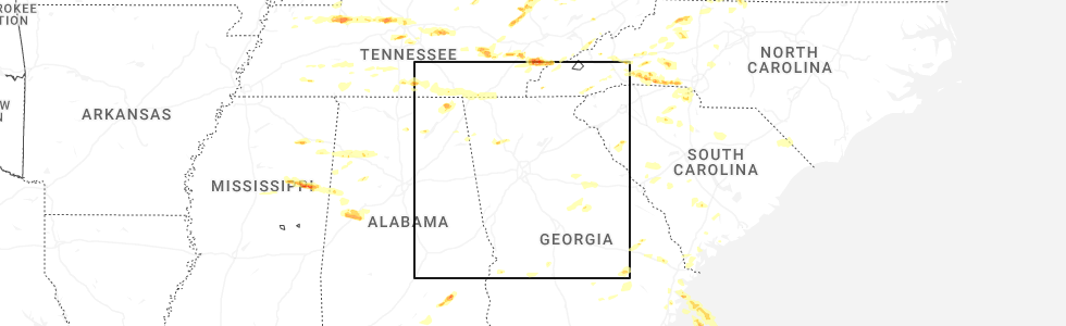
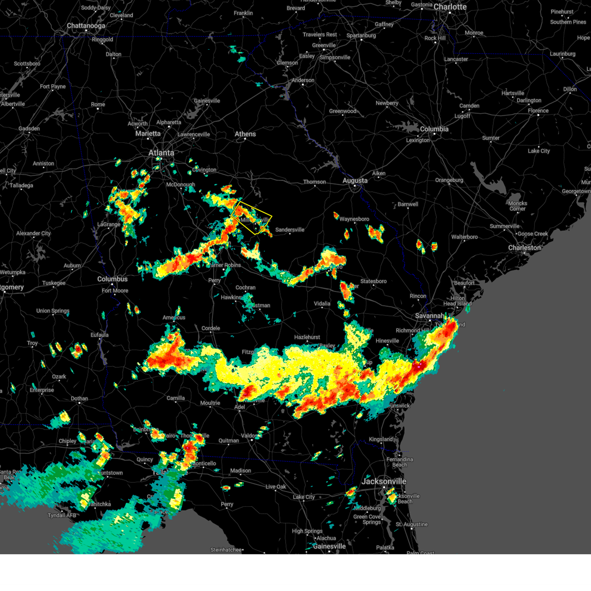
Hail Map for Crooked Creek, GA
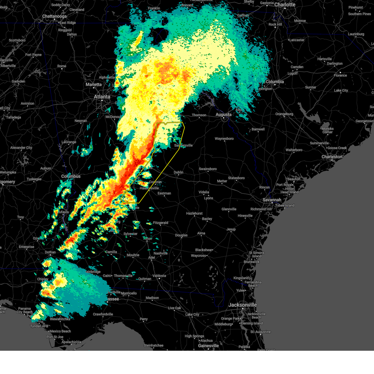
The Crooked Creek, GA area has had 0 reports of on-the-ground hail by trained spotters, and has been under severe weather warnings 29 times during the past 12 months. Doppler radar has detected hail at or near Crooked Creek, GA on 42 occasions, including 3 occasions during the past year.
| Name: | Crooked Creek, GA |
| Where Located: | 72.7 miles ESE of Atlanta, GA |
| Map: | Google Map for Crooked Creek, GA |
| Population: | 639 |
| Housing Units: | 470 |
| More Info: | Search Google for Crooked Creek, GA |
2
The Top Recent Hail Date for Crooked Creek, GA is Thursday, May 8, 2025 (6th out of 42)
Hail and Wind Damage Spotted near Crooked Creek, GA
| Date / Time | Report Details |
|---|---|
| 6/7/2025 7:20 PM EDT |
 The storms which prompted the warning have weakened below severe limits, and have exited the warned area. therefore, the warning will be allowed to expire. however, gusty winds are still possible with these thunderstorms. a severe thunderstorm watch remains in effect until 900 pm edt for central, north central and east central georgia. The storms which prompted the warning have weakened below severe limits, and have exited the warned area. therefore, the warning will be allowed to expire. however, gusty winds are still possible with these thunderstorms. a severe thunderstorm watch remains in effect until 900 pm edt for central, north central and east central georgia.
|
| 6/7/2025 7:15 PM EDT |
 At 715 pm edt, severe thunderstorms were located along a line extending from parks mill to eatonton to near stanfordville, moving east at 40 mph (radar indicated). Hazards include 60 mph wind gusts. Expect damage to roofs, siding, and trees. Locations impacted include, eatonton, white plains, phoenix, reynolds at lake oconee, liberty, meriwether, ethridge, veazey, harmony, resseaus crossroads, oconee springs park, warfield, willard, rockville, rock eagle 4-h center, plant harlee branch, parks mill, shoulderbone, stanfordville, and adgateville. At 715 pm edt, severe thunderstorms were located along a line extending from parks mill to eatonton to near stanfordville, moving east at 40 mph (radar indicated). Hazards include 60 mph wind gusts. Expect damage to roofs, siding, and trees. Locations impacted include, eatonton, white plains, phoenix, reynolds at lake oconee, liberty, meriwether, ethridge, veazey, harmony, resseaus crossroads, oconee springs park, warfield, willard, rockville, rock eagle 4-h center, plant harlee branch, parks mill, shoulderbone, stanfordville, and adgateville.
|
| 6/7/2025 6:46 PM EDT |
 Svrffc the national weather service in peachtree city has issued a * severe thunderstorm warning for, northwestern baldwin county in central georgia, southern morgan county in north central georgia, putnam county in central georgia, northwestern hancock county in east central georgia, southeastern greene county in east central georgia, northeastern jones county in central georgia, jasper county in central georgia, * until 730 pm edt. * at 646 pm edt, severe thunderstorms were located along a line extending from near rutledge to near shady dale to near turtle cove, moving east at 35 mph (radar indicated). Hazards include 60 mph wind gusts. expect damage to roofs, siding, and trees Svrffc the national weather service in peachtree city has issued a * severe thunderstorm warning for, northwestern baldwin county in central georgia, southern morgan county in north central georgia, putnam county in central georgia, northwestern hancock county in east central georgia, southeastern greene county in east central georgia, northeastern jones county in central georgia, jasper county in central georgia, * until 730 pm edt. * at 646 pm edt, severe thunderstorms were located along a line extending from near rutledge to near shady dale to near turtle cove, moving east at 35 mph (radar indicated). Hazards include 60 mph wind gusts. expect damage to roofs, siding, and trees
|
| 5/9/2025 1:15 AM EDT |
 Svrffc the national weather service in peachtree city has issued a * severe thunderstorm warning for, southeastern putnam county in central georgia, west central hancock county in east central georgia, * until 130 am edt. * at 114 am edt, a severe thunderstorm was located over oconee springs park, or 10 miles southeast of eatonton, moving northeast at 25 mph (radar indicated). Hazards include 60 mph wind gusts and quarter size hail. Hail damage to vehicles is expected. Expect wind damage to roofs, siding, and trees. Svrffc the national weather service in peachtree city has issued a * severe thunderstorm warning for, southeastern putnam county in central georgia, west central hancock county in east central georgia, * until 130 am edt. * at 114 am edt, a severe thunderstorm was located over oconee springs park, or 10 miles southeast of eatonton, moving northeast at 25 mph (radar indicated). Hazards include 60 mph wind gusts and quarter size hail. Hail damage to vehicles is expected. Expect wind damage to roofs, siding, and trees.
|
| 5/9/2025 12:51 AM EDT |
 Svrffc the national weather service in peachtree city has issued a * severe thunderstorm warning for, northwestern baldwin county in central georgia, southeastern putnam county in central georgia, west central hancock county in east central georgia, * until 115 am edt. * at 1251 am edt, a severe thunderstorm was located near meriwether, or 9 miles northwest of milledgeville, moving northeast at 25 mph (radar indicated). Hazards include 60 mph wind gusts and quarter size hail. Hail damage to vehicles is expected. Expect wind damage to roofs, siding, and trees. Svrffc the national weather service in peachtree city has issued a * severe thunderstorm warning for, northwestern baldwin county in central georgia, southeastern putnam county in central georgia, west central hancock county in east central georgia, * until 115 am edt. * at 1251 am edt, a severe thunderstorm was located near meriwether, or 9 miles northwest of milledgeville, moving northeast at 25 mph (radar indicated). Hazards include 60 mph wind gusts and quarter size hail. Hail damage to vehicles is expected. Expect wind damage to roofs, siding, and trees.
|
| 4/7/2025 9:10 AM EDT |
 the severe thunderstorm warning has been cancelled and is no longer in effect the severe thunderstorm warning has been cancelled and is no longer in effect
|
| 4/7/2025 8:59 AM EDT |
 At 858 am edt, severe thunderstorms were located along a line extending from rock eagle 4-h center to near warfield to near hillsboro, moving east at 45 mph (radar indicated). Hazards include 60 mph wind gusts. Expect damage to roofs, siding, and trees. Locations impacted include, veazey, greensboro, oconee springs park, warfield, liberty, rockville, plant harlee branch, parks mill, carey, swords, shoulderbone, phoenix, reynolds at lake oconee, siloam, union point, white plains, and eatonton. At 858 am edt, severe thunderstorms were located along a line extending from rock eagle 4-h center to near warfield to near hillsboro, moving east at 45 mph (radar indicated). Hazards include 60 mph wind gusts. Expect damage to roofs, siding, and trees. Locations impacted include, veazey, greensboro, oconee springs park, warfield, liberty, rockville, plant harlee branch, parks mill, carey, swords, shoulderbone, phoenix, reynolds at lake oconee, siloam, union point, white plains, and eatonton.
|
| 4/7/2025 8:59 AM EDT |
 the severe thunderstorm warning has been cancelled and is no longer in effect the severe thunderstorm warning has been cancelled and is no longer in effect
|
| 4/7/2025 8:37 AM EDT |
 Svrffc the national weather service in peachtree city has issued a * severe thunderstorm warning for, southeastern morgan county in north central georgia, putnam county in central georgia, northwestern hancock county in east central georgia, southern greene county in east central georgia, southeastern jasper county in central georgia, * until 930 am edt. * at 837 am edt, severe thunderstorms were located along a line extending from calvin to near monticello to berner, moving east at 45 mph (radar indicated). Hazards include 60 mph wind gusts. expect damage to roofs, siding, and trees Svrffc the national weather service in peachtree city has issued a * severe thunderstorm warning for, southeastern morgan county in north central georgia, putnam county in central georgia, northwestern hancock county in east central georgia, southern greene county in east central georgia, southeastern jasper county in central georgia, * until 930 am edt. * at 837 am edt, severe thunderstorms were located along a line extending from calvin to near monticello to berner, moving east at 45 mph (radar indicated). Hazards include 60 mph wind gusts. expect damage to roofs, siding, and trees
|
| 3/31/2025 2:09 PM EDT |
 Svrffc the national weather service in peachtree city has issued a * severe thunderstorm warning for, northern baldwin county in central georgia, warren county in east central georgia, southeastern morgan county in north central georgia, putnam county in central georgia, hancock county in east central georgia, greene county in east central georgia, taliaferro county in east central georgia, southwestern wilkes county in east central georgia, northeastern jones county in central georgia, * until 300 pm edt. * at 209 pm edt, severe thunderstorms were located along a line extending from near madison to near warfield to near blountsville, moving east at 55 mph (radar indicated). Hazards include 60 mph wind gusts. expect damage to roofs, siding, and trees Svrffc the national weather service in peachtree city has issued a * severe thunderstorm warning for, northern baldwin county in central georgia, warren county in east central georgia, southeastern morgan county in north central georgia, putnam county in central georgia, hancock county in east central georgia, greene county in east central georgia, taliaferro county in east central georgia, southwestern wilkes county in east central georgia, northeastern jones county in central georgia, * until 300 pm edt. * at 209 pm edt, severe thunderstorms were located along a line extending from near madison to near warfield to near blountsville, moving east at 55 mph (radar indicated). Hazards include 60 mph wind gusts. expect damage to roofs, siding, and trees
|
| 3/16/2025 4:38 AM EDT |
 The storms which prompted the warning have moved out of the area. therefore, the warning will be allowed to expire. a tornado watch remains in effect until 1000 am edt for central and east central georgia. to report severe weather, contact your nearest law enforcement agency. they will relay your report to the national weather service peachtree city. The storms which prompted the warning have moved out of the area. therefore, the warning will be allowed to expire. a tornado watch remains in effect until 1000 am edt for central and east central georgia. to report severe weather, contact your nearest law enforcement agency. they will relay your report to the national weather service peachtree city.
|
| 3/16/2025 4:09 AM EDT |
 the tornado warning has been cancelled and is no longer in effect the tornado warning has been cancelled and is no longer in effect
|
| 3/16/2025 3:54 AM EDT |
 Torffc the national weather service in peachtree city has issued a * tornado warning for, north central baldwin county in central georgia, southeastern putnam county in central georgia, hancock county in east central georgia, * until 430 am edt. * at 354 am edt, a severe thunderstorm capable of producing a tornado was located over plant harlee branch, or 7 miles north of milledgeville, moving northeast at 50 mph (radar indicated rotation). Hazards include tornado. Flying debris will be dangerous to those caught without shelter. mobile homes will be damaged or destroyed. damage to roofs, windows, and vehicles will occur. Tree damage is likely. Torffc the national weather service in peachtree city has issued a * tornado warning for, north central baldwin county in central georgia, southeastern putnam county in central georgia, hancock county in east central georgia, * until 430 am edt. * at 354 am edt, a severe thunderstorm capable of producing a tornado was located over plant harlee branch, or 7 miles north of milledgeville, moving northeast at 50 mph (radar indicated rotation). Hazards include tornado. Flying debris will be dangerous to those caught without shelter. mobile homes will be damaged or destroyed. damage to roofs, windows, and vehicles will occur. Tree damage is likely.
|
| 3/16/2025 3:53 AM EDT |
 Svrffc the national weather service in peachtree city has issued a * severe thunderstorm warning for, wilkinson county in central georgia, baldwin county in central georgia, northwestern pulaski county in central georgia, twiggs county in central georgia, southeastern putnam county in central georgia, hancock county in east central georgia, dooly county in central georgia, northwestern bleckley county in central georgia, northwestern washington county in east central georgia, houston county in central georgia, * until 445 am edt. * at 353 am edt, severe thunderstorms were located along a line extending from rockville to near griswoldville to new era, moving east at 40 mph (radar indicated). Hazards include 60 mph wind gusts. expect damage to roofs, siding, and trees Svrffc the national weather service in peachtree city has issued a * severe thunderstorm warning for, wilkinson county in central georgia, baldwin county in central georgia, northwestern pulaski county in central georgia, twiggs county in central georgia, southeastern putnam county in central georgia, hancock county in east central georgia, dooly county in central georgia, northwestern bleckley county in central georgia, northwestern washington county in east central georgia, houston county in central georgia, * until 445 am edt. * at 353 am edt, severe thunderstorms were located along a line extending from rockville to near griswoldville to new era, moving east at 40 mph (radar indicated). Hazards include 60 mph wind gusts. expect damage to roofs, siding, and trees
|
| 2/16/2025 5:59 AM EST |
 Svrffc the national weather service in peachtree city has issued a * severe thunderstorm warning for, northern laurens county in central georgia, central bibb county in central georgia, hancock county in east central georgia, glascock county in east central georgia, northeastern houston county in central georgia, eastern jones county in central georgia, northwestern jefferson county in east central georgia, wilkinson county in central georgia, baldwin county in central georgia, southern warren county in east central georgia, twiggs county in central georgia, southeastern putnam county in central georgia, northeastern bleckley county in central georgia, northeastern peach county in central georgia, washington county in east central georgia, northwestern johnson county in east central georgia, * until 700 am est. * at 558 am est, severe thunderstorms were located along a line extending from near rockville to near james to jack brown estates, moving east at 55 mph (radar indicated). Hazards include 60 mph wind gusts. expect damage to roofs, siding, and trees Svrffc the national weather service in peachtree city has issued a * severe thunderstorm warning for, northern laurens county in central georgia, central bibb county in central georgia, hancock county in east central georgia, glascock county in east central georgia, northeastern houston county in central georgia, eastern jones county in central georgia, northwestern jefferson county in east central georgia, wilkinson county in central georgia, baldwin county in central georgia, southern warren county in east central georgia, twiggs county in central georgia, southeastern putnam county in central georgia, northeastern bleckley county in central georgia, northeastern peach county in central georgia, washington county in east central georgia, northwestern johnson county in east central georgia, * until 700 am est. * at 558 am est, severe thunderstorms were located along a line extending from near rockville to near james to jack brown estates, moving east at 55 mph (radar indicated). Hazards include 60 mph wind gusts. expect damage to roofs, siding, and trees
|
| 2/16/2025 5:37 AM EST |
 At 537 am est, severe thunderstorms were located along a line extending from calvin to near adgateville to plant scherer to near russellville, moving east at 55 mph (radar indicated). Hazards include 70 mph wind gusts. Expect considerable tree damage. damage is likely to mobile homes, roofs, and outbuildings. Locations impacted include, macon, eatonton, forsyth, gray, monticello, shady dale, payne, culloden, payne city, postell, lake tobesofkee, bradley, wayside, resseaus crossroads, round oak, russellville, central georgia experiment stn, plant harlee branch, wesleyan, and skipperton. At 537 am est, severe thunderstorms were located along a line extending from calvin to near adgateville to plant scherer to near russellville, moving east at 55 mph (radar indicated). Hazards include 70 mph wind gusts. Expect considerable tree damage. damage is likely to mobile homes, roofs, and outbuildings. Locations impacted include, macon, eatonton, forsyth, gray, monticello, shady dale, payne, culloden, payne city, postell, lake tobesofkee, bradley, wayside, resseaus crossroads, round oak, russellville, central georgia experiment stn, plant harlee branch, wesleyan, and skipperton.
|
| 2/16/2025 5:37 AM EST |
 the severe thunderstorm warning has been cancelled and is no longer in effect the severe thunderstorm warning has been cancelled and is no longer in effect
|
| 2/16/2025 5:05 AM EST | Svrffc the national weather service in peachtree city has issued a * severe thunderstorm warning for, eastern spalding county in west central georgia, bibb county in central georgia, southeastern pike county in west central georgia, monroe county in central georgia, upson county in west central georgia, butts county in central georgia, jones county in central georgia, south central newton county in north central georgia, northwestern baldwin county in central georgia, putnam county in central georgia, southeastern henry county in north central georgia, northern crawford county in central georgia, jasper county in central georgia, lamar county in west central georgia, * until 600 am est. * at 505 am est, severe thunderstorms were located along a line extending from blacksville to walker mill to near milner to sprewell bluff state park, moving east at 55 mph (radar indicated). Hazards include 70 mph wind gusts. Expect considerable tree damage. Damage is likely to mobile homes, roofs, and outbuildings. |
| 12/29/2024 6:44 AM EST |
 The storms which prompted the warning have weakened below severe limits, and no longer pose an immediate threat to life or property. therefore, the warning will be allowed to expire. however, gusty winds are still possible with these thunderstorms. a tornado watch remains in effect until 900 am est for central and east central georgia. The storms which prompted the warning have weakened below severe limits, and no longer pose an immediate threat to life or property. therefore, the warning will be allowed to expire. however, gusty winds are still possible with these thunderstorms. a tornado watch remains in effect until 900 am est for central and east central georgia.
|
| 12/29/2024 5:51 AM EST |
 Svrffc the national weather service in peachtree city has issued a * severe thunderstorm warning for, western laurens county in central georgia, northwestern dodge county in central georgia, hancock county in east central georgia, west central glascock county in east central georgia, east central houston county in central georgia, taliaferro county in east central georgia, wilkinson county in central georgia, baldwin county in central georgia, western warren county in east central georgia, southeastern morgan county in north central georgia, twiggs county in central georgia, central putnam county in central georgia, bleckley county in central georgia, southern greene county in east central georgia, washington county in east central georgia, northwestern johnson county in east central georgia, * until 645 am est. * at 550 am est, severe thunderstorms were located along a line extending from swords to near gordon to bonaire, moving east at 35 mph (radar indicated). Hazards include 60 mph wind gusts. expect damage to roofs, siding, and trees Svrffc the national weather service in peachtree city has issued a * severe thunderstorm warning for, western laurens county in central georgia, northwestern dodge county in central georgia, hancock county in east central georgia, west central glascock county in east central georgia, east central houston county in central georgia, taliaferro county in east central georgia, wilkinson county in central georgia, baldwin county in central georgia, western warren county in east central georgia, southeastern morgan county in north central georgia, twiggs county in central georgia, central putnam county in central georgia, bleckley county in central georgia, southern greene county in east central georgia, washington county in east central georgia, northwestern johnson county in east central georgia, * until 645 am est. * at 550 am est, severe thunderstorms were located along a line extending from swords to near gordon to bonaire, moving east at 35 mph (radar indicated). Hazards include 60 mph wind gusts. expect damage to roofs, siding, and trees
|
| 12/29/2024 5:31 AM EST |
 the severe thunderstorm warning has been cancelled and is no longer in effect the severe thunderstorm warning has been cancelled and is no longer in effect
|
| 12/29/2024 5:31 AM EST |
 At 530 am est, severe thunderstorms were located along a line extending from near rutledge to clinton to near lakewood, moving east at 55 mph (radar indicated). Hazards include 60 mph wind gusts. Expect damage to roofs, siding, and trees. Locations impacted include, macon, milledgeville, eatonton, madison, gray, monticello, jeffersonville, warner robins, centerville, byron, gordon, ivey, shady dale, payne, buckhead, robins afb, payne city, phoenix, meriwether, and marion. At 530 am est, severe thunderstorms were located along a line extending from near rutledge to clinton to near lakewood, moving east at 55 mph (radar indicated). Hazards include 60 mph wind gusts. Expect damage to roofs, siding, and trees. Locations impacted include, macon, milledgeville, eatonton, madison, gray, monticello, jeffersonville, warner robins, centerville, byron, gordon, ivey, shady dale, payne, buckhead, robins afb, payne city, phoenix, meriwether, and marion.
|
| 12/29/2024 5:18 AM EST |
 the severe thunderstorm warning has been cancelled and is no longer in effect the severe thunderstorm warning has been cancelled and is no longer in effect
|
| 12/29/2024 5:18 AM EST |
 At 518 am est, severe thunderstorms were located along a line extending from conyers to calvin to near monticello to near jarrell plantation to fort valley, moving northeast at 75 mph (radar indicated). Hazards include 60 mph wind gusts. Expect damage to roofs, siding, and trees. Locations impacted include, macon, milledgeville, conyers, monroe, covington, fort valley, eatonton, madison, gray, monticello, jeffersonville, warner robins, centerville, byron, social circle, oxford, gordon, porterdale, walnut grove, and ivey. At 518 am est, severe thunderstorms were located along a line extending from conyers to calvin to near monticello to near jarrell plantation to fort valley, moving northeast at 75 mph (radar indicated). Hazards include 60 mph wind gusts. Expect damage to roofs, siding, and trees. Locations impacted include, macon, milledgeville, conyers, monroe, covington, fort valley, eatonton, madison, gray, monticello, jeffersonville, warner robins, centerville, byron, social circle, oxford, gordon, porterdale, walnut grove, and ivey.
|
| 12/29/2024 4:53 AM EST |
 Svrffc the national weather service in peachtree city has issued a * severe thunderstorm warning for, bibb county in central georgia, monroe county in central georgia, northeastern houston county in central georgia, butts county in central georgia, jones county in central georgia, newton county in north central georgia, rockdale county in north central georgia, northwestern wilkinson county in central georgia, western baldwin county in central georgia, morgan county in north central georgia, twiggs county in central georgia, putnam county in central georgia, henry county in north central georgia, walton county in north central georgia, peach county in central georgia, crawford county in central georgia, jasper county in central georgia, northeastern taylor county in west central georgia, northeastern lamar county in west central georgia, * until 600 am est. * at 452 am est, severe thunderstorms were located along a line extending from stockbridge to high falls state park to brent to near reynolds, moving east at 50 mph (radar indicated). Hazards include 60 mph wind gusts. expect damage to roofs, siding, and trees Svrffc the national weather service in peachtree city has issued a * severe thunderstorm warning for, bibb county in central georgia, monroe county in central georgia, northeastern houston county in central georgia, butts county in central georgia, jones county in central georgia, newton county in north central georgia, rockdale county in north central georgia, northwestern wilkinson county in central georgia, western baldwin county in central georgia, morgan county in north central georgia, twiggs county in central georgia, putnam county in central georgia, henry county in north central georgia, walton county in north central georgia, peach county in central georgia, crawford county in central georgia, jasper county in central georgia, northeastern taylor county in west central georgia, northeastern lamar county in west central georgia, * until 600 am est. * at 452 am est, severe thunderstorms were located along a line extending from stockbridge to high falls state park to brent to near reynolds, moving east at 50 mph (radar indicated). Hazards include 60 mph wind gusts. expect damage to roofs, siding, and trees
|
| 7/31/2024 6:02 PM EDT |
 the severe thunderstorm warning has been cancelled and is no longer in effect the severe thunderstorm warning has been cancelled and is no longer in effect
|
| 7/31/2024 5:49 PM EDT | the severe thunderstorm warning has been cancelled and is no longer in effect |
| 7/31/2024 5:49 PM EDT | At 549 pm edt, a severe thunderstorm was located near milledgeville, moving east at 20 mph (radar indicated). Hazards include 60 mph wind gusts and quarter size hail. Hail damage to vehicles is expected. expect wind damage to roofs, siding, and trees. Locations impacted include, milledgeville, midway-hardwick, meriwether, plant harlee branch, beulah, underwood, hardwick, browns crossing, allenwood, pancras, and scottsboro. |
| 7/31/2024 5:24 PM EDT |
 Svrffc the national weather service in peachtree city has issued a * severe thunderstorm warning for, baldwin county in central georgia, southwestern putnam county in central georgia, southwestern hancock county in east central georgia, northeastern jones county in central georgia, * until 615 pm edt. * at 524 pm edt, a severe thunderstorm was located over resseaus crossroads, or 9 miles south of eatonton, moving southeast at 20 mph (radar indicated). Hazards include 60 mph wind gusts and quarter size hail. Hail damage to vehicles is expected. Expect wind damage to roofs, siding, and trees. Svrffc the national weather service in peachtree city has issued a * severe thunderstorm warning for, baldwin county in central georgia, southwestern putnam county in central georgia, southwestern hancock county in east central georgia, northeastern jones county in central georgia, * until 615 pm edt. * at 524 pm edt, a severe thunderstorm was located over resseaus crossroads, or 9 miles south of eatonton, moving southeast at 20 mph (radar indicated). Hazards include 60 mph wind gusts and quarter size hail. Hail damage to vehicles is expected. Expect wind damage to roofs, siding, and trees.
|
| 9/7/2023 2:21 PM EDT |
 At 220 pm edt, severe thunderstorms were located along a line extending from rockville to near haddock, moving east at 30 mph (radar indicated). Hazards include 60 mph wind gusts and quarter size hail. Hail damage to vehicles is expected. expect wind damage to roofs, siding, and trees. locations impacted include, milledgeville, eatonton, gray, midway-hardwick, meriwether, ethridge, postell, james, bradley, coopers, allenwood, mountain springs, haddock, resseaus crossroads, oconee springs park, warfield, greenberry crossroads, clinton, rockville, and plant harlee branch. hail threat, radar indicated max hail size, 1. 00 in wind threat, radar indicated max wind gust, 60 mph. At 220 pm edt, severe thunderstorms were located along a line extending from rockville to near haddock, moving east at 30 mph (radar indicated). Hazards include 60 mph wind gusts and quarter size hail. Hail damage to vehicles is expected. expect wind damage to roofs, siding, and trees. locations impacted include, milledgeville, eatonton, gray, midway-hardwick, meriwether, ethridge, postell, james, bradley, coopers, allenwood, mountain springs, haddock, resseaus crossroads, oconee springs park, warfield, greenberry crossroads, clinton, rockville, and plant harlee branch. hail threat, radar indicated max hail size, 1. 00 in wind threat, radar indicated max wind gust, 60 mph.
|
| 9/7/2023 2:13 PM EDT |
 At 212 pm edt, severe thunderstorms were located along a line extending from near rockville to near greenberry crossroads, moving east at 30 mph (radar indicated). Hazards include 60 mph wind gusts and quarter size hail. Hail damage to vehicles is expected. expect wind damage to roofs, siding, and trees. locations impacted include, milledgeville, eatonton, gray, midway-hardwick, meriwether, ethridge, postell, james, bradley, coopers, allenwood, mountain springs, haddock, resseaus crossroads, oconee springs park, warfield, greenberry crossroads, clinton, rockville, and plant harlee branch. hail threat, radar indicated max hail size, 1. 00 in wind threat, radar indicated max wind gust, 60 mph. At 212 pm edt, severe thunderstorms were located along a line extending from near rockville to near greenberry crossroads, moving east at 30 mph (radar indicated). Hazards include 60 mph wind gusts and quarter size hail. Hail damage to vehicles is expected. expect wind damage to roofs, siding, and trees. locations impacted include, milledgeville, eatonton, gray, midway-hardwick, meriwether, ethridge, postell, james, bradley, coopers, allenwood, mountain springs, haddock, resseaus crossroads, oconee springs park, warfield, greenberry crossroads, clinton, rockville, and plant harlee branch. hail threat, radar indicated max hail size, 1. 00 in wind threat, radar indicated max wind gust, 60 mph.
|
| 9/7/2023 1:44 PM EDT |
 At 144 pm edt, severe thunderstorms were located along a line extending from willard to near arkwright, moving east at 30 mph (radar indicated). Hazards include 60 mph wind gusts and quarter size hail. Hail damage to vehicles is expected. Expect wind damage to roofs, siding, and trees. At 144 pm edt, severe thunderstorms were located along a line extending from willard to near arkwright, moving east at 30 mph (radar indicated). Hazards include 60 mph wind gusts and quarter size hail. Hail damage to vehicles is expected. Expect wind damage to roofs, siding, and trees.
|
| 8/15/2023 4:24 PM EDT |
 At 424 pm edt, a severe thunderstorm was located over phoenix, or 10 miles northeast of eatonton, moving east at 30 mph (radar indicated). Hazards include 60 mph wind gusts and quarter size hail. Hail damage to vehicles is expected. Expect wind damage to roofs, siding, and trees. At 424 pm edt, a severe thunderstorm was located over phoenix, or 10 miles northeast of eatonton, moving east at 30 mph (radar indicated). Hazards include 60 mph wind gusts and quarter size hail. Hail damage to vehicles is expected. Expect wind damage to roofs, siding, and trees.
|
| 8/15/2023 4:19 PM EDT |
 At 419 pm edt, a severe thunderstorm was located over veazey, or near greensboro, moving east at 40 mph (radar indicated). Hazards include 60 mph wind gusts and penny size hail. Expect damage to roofs, siding, and trees. locations impacted include, eatonton, madison, greensboro, monticello, union point, woodville, white plains, siloam, shady dale, buckhead, phoenix, reynolds at lake oconee, liberty, veazey, greshamville, central georgia experiment stn, parks mill, swords, shoulderbone, and harmony. hail threat, radar indicated max hail size, 0. 75 in wind threat, radar indicated max wind gust, 60 mph. At 419 pm edt, a severe thunderstorm was located over veazey, or near greensboro, moving east at 40 mph (radar indicated). Hazards include 60 mph wind gusts and penny size hail. Expect damage to roofs, siding, and trees. locations impacted include, eatonton, madison, greensboro, monticello, union point, woodville, white plains, siloam, shady dale, buckhead, phoenix, reynolds at lake oconee, liberty, veazey, greshamville, central georgia experiment stn, parks mill, swords, shoulderbone, and harmony. hail threat, radar indicated max hail size, 0. 75 in wind threat, radar indicated max wind gust, 60 mph.
|
| 8/15/2023 3:51 PM EDT |
 At 350 pm edt, a severe thunderstorm was located near godfrey, or near madison, moving east at 40 mph (radar indicated). Hazards include 60 mph wind gusts and penny size hail. expect damage to roofs, siding, and trees At 350 pm edt, a severe thunderstorm was located near godfrey, or near madison, moving east at 40 mph (radar indicated). Hazards include 60 mph wind gusts and penny size hail. expect damage to roofs, siding, and trees
|
| 8/7/2023 6:25 PM EDT |
 At 625 pm edt, severe thunderstorms were located along a line extending from eudora to near calvin to near mcelheneys crossroads, moving east at 45 mph (radar indicated). Hazards include 60 mph wind gusts. expect damage to roofs, siding, and trees At 625 pm edt, severe thunderstorms were located along a line extending from eudora to near calvin to near mcelheneys crossroads, moving east at 45 mph (radar indicated). Hazards include 60 mph wind gusts. expect damage to roofs, siding, and trees
|
| 8/3/2023 6:09 PM EDT |
 At 609 pm edt, severe thunderstorms were located along a line extending from near powelton to devereux to mcelheneys crossroads, moving southeast at 30 mph (radar indicated). Hazards include 60 mph wind gusts and half dollar size hail. Hail damage to vehicles is expected. Expect wind damage to roofs, siding, and trees. At 609 pm edt, severe thunderstorms were located along a line extending from near powelton to devereux to mcelheneys crossroads, moving southeast at 30 mph (radar indicated). Hazards include 60 mph wind gusts and half dollar size hail. Hail damage to vehicles is expected. Expect wind damage to roofs, siding, and trees.
|
| 8/3/2023 5:50 PM EDT |
 At 550 pm edt, severe thunderstorms were located along a line extending from near veazey to near rockville to near monticello, moving southeast at 25 mph (radar indicated). Hazards include 60 mph wind gusts and quarter size hail. Hail damage to vehicles is expected. expect wind damage to roofs, siding, and trees. locations impacted include, eatonton, greensboro, monticello, white plains, siloam, shady dale, phoenix, reynolds at lake oconee, liberty, springfield, veazey, turtle cove, resseaus crossroads, central georgia experiment stn, plant harlee branch, eudora, north alcovy, mcelheneys crossroads, shoulderbone, and harmony. hail threat, radar indicated max hail size, 1. 00 in wind threat, radar indicated max wind gust, 60 mph. At 550 pm edt, severe thunderstorms were located along a line extending from near veazey to near rockville to near monticello, moving southeast at 25 mph (radar indicated). Hazards include 60 mph wind gusts and quarter size hail. Hail damage to vehicles is expected. expect wind damage to roofs, siding, and trees. locations impacted include, eatonton, greensboro, monticello, white plains, siloam, shady dale, phoenix, reynolds at lake oconee, liberty, springfield, veazey, turtle cove, resseaus crossroads, central georgia experiment stn, plant harlee branch, eudora, north alcovy, mcelheneys crossroads, shoulderbone, and harmony. hail threat, radar indicated max hail size, 1. 00 in wind threat, radar indicated max wind gust, 60 mph.
|
| 8/3/2023 5:23 PM EDT |
 At 523 pm edt, severe thunderstorms were located along a line extending from near greensboro to near farrar to worthville, moving southeast at 35 mph (radar indicated). Hazards include 60 mph wind gusts. expect damage to roofs, siding, and trees At 523 pm edt, severe thunderstorms were located along a line extending from near greensboro to near farrar to worthville, moving southeast at 35 mph (radar indicated). Hazards include 60 mph wind gusts. expect damage to roofs, siding, and trees
|
| 7/30/2023 3:44 PM EDT |
 At 343 pm edt, a severe thunderstorm was located over plant harlee branch, or 9 miles north of milledgeville, moving southeast at 15 mph (radar indicated). Hazards include 60 mph wind gusts and quarter size hail. Hail damage to vehicles is expected. Expect wind damage to roofs, siding, and trees. At 343 pm edt, a severe thunderstorm was located over plant harlee branch, or 9 miles north of milledgeville, moving southeast at 15 mph (radar indicated). Hazards include 60 mph wind gusts and quarter size hail. Hail damage to vehicles is expected. Expect wind damage to roofs, siding, and trees.
|
| 7/20/2023 6:46 PM EDT |
 At 646 pm edt, severe thunderstorms were located along a line extending from near carlton to conyers, moving southeast at 50 mph (radar indicated). Hazards include 60 mph wind gusts and nickel size hail. expect damage to roofs, siding, and trees At 646 pm edt, severe thunderstorms were located along a line extending from near carlton to conyers, moving southeast at 50 mph (radar indicated). Hazards include 60 mph wind gusts and nickel size hail. expect damage to roofs, siding, and trees
|
| 3/26/2023 7:25 AM EDT |
 At 725 am edt, a severe thunderstorm was located over milledgeville, moving east at 40 mph (radar indicated). Hazards include 60 mph wind gusts and half dollar size hail. Hail damage to vehicles is expected. expect wind damage to roofs, siding, and trees. Locations impacted include, milledgeville, eatonton, midway-hardwick, liberty, meriwether, devereux, beulah, underwood, allenwood, oconee springs park, warfield, rockville, plant harlee branch, hardwick, browns crossing and shoulderbone. At 725 am edt, a severe thunderstorm was located over milledgeville, moving east at 40 mph (radar indicated). Hazards include 60 mph wind gusts and half dollar size hail. Hail damage to vehicles is expected. expect wind damage to roofs, siding, and trees. Locations impacted include, milledgeville, eatonton, midway-hardwick, liberty, meriwether, devereux, beulah, underwood, allenwood, oconee springs park, warfield, rockville, plant harlee branch, hardwick, browns crossing and shoulderbone.
|
| 3/26/2023 7:12 AM EDT |
 At 712 am edt, a severe thunderstorm was located near browns crossing, or 8 miles west of milledgeville, moving east at 40 mph (radar indicated). Hazards include 60 mph wind gusts and half dollar size hail. Hail damage to vehicles is expected. expect wind damage to roofs, siding, and trees. Locations impacted include, milledgeville, eatonton, gray, midway-hardwick, liberty, meriwether, ethridge, devereux, beulah, underwood, allenwood, haddock, resseaus crossroads, oconee springs park, warfield, scottsboro, rockville, plant harlee branch, hardwick and browns crossing. At 712 am edt, a severe thunderstorm was located near browns crossing, or 8 miles west of milledgeville, moving east at 40 mph (radar indicated). Hazards include 60 mph wind gusts and half dollar size hail. Hail damage to vehicles is expected. expect wind damage to roofs, siding, and trees. Locations impacted include, milledgeville, eatonton, gray, midway-hardwick, liberty, meriwether, ethridge, devereux, beulah, underwood, allenwood, haddock, resseaus crossroads, oconee springs park, warfield, scottsboro, rockville, plant harlee branch, hardwick and browns crossing.
|
| 3/26/2023 6:57 AM EDT |
 At 656 am edt, a severe thunderstorm was located over bradley, or near gray, moving east at 40 mph (radar indicated). Hazards include 60 mph wind gusts and half dollar size hail. Hail damage to vehicles is expected. Expect wind damage to roofs, siding, and trees. At 656 am edt, a severe thunderstorm was located over bradley, or near gray, moving east at 40 mph (radar indicated). Hazards include 60 mph wind gusts and half dollar size hail. Hail damage to vehicles is expected. Expect wind damage to roofs, siding, and trees.
|
| 1/12/2023 5:19 PM EST |
 At 518 pm est, severe thunderstorms were located along a line extending from harmony to near eatonton to bradley, moving east at 50 mph (radar indicated). Hazards include 60 mph wind gusts. expect damage to roofs, siding, and trees At 518 pm est, severe thunderstorms were located along a line extending from harmony to near eatonton to bradley, moving east at 50 mph (radar indicated). Hazards include 60 mph wind gusts. expect damage to roofs, siding, and trees
|
| 1/12/2023 3:40 PM EST |
 At 340 pm est, a severe thunderstorm was located near oconee springs park, or 11 miles north of milledgeville, moving northeast at 75 mph (radar indicated). Hazards include 60 mph wind gusts. Expect damage to roofs, siding, and trees. Locations impacted include, sparta, shoulderbone, oconee springs park and devereux. At 340 pm est, a severe thunderstorm was located near oconee springs park, or 11 miles north of milledgeville, moving northeast at 75 mph (radar indicated). Hazards include 60 mph wind gusts. Expect damage to roofs, siding, and trees. Locations impacted include, sparta, shoulderbone, oconee springs park and devereux.
|
| 1/12/2023 3:25 PM EST |
 At 325 pm est, a severe thunderstorm was located over allenwood, or near milledgeville, moving east at 45 mph (radar indicated). Hazards include 60 mph wind gusts. Expect damage to roofs, siding, and trees. Locations impacted include, milledgeville, sparta, meriwether, plant harlee branch, devereux, beulah, underwood, shoulderbone, oconee springs park, linton and allenwood. At 325 pm est, a severe thunderstorm was located over allenwood, or near milledgeville, moving east at 45 mph (radar indicated). Hazards include 60 mph wind gusts. Expect damage to roofs, siding, and trees. Locations impacted include, milledgeville, sparta, meriwether, plant harlee branch, devereux, beulah, underwood, shoulderbone, oconee springs park, linton and allenwood.
|
| 1/12/2023 3:13 PM EST |
 At 312 pm est, a severe thunderstorm was located over haddock, or near gray, moving east at 45 mph (radar indicated). Hazards include 60 mph wind gusts. expect damage to roofs, siding, and trees At 312 pm est, a severe thunderstorm was located over haddock, or near gray, moving east at 45 mph (radar indicated). Hazards include 60 mph wind gusts. expect damage to roofs, siding, and trees
|
| 8/3/2022 7:08 PM EDT |
 At 708 pm edt, a severe thunderstorm was located near browns crossing, or 7 miles west of milledgeville, moving north at 10 mph (radar indicated). Hazards include 60 mph wind gusts. expect damage to roofs, siding, and trees At 708 pm edt, a severe thunderstorm was located near browns crossing, or 7 miles west of milledgeville, moving north at 10 mph (radar indicated). Hazards include 60 mph wind gusts. expect damage to roofs, siding, and trees
|
| 7/21/2022 6:53 PM EDT |
 At 653 pm edt, a severe thunderstorm was located over oconee springs park, or 11 miles west of sparta, moving east at 25 mph (radar indicated). Hazards include 60 mph wind gusts and nickel size hail. expect damage to roofs, siding, and trees At 653 pm edt, a severe thunderstorm was located over oconee springs park, or 11 miles west of sparta, moving east at 25 mph (radar indicated). Hazards include 60 mph wind gusts and nickel size hail. expect damage to roofs, siding, and trees
|
| 6/17/2022 7:23 PM EDT |
 At 722 pm edt, a severe thunderstorm was located over stanfordville, or 8 miles southwest of eatonton, moving southeast at 25 mph (radar indicated). Hazards include 60 mph wind gusts and quarter size hail. Hail damage to vehicles is expected. Expect wind damage to roofs, siding, and trees. At 722 pm edt, a severe thunderstorm was located over stanfordville, or 8 miles southwest of eatonton, moving southeast at 25 mph (radar indicated). Hazards include 60 mph wind gusts and quarter size hail. Hail damage to vehicles is expected. Expect wind damage to roofs, siding, and trees.
|
| 4/5/2022 3:59 PM EDT |
 At 358 pm edt, a severe thunderstorm capable of producing a tornado was located over browns crossing, or 8 miles east of gray, moving northeast at 40 mph (radar indicated rotation). Hazards include tornado. Flying debris will be dangerous to those caught without shelter. mobile homes will be damaged or destroyed. damage to roofs, windows, and vehicles will occur. Tree damage is likely. At 358 pm edt, a severe thunderstorm capable of producing a tornado was located over browns crossing, or 8 miles east of gray, moving northeast at 40 mph (radar indicated rotation). Hazards include tornado. Flying debris will be dangerous to those caught without shelter. mobile homes will be damaged or destroyed. damage to roofs, windows, and vehicles will occur. Tree damage is likely.
|
| 8/10/2021 5:22 PM EDT |
 The severe thunderstorm warning for central putnam county will expire at 530 pm edt, the storm which prompted the warning has weakened below severe limits, and no longer poses an immediate threat to life or property. therefore, the warning will be allowed to expire. The severe thunderstorm warning for central putnam county will expire at 530 pm edt, the storm which prompted the warning has weakened below severe limits, and no longer poses an immediate threat to life or property. therefore, the warning will be allowed to expire.
|
| 8/10/2021 4:39 PM EDT |
 At 439 pm edt, a severe thunderstorm was located near oconee springs park, or near eatonton, and is nearly stationary (radar indicated). Hazards include 60 mph wind gusts and nickel size hail. expect damage to roofs, siding, and trees At 439 pm edt, a severe thunderstorm was located near oconee springs park, or near eatonton, and is nearly stationary (radar indicated). Hazards include 60 mph wind gusts and nickel size hail. expect damage to roofs, siding, and trees
|
| 5/11/2021 4:55 PM EDT |
 At 455 pm edt, a severe thunderstorm was located over meriwether, or near milledgeville, moving east at 25 mph (radar indicated). Hazards include 60 mph wind gusts and quarter size hail. Hail damage to vehicles is expected. expect wind damage to roofs, siding, and trees. Locations impacted include, milledgeville, meriwether, plant harlee branch and underwood. At 455 pm edt, a severe thunderstorm was located over meriwether, or near milledgeville, moving east at 25 mph (radar indicated). Hazards include 60 mph wind gusts and quarter size hail. Hail damage to vehicles is expected. expect wind damage to roofs, siding, and trees. Locations impacted include, milledgeville, meriwether, plant harlee branch and underwood.
|
| 5/11/2021 4:40 PM EDT |
 At 440 pm edt, a severe thunderstorm was located near resseaus crossroads, or 9 miles south of eatonton, moving east at 20 mph (radar indicated). Hazards include 60 mph wind gusts and quarter size hail. Hail damage to vehicles is expected. Expect wind damage to roofs, siding, and trees. At 440 pm edt, a severe thunderstorm was located near resseaus crossroads, or 9 miles south of eatonton, moving east at 20 mph (radar indicated). Hazards include 60 mph wind gusts and quarter size hail. Hail damage to vehicles is expected. Expect wind damage to roofs, siding, and trees.
|
| 1/1/2021 3:39 PM EST |
 At 339 pm est, a severe thunderstorm capable of producing a tornado was located near meriwether, or 10 miles south of eatonton, moving northeast at 30 mph (radar indicated rotation). Hazards include tornado. Flying debris will be dangerous to those caught without shelter. mobile homes will be damaged or destroyed. damage to roofs, windows, and vehicles will occur. Tree damage is likely. At 339 pm est, a severe thunderstorm capable of producing a tornado was located near meriwether, or 10 miles south of eatonton, moving northeast at 30 mph (radar indicated rotation). Hazards include tornado. Flying debris will be dangerous to those caught without shelter. mobile homes will be damaged or destroyed. damage to roofs, windows, and vehicles will occur. Tree damage is likely.
|
| 1/1/2021 3:36 PM EST |
 At 336 pm est, a severe thunderstorm capable of producing a tornado was located over warfield, or near eatonton, moving northeast at 30 mph (radar indicated rotation). Hazards include tornado. Flying debris will be dangerous to those caught without shelter. mobile homes will be damaged or destroyed. damage to roofs, windows, and vehicles will occur. Tree damage is likely. At 336 pm est, a severe thunderstorm capable of producing a tornado was located over warfield, or near eatonton, moving northeast at 30 mph (radar indicated rotation). Hazards include tornado. Flying debris will be dangerous to those caught without shelter. mobile homes will be damaged or destroyed. damage to roofs, windows, and vehicles will occur. Tree damage is likely.
|
| 1/1/2021 2:57 PM EST |
 At 257 pm est, a tornado producing storm was located over jarrell plantation, or 11 miles east of forsyth, moving northeast at 40 mph (radar confirmed tornado). Hazards include damaging tornado. Flying debris will be dangerous to those caught without shelter. mobile homes will be damaged or destroyed. damage to roofs, windows, and vehicles will occur. Tree damage is likely. At 257 pm est, a tornado producing storm was located over jarrell plantation, or 11 miles east of forsyth, moving northeast at 40 mph (radar confirmed tornado). Hazards include damaging tornado. Flying debris will be dangerous to those caught without shelter. mobile homes will be damaged or destroyed. damage to roofs, windows, and vehicles will occur. Tree damage is likely.
|
| 6/4/2020 3:25 PM EDT |
 The severe thunderstorm warning for baldwin and southwestern hancock counties will expire at 330 pm edt, the storm which prompted the warning has weakened below severe limits, and no longer poses an immediate threat to life or property. therefore, the warning will be allowed to expire. to report severe weather, contact your nearest law enforcement agency. they will relay your report to the national weather service peachtree city. The severe thunderstorm warning for baldwin and southwestern hancock counties will expire at 330 pm edt, the storm which prompted the warning has weakened below severe limits, and no longer poses an immediate threat to life or property. therefore, the warning will be allowed to expire. to report severe weather, contact your nearest law enforcement agency. they will relay your report to the national weather service peachtree city.
|
| 6/4/2020 2:57 PM EDT |
 At 257 pm edt, a severe thunderstorm was located over allenwood, or near milledgeville, moving northeast at 25 mph (radar indicated). Hazards include 60 mph wind gusts and quarter size hail. Hail damage to vehicles is expected. Expect wind damage to roofs, siding, and trees. At 257 pm edt, a severe thunderstorm was located over allenwood, or near milledgeville, moving northeast at 25 mph (radar indicated). Hazards include 60 mph wind gusts and quarter size hail. Hail damage to vehicles is expected. Expect wind damage to roofs, siding, and trees.
|
| 4/13/2020 3:28 AM EDT |
 At 328 am edt, a confirmed tornado was located over rock eagle 4-h center, or near eatonton, moving northeast at 40 mph (radar confirmed tornado). Hazards include damaging tornado. Flying debris will be dangerous to those caught without shelter. mobile homes will be damaged or destroyed. damage to roofs, windows, and vehicles will occur. tree damage is likely. Locations impacted include, eatonton, greensboro, union point, white plains, siloam, phoenix, reynolds at lake oconee, liberty, veazey, oconee springs park, warfield, rockville, rock eagle 4-h center, shoulderbone and harmony. At 328 am edt, a confirmed tornado was located over rock eagle 4-h center, or near eatonton, moving northeast at 40 mph (radar confirmed tornado). Hazards include damaging tornado. Flying debris will be dangerous to those caught without shelter. mobile homes will be damaged or destroyed. damage to roofs, windows, and vehicles will occur. tree damage is likely. Locations impacted include, eatonton, greensboro, union point, white plains, siloam, phoenix, reynolds at lake oconee, liberty, veazey, oconee springs park, warfield, rockville, rock eagle 4-h center, shoulderbone and harmony.
|
| 4/13/2020 3:24 AM EDT |
 At 324 am edt, severe thunderstorms capable of producing a tornado was located near eatonton. another circulation was located near resseaus crossroads, moving northeast at 50 mph (radar indicated rotation). Hazards include tornado. Flying debris will be dangerous to those caught without shelter. mobile homes will be damaged or destroyed. damage to roofs, windows, and vehicles will occur. Tree damage is likely. At 324 am edt, severe thunderstorms capable of producing a tornado was located near eatonton. another circulation was located near resseaus crossroads, moving northeast at 50 mph (radar indicated rotation). Hazards include tornado. Flying debris will be dangerous to those caught without shelter. mobile homes will be damaged or destroyed. damage to roofs, windows, and vehicles will occur. Tree damage is likely.
|
| 4/13/2020 3:19 AM EDT |
 At 319 am edt, a severe thunderstorm capable of producing a tornado was located over stanfordville, or 8 miles southwest of eatonton, moving northeast at 60 mph (radar indicated rotation). Hazards include tornado. Flying debris will be dangerous to those caught without shelter. mobile homes will be damaged or destroyed. damage to roofs, windows, and vehicles will occur. tree damage is likely. Locations impacted include, eatonton, resseaus crossroads, stanfordville and warfield. At 319 am edt, a severe thunderstorm capable of producing a tornado was located over stanfordville, or 8 miles southwest of eatonton, moving northeast at 60 mph (radar indicated rotation). Hazards include tornado. Flying debris will be dangerous to those caught without shelter. mobile homes will be damaged or destroyed. damage to roofs, windows, and vehicles will occur. tree damage is likely. Locations impacted include, eatonton, resseaus crossroads, stanfordville and warfield.
|
| 4/13/2020 3:14 AM EDT |
 At 314 am edt, a severe thunderstorm capable of producing a tornado was located near stanfordville, or 11 miles southeast of monticello, moving northeast at 55 mph (radar indicated rotation). Hazards include tornado. Flying debris will be dangerous to those caught without shelter. mobile homes will be damaged or destroyed. damage to roofs, windows, and vehicles will occur. tree damage is likely. Locations impacted include, eatonton, ethridge, resseaus crossroads, stanfordville and warfield. At 314 am edt, a severe thunderstorm capable of producing a tornado was located near stanfordville, or 11 miles southeast of monticello, moving northeast at 55 mph (radar indicated rotation). Hazards include tornado. Flying debris will be dangerous to those caught without shelter. mobile homes will be damaged or destroyed. damage to roofs, windows, and vehicles will occur. tree damage is likely. Locations impacted include, eatonton, ethridge, resseaus crossroads, stanfordville and warfield.
|
| 4/13/2020 3:13 AM EDT |
 At 313 am edt, severe thunderstorms were located along a line extending from near willard to wayside to near postell to byron, moving east at 50 mph (radar indicated). Hazards include 60 mph wind gusts. Expect damage to roofs, siding, and trees. Locations impacted include, macon, milledgeville, eatonton, gray, jeffersonville, warner robins, centerville, byron, gordon, ivey, mcintyre, shady dale, robins air force base, phoenix, midway-hardwick, meriwether, marion, postell, wayside and allenwood. At 313 am edt, severe thunderstorms were located along a line extending from near willard to wayside to near postell to byron, moving east at 50 mph (radar indicated). Hazards include 60 mph wind gusts. Expect damage to roofs, siding, and trees. Locations impacted include, macon, milledgeville, eatonton, gray, jeffersonville, warner robins, centerville, byron, gordon, ivey, mcintyre, shady dale, robins air force base, phoenix, midway-hardwick, meriwether, marion, postell, wayside and allenwood.
|
| 4/13/2020 3:05 AM EDT |
 At 305 am edt, a severe thunderstorm capable of producing a tornado was located over jarrell plantation, or 10 miles northwest of gray, moving northeast at 60 mph (radar indicated rotation). Hazards include tornado. Flying debris will be dangerous to those caught without shelter. mobile homes will be damaged or destroyed. damage to roofs, windows, and vehicles will occur. Tree damage is likely. At 305 am edt, a severe thunderstorm capable of producing a tornado was located over jarrell plantation, or 10 miles northwest of gray, moving northeast at 60 mph (radar indicated rotation). Hazards include tornado. Flying debris will be dangerous to those caught without shelter. mobile homes will be damaged or destroyed. damage to roofs, windows, and vehicles will occur. Tree damage is likely.
|
| 4/13/2020 2:54 AM EDT |
 At 254 am edt, severe thunderstorms were located along a line extending from near mcelheneys crossroads to near bolingbroke to near lee pope, moving east at 45 mph (radar indicated). Hazards include 60 mph wind gusts. expect damage to roofs, siding, and trees At 254 am edt, severe thunderstorms were located along a line extending from near mcelheneys crossroads to near bolingbroke to near lee pope, moving east at 45 mph (radar indicated). Hazards include 60 mph wind gusts. expect damage to roofs, siding, and trees
|
| 2/6/2020 12:48 PM EST |
 At 1248 pm est, a severe thunderstorm capable of producing a tornado was located over warfield, or over eatonton, moving northeast at 35 mph (radar indicated rotation). Hazards include tornado. Flying debris will be dangerous to those caught without shelter. mobile homes will be damaged or destroyed. damage to roofs, windows, and vehicles will occur. tree damage is likely. Locations impacted include, eatonton, rockville and warfield. At 1248 pm est, a severe thunderstorm capable of producing a tornado was located over warfield, or over eatonton, moving northeast at 35 mph (radar indicated rotation). Hazards include tornado. Flying debris will be dangerous to those caught without shelter. mobile homes will be damaged or destroyed. damage to roofs, windows, and vehicles will occur. tree damage is likely. Locations impacted include, eatonton, rockville and warfield.
|
| 2/6/2020 12:35 PM EST |
 At 1234 pm est, a severe thunderstorm capable of producing a tornado was located over stanfordville, or 10 miles southwest of eatonton, moving northeast at 25 mph (radar indicated rotation). Hazards include tornado. Flying debris will be dangerous to those caught without shelter. mobile homes will be damaged or destroyed. damage to roofs, windows, and vehicles will occur. Tree damage is likely. At 1234 pm est, a severe thunderstorm capable of producing a tornado was located over stanfordville, or 10 miles southwest of eatonton, moving northeast at 25 mph (radar indicated rotation). Hazards include tornado. Flying debris will be dangerous to those caught without shelter. mobile homes will be damaged or destroyed. damage to roofs, windows, and vehicles will occur. Tree damage is likely.
|
| 6/22/2019 5:41 PM EDT |
 The national weather service in peachtree city has issued a * severe thunderstorm warning for. central wilkinson county in central georgia. baldwin county in central georgia. southern warren county in east central georgia. Hancock county in east central georgia. The national weather service in peachtree city has issued a * severe thunderstorm warning for. central wilkinson county in central georgia. baldwin county in central georgia. southern warren county in east central georgia. Hancock county in east central georgia.
|
| 6/22/2019 4:56 PM EDT |
 At 455 pm edt, a severe thunderstorm was located near phoenix, or near eatonton, moving southeast at 25 mph (radar indicated). Hazards include 60 mph wind gusts and quarter size hail. Hail damage to vehicles is expected. Expect wind damage to roofs, siding, and trees. At 455 pm edt, a severe thunderstorm was located near phoenix, or near eatonton, moving southeast at 25 mph (radar indicated). Hazards include 60 mph wind gusts and quarter size hail. Hail damage to vehicles is expected. Expect wind damage to roofs, siding, and trees.
|
| 6/20/2019 3:50 PM EDT |
 At 349 pm edt, a severe thunderstorm was located over hillsboro, or 11 miles south of monticello, moving east at 35 mph (radar indicated). Hazards include ping pong ball size hail and 60 mph wind gusts. People and animals outdoors will be injured. expect hail damage to roofs, siding, windows, and vehicles. expect wind damage to roofs, siding, and trees. Locations impacted include, milledgeville, meriwether, ethridge, bradley, wayside, haddock, resseaus crossroads, round oak, plant harlee branch, hillsboro, browns crossing, stanfordville and blountsville. At 349 pm edt, a severe thunderstorm was located over hillsboro, or 11 miles south of monticello, moving east at 35 mph (radar indicated). Hazards include ping pong ball size hail and 60 mph wind gusts. People and animals outdoors will be injured. expect hail damage to roofs, siding, windows, and vehicles. expect wind damage to roofs, siding, and trees. Locations impacted include, milledgeville, meriwether, ethridge, bradley, wayside, haddock, resseaus crossroads, round oak, plant harlee branch, hillsboro, browns crossing, stanfordville and blountsville.
|
| 6/20/2019 3:39 PM EDT |
 At 338 pm edt, a severe thunderstorm was located near juliette, or 10 miles south of monticello, moving east at 35 mph (radar indicated). Hazards include 60 mph wind gusts and half dollar size hail. Hail damage to vehicles is expected. Expect wind damage to roofs, siding, and trees. At 338 pm edt, a severe thunderstorm was located near juliette, or 10 miles south of monticello, moving east at 35 mph (radar indicated). Hazards include 60 mph wind gusts and half dollar size hail. Hail damage to vehicles is expected. Expect wind damage to roofs, siding, and trees.
|
| 5/4/2019 10:06 PM EDT |
 At 1006 pm edt, a severe thunderstorm was located over underwood, or 9 miles northeast of milledgeville, moving northeast at 35 mph (radar indicated). Hazards include 60 mph wind gusts. Expect damage to roofs, siding, and trees. Locations impacted include, sparta, rockville, linton, oconee springs park, devereux and beulah. At 1006 pm edt, a severe thunderstorm was located over underwood, or 9 miles northeast of milledgeville, moving northeast at 35 mph (radar indicated). Hazards include 60 mph wind gusts. Expect damage to roofs, siding, and trees. Locations impacted include, sparta, rockville, linton, oconee springs park, devereux and beulah.
|
| 5/4/2019 9:43 PM EDT |
 At 942 pm edt, a severe thunderstorm was located over midway-hardwick, or near milledgeville, moving northeast at 35 mph (radar indicated). Hazards include 60 mph wind gusts. Expect damage to roofs, siding, and trees. Locations impacted include, milledgeville, sparta, midway-hardwick, meriwether, devereux, beulah, coopers, underwood, allenwood, linton, oconee springs park, pancras, scottsboro, rockville, plant harlee branch, hardwick and browns crossing. At 942 pm edt, a severe thunderstorm was located over midway-hardwick, or near milledgeville, moving northeast at 35 mph (radar indicated). Hazards include 60 mph wind gusts. Expect damage to roofs, siding, and trees. Locations impacted include, milledgeville, sparta, midway-hardwick, meriwether, devereux, beulah, coopers, underwood, allenwood, linton, oconee springs park, pancras, scottsboro, rockville, plant harlee branch, hardwick and browns crossing.
|
| 5/4/2019 9:31 PM EDT |
 At 931 pm edt, a severe thunderstorm was located near coopers, or 10 miles southwest of milledgeville, moving northeast at 35 mph (radar indicated). Hazards include 60 mph wind gusts. expect damage to roofs, siding, and trees At 931 pm edt, a severe thunderstorm was located near coopers, or 10 miles southwest of milledgeville, moving northeast at 35 mph (radar indicated). Hazards include 60 mph wind gusts. expect damage to roofs, siding, and trees
|
| 3/25/2019 8:06 PM EDT |
 At 806 pm edt, a severe thunderstorm was located over oconee springs park, or 10 miles west of sparta, moving east at 40 mph (radar indicated). Hazards include 60 mph wind gusts and quarter size hail. Hail damage to vehicles is expected. expect wind damage to roofs, siding, and trees. Locations impacted include, eatonton, reynolds plantation, phoenix, liberty, rockville, devereux, shoulderbone, oconee springs park and warfield. At 806 pm edt, a severe thunderstorm was located over oconee springs park, or 10 miles west of sparta, moving east at 40 mph (radar indicated). Hazards include 60 mph wind gusts and quarter size hail. Hail damage to vehicles is expected. expect wind damage to roofs, siding, and trees. Locations impacted include, eatonton, reynolds plantation, phoenix, liberty, rockville, devereux, shoulderbone, oconee springs park and warfield.
|
| 3/25/2019 7:48 PM EDT |
 At 748 pm edt, a severe thunderstorm was located near eatonton, moving east at 40 mph (radar indicated). Hazards include 60 mph wind gusts and quarter size hail. Hail damage to vehicles is expected. Expect wind damage to roofs, siding, and trees. At 748 pm edt, a severe thunderstorm was located near eatonton, moving east at 40 mph (radar indicated). Hazards include 60 mph wind gusts and quarter size hail. Hail damage to vehicles is expected. Expect wind damage to roofs, siding, and trees.
|
| 3/3/2019 4:06 PM EST |
 The tornado warning for eastern putnam, northwestern hancock and southeastern greene counties will expire at 415 pm est, the storm which prompted the warning has weakened below severe limits, and no longer appears capable of producing a tornado. therefore, the warning will be allowed to expire. however gusty winds and heavy rain are still possible with this thunderstorm. a tornado watch remains in effect until 800 pm est for central and east central georgia. The tornado warning for eastern putnam, northwestern hancock and southeastern greene counties will expire at 415 pm est, the storm which prompted the warning has weakened below severe limits, and no longer appears capable of producing a tornado. therefore, the warning will be allowed to expire. however gusty winds and heavy rain are still possible with this thunderstorm. a tornado watch remains in effect until 800 pm est for central and east central georgia.
|
| 3/3/2019 3:58 PM EST |
 At 357 pm est, a severe thunderstorm capable of producing a tornado was located near oconee springs park, or southeast of eatonton, moving northeast at 35 mph (radar indicated rotation). Hazards include tornado. Flying debris will be dangerous to those caught without shelter. mobile homes will be damaged or destroyed. damage to roofs, windows, and vehicles will occur. tree damage is likely. Locations impacted include, sparta, reynolds plantation, liberty, rockville, plant harlee branch, devereux, shoulderbone and oconee springs park. At 357 pm est, a severe thunderstorm capable of producing a tornado was located near oconee springs park, or southeast of eatonton, moving northeast at 35 mph (radar indicated rotation). Hazards include tornado. Flying debris will be dangerous to those caught without shelter. mobile homes will be damaged or destroyed. damage to roofs, windows, and vehicles will occur. tree damage is likely. Locations impacted include, sparta, reynolds plantation, liberty, rockville, plant harlee branch, devereux, shoulderbone and oconee springs park.
|
| 3/3/2019 3:46 PM EST |
 At 345 pm est, a severe thunderstorm capable of producing a tornado was located over meriwether, or northwest of milledgeville, moving northeast at 45 mph (radar indicated rotation). Hazards include tornado. Flying debris will be dangerous to those caught without shelter. mobile homes will be damaged or destroyed. damage to roofs, windows, and vehicles will occur. Tree damage is likely. At 345 pm est, a severe thunderstorm capable of producing a tornado was located over meriwether, or northwest of milledgeville, moving northeast at 45 mph (radar indicated rotation). Hazards include tornado. Flying debris will be dangerous to those caught without shelter. mobile homes will be damaged or destroyed. damage to roofs, windows, and vehicles will occur. Tree damage is likely.
|
| 7/12/2018 4:54 PM EDT |
 The severe thunderstorm warning for northwestern baldwin, southeastern putnam and west central hancock counties will expire at 500 pm edt, the storm which prompted the warning has weakened below severe limits, and no longer poses an immediate threat to life or property. therefore, the warning will be allowed to expire. however gusty winds and heavy rain are still possible with this thunderstorm. The severe thunderstorm warning for northwestern baldwin, southeastern putnam and west central hancock counties will expire at 500 pm edt, the storm which prompted the warning has weakened below severe limits, and no longer poses an immediate threat to life or property. therefore, the warning will be allowed to expire. however gusty winds and heavy rain are still possible with this thunderstorm.
|
| 7/12/2018 4:14 PM EDT |
 At 413 pm edt, a severe thunderstorm was located over plant harlee branch, or 9 miles southeast of eatonton, and is nearly stationary (radar indicated). Hazards include 60 mph wind gusts and quarter size hail. Hail damage to vehicles is expected. Expect wind damage to roofs, siding, and trees. At 413 pm edt, a severe thunderstorm was located over plant harlee branch, or 9 miles southeast of eatonton, and is nearly stationary (radar indicated). Hazards include 60 mph wind gusts and quarter size hail. Hail damage to vehicles is expected. Expect wind damage to roofs, siding, and trees.
|
| 6/11/2018 4:54 PM EDT |
 At 454 pm edt, a severe thunderstorm was located over warfield, or near eatonton, moving south at 5 mph (radar indicated). Hazards include 60 mph wind gusts and quarter size hail. Hail damage to vehicles is expected. Expect wind damage to roofs, siding, and trees. At 454 pm edt, a severe thunderstorm was located over warfield, or near eatonton, moving south at 5 mph (radar indicated). Hazards include 60 mph wind gusts and quarter size hail. Hail damage to vehicles is expected. Expect wind damage to roofs, siding, and trees.
|
| 6/8/2018 5:05 PM EDT |
 At 505 pm edt, a severe thunderstorm was located over eatonton, moving west at 10 mph (radar indicated). Hazards include 60 mph wind gusts and quarter size hail. Hail damage to vehicles is expected. Expect wind damage to roofs, siding, and trees. At 505 pm edt, a severe thunderstorm was located over eatonton, moving west at 10 mph (radar indicated). Hazards include 60 mph wind gusts and quarter size hail. Hail damage to vehicles is expected. Expect wind damage to roofs, siding, and trees.
|
| 6/3/2018 7:47 PM EDT |
 At 747 pm edt, a severe thunderstorm was located over adgateville, or near monticello, moving southeast at 35 mph (radar indicated). Hazards include 60 mph wind gusts and quarter size hail. Hail damage to vehicles is expected. Expect wind damage to roofs, siding, and trees. At 747 pm edt, a severe thunderstorm was located over adgateville, or near monticello, moving southeast at 35 mph (radar indicated). Hazards include 60 mph wind gusts and quarter size hail. Hail damage to vehicles is expected. Expect wind damage to roofs, siding, and trees.
|
| 6/1/2018 5:42 PM EDT |
 At 541 pm edt, severe thunderstorms were located along a line extending from springfield to oconee springs park to blountsville to near juliette, moving southeast at 10 mph (radar indicated). Hazards include 60 mph wind gusts. expect damage to roofs, siding, and trees At 541 pm edt, severe thunderstorms were located along a line extending from springfield to oconee springs park to blountsville to near juliette, moving southeast at 10 mph (radar indicated). Hazards include 60 mph wind gusts. expect damage to roofs, siding, and trees
|
| 6/1/2018 5:19 PM EDT |
 At 519 pm edt, severe thunderstorms were located along a line extending from veazey to hillsboro, moving southeast at 15 mph (radar indicated). Hazards include 60 mph wind gusts and penny size hail. expect damage to roofs, siding, and trees At 519 pm edt, severe thunderstorms were located along a line extending from veazey to hillsboro, moving southeast at 15 mph (radar indicated). Hazards include 60 mph wind gusts and penny size hail. expect damage to roofs, siding, and trees
|
| 6/1/2018 4:47 PM EDT |
 At 447 pm edt, severe thunderstorms were located along a line extending from near buckhead to central georgia experiment stn to near monticello, moving east at 30 mph (radar indicated). Hazards include 60 mph wind gusts and penny size hail. expect damage to roofs, siding, and trees At 447 pm edt, severe thunderstorms were located along a line extending from near buckhead to central georgia experiment stn to near monticello, moving east at 30 mph (radar indicated). Hazards include 60 mph wind gusts and penny size hail. expect damage to roofs, siding, and trees
|
| 3/20/2018 1:13 AM EDT |
 At 112 am edt, a severe thunderstorm was located over resseaus crossroads, or 9 miles south of eatonton, moving east at 50 mph (radar indicated). Hazards include 60 mph wind gusts and quarter size hail. Hail damage to vehicles is expected. Expect wind damage to roofs, siding, and trees. At 112 am edt, a severe thunderstorm was located over resseaus crossroads, or 9 miles south of eatonton, moving east at 50 mph (radar indicated). Hazards include 60 mph wind gusts and quarter size hail. Hail damage to vehicles is expected. Expect wind damage to roofs, siding, and trees.
|
| 3/20/2018 12:27 AM EDT |
 At 1227 am edt, a severe thunderstorm was located over shady dale, or 9 miles northeast of monticello, moving east at 45 mph (radar indicated). Hazards include 60 mph wind gusts and quarter size hail. Hail damage to vehicles is expected. Expect wind damage to roofs, siding, and trees. At 1227 am edt, a severe thunderstorm was located over shady dale, or 9 miles northeast of monticello, moving east at 45 mph (radar indicated). Hazards include 60 mph wind gusts and quarter size hail. Hail damage to vehicles is expected. Expect wind damage to roofs, siding, and trees.
|
| 7/4/2017 7:39 PM EDT |
 At 738 pm edt, a severe thunderstorm was located over willard, moving east at 30 mph (radar indicated). Hazards include 60 mph wind gusts and quarter size hail. Hail damage to vehicles is expected. Expect wind damage to roofs, siding, and trees. At 738 pm edt, a severe thunderstorm was located over willard, moving east at 30 mph (radar indicated). Hazards include 60 mph wind gusts and quarter size hail. Hail damage to vehicles is expected. Expect wind damage to roofs, siding, and trees.
|
| 5/30/2017 5:48 PM EDT |
 At 547 pm edt, a severe thunderstorm was located near adgateville, or near monticello, moving east at 25 mph (radar indicated). Hazards include 60 mph wind gusts and quarter size hail. Hail damage to vehicles is expected. Expect wind damage to roofs, siding, and trees. At 547 pm edt, a severe thunderstorm was located near adgateville, or near monticello, moving east at 25 mph (radar indicated). Hazards include 60 mph wind gusts and quarter size hail. Hail damage to vehicles is expected. Expect wind damage to roofs, siding, and trees.
|
| 4/3/2017 2:34 PM EDT |
 At 233 pm edt, severe thunderstorms were located along a line extending from shoulderbone to near underwood to near mcintyre, moving east at 35 mph (radar indicated). Hazards include 60 mph wind gusts and penny size hail. Expect damage to roofs, siding, and trees. locations impacted include, milledgeville, sparta, irwinton, mcintyre, toomsboro, deepstep, midway-hardwick, springfield, devereux, beulah, underwood, linton, oconee springs park, scottsboro, rockville, hebron, hardwick and shoulderbone. A tornado watch remains in effect until 900 pm edt for central and east central georgia. At 233 pm edt, severe thunderstorms were located along a line extending from shoulderbone to near underwood to near mcintyre, moving east at 35 mph (radar indicated). Hazards include 60 mph wind gusts and penny size hail. Expect damage to roofs, siding, and trees. locations impacted include, milledgeville, sparta, irwinton, mcintyre, toomsboro, deepstep, midway-hardwick, springfield, devereux, beulah, underwood, linton, oconee springs park, scottsboro, rockville, hebron, hardwick and shoulderbone. A tornado watch remains in effect until 900 pm edt for central and east central georgia.
|
| 4/3/2017 2:05 PM EDT |
 At 205 pm edt, a severe squall line capable of producing both tornadoes and extensive straight line wind damage was located near plant harlee branch, or near eatonton, moving east at 45 mph (radar indicated rotation). Hazards include tornado. Flying debris will be dangerous to those caught without shelter. mobile homes will be damaged or destroyed. damage to roofs, windows, and vehicles will occur. tree damage is likely. Locations impacted include, eatonton, meriwether, resseaus crossroads, plant harlee branch and warfield. At 205 pm edt, a severe squall line capable of producing both tornadoes and extensive straight line wind damage was located near plant harlee branch, or near eatonton, moving east at 45 mph (radar indicated rotation). Hazards include tornado. Flying debris will be dangerous to those caught without shelter. mobile homes will be damaged or destroyed. damage to roofs, windows, and vehicles will occur. tree damage is likely. Locations impacted include, eatonton, meriwether, resseaus crossroads, plant harlee branch and warfield.
|
| 4/3/2017 2:03 PM EDT |
 At 203 pm edt, severe thunderstorms were located along a line extending from eatonton to haddock to near dry branch, moving east at 35 mph (radar indicated). Hazards include 60 mph wind gusts and penny size hail. expect damage to roofs, siding, and trees At 203 pm edt, severe thunderstorms were located along a line extending from eatonton to haddock to near dry branch, moving east at 35 mph (radar indicated). Hazards include 60 mph wind gusts and penny size hail. expect damage to roofs, siding, and trees
|
| 4/3/2017 1:41 PM EDT |
 At 140 pm edt, severe thunderstorms capable of producing both tornadoes and extensive straight line wind damage were located over hillsboro, or 10 miles south of monticello, moving east at 45 mph (radar indicated rotation). Hazards include tornado. Flying debris will be dangerous to those caught without shelter. mobile homes will be damaged or destroyed. damage to roofs, windows, and vehicles will occur. Tree damage is likely. At 140 pm edt, severe thunderstorms capable of producing both tornadoes and extensive straight line wind damage were located over hillsboro, or 10 miles south of monticello, moving east at 45 mph (radar indicated rotation). Hazards include tornado. Flying debris will be dangerous to those caught without shelter. mobile homes will be damaged or destroyed. damage to roofs, windows, and vehicles will occur. Tree damage is likely.
|
| 3/21/2017 10:18 PM EDT |
 At 1018 pm edt, severe thunderstorms were located extending from near cadley to near hamburg state park to linton, moving southeast at 60 mph (radar indicated). Hazards include 60 mph wind gusts and quarter size hail. Hail damage to vehicles is expected. expect wind damage to roofs, siding, and trees. Locations impacted include, warrenton, sparta, norwood, mitchell, camak, phoenix, springfield, hamburg state park, cadley, shoals, devereux, jewell, beulah, beall springs, mayfield, oconee springs park, rockville, powelton, barnett and agricola. At 1018 pm edt, severe thunderstorms were located extending from near cadley to near hamburg state park to linton, moving southeast at 60 mph (radar indicated). Hazards include 60 mph wind gusts and quarter size hail. Hail damage to vehicles is expected. expect wind damage to roofs, siding, and trees. Locations impacted include, warrenton, sparta, norwood, mitchell, camak, phoenix, springfield, hamburg state park, cadley, shoals, devereux, jewell, beulah, beall springs, mayfield, oconee springs park, rockville, powelton, barnett and agricola.
|
| 3/21/2017 9:45 PM EDT |
 At 944 pm edt, severe thunderstorms were located extending from near vesta to near union point to near buckhead to newborn, moving southeast at 55 mph (radar indicated, plus numerous reports of downed trees and powerlines across north georgia). Hazards include 60 mph wind gusts and quarter size hail. Hail damage to vehicles is expected. Expect wind damage to roofs, siding, and trees. At 944 pm edt, severe thunderstorms were located extending from near vesta to near union point to near buckhead to newborn, moving southeast at 55 mph (radar indicated, plus numerous reports of downed trees and powerlines across north georgia). Hazards include 60 mph wind gusts and quarter size hail. Hail damage to vehicles is expected. Expect wind damage to roofs, siding, and trees.
|
| 3/21/2017 9:45 PM EDT |
 At 1018 pm edt, severe thunderstorms were located extending from near cadley to near hamburg state park to linton, moving southeast at 60 mph (radar indicated). Hazards include 60 mph wind gusts and quarter size hail. Hail damage to vehicles is expected. expect wind damage to roofs, siding, and trees. Locations impacted include, warrenton, sparta, norwood, mitchell, camak, phoenix, springfield, hamburg state park, cadley, shoals, devereux, jewell, beulah, beall springs, mayfield, oconee springs park, rockville, powelton, barnett and agricola. At 1018 pm edt, severe thunderstorms were located extending from near cadley to near hamburg state park to linton, moving southeast at 60 mph (radar indicated). Hazards include 60 mph wind gusts and quarter size hail. Hail damage to vehicles is expected. expect wind damage to roofs, siding, and trees. Locations impacted include, warrenton, sparta, norwood, mitchell, camak, phoenix, springfield, hamburg state park, cadley, shoals, devereux, jewell, beulah, beall springs, mayfield, oconee springs park, rockville, powelton, barnett and agricola.
|
| 7/6/2016 2:18 PM EDT |
 At 218 pm edt, a severe thunderstorm was located near phoenix, or near eatonton, moving east at 30 mph (radar indicated). Hazards include 60 mph wind gusts. Expect damage to roofs. siding. and trees. Other locations in the warning include but are not limited to eatonton, sparta, white plains, reynolds plantation, phoenix, liberty, springfield, oconee springs park, shoulderbone and rockville. At 218 pm edt, a severe thunderstorm was located near phoenix, or near eatonton, moving east at 30 mph (radar indicated). Hazards include 60 mph wind gusts. Expect damage to roofs. siding. and trees. Other locations in the warning include but are not limited to eatonton, sparta, white plains, reynolds plantation, phoenix, liberty, springfield, oconee springs park, shoulderbone and rockville.
|
| 6/30/2016 5:53 PM EDT |
 At 552 pm edt, a severe thunderstorm was located near eatonton, moving northeast at 5 mph (radar indicated). Hazards include 60 mph wind gusts and quarter size hail. Hail damage to vehicles is expected. expect wind damage to roofs, siding, and trees. Other locations in the warning include but are not limited to eatonton, willard, warfield, oconee springs park, stanfordville, rockville, resseaus crossroads and plant harlee branch. At 552 pm edt, a severe thunderstorm was located near eatonton, moving northeast at 5 mph (radar indicated). Hazards include 60 mph wind gusts and quarter size hail. Hail damage to vehicles is expected. expect wind damage to roofs, siding, and trees. Other locations in the warning include but are not limited to eatonton, willard, warfield, oconee springs park, stanfordville, rockville, resseaus crossroads and plant harlee branch.
|
| 6/17/2016 3:50 PM EDT |
 At 349 pm edt, a severe thunderstorm was located over milledgeville, moving southeast at 25 mph (radar indicated). Hazards include 60 mph wind gusts and quarter size hail. Hail damage to vehicles is expected. expect wind damage to roofs, siding, and trees. Other locations in the warning include but are not limited to milledgeville, midway-hardwick, meriwether, allenwood, hardwick, underwood, browns crossing, beulah, ethridge and blountsville. At 349 pm edt, a severe thunderstorm was located over milledgeville, moving southeast at 25 mph (radar indicated). Hazards include 60 mph wind gusts and quarter size hail. Hail damage to vehicles is expected. expect wind damage to roofs, siding, and trees. Other locations in the warning include but are not limited to milledgeville, midway-hardwick, meriwether, allenwood, hardwick, underwood, browns crossing, beulah, ethridge and blountsville.
|
| 6/17/2016 3:39 PM EDT |
 At 339 pm edt, a severe thunderstorm was located 7 miles northwest of milledgeville, moving southeast at 35 mph (radar indicated). Hazards include 60 mph wind gusts and quarter size hail. Hail damage to vehicles is expected. expect wind damage to roofs, siding, and trees. Other locations in the warning include but are not limited to milledgeville, eatonton, midway-hardwick, meriwether, hardwick, beulah, resseaus crossroads, blountsville, allenwood, underwood, browns crossing, ethridge and plant harlee branch. At 339 pm edt, a severe thunderstorm was located 7 miles northwest of milledgeville, moving southeast at 35 mph (radar indicated). Hazards include 60 mph wind gusts and quarter size hail. Hail damage to vehicles is expected. expect wind damage to roofs, siding, and trees. Other locations in the warning include but are not limited to milledgeville, eatonton, midway-hardwick, meriwether, hardwick, beulah, resseaus crossroads, blountsville, allenwood, underwood, browns crossing, ethridge and plant harlee branch.
|
| 6/17/2016 3:18 PM EDT |
 At 318 pm edt, a severe thunderstorm was located over eatonton, moving southeast at 25 mph (radar indicated). Hazards include 60 mph wind gusts and quarter size hail. Hail damage to vehicles is expected. expect wind damage to roofs, siding, and trees. Other locations in the warning include but are not limited to milledgeville, eatonton, midway-hardwick, meriwether, warfield, hardwick, beulah, stanfordville, resseaus crossroads, blountsville, allenwood, willard, underwood, browns crossing, ethridge and plant harlee branch. At 318 pm edt, a severe thunderstorm was located over eatonton, moving southeast at 25 mph (radar indicated). Hazards include 60 mph wind gusts and quarter size hail. Hail damage to vehicles is expected. expect wind damage to roofs, siding, and trees. Other locations in the warning include but are not limited to milledgeville, eatonton, midway-hardwick, meriwether, warfield, hardwick, beulah, stanfordville, resseaus crossroads, blountsville, allenwood, willard, underwood, browns crossing, ethridge and plant harlee branch.
|
| 8/6/2015 4:16 PM EDT |
 At 416 pm edt, severe thunderstorms were located extending from near siloam to near reynolds plantation to 7 miles south of eatonton, moving east at 35 mph (radar indicated). Hazards include 60 mph wind gusts and quarter size hail. Hail damage to vehicles is expected. expect wind damage to roofs, siding and trees. Other locations in the warning include but are not limited to sparta, crawfordville, white plains, siloam, sharon, liberty, springfield, powelton, rockville, devereux, barnett, oconee springs park, shoulderbone and plant harlee branch. At 416 pm edt, severe thunderstorms were located extending from near siloam to near reynolds plantation to 7 miles south of eatonton, moving east at 35 mph (radar indicated). Hazards include 60 mph wind gusts and quarter size hail. Hail damage to vehicles is expected. expect wind damage to roofs, siding and trees. Other locations in the warning include but are not limited to sparta, crawfordville, white plains, siloam, sharon, liberty, springfield, powelton, rockville, devereux, barnett, oconee springs park, shoulderbone and plant harlee branch.
|
| 8/6/2015 4:10 PM EDT |
 At 409 pm edt, severe thunderstorms were located extending from near tignall to near white plains to 9 miles south of eatonton, moving east at 35 mph (radar indicated). Hazards include 60 mph wind gusts and quarter size hail. Hail damage to vehicles is expected. expect wind damage to roofs, siding and trees. Other locations in the warning include but are not limited to eatonton, washington, greensboro, crawfordville, union point, tignall, woodville, white plains, siloam, rayle, phoenix, reynolds plantation, liberty, meriwether, penfield, warfield, alexander stephens park, harmony, stanfordville and rockville. At 409 pm edt, severe thunderstorms were located extending from near tignall to near white plains to 9 miles south of eatonton, moving east at 35 mph (radar indicated). Hazards include 60 mph wind gusts and quarter size hail. Hail damage to vehicles is expected. expect wind damage to roofs, siding and trees. Other locations in the warning include but are not limited to eatonton, washington, greensboro, crawfordville, union point, tignall, woodville, white plains, siloam, rayle, phoenix, reynolds plantation, liberty, meriwether, penfield, warfield, alexander stephens park, harmony, stanfordville and rockville.
|
| 8/6/2015 3:48 PM EDT |
 At 347 pm edt, severe thunderstorms were located extending from near rayle to near phoenix to 9 miles south of monticello, moving east at 25 mph (radar indicated). Hazards include 60 mph wind gusts and quarter size hail. Hail damage to vehicles is expected. expect wind damage to roofs, siding and trees. Other locations in the warning include but are not limited to eatonton, washington, greensboro, crawfordville, union point, tignall, woodville, white plains, siloam, rayle, phoenix, reynolds plantation, liberty, meriwether, penfield, warfield, alexander stephens park, harmony, stanfordville and rockville. At 347 pm edt, severe thunderstorms were located extending from near rayle to near phoenix to 9 miles south of monticello, moving east at 25 mph (radar indicated). Hazards include 60 mph wind gusts and quarter size hail. Hail damage to vehicles is expected. expect wind damage to roofs, siding and trees. Other locations in the warning include but are not limited to eatonton, washington, greensboro, crawfordville, union point, tignall, woodville, white plains, siloam, rayle, phoenix, reynolds plantation, liberty, meriwether, penfield, warfield, alexander stephens park, harmony, stanfordville and rockville.
|
| 7/3/2015 11:28 AM EDT |
 At 1128 am edt, a severe thunderstorm was located 9 miles west of midway-hardwick, or 9 miles west of milledgeville, moving southeast at 55 mph (radar indicated). Hazards include 60 mph wind gusts. Expect damage to roofs. siding and trees. Other locations in the warning include but are not limited to milledgeville, sandersville, gray, sparta, irwinton, gordon, davisboro, tennille, ivey, mcintyre, harrison, toomsboro, oconee, deepstep, riddleville, midway-hardwick, meriwether, warthen, scottsboro and jarrell plantation. At 1128 am edt, a severe thunderstorm was located 9 miles west of midway-hardwick, or 9 miles west of milledgeville, moving southeast at 55 mph (radar indicated). Hazards include 60 mph wind gusts. Expect damage to roofs. siding and trees. Other locations in the warning include but are not limited to milledgeville, sandersville, gray, sparta, irwinton, gordon, davisboro, tennille, ivey, mcintyre, harrison, toomsboro, oconee, deepstep, riddleville, midway-hardwick, meriwether, warthen, scottsboro and jarrell plantation.
|
| 7/3/2015 11:15 AM EDT |
 At 1115 am edt, a severe thunderstorm was located 9 miles north of gray, moving southeast at 45 mph (radar indicated). Hazards include 60 mph wind gusts. Expect damage to roofs. siding and trees. Other locations in the warning include but are not limited to milledgeville, eatonton, madison, gray, monticello, sparta, shady dale, phoenix, reynolds plantation, midway-hardwick, liberty, meriwether, scottsboro, jarrell plantation, warfield, harmony, griswoldville, allenwood, greenberry crossroads and central georgia experiment stn. At 1115 am edt, a severe thunderstorm was located 9 miles north of gray, moving southeast at 45 mph (radar indicated). Hazards include 60 mph wind gusts. Expect damage to roofs. siding and trees. Other locations in the warning include but are not limited to milledgeville, eatonton, madison, gray, monticello, sparta, shady dale, phoenix, reynolds plantation, midway-hardwick, liberty, meriwether, scottsboro, jarrell plantation, warfield, harmony, griswoldville, allenwood, greenberry crossroads and central georgia experiment stn.
|
| 7/3/2015 10:47 AM EDT |
 At 1046 am edt, a severe thunderstorm was located near flovilla, or 7 miles west of monticello, moving southeast at 45 mph (radar indicated). Hazards include 60 mph wind gusts. Expect damage to roofs. siding and trees. Other locations in the warning include but are not limited to milledgeville, eatonton, jackson, madison, gray, monticello, sparta, rutledge, flovilla, jenkinsburg, shady dale, phoenix, reynolds plantation, midway-hardwick, liberty, meriwether, calvin, scottsboro, jarrell plantation and warfield. At 1046 am edt, a severe thunderstorm was located near flovilla, or 7 miles west of monticello, moving southeast at 45 mph (radar indicated). Hazards include 60 mph wind gusts. Expect damage to roofs. siding and trees. Other locations in the warning include but are not limited to milledgeville, eatonton, jackson, madison, gray, monticello, sparta, rutledge, flovilla, jenkinsburg, shady dale, phoenix, reynolds plantation, midway-hardwick, liberty, meriwether, calvin, scottsboro, jarrell plantation and warfield.
|
| 6/24/2015 6:02 PM EDT | Two trees were blown down onto a power line at the intersection of pea ridge rd and flatrock r in putnam county GA, 3.8 miles NE of Crooked Creek, GA |
| 6/24/2015 5:57 PM EDT |
 At 557 pm edt, a severe thunderstorm was located near phoenix, or 8 miles north of eatonton, moving southeast at 10 mph (radar indicated). Hazards include 60 mph wind gusts and quarter size hail. Hail damage to vehicles is expected. expect wind damage to roofs, siding and trees. Other locations in the warning include but are not limited to eatonton, warfield, willard, harmony, resseaus crossroads, rock eagle 4-h center and plant harlee branch. At 557 pm edt, a severe thunderstorm was located near phoenix, or 8 miles north of eatonton, moving southeast at 10 mph (radar indicated). Hazards include 60 mph wind gusts and quarter size hail. Hail damage to vehicles is expected. expect wind damage to roofs, siding and trees. Other locations in the warning include but are not limited to eatonton, warfield, willard, harmony, resseaus crossroads, rock eagle 4-h center and plant harlee branch.
|
| 5/26/2015 6:11 PM EDT | The severe thunderstorm warning for southwestern greene, northeastern jasper, southeastern morgan and putnam counties will expire at 615 pm edt, the storms which prompted the warning have moved out of the area. therefore the warning will be allowed to expire. however heavy rain is still possible with these thunderstorms. |
| 5/26/2015 5:54 PM EDT | At 554 pm edt, severe thunderstorms were located along a line extending from near shady dale to near eatonton, moving northeast at 35 mph (radar indicated). Hazards include 60 mph wind gusts and quarter size hail. Hail damage to vehicles is expected. expect wind damage to roofs, siding and trees. Other locations in the warning include but are not limited to eatonton, greensboro, shady dale, reynolds plantation, phoenix, swords, warfield, harmony, rock eagle 4-h center, godfrey, parks mill, willard, central georgia experiment stn and carey. |
| 5/26/2015 5:25 PM EDT | At 525 pm edt, a severe thunderstorm was located near shady dale, or near monticello, moving northeast at 40 mph (radar indicated). Hazards include 60 mph wind gusts and quarter size hail. Hail damage to vehicles is expected. expect wind damage to roofs, siding and trees. Other locations in the warning include but are not limited to eatonton, greensboro, shady dale, reynolds plantation, phoenix, swords, warfield, harmony, stanfordville, rock eagle 4-h center, godfrey, parks mill, willard, central georgia experiment stn and carey. |
| 5/31/2012 9:03 PM EDT | 911 center reported 1 tree down near the putnam-hancock county lin in hancock county GA, 9.2 miles WSW of Crooked Creek, GA |
Hail Maps for Crooked Creek, GA


Connect with Interactive Hail Maps