

Hail Map for Cross Plains, TX
The Cross Plains, TX area has had 28 reports of on-the-ground hail by trained spotters, and has been under severe weather warnings 34 times during the past 12 months. Doppler radar has detected hail at or near Cross Plains, TX on 99 occasions, including 9 occasions during the past year.
| Name: | Cross Plains, TX |
| Where Located: | 40.4 miles ESE of Abilene, TX |
| Map: | Google Map for Cross Plains, TX |
| Population: | 982 |
| Housing Units: | 523 |
| More Info: | Search Google for Cross Plains, TX |
2
The Top Recent Hail Date for Cross Plains, TX is Friday, March 7, 2025 (4th out of 99)
Hail and Wind Damage Spotted near Cross Plains, TX
| Date / Time | Report Details |
|---|---|
| 6/15/2025 11:39 AM CDT |
 At 1138 am cdt, severe thunderstorms were located along a line extending from near drasco to near cross plains, moving south at 40 mph (radar indicated). Hazards include 60 mph wind gusts. Expect damage to roofs, siding, and trees. these severe storms will be near, cross plains, lawn, happy valley, bradshaw, and oplin around 1145 am cdt. Other locations impacted by these severe thunderstorms include impact, lake abilene, camp tonkawa, admiral, shep, camp butman, kirby lake, and ovalo. At 1138 am cdt, severe thunderstorms were located along a line extending from near drasco to near cross plains, moving south at 40 mph (radar indicated). Hazards include 60 mph wind gusts. Expect damage to roofs, siding, and trees. these severe storms will be near, cross plains, lawn, happy valley, bradshaw, and oplin around 1145 am cdt. Other locations impacted by these severe thunderstorms include impact, lake abilene, camp tonkawa, admiral, shep, camp butman, kirby lake, and ovalo.
|
| 6/15/2025 11:22 AM CDT |
 Svrsjt the national weather service in san angelo has issued a * severe thunderstorm warning for, callahan county in west central texas, taylor county in west central texas, * until noon cdt. * at 1122 am cdt, severe thunderstorms were located along a line extending from coronados camp to near admiral, moving south at 40 mph (radar indicated). Hazards include 60 mph wind gusts. Expect damage to roofs, siding, and trees. severe thunderstorms will be near, cross plains, tuscola, lawn, coronados camp, happy valley, bradshaw, rowden, and oplin around 1125 am cdt. Other locations impacted by these severe thunderstorms include impact, lake abilene, camp tonkawa, admiral, shep, camp butman, kirby lake, and ovalo. Svrsjt the national weather service in san angelo has issued a * severe thunderstorm warning for, callahan county in west central texas, taylor county in west central texas, * until noon cdt. * at 1122 am cdt, severe thunderstorms were located along a line extending from coronados camp to near admiral, moving south at 40 mph (radar indicated). Hazards include 60 mph wind gusts. Expect damage to roofs, siding, and trees. severe thunderstorms will be near, cross plains, tuscola, lawn, coronados camp, happy valley, bradshaw, rowden, and oplin around 1125 am cdt. Other locations impacted by these severe thunderstorms include impact, lake abilene, camp tonkawa, admiral, shep, camp butman, kirby lake, and ovalo.
|
| 6/9/2025 12:30 AM CDT | At 1230 am cdt, a severe thunderstorm was located over baird, moving east at 30 mph (radar indicated). Hazards include golf ball size hail and 60 mph wind gusts. People and animals outdoors will be injured. expect hail damage to roofs, siding, windows, and vehicles. expect wind damage to roofs, siding, and trees. this severe storm will be near, baird around 1235 am cdt. putnam around 1240 am cdt. atwell around 100 am cdt. other locations impacted by this severe thunderstorm include impact, the intersection of us- 180 and ranch road 126, lake abilene, camp tonkawa, lake fort phantom hill, us-283 near the callahan-shackelford county line, i- 20 near the callahan- eastland county line, ovalo, hodges, and admiral. This includes interstate 20 between mile markers 261 and 323. |
| 6/8/2025 11:57 PM CDT |
 Svrsjt the national weather service in san angelo has issued a * severe thunderstorm warning for, callahan county in west central texas, southern jones county in west central texas, taylor county in west central texas, southern shackelford county in west central texas, * until 100 am cdt. * at 1154 pm cdt, a severe thunderstorm was located over kirby lake, or near potosi, moving east at 30 mph. these are destructive storms for abilene, clyde, putnam, and baird (public). Hazards include 80 mph wind gusts and tennis ball size hail. Flying debris will be dangerous to those caught without shelter. mobile homes will be heavily damaged. expect considerable damage to roofs, windows, and vehicles. extensive tree damage and power outages are likely. this severe thunderstorm will be near, southeastern abilene, clyde, potosi, and eula around 1200 am cdt. baird around 1215 am cdt. putnam around 1240 am cdt. other locations impacted by this severe thunderstorm include impact, the intersection of us- 180 and ranch road 126, lake abilene, camp tonkawa, lake fort phantom hill, us-283 near the callahan-shackelford county line, i- 20 near the callahan- eastland county line, ovalo, hodges, and admiral. This includes interstate 20 between mile markers 261 and 323. Svrsjt the national weather service in san angelo has issued a * severe thunderstorm warning for, callahan county in west central texas, southern jones county in west central texas, taylor county in west central texas, southern shackelford county in west central texas, * until 100 am cdt. * at 1154 pm cdt, a severe thunderstorm was located over kirby lake, or near potosi, moving east at 30 mph. these are destructive storms for abilene, clyde, putnam, and baird (public). Hazards include 80 mph wind gusts and tennis ball size hail. Flying debris will be dangerous to those caught without shelter. mobile homes will be heavily damaged. expect considerable damage to roofs, windows, and vehicles. extensive tree damage and power outages are likely. this severe thunderstorm will be near, southeastern abilene, clyde, potosi, and eula around 1200 am cdt. baird around 1215 am cdt. putnam around 1240 am cdt. other locations impacted by this severe thunderstorm include impact, the intersection of us- 180 and ranch road 126, lake abilene, camp tonkawa, lake fort phantom hill, us-283 near the callahan-shackelford county line, i- 20 near the callahan- eastland county line, ovalo, hodges, and admiral. This includes interstate 20 between mile markers 261 and 323.
|
| 6/8/2025 11:33 PM CDT | At 1132 pm cdt, a severe thunderstorm was located near hamby, moving southeast at 35 mph. this is a destructive storm for the city of abilene (radar indicated). Hazards include 80 mph wind gusts and tennis ball size hail. Flying debris will be dangerous to those caught without shelter. mobile homes will be heavily damaged. expect considerable damage to roofs, windows, and vehicles. extensive tree damage and power outages are likely. this severe storm will be near, clyde, potosi, and eula around 1135 pm cdt. baird around 1140 pm cdt. rowden around 1200 am cdt. cross plains and atwell around 1215 am cdt. other locations impacted by this severe thunderstorm include impact, the intersection of us- 180 and ranch road 126, lake abilene, camp tonkawa, lake fort phantom hill, us-283 near the callahan-shackelford county line, i- 20 near the callahan- eastland county line, ovalo, hodges, and admiral. This includes interstate 20 between mile markers 261 and 323. |
| 6/8/2025 11:29 PM CDT | At 1128 pm cdt, a severe thunderstorm was located over southeastern abilene, moving southeast at 35 mph. this is a destructive storm for the city of abilene (radar indicated). Hazards include 80 mph wind gusts and golf ball size hail. Flying debris will be dangerous to those caught without shelter. mobile homes will be heavily damaged. expect considerable damage to roofs, windows, and vehicles. extensive tree damage and power outages are likely. this severe storm will be near, clyde, potosi, and eula around 1135 pm cdt. baird around 1140 pm cdt. rowden around 1200 am cdt. atwell around 1215 am cdt. other locations impacted by this severe thunderstorm include impact, the intersection of us- 180 and ranch road 126, lake abilene, camp tonkawa, lake fort phantom hill, us-283 near the callahan-shackelford county line, i- 20 near the callahan- eastland county line, ovalo, hodges, and admiral. This includes interstate 20 between mile markers 261 and 323. |
| 6/8/2025 11:05 PM CDT |
 Svrsjt the national weather service in san angelo has issued a * severe thunderstorm warning for, callahan county in west central texas, southern jones county in west central texas, taylor county in west central texas, southern shackelford county in west central texas, * until midnight cdt. * at 1104 pm cdt, a severe thunderstorm was located over hodges, or near hawley, moving southeast at 35 mph (radar indicated). Hazards include golf ball size hail and 60 mph wind gusts. People and animals outdoors will be injured. expect hail damage to roofs, siding, windows, and vehicles. expect wind damage to roofs, siding, and trees. this severe thunderstorm will be near, abilene, tye, and dyess afb around 1110 pm cdt. hamby around 1115 pm cdt. potosi around 1120 pm cdt. clyde and eula around 1130 pm cdt. baird around 1140 pm cdt. other locations impacted by this severe thunderstorm include impact, the intersection of us- 180 and ranch road 126, lake abilene, camp tonkawa, lake fort phantom hill, us-283 near the callahan-shackelford county line, i- 20 near the callahan- eastland county line, ovalo, hodges, and admiral. This includes interstate 20 between mile markers 261 and 323. Svrsjt the national weather service in san angelo has issued a * severe thunderstorm warning for, callahan county in west central texas, southern jones county in west central texas, taylor county in west central texas, southern shackelford county in west central texas, * until midnight cdt. * at 1104 pm cdt, a severe thunderstorm was located over hodges, or near hawley, moving southeast at 35 mph (radar indicated). Hazards include golf ball size hail and 60 mph wind gusts. People and animals outdoors will be injured. expect hail damage to roofs, siding, windows, and vehicles. expect wind damage to roofs, siding, and trees. this severe thunderstorm will be near, abilene, tye, and dyess afb around 1110 pm cdt. hamby around 1115 pm cdt. potosi around 1120 pm cdt. clyde and eula around 1130 pm cdt. baird around 1140 pm cdt. other locations impacted by this severe thunderstorm include impact, the intersection of us- 180 and ranch road 126, lake abilene, camp tonkawa, lake fort phantom hill, us-283 near the callahan-shackelford county line, i- 20 near the callahan- eastland county line, ovalo, hodges, and admiral. This includes interstate 20 between mile markers 261 and 323.
|
| 6/8/2025 10:37 PM CDT |
 Svrsjt the national weather service in san angelo has issued a * severe thunderstorm warning for, eastern callahan county in west central texas, * until 1115 pm cdt. * at 1037 pm cdt, a severe thunderstorm was located near admiral, or near baird, moving east at 40 mph (radar indicated). Hazards include ping pong ball size hail and 60 mph wind gusts. People and animals outdoors will be injured. expect hail damage to roofs, siding, windows, and vehicles. expect wind damage to roofs, siding, and trees. this severe thunderstorm will be near, putnam around 1040 pm cdt. atwell around 1045 pm cdt. other locations impacted by this severe thunderstorm include i-20 near the callahan-eastland county line, admiral, and scranton. This includes interstate 20 between mile markers 306 and 323. Svrsjt the national weather service in san angelo has issued a * severe thunderstorm warning for, eastern callahan county in west central texas, * until 1115 pm cdt. * at 1037 pm cdt, a severe thunderstorm was located near admiral, or near baird, moving east at 40 mph (radar indicated). Hazards include ping pong ball size hail and 60 mph wind gusts. People and animals outdoors will be injured. expect hail damage to roofs, siding, windows, and vehicles. expect wind damage to roofs, siding, and trees. this severe thunderstorm will be near, putnam around 1040 pm cdt. atwell around 1045 pm cdt. other locations impacted by this severe thunderstorm include i-20 near the callahan-eastland county line, admiral, and scranton. This includes interstate 20 between mile markers 306 and 323.
|
| 5/28/2025 5:56 PM CDT |
 the severe thunderstorm warning has been cancelled and is no longer in effect the severe thunderstorm warning has been cancelled and is no longer in effect
|
| 5/28/2025 5:30 PM CDT |
 At 527 pm cdt, a severe thunderstorm was located near admiral, or near atwell, moving southeast at 10 mph (radar indicated). Hazards include 60 mph wind gusts and half dollar size hail. Hail damage to vehicles is expected. expect wind damage to roofs, siding, and trees. This severe storm will be near, cross plains around 535 pm cdt. At 527 pm cdt, a severe thunderstorm was located near admiral, or near atwell, moving southeast at 10 mph (radar indicated). Hazards include 60 mph wind gusts and half dollar size hail. Hail damage to vehicles is expected. expect wind damage to roofs, siding, and trees. This severe storm will be near, cross plains around 535 pm cdt.
|
| 5/28/2025 5:15 PM CDT |
 Svrsjt the national weather service in san angelo has issued a * severe thunderstorm warning for, southeastern callahan county in west central texas, * until 615 pm cdt. * at 514 pm cdt, a severe thunderstorm was located over admiral, or near putnam, moving south at 10 mph (radar indicated). Hazards include golf ball size hail and 60 mph wind gusts. People and animals outdoors will be injured. expect hail damage to roofs, siding, windows, and vehicles. expect wind damage to roofs, siding, and trees. this severe thunderstorm will be near, rowden and atwell around 520 pm cdt. cross plains around 540 pm cdt. other locations impacted by this severe thunderstorm include i-20 near the callahan-eastland county line, admiral, and scranton. This includes interstate 20 between mile markers 315 and 323. Svrsjt the national weather service in san angelo has issued a * severe thunderstorm warning for, southeastern callahan county in west central texas, * until 615 pm cdt. * at 514 pm cdt, a severe thunderstorm was located over admiral, or near putnam, moving south at 10 mph (radar indicated). Hazards include golf ball size hail and 60 mph wind gusts. People and animals outdoors will be injured. expect hail damage to roofs, siding, windows, and vehicles. expect wind damage to roofs, siding, and trees. this severe thunderstorm will be near, rowden and atwell around 520 pm cdt. cross plains around 540 pm cdt. other locations impacted by this severe thunderstorm include i-20 near the callahan-eastland county line, admiral, and scranton. This includes interstate 20 between mile markers 315 and 323.
|
| 5/28/2025 2:36 AM CDT |
 At 234 am cdt, a severe thunderstorm was located over pioneer, or near cross cut, moving northeast at 30 mph (radar indicated). Hazards include 60 mph wind gusts and penny size hail. Expect damage to roofs, siding, and trees. This severe thunderstorm will remain over mainly rural areas of southeastern callahan, northwestern brown and northeastern coleman counties. At 234 am cdt, a severe thunderstorm was located over pioneer, or near cross cut, moving northeast at 30 mph (radar indicated). Hazards include 60 mph wind gusts and penny size hail. Expect damage to roofs, siding, and trees. This severe thunderstorm will remain over mainly rural areas of southeastern callahan, northwestern brown and northeastern coleman counties.
|
| 5/28/2025 2:09 AM CDT |
 Svrsjt the national weather service in san angelo has issued a * severe thunderstorm warning for, southeastern callahan county in west central texas, northwestern brown county in west central texas, northeastern coleman county in west central texas, * until 245 am cdt. * at 208 am cdt, a severe thunderstorm was located over burkett, moving northeast at 30 mph (radar indicated). Hazards include 60 mph wind gusts and quarter size hail. Hail damage to vehicles is expected. expect wind damage to roofs, siding, and trees. this severe thunderstorm will be near, cross plains, cross cut, and burkett around 215 am cdt. Other locations impacted by this severe thunderstorm include us- 283 near the coleman-callahan county line and echo. Svrsjt the national weather service in san angelo has issued a * severe thunderstorm warning for, southeastern callahan county in west central texas, northwestern brown county in west central texas, northeastern coleman county in west central texas, * until 245 am cdt. * at 208 am cdt, a severe thunderstorm was located over burkett, moving northeast at 30 mph (radar indicated). Hazards include 60 mph wind gusts and quarter size hail. Hail damage to vehicles is expected. expect wind damage to roofs, siding, and trees. this severe thunderstorm will be near, cross plains, cross cut, and burkett around 215 am cdt. Other locations impacted by this severe thunderstorm include us- 283 near the coleman-callahan county line and echo.
|
| 5/22/2025 10:10 PM CDT |
 At 1009 pm cdt, a severe thunderstorm was located near winchell, moving southeast at 25 mph (radar indicated). Hazards include 70 mph wind gusts and penny size hail. Expect considerable tree damage. damage is likely to mobile homes, roofs, and outbuildings. Locations impacted include, brownwood, coleman, early, santa anna, bangs, cross plains, blanket, lake brownwood near thrifty, burkett, may, cross cut, lake brownwood, zephyr, byrds, grosvenor, lake brownwood state park, camp bowie, echo, owens, and thrifty. At 1009 pm cdt, a severe thunderstorm was located near winchell, moving southeast at 25 mph (radar indicated). Hazards include 70 mph wind gusts and penny size hail. Expect considerable tree damage. damage is likely to mobile homes, roofs, and outbuildings. Locations impacted include, brownwood, coleman, early, santa anna, bangs, cross plains, blanket, lake brownwood near thrifty, burkett, may, cross cut, lake brownwood, zephyr, byrds, grosvenor, lake brownwood state park, camp bowie, echo, owens, and thrifty.
|
| 5/22/2025 9:55 PM CDT |
 Svrsjt the national weather service in san angelo has issued a * severe thunderstorm warning for, southeastern callahan county in west central texas, brown county in west central texas, northern coleman county in west central texas, * until 1100 pm cdt. * at 954 pm cdt, a severe thunderstorm was located over trickham, moving southeast at 25 mph (radar indicated). Hazards include 70 mph wind gusts and penny size hail. Expect considerable tree damage. damage is likely to mobile homes, roofs, and outbuildings. This severe thunderstorm will remain over mainly rural areas of southeastern callahan, brown and northern coleman counties, including the following locations, owens, thrifty, indian creek, us-283 near the coleman-callahan county line, echo, and hords creek reservoir. Svrsjt the national weather service in san angelo has issued a * severe thunderstorm warning for, southeastern callahan county in west central texas, brown county in west central texas, northern coleman county in west central texas, * until 1100 pm cdt. * at 954 pm cdt, a severe thunderstorm was located over trickham, moving southeast at 25 mph (radar indicated). Hazards include 70 mph wind gusts and penny size hail. Expect considerable tree damage. damage is likely to mobile homes, roofs, and outbuildings. This severe thunderstorm will remain over mainly rural areas of southeastern callahan, brown and northern coleman counties, including the following locations, owens, thrifty, indian creek, us-283 near the coleman-callahan county line, echo, and hords creek reservoir.
|
| 5/22/2025 9:33 PM CDT |
 At 933 pm cdt, a severe thunderstorm was located over cross plains, moving southeast at 20 mph (radar indicated). Hazards include 60 mph wind gusts. Expect damage to roofs, siding, and trees. this severe storm will be near, cross plains, cross cut, and burkett around 940 pm cdt. may around 1005 pm cdt. other locations impacted by this severe thunderstorm include owens, echo, admiral, thrifty, us-283 near the coleman- callahan county line, i-20 near the callahan- eastland county line, lake coleman, and scranton. This includes interstate 20 between mile markers 315 and 323. At 933 pm cdt, a severe thunderstorm was located over cross plains, moving southeast at 20 mph (radar indicated). Hazards include 60 mph wind gusts. Expect damage to roofs, siding, and trees. this severe storm will be near, cross plains, cross cut, and burkett around 940 pm cdt. may around 1005 pm cdt. other locations impacted by this severe thunderstorm include owens, echo, admiral, thrifty, us-283 near the coleman- callahan county line, i-20 near the callahan- eastland county line, lake coleman, and scranton. This includes interstate 20 between mile markers 315 and 323.
|
| 5/22/2025 9:16 PM CDT |
 At 915 pm cdt, a severe thunderstorm was located near rowden, moving southeast at 20 mph (radar indicated). Hazards include 60 mph wind gusts. Expect damage to roofs, siding, and trees. this severe storm will be near, cross plains around 920 pm cdt. cross cut around 930 pm cdt. burkett around 935 pm cdt. other locations impacted by this severe thunderstorm include owens, echo, admiral, thrifty, us-283 near the coleman- callahan county line, i-20 near the callahan- eastland county line, lake coleman, and scranton. This includes interstate 20 between mile markers 315 and 323. At 915 pm cdt, a severe thunderstorm was located near rowden, moving southeast at 20 mph (radar indicated). Hazards include 60 mph wind gusts. Expect damage to roofs, siding, and trees. this severe storm will be near, cross plains around 920 pm cdt. cross cut around 930 pm cdt. burkett around 935 pm cdt. other locations impacted by this severe thunderstorm include owens, echo, admiral, thrifty, us-283 near the coleman- callahan county line, i-20 near the callahan- eastland county line, lake coleman, and scranton. This includes interstate 20 between mile markers 315 and 323.
|
| 5/22/2025 9:12 PM CDT |
 At 911 pm cdt, a severe thunderstorm was located near rowden, moving southeast at 20 mph (radar indicated). Hazards include 60 mph wind gusts. Expect damage to roofs, siding, and trees. this severe storm will be near, cross plains around 915 pm cdt. cross cut around 930 pm cdt. burkett around 935 pm cdt. other locations impacted by this severe thunderstorm include owens, echo, admiral, thrifty, us-283 near the coleman- callahan county line, i-20 near the callahan- eastland county line, lake coleman, and scranton. This includes interstate 20 between mile markers 299 and 323. At 911 pm cdt, a severe thunderstorm was located near rowden, moving southeast at 20 mph (radar indicated). Hazards include 60 mph wind gusts. Expect damage to roofs, siding, and trees. this severe storm will be near, cross plains around 915 pm cdt. cross cut around 930 pm cdt. burkett around 935 pm cdt. other locations impacted by this severe thunderstorm include owens, echo, admiral, thrifty, us-283 near the coleman- callahan county line, i-20 near the callahan- eastland county line, lake coleman, and scranton. This includes interstate 20 between mile markers 299 and 323.
|
| 5/22/2025 8:55 PM CDT |
 Svrsjt the national weather service in san angelo has issued a * severe thunderstorm warning for, callahan county in west central texas, brown county in west central texas, northeastern coleman county in west central texas, * until 1000 pm cdt. * at 855 pm cdt, a severe thunderstorm was located near rowden, moving southeast at 20 mph (radar indicated). Hazards include 60 mph wind gusts and penny size hail. Expect damage to roofs, siding, and trees. this severe thunderstorm will be near, rowden around 900 pm cdt. cross plains around 915 pm cdt. cross cut around 930 pm cdt. burkett around 935 pm cdt. other locations impacted by this severe thunderstorm include owens, echo, admiral, thrifty, us-283 near the coleman- callahan county line, i-20 near the callahan- eastland county line, lake coleman, and scranton. This includes interstate 20 between mile markers 299 and 323. Svrsjt the national weather service in san angelo has issued a * severe thunderstorm warning for, callahan county in west central texas, brown county in west central texas, northeastern coleman county in west central texas, * until 1000 pm cdt. * at 855 pm cdt, a severe thunderstorm was located near rowden, moving southeast at 20 mph (radar indicated). Hazards include 60 mph wind gusts and penny size hail. Expect damage to roofs, siding, and trees. this severe thunderstorm will be near, rowden around 900 pm cdt. cross plains around 915 pm cdt. cross cut around 930 pm cdt. burkett around 935 pm cdt. other locations impacted by this severe thunderstorm include owens, echo, admiral, thrifty, us-283 near the coleman- callahan county line, i-20 near the callahan- eastland county line, lake coleman, and scranton. This includes interstate 20 between mile markers 299 and 323.
|
| 5/6/2025 7:17 AM CDT |
 the severe thunderstorm warning has been cancelled and is no longer in effect the severe thunderstorm warning has been cancelled and is no longer in effect
|
| 5/6/2025 6:41 AM CDT |
 Svrsjt the national weather service in san angelo has issued a * severe thunderstorm warning for, eastern callahan county in west central texas, northeastern coleman county in west central texas, * until 745 am cdt. * at 640 am cdt, a severe thunderstorm was located about 7 miles northeast of silver valley, moving northeast at 30 mph (radar indicated). Hazards include 60 mph wind gusts and quarter size hail. Hail damage to vehicles is expected. expect wind damage to roofs, siding, and trees. this severe thunderstorm will be near, rowden around 655 am cdt. cross plains around 700 am cdt. atwell around 710 am cdt. putnam around 725 am cdt. other locations impacted by this severe thunderstorm include us- 283 near the coleman- callahan county line, echo, lake coleman, admiral, and i- 20 near the callahan-eastland county line. This includes interstate 20 between mile markers 311 and 323. Svrsjt the national weather service in san angelo has issued a * severe thunderstorm warning for, eastern callahan county in west central texas, northeastern coleman county in west central texas, * until 745 am cdt. * at 640 am cdt, a severe thunderstorm was located about 7 miles northeast of silver valley, moving northeast at 30 mph (radar indicated). Hazards include 60 mph wind gusts and quarter size hail. Hail damage to vehicles is expected. expect wind damage to roofs, siding, and trees. this severe thunderstorm will be near, rowden around 655 am cdt. cross plains around 700 am cdt. atwell around 710 am cdt. putnam around 725 am cdt. other locations impacted by this severe thunderstorm include us- 283 near the coleman- callahan county line, echo, lake coleman, admiral, and i- 20 near the callahan-eastland county line. This includes interstate 20 between mile markers 311 and 323.
|
| 4/20/2025 1:16 AM CDT |
 Svrsjt the national weather service in san angelo has issued a * severe thunderstorm warning for, callahan county in west central texas, * until 200 am cdt. * at 115 am cdt, a severe thunderstorm was located over us-283 near the coleman-callahan county line, or 7 miles southwest of rowden, moving northeast at 60 mph (radar indicated). Hazards include 60 mph wind gusts and quarter size hail. Hail damage to vehicles is expected. expect wind damage to roofs, siding, and trees. this severe thunderstorm will be near, rowden around 120 am cdt. cross plains around 125 am cdt. putnam and atwell around 130 am cdt. other locations impacted by this severe thunderstorm include admiral, i-20 near the callahan-eastland county line, us-283 near the coleman- callahan county line, and scranton. This includes interstate 20 between mile markers 298 and 323. Svrsjt the national weather service in san angelo has issued a * severe thunderstorm warning for, callahan county in west central texas, * until 200 am cdt. * at 115 am cdt, a severe thunderstorm was located over us-283 near the coleman-callahan county line, or 7 miles southwest of rowden, moving northeast at 60 mph (radar indicated). Hazards include 60 mph wind gusts and quarter size hail. Hail damage to vehicles is expected. expect wind damage to roofs, siding, and trees. this severe thunderstorm will be near, rowden around 120 am cdt. cross plains around 125 am cdt. putnam and atwell around 130 am cdt. other locations impacted by this severe thunderstorm include admiral, i-20 near the callahan-eastland county line, us-283 near the coleman- callahan county line, and scranton. This includes interstate 20 between mile markers 298 and 323.
|
| 4/19/2025 11:39 PM CDT |
 Torsjt the national weather service in san angelo has issued a * tornado warning for, southeastern callahan county in west central texas, northwestern brown county in west central texas, northeastern coleman county in west central texas, * until 1215 am cdt. * at 1139 pm cdt, a severe thunderstorm capable of producing a tornado was located over burkett, moving east at 40 mph (radar indicated rotation). Hazards include tornado and golf ball size hail. Flying debris will be dangerous to those caught without shelter. mobile homes will be damaged or destroyed. damage to roofs, windows, and vehicles will occur. tree damage is likely. this dangerous storm will be near, cross cut and cross plains around 1145 pm cdt. May around 1200 am cdt. Torsjt the national weather service in san angelo has issued a * tornado warning for, southeastern callahan county in west central texas, northwestern brown county in west central texas, northeastern coleman county in west central texas, * until 1215 am cdt. * at 1139 pm cdt, a severe thunderstorm capable of producing a tornado was located over burkett, moving east at 40 mph (radar indicated rotation). Hazards include tornado and golf ball size hail. Flying debris will be dangerous to those caught without shelter. mobile homes will be damaged or destroyed. damage to roofs, windows, and vehicles will occur. tree damage is likely. this dangerous storm will be near, cross cut and cross plains around 1145 pm cdt. May around 1200 am cdt.
|
| 4/19/2025 11:25 PM CDT | Svrsjt the national weather service in san angelo has issued a * severe thunderstorm warning for, southeastern callahan county in west central texas, northwestern brown county in west central texas, northeastern coleman county in west central texas, * until 1215 am cdt. * at 1124 pm cdt, a severe thunderstorm was located over echo, or 8 miles northeast of coleman, moving east at 40 mph (radar indicated). Hazards include 60 mph wind gusts and half dollar size hail. Hail damage to vehicles is expected. expect wind damage to roofs, siding, and trees. this severe thunderstorm will be near, grosvenor and burkett around 1130 pm cdt. cross cut around 1135 pm cdt. byrds around 1140 pm cdt. may around 1150 pm cdt. Other locations impacted by this severe thunderstorm include echo. |
| 4/5/2025 1:26 AM CDT |
 At 125 am cdt, a severe thunderstorm was located over baird, moving northeast at 65 mph (radar indicated). Hazards include 60 mph wind gusts and half dollar size hail. Hail damage to vehicles is expected. expect wind damage to roofs, siding, and trees. this severe storm will be near, putnam around 130 am cdt. moran around 135 am cdt. ibex around 145 am cdt. other locations impacted by this severe thunderstorm include us- 283 near the callahan-shackelford county line, admiral, i- 20 near the callahan-eastland county line, and scranton. This includes interstate 20 between mile markers 297 and 323. At 125 am cdt, a severe thunderstorm was located over baird, moving northeast at 65 mph (radar indicated). Hazards include 60 mph wind gusts and half dollar size hail. Hail damage to vehicles is expected. expect wind damage to roofs, siding, and trees. this severe storm will be near, putnam around 130 am cdt. moran around 135 am cdt. ibex around 145 am cdt. other locations impacted by this severe thunderstorm include us- 283 near the callahan-shackelford county line, admiral, i- 20 near the callahan-eastland county line, and scranton. This includes interstate 20 between mile markers 297 and 323.
|
| 4/5/2025 1:26 AM CDT |
 the severe thunderstorm warning has been cancelled and is no longer in effect the severe thunderstorm warning has been cancelled and is no longer in effect
|
| 4/5/2025 1:10 AM CDT |
 Svrsjt the national weather service in san angelo has issued a * severe thunderstorm warning for, callahan county in west central texas, southeastern taylor county in west central texas, southeastern shackelford county in west central texas, * until 200 am cdt. * at 110 am cdt, a severe thunderstorm was located over dudley, moving northeast at 65 mph (radar indicated). Hazards include ping pong ball size hail and 60 mph wind gusts. People and animals outdoors will be injured. expect hail damage to roofs, siding, windows, and vehicles. expect wind damage to roofs, siding, and trees. this severe thunderstorm will be near, baird, clyde, and eula around 115 am cdt. putnam around 130 am cdt. moran around 135 am cdt. ibex around 145 am cdt. other locations impacted by this severe thunderstorm include us- 283 near the callahan-shackelford county line, admiral, i- 20 near the callahan-eastland county line, and scranton. This includes interstate 20 between mile markers 297 and 323. Svrsjt the national weather service in san angelo has issued a * severe thunderstorm warning for, callahan county in west central texas, southeastern taylor county in west central texas, southeastern shackelford county in west central texas, * until 200 am cdt. * at 110 am cdt, a severe thunderstorm was located over dudley, moving northeast at 65 mph (radar indicated). Hazards include ping pong ball size hail and 60 mph wind gusts. People and animals outdoors will be injured. expect hail damage to roofs, siding, windows, and vehicles. expect wind damage to roofs, siding, and trees. this severe thunderstorm will be near, baird, clyde, and eula around 115 am cdt. putnam around 130 am cdt. moran around 135 am cdt. ibex around 145 am cdt. other locations impacted by this severe thunderstorm include us- 283 near the callahan-shackelford county line, admiral, i- 20 near the callahan-eastland county line, and scranton. This includes interstate 20 between mile markers 297 and 323.
|
| 3/8/2025 3:38 AM CST |
 At 338 am cst, a severe thunderstorm was located over cross plains, moving northeast at 35 mph (radar indicated). Hazards include quarter size hail. Damage to vehicles is expected. This severe storm will be near, atwell around 345 am cst. At 338 am cst, a severe thunderstorm was located over cross plains, moving northeast at 35 mph (radar indicated). Hazards include quarter size hail. Damage to vehicles is expected. This severe storm will be near, atwell around 345 am cst.
|
| 3/8/2025 3:38 AM CST |
 the severe thunderstorm warning has been cancelled and is no longer in effect the severe thunderstorm warning has been cancelled and is no longer in effect
|
| 3/8/2025 3:21 AM CST |
 At 320 am cst, a severe thunderstorm was located near us-283 near the coleman-callahan county line, or 7 miles northwest of burkett, moving northeast at 35 mph (radar indicated). Hazards include quarter size hail. Damage to vehicles is expected. this severe storm will be near, cross plains and burkett around 325 am cst. cross cut around 330 am cst. atwell around 345 am cst. Other locations impacted by this severe thunderstorm include us- 283 near the coleman-callahan county line. At 320 am cst, a severe thunderstorm was located near us-283 near the coleman-callahan county line, or 7 miles northwest of burkett, moving northeast at 35 mph (radar indicated). Hazards include quarter size hail. Damage to vehicles is expected. this severe storm will be near, cross plains and burkett around 325 am cst. cross cut around 330 am cst. atwell around 345 am cst. Other locations impacted by this severe thunderstorm include us- 283 near the coleman-callahan county line.
|
| 3/8/2025 3:09 AM CST |
 Svrsjt the national weather service in san angelo has issued a * severe thunderstorm warning for, southeastern callahan county in west central texas, northwestern brown county in west central texas, northeastern coleman county in west central texas, * until 400 am cst. * at 308 am cst, a severe thunderstorm was located near lake coleman, or near silver valley, moving northeast at 35 mph (radar indicated). Hazards include quarter size hail. Damage to vehicles is expected. this severe thunderstorm will be near, burkett around 320 am cst. cross plains around 325 am cst. cross cut around 330 am cst. atwell around 345 am cst. Other locations impacted by this severe thunderstorm include us- 283 near the coleman-callahan county line and lake coleman. Svrsjt the national weather service in san angelo has issued a * severe thunderstorm warning for, southeastern callahan county in west central texas, northwestern brown county in west central texas, northeastern coleman county in west central texas, * until 400 am cst. * at 308 am cst, a severe thunderstorm was located near lake coleman, or near silver valley, moving northeast at 35 mph (radar indicated). Hazards include quarter size hail. Damage to vehicles is expected. this severe thunderstorm will be near, burkett around 320 am cst. cross plains around 325 am cst. cross cut around 330 am cst. atwell around 345 am cst. Other locations impacted by this severe thunderstorm include us- 283 near the coleman-callahan county line and lake coleman.
|
| 3/4/2025 3:34 AM CST |
 At 333 am cst, severe thunderstorms were located along a line extending from northeastern callahan county to near cross plains, moving east at 50 mph (radar indicated). Hazards include 60 mph wind gusts and nickel size hail. Expect damage to roofs, siding, and trees. these severe thunderstorms will remain over mainly rural areas of callahan county, including the following locations, admiral, i-20 near the callahan-eastland county line, and scranton. This includes interstate 20 between mile markers 308 and 323. At 333 am cst, severe thunderstorms were located along a line extending from northeastern callahan county to near cross plains, moving east at 50 mph (radar indicated). Hazards include 60 mph wind gusts and nickel size hail. Expect damage to roofs, siding, and trees. these severe thunderstorms will remain over mainly rural areas of callahan county, including the following locations, admiral, i-20 near the callahan-eastland county line, and scranton. This includes interstate 20 between mile markers 308 and 323.
|
| 3/4/2025 3:34 AM CST |
 the severe thunderstorm warning has been cancelled and is no longer in effect the severe thunderstorm warning has been cancelled and is no longer in effect
|
| 3/4/2025 2:58 AM CST |
 Svrsjt the national weather service in san angelo has issued a * severe thunderstorm warning for, callahan county in west central texas, southeastern taylor county in west central texas, shackelford county in west central texas, * until 400 am cst. * at 257 am cst, a line of severe thunderstorms from just north of albany to near lawn, was moving east at 30 mph (radar indicated). Hazards include 60 mph wind gusts and quarter size hail. Hail damage to vehicles is expected. expect wind damage to roofs, siding, and trees. severe thunderstorms will be near, baird, fort griffin, clyde, albany, lawn, potosi, oplin, eula, and dudley around 300 am cst. ibex around 305 am cst. moran around 310 am cst. rowden and putnam around 315 am cst. atwell around 335 am cst. other locations impacted by these severe thunderstorms include mccarty lake, admiral, us-283 near the callahan- shackelford county line, us-180 near the shackelford- stephens county line, ovalo, i-20 near the callahan- eastland county line, and scranton. This includes interstate 20 between mile markers 291 and 323. Svrsjt the national weather service in san angelo has issued a * severe thunderstorm warning for, callahan county in west central texas, southeastern taylor county in west central texas, shackelford county in west central texas, * until 400 am cst. * at 257 am cst, a line of severe thunderstorms from just north of albany to near lawn, was moving east at 30 mph (radar indicated). Hazards include 60 mph wind gusts and quarter size hail. Hail damage to vehicles is expected. expect wind damage to roofs, siding, and trees. severe thunderstorms will be near, baird, fort griffin, clyde, albany, lawn, potosi, oplin, eula, and dudley around 300 am cst. ibex around 305 am cst. moran around 310 am cst. rowden and putnam around 315 am cst. atwell around 335 am cst. other locations impacted by these severe thunderstorms include mccarty lake, admiral, us-283 near the callahan- shackelford county line, us-180 near the shackelford- stephens county line, ovalo, i-20 near the callahan- eastland county line, and scranton. This includes interstate 20 between mile markers 291 and 323.
|
| 5/30/2024 9:15 PM CDT |
 Svrsjt the national weather service in san angelo has issued a * severe thunderstorm warning for, southeastern callahan county in west central texas, brown county in west central texas, eastern coleman county in west central texas, * until 1000 pm cdt. * at 914 pm cdt, severe thunderstorms were located along a line extending from near nimrod to near sipe springs to near owens to near santa anna, moving east at 40 mph (radar indicated). Hazards include 70 mph wind gusts and quarter size hail. Hail damage to vehicles is expected. expect considerable tree damage. wind damage is also likely to mobile homes, roofs, and outbuildings. severe thunderstorms will be near, brownwood, early, bangs, blanket, zephyr, lake brownwood near thrifty, brookesmith, trickham, camp bowie, and lake brownwood state park around 920 pm cdt. Other locations impacted by these severe thunderstorms include owens, echo, mozelle, fisk, thrifty, indian creek, shields, and scranton. Svrsjt the national weather service in san angelo has issued a * severe thunderstorm warning for, southeastern callahan county in west central texas, brown county in west central texas, eastern coleman county in west central texas, * until 1000 pm cdt. * at 914 pm cdt, severe thunderstorms were located along a line extending from near nimrod to near sipe springs to near owens to near santa anna, moving east at 40 mph (radar indicated). Hazards include 70 mph wind gusts and quarter size hail. Hail damage to vehicles is expected. expect considerable tree damage. wind damage is also likely to mobile homes, roofs, and outbuildings. severe thunderstorms will be near, brownwood, early, bangs, blanket, zephyr, lake brownwood near thrifty, brookesmith, trickham, camp bowie, and lake brownwood state park around 920 pm cdt. Other locations impacted by these severe thunderstorms include owens, echo, mozelle, fisk, thrifty, indian creek, shields, and scranton.
|
| 5/30/2024 9:02 PM CDT |
 At 901 pm cdt, severe thunderstorms were located along a line extending from near scranton to near sabanno to near cross cut to 7 miles southwest of grosvenor to fisk, moving east at 55 mph (radar indicated). Hazards include 70 mph wind gusts and quarter size hail. Hail damage to vehicles is expected. expect considerable tree damage. wind damage is also likely to mobile homes, roofs, and outbuildings. these severe storms will be near, brownwood, coleman, santa anna, bangs, lake brownwood near thrifty, may, trickham, byrds, grosvenor, and lake brownwood state park around 905 pm cdt. early around 910 pm cdt. blanket and camp bowie around 915 pm cdt. brookesmith around 920 pm cdt. zephyr around 925 pm cdt. other locations impacted by these severe thunderstorms include owens, echo, admiral, fisk, thrifty, indian creek, us-283 near the coleman- callahan county line, and i-20 near the callahan- eastland county line. This includes interstate 20 between mile markers 317 and 323. At 901 pm cdt, severe thunderstorms were located along a line extending from near scranton to near sabanno to near cross cut to 7 miles southwest of grosvenor to fisk, moving east at 55 mph (radar indicated). Hazards include 70 mph wind gusts and quarter size hail. Hail damage to vehicles is expected. expect considerable tree damage. wind damage is also likely to mobile homes, roofs, and outbuildings. these severe storms will be near, brownwood, coleman, santa anna, bangs, lake brownwood near thrifty, may, trickham, byrds, grosvenor, and lake brownwood state park around 905 pm cdt. early around 910 pm cdt. blanket and camp bowie around 915 pm cdt. brookesmith around 920 pm cdt. zephyr around 925 pm cdt. other locations impacted by these severe thunderstorms include owens, echo, admiral, fisk, thrifty, indian creek, us-283 near the coleman- callahan county line, and i-20 near the callahan- eastland county line. This includes interstate 20 between mile markers 317 and 323.
|
| 5/30/2024 9:02 PM CDT |
 the severe thunderstorm warning has been cancelled and is no longer in effect the severe thunderstorm warning has been cancelled and is no longer in effect
|
| 5/30/2024 8:39 PM CDT |
 the severe thunderstorm warning has been cancelled and is no longer in effect the severe thunderstorm warning has been cancelled and is no longer in effect
|
| 5/30/2024 8:39 PM CDT |
 At 838 pm cdt, severe thunderstorms were located along a line extending from near baird to near rowden to near echo to coleman to near fisk, moving east at 35 mph (radar indicated). Hazards include 60 mph wind gusts and half dollar size hail. Hail damage to vehicles is expected. expect wind damage to roofs, siding, and trees. these severe storms will be near, coleman, santa anna, cross plains, putnam, cross cut, grosvenor, burkett, atwell, and lake brownwood around 845 pm cdt. bangs, lake brownwood near thrifty, trickham, and byrds around 850 pm cdt. lake brownwood state park around 855 pm cdt. may around 900 pm cdt. brownwood around 905 pm cdt. other locations impacted by these severe thunderstorms include owens, echo, admiral, goldsboro, fisk, thrifty, indian creek, us- 283 near the coleman- callahan county line, lake coleman, and hords creek reservoir. This includes interstate 20 between mile markers 303 and 323. At 838 pm cdt, severe thunderstorms were located along a line extending from near baird to near rowden to near echo to coleman to near fisk, moving east at 35 mph (radar indicated). Hazards include 60 mph wind gusts and half dollar size hail. Hail damage to vehicles is expected. expect wind damage to roofs, siding, and trees. these severe storms will be near, coleman, santa anna, cross plains, putnam, cross cut, grosvenor, burkett, atwell, and lake brownwood around 845 pm cdt. bangs, lake brownwood near thrifty, trickham, and byrds around 850 pm cdt. lake brownwood state park around 855 pm cdt. may around 900 pm cdt. brownwood around 905 pm cdt. other locations impacted by these severe thunderstorms include owens, echo, admiral, goldsboro, fisk, thrifty, indian creek, us- 283 near the coleman- callahan county line, lake coleman, and hords creek reservoir. This includes interstate 20 between mile markers 303 and 323.
|
| 5/30/2024 8:16 PM CDT |
 Svrsjt the national weather service in san angelo has issued a * severe thunderstorm warning for, callahan county in west central texas, brown county in west central texas, coleman county in west central texas, eastern taylor county in west central texas, eastern runnels county in west central texas, * until 915 pm cdt. * at 816 pm cdt, severe thunderstorms were located along a line extending from near eula to near silver valley to near hords creek reservoir to 7 miles south of talpa, moving east at 50 mph (radar indicated). Hazards include 60 mph wind gusts and half dollar size hail. Hail damage to vehicles is expected. expect wind damage to roofs, siding, and trees. severe thunderstorms will be near, coleman, clyde, baird, santa anna, rowden, voss, valera, gouldbusk, and burkett around 820 pm cdt. cross plains and putnam around 825 pm cdt. cross cut, grosvenor, atwell, and lake brownwood around 830 pm cdt. bangs, lake brownwood near thrifty, trickham, and byrds around 835 pm cdt. brownwood and lake brownwood state park around 840 pm cdt. early, may, and brookesmith around 845 pm cdt. camp bowie around 850 pm cdt. blanket around 855 pm cdt. other locations impacted by these severe thunderstorms include echo, mozelle, lake coleman, owens, admiral, goldsboro, fisk, kirby lake, thrifty, and indian creek. This includes interstate 20 between mile markers 292 and 323. Svrsjt the national weather service in san angelo has issued a * severe thunderstorm warning for, callahan county in west central texas, brown county in west central texas, coleman county in west central texas, eastern taylor county in west central texas, eastern runnels county in west central texas, * until 915 pm cdt. * at 816 pm cdt, severe thunderstorms were located along a line extending from near eula to near silver valley to near hords creek reservoir to 7 miles south of talpa, moving east at 50 mph (radar indicated). Hazards include 60 mph wind gusts and half dollar size hail. Hail damage to vehicles is expected. expect wind damage to roofs, siding, and trees. severe thunderstorms will be near, coleman, clyde, baird, santa anna, rowden, voss, valera, gouldbusk, and burkett around 820 pm cdt. cross plains and putnam around 825 pm cdt. cross cut, grosvenor, atwell, and lake brownwood around 830 pm cdt. bangs, lake brownwood near thrifty, trickham, and byrds around 835 pm cdt. brownwood and lake brownwood state park around 840 pm cdt. early, may, and brookesmith around 845 pm cdt. camp bowie around 850 pm cdt. blanket around 855 pm cdt. other locations impacted by these severe thunderstorms include echo, mozelle, lake coleman, owens, admiral, goldsboro, fisk, kirby lake, thrifty, and indian creek. This includes interstate 20 between mile markers 292 and 323.
|
| 5/26/2024 3:15 AM CDT |
 the severe thunderstorm warning has been cancelled and is no longer in effect the severe thunderstorm warning has been cancelled and is no longer in effect
|
| 5/26/2024 3:15 AM CDT |
 At 314 am cdt, a severe thunderstorm was located near santa anna, moving east at 60 mph (radar indicated). Hazards include 60 mph wind gusts and nickel size hail. Expect damage to roofs, siding, and trees. this severe storm will be near, lake brownwood near thrifty, byrds, grosvenor, lake brownwood state park, and lake brownwood around 320 am cdt. brownwood around 325 am cdt. Other locations impacted by this severe thunderstorm include echo, mozelle, fisk, thrifty, us-283 near the coleman- callahan county line, lake coleman, shields, and hords creek reservoir. At 314 am cdt, a severe thunderstorm was located near santa anna, moving east at 60 mph (radar indicated). Hazards include 60 mph wind gusts and nickel size hail. Expect damage to roofs, siding, and trees. this severe storm will be near, lake brownwood near thrifty, byrds, grosvenor, lake brownwood state park, and lake brownwood around 320 am cdt. brownwood around 325 am cdt. Other locations impacted by this severe thunderstorm include echo, mozelle, fisk, thrifty, us-283 near the coleman- callahan county line, lake coleman, shields, and hords creek reservoir.
|
| 5/26/2024 2:49 AM CDT |
 Svrsjt the national weather service in san angelo has issued a * severe thunderstorm warning for, southern callahan county in west central texas, northwestern brown county in west central texas, coleman county in west central texas, southeastern taylor county in west central texas, eastern runnels county in west central texas, north central concho county in west central texas, * until 345 am cdt. * at 249 am cdt, a severe thunderstorm was located near benoit, moving east at 45 mph (radar indicated). Hazards include 60 mph wind gusts and quarter size hail. Hail damage to vehicles is expected. expect wind damage to roofs, siding, and trees. this severe thunderstorm will be near, talpa and benoit around 255 am cdt. glen cove around 300 am cdt. valera around 310 am cdt. coleman and silver valley around 315 am cdt. Other locations impacted by this severe thunderstorm include echo, mozelle, lake coleman, the intersection of us- 83 and ranch road 1929, admiral, goldsboro, fisk, lake winters lake, ballinger lake, and thrifty. Svrsjt the national weather service in san angelo has issued a * severe thunderstorm warning for, southern callahan county in west central texas, northwestern brown county in west central texas, coleman county in west central texas, southeastern taylor county in west central texas, eastern runnels county in west central texas, north central concho county in west central texas, * until 345 am cdt. * at 249 am cdt, a severe thunderstorm was located near benoit, moving east at 45 mph (radar indicated). Hazards include 60 mph wind gusts and quarter size hail. Hail damage to vehicles is expected. expect wind damage to roofs, siding, and trees. this severe thunderstorm will be near, talpa and benoit around 255 am cdt. glen cove around 300 am cdt. valera around 310 am cdt. coleman and silver valley around 315 am cdt. Other locations impacted by this severe thunderstorm include echo, mozelle, lake coleman, the intersection of us- 83 and ranch road 1929, admiral, goldsboro, fisk, lake winters lake, ballinger lake, and thrifty.
|
| 5/25/2024 5:49 PM CDT |
 the tornado warning has been cancelled and is no longer in effect the tornado warning has been cancelled and is no longer in effect
|
| 5/25/2024 5:49 PM CDT |
 the severe thunderstorm warning has been cancelled and is no longer in effect the severe thunderstorm warning has been cancelled and is no longer in effect
|
| 5/25/2024 5:38 PM CDT |
 At 537 pm cdt, a severe thunderstorm was located over sabanno, or near cross plains, moving east at 25 mph (radar indicated). Hazards include ping pong ball size hail and 60 mph wind gusts. People and animals outdoors will be injured. expect hail damage to roofs, siding, windows, and vehicles. expect wind damage to roofs, siding, and trees. Locations impacted include, cross plains. At 537 pm cdt, a severe thunderstorm was located over sabanno, or near cross plains, moving east at 25 mph (radar indicated). Hazards include ping pong ball size hail and 60 mph wind gusts. People and animals outdoors will be injured. expect hail damage to roofs, siding, windows, and vehicles. expect wind damage to roofs, siding, and trees. Locations impacted include, cross plains.
|
| 5/25/2024 5:34 PM CDT |
 Torsjt the national weather service in san angelo has issued a * tornado warning for, southeastern callahan county in west central texas, * until 600 pm cdt. * at 534 pm cdt, a severe thunderstorm capable of producing a tornado was located over cross plains, moving east at 25 mph (radar indicated rotation). Hazards include tornado and quarter size hail. Flying debris will be dangerous to those caught without shelter. mobile homes will be damaged or destroyed. damage to roofs, windows, and vehicles will occur. tree damage is likely. This tornadic thunderstorm will remain over mainly rural areas of southeastern callahan county. Torsjt the national weather service in san angelo has issued a * tornado warning for, southeastern callahan county in west central texas, * until 600 pm cdt. * at 534 pm cdt, a severe thunderstorm capable of producing a tornado was located over cross plains, moving east at 25 mph (radar indicated rotation). Hazards include tornado and quarter size hail. Flying debris will be dangerous to those caught without shelter. mobile homes will be damaged or destroyed. damage to roofs, windows, and vehicles will occur. tree damage is likely. This tornadic thunderstorm will remain over mainly rural areas of southeastern callahan county.
|
| 5/25/2024 5:27 PM CDT |
 Svrsjt the national weather service in san angelo has issued a * severe thunderstorm warning for, southeastern callahan county in west central texas, * until 600 pm cdt. * at 527 pm cdt, a severe thunderstorm was located near cross plains, moving east at 25 mph (radar indicated). Hazards include ping pong ball size hail and 60 mph wind gusts. People and animals outdoors will be injured. expect hail damage to roofs, siding, windows, and vehicles. expect wind damage to roofs, siding, and trees. This severe thunderstorm will remain over mainly rural areas of southeastern callahan county. Svrsjt the national weather service in san angelo has issued a * severe thunderstorm warning for, southeastern callahan county in west central texas, * until 600 pm cdt. * at 527 pm cdt, a severe thunderstorm was located near cross plains, moving east at 25 mph (radar indicated). Hazards include ping pong ball size hail and 60 mph wind gusts. People and animals outdoors will be injured. expect hail damage to roofs, siding, windows, and vehicles. expect wind damage to roofs, siding, and trees. This severe thunderstorm will remain over mainly rural areas of southeastern callahan county.
|
| 5/25/2024 5:12 PM CDT | Quarter sized hail reported 2.8 miles NNE of Cross Plains, TX, report from mping: quarter (1.00 in.). |
| 5/25/2024 5:03 PM CDT |
 At 503 pm cdt, a severe thunderstorm was located over cross plains, moving east at 25 mph (radar indicated). Hazards include 60 mph wind gusts and half dollar size hail. Hail damage to vehicles is expected. expect wind damage to roofs, siding, and trees. This severe thunderstorm will remain over mainly rural areas of southeastern callahan and northwestern brown counties. At 503 pm cdt, a severe thunderstorm was located over cross plains, moving east at 25 mph (radar indicated). Hazards include 60 mph wind gusts and half dollar size hail. Hail damage to vehicles is expected. expect wind damage to roofs, siding, and trees. This severe thunderstorm will remain over mainly rural areas of southeastern callahan and northwestern brown counties.
|
| 5/25/2024 5:03 PM CDT |
 the severe thunderstorm warning has been cancelled and is no longer in effect the severe thunderstorm warning has been cancelled and is no longer in effect
|
| 5/25/2024 4:54 PM CDT |
 At 452 pm cdt, a severe thunderstorm was located near cross plains, moving east at 25 mph. at 440 pm cdt, law enforcement reported golf ball to tennis ball size hail along the callahan/coleman county line (radar indicated). Hazards include tennis ball size hail and 60 mph wind gusts. People and animals outdoors will be injured. expect hail damage to roofs, siding, windows, and vehicles. expect wind damage to roofs, siding, and trees. This severe storm will be near, cross plains and cross cut around 455 pm cdt. At 452 pm cdt, a severe thunderstorm was located near cross plains, moving east at 25 mph. at 440 pm cdt, law enforcement reported golf ball to tennis ball size hail along the callahan/coleman county line (radar indicated). Hazards include tennis ball size hail and 60 mph wind gusts. People and animals outdoors will be injured. expect hail damage to roofs, siding, windows, and vehicles. expect wind damage to roofs, siding, and trees. This severe storm will be near, cross plains and cross cut around 455 pm cdt.
|
| 5/25/2024 4:40 PM CDT | Tennis Ball sized hail reported 4.3 miles NE of Cross Plains, TX, coleman co. dispatch reported in tennis to golf ball size hail along the coleman-callahan county line on 206. |
| 5/25/2024 4:29 PM CDT |
 Svrsjt the national weather service in san angelo has issued a * severe thunderstorm warning for, southern callahan county in west central texas, northwestern brown county in west central texas, northeastern coleman county in west central texas, * until 530 pm cdt. * at 428 pm cdt, a severe thunderstorm was located over us-283 near the coleman-callahan county line, or 7 miles southeast of oplin, moving east at 25 mph (radar indicated). Hazards include ping pong ball size hail and 60 mph wind gusts. People and animals outdoors will be injured. expect hail damage to roofs, siding, windows, and vehicles. expect wind damage to roofs, siding, and trees. this severe thunderstorm will be near, cross plains and burkett around 450 pm cdt. cross cut around 455 pm cdt. Other locations impacted by this severe thunderstorm include us- 283 near the coleman-callahan county line and lake coleman. Svrsjt the national weather service in san angelo has issued a * severe thunderstorm warning for, southern callahan county in west central texas, northwestern brown county in west central texas, northeastern coleman county in west central texas, * until 530 pm cdt. * at 428 pm cdt, a severe thunderstorm was located over us-283 near the coleman-callahan county line, or 7 miles southeast of oplin, moving east at 25 mph (radar indicated). Hazards include ping pong ball size hail and 60 mph wind gusts. People and animals outdoors will be injured. expect hail damage to roofs, siding, windows, and vehicles. expect wind damage to roofs, siding, and trees. this severe thunderstorm will be near, cross plains and burkett around 450 pm cdt. cross cut around 455 pm cdt. Other locations impacted by this severe thunderstorm include us- 283 near the coleman-callahan county line and lake coleman.
|
| 5/4/2024 6:52 PM CDT |
 At 651 pm cdt, a severe thunderstorm was located near may, moving east at 20 mph (radar indicated). Hazards include golf ball size hail and 60 mph wind gusts. People and animals outdoors will be injured. expect hail damage to roofs, siding, windows, and vehicles. expect wind damage to roofs, siding, and trees. This severe thunderstorm will remain over mainly rural areas of southeastern callahan, northwestern brown and northeastern coleman counties, including the following locations, echo and thrifty. At 651 pm cdt, a severe thunderstorm was located near may, moving east at 20 mph (radar indicated). Hazards include golf ball size hail and 60 mph wind gusts. People and animals outdoors will be injured. expect hail damage to roofs, siding, windows, and vehicles. expect wind damage to roofs, siding, and trees. This severe thunderstorm will remain over mainly rural areas of southeastern callahan, northwestern brown and northeastern coleman counties, including the following locations, echo and thrifty.
|
| 5/4/2024 6:18 PM CDT |
 Svrsjt the national weather service in san angelo has issued a * severe thunderstorm warning for, southeastern callahan county in west central texas, northwestern brown county in west central texas, northeastern coleman county in west central texas, * until 715 pm cdt. * at 615 pm cdt, a severe thunderstorm was located near burkett, moving east at 15 mph. expect the thunderstorm motion to vary at times (radar indicated). Hazards include golf ball size hail and 60 mph wind gusts. People and animals outdoors will be injured. expect hail damage to roofs, siding, windows, and vehicles. expect wind damage to roofs, siding, and trees. this severe thunderstorm will be near, cross cut and burkett around 620 pm cdt. cross plains around 625 pm cdt. byrds around 635 pm cdt. Other locations impacted by this severe thunderstorm include us- 283 near the coleman-callahan county line, echo, and thrifty. Svrsjt the national weather service in san angelo has issued a * severe thunderstorm warning for, southeastern callahan county in west central texas, northwestern brown county in west central texas, northeastern coleman county in west central texas, * until 715 pm cdt. * at 615 pm cdt, a severe thunderstorm was located near burkett, moving east at 15 mph. expect the thunderstorm motion to vary at times (radar indicated). Hazards include golf ball size hail and 60 mph wind gusts. People and animals outdoors will be injured. expect hail damage to roofs, siding, windows, and vehicles. expect wind damage to roofs, siding, and trees. this severe thunderstorm will be near, cross cut and burkett around 620 pm cdt. cross plains around 625 pm cdt. byrds around 635 pm cdt. Other locations impacted by this severe thunderstorm include us- 283 near the coleman-callahan county line, echo, and thrifty.
|
| 4/1/2024 6:34 PM CDT |
 The severe thunderstorm which prompted the warning has moved out of the warned area. therefore, the warning has been allowed to expire. a severe thunderstorm watch remains in effect until 900 pm cdt for west central texas. The severe thunderstorm which prompted the warning has moved out of the warned area. therefore, the warning has been allowed to expire. a severe thunderstorm watch remains in effect until 900 pm cdt for west central texas.
|
| 4/1/2024 5:46 PM CDT |
 Svrsjt the national weather service in san angelo has issued a * severe thunderstorm warning for, southeastern callahan county in west central texas, northern brown county in west central texas, northeastern coleman county in west central texas, * until 630 pm cdt. * at 546 pm cdt, a severe thunderstorm was located over burkett, moving east at 40 mph (radar indicated). Hazards include 60 mph wind gusts and quarter size hail. Hail damage to vehicles is expected. expect wind damage to roofs, siding, and trees. this severe thunderstorm will be near, cross cut and grosvenor around 550 pm cdt. byrds around 555 pm cdt. may around 600 pm cdt. Other locations impacted by this severe thunderstorm include echo, owens, and thrifty. Svrsjt the national weather service in san angelo has issued a * severe thunderstorm warning for, southeastern callahan county in west central texas, northern brown county in west central texas, northeastern coleman county in west central texas, * until 630 pm cdt. * at 546 pm cdt, a severe thunderstorm was located over burkett, moving east at 40 mph (radar indicated). Hazards include 60 mph wind gusts and quarter size hail. Hail damage to vehicles is expected. expect wind damage to roofs, siding, and trees. this severe thunderstorm will be near, cross cut and grosvenor around 550 pm cdt. byrds around 555 pm cdt. may around 600 pm cdt. Other locations impacted by this severe thunderstorm include echo, owens, and thrifty.
|
| 4/1/2024 5:25 PM CDT | At 524 pm cdt, a severe thunderstorm was located over atwell, moving east at 45 mph (radar indicated). Hazards include golf ball size hail and 60 mph wind gusts. People and animals outdoors will be injured. expect hail damage to roofs, siding, windows, and vehicles. expect wind damage to roofs, siding, and trees. this severe storm will be near, atwell around 530 pm cdt. other locations impacted by this severe thunderstorm include us- 283 near the coleman- callahan county line, echo, lake coleman, admiral, and i- 20 near the callahan-eastland county line. This includes interstate 20 between mile markers 320 and 323. |
| 4/1/2024 5:19 PM CDT |
 Svrsjt the national weather service in san angelo has issued a * severe thunderstorm warning for, southeastern callahan county in west central texas, northern coleman county in west central texas, * until 600 pm cdt. * at 518 pm cdt, severe thunderstorms extended from just north of silver valley toadmiral, or near rowden, moving east at 45 mph (radar indicated). Hazards include 60 mph wind gusts and quarter size hail. Hail damage to vehicles is expected. expect wind damage to roofs, siding, and trees. this severe thunderstorm will be near, putnam and atwell around 525 pm cdt. other locations impacted by this severe thunderstorm include us- 283 near the coleman- callahan county line, echo, lake coleman, admiral, and i- 20 near the callahan-eastland county line. This includes interstate 20 between mile markers 320 and 323. Svrsjt the national weather service in san angelo has issued a * severe thunderstorm warning for, southeastern callahan county in west central texas, northern coleman county in west central texas, * until 600 pm cdt. * at 518 pm cdt, severe thunderstorms extended from just north of silver valley toadmiral, or near rowden, moving east at 45 mph (radar indicated). Hazards include 60 mph wind gusts and quarter size hail. Hail damage to vehicles is expected. expect wind damage to roofs, siding, and trees. this severe thunderstorm will be near, putnam and atwell around 525 pm cdt. other locations impacted by this severe thunderstorm include us- 283 near the coleman- callahan county line, echo, lake coleman, admiral, and i- 20 near the callahan-eastland county line. This includes interstate 20 between mile markers 320 and 323.
|
| 2/11/2024 1:47 AM CST |
 At 147 am cst, a severe thunderstorm was located over burkett, moving east at 30 mph (radar indicated). Hazards include 60 mph wind gusts and quarter size hail. Hail damage to vehicles is expected. expect wind damage to roofs, siding, and trees. this severe storm will be near, cross plains and cross cut around 150 am cst. hail threat, radar indicated max hail size, 1. 00 in wind threat, radar indicated max wind gust, 60 mph. At 147 am cst, a severe thunderstorm was located over burkett, moving east at 30 mph (radar indicated). Hazards include 60 mph wind gusts and quarter size hail. Hail damage to vehicles is expected. expect wind damage to roofs, siding, and trees. this severe storm will be near, cross plains and cross cut around 150 am cst. hail threat, radar indicated max hail size, 1. 00 in wind threat, radar indicated max wind gust, 60 mph.
|
| 2/11/2024 1:25 AM CST |
 At 124 am cst, a severe thunderstorm was located near us-283 near the coleman-callahan county line, or 8 miles east of silver valley, moving east at 30 mph (radar indicated). Hazards include 60 mph wind gusts and quarter size hail. Hail damage to vehicles is expected. expect wind damage to roofs, siding, and trees. this severe thunderstorm will be near, burkett around 130 am cst. cross cut around 140 am cst. cross plains around 145 am cst. other locations impacted by this severe thunderstorm include echo. hail threat, radar indicated max hail size, 1. 00 in wind threat, radar indicated max wind gust, 60 mph. At 124 am cst, a severe thunderstorm was located near us-283 near the coleman-callahan county line, or 8 miles east of silver valley, moving east at 30 mph (radar indicated). Hazards include 60 mph wind gusts and quarter size hail. Hail damage to vehicles is expected. expect wind damage to roofs, siding, and trees. this severe thunderstorm will be near, burkett around 130 am cst. cross cut around 140 am cst. cross plains around 145 am cst. other locations impacted by this severe thunderstorm include echo. hail threat, radar indicated max hail size, 1. 00 in wind threat, radar indicated max wind gust, 60 mph.
|
| 9/11/2023 9:45 PM CDT | Golf Ball sized hail reported 0.7 miles NNE of Cross Plains, TX |
| 9/11/2023 9:42 PM CDT |
 At 942 pm cdt, a severe thunderstorm was located over cross plains, moving south at 20 mph (radar indicated). Hazards include ping pong ball size hail and 60 mph wind gusts. People and animals outdoors will be injured. expect hail damage to roofs, siding, windows, and vehicles. expect wind damage to roofs, siding, and trees. this severe thunderstorm will be near, cross cut around 955 pm cdt. may around 1020 pm cdt. byrds and grosvenor around 1025 pm cdt. lake brownwood state park and lake brownwood around 1035 pm cdt. lake brownwood near thrifty around 1040 pm cdt. brownwood, bangs and blanket around 1045 pm cdt. other locations impacted by this severe thunderstorm include owens and thrifty. hail threat, radar indicated max hail size, 1. 50 in wind threat, radar indicated max wind gust, 60 mph. At 942 pm cdt, a severe thunderstorm was located over cross plains, moving south at 20 mph (radar indicated). Hazards include ping pong ball size hail and 60 mph wind gusts. People and animals outdoors will be injured. expect hail damage to roofs, siding, windows, and vehicles. expect wind damage to roofs, siding, and trees. this severe thunderstorm will be near, cross cut around 955 pm cdt. may around 1020 pm cdt. byrds and grosvenor around 1025 pm cdt. lake brownwood state park and lake brownwood around 1035 pm cdt. lake brownwood near thrifty around 1040 pm cdt. brownwood, bangs and blanket around 1045 pm cdt. other locations impacted by this severe thunderstorm include owens and thrifty. hail threat, radar indicated max hail size, 1. 50 in wind threat, radar indicated max wind gust, 60 mph.
|
| 9/11/2023 9:41 PM CDT | Quarter sized hail reported 0.7 miles NNE of Cross Plains, TX |
| 9/11/2023 9:24 PM CDT |
 At 924 pm cdt, a severe thunderstorm was located 5 miles north of cross plains, moving south at 20 mph (radar indicated). Hazards include ping pong ball size hail and 60 mph wind gusts. People and animals outdoors will be injured. expect hail damage to roofs, siding, windows, and vehicles. expect wind damage to roofs, siding, and trees. this severe storm will be near, cross plains around 935 pm cdt. hail threat, radar indicated max hail size, 1. 50 in wind threat, radar indicated max wind gust, 60 mph. At 924 pm cdt, a severe thunderstorm was located 5 miles north of cross plains, moving south at 20 mph (radar indicated). Hazards include ping pong ball size hail and 60 mph wind gusts. People and animals outdoors will be injured. expect hail damage to roofs, siding, windows, and vehicles. expect wind damage to roofs, siding, and trees. this severe storm will be near, cross plains around 935 pm cdt. hail threat, radar indicated max hail size, 1. 50 in wind threat, radar indicated max wind gust, 60 mph.
|
| 9/11/2023 9:07 PM CDT |
 At 906 pm cdt, a severe thunderstorm was located near atwell, moving southeast at 15 mph (radar indicated). Hazards include ping pong ball size hail and 60 mph wind gusts. People and animals outdoors will be injured. expect hail damage to roofs, siding, windows, and vehicles. expect wind damage to roofs, siding, and trees. this severe thunderstorm will be near, atwell around 925 pm cdt. cross plains around 950 pm cdt. other locations impacted by this severe thunderstorm include scranton. hail threat, radar indicated max hail size, 1. 50 in wind threat, radar indicated max wind gust, 60 mph. At 906 pm cdt, a severe thunderstorm was located near atwell, moving southeast at 15 mph (radar indicated). Hazards include ping pong ball size hail and 60 mph wind gusts. People and animals outdoors will be injured. expect hail damage to roofs, siding, windows, and vehicles. expect wind damage to roofs, siding, and trees. this severe thunderstorm will be near, atwell around 925 pm cdt. cross plains around 950 pm cdt. other locations impacted by this severe thunderstorm include scranton. hail threat, radar indicated max hail size, 1. 50 in wind threat, radar indicated max wind gust, 60 mph.
|
| 8/10/2023 9:04 PM CDT |
 At 903 pm cdt, severe thunderstorms were located along a line extending from near cisco to near burkett to near voss, moving east at 30 mph (radar indicated). Hazards include 60 mph wind gusts. Expect damage to roofs, siding, and trees. these severe storms will be near, cross cut around 915 pm cdt. grosvenor around 920 pm cdt. lake brownwood near thrifty around 925 pm cdt. byrds, rockwood, waldrip and lake brownwood around 930 pm cdt. other locations impacted by these severe thunderstorms include echo, mozelle, fisk, thrifty, us-283 near the coleman- callahan county line, shields and hords creek reservoir. hail threat, radar indicated max hail size, <. 75 in wind threat, radar indicated max wind gust, 60 mph. At 903 pm cdt, severe thunderstorms were located along a line extending from near cisco to near burkett to near voss, moving east at 30 mph (radar indicated). Hazards include 60 mph wind gusts. Expect damage to roofs, siding, and trees. these severe storms will be near, cross cut around 915 pm cdt. grosvenor around 920 pm cdt. lake brownwood near thrifty around 925 pm cdt. byrds, rockwood, waldrip and lake brownwood around 930 pm cdt. other locations impacted by these severe thunderstorms include echo, mozelle, fisk, thrifty, us-283 near the coleman- callahan county line, shields and hords creek reservoir. hail threat, radar indicated max hail size, <. 75 in wind threat, radar indicated max wind gust, 60 mph.
|
| 8/10/2023 8:16 PM CDT |
 At 815 pm cdt, severe thunderstorms were located along a line extending from near us-283 near the callahan-shackelford county line to near oplin to near ballinger, moving east at 30 mph (radar indicated). Hazards include 60 mph wind gusts. Expect damage to roofs, siding, and trees. 5 * severe thunderstorms will be near, baird, novice and oplin around 820 pm cdt. putnam and silver valley around 830 pm cdt. talpa and rowden around 835 pm cdt. glen cove around 840 pm cdt. atwell and ivie reservoir near concho park marina around 845 pm cdt. leaday around 850 pm cdt. valera around 855 pm cdt. coleman, cross plains, voss, burkett and stacy around 900 pm cdt. other locations impacted by these severe thunderstorms include echo, mozelle, us-283 near the callahan- shackelford county line, lake coleman, i-20 near the callahan- eastland county line, admiral, goldsboro, lake winters lake, fisk and ballinger lake. this includes interstate 20 between mile markers 299 and 323. hail threat, radar indicated max hail size, <. 75 in wind threat, radar indicated max wind gust, 60 mph. At 815 pm cdt, severe thunderstorms were located along a line extending from near us-283 near the callahan-shackelford county line to near oplin to near ballinger, moving east at 30 mph (radar indicated). Hazards include 60 mph wind gusts. Expect damage to roofs, siding, and trees. 5 * severe thunderstorms will be near, baird, novice and oplin around 820 pm cdt. putnam and silver valley around 830 pm cdt. talpa and rowden around 835 pm cdt. glen cove around 840 pm cdt. atwell and ivie reservoir near concho park marina around 845 pm cdt. leaday around 850 pm cdt. valera around 855 pm cdt. coleman, cross plains, voss, burkett and stacy around 900 pm cdt. other locations impacted by these severe thunderstorms include echo, mozelle, us-283 near the callahan- shackelford county line, lake coleman, i-20 near the callahan- eastland county line, admiral, goldsboro, lake winters lake, fisk and ballinger lake. this includes interstate 20 between mile markers 299 and 323. hail threat, radar indicated max hail size, <. 75 in wind threat, radar indicated max wind gust, 60 mph.
|
| 8/10/2023 7:34 PM CDT |
 At 733 pm cdt, severe thunderstorms were located along a line extending from near potosi to near bradshaw to ballinger lake, moving southeast at 25 mph (radar indicated). Hazards include 60 mph wind gusts. Expect damage to roofs, siding, and trees. severe thunderstorms will be near, clyde and hatchel around 740 pm cdt. ballinger and eula around 745 pm cdt. dudley around 750 pm cdt. crews and benoit around 755 pm cdt. baird around 800 pm cdt. novice around 805 pm cdt. oplin around 810 pm cdt. cross plains, putnam, glen cove, silver valley, talpa, rowden, valera and atwell around 815 pm cdt. other locations impacted by these severe thunderstorms include camp tonkawa, us-283 near the callahan- shackelford county line, lake coleman, ovalo, i-20 near the callahan- eastland county line, drasco, pumphrey, admiral, goldsboro and lake winters lake. this includes interstate 20 between mile markers 290 and 323. hail threat, radar indicated max hail size, <. 75 in wind threat, radar indicated max wind gust, 60 mph. At 733 pm cdt, severe thunderstorms were located along a line extending from near potosi to near bradshaw to ballinger lake, moving southeast at 25 mph (radar indicated). Hazards include 60 mph wind gusts. Expect damage to roofs, siding, and trees. severe thunderstorms will be near, clyde and hatchel around 740 pm cdt. ballinger and eula around 745 pm cdt. dudley around 750 pm cdt. crews and benoit around 755 pm cdt. baird around 800 pm cdt. novice around 805 pm cdt. oplin around 810 pm cdt. cross plains, putnam, glen cove, silver valley, talpa, rowden, valera and atwell around 815 pm cdt. other locations impacted by these severe thunderstorms include camp tonkawa, us-283 near the callahan- shackelford county line, lake coleman, ovalo, i-20 near the callahan- eastland county line, drasco, pumphrey, admiral, goldsboro and lake winters lake. this includes interstate 20 between mile markers 290 and 323. hail threat, radar indicated max hail size, <. 75 in wind threat, radar indicated max wind gust, 60 mph.
|
| 6/22/2023 1:12 AM CDT |
 At 112 am cdt, a severe thunderstorm was located near echo, or 7 miles east of silver valley, moving southeast at 40 mph (radar indicated). Hazards include 60 mph wind gusts and penny size hail. Expect damage to roofs, siding, and trees. this severe thunderstorm will be near, coleman, burkett and cross cut around 120 am cdt. valera around 125 am cdt. santa anna, grosvenor and byrds around 135 am cdt. lake brownwood near thrifty, lake brownwood and lake brownwood state park around 140 am cdt. bangs and gouldbusk around 150 am cdt. early and trickham around 155 am cdt. brownwood, camp bowie and rockwood around 200 am cdt. brookesmith around 205 am cdt. other locations impacted by this severe thunderstorm include echo, mozelle, goldsboro, whon, fisk, thrifty, indian creek, us- 283 near the coleman-callahan county line, lake coleman and shields. hail threat, radar indicated max hail size, 0. 75 in wind threat, radar indicated max wind gust, 60 mph. At 112 am cdt, a severe thunderstorm was located near echo, or 7 miles east of silver valley, moving southeast at 40 mph (radar indicated). Hazards include 60 mph wind gusts and penny size hail. Expect damage to roofs, siding, and trees. this severe thunderstorm will be near, coleman, burkett and cross cut around 120 am cdt. valera around 125 am cdt. santa anna, grosvenor and byrds around 135 am cdt. lake brownwood near thrifty, lake brownwood and lake brownwood state park around 140 am cdt. bangs and gouldbusk around 150 am cdt. early and trickham around 155 am cdt. brownwood, camp bowie and rockwood around 200 am cdt. brookesmith around 205 am cdt. other locations impacted by this severe thunderstorm include echo, mozelle, goldsboro, whon, fisk, thrifty, indian creek, us- 283 near the coleman-callahan county line, lake coleman and shields. hail threat, radar indicated max hail size, 0. 75 in wind threat, radar indicated max wind gust, 60 mph.
|
| 6/19/2023 7:15 PM CDT |
 At 714 pm cdt, a severe thunderstorm was located near cross plains, moving east at 10 mph (radar indicated). Hazards include 60 mph wind gusts and quarter size hail. Hail damage to vehicles is expected. expect wind damage to roofs, siding, and trees. this severe thunderstorm will be near, burkett around 725 pm cdt. cross plains around 740 pm cdt. atwell around 745 pm cdt. cross cut around 750 pm cdt. hail threat, radar indicated max hail size, 1. 00 in wind threat, radar indicated max wind gust, 60 mph. At 714 pm cdt, a severe thunderstorm was located near cross plains, moving east at 10 mph (radar indicated). Hazards include 60 mph wind gusts and quarter size hail. Hail damage to vehicles is expected. expect wind damage to roofs, siding, and trees. this severe thunderstorm will be near, burkett around 725 pm cdt. cross plains around 740 pm cdt. atwell around 745 pm cdt. cross cut around 750 pm cdt. hail threat, radar indicated max hail size, 1. 00 in wind threat, radar indicated max wind gust, 60 mph.
|
| 6/19/2023 6:49 PM CDT |
 At 648 pm cdt, a severe thunderstorm was located near us- 283 near the coleman- callahan county line, or 8 miles west of burkett, moving east at 15 mph (radar indicated). Hazards include ping pong ball size hail and 60 mph wind gusts. People and animals outdoors will be injured. expect hail damage to roofs, siding, windows, and vehicles. expect wind damage to roofs, siding, and trees. this severe storm will be near, cross plains and burkett around 730 pm cdt. other locations impacted by this severe thunderstorm include us- 283 near the coleman-callahan county line, echo and lake coleman. hail threat, radar indicated max hail size, 1. 50 in wind threat, radar indicated max wind gust, 60 mph. At 648 pm cdt, a severe thunderstorm was located near us- 283 near the coleman- callahan county line, or 8 miles west of burkett, moving east at 15 mph (radar indicated). Hazards include ping pong ball size hail and 60 mph wind gusts. People and animals outdoors will be injured. expect hail damage to roofs, siding, windows, and vehicles. expect wind damage to roofs, siding, and trees. this severe storm will be near, cross plains and burkett around 730 pm cdt. other locations impacted by this severe thunderstorm include us- 283 near the coleman-callahan county line, echo and lake coleman. hail threat, radar indicated max hail size, 1. 50 in wind threat, radar indicated max wind gust, 60 mph.
|
| 6/19/2023 6:38 PM CDT |
 At 636 pm cdt, a severe thunderstorm was located over us-283 near the coleman-callahan county line, or 9 miles northeast of silver valley, moving east at 15 mph (radar indicated). Hazards include 60 mph wind gusts and quarter size hail. Hail damage to vehicles is expected. expect wind damage to roofs, siding, and trees. this severe thunderstorm will be near, cross plains and burkett around 715 pm cdt. other locations impacted by this severe thunderstorm include us- 283 near the coleman-callahan county line, echo and lake coleman. hail threat, radar indicated max hail size, 1. 00 in wind threat, radar indicated max wind gust, 60 mph. At 636 pm cdt, a severe thunderstorm was located over us-283 near the coleman-callahan county line, or 9 miles northeast of silver valley, moving east at 15 mph (radar indicated). Hazards include 60 mph wind gusts and quarter size hail. Hail damage to vehicles is expected. expect wind damage to roofs, siding, and trees. this severe thunderstorm will be near, cross plains and burkett around 715 pm cdt. other locations impacted by this severe thunderstorm include us- 283 near the coleman-callahan county line, echo and lake coleman. hail threat, radar indicated max hail size, 1. 00 in wind threat, radar indicated max wind gust, 60 mph.
|
| 6/17/2023 5:45 PM CDT | Ping Pong Ball sized hail reported 9.7 miles NNE of Cross Plains, TX |
| 6/17/2023 5:38 PM CDT |
 At 538 pm cdt, a severe thunderstorm was located over echo, or near burkett, moving northeast at 25 mph (radar indicated). Hazards include half dollar size hail. Damage to vehicles is expected. this severe thunderstorm will be near, grosvenor around 545 pm cdt. burkett around 550 pm cdt. cross cut around 605 pm cdt. cross plains around 610 pm cdt. may around 620 pm cdt. atwell around 625 pm cdt. other locations impacted by this severe thunderstorm include echo. hail threat, radar indicated max hail size, 1. 25 in wind threat, radar indicated max wind gust, <50 mph. At 538 pm cdt, a severe thunderstorm was located over echo, or near burkett, moving northeast at 25 mph (radar indicated). Hazards include half dollar size hail. Damage to vehicles is expected. this severe thunderstorm will be near, grosvenor around 545 pm cdt. burkett around 550 pm cdt. cross cut around 605 pm cdt. cross plains around 610 pm cdt. may around 620 pm cdt. atwell around 625 pm cdt. other locations impacted by this severe thunderstorm include echo. hail threat, radar indicated max hail size, 1. 25 in wind threat, radar indicated max wind gust, <50 mph.
|
| 5/23/2023 10:14 PM CDT |
 At 1014 pm cdt, severe thunderstorms were located along a line extending from albany to near tuscola, moving east at 50 mph (radar indicated). Hazards include 60 mph wind gusts and nickel size hail. Expect damage to roofs, siding, and trees. these severe storms will be near, albany around 1020 pm cdt. ibex and eula around 1025 pm cdt. rowden around 1040 pm cdt. cross plains and atwell around 1055 pm cdt. other locations impacted by these severe thunderstorms include funston, impact, lake abilene, mccarty lake, camp tonkawa, lake fort phantom hill, us-283 near the callahan- shackelford county line, the intersection of us- 180 and farm road 600, ovalo and i-20 near the callahan- eastland county line. this includes interstate 20 between mile markers 269 and 323. hail threat, radar indicated max hail size, 0. 88 in wind threat, radar indicated max wind gust, 60 mph. At 1014 pm cdt, severe thunderstorms were located along a line extending from albany to near tuscola, moving east at 50 mph (radar indicated). Hazards include 60 mph wind gusts and nickel size hail. Expect damage to roofs, siding, and trees. these severe storms will be near, albany around 1020 pm cdt. ibex and eula around 1025 pm cdt. rowden around 1040 pm cdt. cross plains and atwell around 1055 pm cdt. other locations impacted by these severe thunderstorms include funston, impact, lake abilene, mccarty lake, camp tonkawa, lake fort phantom hill, us-283 near the callahan- shackelford county line, the intersection of us- 180 and farm road 600, ovalo and i-20 near the callahan- eastland county line. this includes interstate 20 between mile markers 269 and 323. hail threat, radar indicated max hail size, 0. 88 in wind threat, radar indicated max wind gust, 60 mph.
|
| 5/23/2023 9:59 PM CDT |
 At 959 pm cdt, severe thunderstorms were located along a line extending from 8 miles northwest of mccarty lake to camp tonkawa, moving east at 50 mph (radar indicated). Hazards include 60 mph wind gusts and quarter size hail. Hail damage to vehicles is expected. expect wind damage to roofs, siding, and trees. severe thunderstorms will be near, albany around 1010 pm cdt. dudley and eula around 1020 pm cdt. ibex and oplin around 1025 pm cdt. rowden around 1040 pm cdt. cross plains around 1050 pm cdt. atwell around 1055 pm cdt. other locations impacted by these severe thunderstorms include funston, impact, lake abilene, mccarty lake, camp tonkawa, lake fort phantom hill, us-283 near the callahan- shackelford county line, the intersection of us- 180 and farm road 600, ovalo and i-20 near the callahan- eastland county line. this includes interstate 20 between mile markers 265 and 323. hail threat, radar indicated max hail size, 1. 00 in wind threat, radar indicated max wind gust, 60 mph. At 959 pm cdt, severe thunderstorms were located along a line extending from 8 miles northwest of mccarty lake to camp tonkawa, moving east at 50 mph (radar indicated). Hazards include 60 mph wind gusts and quarter size hail. Hail damage to vehicles is expected. expect wind damage to roofs, siding, and trees. severe thunderstorms will be near, albany around 1010 pm cdt. dudley and eula around 1020 pm cdt. ibex and oplin around 1025 pm cdt. rowden around 1040 pm cdt. cross plains around 1050 pm cdt. atwell around 1055 pm cdt. other locations impacted by these severe thunderstorms include funston, impact, lake abilene, mccarty lake, camp tonkawa, lake fort phantom hill, us-283 near the callahan- shackelford county line, the intersection of us- 180 and farm road 600, ovalo and i-20 near the callahan- eastland county line. this includes interstate 20 between mile markers 265 and 323. hail threat, radar indicated max hail size, 1. 00 in wind threat, radar indicated max wind gust, 60 mph.
|
| 5/22/2023 11:48 PM CDT |
 At 1147 pm cdt, a severe thunderstorm was located over lake brownwood state park, moving southeast at 40 mph (radar indicated). Hazards include 60 mph wind gusts. Expect damage to roofs, siding, and trees. this severe storm will be near, early around 1205 am cdt. brownwood and camp bowie around 1210 am cdt. zephyr around 1215 am cdt. other locations impacted by this severe thunderstorm include indian creek, owens and thrifty. hail threat, radar indicated max hail size, <. 75 in wind threat, radar indicated max wind gust, 60 mph. At 1147 pm cdt, a severe thunderstorm was located over lake brownwood state park, moving southeast at 40 mph (radar indicated). Hazards include 60 mph wind gusts. Expect damage to roofs, siding, and trees. this severe storm will be near, early around 1205 am cdt. brownwood and camp bowie around 1210 am cdt. zephyr around 1215 am cdt. other locations impacted by this severe thunderstorm include indian creek, owens and thrifty. hail threat, radar indicated max hail size, <. 75 in wind threat, radar indicated max wind gust, 60 mph.
|
| 5/22/2023 11:27 PM CDT |
 At 1127 pm cdt, a severe thunderstorm was located over cross cut, moving southeast at 35 mph (radar indicated). Hazards include 60 mph wind gusts. Expect damage to roofs, siding, and trees. this severe thunderstorm will be near, byrds around 1145 pm cdt. may and lake brownwood state park around 1150 pm cdt. early around 1205 am cdt. blanket around 1210 am cdt. zephyr around 1220 am cdt. other locations impacted by this severe thunderstorm include indian creek, owens and thrifty. hail threat, radar indicated max hail size, <. 75 in wind threat, radar indicated max wind gust, 60 mph. At 1127 pm cdt, a severe thunderstorm was located over cross cut, moving southeast at 35 mph (radar indicated). Hazards include 60 mph wind gusts. Expect damage to roofs, siding, and trees. this severe thunderstorm will be near, byrds around 1145 pm cdt. may and lake brownwood state park around 1150 pm cdt. early around 1205 am cdt. blanket around 1210 am cdt. zephyr around 1220 am cdt. other locations impacted by this severe thunderstorm include indian creek, owens and thrifty. hail threat, radar indicated max hail size, <. 75 in wind threat, radar indicated max wind gust, 60 mph.
|
| 5/6/2023 7:07 PM CDT |
 At 707 pm cdt, a severe thunderstorm was located near grosvenor, moving east at 20 mph (radar indicated). Hazards include golf ball size hail and 60 mph wind gusts. People and animals outdoors will be injured. expect hail damage to roofs, siding, windows, and vehicles. expect wind damage to roofs, siding, and trees. this severe thunderstorm will be near, grosvenor around 720 pm cdt. lake brownwood and lake brownwood near thrifty around 730 pm cdt. byrds around 740 pm cdt. lake brownwood state park around 745 pm cdt. may around 800 pm cdt. Other locations impacted by this severe thunderstorm include echo, owens and thrifty. At 707 pm cdt, a severe thunderstorm was located near grosvenor, moving east at 20 mph (radar indicated). Hazards include golf ball size hail and 60 mph wind gusts. People and animals outdoors will be injured. expect hail damage to roofs, siding, windows, and vehicles. expect wind damage to roofs, siding, and trees. this severe thunderstorm will be near, grosvenor around 720 pm cdt. lake brownwood and lake brownwood near thrifty around 730 pm cdt. byrds around 740 pm cdt. lake brownwood state park around 745 pm cdt. may around 800 pm cdt. Other locations impacted by this severe thunderstorm include echo, owens and thrifty.
|
| 5/6/2023 6:01 PM CDT |
 At 600 pm cdt, a severe thunderstorm was located over grosvenor, moving northeast at 30 mph (radar indicated). Hazards include golf ball size hail. People and animals outdoors will be injured. expect damage to roofs, siding, windows, and vehicles. this severe thunderstorm will be near, lake brownwood state park around 605 pm cdt. byrds and cross cut around 610 pm cdt. may around 625 pm cdt. Other locations impacted by this severe thunderstorm include owens. At 600 pm cdt, a severe thunderstorm was located over grosvenor, moving northeast at 30 mph (radar indicated). Hazards include golf ball size hail. People and animals outdoors will be injured. expect damage to roofs, siding, windows, and vehicles. this severe thunderstorm will be near, lake brownwood state park around 605 pm cdt. byrds and cross cut around 610 pm cdt. may around 625 pm cdt. Other locations impacted by this severe thunderstorm include owens.
|
| 5/5/2023 4:39 PM CDT |
 At 438 pm cdt, a severe thunderstorm continues near near burkett, moving east at 20 mph (radar indicated). Hazards include 60 mph wind gusts. Expect damage to roofs, siding, and trees. this severe storm will be near, cross plains around 455 pm cdt. cross cut around 500 pm cdt. hail threat, radar indicated max hail size, <. 75 in wind threat, radar indicated max wind gust, 60 mph. At 438 pm cdt, a severe thunderstorm continues near near burkett, moving east at 20 mph (radar indicated). Hazards include 60 mph wind gusts. Expect damage to roofs, siding, and trees. this severe storm will be near, cross plains around 455 pm cdt. cross cut around 500 pm cdt. hail threat, radar indicated max hail size, <. 75 in wind threat, radar indicated max wind gust, 60 mph.
|
| 5/5/2023 4:11 PM CDT |
 At 410 pm cdt, a severe thunderstorm was located over us-283 near the coleman-callahan county line, or 10 miles northeast of silver valley, moving east at 20 mph (radar indicated). Hazards include golf ball size hail and 60 mph wind gusts. People and animals outdoors will be injured. expect hail damage to roofs, siding, windows, and vehicles. expect wind damage to roofs, siding, and trees. this severe thunderstorm will be near, burkett around 440 pm cdt. cross plains around 455 pm cdt. cross cut around 500 pm cdt. other locations impacted by this severe thunderstorm include us- 283 near the coleman-callahan county line. thunderstorm damage threat, considerable hail threat, radar indicated max hail size, 1. 75 in wind threat, radar indicated max wind gust, 60 mph. At 410 pm cdt, a severe thunderstorm was located over us-283 near the coleman-callahan county line, or 10 miles northeast of silver valley, moving east at 20 mph (radar indicated). Hazards include golf ball size hail and 60 mph wind gusts. People and animals outdoors will be injured. expect hail damage to roofs, siding, windows, and vehicles. expect wind damage to roofs, siding, and trees. this severe thunderstorm will be near, burkett around 440 pm cdt. cross plains around 455 pm cdt. cross cut around 500 pm cdt. other locations impacted by this severe thunderstorm include us- 283 near the coleman-callahan county line. thunderstorm damage threat, considerable hail threat, radar indicated max hail size, 1. 75 in wind threat, radar indicated max wind gust, 60 mph.
|
| 5/5/2023 3:34 PM CDT |
 At 333 pm cdt, a severe thunderstorm was located near lake coleman, or near novice, moving northeast at 25 mph (radar indicated). Hazards include ping pong ball size hail and 60 mph wind gusts. People and animals outdoors will be injured. expect hail damage to roofs, siding, windows, and vehicles. expect wind damage to roofs, siding, and trees. this severe thunderstorm will be near, rowden around 415 pm cdt. cross plains and atwell around 430 pm cdt. other locations impacted by this severe thunderstorm include us- 283 near the coleman-callahan county line and lake coleman. hail threat, radar indicated max hail size, 1. 50 in wind threat, radar indicated max wind gust, 60 mph. At 333 pm cdt, a severe thunderstorm was located near lake coleman, or near novice, moving northeast at 25 mph (radar indicated). Hazards include ping pong ball size hail and 60 mph wind gusts. People and animals outdoors will be injured. expect hail damage to roofs, siding, windows, and vehicles. expect wind damage to roofs, siding, and trees. this severe thunderstorm will be near, rowden around 415 pm cdt. cross plains and atwell around 430 pm cdt. other locations impacted by this severe thunderstorm include us- 283 near the coleman-callahan county line and lake coleman. hail threat, radar indicated max hail size, 1. 50 in wind threat, radar indicated max wind gust, 60 mph.
|
| 5/4/2023 6:16 PM CDT | Strong thunderstorm winds damaged (split) a tre in coleman county TX, 11.8 miles NE of Cross Plains, TX |
| 3/24/2023 3:22 AM CDT |
 The severe thunderstorm warning for southern callahan, northwestern brown and northern coleman counties will expire at 330 am cdt, the storm which prompted the warning has weakened below severe limits, and no longer poses an immediate threat to life or property. therefore, the warning will be allowed to expire. however small hail and gusty winds are still possible with this thunderstorm. a severe thunderstorm watch remains in effect until 600 am cdt for west central texas. The severe thunderstorm warning for southern callahan, northwestern brown and northern coleman counties will expire at 330 am cdt, the storm which prompted the warning has weakened below severe limits, and no longer poses an immediate threat to life or property. therefore, the warning will be allowed to expire. however small hail and gusty winds are still possible with this thunderstorm. a severe thunderstorm watch remains in effect until 600 am cdt for west central texas.
|
| 3/24/2023 3:00 AM CDT |
 At 259 am cdt, a severe thunderstorm was located over silver valley, moving northeast at 45 mph (radar indicated). Hazards include two inch hail and 60 mph wind gusts. People and animals outdoors will be injured. expect hail damage to roofs, siding, windows, and vehicles. expect wind damage to roofs, siding, and trees. this severe storm will be near, burkett around 320 am cdt. cross plains around 330 am cdt. other locations impacted by this severe thunderstorm include us- 283 near the coleman- callahan county line, echo, admiral, lake coleman and hords creek reservoir. thunderstorm damage threat, considerable hail threat, radar indicated max hail size, 2. 00 in wind threat, radar indicated max wind gust, 60 mph. At 259 am cdt, a severe thunderstorm was located over silver valley, moving northeast at 45 mph (radar indicated). Hazards include two inch hail and 60 mph wind gusts. People and animals outdoors will be injured. expect hail damage to roofs, siding, windows, and vehicles. expect wind damage to roofs, siding, and trees. this severe storm will be near, burkett around 320 am cdt. cross plains around 330 am cdt. other locations impacted by this severe thunderstorm include us- 283 near the coleman- callahan county line, echo, admiral, lake coleman and hords creek reservoir. thunderstorm damage threat, considerable hail threat, radar indicated max hail size, 2. 00 in wind threat, radar indicated max wind gust, 60 mph.
|
| 3/24/2023 2:40 AM CDT |
 At 239 am cdt, a severe thunderstorm was located near crews, moving northeast at 50 mph (radar indicated). Hazards include two inch hail and 60 mph wind gusts. People and animals outdoors will be injured. expect hail damage to roofs, siding, windows, and vehicles. expect wind damage to roofs, siding, and trees. this severe thunderstorm will be near, novice around 245 am cdt. silver valley around 250 am cdt. oplin around 255 am cdt. rowden around 310 am cdt. cross plains around 320 am cdt. other locations impacted by this severe thunderstorm include echo, admiral, goldsboro, lake winters lake, us-283 near the coleman- callahan county line, lake coleman and hords creek reservoir. this includes interstate 20 between mile markers 308 and 314. thunderstorm damage threat, considerable hail threat, radar indicated max hail size, 2. 00 in wind threat, radar indicated max wind gust, 60 mph. At 239 am cdt, a severe thunderstorm was located near crews, moving northeast at 50 mph (radar indicated). Hazards include two inch hail and 60 mph wind gusts. People and animals outdoors will be injured. expect hail damage to roofs, siding, windows, and vehicles. expect wind damage to roofs, siding, and trees. this severe thunderstorm will be near, novice around 245 am cdt. silver valley around 250 am cdt. oplin around 255 am cdt. rowden around 310 am cdt. cross plains around 320 am cdt. other locations impacted by this severe thunderstorm include echo, admiral, goldsboro, lake winters lake, us-283 near the coleman- callahan county line, lake coleman and hords creek reservoir. this includes interstate 20 between mile markers 308 and 314. thunderstorm damage threat, considerable hail threat, radar indicated max hail size, 2. 00 in wind threat, radar indicated max wind gust, 60 mph.
|
| 3/2/2023 3:57 PM CST |
 At 356 pm cst, a severe thunderstorm was located near silver valley, moving northeast at 60 mph (radar indicated). Hazards include 60 mph wind gusts and quarter size hail. Hail damage to vehicles is expected. expect wind damage to roofs, siding, and trees. this severe storm will be near, rowden around 415 pm cst. cross plains around 420 pm cst. atwell around 425 pm cst. putnam around 430 pm cst. other locations impacted by this severe thunderstorm include us- 283 near the coleman- callahan county line, echo, admiral, lake coleman and hords creek reservoir. this includes interstate 20 between mile markers 310 and 320. hail threat, radar indicated max hail size, 1. 00 in wind threat, radar indicated max wind gust, 60 mph. At 356 pm cst, a severe thunderstorm was located near silver valley, moving northeast at 60 mph (radar indicated). Hazards include 60 mph wind gusts and quarter size hail. Hail damage to vehicles is expected. expect wind damage to roofs, siding, and trees. this severe storm will be near, rowden around 415 pm cst. cross plains around 420 pm cst. atwell around 425 pm cst. putnam around 430 pm cst. other locations impacted by this severe thunderstorm include us- 283 near the coleman- callahan county line, echo, admiral, lake coleman and hords creek reservoir. this includes interstate 20 between mile markers 310 and 320. hail threat, radar indicated max hail size, 1. 00 in wind threat, radar indicated max wind gust, 60 mph.
|
| 3/2/2023 3:44 PM CST |
 At 344 pm cst, a severe thunderstorm was located over valera, moving northeast at 60 mph (radar indicated). Hazards include 60 mph wind gusts and half dollar size hail. Hail damage to vehicles is expected. expect wind damage to roofs, siding, and trees. this severe thunderstorm will be near, coleman and silver valley around 355 pm cst. rowden around 415 pm cst. cross plains around 420 pm cst. atwell around 425 pm cst. putnam around 430 pm cst. other locations impacted by this severe thunderstorm include fisk, us-283 near the coleman- callahan county line, echo, admiral, lake coleman and hords creek reservoir. this includes interstate 20 between mile markers 310 and 320. hail threat, radar indicated max hail size, 1. 25 in wind threat, radar indicated max wind gust, 60 mph. At 344 pm cst, a severe thunderstorm was located over valera, moving northeast at 60 mph (radar indicated). Hazards include 60 mph wind gusts and half dollar size hail. Hail damage to vehicles is expected. expect wind damage to roofs, siding, and trees. this severe thunderstorm will be near, coleman and silver valley around 355 pm cst. rowden around 415 pm cst. cross plains around 420 pm cst. atwell around 425 pm cst. putnam around 430 pm cst. other locations impacted by this severe thunderstorm include fisk, us-283 near the coleman- callahan county line, echo, admiral, lake coleman and hords creek reservoir. this includes interstate 20 between mile markers 310 and 320. hail threat, radar indicated max hail size, 1. 25 in wind threat, radar indicated max wind gust, 60 mph.
|
| 12/13/2022 4:50 AM CST |
 At 449 am cst, a severe thunderstorm capable of producing a tornado was located near echo, or 8 miles north of coleman, moving northeast at 35 mph (radar indicated rotation). Hazards include tornado. Flying debris will be dangerous to those caught without shelter. mobile homes will be damaged or destroyed. damage to roofs, windows, and vehicles will occur. tree damage is likely. this dangerous storm will be near, burkett around 505 am cst. cross cut around 515 am cst. cross plains around 520 am cst. Other locations impacted by this tornadic thunderstorm include echo. At 449 am cst, a severe thunderstorm capable of producing a tornado was located near echo, or 8 miles north of coleman, moving northeast at 35 mph (radar indicated rotation). Hazards include tornado. Flying debris will be dangerous to those caught without shelter. mobile homes will be damaged or destroyed. damage to roofs, windows, and vehicles will occur. tree damage is likely. this dangerous storm will be near, burkett around 505 am cst. cross cut around 515 am cst. cross plains around 520 am cst. Other locations impacted by this tornadic thunderstorm include echo.
|
| 12/13/2022 4:24 AM CST |
 At 424 am cst, a severe thunderstorm capable of producing a tornado was located near echo, or 8 miles west of burkett, moving northeast at 45 mph (radar indicated rotation). Hazards include tornado. Flying debris will be dangerous to those caught without shelter. mobile homes will be damaged or destroyed. damage to roofs, windows, and vehicles will occur. tree damage is likely. this dangerous storm will be near, burkett around 435 am cst. cross cut around 445 am cst. cross plains around 450 am cst. Other locations impacted by this tornadic thunderstorm include echo and hords creek reservoir. At 424 am cst, a severe thunderstorm capable of producing a tornado was located near echo, or 8 miles west of burkett, moving northeast at 45 mph (radar indicated rotation). Hazards include tornado. Flying debris will be dangerous to those caught without shelter. mobile homes will be damaged or destroyed. damage to roofs, windows, and vehicles will occur. tree damage is likely. this dangerous storm will be near, burkett around 435 am cst. cross cut around 445 am cst. cross plains around 450 am cst. Other locations impacted by this tornadic thunderstorm include echo and hords creek reservoir.
|
| 10/24/2022 5:45 PM CDT |
 At 544 pm cdt, a severe thunderstorm was located near us- 283 near the coleman- callahan county line, or near rowden, moving east at 40 mph (radar indicated). Hazards include 60 mph wind gusts and nickel size hail. Expect damage to roofs, siding, and trees. this severe storm will be near, cross plains and cross cut around 605 pm cdt. Other locations impacted by this severe thunderstorm include us- 283 near the coleman-callahan county line and echo. At 544 pm cdt, a severe thunderstorm was located near us- 283 near the coleman- callahan county line, or near rowden, moving east at 40 mph (radar indicated). Hazards include 60 mph wind gusts and nickel size hail. Expect damage to roofs, siding, and trees. this severe storm will be near, cross plains and cross cut around 605 pm cdt. Other locations impacted by this severe thunderstorm include us- 283 near the coleman-callahan county line and echo.
|
| 10/24/2022 5:35 PM CDT |
 At 534 pm cdt, a severe thunderstorm was located near lake coleman, or near oplin, moving east at 40 mph (radar indicated). Hazards include 60 mph wind gusts and half dollar size hail. Hail damage to vehicles is expected. expect wind damage to roofs, siding, and trees. this severe storm will be near, rowden around 550 pm cdt. cross plains and cross cut around 605 pm cdt. Other locations impacted by this severe thunderstorm include us- 283 near the coleman-callahan county line, echo and lake coleman. At 534 pm cdt, a severe thunderstorm was located near lake coleman, or near oplin, moving east at 40 mph (radar indicated). Hazards include 60 mph wind gusts and half dollar size hail. Hail damage to vehicles is expected. expect wind damage to roofs, siding, and trees. this severe storm will be near, rowden around 550 pm cdt. cross plains and cross cut around 605 pm cdt. Other locations impacted by this severe thunderstorm include us- 283 near the coleman-callahan county line, echo and lake coleman.
|
| 10/24/2022 5:19 PM CDT |
 At 519 pm cdt, a severe thunderstorm was located over goldsboro, or near lawn, moving east at 40 mph (radar indicated). Hazards include 60 mph wind gusts and quarter size hail. Hail damage to vehicles is expected. expect wind damage to roofs, siding, and trees. this severe storm will be near, oplin around 530 pm cdt. rowden around 550 pm cdt. cross plains and cross cut around 605 pm cdt. Other locations impacted by this severe thunderstorm include goldsboro, lake winters lake, us-283 near the coleman- callahan county line, echo, lake coleman and ovalo. At 519 pm cdt, a severe thunderstorm was located over goldsboro, or near lawn, moving east at 40 mph (radar indicated). Hazards include 60 mph wind gusts and quarter size hail. Hail damage to vehicles is expected. expect wind damage to roofs, siding, and trees. this severe storm will be near, oplin around 530 pm cdt. rowden around 550 pm cdt. cross plains and cross cut around 605 pm cdt. Other locations impacted by this severe thunderstorm include goldsboro, lake winters lake, us-283 near the coleman- callahan county line, echo, lake coleman and ovalo.
|
| 10/24/2022 5:13 PM CDT |
 At 512 pm cdt, a severe thunderstorm was located near goldsboro, or near lawn, moving east at 35 mph (radar indicated). Hazards include 60 mph wind gusts and quarter size hail. Hail damage to vehicles is expected. expect wind damage to roofs, siding, and trees. this severe thunderstorm will be near, novice around 525 pm cdt. oplin around 530 pm cdt. rowden around 550 pm cdt. cross plains and cross cut around 605 pm cdt. other locations impacted by this severe thunderstorm include goldsboro, lake winters lake, us-283 near the coleman- callahan county line, echo, lake coleman and ovalo. hail threat, radar indicated max hail size, 1. 00 in wind threat, radar indicated max wind gust, 60 mph. At 512 pm cdt, a severe thunderstorm was located near goldsboro, or near lawn, moving east at 35 mph (radar indicated). Hazards include 60 mph wind gusts and quarter size hail. Hail damage to vehicles is expected. expect wind damage to roofs, siding, and trees. this severe thunderstorm will be near, novice around 525 pm cdt. oplin around 530 pm cdt. rowden around 550 pm cdt. cross plains and cross cut around 605 pm cdt. other locations impacted by this severe thunderstorm include goldsboro, lake winters lake, us-283 near the coleman- callahan county line, echo, lake coleman and ovalo. hail threat, radar indicated max hail size, 1. 00 in wind threat, radar indicated max wind gust, 60 mph.
|
| 9/5/2022 4:16 PM CDT |
 At 415 pm cdt, a severe thunderstorm was located over silver valley, and is nearly stationary (radar indicated). Hazards include 60 mph wind gusts and quarter size hail. Hail damage to vehicles is expected. expect wind damage to roofs, siding, and trees. this severe thunderstorm will remain over mainly rural areas of callahan county, including the following locations, admiral and i-20 near the callahan-eastland county line. this includes interstate 20 between mile markers 298 and 323. hail threat, radar indicated max hail size, 1. 00 in wind threat, radar indicated max wind gust, 60 mph. At 415 pm cdt, a severe thunderstorm was located over silver valley, and is nearly stationary (radar indicated). Hazards include 60 mph wind gusts and quarter size hail. Hail damage to vehicles is expected. expect wind damage to roofs, siding, and trees. this severe thunderstorm will remain over mainly rural areas of callahan county, including the following locations, admiral and i-20 near the callahan-eastland county line. this includes interstate 20 between mile markers 298 and 323. hail threat, radar indicated max hail size, 1. 00 in wind threat, radar indicated max wind gust, 60 mph.
|
| 9/5/2022 3:53 PM CDT |
 At 353 pm cdt, a severe thunderstorm was located 7 miles south of baird, moving east at 15 mph (radar indicated). Hazards include golf ball size hail and 60 mph wind gusts. People and animals outdoors will be injured. expect hail damage to roofs, siding, windows, and vehicles. expect wind damage to roofs, siding, and trees. this severe thunderstorm will be near, rowden around 420 pm cdt. cross plains and atwell around 500 pm cdt. other locations impacted by this severe thunderstorm include admiral and i-20 near the callahan-eastland county line. this includes interstate 20 between mile markers 298 and 323. thunderstorm damage threat, considerable hail threat, radar indicated max hail size, 1. 75 in wind threat, radar indicated max wind gust, 60 mph. At 353 pm cdt, a severe thunderstorm was located 7 miles south of baird, moving east at 15 mph (radar indicated). Hazards include golf ball size hail and 60 mph wind gusts. People and animals outdoors will be injured. expect hail damage to roofs, siding, windows, and vehicles. expect wind damage to roofs, siding, and trees. this severe thunderstorm will be near, rowden around 420 pm cdt. cross plains and atwell around 500 pm cdt. other locations impacted by this severe thunderstorm include admiral and i-20 near the callahan-eastland county line. this includes interstate 20 between mile markers 298 and 323. thunderstorm damage threat, considerable hail threat, radar indicated max hail size, 1. 75 in wind threat, radar indicated max wind gust, 60 mph.
|
| 5/31/2021 1:59 PM CDT |
 The national weather service in san angelo has issued a * severe thunderstorm warning for. southeastern callahan county in west central texas. northern brown county in west central texas. northeastern coleman county in west central texas. Until 300 pm cdt. The national weather service in san angelo has issued a * severe thunderstorm warning for. southeastern callahan county in west central texas. northern brown county in west central texas. northeastern coleman county in west central texas. Until 300 pm cdt.
|
| 4/28/2021 4:18 PM CDT |
 At 417 pm cdt, a severe thunderstorm was located 7 miles southeast of atwell, or 14 miles south of cisco, moving east at 60 mph (radar indicated). Hazards include quarter size hail. Damage to vehicles is expected. Locations impacted include, cross plains. At 417 pm cdt, a severe thunderstorm was located 7 miles southeast of atwell, or 14 miles south of cisco, moving east at 60 mph (radar indicated). Hazards include quarter size hail. Damage to vehicles is expected. Locations impacted include, cross plains.
|
| 4/28/2021 4:03 PM CDT |
 At 403 pm cdt, a severe thunderstorm was located near cross plains, or 20 miles south of baird, moving east at 55 mph (radar indicated). Hazards include quarter size hail. Damage to vehicles is expected. This severe thunderstorm will remain over mainly rural areas of southeastern callahan and northeastern coleman counties. At 403 pm cdt, a severe thunderstorm was located near cross plains, or 20 miles south of baird, moving east at 55 mph (radar indicated). Hazards include quarter size hail. Damage to vehicles is expected. This severe thunderstorm will remain over mainly rural areas of southeastern callahan and northeastern coleman counties.
|
| 4/28/2021 3:52 PM CDT |
 At 351 pm cdt, a severe thunderstorm was located near oplin, or 18 miles north of coleman, moving east at 60 mph (radar indicated). Hazards include half dollar size hail. Damage to vehicles is expected. this severe thunderstorm will be near, rowden around 400 pm cdt. cross plains around 410 pm cdt. atwell around 415 pm cdt. Other locations impacted by this severe thunderstorm include us- 283 near the coleman-callahan county line. At 351 pm cdt, a severe thunderstorm was located near oplin, or 18 miles north of coleman, moving east at 60 mph (radar indicated). Hazards include half dollar size hail. Damage to vehicles is expected. this severe thunderstorm will be near, rowden around 400 pm cdt. cross plains around 410 pm cdt. atwell around 415 pm cdt. Other locations impacted by this severe thunderstorm include us- 283 near the coleman-callahan county line.
|
| 3/17/2021 2:36 AM CDT |
 At 233 am cdt, severe thunderstorms were located along a line extending from near rising star to near lake brownwood state park to near brownwood, moving east at 50 mph (radar indicated). Hazards include two inch hail and 60 mph wind gusts. People and animals outdoors will be injured. expect hail damage to roofs, siding, windows, and vehicles. expect wind damage to roofs, siding, and trees. these severe storms will be near, blanket and zephyr around 250 am cdt. Other locations impacted by these severe thunderstorms include indian creek, owens and thrifty. At 233 am cdt, severe thunderstorms were located along a line extending from near rising star to near lake brownwood state park to near brownwood, moving east at 50 mph (radar indicated). Hazards include two inch hail and 60 mph wind gusts. People and animals outdoors will be injured. expect hail damage to roofs, siding, windows, and vehicles. expect wind damage to roofs, siding, and trees. these severe storms will be near, blanket and zephyr around 250 am cdt. Other locations impacted by these severe thunderstorms include indian creek, owens and thrifty.
|
| 3/17/2021 2:21 AM CDT |
 At 218 am cdt, severe thunderstorms were located along a line extending from burkett to near santa anna to near trickham, moving east at 50 mph (radar indicated). Hazards include 60 mph wind gusts and quarter size hail. Hail damage to vehicles is expected. expect wind damage to roofs, siding, and trees. these severe storms will be near, cross plains, cross cut, lake brownwood near thrifty and grosvenor around 225 am cdt. lake brownwood and byrds around 230 am cdt. brownwood and lake brownwood state park around 235 am cdt. zephyr around 250 am cdt. Other locations impacted by these severe thunderstorms include owens, milburn, locker, echo, whon, thrifty and indian creek. At 218 am cdt, severe thunderstorms were located along a line extending from burkett to near santa anna to near trickham, moving east at 50 mph (radar indicated). Hazards include 60 mph wind gusts and quarter size hail. Hail damage to vehicles is expected. expect wind damage to roofs, siding, and trees. these severe storms will be near, cross plains, cross cut, lake brownwood near thrifty and grosvenor around 225 am cdt. lake brownwood and byrds around 230 am cdt. brownwood and lake brownwood state park around 235 am cdt. zephyr around 250 am cdt. Other locations impacted by these severe thunderstorms include owens, milburn, locker, echo, whon, thrifty and indian creek.
|
| 3/17/2021 1:59 AM CDT |
 At 157 am cdt, severe thunderstorms were located along a line extending from silver valley to near valera to near stacy, moving east at 50 mph (radar indicated). Hazards include golf ball size hail and 70 mph wind gusts. People and animals outdoors will be injured. expect hail damage to roofs, siding, windows, and vehicles. expect considerable tree damage. wind damage is also likely to mobile homes, roofs, and outbuildings. severe thunderstorms will be near, coleman around 205 am cdt. santa anna around 210 am cdt. bangs, trickham and burkett around 220 am cdt. cross plains, cross cut, lake brownwood near thrifty, lake brownwood, brookesmith and grosvenor around 225 am cdt. lake brownwood state park and byrds around 230 am cdt. brownwood, camp bowie and may around 235 am cdt. early around 240 am cdt. blanket and zephyr around 245 am cdt. Other locations impacted by these severe thunderstorms include fife, locker, echo, mozelle, us-283 near the mcculloch- coleman county line, lake coleman, owens, milburn, goldsboro and whon. At 157 am cdt, severe thunderstorms were located along a line extending from silver valley to near valera to near stacy, moving east at 50 mph (radar indicated). Hazards include golf ball size hail and 70 mph wind gusts. People and animals outdoors will be injured. expect hail damage to roofs, siding, windows, and vehicles. expect considerable tree damage. wind damage is also likely to mobile homes, roofs, and outbuildings. severe thunderstorms will be near, coleman around 205 am cdt. santa anna around 210 am cdt. bangs, trickham and burkett around 220 am cdt. cross plains, cross cut, lake brownwood near thrifty, lake brownwood, brookesmith and grosvenor around 225 am cdt. lake brownwood state park and byrds around 230 am cdt. brownwood, camp bowie and may around 235 am cdt. early around 240 am cdt. blanket and zephyr around 245 am cdt. Other locations impacted by these severe thunderstorms include fife, locker, echo, mozelle, us-283 near the mcculloch- coleman county line, lake coleman, owens, milburn, goldsboro and whon.
|
| 6/23/2020 2:42 AM CDT |
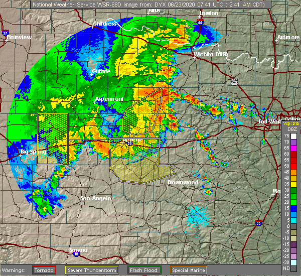 At 242 am cdt, a severe thunderstorm was located over abilene, moving east at 20 mph (radar indicated). Hazards include 60 mph wind gusts and penny size hail. Expect damage to roofs, siding, and trees. this severe thunderstorm will be near, potosi around 255 am cdt. hamby around 300 am cdt. eula around 310 am cdt. clyde around 315 am cdt. baird around 335 am cdt. other locations impacted by this severe thunderstorm include impact, lake abilene, camp tonkawa, echo, us-283 near the callahan- shackelford county line, lake coleman, ovalo, i-20 near the callahan- eastland county line, admiral and goldsboro. This includes interstate 20 between mile markers 273 and 323. At 242 am cdt, a severe thunderstorm was located over abilene, moving east at 20 mph (radar indicated). Hazards include 60 mph wind gusts and penny size hail. Expect damage to roofs, siding, and trees. this severe thunderstorm will be near, potosi around 255 am cdt. hamby around 300 am cdt. eula around 310 am cdt. clyde around 315 am cdt. baird around 335 am cdt. other locations impacted by this severe thunderstorm include impact, lake abilene, camp tonkawa, echo, us-283 near the callahan- shackelford county line, lake coleman, ovalo, i-20 near the callahan- eastland county line, admiral and goldsboro. This includes interstate 20 between mile markers 273 and 323.
|
| 5/27/2020 4:28 PM CDT |
 At 427 pm cdt, a severe thunderstorm was located near cross plains, or 16 miles southwest of cisco, moving southeast at 40 mph (law enforcement reported nickel size hail near baird). Hazards include 60 mph winds and nickel size hail. expect damage to roofs, siding, and trees At 427 pm cdt, a severe thunderstorm was located near cross plains, or 16 miles southwest of cisco, moving southeast at 40 mph (law enforcement reported nickel size hail near baird). Hazards include 60 mph winds and nickel size hail. expect damage to roofs, siding, and trees
|
| 5/15/2020 8:06 PM CDT |
 At 805 pm cdt, a severe thunderstorm was located near hamby, or 12 miles north of clyde, moving northeast at 50 mph (radar indicated). Hazards include 60 mph wind gusts. Expect damage to roofs, siding, and trees. this severe thunderstorm will be near, albany around 830 pm cdt. fort griffin around 840 pm cdt. other locations impacted by this severe thunderstorm include big country baptist assembly, mccarty lake, us-283 near the callahan- shackelford county line, admiral, i-20 near the callahan- eastland county line and us-180 near the shackelford- stephens county line. This includes interstate 20 between mile markers 294 and 323. At 805 pm cdt, a severe thunderstorm was located near hamby, or 12 miles north of clyde, moving northeast at 50 mph (radar indicated). Hazards include 60 mph wind gusts. Expect damage to roofs, siding, and trees. this severe thunderstorm will be near, albany around 830 pm cdt. fort griffin around 840 pm cdt. other locations impacted by this severe thunderstorm include big country baptist assembly, mccarty lake, us-283 near the callahan- shackelford county line, admiral, i-20 near the callahan- eastland county line and us-180 near the shackelford- stephens county line. This includes interstate 20 between mile markers 294 and 323.
|
| 3/18/2020 6:04 PM CDT |
 At 603 pm cdt, a severe thunderstorm was located over atwell, or 15 miles southwest of cisco, moving northeast at 35 mph (radar indicated). Hazards include 60 mph wind gusts and quarter size hail. Hail damage to vehicles is expected. expect wind damage to roofs, siding, and trees. this severe thunderstorm will remain over mainly rural areas of eastern callahan county, including the following locations, admiral and i-20 near the callahan-eastland county line. This includes interstate 20 between mile markers 314 and 323. At 603 pm cdt, a severe thunderstorm was located over atwell, or 15 miles southwest of cisco, moving northeast at 35 mph (radar indicated). Hazards include 60 mph wind gusts and quarter size hail. Hail damage to vehicles is expected. expect wind damage to roofs, siding, and trees. this severe thunderstorm will remain over mainly rural areas of eastern callahan county, including the following locations, admiral and i-20 near the callahan-eastland county line. This includes interstate 20 between mile markers 314 and 323.
|
| 3/18/2020 5:55 PM CDT |
 At 554 pm cdt, a severe thunderstorm was located near rowden, or 14 miles southeast of baird, moving northeast at 35 mph (radar indicated). Hazards include ping pong ball size hail and 60 mph wind gusts. People and animals outdoors will be injured. expect hail damage to roofs, siding, windows, and vehicles. expect wind damage to roofs, siding, and trees. this severe storm will be near, atwell around 610 pm cdt. other locations impacted by this severe thunderstorm include admiral and i-20 near the callahan-eastland county line. This includes interstate 20 between mile markers 310 and 323. At 554 pm cdt, a severe thunderstorm was located near rowden, or 14 miles southeast of baird, moving northeast at 35 mph (radar indicated). Hazards include ping pong ball size hail and 60 mph wind gusts. People and animals outdoors will be injured. expect hail damage to roofs, siding, windows, and vehicles. expect wind damage to roofs, siding, and trees. this severe storm will be near, atwell around 610 pm cdt. other locations impacted by this severe thunderstorm include admiral and i-20 near the callahan-eastland county line. This includes interstate 20 between mile markers 310 and 323.
|
| 3/18/2020 5:45 PM CDT |
 At 544 pm cdt, a severe thunderstorm was located over rowden, or 15 miles south of baird, moving northeast at 35 mph (radar indicated). Hazards include ping pong ball size hail and 60 mph wind gusts. People and animals outdoors will be injured. expect hail damage to roofs, siding, windows, and vehicles. expect wind damage to roofs, siding, and trees. this severe storm will be near, cross plains around 600 pm cdt. atwell around 610 pm cdt. other locations impacted by this severe thunderstorm include us- 283 near the coleman-callahan county line, admiral and i- 20 near the callahan-eastland county line. This includes interstate 20 between mile markers 310 and 323. At 544 pm cdt, a severe thunderstorm was located over rowden, or 15 miles south of baird, moving northeast at 35 mph (radar indicated). Hazards include ping pong ball size hail and 60 mph wind gusts. People and animals outdoors will be injured. expect hail damage to roofs, siding, windows, and vehicles. expect wind damage to roofs, siding, and trees. this severe storm will be near, cross plains around 600 pm cdt. atwell around 610 pm cdt. other locations impacted by this severe thunderstorm include us- 283 near the coleman-callahan county line, admiral and i- 20 near the callahan-eastland county line. This includes interstate 20 between mile markers 310 and 323.
|
| 3/18/2020 5:38 PM CDT |
 At 537 pm cdt, a severe thunderstorm was located near rowden, or 16 miles south of baird, moving northeast at 35 mph (radar indicated). Hazards include tennis ball size hail and 60 mph wind gusts. People and animals outdoors will be injured. expect hail damage to roofs, siding, windows, and vehicles. expect wind damage to roofs, siding, and trees. this severe thunderstorm will be near, rowden around 545 pm cdt. cross plains around 600 pm cdt. atwell around 610 pm cdt. other locations impacted by this severe thunderstorm include us- 283 near the coleman-callahan county line, admiral and i- 20 near the callahan-eastland county line. This includes interstate 20 between mile markers 310 and 323. At 537 pm cdt, a severe thunderstorm was located near rowden, or 16 miles south of baird, moving northeast at 35 mph (radar indicated). Hazards include tennis ball size hail and 60 mph wind gusts. People and animals outdoors will be injured. expect hail damage to roofs, siding, windows, and vehicles. expect wind damage to roofs, siding, and trees. this severe thunderstorm will be near, rowden around 545 pm cdt. cross plains around 600 pm cdt. atwell around 610 pm cdt. other locations impacted by this severe thunderstorm include us- 283 near the coleman-callahan county line, admiral and i- 20 near the callahan-eastland county line. This includes interstate 20 between mile markers 310 and 323.
|
| 6/23/2019 11:11 PM CDT |
 At 1110 pm cdt, a severe thunderstorm was located near may, or 11 miles north of early, moving east at 30 mph (radar indicated). Hazards include golf ball size hail and 60 mph wind gusts. People and animals outdoors will be injured. expect hail damage to roofs, siding, windows, and vehicles. Expect wind damage to roofs, siding, and trees. At 1110 pm cdt, a severe thunderstorm was located near may, or 11 miles north of early, moving east at 30 mph (radar indicated). Hazards include golf ball size hail and 60 mph wind gusts. People and animals outdoors will be injured. expect hail damage to roofs, siding, windows, and vehicles. Expect wind damage to roofs, siding, and trees.
|
| 6/23/2019 10:58 PM CDT |
 At 1057 pm cdt, a severe thunderstorm was located near cross cut, or 23 miles north of early, moving east at 25 mph (radar indicated). Hazards include 60 mph wind gusts and quarter size hail. Hail damage to vehicles is expected. expect wind damage to roofs, siding, and trees. Locations impacted include, cross plains, blanket, byrds, grosvenor, lake brownwood state park, burkett, may, cross cut, owens, echo and us-283 near the coleman- callahan county line. At 1057 pm cdt, a severe thunderstorm was located near cross cut, or 23 miles north of early, moving east at 25 mph (radar indicated). Hazards include 60 mph wind gusts and quarter size hail. Hail damage to vehicles is expected. expect wind damage to roofs, siding, and trees. Locations impacted include, cross plains, blanket, byrds, grosvenor, lake brownwood state park, burkett, may, cross cut, owens, echo and us-283 near the coleman- callahan county line.
|
| 6/23/2019 10:09 PM CDT |
 At 1008 pm cdt, a severe thunderstorm was located 9 miles northeast of silver valley, or 15 miles north of coleman, moving east at 25 mph (radar indicated). Hazards include 60 mph wind gusts and quarter size hail. Hail damage to vehicles is expected. Expect wind damage to roofs, siding, and trees. At 1008 pm cdt, a severe thunderstorm was located 9 miles northeast of silver valley, or 15 miles north of coleman, moving east at 25 mph (radar indicated). Hazards include 60 mph wind gusts and quarter size hail. Hail damage to vehicles is expected. Expect wind damage to roofs, siding, and trees.
|
| 6/23/2019 9:57 PM CDT |
 At 921 pm cdt, a severe thunderstorm was located over cross plains, or 20 miles southwest of cisco, moving east at 20 mph (radar indicated). Hazards include ping pong ball size hail and 60 mph wind gusts. People and animals outdoors will be injured. expect hail damage to roofs, siding, windows, and vehicles. expect wind damage to roofs, siding, and trees. this severe thunderstorm will be near, cross plains around 925 pm cdt. cross cut around 930 pm cdt. atwell around 935 pm cdt. Other locations impacted by this severe thunderstorm include admiral. At 921 pm cdt, a severe thunderstorm was located over cross plains, or 20 miles southwest of cisco, moving east at 20 mph (radar indicated). Hazards include ping pong ball size hail and 60 mph wind gusts. People and animals outdoors will be injured. expect hail damage to roofs, siding, windows, and vehicles. expect wind damage to roofs, siding, and trees. this severe thunderstorm will be near, cross plains around 925 pm cdt. cross cut around 930 pm cdt. atwell around 935 pm cdt. Other locations impacted by this severe thunderstorm include admiral.
|
| 6/23/2019 9:21 PM CDT |
 At 921 pm cdt, a severe thunderstorm was located over cross plains, or 20 miles southwest of cisco, moving east at 20 mph (radar indicated). Hazards include ping pong ball size hail and 60 mph wind gusts. People and animals outdoors will be injured. expect hail damage to roofs, siding, windows, and vehicles. expect wind damage to roofs, siding, and trees. this severe thunderstorm will be near, cross plains around 925 pm cdt. cross cut around 930 pm cdt. atwell around 935 pm cdt. Other locations impacted by this severe thunderstorm include admiral. At 921 pm cdt, a severe thunderstorm was located over cross plains, or 20 miles southwest of cisco, moving east at 20 mph (radar indicated). Hazards include ping pong ball size hail and 60 mph wind gusts. People and animals outdoors will be injured. expect hail damage to roofs, siding, windows, and vehicles. expect wind damage to roofs, siding, and trees. this severe thunderstorm will be near, cross plains around 925 pm cdt. cross cut around 930 pm cdt. atwell around 935 pm cdt. Other locations impacted by this severe thunderstorm include admiral.
|
| 6/23/2019 9:14 PM CDT |
 At 914 pm cdt, a severe thunderstorm was located near cross plains, or 18 miles southeast of baird, moving east at 15 mph (radar indicated). Hazards include 60 mph wind gusts and quarter size hail. Hail damage to vehicles is expected. expect wind damage to roofs, siding, and trees. locations impacted include, cross plains, putnam, rowden, atwell, admiral and i-20 near the callahan-eastland county line. This includes interstate 20 between mile markers 312 and 323. At 914 pm cdt, a severe thunderstorm was located near cross plains, or 18 miles southeast of baird, moving east at 15 mph (radar indicated). Hazards include 60 mph wind gusts and quarter size hail. Hail damage to vehicles is expected. expect wind damage to roofs, siding, and trees. locations impacted include, cross plains, putnam, rowden, atwell, admiral and i-20 near the callahan-eastland county line. This includes interstate 20 between mile markers 312 and 323.
|
| 6/23/2019 8:29 PM CDT |
 The national weather service in san angelo has issued a * severe thunderstorm warning for. eastern callahan county in west central texas. until 930 pm cdt. At 829 pm cdt, a severe thunderstorm was located near baird, moving east at 25 mph. The national weather service in san angelo has issued a * severe thunderstorm warning for. eastern callahan county in west central texas. until 930 pm cdt. At 829 pm cdt, a severe thunderstorm was located near baird, moving east at 25 mph.
|
| 6/23/2019 7:44 PM CDT |
 At 744 pm cdt, a severe thunderstorm was located near rowden, or 15 miles southeast of baird, moving southeast at 20 mph (radar indicated). Hazards include 60 mph wind gusts and quarter size hail. Hail damage to vehicles is expected. expect wind damage to roofs, siding, and trees. this severe thunderstorm will be near, cross plains around 810 pm cdt. burkett around 825 pm cdt. Cross cut around 830 pm cdt. At 744 pm cdt, a severe thunderstorm was located near rowden, or 15 miles southeast of baird, moving southeast at 20 mph (radar indicated). Hazards include 60 mph wind gusts and quarter size hail. Hail damage to vehicles is expected. expect wind damage to roofs, siding, and trees. this severe thunderstorm will be near, cross plains around 810 pm cdt. burkett around 825 pm cdt. Cross cut around 830 pm cdt.
|
| 6/23/2019 7:27 PM CDT |
 At 726 pm cdt, a severe thunderstorm was located near cisco, moving east at 35 mph (radar indicated). Hazards include ping pong ball size hail and 60 mph wind gusts. People and animals outdoors will be injured. expect hail damage to roofs, siding, windows, and vehicles. expect wind damage to roofs, siding, and trees. locations impacted include, clyde, baird, cross plains, putnam, rowden, atwell, eula, dudley, potosi, admiral and i-20 near the callahan-eastland county line. This includes interstate 20 between mile markers 295 and 323. At 726 pm cdt, a severe thunderstorm was located near cisco, moving east at 35 mph (radar indicated). Hazards include ping pong ball size hail and 60 mph wind gusts. People and animals outdoors will be injured. expect hail damage to roofs, siding, windows, and vehicles. expect wind damage to roofs, siding, and trees. locations impacted include, clyde, baird, cross plains, putnam, rowden, atwell, eula, dudley, potosi, admiral and i-20 near the callahan-eastland county line. This includes interstate 20 between mile markers 295 and 323.
|
| 6/23/2019 7:14 PM CDT |
 At 713 pm cdt, a severe thunderstorm was located near cisco, moving east at 35 mph (radar indicated). Hazards include 60 mph wind gusts and quarter size hail. Hail damage to vehicles is expected. expect wind damage to roofs, siding, and trees. this severe thunderstorm will remain over mainly rural areas of callahan, southeastern shackelford and east central taylor counties, including the following locations, mccarty lake, us- 283 near the callahan-shackelford county line, us- 180 near the shackelford-stephens county line, admiral and i- 20 near the callahan-eastland county line. This includes interstate 20 between mile markers 294 and 323. At 713 pm cdt, a severe thunderstorm was located near cisco, moving east at 35 mph (radar indicated). Hazards include 60 mph wind gusts and quarter size hail. Hail damage to vehicles is expected. expect wind damage to roofs, siding, and trees. this severe thunderstorm will remain over mainly rural areas of callahan, southeastern shackelford and east central taylor counties, including the following locations, mccarty lake, us- 283 near the callahan-shackelford county line, us- 180 near the shackelford-stephens county line, admiral and i- 20 near the callahan-eastland county line. This includes interstate 20 between mile markers 294 and 323.
|
| 6/23/2019 6:57 PM CDT |
 The national weather service in san angelo has issued a * severe thunderstorm warning for. callahan county in west central texas. southeastern shackelford county in west central texas. east central taylor county in west central texas. Until 745 pm cdt. The national weather service in san angelo has issued a * severe thunderstorm warning for. callahan county in west central texas. southeastern shackelford county in west central texas. east central taylor county in west central texas. Until 745 pm cdt.
|
| 6/19/2019 7:52 PM CDT |
 At 751 pm cdt, a severe thunderstorm was located 9 miles northwest of burkett, or 16 miles north of coleman, moving northeast at 35 mph (radar indicated). Hazards include 60 mph wind gusts and quarter size hail. Hail damage to vehicles is expected. expect wind damage to roofs, siding, and trees. this severe thunderstorm will be near, rowden around 800 pm cdt. cross plains around 815 pm cdt. atwell around 820 pm cdt. Other locations impacted by this severe thunderstorm include us- 283 near the coleman-callahan county line. At 751 pm cdt, a severe thunderstorm was located 9 miles northwest of burkett, or 16 miles north of coleman, moving northeast at 35 mph (radar indicated). Hazards include 60 mph wind gusts and quarter size hail. Hail damage to vehicles is expected. expect wind damage to roofs, siding, and trees. this severe thunderstorm will be near, rowden around 800 pm cdt. cross plains around 815 pm cdt. atwell around 820 pm cdt. Other locations impacted by this severe thunderstorm include us- 283 near the coleman-callahan county line.
|
| 6/16/2019 5:10 PM CDT |
 At 509 pm cdt, a severe thunderstorm was located over cross cut, or 19 miles northeast of coleman, moving southeast at 20 mph (radar indicated). Hazards include 60 mph wind gusts and quarter size hail. Hail damage to vehicles is expected. expect wind damage to roofs, siding, and trees. This severe thunderstorm will remain over mainly rural areas of southeastern callahan, northwestern brown and northeastern coleman counties, including the following locations, us- 283 near the coleman-callahan county line. At 509 pm cdt, a severe thunderstorm was located over cross cut, or 19 miles northeast of coleman, moving southeast at 20 mph (radar indicated). Hazards include 60 mph wind gusts and quarter size hail. Hail damage to vehicles is expected. expect wind damage to roofs, siding, and trees. This severe thunderstorm will remain over mainly rural areas of southeastern callahan, northwestern brown and northeastern coleman counties, including the following locations, us- 283 near the coleman-callahan county line.
|
| 6/16/2019 4:39 PM CDT |
 At 438 pm cdt, a severe thunderstorm was located 7 miles south of rowden, or 19 miles north of coleman, moving southeast at 20 mph (radar indicated). Hazards include 60 mph wind gusts and half dollar size hail. Hail damage to vehicles is expected. expect wind damage to roofs, siding, and trees. this severe thunderstorm will be near, cross plains around 455 pm cdt. burkett around 505 pm cdt. cross cut around 510 pm cdt. Other locations impacted by this severe thunderstorm include us- 283 near the coleman-callahan county line and lake brownwood. At 438 pm cdt, a severe thunderstorm was located 7 miles south of rowden, or 19 miles north of coleman, moving southeast at 20 mph (radar indicated). Hazards include 60 mph wind gusts and half dollar size hail. Hail damage to vehicles is expected. expect wind damage to roofs, siding, and trees. this severe thunderstorm will be near, cross plains around 455 pm cdt. burkett around 505 pm cdt. cross cut around 510 pm cdt. Other locations impacted by this severe thunderstorm include us- 283 near the coleman-callahan county line and lake brownwood.
|
| 6/16/2019 4:17 PM CDT |
 At 415 pm cdt, a severe thunderstorm was located over rowden, or 15 miles south of baird, moving southeast at 25 mph. at 408 pm cdt public reported quarter size hail 8 miles sw of admiral (radar indicated). Hazards include 60 mph wind gusts and half dollar size hail. Hail damage to vehicles is expected. expect wind damage to roofs, siding, and trees. this severe storm will be near, cross plains around 435 pm cdt. Other locations impacted by this severe thunderstorm include admiral. At 415 pm cdt, a severe thunderstorm was located over rowden, or 15 miles south of baird, moving southeast at 25 mph. at 408 pm cdt public reported quarter size hail 8 miles sw of admiral (radar indicated). Hazards include 60 mph wind gusts and half dollar size hail. Hail damage to vehicles is expected. expect wind damage to roofs, siding, and trees. this severe storm will be near, cross plains around 435 pm cdt. Other locations impacted by this severe thunderstorm include admiral.
|
| 6/16/2019 4:06 PM CDT |
 At 405 pm cdt, a severe thunderstorm was located over rowden, or 11 miles south of baird, moving southeast at 25 mph (radar indicated). Hazards include 60 mph wind gusts and half dollar size hail. Hail damage to vehicles is expected. expect wind damage to roofs, siding, and trees. this severe thunderstorm will be near, rowden around 410 pm cdt. cross plains around 435 pm cdt. Other locations impacted by this severe thunderstorm include admiral. At 405 pm cdt, a severe thunderstorm was located over rowden, or 11 miles south of baird, moving southeast at 25 mph (radar indicated). Hazards include 60 mph wind gusts and half dollar size hail. Hail damage to vehicles is expected. expect wind damage to roofs, siding, and trees. this severe thunderstorm will be near, rowden around 410 pm cdt. cross plains around 435 pm cdt. Other locations impacted by this severe thunderstorm include admiral.
|
| 6/5/2019 10:48 PM CDT |
 At 1047 pm cdt, severe thunderstorms were located along a line extending from near nugent to near eula to near novice, moving east at 50 mph (radar indicated). Hazards include 60 mph wind gusts and quarter size hail. Hail damage to vehicles is expected. expect wind damage to roofs, siding, and trees. severe thunderstorms will be near, baird around 1055 pm cdt. rowden around 1100 pm cdt. putnam around 1105 pm cdt. atwell around 1110 pm cdt. moran around 1120 pm cdt. other locations impacted by these severe thunderstorms include lake fort phantom hill, mccarty lake, us-283 near the callahan- shackelford county line, admiral and i-20 near the callahan- eastland county line. This includes interstate 20 between mile markers 291 and 323. At 1047 pm cdt, severe thunderstorms were located along a line extending from near nugent to near eula to near novice, moving east at 50 mph (radar indicated). Hazards include 60 mph wind gusts and quarter size hail. Hail damage to vehicles is expected. expect wind damage to roofs, siding, and trees. severe thunderstorms will be near, baird around 1055 pm cdt. rowden around 1100 pm cdt. putnam around 1105 pm cdt. atwell around 1110 pm cdt. moran around 1120 pm cdt. other locations impacted by these severe thunderstorms include lake fort phantom hill, mccarty lake, us-283 near the callahan- shackelford county line, admiral and i-20 near the callahan- eastland county line. This includes interstate 20 between mile markers 291 and 323.
|
| 5/31/2019 6:09 AM CDT |
 At 608 am cdt, severe thunderstorms were located along a line extending from near rowden to near burkett to near valera, moving southeast at 45 mph (radar indicated). Hazards include 60 mph wind gusts and quarter size hail. Hail damage to vehicles is expected. expect wind damage to roofs, siding, and trees. severe thunderstorms will be near, santa anna and burkett around 615 am cdt. grosvenor and cross cut around 625 am cdt. lake brownwood state park, lake brownwood, byrds and lake brownwood near thrifty around 630 am cdt. may around 640 am cdt. early around 645 am cdt. Other locations impacted by these severe thunderstorms include owens, thrifty, indian creek, us-283 near the coleman- callahan county line, echo and hords creek reservoir. At 608 am cdt, severe thunderstorms were located along a line extending from near rowden to near burkett to near valera, moving southeast at 45 mph (radar indicated). Hazards include 60 mph wind gusts and quarter size hail. Hail damage to vehicles is expected. expect wind damage to roofs, siding, and trees. severe thunderstorms will be near, santa anna and burkett around 615 am cdt. grosvenor and cross cut around 625 am cdt. lake brownwood state park, lake brownwood, byrds and lake brownwood near thrifty around 630 am cdt. may around 640 am cdt. early around 645 am cdt. Other locations impacted by these severe thunderstorms include owens, thrifty, indian creek, us-283 near the coleman- callahan county line, echo and hords creek reservoir.
|
| 5/18/2019 9:03 AM CDT |
 At 902 am cdt, a severe thunderstorm was located 9 miles south of rowden, or 17 miles north of coleman, moving northeast at 40 mph (radar indicated). Hazards include quarter size hail. damage to vehicles is expected At 902 am cdt, a severe thunderstorm was located 9 miles south of rowden, or 17 miles north of coleman, moving northeast at 40 mph (radar indicated). Hazards include quarter size hail. damage to vehicles is expected
|
| 4/23/2019 9:05 PM CDT |
 At 904 pm cdt, a severe thunderstorm was located near cross plains, or 16 miles south of cisco, moving east at 40 mph (radar indicated). Hazards include 60 mph wind gusts and quarter size hail. Hail damage to vehicles is expected. expect wind damage to roofs, siding, and trees. This severe thunderstorm will remain over mainly rural areas of southeastern callahan and northwestern brown counties, including the following locations, admiral and i-20 near the callahan-eastland county line. At 904 pm cdt, a severe thunderstorm was located near cross plains, or 16 miles south of cisco, moving east at 40 mph (radar indicated). Hazards include 60 mph wind gusts and quarter size hail. Hail damage to vehicles is expected. expect wind damage to roofs, siding, and trees. This severe thunderstorm will remain over mainly rural areas of southeastern callahan and northwestern brown counties, including the following locations, admiral and i-20 near the callahan-eastland county line.
|
| 4/23/2019 8:45 PM CDT |
 At 844 pm cdt, a severe thunderstorm was located near rowden, or 19 miles south of baird, moving east at 40 mph (radar indicated). Hazards include 60 mph wind gusts and quarter size hail. Hail damage to vehicles is expected. expect wind damage to roofs, siding, and trees. this severe thunderstorm will be near, cross plains around 855 pm cdt. atwell and cross cut around 900 pm cdt. other locations impacted by this severe thunderstorm include echo, admiral and i-20 near the callahan-eastland county line. This includes interstate 20 near mile marker 323. At 844 pm cdt, a severe thunderstorm was located near rowden, or 19 miles south of baird, moving east at 40 mph (radar indicated). Hazards include 60 mph wind gusts and quarter size hail. Hail damage to vehicles is expected. expect wind damage to roofs, siding, and trees. this severe thunderstorm will be near, cross plains around 855 pm cdt. atwell and cross cut around 900 pm cdt. other locations impacted by this severe thunderstorm include echo, admiral and i-20 near the callahan-eastland county line. This includes interstate 20 near mile marker 323.
|
| 3/13/2019 1:53 AM CDT |
 At 152 am cdt, severe thunderstorms were located along a line extending from 8 miles west of fort griffin to near albany to near lawn, moving east at 55 mph (radar indicated). Hazards include 60 mph wind gusts. Expect damage to roofs, siding, and trees. these severe storms will be near, albany and fort griffin around 200 am cdt. ibex around 205 am cdt. rowden around 215 am cdt. other locations impacted by these severe thunderstorms include impact, mccarty lake, admiral, big country baptist assembly, lake fort phantom hill, us-283 near the callahan- shackelford county line, kirby lake, the intersection of us- 180 and farm road 600, ovalo and i-20 near the callahan- eastland county line. A tornado watch remains in effect until 500 am cdt for west central texas. At 152 am cdt, severe thunderstorms were located along a line extending from 8 miles west of fort griffin to near albany to near lawn, moving east at 55 mph (radar indicated). Hazards include 60 mph wind gusts. Expect damage to roofs, siding, and trees. these severe storms will be near, albany and fort griffin around 200 am cdt. ibex around 205 am cdt. rowden around 215 am cdt. other locations impacted by these severe thunderstorms include impact, mccarty lake, admiral, big country baptist assembly, lake fort phantom hill, us-283 near the callahan- shackelford county line, kirby lake, the intersection of us- 180 and farm road 600, ovalo and i-20 near the callahan- eastland county line. A tornado watch remains in effect until 500 am cdt for west central texas.
|
| 3/13/2019 1:34 AM CDT |
 At 133 am cdt, severe thunderstorms were located along a line extending from near lake stamford marina to near nugent to near happy valley, moving east at 60 mph (radar indicated). Hazards include 60 mph wind gusts. Expect damage to roofs, siding, and trees. severe thunderstorms will be near, tuscola around 145 am cdt. albany and lawn around 150 am cdt. fort griffin around 155 am cdt. oplin, ibex and dudley around 200 am cdt. rowden around 215 am cdt. other locations impacted by these severe thunderstorms include funston, impact, lake abilene, mccarty lake, camp tonkawa, lake fort phantom hill, us-283 near the callahan- shackelford county line, the intersection of us- 180 and farm road 600, ovalo and i-20 near the callahan- eastland county line. this includes interstate 20 between mile markers 271 and 323. A tornado watch remains in effect until 500 am cdt for west central texas. At 133 am cdt, severe thunderstorms were located along a line extending from near lake stamford marina to near nugent to near happy valley, moving east at 60 mph (radar indicated). Hazards include 60 mph wind gusts. Expect damage to roofs, siding, and trees. severe thunderstorms will be near, tuscola around 145 am cdt. albany and lawn around 150 am cdt. fort griffin around 155 am cdt. oplin, ibex and dudley around 200 am cdt. rowden around 215 am cdt. other locations impacted by these severe thunderstorms include funston, impact, lake abilene, mccarty lake, camp tonkawa, lake fort phantom hill, us-283 near the callahan- shackelford county line, the intersection of us- 180 and farm road 600, ovalo and i-20 near the callahan- eastland county line. this includes interstate 20 between mile markers 271 and 323. A tornado watch remains in effect until 500 am cdt for west central texas.
|
| 12/26/2018 4:41 PM CST |
 At 440 pm cst, severe thunderstorms were located along a line extending from near lake stamford marina to 6 miles southeast of lawn, moving east at 35 mph (radar indicated). Hazards include 60 to 65 mph wind gusts. Expect damage to roofs, siding, and trees. severe thunderstorms will be near, oplin around 450 pm cst. rowden around 510 pm cst. fort griffin around 520 pm cst. cross plains around 530 pm cst. other locations impacted by these severe thunderstorms include impact, mccarty lake, admiral, big country baptist assembly, lake fort phantom hill, us-283 near the callahan- shackelford county line, kirby lake, us-180 near the shackelford- stephens county line, the intersection of us- 180 and farm road 600 and i-20 near the callahan- eastland county line. this includes interstate 20 between mile markers 283 and 323. A tornado watch remains in effect until 1000 pm cst for west central texas. At 440 pm cst, severe thunderstorms were located along a line extending from near lake stamford marina to 6 miles southeast of lawn, moving east at 35 mph (radar indicated). Hazards include 60 to 65 mph wind gusts. Expect damage to roofs, siding, and trees. severe thunderstorms will be near, oplin around 450 pm cst. rowden around 510 pm cst. fort griffin around 520 pm cst. cross plains around 530 pm cst. other locations impacted by these severe thunderstorms include impact, mccarty lake, admiral, big country baptist assembly, lake fort phantom hill, us-283 near the callahan- shackelford county line, kirby lake, us-180 near the shackelford- stephens county line, the intersection of us- 180 and farm road 600 and i-20 near the callahan- eastland county line. this includes interstate 20 between mile markers 283 and 323. A tornado watch remains in effect until 1000 pm cst for west central texas.
|
| 10/14/2018 5:26 PM CDT |
 At 525 pm cdt, a severe thunderstorm was located near burkett, or 19 miles northeast of coleman, moving northeast at 50 mph (trained weather spotters). Hazards include 60 mph wind gusts and quarter size hail. Hail damage to vehicles is expected. expect wind damage to roofs, siding, and trees. This severe storm will be near, cross plains and cross cut around 530 pm cdt. At 525 pm cdt, a severe thunderstorm was located near burkett, or 19 miles northeast of coleman, moving northeast at 50 mph (trained weather spotters). Hazards include 60 mph wind gusts and quarter size hail. Hail damage to vehicles is expected. expect wind damage to roofs, siding, and trees. This severe storm will be near, cross plains and cross cut around 530 pm cdt.
|
| 10/14/2018 5:10 PM CDT |
 At 509 pm cdt, a severe thunderstorm was located 7 miles east of silver valley, or 9 miles north of coleman, moving northeast at 50 mph (trained weather spotters). Hazards include 60 mph wind gusts and quarter size hail. Hail damage to vehicles is expected. expect wind damage to roofs, siding, and trees. this severe thunderstorm will be near, burkett around 525 pm cdt. cross cut around 530 pm cdt. cross plains around 535 pm cdt. Other locations impacted by this severe thunderstorm include us- 283 near the coleman-callahan county line, echo and lake coleman. At 509 pm cdt, a severe thunderstorm was located 7 miles east of silver valley, or 9 miles north of coleman, moving northeast at 50 mph (trained weather spotters). Hazards include 60 mph wind gusts and quarter size hail. Hail damage to vehicles is expected. expect wind damage to roofs, siding, and trees. this severe thunderstorm will be near, burkett around 525 pm cdt. cross cut around 530 pm cdt. cross plains around 535 pm cdt. Other locations impacted by this severe thunderstorm include us- 283 near the coleman-callahan county line, echo and lake coleman.
|
| 7/30/2018 7:12 AM CDT |
 The severe thunderstorm warning for callahan, southern jones, nolan, southern shackelford, southeastern fisher and taylor counties will expire at 715 am cdt, the storms which prompted the warning have weakened below severe limits, and no longer pose an immediate threat to life or property. therefore, the warning will be allowed to expire. however gusty winds are still possible with these thunderstorms. The severe thunderstorm warning for callahan, southern jones, nolan, southern shackelford, southeastern fisher and taylor counties will expire at 715 am cdt, the storms which prompted the warning have weakened below severe limits, and no longer pose an immediate threat to life or property. therefore, the warning will be allowed to expire. however gusty winds are still possible with these thunderstorms.
|
| 7/30/2018 6:52 AM CDT |
 At 650 am cdt, a severe thunderstorm was located 8 miles southwest of merkel, or 20 miles east of sweetwater, moving south at 20 mph (radar indicated). Hazards include 60 mph wind gusts. Expect damage to roofs, siding, and trees. this severe storm will be near, coronados camp around 705 am cdt. happy valley around 715 am cdt. Other locations impacted by this severe thunderstorm include funston, shep, lake sweetwater, the intersection of us- 180 and farm road 600, admiral, camp butman, the intersection of ranch road 608 and highway 147, camp boothe oaks, impact and the intersection of us-180 and ranch road 126. At 650 am cdt, a severe thunderstorm was located 8 miles southwest of merkel, or 20 miles east of sweetwater, moving south at 20 mph (radar indicated). Hazards include 60 mph wind gusts. Expect damage to roofs, siding, and trees. this severe storm will be near, coronados camp around 705 am cdt. happy valley around 715 am cdt. Other locations impacted by this severe thunderstorm include funston, shep, lake sweetwater, the intersection of us- 180 and farm road 600, admiral, camp butman, the intersection of ranch road 608 and highway 147, camp boothe oaks, impact and the intersection of us-180 and ranch road 126.
|
| 7/30/2018 6:27 AM CDT |
 At 622 am cdt, a severe thunderstorm was located 8 miles northwest of trent, or 12 miles northeast of sweetwater, moving south at 20 mph (radar indicated). Hazards include 60 mph wind gusts. Expect damage to roofs, siding, and trees. this severe thunderstorm will be near, abilene around 630 am cdt. trent around 630 am cdt. nolan around 645 am cdt. coronados camp around 650 am cdt. happy valley around 700 am cdt. bradshaw around 705 am cdt. This includes interstate 20 between mile markers 229 and 323. At 622 am cdt, a severe thunderstorm was located 8 miles northwest of trent, or 12 miles northeast of sweetwater, moving south at 20 mph (radar indicated). Hazards include 60 mph wind gusts. Expect damage to roofs, siding, and trees. this severe thunderstorm will be near, abilene around 630 am cdt. trent around 630 am cdt. nolan around 645 am cdt. coronados camp around 650 am cdt. happy valley around 700 am cdt. bradshaw around 705 am cdt. This includes interstate 20 between mile markers 229 and 323.
|
| 5/25/2018 11:05 PM CDT |
 At 1102 pm cdt, a severe thunderstorm was located near oplin in southwestern callahan county, and was moving southeast at 35 mph (radar indicated). Hazards include 60 mph wind gusts and quarter size hail. Hail damage to vehicles is expected. expect wind damage to roofs, siding, and trees. This storm will move into rural parts of northern coleman county. At 1102 pm cdt, a severe thunderstorm was located near oplin in southwestern callahan county, and was moving southeast at 35 mph (radar indicated). Hazards include 60 mph wind gusts and quarter size hail. Hail damage to vehicles is expected. expect wind damage to roofs, siding, and trees. This storm will move into rural parts of northern coleman county.
|
| 5/25/2018 10:34 PM CDT |
 At 1033 pm cdt, a band of severe thunderstorms extended from eula to just north of moran. this band of thunderstorms was moving southeast at 35 mph (radar indicated). Hazards include 60 mph wind gusts and quarter to half dollar size hail. Hail damage to vehicles is expected. expect wind damage to roofs, siding, and trees. this severe thunderstorm will be near, oplin around 1045 pm cdt. rowden around 1050 pm cdt. burkett around 1115 pm cdt. other locations impacted by this severe thunderstorm include us- 283 near the callahan-shackelford county line, us- 283 near the coleman- callahan county line, echo, admiral, lake coleman and i- 20 near the callahan-eastland county line. This includes interstate 20 between mile markers 294 and 323. At 1033 pm cdt, a band of severe thunderstorms extended from eula to just north of moran. this band of thunderstorms was moving southeast at 35 mph (radar indicated). Hazards include 60 mph wind gusts and quarter to half dollar size hail. Hail damage to vehicles is expected. expect wind damage to roofs, siding, and trees. this severe thunderstorm will be near, oplin around 1045 pm cdt. rowden around 1050 pm cdt. burkett around 1115 pm cdt. other locations impacted by this severe thunderstorm include us- 283 near the callahan-shackelford county line, us- 283 near the coleman- callahan county line, echo, admiral, lake coleman and i- 20 near the callahan-eastland county line. This includes interstate 20 between mile markers 294 and 323.
|
| 5/25/2018 10:00 PM CDT |
 At 956 pm cdt, the leading edge of a band of a severe thunderstorm extended from abilene to 5 miles south of moran, and was moving south at 40 mph. the strongest thunderstorm with hail to ping pong ball size was along the border of southeastern jones and southwestern shackelford counties. the storm was moving southeast at 40 mph and will affect southwestern shackelford and northern callahan county (radar indicated). Hazards include 60 mph wind gusts and half dollar size hail. Hail damage to vehicles is expected. expect wind damage to roofs, siding, and trees. this severe storm will be near, clyde and potosi around 1005 pm cdt. eula around 1015 pm cdt. dudley around 1020 pm cdt. rowden around 1030 pm cdt. Other locations impacted by this severe thunderstorm include impact, hodges, lake abilene, mccarty lake, camp tonkawa, admiral, lake fort phantom hill, us-283 near the callahan- shackelford county line, kirby lake and us-180 near the shackelford- stephens county line. At 956 pm cdt, the leading edge of a band of a severe thunderstorm extended from abilene to 5 miles south of moran, and was moving south at 40 mph. the strongest thunderstorm with hail to ping pong ball size was along the border of southeastern jones and southwestern shackelford counties. the storm was moving southeast at 40 mph and will affect southwestern shackelford and northern callahan county (radar indicated). Hazards include 60 mph wind gusts and half dollar size hail. Hail damage to vehicles is expected. expect wind damage to roofs, siding, and trees. this severe storm will be near, clyde and potosi around 1005 pm cdt. eula around 1015 pm cdt. dudley around 1020 pm cdt. rowden around 1030 pm cdt. Other locations impacted by this severe thunderstorm include impact, hodges, lake abilene, mccarty lake, camp tonkawa, admiral, lake fort phantom hill, us-283 near the callahan- shackelford county line, kirby lake and us-180 near the shackelford- stephens county line.
|
| 5/25/2018 9:43 PM CDT |
 At 938 pm cdt, the leading edge of a band of a severe thunderstorm extended from just northwest of abilene to near moran, and was moving southeast at 40 mph. the thunderstorms with hail and rain were located about 10 miles behind the leading edge outflow (radar indicated). Hazards include 60 mph wind gusts and quarter size hail. Hail damage to vehicles is expected. expect wind damage to roofs, siding, and trees. this severe thunderstorm will be near, abilene around 945 pm cdt. hamby around 950 pm cdt. clyde and potosi around 1000 pm cdt. eula around 1010 pm cdt. dudley around 1015 pm cdt. oplin around 1030 pm cdt. other locations impacted by this severe thunderstorm include funston, impact, lake abilene, mccarty lake, camp tonkawa, lake fort phantom hill, us-283 near the callahan-shackelford county line, us- 180 near the shackelford- stephens county line, the intersection of us- 180 and farm road 600 and ovalo. This includes interstate 20 between mile markers 277 and 323. At 938 pm cdt, the leading edge of a band of a severe thunderstorm extended from just northwest of abilene to near moran, and was moving southeast at 40 mph. the thunderstorms with hail and rain were located about 10 miles behind the leading edge outflow (radar indicated). Hazards include 60 mph wind gusts and quarter size hail. Hail damage to vehicles is expected. expect wind damage to roofs, siding, and trees. this severe thunderstorm will be near, abilene around 945 pm cdt. hamby around 950 pm cdt. clyde and potosi around 1000 pm cdt. eula around 1010 pm cdt. dudley around 1015 pm cdt. oplin around 1030 pm cdt. other locations impacted by this severe thunderstorm include funston, impact, lake abilene, mccarty lake, camp tonkawa, lake fort phantom hill, us-283 near the callahan-shackelford county line, us- 180 near the shackelford- stephens county line, the intersection of us- 180 and farm road 600 and ovalo. This includes interstate 20 between mile markers 277 and 323.
|
| 5/19/2017 5:25 PM CDT |
 At 525 pm cdt, a severe thunderstorm was located 9 miles east of oplin, or 17 miles south of baird, moving northeast at 30 mph (radar indicated). Hazards include 60 mph wind gusts and half dollar size hail. Hail damage to vehicles is expected. expect wind damage to roofs, siding, and trees. this severe thunderstorm will be near, cross plains around 550 pm cdt. atwell around 555 pm cdt. other locations impacted by this severe thunderstorm include us- 283 near the coleman- callahan county line, admiral, lake coleman, the intersection of us- 283 and highway 36 and i-20 near the callahan-eastland county line. this includes interstate 20 between mile markers 314 and 323. A tornado watch remains in effect until 800 pm cdt for west central texas. At 525 pm cdt, a severe thunderstorm was located 9 miles east of oplin, or 17 miles south of baird, moving northeast at 30 mph (radar indicated). Hazards include 60 mph wind gusts and half dollar size hail. Hail damage to vehicles is expected. expect wind damage to roofs, siding, and trees. this severe thunderstorm will be near, cross plains around 550 pm cdt. atwell around 555 pm cdt. other locations impacted by this severe thunderstorm include us- 283 near the coleman- callahan county line, admiral, lake coleman, the intersection of us- 283 and highway 36 and i-20 near the callahan-eastland county line. this includes interstate 20 between mile markers 314 and 323. A tornado watch remains in effect until 800 pm cdt for west central texas.
|
| 5/19/2017 12:56 AM CDT |
 At 1255 am cdt, a severe thunderstorm was located over burkett, or 17 miles northeast of coleman, moving east at 15 mph (radar indicated). Hazards include 60 mph wind gusts and quarter size hail. Hail damage to vehicles is expected. expect wind damage to roofs, siding, and trees. Locations impacted include, cross plains and cross cut. At 1255 am cdt, a severe thunderstorm was located over burkett, or 17 miles northeast of coleman, moving east at 15 mph (radar indicated). Hazards include 60 mph wind gusts and quarter size hail. Hail damage to vehicles is expected. expect wind damage to roofs, siding, and trees. Locations impacted include, cross plains and cross cut.
|
| 5/19/2017 12:15 AM CDT |
 At 1215 am cdt, a severe thunderstorm was located 9 miles northeast of silver valley, or 14 miles north of coleman, moving east at 15 mph (radar indicated). Hazards include 60 mph wind gusts and half dollar size hail. Hail damage to vehicles is expected. expect wind damage to roofs, siding, and trees. this severe thunderstorm will be near, burkett around 1255 am cdt. cross cut around 110 am cdt. Other locations impacted by this severe thunderstorm include echo and us-283 near the coleman-callahan county line. At 1215 am cdt, a severe thunderstorm was located 9 miles northeast of silver valley, or 14 miles north of coleman, moving east at 15 mph (radar indicated). Hazards include 60 mph wind gusts and half dollar size hail. Hail damage to vehicles is expected. expect wind damage to roofs, siding, and trees. this severe thunderstorm will be near, burkett around 1255 am cdt. cross cut around 110 am cdt. Other locations impacted by this severe thunderstorm include echo and us-283 near the coleman-callahan county line.
|
| 5/18/2017 8:20 PM CDT |
 At 820 pm cdt, a severe thunderstorm was located near cross plains, or 22 miles northeast of coleman, moving east at 50 mph (radar indicated). Hazards include 60 mph wind gusts and half dollar size hail. Hail damage to vehicles is expected. expect wind damage to roofs, siding, and trees. this severe thunderstorm will remain over mainly rural areas of southeastern callahan, northwestern brown and northeastern coleman counties, including the following locations: us-283 near the coleman-callahan county line. A tornado watch remains in effect until 1000 pm cdt for west central texas. At 820 pm cdt, a severe thunderstorm was located near cross plains, or 22 miles northeast of coleman, moving east at 50 mph (radar indicated). Hazards include 60 mph wind gusts and half dollar size hail. Hail damage to vehicles is expected. expect wind damage to roofs, siding, and trees. this severe thunderstorm will remain over mainly rural areas of southeastern callahan, northwestern brown and northeastern coleman counties, including the following locations: us-283 near the coleman-callahan county line. A tornado watch remains in effect until 1000 pm cdt for west central texas.
|
| 5/18/2017 7:45 PM CDT |
 At 745 pm cdt, a severe thunderstorm was located near cross plains, or 22 miles northeast of coleman, moving east at 20 mph (radar indicated). Hazards include two inch hail and 60 mph wind gusts. People and animals outdoors will be injured. expect hail damage to roofs, siding, windows, and vehicles. expect wind damage to roofs, siding, and trees. this severe thunderstorm will remain over mainly rural areas of southern callahan and northeastern coleman counties, including the following locations: us-283 near the coleman-callahan county line and the intersection of us-283 and highway 36. A tornado watch remains in effect until 1000 pm cdt for west central texas. At 745 pm cdt, a severe thunderstorm was located near cross plains, or 22 miles northeast of coleman, moving east at 20 mph (radar indicated). Hazards include two inch hail and 60 mph wind gusts. People and animals outdoors will be injured. expect hail damage to roofs, siding, windows, and vehicles. expect wind damage to roofs, siding, and trees. this severe thunderstorm will remain over mainly rural areas of southern callahan and northeastern coleman counties, including the following locations: us-283 near the coleman-callahan county line and the intersection of us-283 and highway 36. A tornado watch remains in effect until 1000 pm cdt for west central texas.
|
| 5/18/2017 7:27 PM CDT | Quarter sized hail reported 7.1 miles NNW of Cross Plains, TX, quarter size hail was reported. |
| 5/18/2017 7:16 PM CDT | Golf Ball sized hail reported 0.4 miles ESE of Cross Plains, TX |
| 5/18/2017 7:11 PM CDT | Golf Ball sized hail reported 0.4 miles ESE of Cross Plains, TX |
| 5/18/2017 7:04 PM CDT | Quarter sized hail reported 7.1 miles NNW of Cross Plains, TX, quarter size hail was reported. |
| 5/18/2017 7:01 PM CDT |
 At 701 pm cdt, severe thunderstorms were located along a line extending from near cross plains to near burkett to near oplin, moving northeast at 25 mph (radar indicated). Hazards include golf ball size hail and 60 mph wind gusts. People and animals outdoors will be injured. expect hail damage to roofs, siding, windows, and vehicles. expect wind damage to roofs, siding, and trees. severe thunderstorms will be near, burkett around 705 pm cdt. cross cut around 710 pm cdt. cross plains around 720 pm cdt. other locations impacted by these severe thunderstorms include goldsboro, echo, us-283 near the coleman- callahan county line, lake coleman and the intersection of us- 283 and highway 36. A tornado watch remains in effect until 1000 pm cdt for west central texas. At 701 pm cdt, severe thunderstorms were located along a line extending from near cross plains to near burkett to near oplin, moving northeast at 25 mph (radar indicated). Hazards include golf ball size hail and 60 mph wind gusts. People and animals outdoors will be injured. expect hail damage to roofs, siding, windows, and vehicles. expect wind damage to roofs, siding, and trees. severe thunderstorms will be near, burkett around 705 pm cdt. cross cut around 710 pm cdt. cross plains around 720 pm cdt. other locations impacted by these severe thunderstorms include goldsboro, echo, us-283 near the coleman- callahan county line, lake coleman and the intersection of us- 283 and highway 36. A tornado watch remains in effect until 1000 pm cdt for west central texas.
|
| 5/18/2017 6:15 PM CDT |
 At 614 pm cdt, a severe thunderstorm was located near burkett, or 14 miles north of coleman, moving east at 25 mph (radar indicated). Hazards include tennis ball size hail and 60 mph wind gusts. People and animals outdoors will be injured. expect hail damage to roofs, siding, windows, and vehicles. expect wind damage to roofs, siding, and trees. this severe thunderstorm will be near, cross plains around 640 pm cdt. other locations impacted by this severe thunderstorm include us- 283 near the coleman-callahan county line. A tornado watch remains in effect until 1000 pm cdt for west central texas. At 614 pm cdt, a severe thunderstorm was located near burkett, or 14 miles north of coleman, moving east at 25 mph (radar indicated). Hazards include tennis ball size hail and 60 mph wind gusts. People and animals outdoors will be injured. expect hail damage to roofs, siding, windows, and vehicles. expect wind damage to roofs, siding, and trees. this severe thunderstorm will be near, cross plains around 640 pm cdt. other locations impacted by this severe thunderstorm include us- 283 near the coleman-callahan county line. A tornado watch remains in effect until 1000 pm cdt for west central texas.
|
| 5/18/2017 4:52 PM CDT |
 At 451 pm cdt, a severe thunderstorm was located near novice, or 17 miles northwest of coleman, moving northeast at 40 mph. at 448 pm public reported half dollar size hail in novice (public). Hazards include ping pong ball size hail and 60 mph wind gusts. People and animals outdoors will be injured. expect hail damage to roofs, siding, windows, and vehicles. expect wind damage to roofs, siding, and trees. this severe storm will be near, oplin around 500 pm cdt. other locations impacted by this severe thunderstorm include goldsboro, winters little elm lake, us-283 near the coleman- callahan county line, lake coleman, the intersection of us- 283 and highway 36 and hords creek reservoir. A tornado watch remains in effect until 1000 pm cdt for west central texas. At 451 pm cdt, a severe thunderstorm was located near novice, or 17 miles northwest of coleman, moving northeast at 40 mph. at 448 pm public reported half dollar size hail in novice (public). Hazards include ping pong ball size hail and 60 mph wind gusts. People and animals outdoors will be injured. expect hail damage to roofs, siding, windows, and vehicles. expect wind damage to roofs, siding, and trees. this severe storm will be near, oplin around 500 pm cdt. other locations impacted by this severe thunderstorm include goldsboro, winters little elm lake, us-283 near the coleman- callahan county line, lake coleman, the intersection of us- 283 and highway 36 and hords creek reservoir. A tornado watch remains in effect until 1000 pm cdt for west central texas.
|
| 5/18/2017 4:41 PM CDT |
 At 441 pm cdt, a severe thunderstorm was located near novice, or 16 miles northwest of coleman, moving northeast at 40 mph (radar indicated). Hazards include ping pong ball size hail and 60 mph wind gusts. People and animals outdoors will be injured. expect hail damage to roofs, siding, windows, and vehicles. expect wind damage to roofs, siding, and trees. this severe thunderstorm will be near, novice around 445 pm cdt. silver valley around 450 pm cdt. oplin around 500 pm cdt. other locations impacted by this severe thunderstorm include goldsboro, winters little elm lake, us-283 near the coleman- callahan county line, lake coleman, the intersection of us- 283 and highway 36 and hords creek reservoir. A tornado watch remains in effect until 1000 pm cdt for west central texas. At 441 pm cdt, a severe thunderstorm was located near novice, or 16 miles northwest of coleman, moving northeast at 40 mph (radar indicated). Hazards include ping pong ball size hail and 60 mph wind gusts. People and animals outdoors will be injured. expect hail damage to roofs, siding, windows, and vehicles. expect wind damage to roofs, siding, and trees. this severe thunderstorm will be near, novice around 445 pm cdt. silver valley around 450 pm cdt. oplin around 500 pm cdt. other locations impacted by this severe thunderstorm include goldsboro, winters little elm lake, us-283 near the coleman- callahan county line, lake coleman, the intersection of us- 283 and highway 36 and hords creek reservoir. A tornado watch remains in effect until 1000 pm cdt for west central texas.
|
| 3/28/2017 10:36 PM CDT |
 At 1035 pm cdt, severe thunderstorms were located along a line extending from near weinert to near lueders to hamby to oplin, moving east at 25 mph (radar indicated). Hazards include 60 mph wind gusts and penny size hail. Expect damage to roofs, siding, and trees. these severe storms will be near, clyde, eula, oplin and dudley around 1040 pm cdt. baird around 1100 pm cdt. Albany and putnam around 1115 pm cdt. At 1035 pm cdt, severe thunderstorms were located along a line extending from near weinert to near lueders to hamby to oplin, moving east at 25 mph (radar indicated). Hazards include 60 mph wind gusts and penny size hail. Expect damage to roofs, siding, and trees. these severe storms will be near, clyde, eula, oplin and dudley around 1040 pm cdt. baird around 1100 pm cdt. Albany and putnam around 1115 pm cdt.
|
| 3/28/2017 10:14 PM CDT |
 At 1013 pm cdt, severe thunderstorms were located along a line extending from near weinert to near stamford to near hawley to near dyess afb to near lawn, moving east at 45 mph (radar indicated). Hazards include 60 to 70 mph wind gusts and penny size hail. Expect considerable tree damage. damage is likely to mobile homes, roofs, and outbuildings. severe thunderstorms will be near, oplin, hamby and nugent around 1020 pm cdt. lueders, potosi and dudley around 1025 pm cdt. clyde and eula around 1030 pm cdt. baird around 1040 pm cdt. albany, throckmorton, cross plains, moran and fort griffin around 1050 pm cdt. putnam around 1055 pm cdt. atwell around 1100 pm cdt. elbert around 1105 pm cdt. other locations impacted by these severe thunderstorms include funston, us-180 near the shackelford-stephens county line, us- 183 near the throckmorton- stephens county line, admiral, big country baptist assembly, the intersection of us- 180 and farm road 600, impact, lake abilene, camp tonkawa and tuxedo. This includes interstate 20 between mile markers 265 and 323. At 1013 pm cdt, severe thunderstorms were located along a line extending from near weinert to near stamford to near hawley to near dyess afb to near lawn, moving east at 45 mph (radar indicated). Hazards include 60 to 70 mph wind gusts and penny size hail. Expect considerable tree damage. damage is likely to mobile homes, roofs, and outbuildings. severe thunderstorms will be near, oplin, hamby and nugent around 1020 pm cdt. lueders, potosi and dudley around 1025 pm cdt. clyde and eula around 1030 pm cdt. baird around 1040 pm cdt. albany, throckmorton, cross plains, moran and fort griffin around 1050 pm cdt. putnam around 1055 pm cdt. atwell around 1100 pm cdt. elbert around 1105 pm cdt. other locations impacted by these severe thunderstorms include funston, us-180 near the shackelford-stephens county line, us- 183 near the throckmorton- stephens county line, admiral, big country baptist assembly, the intersection of us- 180 and farm road 600, impact, lake abilene, camp tonkawa and tuxedo. This includes interstate 20 between mile markers 265 and 323.
|
| 5/29/2016 11:32 PM CDT |
 At 1131 pm cdt, a severe thunderstorm was located 9 miles west of atwell, or 12 miles southeast of baird, moving east at 15 mph (radar indicated). Hazards include 60 mph wind gusts and quarter size hail. Hail damage to vehicles is expected. expect wind damage to roofs, siding, and trees. this severe storm will be near, cross plains around 1205 am cdt. atwell around 1210 am cdt. other locations impacted by this severe thunderstorm include admiral, the intersection of us-283 and highway 36, i-20 near the callahan-eastland county line and us-283 near the coleman-callahan county line. This includes interstate 20 between mile markers 296 and 323. At 1131 pm cdt, a severe thunderstorm was located 9 miles west of atwell, or 12 miles southeast of baird, moving east at 15 mph (radar indicated). Hazards include 60 mph wind gusts and quarter size hail. Hail damage to vehicles is expected. expect wind damage to roofs, siding, and trees. this severe storm will be near, cross plains around 1205 am cdt. atwell around 1210 am cdt. other locations impacted by this severe thunderstorm include admiral, the intersection of us-283 and highway 36, i-20 near the callahan-eastland county line and us-283 near the coleman-callahan county line. This includes interstate 20 between mile markers 296 and 323.
|
| 5/29/2016 11:11 PM CDT |
 At 1111 pm cdt, a severe thunderstorm was located near lawn, or 17 miles south of abilene, moving east at 40 mph (radar indicated). Hazards include 60 mph wind gusts and quarter size hail. Hail damage to vehicles is expected. expect wind damage to roofs, siding, and trees. this severe thunderstorm will be near, dudley and oplin around 1120 pm cdt. putnam and atwell around 1200 am cdt. other locations impacted by this severe thunderstorm include admiral, the intersection of us-283 and highway 36, i-20 near the callahan-eastland county line and us-283 near the coleman-callahan county line. This includes interstate 20 between mile markers 296 and 323. At 1111 pm cdt, a severe thunderstorm was located near lawn, or 17 miles south of abilene, moving east at 40 mph (radar indicated). Hazards include 60 mph wind gusts and quarter size hail. Hail damage to vehicles is expected. expect wind damage to roofs, siding, and trees. this severe thunderstorm will be near, dudley and oplin around 1120 pm cdt. putnam and atwell around 1200 am cdt. other locations impacted by this severe thunderstorm include admiral, the intersection of us-283 and highway 36, i-20 near the callahan-eastland county line and us-283 near the coleman-callahan county line. This includes interstate 20 between mile markers 296 and 323.
|
| 5/26/2016 9:00 PM CDT | Four to five trees snapped. each were about twelve inches in diamete in brown county TX, 7.1 miles NNW of Cross Plains, TX |
| 5/26/2016 8:28 PM CDT |
 At 823 pm cdt, a confirmed tornado was located 4 miles south cross cut, or 23 miles northwest of early, moving northeast at 35 mph (law enforcement confirmed tornado). Hazards include damaging tornado and quarter size hail. Flying debris will be dangerous to those caught without shelter. mobile homes will be damaged or destroyed. damage to roofs, windows, and vehicles will occur. tree damage is likely. This tornadic thunderstorm will remain over mainly rural areas of northwestern brown, northeastern coleman and southeastern callahan counties. At 823 pm cdt, a confirmed tornado was located 4 miles south cross cut, or 23 miles northwest of early, moving northeast at 35 mph (law enforcement confirmed tornado). Hazards include damaging tornado and quarter size hail. Flying debris will be dangerous to those caught without shelter. mobile homes will be damaged or destroyed. damage to roofs, windows, and vehicles will occur. tree damage is likely. This tornadic thunderstorm will remain over mainly rural areas of northwestern brown, northeastern coleman and southeastern callahan counties.
|
| 5/26/2016 8:15 PM CDT | Significant damage to community center in burkett. power lines and trees blocking road in coleman county TX, 9.7 miles NNE of Cross Plains, TX |
| 5/26/2016 8:15 PM CDT |
 At 814 pm cdt, a severe thunderstorm capable of producing a tornado was located over burkett, or 16 miles northeast of coleman, moving northeast at 35 mph (radar indicated rotation). Hazards include tornado and ping pong ball size hail. Flying debris will be dangerous to those caught without shelter. mobile homes will be damaged or destroyed. damage to roofs, windows, and vehicles will occur. tree damage is likely. this dangerous storm will be near, cross cut around 825 pm cdt. Cross plains around 830 pm cdt. At 814 pm cdt, a severe thunderstorm capable of producing a tornado was located over burkett, or 16 miles northeast of coleman, moving northeast at 35 mph (radar indicated rotation). Hazards include tornado and ping pong ball size hail. Flying debris will be dangerous to those caught without shelter. mobile homes will be damaged or destroyed. damage to roofs, windows, and vehicles will occur. tree damage is likely. this dangerous storm will be near, cross cut around 825 pm cdt. Cross plains around 830 pm cdt.
|
| 5/26/2016 8:05 PM CDT |
 At 805 pm cdt, a confirmed tornado was located near burkett, or 13 miles northeast of coleman, moving northeast at 30 mph (radar confirmed tornado). Hazards include damaging tornado and ping pong ball size hail. Flying debris will be dangerous to those caught without shelter. mobile homes will be damaged or destroyed. damage to roofs, windows, and vehicles will occur. tree damage is likely. this tornado will be near, burkett around 810 pm cdt. cross cut around 825 pm cdt. Other locations impacted by this tornadic thunderstorm include echo. At 805 pm cdt, a confirmed tornado was located near burkett, or 13 miles northeast of coleman, moving northeast at 30 mph (radar confirmed tornado). Hazards include damaging tornado and ping pong ball size hail. Flying debris will be dangerous to those caught without shelter. mobile homes will be damaged or destroyed. damage to roofs, windows, and vehicles will occur. tree damage is likely. this tornado will be near, burkett around 810 pm cdt. cross cut around 825 pm cdt. Other locations impacted by this tornadic thunderstorm include echo.
|
| 5/26/2016 7:59 PM CDT |
 At 759 pm cdt, a severe thunderstorm capable of producing a tornado was located 8 miles west of burkett, or 10 miles north of coleman, moving northeast at 25 mph (radar indicated rotation). Hazards include tornado. Flying debris will be dangerous to those caught without shelter. mobile homes will be damaged or destroyed. damage to roofs, windows, and vehicles will occur. tree damage is likely. this dangerous storm will be near, burkett around 815 pm cdt. cross cut around 825 pm cdt. Other locations impacted by this tornadic thunderstorm include echo. At 759 pm cdt, a severe thunderstorm capable of producing a tornado was located 8 miles west of burkett, or 10 miles north of coleman, moving northeast at 25 mph (radar indicated rotation). Hazards include tornado. Flying debris will be dangerous to those caught without shelter. mobile homes will be damaged or destroyed. damage to roofs, windows, and vehicles will occur. tree damage is likely. this dangerous storm will be near, burkett around 815 pm cdt. cross cut around 825 pm cdt. Other locations impacted by this tornadic thunderstorm include echo.
|
| 5/26/2016 6:28 PM CDT | Roof blown off building in cross plain in callahan county TX, 0.4 miles ESE of Cross Plains, TX |
| 5/12/2016 5:58 AM CDT |
 At 557 am cdt, a severe thunderstorm was located over cross plains, or 20 miles southwest of cisco, moving southeast at 15 mph (radar indicated). Hazards include 70 mph wind gusts and half dollar size hail. Hail damage to vehicles is expected. expect considerable tree damage. wind damage is also likely to mobile homes, roofs, and outbuildings. this severe thunderstorm will remain over mainly rural areas of eastern callahan county, including the following locations: i-20 near the callahan-eastland county line, us-283 near the coleman-callahan county line and admiral. This includes interstate 20 between mile markers 308 and 323. At 557 am cdt, a severe thunderstorm was located over cross plains, or 20 miles southwest of cisco, moving southeast at 15 mph (radar indicated). Hazards include 70 mph wind gusts and half dollar size hail. Hail damage to vehicles is expected. expect considerable tree damage. wind damage is also likely to mobile homes, roofs, and outbuildings. this severe thunderstorm will remain over mainly rural areas of eastern callahan county, including the following locations: i-20 near the callahan-eastland county line, us-283 near the coleman-callahan county line and admiral. This includes interstate 20 between mile markers 308 and 323.
|
| 5/12/2016 5:48 AM CDT |
 At 548 am cdt, a severe thunderstorm was located near atwell, or 15 miles southeast of baird, moving east at 30 mph (radar indicated). Hazards include 70 mph wind gusts and quarter size hail. Hail damage to vehicles is expected. expect considerable tree damage. wind damage is also likely to mobile homes, roofs, and outbuildings. this severe thunderstorm will be near, cross plains and atwell around 600 am cdt. other locations impacted by this severe thunderstorm include i- 20 near the callahan-eastland county line, us-283 near the coleman- callahan county line and admiral. This includes interstate 20 between mile markers 308 and 323. At 548 am cdt, a severe thunderstorm was located near atwell, or 15 miles southeast of baird, moving east at 30 mph (radar indicated). Hazards include 70 mph wind gusts and quarter size hail. Hail damage to vehicles is expected. expect considerable tree damage. wind damage is also likely to mobile homes, roofs, and outbuildings. this severe thunderstorm will be near, cross plains and atwell around 600 am cdt. other locations impacted by this severe thunderstorm include i- 20 near the callahan-eastland county line, us-283 near the coleman- callahan county line and admiral. This includes interstate 20 between mile markers 308 and 323.
|
| 5/12/2016 2:38 AM CDT |
 At 238 am cdt, a severe thunderstorm was located near atwell, or 14 miles southwest of cisco, moving east at 25 mph (radar indicated). Hazards include 60 mph wind gusts and quarter size hail. Hail damage to vehicles is expected. expect wind damage to roofs, siding, and trees. This severe thunderstorm will remain over mainly rural areas of southeastern callahan county, including the following locations: admiral, the intersection of us-283 and highway 36 and us-283 near the coleman-callahan county line. At 238 am cdt, a severe thunderstorm was located near atwell, or 14 miles southwest of cisco, moving east at 25 mph (radar indicated). Hazards include 60 mph wind gusts and quarter size hail. Hail damage to vehicles is expected. expect wind damage to roofs, siding, and trees. This severe thunderstorm will remain over mainly rural areas of southeastern callahan county, including the following locations: admiral, the intersection of us-283 and highway 36 and us-283 near the coleman-callahan county line.
|
| 5/12/2016 2:24 AM CDT |
 At 224 am cdt, a severe thunderstorm was located 5 miles south of admiral, or 15 miles southeast of baird, moving east at 25 mph (radar indicated). Hazards include 60 mph wind gusts and quarter size hail. Hail damage to vehicles is expected. expect wind damage to roofs, siding, and trees. this severe thunderstorm will be near, cross plains and atwell around 235 am cdt. Other locations impacted by this severe thunderstorm include admiral, the intersection of us-283 and highway 36 and us- 283 near the coleman-callahan county line. At 224 am cdt, a severe thunderstorm was located 5 miles south of admiral, or 15 miles southeast of baird, moving east at 25 mph (radar indicated). Hazards include 60 mph wind gusts and quarter size hail. Hail damage to vehicles is expected. expect wind damage to roofs, siding, and trees. this severe thunderstorm will be near, cross plains and atwell around 235 am cdt. Other locations impacted by this severe thunderstorm include admiral, the intersection of us-283 and highway 36 and us- 283 near the coleman-callahan county line.
|
| 5/11/2016 10:00 PM CDT |
 At 1000 pm cdt, a severe thunderstorm was located near cross cut, or 20 miles north of early, moving east at 20 mph (radar indicated). Hazards include 60 mph wind gusts and quarter size hail. Hail damage to vehicles is expected. expect wind damage to roofs, siding, and trees. this severe storm will be near, may around 1015 pm cdt. Other locations impacted by this severe thunderstorm include echo. At 1000 pm cdt, a severe thunderstorm was located near cross cut, or 20 miles north of early, moving east at 20 mph (radar indicated). Hazards include 60 mph wind gusts and quarter size hail. Hail damage to vehicles is expected. expect wind damage to roofs, siding, and trees. this severe storm will be near, may around 1015 pm cdt. Other locations impacted by this severe thunderstorm include echo.
|
| 5/11/2016 9:37 PM CDT |
 At 935 pm cdt, a severe thunderstorm was located from burkett to cross plains, or 17 miles northeast of coleman, moving east at 10 mph. this is a very dangerous storm (radar indicated. law enforcement at cross plains was also reporting golf ball hail with this storm at 935 pm). Hazards include baseball size hail and 60 mph wind gusts. People and animals outdoors will be severely injured. expect shattered windows, extensive damage to roofs, siding, and vehicles. this severe storm will be near, cross cut around 1000 pm cdt. Other locations impacted by this severe thunderstorm include echo. At 935 pm cdt, a severe thunderstorm was located from burkett to cross plains, or 17 miles northeast of coleman, moving east at 10 mph. this is a very dangerous storm (radar indicated. law enforcement at cross plains was also reporting golf ball hail with this storm at 935 pm). Hazards include baseball size hail and 60 mph wind gusts. People and animals outdoors will be severely injured. expect shattered windows, extensive damage to roofs, siding, and vehicles. this severe storm will be near, cross cut around 1000 pm cdt. Other locations impacted by this severe thunderstorm include echo.
|
| 5/11/2016 9:33 PM CDT | Golf Ball sized hail reported 0.4 miles ESE of Cross Plains, TX |
| 5/11/2016 9:28 PM CDT |
 At 927 pm cdt, a severe thunderstorm was located over burkett to 10 miles north of burkett , or 16 miles northeast of coleman, moving east at 10 mph (radar indicated). Hazards include ping pong ball size hail and 60 mph wind gusts. People and animals outdoors will be injured. expect hail damage to roofs, siding, windows, and vehicles. expect wind damage to roofs, siding, and trees. this severe thunderstorm will be near, cross cut around 1005 pm cdt. Other locations impacted by this severe thunderstorm include echo. At 927 pm cdt, a severe thunderstorm was located over burkett to 10 miles north of burkett , or 16 miles northeast of coleman, moving east at 10 mph (radar indicated). Hazards include ping pong ball size hail and 60 mph wind gusts. People and animals outdoors will be injured. expect hail damage to roofs, siding, windows, and vehicles. expect wind damage to roofs, siding, and trees. this severe thunderstorm will be near, cross cut around 1005 pm cdt. Other locations impacted by this severe thunderstorm include echo.
|
| 5/11/2016 8:59 PM CDT |
 At 858 pm cdt, a severe thunderstorm was located 7 miles northwest of burkett, or 17 miles north of coleman, moving southeast at 15 mph. this is a very dangerous storm (radar indicated). Hazards include baseball size hail and 60 mph wind gusts. People and animals outdoors will be severely injured. expect shattered windows, extensive damage to roofs, siding, and vehicles. this severe storm will be near, burkett and cross cut around 930 pm cdt. Other locations impacted by this severe thunderstorm include us- 283 near the coleman-callahan county line, echo and lake coleman. At 858 pm cdt, a severe thunderstorm was located 7 miles northwest of burkett, or 17 miles north of coleman, moving southeast at 15 mph. this is a very dangerous storm (radar indicated). Hazards include baseball size hail and 60 mph wind gusts. People and animals outdoors will be severely injured. expect shattered windows, extensive damage to roofs, siding, and vehicles. this severe storm will be near, burkett and cross cut around 930 pm cdt. Other locations impacted by this severe thunderstorm include us- 283 near the coleman-callahan county line, echo and lake coleman.
|
| 5/11/2016 8:38 PM CDT |
 At 837 pm cdt, a severe thunderstorm was located 9 miles east of oplin, or 18 miles north of coleman, moving southeast at 15 mph. a second severe storm was located 3 miles north of burkett and was stationary. these are a very dangerous storms (radar indicated). Hazards include baseball size hail and 60 mph wind gusts. People and animals outdoors will be severely injured. expect shattered windows, extensive damage to roofs, siding, and vehicles. this severe thunderstorm will be near, burkett and cross cut around 930 pm cdt. Other locations impacted by this severe thunderstorm include us- 283 near the coleman-callahan county line, echo and lake coleman. At 837 pm cdt, a severe thunderstorm was located 9 miles east of oplin, or 18 miles north of coleman, moving southeast at 15 mph. a second severe storm was located 3 miles north of burkett and was stationary. these are a very dangerous storms (radar indicated). Hazards include baseball size hail and 60 mph wind gusts. People and animals outdoors will be severely injured. expect shattered windows, extensive damage to roofs, siding, and vehicles. this severe thunderstorm will be near, burkett and cross cut around 930 pm cdt. Other locations impacted by this severe thunderstorm include us- 283 near the coleman-callahan county line, echo and lake coleman.
|
| 5/11/2016 8:31 PM CDT |
 At 828 pm cdt, a severe thunderstorm was located 10 miles east of oplin, or 19 miles south of baird, moving southeast at 15 mph. a second severe storm was 3 miles north of burkett. it was stationary. these are a very dangerous storms (radar indicated). Hazards include baseball size hail was reported 3 miles north of burkett by the fire department volunteers at 826 pm. ping pong size hail was reported 8 miles east of oplin at 815 pm. People and animals outdoors will be severely injured. expect shattered windows, extensive damage to roofs, siding, and vehicles. this severe storm will be near, burkett around 845 pm cdt. other locations impacted by this severe thunderstorm include us- 283 near the coleman- callahan county line, admiral, the intersection of us- 283 and highway 36 and i-20 near the callahan-eastland county line. This includes interstate 20 near mile marker 323. At 828 pm cdt, a severe thunderstorm was located 10 miles east of oplin, or 19 miles south of baird, moving southeast at 15 mph. a second severe storm was 3 miles north of burkett. it was stationary. these are a very dangerous storms (radar indicated). Hazards include baseball size hail was reported 3 miles north of burkett by the fire department volunteers at 826 pm. ping pong size hail was reported 8 miles east of oplin at 815 pm. People and animals outdoors will be severely injured. expect shattered windows, extensive damage to roofs, siding, and vehicles. this severe storm will be near, burkett around 845 pm cdt. other locations impacted by this severe thunderstorm include us- 283 near the coleman- callahan county line, admiral, the intersection of us- 283 and highway 36 and i-20 near the callahan-eastland county line. This includes interstate 20 near mile marker 323.
|
| 5/11/2016 8:26 PM CDT | Baseball sized hail reported 7.2 miles NNE of Cross Plains, TX |
| 5/11/2016 8:26 PM CDT |
 At 822 pm cdt, a severe thunderstorm was located 9 miles east of oplin, or 18 miles south of baird, moving southeast at 15 mph. a second severe thunderstorm was 4 miles north of burkett and was stationary (radar indicated. ping pong size hail was also reported by trained spotters 8 miles east of oplin at 810 pm). Hazards include golf ball size hail and 60 mph wind gusts. People and animals outdoors will be injured. expect hail damage to roofs, siding, windows, and vehicles. expect wind damage to roofs, siding, and trees. this severe storm will be near, burkett around 845 pm cdt. other locations impacted by this severe thunderstorm include us- 283 near the coleman- callahan county line, admiral, the intersection of us- 283 and highway 36 and i-20 near the callahan-eastland county line. This includes interstate 20 near mile marker 323. At 822 pm cdt, a severe thunderstorm was located 9 miles east of oplin, or 18 miles south of baird, moving southeast at 15 mph. a second severe thunderstorm was 4 miles north of burkett and was stationary (radar indicated. ping pong size hail was also reported by trained spotters 8 miles east of oplin at 810 pm). Hazards include golf ball size hail and 60 mph wind gusts. People and animals outdoors will be injured. expect hail damage to roofs, siding, windows, and vehicles. expect wind damage to roofs, siding, and trees. this severe storm will be near, burkett around 845 pm cdt. other locations impacted by this severe thunderstorm include us- 283 near the coleman- callahan county line, admiral, the intersection of us- 283 and highway 36 and i-20 near the callahan-eastland county line. This includes interstate 20 near mile marker 323.
|
| 5/11/2016 8:08 PM CDT |
 At 808 pm cdt, a severe thunderstorm was located 10 miles east of oplin, or 14 miles south of baird, moving southeast at 10 mph. this is a very dangerous storm (radar indicated). Hazards include baseball size hail and 60 mph wind gusts. People and animals outdoors will be severely injured. expect shattered windows, extensive damage to roofs, siding, and vehicles. this severe thunderstorm will remain over mainly rural areas of northeastern coleman and southern callahan counties, including the following locations: us-283 near the coleman-callahan county line, admiral, the intersection of us-283 and highway 36 and i-20 near the callahan-eastland county line. This includes interstate 20 near mile marker 323. At 808 pm cdt, a severe thunderstorm was located 10 miles east of oplin, or 14 miles south of baird, moving southeast at 10 mph. this is a very dangerous storm (radar indicated). Hazards include baseball size hail and 60 mph wind gusts. People and animals outdoors will be severely injured. expect shattered windows, extensive damage to roofs, siding, and vehicles. this severe thunderstorm will remain over mainly rural areas of northeastern coleman and southern callahan counties, including the following locations: us-283 near the coleman-callahan county line, admiral, the intersection of us-283 and highway 36 and i-20 near the callahan-eastland county line. This includes interstate 20 near mile marker 323.
|
| 5/11/2016 7:58 PM CDT |
 At 757 pm cdt, a severe thunderstorm was located 9 miles northeast of oplin, or 13 miles south of baird, moving southeast at 20 mph. another severe storm was just near burkett and was stationary (radar indicated). Hazards include 60 mph wind gusts and quarter size hail. Hail damage to vehicles is expected. expect wind damage to roofs, siding, and trees. this severe thunderstorm will be near, cross plains around 840 pm cdt. burkett around 845 pm cdt. other locations impacted by this severe thunderstorm include us- 283 near the coleman- callahan county line, admiral, the intersection of us- 283 and highway 36 and i-20 near the callahan-eastland county line. This includes interstate 20 near mile marker 323. At 757 pm cdt, a severe thunderstorm was located 9 miles northeast of oplin, or 13 miles south of baird, moving southeast at 20 mph. another severe storm was just near burkett and was stationary (radar indicated). Hazards include 60 mph wind gusts and quarter size hail. Hail damage to vehicles is expected. expect wind damage to roofs, siding, and trees. this severe thunderstorm will be near, cross plains around 840 pm cdt. burkett around 845 pm cdt. other locations impacted by this severe thunderstorm include us- 283 near the coleman- callahan county line, admiral, the intersection of us- 283 and highway 36 and i-20 near the callahan-eastland county line. This includes interstate 20 near mile marker 323.
|
| 5/11/2016 7:21 PM CDT |
 At 720 pm cdt, severe thunderstorms were located near moran and near putnam, moving east at 5 mph (radar indicated. quarter size hail was also reported at moran at 718 pm). Hazards include 60 mph wind gusts and quarter size hail. Hail damage to vehicles is expected. expect wind damage to roofs, siding, and trees. this severe storm will be near, cross plains and atwell around 745 pm cdt. other locations impacted by this severe thunderstorm include admiral, us-180 near the shackelford- stephens county line, mccarty lake, the intersection of us- 283 and highway 36, i-20 near the callahan-eastland county line, us- 283 near the callahan-shackelford county line and us- 283 near the coleman-callahan county line. This includes interstate 20 between mile markers 304 and 323. At 720 pm cdt, severe thunderstorms were located near moran and near putnam, moving east at 5 mph (radar indicated. quarter size hail was also reported at moran at 718 pm). Hazards include 60 mph wind gusts and quarter size hail. Hail damage to vehicles is expected. expect wind damage to roofs, siding, and trees. this severe storm will be near, cross plains and atwell around 745 pm cdt. other locations impacted by this severe thunderstorm include admiral, us-180 near the shackelford- stephens county line, mccarty lake, the intersection of us- 283 and highway 36, i-20 near the callahan-eastland county line, us- 283 near the callahan-shackelford county line and us- 283 near the coleman-callahan county line. This includes interstate 20 between mile markers 304 and 323.
|
| 5/11/2016 7:06 PM CDT |
 At 704 pm cdt, a severe thunderstorm was located 7 miles west of cross plains, or 17 miles south of baird, moving east at 5 mph. another severe thunderstorms was just south of albany to moran moving southeast at 45 mph (radar indicated). Hazards include 70 mph wind gusts and ping pong ball size hail. People and animals outdoors will be injured. expect hail damage to roofs, siding, windows, and vehicles. expect considerable tree damage. wind damage is also likely to mobile homes, roofs, and outbuildings. this severe thunderstorm will be near, cross plains and atwell around 745 pm cdt. other locations impacted by this severe thunderstorm include admiral, us-180 near the shackelford- stephens county line, mccarty lake, the intersection of us- 283 and highway 36, i-20 near the callahan-eastland county line, us- 283 near the callahan-shackelford county line and us- 283 near the coleman-callahan county line. This includes interstate 20 between mile markers 304 and 323. At 704 pm cdt, a severe thunderstorm was located 7 miles west of cross plains, or 17 miles south of baird, moving east at 5 mph. another severe thunderstorms was just south of albany to moran moving southeast at 45 mph (radar indicated). Hazards include 70 mph wind gusts and ping pong ball size hail. People and animals outdoors will be injured. expect hail damage to roofs, siding, windows, and vehicles. expect considerable tree damage. wind damage is also likely to mobile homes, roofs, and outbuildings. this severe thunderstorm will be near, cross plains and atwell around 745 pm cdt. other locations impacted by this severe thunderstorm include admiral, us-180 near the shackelford- stephens county line, mccarty lake, the intersection of us- 283 and highway 36, i-20 near the callahan-eastland county line, us- 283 near the callahan-shackelford county line and us- 283 near the coleman-callahan county line. This includes interstate 20 between mile markers 304 and 323.
|
| 4/26/2016 8:27 PM CDT |
 At 827 pm cdt, a severe thunderstorm was located 9 miles west of burkett, or 13 miles north of coleman, moving east at 40 mph (trained weather spotters). Hazards include ping pong ball size hail and 60 mph wind gusts. People and animals outdoors will be injured. expect hail damage to roofs, siding, windows, and vehicles. expect wind damage to roofs, siding, and trees. locations impacted include, cross plains, may, burkett, cross cut, us-283 near the coleman- callahan county line and echo. A tornado watch remains in effect until midnight cdt for west central texas. At 827 pm cdt, a severe thunderstorm was located 9 miles west of burkett, or 13 miles north of coleman, moving east at 40 mph (trained weather spotters). Hazards include ping pong ball size hail and 60 mph wind gusts. People and animals outdoors will be injured. expect hail damage to roofs, siding, windows, and vehicles. expect wind damage to roofs, siding, and trees. locations impacted include, cross plains, may, burkett, cross cut, us-283 near the coleman- callahan county line and echo. A tornado watch remains in effect until midnight cdt for west central texas.
|
| 4/26/2016 8:20 PM CDT |
 At 819 pm cdt, a severe thunderstorm was located over cross cut, or 23 miles south of cisco, moving east at 40 mph (trained weather spotters. at 808 pm...golf ball size hail was reported in cross plains). Hazards include golf ball size hail and 60 mph wind gusts. People and animals outdoors will be injured. expect hail damage to roofs, siding, windows, and vehicles. expect wind damage to roofs, siding, and trees. locations impacted include, cross plains, burkett, atwell, cross cut, may, us- 283 near the coleman- callahan county line, admiral, the intersection of us- 283 and highway 36 and echo. A tornado watch remains in effect until midnight cdt for west central texas. At 819 pm cdt, a severe thunderstorm was located over cross cut, or 23 miles south of cisco, moving east at 40 mph (trained weather spotters. at 808 pm...golf ball size hail was reported in cross plains). Hazards include golf ball size hail and 60 mph wind gusts. People and animals outdoors will be injured. expect hail damage to roofs, siding, windows, and vehicles. expect wind damage to roofs, siding, and trees. locations impacted include, cross plains, burkett, atwell, cross cut, may, us- 283 near the coleman- callahan county line, admiral, the intersection of us- 283 and highway 36 and echo. A tornado watch remains in effect until midnight cdt for west central texas.
|
| 4/26/2016 8:12 PM CDT |
 At 812 pm cdt, a severe thunderstorm was located near cross plains, or 22 miles southwest of cisco, moving east at 45 mph (radar indicated). Hazards include 60 mph wind gusts and half dollar size hail. Hail damage to vehicles is expected. expect wind damage to roofs, siding, and trees. this severe thunderstorm will remain over mainly rural areas of northwestern brown, northeastern coleman and southern callahan counties, including the following locations: us-283 near the coleman-callahan county line, admiral, the intersection of us-283 and highway 36 and echo. A tornado watch remains in effect until midnight cdt for west central texas. At 812 pm cdt, a severe thunderstorm was located near cross plains, or 22 miles southwest of cisco, moving east at 45 mph (radar indicated). Hazards include 60 mph wind gusts and half dollar size hail. Hail damage to vehicles is expected. expect wind damage to roofs, siding, and trees. this severe thunderstorm will remain over mainly rural areas of northwestern brown, northeastern coleman and southern callahan counties, including the following locations: us-283 near the coleman-callahan county line, admiral, the intersection of us-283 and highway 36 and echo. A tornado watch remains in effect until midnight cdt for west central texas.
|
| 4/26/2016 8:08 PM CDT | Golf Ball sized hail reported 0.4 miles ESE of Cross Plains, TX, golfball size hail was reported |
| 4/26/2016 8:07 PM CDT |
 At 807 pm cdt, a severe thunderstorm was located over cross plains, or 23 miles northeast of coleman, moving east at 45 mph (radar indicated). Hazards include 60 mph wind gusts and half dollar size hail. Hail damage to vehicles is expected. expect wind damage to roofs, siding, and trees. this severe thunderstorm will remain over mainly rural areas of northwestern brown, northern coleman and southern callahan counties, including the following locations: us-283 near the coleman-callahan county line, the intersection of us-283 and highway 36, lake coleman and echo. A tornado watch remains in effect until midnight cdt for west central texas. At 807 pm cdt, a severe thunderstorm was located over cross plains, or 23 miles northeast of coleman, moving east at 45 mph (radar indicated). Hazards include 60 mph wind gusts and half dollar size hail. Hail damage to vehicles is expected. expect wind damage to roofs, siding, and trees. this severe thunderstorm will remain over mainly rural areas of northwestern brown, northern coleman and southern callahan counties, including the following locations: us-283 near the coleman-callahan county line, the intersection of us-283 and highway 36, lake coleman and echo. A tornado watch remains in effect until midnight cdt for west central texas.
|
| 4/26/2016 7:55 PM CDT |
 At 754 pm cdt, a severe thunderstorm was located 10 miles northwest of burkett, or 19 miles north of coleman, moving east at 45 mph (radar indicated). Hazards include ping pong ball size hail and 60 mph wind gusts. People and animals outdoors will be injured. expect hail damage to roofs, siding, windows, and vehicles. expect wind damage to roofs, siding, and trees. this severe storm will be near, cross plains around 810 pm cdt. atwell around 815 pm cdt. other locations impacted by this severe thunderstorm include us- 283 near the coleman- callahan county line, admiral, the intersection of us- 283 and highway 36, lake coleman, echo and i-20 near the callahan- eastland county line. this includes interstate 20 between mile markers 312 and 323. A tornado watch remains in effect until midnight cdt for west central texas. At 754 pm cdt, a severe thunderstorm was located 10 miles northwest of burkett, or 19 miles north of coleman, moving east at 45 mph (radar indicated). Hazards include ping pong ball size hail and 60 mph wind gusts. People and animals outdoors will be injured. expect hail damage to roofs, siding, windows, and vehicles. expect wind damage to roofs, siding, and trees. this severe storm will be near, cross plains around 810 pm cdt. atwell around 815 pm cdt. other locations impacted by this severe thunderstorm include us- 283 near the coleman- callahan county line, admiral, the intersection of us- 283 and highway 36, lake coleman, echo and i-20 near the callahan- eastland county line. this includes interstate 20 between mile markers 312 and 323. A tornado watch remains in effect until midnight cdt for west central texas.
|
| 4/26/2016 7:40 PM CDT |
 At 740 pm cdt, a severe thunderstorm was located near oplin, or 20 miles north of coleman, moving east at 45 mph (radar indicated). Hazards include ping pong ball size hail and 60 mph wind gusts. People and animals outdoors will be injured. expect hail damage to roofs, siding, windows, and vehicles. expect wind damage to roofs, siding, and trees. this severe thunderstorm will be near, cross plains around 805 pm cdt. atwell around 810 pm cdt. other locations impacted by this severe thunderstorm include us- 283 near the coleman- callahan county line, admiral, the intersection of us- 283 and highway 36, lake coleman, echo and i-20 near the callahan- eastland county line. this includes interstate 20 between mile markers 308 and 323. A tornado watch remains in effect until midnight cdt for west central texas. At 740 pm cdt, a severe thunderstorm was located near oplin, or 20 miles north of coleman, moving east at 45 mph (radar indicated). Hazards include ping pong ball size hail and 60 mph wind gusts. People and animals outdoors will be injured. expect hail damage to roofs, siding, windows, and vehicles. expect wind damage to roofs, siding, and trees. this severe thunderstorm will be near, cross plains around 805 pm cdt. atwell around 810 pm cdt. other locations impacted by this severe thunderstorm include us- 283 near the coleman- callahan county line, admiral, the intersection of us- 283 and highway 36, lake coleman, echo and i-20 near the callahan- eastland county line. this includes interstate 20 between mile markers 308 and 323. A tornado watch remains in effect until midnight cdt for west central texas.
|
| 4/20/2016 12:44 AM CDT |
 At 1243 am cdt, a severe thunderstorm was located 8 miles west of cross plains, or 17 miles south of baird, moving east at 20 mph (radar indicated). Hazards include 60 mph wind gusts and quarter size hail. Hail damage to vehicles is expected. expect wind damage to roofs, siding, and trees. This severe storm will be near, cross plains around 100 am cdt. At 1243 am cdt, a severe thunderstorm was located 8 miles west of cross plains, or 17 miles south of baird, moving east at 20 mph (radar indicated). Hazards include 60 mph wind gusts and quarter size hail. Hail damage to vehicles is expected. expect wind damage to roofs, siding, and trees. This severe storm will be near, cross plains around 100 am cdt.
|
| 4/20/2016 12:12 AM CDT |
 At 1211 am cdt, a severe thunderstorm was located 8 miles east of oplin, or 16 miles south of baird, moving east at 20 mph (radar indicated). Hazards include 60 mph wind gusts and quarter size hail. Hail damage to vehicles is expected. expect wind damage to roofs, siding, and trees. this severe thunderstorm will be near, cross plains and cross cut around 100 am cdt. Other locations impacted by this severe thunderstorm include us- 283 near the coleman-callahan county line and the intersection of us- 283 and highway 36. At 1211 am cdt, a severe thunderstorm was located 8 miles east of oplin, or 16 miles south of baird, moving east at 20 mph (radar indicated). Hazards include 60 mph wind gusts and quarter size hail. Hail damage to vehicles is expected. expect wind damage to roofs, siding, and trees. this severe thunderstorm will be near, cross plains and cross cut around 100 am cdt. Other locations impacted by this severe thunderstorm include us- 283 near the coleman-callahan county line and the intersection of us- 283 and highway 36.
|
| 12/26/2015 8:37 PM CST |
 A severe thunderstorm warning remains in effect until 900 pm cst for northwestern brown and southeastern callahan counties. at 837 pm cst. a severe thunderstorm was located over cross plains. or 21 miles southwest of cisco. moving north at 35 mph. hazard. quarter size hail. source. Radar indicated. A severe thunderstorm warning remains in effect until 900 pm cst for northwestern brown and southeastern callahan counties. at 837 pm cst. a severe thunderstorm was located over cross plains. or 21 miles southwest of cisco. moving north at 35 mph. hazard. quarter size hail. source. Radar indicated.
|
| 12/26/2015 8:23 PM CST |
 At 823 pm cst, a severe thunderstorm was located near burkett, or 18 miles northeast of coleman, moving north at 40 mph (radar indicated). Hazards include quarter size hail. Damage to vehicles is expected. this severe thunderstorm will be near, cross plains around 840 pm cst. atwell around 850 pm cst. Other locations impacted by this severe thunderstorm include admiral. At 823 pm cst, a severe thunderstorm was located near burkett, or 18 miles northeast of coleman, moving north at 40 mph (radar indicated). Hazards include quarter size hail. Damage to vehicles is expected. this severe thunderstorm will be near, cross plains around 840 pm cst. atwell around 850 pm cst. Other locations impacted by this severe thunderstorm include admiral.
|
| 10/30/2015 9:15 PM CDT |
 The national weather service in san angelo has issued a * severe thunderstorm warning for. southeastern callahan county in north central texas. until 945 pm cdt * at 914 pm cdt. a severe thunderstorm was located over cross plains. or 18 miles southwest of cisco. Moving east at 35 mph. The national weather service in san angelo has issued a * severe thunderstorm warning for. southeastern callahan county in north central texas. until 945 pm cdt * at 914 pm cdt. a severe thunderstorm was located over cross plains. or 18 miles southwest of cisco. Moving east at 35 mph.
|
| 10/30/2015 9:06 PM CDT |
 At 905 pm cdt, a severe thunderstorm was located near cross plains, or 20 miles southeast of baird, moving east at 35 mph (radar indicated). Hazards include ping pong ball size hail and 60 mph wind gusts. People and animals outdoors will be injured. expect hail damage to roofs, siding, windows and vehicles. expect wind damage to roofs, siding and trees. This severe storm will be near, cross plains around 915 pm cdt. At 905 pm cdt, a severe thunderstorm was located near cross plains, or 20 miles southeast of baird, moving east at 35 mph (radar indicated). Hazards include ping pong ball size hail and 60 mph wind gusts. People and animals outdoors will be injured. expect hail damage to roofs, siding, windows and vehicles. expect wind damage to roofs, siding and trees. This severe storm will be near, cross plains around 915 pm cdt.
|
| 10/30/2015 8:50 PM CDT |
 At 850 pm cdt, a severe thunderstorm was located 9 miles east of oplin, or 19 miles north of coleman, moving east at 30 mph (radar indicated). Hazards include 60 mph wind gusts and quarter size hail. Hail damage to vehicles is expected. expect wind damage to roofs, siding and trees. this severe storm will be near, cross plains around 915 pm cdt. Other locations impacted by this severe thunderstorm include us- 283 near the coleman-callahan county line and lake coleman. At 850 pm cdt, a severe thunderstorm was located 9 miles east of oplin, or 19 miles north of coleman, moving east at 30 mph (radar indicated). Hazards include 60 mph wind gusts and quarter size hail. Hail damage to vehicles is expected. expect wind damage to roofs, siding and trees. this severe storm will be near, cross plains around 915 pm cdt. Other locations impacted by this severe thunderstorm include us- 283 near the coleman-callahan county line and lake coleman.
|
| 10/30/2015 8:35 PM CDT |
 At 834 pm cdt, a severe thunderstorm was located near oplin, or 19 miles north of coleman, moving east at 35 mph (radar indicated). Hazards include 60 mph wind gusts and quarter size hail. Hail damage to vehicles is expected. expect wind damage to roofs, siding and trees. this severe thunderstorm will be near, burkett around 905 pm cdt. cross plains around 910 pm cdt. Other locations impacted by this severe thunderstorm include us- 283 near the coleman-callahan county line, the intersection of us- 283 and highway 36 and lake coleman. At 834 pm cdt, a severe thunderstorm was located near oplin, or 19 miles north of coleman, moving east at 35 mph (radar indicated). Hazards include 60 mph wind gusts and quarter size hail. Hail damage to vehicles is expected. expect wind damage to roofs, siding and trees. this severe thunderstorm will be near, burkett around 905 pm cdt. cross plains around 910 pm cdt. Other locations impacted by this severe thunderstorm include us- 283 near the coleman-callahan county line, the intersection of us- 283 and highway 36 and lake coleman.
|
| 5/30/2015 3:03 AM CDT | At 302 am cdt, a severe thunderstorm was located 6 miles southwest of moran, and moving northeast at 35 mph (radar indicated). Hazards include 60 mph wind gusts. Expect damage to roofs. siding and trees. the severe thunderstorm will affect mainly rural areas of callahan county. This includes interstate 20 between mile markers 292 and 316. |
| 5/30/2015 2:43 AM CDT | At 241 am cdt, a severe thunderstorm was located near baird, moving east at 30 mph (radar indicated). Hazards include 60 mph wind gusts. Expect damage to roofs. siding and trees. the severe thunderstorm will be near, putnam around 300 am cdt. other locations in the warning include admiral and i-20 near the callahan-eastland county line. This includes interstate 20 between mile markers 288 and 316. |
| 5/28/2015 7:18 PM CDT | At 715 pm cdt, a severe thunderstorm was located near putnam, and moving north at 25 mph. the line of storms continues to build south (radar indicated). Hazards include 60 mph wind gusts and quarter size hail. Hail damage to vehicles is expected. expect wind damage to roofs, siding and trees. the severe thunderstorm will be near, moran around 735 pm cdt. This includes interstate 20 between mile markers 288 and 316. |
| 5/28/2015 6:54 PM CDT | At 652 pm cdt, a severe thunderstorm was located 6 miles southwest of putnam, moving north at 25 mph. although individual storms are moving north the line of storms is propagating south (radar indicated). Hazards include 60 mph wind gusts and quarter size hail. Hail damage to vehicles is expected. expect wind damage to roofs, siding and trees. the severe thunderstorm will be near, putnam around 705 pm cdt. moran around 735 pm cdt. other locations in the warning include i-20 near the callahan-eastland county line. This includes interstate 20 between mile markers 288 and 316. |
| 5/26/2015 9:10 PM CDT | Quarter sized hail reported 7.1 miles NNW of Cross Plains, TX, dime to quarter size hail |
| 5/26/2015 8:47 PM CDT | At 846 pm cdt, a severe thunderstorm was located 6 miles northwest of rowden, and moving east at 45 mph (radar indicated). Hazards include golf ball size hail and 60 mph wind gusts. People and pets outdoors will be injured. expect hail damage to roofs, siding, windows and vehicles. expect wind damage to roofs, siding and trees. the severe thunderstorm will be near, putnam and atwell around 910 pm cdt. other locations in the warning include admiral and i-20 near the callahan-eastland county line. This includes interstate 20 between mile markers 302 and 316. |
| 5/26/2015 8:31 PM CDT | At 828 pm cdt, a severe thunderstorm was located near dudley, moving east at 40 mph (radar indicated). Hazards include golf ball size hail and 60 mph wind gusts. People and pets outdoors will be injured. expect hail damage to roofs, siding, windows and vehicles. expect wind damage to roofs, siding and trees. the severe thunderstorm will be near, rowden around 850 pm cdt. putnam and atwell around 910 pm cdt. other locations in the warning include admiral and i-20 near the callahan-eastland county line. This includes interstate 20 between mile markers 301 and 316. |
| 5/25/2015 11:43 AM CDT | At 1140 am cdt, severe thunderstorms were located along a line extending from 8 miles east of irby to cross plains, and moving northeast at 40 mph (radar indicated). Hazards include 60 mph wind gusts. Expect damage to roofs. siding and trees. severe thunderstorms will be near, fort griffin around 1150 am cdt. ibex around 1155 am cdt. throckmorton around noon cdt. woodson around 1205 pm cdt. elbert around 1215 pm cdt. other locations in the warning include the intersection of us-183 and us-283, the intersection of us-283 and ranch road 209, us-180 near the shackelford-stephens county line, lusk and us-380 near the throckmorton-young county line. This includes interstate 20 between mile markers 299 and 316. |
| 5/25/2015 11:17 AM CDT | At 1112 am cdt, severe thunderstorms were located along a line extending from haskell to just west of albany to oplin, moving northeast at 40 mph. the highest winds will likely approach albany (radar indicated). Hazards include 70 mph wind gusts. Expect considerable tree damage. damage is likely to mobile homes, roofs and outbuildings. severe thunderstorms will be near, cross plains around 1120 am cdt. irby and cottonwood around 1125 am cdt. atwell and putnam around 1130 am cdt. albany around 1135 am cdt. moran around 1140 am cdt. ibex and fort griffin around 1145 am cdt. other locations in the warning include us-283 near the callahan-shackelford county line, mccarty lake, i-20 near the callahan-eastland county line, the intersection of us-380 and highway 222, the intersection of us-283 and ranch road 209, us-180 near the shackelford-stephens county line, the intersection of us-183 and us-283, lusk and us-380 near the throckmorton-young county line. This includes interstate 20 between mile markers 287 and 316. |
| 5/19/2015 7:22 PM CDT | Quarter sized hail reported 0.4 miles ESE of Cross Plains, TX |
| 5/19/2015 7:22 PM CDT | At 721 pm cdt, a severe thunderstorm capable of producing a tornado was located near cross plains, and moving northeast at 20 mph (radar indicated rotation). Hazards include tornado and golf ball size hail. Flying debris will be dangerous to those caught without shelter. mobile homes will be damaged or destroyed. damage to roofs, windows and vehicles will occur. tree damage is likely. This dangerous storm will affect mainly rural areas of southeastern callahan county. |
| 5/19/2015 7:20 PM CDT | Half Dollar sized hail reported 13.1 miles ESE of Cross Plains, TX |
| 5/19/2015 7:03 PM CDT | At 702 pm cdt, a severe thunderstorm capable of producing a tornado was located near cross plains, and moving northeast at 20 mph (radar indicated rotation). Hazards include tornado...golf ball size hail and 60 mph wind gusts. Flying debris will be dangerous to those caught without shelter. mobile homes will be damaged or destroyed. damage to roofs, windows and vehicles will occur. tree damage is likely. this dangerous storm will be near, cross plains and cottonwood around 715 pm cdt. Atwell around 730 pm cdt. |
| 5/19/2015 6:49 PM CDT | At 645 pm cdt, a severe thunderstorm was located near cross plains, and moving northeast at 25 mph (radar indicated). Hazards include golf ball size hail and 60 mph wind gusts. People and pets outdoors will be injured. expect hail damage to roofs, siding, windows and vehicles. expect wind damage to roofs, siding and trees. Locations impacted include, mainly rural areas of extreme southeastern callahan county. |
| 5/19/2015 6:19 PM CDT | At 617 pm cdt, a severe thunderstorm was located 8 miles south of rowden, and moving northeast at 25 mph (radar indicated). Hazards include golf ball size hail and 60 mph wind gusts. People and pets outdoors will be injured. expect hail damage to roofs, siding, windows and vehicles. expect wind damage to roofs, siding and trees. Locations impacted include, burkett, cross cut and cross plains. |
| 5/19/2015 6:03 PM CDT | At 600 pm cdt, a severe thunderstorm was located 7 miles northeast of silver valley, moving northeast at 25 mph (radar indicated). Hazards include golf ball size hail and 60 mph wind gusts. People and pets outdoors will be injured. expect hail damage to roofs, siding, windows and vehicles. Expect wind damage to roofs, siding and trees. |
| 5/19/2015 5:53 PM CDT | At 551 pm cdt, a severe thunderstorm was located 9 miles east of silver valley, and moving northeast at 30 mph (trained weather spotters). Hazards include 60 mph wind gusts and quarter size hail. Hail damage to vehicles is expected. expect wind damage to roofs, siding and trees. The severe thunderstorm will affect mainly rural areas of northeastern coleman and southeastern callahan counties. |
| 5/19/2015 5:31 PM CDT | At 528 pm cdt, a severe thunderstorm was located near silver valley, moving northeast at 30 mph (radar indicated). Hazards include 60 mph wind gusts and quarter size hail. Hail damage to vehicles is expected. expect wind damage to roofs, siding and trees. the severe thunderstorm will be near, silver valley around 535 pm cdt. Other locations in the warning include us-283 near the coleman-callahan county line. |
| 5/16/2015 10:47 PM CDT | At 1046 pm cdt, a severe thunderstorm was located 8 miles southwest of burkett, and moving east at 25 mph (radar indicated). Hazards include 60 mph wind gusts and half dollar size hail. Hail damage to vehicles is expected. expect wind damage to roofs, siding and trees. the severe thunderstorm will be near, grosvenor and burkett around 1100 pm cdt. 1. 25in. |
| 5/16/2015 10:26 PM CDT | At 1024 pm cdt, a severe thunderstorm was located near coleman, and moving east at 25 mph (radar indicated). Hazards include golf ball size hail and 60 mph wind gusts. People and pets outdoors will be injured. expect hail damage to roofs, siding, windows and vehicles. expect wind damage to roofs, siding and trees. the severe thunderstorm will be near, burkett around 1055 pm cdt. grosvenor around 1100 pm cdt. other locations in the warning include echo. 1. 75in. |
| 5/16/2015 10:14 PM CDT | At 1014 pm cdt, a severe thunderstorm was located near silver valley, moving east at 25 mph (radar indicated). Hazards include ping pong ball size hail and 60 mph wind gusts. People and pets outdoors will be injured. expect hail damage to roofs, siding, windows and vehicles. expect wind damage to roofs, siding and trees. the severe thunderstorm will be near, burkett around 1055 pm cdt. cross cut around 1100 pm cdt. other locations in the warning include echo. 1. 50in. |
| 5/10/2015 3:59 AM CDT | At 355 am cdt, severe thunderstorms were located along a line from near hamby, to baird, to atwell. additional severe thudnerstorms were located near santa ana, which may move into southern callahan county. these thudnerstorms were moving northeast at 30 mph (radar indicated). Hazards include 60 mph wind gusts and quarter size hail. Hail damage to vehicles is expected. expect wind damage to roofs, siding and trees. the severe thunderstorm will be near, albany around 425 am cdt. ibex around 435 am cdt. other locations in the warning include mccarty lake. this includes interstate 20 between mile markers 286 and 316. 1. 00in. |
| 5/10/2015 3:47 AM CDT | At 344 am cdt, a severe thunderstorm was located 6 miles east of hamby, moving northeast at 30 mph (radar indicated). Hazards include 60 mph wind gusts and quarter size hail. Hail damage to vehicles is expected. expect wind damage to roofs, siding and trees. the severe thunderstorm will be near, albany around 425 am cdt. ibex around 435 am cdt. other locations in the warning include us-283 near the callahan-shackelford county line, mccarty lake and us-180 near the shackelford-stephens county line. this includes interstate 20 between mile markers 284 and 316. 1. 00in. |
| 5/7/2015 9:08 PM CDT | Tennis Ball sized hail reported 7.1 miles NNW of Cross Plains, TX |
| 5/7/2015 9:06 PM CDT | Half Dollar sized hail reported 2 miles N of Cross Plains, TX |
| 5/7/2015 9:02 PM CDT | At 900 pm cdt, a severe thunderstorm was located near cross cut, and moving east at 30 mph. this is a very dangerous storm (radar indicated). Hazards include baseball size hail and 70 mph wind gusts. People and pets outdoors will be severely injured. expect shattered windows, extensive damage to roofs, siding and vehicles. the severe thunderstorm will be near, may around 930 pm cdt. 2. 75in. |
| 5/7/2015 8:51 PM CDT | Ping Pong Ball sized hail reported 2.9 miles NE of Cross Plains, TX |
| 5/7/2015 8:48 PM CDT | At 846 pm cdt, a severe thunderstorm was located near cross plains, moving east at 40 mph (radar indicated). Hazards include tennis ball size hail and 70 mph wind gusts. People and pets outdoors will be injured. expect hail damage to roofs, siding, windows and vehicles. expect considerable tree damage. wind damage is also likely to mobile homes, roofs and outbuildings. the severe thunderstorm will be near, may around 910 pm cdt. 2. 50in. |
| 5/7/2015 8:42 PM CDT | At 841 pm cdt, a severe thunderstorm was located near cottonwood, and moving east at 35 mph (radar indicated). Hazards include tennis ball size hail and 70 mph wind gusts. People and pets outdoors will be injured. expect hail damage to roofs, siding, windows and vehicles. expect considerable tree damage. wind damage is also likely to mobile homes, roofs and outbuildings. locations impacted include, cottonwood, cross plains, atwell and i-20 near the callahan-eastland county line. 2. 50in. |
| 5/7/2015 8:37 PM CDT | At 835 pm cdt, a severe thunderstorm was located near rowden, and moving east at 35 mph (radar indicated). Hazards include golf ball size hail and 60 mph wind gusts. People and pets outdoors will be injured. expect hail damage to roofs, siding, windows and vehicles. expect wind damage to roofs, siding and trees. locations impacted include, cottonwood, cross plains, atwell and i-20 near the callahan-eastland county line. 1. 75in. |
| 5/7/2015 8:27 PM CDT | At 824 pm cdt, a severe thunderstorm was located near atwell, and moving east at 20 mph (radar indicated). Hazards include golf ball size hail and 60 mph wind gusts. People and pets outdoors will be injured. expect hail damage to roofs, siding, windows and vehicles. expect wind damage to roofs, siding and trees. the severe thunderstorm will affect mainly rural areas of eastern callahan county. 1. 75in. |
| 5/7/2015 8:18 PM CDT | At 818 pm cdt, a severe thunderstorm was located near cottonwood, moving east at 20 mph (radar indicated). Hazards include ping pong ball size hail and 60 mph wind gusts. People and pets outdoors will be injured. expect hail damage to roofs, siding, windows and vehicles. expect wind damage to roofs, siding and trees. the severe thunderstorm will be near, atwell around 830 pm cdt. this includes interstate 20 between mile markers 305 and 316. 1. 50in. |
| 5/6/2015 4:49 PM CDT | At 447 pm cdt, a severe thunderstorm was located near rowden, and moving northeast at 40 mph (trained weather spotters). Hazards include tennis ball size hail and 70 mph wind gusts. People and pets outdoors will be injured. expect hail damage to roofs, siding, windows and vehicles. expect considerable tree damage. wind damage is also likely to mobile homes, roofs and outbuildings. the severe thunderstorm will be near, baird around 500 pm cdt. other locations in the warning include admiral. this includes interstate 20 between mile markers 286 and 308. 2. 50in. |
| 5/6/2015 4:22 PM CDT | At 420 pm cdt, a severe thunderstorm was located near silver valley, moving northeast at 40 mph (trained weather spotters). Hazards include tennis ball size hail and 70 mph wind gusts. People and pets outdoors will be injured. expect hail damage to roofs, siding, windows and vehicles. expect considerable tree damage. wind damage is also likely to mobile homes, roofs and outbuildings. the severe thunderstorm will be near, oplin around 430 pm cdt. rowden around 450 pm cdt. other locations in the warning include us-283 near the coleman-callahan county line and admiral. this includes interstate 20 between mile markers 286 and 308. 2. 50in. |
| 4/26/2015 9:08 PM CDT | At 905 pm cdt, a severe thunderstorm was located near burkett, moving northeast at 35 mph (radar indicated). Hazards include 60 mph wind gusts and quarter size hail. Hail damage to vehicles is expected. expect wind damage to roofs, siding and trees. the severe thunderstorm will be near, cross cut around 915 pm cdt. cross plains around 925 pm cdt. 1. 00in. |
| 4/26/2015 4:54 PM CDT | At 452 pm cdt, a severe thunderstorm was located near cross cut, moving north at 20 mph (radar indicated). Hazards include 60 mph wind gusts and half dollar size hail. Hail damage to vehicles is expected. expect wind damage to roofs, siding and trees. the severe thunderstorm will be near, cross plains around 515 pm cdt. 1. 25in. |
| 4/26/2015 3:00 PM CDT | Tennis Ball sized hail reported 7.1 miles NNW of Cross Plains, TX |
| 4/26/2015 2:56 PM CDT | Baseball sized hail reported 5.4 miles N of Cross Plains, TX |
| 4/26/2015 2:45 PM CDT | At 243 pm cdt, a confirmed tornado was located near burkett, and moving east at 20 mph (weather spotters confirmed tornado). Hazards include damaging tornado and golf ball size hail. Flying debris will be dangerous to those caught without shelter. mobile homes will be damaged or destroyed. damage to roofs, windows and vehicles will occur. tree damage is likely. this tornadic storm will be near, cross plains and cross cut around 305 pm cdt. Observed. |
| 4/26/2015 2:32 PM CDT | At 229 pm cdt, a severe thunderstorm capable of producing a tornado was located 9 miles northwest of burkett, and moving east at 20 mph (radar indicated rotation). Hazards include tornado and golf ball size hail. Flying debris will be dangerous to those caught without shelter. mobile homes will be damaged or destroyed. damage to roofs, windows and vehicles will occur. tree damage is likely. this dangerous storm will be near, burkett around 245 pm cdt. cross plains and cross cut around 305 pm cdt. Radar indicated. |
| 4/26/2015 2:08 PM CDT | At 207 pm cdt, a severe thunderstorm was located near lake coleman, and moving northeast at 25 mph (radar indicated). Hazards include tennis ball size hail and 70 mph wind gusts. People and pets outdoors will be injured. expect hail damage to roofs, siding, windows and vehicles. expect considerable tree damage. wind damage is also likely to mobile homes, roofs and outbuildings. the severe thunderstorm will be near, rowden around 230 pm cdt. other locations in the warning include us-283 near the coleman-callahan county line. 2. 50in. |
| 4/26/2015 2:04 PM CDT | At 202 pm cdt, a severe thunderstorm was located 5 miles south of oplin, and moving northeast at 25 mph (radar indicated). Hazards include golf ball size hail and 60 mph wind gusts. People and pets outdoors will be injured. expect hail damage to roofs, siding, windows and vehicles. expect wind damage to roofs, siding and trees. the severe thunderstorm will be near, rowden around 230 pm cdt. other locations in the warning include us-283 near the coleman-callahan county line. 1. 75in. |
| 4/26/2015 1:54 PM CDT | At 150 pm cdt, a severe thunderstorm was located near novice, and moving northeast at 25 mph (radar indicated). Hazards include tennis ball size hail and 60 mph wind gusts. People and pets outdoors will be injured. expect hail damage to roofs, siding, windows and vehicles. expect wind damage to roofs, siding and trees. the severe thunderstorm will be near, oplin around 200 pm cdt. rowden around 225 pm cdt. other locations in the warning include us-283 near the coleman-callahan county line and admiral. Possible. |
| 4/26/2015 1:46 PM CDT | At 144 pm cdt, a severe thunderstorm was located near novice, and moving northeast at 25 mph (radar indicated). Hazards include tennis ball size hail and 60 mph wind gusts. People and pets outdoors will be injured. expect hail damage to roofs, siding, windows and vehicles. expect wind damage to roofs, siding and trees. the severe thunderstorm will be near, oplin around 200 pm cdt. rowden around 230 pm cdt. other locations in the warning include lake coleman, us-283 near the coleman-callahan county line and admiral. 2. 50in. |
| 4/26/2015 1:41 PM CDT | At 139 pm cdt, a severe thunderstorm was located near novice, moving northeast at 25 mph (radar indicated). Hazards include ping pong ball size hail and 60 mph wind gusts. People and pets outdoors will be injured. expect hail damage to roofs, siding, windows and vehicles. expect wind damage to roofs, siding and trees. the severe thunderstorm will be near, oplin around 200 pm cdt. rowden around 225 pm cdt. other locations in the warning include lake coleman, us-283 near the coleman-callahan county line and admiral. 1. 50in. |
| 4/24/2015 4:39 PM CDT | At 438 pm cdt, a severe thunderstorm was located 5 miles north of byrds, and moving east at 55 mph (radar indicated). Hazards include hen egg size hail and 70 mph wind gusts. People and pets outdoors will be injured. expect hail damage to roofs, siding, windows and vehicles. expect considerable tree damage. wind damage is also likely to mobile homes, roofs and outbuildings. the severe thunderstorm will be near, may around 445 pm cdt. 2. 00in. |
| 4/24/2015 4:38 PM CDT | Hen Egg sized hail reported 0.4 miles ESE of Cross Plains, TX |
| 4/24/2015 4:37 PM CDT | The tornado warning for northwestern brown, southeastern callahan and northeastern coleman counties will expire at 445 pm cdt, the storm which prompted the warning has moved out of the warned area. |
| 4/24/2015 4:30 PM CDT | Numerous trees down across the city. some trees down on car in callahan county TX, 0.4 miles ESE of Cross Plains, TX |
| 4/24/2015 4:24 PM CDT | At 423 pm cdt, a severe thunderstorm capable of producing a tornado was located near cross plains, and moving east at 45 mph (radar indicated rotation). Hazards include tornado and golf ball size hail. Flying debris will be dangerous to those caught without shelter. mobile homes will be damaged or destroyed. damage to roofs, windows and vehicles will occur. tree damage is likely. this dangerous storm will be near, cross plains and cross cut around 430 pm cdt. Radar indicated. |
| 4/24/2015 4:18 PM CDT | At 414 pm cdt, a severe thunderstorm was located 9 miles north of coleman, and moving east at 55 mph (radar indicated). Hazards include golf ball size hail and 70 mph wind gusts. People and pets outdoors will be injured. expect hail damage to roofs, siding, windows and vehicles. expect considerable tree damage. wind damage is also likely to mobile homes, roofs and outbuildings. the severe thunderstorm will be near, burkett around 425 pm cdt. cross cut and grosvenor around 430 pm cdt. byrds around 435 pm cdt. may around 445 pm cdt. 1. 75in. |
| 4/24/2015 4:16 PM CDT | At 414 pm cdt, a severe thunderstorm capable of producing a tornado was located 8 miles south of rowden, and moving east at 45 mph (radar indicated rotation). Hazards include tornado and golf ball size hail. Flying debris will be dangerous to those caught without shelter. mobile homes will be damaged or destroyed. damage to roofs, windows and vehicles will occur. tree damage is likely. this dangerous storm will be near, cross plains and cottonwood around 425 pm cdt. Radar indicated. |
| 4/24/2015 4:09 PM CDT | At 406 pm cdt, a severe thunderstorm was located near silver valley, moving east at 65 mph (radar indicated). Hazards include 70 mph wind gusts and ping pong ball size hail. People and pets outdoors will be injured. expect hail damage to roofs, siding, windows and vehicles. expect considerable tree damage. wind damage is also likely to mobile homes, roofs and outbuildings. the severe thunderstorm will be near, burkett around 420 pm cdt. cross cut around 425 pm cdt. byrds around 430 pm cdt. may around 435 pm cdt. other locations in the warning include echo. 1. 50in. |
| 4/24/2015 3:56 PM CDT | At 355 pm cdt, a severe thunderstorm capable of producing a tornado was located 5 miles north of silver valley, and moving east at 45 mph (radar indicated rotation). Hazards include tornado...golf ball size hail and 70 mph wind gusts. Flying debris will be dangerous to those caught without shelter. mobile homes will be damaged or destroyed. damage to roofs, windows and vehicles will occur. tree damage is likely. this dangerous storm will be near, cross plains and cottonwood around 425 pm cdt. other locations in the warning include us-283 near the coleman-callahan county line. Radar indicated. |
| 4/18/2015 4:39 PM CDT | At 438 pm cdt, severe thunderstorms were located along a line extending from cross cut to bangs to rockwood, and moving east at 35 mph (radar indicated). Hazards include 60 mph wind gusts and quarter size hail. Hail damage to vehicles is expected. expect wind damage to roofs, siding and trees. severe thunderstorms will be near, byrds and bangs around 445 pm cdt. lake brownwood state park and winchell around 450 pm cdt. mercury and brookesmith around 455 pm cdt. other locations in the warning include milburn. 1. 00in. |
| 4/18/2015 4:15 PM CDT | At 413 pm cdt, severe thunderstorms were located along a line extending from 6 miles southwest of cross plains to santa anna to gouldbusk, moving east at 10 mph (radar indicated). Hazards include 60 mph wind gusts and quarter size hail. Hail damage to vehicles is expected. expect wind damage to roofs, siding and trees. severe thunderstorms will be near, santa anna around 420 pm cdt. burkett around 430 pm cdt. waldrip around 440 pm cdt. cross plains around 445 pm cdt. rockwood around 455 pm cdt. cross cut and grosvenor around 500 pm cdt. other locations in the warning include whon, thrifty and us-283 near the mcculloch-coleman county line. 1. 00in. |
| 4/13/2015 5:38 PM CDT | A severe thunderstorm warning remains in effect for northwestern brown. southeastern callahan and northeastern coleman counties until 600 pm cdt. at 535 pm cdt. a severe thunderstorm was located near burkett. and moving east at 20 mph. Golf ball size hail was reported in burkett in northeast coleman county. |
| 4/13/2015 5:35 PM CDT | Golf Ball sized hail reported 9.7 miles NNE of Cross Plains, TX, golf ball hail occurring at this time. |
| 4/13/2015 5:30 PM CDT | A severe thunderstorm warning remains in effect for northwestern brown. southeastern callahan and northeastern coleman counties until 600 pm cdt. at 527 pm cdt. a severe thunderstorm was located near burkett. and moving east at 30 mph. hazard. 60 mph wind gusts and quarter size hail. |
| 4/13/2015 5:12 PM CDT | The national weather service in san angelo has issued a * severe thunderstorm warning for. northwestern brown county in west central texas. southeastern callahan county in west central texas. northeastern coleman county in west central texas. Until 600 pm cdt. |
| 7/16/2014 7:14 PM CDT | Two tree reported down in cross plains in callahan county TX, 0.4 miles ESE of Cross Plains, TX |
| 3/15/2014 5:36 PM CDT | Golf Ball sized hail reported 7.1 miles NNW of Cross Plains, TX, golf ball hail covering highway 279. |
| 3/15/2014 5:30 PM CDT | Golf Ball sized hail reported 5.8 miles NNE of Cross Plains, TX, hail covering the ground on highway 206. |
| 8/15/2013 3:03 PM CDT | Numerous large pecan tree limbs dow in coleman county TX, 10.9 miles NE of Cross Plains, TX |
| 3/30/2013 6:35 PM CDT | Quarter sized hail reported 8 miles NNE of Cross Plains, TX, trained spotter reported 1 inch hail. |
| 3/30/2013 6:15 PM CDT | Quarter sized hail reported 8 miles NNE of Cross Plains, TX, trained spotter reported 1 inch hail. |
| 5/4/2012 7:20 PM CDT | Golf Ball sized hail reported 0.4 miles ESE of Cross Plains, TX, public reported golfball size hail in cross plains which produced extensive damage to vehicles |
| 5/4/2012 7:16 PM CDT | Ping Pong Ball sized hail reported 0.4 miles ESE of Cross Plains, TX, pea to ping pong ball size hail reported in cross plains. |
| 5/4/2012 7:15 PM CDT | Tree damage in callahan county TX, 0.4 miles ESE of Cross Plains, TX |
Hail Maps for Cross Plains, TX


Connect with Interactive Hail Maps