

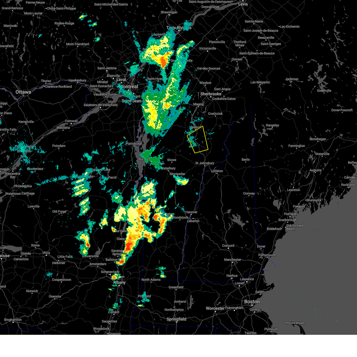
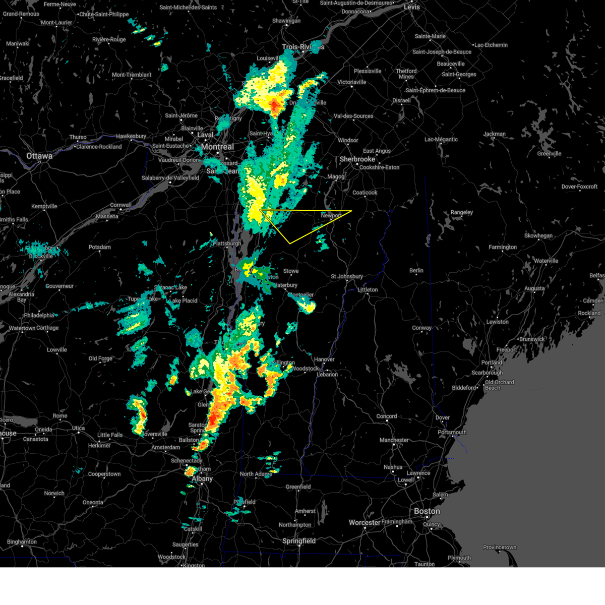
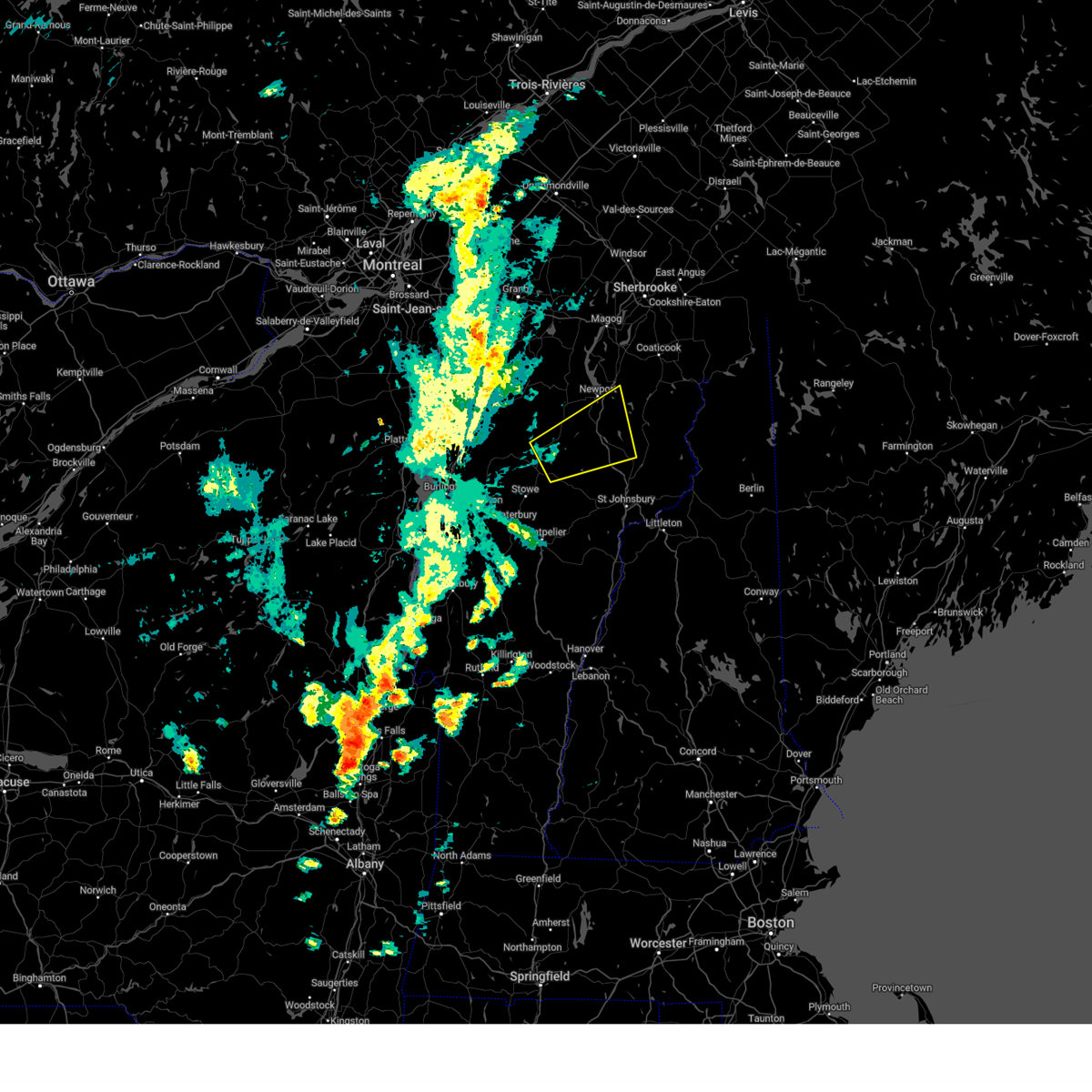
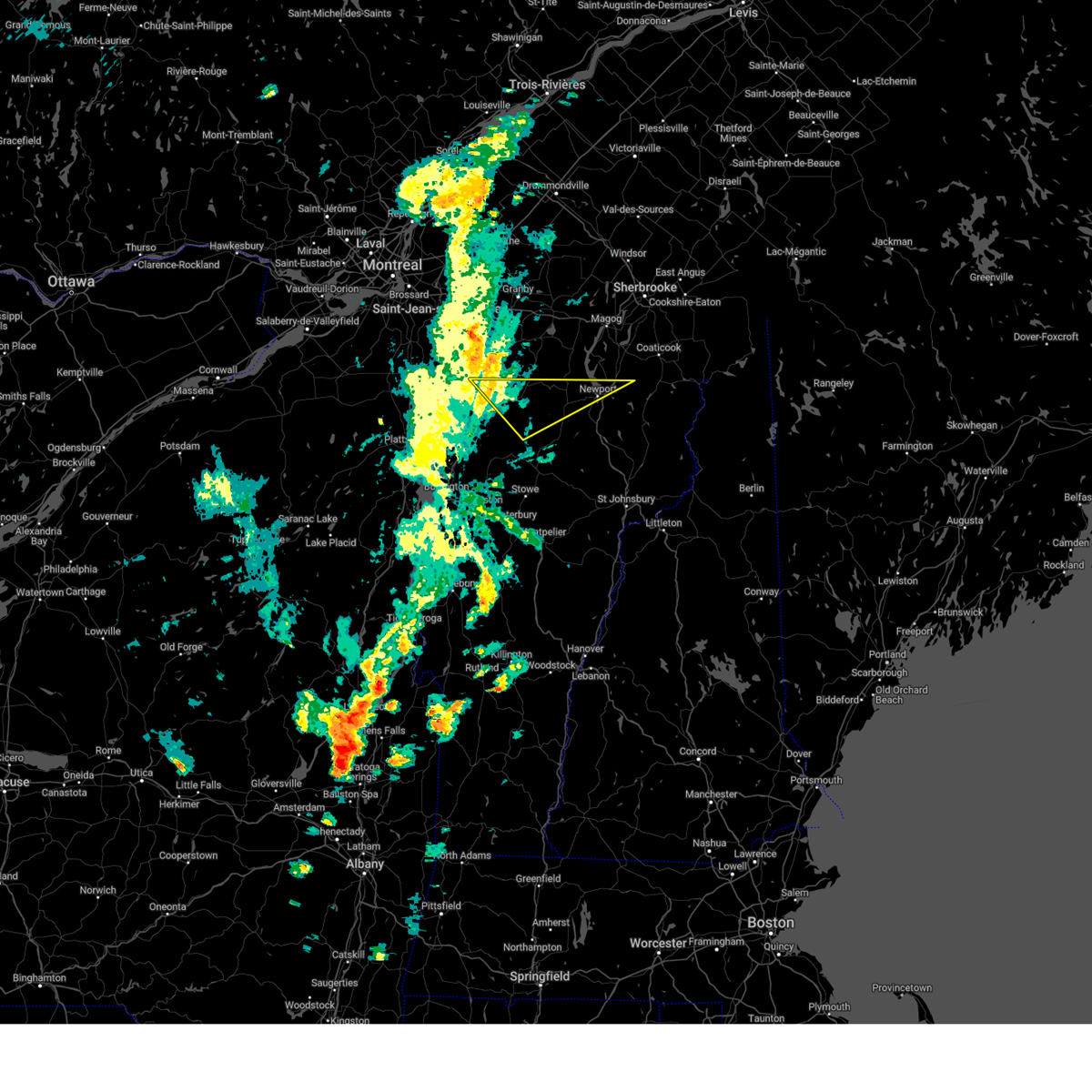
Hail Map for Derby Center, VT
The Derby Center, VT area has had 2 reports of on-the-ground hail by trained spotters, and has been under severe weather warnings 8 times during the past 12 months. Doppler radar has detected hail at or near Derby Center, VT on 8 occasions.
| Name: | Derby Center, VT |
| Where Located: | 62.5 miles ENE of Burlington, VT |
| Map: | Google Map for Derby Center, VT |
| Population: | 597 |
| Housing Units: | 295 |
| More Info: | Search Google for Derby Center, VT |
5
The Top Recent Hail Date for Derby Center, VT is Thursday, May 26, 2011 (1st out of 8)

Hail and Wind Damage Spotted near Derby Center, VT
| Date / Time | Report Details |
|---|---|
| 7/3/2025 7:35 PM EDT | the severe thunderstorm warning has been cancelled and is no longer in effect |
| 7/3/2025 7:23 PM EDT | At 722 pm edt, a severe thunderstorm was located near lowell, moving east at 15 mph (public). Hazards include 60 mph wind gusts and quarter size hail. Minor hail damage to vehicles is possible. expect wind damage to trees and powerlines. Locations impacted include, newport city, orleans, derby center, jay, newport town, jay in franklin county, orleans village, montgomery center, brownington, albany, montgomery, coventry, barton, troy, brownington village, irasburg, derby line village, westfield, newport center, and north troy village. |
| 7/3/2025 6:55 PM EDT | Svrbtv the national weather service in burlington has issued a * severe thunderstorm warning for, north central lamoille county in northwestern vermont, orleans county in northeastern vermont, northeastern franklin county in northwestern vermont, * until 800 pm edt. * at 655 pm edt, a severe thunderstorm was located over east berkshire, moving east at 35 mph (radar indicated). Hazards include 60 mph wind gusts and quarter size hail. Minor hail damage to vehicles is possible. Expect wind damage to trees and powerlines. |
| 5/17/2025 5:02 PM EDT |
 the severe thunderstorm warning has been cancelled and is no longer in effect the severe thunderstorm warning has been cancelled and is no longer in effect
|
| 5/17/2025 5:02 PM EDT |
 At 501 pm edt, a severe thunderstorm was located over evansville, moving northeast at 30 mph (radar indicated). Hazards include 60 mph wind gusts and quarter size hail. Minor hail damage to vehicles is possible. expect wind damage to trees and powerlines. Locations impacted include, east brownington, south bay in orleans county, charleston, west glover, irasburg, westmore, orleans village, west charleston, derby center, glover, brownington center, brownington, orleans, crystal lake state park, willoughby, derby, sutton, coventry, barton, and connor island. At 501 pm edt, a severe thunderstorm was located over evansville, moving northeast at 30 mph (radar indicated). Hazards include 60 mph wind gusts and quarter size hail. Minor hail damage to vehicles is possible. expect wind damage to trees and powerlines. Locations impacted include, east brownington, south bay in orleans county, charleston, west glover, irasburg, westmore, orleans village, west charleston, derby center, glover, brownington center, brownington, orleans, crystal lake state park, willoughby, derby, sutton, coventry, barton, and connor island.
|
| 5/17/2025 4:49 PM EDT |
 the severe thunderstorm warning has been cancelled and is no longer in effect the severe thunderstorm warning has been cancelled and is no longer in effect
|
| 5/17/2025 4:23 PM EDT |
 Svrbtv the national weather service in burlington has issued a * severe thunderstorm warning for, northeastern lamoille county in northwestern vermont, northern caledonia county in northeastern vermont, central orleans county in northeastern vermont, * until 515 pm edt. * at 423 pm edt, a severe thunderstorm was located over tromp point, moving northeast at 30 mph (radar indicated). Hazards include 60 mph wind gusts and quarter size hail. Minor hail damage to vehicles is possible. Expect wind damage to trees and powerlines. Svrbtv the national weather service in burlington has issued a * severe thunderstorm warning for, northeastern lamoille county in northwestern vermont, northern caledonia county in northeastern vermont, central orleans county in northeastern vermont, * until 515 pm edt. * at 423 pm edt, a severe thunderstorm was located over tromp point, moving northeast at 30 mph (radar indicated). Hazards include 60 mph wind gusts and quarter size hail. Minor hail damage to vehicles is possible. Expect wind damage to trees and powerlines.
|
| 5/17/2025 4:16 PM EDT |
 Svrbtv the national weather service in burlington has issued a * severe thunderstorm warning for, north central lamoille county in northwestern vermont, northwestern orleans county in northeastern vermont, northeastern franklin county in northwestern vermont, * until 500 pm edt. * at 413 pm edt, a severe thunderstorm was located over west hill, moving northeast at 30 mph (this storm has a history of blowing down trees as reported by law enforcement). Hazards include 60 mph wind gusts and quarter size hail. Minor hail damage to vehicles is possible. Expect wind damage to trees and powerlines. Svrbtv the national weather service in burlington has issued a * severe thunderstorm warning for, north central lamoille county in northwestern vermont, northwestern orleans county in northeastern vermont, northeastern franklin county in northwestern vermont, * until 500 pm edt. * at 413 pm edt, a severe thunderstorm was located over west hill, moving northeast at 30 mph (this storm has a history of blowing down trees as reported by law enforcement). Hazards include 60 mph wind gusts and quarter size hail. Minor hail damage to vehicles is possible. Expect wind damage to trees and powerlines.
|
| 7/13/2023 6:59 PM EDT |
 At 659 pm edt, a severe thunderstorm was located over jay in franklin county, moving north at 20 mph (radar indicated). Hazards include 60 mph wind gusts and quarter size hail. Minor hail damage to vehicles is possible. expect wind damage to trees and powerlines. locations impacted include, newport city, morrisville, orleans, derby center, jay, newport town, jay in franklin county, eden, orleans village, brownington, albany, hyde park, wolcott, coventry, troy, brownington village, irasburg, derby line village, westfield, and morrisville village. hail threat, radar indicated max hail size, 1. 00 in wind threat, radar indicated max wind gust, 60 mph. At 659 pm edt, a severe thunderstorm was located over jay in franklin county, moving north at 20 mph (radar indicated). Hazards include 60 mph wind gusts and quarter size hail. Minor hail damage to vehicles is possible. expect wind damage to trees and powerlines. locations impacted include, newport city, morrisville, orleans, derby center, jay, newport town, jay in franklin county, eden, orleans village, brownington, albany, hyde park, wolcott, coventry, troy, brownington village, irasburg, derby line village, westfield, and morrisville village. hail threat, radar indicated max hail size, 1. 00 in wind threat, radar indicated max wind gust, 60 mph.
|
| 7/13/2023 6:33 PM EDT |
 At 633 pm edt, a severe thunderstorm was located near lowell, moving north at 20 mph (radar indicated). Hazards include 60 mph wind gusts and quarter size hail. Minor hail damage to vehicles is possible. Expect wind damage to trees and powerlines. At 633 pm edt, a severe thunderstorm was located near lowell, moving north at 20 mph (radar indicated). Hazards include 60 mph wind gusts and quarter size hail. Minor hail damage to vehicles is possible. Expect wind damage to trees and powerlines.
|
| 7/25/2022 12:57 PM EDT |
 The severe thunderstorm warning for northeastern lamoille, central orleans and east central franklin counties will expire at 100 pm edt, the storm which prompted the warning has weakened below severe limits, and no longer poses an immediate threat to life or property. therefore, the warning will be allowed to expire. however gusty winds of 40 to 45 mph are still possible with this thunderstorm. The severe thunderstorm warning for northeastern lamoille, central orleans and east central franklin counties will expire at 100 pm edt, the storm which prompted the warning has weakened below severe limits, and no longer poses an immediate threat to life or property. therefore, the warning will be allowed to expire. however gusty winds of 40 to 45 mph are still possible with this thunderstorm.
|
| 7/25/2022 12:44 PM EDT |
 At 1244 pm edt, a severe thunderstorm was located near irasburg, moving east at 40 mph (radar indicated). Hazards include 60 mph wind gusts. Expect damage to trees and powerlines. locations impacted include, newport city, orleans, derby center, newport town, irasburg, eden, westfield, orleans village, newport center, brownington, albany, derby, coventry, barton, barton village, albany village, lowell, brownington village, derby center village and westmore. hail threat, radar indicated max hail size, <. 75 in wind threat, radar indicated max wind gust, 60 mph. At 1244 pm edt, a severe thunderstorm was located near irasburg, moving east at 40 mph (radar indicated). Hazards include 60 mph wind gusts. Expect damage to trees and powerlines. locations impacted include, newport city, orleans, derby center, newport town, irasburg, eden, westfield, orleans village, newport center, brownington, albany, derby, coventry, barton, barton village, albany village, lowell, brownington village, derby center village and westmore. hail threat, radar indicated max hail size, <. 75 in wind threat, radar indicated max wind gust, 60 mph.
|
| 7/25/2022 12:21 PM EDT |
 At 1221 pm edt, a severe thunderstorm was located over belvidere, moving east at 40 mph (radar indicated). Hazards include 60 mph wind gusts. expect damage to trees and powerlines At 1221 pm edt, a severe thunderstorm was located over belvidere, moving east at 40 mph (radar indicated). Hazards include 60 mph wind gusts. expect damage to trees and powerlines
|
| 7/21/2022 12:58 PM EDT |
 At 1258 pm edt, a severe thunderstorm capable of producing a tornado was located over brownington village, moving northeast at 35 mph (radar indicated rotation). Hazards include tornado and ping pong ball size hail. Flying debris will be dangerous to those caught without shelter. mobile homes will be damaged or destroyed. damage to roofs, windows, and vehicles will occur. tree damage is likely. this dangerous storm will be near, derby center around 105 pm edt. derby center village around 110 pm edt. derby, derby line village and charleston around 115 pm edt. morgan, warners grant, warren gore and brighton around 120 pm edt. holland around 125 pm edt. averys gore and norton around 130 pm edt. Other locations impacted by this tornadic thunderstorm include east brownington, south bay in orleans county, west charleston, morgan center, derby line, brownington center, crystal lake state park, evansville and east charleston. At 1258 pm edt, a severe thunderstorm capable of producing a tornado was located over brownington village, moving northeast at 35 mph (radar indicated rotation). Hazards include tornado and ping pong ball size hail. Flying debris will be dangerous to those caught without shelter. mobile homes will be damaged or destroyed. damage to roofs, windows, and vehicles will occur. tree damage is likely. this dangerous storm will be near, derby center around 105 pm edt. derby center village around 110 pm edt. derby, derby line village and charleston around 115 pm edt. morgan, warners grant, warren gore and brighton around 120 pm edt. holland around 125 pm edt. averys gore and norton around 130 pm edt. Other locations impacted by this tornadic thunderstorm include east brownington, south bay in orleans county, west charleston, morgan center, derby line, brownington center, crystal lake state park, evansville and east charleston.
|
| 6/16/2022 7:11 PM EDT |
 At 711 pm edt, a severe thunderstorm was located over south franklin, moving east at 45 mph (radar indicated). Hazards include 60 mph wind gusts and quarter size hail. Minor hail damage to vehicles is possible. Expect wind damage to trees and powerlines. At 711 pm edt, a severe thunderstorm was located over south franklin, moving east at 45 mph (radar indicated). Hazards include 60 mph wind gusts and quarter size hail. Minor hail damage to vehicles is possible. Expect wind damage to trees and powerlines.
|
| 5/21/2022 6:18 PM EDT |
 At 618 pm edt, a severe thunderstorm was located over black island, moving east at 25 mph (radar indicated). Hazards include 60 mph wind gusts and quarter size hail. Minor hail damage to vehicles is possible. Expect wind damage to trees and powerlines. At 618 pm edt, a severe thunderstorm was located over black island, moving east at 25 mph (radar indicated). Hazards include 60 mph wind gusts and quarter size hail. Minor hail damage to vehicles is possible. Expect wind damage to trees and powerlines.
|
| 7/20/2021 8:11 PM EDT |
 At 808 pm edt, a line of severe thunderstorms over northern and central vermont was located along a line extending from near east richford to near wolcott to ainsworth state park to near pittsfield, moving east at 30 mph (radar indicated). Hazards include 60 mph wind gusts and quarter size hail. Expect wind damage to trees and powerlines. minor hail damage to vehicles is possible. these storms have a history of producing wind damage and power outages. locations impacted include, barre, montpelier, island pond, lyndon, st. Johnsbury, middlebury, newport city, vergennes, crown point, morrisville, enosburg falls, orleans, derby center, charleston, braintree hill, glover, waterbury village, montgomery center, websterville and orwell. At 808 pm edt, a line of severe thunderstorms over northern and central vermont was located along a line extending from near east richford to near wolcott to ainsworth state park to near pittsfield, moving east at 30 mph (radar indicated). Hazards include 60 mph wind gusts and quarter size hail. Expect wind damage to trees and powerlines. minor hail damage to vehicles is possible. these storms have a history of producing wind damage and power outages. locations impacted include, barre, montpelier, island pond, lyndon, st. Johnsbury, middlebury, newport city, vergennes, crown point, morrisville, enosburg falls, orleans, derby center, charleston, braintree hill, glover, waterbury village, montgomery center, websterville and orwell.
|
| 7/20/2021 7:32 PM EDT |
 At 730 pm edt, a line of severe thunderstorms over western vermont was located along a line extending from near east franklin to stowe to east warren to mossy point, moving east at 40 mph (radar indicated). Hazards include 60 mph wind gusts and quarter size hail. Expect wind damage to trees and powerlines. minor hail damage to vehicles is possible. This line of storms has a history of producing wind damage and power outages. At 730 pm edt, a line of severe thunderstorms over western vermont was located along a line extending from near east franklin to stowe to east warren to mossy point, moving east at 40 mph (radar indicated). Hazards include 60 mph wind gusts and quarter size hail. Expect wind damage to trees and powerlines. minor hail damage to vehicles is possible. This line of storms has a history of producing wind damage and power outages.
|
| 7/8/2020 3:48 PM EDT |
 At 348 pm edt, severe thunderstorms were located along a line extending from near norton to near derby line to newport center, moving south at 30 mph (radar indicated). Hazards include 60 mph wind gusts and quarter size hail. Minor hail damage to vehicles is possible. Expect wind damage to trees and powerlines. At 348 pm edt, severe thunderstorms were located along a line extending from near norton to near derby line to newport center, moving south at 30 mph (radar indicated). Hazards include 60 mph wind gusts and quarter size hail. Minor hail damage to vehicles is possible. Expect wind damage to trees and powerlines.
|
| 7/8/2020 3:45 PM EDT | Trees dow in orleans county VT, 0.6 miles SSW of Derby Center, VT |
| 7/1/2020 5:41 PM EDT |
 A severe thunderstorm warning remains in effect until 600 pm edt for northeastern orleans county. at 540 pm edt, a severe thunderstorm was located over derby line, moving west at 25 mph. hazard. 60 mph wind gusts and quarter size hail. source. Radar indicated. A severe thunderstorm warning remains in effect until 600 pm edt for northeastern orleans county. at 540 pm edt, a severe thunderstorm was located over derby line, moving west at 25 mph. hazard. 60 mph wind gusts and quarter size hail. source. Radar indicated.
|
| 7/1/2020 5:29 PM EDT |
 At 529 pm edt, a severe thunderstorm was located over holland, moving west at 25 mph (radar indicated). Hazards include 60 mph wind gusts and quarter size hail. Minor hail damage to vehicles is possible. expect wind damage to trees and powerlines. Locations impacted include, newport city, orleans, derby center, charleston, newport town, westmore, orleans village, glover, brownington, coventry, barton, troy, brownington village, irasburg, derby line village, morgan, warren gore, newport center, north troy village and averys gore. At 529 pm edt, a severe thunderstorm was located over holland, moving west at 25 mph (radar indicated). Hazards include 60 mph wind gusts and quarter size hail. Minor hail damage to vehicles is possible. expect wind damage to trees and powerlines. Locations impacted include, newport city, orleans, derby center, charleston, newport town, westmore, orleans village, glover, brownington, coventry, barton, troy, brownington village, irasburg, derby line village, morgan, warren gore, newport center, north troy village and averys gore.
|
| 7/1/2020 5:07 PM EDT |
 At 507 pm edt, a severe thunderstorm was located near norton, moving southwest at 20 mph (radar indicated). Hazards include 60 mph wind gusts and quarter size hail. Minor hail damage to vehicles is possible. Expect wind damage to trees and powerlines. At 507 pm edt, a severe thunderstorm was located near norton, moving southwest at 20 mph (radar indicated). Hazards include 60 mph wind gusts and quarter size hail. Minor hail damage to vehicles is possible. Expect wind damage to trees and powerlines.
|
| 6/29/2019 6:59 PM EDT |
 At 658 pm edt, a severe thunderstorm was located over coventry and east charleston, moving southeast at 25 mph (radar indicated). Hazards include 60 mph wind gusts and quarter size hail. Minor hail damage to vehicles is possible. expect wind damage to trees and powerlines. Locations impacted include, newport city, island pond, lyndon, orleans, derby center, charleston, newport town, jay in franklin county, westmore, orleans village, brownington, burke, sutton, coventry, barton, troy, newark, newark hollow, brownington village and west burke village. At 658 pm edt, a severe thunderstorm was located over coventry and east charleston, moving southeast at 25 mph (radar indicated). Hazards include 60 mph wind gusts and quarter size hail. Minor hail damage to vehicles is possible. expect wind damage to trees and powerlines. Locations impacted include, newport city, island pond, lyndon, orleans, derby center, charleston, newport town, jay in franklin county, westmore, orleans village, brownington, burke, sutton, coventry, barton, troy, newark, newark hollow, brownington village and west burke village.
|
| 6/29/2019 6:55 PM EDT | Trees down in orleans county VT, 0.6 miles SSW of Derby Center, VT |
| 6/29/2019 6:41 PM EDT |
 At 641 pm edt, a severe thunderstorm was located over newport center, moving southeast at 25 mph (radar indicated). Hazards include 60 mph wind gusts and quarter size hail. Minor hail damage to vehicles is possible. Expect wind damage to trees and powerlines. At 641 pm edt, a severe thunderstorm was located over newport center, moving southeast at 25 mph (radar indicated). Hazards include 60 mph wind gusts and quarter size hail. Minor hail damage to vehicles is possible. Expect wind damage to trees and powerlines.
|
| 5/4/2018 6:54 PM EDT |
 At 654 pm edt, a severe thunderstorm was located over berkshire, moving east at 35 mph (radar indicated). Hazards include 60 mph wind gusts and quarter size hail. Minor hail damage to vehicles is possible. Expect wind damage to trees and powerlines. At 654 pm edt, a severe thunderstorm was located over berkshire, moving east at 35 mph (radar indicated). Hazards include 60 mph wind gusts and quarter size hail. Minor hail damage to vehicles is possible. Expect wind damage to trees and powerlines.
|
| 8/22/2017 6:40 PM EDT |
 The severe thunderstorm warning for northern lamoille, northeastern caledonia, orleans and eastern franklin counties will expire at 645 pm edt, the storm which prompted the warning has weakened below severe limits, and no longer pose an immediate threat to life or property. therefore the warning will be allowed to expire. however gusty winds are still possible with this thunderstorm. a tornado watch remains in effect until 900 pm edt for northwestern vermont. a severe thunderstorm watch remains in effect until midnight edt for northeastern and northwestern vermont. The severe thunderstorm warning for northern lamoille, northeastern caledonia, orleans and eastern franklin counties will expire at 645 pm edt, the storm which prompted the warning has weakened below severe limits, and no longer pose an immediate threat to life or property. therefore the warning will be allowed to expire. however gusty winds are still possible with this thunderstorm. a tornado watch remains in effect until 900 pm edt for northwestern vermont. a severe thunderstorm watch remains in effect until midnight edt for northeastern and northwestern vermont.
|
| 8/22/2017 6:07 PM EDT |
 At 607 pm edt, a severe thunderstorm was located over montgomery, moving east at 25 mph (radar indicated). Hazards include 60 mph wind gusts and penny size hail. Expect damage to trees and powerlines. locations impacted include, newport city, enosburg falls, orleans, derby center, charleston, jay, newport town, jay in franklin county, glover, montgomery center, albany, montgomery, fairfax, troy, belvidere center, newark, brownington village, enosburg, west burke village and waterville. A tornado watch remains in effect until 900 pm edt for northwestern vermont. At 607 pm edt, a severe thunderstorm was located over montgomery, moving east at 25 mph (radar indicated). Hazards include 60 mph wind gusts and penny size hail. Expect damage to trees and powerlines. locations impacted include, newport city, enosburg falls, orleans, derby center, charleston, jay, newport town, jay in franklin county, glover, montgomery center, albany, montgomery, fairfax, troy, belvidere center, newark, brownington village, enosburg, west burke village and waterville. A tornado watch remains in effect until 900 pm edt for northwestern vermont.
|
| 8/22/2017 5:46 PM EDT |
 At 545 pm edt, a severe thunderstorm was located over bakersfield, moving east at 40 mph (radar indicated). Hazards include 60 mph wind gusts. expect damage to trees and powerlines At 545 pm edt, a severe thunderstorm was located over bakersfield, moving east at 40 mph (radar indicated). Hazards include 60 mph wind gusts. expect damage to trees and powerlines
|
| 8/12/2017 7:00 PM EDT |
 At 700 pm edt, severe thunderstorms were located along a line extending from cove island to near elmore state park, moving east at 40 mph (radar indicated). Hazards include 60 mph wind gusts and quarter size hail. Minor hail damage to vehicles is possible. Expect wind damage to trees and powerlines. At 700 pm edt, severe thunderstorms were located along a line extending from cove island to near elmore state park, moving east at 40 mph (radar indicated). Hazards include 60 mph wind gusts and quarter size hail. Minor hail damage to vehicles is possible. Expect wind damage to trees and powerlines.
|
| 7/22/2016 11:36 PM EDT |
 At 1134 pm edt, severe thunderstorms were located along a line extending from north troy to mount worcester, moving east at 35 mph (radar indicated). Hazards include 60 mph wind gusts and quarter size hail. Hail damage to vehicles is expected. expect wind damage to roofs, siding, and trees. Locations impacted include, island pond, stowe, hardwick, richford, danville, morrisville, berkshire, wolcott, troy, johnson, eden, bakersfield, concord, craftsbury, montgomery, irasburg, glover, coventry, sutton and canaan. At 1134 pm edt, severe thunderstorms were located along a line extending from north troy to mount worcester, moving east at 35 mph (radar indicated). Hazards include 60 mph wind gusts and quarter size hail. Hail damage to vehicles is expected. expect wind damage to roofs, siding, and trees. Locations impacted include, island pond, stowe, hardwick, richford, danville, morrisville, berkshire, wolcott, troy, johnson, eden, bakersfield, concord, craftsbury, montgomery, irasburg, glover, coventry, sutton and canaan.
|
| 7/22/2016 10:43 PM EDT |
 At 1041 pm edt, severe thunderstorms were located along a line extending from alburg vermont to burlington vermont, moving east at 35 to 40 mph. other strong to severe thunderstorms were located over northeast vermont moving east at 35 mph (radar indicated). Hazards include 60 mph wind gusts and quarter size hail. Hail damage to vehicles is expected. Expect wind damage to roofs, siding, and trees. At 1041 pm edt, severe thunderstorms were located along a line extending from alburg vermont to burlington vermont, moving east at 35 to 40 mph. other strong to severe thunderstorms were located over northeast vermont moving east at 35 mph (radar indicated). Hazards include 60 mph wind gusts and quarter size hail. Hail damage to vehicles is expected. Expect wind damage to roofs, siding, and trees.
|
| 7/18/2016 8:06 PM EDT |
 The severe thunderstorm warning for northern orleans, northern essex and northeastern franklin counties will expire at 815 pm edt, the storm which prompted the warning has weakened below severe limits, and have exited the warned area. therefore the warning will be allowed to expire. The severe thunderstorm warning for northern orleans, northern essex and northeastern franklin counties will expire at 815 pm edt, the storm which prompted the warning has weakened below severe limits, and have exited the warned area. therefore the warning will be allowed to expire.
|
| 7/18/2016 7:31 PM EDT |
 At 729 pm edt, a severe thunderstorm was located over jay in franklin county, moving east at 40 mph (the public reported quarter sized hail and large tree limbs downed in richford). Hazards include 60 mph wind gusts and quarter size hail. Hail damage to vehicles is expected. expect wind damage to roofs, siding, and trees. locations impacted include, colebrook, richford, troy, montgomery, coventry, canaan, morgan, holland, derby center, westfield, jay, norton, averill, newport center, montgomery center, jay in franklin county, derby line, north troy, west charleston and holbrook bay. At 729 pm edt, a severe thunderstorm was located over jay in franklin county, moving east at 40 mph (the public reported quarter sized hail and large tree limbs downed in richford). Hazards include 60 mph wind gusts and quarter size hail. Hail damage to vehicles is expected. expect wind damage to roofs, siding, and trees. locations impacted include, colebrook, richford, troy, montgomery, coventry, canaan, morgan, holland, derby center, westfield, jay, norton, averill, newport center, montgomery center, jay in franklin county, derby line, north troy, west charleston and holbrook bay.
|
| 7/18/2016 7:11 PM EDT |
 At 710 pm edt, a severe thunderstorm was located near montgomery, moving east at 50 mph (radar indicated). Hazards include 60 mph wind gusts and half dollar size hail. Hail damage to vehicles is expected. Expect wind damage to roofs, siding, and trees. At 710 pm edt, a severe thunderstorm was located near montgomery, moving east at 50 mph (radar indicated). Hazards include 60 mph wind gusts and half dollar size hail. Hail damage to vehicles is expected. Expect wind damage to roofs, siding, and trees.
|
| 7/18/2016 12:30 PM EDT | Tree down in orleans county VT, 0.6 miles SSW of Derby Center, VT |
| 7/18/2016 12:22 PM EDT |
 At 1222 pm edt, a severe thunderstorm was located over newport center, moving east at 45 mph (radar indicated). Hazards include 60 mph wind gusts and quarter size hail. Hail damage to vehicles is expected. expect wind damage to roofs, siding, and trees. locations impacted include, colebrook, island pond, troy, irasburg, coventry, canaan, orleans, morgan, barton, holland, derby center, westfield, jay, westmore, bloomfield, maidstone, norton, averill, newport center and jay in franklin county. At 1222 pm edt, a severe thunderstorm was located over newport center, moving east at 45 mph (radar indicated). Hazards include 60 mph wind gusts and quarter size hail. Hail damage to vehicles is expected. expect wind damage to roofs, siding, and trees. locations impacted include, colebrook, island pond, troy, irasburg, coventry, canaan, orleans, morgan, barton, holland, derby center, westfield, jay, westmore, bloomfield, maidstone, norton, averill, newport center and jay in franklin county.
|
| 7/18/2016 11:42 AM EDT |
 At 1141 am edt, a severe thunderstorm was located near north troy, moving east at 35 mph (radar indicated). Hazards include 60 mph wind gusts and quarter size hail. Hail damage to vehicles is expected. Expect wind damage to roofs, siding, and trees. At 1141 am edt, a severe thunderstorm was located near north troy, moving east at 35 mph (radar indicated). Hazards include 60 mph wind gusts and quarter size hail. Hail damage to vehicles is expected. Expect wind damage to roofs, siding, and trees.
|
| 9/9/2015 4:35 PM EDT |
 At 433 pm edt, doppler radar continued to indicate a severe thunderstorm capable of producing damaging winds in excess of 60 mph. this storm was located over holland, moving east at 40 mph. locations impacted include, irasburg, coventry, orleans, morgan, barton, holland, derby center, westmore, newport center, brownington village, brownington, derby line, west charleston, holbrook bay, crystal lake state park, black island, south bay in orleans county, bell island, south newport and brownington center. At 433 pm edt, doppler radar continued to indicate a severe thunderstorm capable of producing damaging winds in excess of 60 mph. this storm was located over holland, moving east at 40 mph. locations impacted include, irasburg, coventry, orleans, morgan, barton, holland, derby center, westmore, newport center, brownington village, brownington, derby line, west charleston, holbrook bay, crystal lake state park, black island, south bay in orleans county, bell island, south newport and brownington center.
|
| 9/9/2015 4:09 PM EDT |
 At 409 pm edt, doppler radar indicated a severe thunderstorm capable of producing damaging winds in excess of 60 mph. this storm was located over newport center, and moving east at 45 mph. * locations to be impacted include, troy, irasburg, coventry, orleans, morgan, barton, holland, derby center, westfield, jay, westmore, newport center, brownington village, jay in franklin county, brownington, derby line, north troy, west charleston, holbrook bay and crystal lake state park. At 409 pm edt, doppler radar indicated a severe thunderstorm capable of producing damaging winds in excess of 60 mph. this storm was located over newport center, and moving east at 45 mph. * locations to be impacted include, troy, irasburg, coventry, orleans, morgan, barton, holland, derby center, westfield, jay, westmore, newport center, brownington village, jay in franklin county, brownington, derby line, north troy, west charleston, holbrook bay and crystal lake state park.
|
| 8/3/2015 3:21 PM EDT |
 The severe thunderstorm warning for north central orleans county will expire at 330 pm edt, the storm which prompted the warning has weakened below severe limits and exited the warned area. therefore the warning will be allowed to expire. The severe thunderstorm warning for north central orleans county will expire at 330 pm edt, the storm which prompted the warning has weakened below severe limits and exited the warned area. therefore the warning will be allowed to expire.
|
| 8/3/2015 3:10 PM EDT |
 At 310 pm edt, doppler radar indicated a severe thunderstorm capable of producing quarter size hail and damaging winds in excess of 60 mph. this storm was located near derby center, or 19 miles northwest of island pond, moving northeast at 25 mph. this severe thunderstorm will remain over mainly rural areas of north central orleans county, including the following locations, south bay in orleans county, holbrook bay, bell island, derby line, derby bay, horseneck island, cove island, black island, beebe plains and beebe plain. At 310 pm edt, doppler radar indicated a severe thunderstorm capable of producing quarter size hail and damaging winds in excess of 60 mph. this storm was located near derby center, or 19 miles northwest of island pond, moving northeast at 25 mph. this severe thunderstorm will remain over mainly rural areas of north central orleans county, including the following locations, south bay in orleans county, holbrook bay, bell island, derby line, derby bay, horseneck island, cove island, black island, beebe plains and beebe plain.
|
| 8/3/2015 2:56 PM EDT |
 At 255 pm edt, doppler radar indicated a severe thunderstorm capable of producing quarter size hail and damaging winds in excess of 60 mph. this storm was located near newport center, or 19 miles northwest of island pond, and moving northeast at 25 mph. * this severe thunderstorm will be near, derby center around 300 pm edt. holland around 315 pm edt. other locations impacted by this severe thunderstorm include south bay in orleans county, holbrook bay, bell island, derby line, derby bay, horseneck island, cove island, black island, beebe plains and beebe plain. At 255 pm edt, doppler radar indicated a severe thunderstorm capable of producing quarter size hail and damaging winds in excess of 60 mph. this storm was located near newport center, or 19 miles northwest of island pond, and moving northeast at 25 mph. * this severe thunderstorm will be near, derby center around 300 pm edt. holland around 315 pm edt. other locations impacted by this severe thunderstorm include south bay in orleans county, holbrook bay, bell island, derby line, derby bay, horseneck island, cove island, black island, beebe plains and beebe plain.
|
| 5/28/2015 1:24 PM EDT | At 123 pm edt, doppler radar indicated a severe thunderstorm capable of producing quarter size hail and damaging winds in excess of 60 mph. this storm was located over derby center, and moving northeast at 25 mph. * locations to be impacted include, canaan, morgan, holland, derby center, averill, west charleston, east charleston, morgan center, cove island, black island, beecher falls, bell island, stewartstown, horseneck island and derby bay. |
| 9/11/2013 6:50 PM EDT | Trees down around town. report from vt state police. time estimated from radar in orleans county VT, 6.8 miles WNW of Derby Center, VT |
| 5/21/2013 9:30 PM EDT | 5 trees down with damage to a few cars. winds estimated 55-72 mp in orleans county VT, 0.6 miles SSW of Derby Center, VT |
| 8/21/2011 2:05 PM EDT | Quarter sized hail reported 6.8 miles WNW of Derby Center, VT |
| 1/1/0001 12:00 AM | Trees down per state police dispatch in orleans county VT, 0.6 miles SSW of Derby Center, VT |
| 1/1/0001 12:00 AM | Trees down and power outages in orleans county VT, 0.6 miles SSW of Derby Center, VT |
| 1/1/0001 12:00 AM | Trees down and power outages in orleans county VT, 6.8 miles WNW of Derby Center, VT |
| 1/1/0001 12:00 AM | Quarter sized hail reported 0.6 miles SSW of Derby Center, VT, quarter size hail and estimated wind gust to 50 knots. |
| 1/1/0001 12:00 AM | Quarter size hail and estimated wind gust to 50 knot in orleans county VT, 0.6 miles SSW of Derby Center, VT |
Hail Maps for Derby Center, VT


Connect with Interactive Hail Maps