

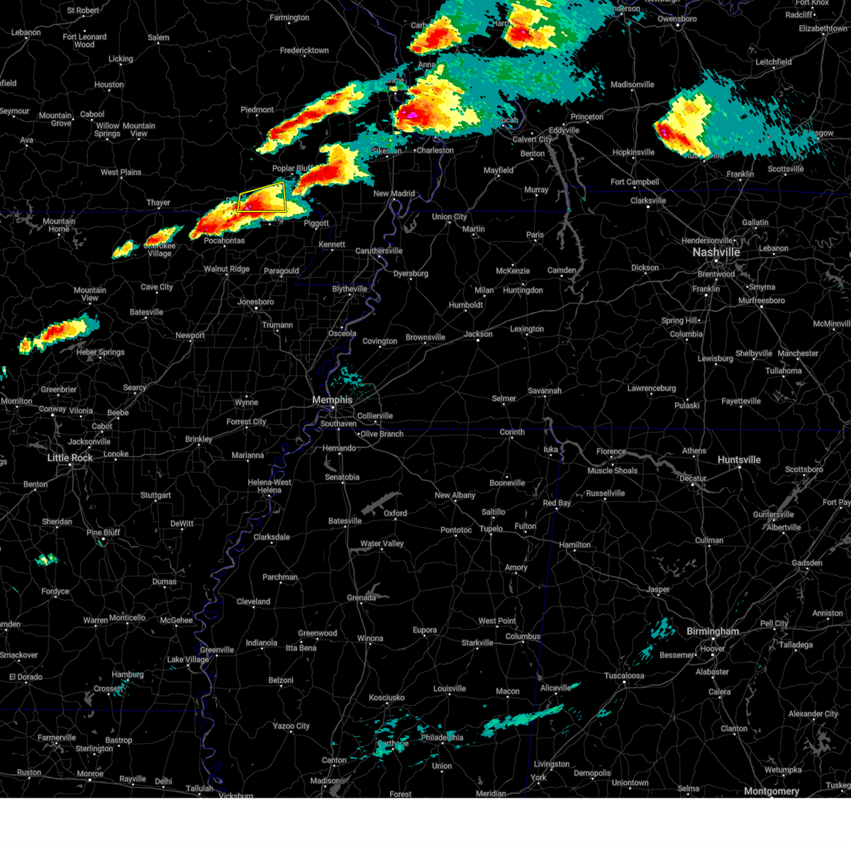
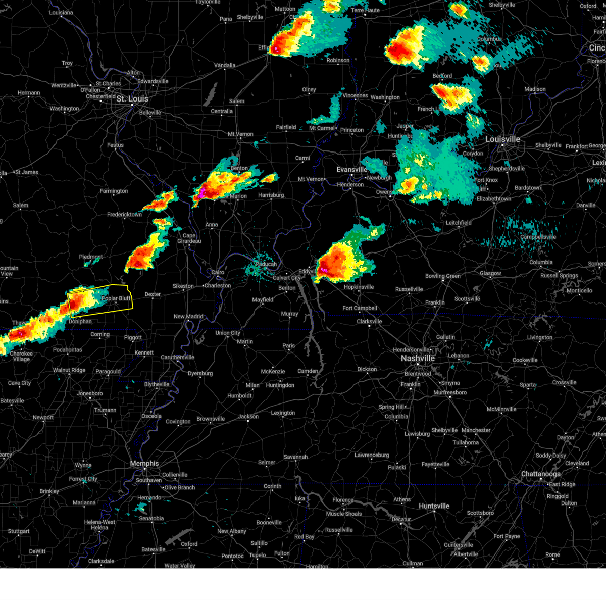
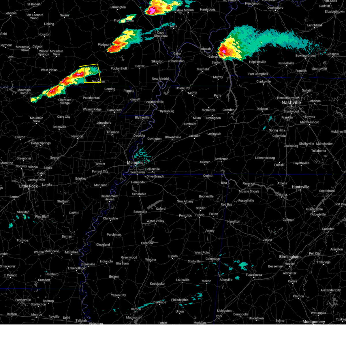
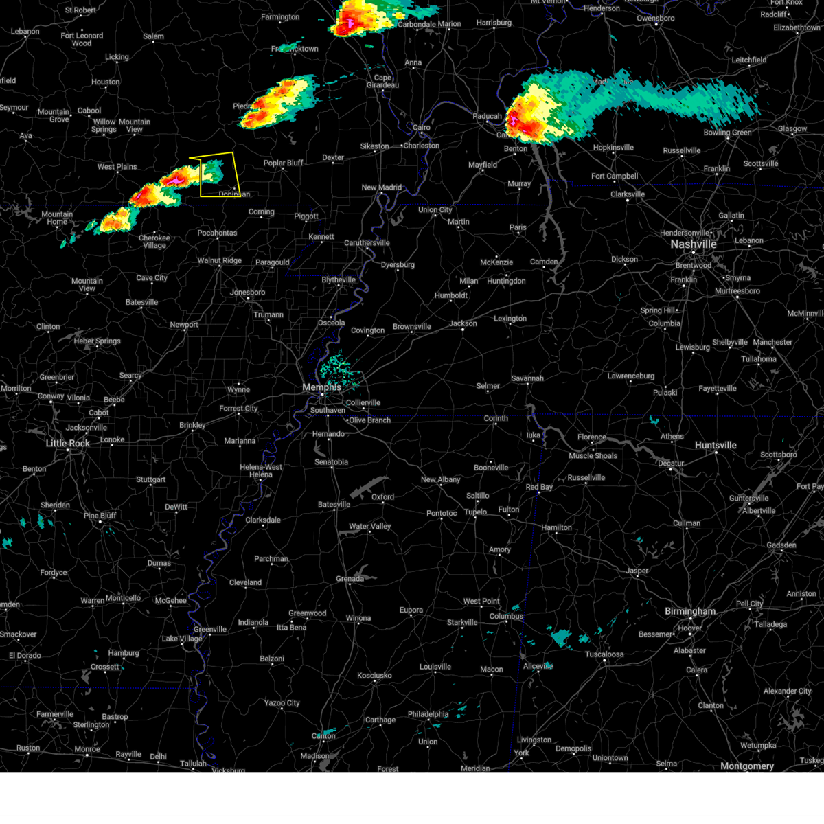
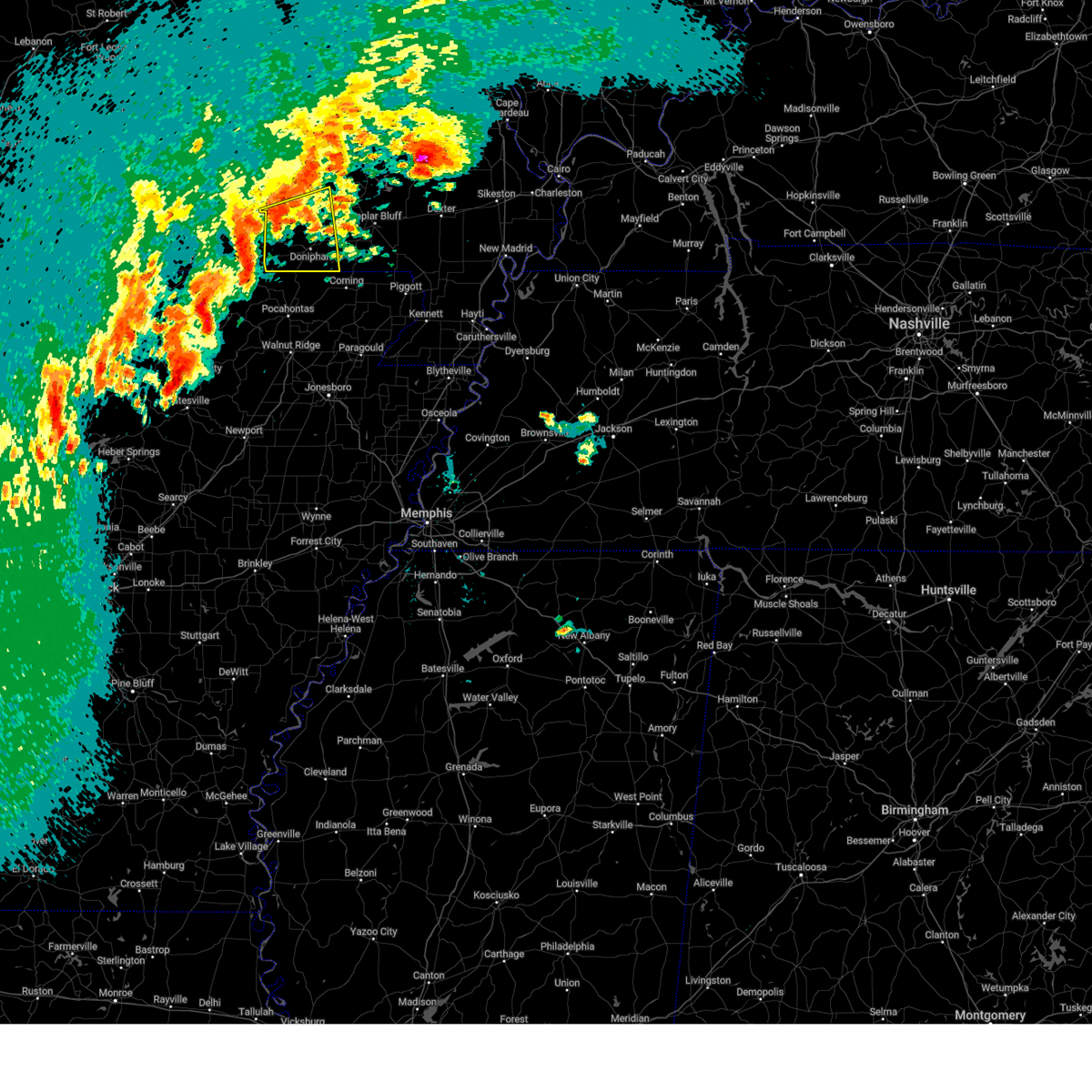
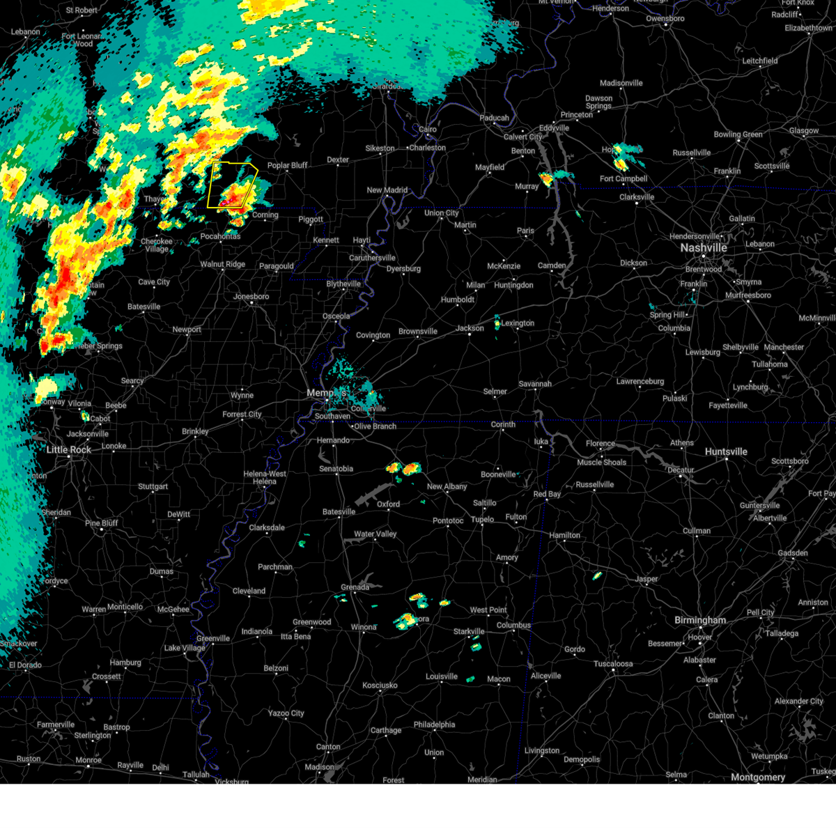
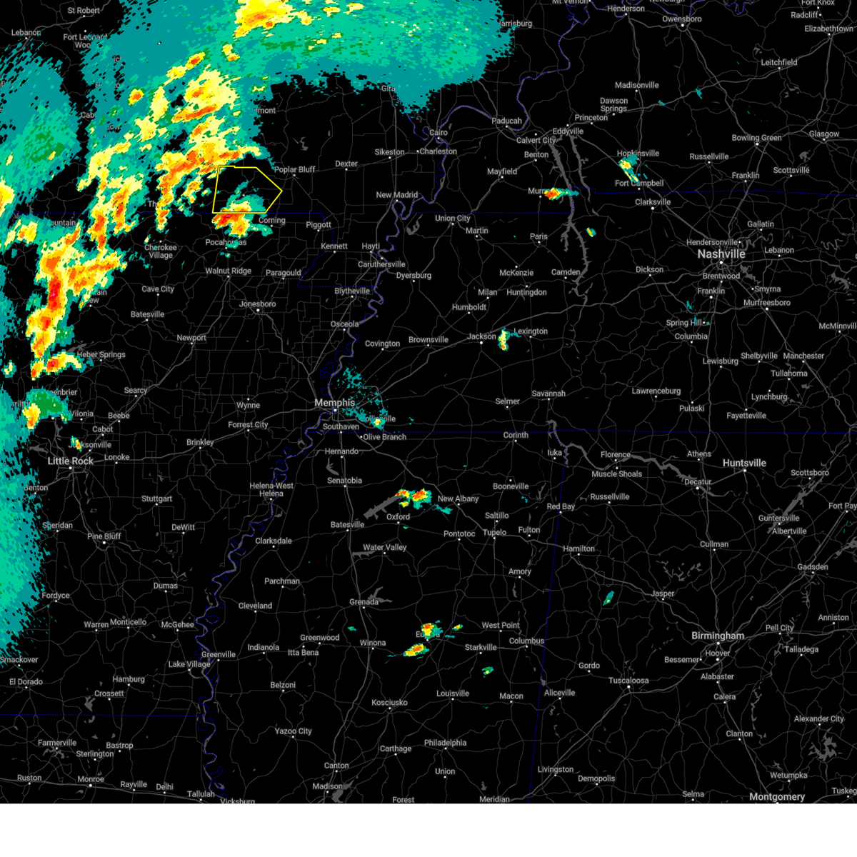
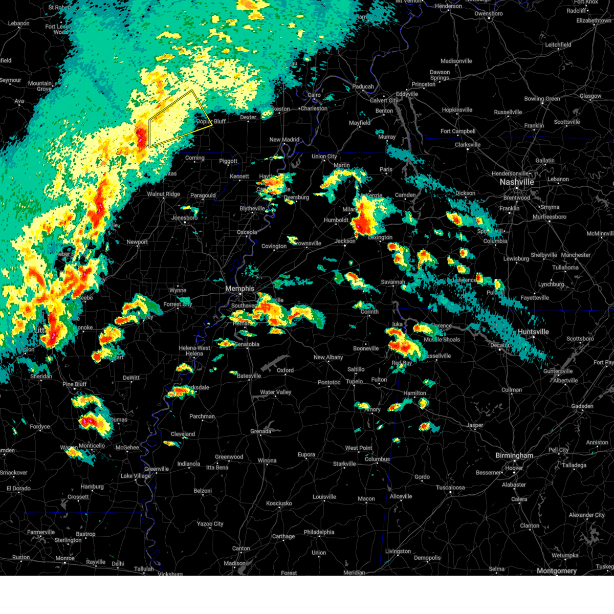
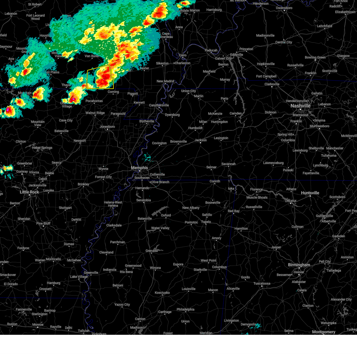
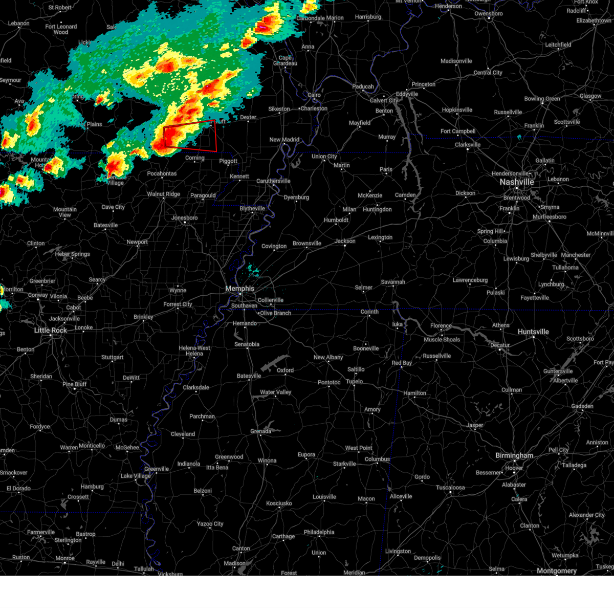
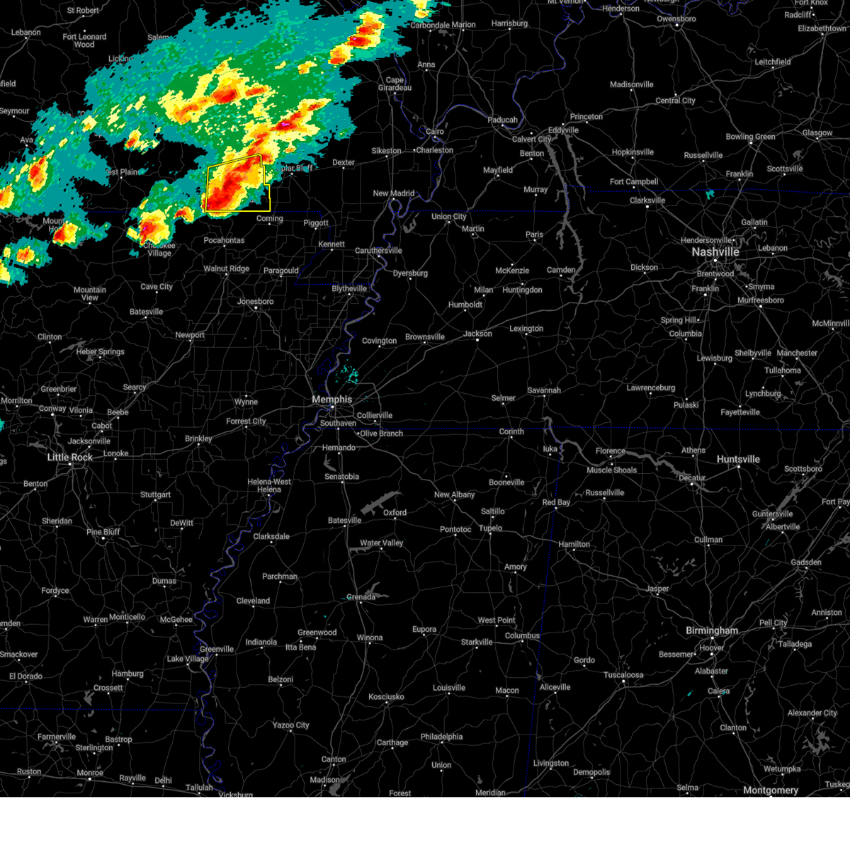
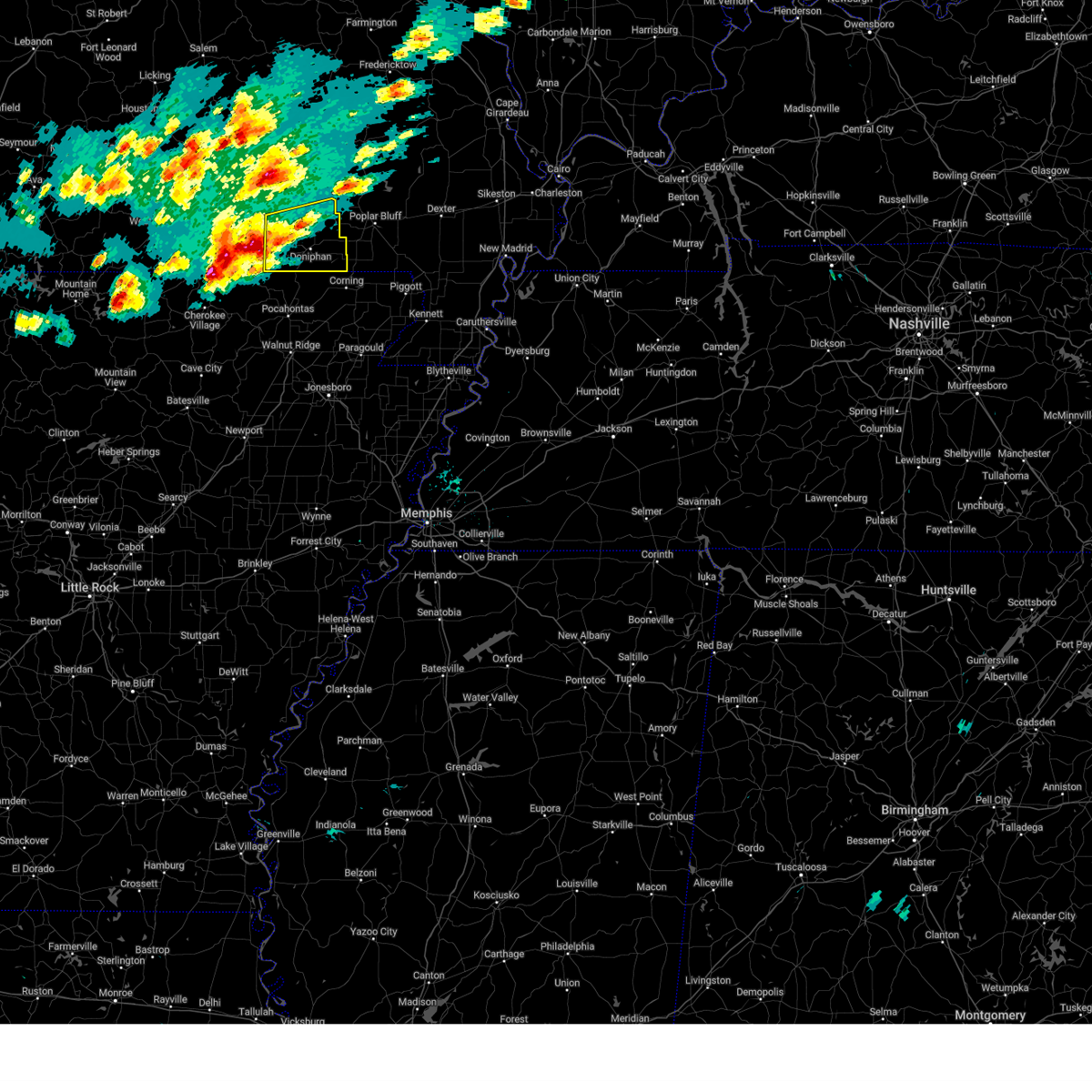
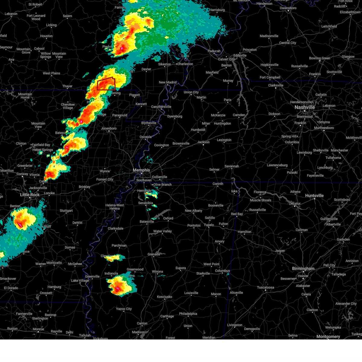
Hail Map for Doniphan, MO
The Doniphan, MO area has had 16 reports of on-the-ground hail by trained spotters, and has been under severe weather warnings 35 times during the past 12 months. Doppler radar has detected hail at or near Doniphan, MO on 66 occasions, including 4 occasions during the past year.
| Name: | Doniphan, MO |
| Where Located: | 80.3 miles SSE of Salem, MO |
| Map: | Google Map for Doniphan, MO |
| Population: | 1997 |
| Housing Units: | 966 |
| More Info: | Search Google for Doniphan, MO |
5
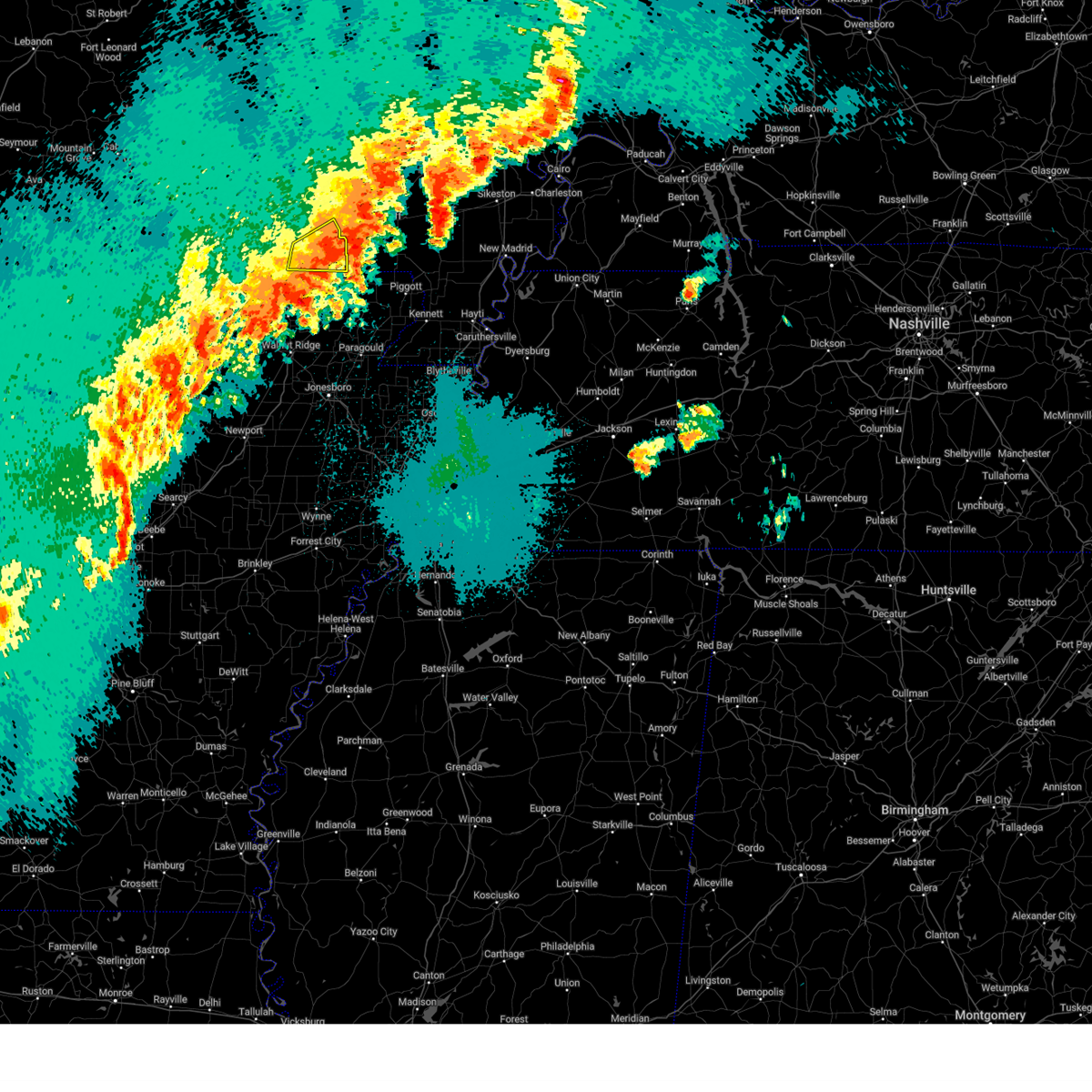
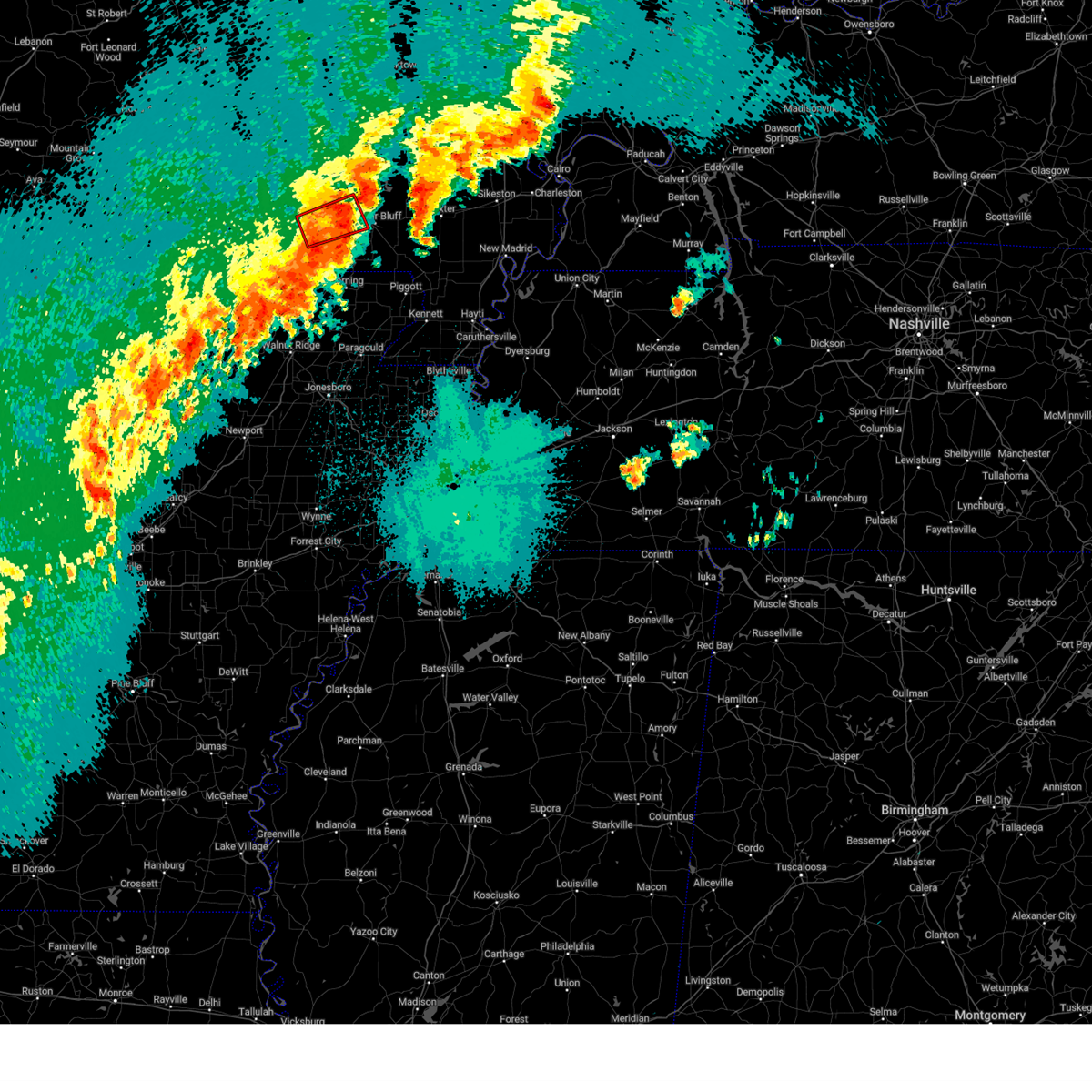
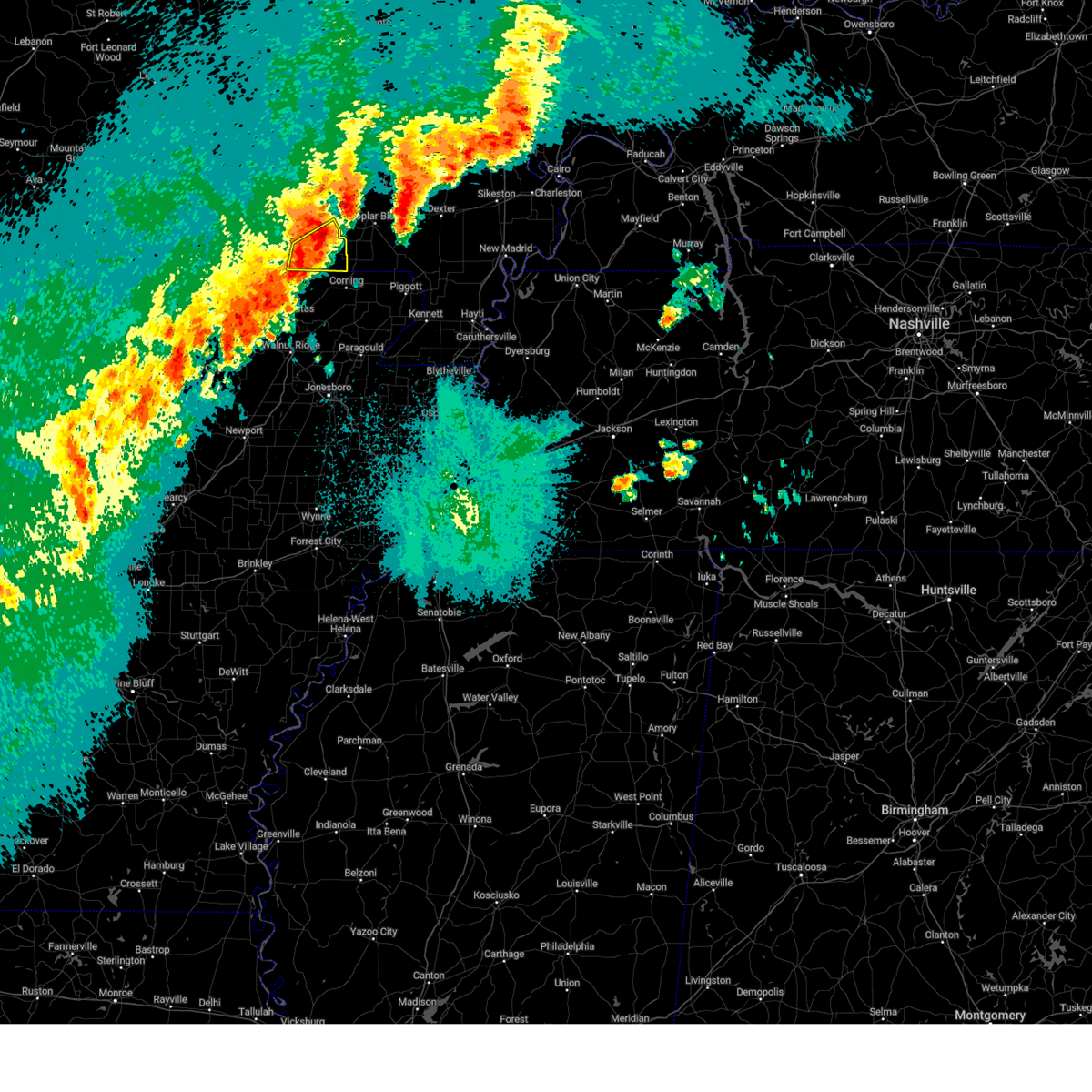
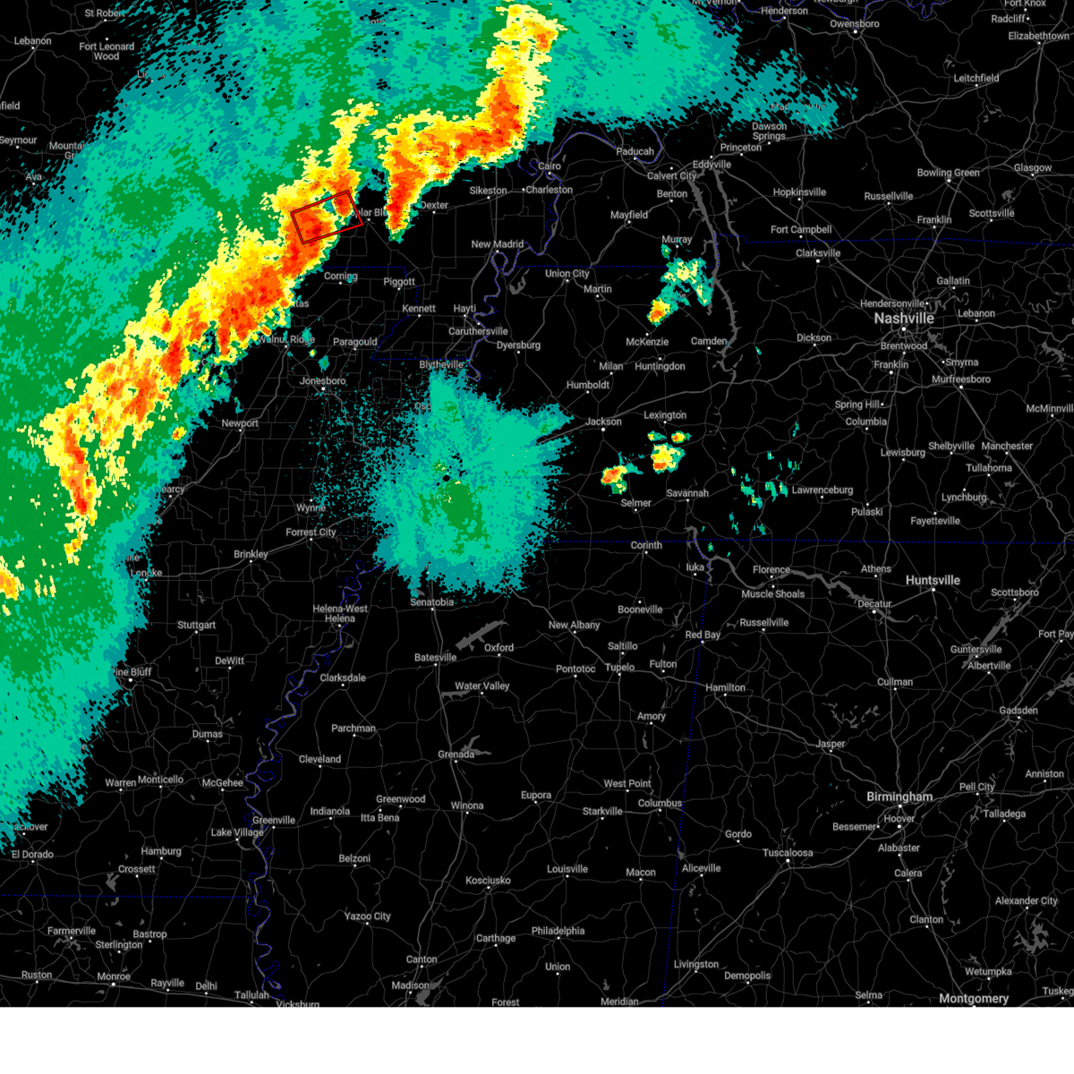
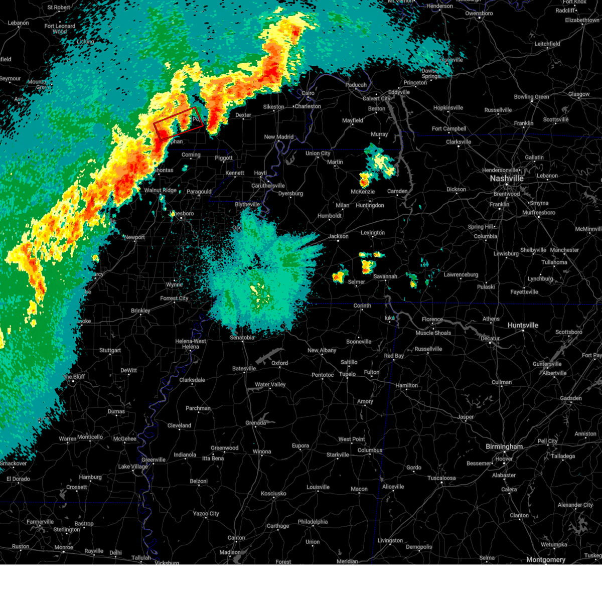
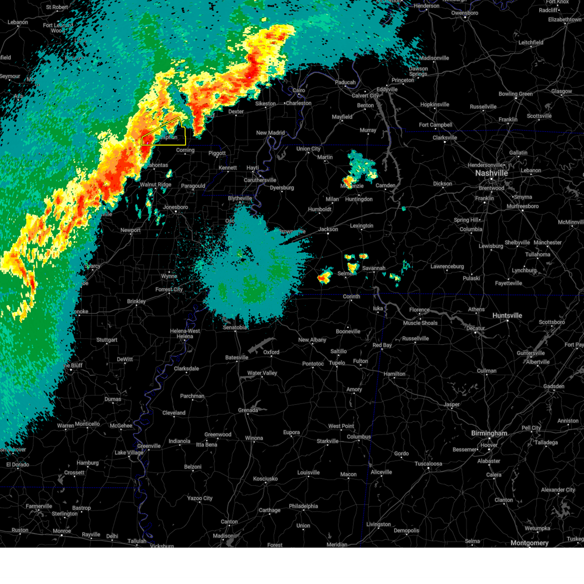
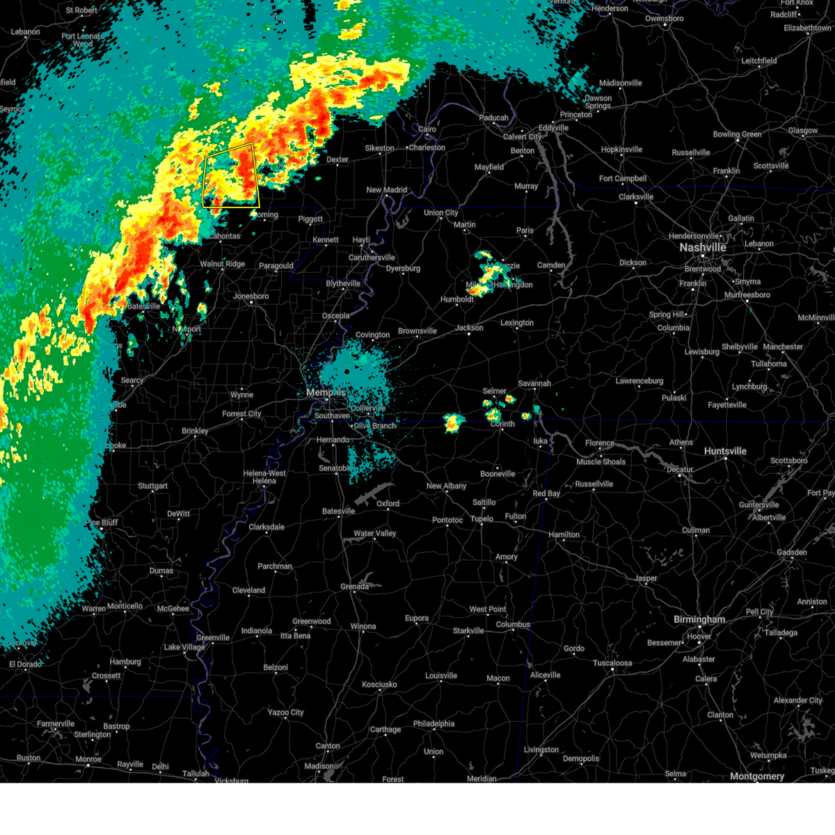
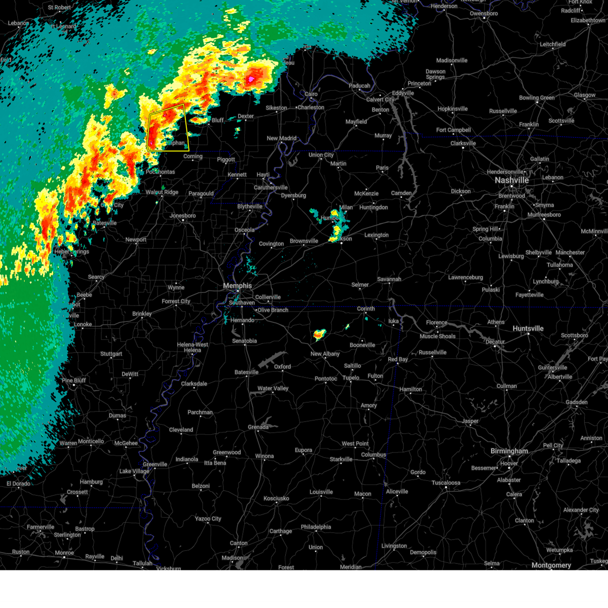
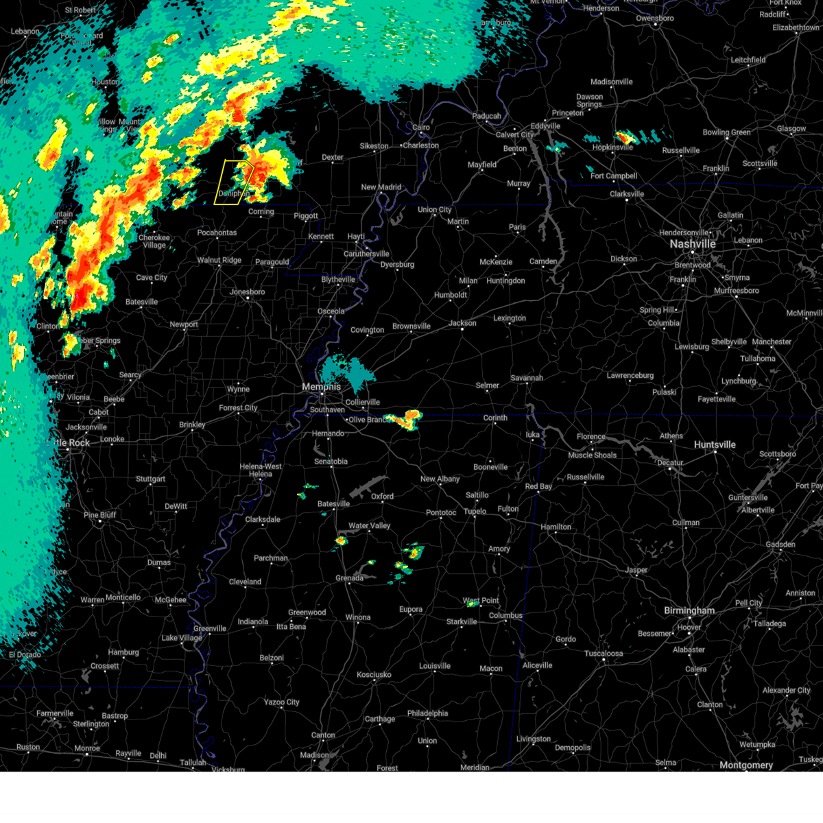
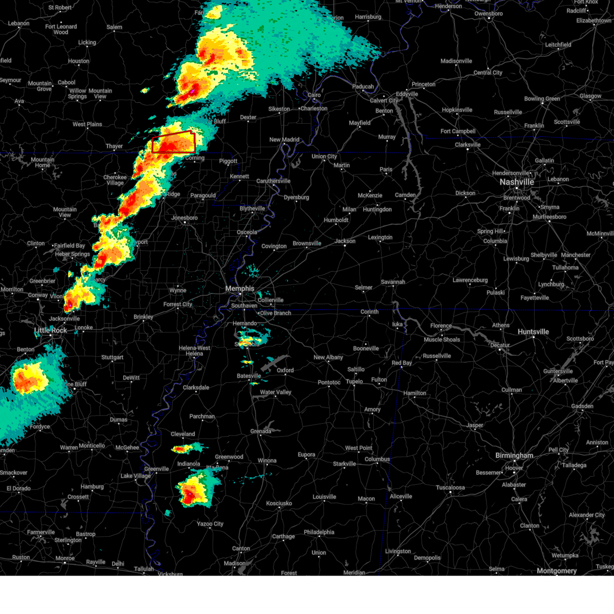
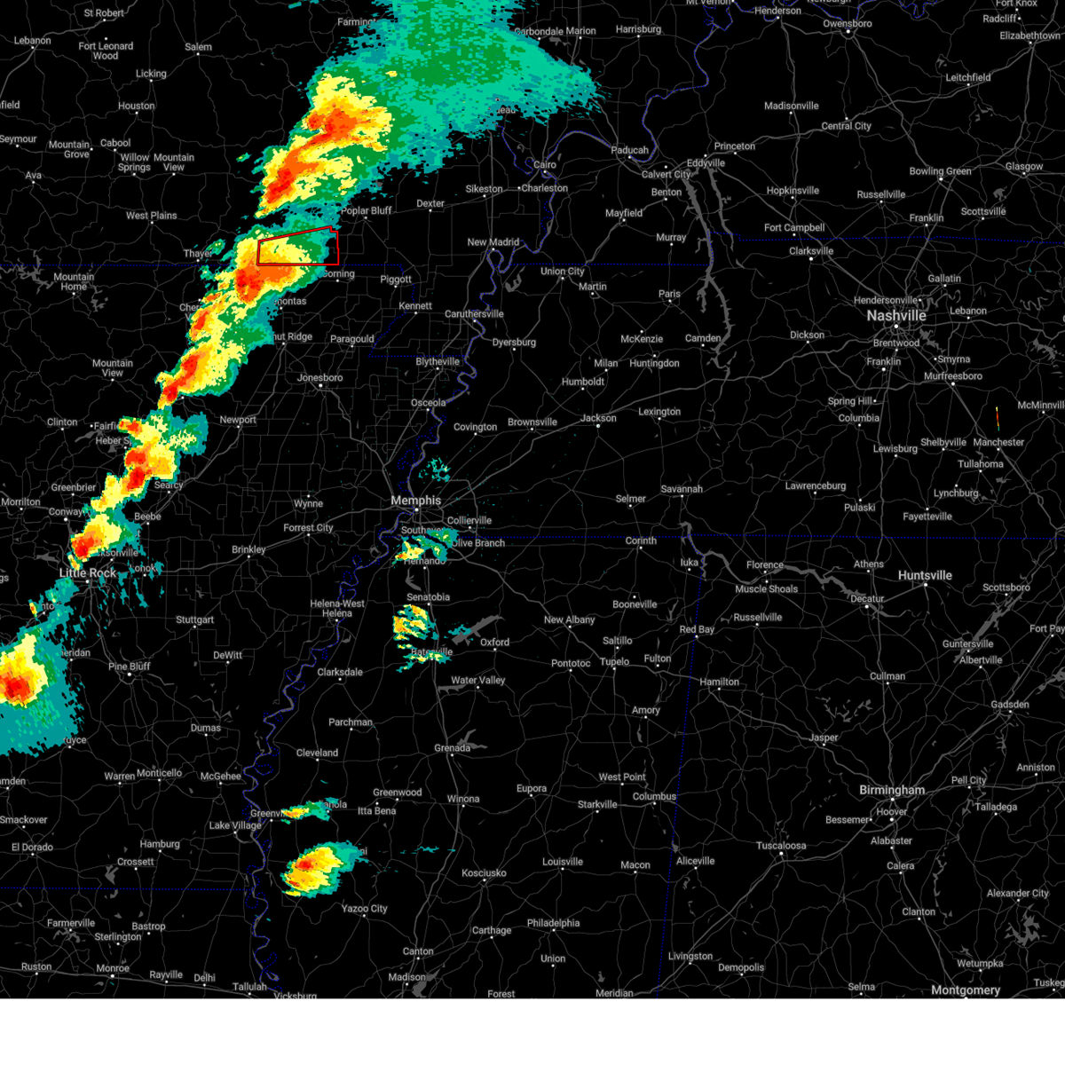
The Top Recent Hail Date for Doniphan, MO is Sunday, March 30, 2025 (1st out of 66)

Hail and Wind Damage Spotted near Doniphan, MO
| Date / Time | Report Details |
|---|---|
| 5/16/2025 6:49 PM CDT |
 At 649 pm cdt, a severe thunderstorm was located over naylor, or 11 miles east of doniphan, moving east at 55 mph (radar indicated). Hazards include golf ball size hail and 60 mph wind gusts. People and animals outdoors will be injured. expect hail damage to roofs, siding, windows, and vehicles. expect wind damage to roofs, siding, and trees. Locations impacted include, doniphan, naylor, neelyville, harviell, oxly, and fairdealing. At 649 pm cdt, a severe thunderstorm was located over naylor, or 11 miles east of doniphan, moving east at 55 mph (radar indicated). Hazards include golf ball size hail and 60 mph wind gusts. People and animals outdoors will be injured. expect hail damage to roofs, siding, windows, and vehicles. expect wind damage to roofs, siding, and trees. Locations impacted include, doniphan, naylor, neelyville, harviell, oxly, and fairdealing.
|
| 5/16/2025 6:17 PM CDT | Svrpah the national weather service in paducah has issued a * severe thunderstorm warning for, southern ripley county in southeastern missouri, southwestern butler county in southeastern missouri, * until 700 pm cdt. * at 617 pm cdt, a severe thunderstorm was located near gatewood, or 20 miles northwest of pocahontas, moving east at 55 mph (radar indicated). Hazards include 60 mph wind gusts and half dollar size hail. Hail damage to vehicles is expected. Expect wind damage to roofs, siding, and trees. |
| 5/16/2025 6:06 PM CDT | At 606 pm cdt, a severe thunderstorm was located near budapest, or 9 miles north of doniphan, moving east at 45 mph (radar indicated). Hazards include two inch hail and 60 mph wind gusts. People and animals outdoors will be injured. expect hail damage to roofs, siding, windows, and vehicles. expect wind damage to roofs, siding, and trees. Locations impacted include, doniphan, gatewood, and briar. |
| 5/16/2025 5:59 PM CDT |
 Svrpah the national weather service in paducah has issued a * severe thunderstorm warning for, southeastern carter county in southeastern missouri, northeastern ripley county in southeastern missouri, northern butler county in southeastern missouri, * until 645 pm cdt. * at 559 pm cdt, a severe thunderstorm was located 8 miles west of budapest, or 8 miles north of doniphan, moving east at 55 mph (radar indicated). Hazards include two inch hail and 60 mph wind gusts. People and animals outdoors will be injured. expect hail damage to roofs, siding, windows, and vehicles. Expect wind damage to roofs, siding, and trees. Svrpah the national weather service in paducah has issued a * severe thunderstorm warning for, southeastern carter county in southeastern missouri, northeastern ripley county in southeastern missouri, northern butler county in southeastern missouri, * until 645 pm cdt. * at 559 pm cdt, a severe thunderstorm was located 8 miles west of budapest, or 8 miles north of doniphan, moving east at 55 mph (radar indicated). Hazards include two inch hail and 60 mph wind gusts. People and animals outdoors will be injured. expect hail damage to roofs, siding, windows, and vehicles. Expect wind damage to roofs, siding, and trees.
|
| 5/16/2025 5:36 PM CDT |
 At 536 pm cdt, a severe thunderstorm was located 8 miles east of alton, or 20 miles northeast of thayer, moving east at 45 mph (radar indicated). Hazards include two inch hail and 60 mph wind gusts. People and animals outdoors will be injured. expect hail damage to roofs, siding, windows, and vehicles. expect wind damage to roofs, siding, and trees. Locations impacted include, doniphan, gatewood, handy, and briar. At 536 pm cdt, a severe thunderstorm was located 8 miles east of alton, or 20 miles northeast of thayer, moving east at 45 mph (radar indicated). Hazards include two inch hail and 60 mph wind gusts. People and animals outdoors will be injured. expect hail damage to roofs, siding, windows, and vehicles. expect wind damage to roofs, siding, and trees. Locations impacted include, doniphan, gatewood, handy, and briar.
|
| 5/16/2025 5:27 PM CDT |
 Svrpah the national weather service in paducah has issued a * severe thunderstorm warning for, southwestern carter county in southeastern missouri, western ripley county in southeastern missouri, * until 615 pm cdt. * at 527 pm cdt, a severe thunderstorm was located over alton, or 13 miles northeast of thayer, moving east at 45 mph (radar indicated). Hazards include ping pong ball size hail and 60 mph wind gusts. People and animals outdoors will be injured. expect hail damage to roofs, siding, windows, and vehicles. Expect wind damage to roofs, siding, and trees. Svrpah the national weather service in paducah has issued a * severe thunderstorm warning for, southwestern carter county in southeastern missouri, western ripley county in southeastern missouri, * until 615 pm cdt. * at 527 pm cdt, a severe thunderstorm was located over alton, or 13 miles northeast of thayer, moving east at 45 mph (radar indicated). Hazards include ping pong ball size hail and 60 mph wind gusts. People and animals outdoors will be injured. expect hail damage to roofs, siding, windows, and vehicles. Expect wind damage to roofs, siding, and trees.
|
| 4/4/2025 8:55 PM CDT |
 The storm which prompted the warning has weakened below severe limits, and no longer poses an immediate threat to life or property. therefore, the warning will be allowed to expire. a tornado watch remains in effect until 1000 pm cdt for southeastern missouri. remember, a severe thunderstorm warning still remains in effect for the eastern portion of the county!. The storm which prompted the warning has weakened below severe limits, and no longer poses an immediate threat to life or property. therefore, the warning will be allowed to expire. a tornado watch remains in effect until 1000 pm cdt for southeastern missouri. remember, a severe thunderstorm warning still remains in effect for the eastern portion of the county!.
|
| 4/4/2025 8:47 PM CDT |
 the tornado warning has been cancelled and is no longer in effect the tornado warning has been cancelled and is no longer in effect
|
| 4/4/2025 8:42 PM CDT |
 At 842 pm cdt, a severe thunderstorm was located near oxly, or near doniphan, moving east at 40 mph (radar indicated). Hazards include 60 mph wind gusts and quarter size hail. Hail damage to vehicles is expected. expect wind damage to roofs, siding, and trees. Locations impacted include, budapest, naylor, oxly, fairdealing, and doniphan. At 842 pm cdt, a severe thunderstorm was located near oxly, or near doniphan, moving east at 40 mph (radar indicated). Hazards include 60 mph wind gusts and quarter size hail. Hail damage to vehicles is expected. expect wind damage to roofs, siding, and trees. Locations impacted include, budapest, naylor, oxly, fairdealing, and doniphan.
|
| 4/4/2025 8:39 PM CDT |
 At 838 pm cdt, a severe thunderstorm capable of producing a tornado was located near budapest, or 8 miles north of doniphan, moving east at 40 mph (radar indicated rotation). Hazards include tornado and quarter size hail. Flying debris will be dangerous to those caught without shelter. mobile homes will be damaged or destroyed. damage to roofs, windows, and vehicles will occur. tree damage is likely. this dangerous storm will be near, budapest and milltown around 845 pm cdt. Poplar bluff around 850 pm cdt. At 838 pm cdt, a severe thunderstorm capable of producing a tornado was located near budapest, or 8 miles north of doniphan, moving east at 40 mph (radar indicated rotation). Hazards include tornado and quarter size hail. Flying debris will be dangerous to those caught without shelter. mobile homes will be damaged or destroyed. damage to roofs, windows, and vehicles will occur. tree damage is likely. this dangerous storm will be near, budapest and milltown around 845 pm cdt. Poplar bluff around 850 pm cdt.
|
| 4/4/2025 8:29 PM CDT |
 Torpah the national weather service in paducah has issued a * tornado warning for, southeastern carter county in southeastern missouri, northern ripley county in southeastern missouri, northwestern butler county in southeastern missouri, * until 915 pm cdt. * at 829 pm cdt, a severe thunderstorm capable of producing a tornado was located 7 miles northwest of doniphan, moving east at 40 mph (radar indicated rotation). Hazards include tornado and quarter size hail. Flying debris will be dangerous to those caught without shelter. mobile homes will be damaged or destroyed. damage to roofs, windows, and vehicles will occur. tree damage is likely. this dangerous storm will be near, budapest and doniphan around 835 pm cdt. milltown around 845 pm cdt. poplar bluff around 855 pm cdt. Other locations impacted by this tornadic thunderstorm include briar. Torpah the national weather service in paducah has issued a * tornado warning for, southeastern carter county in southeastern missouri, northern ripley county in southeastern missouri, northwestern butler county in southeastern missouri, * until 915 pm cdt. * at 829 pm cdt, a severe thunderstorm capable of producing a tornado was located 7 miles northwest of doniphan, moving east at 40 mph (radar indicated rotation). Hazards include tornado and quarter size hail. Flying debris will be dangerous to those caught without shelter. mobile homes will be damaged or destroyed. damage to roofs, windows, and vehicles will occur. tree damage is likely. this dangerous storm will be near, budapest and doniphan around 835 pm cdt. milltown around 845 pm cdt. poplar bluff around 855 pm cdt. Other locations impacted by this tornadic thunderstorm include briar.
|
| 4/4/2025 8:17 PM CDT |
 Svrpah the national weather service in paducah has issued a * severe thunderstorm warning for, ripley county in southeastern missouri, * until 900 pm cdt. * at 817 pm cdt, a severe thunderstorm was located near gatewood, or 15 miles southwest of doniphan, moving east at 40 mph (radar indicated). Hazards include 60 mph wind gusts and quarter size hail. Hail damage to vehicles is expected. Expect wind damage to roofs, siding, and trees. Svrpah the national weather service in paducah has issued a * severe thunderstorm warning for, ripley county in southeastern missouri, * until 900 pm cdt. * at 817 pm cdt, a severe thunderstorm was located near gatewood, or 15 miles southwest of doniphan, moving east at 40 mph (radar indicated). Hazards include 60 mph wind gusts and quarter size hail. Hail damage to vehicles is expected. Expect wind damage to roofs, siding, and trees.
|
| 4/4/2025 7:58 PM CDT |
 The storms which prompted the warning have moved out of the area. therefore, the warning will be allowed to expire. however, gusty winds are still possible with these thunderstorms. a tornado watch remains in effect until 1000 pm cdt for southeastern missouri. a severe thunderstorm watch remains in effect until midnight cdt for southeastern missouri. The storms which prompted the warning have moved out of the area. therefore, the warning will be allowed to expire. however, gusty winds are still possible with these thunderstorms. a tornado watch remains in effect until 1000 pm cdt for southeastern missouri. a severe thunderstorm watch remains in effect until midnight cdt for southeastern missouri.
|
| 4/4/2025 7:40 PM CDT |
 At 740 pm cdt, severe thunderstorms were located along a line extending from near hunter to near gatewood, moving east at 30 mph (radar indicated). Hazards include 60 mph wind gusts and quarter size hail. Hail damage to vehicles is expected. expect wind damage to roofs, siding, and trees. Locations impacted include, budapest, gatewood, hunter, oxly, ellsinore, grandin, briar, and doniphan. At 740 pm cdt, severe thunderstorms were located along a line extending from near hunter to near gatewood, moving east at 30 mph (radar indicated). Hazards include 60 mph wind gusts and quarter size hail. Hail damage to vehicles is expected. expect wind damage to roofs, siding, and trees. Locations impacted include, budapest, gatewood, hunter, oxly, ellsinore, grandin, briar, and doniphan.
|
| 4/4/2025 7:20 PM CDT |
 Svrpah the national weather service in paducah has issued a * severe thunderstorm warning for, southeastern carter county in southeastern missouri, ripley county in southeastern missouri, * until 800 pm cdt. * at 719 pm cdt, severe thunderstorms were located along a line extending from handy to dalton, moving east at 35 mph (radar indicated). Hazards include 60 mph wind gusts and quarter size hail. Hail damage to vehicles is expected. Expect wind damage to roofs, siding, and trees. Svrpah the national weather service in paducah has issued a * severe thunderstorm warning for, southeastern carter county in southeastern missouri, ripley county in southeastern missouri, * until 800 pm cdt. * at 719 pm cdt, severe thunderstorms were located along a line extending from handy to dalton, moving east at 35 mph (radar indicated). Hazards include 60 mph wind gusts and quarter size hail. Hail damage to vehicles is expected. Expect wind damage to roofs, siding, and trees.
|
| 4/4/2025 6:10 PM CDT |
 The storm which prompted the warning has moved out of the area. therefore, the warning will be allowed to expire. a tornado watch remains in effect until 1000 pm cdt for southeastern missouri. a severe thunderstorm watch remains in effect until midnight cdt for southeastern missouri. The storm which prompted the warning has moved out of the area. therefore, the warning will be allowed to expire. a tornado watch remains in effect until 1000 pm cdt for southeastern missouri. a severe thunderstorm watch remains in effect until midnight cdt for southeastern missouri.
|
| 4/4/2025 5:55 PM CDT |
 Svrpah the national weather service in paducah has issued a * severe thunderstorm warning for, southeastern carter county in southeastern missouri, eastern ripley county in southeastern missouri, southwestern wayne county in southeastern missouri, western butler county in southeastern missouri, * until 645 pm cdt. * at 555 pm cdt, a severe thunderstorm was located near budapest, or near doniphan, moving northeast at 40 mph (radar indicated). Hazards include ping pong ball size hail and 60 mph wind gusts. People and animals outdoors will be injured. expect hail damage to roofs, siding, windows, and vehicles. Expect wind damage to roofs, siding, and trees. Svrpah the national weather service in paducah has issued a * severe thunderstorm warning for, southeastern carter county in southeastern missouri, eastern ripley county in southeastern missouri, southwestern wayne county in southeastern missouri, western butler county in southeastern missouri, * until 645 pm cdt. * at 555 pm cdt, a severe thunderstorm was located near budapest, or near doniphan, moving northeast at 40 mph (radar indicated). Hazards include ping pong ball size hail and 60 mph wind gusts. People and animals outdoors will be injured. expect hail damage to roofs, siding, windows, and vehicles. Expect wind damage to roofs, siding, and trees.
|
| 4/4/2025 5:45 PM CDT | At 545 pm cdt, a severe thunderstorm was located over doniphan, moving northeast at 45 mph (radar indicated). Hazards include ping pong ball size hail. People and animals outdoors will be injured. expect damage to roofs, siding, windows, and vehicles. Locations impacted include, budapest and doniphan. |
| 4/4/2025 5:36 PM CDT |
 the severe thunderstorm warning has been cancelled and is no longer in effect the severe thunderstorm warning has been cancelled and is no longer in effect
|
| 4/4/2025 5:36 PM CDT |
 At 536 pm cdt, a severe thunderstorm was located 8 miles north of maynard, or 8 miles southwest of doniphan, moving northeast at 45 mph (radar indicated). Hazards include quarter size hail. Damage to vehicles is expected. Locations impacted include, budapest, briar, and doniphan. At 536 pm cdt, a severe thunderstorm was located 8 miles north of maynard, or 8 miles southwest of doniphan, moving northeast at 45 mph (radar indicated). Hazards include quarter size hail. Damage to vehicles is expected. Locations impacted include, budapest, briar, and doniphan.
|
| 4/4/2025 5:28 PM CDT |
 Svrpah the national weather service in paducah has issued a * severe thunderstorm warning for, ripley county in southeastern missouri, west central butler county in southeastern missouri, * until 615 pm cdt. * at 527 pm cdt, a severe thunderstorm was located near maynard, or 12 miles north of pocahontas, moving northeast at 40 mph (radar indicated). Hazards include quarter size hail. damage to vehicles is expected Svrpah the national weather service in paducah has issued a * severe thunderstorm warning for, ripley county in southeastern missouri, west central butler county in southeastern missouri, * until 615 pm cdt. * at 527 pm cdt, a severe thunderstorm was located near maynard, or 12 miles north of pocahontas, moving northeast at 40 mph (radar indicated). Hazards include quarter size hail. damage to vehicles is expected
|
| 4/2/2025 5:09 PM CDT |
 Svrpah the national weather service in paducah has issued a * severe thunderstorm warning for, southeastern carter county in southeastern missouri, northern ripley county in southeastern missouri, southwestern wayne county in southeastern missouri, northwestern butler county in southeastern missouri, * until 600 pm cdt. * at 508 pm cdt, a severe thunderstorm was located 7 miles northwest of gatewood, or 20 miles northeast of thayer, moving northeast at 65 mph (radar indicated). Hazards include 60 mph wind gusts and quarter size hail. Hail damage to vehicles is expected. Expect wind damage to roofs, siding, and trees. Svrpah the national weather service in paducah has issued a * severe thunderstorm warning for, southeastern carter county in southeastern missouri, northern ripley county in southeastern missouri, southwestern wayne county in southeastern missouri, northwestern butler county in southeastern missouri, * until 600 pm cdt. * at 508 pm cdt, a severe thunderstorm was located 7 miles northwest of gatewood, or 20 miles northeast of thayer, moving northeast at 65 mph (radar indicated). Hazards include 60 mph wind gusts and quarter size hail. Hail damage to vehicles is expected. Expect wind damage to roofs, siding, and trees.
|
| 3/30/2025 6:44 PM CDT | The storm which prompted the warning has weakened below severe limits, and has exited the warned area. therefore, the warning will be allowed to expire. however, gusty winds are still possible with this thunderstorm. a tornado watch remains in effect until 1100 pm cdt for southeastern missouri. |
| 3/30/2025 6:22 PM CDT | At 622 pm cdt, a severe thunderstorm was located over fairdealing, or 9 miles east of doniphan, moving east at 60 mph (radar indicated). Hazards include 60 mph wind gusts and half dollar size hail. Hail damage to vehicles is expected. expect wind damage to roofs, siding, and trees. Locations impacted include, harviell, naylor, poplar bluff, oxly, fairdealing, neelyville, and doniphan. |
| 3/30/2025 5:55 PM CDT | Svrpah the national weather service in paducah has issued a * severe thunderstorm warning for, ripley county in southeastern missouri, southwestern butler county in southeastern missouri, * until 645 pm cdt. * at 555 pm cdt, a severe thunderstorm was located near gatewood, or 18 miles west of doniphan, moving east at 60 mph (radar indicated). Hazards include 60 mph wind gusts and quarter size hail. Hail damage to vehicles is expected. Expect wind damage to roofs, siding, and trees. |
| 3/30/2025 4:59 PM CDT |
 The severe thunderstorm which prompted the warning has moved out of the warned area. therefore, the warning will be allowed to expire. a tornado watch remains in effect until 1100 pm cdt for southeastern missouri. remember, a severe thunderstorm warning still remains in effect for ripley and butler county. The severe thunderstorm which prompted the warning has moved out of the warned area. therefore, the warning will be allowed to expire. a tornado watch remains in effect until 1100 pm cdt for southeastern missouri. remember, a severe thunderstorm warning still remains in effect for ripley and butler county.
|
| 3/30/2025 4:55 PM CDT | Svrpah the national weather service in paducah has issued a * severe thunderstorm warning for, southeastern carter county in southeastern missouri, eastern ripley county in southeastern missouri, butler county in southeastern missouri, * until 545 pm cdt. * at 454 pm cdt, severe thunderstorms were located along a line extending from near williamsville to budapest to near doniphan, moving east at 50 mph (radar indicated). Hazards include 70 mph wind gusts and half dollar size hail. Hail damage to vehicles is expected. expect considerable tree damage. Wind damage is also likely to mobile homes, roofs, and outbuildings. |
| 3/30/2025 4:49 PM CDT |
 Torpah the national weather service in paducah has issued a * tornado warning for, eastern ripley county in southeastern missouri, southwestern butler county in southeastern missouri, * until 530 pm cdt. * at 448 pm cdt, a severe thunderstorm capable of producing a tornado was located near doniphan, moving east at 40 mph (radar indicated rotation). Hazards include tornado and ping pong ball size hail. Flying debris will be dangerous to those caught without shelter. mobile homes will be damaged or destroyed. damage to roofs, windows, and vehicles will occur. tree damage is likely. this dangerous storm will be near, budapest, oxly, fairdealing, and doniphan around 455 pm cdt. naylor around 500 pm cdt. milltown around 505 pm cdt. harviell and poplar bluff around 510 pm cdt. Neelyville around 515 pm cdt. Torpah the national weather service in paducah has issued a * tornado warning for, eastern ripley county in southeastern missouri, southwestern butler county in southeastern missouri, * until 530 pm cdt. * at 448 pm cdt, a severe thunderstorm capable of producing a tornado was located near doniphan, moving east at 40 mph (radar indicated rotation). Hazards include tornado and ping pong ball size hail. Flying debris will be dangerous to those caught without shelter. mobile homes will be damaged or destroyed. damage to roofs, windows, and vehicles will occur. tree damage is likely. this dangerous storm will be near, budapest, oxly, fairdealing, and doniphan around 455 pm cdt. naylor around 500 pm cdt. milltown around 505 pm cdt. harviell and poplar bluff around 510 pm cdt. Neelyville around 515 pm cdt.
|
| 3/30/2025 4:41 PM CDT |
 At 441 pm cdt, severe thunderstorms were located over gatewood, or 14 miles west of doniphan, moving east at 40 mph (radar indicated). Hazards include golf ball size hail and 70 mph wind gusts. People and animals outdoors will be injured. expect hail damage to roofs, siding, windows, and vehicles. expect considerable tree damage. wind damage is also likely to mobile homes, roofs, and outbuildings. Locations impacted include, budapest, naylor, gatewood, oxly, fairdealing, grandin, briar, and doniphan. At 441 pm cdt, severe thunderstorms were located over gatewood, or 14 miles west of doniphan, moving east at 40 mph (radar indicated). Hazards include golf ball size hail and 70 mph wind gusts. People and animals outdoors will be injured. expect hail damage to roofs, siding, windows, and vehicles. expect considerable tree damage. wind damage is also likely to mobile homes, roofs, and outbuildings. Locations impacted include, budapest, naylor, gatewood, oxly, fairdealing, grandin, briar, and doniphan.
|
| 3/30/2025 4:13 PM CDT |
 Svrpah the national weather service in paducah has issued a * severe thunderstorm warning for, southeastern carter county in southeastern missouri, ripley county in southeastern missouri, * until 500 pm cdt. * at 413 pm cdt, a severe thunderstorm was located near gatewood, or 19 miles west of doniphan, moving east at 45 mph (radar indicated). Hazards include golf ball size hail. People and animals outdoors will be injured. Expect damage to roofs, siding, windows, and vehicles. Svrpah the national weather service in paducah has issued a * severe thunderstorm warning for, southeastern carter county in southeastern missouri, ripley county in southeastern missouri, * until 500 pm cdt. * at 413 pm cdt, a severe thunderstorm was located near gatewood, or 19 miles west of doniphan, moving east at 45 mph (radar indicated). Hazards include golf ball size hail. People and animals outdoors will be injured. Expect damage to roofs, siding, windows, and vehicles.
|
| 3/14/2025 11:16 PM CDT | Torpah the national weather service in paducah has issued a * tornado warning for, eastern ripley county in southeastern missouri, central butler county in southeastern missouri, * until midnight cdt. * at 1115 pm cdt, a large and extremely dangerous tornado was developing near oxly, or near doniphan, moving northeast at 40 mph. this is a particularly dangerous situation. take cover now! (radar indicated rotation). Hazards include damaging tornado. You are in a life-threatening situation. flying debris may be deadly to those caught without shelter. mobile homes will be destroyed. considerable damage to homes, businesses, and vehicles is likely and complete destruction is possible. the tornado will be near, naylor, milltown, oxly, and fairdealing around 1120 pm cdt. harviell and poplar bluff around 1125 pm cdt. fisk around 1150 pm cdt. Other locations impacted by this tornadic thunderstorm include rombauer. |
| 3/14/2025 11:06 PM CDT |
 At 1106 pm cdt, a confirmed large and extremely dangerous tornado was located near oxly, or south of doniphan, moving northeast at 40 mph. this is a particularly dangerous situation. take cover now! (radar confirmed tornado). Hazards include damaging tornado. You are in a life-threatening situation. flying debris may be deadly to those caught without shelter. mobile homes will be destroyed. considerable damage to homes, businesses, and vehicles is likely and complete destruction is possible. The tornado will be near, naylor, oxly, and fairdealing around 1110 pm cdt. At 1106 pm cdt, a confirmed large and extremely dangerous tornado was located near oxly, or south of doniphan, moving northeast at 40 mph. this is a particularly dangerous situation. take cover now! (radar confirmed tornado). Hazards include damaging tornado. You are in a life-threatening situation. flying debris may be deadly to those caught without shelter. mobile homes will be destroyed. considerable damage to homes, businesses, and vehicles is likely and complete destruction is possible. The tornado will be near, naylor, oxly, and fairdealing around 1110 pm cdt.
|
| 3/14/2025 10:56 PM CDT |
 At 1055 pm cdt, a confirmed large and extremely dangerous tornado was located near maynard, or 8 miles south of doniphan, moving northeast at 65 mph. this is a particularly dangerous situation. take cover now! (radar confirmed tornado). Hazards include damaging tornado. You are in a life-threatening situation. flying debris may be deadly to those caught without shelter. mobile homes will be destroyed. considerable damage to homes, businesses, and vehicles is likely and complete destruction is possible. the tornado will be near, naylor, oxly, and doniphan around 1100 pm cdt. fairdealing around 1105 pm cdt. Other locations impacted by this tornadic thunderstorm include briar. At 1055 pm cdt, a confirmed large and extremely dangerous tornado was located near maynard, or 8 miles south of doniphan, moving northeast at 65 mph. this is a particularly dangerous situation. take cover now! (radar confirmed tornado). Hazards include damaging tornado. You are in a life-threatening situation. flying debris may be deadly to those caught without shelter. mobile homes will be destroyed. considerable damage to homes, businesses, and vehicles is likely and complete destruction is possible. the tornado will be near, naylor, oxly, and doniphan around 1100 pm cdt. fairdealing around 1105 pm cdt. Other locations impacted by this tornadic thunderstorm include briar.
|
| 3/14/2025 10:52 PM CDT |
 At 1052 pm cdt, a confirmed tornado was located near maynard, or 11 miles southwest of doniphan, moving northeast at 55 mph (radar confirmed tornado). Hazards include damaging tornado. Flying debris will be dangerous to those caught without shelter. mobile homes will be damaged or destroyed. damage to roofs, windows, and vehicles will occur. tree damage is likely. this tornado will be near, oxly and doniphan around 1100 pm cdt. naylor around 1105 pm cdt. fairdealing around 1110 pm cdt. Other locations impacted by this tornadic thunderstorm include briar. At 1052 pm cdt, a confirmed tornado was located near maynard, or 11 miles southwest of doniphan, moving northeast at 55 mph (radar confirmed tornado). Hazards include damaging tornado. Flying debris will be dangerous to those caught without shelter. mobile homes will be damaged or destroyed. damage to roofs, windows, and vehicles will occur. tree damage is likely. this tornado will be near, oxly and doniphan around 1100 pm cdt. naylor around 1105 pm cdt. fairdealing around 1110 pm cdt. Other locations impacted by this tornadic thunderstorm include briar.
|
| 3/14/2025 10:34 PM CDT |
 Torpah the national weather service in paducah has issued a * tornado warning for, southern ripley county in southeastern missouri, * until 1115 pm cdt. * at 1033 pm cdt, a tornado producing storm was located between dalton and ravenden springs arkansas, or 12 miles northwest of pocahontas, moving northeast at 65 mph (radar confirmed tornado). Hazards include damaging tornado. Flying debris will be dangerous to those caught without shelter. mobile homes will be damaged or destroyed. damage to roofs, windows, and vehicles will occur. tree damage is likely. this tornadic storm will be near, naylor and oxly around 1055 pm cdt. fairdealing around 1100 pm cdt. Other locations impacted by this tornadic thunderstorm include briar. Torpah the national weather service in paducah has issued a * tornado warning for, southern ripley county in southeastern missouri, * until 1115 pm cdt. * at 1033 pm cdt, a tornado producing storm was located between dalton and ravenden springs arkansas, or 12 miles northwest of pocahontas, moving northeast at 65 mph (radar confirmed tornado). Hazards include damaging tornado. Flying debris will be dangerous to those caught without shelter. mobile homes will be damaged or destroyed. damage to roofs, windows, and vehicles will occur. tree damage is likely. this tornadic storm will be near, naylor and oxly around 1055 pm cdt. fairdealing around 1100 pm cdt. Other locations impacted by this tornadic thunderstorm include briar.
|
| 7/12/2024 1:28 PM CDT |
 The storm which prompted the warning has weakened below severe limits, and no longer poses an immediate threat to life or property. therefore, the warning will be allowed to expire. The storm which prompted the warning has weakened below severe limits, and no longer poses an immediate threat to life or property. therefore, the warning will be allowed to expire.
|
| 7/12/2024 1:03 PM CDT |
 At 103 pm cdt, a severe thunderstorm was located near doniphan, moving southeast at 5 mph (radar indicated). Hazards include 60 mph wind gusts and quarter size hail. Hail damage to vehicles is expected. expect wind damage to roofs, siding, and trees. Locations impacted include, doniphan and oxly. At 103 pm cdt, a severe thunderstorm was located near doniphan, moving southeast at 5 mph (radar indicated). Hazards include 60 mph wind gusts and quarter size hail. Hail damage to vehicles is expected. expect wind damage to roofs, siding, and trees. Locations impacted include, doniphan and oxly.
|
| 7/12/2024 12:45 PM CDT |
 Svrpah the national weather service in paducah has issued a * severe thunderstorm warning for, southeastern ripley county in southeastern missouri, * until 130 pm cdt. * at 1241 pm cdt, a severe thunderstorm was located near doniphan, moving east at 15 mph (radar indicated). Hazards include 60 mph wind gusts and quarter size hail. Hail damage to vehicles is expected. Expect wind damage to roofs, siding, and trees. Svrpah the national weather service in paducah has issued a * severe thunderstorm warning for, southeastern ripley county in southeastern missouri, * until 130 pm cdt. * at 1241 pm cdt, a severe thunderstorm was located near doniphan, moving east at 15 mph (radar indicated). Hazards include 60 mph wind gusts and quarter size hail. Hail damage to vehicles is expected. Expect wind damage to roofs, siding, and trees.
|
| 1/1/0001 12:00 AM | Reports of trees down south of doniphan and power lines down in portions of ripley count in ripley county MO, 1.5 miles N of Doniphan, MO |
| 5/26/2024 6:33 AM CDT |
 Torpah the national weather service in paducah has issued a * tornado warning for, southeastern ripley county in southeastern missouri, butler county in southeastern missouri, southwestern stoddard county in southeastern missouri, * until 700 am cdt. * at 632 am cdt, a severe thunderstorm capable of producing a tornado was located over doniphan, moving east at 70 mph (radar indicated rotation). Hazards include tornado and quarter size hail. Flying debris will be dangerous to those caught without shelter. mobile homes will be damaged or destroyed. damage to roofs, windows, and vehicles will occur. tree damage is likely. This dangerous storm will be near, poplar bluff, naylor, neelyville, fairdealing, and harviell around 640 am cdt. Torpah the national weather service in paducah has issued a * tornado warning for, southeastern ripley county in southeastern missouri, butler county in southeastern missouri, southwestern stoddard county in southeastern missouri, * until 700 am cdt. * at 632 am cdt, a severe thunderstorm capable of producing a tornado was located over doniphan, moving east at 70 mph (radar indicated rotation). Hazards include tornado and quarter size hail. Flying debris will be dangerous to those caught without shelter. mobile homes will be damaged or destroyed. damage to roofs, windows, and vehicles will occur. tree damage is likely. This dangerous storm will be near, poplar bluff, naylor, neelyville, fairdealing, and harviell around 640 am cdt.
|
| 5/26/2024 6:26 AM CDT |
 At 626 am cdt, a severe thunderstorm capable of producing a tornado was located near doniphan, moving east at 60 mph (radar indicated rotation). Hazards include tornado and quarter size hail. Flying debris will be dangerous to those caught without shelter. mobile homes will be damaged or destroyed. damage to roofs, windows, and vehicles will occur. tree damage is likely. this dangerous storm will be near, doniphan around 630 am cdt. Other locations impacted by this tornadic thunderstorm include briar. At 626 am cdt, a severe thunderstorm capable of producing a tornado was located near doniphan, moving east at 60 mph (radar indicated rotation). Hazards include tornado and quarter size hail. Flying debris will be dangerous to those caught without shelter. mobile homes will be damaged or destroyed. damage to roofs, windows, and vehicles will occur. tree damage is likely. this dangerous storm will be near, doniphan around 630 am cdt. Other locations impacted by this tornadic thunderstorm include briar.
|
| 5/26/2024 6:17 AM CDT |
 At 617 am cdt, a severe thunderstorm capable of producing a tornado was located over gatewood, or 15 miles west of doniphan, moving east at 40 mph (radar indicated rotation). Hazards include tornado and quarter size hail. Flying debris will be dangerous to those caught without shelter. mobile homes will be damaged or destroyed. damage to roofs, windows, and vehicles will occur. tree damage is likely. this dangerous storm will be near, gatewood around 620 am cdt. doniphan around 630 am cdt. Other locations impacted by this tornadic thunderstorm include briar. At 617 am cdt, a severe thunderstorm capable of producing a tornado was located over gatewood, or 15 miles west of doniphan, moving east at 40 mph (radar indicated rotation). Hazards include tornado and quarter size hail. Flying debris will be dangerous to those caught without shelter. mobile homes will be damaged or destroyed. damage to roofs, windows, and vehicles will occur. tree damage is likely. this dangerous storm will be near, gatewood around 620 am cdt. doniphan around 630 am cdt. Other locations impacted by this tornadic thunderstorm include briar.
|
| 5/26/2024 6:02 AM CDT |
 Torpah the national weather service in paducah has issued a * tornado warning for, southwestern ripley county in southeastern missouri, * until 645 am cdt. * at 600 am cdt, a severe thunderstorm capable of producing a tornado was located 8 miles northwest of dalton, or 15 miles east of mammoth spring, moving east at 35 mph (radar indicated rotation. this storm has a long history of producing tornadoes extending back into northeast oklahoma). Hazards include tornado and half dollar size hail. Flying debris will be dangerous to those caught without shelter. mobile homes will be damaged or destroyed. damage to roofs, windows, and vehicles will occur. tree damage is likely. this dangerous storm will be near, gatewood around 605 am cdt. doniphan around 630 am cdt. Other locations impacted by this tornadic thunderstorm include briar. Torpah the national weather service in paducah has issued a * tornado warning for, southwestern ripley county in southeastern missouri, * until 645 am cdt. * at 600 am cdt, a severe thunderstorm capable of producing a tornado was located 8 miles northwest of dalton, or 15 miles east of mammoth spring, moving east at 35 mph (radar indicated rotation. this storm has a long history of producing tornadoes extending back into northeast oklahoma). Hazards include tornado and half dollar size hail. Flying debris will be dangerous to those caught without shelter. mobile homes will be damaged or destroyed. damage to roofs, windows, and vehicles will occur. tree damage is likely. this dangerous storm will be near, gatewood around 605 am cdt. doniphan around 630 am cdt. Other locations impacted by this tornadic thunderstorm include briar.
|
| 5/25/2024 1:39 AM CDT |
 Svrpah the national weather service in paducah has issued a * severe thunderstorm warning for, southeastern ripley county in southeastern missouri, south central butler county in southeastern missouri, * until 215 am cdt. * at 139 am cdt, a severe thunderstorm was located near doniphan, moving southeast at 25 mph (radar indicated). Hazards include 60 mph wind gusts and quarter size hail. Hail damage to vehicles is expected. Expect wind damage to roofs, siding, and trees. Svrpah the national weather service in paducah has issued a * severe thunderstorm warning for, southeastern ripley county in southeastern missouri, south central butler county in southeastern missouri, * until 215 am cdt. * at 139 am cdt, a severe thunderstorm was located near doniphan, moving southeast at 25 mph (radar indicated). Hazards include 60 mph wind gusts and quarter size hail. Hail damage to vehicles is expected. Expect wind damage to roofs, siding, and trees.
|
| 5/8/2024 10:55 PM CDT |
 the severe thunderstorm warning has been cancelled and is no longer in effect the severe thunderstorm warning has been cancelled and is no longer in effect
|
| 5/8/2024 10:31 PM CDT |
 Svrpah the national weather service in paducah has issued a * severe thunderstorm warning for, southeastern ripley county in southeastern missouri, butler county in southeastern missouri, * until 1115 pm cdt. * at 1031 pm cdt, a severe thunderstorm was located near doniphan, moving east at 55 mph (radar indicated). Hazards include 60 mph wind gusts and quarter size hail. Hail damage to vehicles is expected. Expect wind damage to roofs, siding, and trees. Svrpah the national weather service in paducah has issued a * severe thunderstorm warning for, southeastern ripley county in southeastern missouri, butler county in southeastern missouri, * until 1115 pm cdt. * at 1031 pm cdt, a severe thunderstorm was located near doniphan, moving east at 55 mph (radar indicated). Hazards include 60 mph wind gusts and quarter size hail. Hail damage to vehicles is expected. Expect wind damage to roofs, siding, and trees.
|
| 8/26/2023 4:27 PM CDT |
 The severe thunderstorm warning for western ripley county will expire at 430 pm cdt, the storm which prompted the warning has weakened below severe limits, and no longer poses an immediate threat to life or property. therefore, the warning will be allowed to expire. however heavy rain is still possible with this thunderstorm. The severe thunderstorm warning for western ripley county will expire at 430 pm cdt, the storm which prompted the warning has weakened below severe limits, and no longer poses an immediate threat to life or property. therefore, the warning will be allowed to expire. however heavy rain is still possible with this thunderstorm.
|
| 8/26/2023 4:07 PM CDT |
 At 406 pm cdt, a severe thunderstorm was located near handy, or 15 miles south of van buren, moving southeast at 20 mph (radar indicated). Hazards include 60 mph wind gusts and quarter size hail. Hail damage to vehicles is expected. Expect wind damage to roofs, siding, and trees. At 406 pm cdt, a severe thunderstorm was located near handy, or 15 miles south of van buren, moving southeast at 20 mph (radar indicated). Hazards include 60 mph wind gusts and quarter size hail. Hail damage to vehicles is expected. Expect wind damage to roofs, siding, and trees.
|
| 7/13/2023 6:31 PM CDT |
 At 630 pm cdt, a severe thunderstorm was located near doniphan, moving east at 30 mph (radar indicated. at 6:15 pm, quarter size hail was reported on highway 142 three miles east of gatewood). Hazards include 60 mph wind gusts and quarter size hail. Hail damage to vehicles is expected. expect wind damage to roofs, siding, and trees. locations impacted include, doniphan and oxly. hail threat, observed max hail size, 1. 00 in wind threat, radar indicated max wind gust, 60 mph. At 630 pm cdt, a severe thunderstorm was located near doniphan, moving east at 30 mph (radar indicated. at 6:15 pm, quarter size hail was reported on highway 142 three miles east of gatewood). Hazards include 60 mph wind gusts and quarter size hail. Hail damage to vehicles is expected. expect wind damage to roofs, siding, and trees. locations impacted include, doniphan and oxly. hail threat, observed max hail size, 1. 00 in wind threat, radar indicated max wind gust, 60 mph.
|
| 1/1/0001 12:00 AM | Quarter sized hail reported 14.9 miles E of Doniphan, MO, nickel to quarter sized hail reported at a school three miles east of gatewood along 142 highway. relayed by nws springfield. |
| 1/1/0001 12:00 AM | Quarter sized hail reported 12.5 miles ENE of Doniphan, MO, corrects previous hail report from 3 n gatewood. nickel to quarter sized hail reported at a school three miles east of gatewood along 142 highway. relayed by nws spring |
| 7/13/2023 6:08 PM CDT |
 At 608 pm cdt, a severe thunderstorm was located over gatewood, or 12 miles west of doniphan, moving east at 25 mph (radar indicated). Hazards include 60 mph wind gusts and quarter size hail. Hail damage to vehicles is expected. Expect wind damage to roofs, siding, and trees. At 608 pm cdt, a severe thunderstorm was located over gatewood, or 12 miles west of doniphan, moving east at 25 mph (radar indicated). Hazards include 60 mph wind gusts and quarter size hail. Hail damage to vehicles is expected. Expect wind damage to roofs, siding, and trees.
|
| 7/8/2023 1:43 AM CDT |
 At 143 am cdt, a severe thunderstorm was located near gatewood, or 11 miles west of doniphan, moving southeast at 15 mph (radar indicated). Hazards include 60 mph wind gusts and quarter size hail. Hail damage to vehicles is expected. Expect wind damage to roofs, siding, and trees. At 143 am cdt, a severe thunderstorm was located near gatewood, or 11 miles west of doniphan, moving southeast at 15 mph (radar indicated). Hazards include 60 mph wind gusts and quarter size hail. Hail damage to vehicles is expected. Expect wind damage to roofs, siding, and trees.
|
| 7/8/2023 1:20 AM CDT | Several trees down near intersection of hwy 160w and j hwy. observed by local firefighter and relayed by doniphan pd. time estimated from rada in ripley county MO, 16.3 miles ESE of Doniphan, MO |
| 6/14/2023 7:50 PM CDT | Ping Pong Ball sized hail reported 8.4 miles N of Doniphan, MO, time estimated via radar. |
| 6/14/2023 12:51 PM CDT |
 The severe thunderstorm warning for western ripley county will expire at 100 pm cdt, the storm which prompted the warning has weakened below severe limits, and no longer poses an immediate threat to life or property. therefore, the warning will be allowed to expire. however gusty winds are still possible with this thunderstorm. The severe thunderstorm warning for western ripley county will expire at 100 pm cdt, the storm which prompted the warning has weakened below severe limits, and no longer poses an immediate threat to life or property. therefore, the warning will be allowed to expire. however gusty winds are still possible with this thunderstorm.
|
| 6/14/2023 12:35 PM CDT | Golf Ball sized hail reported 19 miles E of Doniphan, MO |
| 6/14/2023 12:35 PM CDT |
 At 1235 pm cdt, a severe thunderstorm was located near gatewood, or 14 miles west of doniphan, moving east at 30 mph (radar indicated). Hazards include 60 mph wind gusts and quarter size hail. Hail damage to vehicles is expected. Expect wind damage to roofs, siding, and trees. At 1235 pm cdt, a severe thunderstorm was located near gatewood, or 14 miles west of doniphan, moving east at 30 mph (radar indicated). Hazards include 60 mph wind gusts and quarter size hail. Hail damage to vehicles is expected. Expect wind damage to roofs, siding, and trees.
|
| 4/5/2023 3:46 AM CDT |
 At 346 am cdt, a severe thunderstorm capable of producing a tornado was located near doniphan, moving east at 55 mph (radar indicated rotation). Hazards include tornado. Flying debris will be dangerous to those caught without shelter. mobile homes will be damaged or destroyed. damage to roofs, windows, and vehicles will occur. tree damage is likely. this dangerous storm will be near, budapest around 350 am cdt. fairdealing around 355 am cdt. milltown around 400 am cdt. poplar bluff and harviell around 405 am cdt. Other locations in the path of this tornadic thunderstorm include fisk. At 346 am cdt, a severe thunderstorm capable of producing a tornado was located near doniphan, moving east at 55 mph (radar indicated rotation). Hazards include tornado. Flying debris will be dangerous to those caught without shelter. mobile homes will be damaged or destroyed. damage to roofs, windows, and vehicles will occur. tree damage is likely. this dangerous storm will be near, budapest around 350 am cdt. fairdealing around 355 am cdt. milltown around 400 am cdt. poplar bluff and harviell around 405 am cdt. Other locations in the path of this tornadic thunderstorm include fisk.
|
| 4/5/2023 3:24 AM CDT |
 At 324 am cdt, a severe thunderstorm capable of producing a tornado was located near gatewood, or 14 miles southwest of doniphan, moving northeast at 60 mph. this storm is showing strong enough rotation to produce a significant tornado (radar indicated rotation). Hazards include tornado and golf ball size hail. Flying debris will be dangerous to those caught without shelter. mobile homes will be damaged or destroyed. damage to roofs, windows, and vehicles will occur. tree damage is likely. Locations impacted include, doniphan and oxly. At 324 am cdt, a severe thunderstorm capable of producing a tornado was located near gatewood, or 14 miles southwest of doniphan, moving northeast at 60 mph. this storm is showing strong enough rotation to produce a significant tornado (radar indicated rotation). Hazards include tornado and golf ball size hail. Flying debris will be dangerous to those caught without shelter. mobile homes will be damaged or destroyed. damage to roofs, windows, and vehicles will occur. tree damage is likely. Locations impacted include, doniphan and oxly.
|
| 4/5/2023 3:06 AM CDT |
 At 306 am cdt, a severe thunderstorm capable of producing a tornado was located 7 miles northwest of ravenden springs, or 14 miles southeast of mammoth spring, moving northeast at 55 mph. this storm has a history of tornado damage in arkansas (radar indicated rotation). Hazards include tornado and hail up to two inches in diameter. Flying debris will be dangerous to those caught without shelter. mobile homes will be damaged or destroyed. damage to roofs, windows, and vehicles will occur. tree damage is likely. this dangerous storm will be near, gatewood around 325 am cdt. doniphan around 335 am cdt. Other locations in the path of this tornadic thunderstorm include doniphan and oxly. At 306 am cdt, a severe thunderstorm capable of producing a tornado was located 7 miles northwest of ravenden springs, or 14 miles southeast of mammoth spring, moving northeast at 55 mph. this storm has a history of tornado damage in arkansas (radar indicated rotation). Hazards include tornado and hail up to two inches in diameter. Flying debris will be dangerous to those caught without shelter. mobile homes will be damaged or destroyed. damage to roofs, windows, and vehicles will occur. tree damage is likely. this dangerous storm will be near, gatewood around 325 am cdt. doniphan around 335 am cdt. Other locations in the path of this tornadic thunderstorm include doniphan and oxly.
|
| 2/22/2023 1:17 PM CST |
 At 116 pm cst, severe thunderstorms were located along a line extending from near ellsinore to near doniphan, moving northeast at 45 mph. there were already reports of power outages in ellsinore (radar indicated). Hazards include 60 mph wind gusts. Expect damage to roofs, siding, and trees. these severe storms will be near, piedmont around 125 pm cst. other locations in the path of these severe thunderstorms include williamsville, budapest, fairdealing, milltown, poplar bluff and hendrickson. hail threat, radar indicated max hail size, <. 75 in wind threat, radar indicated max wind gust, 60 mph. At 116 pm cst, severe thunderstorms were located along a line extending from near ellsinore to near doniphan, moving northeast at 45 mph. there were already reports of power outages in ellsinore (radar indicated). Hazards include 60 mph wind gusts. Expect damage to roofs, siding, and trees. these severe storms will be near, piedmont around 125 pm cst. other locations in the path of these severe thunderstorms include williamsville, budapest, fairdealing, milltown, poplar bluff and hendrickson. hail threat, radar indicated max hail size, <. 75 in wind threat, radar indicated max wind gust, 60 mph.
|
| 2/22/2023 1:09 PM CST |
 At 109 pm cst, severe thunderstorms were located along a line extending from near hunter to 6 miles northeast of gatewood, moving east at 25 mph (radar indicated). Hazards include 60 mph wind gusts. Expect damage to roofs, siding, and trees. severe thunderstorms will be near, hunter around 115 pm cst. ellsinore around 120 pm cst. other locations in the path of these severe thunderstorms include doniphan, brush arbor, williamsville, oxly, naylor, fairdealing, hendrickson and harviell. hail threat, radar indicated max hail size, <. 75 in wind threat, radar indicated max wind gust, 60 mph. At 109 pm cst, severe thunderstorms were located along a line extending from near hunter to 6 miles northeast of gatewood, moving east at 25 mph (radar indicated). Hazards include 60 mph wind gusts. Expect damage to roofs, siding, and trees. severe thunderstorms will be near, hunter around 115 pm cst. ellsinore around 120 pm cst. other locations in the path of these severe thunderstorms include doniphan, brush arbor, williamsville, oxly, naylor, fairdealing, hendrickson and harviell. hail threat, radar indicated max hail size, <. 75 in wind threat, radar indicated max wind gust, 60 mph.
|
| 10/15/2022 11:16 PM CDT |
 At 1116 pm cdt, a severe thunderstorm was located near doniphan, moving east at 45 mph (radar indicated). Hazards include 60 mph wind gusts and quarter size hail. Hail damage to vehicles is expected. expect wind damage to roofs, siding, and trees. locations impacted include, doniphan and oxly. hail threat, radar indicated max hail size, 1. 00 in wind threat, radar indicated max wind gust, 60 mph. At 1116 pm cdt, a severe thunderstorm was located near doniphan, moving east at 45 mph (radar indicated). Hazards include 60 mph wind gusts and quarter size hail. Hail damage to vehicles is expected. expect wind damage to roofs, siding, and trees. locations impacted include, doniphan and oxly. hail threat, radar indicated max hail size, 1. 00 in wind threat, radar indicated max wind gust, 60 mph.
|
| 10/15/2022 11:05 PM CDT |
 At 1104 pm cdt, a severe thunderstorm was located near gatewood, or 12 miles west of doniphan, moving east at 35 mph (radar indicated). Hazards include golf ball size hail and 60 mph wind gusts. People and animals outdoors will be injured. expect hail damage to roofs, siding, windows, and vehicles. expect wind damage to roofs, siding, and trees. locations impacted include, doniphan, gatewood and oxly. thunderstorm damage threat, considerable hail threat, radar indicated max hail size, 1. 75 in wind threat, radar indicated max wind gust, 60 mph. At 1104 pm cdt, a severe thunderstorm was located near gatewood, or 12 miles west of doniphan, moving east at 35 mph (radar indicated). Hazards include golf ball size hail and 60 mph wind gusts. People and animals outdoors will be injured. expect hail damage to roofs, siding, windows, and vehicles. expect wind damage to roofs, siding, and trees. locations impacted include, doniphan, gatewood and oxly. thunderstorm damage threat, considerable hail threat, radar indicated max hail size, 1. 75 in wind threat, radar indicated max wind gust, 60 mph.
|
| 10/15/2022 10:53 PM CDT |
 At 1053 pm cdt, a severe thunderstorm was located near gatewood, or 20 miles west of doniphan, moving east at 35 mph (radar indicated). Hazards include 60 mph wind gusts and half dollar size hail. Hail damage to vehicles is expected. Expect wind damage to roofs, siding, and trees. At 1053 pm cdt, a severe thunderstorm was located near gatewood, or 20 miles west of doniphan, moving east at 35 mph (radar indicated). Hazards include 60 mph wind gusts and half dollar size hail. Hail damage to vehicles is expected. Expect wind damage to roofs, siding, and trees.
|
| 8/8/2022 3:13 PM CDT |
 The severe thunderstorm warning for southwestern ripley county will expire at 315 pm cdt, the storm which prompted the warning has weakened below severe limits, and has exited the warned area. therefore, the warning will be allowed to expire. The severe thunderstorm warning for southwestern ripley county will expire at 315 pm cdt, the storm which prompted the warning has weakened below severe limits, and has exited the warned area. therefore, the warning will be allowed to expire.
|
| 8/8/2022 2:57 PM CDT |
 At 256 pm cdt, a severe thunderstorm was located near doniphan, moving east at 20 mph (radar indicated). Hazards include 60 mph wind gusts and nickel size hail. Expect damage to roofs, siding, and trees. locations impacted include, doniphan. hail threat, radar indicated max hail size, 0. 88 in wind threat, radar indicated max wind gust, 60 mph. At 256 pm cdt, a severe thunderstorm was located near doniphan, moving east at 20 mph (radar indicated). Hazards include 60 mph wind gusts and nickel size hail. Expect damage to roofs, siding, and trees. locations impacted include, doniphan. hail threat, radar indicated max hail size, 0. 88 in wind threat, radar indicated max wind gust, 60 mph.
|
| 8/8/2022 2:37 PM CDT |
 At 237 pm cdt, a severe thunderstorm was located near gatewood, or 9 miles southwest of doniphan, moving east at 20 mph (radar indicated). Hazards include 60 mph wind gusts and nickel size hail. expect damage to roofs, siding, and trees At 237 pm cdt, a severe thunderstorm was located near gatewood, or 9 miles southwest of doniphan, moving east at 20 mph (radar indicated). Hazards include 60 mph wind gusts and nickel size hail. expect damage to roofs, siding, and trees
|
| 7/26/2022 1:45 PM CDT | The ripley county sheriff reported trees down from thunderstorm winds about 5 miles southeast of doniphan occurring at 145 p in ripley county MO, 5 miles NW of Doniphan, MO |
| 7/26/2022 1:39 PM CDT |
 At 138 pm cdt, a severe thunderstorm was located near oxly, or 7 miles southeast of doniphan, moving south at 20 mph (radar indicated). Hazards include 60 mph wind gusts and quarter size hail. Hail damage to vehicles is expected. expect wind damage to roofs, siding, and trees. this severe thunderstorm will remain over mainly rural areas of southeastern ripley county. hail threat, radar indicated max hail size, 1. 00 in wind threat, radar indicated max wind gust, 60 mph. At 138 pm cdt, a severe thunderstorm was located near oxly, or 7 miles southeast of doniphan, moving south at 20 mph (radar indicated). Hazards include 60 mph wind gusts and quarter size hail. Hail damage to vehicles is expected. expect wind damage to roofs, siding, and trees. this severe thunderstorm will remain over mainly rural areas of southeastern ripley county. hail threat, radar indicated max hail size, 1. 00 in wind threat, radar indicated max wind gust, 60 mph.
|
| 7/17/2022 8:05 PM CDT |
 At 803 pm cdt, severe thunderstorms were located along a line extending from 6 miles north of hendrickson to near poplar bluff to near success, moving east at 40 mph (radar indicated. these storms have had a history of producing wind damage in carter county and winds of nearly 55 mph along the leading edge of the storms). Hazards include 60 mph wind gusts and penny size hail. Expect damage to roofs, siding, and trees. locations impacted include, lake wappapello state park, neelyville, fisk and wappapello. hail threat, radar indicated max hail size, 0. 75 in wind threat, radar indicated max wind gust, 60 mph. At 803 pm cdt, severe thunderstorms were located along a line extending from 6 miles north of hendrickson to near poplar bluff to near success, moving east at 40 mph (radar indicated. these storms have had a history of producing wind damage in carter county and winds of nearly 55 mph along the leading edge of the storms). Hazards include 60 mph wind gusts and penny size hail. Expect damage to roofs, siding, and trees. locations impacted include, lake wappapello state park, neelyville, fisk and wappapello. hail threat, radar indicated max hail size, 0. 75 in wind threat, radar indicated max wind gust, 60 mph.
|
| 7/17/2022 7:33 PM CDT |
 At 732 pm cdt, severe thunderstorms were located along a line extending from 6 miles northeast of ellsinore to near milltown to 8 miles northwest of doniphan, moving east at 40 mph (radar indicated). Hazards include 60 mph wind gusts and penny size hail. Expect damage to roofs, siding, and trees. severe thunderstorms will be near, williamsville and milltown around 740 pm cdt. poplar bluff around 745 pm cdt. hendrickson, harviell and budapest around 750 pm cdt. other locations in the path of these severe thunderstorms include oxly, lake wappapello state park, naylor, fairdealing, wappapello, neelyville, qulin and fisk. hail threat, radar indicated max hail size, 0. 75 in wind threat, radar indicated max wind gust, 60 mph. At 732 pm cdt, severe thunderstorms were located along a line extending from 6 miles northeast of ellsinore to near milltown to 8 miles northwest of doniphan, moving east at 40 mph (radar indicated). Hazards include 60 mph wind gusts and penny size hail. Expect damage to roofs, siding, and trees. severe thunderstorms will be near, williamsville and milltown around 740 pm cdt. poplar bluff around 745 pm cdt. hendrickson, harviell and budapest around 750 pm cdt. other locations in the path of these severe thunderstorms include oxly, lake wappapello state park, naylor, fairdealing, wappapello, neelyville, qulin and fisk. hail threat, radar indicated max hail size, 0. 75 in wind threat, radar indicated max wind gust, 60 mph.
|
| 4/15/2022 7:42 PM CDT |
 At 742 pm cdt, a severe thunderstorm was located near dalton, or 19 miles east of mammoth spring, moving east at 55 mph (radar indicated). Hazards include 60 mph wind gusts and quarter size hail. Hail damage to vehicles is expected. expect wind damage to roofs, siding, and trees. this severe thunderstorm will be near, gatewood around 750 pm cdt. other locations in the path of this severe thunderstorm include doniphan. hail threat, radar indicated max hail size, 1. 00 in wind threat, radar indicated max wind gust, 60 mph. At 742 pm cdt, a severe thunderstorm was located near dalton, or 19 miles east of mammoth spring, moving east at 55 mph (radar indicated). Hazards include 60 mph wind gusts and quarter size hail. Hail damage to vehicles is expected. expect wind damage to roofs, siding, and trees. this severe thunderstorm will be near, gatewood around 750 pm cdt. other locations in the path of this severe thunderstorm include doniphan. hail threat, radar indicated max hail size, 1. 00 in wind threat, radar indicated max wind gust, 60 mph.
|
| 3/18/2022 2:35 PM CDT |
 The severe thunderstorm warning for southeastern ripley county will expire at 245 pm cdt, the storm which prompted the warning has weakened below severe limits, and no longer poses an immediate threat to life or property. therefore, the warning will be allowed to expire. The severe thunderstorm warning for southeastern ripley county will expire at 245 pm cdt, the storm which prompted the warning has weakened below severe limits, and no longer poses an immediate threat to life or property. therefore, the warning will be allowed to expire.
|
| 3/18/2022 2:29 PM CDT |
 At 229 pm cdt, a severe thunderstorm was located near doniphan, moving east at 35 mph (radar indicated). Hazards include 60 mph wind gusts and quarter size hail. Hail damage to vehicles is expected. expect wind damage to roofs, siding, and trees. locations impacted include, oxly, naylor and fairdealing. hail threat, radar indicated max hail size, 1. 00 in wind threat, radar indicated max wind gust, 60 mph. At 229 pm cdt, a severe thunderstorm was located near doniphan, moving east at 35 mph (radar indicated). Hazards include 60 mph wind gusts and quarter size hail. Hail damage to vehicles is expected. expect wind damage to roofs, siding, and trees. locations impacted include, oxly, naylor and fairdealing. hail threat, radar indicated max hail size, 1. 00 in wind threat, radar indicated max wind gust, 60 mph.
|
| 3/18/2022 2:21 PM CDT | Quarter sized hail reported 8.6 miles NE of Doniphan, MO, video shared on twitter of 1 inch hail covering the ground. |
| 3/18/2022 2:16 PM CDT |
 At 216 pm cdt, a severe thunderstorm was located 7 miles north of maynard, or 9 miles southwest of doniphan, moving east at 40 mph (radar indicated). Hazards include 60 mph wind gusts and quarter size hail. Hail damage to vehicles is expected. expect wind damage to roofs, siding, and trees. this severe thunderstorm will be near, doniphan around 230 pm cdt. other locations in the path of this severe thunderstorm include oxly, naylor and fairdealing. hail threat, radar indicated max hail size, 1. 00 in wind threat, radar indicated max wind gust, 60 mph. At 216 pm cdt, a severe thunderstorm was located 7 miles north of maynard, or 9 miles southwest of doniphan, moving east at 40 mph (radar indicated). Hazards include 60 mph wind gusts and quarter size hail. Hail damage to vehicles is expected. expect wind damage to roofs, siding, and trees. this severe thunderstorm will be near, doniphan around 230 pm cdt. other locations in the path of this severe thunderstorm include oxly, naylor and fairdealing. hail threat, radar indicated max hail size, 1. 00 in wind threat, radar indicated max wind gust, 60 mph.
|
| 2/22/2022 3:31 AM CST |
 At 331 am cst, a severe thunderstorm was located 9 miles south of hunter, or 9 miles north of doniphan, moving northeast at 70 mph (radar indicated). Hazards include 60 mph wind gusts and nickel size hail. Expect damage to roofs, siding, and trees. this severe thunderstorm will be near, hunter around 335 am cst. ellsinore and budapest around 340 am cst. brush arbor and milltown around 345 am cst. Williamsville and hendrickson around 350 am cst. At 331 am cst, a severe thunderstorm was located 9 miles south of hunter, or 9 miles north of doniphan, moving northeast at 70 mph (radar indicated). Hazards include 60 mph wind gusts and nickel size hail. Expect damage to roofs, siding, and trees. this severe thunderstorm will be near, hunter around 335 am cst. ellsinore and budapest around 340 am cst. brush arbor and milltown around 345 am cst. Williamsville and hendrickson around 350 am cst.
|
| 7/10/2021 9:53 PM CDT |
 At 953 pm cdt, severe thunderstorms were located along a line extending from near handy to gatewood, moving southeast at 40 mph (radar indicated). Hazards include 60 mph wind gusts and nickel size hail. Expect damage to roofs, siding, and trees. Locations impacted include, doniphan, budapest, fairdealing, oxly and naylor. At 953 pm cdt, severe thunderstorms were located along a line extending from near handy to gatewood, moving southeast at 40 mph (radar indicated). Hazards include 60 mph wind gusts and nickel size hail. Expect damage to roofs, siding, and trees. Locations impacted include, doniphan, budapest, fairdealing, oxly and naylor.
|
| 7/10/2021 9:30 PM CDT |
 At 930 pm cdt, severe thunderstorms were located along a line extending from near fremont to 10 miles southeast of alton, moving southeast at 40 mph (radar indicated). Hazards include 60 mph wind gusts and nickel size hail. Expect damage to roofs, siding, and trees. severe thunderstorms will be near, handy and gatewood around 945 pm cdt. Other locations in the path of these severe thunderstorms include doniphan, budapest, oxly and fairdealing. At 930 pm cdt, severe thunderstorms were located along a line extending from near fremont to 10 miles southeast of alton, moving southeast at 40 mph (radar indicated). Hazards include 60 mph wind gusts and nickel size hail. Expect damage to roofs, siding, and trees. severe thunderstorms will be near, handy and gatewood around 945 pm cdt. Other locations in the path of these severe thunderstorms include doniphan, budapest, oxly and fairdealing.
|
| 7/9/2021 4:02 PM CDT | One tree down on y highway near doniphan. pea to nickle size hail last around 5 minutes. minor street flooding in doniphan. highest reported wind gust 35 mp in ripley county MO, 0.7 miles SE of Doniphan, MO |
| 6/17/2021 11:57 AM CDT |
 The severe thunderstorm warning for south central ripley county will expire at noon cdt, the storm which prompted the warning has weakened below severe limits, and no longer poses an immediate threat to life or property. therefore, the warning will be allowed to expire. to report severe weather, contact your nearest law enforcement agency. they will relay your report to the national weather service paducah. The severe thunderstorm warning for south central ripley county will expire at noon cdt, the storm which prompted the warning has weakened below severe limits, and no longer poses an immediate threat to life or property. therefore, the warning will be allowed to expire. to report severe weather, contact your nearest law enforcement agency. they will relay your report to the national weather service paducah.
|
| 6/17/2021 11:47 AM CDT |
 At 1147 am cdt, a severe thunderstorm was located just southwest of doniphan, moving south at 20 mph (radar indicated). Hazards include 60 mph wind gusts. Expect damage to roofs, siding, and trees. Locations impacted include, doniphan. At 1147 am cdt, a severe thunderstorm was located just southwest of doniphan, moving south at 20 mph (radar indicated). Hazards include 60 mph wind gusts. Expect damage to roofs, siding, and trees. Locations impacted include, doniphan.
|
| 6/17/2021 11:35 AM CDT |
 At 1134 am cdt, a severe thunderstorm was located just north of doniphan, moving south at 20 mph (radar indicated). Hazards include 60 mph wind gusts and penny size hail. Expect damage to roofs, siding, and trees. Locations impacted include, doniphan, and highway 160. At 1134 am cdt, a severe thunderstorm was located just north of doniphan, moving south at 20 mph (radar indicated). Hazards include 60 mph wind gusts and penny size hail. Expect damage to roofs, siding, and trees. Locations impacted include, doniphan, and highway 160.
|
| 6/17/2021 11:19 AM CDT |
 At 1118 am cdt, a severe thunderstorm was located 7 miles west of budapest, or 8 miles north of doniphan, moving south at 25 mph (radar indicated). Hazards include 70 mph wind gusts in downbursts and quarter size hail. Hail damage to vehicles is expected. expect considerable tree damage. wind damage is also likely to mobile homes, roofs, and outbuildings. Boaters on the current river should be alert for falling trees, and frequent cloud to ground lightning. At 1118 am cdt, a severe thunderstorm was located 7 miles west of budapest, or 8 miles north of doniphan, moving south at 25 mph (radar indicated). Hazards include 70 mph wind gusts in downbursts and quarter size hail. Hail damage to vehicles is expected. expect considerable tree damage. wind damage is also likely to mobile homes, roofs, and outbuildings. Boaters on the current river should be alert for falling trees, and frequent cloud to ground lightning.
|
| 5/4/2021 2:41 AM CDT |
 At 224 am cdt, severe thunderstorms were located along a line extending from 7 miles north of fremont to budapest to near chalk bluff natural area, moving northeast at 40 mph (radar indicated). Hazards include 60 mph wind gusts and quarter size hail. Hail damage to vehicles is expected. expect wind damage to roofs, siding, and trees. Locations impacted include, poplar bluff, doniphan, piedmont, van buren, lake wappapello state park, naylor, neelyville, qulin, ellsinore, williamsville, fisk, hendrickson, hunter, brush arbor, harviell, budapest, milltown, oxly, fairdealing and fremont. At 224 am cdt, severe thunderstorms were located along a line extending from 7 miles north of fremont to budapest to near chalk bluff natural area, moving northeast at 40 mph (radar indicated). Hazards include 60 mph wind gusts and quarter size hail. Hail damage to vehicles is expected. expect wind damage to roofs, siding, and trees. Locations impacted include, poplar bluff, doniphan, piedmont, van buren, lake wappapello state park, naylor, neelyville, qulin, ellsinore, williamsville, fisk, hendrickson, hunter, brush arbor, harviell, budapest, milltown, oxly, fairdealing and fremont.
|
| 5/4/2021 2:24 AM CDT |
 At 224 am cdt, severe thunderstorms were located along a line extending from 7 miles north of fremont to budapest to near chalk bluff natural area, moving northeast at 40 mph (radar indicated). Hazards include 60 mph wind gusts and quarter size hail. Hail damage to vehicles is expected. expect wind damage to roofs, siding, and trees. Locations impacted include, poplar bluff, doniphan, piedmont, van buren, lake wappapello state park, naylor, neelyville, qulin, ellsinore, williamsville, fisk, hendrickson, hunter, brush arbor, harviell, budapest, milltown, oxly, fairdealing and fremont. At 224 am cdt, severe thunderstorms were located along a line extending from 7 miles north of fremont to budapest to near chalk bluff natural area, moving northeast at 40 mph (radar indicated). Hazards include 60 mph wind gusts and quarter size hail. Hail damage to vehicles is expected. expect wind damage to roofs, siding, and trees. Locations impacted include, poplar bluff, doniphan, piedmont, van buren, lake wappapello state park, naylor, neelyville, qulin, ellsinore, williamsville, fisk, hendrickson, hunter, brush arbor, harviell, budapest, milltown, oxly, fairdealing and fremont.
|
| 5/4/2021 2:10 AM CDT | Plenty of tree damage... power outages. highest measured gust 55 mp in ripley county MO, 0.2 miles NW of Doniphan, MO |
| 5/4/2021 2:10 AM CDT |
 At 210 am cdt, a severe thunderstorm capable of producing a tornado was located near doniphan, moving northeast at 45 mph (radar indicated rotation). Hazards include tornado. Flying debris will be dangerous to those caught without shelter. mobile homes will be damaged or destroyed. damage to roofs, windows, and vehicles will occur. tree damage is likely. this dangerous storm will be near, budapest around 225 am cdt. Other locations impacted by this tornadic thunderstorm include briar. At 210 am cdt, a severe thunderstorm capable of producing a tornado was located near doniphan, moving northeast at 45 mph (radar indicated rotation). Hazards include tornado. Flying debris will be dangerous to those caught without shelter. mobile homes will be damaged or destroyed. damage to roofs, windows, and vehicles will occur. tree damage is likely. this dangerous storm will be near, budapest around 225 am cdt. Other locations impacted by this tornadic thunderstorm include briar.
|
| 5/4/2021 2:05 AM CDT | Media relayed report of a large tree on a home in donipha in ripley county MO, 0.2 miles NW of Doniphan, MO |
| 5/4/2021 1:55 AM CDT |
 The national weather service in paducah has issued a * tornado warning for. ripley county in southeastern missouri. until 230 am cdt. At 154 am cdt, a severe thunderstorm capable of producing a tornado was located over gatewood, or 14 miles southwest of doniphan,. The national weather service in paducah has issued a * tornado warning for. ripley county in southeastern missouri. until 230 am cdt. At 154 am cdt, a severe thunderstorm capable of producing a tornado was located over gatewood, or 14 miles southwest of doniphan,.
|
| 5/4/2021 1:43 AM CDT |
 At 142 am cdt, severe thunderstorms were located along a line extending from 10 miles north of alton to near dalton to near delaplaine, moving northeast at 45 mph (radar indicated). Hazards include 60 mph wind gusts and quarter size hail. Hail damage to vehicles is expected. Expect wind damage to roofs, siding, and trees. At 142 am cdt, severe thunderstorms were located along a line extending from 10 miles north of alton to near dalton to near delaplaine, moving northeast at 45 mph (radar indicated). Hazards include 60 mph wind gusts and quarter size hail. Hail damage to vehicles is expected. Expect wind damage to roofs, siding, and trees.
|
| 4/29/2021 3:27 AM CDT |
 At 327 am cdt, a severe thunderstorm was located near fairdealing, or 8 miles east of doniphan, moving east at 50 mph (radar indicated). Hazards include 60 mph wind gusts. Expect damage to roofs, siding, and trees. Locations impacted include, doniphan, naylor, budapest, oxly and fairdealing. At 327 am cdt, a severe thunderstorm was located near fairdealing, or 8 miles east of doniphan, moving east at 50 mph (radar indicated). Hazards include 60 mph wind gusts. Expect damage to roofs, siding, and trees. Locations impacted include, doniphan, naylor, budapest, oxly and fairdealing.
|
| 4/29/2021 2:56 AM CDT |
 At 255 am cdt, a severe thunderstorm was located near gatewood, or 14 miles west of doniphan, moving east, northeast at 50 mph (radar indicated). Hazards include 60 mph wind gusts. expect damage to roofs, siding, and trees At 255 am cdt, a severe thunderstorm was located near gatewood, or 14 miles west of doniphan, moving east, northeast at 50 mph (radar indicated). Hazards include 60 mph wind gusts. expect damage to roofs, siding, and trees
|
| 4/28/2021 12:35 PM CDT |
 At 1234 pm cdt, severe thunderstorms were located along a line extending from 7 miles northwest of eminence to 10 miles south of winona to 8 miles east of alton to 10 miles northwest of gatewood to near dalton, moving northeast at 50 mph (radar indicated). Hazards include 60 mph wind gusts and penny size hail. expect damage to roofs, siding, and trees At 1234 pm cdt, severe thunderstorms were located along a line extending from 7 miles northwest of eminence to 10 miles south of winona to 8 miles east of alton to 10 miles northwest of gatewood to near dalton, moving northeast at 50 mph (radar indicated). Hazards include 60 mph wind gusts and penny size hail. expect damage to roofs, siding, and trees
|
| 4/9/2021 4:52 PM CDT |
 At 452 pm cdt, a severe thunderstorm was located 7 miles northwest of doniphan, moving northeast at 15 mph (radar indicated). Hazards include ping pong ball size hail and 60 mph wind gusts. People and animals outdoors will be injured. expect hail damage to roofs, siding, windows, and vehicles. expect wind damage to roofs, siding, and trees. Locations impacted include, doniphan, budapest and briar. At 452 pm cdt, a severe thunderstorm was located 7 miles northwest of doniphan, moving northeast at 15 mph (radar indicated). Hazards include ping pong ball size hail and 60 mph wind gusts. People and animals outdoors will be injured. expect hail damage to roofs, siding, windows, and vehicles. expect wind damage to roofs, siding, and trees. Locations impacted include, doniphan, budapest and briar.
|
| 4/9/2021 4:34 PM CDT | Ping Pong Ball sized hail reported 0.2 miles NW of Doniphan, MO |
| 4/9/2021 4:22 PM CDT |
 At 421 pm cdt, a severe thunderstorm was located over doniphan, moving east at 15 mph (trained weather spotters). Hazards include quarter size hail. damage to vehicles is expected At 421 pm cdt, a severe thunderstorm was located over doniphan, moving east at 15 mph (trained weather spotters). Hazards include quarter size hail. damage to vehicles is expected
|
| 4/9/2021 4:19 PM CDT | Quarter sized hail reported 0.2 miles NW of Doniphan, MO, quarter size hail near lone star school. |
| 5/4/2020 4:36 PM CDT |
 At 435 pm cdt, severe thunderstorms were located along a line extending from brush arbor to budapest to doniphan, moving east at 60 mph (radar indicated). Hazards include 60 mph wind gusts and penny size hail. Expect damage to roofs, siding, and trees. Locations impacted include, doniphan, naylor, ellsinore, budapest, oxly and fairdealing. At 435 pm cdt, severe thunderstorms were located along a line extending from brush arbor to budapest to doniphan, moving east at 60 mph (radar indicated). Hazards include 60 mph wind gusts and penny size hail. Expect damage to roofs, siding, and trees. Locations impacted include, doniphan, naylor, ellsinore, budapest, oxly and fairdealing.
|
| 5/4/2020 4:26 PM CDT | Severe trees and power lines down including a tree on a hous in ripley county MO, 12.3 miles S of Doniphan, MO |
| 5/4/2020 4:25 PM CDT |
 At 425 pm cdt, severe thunderstorms were located along a line extending from near ellsinore to near hunter to 8 miles northwest of doniphan, moving east at 55 mph (radar indicated). Hazards include 70 mph wind gusts and quarter size hail. Hail damage to vehicles is expected. expect considerable tree damage. wind damage is also likely to mobile homes, roofs, and outbuildings. Locations impacted include, doniphan, naylor, ellsinore, budapest, hunter, gatewood, oxly, fairdealing, grandin and briar. At 425 pm cdt, severe thunderstorms were located along a line extending from near ellsinore to near hunter to 8 miles northwest of doniphan, moving east at 55 mph (radar indicated). Hazards include 70 mph wind gusts and quarter size hail. Hail damage to vehicles is expected. expect considerable tree damage. wind damage is also likely to mobile homes, roofs, and outbuildings. Locations impacted include, doniphan, naylor, ellsinore, budapest, hunter, gatewood, oxly, fairdealing, grandin and briar.
|
| 5/4/2020 4:20 PM CDT | Large trees uprooted as wel in ripley county MO, 15.4 miles SE of Doniphan, MO |
| 5/4/2020 4:15 PM CDT |
 At 415 pm cdt, severe thunderstorms were located along a line extending from garwood to 6 miles west of hunter to handy, moving east at 60 mph (radar indicated). Hazards include 60 mph wind gusts and quarter size hail. Hail damage to vehicles is expected. expect wind damage to roofs, siding, and trees. Locations impacted include, doniphan, naylor, ellsinore, budapest, hunter, gatewood, oxly, fairdealing, handy, grandin and briar. At 415 pm cdt, severe thunderstorms were located along a line extending from garwood to 6 miles west of hunter to handy, moving east at 60 mph (radar indicated). Hazards include 60 mph wind gusts and quarter size hail. Hail damage to vehicles is expected. expect wind damage to roofs, siding, and trees. Locations impacted include, doniphan, naylor, ellsinore, budapest, hunter, gatewood, oxly, fairdealing, handy, grandin and briar.
|
| 5/4/2020 3:55 PM CDT |
 At 354 pm cdt, severe thunderstorms were located along a line extending from 10 miles east of eminence to near winona to 9 miles south of birch tree, moving east at 60 mph (radar indicated). Hazards include 60 mph wind gusts and quarter size hail. Hail damage to vehicles is expected. Expect wind damage to roofs, siding, and trees. At 354 pm cdt, severe thunderstorms were located along a line extending from 10 miles east of eminence to near winona to 9 miles south of birch tree, moving east at 60 mph (radar indicated). Hazards include 60 mph wind gusts and quarter size hail. Hail damage to vehicles is expected. Expect wind damage to roofs, siding, and trees.
|
| 5/4/2020 3:38 PM CDT |
 At 337 pm cdt, severe thunderstorms were located along a line extending from near budapest to 6 miles west of doniphan, moving east at 55 mph (radar indicated). Hazards include 60 mph wind gusts. Expect damage to roofs, siding, and trees. Locations impacted include, doniphan, naylor, budapest, oxly, fairdealing and briar. At 337 pm cdt, severe thunderstorms were located along a line extending from near budapest to 6 miles west of doniphan, moving east at 55 mph (radar indicated). Hazards include 60 mph wind gusts. Expect damage to roofs, siding, and trees. Locations impacted include, doniphan, naylor, budapest, oxly, fairdealing and briar.
|
| 5/4/2020 3:25 PM CDT |
 At 323 pm cdt, severe thunderstorms were located along a line extending from near hunter to 7 miles southwest of handy, moving east at 55 mph (radar indicated). Hazards include 60 mph wind gusts and penny size hail. Expect damage to roofs, siding, and trees. Locations impacted include, doniphan, naylor, ellsinore, budapest, hunter, gatewood, oxly, fairdealing, handy, grandin and briar. At 323 pm cdt, severe thunderstorms were located along a line extending from near hunter to 7 miles southwest of handy, moving east at 55 mph (radar indicated). Hazards include 60 mph wind gusts and penny size hail. Expect damage to roofs, siding, and trees. Locations impacted include, doniphan, naylor, ellsinore, budapest, hunter, gatewood, oxly, fairdealing, handy, grandin and briar.
|
| 5/4/2020 2:59 PM CDT |
 At 258 pm cdt, severe thunderstorms were located along a line extending from near winona to 7 miles northwest of alton, moving southeast at 50 mph (trained weather spotters. this storm has a history of producing damaging winds across south central missouri). Hazards include 60 mph wind gusts and nickel size hail. expect damage to roofs, siding, and trees At 258 pm cdt, severe thunderstorms were located along a line extending from near winona to 7 miles northwest of alton, moving southeast at 50 mph (trained weather spotters. this storm has a history of producing damaging winds across south central missouri). Hazards include 60 mph wind gusts and nickel size hail. expect damage to roofs, siding, and trees
|
| 5/3/2020 12:59 PM CDT |
 At 1259 pm cdt, severe thunderstorms were located along a line extending from near budapest to near success, moving east at 50 mph (radar indicated). Hazards include 60 mph wind gusts and quarter size hail. Hail damage to vehicles is expected. expect wind damage to roofs, siding, and trees. Locations impacted include, doniphan, naylor, oxly and fairdealing. At 1259 pm cdt, severe thunderstorms were located along a line extending from near budapest to near success, moving east at 50 mph (radar indicated). Hazards include 60 mph wind gusts and quarter size hail. Hail damage to vehicles is expected. expect wind damage to roofs, siding, and trees. Locations impacted include, doniphan, naylor, oxly and fairdealing.
|
| 5/3/2020 12:55 PM CDT | Numerous trees down on the north side of donipha in ripley county MO, 0.2 miles NW of Doniphan, MO |
| 5/3/2020 12:45 PM CDT | 3 large trees uprooted. gust to 52mph measured with ambient weather w in ripley county MO, 15.4 miles SE of Doniphan, MO |
| 5/3/2020 12:40 PM CDT |
 At 1240 pm cdt, severe thunderstorms were located along a line extending from near handy to near gatewood, moving east at 55 mph (radar indicated). Hazards include 60 mph wind gusts and quarter size hail. Hail damage to vehicles is expected. Expect wind damage to roofs, siding, and trees. At 1240 pm cdt, severe thunderstorms were located along a line extending from near handy to near gatewood, moving east at 55 mph (radar indicated). Hazards include 60 mph wind gusts and quarter size hail. Hail damage to vehicles is expected. Expect wind damage to roofs, siding, and trees.
|
| 4/28/2020 10:11 PM CDT |
 At 1011 pm cdt, severe thunderstorms were located along a line extending from near ellsinore to 7 miles east of handy to 6 miles northwest of maynard, moving east at 45 mph (radar indicated). Hazards include 60 mph wind gusts. expect damage to roofs, siding, and trees At 1011 pm cdt, severe thunderstorms were located along a line extending from near ellsinore to 7 miles east of handy to 6 miles northwest of maynard, moving east at 45 mph (radar indicated). Hazards include 60 mph wind gusts. expect damage to roofs, siding, and trees
|
| 4/28/2020 9:46 PM CDT |
 At 946 pm cdt, severe thunderstorms were located along a line extending from 6 miles southwest of fremont to 7 miles southwest of handy to 8 miles northwest of dalton, moving east at 40 mph (radar indicated). Hazards include 60 mph wind gusts. Expect damage to roofs, siding, and trees. Locations impacted include, doniphan, van buren, naylor, ellsinore, hunter, handy, budapest, gatewood, oxly, fairdealing, fremont, grandin and briar. At 946 pm cdt, severe thunderstorms were located along a line extending from 6 miles southwest of fremont to 7 miles southwest of handy to 8 miles northwest of dalton, moving east at 40 mph (radar indicated). Hazards include 60 mph wind gusts. Expect damage to roofs, siding, and trees. Locations impacted include, doniphan, van buren, naylor, ellsinore, hunter, handy, budapest, gatewood, oxly, fairdealing, fremont, grandin and briar.
|
| 4/28/2020 9:25 PM CDT |
 At 924 pm cdt, severe thunderstorms were located along a line extending from near birch tree to near alton to near thayer, moving east at 55 mph (radar indicated). Hazards include 70 mph wind gusts. Expect considerable tree damage. Damage is likely to mobile homes, roofs, and outbuildings. At 924 pm cdt, severe thunderstorms were located along a line extending from near birch tree to near alton to near thayer, moving east at 55 mph (radar indicated). Hazards include 70 mph wind gusts. Expect considerable tree damage. Damage is likely to mobile homes, roofs, and outbuildings.
|
| 4/8/2020 6:46 PM CDT | Quarter sized hail reported 14.8 miles SSE of Doniphan, MO, report from mping: quarter (1.00 in.). |
| 4/8/2020 6:20 PM CDT |
 At 620 pm cdt, a severe thunderstorm was located 8 miles northwest of gatewood, or 20 miles east of thayer, moving east at 30 mph (radar indicated). Hazards include 60 mph wind gusts and half dollar size hail. Hail damage to vehicles is expected. Expect wind damage to roofs, siding, and trees. At 620 pm cdt, a severe thunderstorm was located 8 miles northwest of gatewood, or 20 miles east of thayer, moving east at 30 mph (radar indicated). Hazards include 60 mph wind gusts and half dollar size hail. Hail damage to vehicles is expected. Expect wind damage to roofs, siding, and trees.
|
| 3/3/2020 8:57 PM CST | Damage report 3 miles ssw of oxly included a 50x100 foot pole barn destroyed... a shed with roof damage... and shingles removed from a hom in ripley county MO, 8 miles NW of Doniphan, MO |
| 10/21/2019 3:40 AM CDT |
 At 339 am cdt, severe thunderstorms were located along a line extending from 6 miles northwest of williamsville to near budapest to near maynard, moving northeast at 60 mph (law enforcement). Hazards include 60 mph wind gusts and quarter size hail. Hail damage to vehicles is expected. expect wind damage to roofs, siding, and trees. Locations impacted include, doniphan, piedmont, naylor, ellsinore, budapest, hunter, oxly, fairdealing, grandin, mill spring and briar. At 339 am cdt, severe thunderstorms were located along a line extending from 6 miles northwest of williamsville to near budapest to near maynard, moving northeast at 60 mph (law enforcement). Hazards include 60 mph wind gusts and quarter size hail. Hail damage to vehicles is expected. expect wind damage to roofs, siding, and trees. Locations impacted include, doniphan, piedmont, naylor, ellsinore, budapest, hunter, oxly, fairdealing, grandin, mill spring and briar.
|
| 10/21/2019 3:34 AM CDT | Storm damage reported in ripley county MO, 0.2 miles NW of Doniphan, MO |
| 10/21/2019 3:25 AM CDT | Part of a roof and porch blown off a house between doniphan and gatewoo in ripley county MO, 0.2 miles NW of Doniphan, MO |
| 10/21/2019 3:11 AM CDT |
 At 310 am cdt, severe thunderstorms were located along a line extending from 13 miles southwest of bunker to 9 miles south of winona to near mammoth spring, moving east at 55 mph (radar indicated). Hazards include 60 mph wind gusts and quarter size hail. Hail damage to vehicles is expected. Expect wind damage to roofs, siding, and trees. At 310 am cdt, severe thunderstorms were located along a line extending from 13 miles southwest of bunker to 9 miles south of winona to near mammoth spring, moving east at 55 mph (radar indicated). Hazards include 60 mph wind gusts and quarter size hail. Hail damage to vehicles is expected. Expect wind damage to roofs, siding, and trees.
|
| 9/25/2019 5:07 PM CDT |
 At 506 pm cdt, a severe thunderstorm was located 7 miles south of doniphan, moving east at 25 mph (radar indicated). Hazards include 60 mph wind gusts and quarter size hail. Hail damage to vehicles is expected. expect wind damage to roofs, siding, and trees. Locations impacted include, doniphan, naylor, oxly and fairdealing. At 506 pm cdt, a severe thunderstorm was located 7 miles south of doniphan, moving east at 25 mph (radar indicated). Hazards include 60 mph wind gusts and quarter size hail. Hail damage to vehicles is expected. expect wind damage to roofs, siding, and trees. Locations impacted include, doniphan, naylor, oxly and fairdealing.
|
| 9/25/2019 4:53 PM CDT |
 At 452 pm cdt, a severe thunderstorm was located 7 miles north of maynard, or 9 miles southwest of doniphan, moving east at 25 mph (radar indicated). Hazards include 60 mph wind gusts and quarter size hail. Hail damage to vehicles is expected. Expect wind damage to roofs, siding, and trees. At 452 pm cdt, a severe thunderstorm was located 7 miles north of maynard, or 9 miles southwest of doniphan, moving east at 25 mph (radar indicated). Hazards include 60 mph wind gusts and quarter size hail. Hail damage to vehicles is expected. Expect wind damage to roofs, siding, and trees.
|
| 6/26/2019 4:02 PM CDT |
 At 402 pm cdt, severe thunderstorms were located along a line extending from near poplar bluff to near fairdealing to near oxly to near maynard, moving east at 30 mph (radar indicated). Hazards include 60 mph wind gusts and quarter size hail. Hail damage to vehicles is expected. expect wind damage to roofs, siding, and trees. Locations impacted include, doniphan, fairdealing and oxly. At 402 pm cdt, severe thunderstorms were located along a line extending from near poplar bluff to near fairdealing to near oxly to near maynard, moving east at 30 mph (radar indicated). Hazards include 60 mph wind gusts and quarter size hail. Hail damage to vehicles is expected. expect wind damage to roofs, siding, and trees. Locations impacted include, doniphan, fairdealing and oxly.
|
| 6/26/2019 3:44 PM CDT |
 The national weather service in paducah has issued a * severe thunderstorm warning for. southeastern ripley county in southeastern missouri. until 415 pm cdt. At 343 pm cdt, severe thunderstorms were located along a line extending from near poplar bluff to near doniphan to 10 miles east. The national weather service in paducah has issued a * severe thunderstorm warning for. southeastern ripley county in southeastern missouri. until 415 pm cdt. At 343 pm cdt, severe thunderstorms were located along a line extending from near poplar bluff to near doniphan to 10 miles east.
|
| 6/26/2019 2:40 PM CDT | Quarter sized hail reported 7.8 miles E of Doniphan, MO |
| 6/26/2019 2:33 PM CDT |
 At 231 pm cdt, severe thunderstorms were located along a line extending from greenville to brush arbor to near budapest to 7 miles southeast of handy to near gatewood, moving east at 10 mph. the strongest storm was located near bennett missouri (radar indicated). Hazards include 60 mph wind gusts and quarter size hail. Hail damage to vehicles is expected. expect wind damage to roofs, siding, and trees. Locations impacted include, doniphan, piedmont, greenville, ellsinore, williamsville, hunter, brush arbor, handy, budapest, gatewood, grandin, mill spring and briar. At 231 pm cdt, severe thunderstorms were located along a line extending from greenville to brush arbor to near budapest to 7 miles southeast of handy to near gatewood, moving east at 10 mph. the strongest storm was located near bennett missouri (radar indicated). Hazards include 60 mph wind gusts and quarter size hail. Hail damage to vehicles is expected. expect wind damage to roofs, siding, and trees. Locations impacted include, doniphan, piedmont, greenville, ellsinore, williamsville, hunter, brush arbor, handy, budapest, gatewood, grandin, mill spring and briar.
|
| 6/26/2019 2:30 PM CDT | Tree blown down on c highway north of briar closer to the carter county. time estimated by rada in ripley county MO, 12.6 miles SE of Doniphan, MO |
| 6/26/2019 2:14 PM CDT |
 At 214 pm cdt, severe thunderstorms were located along a line extending from near sam a. baker state park to near ellsinore to near gatewood, moving east at 15 mph (radar indicated). Hazards include 60 mph wind gusts and quarter size hail. Hail damage to vehicles is expected. Expect wind damage to roofs, siding, and trees. At 214 pm cdt, severe thunderstorms were located along a line extending from near sam a. baker state park to near ellsinore to near gatewood, moving east at 15 mph (radar indicated). Hazards include 60 mph wind gusts and quarter size hail. Hail damage to vehicles is expected. Expect wind damage to roofs, siding, and trees.
|
| 6/23/2019 1:57 PM CDT |
 At 156 pm cdt, a severe thunderstorm was located near hunter, or 12 miles north of doniphan, moving east at 35 mph (radar indicated). Hazards include 60 mph wind gusts. expect damage to roofs, siding, and trees At 156 pm cdt, a severe thunderstorm was located near hunter, or 12 miles north of doniphan, moving east at 35 mph (radar indicated). Hazards include 60 mph wind gusts. expect damage to roofs, siding, and trees
|
| 6/23/2019 1:54 PM CDT |
 At 154 pm cdt, a severe thunderstorm was located near hunter, or 14 miles southeast of van buren, moving east at 40 mph (radar indicated). Hazards include 60 mph wind gusts. Expect damage to roofs, siding, and trees. Locations impacted include, doniphan, van buren, naylor, ellsinore, hunter, handy, budapest, gatewood, oxly, fairdealing, fremont, grandin and briar. At 154 pm cdt, a severe thunderstorm was located near hunter, or 14 miles southeast of van buren, moving east at 40 mph (radar indicated). Hazards include 60 mph wind gusts. Expect damage to roofs, siding, and trees. Locations impacted include, doniphan, van buren, naylor, ellsinore, hunter, handy, budapest, gatewood, oxly, fairdealing, fremont, grandin and briar.
|
| 6/23/2019 1:19 PM CDT |
 The national weather service in paducah has issued a * severe thunderstorm warning for. carter county in southeastern missouri. ripley county in southeastern missouri. southwestern wayne county in southeastern missouri. Until 200 pm cdt. The national weather service in paducah has issued a * severe thunderstorm warning for. carter county in southeastern missouri. ripley county in southeastern missouri. southwestern wayne county in southeastern missouri. Until 200 pm cdt.
|
| 6/21/2019 5:12 PM CDT |
 At 510 pm cdt, severe thunderstorms were located along a line extending from near fisk to near oxly to near dalton, moving east at 25 mph. additional storms are developing along the western border of ripley county and may produce torrential rainfall that could produce flooding (radar indicated). Hazards include 60 mph wind gusts and quarter size hail. Hail damage to vehicles is expected. expect wind damage to roofs, siding, and trees. Locations impacted include, doniphan, naylor, neelyville, budapest, gatewood, oxly, fairdealing, handy and briar. At 510 pm cdt, severe thunderstorms were located along a line extending from near fisk to near oxly to near dalton, moving east at 25 mph. additional storms are developing along the western border of ripley county and may produce torrential rainfall that could produce flooding (radar indicated). Hazards include 60 mph wind gusts and quarter size hail. Hail damage to vehicles is expected. expect wind damage to roofs, siding, and trees. Locations impacted include, doniphan, naylor, neelyville, budapest, gatewood, oxly, fairdealing, handy and briar.
|
| 6/21/2019 4:33 PM CDT |
 At 432 pm cdt, severe thunderstorms were located along a line extending from near lake wappapello state park to near budapest to 9 miles northwest of gatewood, moving south at 25 mph (radar indicated). Hazards include 60 mph wind gusts and quarter size hail. Hail damage to vehicles is expected. Expect wind damage to roofs, siding, and trees. At 432 pm cdt, severe thunderstorms were located along a line extending from near lake wappapello state park to near budapest to 9 miles northwest of gatewood, moving south at 25 mph (radar indicated). Hazards include 60 mph wind gusts and quarter size hail. Hail damage to vehicles is expected. Expect wind damage to roofs, siding, and trees.
|
| 5/29/2019 5:58 PM CDT |
 The severe thunderstorm warning for ripley county will expire at 600 pm cdt. The storms have moved into eastern ripley county and a new severe thunderstorm warning has been issued for that area until 645 pm. The severe thunderstorm warning for ripley county will expire at 600 pm cdt. The storms have moved into eastern ripley county and a new severe thunderstorm warning has been issued for that area until 645 pm.
|
| 5/29/2019 5:55 PM CDT | Many trees down throughout the county. numerous power outages as well. time estimated by rada in ripley county MO, 0.2 miles NW of Doniphan, MO |
| 5/29/2019 5:53 PM CDT | Wind gust measured at raws observation station in donipha in ripley county MO, 1.2 miles W of Doniphan, MO |
| 5/29/2019 5:52 PM CDT |
 At 551 pm cdt, severe thunderstorms were located along a line extending from 8 miles south of hunter to near success, moving east at 45 mph (radar indicated). Hazards include 60 mph wind gusts. expect damage to roofs, siding, and trees At 551 pm cdt, severe thunderstorms were located along a line extending from 8 miles south of hunter to near success, moving east at 45 mph (radar indicated). Hazards include 60 mph wind gusts. expect damage to roofs, siding, and trees
|
| 5/29/2019 5:50 PM CDT | Trees down in doniphan. one home sustained roof damage from fallen tre in ripley county MO, 0.2 miles NW of Doniphan, MO |
| 5/29/2019 5:44 PM CDT |
 At 544 pm cdt, severe thunderstorms were located along a line extending from 8 miles southeast of handy to near maynard, moving northeast at 40 mph (radar indicated). Hazards include 70 mph wind gusts and quarter size hail. Hail damage to vehicles is expected. expect considerable tree damage. wind damage is also likely to mobile homes, roofs, and outbuildings. Locations impacted include, doniphan, naylor, budapest, gatewood, oxly, fairdealing and briar. At 544 pm cdt, severe thunderstorms were located along a line extending from 8 miles southeast of handy to near maynard, moving northeast at 40 mph (radar indicated). Hazards include 70 mph wind gusts and quarter size hail. Hail damage to vehicles is expected. expect considerable tree damage. wind damage is also likely to mobile homes, roofs, and outbuildings. Locations impacted include, doniphan, naylor, budapest, gatewood, oxly, fairdealing and briar.
|
| 5/29/2019 5:27 PM CDT |
 At 527 pm cdt, severe thunderstorms were located along a line extending from 6 miles northwest of gatewood to near attica, moving east at 35 mph (radar indicated). Hazards include 60 mph wind gusts and quarter size hail. Hail damage to vehicles is expected. expect wind damage to roofs, siding, and trees. Locations impacted include, doniphan, naylor, budapest, gatewood, oxly, fairdealing, handy and briar. At 527 pm cdt, severe thunderstorms were located along a line extending from 6 miles northwest of gatewood to near attica, moving east at 35 mph (radar indicated). Hazards include 60 mph wind gusts and quarter size hail. Hail damage to vehicles is expected. expect wind damage to roofs, siding, and trees. Locations impacted include, doniphan, naylor, budapest, gatewood, oxly, fairdealing, handy and briar.
|
| 5/29/2019 5:06 PM CDT |
 At 505 pm cdt, severe thunderstorms were located along a line extending from 8 miles southeast of alton to near ravenden, moving east at 35 mph (radar indicated). Hazards include 60 mph wind gusts and quarter size hail. Hail damage to vehicles is expected. Expect wind damage to roofs, siding, and trees. At 505 pm cdt, severe thunderstorms were located along a line extending from 8 miles southeast of alton to near ravenden, moving east at 35 mph (radar indicated). Hazards include 60 mph wind gusts and quarter size hail. Hail damage to vehicles is expected. Expect wind damage to roofs, siding, and trees.
|
| 5/18/2019 6:17 PM CDT |
 At 616 pm cdt, a line of severe thunderstorms was located from fremont to gatewood, moving northeast at 45 mph (radar indicated). Hazards include 60 mph wind gusts and penny size hail. Expect damage to roofs, siding, and trees. Locations impacted include, doniphan, van buren, naylor, ellsinore, hunter, handy, budapest, gatewood, oxly, fairdealing, fremont, grandin and briar. At 616 pm cdt, a line of severe thunderstorms was located from fremont to gatewood, moving northeast at 45 mph (radar indicated). Hazards include 60 mph wind gusts and penny size hail. Expect damage to roofs, siding, and trees. Locations impacted include, doniphan, van buren, naylor, ellsinore, hunter, handy, budapest, gatewood, oxly, fairdealing, fremont, grandin and briar.
|
| 5/18/2019 5:49 PM CDT |
 At 546 pm cdt, a line of severe thunderstorms was located from thayer to birch tree moving northeast at 45 mph (radar indicated). Hazards include 60 mph wind gusts and penny size hail. expect damage to roofs, siding, and trees At 546 pm cdt, a line of severe thunderstorms was located from thayer to birch tree moving northeast at 45 mph (radar indicated). Hazards include 60 mph wind gusts and penny size hail. expect damage to roofs, siding, and trees
|
| 5/15/2019 3:39 PM CDT |
 At 317 pm cdt, a severe thunderstorm was located near doniphan, moving south at 25 mph (radar indicated). Hazards include 60 mph wind gusts and quarter size hail. Hail damage to vehicles is expected. Expect wind damage to roofs, siding, and trees. At 317 pm cdt, a severe thunderstorm was located near doniphan, moving south at 25 mph (radar indicated). Hazards include 60 mph wind gusts and quarter size hail. Hail damage to vehicles is expected. Expect wind damage to roofs, siding, and trees.
|
| 5/15/2019 3:17 PM CDT |
 At 317 pm cdt, a severe thunderstorm was located near doniphan, moving south at 25 mph (radar indicated). Hazards include 60 mph wind gusts and quarter size hail. Hail damage to vehicles is expected. Expect wind damage to roofs, siding, and trees. At 317 pm cdt, a severe thunderstorm was located near doniphan, moving south at 25 mph (radar indicated). Hazards include 60 mph wind gusts and quarter size hail. Hail damage to vehicles is expected. Expect wind damage to roofs, siding, and trees.
|
| 2/7/2019 8:39 AM CST |
 At 836 am cst, a severe thunderstorm was located near harviell, or 11 miles south of poplar bluff, moving east at 50 mph (trained weather spotters. at 808 am, wind damage was reported at current river marina, and damage to trees was reported across the county). Hazards include 70 mph wind gusts. Expect considerable tree damage. damage is likely to mobile homes, roofs, and outbuildings. Locations impacted include, doniphan, naylor, neelyville, qulin, harviell, oxly, fairdealing and briar. At 836 am cst, a severe thunderstorm was located near harviell, or 11 miles south of poplar bluff, moving east at 50 mph (trained weather spotters. at 808 am, wind damage was reported at current river marina, and damage to trees was reported across the county). Hazards include 70 mph wind gusts. Expect considerable tree damage. damage is likely to mobile homes, roofs, and outbuildings. Locations impacted include, doniphan, naylor, neelyville, qulin, harviell, oxly, fairdealing and briar.
|
| 2/7/2019 8:08 AM CST | Several boats and trailers were flipped over at a marine shop. glass doors were blown out of the shop building. several trees were down in the doniphan area as well as in ripley county MO, 1.5 miles N of Doniphan, MO |
| 2/7/2019 8:04 AM CST |
 At 804 am cst, a severe thunderstorm was located near doniphan, moving east at 50 mph (radar indicated). Hazards include 60 mph wind gusts and quarter size hail. Hail damage to vehicles is expected. Expect wind damage to roofs, siding, and trees. At 804 am cst, a severe thunderstorm was located near doniphan, moving east at 50 mph (radar indicated). Hazards include 60 mph wind gusts and quarter size hail. Hail damage to vehicles is expected. Expect wind damage to roofs, siding, and trees.
|
| 8/20/2018 3:10 PM CDT |
 At 310 pm cdt, severe thunderstorms were located along a line extending from near hunter to 10 miles west of budapest to 6 miles west of doniphan, moving east at 35 mph (radar indicated). Hazards include 60 mph wind gusts and quarter size hail. Hail damage to vehicles is expected. expect wind damage to roofs, siding, and trees. Locations impacted include, doniphan, grandin and briar. At 310 pm cdt, severe thunderstorms were located along a line extending from near hunter to 10 miles west of budapest to 6 miles west of doniphan, moving east at 35 mph (radar indicated). Hazards include 60 mph wind gusts and quarter size hail. Hail damage to vehicles is expected. expect wind damage to roofs, siding, and trees. Locations impacted include, doniphan, grandin and briar.
|
| 8/20/2018 3:00 PM CDT |
 At 259 pm cdt, severe thunderstorms were located along a line extending from near handy to 11 miles northwest of doniphan to near gatewood, moving east at 40 mph (radar indicated). Hazards include 60 mph wind gusts and quarter size hail. Hail damage to vehicles is expected. expect wind damage to roofs, siding, and trees. Locations impacted include, doniphan, handy, grandin and briar. At 259 pm cdt, severe thunderstorms were located along a line extending from near handy to 11 miles northwest of doniphan to near gatewood, moving east at 40 mph (radar indicated). Hazards include 60 mph wind gusts and quarter size hail. Hail damage to vehicles is expected. expect wind damage to roofs, siding, and trees. Locations impacted include, doniphan, handy, grandin and briar.
|
| 8/20/2018 2:41 PM CDT |
 At 240 pm cdt, severe thunderstorms were located along a line extending from 7 miles west of handy to 10 miles east of alton to 9 miles west of gatewood, moving east at 35 mph (radar indicated. strong winds of unknown speed were reported in alton, missouri with this line of storms). Hazards include 60 mph wind gusts and penny size hail. expect damage to roofs, siding, and trees At 240 pm cdt, severe thunderstorms were located along a line extending from 7 miles west of handy to 10 miles east of alton to 9 miles west of gatewood, moving east at 35 mph (radar indicated. strong winds of unknown speed were reported in alton, missouri with this line of storms). Hazards include 60 mph wind gusts and penny size hail. expect damage to roofs, siding, and trees
|
| 6/26/2018 7:30 PM CDT |
 At 730 pm cdt, severe thunderstorms were located along a line extending from near harviell to near maynard, moving southeast at 20 mph (radar indicated). Hazards include 60 mph wind gusts and penny size hail. Expect damage to roofs, siding, and trees. Locations impacted include, doniphan, naylor, neelyville, harviell, gatewood, oxly and fairdealing. At 730 pm cdt, severe thunderstorms were located along a line extending from near harviell to near maynard, moving southeast at 20 mph (radar indicated). Hazards include 60 mph wind gusts and penny size hail. Expect damage to roofs, siding, and trees. Locations impacted include, doniphan, naylor, neelyville, harviell, gatewood, oxly and fairdealing.
|
| 6/26/2018 7:18 PM CDT |
 At 718 pm cdt, severe thunderstorms were located along a line extending from near fairdealing to near gatewood, moving southeast at 20 mph (radar indicated). Hazards include 60 mph wind gusts and penny size hail. expect damage to roofs, siding, and trees At 718 pm cdt, severe thunderstorms were located along a line extending from near fairdealing to near gatewood, moving southeast at 20 mph (radar indicated). Hazards include 60 mph wind gusts and penny size hail. expect damage to roofs, siding, and trees
|
| 4/3/2018 4:33 PM CDT |
 At 433 pm cdt, a severe thunderstorm capable of producing a tornado was located near doniphan, moving east at 45 mph (radar indicated rotation). Hazards include tornado. Flying debris will be dangerous to those caught without shelter. mobile homes will be damaged or destroyed. damage to roofs, windows, and vehicles will occur. Tree damage is likely. At 433 pm cdt, a severe thunderstorm capable of producing a tornado was located near doniphan, moving east at 45 mph (radar indicated rotation). Hazards include tornado. Flying debris will be dangerous to those caught without shelter. mobile homes will be damaged or destroyed. damage to roofs, windows, and vehicles will occur. Tree damage is likely.
|
| 4/3/2018 4:25 PM CDT | Quarter sized hail reported 0.2 miles NW of Doniphan, MO, late report. quarter size hail reported in the community. |
| 4/3/2018 4:25 PM CDT |
 At 425 pm cdt, a severe thunderstorm was located 9 miles northwest of doniphan, moving east at 40 mph (radar indicated). Hazards include two inch hail and 60 mph wind gusts. People and animals outdoors will be injured. expect hail damage to roofs, siding, windows, and vehicles. expect wind damage to roofs, siding, and trees. locations impacted include, doniphan, budapest, oxly, fairdealing, grandin and briar. A tornado watch remains in effect until 800 pm cdt for southeastern missouri. At 425 pm cdt, a severe thunderstorm was located 9 miles northwest of doniphan, moving east at 40 mph (radar indicated). Hazards include two inch hail and 60 mph wind gusts. People and animals outdoors will be injured. expect hail damage to roofs, siding, windows, and vehicles. expect wind damage to roofs, siding, and trees. locations impacted include, doniphan, budapest, oxly, fairdealing, grandin and briar. A tornado watch remains in effect until 800 pm cdt for southeastern missouri.
|
| 4/3/2018 4:14 PM CDT |
 At 414 pm cdt, a severe thunderstorm was located near handy, or 13 miles northwest of doniphan, moving east at 55 mph (radar indicated). Hazards include two inch hail and 60 mph wind gusts. People and animals outdoors will be injured. expect hail damage to roofs, siding, windows, and vehicles. expect wind damage to roofs, siding, and trees. locations impacted include, doniphan, budapest, oxly, fairdealing, handy, grandin and briar. A tornado watch remains in effect until 800 pm cdt for southeastern missouri. At 414 pm cdt, a severe thunderstorm was located near handy, or 13 miles northwest of doniphan, moving east at 55 mph (radar indicated). Hazards include two inch hail and 60 mph wind gusts. People and animals outdoors will be injured. expect hail damage to roofs, siding, windows, and vehicles. expect wind damage to roofs, siding, and trees. locations impacted include, doniphan, budapest, oxly, fairdealing, handy, grandin and briar. A tornado watch remains in effect until 800 pm cdt for southeastern missouri.
|
| 4/3/2018 3:58 PM CDT |
 At 358 pm cdt, a severe thunderstorm was located 8 miles southwest of handy, or 22 miles southwest of van buren, moving east at 70 mph (radar indicated). Hazards include 60 mph wind gusts and half dollar size hail. Hail damage to vehicles is expected. Expect wind damage to roofs, siding, and trees. At 358 pm cdt, a severe thunderstorm was located 8 miles southwest of handy, or 22 miles southwest of van buren, moving east at 70 mph (radar indicated). Hazards include 60 mph wind gusts and half dollar size hail. Hail damage to vehicles is expected. Expect wind damage to roofs, siding, and trees.
|
| 1/22/2018 2:28 AM CST |
 At 228 am cst, severe thunderstorms were located along a line extending from 6 miles northwest of garwood to near handy to near ravenden springs, moving east at 40 mph (radar indicated). Hazards include 60 mph wind gusts. Expect damage to roofs, siding, and trees. Locations impacted include, doniphan, van buren, naylor, ellsinore, hunter, handy, budapest, gatewood, oxly, fairdealing, fremont, grandin, and briar. At 228 am cst, severe thunderstorms were located along a line extending from 6 miles northwest of garwood to near handy to near ravenden springs, moving east at 40 mph (radar indicated). Hazards include 60 mph wind gusts. Expect damage to roofs, siding, and trees. Locations impacted include, doniphan, van buren, naylor, ellsinore, hunter, handy, budapest, gatewood, oxly, fairdealing, fremont, grandin, and briar.
|
| 1/22/2018 2:04 AM CST |
 At 204 am cst, severe thunderstorms were located along a line extending from near winona to 7 miles west of ravenden, moving northeast at 40 mph (radar indicated). Hazards include 60 mph wind gusts. expect damage to roofs, siding, and trees At 204 am cst, severe thunderstorms were located along a line extending from near winona to 7 miles west of ravenden, moving northeast at 40 mph (radar indicated). Hazards include 60 mph wind gusts. expect damage to roofs, siding, and trees
|
| 5/27/2017 8:42 PM CDT |
 At 841 pm cdt, severe thunderstorms were located along a line extending from handy to 9 miles west of dalton, moving southeast at 55 mph (radar indicated). Hazards include 60 mph wind gusts. expect damage to roofs, siding, and trees At 841 pm cdt, severe thunderstorms were located along a line extending from handy to 9 miles west of dalton, moving southeast at 55 mph (radar indicated). Hazards include 60 mph wind gusts. expect damage to roofs, siding, and trees
|
| 5/27/2017 5:11 AM CDT |
 At 510 am cdt, a severe thunderstorm was located over oxly, or 9 miles southeast of doniphan, moving east at 50 mph (radar indicated). Hazards include 60 mph wind gusts and quarter size hail. Hail damage to vehicles is expected. Expect wind damage to roofs, siding, and trees. At 510 am cdt, a severe thunderstorm was located over oxly, or 9 miles southeast of doniphan, moving east at 50 mph (radar indicated). Hazards include 60 mph wind gusts and quarter size hail. Hail damage to vehicles is expected. Expect wind damage to roofs, siding, and trees.
|
| 5/27/2017 4:34 AM CDT |
 At 433 am cdt, a severe thunderstorm was located near gatewood, or 19 miles west of doniphan, moving east at 45 mph (radar indicated). Hazards include 60 mph wind gusts and quarter size hail. Hail damage to vehicles is expected. Expect wind damage to roofs, siding, and trees. At 433 am cdt, a severe thunderstorm was located near gatewood, or 19 miles west of doniphan, moving east at 45 mph (radar indicated). Hazards include 60 mph wind gusts and quarter size hail. Hail damage to vehicles is expected. Expect wind damage to roofs, siding, and trees.
|
| 5/11/2017 5:49 PM CDT |
 At 548 pm cdt, a severe thunderstorm was located near gatewood, or 10 miles west of doniphan, moving east northeast at 25 mph (radar indicated). Hazards include 60 mph wind gusts and quarter size hail. Hail damage to vehicles is expected. expect wind damage to roofs, siding, and trees. Locations impacted include, doniphan, budapest, oxly, fairdealing and briar. At 548 pm cdt, a severe thunderstorm was located near gatewood, or 10 miles west of doniphan, moving east northeast at 25 mph (radar indicated). Hazards include 60 mph wind gusts and quarter size hail. Hail damage to vehicles is expected. expect wind damage to roofs, siding, and trees. Locations impacted include, doniphan, budapest, oxly, fairdealing and briar.
|
| 5/11/2017 5:30 PM CDT |
 At 529 pm cdt, a severe thunderstorm was located near gatewood, or 12 miles west of doniphan, moving northeast at 35 mph (radar indicated). Hazards include 60 mph wind gusts and quarter size hail. Hail damage to vehicles is expected. Expect wind damage to roofs, siding, and trees. At 529 pm cdt, a severe thunderstorm was located near gatewood, or 12 miles west of doniphan, moving northeast at 35 mph (radar indicated). Hazards include 60 mph wind gusts and quarter size hail. Hail damage to vehicles is expected. Expect wind damage to roofs, siding, and trees.
|
| 4/20/2017 5:20 PM CDT | Moderate damage to 3 homes with trees falling through roofs. one home with minor damage with power line weatherhead pulled from structure by downed tree. two homes were in ripley county MO, 3.8 miles WNW of Doniphan, MO |
| 4/20/2017 4:55 PM CDT | Report of a tree was blocking route k near doniphan. report relayed by kfvs-12 from doniphan police departmen in ripley county MO, 0.2 miles NW of Doniphan, MO |
| 4/20/2017 4:40 PM CDT | Report of a tree was blocking route y near doniphan. report relayed by kfvs-12 from doniphan police departmen in ripley county MO, 0.2 miles NW of Doniphan, MO |
| 4/20/2017 4:37 PM CDT |
 At 436 pm cdt, a severe thunderstorm was located near budapest, or just north of doniphan, moving east at 25 mph (radar indicated). Hazards include 60 mph wind gusts and quarter size hail. Hail damage to vehicles is expected. expect wind damage to roofs, siding, and trees. Locations impacted include, doniphan, budapest and fairdealing. At 436 pm cdt, a severe thunderstorm was located near budapest, or just north of doniphan, moving east at 25 mph (radar indicated). Hazards include 60 mph wind gusts and quarter size hail. Hail damage to vehicles is expected. expect wind damage to roofs, siding, and trees. Locations impacted include, doniphan, budapest and fairdealing.
|
| 4/20/2017 4:24 PM CDT |
 At 423 pm cdt, a severe thunderstorm was located 7 miles north of doniphan, moving east at 30 mph (radar indicated). Hazards include quarter size hail. damage to vehicles is expected At 423 pm cdt, a severe thunderstorm was located 7 miles north of doniphan, moving east at 30 mph (radar indicated). Hazards include quarter size hail. damage to vehicles is expected
|
| 3/9/2017 6:52 PM CST |
 At 651 pm cst, severe thunderstorms were located along a line extending from near shook to near hendrickson to near harviell to near naylor, moving east at 35 mph (radar indicated). Hazards include 60 mph wind gusts and quarter size hail. Hail damage to vehicles is expected. expect wind damage to roofs, siding, and trees. Locations impacted include, poplar bluff, doniphan, wappapello lake area, naylor, ellsinore, williamsville, hendrickson, hunter, brush arbor, budapest, harviell, milltown, oxly, shook, fairdealing, grandin and mill spring. At 651 pm cst, severe thunderstorms were located along a line extending from near shook to near hendrickson to near harviell to near naylor, moving east at 35 mph (radar indicated). Hazards include 60 mph wind gusts and quarter size hail. Hail damage to vehicles is expected. expect wind damage to roofs, siding, and trees. Locations impacted include, poplar bluff, doniphan, wappapello lake area, naylor, ellsinore, williamsville, hendrickson, hunter, brush arbor, budapest, harviell, milltown, oxly, shook, fairdealing, grandin and mill spring.
|
| 3/9/2017 6:11 PM CST |
 At 611 pm cst, severe thunderstorms were located along a line extending from near piedmont to near hunter to 6 miles west of budapest to 7 miles northwest of doniphan, moving east at 35 mph (radar indicated). Hazards include 60 mph wind gusts and quarter size hail. Hail damage to vehicles is expected. Expect wind damage to roofs, siding, and trees. At 611 pm cst, severe thunderstorms were located along a line extending from near piedmont to near hunter to 6 miles west of budapest to 7 miles northwest of doniphan, moving east at 35 mph (radar indicated). Hazards include 60 mph wind gusts and quarter size hail. Hail damage to vehicles is expected. Expect wind damage to roofs, siding, and trees.
|
| 3/9/2017 6:07 PM CST |
 At 606 pm cst, severe thunderstorms were located along a line extending from 6 miles south of piedmont to 7 miles southeast of van buren to near hunter to near budapest to 6 miles southeast of handy, moving southeast at 30 mph (radar indicated). Hazards include 60 mph wind gusts and half dollar size hail. Hail damage to vehicles is expected. expect wind damage to roofs, siding, and trees. Locations impacted include, doniphan, van buren, naylor, ellsinore, williamsville, hunter, handy, budapest, oxly, fairdealing, grandin, mill spring and freemont. At 606 pm cst, severe thunderstorms were located along a line extending from 6 miles south of piedmont to 7 miles southeast of van buren to near hunter to near budapest to 6 miles southeast of handy, moving southeast at 30 mph (radar indicated). Hazards include 60 mph wind gusts and half dollar size hail. Hail damage to vehicles is expected. expect wind damage to roofs, siding, and trees. Locations impacted include, doniphan, van buren, naylor, ellsinore, williamsville, hunter, handy, budapest, oxly, fairdealing, grandin, mill spring and freemont.
|
| 3/9/2017 5:32 PM CST |
 At 531 pm cst, severe thunderstorms were located along a line extending from 6 miles northeast of ellington to 7 miles northwest of van buren to near hunter to handy, moving east at 50 mph. at 530 pm cst, dime size hail was reported 5 miles west of van buren missouri (radar indicated). Hazards include 70 mph wind gusts and ping pong ball size hail. People and animals outdoors will be injured. expect hail damage to roofs, siding, windows, and vehicles. expect considerable tree damage. wind damage is also likely to mobile homes, roofs, and outbuildings. Locations impacted include, doniphan, piedmont, van buren, greenville, sam a baker state park, naylor, ellsinore, williamsville, hunter, lodi, handy, budapest, oxly, fairdealing, fremont, grandin, mill spring and freemont. At 531 pm cst, severe thunderstorms were located along a line extending from 6 miles northeast of ellington to 7 miles northwest of van buren to near hunter to handy, moving east at 50 mph. at 530 pm cst, dime size hail was reported 5 miles west of van buren missouri (radar indicated). Hazards include 70 mph wind gusts and ping pong ball size hail. People and animals outdoors will be injured. expect hail damage to roofs, siding, windows, and vehicles. expect considerable tree damage. wind damage is also likely to mobile homes, roofs, and outbuildings. Locations impacted include, doniphan, piedmont, van buren, greenville, sam a baker state park, naylor, ellsinore, williamsville, hunter, lodi, handy, budapest, oxly, fairdealing, fremont, grandin, mill spring and freemont.
|
| 3/9/2017 5:08 PM CST |
 At 507 pm cst, severe thunderstorms were located along a line extending from near reynolds to near eminence to near winona to 8 miles southwest of fremont to 9 miles west of handy, moving east at 50 mph (radar indicated). Hazards include 70 mph wind gusts and ping pong ball size hail. People and animals outdoors will be injured. expect hail damage to roofs, siding, windows, and vehicles. expect considerable tree damage. Wind damage is also likely to mobile homes, roofs, and outbuildings. At 507 pm cst, severe thunderstorms were located along a line extending from near reynolds to near eminence to near winona to 8 miles southwest of fremont to 9 miles west of handy, moving east at 50 mph (radar indicated). Hazards include 70 mph wind gusts and ping pong ball size hail. People and animals outdoors will be injured. expect hail damage to roofs, siding, windows, and vehicles. expect considerable tree damage. Wind damage is also likely to mobile homes, roofs, and outbuildings.
|
| 8/26/2016 10:17 AM CDT |
 At 1016 am cdt, a severe thunderstorm was located near doniphan, moving northeast at 15 mph (radar indicated). Hazards include 60 mph wind gusts and quarter size hail. Hail damage to vehicles is expected. expect wind damage to roofs, siding, and trees. Locations impacted include, doniphan. At 1016 am cdt, a severe thunderstorm was located near doniphan, moving northeast at 15 mph (radar indicated). Hazards include 60 mph wind gusts and quarter size hail. Hail damage to vehicles is expected. expect wind damage to roofs, siding, and trees. Locations impacted include, doniphan.
|
| 8/26/2016 9:57 AM CDT |
 At 957 am cdt, a severe thunderstorm was located 7 miles north of maynard, or 7 miles south of doniphan, moving north at 20 mph (radar indicated). Hazards include 60 mph wind gusts and quarter size hail. Hail damage to vehicles is expected. Expect wind damage to roofs, siding, and trees. At 957 am cdt, a severe thunderstorm was located 7 miles north of maynard, or 7 miles south of doniphan, moving north at 20 mph (radar indicated). Hazards include 60 mph wind gusts and quarter size hail. Hail damage to vehicles is expected. Expect wind damage to roofs, siding, and trees.
|
| 7/8/2016 4:05 PM CDT |
 At 404 pm cdt, severe thunderstorms were located along a line extending from 6 miles southwest of eminence to 10 miles south of winona to near thayer, moving east at 45 mph (radar indicated). Hazards include 60 mph wind gusts. Expect damage to roofs. siding. And trees. At 404 pm cdt, severe thunderstorms were located along a line extending from 6 miles southwest of eminence to 10 miles south of winona to near thayer, moving east at 45 mph (radar indicated). Hazards include 60 mph wind gusts. Expect damage to roofs. siding. And trees.
|
| 7/6/2016 11:57 AM CDT |
 At 1157 am cdt, severe thunderstorms were located along a line extending from near williamsville to near success, moving east at 45 mph (law enforcement). Hazards include 60 mph wind gusts and penny size hail. Expect damage to roofs. siding. And trees. At 1157 am cdt, severe thunderstorms were located along a line extending from near williamsville to near success, moving east at 45 mph (law enforcement). Hazards include 60 mph wind gusts and penny size hail. Expect damage to roofs. siding. And trees.
|
| 7/6/2016 11:53 AM CDT | Some gusts higher than 60 mp in ripley county MO, 0.7 miles SE of Doniphan, MO |
| 7/6/2016 11:51 AM CDT |
 At 1151 am cdt, severe thunderstorms were located along a line extending from 7 miles west of budapest to near maynard, moving east at 35 mph (radar indicated). Hazards include 60 mph wind gusts and penny size hail. Expect damage to roofs. siding. and trees. Locations impacted include, doniphan, naylor, ellsinore, williamsville, fairdealing, hunter, brush arbor, oxly, budapest, gatewood, milltown, grandin and briar. At 1151 am cdt, severe thunderstorms were located along a line extending from 7 miles west of budapest to near maynard, moving east at 35 mph (radar indicated). Hazards include 60 mph wind gusts and penny size hail. Expect damage to roofs. siding. and trees. Locations impacted include, doniphan, naylor, ellsinore, williamsville, fairdealing, hunter, brush arbor, oxly, budapest, gatewood, milltown, grandin and briar.
|
| 7/6/2016 11:21 AM CDT |
 At 1120 am cdt, severe thunderstorms were located along a line extending from near hunter to near dalton, moving east at 35 mph (radar indicated). Hazards include 60 mph wind gusts and penny size hail. Expect damage to roofs. siding. And trees. At 1120 am cdt, severe thunderstorms were located along a line extending from near hunter to near dalton, moving east at 35 mph (radar indicated). Hazards include 60 mph wind gusts and penny size hail. Expect damage to roofs. siding. And trees.
|
| 5/9/2016 8:50 PM CDT |
 At 850 pm cdt, a severe thunderstorm was located near budapest, or 8 miles northeast of doniphan, moving northeast at 50 mph (radar indicated). Hazards include 60 mph wind gusts and penny size hail. Expect damage to roofs. siding. and trees. Locations impacted include, doniphan, oxly, fairdealing and budapest. At 850 pm cdt, a severe thunderstorm was located near budapest, or 8 miles northeast of doniphan, moving northeast at 50 mph (radar indicated). Hazards include 60 mph wind gusts and penny size hail. Expect damage to roofs. siding. and trees. Locations impacted include, doniphan, oxly, fairdealing and budapest.
|
| 5/9/2016 8:39 PM CDT |
 At 838 pm cdt, a severe thunderstorm was located over doniphan, moving northeast at 55 mph (radar indicated. no reports have been received from ripley county yet). Hazards include 70 mph wind gusts and penny size hail. Expect considerable tree damage. damage is likely to mobile homes, roofs, and outbuildings. Locations impacted include, doniphan, oxly, fairdealing, budapest and briar. At 838 pm cdt, a severe thunderstorm was located over doniphan, moving northeast at 55 mph (radar indicated. no reports have been received from ripley county yet). Hazards include 70 mph wind gusts and penny size hail. Expect considerable tree damage. damage is likely to mobile homes, roofs, and outbuildings. Locations impacted include, doniphan, oxly, fairdealing, budapest and briar.
|
| 5/9/2016 8:30 PM CDT |
 At 830 pm cdt, a severe thunderstorm was located near gatewood, or 8 miles west of doniphan, moving northeast at 50 mph (radar indicated). Hazards include 70 mph wind gusts and penny size hail. Expect considerable tree damage. damage is likely to mobile homes, roofs, and outbuildings. Locations impacted include, doniphan, fairdealing, oxly, budapest, gatewood, handy and briar. At 830 pm cdt, a severe thunderstorm was located near gatewood, or 8 miles west of doniphan, moving northeast at 50 mph (radar indicated). Hazards include 70 mph wind gusts and penny size hail. Expect considerable tree damage. damage is likely to mobile homes, roofs, and outbuildings. Locations impacted include, doniphan, fairdealing, oxly, budapest, gatewood, handy and briar.
|
| 5/9/2016 8:19 PM CDT |
 At 818 pm cdt, a severe thunderstorm was located near gatewood, or 18 miles west of doniphan, moving northeast at 55 mph (radar indicated). Hazards include 70 mph wind gusts and penny size hail. this storm produced 60-80 mph winds in fulton county arkansas in the past hour. Expect considerable tree damage. Damage is likely to mobile homes, roofs, and outbuildings. At 818 pm cdt, a severe thunderstorm was located near gatewood, or 18 miles west of doniphan, moving northeast at 55 mph (radar indicated). Hazards include 70 mph wind gusts and penny size hail. this storm produced 60-80 mph winds in fulton county arkansas in the past hour. Expect considerable tree damage. Damage is likely to mobile homes, roofs, and outbuildings.
|
| 12/23/2015 9:51 AM CST | At 951 am cst, severe thunderstorms were located along a line extending from near garwood to near hunter to 6 miles northwest of maynard, moving northeast at 70 mph (radar indicated). Hazards include 60 mph wind gusts and penny size hail. Expect damage to roofs. Siding and trees. |
| 12/23/2015 9:36 AM CST | At 936 am cst, severe thunderstorms were located along a line extending from near fremont to near handy to near dalton, moving northeast at 55 mph (radar indicated). Hazards include 60 mph wind gusts and penny size hail. Expect damage to roofs. siding and trees. locations impacted include, doniphan, van buren, naylor, ellsinore, fremont, fairdealing, hunter, oxly, gatewood, handy, budapest, grandin, freemont and briar. A tornado watch remains in effect until 500 pm cst for southeastern missouri. |
| 12/23/2015 9:21 AM CST | At 920 am cst, severe thunderstorms were located along a line extending from near winona to near alton to 14 miles south of thayer, moving northeast at 60 mph (radar indicated). Hazards include 60 mph wind gusts. Expect damage to roofs. Siding and trees. |
| 9/10/2015 3:30 PM CDT |
 At 329 pm cdt, a severe thunderstorm was located over doniphan, moving southeast at 10 mph (radar indicated). Hazards include 60 mph wind gusts and quarter size hail. Hail damage to vehicles is expected. Expect wind damage to roofs, siding and trees. At 329 pm cdt, a severe thunderstorm was located over doniphan, moving southeast at 10 mph (radar indicated). Hazards include 60 mph wind gusts and quarter size hail. Hail damage to vehicles is expected. Expect wind damage to roofs, siding and trees.
|
| 4/3/2015 1:38 AM CDT | The national weather service in paducah has issued a * severe thunderstorm warning for. northwestern ripley county in southeastern missouri. southwestern carter county in southeastern missouri. until 230 am cdt * at 138 am cdt. a severe thunderstorm was located near alton. Or. |
| 4/1/2015 5:42 PM CDT | The national weather service in paducah has issued a * severe thunderstorm warning for. ripley county in southeastern missouri. until 615 pm cdt * at 542 pm cdt. a severe thunderstorm was located near gatewood. or 9 miles west of doniphan. Moving northeast at 25 mph. |
| 3/25/2015 8:55 PM CST | 2 trees down on highway 160w in ripley county MO, 4.9 miles E of Doniphan, MO |
| 3/25/2015 8:40 PM CST | 2 trees down on highway 160w in ripley county MO, 4.9 miles E of Doniphan, MO |
| 3/25/2015 9:38 PM CDT | A severe thunderstorm warning remains in effect until 1000 pm cdt for ripley county. at 938 pm cdt. a severe thunderstorm was located 8 miles northwest of doniphan. moving east at 40 mph. hazard. 60 mph wind gusts and nickel size hail. source. Radar indicated. |
| 3/25/2015 9:19 PM CDT | The national weather service in paducah has issued a * severe thunderstorm warning for. ripley county in southeastern missouri. until 1000 pm cdt * at 919 pm cdt. a severe thunderstorm was located near handy. or 16 miles west of doniphan. Moving east at 40 mph. |
| 4/3/2014 9:44 PM CDT | Multiple trees down in the are in ripley county MO, 3.3 miles S of Doniphan, MO |
| 4/3/2014 8:03 PM CDT | Quarter sized hail reported 0.2 miles NW of Doniphan, MO, also had 45 mph wind gusts. |
| 4/3/2014 7:40 PM CDT | Quarter sized hail reported 9.5 miles S of Doniphan, MO |
| 4/10/2013 8:35 PM CDT | Several tree branches down east of doniphan along hwy 16 in ripley county MO, 0.2 miles NW of Doniphan, MO |
| 4/10/2013 8:20 PM CDT | Report of power outages in donipha in ripley county MO, 0.2 miles NW of Doniphan, MO |
| 4/10/2013 5:20 PM CDT | Report of power outages in donipha in ripley county MO, 0.2 miles NW of Doniphan, MO |
| 1/29/2013 8:15 PM CST | Porch roof ripped off of home with 15 trees dow in ripley county MO, 5.7 miles SW of Doniphan, MO |
| 1/29/2013 8:15 PM CST | Porch roof ripped off of home with 15 trees down. winds measured at 52 mp in ripley county MO, 5.7 miles SW of Doniphan, MO |
| 9/5/2012 3:20 PM CDT | Quarter sized hail reported 3.9 miles SW of Doniphan, MO, one half inch hail also reported at 319 pm cdt at same location. |
| 8/16/2012 4:53 PM CDT | Half Dollar sized hail reported 3.9 miles SW of Doniphan, MO, half dollar hail near doniphan |
| 8/16/2012 4:44 PM CDT | Storm damage reported in ripley county MO, 0.2 miles NW of Doniphan, MO |
| 3/31/2012 4:50 PM CDT | Ping Pong Ball sized hail reported 3 miles SW of Doniphan, MO, late report....quarter to ping pong ball size hail reported northeast of the community. |
| 1/1/0001 12:00 AM | Storm damage reported in ripley county MO, 0.2 miles NW of Doniphan, MO |
| 1/1/0001 12:00 AM | Storm damage reported in ripley county MO, 0.2 miles NW of Doniphan, MO |
| 1/1/0001 12:00 AM | Numerous trees down in tow in ripley county MO, 0.2 miles NW of Doniphan, MO |
| 1/1/0001 12:00 AM | Golf Ball sized hail reported 4.3 miles N of Doniphan, MO, golf ball size hail reported south of doniphan. |
| 1/1/0001 12:00 AM | Trees down and still being snapped as of 520 p in ripley county MO, 4.9 miles E of Doniphan, MO |
Hail Maps for Doniphan, MO
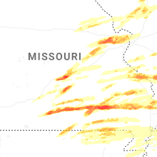

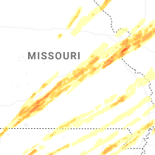


Connect with Interactive Hail Maps