

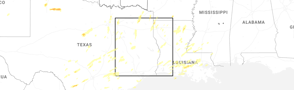
Hail Map for Elkhart, TX
The Elkhart, TX area has had 11 reports of on-the-ground hail by trained spotters, and has been under severe weather warnings 19 times during the past 12 months. Doppler radar has detected hail at or near Elkhart, TX on 58 occasions, including 3 occasions during the past year.
| Name: | Elkhart, TX |
| Where Located: | 54.5 miles WNW of Lufkin, TX |
| Map: | Google Map for Elkhart, TX |
| Population: | 1371 |
| Housing Units: | 549 |
| More Info: | Search Google for Elkhart, TX |
0
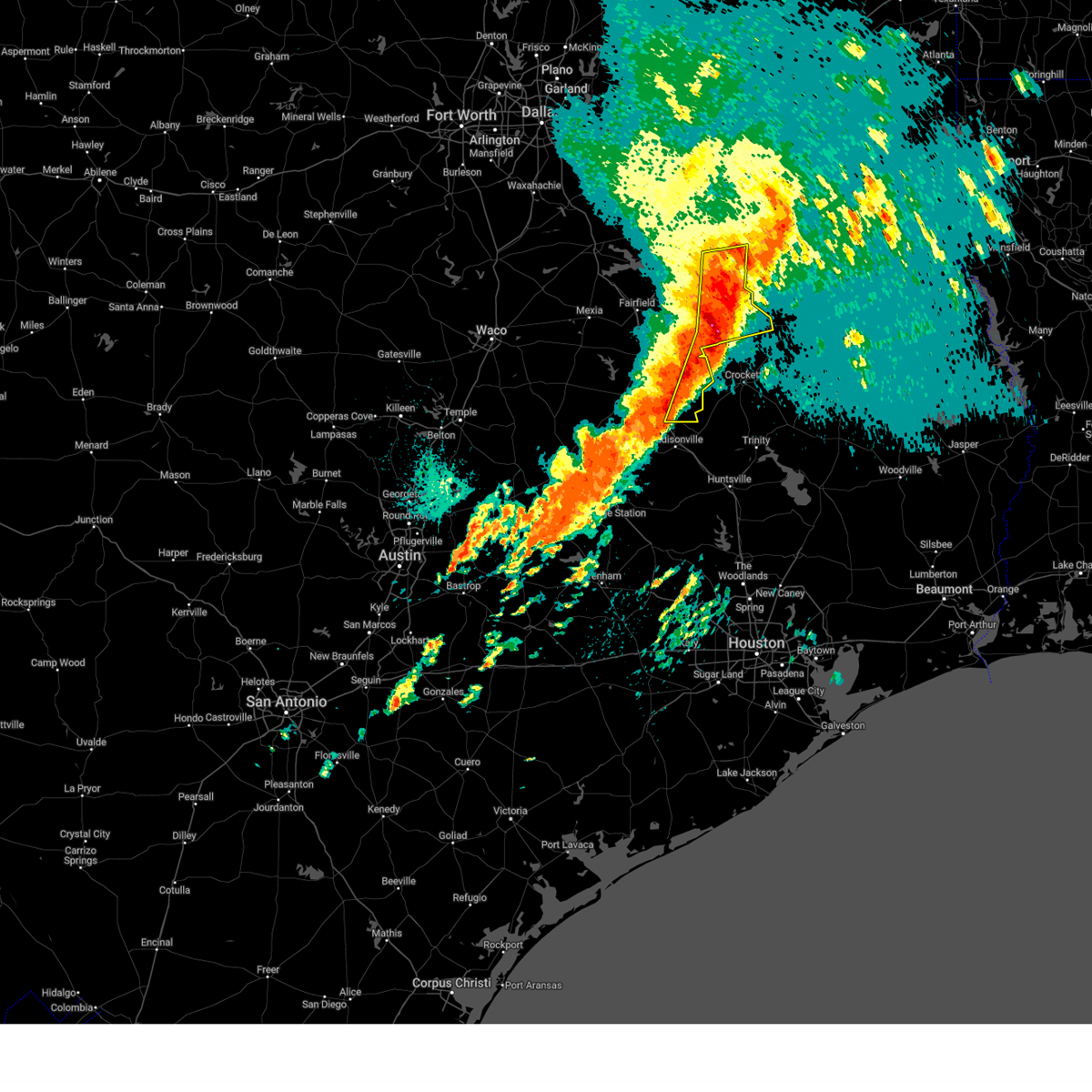
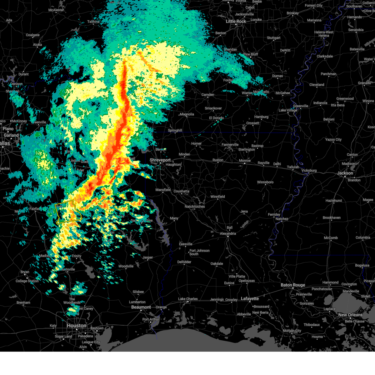
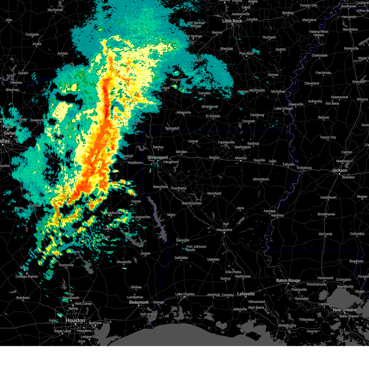
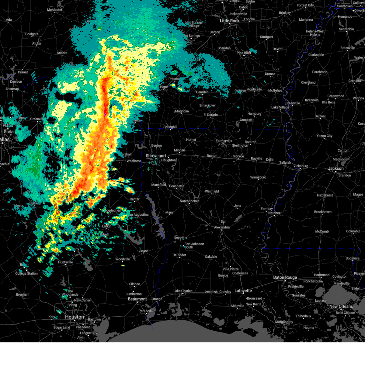
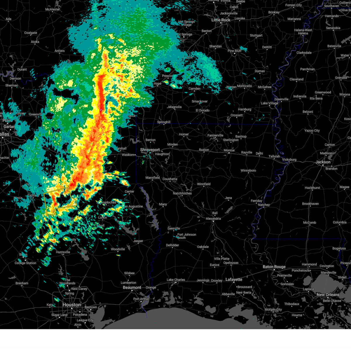
The Top Recent Hail Date for Elkhart, TX is Tuesday, May 6, 2025 (56th out of 58)
Hail and Wind Damage Spotted near Elkhart, TX
| Date / Time | Report Details |
|---|---|
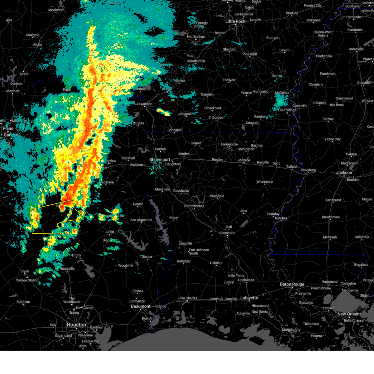
| 5/6/2025 2:14 PM CDT | At 214 pm cdt, severe thunderstorms were located along a line extending from jacksonville to maydelle to austonio, moving northeast at 50 mph (radar indicated). Hazards include 60 mph wind gusts and quarter size hail. Hail damage to vehicles is expected. expect wind damage to roofs, siding, and trees. Locations impacted include, elkhart, redtown, denson spring, salmon, cedar creek, crystal lake, centerview, slocum, eunice, broom city, and mound city. |
| 5/6/2025 1:56 PM CDT |
 the severe thunderstorm warning has been cancelled and is no longer in effect the severe thunderstorm warning has been cancelled and is no longer in effect
|
| 5/6/2025 1:56 PM CDT |
 At 155 pm cdt, severe thunderstorms were located along a line extending from near montalba to near elkhart to fort boggy state park, moving northeast at 50 mph (radar indicated). Hazards include 60 mph wind gusts and quarter size hail. Hail damage to vehicles is expected. expect wind damage to roofs, siding, and trees. Locations impacted include, tucker, montalba, brushy creek, salmon, cedar creek, slocum, palestine, eunice, broom city, elkhart, pert, redtown, frankston, denson spring, crystal lake, centerview, todd city, neches, berryville, and mound city. At 155 pm cdt, severe thunderstorms were located along a line extending from near montalba to near elkhart to fort boggy state park, moving northeast at 50 mph (radar indicated). Hazards include 60 mph wind gusts and quarter size hail. Hail damage to vehicles is expected. expect wind damage to roofs, siding, and trees. Locations impacted include, tucker, montalba, brushy creek, salmon, cedar creek, slocum, palestine, eunice, broom city, elkhart, pert, redtown, frankston, denson spring, crystal lake, centerview, todd city, neches, berryville, and mound city.
|
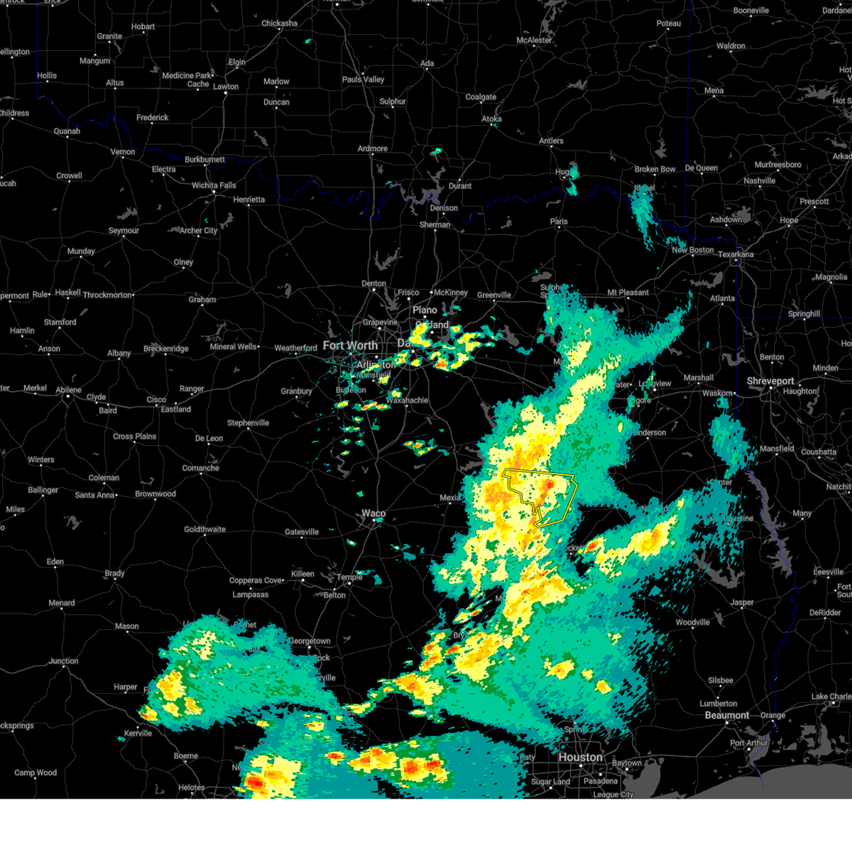
| 5/6/2025 1:36 PM CDT | Svrfwd the national weather service in fort worth has issued a * severe thunderstorm warning for, eastern freestone county in central texas, leon county in central texas, anderson county in central texas, * until 230 pm cdt. * at 136 pm cdt, severe thunderstorms were located along a line extending from fairfield lake to buffalo to fort boggy state park, moving east at 50 mph (radar indicated). Hazards include 60 mph wind gusts and quarter size hail. Hail damage to vehicles is expected. expect wind damage to roofs, siding, and trees. severe thunderstorms will be near, centerville and fort boggy state park around 140 pm cdt. palestine around 145 pm cdt. montalba and elkhart around 150 pm cdt. other locations impacted by these severe thunderstorms include tucker, bradford, flo, bois d'arc, oakwood, eunice, cayuga, redland, redtown, and bethel. This includes interstate 45 between mile markers 152 and 171. |
| 5/2/2025 5:12 PM CDT |
 the severe thunderstorm warning has been cancelled and is no longer in effect the severe thunderstorm warning has been cancelled and is no longer in effect
|
| 5/2/2025 5:03 PM CDT | the severe thunderstorm warning has been cancelled and is no longer in effect |
| 5/2/2025 5:03 PM CDT | At 503 pm cdt, a severe thunderstorm was located over palestine, moving east at 35 mph (radar indicated). Hazards include 60 mph wind gusts and nickel size hail. Expect damage to roofs, siding, and trees. this severe storm will be near, palestine around 510 pm cdt. Other locations impacted by this severe thunderstorm include tucker, johnson, redtown, yard, cedar creek, crystal lake, bethel, neches, massey lake, and tennessee colony. |
| 5/2/2025 4:26 PM CDT |
 Svrfwd the national weather service in fort worth has issued a * severe thunderstorm warning for, freestone county in central texas, northern leon county in central texas, central anderson county in central texas, * until 530 pm cdt. * at 425 pm cdt, a severe thunderstorm was located over fairfield lake, or 7 miles northeast of fairfield, moving east at 30 mph (radar indicated). Hazards include 60 mph wind gusts and half dollar size hail. Hail damage to vehicles is expected. expect wind damage to roofs, siding, and trees. this severe thunderstorm will be near, fairfield lake state park and fairfield lake around 430 pm cdt. palestine around 500 pm cdt. other locations impacted by this severe thunderstorm include tucker, johnson, lanely, cedar creek, flo, stewards mill, oakwood, donie, freestone, and eunice. This includes interstate 45 between mile markers 173 and 206. Svrfwd the national weather service in fort worth has issued a * severe thunderstorm warning for, freestone county in central texas, northern leon county in central texas, central anderson county in central texas, * until 530 pm cdt. * at 425 pm cdt, a severe thunderstorm was located over fairfield lake, or 7 miles northeast of fairfield, moving east at 30 mph (radar indicated). Hazards include 60 mph wind gusts and half dollar size hail. Hail damage to vehicles is expected. expect wind damage to roofs, siding, and trees. this severe thunderstorm will be near, fairfield lake state park and fairfield lake around 430 pm cdt. palestine around 500 pm cdt. other locations impacted by this severe thunderstorm include tucker, johnson, lanely, cedar creek, flo, stewards mill, oakwood, donie, freestone, and eunice. This includes interstate 45 between mile markers 173 and 206.
|
| 4/30/2025 7:25 PM CDT | At 725 pm cdt, a severe thunderstorm was located 14 miles west of elkhart, or 15 miles southwest of palestine, moving northeast at 30 mph. another storm was located to the northwest of buffalo (radar indicated). Hazards include quarter size hail. Damage to vehicles is possible. this severe storm will be near, elkhart around 745 pm cdt. Other locations impacted by this severe thunderstorm include tucker, johnson, lanely, cedar creek, flo, oakwood, donie, freestone, redtown, and dew. |
| 4/30/2025 6:45 PM CDT |
 Svrfwd the national weather service in fort worth has issued a * severe thunderstorm warning for, southeastern freestone county in central texas, northern leon county in central texas, southwestern anderson county in central texas, * until 745 pm cdt. * at 645 pm cdt, a severe thunderstorm was located near buffalo, or 12 miles southeast of teague, moving northeast at 35 mph (radar indicated). Hazards include ping pong ball size hail. People and animals outdoors will be injured. expect damage to roofs, siding, windows, and vehicles. this severe thunderstorm will be near, buffalo around 650 pm cdt. palestine around 730 pm cdt. other locations impacted by this severe thunderstorm include tucker, johnson, lanely, cedar creek, flo, oakwood, donie, freestone, redtown, and dew. This includes interstate 45 between mile markers 174 and 191. Svrfwd the national weather service in fort worth has issued a * severe thunderstorm warning for, southeastern freestone county in central texas, northern leon county in central texas, southwestern anderson county in central texas, * until 745 pm cdt. * at 645 pm cdt, a severe thunderstorm was located near buffalo, or 12 miles southeast of teague, moving northeast at 35 mph (radar indicated). Hazards include ping pong ball size hail. People and animals outdoors will be injured. expect damage to roofs, siding, windows, and vehicles. this severe thunderstorm will be near, buffalo around 650 pm cdt. palestine around 730 pm cdt. other locations impacted by this severe thunderstorm include tucker, johnson, lanely, cedar creek, flo, oakwood, donie, freestone, redtown, and dew. This includes interstate 45 between mile markers 174 and 191.
|
| 4/24/2025 4:40 PM CDT |
 The storm which prompted the warning has weakened below severe limits, and has exited the warned area. therefore, the warning will be allowed to expire. a severe thunderstorm watch remains in effect until 800 pm cdt for central texas. The storm which prompted the warning has weakened below severe limits, and has exited the warned area. therefore, the warning will be allowed to expire. a severe thunderstorm watch remains in effect until 800 pm cdt for central texas.
|
| 4/24/2025 4:28 PM CDT |
 the severe thunderstorm warning has been cancelled and is no longer in effect the severe thunderstorm warning has been cancelled and is no longer in effect
|
| 4/24/2025 4:28 PM CDT |
 At 427 pm cdt, a severe thunderstorm was located near elkhart, or 14 miles south of palestine, moving northeast at 20 mph (radar indicated). Hazards include 60 mph wind gusts and quarter size hail. Hail damage to vehicles is expected. expect wind damage to roofs, siding, and trees. this severe storm will be near, elkhart around 435 pm cdt. Other locations impacted by this severe thunderstorm include redtown, mound city, denson spring, salmon, cedar creek, crystal lake, slocum, and broom city. At 427 pm cdt, a severe thunderstorm was located near elkhart, or 14 miles south of palestine, moving northeast at 20 mph (radar indicated). Hazards include 60 mph wind gusts and quarter size hail. Hail damage to vehicles is expected. expect wind damage to roofs, siding, and trees. this severe storm will be near, elkhart around 435 pm cdt. Other locations impacted by this severe thunderstorm include redtown, mound city, denson spring, salmon, cedar creek, crystal lake, slocum, and broom city.
|
| 4/24/2025 3:40 PM CDT |
 Svrfwd the national weather service in fort worth has issued a * severe thunderstorm warning for, southeastern freestone county in central texas, northeastern leon county in central texas, anderson county in central texas, * until 445 pm cdt. * at 339 pm cdt, a severe thunderstorm was located 11 miles east of buffalo, or 21 miles southeast of fairfield, moving northeast at 35 mph (radar indicated). Hazards include 60 mph wind gusts and quarter size hail. Hail damage to vehicles is expected. expect wind damage to roofs, siding, and trees. this severe thunderstorm will be near, palestine around 405 pm cdt. elkhart around 410 pm cdt. Other locations impacted by this severe thunderstorm include tucker, johnson, redtown, mound city, denson spring, salmon, cedar creek, crystal lake, flo, and oakwood. Svrfwd the national weather service in fort worth has issued a * severe thunderstorm warning for, southeastern freestone county in central texas, northeastern leon county in central texas, anderson county in central texas, * until 445 pm cdt. * at 339 pm cdt, a severe thunderstorm was located 11 miles east of buffalo, or 21 miles southeast of fairfield, moving northeast at 35 mph (radar indicated). Hazards include 60 mph wind gusts and quarter size hail. Hail damage to vehicles is expected. expect wind damage to roofs, siding, and trees. this severe thunderstorm will be near, palestine around 405 pm cdt. elkhart around 410 pm cdt. Other locations impacted by this severe thunderstorm include tucker, johnson, redtown, mound city, denson spring, salmon, cedar creek, crystal lake, flo, and oakwood.
|
| 3/4/2025 8:11 AM CST |
 the severe thunderstorm warning has been cancelled and is no longer in effect the severe thunderstorm warning has been cancelled and is no longer in effect
|
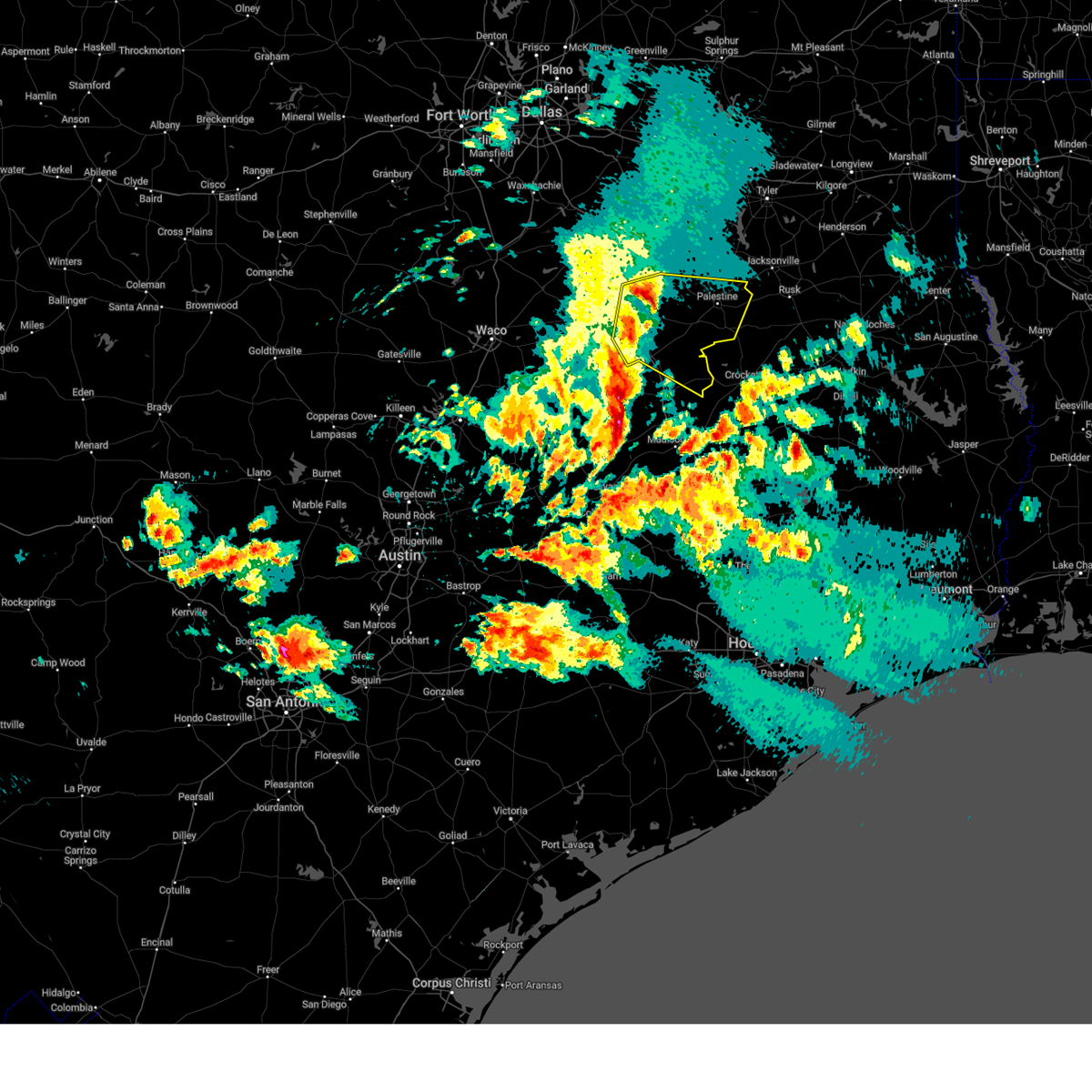
| 3/4/2025 7:58 AM CST |
 At 757 am cst, severe thunderstorms were located along a line extending from palestine to 6 miles southwest of elkhart, moving east at 60 mph (radar indicated). Hazards include 60 mph wind gusts and penny size hail. Expect damage to roofs, siding, and trees. Locations impacted include, elkhart, redtown, mound city, denson spring, salmon, cedar creek, crystal lake, neches, slocum, palestine, and broom city. At 757 am cst, severe thunderstorms were located along a line extending from palestine to 6 miles southwest of elkhart, moving east at 60 mph (radar indicated). Hazards include 60 mph wind gusts and penny size hail. Expect damage to roofs, siding, and trees. Locations impacted include, elkhart, redtown, mound city, denson spring, salmon, cedar creek, crystal lake, neches, slocum, palestine, and broom city.
|
| 3/4/2025 7:58 AM CST |
 the severe thunderstorm warning has been cancelled and is no longer in effect the severe thunderstorm warning has been cancelled and is no longer in effect
|
| 3/4/2025 7:50 AM CST |
 At 748 am cst, severe thunderstorms were located along the trinity river, moving east at 55 mph (radar indicated). Hazards include 60 mph wind gusts and penny size hail. Expect damage to roofs, siding, and trees. Locations impacted include, tucker, johnson, mound city, salmon, cedar creek, oakwood, slocum, palestine, broom city, elkhart, redtown, denson spring, crystal lake, neches, massey lake, and tennessee colony. At 748 am cst, severe thunderstorms were located along the trinity river, moving east at 55 mph (radar indicated). Hazards include 60 mph wind gusts and penny size hail. Expect damage to roofs, siding, and trees. Locations impacted include, tucker, johnson, mound city, salmon, cedar creek, oakwood, slocum, palestine, broom city, elkhart, redtown, denson spring, crystal lake, neches, massey lake, and tennessee colony.
|
| 3/4/2025 7:28 AM CST |
 Svrfwd the national weather service in fort worth has issued a * severe thunderstorm warning for, southeastern freestone county in central texas, northern leon county in central texas, southern anderson county in central texas, * until 830 am cst. * at 728 am cst, a severe thunderstorm was located over buffalo, moving east at 60 mph (radar indicated). Hazards include 60 mph wind gusts. Expect damage to roofs, siding, and trees. this severe thunderstorm will remain over mainly rural areas of southeastern freestone, northern leon and southern anderson counties, including the following locations, tucker, johnson, lanely, mound city, jewett, salmon, cedar creek, flo, oakwood, and donie. This includes interstate 45 between mile markers 171 and 200. Svrfwd the national weather service in fort worth has issued a * severe thunderstorm warning for, southeastern freestone county in central texas, northern leon county in central texas, southern anderson county in central texas, * until 830 am cst. * at 728 am cst, a severe thunderstorm was located over buffalo, moving east at 60 mph (radar indicated). Hazards include 60 mph wind gusts. Expect damage to roofs, siding, and trees. this severe thunderstorm will remain over mainly rural areas of southeastern freestone, northern leon and southern anderson counties, including the following locations, tucker, johnson, lanely, mound city, jewett, salmon, cedar creek, flo, oakwood, and donie. This includes interstate 45 between mile markers 171 and 200.
|
| 6/1/2024 5:00 PM CDT |
 At 459 pm cdt, a severe thunderstorm was located near montalba, or 10 miles north of palestine, moving southeast at 30 mph (radar indicated). Hazards include ping pong ball size hail and 65 mph wind gusts. People and animals outdoors will be injured. expect hail damage to roofs, siding, windows, and vehicles. expect wind damage to roofs, siding, and trees. This severe storm will be, northeast of palestine around 505 pm cdt. At 459 pm cdt, a severe thunderstorm was located near montalba, or 10 miles north of palestine, moving southeast at 30 mph (radar indicated). Hazards include ping pong ball size hail and 65 mph wind gusts. People and animals outdoors will be injured. expect hail damage to roofs, siding, windows, and vehicles. expect wind damage to roofs, siding, and trees. This severe storm will be, northeast of palestine around 505 pm cdt.
|
| 6/1/2024 4:43 PM CDT |
 At 439 pm cdt, a severe thunderstorm was located near bradford, moving southeast at 25 mph (radar indicated). Hazards include golf ball size hail and 65 mph wind gusts. People and animals outdoors will be injured. expect hail damage to roofs, siding, windows, and vehicles. expect wind damage to roofs, siding, and trees. this severe storm will be near, montalba around 455 pm cdt. Palestine around 510 pm cdt. At 439 pm cdt, a severe thunderstorm was located near bradford, moving southeast at 25 mph (radar indicated). Hazards include golf ball size hail and 65 mph wind gusts. People and animals outdoors will be injured. expect hail damage to roofs, siding, windows, and vehicles. expect wind damage to roofs, siding, and trees. this severe storm will be near, montalba around 455 pm cdt. Palestine around 510 pm cdt.
|
| 6/1/2024 4:20 PM CDT |
 Svrfwd the national weather service in fort worth has issued a * severe thunderstorm warning for, anderson county in central texas, * until 530 pm cdt. * at 419 pm cdt, a severe thunderstorm was located over coon creek lake in henderson county, or 10 miles south of athens, moving southeast at 40 mph (radar indicated). Hazards include ping pong ball size hail and 65 mph wind gusts. People and animals outdoors will be injured. expect hail damage to roofs, siding, windows, and vehicles. expect wind damage to roofs, siding, and trees. this severe thunderstorm will be near, montalba around 435 pm cdt. Palestine around 445 pm cdt. Svrfwd the national weather service in fort worth has issued a * severe thunderstorm warning for, anderson county in central texas, * until 530 pm cdt. * at 419 pm cdt, a severe thunderstorm was located over coon creek lake in henderson county, or 10 miles south of athens, moving southeast at 40 mph (radar indicated). Hazards include ping pong ball size hail and 65 mph wind gusts. People and animals outdoors will be injured. expect hail damage to roofs, siding, windows, and vehicles. expect wind damage to roofs, siding, and trees. this severe thunderstorm will be near, montalba around 435 pm cdt. Palestine around 445 pm cdt.
|
| 5/31/2024 5:57 AM CDT |
 The storm which prompted the warning has moved out of the area. therefore the warning will be allowed to expire. however gusty winds are still possible with this thunderstorm. The storm which prompted the warning has moved out of the area. therefore the warning will be allowed to expire. however gusty winds are still possible with this thunderstorm.
|
| 5/31/2024 5:19 AM CDT |
 Svrfwd the national weather service in fort worth has issued a * severe thunderstorm warning for, southeastern freestone county in central texas, northeastern leon county in central texas, southeastern anderson county in central texas, * until 600 am cdt. * at 519 am cdt, a severe thunderstorm was located 11 miles east of buffalo, or 21 miles northwest of austonio, moving east at 45 mph (radar indicated). Hazards include 60 mph wind gusts and penny size hail. Expect damage to roofs, siding, and trees. this severe thunderstorm will remain over mainly rural areas of southeastern freestone, northeastern leon and southeastern anderson counties, including the following locations, tucker, pleasant springs, lanely, mound city, salmon, cedar creek, flo, oakwood, slocum, and broom city. This includes interstate 45 between mile markers 160 and 179. Svrfwd the national weather service in fort worth has issued a * severe thunderstorm warning for, southeastern freestone county in central texas, northeastern leon county in central texas, southeastern anderson county in central texas, * until 600 am cdt. * at 519 am cdt, a severe thunderstorm was located 11 miles east of buffalo, or 21 miles northwest of austonio, moving east at 45 mph (radar indicated). Hazards include 60 mph wind gusts and penny size hail. Expect damage to roofs, siding, and trees. this severe thunderstorm will remain over mainly rural areas of southeastern freestone, northeastern leon and southeastern anderson counties, including the following locations, tucker, pleasant springs, lanely, mound city, salmon, cedar creek, flo, oakwood, slocum, and broom city. This includes interstate 45 between mile markers 160 and 179.
|
| 5/30/2024 5:54 PM CDT |
 the severe thunderstorm warning has been cancelled and is no longer in effect the severe thunderstorm warning has been cancelled and is no longer in effect
|
| 5/30/2024 5:44 PM CDT |
 At 544 pm cdt, a severe thunderstorm was located over elkhart, or 10 miles southeast of palestine, moving southeast at 40 mph (radar indicated). Hazards include 60 mph wind gusts and quarter size hail. Hail damage to vehicles is expected. expect wind damage to roofs, siding, and trees. This severe thunderstorm will remain over mainly rural areas of southeastern anderson county, including the following locations, tucker, johnson, denson spring, cedar creek, crystal lake, slocum, neches, and broom city. At 544 pm cdt, a severe thunderstorm was located over elkhart, or 10 miles southeast of palestine, moving southeast at 40 mph (radar indicated). Hazards include 60 mph wind gusts and quarter size hail. Hail damage to vehicles is expected. expect wind damage to roofs, siding, and trees. This severe thunderstorm will remain over mainly rural areas of southeastern anderson county, including the following locations, tucker, johnson, denson spring, cedar creek, crystal lake, slocum, neches, and broom city.
|
| 5/30/2024 5:44 PM CDT |
 the severe thunderstorm warning has been cancelled and is no longer in effect the severe thunderstorm warning has been cancelled and is no longer in effect
|
| 5/30/2024 5:09 PM CDT |
 Svrfwd the national weather service in fort worth has issued a * severe thunderstorm warning for, northeastern freestone county in central texas, anderson county in central texas, * until 615 pm cdt. * at 508 pm cdt, a severe thunderstorm was located near fairfield lake, or 11 miles east of fairfield, moving east at 35 mph (radar indicated). Hazards include 60 mph wind gusts and nickel size hail. Expect damage to roofs, siding, and trees. this severe thunderstorm will be near, palestine around 535 pm cdt. Other locations impacted by this severe thunderstorm include tucker, johnson, brushy creek, bradford, cedar creek, bois d'arc, slocum, blackfoot, broom city, and cayuga. Svrfwd the national weather service in fort worth has issued a * severe thunderstorm warning for, northeastern freestone county in central texas, anderson county in central texas, * until 615 pm cdt. * at 508 pm cdt, a severe thunderstorm was located near fairfield lake, or 11 miles east of fairfield, moving east at 35 mph (radar indicated). Hazards include 60 mph wind gusts and nickel size hail. Expect damage to roofs, siding, and trees. this severe thunderstorm will be near, palestine around 535 pm cdt. Other locations impacted by this severe thunderstorm include tucker, johnson, brushy creek, bradford, cedar creek, bois d'arc, slocum, blackfoot, broom city, and cayuga.
|
| 5/28/2024 11:42 AM CDT |
 The storm which prompted the warning has moved out of the area. therefore, the warning will be allowed to expire. however, gusty winds are still possible with this thunderstorm. a severe thunderstorm watch remains in effect until noon cdt for central texas. The storm which prompted the warning has moved out of the area. therefore, the warning will be allowed to expire. however, gusty winds are still possible with this thunderstorm. a severe thunderstorm watch remains in effect until noon cdt for central texas.
|
| 5/28/2024 11:07 AM CDT |
 Svrfwd the national weather service in fort worth has issued a * severe thunderstorm warning for, eastern anderson county in central texas, * until 1145 am cdt. * at 1106 am cdt, a severe thunderstorm was located near elkhart, or 8 miles southeast of palestine, moving southeast at 45 mph (radar indicated). Hazards include 60 mph wind gusts and quarter size hail. Hail damage to vehicles is expected. expect wind damage to roofs, siding, and trees. This severe thunderstorm will remain over mainly rural areas of eastern anderson county, including the following locations, tucker, pert, mound city, salmon, denson spring, cedar creek, crystal lake, slocum, todd city, and neches. Svrfwd the national weather service in fort worth has issued a * severe thunderstorm warning for, eastern anderson county in central texas, * until 1145 am cdt. * at 1106 am cdt, a severe thunderstorm was located near elkhart, or 8 miles southeast of palestine, moving southeast at 45 mph (radar indicated). Hazards include 60 mph wind gusts and quarter size hail. Hail damage to vehicles is expected. expect wind damage to roofs, siding, and trees. This severe thunderstorm will remain over mainly rural areas of eastern anderson county, including the following locations, tucker, pert, mound city, salmon, denson spring, cedar creek, crystal lake, slocum, todd city, and neches.
|
| 5/22/2024 9:02 PM CDT |
 the severe thunderstorm warning has been cancelled and is no longer in effect the severe thunderstorm warning has been cancelled and is no longer in effect
|
| 5/22/2024 8:45 PM CDT | Numerous trees and powerlines down along hwy 294 from elkhart to slocum. reports of trees fallen on homes and vehicles. time estimated from rada in anderson county TX, 4.1 miles W of Elkhart, TX |
| 5/22/2024 8:35 PM CDT | Tree fell onto a house near highway 294 and fm 2419. time estimate in anderson county TX, 3 miles WSW of Elkhart, TX |
| 5/22/2024 8:35 PM CDT |
 At 835 pm cdt, a severe thunderstorm was located near elkhart, or 10 miles southeast of palestine, moving northeast at 50 mph (radar indicated). Hazards include 65 mph wind gusts. Expect damage to roofs, siding, and trees. This severe thunderstorm will remain over mainly rural areas of anderson county, including the following locations, tucker, johnson, salmon, cedar creek, slocum, broom city, pert, redtown, yard, and denson spring. At 835 pm cdt, a severe thunderstorm was located near elkhart, or 10 miles southeast of palestine, moving northeast at 50 mph (radar indicated). Hazards include 65 mph wind gusts. Expect damage to roofs, siding, and trees. This severe thunderstorm will remain over mainly rural areas of anderson county, including the following locations, tucker, johnson, salmon, cedar creek, slocum, broom city, pert, redtown, yard, and denson spring.
|
| 5/22/2024 8:15 PM CDT |
 Svrfwd the national weather service in fort worth has issued a * severe thunderstorm warning for, anderson county in central texas, * until 915 pm cdt. * at 815 pm cdt, a severe thunderstorm was located 15 miles southwest of palestine, moving northeast at 50 mph (radar indicated). Hazards include 65 mph wind gusts and nickel size hail. Expect damage to roofs, siding, and trees. this severe thunderstorm will be near, palestine around 820 pm cdt. Other locations impacted by this severe thunderstorm include tucker, johnson, brushy creek, salmon, bradford, cedar creek, bois d'arc, slocum, blackfoot, and broom city. Svrfwd the national weather service in fort worth has issued a * severe thunderstorm warning for, anderson county in central texas, * until 915 pm cdt. * at 815 pm cdt, a severe thunderstorm was located 15 miles southwest of palestine, moving northeast at 50 mph (radar indicated). Hazards include 65 mph wind gusts and nickel size hail. Expect damage to roofs, siding, and trees. this severe thunderstorm will be near, palestine around 820 pm cdt. Other locations impacted by this severe thunderstorm include tucker, johnson, brushy creek, salmon, bradford, cedar creek, bois d'arc, slocum, blackfoot, and broom city.
|
| 4/28/2024 6:25 PM CDT |
 The storms which prompted the warning have moved out of the area. therefore the warning will be allowed to expire. a tornado watch remains in effect until 900 pm cdt for central texas. The storms which prompted the warning have moved out of the area. therefore the warning will be allowed to expire. a tornado watch remains in effect until 900 pm cdt for central texas.
|
| 4/28/2024 5:59 PM CDT |
 the severe thunderstorm warning has been cancelled and is no longer in effect the severe thunderstorm warning has been cancelled and is no longer in effect
|
| 4/28/2024 5:59 PM CDT |
 At 558 pm cdt, severe thunderstorms were located along a line extending from near elkhart to 7 miles northwest of madisonville, moving northeast at 40 mph (radar indicated). Hazards include 60 mph wind gusts and half dollar size hail. Hail damage to vehicles is expected. expect wind damage to roofs, siding, and trees. these severe storms will be near, elkhart around 605 pm cdt. Other locations impacted by these severe thunderstorms include tucker, pleasant springs, redtown, leona, cedar creek, flo, centerview, oakwood, and eunice. At 558 pm cdt, severe thunderstorms were located along a line extending from near elkhart to 7 miles northwest of madisonville, moving northeast at 40 mph (radar indicated). Hazards include 60 mph wind gusts and half dollar size hail. Hail damage to vehicles is expected. expect wind damage to roofs, siding, and trees. these severe storms will be near, elkhart around 605 pm cdt. Other locations impacted by these severe thunderstorms include tucker, pleasant springs, redtown, leona, cedar creek, flo, centerview, oakwood, and eunice.
|
| 4/28/2024 5:39 PM CDT |
 Svrfwd the national weather service in fort worth has issued a * severe thunderstorm warning for, southeastern freestone county in central texas, leon county in central texas, south central anderson county in central texas, * until 630 pm cdt. * at 539 pm cdt, severe thunderstorms were located along a line extending from near buffalo to 7 miles northwest of madisonville, moving east at 40 mph (radar indicated). Hazards include 60 mph wind gusts and half dollar size hail. Hail damage to vehicles is expected. expect wind damage to roofs, siding, and trees. severe thunderstorms will be near, buffalo, centerville, and fort boggy state park around 545 pm cdt. other locations impacted by these severe thunderstorms include tucker, pleasant springs, jewett, cedar creek, flo, oakwood, robbins, eunice, redland, and redtown. This includes interstate 45 between mile markers 152 and 184. Svrfwd the national weather service in fort worth has issued a * severe thunderstorm warning for, southeastern freestone county in central texas, leon county in central texas, south central anderson county in central texas, * until 630 pm cdt. * at 539 pm cdt, severe thunderstorms were located along a line extending from near buffalo to 7 miles northwest of madisonville, moving east at 40 mph (radar indicated). Hazards include 60 mph wind gusts and half dollar size hail. Hail damage to vehicles is expected. expect wind damage to roofs, siding, and trees. severe thunderstorms will be near, buffalo, centerville, and fort boggy state park around 545 pm cdt. other locations impacted by these severe thunderstorms include tucker, pleasant springs, jewett, cedar creek, flo, oakwood, robbins, eunice, redland, and redtown. This includes interstate 45 between mile markers 152 and 184.
|
| 3/5/2024 3:48 AM CST |
 Svrfwd the national weather service in fort worth has issued a * severe thunderstorm warning for, southeastern anderson county in central texas, * until 415 am cst. * at 347 am cst, a severe thunderstorm was located near palestine, moving northeast at 40 mph (radar indicated). Hazards include quarter size hail. Damage to vehicles is possible. This severe thunderstorm will remain over mainly rural areas of southeastern anderson county, including the following locations, crystal lake, slocum, broom city, cedar creek, and denson spring. Svrfwd the national weather service in fort worth has issued a * severe thunderstorm warning for, southeastern anderson county in central texas, * until 415 am cst. * at 347 am cst, a severe thunderstorm was located near palestine, moving northeast at 40 mph (radar indicated). Hazards include quarter size hail. Damage to vehicles is possible. This severe thunderstorm will remain over mainly rural areas of southeastern anderson county, including the following locations, crystal lake, slocum, broom city, cedar creek, and denson spring.
|
| 2/11/2024 8:10 AM CST |
 The severe thunderstorm warning for southeastern anderson county will expire at 815 am cst, the storm which prompted the warning has moved out of the area. therefore the warning will be allowed to expire. however, gusty winds are still possible with this thunderstorm. a severe thunderstorm watch remains in effect until 1100 am cst for central texas. The severe thunderstorm warning for southeastern anderson county will expire at 815 am cst, the storm which prompted the warning has moved out of the area. therefore the warning will be allowed to expire. however, gusty winds are still possible with this thunderstorm. a severe thunderstorm watch remains in effect until 1100 am cst for central texas.
|
| 2/11/2024 7:57 AM CST |
 At 757 am cst, a severe thunderstorm was located 8 miles southwest of maydelle, or 14 miles southwest of rusk, moving east at 50 mph (radar indicated). Hazards include 60 mph wind gusts and quarter size hail. Hail damage to vehicles is expected. expect wind damage to roofs, siding, and trees. locations impacted include, elkhart, mound city, salmon, denson spring, crystal lake, slocum, and broom city. hail threat, observed max hail size, 1. 00 in wind threat, radar indicated max wind gust, 60 mph. At 757 am cst, a severe thunderstorm was located 8 miles southwest of maydelle, or 14 miles southwest of rusk, moving east at 50 mph (radar indicated). Hazards include 60 mph wind gusts and quarter size hail. Hail damage to vehicles is expected. expect wind damage to roofs, siding, and trees. locations impacted include, elkhart, mound city, salmon, denson spring, crystal lake, slocum, and broom city. hail threat, observed max hail size, 1. 00 in wind threat, radar indicated max wind gust, 60 mph.
|
| 2/11/2024 7:43 AM CST |
 At 742 am cst, a severe thunderstorm was located over elkhart, or 10 miles southeast of palestine, moving east at 50 mph (radar indicated). Hazards include 60 mph wind gusts and half dollar size hail. Hail damage to vehicles is expected. expect wind damage to roofs, siding, and trees. this severe thunderstorm will remain over mainly rural areas of northeastern leon and southeastern anderson counties, including the following locations, tucker, redtown, mound city, salmon, denson spring, cedar creek, crystal lake, slocum, neches, and broom city. hail threat, radar indicated max hail size, 1. 25 in wind threat, radar indicated max wind gust, 60 mph. At 742 am cst, a severe thunderstorm was located over elkhart, or 10 miles southeast of palestine, moving east at 50 mph (radar indicated). Hazards include 60 mph wind gusts and half dollar size hail. Hail damage to vehicles is expected. expect wind damage to roofs, siding, and trees. this severe thunderstorm will remain over mainly rural areas of northeastern leon and southeastern anderson counties, including the following locations, tucker, redtown, mound city, salmon, denson spring, cedar creek, crystal lake, slocum, neches, and broom city. hail threat, radar indicated max hail size, 1. 25 in wind threat, radar indicated max wind gust, 60 mph.
|
| 2/11/2024 7:40 AM CST | Quarter sized hail reported 1.3 miles N of Elkhart, TX, report from mping: quarter (1.00 in.). |
| 2/11/2024 7:40 AM CST | Half Dollar sized hail reported 1.8 miles WNW of Elkhart, TX, nickel to half dollar size reported near elkhart. |
| 2/11/2024 7:15 AM CST |
 At 714 am cst, a severe thunderstorm was located near buffalo, or 20 miles southeast of fairfield, moving northeast at 55 mph (radar indicated). Hazards include 60 mph wind gusts and half dollar size hail. Hail damage to vehicles is expected. expect wind damage to roofs, siding, and trees. this severe thunderstorm will be near, elkhart around 735 am cst. other locations impacted by this severe thunderstorm include tucker, johnson, mound city, salmon, cedar creek, flo, oakwood, slocum, broom city, and redtown. hail threat, radar indicated max hail size, 1. 25 in wind threat, radar indicated max wind gust, 60 mph. At 714 am cst, a severe thunderstorm was located near buffalo, or 20 miles southeast of fairfield, moving northeast at 55 mph (radar indicated). Hazards include 60 mph wind gusts and half dollar size hail. Hail damage to vehicles is expected. expect wind damage to roofs, siding, and trees. this severe thunderstorm will be near, elkhart around 735 am cst. other locations impacted by this severe thunderstorm include tucker, johnson, mound city, salmon, cedar creek, flo, oakwood, slocum, broom city, and redtown. hail threat, radar indicated max hail size, 1. 25 in wind threat, radar indicated max wind gust, 60 mph.
|
| 10/5/2023 1:35 AM CDT |
 At 134 am cdt, severe thunderstorms were located along a line extending from 6 miles west of maydelle to near elkhart, moving southeast at 30 mph (radar indicated). Hazards include 60 mph wind gusts. expect damage to roofs, siding, and trees At 134 am cdt, severe thunderstorms were located along a line extending from 6 miles west of maydelle to near elkhart, moving southeast at 30 mph (radar indicated). Hazards include 60 mph wind gusts. expect damage to roofs, siding, and trees
|
| 9/24/2023 7:36 PM CDT |
 At 736 pm cdt, a severe thunderstorm was located near elkhart, or near palestine, moving southeast at 25 mph (law enforcement). Hazards include 60 mph wind gusts and half dollar size hail. Hail damage to vehicles is expected. expect wind damage to roofs, siding, and trees. locations impacted include, palestine, elkhart, mound city, denson spring, salmon, cedar creek, crystal lake, slocum, and broom city. hail threat, radar indicated max hail size, 1. 25 in wind threat, radar indicated max wind gust, 60 mph. At 736 pm cdt, a severe thunderstorm was located near elkhart, or near palestine, moving southeast at 25 mph (law enforcement). Hazards include 60 mph wind gusts and half dollar size hail. Hail damage to vehicles is expected. expect wind damage to roofs, siding, and trees. locations impacted include, palestine, elkhart, mound city, denson spring, salmon, cedar creek, crystal lake, slocum, and broom city. hail threat, radar indicated max hail size, 1. 25 in wind threat, radar indicated max wind gust, 60 mph.
|
| 9/24/2023 7:18 PM CDT |
 At 718 pm cdt, a severe thunderstorm was located over palestine, moving southeast at 20 mph (law enforcement). Hazards include golf ball size hail and 60 mph wind gusts. People and animals outdoors will be injured. expect hail damage to roofs, siding, windows, and vehicles. expect wind damage to roofs, siding, and trees. locations impacted include, palestine, elkhart, mound city, denson spring, salmon, cedar creek, crystal lake, slocum, and broom city. thunderstorm damage threat, considerable hail threat, radar indicated max hail size, 1. 75 in wind threat, radar indicated max wind gust, 60 mph. At 718 pm cdt, a severe thunderstorm was located over palestine, moving southeast at 20 mph (law enforcement). Hazards include golf ball size hail and 60 mph wind gusts. People and animals outdoors will be injured. expect hail damage to roofs, siding, windows, and vehicles. expect wind damage to roofs, siding, and trees. locations impacted include, palestine, elkhart, mound city, denson spring, salmon, cedar creek, crystal lake, slocum, and broom city. thunderstorm damage threat, considerable hail threat, radar indicated max hail size, 1. 75 in wind threat, radar indicated max wind gust, 60 mph.
|
| 9/24/2023 6:55 PM CDT |
 At 654 pm cdt, a severe thunderstorm was located near montalba, or near palestine, moving southeast at 20 mph (radar indicated). Hazards include 60 mph wind gusts and quarter size hail. Hail damage to vehicles is expected. Expect wind damage to roofs, siding, and trees. At 654 pm cdt, a severe thunderstorm was located near montalba, or near palestine, moving southeast at 20 mph (radar indicated). Hazards include 60 mph wind gusts and quarter size hail. Hail damage to vehicles is expected. Expect wind damage to roofs, siding, and trees.
|
| 9/9/2023 3:08 AM CDT |
 The severe thunderstorm warning for southeastern anderson county will expire at 315 am cdt, the storms which prompted the warning have moved out of the area. therefore the warning will be allowed to expire. however gusty winds are still possible with these thunderstorms. The severe thunderstorm warning for southeastern anderson county will expire at 315 am cdt, the storms which prompted the warning have moved out of the area. therefore the warning will be allowed to expire. however gusty winds are still possible with these thunderstorms.
|
| 9/9/2023 2:53 AM CDT |
 At 253 am cdt, severe thunderstorms were located along a line extending from near rusk to 9 miles southwest of palestine, moving southeast at 30 mph (radar indicated). Hazards include 60 mph wind gusts. Expect damage to roofs, siding, and trees. locations impacted include, palestine, elkhart, tucker, redtown, denson spring, salmon, cedar creek, crystal lake, slocum, broom city, and mound city. hail threat, radar indicated max hail size, <. 75 in wind threat, radar indicated max wind gust, 60 mph. At 253 am cdt, severe thunderstorms were located along a line extending from near rusk to 9 miles southwest of palestine, moving southeast at 30 mph (radar indicated). Hazards include 60 mph wind gusts. Expect damage to roofs, siding, and trees. locations impacted include, palestine, elkhart, tucker, redtown, denson spring, salmon, cedar creek, crystal lake, slocum, broom city, and mound city. hail threat, radar indicated max hail size, <. 75 in wind threat, radar indicated max wind gust, 60 mph.
|
| 9/9/2023 2:20 AM CDT |
 At 219 am cdt, severe thunderstorms were located along a line extending from near reese to near fairfield lake, moving southeast at 25 mph (radar indicated). Hazards include 60 mph wind gusts. expect damage to roofs, siding, and trees At 219 am cdt, severe thunderstorms were located along a line extending from near reese to near fairfield lake, moving southeast at 25 mph (radar indicated). Hazards include 60 mph wind gusts. expect damage to roofs, siding, and trees
|
| 6/21/2023 6:14 PM CDT |
 At 613 pm cdt, severe thunderstorms were located along a line extending from 7 miles south of montalba to 8 miles north of buffalo to groesbeck, moving southeast at 45 mph (radar indicated). Hazards include 70 mph wind gusts and quarter size hail. Hail damage to vehicles is expected. expect considerable tree damage. Wind damage is also likely to mobile homes, roofs, and outbuildings. At 613 pm cdt, severe thunderstorms were located along a line extending from 7 miles south of montalba to 8 miles north of buffalo to groesbeck, moving southeast at 45 mph (radar indicated). Hazards include 70 mph wind gusts and quarter size hail. Hail damage to vehicles is expected. expect considerable tree damage. Wind damage is also likely to mobile homes, roofs, and outbuildings.
|
| 6/10/2023 6:36 PM CDT |
 At 636 pm cdt, a severe thunderstorm was located near grapeland, or 17 miles southeast of palestine, moving southeast at 25 mph (radar indicated). Hazards include 65 mph wind gusts and quarter size hail. Hail damage to vehicles is expected. expect wind damage to roofs, siding, and trees. locations impacted include, elkhart, oakwood, redtown, mound city, denson spring, salmon, cedar creek, slocum and broom city. hail threat, radar indicated max hail size, 1. 00 in wind threat, radar indicated max wind gust, 65 mph. At 636 pm cdt, a severe thunderstorm was located near grapeland, or 17 miles southeast of palestine, moving southeast at 25 mph (radar indicated). Hazards include 65 mph wind gusts and quarter size hail. Hail damage to vehicles is expected. expect wind damage to roofs, siding, and trees. locations impacted include, elkhart, oakwood, redtown, mound city, denson spring, salmon, cedar creek, slocum and broom city. hail threat, radar indicated max hail size, 1. 00 in wind threat, radar indicated max wind gust, 65 mph.
|
| 6/10/2023 5:41 PM CDT |
 At 540 pm cdt, a severe thunderstorm was located 9 miles west of palestine, moving southeast at 25 mph (radar indicated). Hazards include 65 mph wind gusts and quarter size hail. Hail damage to vehicles is expected. Expect wind damage to roofs, siding, and trees. At 540 pm cdt, a severe thunderstorm was located 9 miles west of palestine, moving southeast at 25 mph (radar indicated). Hazards include 65 mph wind gusts and quarter size hail. Hail damage to vehicles is expected. Expect wind damage to roofs, siding, and trees.
|
| 4/2/2023 8:00 PM CDT | Half Dollar sized hail reported 5.4 miles WNW of Elkhart, TX, delayed report: half-dollar size hail reported near elkhart. |
| 4/2/2023 7:21 PM CDT |
 At 720 pm cdt, a severe thunderstorm capable of producing a tornado was located over elkhart, or 10 miles south of palestine, moving northeast at 35 mph (radar indicated rotation). Hazards include tornado and quarter size hail. Flying debris will be dangerous to those caught without shelter. mobile homes will be damaged or destroyed. damage to roofs, windows, and vehicles will occur. tree damage is likely. This tornadic thunderstorm will remain over mainly rural areas of southeastern anderson county, including the following locations, mound city, slocum, denson spring, salmon, cedar creek and broom city. At 720 pm cdt, a severe thunderstorm capable of producing a tornado was located over elkhart, or 10 miles south of palestine, moving northeast at 35 mph (radar indicated rotation). Hazards include tornado and quarter size hail. Flying debris will be dangerous to those caught without shelter. mobile homes will be damaged or destroyed. damage to roofs, windows, and vehicles will occur. tree damage is likely. This tornadic thunderstorm will remain over mainly rural areas of southeastern anderson county, including the following locations, mound city, slocum, denson spring, salmon, cedar creek and broom city.
|
| 4/2/2023 6:59 PM CDT |
 At 659 pm cdt, a severe thunderstorm capable of producing a tornado was located 11 miles southwest of elkhart, or 15 miles southwest of palestine, moving northeast at 40 mph (radar indicated rotation). Hazards include tornado and quarter size hail. Flying debris will be dangerous to those caught without shelter. mobile homes will be damaged or destroyed. damage to roofs, windows, and vehicles will occur. tree damage is likely. this dangerous storm will be near, elkhart around 720 pm cdt. Other locations impacted by this tornadic thunderstorm include redtown, mound city, denson spring, salmon, cedar creek, crystal lake, slocum, broom city, tucker and oakwood. At 659 pm cdt, a severe thunderstorm capable of producing a tornado was located 11 miles southwest of elkhart, or 15 miles southwest of palestine, moving northeast at 40 mph (radar indicated rotation). Hazards include tornado and quarter size hail. Flying debris will be dangerous to those caught without shelter. mobile homes will be damaged or destroyed. damage to roofs, windows, and vehicles will occur. tree damage is likely. this dangerous storm will be near, elkhart around 720 pm cdt. Other locations impacted by this tornadic thunderstorm include redtown, mound city, denson spring, salmon, cedar creek, crystal lake, slocum, broom city, tucker and oakwood.
|
| 3/16/2023 10:25 PM CDT |
 The severe thunderstorm warning for southeastern anderson county will expire at 1030 pm cdt, the storm which prompted the warning has moved out of the area. therefore the warning will be allowed to expire. a tornado watch remains in effect until 100 am cdt for central texas. The severe thunderstorm warning for southeastern anderson county will expire at 1030 pm cdt, the storm which prompted the warning has moved out of the area. therefore the warning will be allowed to expire. a tornado watch remains in effect until 100 am cdt for central texas.
|
| 3/16/2023 10:03 PM CDT | Quarter sized hail reported 0.1 miles SSE of Elkhart, TX, quarter size hail reported via mping in eklhart... tx. |
| 3/16/2023 10:02 PM CDT |
 At 1002 pm cdt, a severe thunderstorm was located over elkhart, or 9 miles south of palestine, moving east at 40 mph (radar indicated). Hazards include 60 mph wind gusts and quarter size hail. Hail damage to vehicles is expected. Expect wind damage to roofs, siding, and trees. At 1002 pm cdt, a severe thunderstorm was located over elkhart, or 9 miles south of palestine, moving east at 40 mph (radar indicated). Hazards include 60 mph wind gusts and quarter size hail. Hail damage to vehicles is expected. Expect wind damage to roofs, siding, and trees.
|
| 3/2/2023 10:21 PM CST |
 The severe thunderstorm warning for southeastern anderson county will expire at 1030 pm cst, the storms which prompted the warning have moved out of the area. therefore the warning will be allowed to expire. The severe thunderstorm warning for southeastern anderson county will expire at 1030 pm cst, the storms which prompted the warning have moved out of the area. therefore the warning will be allowed to expire.
|
| 3/2/2023 10:05 PM CST |
 At 1004 pm cst, severe thunderstorms were located along a line extending from near palestine to near austonio, moving east at 50 mph (radar indicated). Hazards include 60 mph wind gusts. Expect damage to roofs, siding, and trees. locations impacted include, elkhart, denson spring, salmon, crystal lake, slocum, broom city and mound city. hail threat, radar indicated max hail size, <. 75 in wind threat, radar indicated max wind gust, 60 mph. At 1004 pm cst, severe thunderstorms were located along a line extending from near palestine to near austonio, moving east at 50 mph (radar indicated). Hazards include 60 mph wind gusts. Expect damage to roofs, siding, and trees. locations impacted include, elkhart, denson spring, salmon, crystal lake, slocum, broom city and mound city. hail threat, radar indicated max hail size, <. 75 in wind threat, radar indicated max wind gust, 60 mph.
|
| 3/2/2023 9:52 PM CST |
 At 951 pm cst, severe thunderstorms were located along a line extending from elkhart to 9 miles southeast of fort boggy state park, moving east at 50 mph (radar indicated). Hazards include 60 mph wind gusts. Expect damage to roofs, siding, and trees. locations impacted include, palestine, elkhart, tucker, salmon, cedar creek, slocum, eunice, broom city, redtown, denson spring, crystal lake, centerview and mound city. hail threat, radar indicated max hail size, <. 75 in wind threat, radar indicated max wind gust, 60 mph. At 951 pm cst, severe thunderstorms were located along a line extending from elkhart to 9 miles southeast of fort boggy state park, moving east at 50 mph (radar indicated). Hazards include 60 mph wind gusts. Expect damage to roofs, siding, and trees. locations impacted include, palestine, elkhart, tucker, salmon, cedar creek, slocum, eunice, broom city, redtown, denson spring, crystal lake, centerview and mound city. hail threat, radar indicated max hail size, <. 75 in wind threat, radar indicated max wind gust, 60 mph.
|
| 3/2/2023 9:42 PM CST |
 At 942 pm cst, severe thunderstorms were located along a line extending from near tucker to leona, moving east at 40 mph (radar indicated). Hazards include 60 mph wind gusts. Expect damage to roofs, siding, and trees. locations impacted include, palestine, elkhart, centerville, fort boggy state park, oakwood, leona, tucker, pleasant springs, johnson, salmon, cedar creek, flo, slocum, eunice, broom city, redtown, denson spring, crystal lake, centerview and red lake. hail threat, radar indicated max hail size, <. 75 in wind threat, radar indicated max wind gust, 60 mph. At 942 pm cst, severe thunderstorms were located along a line extending from near tucker to leona, moving east at 40 mph (radar indicated). Hazards include 60 mph wind gusts. Expect damage to roofs, siding, and trees. locations impacted include, palestine, elkhart, centerville, fort boggy state park, oakwood, leona, tucker, pleasant springs, johnson, salmon, cedar creek, flo, slocum, eunice, broom city, redtown, denson spring, crystal lake, centerview and red lake. hail threat, radar indicated max hail size, <. 75 in wind threat, radar indicated max wind gust, 60 mph.
|
| 3/2/2023 9:26 PM CST |
 At 925 pm cst, severe thunderstorms were located along a line extending from near buffalo to flo to near centerville to near normangee, moving east at 55 mph (radar indicated). Hazards include 60 mph wind gusts and penny size hail. expect damage to roofs, siding, and trees At 925 pm cst, severe thunderstorms were located along a line extending from near buffalo to flo to near centerville to near normangee, moving east at 55 mph (radar indicated). Hazards include 60 mph wind gusts and penny size hail. expect damage to roofs, siding, and trees
|
| 5/21/2022 10:08 PM CDT |
 The severe thunderstorm warning for southeastern henderson and anderson counties will expire at 1015 pm cdt, the storms which prompted the warning have moved out of the warned area. therefore, the warning will be allowed to expire. however gusty winds are still possible with these thunderstorms. a severe thunderstorm watch remains in effect until 100 am cdt for central texas. The severe thunderstorm warning for southeastern henderson and anderson counties will expire at 1015 pm cdt, the storms which prompted the warning have moved out of the warned area. therefore, the warning will be allowed to expire. however gusty winds are still possible with these thunderstorms. a severe thunderstorm watch remains in effect until 100 am cdt for central texas.
|
| 5/21/2022 9:41 PM CDT |
 At 940 pm cdt, severe thunderstorms were located along a line extending from near athens to neches to elkhart, moving east at 40 mph. tree damage and near 60 mph winds were reported in palestine with these storms (radar indicated). Hazards include 65 mph wind gusts and nickel size hail. Expect damage to roofs, siding, and trees. locations impacted include, palestine, elkhart, frankston, berryville, coffee city and poynor. hail threat, radar indicated max hail size, 0. 88 in wind threat, observed max wind gust, 65 mph. At 940 pm cdt, severe thunderstorms were located along a line extending from near athens to neches to elkhart, moving east at 40 mph. tree damage and near 60 mph winds were reported in palestine with these storms (radar indicated). Hazards include 65 mph wind gusts and nickel size hail. Expect damage to roofs, siding, and trees. locations impacted include, palestine, elkhart, frankston, berryville, coffee city and poynor. hail threat, radar indicated max hail size, 0. 88 in wind threat, observed max wind gust, 65 mph.
|
| 5/21/2022 9:17 PM CDT |
 At 916 pm cdt, severe thunderstorms were located along a line extending from cross ranch to tennessee colony to tucker to oakwood, moving east at 50 mph. at 915pm, 60 mph winds were observed in tucker (radar indicated). Hazards include 65 mph wind gusts and nickel size hail. Expect damage to roofs, siding, and trees. locations impacted include, palestine, buffalo, elkhart, frankston, berryville, coffee city, fairfield lake state park, oakwood, poynor and moore station. hail threat, radar indicated max hail size, 0. 88 in wind threat, observed max wind gust, 65 mph. At 916 pm cdt, severe thunderstorms were located along a line extending from cross ranch to tennessee colony to tucker to oakwood, moving east at 50 mph. at 915pm, 60 mph winds were observed in tucker (radar indicated). Hazards include 65 mph wind gusts and nickel size hail. Expect damage to roofs, siding, and trees. locations impacted include, palestine, buffalo, elkhart, frankston, berryville, coffee city, fairfield lake state park, oakwood, poynor and moore station. hail threat, radar indicated max hail size, 0. 88 in wind threat, observed max wind gust, 65 mph.
|
| 5/21/2022 9:01 PM CDT |
 At 900 pm cdt, severe thunderstorms were located along a line extending from eureka to fairfield to buffalo, moving east at 45 mph (radar indicated). Hazards include 65 mph wind gusts and nickel size hail. expect damage to roofs, siding, and trees At 900 pm cdt, severe thunderstorms were located along a line extending from eureka to fairfield to buffalo, moving east at 45 mph (radar indicated). Hazards include 65 mph wind gusts and nickel size hail. expect damage to roofs, siding, and trees
|
| 5/16/2022 1:37 AM CDT |
 The severe thunderstorm warning for southeastern anderson county will expire at 145 am cdt, the storm which prompted the warning has moved out of the area. therefore the warning will be allowed to expire. The severe thunderstorm warning for southeastern anderson county will expire at 145 am cdt, the storm which prompted the warning has moved out of the area. therefore the warning will be allowed to expire.
|
| 5/16/2022 1:13 AM CDT |
 At 113 am cdt, a severe thunderstorm was located near elkhart, or 13 miles southeast of palestine, moving southeast at 20 mph (radar indicated). Hazards include 60 mph wind gusts and quarter size hail. Hail damage to vehicles is expected. Expect wind damage to roofs, siding, and trees. At 113 am cdt, a severe thunderstorm was located near elkhart, or 13 miles southeast of palestine, moving southeast at 20 mph (radar indicated). Hazards include 60 mph wind gusts and quarter size hail. Hail damage to vehicles is expected. Expect wind damage to roofs, siding, and trees.
|
| 5/5/2022 2:33 PM CDT |
 At 232 pm cdt, severe thunderstorms were located along a line extending from near frankston to 9 miles east of fairfield lake state park, moving east at 45 mph (radar indicated). Hazards include 60 mph wind gusts and quarter size hail. Hail damage to vehicles is expected. Expect wind damage to roofs, siding, and trees. At 232 pm cdt, severe thunderstorms were located along a line extending from near frankston to 9 miles east of fairfield lake state park, moving east at 45 mph (radar indicated). Hazards include 60 mph wind gusts and quarter size hail. Hail damage to vehicles is expected. Expect wind damage to roofs, siding, and trees.
|
| 4/30/2022 5:58 PM CDT | Quarter sized hail reported 3.6 miles E of Elkhart, TX, report from mping: quarter (1.00 in.). |
| 4/30/2022 5:48 PM CDT |
 At 548 pm cdt, a severe thunderstorm was located near palestine, moving southeast at 10 mph (radar indicated). Hazards include 60 mph wind gusts and quarter size hail. Hail damage to vehicles is expected. Expect wind damage to roofs, siding, and trees. At 548 pm cdt, a severe thunderstorm was located near palestine, moving southeast at 10 mph (radar indicated). Hazards include 60 mph wind gusts and quarter size hail. Hail damage to vehicles is expected. Expect wind damage to roofs, siding, and trees.
|
| 4/12/2022 8:15 PM CDT |
 At 814 pm cdt, severe thunderstorms were located along a line extending from near palestine, moving east at 30 mph (radar indicated). Hazards include 60 mph wind gusts. expect damage to roofs, siding, and trees At 814 pm cdt, severe thunderstorms were located along a line extending from near palestine, moving east at 30 mph (radar indicated). Hazards include 60 mph wind gusts. expect damage to roofs, siding, and trees
|
| 5/9/2021 6:05 PM CDT |
 At 605 pm cdt, a severe thunderstorm was located 13 miles east of buffalo, or 21 miles northwest of austonio, moving east at 35 mph (radar indicated). Hazards include 65 mph wind gusts and quarter size hail. Hail damage to vehicles is expected. expect wind damage to roofs, siding, and trees. Locations impacted include, buffalo, elkhart and oakwood. At 605 pm cdt, a severe thunderstorm was located 13 miles east of buffalo, or 21 miles northwest of austonio, moving east at 35 mph (radar indicated). Hazards include 65 mph wind gusts and quarter size hail. Hail damage to vehicles is expected. expect wind damage to roofs, siding, and trees. Locations impacted include, buffalo, elkhart and oakwood.
|
| 5/9/2021 5:49 PM CDT |
 At 549 pm cdt, a severe thunderstorm was located over buffalo, or 17 miles southeast of teague, moving east at 30 mph (radar indicated). Hazards include 60 mph wind gusts and quarter size hail. Hail damage to vehicles is expected. Expect wind damage to roofs, siding, and trees. At 549 pm cdt, a severe thunderstorm was located over buffalo, or 17 miles southeast of teague, moving east at 30 mph (radar indicated). Hazards include 60 mph wind gusts and quarter size hail. Hail damage to vehicles is expected. Expect wind damage to roofs, siding, and trees.
|
| 4/9/2021 10:45 PM CDT |
 At 1045 pm cdt, a severe thunderstorm was located just east of elkhart, or 15 miles southeast of palestine, moving southeast at 30 mph (radar indicated). Hazards include 60 mph wind gusts and half dollar size hail. Hail damage to vehicles is expected. expect wind damage to roofs, siding, and trees. Locations impacted include, elkhart. At 1045 pm cdt, a severe thunderstorm was located just east of elkhart, or 15 miles southeast of palestine, moving southeast at 30 mph (radar indicated). Hazards include 60 mph wind gusts and half dollar size hail. Hail damage to vehicles is expected. expect wind damage to roofs, siding, and trees. Locations impacted include, elkhart.
|
| 4/9/2021 10:29 PM CDT |
 At 1029 pm cdt, a severe thunderstorm was located over elkhart, or 10 miles southeast of palestine, moving southeast at 25 mph (radar indicated). Hazards include golf ball size hail and 60 mph wind gusts. People and animals outdoors will be injured. expect hail damage to roofs, siding, windows, and vehicles. expect wind damage to roofs, siding, and trees. Locations impacted include, palestine and elkhart. At 1029 pm cdt, a severe thunderstorm was located over elkhart, or 10 miles southeast of palestine, moving southeast at 25 mph (radar indicated). Hazards include golf ball size hail and 60 mph wind gusts. People and animals outdoors will be injured. expect hail damage to roofs, siding, windows, and vehicles. expect wind damage to roofs, siding, and trees. Locations impacted include, palestine and elkhart.
|
| 4/9/2021 10:19 PM CDT |
 At 1018 pm cdt, a severe thunderstorm was located near elkhart, or near palestine, moving southeast at 30 mph (radar indicated). Hazards include 60 mph wind gusts and half dollar size hail. Hail damage to vehicles is expected. expect wind damage to roofs, siding, and trees. Locations impacted include, palestine and elkhart. At 1018 pm cdt, a severe thunderstorm was located near elkhart, or near palestine, moving southeast at 30 mph (radar indicated). Hazards include 60 mph wind gusts and half dollar size hail. Hail damage to vehicles is expected. expect wind damage to roofs, siding, and trees. Locations impacted include, palestine and elkhart.
|
| 4/9/2021 10:00 PM CDT |
 At 1000 pm cdt, a severe thunderstorm was located near palestine, moving southeast at 25 mph (radar indicated). Hazards include 60 mph wind gusts and half dollar size hail. Hail damage to vehicles is expected. Expect wind damage to roofs, siding, and trees. At 1000 pm cdt, a severe thunderstorm was located near palestine, moving southeast at 25 mph (radar indicated). Hazards include 60 mph wind gusts and half dollar size hail. Hail damage to vehicles is expected. Expect wind damage to roofs, siding, and trees.
|
| 4/29/2020 2:12 AM CDT |
 At 212 am cdt, severe thunderstorms were located along a line extending from 10 miles south of maydelle to 13 miles west of elkhart to 6 miles south of hubbard, moving southeast at 30 mph (radar indicated). Hazards include 65 mph wind gusts and quarter size hail. Hail damage to vehicles is expected. expect wind damage to roofs, siding, and trees. Locations impacted include, palestine, hillsboro, mexia, groesbeck, teague, fairfield, mart, hubbard, elkhart, wortham, coolidge, dawson, angus, bynum, carl`s corner, fort parker state park, fairfield lake state park, thornton, oakwood and kosse. At 212 am cdt, severe thunderstorms were located along a line extending from 10 miles south of maydelle to 13 miles west of elkhart to 6 miles south of hubbard, moving southeast at 30 mph (radar indicated). Hazards include 65 mph wind gusts and quarter size hail. Hail damage to vehicles is expected. expect wind damage to roofs, siding, and trees. Locations impacted include, palestine, hillsboro, mexia, groesbeck, teague, fairfield, mart, hubbard, elkhart, wortham, coolidge, dawson, angus, bynum, carl`s corner, fort parker state park, fairfield lake state park, thornton, oakwood and kosse.
|
| 4/29/2020 1:35 AM CDT |
 At 133 am cdt, severe thunderstorms were located along a line extending from near dawson to palestine, moving southeast at 50 mph. strong winds to 70 mph will be possible in the wortham and kirvin areas in the next few minutes (radar indicated). Hazards include 70 mph wind gusts and quarter size hail. Hail damage to vehicles is expected. expect considerable tree damage. wind damage is also likely to mobile homes, roofs, and outbuildings. Locations impacted include, corsicana, palestine, athens, hillsboro, mexia, groesbeck, teague, fairfield, malakoff, mart, kerens, hubbard, elkhart, frankston, wortham, berryville, coolidge, trinidad, blooming grove and dawson. At 133 am cdt, severe thunderstorms were located along a line extending from near dawson to palestine, moving southeast at 50 mph. strong winds to 70 mph will be possible in the wortham and kirvin areas in the next few minutes (radar indicated). Hazards include 70 mph wind gusts and quarter size hail. Hail damage to vehicles is expected. expect considerable tree damage. wind damage is also likely to mobile homes, roofs, and outbuildings. Locations impacted include, corsicana, palestine, athens, hillsboro, mexia, groesbeck, teague, fairfield, malakoff, mart, kerens, hubbard, elkhart, frankston, wortham, berryville, coolidge, trinidad, blooming grove and dawson.
|
| 4/29/2020 1:12 AM CDT |
 At 111 am cdt, severe thunderstorms were located along a line extending from bynum to oak valley to kerens to athens, moving southeast at 50 mph (radar indicated). Hazards include 70 mph wind gusts and quarter size hail. Hail damage to vehicles is expected. expect considerable tree damage. Wind damage is also likely to mobile homes, roofs, and outbuildings. At 111 am cdt, severe thunderstorms were located along a line extending from bynum to oak valley to kerens to athens, moving southeast at 50 mph (radar indicated). Hazards include 70 mph wind gusts and quarter size hail. Hail damage to vehicles is expected. expect considerable tree damage. Wind damage is also likely to mobile homes, roofs, and outbuildings.
|
| 4/22/2020 2:52 PM CDT |
 The tornado warning for southeastern anderson county will expire at 300 pm cdt, the tornado threat has diminished and moved out of anderson county, therefore, the tornado warning will be allowed to expire at 300 pm cdt. however, damaging winds remain likely as a severe thunderstorm warning remains in effect for the area through 315 pm cdt. a tornado watch remains in effect until 500 pm cdt for central texas. The tornado warning for southeastern anderson county will expire at 300 pm cdt, the tornado threat has diminished and moved out of anderson county, therefore, the tornado warning will be allowed to expire at 300 pm cdt. however, damaging winds remain likely as a severe thunderstorm warning remains in effect for the area through 315 pm cdt. a tornado watch remains in effect until 500 pm cdt for central texas.
|
| 4/22/2020 2:46 PM CDT |
 At 245 pm cdt, a severe thunderstorm was located 7 miles east of elkhart, or 13 miles southeast of palestine, moving northeast at 35 mph (radar indicated). Hazards include 70 mph wind gusts and quarter size hail. Hail damage to vehicles is expected. expect considerable tree damage. wind damage is also likely to mobile homes, roofs, and outbuildings. locations impacted include, palestine and elkhart. A tornado watch remains in effect until 500 pm cdt for central texas. At 245 pm cdt, a severe thunderstorm was located 7 miles east of elkhart, or 13 miles southeast of palestine, moving northeast at 35 mph (radar indicated). Hazards include 70 mph wind gusts and quarter size hail. Hail damage to vehicles is expected. expect considerable tree damage. wind damage is also likely to mobile homes, roofs, and outbuildings. locations impacted include, palestine and elkhart. A tornado watch remains in effect until 500 pm cdt for central texas.
|
| 4/22/2020 2:38 PM CDT |
 At 237 pm cdt, a severe thunderstorm was located over elkhart, or 12 miles southeast of palestine, moving east at 30 mph (radar indicated). Hazards include 70 mph wind gusts and quarter size hail. Hail damage to vehicles is expected. expect considerable tree damage. wind damage is also likely to mobile homes, roofs, and outbuildings. locations impacted include, palestine and elkhart. A tornado watch remains in effect until 500 pm cdt for central texas. At 237 pm cdt, a severe thunderstorm was located over elkhart, or 12 miles southeast of palestine, moving east at 30 mph (radar indicated). Hazards include 70 mph wind gusts and quarter size hail. Hail damage to vehicles is expected. expect considerable tree damage. wind damage is also likely to mobile homes, roofs, and outbuildings. locations impacted include, palestine and elkhart. A tornado watch remains in effect until 500 pm cdt for central texas.
|
| 4/22/2020 2:35 PM CDT |
 At 234 pm cdt, a severe thunderstorm capable of producing a tornado was located just southwest of elkhart moving northeast at 50 mph (radar indicated rotation). Hazards include tornado and quarter size hail. Flying debris will be dangerous to those caught without shelter. mobile homes will be damaged or destroyed. damage to roofs, windows, and vehicles will occur. tree damage is likely. This tornadic thunderstorm is approaching elkhart and us highway 287. At 234 pm cdt, a severe thunderstorm capable of producing a tornado was located just southwest of elkhart moving northeast at 50 mph (radar indicated rotation). Hazards include tornado and quarter size hail. Flying debris will be dangerous to those caught without shelter. mobile homes will be damaged or destroyed. damage to roofs, windows, and vehicles will occur. tree damage is likely. This tornadic thunderstorm is approaching elkhart and us highway 287.
|
| 4/22/2020 2:28 PM CDT |
 At 226 pm cdt, a severe thunderstorm was located 10 miles southwest of elkhart, or 15 miles south of palestine, moving east at 40 mph (radar indicated). Hazards include 65 mph wind gusts and quarter size hail. Hail damage to vehicles is expected. expect wind damage to roofs, siding, and trees. locations impacted include, palestine, elkhart and oakwood. a tornado watch remains in effect until 500 pm cdt for central texas. heavy rainfall is occurring with this storm, and may lead to flash flooding. Do not drive your vehicle through flooded roadways. At 226 pm cdt, a severe thunderstorm was located 10 miles southwest of elkhart, or 15 miles south of palestine, moving east at 40 mph (radar indicated). Hazards include 65 mph wind gusts and quarter size hail. Hail damage to vehicles is expected. expect wind damage to roofs, siding, and trees. locations impacted include, palestine, elkhart and oakwood. a tornado watch remains in effect until 500 pm cdt for central texas. heavy rainfall is occurring with this storm, and may lead to flash flooding. Do not drive your vehicle through flooded roadways.
|
| 4/22/2020 2:25 PM CDT |
 At 224 pm cdt, a severe thunderstorm capable of producing a tornado was located 4 miles southeast of oakwood, moving east at 40 mph (radar indicated rotation). Hazards include tornado and quarter size hail. Flying debris will be dangerous to those caught without shelter. mobile homes will be damaged or destroyed. damage to roofs, windows, and vehicles will occur. tree damage is likely. this dangerous storm will be near, elkhart around 240 pm cdt. Other locations impacted by this tornadic thunderstorm include oakwood. At 224 pm cdt, a severe thunderstorm capable of producing a tornado was located 4 miles southeast of oakwood, moving east at 40 mph (radar indicated rotation). Hazards include tornado and quarter size hail. Flying debris will be dangerous to those caught without shelter. mobile homes will be damaged or destroyed. damage to roofs, windows, and vehicles will occur. tree damage is likely. this dangerous storm will be near, elkhart around 240 pm cdt. Other locations impacted by this tornadic thunderstorm include oakwood.
|
| 4/22/2020 2:14 PM CDT |
 At 213 pm cdt, a severe thunderstorm capable of producing a tornado was located 5 miles southeast of oakwood moving east at 40 mph (radar indicated rotation). Hazards include tornado and quarter size hail. Flying debris will be dangerous to those caught without shelter. mobile homes will be damaged or destroyed. damage to roofs, windows, and vehicles will occur. tree damage is likely. this dangerous storm will be near, elkhart around 240 pm cdt. Other locations impacted by this tornadic thunderstorm include oakwood. At 213 pm cdt, a severe thunderstorm capable of producing a tornado was located 5 miles southeast of oakwood moving east at 40 mph (radar indicated rotation). Hazards include tornado and quarter size hail. Flying debris will be dangerous to those caught without shelter. mobile homes will be damaged or destroyed. damage to roofs, windows, and vehicles will occur. tree damage is likely. this dangerous storm will be near, elkhart around 240 pm cdt. Other locations impacted by this tornadic thunderstorm include oakwood.
|
| 4/22/2020 2:08 PM CDT |
 At 208 pm cdt, a severe thunderstorm was located 7 miles east of buffalo moving northeast at 35 mph (radar indicated). Hazards include 65 mph wind gusts and quarter size hail. Hail damage to vehicles is expected. expect wind damage to roofs, siding, and trees. locations impacted include, palestine, buffalo, elkhart and oakwood. A tornado watch remains in effect until 500 pm cdt for central texas. At 208 pm cdt, a severe thunderstorm was located 7 miles east of buffalo moving northeast at 35 mph (radar indicated). Hazards include 65 mph wind gusts and quarter size hail. Hail damage to vehicles is expected. expect wind damage to roofs, siding, and trees. locations impacted include, palestine, buffalo, elkhart and oakwood. A tornado watch remains in effect until 500 pm cdt for central texas.
|
| 4/22/2020 1:55 PM CDT |
 At 155 pm cdt, a severe thunderstorm was located near buffalo, or 20 miles southeast of teague, moving northeast at 35 mph (radar indicated). Hazards include 65 mph wind gusts and quarter size hail. Hail damage to vehicles is expected. Expect wind damage to roofs, siding, and trees. At 155 pm cdt, a severe thunderstorm was located near buffalo, or 20 miles southeast of teague, moving northeast at 35 mph (radar indicated). Hazards include 65 mph wind gusts and quarter size hail. Hail damage to vehicles is expected. Expect wind damage to roofs, siding, and trees.
|
| 4/19/2020 10:05 AM CDT |
 At 1005 am cdt, a severe thunderstorm was located near palestine, moving east at 45 mph. at 1000 am cdt, golf ball size hail was reported with this storm (emergency management). Hazards include golf ball size hail. People and animals outdoors will be injured. Expect damage to roofs, siding, windows, and vehicles. At 1005 am cdt, a severe thunderstorm was located near palestine, moving east at 45 mph. at 1000 am cdt, golf ball size hail was reported with this storm (emergency management). Hazards include golf ball size hail. People and animals outdoors will be injured. Expect damage to roofs, siding, windows, and vehicles.
|
| 4/19/2020 9:53 AM CDT |
 At 953 am cdt, a severe thunderstorm was located 7 miles west of palestine, moving east at 40 mph (radar indicated). Hazards include golf ball size hail. People and animals outdoors will be injured. expect damage to roofs, siding, windows, and vehicles. locations impacted include, palestine and elkhart. A tornado watch remains in effect until 300 pm cdt for central texas. At 953 am cdt, a severe thunderstorm was located 7 miles west of palestine, moving east at 40 mph (radar indicated). Hazards include golf ball size hail. People and animals outdoors will be injured. expect damage to roofs, siding, windows, and vehicles. locations impacted include, palestine and elkhart. A tornado watch remains in effect until 300 pm cdt for central texas.
|
| 4/19/2020 9:43 AM CDT |
 At 943 am cdt, a severe thunderstorm was located 11 miles southeast of fairfield lake state park, or 15 miles west of palestine, moving east at 40 mph (radar indicated). Hazards include ping pong ball size hail. People and animals outdoors will be injured. expect damage to roofs, siding, windows, and vehicles. locations impacted include, palestine, fairfield, elkhart and fairfield lake state park. A tornado watch remains in effect until 300 pm cdt for central texas. At 943 am cdt, a severe thunderstorm was located 11 miles southeast of fairfield lake state park, or 15 miles west of palestine, moving east at 40 mph (radar indicated). Hazards include ping pong ball size hail. People and animals outdoors will be injured. expect damage to roofs, siding, windows, and vehicles. locations impacted include, palestine, fairfield, elkhart and fairfield lake state park. A tornado watch remains in effect until 300 pm cdt for central texas.
|
| 4/19/2020 9:30 AM CDT |
 At 929 am cdt, a severe thunderstorm was located 8 miles southeast of fairfield, moving east at 45 mph (radar indicated). Hazards include ping pong ball size hail. People and animals outdoors will be injured. expect damage to roofs, siding, windows, and vehicles. locations impacted include, palestine, teague, fairfield, elkhart and fairfield lake state park. A tornado watch remains in effect until 300 pm cdt for central texas. At 929 am cdt, a severe thunderstorm was located 8 miles southeast of fairfield, moving east at 45 mph (radar indicated). Hazards include ping pong ball size hail. People and animals outdoors will be injured. expect damage to roofs, siding, windows, and vehicles. locations impacted include, palestine, teague, fairfield, elkhart and fairfield lake state park. A tornado watch remains in effect until 300 pm cdt for central texas.
|
| 4/19/2020 9:16 AM CDT |
 At 916 am cdt, a severe thunderstorm was located over teague, moving east at 45 mph (radar indicated). Hazards include quarter size hail. damage to vehicles is possible At 916 am cdt, a severe thunderstorm was located over teague, moving east at 45 mph (radar indicated). Hazards include quarter size hail. damage to vehicles is possible
|
| 4/12/2020 7:43 AM CDT |
 At 743 am cdt, a severe thunderstorm was located near elkhart, or near palestine, moving east at 45 mph (radar indicated). Hazards include 70 mph wind gusts and quarter size hail. Hail damage to vehicles is expected. expect considerable tree damage. wind damage is also likely to mobile homes, roofs, and outbuildings. locations impacted include, palestine, buffalo, elkhart and oakwood. A tornado watch remains in effect until noon cdt for central texas. At 743 am cdt, a severe thunderstorm was located near elkhart, or near palestine, moving east at 45 mph (radar indicated). Hazards include 70 mph wind gusts and quarter size hail. Hail damage to vehicles is expected. expect considerable tree damage. wind damage is also likely to mobile homes, roofs, and outbuildings. locations impacted include, palestine, buffalo, elkhart and oakwood. A tornado watch remains in effect until noon cdt for central texas.
|
| 4/12/2020 7:16 AM CDT |
 At 716 am cdt, a severe thunderstorm was located near buffalo, or 17 miles southeast of fairfield, moving east at 40 mph. another severe storm was located just north of palestine, moving east and southeast at 40 mph (radar indicated). Hazards include 70 mph wind gusts and quarter size hail. Hail damage to vehicles is expected. expect considerable tree damage. Wind damage is also likely to mobile homes, roofs, and outbuildings. At 716 am cdt, a severe thunderstorm was located near buffalo, or 17 miles southeast of fairfield, moving east at 40 mph. another severe storm was located just north of palestine, moving east and southeast at 40 mph (radar indicated). Hazards include 70 mph wind gusts and quarter size hail. Hail damage to vehicles is expected. expect considerable tree damage. Wind damage is also likely to mobile homes, roofs, and outbuildings.
|
| 5/18/2019 7:16 PM CDT |
 At 716 pm cdt, a severe thunderstorm was located 7 miles northwest of maydelle, or 11 miles southwest of jacksonville, moving northeast at 35 mph (radar indicated). Hazards include golf ball size hail and 65 mph wind gusts. People and animals outdoors will be injured. expect hail damage to roofs, siding, windows, and vehicles. expect wind damage to roofs, siding, and trees. locations impacted include, palestine, elkhart, frankston, berryville and poynor. A tornado watch remains in effect until 800 pm cdt for central texas. At 716 pm cdt, a severe thunderstorm was located 7 miles northwest of maydelle, or 11 miles southwest of jacksonville, moving northeast at 35 mph (radar indicated). Hazards include golf ball size hail and 65 mph wind gusts. People and animals outdoors will be injured. expect hail damage to roofs, siding, windows, and vehicles. expect wind damage to roofs, siding, and trees. locations impacted include, palestine, elkhart, frankston, berryville and poynor. A tornado watch remains in effect until 800 pm cdt for central texas.
|
| 5/18/2019 6:55 PM CDT |
 At 655 pm cdt, a severe thunderstorm was located over palestine, moving northeast at 35 mph (radar indicated). Hazards include 65 mph wind gusts and half dollar size hail. Hail damage to vehicles is expected. expect wind damage to roofs, siding, and trees. locations impacted include, palestine, elkhart, frankston, berryville and poynor. A tornado watch remains in effect until 800 pm cdt for central texas. At 655 pm cdt, a severe thunderstorm was located over palestine, moving northeast at 35 mph (radar indicated). Hazards include 65 mph wind gusts and half dollar size hail. Hail damage to vehicles is expected. expect wind damage to roofs, siding, and trees. locations impacted include, palestine, elkhart, frankston, berryville and poynor. A tornado watch remains in effect until 800 pm cdt for central texas.
|
| 5/18/2019 6:40 PM CDT |
 The national weather service in fort worth has issued a * severe thunderstorm warning for. anderson county in central texas. until 745 pm cdt. At 640 pm cdt, a severe thunderstorm was located near palestine, moving northeast at 35 mph. The national weather service in fort worth has issued a * severe thunderstorm warning for. anderson county in central texas. until 745 pm cdt. At 640 pm cdt, a severe thunderstorm was located near palestine, moving northeast at 35 mph.
|
| 4/18/2019 2:57 AM CDT |
 The severe thunderstorm warning for anderson county will expire at 300 am cdt. the storms which prompted the warning have moved out of the area. Therefore the warning will be allowed to expire. The severe thunderstorm warning for anderson county will expire at 300 am cdt. the storms which prompted the warning have moved out of the area. Therefore the warning will be allowed to expire.
|
| 4/18/2019 2:30 AM CDT |
 At 230 am cdt, severe thunderstorms were located along a line extending from 14 miles southwest of frankston to near palestine to near elkhart, moving east at 45 mph (radar indicated). Hazards include 65 mph wind gusts and nickel size hail. Expect damage to roofs, siding, and trees. Locations impacted include, palestine, elkhart and frankston. At 230 am cdt, severe thunderstorms were located along a line extending from 14 miles southwest of frankston to near palestine to near elkhart, moving east at 45 mph (radar indicated). Hazards include 65 mph wind gusts and nickel size hail. Expect damage to roofs, siding, and trees. Locations impacted include, palestine, elkhart and frankston.
|
| 4/18/2019 2:02 AM CDT |
 At 201 am cdt, severe thunderstorms were located along a line extending from 6 miles north of fairfield lake state park to 13 miles east of fairfield to 13 miles northeast of buffalo, moving northeast at 45 mph (radar indicated). Hazards include 65 mph wind gusts and quarter size hail. Hail damage to vehicles is expected. Expect wind damage to roofs, siding, and trees. At 201 am cdt, severe thunderstorms were located along a line extending from 6 miles north of fairfield lake state park to 13 miles east of fairfield to 13 miles northeast of buffalo, moving northeast at 45 mph (radar indicated). Hazards include 65 mph wind gusts and quarter size hail. Hail damage to vehicles is expected. Expect wind damage to roofs, siding, and trees.
|
| 4/13/2019 1:12 PM CDT | Large tree down on cr 184 just off off hwy 287 in elkhar in anderson county TX, 0.6 miles N of Elkhart, TX |
| 4/13/2019 12:50 PM CDT |
 At 1250 pm cdt, a severe thunderstorm capable of producing a tornado was located 12 miles southwest of palestine, moving northeast at 45 mph (radar indicated rotation). Hazards include tornado and quarter size hail. Flying debris will be dangerous to those caught without shelter. mobile homes will be damaged or destroyed. damage to roofs, windows, and vehicles will occur. tree damage is likely. Locations impacted include, palestine, elkhart and oakwood. At 1250 pm cdt, a severe thunderstorm capable of producing a tornado was located 12 miles southwest of palestine, moving northeast at 45 mph (radar indicated rotation). Hazards include tornado and quarter size hail. Flying debris will be dangerous to those caught without shelter. mobile homes will be damaged or destroyed. damage to roofs, windows, and vehicles will occur. tree damage is likely. Locations impacted include, palestine, elkhart and oakwood.
|
| 4/13/2019 12:28 PM CDT |
 At 1228 pm cdt, a tornado producing storm was located near buffalo, or 19 miles southeast of fairfield, moving northeast at 40 mph (radar confirmed tornado). Hazards include damaging tornado and half dollar size hail. Flying debris will be dangerous to those caught without shelter. mobile homes will be damaged or destroyed. damage to roofs, windows, and vehicles will occur. Tree damage is likely. At 1228 pm cdt, a tornado producing storm was located near buffalo, or 19 miles southeast of fairfield, moving northeast at 40 mph (radar confirmed tornado). Hazards include damaging tornado and half dollar size hail. Flying debris will be dangerous to those caught without shelter. mobile homes will be damaged or destroyed. damage to roofs, windows, and vehicles will occur. Tree damage is likely.
|
| 4/6/2019 5:56 PM CDT |
 At 554 pm cdt, a severe thunderstorm was located near elkhart, or 14 miles south of palestine, moving east at 40 mph (radar indicated). Hazards include half dollar size hail. Damage to vehicles is possible. The hail core will impact areas primarily along the anderson/houston county line,. At 554 pm cdt, a severe thunderstorm was located near elkhart, or 14 miles south of palestine, moving east at 40 mph (radar indicated). Hazards include half dollar size hail. Damage to vehicles is possible. The hail core will impact areas primarily along the anderson/houston county line,.
|
| 4/6/2019 5:34 PM CDT |
 At 532 pm cdt, a severe thunderstorm was located 15 miles east of buffalo, moving east at 35 mph (radar indicated). Hazards include tennis ball size hail and 60 mph wind gusts. People and animals outdoors will be injured. expect hail damage to roofs, siding, windows, and vehicles. expect wind damage to roofs, siding, and trees. baseball size hail was reported in flo, which is 7 miles southeast of buffalo in leon county. this hail core will primarily impact along the trinity river, near and south of the leon/anderson county line. A tornado watch remains in effect until 600 pm cdt for central texas. At 532 pm cdt, a severe thunderstorm was located 15 miles east of buffalo, moving east at 35 mph (radar indicated). Hazards include tennis ball size hail and 60 mph wind gusts. People and animals outdoors will be injured. expect hail damage to roofs, siding, windows, and vehicles. expect wind damage to roofs, siding, and trees. baseball size hail was reported in flo, which is 7 miles southeast of buffalo in leon county. this hail core will primarily impact along the trinity river, near and south of the leon/anderson county line. A tornado watch remains in effect until 600 pm cdt for central texas.
|
| 4/6/2019 5:16 PM CDT |
 At 515 pm cdt, a severe thunderstorm was located 7 miles southeast of buffalo, moving east at 35 mph (radar indicated). Hazards include 60 mph wind gusts and half dollar size hail. Hail damage to vehicles is expected. expect wind damage to roofs, siding, and trees. this severe thunderstorm will remain over mainly rural areas of northeastern leon and southeastern anderson counties. A tornado watch remains in effect until 600 pm cdt for central texas. At 515 pm cdt, a severe thunderstorm was located 7 miles southeast of buffalo, moving east at 35 mph (radar indicated). Hazards include 60 mph wind gusts and half dollar size hail. Hail damage to vehicles is expected. expect wind damage to roofs, siding, and trees. this severe thunderstorm will remain over mainly rural areas of northeastern leon and southeastern anderson counties. A tornado watch remains in effect until 600 pm cdt for central texas.
|
| 4/6/2019 3:42 PM CDT |
 At 342 pm cdt, a severe thunderstorm was located 14 miles west of elkhart, or 15 miles southwest of palestine, moving east at 30 mph (radar indicated). Hazards include 60 mph wind gusts and nickel size hail. expect damage to roofs, siding, and trees At 342 pm cdt, a severe thunderstorm was located 14 miles west of elkhart, or 15 miles southwest of palestine, moving east at 30 mph (radar indicated). Hazards include 60 mph wind gusts and nickel size hail. expect damage to roofs, siding, and trees
|
| 7/9/2017 2:45 PM CDT |
 At 245 pm cdt, a severe thunderstorm was located 10 miles southwest of frankston, or 15 miles north of palestine, moving north at 15 mph (radar indicated). Hazards include 60 mph wind gusts and nickel size hail. Expect damage to roofs, siding, and trees. this severe thunderstorm will be near, frankston around 325 pm cdt. berryville and coffee city around 330 pm cdt. Other locations impacted by this severe thunderstorm include poynor and moore station. At 245 pm cdt, a severe thunderstorm was located 10 miles southwest of frankston, or 15 miles north of palestine, moving north at 15 mph (radar indicated). Hazards include 60 mph wind gusts and nickel size hail. Expect damage to roofs, siding, and trees. this severe thunderstorm will be near, frankston around 325 pm cdt. berryville and coffee city around 330 pm cdt. Other locations impacted by this severe thunderstorm include poynor and moore station.
|
| 5/23/2017 4:52 PM CDT |
 The severe thunderstorm warning for southeastern anderson county will expire at 500 pm cdt, the storm which prompted the warning has moved out of the area. therefore the warning will be allowed to expire. a severe thunderstorm watch remains in effect until 1100 pm cdt for central texas. The severe thunderstorm warning for southeastern anderson county will expire at 500 pm cdt, the storm which prompted the warning has moved out of the area. therefore the warning will be allowed to expire. a severe thunderstorm watch remains in effect until 1100 pm cdt for central texas.
|
| 5/23/2017 4:30 PM CDT | Quarter sized hail reported 0.6 miles N of Elkhart, TX, quarter sized hail on cr 130 near elkhart |
| 5/23/2017 4:25 PM CDT |
 At 425 pm cdt, a severe thunderstorm was located over elkhart, or 10 miles south of palestine, moving east at 45 mph (radar indicated). Hazards include quarter size hail. damage to vehicles is possible At 425 pm cdt, a severe thunderstorm was located over elkhart, or 10 miles south of palestine, moving east at 45 mph (radar indicated). Hazards include quarter size hail. damage to vehicles is possible
|
| 5/3/2017 5:14 PM CDT |
 At 514 pm cdt, a severe thunderstorm was located 11 miles west of elkhart, or 11 miles southwest of palestine, moving east at 50 mph (radar indicated). Hazards include 60 mph wind gusts and quarter size hail. Hail damage to vehicles is expected. expect wind damage to roofs, siding, and trees. Locations impacted include, elkhart. At 514 pm cdt, a severe thunderstorm was located 11 miles west of elkhart, or 11 miles southwest of palestine, moving east at 50 mph (radar indicated). Hazards include 60 mph wind gusts and quarter size hail. Hail damage to vehicles is expected. expect wind damage to roofs, siding, and trees. Locations impacted include, elkhart.
|
| 5/3/2017 4:40 PM CDT |
 At 440 pm cdt, a severe thunderstorm was located near elkhart, or 12 miles south of palestine, moving east at 55 mph (radar indicated). Hazards include 60 mph wind gusts and quarter size hail. Hail damage to vehicles is expected. Expect wind damage to roofs, siding, and trees. At 440 pm cdt, a severe thunderstorm was located near elkhart, or 12 miles south of palestine, moving east at 55 mph (radar indicated). Hazards include 60 mph wind gusts and quarter size hail. Hail damage to vehicles is expected. Expect wind damage to roofs, siding, and trees.
|
| 1/2/2017 6:55 AM CST |
 The severe thunderstorm warning for anderson county will expire at 700 am cst, the storms which prompted the warning have moved out of the area. therefore the warning will be allowed to expire. however gusty winds are still possible with these thunderstorms. a severe thunderstorm watch remains in effect until 900 am cst for central texas. The severe thunderstorm warning for anderson county will expire at 700 am cst, the storms which prompted the warning have moved out of the area. therefore the warning will be allowed to expire. however gusty winds are still possible with these thunderstorms. a severe thunderstorm watch remains in effect until 900 am cst for central texas.
|
| 1/2/2017 6:09 AM CST |
 At 607 am cst, severe thunderstorms were located along a line extending from 12 miles southeast of trinidad to near buffalo, moving east at 50 mph (radar indicated). Hazards include 60 mph wind gusts. Expect damage to roofs, siding, and trees. These severe thunderstorms will move over much of anderson county, including the cities of palestine, frankston, elkhart and poynor. At 607 am cst, severe thunderstorms were located along a line extending from 12 miles southeast of trinidad to near buffalo, moving east at 50 mph (radar indicated). Hazards include 60 mph wind gusts. Expect damage to roofs, siding, and trees. These severe thunderstorms will move over much of anderson county, including the cities of palestine, frankston, elkhart and poynor.
|
| 4/30/2016 1:26 AM CDT |
 The severe thunderstorm warning for central anderson county will expire at 130 am cdt, the storm which prompted the warning has weakened below severe limits and exited the warned area, therefore the warning will be allowed to expire. however, gusty winds and heavy rain are still possible with this thunderstorm. a severe thunderstorm watch remains in effect until 500 am cdt for central texas. The severe thunderstorm warning for central anderson county will expire at 130 am cdt, the storm which prompted the warning has weakened below severe limits and exited the warned area, therefore the warning will be allowed to expire. however, gusty winds and heavy rain are still possible with this thunderstorm. a severe thunderstorm watch remains in effect until 500 am cdt for central texas.
|
| 4/30/2016 1:06 AM CDT |
 At 105 am cdt, a severe thunderstorm was located near palestine, moving northeast at 30 mph (radar indicated). Hazards include 60 mph wind gusts and quarter size hail. Hail damage to vehicles is expected. expect wind damage to roofs, siding, and trees. This severe thunderstorm will remain over mainly rural areas of central anderson county. At 105 am cdt, a severe thunderstorm was located near palestine, moving northeast at 30 mph (radar indicated). Hazards include 60 mph wind gusts and quarter size hail. Hail damage to vehicles is expected. expect wind damage to roofs, siding, and trees. This severe thunderstorm will remain over mainly rural areas of central anderson county.
|
| 4/30/2016 12:53 AM CDT |
 At 1253 am cdt, a severe thunderstorm was located near elkhart, or 9 miles south of palestine, moving northeast at 20 mph (radar indicated). Hazards include 60 mph wind gusts and quarter size hail. Hail damage to vehicles is expected. expect wind damage to roofs, siding, and trees. this severe storm will be near, elkhart around 105 am cdt. palestine around 120 am cdt. Other locations impacted by this severe thunderstorm include oakwood. At 1253 am cdt, a severe thunderstorm was located near elkhart, or 9 miles south of palestine, moving northeast at 20 mph (radar indicated). Hazards include 60 mph wind gusts and quarter size hail. Hail damage to vehicles is expected. expect wind damage to roofs, siding, and trees. this severe storm will be near, elkhart around 105 am cdt. palestine around 120 am cdt. Other locations impacted by this severe thunderstorm include oakwood.
|
| 4/30/2016 12:26 AM CDT |
 At 1225 am cdt, a severe thunderstorm was located 10 miles west of elkhart, or 12 miles southwest of palestine, moving northeast at 20 mph (radar indicated). Hazards include 60 mph wind gusts and quarter size hail. Hail damage to vehicles is expected. expect wind damage to roofs, siding, and trees. this severe thunderstorm will be near, elkhart around 1250 am cdt. palestine around 110 am cdt. Other locations impacted by this severe thunderstorm include oakwood. At 1225 am cdt, a severe thunderstorm was located 10 miles west of elkhart, or 12 miles southwest of palestine, moving northeast at 20 mph (radar indicated). Hazards include 60 mph wind gusts and quarter size hail. Hail damage to vehicles is expected. expect wind damage to roofs, siding, and trees. this severe thunderstorm will be near, elkhart around 1250 am cdt. palestine around 110 am cdt. Other locations impacted by this severe thunderstorm include oakwood.
|
| 4/29/2016 2:53 PM CDT |
 The severe thunderstorm warning for anderson and freestone counties will expire at 300 pm cdt, the storm which prompted the warning has weakened below severe limits. therefore the warning will be allowed to expire. however gusty winds and heavy rain are still possible with this thunderstorm. a tornado watch remains in effect until 1000 pm cdt for north central texas. The severe thunderstorm warning for anderson and freestone counties will expire at 300 pm cdt, the storm which prompted the warning has weakened below severe limits. therefore the warning will be allowed to expire. however gusty winds and heavy rain are still possible with this thunderstorm. a tornado watch remains in effect until 1000 pm cdt for north central texas.
|
| 4/29/2016 2:06 PM CDT |
 At 206 pm cdt, a severe thunderstorm was located 7 miles northwest of buffalo, or 9 miles southeast of teague, moving northeast at 45 mph (radar indicated). Hazards include half dollar size hail. Damage to vehicles is possible. this severe thunderstorm will be near, fairfield lake state park around 225 pm cdt. other locations impacted by this severe thunderstorm include streetman, kirvin and poynor. this includes interstate 45 between mile markers 181 and 212. A tornado watch remains in effect until 1000 pm cdt for north central texas. At 206 pm cdt, a severe thunderstorm was located 7 miles northwest of buffalo, or 9 miles southeast of teague, moving northeast at 45 mph (radar indicated). Hazards include half dollar size hail. Damage to vehicles is possible. this severe thunderstorm will be near, fairfield lake state park around 225 pm cdt. other locations impacted by this severe thunderstorm include streetman, kirvin and poynor. this includes interstate 45 between mile markers 181 and 212. A tornado watch remains in effect until 1000 pm cdt for north central texas.
|
| 5/25/2015 6:22 PM CDT | The severe thunderstorm warning for central anderson county will expire at 630 pm cdt, the storms which prompted the warning have weakened below severe limits, and exited the warned area. therefore the warning will be allowed to expire. however gusty winds and heavy rain are still possible with these thunderstorms. a tornado watch remains in effect until 1000 pm cdt for central texas. |
| 5/25/2015 6:15 PM CDT | At 614 pm cdt, severe thunderstorms were located along a line extending from near frankston to 9 miles southwest of maydelle, moving northeast at 40 mph (radar indicated). Hazards include 60 mph wind gusts and penny size hail. Expect damage to roofs. siding and trees. locations impacted include, palestine, elkhart, frankston, berryville and poynor. A tornado watch remains in effect until 1000 pm cdt for central texas. |
| 5/25/2015 6:03 PM CDT | At 602 pm cdt, severe thunderstorms were located along a line extending from 10 miles west of frankston to near elkhart, moving east at 40 mph (radar indicated). Hazards include 60 mph wind gusts. Expect damage to roofs. siding and trees. locations impacted include, palestine, elkhart, frankston, berryville and poynor. A tornado watch remains in effect until 1000 pm cdt for central texas. |
| 5/25/2015 5:17 PM CDT | At 517 pm cdt, severe thunderstorms were located along a line extending from 11 miles south of trinidad to near buffalo, moving northeast at 40 mph (radar indicated). Hazards include 60 mph wind gusts. Expect damage to roofs. Siding and trees. |
| 5/11/2015 2:41 AM CDT | At 240 am cdt, a severe thunderstorm was located 10 miles southwest of palestine, moving northeast at 35 mph (radar indicated). Hazards include 60 mph wind gusts and quarter size hail. Hail damage to vehicles is expected. Expect wind damage to roofs, siding and trees. |
| 5/11/2015 12:42 AM CDT | The tornado warning for eastern anderson county will expire at 1245 am cdt, the storm which prompted the warning has moved out of the area. therefore the warning will be allowed to expire. |
| 5/11/2015 12:28 AM CDT | At 1227 am cdt, a severe thunderstorm capable of producing a tornado was located 7 miles northeast of elkhart, or 9 miles southeast of palestine, moving northeast at 40 mph (radar indicated rotation). Hazards include tornado and half dollar size hail. Flying debris will be dangerous to those caught without shelter. mobile homes will be damaged or destroyed. damage to roofs, windows and vehicles will occur. tree damage is likely. locations impacted include, elkhart. Radar indicated. |
| 5/11/2015 12:14 AM CDT | At 1213 am cdt, a severe thunderstorm capable of producing a tornado was located near elkhart, or 12 miles south of palestine, moving northeast at 35 mph (radar indicated rotation). Hazards include tornado. Flying debris will be dangerous to those caught without shelter. mobile homes will be damaged or destroyed. damage to roofs, windows and vehicles will occur. tree damage is likely. this tornadic thunderstorm will remain over mainly rural areas of eastern anderson county. Radar indicated. |
| 4/27/2015 3:39 AM CDT | At 338 am cdt, a severe thunderstorm was located 10 miles southwest of maydelle, or 16 miles southeast of palestine, moving east at 30 mph (radar indicated). Hazards include 60 mph wind gusts and quarter size hail. Hail damage to vehicles is expected. expect wind damage to roofs, siding and trees. locations impacted include, rural southeastern anderson county. a tornado watch remains in effect until 500 am cdt for central texas. 1. 00in. |
| 4/27/2015 3:15 AM CDT | At 314 am cdt, a severe thunderstorm was located near elkhart, or near palestine, moving east at 45 mph (radar indicated). Hazards include 60 mph wind gusts and quarter size hail. Hail damage to vehicles is expected. Expect wind damage to roofs, siding and trees. |
| 4/28/2014 1:50 AM CDT | Half Dollar sized hail reported 4.2 miles E of Elkhart, TX, sh 294 fm 1990 |
| 12/25/2012 8:25 AM CST | Quarter sized hail reported 4.4 miles NNW of Elkhart, TX, quarter sized hail near mound city |
| 12/19/2012 11:54 PM CST | Trees down off cr157 and also fm322 2 ne through 4 nw of elkhart. time estimate in anderson county TX, 1.5 miles S of Elkhart, TX |
| 1/1/0001 12:00 AM | Two storage buildings blown down. trees also blown down in the same location. cr 181 and cr 179 in anderson county TX, 0.6 miles N of Elkhart, TX |
| 1/1/0001 12:00 AM | Golf Ball sized hail reported 4.4 miles NW of Elkhart, TX, golfball hail se of elkhart. |
| 1/1/0001 12:00 AM | Golf Ball sized hail reported 4.5 miles NE of Elkhart, TX |
| 1/1/0001 12:00 AM | Golf Ball sized hail reported 0.6 miles N of Elkhart, TX, quarter to golfball sized hail reported in elkhart. 12 inch tree also knocked down across from fm861. |
| 1/1/0001 12:00 AM | 36 inch tree blown down at hwy 294 & fm 319 in west elkhart in anderson county TX, 0.6 miles N of Elkhart, TX |
Hail Maps for Elkhart, TX


Connect with Interactive Hail Maps