

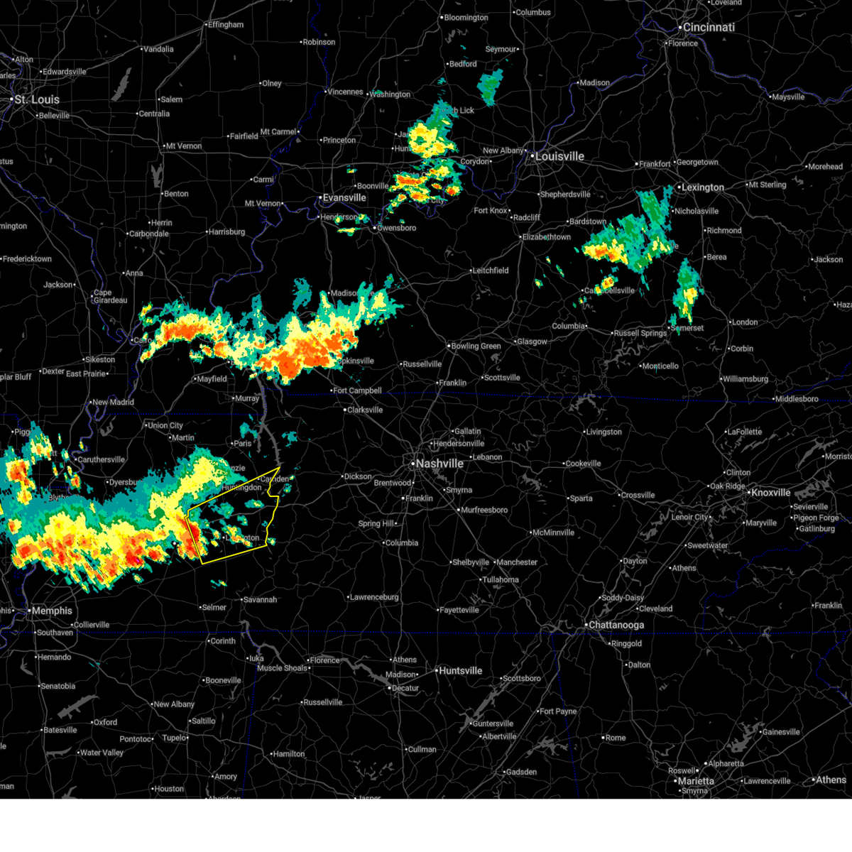
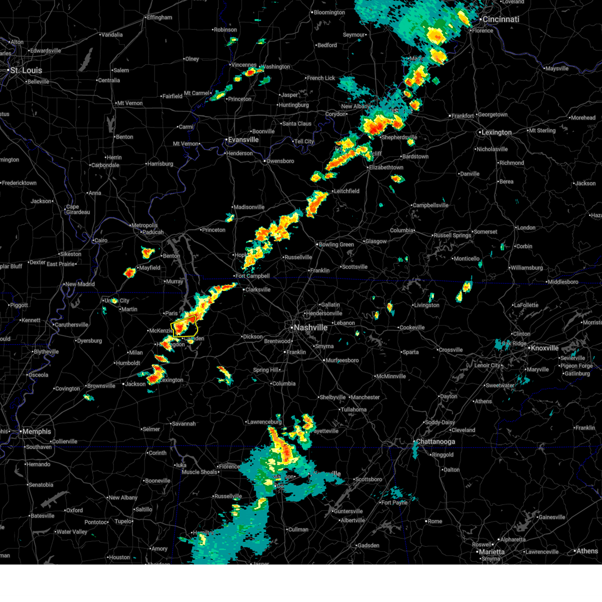
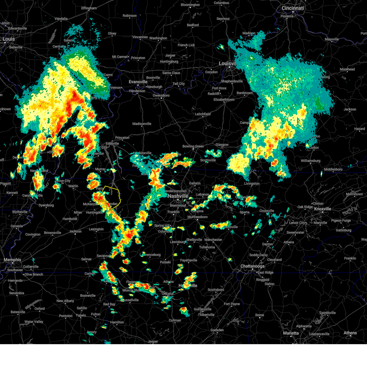
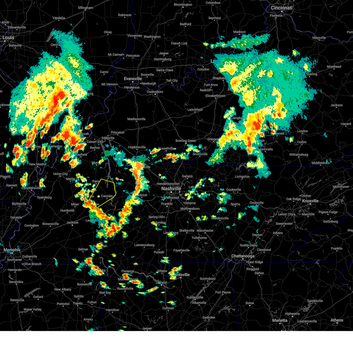
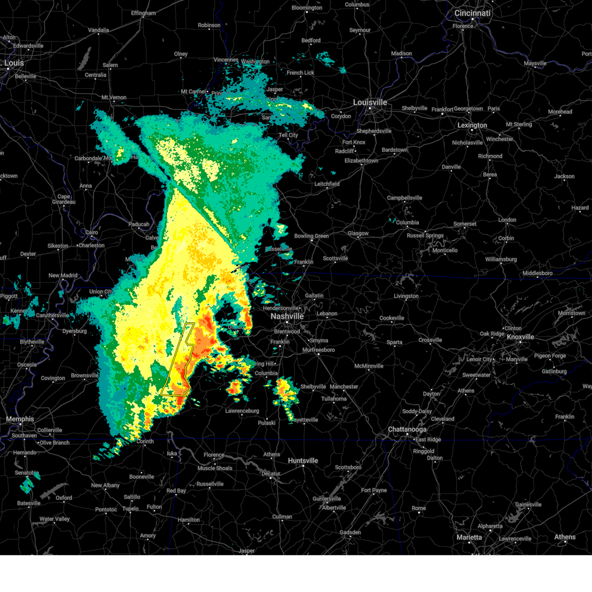
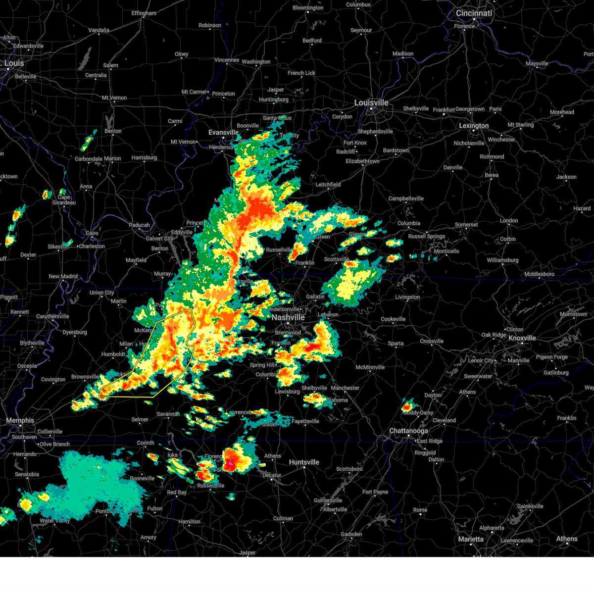
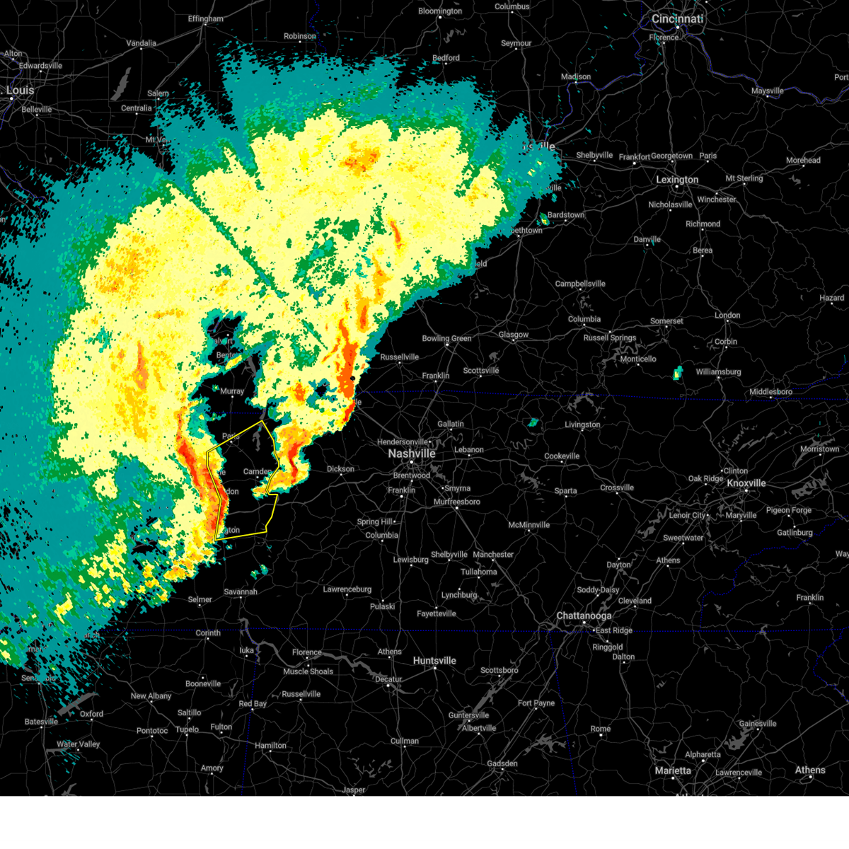
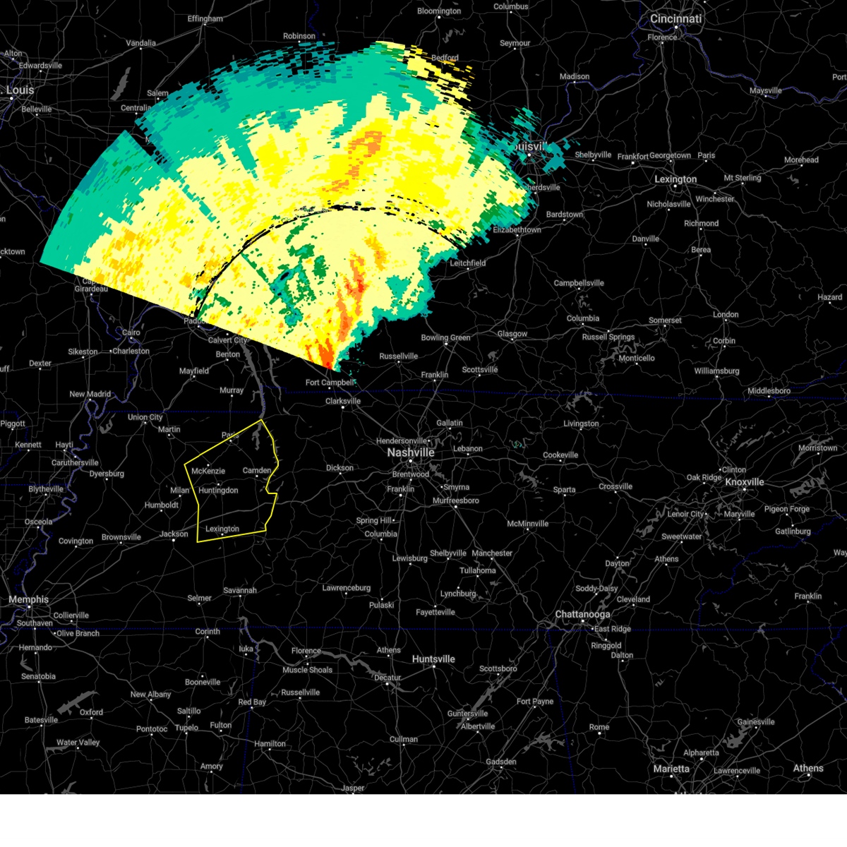
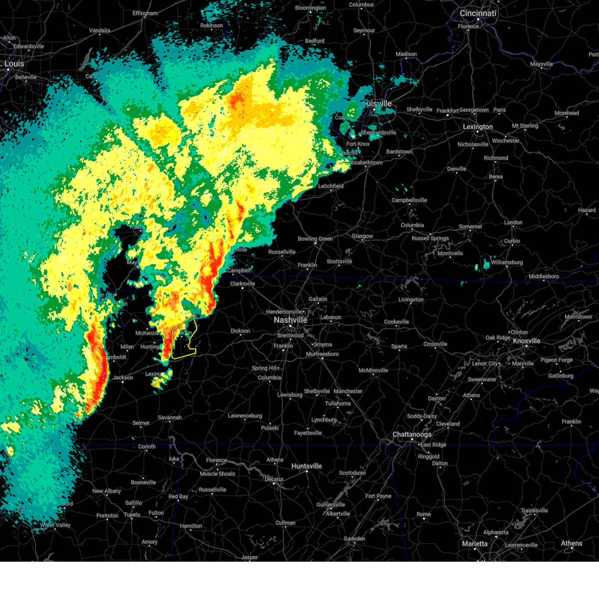
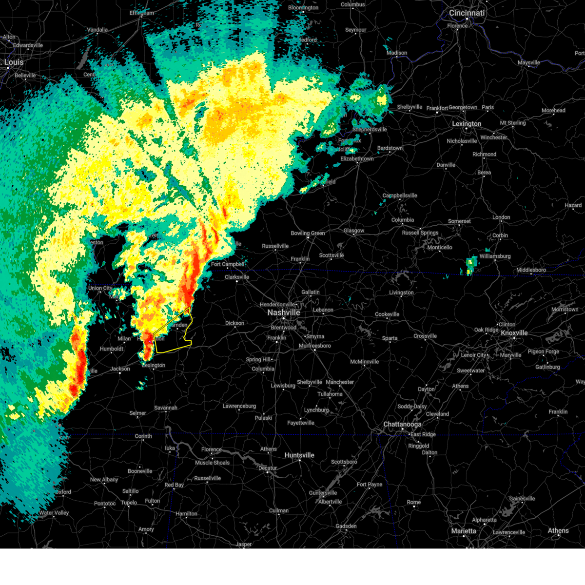
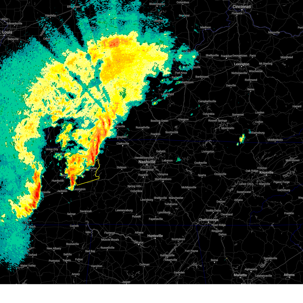
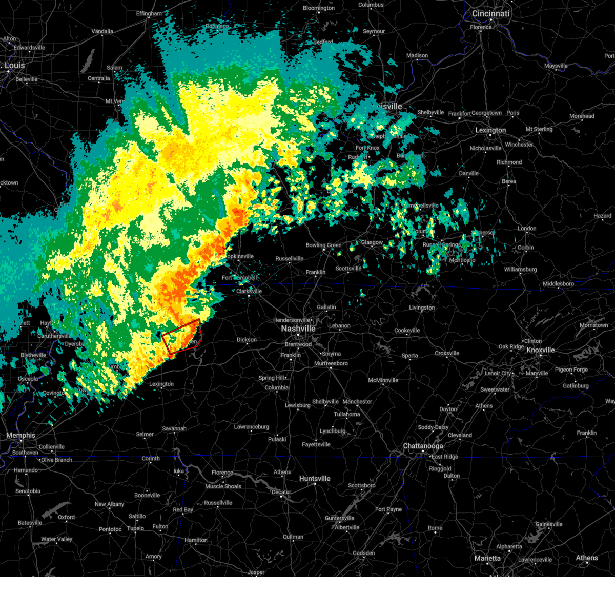
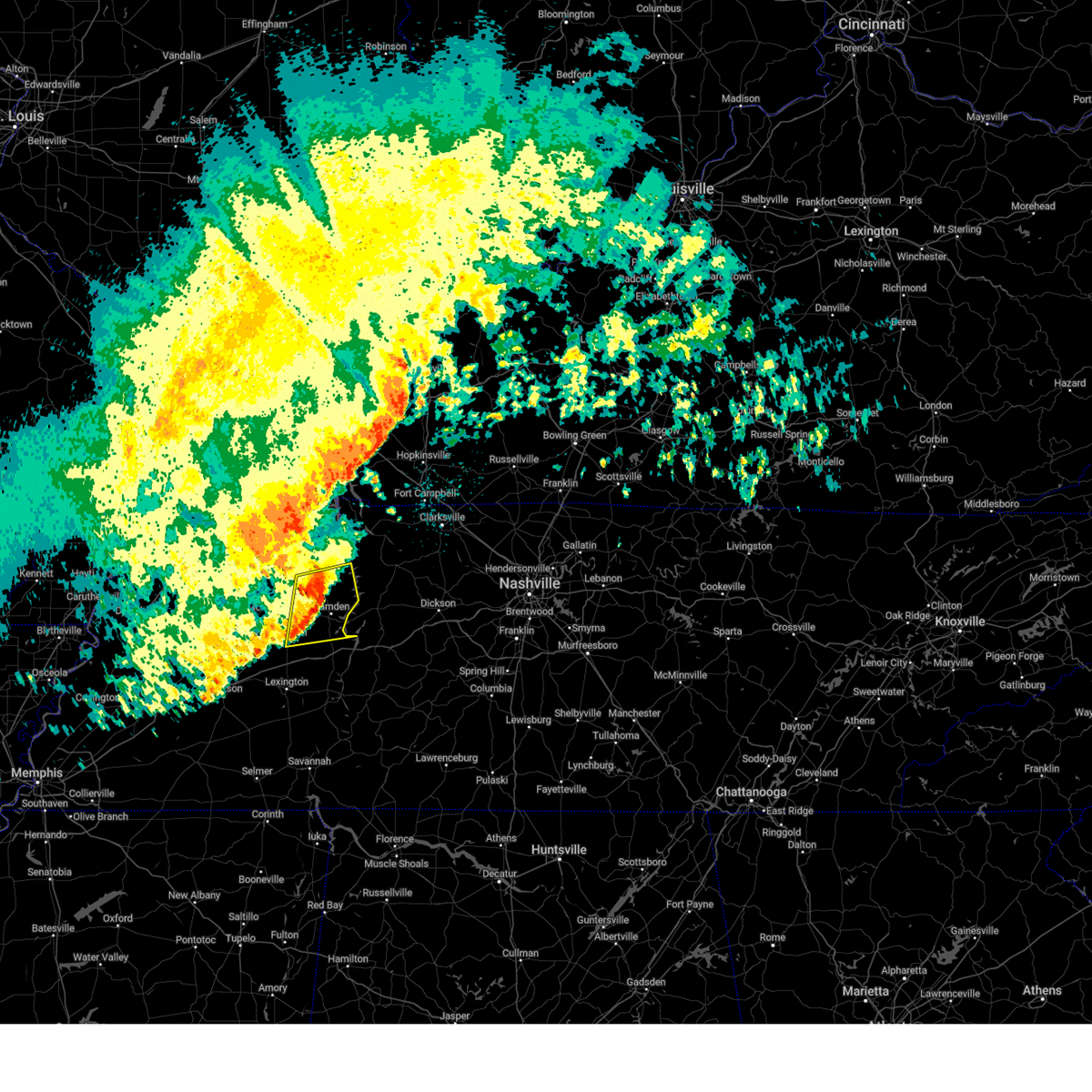
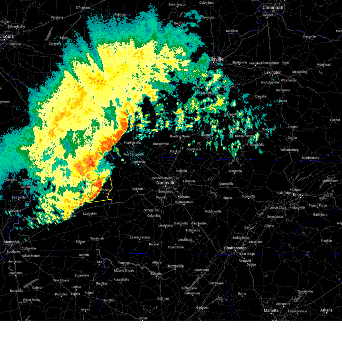
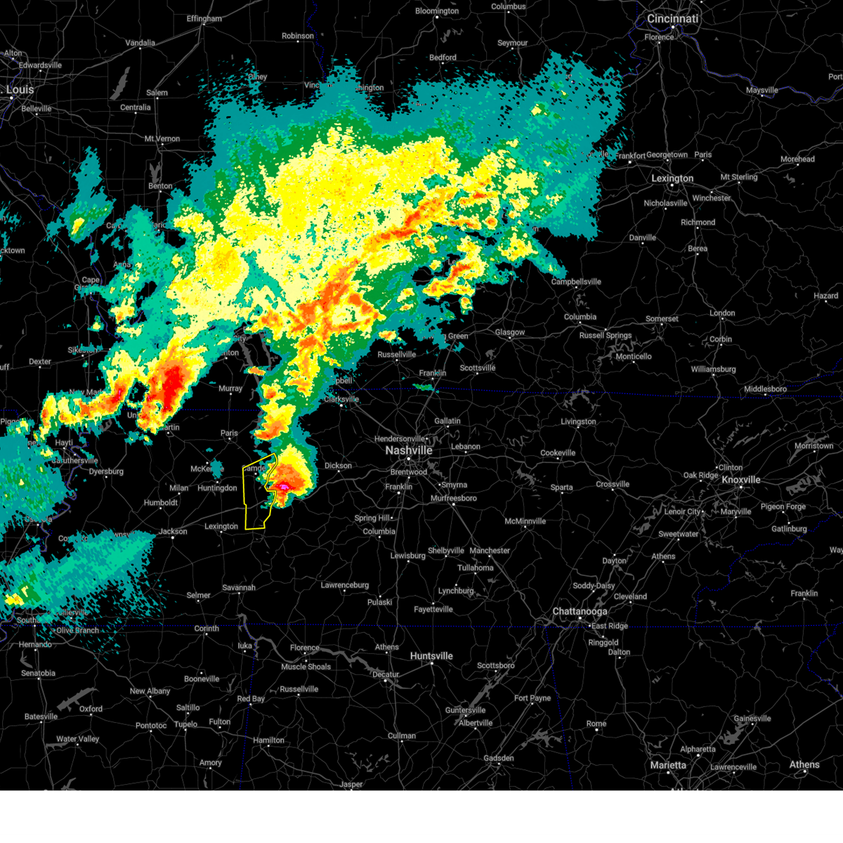
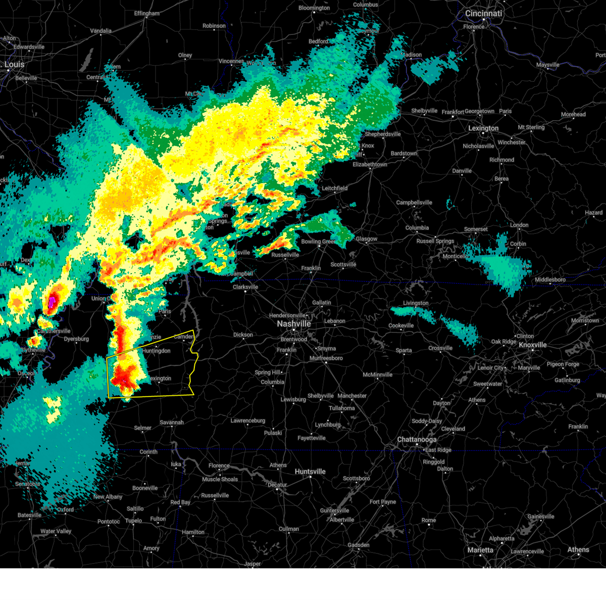
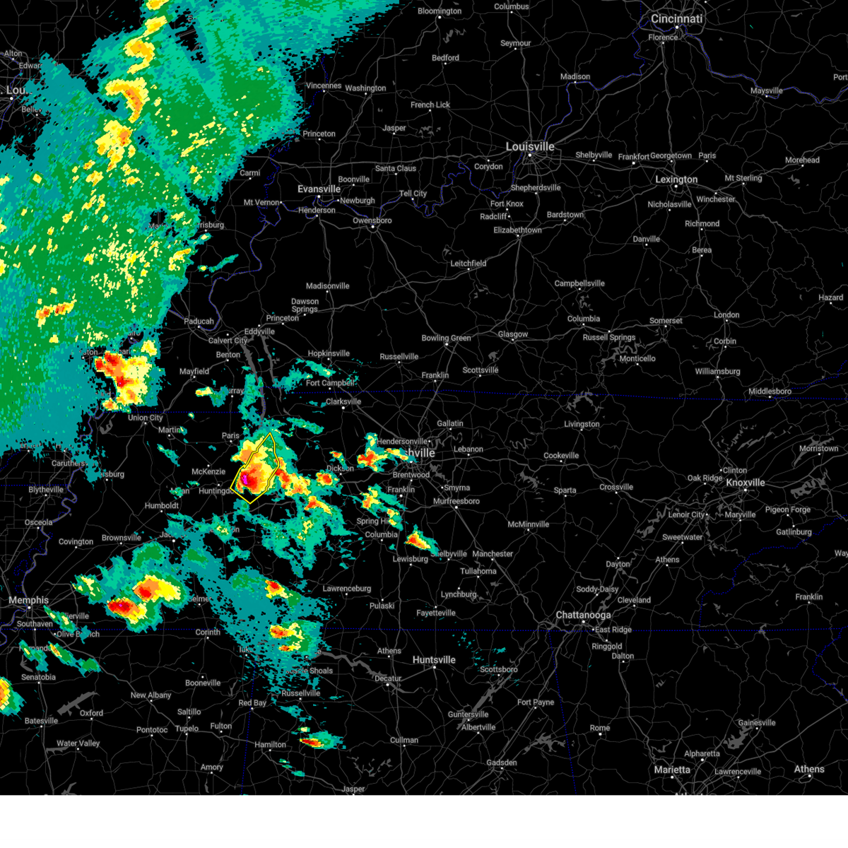
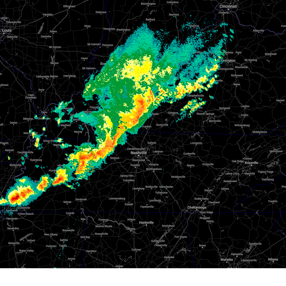
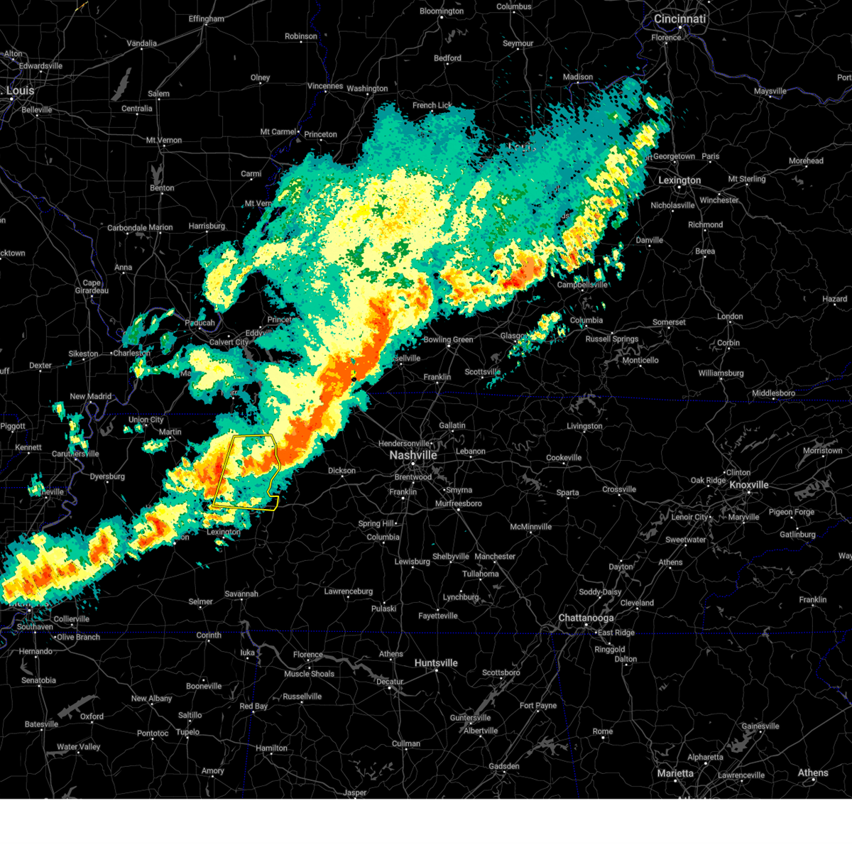
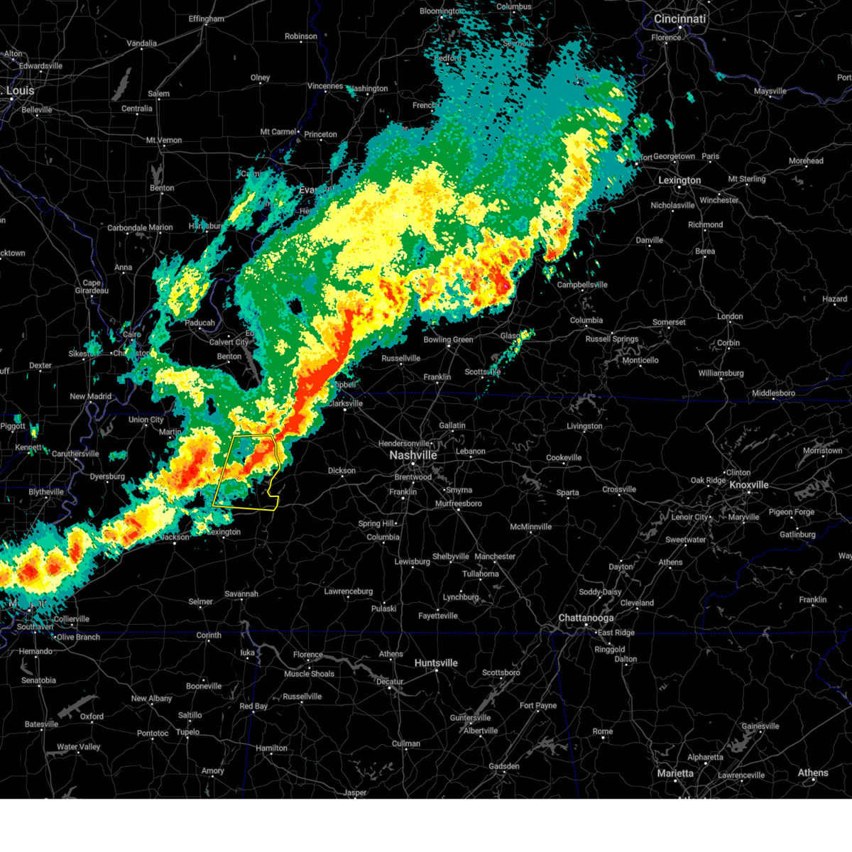
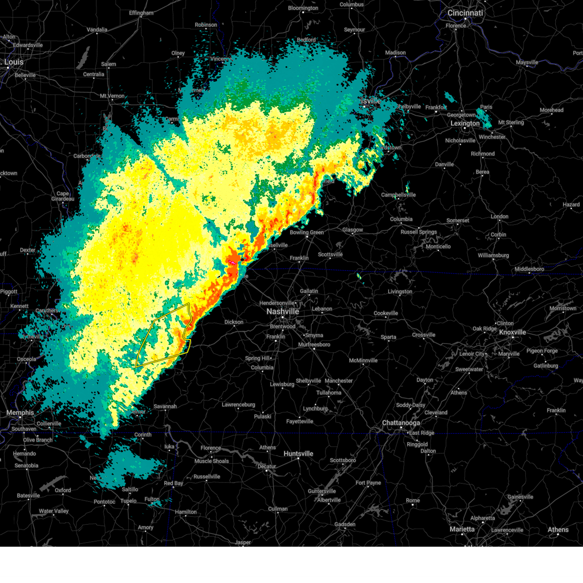
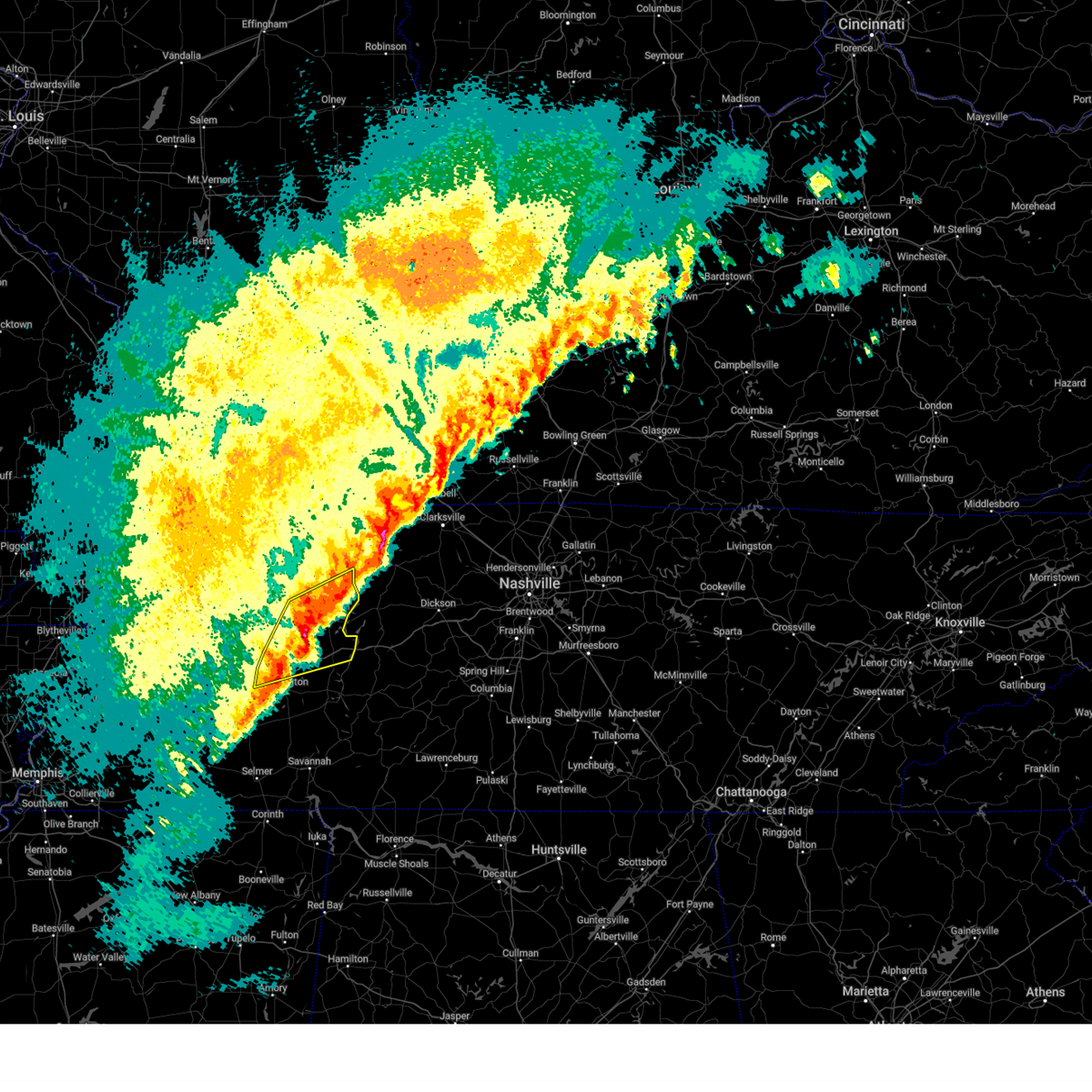
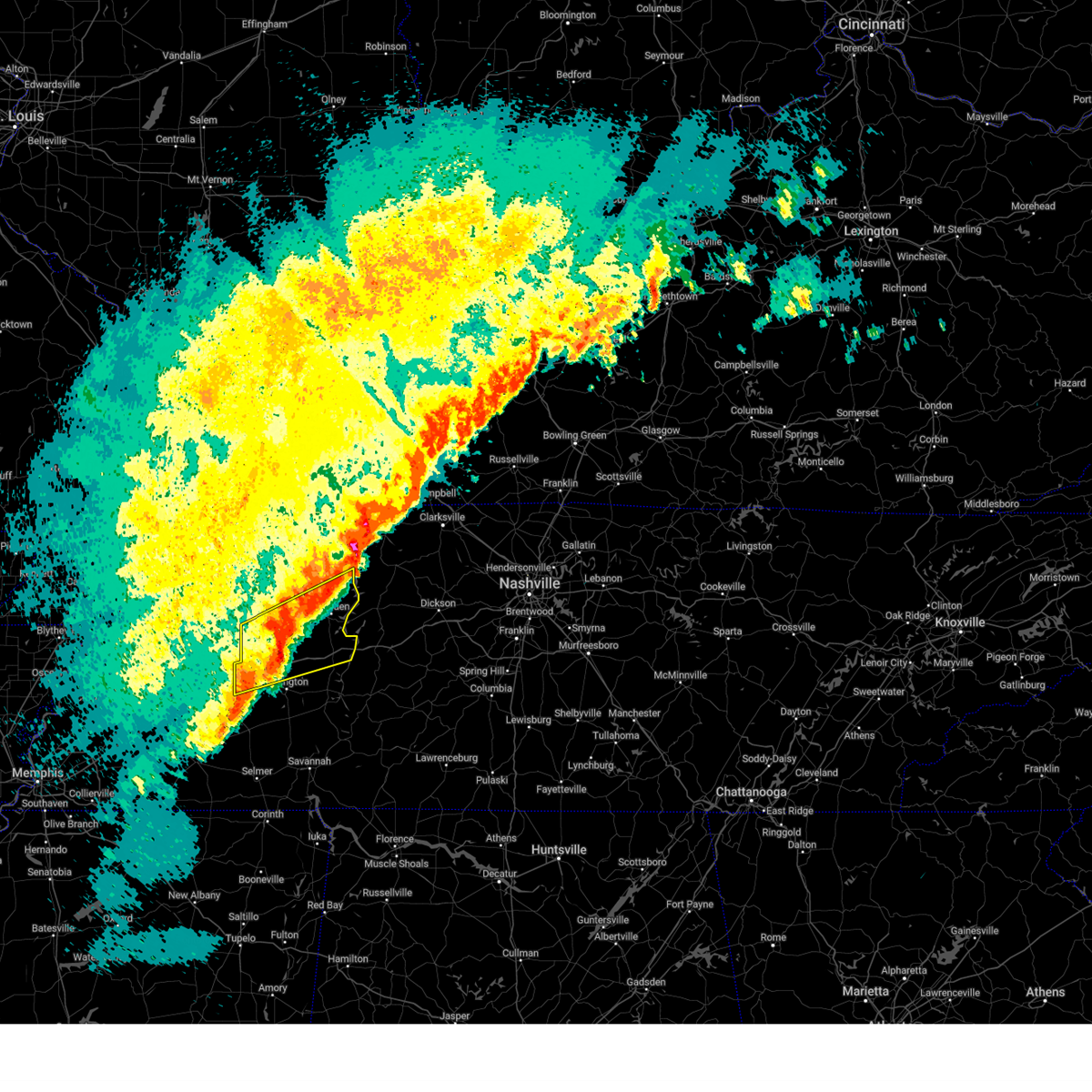
Hail Map for Eva, TN
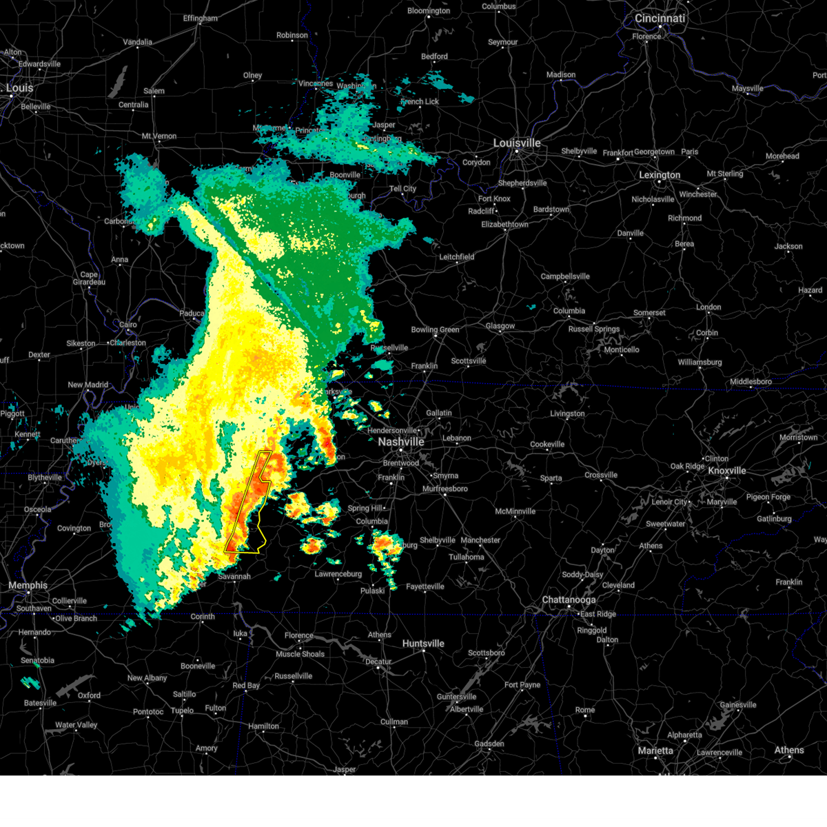
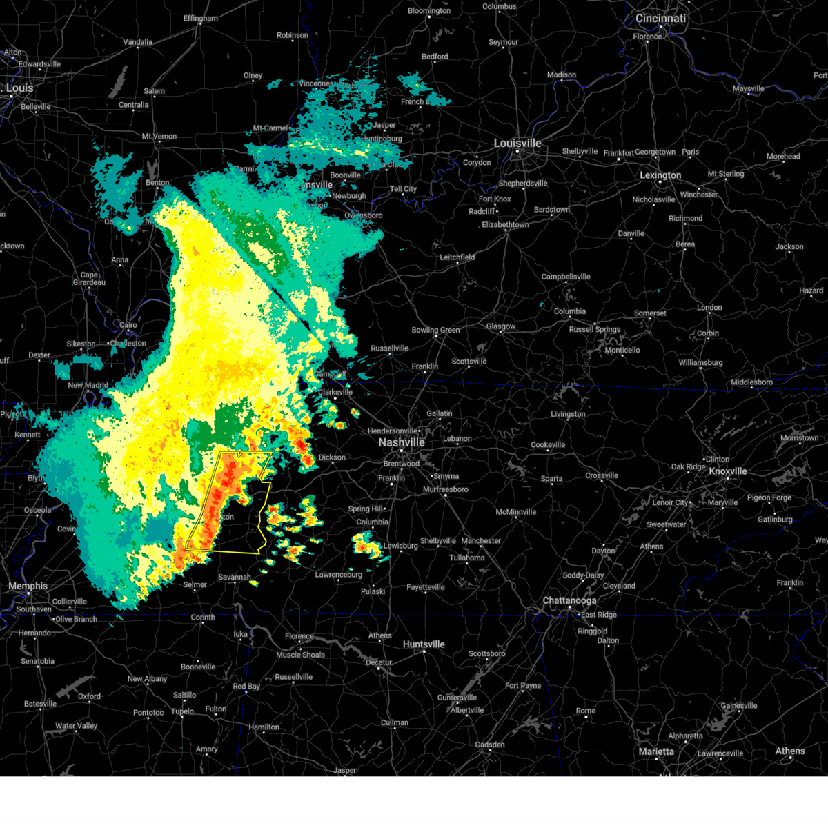
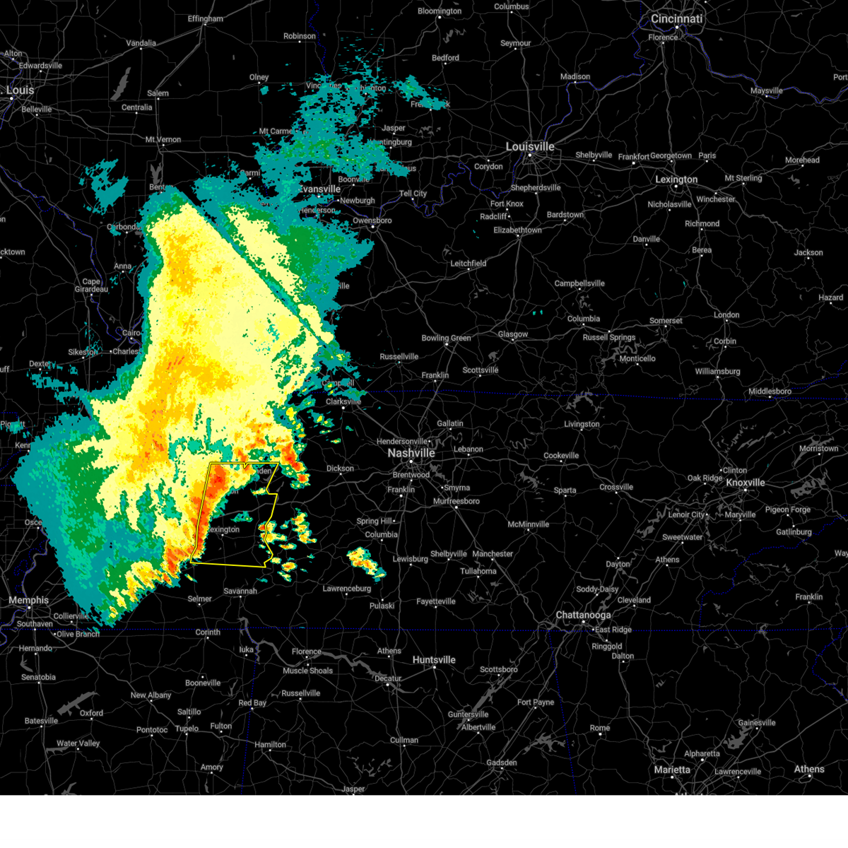
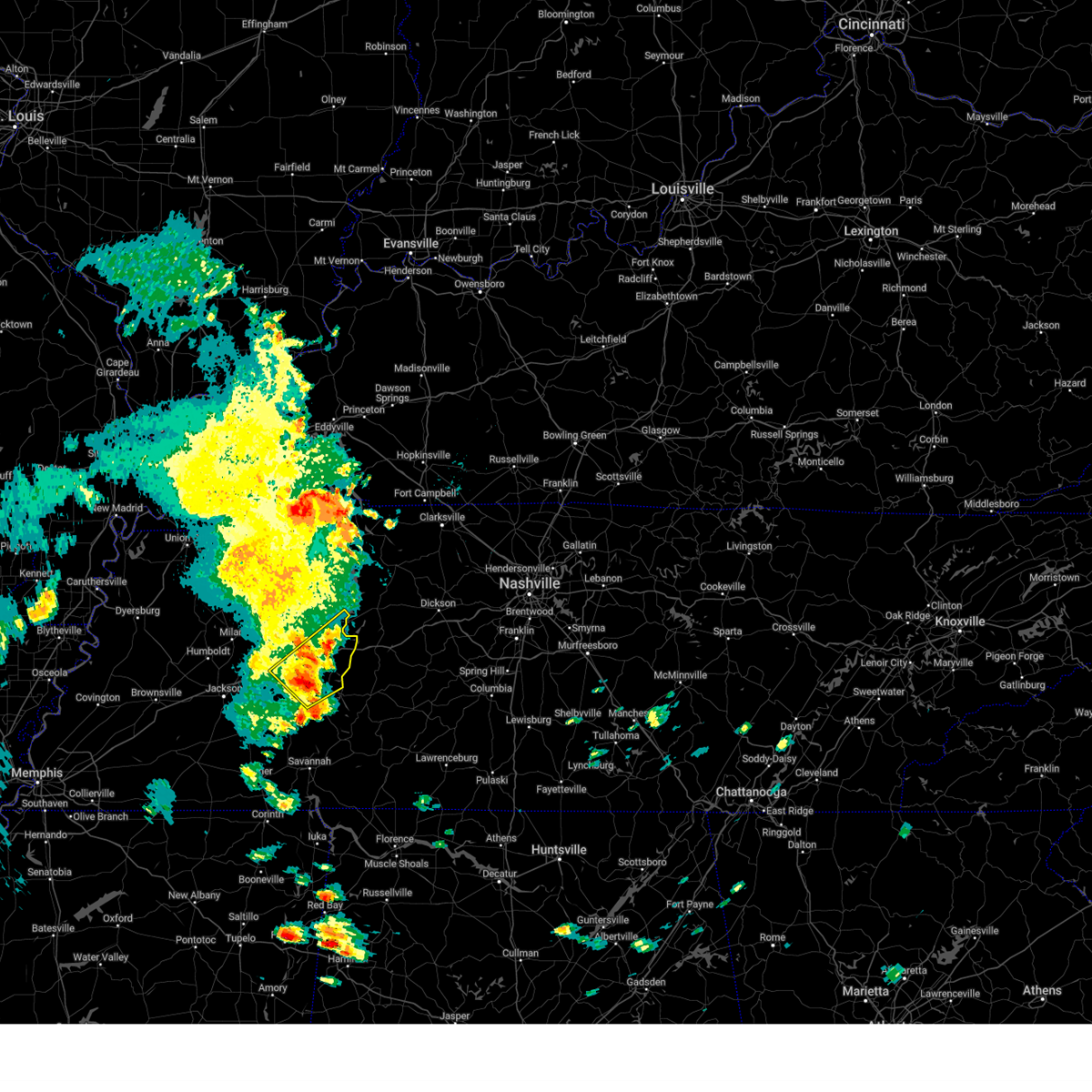
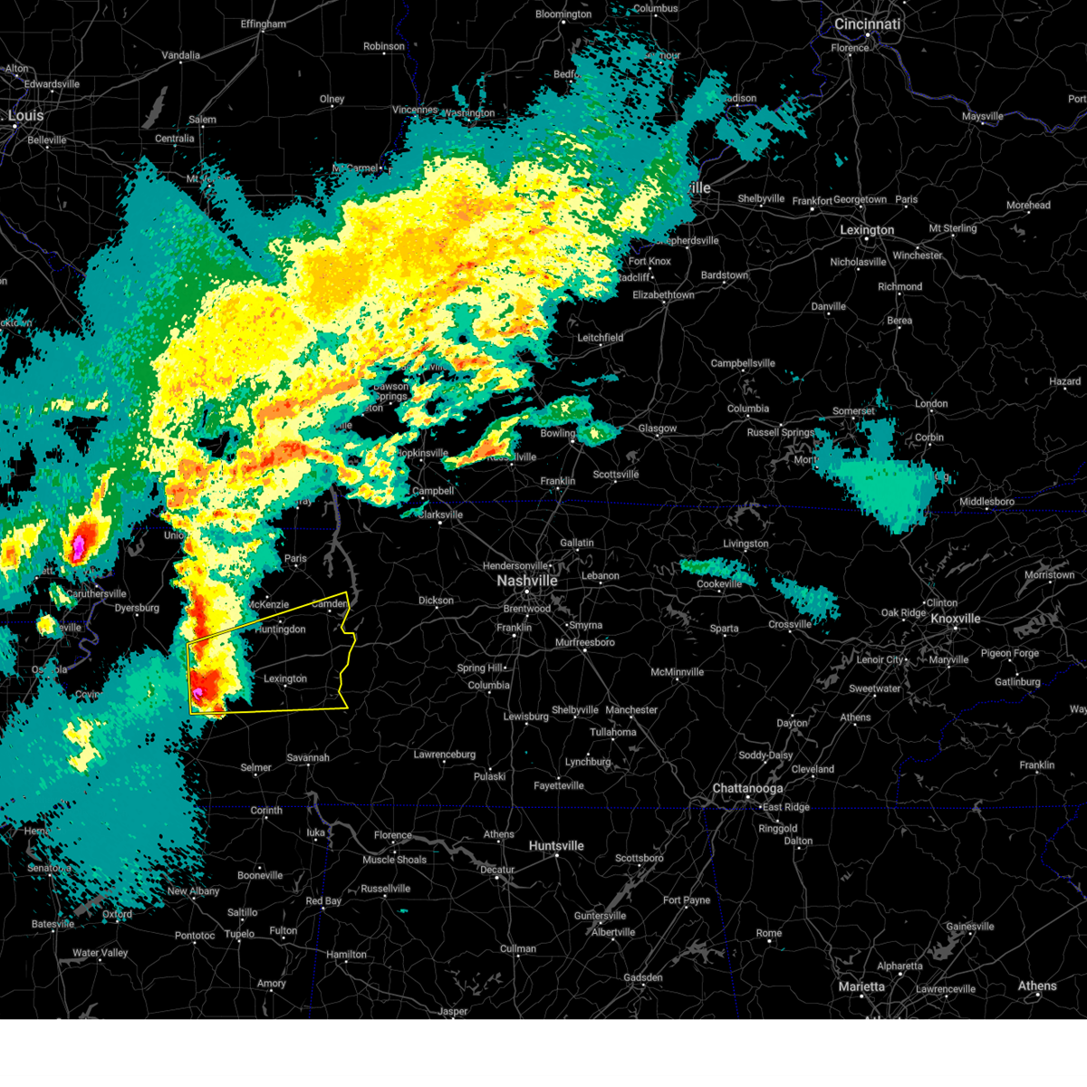
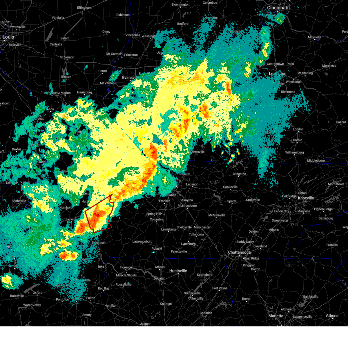
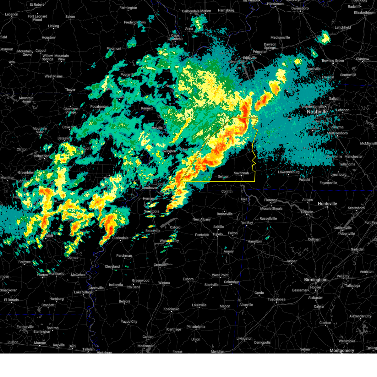
The Eva, TN area has had 1 report of on-the-ground hail by trained spotters, and has been under severe weather warnings 101 times during the past 12 months. Doppler radar has detected hail at or near Eva, TN on 65 occasions, including 6 occasions during the past year.
| Name: | Eva, TN |
| Where Located: | 29.1 miles E of Mc Kenzie, TN |
| Map: | Google Map for Eva, TN |
| Population: | 293 |
| Housing Units: | 216 |
| More Info: | Search Google for Eva, TN |
3
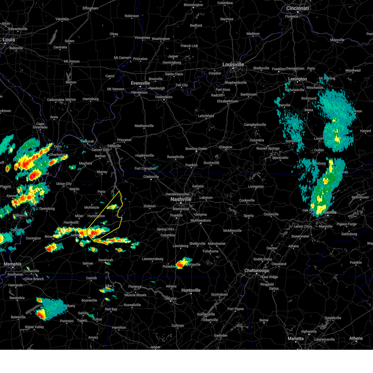
The Top Recent Hail Date for Eva, TN is Sunday, March 30, 2025 (4th out of 65)

Hail and Wind Damage Spotted near Eva, TN
| Date / Time | Report Details |
|---|---|
| 6/19/2025 1:24 AM CDT |
 Svrmeg the national weather service in memphis has issued a * severe thunderstorm warning for, henderson county in west tennessee, southern benton county in west tennessee, southern carroll county in west tennessee, northeastern madison county in west tennessee, north central chester county in west tennessee, northern decatur county in west tennessee, * until 230 am cdt. * at 124 am cdt, a severe thunderstorm was located over blue goose, or 10 miles west of lexington, moving east at 45 mph (radar indicated). Hazards include 60 mph wind gusts and quarter size hail. Hail damage to vehicles is expected. Expect wind damage to roofs, siding, and trees. Svrmeg the national weather service in memphis has issued a * severe thunderstorm warning for, henderson county in west tennessee, southern benton county in west tennessee, southern carroll county in west tennessee, northeastern madison county in west tennessee, north central chester county in west tennessee, northern decatur county in west tennessee, * until 230 am cdt. * at 124 am cdt, a severe thunderstorm was located over blue goose, or 10 miles west of lexington, moving east at 45 mph (radar indicated). Hazards include 60 mph wind gusts and quarter size hail. Hail damage to vehicles is expected. Expect wind damage to roofs, siding, and trees.
|
| 6/18/2025 6:26 PM CDT | The storm which prompted the warning has moved out of the area. therefore, the warning will be allowed to expire. |
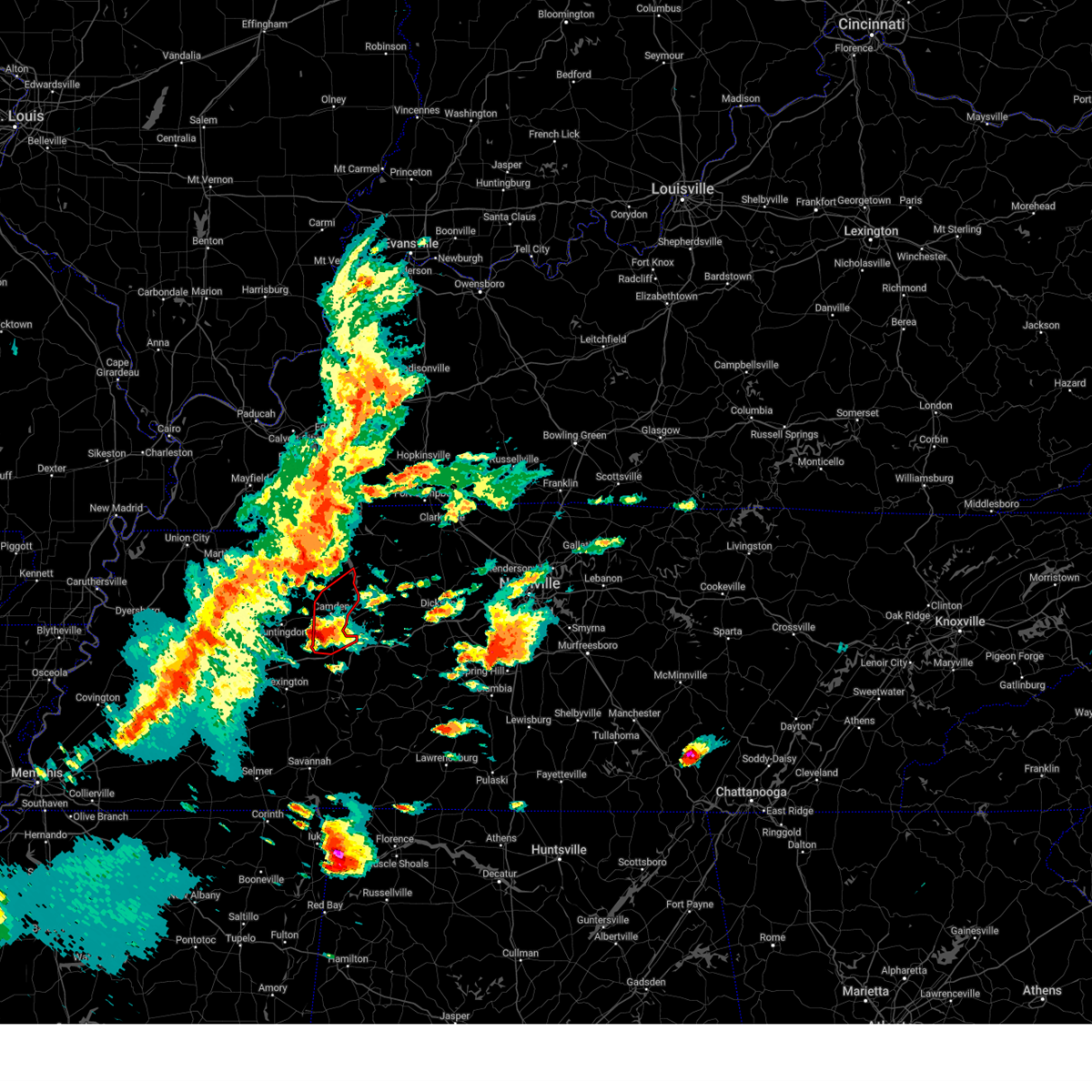
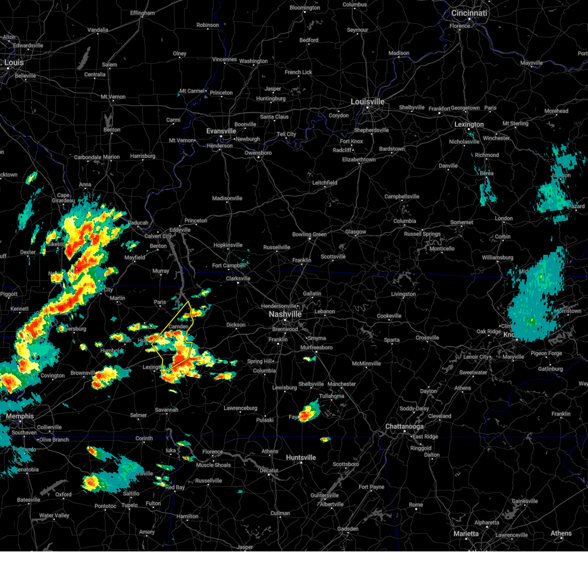
| 6/18/2025 6:22 PM CDT | At 621 pm cdt, a severe thunderstorm was located 7 miles north of camden, moving east at 30 mph (radar indicated). Hazards include 60 mph wind gusts and quarter size hail. Hail damage to vehicles is expected. expect wind damage to roofs, siding, and trees. Locations impacted include, camden, big sandy, and nathan bedford forrest state park. |
| 6/18/2025 6:22 PM CDT | the severe thunderstorm warning has been cancelled and is no longer in effect |
| 6/18/2025 6:10 PM CDT |
 the severe thunderstorm warning has been cancelled and is no longer in effect the severe thunderstorm warning has been cancelled and is no longer in effect
|
| 6/18/2025 6:10 PM CDT |
 At 609 pm cdt, a severe thunderstorm was located 7 miles northwest of camden, moving east at 30 mph (radar indicated). Hazards include 60 mph wind gusts and quarter size hail. Hail damage to vehicles is expected. expect wind damage to roofs, siding, and trees. Locations impacted include, camden, big sandy, spring creek, and nathan bedford forrest state park. At 609 pm cdt, a severe thunderstorm was located 7 miles northwest of camden, moving east at 30 mph (radar indicated). Hazards include 60 mph wind gusts and quarter size hail. Hail damage to vehicles is expected. expect wind damage to roofs, siding, and trees. Locations impacted include, camden, big sandy, spring creek, and nathan bedford forrest state park.
|
| 6/18/2025 6:03 PM CDT | Svrmeg the national weather service in memphis has issued a * severe thunderstorm warning for, central benton county in west tennessee, northeastern carroll county in west tennessee, southeastern henry county in west tennessee, * until 630 pm cdt. * at 603 pm cdt, a severe thunderstorm was located near vale, or 9 miles northwest of camden, moving east at 30 mph (radar indicated). Hazards include 60 mph wind gusts and quarter size hail. Hail damage to vehicles is expected. Expect wind damage to roofs, siding, and trees. |
| 6/6/2025 2:13 PM CDT |
 the severe thunderstorm warning has been cancelled and is no longer in effect the severe thunderstorm warning has been cancelled and is no longer in effect
|
| 6/6/2025 2:13 PM CDT |
 At 213 pm cdt, a severe thunderstorm was located near vale, or 9 miles northwest of camden, moving northeast at 40 mph (radar indicated). Hazards include 60 mph wind gusts. Expect damage to roofs, siding, and trees. Locations impacted include, paris, camden, springville, big sandy, mansfield, haigler ridge, sunnyside, van dyke, manleyville, spring creek, old springville, and nathan bedford forrest state park. At 213 pm cdt, a severe thunderstorm was located near vale, or 9 miles northwest of camden, moving northeast at 40 mph (radar indicated). Hazards include 60 mph wind gusts. Expect damage to roofs, siding, and trees. Locations impacted include, paris, camden, springville, big sandy, mansfield, haigler ridge, sunnyside, van dyke, manleyville, spring creek, old springville, and nathan bedford forrest state park.
|
| 6/6/2025 1:49 PM CDT |
 Svrmeg the national weather service in memphis has issued a * severe thunderstorm warning for, benton county in west tennessee, northeastern carroll county in west tennessee, southeastern henry county in west tennessee, * until 230 pm cdt. * at 149 pm cdt, a severe thunderstorm was located near huntingdon, moving northeast at 40 mph (radar indicated). Hazards include 60 mph wind gusts and penny size hail. expect damage to roofs, siding, and trees Svrmeg the national weather service in memphis has issued a * severe thunderstorm warning for, benton county in west tennessee, northeastern carroll county in west tennessee, southeastern henry county in west tennessee, * until 230 pm cdt. * at 149 pm cdt, a severe thunderstorm was located near huntingdon, moving northeast at 40 mph (radar indicated). Hazards include 60 mph wind gusts and penny size hail. expect damage to roofs, siding, and trees
|
| 5/25/2025 2:08 PM CDT |
 The storm which prompted the warning has moved out of the area. therefore, the warning will be allowed to expire. The storm which prompted the warning has moved out of the area. therefore, the warning will be allowed to expire.
|
| 5/25/2025 1:58 PM CDT |
 the severe thunderstorm warning has been cancelled and is no longer in effect the severe thunderstorm warning has been cancelled and is no longer in effect
|
| 5/25/2025 1:58 PM CDT |
 At 157 pm cdt, a severe thunderstorm was located 10 miles northeast of parsons, or 12 miles northwest of linden, moving east at 45 mph (radar indicated). Hazards include 60 mph wind gusts and penny size hail. Expect damage to roofs, siding, and trees. Locations impacted include, nathan bedford forrest state park, busseltown, jeannette, haney, mount tabor, sugar tree, parsons, red walnut, decaturville, scotts hill, cozette, camden, lick skillet, sardis, perryville, gumdale, montgomery, wilkinstown, darden, and bath springs. At 157 pm cdt, a severe thunderstorm was located 10 miles northeast of parsons, or 12 miles northwest of linden, moving east at 45 mph (radar indicated). Hazards include 60 mph wind gusts and penny size hail. Expect damage to roofs, siding, and trees. Locations impacted include, nathan bedford forrest state park, busseltown, jeannette, haney, mount tabor, sugar tree, parsons, red walnut, decaturville, scotts hill, cozette, camden, lick skillet, sardis, perryville, gumdale, montgomery, wilkinstown, darden, and bath springs.
|
| 5/25/2025 1:45 PM CDT |
 At 145 pm cdt, a severe thunderstorm was located 7 miles east of natchez trace state park, moving east at 45 mph (radar indicated). Hazards include 60 mph wind gusts and penny size hail. Expect damage to roofs, siding, and trees. Locations impacted include, nathan bedford forrest state park, dollar, busseltown, jeannette, reagan, haney, lexington, rock hill, holladay, roby, mount tabor, sugar tree, parsons, red walnut, timberlake, decaturville, hinson springs, scotts hill, cozette, and camden. At 145 pm cdt, a severe thunderstorm was located 7 miles east of natchez trace state park, moving east at 45 mph (radar indicated). Hazards include 60 mph wind gusts and penny size hail. Expect damage to roofs, siding, and trees. Locations impacted include, nathan bedford forrest state park, dollar, busseltown, jeannette, reagan, haney, lexington, rock hill, holladay, roby, mount tabor, sugar tree, parsons, red walnut, timberlake, decaturville, hinson springs, scotts hill, cozette, and camden.
|
| 5/25/2025 1:36 PM CDT |
 At 136 pm cdt, a severe thunderstorm was located over natchez trace state park, moving east at 45 mph (radar indicated). Hazards include 60 mph wind gusts and penny size hail. Expect damage to roofs, siding, and trees. Locations impacted include, dollar, reagan, lexington, rock hill, bruceton, holladay, middle fork, decaturville, palmer shelter, hinson springs, buena vista, hollow rock, camden, lick skillet, clarksburg, perryville, montgomery, huron, warrens bluff, and vale. At 136 pm cdt, a severe thunderstorm was located over natchez trace state park, moving east at 45 mph (radar indicated). Hazards include 60 mph wind gusts and penny size hail. Expect damage to roofs, siding, and trees. Locations impacted include, dollar, reagan, lexington, rock hill, bruceton, holladay, middle fork, decaturville, palmer shelter, hinson springs, buena vista, hollow rock, camden, lick skillet, clarksburg, perryville, montgomery, huron, warrens bluff, and vale.
|
| 5/25/2025 1:24 PM CDT |
 Svrmeg the national weather service in memphis has issued a * severe thunderstorm warning for, henderson county in west tennessee, benton county in west tennessee, carroll county in west tennessee, northeastern chester county in west tennessee, decatur county in west tennessee, * until 215 pm cdt. * at 124 pm cdt, a severe thunderstorm was located over parkers crossroads, or near lexington, moving east at 45 mph (radar indicated). Hazards include 60 mph wind gusts and penny size hail. expect damage to roofs, siding, and trees Svrmeg the national weather service in memphis has issued a * severe thunderstorm warning for, henderson county in west tennessee, benton county in west tennessee, carroll county in west tennessee, northeastern chester county in west tennessee, decatur county in west tennessee, * until 215 pm cdt. * at 124 pm cdt, a severe thunderstorm was located over parkers crossroads, or near lexington, moving east at 45 mph (radar indicated). Hazards include 60 mph wind gusts and penny size hail. expect damage to roofs, siding, and trees
|
| 5/20/2025 5:17 PM CDT |
 At 516 pm cdt, severe thunderstorms were located along a line extending from near vale to near natchez trace state park to near henderson, moving east at 40 mph (radar indicated). Hazards include 60 mph wind gusts and quarter size hail. Hail damage to vehicles is expected. expect wind damage to roofs, siding, and trees. Locations impacted include, neely, pinson, dollar, reagan, madison hall, uptonville, lexington, rock hill, bruceton, holladay, leach, middle fork, blue goose, tate, palmer shelter, hinson springs, buena vista, pinson mounds state archaeological park, hollow rock, and camden. At 516 pm cdt, severe thunderstorms were located along a line extending from near vale to near natchez trace state park to near henderson, moving east at 40 mph (radar indicated). Hazards include 60 mph wind gusts and quarter size hail. Hail damage to vehicles is expected. expect wind damage to roofs, siding, and trees. Locations impacted include, neely, pinson, dollar, reagan, madison hall, uptonville, lexington, rock hill, bruceton, holladay, leach, middle fork, blue goose, tate, palmer shelter, hinson springs, buena vista, pinson mounds state archaeological park, hollow rock, and camden.
|
| 5/20/2025 4:54 PM CDT | The tornadic thunderstorm which prompted the warning has moved out of the warned area. therefore, the warning will be allowed to expire. a tornado watch remains in effect until 800 pm cdt for west tennessee. remember, a severe thunderstorm warning still remains in effect for benton county. |
| 5/20/2025 4:53 PM CDT | Svrmeg the national weather service in memphis has issued a * severe thunderstorm warning for, henderson county in west tennessee, benton county in west tennessee, carroll county in west tennessee, madison county in west tennessee, southern henry county in west tennessee, northern chester county in west tennessee, northern decatur county in west tennessee, * until 545 pm cdt. * at 452 pm cdt, severe thunderstorms were located along a line extending from near mckenzie to near blue goose to near mercer, moving east at 40 mph (radar indicated). Hazards include 70 mph wind gusts and quarter size hail. Hail damage to vehicles is expected. expect considerable tree damage. Wind damage is also likely to mobile homes, roofs, and outbuildings. |
| 5/20/2025 4:36 PM CDT |
 the tornado warning has been cancelled and is no longer in effect the tornado warning has been cancelled and is no longer in effect
|
| 5/20/2025 4:36 PM CDT |
 At 436 pm cdt, a severe thunderstorm capable of producing a tornado was located near camden, moving northeast at 40 mph (radar indicated rotation). Hazards include tornado and ping pong ball size hail. Flying debris will be dangerous to those caught without shelter. mobile homes will be damaged or destroyed. damage to roofs, windows, and vehicles will occur. tree damage is likely. Locations impacted include, camden, holladay, nathan bedford forrest state park, big sandy, and new johnsonville. At 436 pm cdt, a severe thunderstorm capable of producing a tornado was located near camden, moving northeast at 40 mph (radar indicated rotation). Hazards include tornado and ping pong ball size hail. Flying debris will be dangerous to those caught without shelter. mobile homes will be damaged or destroyed. damage to roofs, windows, and vehicles will occur. tree damage is likely. Locations impacted include, camden, holladay, nathan bedford forrest state park, big sandy, and new johnsonville.
|
| 5/20/2025 4:31 PM CDT |
 the severe thunderstorm warning has been cancelled and is no longer in effect the severe thunderstorm warning has been cancelled and is no longer in effect
|
| 5/20/2025 4:31 PM CDT |
 At 431 pm cdt, a severe thunderstorm was located 7 miles southwest of camden, moving northeast at 50 mph (radar indicated). Hazards include 60 mph wind gusts and half dollar size hail. Hail damage to vehicles is expected. expect wind damage to roofs, siding, and trees. Locations impacted include, camden, holladay, big sandy, nathan bedford forrest state park, and new johnsonville. At 431 pm cdt, a severe thunderstorm was located 7 miles southwest of camden, moving northeast at 50 mph (radar indicated). Hazards include 60 mph wind gusts and half dollar size hail. Hail damage to vehicles is expected. expect wind damage to roofs, siding, and trees. Locations impacted include, camden, holladay, big sandy, nathan bedford forrest state park, and new johnsonville.
|
| 5/20/2025 4:24 PM CDT | At 423 pm cdt, a severe thunderstorm was located near bruceton, or 12 miles southwest of camden, moving east at 50 mph (radar indicated). Hazards include golf ball size hail and 60 mph wind gusts. People and animals outdoors will be injured. expect hail damage to roofs, siding, windows, and vehicles. expect wind damage to roofs, siding, and trees. Locations impacted include, westport, hollow rock, camden, bruceton, holladay, nathan bedford forrest state park, dollar, garretsburg, big sandy, vale, buena vista, and new johnsonville. |
| 5/20/2025 4:24 PM CDT | the severe thunderstorm warning has been cancelled and is no longer in effect |
| 5/20/2025 4:22 PM CDT | At 421 pm cdt, a severe thunderstorm capable of producing a tornado was located 7 miles south of bruceton, or 10 miles southeast of huntingdon, moving northeast at 40 mph (radar indicated rotation). Hazards include tornado and golf ball size hail. Flying debris will be dangerous to those caught without shelter. mobile homes will be damaged or destroyed. damage to roofs, windows, and vehicles will occur. tree damage is likely. Locations impacted include, westport, hollow rock, camden, nathan bedford forrest state park, dollar, bruceton, holladay, garretsburg, yuma, buena vista, big sandy, new johnsonville, and huntingdon. |
| 5/20/2025 4:13 PM CDT | At 413 pm cdt, a severe thunderstorm was located 7 miles southeast of huntingdon, moving northeast at 55 mph (radar indicated). Hazards include golf ball size hail and 60 mph wind gusts. People and animals outdoors will be injured. expect hail damage to roofs, siding, windows, and vehicles. expect wind damage to roofs, siding, and trees. Locations impacted include, westport, hollow rock, hillard, parker's cross roads, camden, nathan bedford forrest state park, clarksburg, parkers crossroads, dollar, big sandy, vale, scott hill, bruceton, holladay, leach, wildersville, crews store, huntingdon, tate, and garretsburg. |
| 5/20/2025 4:11 PM CDT | At 410 pm cdt, a severe thunderstorm was located 7 miles north of parkers crossroads, or 8 miles south of huntingdon, moving northeast at 30 mph (radar indicated). Hazards include ping pong ball size hail and 60 mph wind gusts. People and animals outdoors will be injured. expect hail damage to roofs, siding, windows, and vehicles. expect wind damage to roofs, siding, and trees. Locations impacted include, hillard, nathan bedford forrest state park, dollar, bruceton, holladay, leach, tate, palmer shelter, ephesus, buena vista, westport, hollow rock, parker's cross roads, camden, clarksburg, parkers crossroads, jumbo, big sandy, vale, and scott hill. |
| 5/20/2025 4:11 PM CDT | At 411 pm cdt, a severe thunderstorm capable of producing a tornado was located near wildersville, or 9 miles south of huntingdon, moving northeast at 40 mph (radar indicated rotation). Hazards include tornado and ping pong ball size hail. Flying debris will be dangerous to those caught without shelter. mobile homes will be damaged or destroyed. damage to roofs, windows, and vehicles will occur. tree damage is likely. Locations impacted include, westport, hollow rock, hillard, parker's cross roads, camden, nathan bedford forrest state park, clarksburg, parkers crossroads, dollar, scott hill, bruceton, holladay, leach, wildersville, huntingdon, tate, garretsburg, palmer shelter, yuma, and buena vista. |
| 5/20/2025 4:09 PM CDT | Tormeg the national weather service in memphis has issued a * tornado warning for, northeastern henderson county in west tennessee, benton county in west tennessee, eastern carroll county in west tennessee, * until 500 pm cdt. * at 409 pm cdt, a severe thunderstorm capable of producing a tornado was located near parkers crossroads, or 10 miles northwest of natchez trace state park, moving northeast at 40 mph (radar indicated rotation). Hazards include tornado and quarter size hail. Flying debris will be dangerous to those caught without shelter. mobile homes will be damaged or destroyed. damage to roofs, windows, and vehicles will occur. Tree damage is likely. |
| 5/20/2025 3:58 PM CDT | Svrmeg the national weather service in memphis has issued a * severe thunderstorm warning for, northwestern henderson county in west tennessee, benton county in west tennessee, carroll county in west tennessee, southeastern henry county in west tennessee, * until 445 pm cdt. * at 358 pm cdt, a severe thunderstorm was located near parkers crossroads, or 10 miles south of huntingdon, moving northeast at 55 mph (radar indicated). Hazards include 60 mph wind gusts and quarter size hail. Hail damage to vehicles is expected. Expect wind damage to roofs, siding, and trees. |
| 5/20/2025 2:55 PM CDT |
 At 255 pm cdt, a severe thunderstorm was located near parsons, or 9 miles east of natchez trace state forest, moving east at 40 mph (radar indicated). Hazards include ping pong ball size hail and 60 mph wind gusts. People and animals outdoors will be injured. expect hail damage to roofs, siding, windows, and vehicles. expect wind damage to roofs, siding, and trees. Locations impacted include, westport, hollow rock, camden, nathan bedford forrest state park, dollar, jeannette, big sandy, natchez trace state park, bruceton, holladay, sugar tree, garretsburg, yuma, natchez trace state forest, cozette, bible hill, buena vista, clarksburg, and new johnsonville. At 255 pm cdt, a severe thunderstorm was located near parsons, or 9 miles east of natchez trace state forest, moving east at 40 mph (radar indicated). Hazards include ping pong ball size hail and 60 mph wind gusts. People and animals outdoors will be injured. expect hail damage to roofs, siding, windows, and vehicles. expect wind damage to roofs, siding, and trees. Locations impacted include, westport, hollow rock, camden, nathan bedford forrest state park, dollar, jeannette, big sandy, natchez trace state park, bruceton, holladay, sugar tree, garretsburg, yuma, natchez trace state forest, cozette, bible hill, buena vista, clarksburg, and new johnsonville.
|
| 5/20/2025 2:41 PM CDT | At 241 pm cdt, a severe thunderstorm was located over natchez trace state park, moving northeast at 40 mph (radar indicated). Hazards include 60 mph wind gusts and quarter size hail. Hail damage to vehicles is expected. expect wind damage to roofs, siding, and trees. Locations impacted include, nathan bedford forrest state park, dollar, jeannette, rock hill, bruceton, holladay, sugar tree, timberlake, cozette, buena vista, westport, hollow rock, parker's cross roads, camden, clarksburg, parkers crossroads, big sandy, natchez trace state park, wildersville, and garretsburg. |
| 5/20/2025 2:26 PM CDT |
 Svrmeg the national weather service in memphis has issued a * severe thunderstorm warning for, henderson county in west tennessee, benton county in west tennessee, eastern carroll county in west tennessee, northern decatur county in west tennessee, * until 315 pm cdt. * at 226 pm cdt, a severe thunderstorm was located over bargerton, or near lexington, moving northeast at 40 mph (radar indicated). Hazards include 60 mph wind gusts and quarter size hail. Hail damage to vehicles is expected. Expect wind damage to roofs, siding, and trees. Svrmeg the national weather service in memphis has issued a * severe thunderstorm warning for, henderson county in west tennessee, benton county in west tennessee, eastern carroll county in west tennessee, northern decatur county in west tennessee, * until 315 pm cdt. * at 226 pm cdt, a severe thunderstorm was located over bargerton, or near lexington, moving northeast at 40 mph (radar indicated). Hazards include 60 mph wind gusts and quarter size hail. Hail damage to vehicles is expected. Expect wind damage to roofs, siding, and trees.
|
| 5/16/2025 11:02 PM CDT | the severe thunderstorm warning has been cancelled and is no longer in effect |
| 5/16/2025 10:30 PM CDT | Svrmeg the national weather service in memphis has issued a * severe thunderstorm warning for, northern benton county in west tennessee, southeastern henry county in west tennessee, * until 1115 pm cdt. * at 1030 pm cdt, a severe thunderstorm was located over springville, or 10 miles southeast of paris, moving southeast at 30 mph (radar indicated). Hazards include 60 mph wind gusts and quarter size hail. Hail damage to vehicles is expected. Expect wind damage to roofs, siding, and trees. |
| 5/2/2025 11:12 AM CDT |
 Svrmeg the national weather service in memphis has issued a * severe thunderstorm warning for, northeastern henderson county in west tennessee, southern benton county in west tennessee, southeastern carroll county in west tennessee, northern decatur county in west tennessee, * until noon cdt. * at 1112 am cdt, a severe thunderstorm was located over natchez trace state forest, moving northeast at 40 mph (radar indicated). Hazards include 60 mph wind gusts and quarter size hail. Hail damage to vehicles is expected. Expect wind damage to roofs, siding, and trees. Svrmeg the national weather service in memphis has issued a * severe thunderstorm warning for, northeastern henderson county in west tennessee, southern benton county in west tennessee, southeastern carroll county in west tennessee, northern decatur county in west tennessee, * until noon cdt. * at 1112 am cdt, a severe thunderstorm was located over natchez trace state forest, moving northeast at 40 mph (radar indicated). Hazards include 60 mph wind gusts and quarter size hail. Hail damage to vehicles is expected. Expect wind damage to roofs, siding, and trees.
|
| 4/5/2025 3:54 PM CDT |
 The storms which prompted the warning have moved out of the area. therefore, the warning will be allowed to expire. however, heavy rain is still likely with these thunderstorms. a tornado watch remains in effect until 700 pm cdt for west tennessee. The storms which prompted the warning have moved out of the area. therefore, the warning will be allowed to expire. however, heavy rain is still likely with these thunderstorms. a tornado watch remains in effect until 700 pm cdt for west tennessee.
|
| 4/5/2025 3:43 PM CDT |
 At 343 pm cdt, severe thunderstorms were located along a line extending from near springville to near new johnsonville to 8 miles northeast of parsons, moving east at 55 mph (radar indicated). Hazards include 60 mph wind gusts and quarter size hail. Hail damage to vehicles is expected. expect wind damage to roofs, siding, and trees. Locations impacted include, camden, haigler ridge, nathan bedford forrest state park, jeannette, manleyville, big sandy, old springville, india, holladay, big sandy unit tennessee national wildlife refuge, sunnyside, sugar tree, springville, spring creek, porter court, hickory forks, paris landing state park, cozette, bible hill, and paris. At 343 pm cdt, severe thunderstorms were located along a line extending from near springville to near new johnsonville to 8 miles northeast of parsons, moving east at 55 mph (radar indicated). Hazards include 60 mph wind gusts and quarter size hail. Hail damage to vehicles is expected. expect wind damage to roofs, siding, and trees. Locations impacted include, camden, haigler ridge, nathan bedford forrest state park, jeannette, manleyville, big sandy, old springville, india, holladay, big sandy unit tennessee national wildlife refuge, sunnyside, sugar tree, springville, spring creek, porter court, hickory forks, paris landing state park, cozette, bible hill, and paris.
|
| 4/5/2025 3:43 PM CDT |
 the severe thunderstorm warning has been cancelled and is no longer in effect the severe thunderstorm warning has been cancelled and is no longer in effect
|
| 4/5/2025 3:31 PM CDT |
 the severe thunderstorm warning has been cancelled and is no longer in effect the severe thunderstorm warning has been cancelled and is no longer in effect
|
| 4/5/2025 3:31 PM CDT |
 At 330 pm cdt, severe thunderstorms were located along a line extending from near paris to 8 miles southeast of bruceton to near darden, moving east at 70 mph (radar indicated). Hazards include 60 mph wind gusts and quarter size hail. Hail damage to vehicles is expected. expect wind damage to roofs, siding, and trees. Locations impacted include, dollar, old springville, lexington, bruceton, holladay, porter court, mckenzie, palmer shelter, hinson springs, buena vista, hollow rock, camden, haigler ridge, clarksburg, vale, india, natchez trace state park, van dyke, mixie, and wildersville. At 330 pm cdt, severe thunderstorms were located along a line extending from near paris to 8 miles southeast of bruceton to near darden, moving east at 70 mph (radar indicated). Hazards include 60 mph wind gusts and quarter size hail. Hail damage to vehicles is expected. expect wind damage to roofs, siding, and trees. Locations impacted include, dollar, old springville, lexington, bruceton, holladay, porter court, mckenzie, palmer shelter, hinson springs, buena vista, hollow rock, camden, haigler ridge, clarksburg, vale, india, natchez trace state park, van dyke, mixie, and wildersville.
|
| 4/5/2025 3:20 PM CDT |
 At 320 pm cdt, severe thunderstorms were located along a line extending from mckenzie to near parkers crossroads to near lexington, moving east at 60 mph (radar indicated). Hazards include 60 mph wind gusts and quarter size hail. Hail damage to vehicles is expected. expect wind damage to roofs, siding, and trees. Locations impacted include, hickory flat, dollar, old springville, lexington, bruceton, holladay, leach, blue goose, porter court, mckenzie, tate, palmer shelter, hinson springs, buena vista, hollow rock, camden, haigler ridge, clarksburg, trezevant, and vale. At 320 pm cdt, severe thunderstorms were located along a line extending from mckenzie to near parkers crossroads to near lexington, moving east at 60 mph (radar indicated). Hazards include 60 mph wind gusts and quarter size hail. Hail damage to vehicles is expected. expect wind damage to roofs, siding, and trees. Locations impacted include, hickory flat, dollar, old springville, lexington, bruceton, holladay, leach, blue goose, porter court, mckenzie, tate, palmer shelter, hinson springs, buena vista, hollow rock, camden, haigler ridge, clarksburg, trezevant, and vale.
|
| 4/5/2025 3:20 PM CDT |
 the severe thunderstorm warning has been cancelled and is no longer in effect the severe thunderstorm warning has been cancelled and is no longer in effect
|
| 4/5/2025 3:09 PM CDT | the severe thunderstorm warning has been cancelled and is no longer in effect |
| 4/5/2025 3:09 PM CDT | At 309 pm cdt, severe thunderstorms were located along a line extending from 7 miles south of gleason to 6 miles northwest of bargerton to near mifflin, moving east at 60 mph (radar indicated). Hazards include 60 mph wind gusts and quarter size hail. Hail damage to vehicles is expected. expect wind damage to roofs, siding, and trees. Locations impacted include, hickory flat, dollar, bradford, atwood, cades, old springville, ledbetter, lexington, bruceton, holladay, leach, blue goose, porter court, mckenzie, tate, palmer shelter, hinson springs, gann, buena vista, and hollow rock. |
| 4/5/2025 3:02 PM CDT | Svrmeg the national weather service in memphis has issued a * severe thunderstorm warning for, southeastern weakley county in west tennessee, henderson county in west tennessee, southeastern gibson county in west tennessee, benton county in west tennessee, carroll county in west tennessee, northeastern madison county in west tennessee, southeastern henry county in west tennessee, northern decatur county in west tennessee, * until 400 pm cdt. * at 302 pm cdt, severe thunderstorms were located along a line extending from near bradford to 7 miles northwest of blue goose to 6 miles southeast of bemis, moving east at 60 mph (radar indicated). Hazards include 60 mph wind gusts and quarter size hail. Hail damage to vehicles is expected. Expect wind damage to roofs, siding, and trees. |
| 4/5/2025 2:55 PM CDT |
 At 255 pm cdt, a severe thunderstorm was located over camden, moving northeast at 60 mph (radar indicated). Hazards include 60 mph wind gusts and quarter size hail. Hail damage to vehicles is expected. expect wind damage to roofs, siding, and trees. Locations impacted include, camden, holladay, and nathan bedford forrest state park. At 255 pm cdt, a severe thunderstorm was located over camden, moving northeast at 60 mph (radar indicated). Hazards include 60 mph wind gusts and quarter size hail. Hail damage to vehicles is expected. expect wind damage to roofs, siding, and trees. Locations impacted include, camden, holladay, and nathan bedford forrest state park.
|
| 4/5/2025 2:55 PM CDT |
 the severe thunderstorm warning has been cancelled and is no longer in effect the severe thunderstorm warning has been cancelled and is no longer in effect
|
| 4/5/2025 2:41 PM CDT |
 At 241 pm cdt, a severe thunderstorm was located near bruceton, or 9 miles east of huntingdon, moving northeast at 50 mph (radar indicated). Hazards include 60 mph wind gusts and quarter size hail. Hail damage to vehicles is expected. expect wind damage to roofs, siding, and trees. Locations impacted include, westport, hollow rock, camden, bruceton, holladay, nathan bedford forrest state park, dollar, garretsburg, yuma, buena vista, huntingdon, and new johnsonville. At 241 pm cdt, a severe thunderstorm was located near bruceton, or 9 miles east of huntingdon, moving northeast at 50 mph (radar indicated). Hazards include 60 mph wind gusts and quarter size hail. Hail damage to vehicles is expected. expect wind damage to roofs, siding, and trees. Locations impacted include, westport, hollow rock, camden, bruceton, holladay, nathan bedford forrest state park, dollar, garretsburg, yuma, buena vista, huntingdon, and new johnsonville.
|
| 4/5/2025 2:41 PM CDT |
 the severe thunderstorm warning has been cancelled and is no longer in effect the severe thunderstorm warning has been cancelled and is no longer in effect
|
| 4/5/2025 2:30 PM CDT |
 Svrmeg the national weather service in memphis has issued a * severe thunderstorm warning for, north central henderson county in west tennessee, benton county in west tennessee, eastern carroll county in west tennessee, * until 330 pm cdt. * at 230 pm cdt, a severe thunderstorm was located 7 miles south of huntingdon, moving northeast at 60 mph (radar indicated). Hazards include 60 mph wind gusts and quarter size hail. Hail damage to vehicles is expected. Expect wind damage to roofs, siding, and trees. Svrmeg the national weather service in memphis has issued a * severe thunderstorm warning for, north central henderson county in west tennessee, benton county in west tennessee, eastern carroll county in west tennessee, * until 330 pm cdt. * at 230 pm cdt, a severe thunderstorm was located 7 miles south of huntingdon, moving northeast at 60 mph (radar indicated). Hazards include 60 mph wind gusts and quarter size hail. Hail damage to vehicles is expected. Expect wind damage to roofs, siding, and trees.
|
| 4/5/2025 5:35 AM CDT |
 The storm which prompted the warning has weakened below severe limits, and no longer appears capable of producing a tornado. therefore, the warning will be allowed to expire. a tornado watch remains in effect until 600 am cdt for west tennessee. The storm which prompted the warning has weakened below severe limits, and no longer appears capable of producing a tornado. therefore, the warning will be allowed to expire. a tornado watch remains in effect until 600 am cdt for west tennessee.
|
| 4/5/2025 5:21 AM CDT |
 The storms which prompted the warning have moved out of the warned area.therefore, the warning will be allowed to expire. a tornado watch remains in effect until 600 am cdt for west tennessee. remember, a tornado warning still remains in effect for northeast carroll, southeast henry, and benton counties until 545am cdt!. The storms which prompted the warning have moved out of the warned area.therefore, the warning will be allowed to expire. a tornado watch remains in effect until 600 am cdt for west tennessee. remember, a tornado warning still remains in effect for northeast carroll, southeast henry, and benton counties until 545am cdt!.
|
| 4/5/2025 5:16 AM CDT |
 At 516 am cdt, severe thunderstorms were located along a line extending from near vale to 7 miles north of wildersville to near blue goose, moving east at 35 mph (radar indicated). Hazards include 60 mph wind gusts and quarter size hail. Hail damage to vehicles is expected. expect wind damage to roofs, siding, and trees. Locations impacted include, westport, hollow rock, camden, mansfield, haigler ridge, nathan bedford forrest state park, dollar, manleyville, big sandy, old springville, vale, bruceton, van dyke, mixie, springville, spring creek, crews store, garretsburg, ephesus, and buena vista. At 516 am cdt, severe thunderstorms were located along a line extending from near vale to 7 miles north of wildersville to near blue goose, moving east at 35 mph (radar indicated). Hazards include 60 mph wind gusts and quarter size hail. Hail damage to vehicles is expected. expect wind damage to roofs, siding, and trees. Locations impacted include, westport, hollow rock, camden, mansfield, haigler ridge, nathan bedford forrest state park, dollar, manleyville, big sandy, old springville, vale, bruceton, van dyke, mixie, springville, spring creek, crews store, garretsburg, ephesus, and buena vista.
|
| 4/5/2025 5:09 AM CDT |
 Tormeg the national weather service in memphis has issued a * tornado warning for, central benton county in west tennessee, northeastern carroll county in west tennessee, southeastern henry county in west tennessee, * until 545 am cdt. * at 509 am cdt, a severe thunderstorm capable of producing a tornado was located over vale, or 11 miles northeast of huntingdon, moving east at 40 mph (radar indicated rotation). Hazards include tornado. Flying debris will be dangerous to those caught without shelter. mobile homes will be damaged or destroyed. damage to roofs, windows, and vehicles will occur. Tree damage is likely. Tormeg the national weather service in memphis has issued a * tornado warning for, central benton county in west tennessee, northeastern carroll county in west tennessee, southeastern henry county in west tennessee, * until 545 am cdt. * at 509 am cdt, a severe thunderstorm capable of producing a tornado was located over vale, or 11 miles northeast of huntingdon, moving east at 40 mph (radar indicated rotation). Hazards include tornado. Flying debris will be dangerous to those caught without shelter. mobile homes will be damaged or destroyed. damage to roofs, windows, and vehicles will occur. Tree damage is likely.
|
| 4/5/2025 5:04 AM CDT |
 the severe thunderstorm warning has been cancelled and is no longer in effect the severe thunderstorm warning has been cancelled and is no longer in effect
|
| 4/5/2025 5:04 AM CDT |
 At 504 am cdt, severe thunderstorms were located along a line extending from near mckenzie to 8 miles southwest of huntingdon to 7 miles west of blue goose, moving east at 35 mph (radar indicated). Hazards include 60 mph wind gusts and quarter size hail. Hail damage to vehicles is expected. expect wind damage to roofs, siding, and trees. Locations impacted include, howley, hillard, mansfield, nathan bedford forrest state park, dollar, old springville, bruceton, holladay, leach, mckenzie, tate, palmer shelter, routon, ephesus, henry, buena vista, wingo, westport, hollow rock, and camden. At 504 am cdt, severe thunderstorms were located along a line extending from near mckenzie to 8 miles southwest of huntingdon to 7 miles west of blue goose, moving east at 35 mph (radar indicated). Hazards include 60 mph wind gusts and quarter size hail. Hail damage to vehicles is expected. expect wind damage to roofs, siding, and trees. Locations impacted include, howley, hillard, mansfield, nathan bedford forrest state park, dollar, old springville, bruceton, holladay, leach, mckenzie, tate, palmer shelter, routon, ephesus, henry, buena vista, wingo, westport, hollow rock, and camden.
|
| 4/5/2025 4:58 AM CDT |
 the severe thunderstorm warning has been cancelled and is no longer in effect the severe thunderstorm warning has been cancelled and is no longer in effect
|
| 4/5/2025 4:58 AM CDT |
 At 458 am cdt, severe thunderstorms were located along a line extending from near mckenzie to 8 miles southwest of huntingdon to 7 miles east of fairview, moving east at 35 mph (radar indicated). Hazards include 60 mph wind gusts and quarter size hail. Hail damage to vehicles is expected. expect wind damage to roofs, siding, and trees. Locations impacted include, howley, hickory flat, hillard, mansfield, nathan bedford forrest state park, dollar, old springville, bruceton, holladay, leach, mckenzie, tate, palmer shelter, routon, ephesus, henry, buena vista, wingo, westport, and hollow rock. At 458 am cdt, severe thunderstorms were located along a line extending from near mckenzie to 8 miles southwest of huntingdon to 7 miles east of fairview, moving east at 35 mph (radar indicated). Hazards include 60 mph wind gusts and quarter size hail. Hail damage to vehicles is expected. expect wind damage to roofs, siding, and trees. Locations impacted include, howley, hickory flat, hillard, mansfield, nathan bedford forrest state park, dollar, old springville, bruceton, holladay, leach, mckenzie, tate, palmer shelter, routon, ephesus, henry, buena vista, wingo, westport, and hollow rock.
|
| 4/5/2025 4:49 AM CDT |
 Svrmeg the national weather service in memphis has issued a * severe thunderstorm warning for, southeastern weakley county in west tennessee, northern henderson county in west tennessee, benton county in west tennessee, carroll county in west tennessee, northeastern madison county in west tennessee, southern henry county in west tennessee, northeastern decatur county in west tennessee, * until 530 am cdt. * at 448 am cdt, severe thunderstorms were located along a line extending from mckenzie to 8 miles southeast of atwood to near fairview, moving east at 35 mph (radar indicated). Hazards include 60 mph wind gusts and quarter size hail. Hail damage to vehicles is expected. Expect wind damage to roofs, siding, and trees. Svrmeg the national weather service in memphis has issued a * severe thunderstorm warning for, southeastern weakley county in west tennessee, northern henderson county in west tennessee, benton county in west tennessee, carroll county in west tennessee, northeastern madison county in west tennessee, southern henry county in west tennessee, northeastern decatur county in west tennessee, * until 530 am cdt. * at 448 am cdt, severe thunderstorms were located along a line extending from mckenzie to 8 miles southeast of atwood to near fairview, moving east at 35 mph (radar indicated). Hazards include 60 mph wind gusts and quarter size hail. Hail damage to vehicles is expected. Expect wind damage to roofs, siding, and trees.
|
| 4/3/2025 9:42 PM CDT |
 the severe thunderstorm warning has been cancelled and is no longer in effect the severe thunderstorm warning has been cancelled and is no longer in effect
|
| 4/3/2025 9:29 PM CDT |
 the severe thunderstorm warning has been cancelled and is no longer in effect the severe thunderstorm warning has been cancelled and is no longer in effect
|
| 4/3/2025 9:29 PM CDT |
 At 929 pm cdt, a severe thunderstorm was located 8 miles south of new johnsonville, or 10 miles south of camden, moving northeast at 55 mph (radar indicated). Hazards include two inch hail and 70 mph wind gusts. People and animals outdoors will be injured. expect hail damage to roofs, siding, windows, and vehicles. expect considerable tree damage. wind damage is also likely to mobile homes, roofs, and outbuildings. Locations impacted include, camden, holladay, nathan bedford forrest state park, sugar tree, jeannette, hickory forks, cozette, i-40 near the tennessee river, bible hill, new johnsonville, and parsons. At 929 pm cdt, a severe thunderstorm was located 8 miles south of new johnsonville, or 10 miles south of camden, moving northeast at 55 mph (radar indicated). Hazards include two inch hail and 70 mph wind gusts. People and animals outdoors will be injured. expect hail damage to roofs, siding, windows, and vehicles. expect considerable tree damage. wind damage is also likely to mobile homes, roofs, and outbuildings. Locations impacted include, camden, holladay, nathan bedford forrest state park, sugar tree, jeannette, hickory forks, cozette, i-40 near the tennessee river, bible hill, new johnsonville, and parsons.
|
| 4/3/2025 9:22 PM CDT |
 Svrmeg the national weather service in memphis has issued a * severe thunderstorm warning for, northeastern henderson county in west tennessee, benton county in west tennessee, eastern carroll county in west tennessee, northern decatur county in west tennessee, * until 1000 pm cdt. * at 922 pm cdt, a severe thunderstorm was located 10 miles northeast of natchez trace state park, moving northeast at 55 mph (radar indicated). Hazards include two inch hail and 70 mph wind gusts. People and animals outdoors will be injured. expect hail damage to roofs, siding, windows, and vehicles. expect considerable tree damage. Wind damage is also likely to mobile homes, roofs, and outbuildings. Svrmeg the national weather service in memphis has issued a * severe thunderstorm warning for, northeastern henderson county in west tennessee, benton county in west tennessee, eastern carroll county in west tennessee, northern decatur county in west tennessee, * until 1000 pm cdt. * at 922 pm cdt, a severe thunderstorm was located 10 miles northeast of natchez trace state park, moving northeast at 55 mph (radar indicated). Hazards include two inch hail and 70 mph wind gusts. People and animals outdoors will be injured. expect hail damage to roofs, siding, windows, and vehicles. expect considerable tree damage. Wind damage is also likely to mobile homes, roofs, and outbuildings.
|
| 4/3/2025 9:19 PM CDT |
 the severe thunderstorm warning has been cancelled and is no longer in effect the severe thunderstorm warning has been cancelled and is no longer in effect
|
| 4/3/2025 9:19 PM CDT |
 At 919 pm cdt, a severe thunderstorm was located 8 miles northeast of natchez trace state park, moving northeast at 70 mph (radar indicated). Hazards include two inch hail and 70 mph wind gusts. People and animals outdoors will be injured. expect hail damage to roofs, siding, windows, and vehicles. expect considerable tree damage. wind damage is also likely to mobile homes, roofs, and outbuildings. Locations impacted include, hillard, nathan bedford forrest state park, dollar, jeannette, lexington, union cross, bruceton, holladay, leach, sugar tree, timberlake, tate, palmer shelter, cozette, buena vista, westport, hollow rock, parker's cross roads, camden, and clarksburg. At 919 pm cdt, a severe thunderstorm was located 8 miles northeast of natchez trace state park, moving northeast at 70 mph (radar indicated). Hazards include two inch hail and 70 mph wind gusts. People and animals outdoors will be injured. expect hail damage to roofs, siding, windows, and vehicles. expect considerable tree damage. wind damage is also likely to mobile homes, roofs, and outbuildings. Locations impacted include, hillard, nathan bedford forrest state park, dollar, jeannette, lexington, union cross, bruceton, holladay, leach, sugar tree, timberlake, tate, palmer shelter, cozette, buena vista, westport, hollow rock, parker's cross roads, camden, and clarksburg.
|
| 4/3/2025 9:05 PM CDT |
 At 904 pm cdt, a severe thunderstorm was located over parkers crossroads, or 8 miles north of lexington, moving east at 60 mph (radar indicated). Hazards include two inch hail and 70 mph wind gusts. People and animals outdoors will be injured. expect hail damage to roofs, siding, windows, and vehicles. expect considerable tree damage. wind damage is also likely to mobile homes, roofs, and outbuildings. Locations impacted include, hickory flat, dollar, atwood, lexington, rock hill, bruceton, holladay, leach, middle fork, blue goose, decaturville, tate, palmer shelter, hinson springs, buena vista, hollow rock, camden, clarksburg, perryville, and huron. At 904 pm cdt, a severe thunderstorm was located over parkers crossroads, or 8 miles north of lexington, moving east at 60 mph (radar indicated). Hazards include two inch hail and 70 mph wind gusts. People and animals outdoors will be injured. expect hail damage to roofs, siding, windows, and vehicles. expect considerable tree damage. wind damage is also likely to mobile homes, roofs, and outbuildings. Locations impacted include, hickory flat, dollar, atwood, lexington, rock hill, bruceton, holladay, leach, middle fork, blue goose, decaturville, tate, palmer shelter, hinson springs, buena vista, hollow rock, camden, clarksburg, perryville, and huron.
|
| 4/3/2025 9:05 PM CDT |
 the severe thunderstorm warning has been cancelled and is no longer in effect the severe thunderstorm warning has been cancelled and is no longer in effect
|
| 4/3/2025 8:59 PM CDT |
 At 859 pm cdt, a severe thunderstorm was located near parkers crossroads, or 9 miles northwest of natchez trace state park, moving northeast at 75 mph (radar indicated). Hazards include two inch hail and 70 mph wind gusts. People and animals outdoors will be injured. expect hail damage to roofs, siding, windows, and vehicles. expect considerable tree damage. wind damage is also likely to mobile homes, roofs, and outbuildings. Locations impacted include, hickory flat, dollar, atwood, jackson, ledbetter, madison hall, lexington, rock hill, bruceton, holladay, medina, leach, middle fork, blue goose, decaturville, tate, palmer shelter, hinson springs, buena vista, and hollow rock. At 859 pm cdt, a severe thunderstorm was located near parkers crossroads, or 9 miles northwest of natchez trace state park, moving northeast at 75 mph (radar indicated). Hazards include two inch hail and 70 mph wind gusts. People and animals outdoors will be injured. expect hail damage to roofs, siding, windows, and vehicles. expect considerable tree damage. wind damage is also likely to mobile homes, roofs, and outbuildings. Locations impacted include, hickory flat, dollar, atwood, jackson, ledbetter, madison hall, lexington, rock hill, bruceton, holladay, medina, leach, middle fork, blue goose, decaturville, tate, palmer shelter, hinson springs, buena vista, and hollow rock.
|
| 4/3/2025 8:55 PM CDT |
 At 855 pm cdt, a severe thunderstorm was located near parkers crossroads, or 12 miles north of lexington, moving northeast at 75 mph (radar indicated). Hazards include 70 mph wind gusts and ping pong ball size hail. People and animals outdoors will be injured. expect hail damage to roofs, siding, windows, and vehicles. expect considerable tree damage. wind damage is also likely to mobile homes, roofs, and outbuildings. Locations impacted include, hickory flat, dollar, atwood, jackson, westover, ledbetter, madison hall, lexington, rock hill, fairview, bruceton, holladay, medina, leach, middle fork, blue goose, decaturville, tate, palmer shelter, and hinson springs. At 855 pm cdt, a severe thunderstorm was located near parkers crossroads, or 12 miles north of lexington, moving northeast at 75 mph (radar indicated). Hazards include 70 mph wind gusts and ping pong ball size hail. People and animals outdoors will be injured. expect hail damage to roofs, siding, windows, and vehicles. expect considerable tree damage. wind damage is also likely to mobile homes, roofs, and outbuildings. Locations impacted include, hickory flat, dollar, atwood, jackson, westover, ledbetter, madison hall, lexington, rock hill, fairview, bruceton, holladay, medina, leach, middle fork, blue goose, decaturville, tate, palmer shelter, and hinson springs.
|
| 4/3/2025 8:55 PM CDT |
 the severe thunderstorm warning has been cancelled and is no longer in effect the severe thunderstorm warning has been cancelled and is no longer in effect
|
| 4/3/2025 8:44 PM CDT |
 At 844 pm cdt, a severe thunderstorm was located 7 miles east of fairview, or 9 miles northeast of jackson, moving northeast at 75 mph (radar indicated). Hazards include two inch hail and 70 mph wind gusts. People and animals outdoors will be injured. expect hail damage to roofs, siding, windows, and vehicles. expect considerable tree damage. wind damage is also likely to mobile homes, roofs, and outbuildings. Locations impacted include, neely, atwood, huntersville, westover, madison hall, rock hill, bruceton, leach, hinson springs, buena vista, hollow rock, camden, clarksburg, perryville, fruitland, warrens bluff, natchez trace state park, mclemoresville, scott hill, and milan. At 844 pm cdt, a severe thunderstorm was located 7 miles east of fairview, or 9 miles northeast of jackson, moving northeast at 75 mph (radar indicated). Hazards include two inch hail and 70 mph wind gusts. People and animals outdoors will be injured. expect hail damage to roofs, siding, windows, and vehicles. expect considerable tree damage. wind damage is also likely to mobile homes, roofs, and outbuildings. Locations impacted include, neely, atwood, huntersville, westover, madison hall, rock hill, bruceton, leach, hinson springs, buena vista, hollow rock, camden, clarksburg, perryville, fruitland, warrens bluff, natchez trace state park, mclemoresville, scott hill, and milan.
|
| 4/3/2025 8:41 PM CDT |
 At 841 pm cdt, a severe thunderstorm was located near fairview, or near jackson, moving northeast at 75 mph (radar indicated). Hazards include two inch hail and 60 mph wind gusts. People and animals outdoors will be injured. expect hail damage to roofs, siding, windows, and vehicles. expect wind damage to roofs, siding, and trees. Locations impacted include, neely, atwood, huntersville, westover, madison hall, rock hill, bruceton, leach, hinson springs, buena vista, hollow rock, camden, clarksburg, perryville, fruitland, warrens bluff, natchez trace state park, mclemoresville, scott hill, and milan. At 841 pm cdt, a severe thunderstorm was located near fairview, or near jackson, moving northeast at 75 mph (radar indicated). Hazards include two inch hail and 60 mph wind gusts. People and animals outdoors will be injured. expect hail damage to roofs, siding, windows, and vehicles. expect wind damage to roofs, siding, and trees. Locations impacted include, neely, atwood, huntersville, westover, madison hall, rock hill, bruceton, leach, hinson springs, buena vista, hollow rock, camden, clarksburg, perryville, fruitland, warrens bluff, natchez trace state park, mclemoresville, scott hill, and milan.
|
| 4/3/2025 8:39 PM CDT |
 Svrmeg the national weather service in memphis has issued a * severe thunderstorm warning for, southeastern crockett county in west tennessee, henderson county in west tennessee, southeastern gibson county in west tennessee, benton county in west tennessee, carroll county in west tennessee, madison county in west tennessee, north central chester county in west tennessee, decatur county in west tennessee, * until 930 pm cdt. * at 838 pm cdt, a severe thunderstorm was located near fairview, or near jackson, moving northeast at 60 mph (radar indicated). Hazards include ping pong ball size hail and 60 mph wind gusts. People and animals outdoors will be injured. expect hail damage to roofs, siding, windows, and vehicles. Expect wind damage to roofs, siding, and trees. Svrmeg the national weather service in memphis has issued a * severe thunderstorm warning for, southeastern crockett county in west tennessee, henderson county in west tennessee, southeastern gibson county in west tennessee, benton county in west tennessee, carroll county in west tennessee, madison county in west tennessee, north central chester county in west tennessee, decatur county in west tennessee, * until 930 pm cdt. * at 838 pm cdt, a severe thunderstorm was located near fairview, or near jackson, moving northeast at 60 mph (radar indicated). Hazards include ping pong ball size hail and 60 mph wind gusts. People and animals outdoors will be injured. expect hail damage to roofs, siding, windows, and vehicles. Expect wind damage to roofs, siding, and trees.
|
| 4/3/2025 12:45 AM CDT | the tornado warning has been cancelled and is no longer in effect |
| 4/3/2025 12:26 AM CDT | Tormeg the national weather service in memphis has issued a * tornado warning for, southern benton county in west tennessee, northeastern decatur county in west tennessee, * until 115 am cdt. * at 1226 am cdt, a severe thunderstorm capable of producing a tornado was located 10 miles east of natchez trace state park, moving northeast at 55 mph (radar indicated rotation). Hazards include tornado and quarter size hail. Flying debris will be dangerous to those caught without shelter. mobile homes will be damaged or destroyed. damage to roofs, windows, and vehicles will occur. Tree damage is likely. |
| 4/3/2025 12:17 AM CDT |
 the tornado warning has been cancelled and is no longer in effect the tornado warning has been cancelled and is no longer in effect
|
| 4/3/2025 12:17 AM CDT |
 At 1217 am cdt, a severe thunderstorm capable of producing a tornado was located near natchez trace state forest, moving northeast at 45 mph (radar indicated rotation). Hazards include tornado and quarter size hail. Flying debris will be dangerous to those caught without shelter. mobile homes will be damaged or destroyed. damage to roofs, windows, and vehicles will occur. tree damage is likely. Locations impacted include, dollar, busseltown, jeannette, reagan, haney, lexington, rock hill, union cross, holladay, mount tabor, sugar tree, parsons, timberlake, decaturville, hinson springs, scotts hill, cozette, westport, parker's cross roads, and lick skillet. At 1217 am cdt, a severe thunderstorm capable of producing a tornado was located near natchez trace state forest, moving northeast at 45 mph (radar indicated rotation). Hazards include tornado and quarter size hail. Flying debris will be dangerous to those caught without shelter. mobile homes will be damaged or destroyed. damage to roofs, windows, and vehicles will occur. tree damage is likely. Locations impacted include, dollar, busseltown, jeannette, reagan, haney, lexington, rock hill, union cross, holladay, mount tabor, sugar tree, parsons, timberlake, decaturville, hinson springs, scotts hill, cozette, westport, parker's cross roads, and lick skillet.
|
| 4/3/2025 12:10 AM CDT | Svrmeg the national weather service in memphis has issued a * severe thunderstorm warning for, henderson county in west tennessee, benton county in west tennessee, northern mcnairy county in west tennessee, southeastern carroll county in west tennessee, northwestern hardin county in west tennessee, southeastern madison county in west tennessee, chester county in west tennessee, decatur county in west tennessee, * until 100 am cdt. * at 1210 am cdt, a severe thunderstorm was located near henderson, moving northeast at 55 mph (radar indicated). Hazards include 60 mph wind gusts and quarter size hail. Hail damage to vehicles is expected. Expect wind damage to roofs, siding, and trees. |
| 4/2/2025 11:50 PM CDT | Tormeg the national weather service in memphis has issued a * tornado warning for, henderson county in west tennessee, southern benton county in west tennessee, southeastern carroll county in west tennessee, east central madison county in west tennessee, northeastern chester county in west tennessee, decatur county in west tennessee, * until 1230 am cdt. * at 1150 pm cdt, a severe thunderstorm capable of producing a tornado was located over mifflin, or 9 miles northeast of henderson, moving northeast at 45 mph (radar indicated rotation). Hazards include tornado and quarter size hail. Flying debris will be dangerous to those caught without shelter. mobile homes will be damaged or destroyed. damage to roofs, windows, and vehicles will occur. Tree damage is likely. |
| 4/2/2025 11:24 PM CDT | The storms which prompted the warning have moved out of the area. therefore, the warning will be allowed to expire. however, gusty winds are still possible with these thunderstorms. a tornado watch remains in effect until midnight cdt for west tennessee. |
| 4/2/2025 11:21 PM CDT |
 At 1120 pm cdt, a severe thunderstorm was located 7 miles south of bruceton, or 12 miles north of natchez trace state park, moving east at 65 mph (radar indicated). Hazards include 70 mph wind gusts and quarter size hail. Hail damage to vehicles is expected. expect considerable tree damage. wind damage is also likely to mobile homes, roofs, and outbuildings. Locations impacted include, neely, selmer, huntersville, masseyville, reagan, crump, westover, madison hall, uptonville, rock hill, silerton, bruceton, leach, walkertown, hinson springs, cerro gordo, buena vista, pinson mounds state archaeological park, hollow rock, and thurman. At 1120 pm cdt, a severe thunderstorm was located 7 miles south of bruceton, or 12 miles north of natchez trace state park, moving east at 65 mph (radar indicated). Hazards include 70 mph wind gusts and quarter size hail. Hail damage to vehicles is expected. expect considerable tree damage. wind damage is also likely to mobile homes, roofs, and outbuildings. Locations impacted include, neely, selmer, huntersville, masseyville, reagan, crump, westover, madison hall, uptonville, rock hill, silerton, bruceton, leach, walkertown, hinson springs, cerro gordo, buena vista, pinson mounds state archaeological park, hollow rock, and thurman.
|
| 4/2/2025 11:08 PM CDT | At 1107 pm cdt, severe thunderstorms were located along a line extending from paris to 6 miles southwest of huntingdon, moving northeast at 45 mph (radar indicated). Hazards include 70 mph wind gusts and quarter size hail. Hail damage to vehicles is expected. expect considerable tree damage. wind damage is also likely to mobile homes, roofs, and outbuildings. Locations impacted include, paris, huntingdon, dollar, atwood, old springville, ledbetter, como, bruceton, leach, porter court, mckenzie, tate, palmer shelter, pine hill, gann, buena vista, hollow rock, camden, haigler ridge, clarksburg, trezevant, and vale. |
| 4/2/2025 11:06 PM CDT | Svrmeg the national weather service in memphis has issued a * severe thunderstorm warning for, henderson county in west tennessee, southeastern gibson county in west tennessee, northeastern fayette county in west tennessee, hardeman county in west tennessee, benton county in west tennessee, mcnairy county in west tennessee, carroll county in west tennessee, hardin county in west tennessee, southeastern haywood county in west tennessee, madison county in west tennessee, chester county in west tennessee, decatur county in west tennessee, * until 1145 pm cdt. * at 1105 pm cdt, a severe thunderstorm was located 7 miles northwest of parkers crossroads, or 11 miles southwest of huntingdon, moving east at 65 mph. this is a destructive storm for humbolt, jackson, and henderson (radar indicated). Hazards include 80 mph wind gusts and quarter size hail. Flying debris will be dangerous to those caught without shelter. mobile homes will be heavily damaged. expect considerable damage to roofs, windows, and vehicles. Extensive tree damage and power outages are likely. |
| 4/2/2025 10:41 PM CDT | Tormeg the national weather service in memphis has issued a * tornado warning for, northern benton county in west tennessee, northeastern carroll county in west tennessee, central henry county in west tennessee, * until 1130 pm cdt. * at 1041 pm cdt, a severe thunderstorm capable of producing a tornado was located over vale, or 9 miles northeast of huntingdon, moving northeast at 50 mph (radar indicated rotation). Hazards include tornado. Flying debris will be dangerous to those caught without shelter. mobile homes will be damaged or destroyed. damage to roofs, windows, and vehicles will occur. Tree damage is likely. |
| 4/2/2025 10:39 PM CDT | Svrmeg the national weather service in memphis has issued a * severe thunderstorm warning for, weakley county in west tennessee, central gibson county in west tennessee, benton county in west tennessee, carroll county in west tennessee, henry county in west tennessee, * until 1130 pm cdt. * at 1038 pm cdt, severe thunderstorms were located along a line extending from 10 miles south of wranglers campground to near bradford, moving northeast at 50 mph (radar indicated). Hazards include 60 mph wind gusts and quarter size hail. Hail damage to vehicles is expected. Expect wind damage to roofs, siding, and trees. |
| 4/2/2025 7:10 PM CDT | The storm which prompted the warning has weakened below severe limits, and no longer appears capable of producing a tornado. therefore, the warning will be allowed to expire. a tornado watch remains in effect until midnight cdt for west tennessee. |
| 4/2/2025 6:45 PM CDT | At 645 pm cdt, a severe thunderstorm capable of producing a tornado was located 7 miles northwest of mifflin, or 8 miles east of jackson, moving northeast at 50 mph (radar indicated rotation). Hazards include tornado and quarter size hail. Flying debris will be dangerous to those caught without shelter. mobile homes will be damaged or destroyed. damage to roofs, windows, and vehicles will occur. tree damage is likely. Locations impacted include, hickory flat, dollar, old springville, lexington, rock hill, bruceton, holladay, leach, middle fork, blue goose, tate, palmer shelter, hinson springs, buena vista, hollow rock, camden, haigler ridge, clarksburg, huron, and warrens bluff. |
| 4/2/2025 6:45 PM CDT | the tornado warning has been cancelled and is no longer in effect |
| 4/2/2025 6:28 PM CDT | Tormeg the national weather service in memphis has issued a * tornado warning for, henderson county in west tennessee, benton county in west tennessee, carroll county in west tennessee, madison county in west tennessee, southeastern henry county in west tennessee, central chester county in west tennessee, northwestern decatur county in west tennessee, * until 715 pm cdt. * at 628 pm cdt, a severe thunderstorm capable of producing a tornado was located near bemis, or 8 miles northwest of henderson, moving northeast at 55 mph (radar indicated rotation). Hazards include tornado. Flying debris will be dangerous to those caught without shelter. mobile homes will be damaged or destroyed. damage to roofs, windows, and vehicles will occur. Tree damage is likely. |
| 4/2/2025 5:47 PM CDT |
 Svrmeg the national weather service in memphis has issued a * severe thunderstorm warning for, benton county in west tennessee, northeastern carroll county in west tennessee, * until 615 pm cdt. * at 547 pm cdt, a severe thunderstorm was located near bruceton, or 9 miles west of camden, moving northeast at 50 mph (radar indicated). Hazards include two inch hail and 70 mph wind gusts. People and animals outdoors will be injured. expect hail damage to roofs, siding, windows, and vehicles. expect considerable tree damage. Wind damage is also likely to mobile homes, roofs, and outbuildings. Svrmeg the national weather service in memphis has issued a * severe thunderstorm warning for, benton county in west tennessee, northeastern carroll county in west tennessee, * until 615 pm cdt. * at 547 pm cdt, a severe thunderstorm was located near bruceton, or 9 miles west of camden, moving northeast at 50 mph (radar indicated). Hazards include two inch hail and 70 mph wind gusts. People and animals outdoors will be injured. expect hail damage to roofs, siding, windows, and vehicles. expect considerable tree damage. Wind damage is also likely to mobile homes, roofs, and outbuildings.
|
| 3/30/2025 10:13 PM CDT | The storm which prompted the warning has moved out of the area. therefore, the warning will be allowed to expire. a tornado watch remains in effect until 300 am cdt for west tennessee. |
| 3/30/2025 9:57 PM CDT |
 At 957 pm cdt, a severe thunderstorm was located near camden, moving east at 40 mph (radar indicated). Hazards include 60 mph wind gusts and quarter size hail. Hail damage to vehicles is expected. expect wind damage to roofs, siding, and trees. Locations impacted include, westport, hollow rock, camden, nathan bedford forrest state park, dollar, manleyville, big sandy, i-40 near the tennessee river, bruceton, holladay, spring creek, garretsburg, buena vista, vale, and new johnsonville. At 957 pm cdt, a severe thunderstorm was located near camden, moving east at 40 mph (radar indicated). Hazards include 60 mph wind gusts and quarter size hail. Hail damage to vehicles is expected. expect wind damage to roofs, siding, and trees. Locations impacted include, westport, hollow rock, camden, nathan bedford forrest state park, dollar, manleyville, big sandy, i-40 near the tennessee river, bruceton, holladay, spring creek, garretsburg, buena vista, vale, and new johnsonville.
|
| 3/30/2025 9:40 PM CDT |
 At 940 pm cdt, a severe thunderstorm was located near bruceton, or near huntingdon, moving east at 45 mph (radar indicated). Hazards include 60 mph wind gusts and quarter size hail. Hail damage to vehicles is expected. expect wind damage to roofs, siding, and trees. Locations impacted include, hillard, mansfield, nathan bedford forrest state park, dollar, old springville, bruceton, holladay, sunnyside, palmer shelter, ephesus, buena vista, westport, hollow rock, camden, haigler ridge, clarksburg, manleyville, big sandy, vale, and i-40 near the tennessee river. At 940 pm cdt, a severe thunderstorm was located near bruceton, or near huntingdon, moving east at 45 mph (radar indicated). Hazards include 60 mph wind gusts and quarter size hail. Hail damage to vehicles is expected. expect wind damage to roofs, siding, and trees. Locations impacted include, hillard, mansfield, nathan bedford forrest state park, dollar, old springville, bruceton, holladay, sunnyside, palmer shelter, ephesus, buena vista, westport, hollow rock, camden, haigler ridge, clarksburg, manleyville, big sandy, vale, and i-40 near the tennessee river.
|
| 3/30/2025 9:22 PM CDT |
 Svrmeg the national weather service in memphis has issued a * severe thunderstorm warning for, benton county in west tennessee, eastern carroll county in west tennessee, southeastern henry county in west tennessee, * until 1015 pm cdt. * at 922 pm cdt, a severe thunderstorm was located near camden, moving east at 40 mph (radar indicated). Hazards include 60 mph wind gusts and quarter size hail. Hail damage to vehicles is expected. Expect wind damage to roofs, siding, and trees. Svrmeg the national weather service in memphis has issued a * severe thunderstorm warning for, benton county in west tennessee, eastern carroll county in west tennessee, southeastern henry county in west tennessee, * until 1015 pm cdt. * at 922 pm cdt, a severe thunderstorm was located near camden, moving east at 40 mph (radar indicated). Hazards include 60 mph wind gusts and quarter size hail. Hail damage to vehicles is expected. Expect wind damage to roofs, siding, and trees.
|
| 2/15/2025 8:59 PM CST |
 The storm which prompted the warning has moved out of the area. therefore, the warning will be allowed to expire. a tornado watch remains in effect until 1000 pm cst for west tennessee. The storm which prompted the warning has moved out of the area. therefore, the warning will be allowed to expire. a tornado watch remains in effect until 1000 pm cst for west tennessee.
|
| 2/15/2025 8:35 PM CST |
 At 834 pm cst, a severe thunderstorm was located over bruceton, or 10 miles east of huntingdon, moving northeast at 50 mph (radar indicated). Hazards include ping pong ball size hail and 60 mph wind gusts. People and animals outdoors will be injured. expect hail damage to roofs, siding, windows, and vehicles. expect wind damage to roofs, siding, and trees. locations impacted include, lexington, huntingdon, camden, natchez trace state park, natchez trace state forest, new johnsonville, bruceton, blue goose, parkers crossroads, vale, bargerton, wildersville, hollow rock, big sandy, clarksburg, hillard, dollar, cedar grove, union cross, and juno. This includes interstate 40 in tennessee between mile markers 97 and 135. At 834 pm cst, a severe thunderstorm was located over bruceton, or 10 miles east of huntingdon, moving northeast at 50 mph (radar indicated). Hazards include ping pong ball size hail and 60 mph wind gusts. People and animals outdoors will be injured. expect hail damage to roofs, siding, windows, and vehicles. expect wind damage to roofs, siding, and trees. locations impacted include, lexington, huntingdon, camden, natchez trace state park, natchez trace state forest, new johnsonville, bruceton, blue goose, parkers crossroads, vale, bargerton, wildersville, hollow rock, big sandy, clarksburg, hillard, dollar, cedar grove, union cross, and juno. This includes interstate 40 in tennessee between mile markers 97 and 135.
|
| 2/15/2025 8:35 PM CST |
 the severe thunderstorm warning has been cancelled and is no longer in effect the severe thunderstorm warning has been cancelled and is no longer in effect
|
| 2/15/2025 8:23 PM CST |
 At 822 pm cst, a severe thunderstorm was located near huntingdon, moving northeast at 65 mph (radar indicated). Hazards include 60 mph wind gusts and penny size hail. Expect damage to roofs, siding, and trees. locations impacted include, lexington, huntingdon, camden, natchez trace state park, natchez trace state forest, new johnsonville, bruceton, atwood, blue goose, vale, bargerton, wildersville, parkers crossroads, trezevant, hollow rock, big sandy, clarksburg, mclemoresville, hickory flat, and dollar. This includes interstate 40 in tennessee between mile markers 88 and 135. At 822 pm cst, a severe thunderstorm was located near huntingdon, moving northeast at 65 mph (radar indicated). Hazards include 60 mph wind gusts and penny size hail. Expect damage to roofs, siding, and trees. locations impacted include, lexington, huntingdon, camden, natchez trace state park, natchez trace state forest, new johnsonville, bruceton, atwood, blue goose, vale, bargerton, wildersville, parkers crossroads, trezevant, hollow rock, big sandy, clarksburg, mclemoresville, hickory flat, and dollar. This includes interstate 40 in tennessee between mile markers 88 and 135.
|
| 2/15/2025 8:08 PM CST |
 Svrmeg the national weather service in memphis has issued a * severe thunderstorm warning for, northern henderson county in west tennessee, benton county in west tennessee, carroll county in west tennessee, northeastern madison county in west tennessee, southeastern henry county in west tennessee, northeastern decatur county in west tennessee, * until 900 pm cst. * at 808 pm cst, a severe thunderstorm was located 7 miles northwest of bargerton, or 11 miles southeast of milan, moving northeast at 75 mph (radar indicated). Hazards include ping pong ball size hail and 60 mph wind gusts. People and animals outdoors will be injured. expect hail damage to roofs, siding, windows, and vehicles. Expect wind damage to roofs, siding, and trees. Svrmeg the national weather service in memphis has issued a * severe thunderstorm warning for, northern henderson county in west tennessee, benton county in west tennessee, carroll county in west tennessee, northeastern madison county in west tennessee, southeastern henry county in west tennessee, northeastern decatur county in west tennessee, * until 900 pm cst. * at 808 pm cst, a severe thunderstorm was located 7 miles northwest of bargerton, or 11 miles southeast of milan, moving northeast at 75 mph (radar indicated). Hazards include ping pong ball size hail and 60 mph wind gusts. People and animals outdoors will be injured. expect hail damage to roofs, siding, windows, and vehicles. Expect wind damage to roofs, siding, and trees.
|
| 6/9/2024 2:30 AM CDT |
 At 229 am cdt, severe thunderstorms were located along a line extending from near springville to camden to 13 miles north of parsons, moving east at 45 mph (radar indicated). Hazards include 60 mph wind gusts and penny size hail. Expect damage to roofs, siding, and trees. Locations impacted include, camden, new johnsonville, bruceton, hollow rock, holladay, dollar, garretsburg, i-40 near the tennessee river, buena vista, and nathan bedford forrest state park. At 229 am cdt, severe thunderstorms were located along a line extending from near springville to camden to 13 miles north of parsons, moving east at 45 mph (radar indicated). Hazards include 60 mph wind gusts and penny size hail. Expect damage to roofs, siding, and trees. Locations impacted include, camden, new johnsonville, bruceton, hollow rock, holladay, dollar, garretsburg, i-40 near the tennessee river, buena vista, and nathan bedford forrest state park.
|
| 6/9/2024 2:30 AM CDT |
 the severe thunderstorm warning has been cancelled and is no longer in effect the severe thunderstorm warning has been cancelled and is no longer in effect
|
| 6/9/2024 2:10 AM CDT |
 Svrmeg the national weather service in memphis has issued a * severe thunderstorm warning for, benton county in west tennessee, eastern carroll county in west tennessee, southern henry county in west tennessee, * until 300 am cdt. * at 209 am cdt, severe thunderstorms were located along a line extending from routon to near bruceton to near natchez trace state park, moving east at 45 mph (radar indicated). Hazards include 60 mph wind gusts and nickel size hail. expect damage to roofs, siding, and trees Svrmeg the national weather service in memphis has issued a * severe thunderstorm warning for, benton county in west tennessee, eastern carroll county in west tennessee, southern henry county in west tennessee, * until 300 am cdt. * at 209 am cdt, severe thunderstorms were located along a line extending from routon to near bruceton to near natchez trace state park, moving east at 45 mph (radar indicated). Hazards include 60 mph wind gusts and nickel size hail. expect damage to roofs, siding, and trees
|
| 5/27/2024 1:31 AM CDT |
 At 131 am cdt, a severe thunderstorm was located 12 miles south of new johnsonville, or 14 miles south of camden, moving east at 60 mph (radar indicated). Hazards include 70 mph wind gusts and nickel size hail. Expect considerable tree damage. damage is likely to mobile homes, roofs, and outbuildings. Locations impacted include, lexington, huntingdon, camden, natchez trace state park, natchez trace state forest, parsons, new johnsonville, bruceton, decaturville, sardis, reagan, blue goose, vale, mifflin, bargerton, wildersville, parkers crossroads, darden, montgomery, and scotts hill. At 131 am cdt, a severe thunderstorm was located 12 miles south of new johnsonville, or 14 miles south of camden, moving east at 60 mph (radar indicated). Hazards include 70 mph wind gusts and nickel size hail. Expect considerable tree damage. damage is likely to mobile homes, roofs, and outbuildings. Locations impacted include, lexington, huntingdon, camden, natchez trace state park, natchez trace state forest, parsons, new johnsonville, bruceton, decaturville, sardis, reagan, blue goose, vale, mifflin, bargerton, wildersville, parkers crossroads, darden, montgomery, and scotts hill.
|
| 5/27/2024 1:22 AM CDT |
 At 121 am cdt, a severe thunderstorm was located 7 miles northeast of natchez trace state park, moving east at 60 mph (radar indicated). Hazards include 70 mph wind gusts and nickel size hail. Expect considerable tree damage. damage is likely to mobile homes, roofs, and outbuildings. Locations impacted include, jackson, lexington, huntingdon, camden, natchez trace state park, natchez trace state forest, parsons, new johnsonville, bruceton, decaturville, sardis, reagan, blue goose, vale, mifflin, bargerton, wildersville, parkers crossroads, darden, and montgomery. At 121 am cdt, a severe thunderstorm was located 7 miles northeast of natchez trace state park, moving east at 60 mph (radar indicated). Hazards include 70 mph wind gusts and nickel size hail. Expect considerable tree damage. damage is likely to mobile homes, roofs, and outbuildings. Locations impacted include, jackson, lexington, huntingdon, camden, natchez trace state park, natchez trace state forest, parsons, new johnsonville, bruceton, decaturville, sardis, reagan, blue goose, vale, mifflin, bargerton, wildersville, parkers crossroads, darden, and montgomery.
|
| 5/27/2024 1:22 AM CDT |
 the severe thunderstorm warning has been cancelled and is no longer in effect the severe thunderstorm warning has been cancelled and is no longer in effect
|
| 5/27/2024 1:13 AM CDT |
 At 113 am cdt, a severe thunderstorm was located near wildersville, or near natchez trace state park, moving east at 60 mph (radar indicated). Hazards include 70 mph wind gusts and nickel size hail. Expect considerable tree damage. damage is likely to mobile homes, roofs, and outbuildings. Locations impacted include, jackson, humboldt, milan, lexington, huntingdon, camden, natchez trace state park, natchez trace state forest, fairview, parsons, new johnsonville, three way, bruceton, atwood, decaturville, sardis, reagan, bargerton, blue goose, and vale. At 113 am cdt, a severe thunderstorm was located near wildersville, or near natchez trace state park, moving east at 60 mph (radar indicated). Hazards include 70 mph wind gusts and nickel size hail. Expect considerable tree damage. damage is likely to mobile homes, roofs, and outbuildings. Locations impacted include, jackson, humboldt, milan, lexington, huntingdon, camden, natchez trace state park, natchez trace state forest, fairview, parsons, new johnsonville, three way, bruceton, atwood, decaturville, sardis, reagan, bargerton, blue goose, and vale.
|
| 5/27/2024 1:13 AM CDT |
 the severe thunderstorm warning has been cancelled and is no longer in effect the severe thunderstorm warning has been cancelled and is no longer in effect
|
| 5/27/2024 12:53 AM CDT |
 Svrmeg the national weather service in memphis has issued a * severe thunderstorm warning for, southeastern crockett county in west tennessee, henderson county in west tennessee, southeastern gibson county in west tennessee, benton county in west tennessee, carroll county in west tennessee, east central haywood county in west tennessee, madison county in west tennessee, northeastern chester county in west tennessee, decatur county in west tennessee, * until 145 am cdt. * at 1253 am cdt, a severe thunderstorm was located 8 miles south of milan, moving east at 60 mph (radar indicated). Hazards include 70 mph wind gusts and nickel size hail. Expect considerable tree damage. Damage is likely to mobile homes, roofs, and outbuildings. Svrmeg the national weather service in memphis has issued a * severe thunderstorm warning for, southeastern crockett county in west tennessee, henderson county in west tennessee, southeastern gibson county in west tennessee, benton county in west tennessee, carroll county in west tennessee, east central haywood county in west tennessee, madison county in west tennessee, northeastern chester county in west tennessee, decatur county in west tennessee, * until 145 am cdt. * at 1253 am cdt, a severe thunderstorm was located 8 miles south of milan, moving east at 60 mph (radar indicated). Hazards include 70 mph wind gusts and nickel size hail. Expect considerable tree damage. Damage is likely to mobile homes, roofs, and outbuildings.
|
| 5/27/2024 12:07 AM CDT |
 The storms which prompted the warning have weakened below severe limits, and no longer pose an immediate threat to life or property. therefore, the warning will be allowed to expire. however, gusty winds are still possible with these thunderstorms. a tornado watch remains in effect until 500 am cdt for west tennessee. a tornado watch also remains in effect until 400 am cdt for west tennessee. The storms which prompted the warning have weakened below severe limits, and no longer pose an immediate threat to life or property. therefore, the warning will be allowed to expire. however, gusty winds are still possible with these thunderstorms. a tornado watch remains in effect until 500 am cdt for west tennessee. a tornado watch also remains in effect until 400 am cdt for west tennessee.
|
| 5/26/2024 11:55 PM CDT |
 At 1155 pm cdt, severe thunderstorms were located along a line extending from near tennessee ridge to near huntingdon to near dyersburg, moving southeast at 25 mph (radar indicated). Hazards include 60 mph wind gusts and nickel size hail. Expect damage to roofs, siding, and trees. Locations impacted include, dyersburg, martin, union city, paris, milan, mckenzie, trenton, huntingdon, camden, fulton, paris landing state park, reelfoot lake state park, tiptonville, newbern, dresden, south fulton, dyer, greenfield, new johnsonville, and ridgely. At 1155 pm cdt, severe thunderstorms were located along a line extending from near tennessee ridge to near huntingdon to near dyersburg, moving southeast at 25 mph (radar indicated). Hazards include 60 mph wind gusts and nickel size hail. Expect damage to roofs, siding, and trees. Locations impacted include, dyersburg, martin, union city, paris, milan, mckenzie, trenton, huntingdon, camden, fulton, paris landing state park, reelfoot lake state park, tiptonville, newbern, dresden, south fulton, dyer, greenfield, new johnsonville, and ridgely.
|
| 5/26/2024 11:30 PM CDT |
 Svrmeg the national weather service in memphis has issued a * severe thunderstorm warning for, weakley county in west tennessee, northeastern dyer county in west tennessee, gibson county in west tennessee, benton county in west tennessee, obion county in west tennessee, carroll county in west tennessee, henry county in west tennessee, northeastern decatur county in west tennessee, lake county in west tennessee, * until 1215 am cdt. * at 1130 pm cdt, severe thunderstorms were located along a line extending from near paris landing state park to near huntingdon to cottonwood grove, moving southeast at 25 mph (radar indicated). Hazards include 60 mph wind gusts and nickel size hail. expect damage to roofs, siding, and trees Svrmeg the national weather service in memphis has issued a * severe thunderstorm warning for, weakley county in west tennessee, northeastern dyer county in west tennessee, gibson county in west tennessee, benton county in west tennessee, obion county in west tennessee, carroll county in west tennessee, henry county in west tennessee, northeastern decatur county in west tennessee, lake county in west tennessee, * until 1215 am cdt. * at 1130 pm cdt, severe thunderstorms were located along a line extending from near paris landing state park to near huntingdon to cottonwood grove, moving southeast at 25 mph (radar indicated). Hazards include 60 mph wind gusts and nickel size hail. expect damage to roofs, siding, and trees
|
| 5/22/2024 3:56 PM CDT |
 the severe thunderstorm warning has been cancelled and is no longer in effect the severe thunderstorm warning has been cancelled and is no longer in effect
|
| 5/22/2024 3:34 PM CDT |
 At 332 pm cdt, severe thunderstorms were located along a line extending from near parkers crossroads to near lexington to 7 miles south of silerton, moving east at 55 mph (trained weather spotters. at 330 pm cdt, several downed trees were reported near the intersection of highways 70 and 412 east of jackson). Hazards include 60 mph wind gusts and quarter size hail. Hail damage to vehicles is expected. expect wind damage to roofs, siding, and trees. Locations impacted include, jackson, lexington, savannah, henderson, bolivar, selmer, camden, natchez trace state park, chickasaw state park, natchez trace state forest, chickasaw state forest, parsons, adamsville, decaturville, sardis, silerton, masseyville, reagan, bargerton, and jacks creek. At 332 pm cdt, severe thunderstorms were located along a line extending from near parkers crossroads to near lexington to 7 miles south of silerton, moving east at 55 mph (trained weather spotters. at 330 pm cdt, several downed trees were reported near the intersection of highways 70 and 412 east of jackson). Hazards include 60 mph wind gusts and quarter size hail. Hail damage to vehicles is expected. expect wind damage to roofs, siding, and trees. Locations impacted include, jackson, lexington, savannah, henderson, bolivar, selmer, camden, natchez trace state park, chickasaw state park, natchez trace state forest, chickasaw state forest, parsons, adamsville, decaturville, sardis, silerton, masseyville, reagan, bargerton, and jacks creek.
|
| 5/22/2024 3:23 PM CDT |
 Svrmeg the national weather service in memphis has issued a * severe thunderstorm warning for, henderson county in west tennessee, northern hardeman county in west tennessee, southern benton county in west tennessee, northern mcnairy county in west tennessee, southern carroll county in west tennessee, northwestern hardin county in west tennessee, eastern madison county in west tennessee, chester county in west tennessee, decatur county in west tennessee, * until 415 pm cdt. * at 323 pm cdt, severe thunderstorms were located along a line extending from 6 miles north of bargerton to near mifflin to near bolivar, moving east at 55 mph (radar indicated). Hazards include 60 mph wind gusts and quarter size hail. Hail damage to vehicles is expected. Expect wind damage to roofs, siding, and trees. Svrmeg the national weather service in memphis has issued a * severe thunderstorm warning for, henderson county in west tennessee, northern hardeman county in west tennessee, southern benton county in west tennessee, northern mcnairy county in west tennessee, southern carroll county in west tennessee, northwestern hardin county in west tennessee, eastern madison county in west tennessee, chester county in west tennessee, decatur county in west tennessee, * until 415 pm cdt. * at 323 pm cdt, severe thunderstorms were located along a line extending from 6 miles north of bargerton to near mifflin to near bolivar, moving east at 55 mph (radar indicated). Hazards include 60 mph wind gusts and quarter size hail. Hail damage to vehicles is expected. Expect wind damage to roofs, siding, and trees.
|
| 5/9/2024 2:08 AM CDT |
 The storm which prompted the warning has weakened below severe limits, and has exited the warned area. therefore, the warning will be allowed to expire. a tornado watch remains in effect until 300 am cdt for west tennessee. The storm which prompted the warning has weakened below severe limits, and has exited the warned area. therefore, the warning will be allowed to expire. a tornado watch remains in effect until 300 am cdt for west tennessee.
|
| 5/9/2024 1:59 AM CDT |
 At 157 am cdt, a severe thunderstorm was located near darden, or near natchez trace state forest, moving east at 30 mph (radar indicated). Hazards include 60 mph wind gusts and quarter size hail. Hail damage to vehicles is expected. expect wind damage to roofs, siding, and trees. Locations impacted include, camden, parsons, new johnsonville, decaturville, darden, perryville, busseltown, jeannette, wilkinstown, i-40 near the tennessee river, mount tabor, sugar tree, garrett, beacon, hickory forks, cozette, bible hill, mount lebanon, chesterfield, and nathan bedford forrest state park. At 157 am cdt, a severe thunderstorm was located near darden, or near natchez trace state forest, moving east at 30 mph (radar indicated). Hazards include 60 mph wind gusts and quarter size hail. Hail damage to vehicles is expected. expect wind damage to roofs, siding, and trees. Locations impacted include, camden, parsons, new johnsonville, decaturville, darden, perryville, busseltown, jeannette, wilkinstown, i-40 near the tennessee river, mount tabor, sugar tree, garrett, beacon, hickory forks, cozette, bible hill, mount lebanon, chesterfield, and nathan bedford forrest state park.
|
| 5/9/2024 1:59 AM CDT |
 the severe thunderstorm warning has been cancelled and is no longer in effect the severe thunderstorm warning has been cancelled and is no longer in effect
|
| 5/9/2024 1:50 AM CDT |
 At 149 am cdt, a severe thunderstorm was located over natchez trace state forest, moving east at 30 mph (radar indicated). Hazards include 60 mph wind gusts and quarter size hail. Hail damage to vehicles is expected. expect wind damage to roofs, siding, and trees. Locations impacted include, lexington, camden, natchez trace state park, natchez trace state forest, parsons, new johnsonville, decaturville, darden, wildersville, parkers crossroads, busseltown, jeannette, rock hill, holladay, mount tabor, sugar tree, timberlake, hinson springs, cozette, and perryville. At 149 am cdt, a severe thunderstorm was located over natchez trace state forest, moving east at 30 mph (radar indicated). Hazards include 60 mph wind gusts and quarter size hail. Hail damage to vehicles is expected. expect wind damage to roofs, siding, and trees. Locations impacted include, lexington, camden, natchez trace state park, natchez trace state forest, parsons, new johnsonville, decaturville, darden, wildersville, parkers crossroads, busseltown, jeannette, rock hill, holladay, mount tabor, sugar tree, timberlake, hinson springs, cozette, and perryville.
|
| 5/9/2024 1:50 AM CDT |
 the severe thunderstorm warning has been cancelled and is no longer in effect the severe thunderstorm warning has been cancelled and is no longer in effect
|
| 5/9/2024 1:28 AM CDT |
 the severe thunderstorm warning has been cancelled and is no longer in effect the severe thunderstorm warning has been cancelled and is no longer in effect
|
| 5/9/2024 1:28 AM CDT |
 At 127 am cdt, a severe thunderstorm was located over bruceton, or 7 miles east of huntingdon, moving east at 30 mph (radar indicated). Hazards include 60 mph wind gusts and quarter size hail. Hail damage to vehicles is expected. expect wind damage to roofs, siding, and trees. Locations impacted include, huntingdon, camden, bruceton, vale, springville, hollow rock, big sandy, clarksburg, mclemoresville, howley, hillard, mansfield, dollar, old springville, leach, tate, palmer shelter, ephesus, buena vista, and westport. At 127 am cdt, a severe thunderstorm was located over bruceton, or 7 miles east of huntingdon, moving east at 30 mph (radar indicated). Hazards include 60 mph wind gusts and quarter size hail. Hail damage to vehicles is expected. expect wind damage to roofs, siding, and trees. Locations impacted include, huntingdon, camden, bruceton, vale, springville, hollow rock, big sandy, clarksburg, mclemoresville, howley, hillard, mansfield, dollar, old springville, leach, tate, palmer shelter, ephesus, buena vista, and westport.
|
| 5/9/2024 1:26 AM CDT |
 Svrmeg the national weather service in memphis has issued a * severe thunderstorm warning for, henderson county in west tennessee, southern benton county in west tennessee, southeastern carroll county in west tennessee, northeastern madison county in west tennessee, northern decatur county in west tennessee, * until 215 am cdt. * at 126 am cdt, a severe thunderstorm was located over bargerton, or 8 miles northwest of lexington, moving east at 30 mph (radar indicated). Hazards include 60 mph wind gusts and quarter size hail. Hail damage to vehicles is expected. Expect wind damage to roofs, siding, and trees. Svrmeg the national weather service in memphis has issued a * severe thunderstorm warning for, henderson county in west tennessee, southern benton county in west tennessee, southeastern carroll county in west tennessee, northeastern madison county in west tennessee, northern decatur county in west tennessee, * until 215 am cdt. * at 126 am cdt, a severe thunderstorm was located over bargerton, or 8 miles northwest of lexington, moving east at 30 mph (radar indicated). Hazards include 60 mph wind gusts and quarter size hail. Hail damage to vehicles is expected. Expect wind damage to roofs, siding, and trees.
|
| 5/9/2024 1:16 AM CDT |
 the severe thunderstorm warning has been cancelled and is no longer in effect the severe thunderstorm warning has been cancelled and is no longer in effect
|
| 5/9/2024 1:16 AM CDT |
 At 115 am cdt, a severe thunderstorm was located over huntingdon, moving east at 30 mph (radar indicated). Hazards include 60 mph wind gusts and quarter size hail. Hail damage to vehicles is expected. expect wind damage to roofs, siding, and trees. Locations impacted include, paris, humboldt, milan, mckenzie, huntingdon, camden, bruceton, atwood, vale, springville, routon, medina, trezevant, hollow rock, big sandy, henry, gibson, clarksburg, mclemoresville, and dollar. At 115 am cdt, a severe thunderstorm was located over huntingdon, moving east at 30 mph (radar indicated). Hazards include 60 mph wind gusts and quarter size hail. Hail damage to vehicles is expected. expect wind damage to roofs, siding, and trees. Locations impacted include, paris, humboldt, milan, mckenzie, huntingdon, camden, bruceton, atwood, vale, springville, routon, medina, trezevant, hollow rock, big sandy, henry, gibson, clarksburg, mclemoresville, and dollar.
|
| 5/9/2024 1:05 AM CDT |
 At 104 am cdt, a severe thunderstorm was located near huntingdon, moving east at 30 mph (radar indicated). Hazards include 60 mph wind gusts and quarter size hail. Hail damage to vehicles is expected. expect wind damage to roofs, siding, and trees. Locations impacted include, paris, humboldt, milan, mckenzie, huntingdon, camden, bruceton, gleason, bradford, atwood, vale, springville, routon, medina, trezevant, hollow rock, big sandy, henry, gibson, and clarksburg. At 104 am cdt, a severe thunderstorm was located near huntingdon, moving east at 30 mph (radar indicated). Hazards include 60 mph wind gusts and quarter size hail. Hail damage to vehicles is expected. expect wind damage to roofs, siding, and trees. Locations impacted include, paris, humboldt, milan, mckenzie, huntingdon, camden, bruceton, gleason, bradford, atwood, vale, springville, routon, medina, trezevant, hollow rock, big sandy, henry, gibson, and clarksburg.
|
| 5/9/2024 12:54 AM CDT |
 Svrmeg the national weather service in memphis has issued a * severe thunderstorm warning for, southeastern weakley county in west tennessee, eastern gibson county in west tennessee, benton county in west tennessee, carroll county in west tennessee, southern henry county in west tennessee, * until 145 am cdt. * at 1253 am cdt, a severe thunderstorm was located near atwood, or 7 miles southwest of mckenzie, moving east at 30 mph (radar indicated). Hazards include 60 mph wind gusts and quarter size hail. Hail damage to vehicles is expected. Expect wind damage to roofs, siding, and trees. Svrmeg the national weather service in memphis has issued a * severe thunderstorm warning for, southeastern weakley county in west tennessee, eastern gibson county in west tennessee, benton county in west tennessee, carroll county in west tennessee, southern henry county in west tennessee, * until 145 am cdt. * at 1253 am cdt, a severe thunderstorm was located near atwood, or 7 miles southwest of mckenzie, moving east at 30 mph (radar indicated). Hazards include 60 mph wind gusts and quarter size hail. Hail damage to vehicles is expected. Expect wind damage to roofs, siding, and trees.
|
| 4/8/2024 6:50 PM CDT |
 the severe thunderstorm warning has been cancelled and is no longer in effect the severe thunderstorm warning has been cancelled and is no longer in effect
|
| 4/8/2024 6:41 PM CDT |
 the severe thunderstorm warning has been cancelled and is no longer in effect the severe thunderstorm warning has been cancelled and is no longer in effect
|
| 4/8/2024 6:41 PM CDT |
 At 640 pm cdt, a severe thunderstorm was located 11 miles northwest of waverly, moving northeast at 40 mph (radar indicated). Hazards include ping pong ball size hail and 60 mph wind gusts. People and animals outdoors will be injured. expect hail damage to roofs, siding, windows, and vehicles. expect wind damage to roofs, siding, and trees. Locations impacted include, camden, new johnsonville, big sandy, and nathan bedford forrest state park. At 640 pm cdt, a severe thunderstorm was located 11 miles northwest of waverly, moving northeast at 40 mph (radar indicated). Hazards include ping pong ball size hail and 60 mph wind gusts. People and animals outdoors will be injured. expect hail damage to roofs, siding, windows, and vehicles. expect wind damage to roofs, siding, and trees. Locations impacted include, camden, new johnsonville, big sandy, and nathan bedford forrest state park.
|
| 4/8/2024 6:24 PM CDT | Golf Ball sized hail reported 0.4 miles SW of Eva, TN |
| 4/8/2024 6:21 PM CDT |
 Svrmeg the national weather service in memphis has issued a * severe thunderstorm warning for, benton county in west tennessee, northeastern carroll county in west tennessee, eastern henry county in west tennessee, * until 700 pm cdt. * at 620 pm cdt, a severe thunderstorm was located near camden, moving northeast at 40 mph (emergency management. at 620 pm, emergency management reported half dollar sized hail near camden). Hazards include ping pong ball size hail and 60 mph wind gusts. People and animals outdoors will be injured. expect hail damage to roofs, siding, windows, and vehicles. Expect wind damage to roofs, siding, and trees. Svrmeg the national weather service in memphis has issued a * severe thunderstorm warning for, benton county in west tennessee, northeastern carroll county in west tennessee, eastern henry county in west tennessee, * until 700 pm cdt. * at 620 pm cdt, a severe thunderstorm was located near camden, moving northeast at 40 mph (emergency management. at 620 pm, emergency management reported half dollar sized hail near camden). Hazards include ping pong ball size hail and 60 mph wind gusts. People and animals outdoors will be injured. expect hail damage to roofs, siding, windows, and vehicles. Expect wind damage to roofs, siding, and trees.
|
| 4/8/2024 6:15 PM CDT |
 the severe thunderstorm warning has been cancelled and is no longer in effect the severe thunderstorm warning has been cancelled and is no longer in effect
|
| 4/8/2024 6:15 PM CDT |
 At 614 pm cdt, a severe thunderstorm was located near bruceton, or 7 miles west of camden, moving northeast at 40 mph (radar indicated). Hazards include ping pong ball size hail and 60 mph wind gusts. People and animals outdoors will be injured. expect hail damage to roofs, siding, windows, and vehicles. expect wind damage to roofs, siding, and trees. Locations impacted include, paris, huntingdon, camden, bruceton, vale, springville, hollow rock, big sandy, mansfield, manleyville, holladay, sunnyside, van dyke, mixie, spring creek, crews store, garretsburg, ephesus, buena vista, and nathan bedford forrest state park. At 614 pm cdt, a severe thunderstorm was located near bruceton, or 7 miles west of camden, moving northeast at 40 mph (radar indicated). Hazards include ping pong ball size hail and 60 mph wind gusts. People and animals outdoors will be injured. expect hail damage to roofs, siding, windows, and vehicles. expect wind damage to roofs, siding, and trees. Locations impacted include, paris, huntingdon, camden, bruceton, vale, springville, hollow rock, big sandy, mansfield, manleyville, holladay, sunnyside, van dyke, mixie, spring creek, crews store, garretsburg, ephesus, buena vista, and nathan bedford forrest state park.
|
| 4/8/2024 5:59 PM CDT |
 At 559 pm cdt, a severe thunderstorm was located near bruceton, or 9 miles southeast of huntingdon, moving northeast at 40 mph (radar indicated). Hazards include ping pong ball size hail and 60 mph wind gusts. People and animals outdoors will be injured. expect hail damage to roofs, siding, windows, and vehicles. expect wind damage to roofs, siding, and trees. Locations impacted include, paris, huntingdon, camden, bruceton, vale, springville, parkers crossroads, hollow rock, big sandy, henry, clarksburg, howley, hillard, mansfield, dollar, holladay, leach, sunnyside, tate, and palmer shelter. At 559 pm cdt, a severe thunderstorm was located near bruceton, or 9 miles southeast of huntingdon, moving northeast at 40 mph (radar indicated). Hazards include ping pong ball size hail and 60 mph wind gusts. People and animals outdoors will be injured. expect hail damage to roofs, siding, windows, and vehicles. expect wind damage to roofs, siding, and trees. Locations impacted include, paris, huntingdon, camden, bruceton, vale, springville, parkers crossroads, hollow rock, big sandy, henry, clarksburg, howley, hillard, mansfield, dollar, holladay, leach, sunnyside, tate, and palmer shelter.
|
| 4/8/2024 5:43 PM CDT |
 Svrmeg the national weather service in memphis has issued a * severe thunderstorm warning for, northern henderson county in west tennessee, benton county in west tennessee, carroll county in west tennessee, southeastern henry county in west tennessee, northwestern decatur county in west tennessee, * until 630 pm cdt. * at 543 pm cdt, a severe thunderstorm was located near parkers crossroads, or 7 miles northwest of natchez trace state park, moving northeast at 40 mph (radar indicated). Hazards include 60 mph wind gusts and quarter size hail. Hail damage to vehicles is expected. Expect wind damage to roofs, siding, and trees. Svrmeg the national weather service in memphis has issued a * severe thunderstorm warning for, northern henderson county in west tennessee, benton county in west tennessee, carroll county in west tennessee, southeastern henry county in west tennessee, northwestern decatur county in west tennessee, * until 630 pm cdt. * at 543 pm cdt, a severe thunderstorm was located near parkers crossroads, or 7 miles northwest of natchez trace state park, moving northeast at 40 mph (radar indicated). Hazards include 60 mph wind gusts and quarter size hail. Hail damage to vehicles is expected. Expect wind damage to roofs, siding, and trees.
|
| 12/9/2023 3:18 PM CST |
 At 318 pm cst, a severe thunderstorm was located 8 miles southeast of bruceton, or 10 miles southwest of camden, moving northeast at 50 mph (radar indicated). Hazards include 60 mph wind gusts and quarter size hail. Hail damage to vehicles is expected. expect wind damage to roofs, siding, and trees. locations impacted include, camden, garretsburg, holladay, buena vista, and nathan bedford forrest state park. hail threat, radar indicated max hail size, 1. 00 in wind threat, radar indicated max wind gust, 60 mph. At 318 pm cst, a severe thunderstorm was located 8 miles southeast of bruceton, or 10 miles southwest of camden, moving northeast at 50 mph (radar indicated). Hazards include 60 mph wind gusts and quarter size hail. Hail damage to vehicles is expected. expect wind damage to roofs, siding, and trees. locations impacted include, camden, garretsburg, holladay, buena vista, and nathan bedford forrest state park. hail threat, radar indicated max hail size, 1. 00 in wind threat, radar indicated max wind gust, 60 mph.
|
| 12/9/2023 3:07 PM CST |
 At 307 pm cst, a severe thunderstorm was located 7 miles northeast of wildersville, or 8 miles north of natchez trace state park, moving northeast at 50 mph (radar indicated). Hazards include 60 mph wind gusts and quarter size hail. Hail damage to vehicles is expected. Expect wind damage to roofs, siding, and trees. At 307 pm cst, a severe thunderstorm was located 7 miles northeast of wildersville, or 8 miles north of natchez trace state park, moving northeast at 50 mph (radar indicated). Hazards include 60 mph wind gusts and quarter size hail. Hail damage to vehicles is expected. Expect wind damage to roofs, siding, and trees.
|
| 12/9/2023 2:24 PM CST |
 The severe thunderstorm warning for benton, northeastern carroll and southeastern henry counties will expire at 230 pm cst, the severe thunderstorm warning will be allowed to expire. a tornado watch remains in effect until 700 pm cst for west tennessee. remember, a severe thunderstorm warning still remains in effect for carroll, henry, and benton counties. The severe thunderstorm warning for benton, northeastern carroll and southeastern henry counties will expire at 230 pm cst, the severe thunderstorm warning will be allowed to expire. a tornado watch remains in effect until 700 pm cst for west tennessee. remember, a severe thunderstorm warning still remains in effect for carroll, henry, and benton counties.
|
| 12/9/2023 2:22 PM CST |
 At 222 pm cst, a severe thunderstorm was located over bruceton, or 10 miles east of huntingdon, moving east at 40 mph (radar indicated). Hazards include ping pong ball size hail and 60 mph wind gusts. People and animals outdoors will be injured. expect hail damage to roofs, siding, windows, and vehicles. Expect wind damage to roofs, siding, and trees. At 222 pm cst, a severe thunderstorm was located over bruceton, or 10 miles east of huntingdon, moving east at 40 mph (radar indicated). Hazards include ping pong ball size hail and 60 mph wind gusts. People and animals outdoors will be injured. expect hail damage to roofs, siding, windows, and vehicles. Expect wind damage to roofs, siding, and trees.
|
| 12/9/2023 2:06 PM CST |
 At 205 pm cst, a severe thunderstorm was located near bruceton, or near huntingdon, moving east at 40 mph (radar indicated). Hazards include golf ball size hail and 60 mph wind gusts. People and animals outdoors will be injured. expect hail damage to roofs, siding, windows, and vehicles. expect wind damage to roofs, siding, and trees. locations impacted include, camden, bruceton, vale, hollow rock, big sandy, mixie, manleyville, crews store, ephesus, buena vista, and nathan bedford forrest state park. thunderstorm damage threat, considerable hail threat, radar indicated max hail size, 1. 75 in wind threat, radar indicated max wind gust, 60 mph. At 205 pm cst, a severe thunderstorm was located near bruceton, or near huntingdon, moving east at 40 mph (radar indicated). Hazards include golf ball size hail and 60 mph wind gusts. People and animals outdoors will be injured. expect hail damage to roofs, siding, windows, and vehicles. expect wind damage to roofs, siding, and trees. locations impacted include, camden, bruceton, vale, hollow rock, big sandy, mixie, manleyville, crews store, ephesus, buena vista, and nathan bedford forrest state park. thunderstorm damage threat, considerable hail threat, radar indicated max hail size, 1. 75 in wind threat, radar indicated max wind gust, 60 mph.
|
| 12/9/2023 1:52 PM CST |
 At 151 pm cst, a severe thunderstorm was located near huntingdon, moving east at 40 mph (radar indicated). Hazards include golf ball size hail and 60 mph wind gusts. People and animals outdoors will be injured. expect hail damage to roofs, siding, windows, and vehicles. Expect wind damage to roofs, siding, and trees. At 151 pm cst, a severe thunderstorm was located near huntingdon, moving east at 40 mph (radar indicated). Hazards include golf ball size hail and 60 mph wind gusts. People and animals outdoors will be injured. expect hail damage to roofs, siding, windows, and vehicles. Expect wind damage to roofs, siding, and trees.
|
| 7/18/2023 3:27 PM CDT |
 At 327 pm cdt, severe thunderstorms were located along a line extending from 10 miles northwest of linden to near mifflin, moving southeast at 45 mph (radar indicated). Hazards include 60 mph wind gusts and penny size hail. expect damage to roofs, siding, and trees At 327 pm cdt, severe thunderstorms were located along a line extending from 10 miles northwest of linden to near mifflin, moving southeast at 45 mph (radar indicated). Hazards include 60 mph wind gusts and penny size hail. expect damage to roofs, siding, and trees
|
| 7/18/2023 3:12 PM CDT |
 At 311 pm cdt, severe thunderstorms were located along a line extending from near new johnsonville to 7 miles northeast of natchez trace state park to bargerton, moving southeast at 55 mph (radar indicated). Hazards include 70 mph wind gusts. Expect considerable tree damage. damage is likely to mobile homes, roofs, and outbuildings. locations impacted include, milan, lexington, henderson, mckenzie, huntingdon, camden, natchez trace state park, natchez trace state forest, parsons, new johnsonville, bruceton, atwood, decaturville, reagan, blue goose, vale, mifflin, bargerton, wildersville and jacks creek. thunderstorm damage threat, considerable hail threat, radar indicated max hail size, <. 75 in wind threat, radar indicated max wind gust, 70 mph. At 311 pm cdt, severe thunderstorms were located along a line extending from near new johnsonville to 7 miles northeast of natchez trace state park to bargerton, moving southeast at 55 mph (radar indicated). Hazards include 70 mph wind gusts. Expect considerable tree damage. damage is likely to mobile homes, roofs, and outbuildings. locations impacted include, milan, lexington, henderson, mckenzie, huntingdon, camden, natchez trace state park, natchez trace state forest, parsons, new johnsonville, bruceton, atwood, decaturville, reagan, blue goose, vale, mifflin, bargerton, wildersville and jacks creek. thunderstorm damage threat, considerable hail threat, radar indicated max hail size, <. 75 in wind threat, radar indicated max wind gust, 70 mph.
|
| 7/18/2023 3:02 PM CDT |
 At 301 pm cdt, severe thunderstorms were located along a line extending from 6 miles west of waverly to near parkers crossroads to near fairview, moving southeast at 50 mph (trained weather spotters. at 300 pm cdt, trained spotters reported numerous trees down across carroll county). Hazards include 70 mph wind gusts. Expect considerable tree damage. damage is likely to mobile homes, roofs, and outbuildings. locations impacted include, jackson, humboldt, milan, lexington, henderson, mckenzie, trenton, huntingdon, camden, natchez trace state park, chickasaw state park, natchez trace state forest, fairview, alamo, bells, parsons, new johnsonville, three way, bruceton and bradford. thunderstorm damage threat, considerable hail threat, radar indicated max hail size, <. 75 in wind threat, observed max wind gust, 70 mph. At 301 pm cdt, severe thunderstorms were located along a line extending from 6 miles west of waverly to near parkers crossroads to near fairview, moving southeast at 50 mph (trained weather spotters. at 300 pm cdt, trained spotters reported numerous trees down across carroll county). Hazards include 70 mph wind gusts. Expect considerable tree damage. damage is likely to mobile homes, roofs, and outbuildings. locations impacted include, jackson, humboldt, milan, lexington, henderson, mckenzie, trenton, huntingdon, camden, natchez trace state park, chickasaw state park, natchez trace state forest, fairview, alamo, bells, parsons, new johnsonville, three way, bruceton and bradford. thunderstorm damage threat, considerable hail threat, radar indicated max hail size, <. 75 in wind threat, observed max wind gust, 70 mph.
|
| 7/18/2023 3:00 PM CDT |
 At 258 pm cdt, severe thunderstorms were located along a line extending from 6 miles northwest of waverly to near parkers crossroads, moving southeast at 45 mph (trained weather spotters. at 242 pm cdt, trained spotters measured 63 mph wind gusts in big sandy and numerous trees were down across carroll county). Hazards include 70 mph wind gusts. Expect considerable tree damage. damage is likely to mobile homes, roofs, and outbuildings. locations impacted include, mckenzie, huntingdon, camden, bruceton, atwood, vale, springville, trezevant, hollow rock, big sandy, mclemoresville, howley, hillard, mansfield, old springville, leach, tate, palmer shelter, ephesus and buena vista. thunderstorm damage threat, considerable hail threat, radar indicated max hail size, <. 75 in wind threat, observed max wind gust, 70 mph. At 258 pm cdt, severe thunderstorms were located along a line extending from 6 miles northwest of waverly to near parkers crossroads, moving southeast at 45 mph (trained weather spotters. at 242 pm cdt, trained spotters measured 63 mph wind gusts in big sandy and numerous trees were down across carroll county). Hazards include 70 mph wind gusts. Expect considerable tree damage. damage is likely to mobile homes, roofs, and outbuildings. locations impacted include, mckenzie, huntingdon, camden, bruceton, atwood, vale, springville, trezevant, hollow rock, big sandy, mclemoresville, howley, hillard, mansfield, old springville, leach, tate, palmer shelter, ephesus and buena vista. thunderstorm damage threat, considerable hail threat, radar indicated max hail size, <. 75 in wind threat, observed max wind gust, 70 mph.
|
| 7/18/2023 2:52 PM CDT |
 At 252 pm cdt, severe thunderstorms were located along a line extending from near camden to 9 miles southwest of huntingdon to near adair, moving southeast at 50 mph (trained weather spotters). Hazards include 60 mph wind gusts and penny size hail. expect damage to roofs, siding, and trees At 252 pm cdt, severe thunderstorms were located along a line extending from near camden to 9 miles southwest of huntingdon to near adair, moving southeast at 50 mph (trained weather spotters). Hazards include 60 mph wind gusts and penny size hail. expect damage to roofs, siding, and trees
|
| 7/18/2023 2:49 PM CDT |
 At 248 pm cdt, severe thunderstorms were located along a line extending from 10 miles east of springville to near atwood, moving southeast at 40 mph (trained weather spotters. at 242 pm cdt...a trained spotter reported a 63 mph wind gust at big sandy). Hazards include 60 mph wind gusts. Expect damage to roofs, siding, and trees. locations impacted include, paris, mckenzie, huntingdon, camden, dresden, new johnsonville, bruceton, gleason, atwood, vale, springville, routon, trezevant, hollow rock, big sandy, henry, mclemoresville, old springville, como and leach. hail threat, radar indicated max hail size, <. 75 in wind threat, observed max wind gust, 60 mph. At 248 pm cdt, severe thunderstorms were located along a line extending from 10 miles east of springville to near atwood, moving southeast at 40 mph (trained weather spotters. at 242 pm cdt...a trained spotter reported a 63 mph wind gust at big sandy). Hazards include 60 mph wind gusts. Expect damage to roofs, siding, and trees. locations impacted include, paris, mckenzie, huntingdon, camden, dresden, new johnsonville, bruceton, gleason, atwood, vale, springville, routon, trezevant, hollow rock, big sandy, henry, mclemoresville, old springville, como and leach. hail threat, radar indicated max hail size, <. 75 in wind threat, observed max wind gust, 60 mph.
|
| 7/18/2023 2:24 PM CDT |
 At 223 pm cdt, severe thunderstorms were located along a line extending from 7 miles southeast of paris landing state park to near dresden, moving southeast at 45 mph (radar indicated). Hazards include 60 mph wind gusts and penny size hail. expect damage to roofs, siding, and trees At 223 pm cdt, severe thunderstorms were located along a line extending from 7 miles southeast of paris landing state park to near dresden, moving southeast at 45 mph (radar indicated). Hazards include 60 mph wind gusts and penny size hail. expect damage to roofs, siding, and trees
|
| 2/16/2023 1:07 PM CST |
 At 106 pm cst, a severe thunderstorm capable of producing a tornado was located 11 miles southeast of bruceton, or 12 miles southwest of camden, moving northeast at 40 mph (radar indicated rotation). Hazards include tornado. Flying debris will be dangerous to those caught without shelter. mobile homes will be damaged or destroyed. damage to roofs, windows, and vehicles will occur. tree damage is likely. Locations impacted include, camden, holladay, sugar tree and nathan bedford forrest state park. At 106 pm cst, a severe thunderstorm capable of producing a tornado was located 11 miles southeast of bruceton, or 12 miles southwest of camden, moving northeast at 40 mph (radar indicated rotation). Hazards include tornado. Flying debris will be dangerous to those caught without shelter. mobile homes will be damaged or destroyed. damage to roofs, windows, and vehicles will occur. tree damage is likely. Locations impacted include, camden, holladay, sugar tree and nathan bedford forrest state park.
|
| 2/16/2023 12:58 PM CST |
 At 1258 pm cst, a severe thunderstorm capable of producing a tornado was located 7 miles northeast of natchez trace state park, moving northeast at 40 mph (radar indicated rotation). Hazards include tornado. Flying debris will be dangerous to those caught without shelter. mobile homes will be damaged or destroyed. damage to roofs, windows, and vehicles will occur. Tree damage is likely. At 1258 pm cst, a severe thunderstorm capable of producing a tornado was located 7 miles northeast of natchez trace state park, moving northeast at 40 mph (radar indicated rotation). Hazards include tornado. Flying debris will be dangerous to those caught without shelter. mobile homes will be damaged or destroyed. damage to roofs, windows, and vehicles will occur. Tree damage is likely.
|
| 6/6/2022 8:37 PM CDT |
 The severe thunderstorm warning for central benton county will expire at 845 pm cdt, the storm which prompted the warning has moved out of the area. therefore, the warning will be allowed to expire. to report severe weather, contact your nearest law enforcement agency. they will relay your report to the national weather service memphis. The severe thunderstorm warning for central benton county will expire at 845 pm cdt, the storm which prompted the warning has moved out of the area. therefore, the warning will be allowed to expire. to report severe weather, contact your nearest law enforcement agency. they will relay your report to the national weather service memphis.
|
| 6/6/2022 8:13 PM CDT |
 At 813 pm cdt, a severe thunderstorm was located near camden, moving northeast at 25 mph (radar indicated). Hazards include 60 mph wind gusts and quarter size hail. Hail damage to vehicles is expected. expect wind damage to roofs, siding, and trees. Locations impacted include, camden and nathan bedford forrest state park. At 813 pm cdt, a severe thunderstorm was located near camden, moving northeast at 25 mph (radar indicated). Hazards include 60 mph wind gusts and quarter size hail. Hail damage to vehicles is expected. expect wind damage to roofs, siding, and trees. Locations impacted include, camden and nathan bedford forrest state park.
|
| 6/6/2022 7:57 PM CDT |
 At 757 pm cdt, a severe thunderstorm was located over bruceton, or 10 miles east of huntingdon, moving northeast at 25 mph (radar indicated). Hazards include 60 mph wind gusts and quarter size hail. Hail damage to vehicles is expected. Expect wind damage to roofs, siding, and trees. At 757 pm cdt, a severe thunderstorm was located over bruceton, or 10 miles east of huntingdon, moving northeast at 25 mph (radar indicated). Hazards include 60 mph wind gusts and quarter size hail. Hail damage to vehicles is expected. Expect wind damage to roofs, siding, and trees.
|
| 4/13/2022 5:07 PM CDT |
 At 506 pm cdt, a severe thunderstorm was located 7 miles southwest of huntingdon, moving northeast at 50 mph (radar indicated). Hazards include 60 mph wind gusts. expect damage to roofs, siding, and trees At 506 pm cdt, a severe thunderstorm was located 7 miles southwest of huntingdon, moving northeast at 50 mph (radar indicated). Hazards include 60 mph wind gusts. expect damage to roofs, siding, and trees
|
| 1/1/2022 11:38 AM CST |
 The severe thunderstorm warning for central benton county will expire at 1145 am cst, the storm which prompted the warning has moved out of the area. therefore, the warning will be allowed to expire. a tornado watch remains in effect until 600 pm cst for western tennessee. The severe thunderstorm warning for central benton county will expire at 1145 am cst, the storm which prompted the warning has moved out of the area. therefore, the warning will be allowed to expire. a tornado watch remains in effect until 600 pm cst for western tennessee.
|
| 1/1/2022 11:21 AM CST |
 At 1121 am cst, a severe thunderstorm was located near bruceton, or near camden, moving east at 55 mph (radar indicated). Hazards include 60 mph wind gusts. expect damage to roofs, siding, and trees At 1121 am cst, a severe thunderstorm was located near bruceton, or near camden, moving east at 55 mph (radar indicated). Hazards include 60 mph wind gusts. expect damage to roofs, siding, and trees
|
| 6/12/2021 10:56 PM CDT |
 At 1056 pm cdt, a severe thunderstorm was located 9 miles southeast of paris landing state park, moving southwest at 25 mph (radar indicated). Hazards include 60 mph wind gusts and quarter size hail. Hail damage to vehicles is expected. Expect wind damage to roofs, siding, and trees. At 1056 pm cdt, a severe thunderstorm was located 9 miles southeast of paris landing state park, moving southwest at 25 mph (radar indicated). Hazards include 60 mph wind gusts and quarter size hail. Hail damage to vehicles is expected. Expect wind damage to roofs, siding, and trees.
|
| 6/2/2021 4:36 PM CDT |
 The severe thunderstorm warning for east central benton county will expire at 445 pm cdt, the storm which prompted the warning has weakened below severe limits, and no longer poses an immediate threat to life or property. therefore, the warning will be allowed to expire. however small hail and gusty winds are still possible with this thunderstorm. The severe thunderstorm warning for east central benton county will expire at 445 pm cdt, the storm which prompted the warning has weakened below severe limits, and no longer poses an immediate threat to life or property. therefore, the warning will be allowed to expire. however small hail and gusty winds are still possible with this thunderstorm.
|
| 6/2/2021 4:27 PM CDT |
 At 427 pm cdt, a severe thunderstorm was located near camden, moving east at 20 mph (radar indicated). Hazards include 60 mph wind gusts and quarter size hail. Hail damage to vehicles is expected. expect wind damage to roofs, siding, and trees. Locations impacted include, camden and nathan bedford forrest state park. At 427 pm cdt, a severe thunderstorm was located near camden, moving east at 20 mph (radar indicated). Hazards include 60 mph wind gusts and quarter size hail. Hail damage to vehicles is expected. expect wind damage to roofs, siding, and trees. Locations impacted include, camden and nathan bedford forrest state park.
|
| 6/2/2021 4:10 PM CDT |
 At 410 pm cdt, a severe thunderstorm was located near bruceton, or 7 miles west of camden, moving east at 20 mph (radar indicated). Hazards include ping pong ball size hail and 60 mph wind gusts. People and animals outdoors will be injured. expect hail damage to roofs, siding, windows, and vehicles. expect wind damage to roofs, siding, and trees. Locations impacted include, camden and nathan bedford forrest state park. At 410 pm cdt, a severe thunderstorm was located near bruceton, or 7 miles west of camden, moving east at 20 mph (radar indicated). Hazards include ping pong ball size hail and 60 mph wind gusts. People and animals outdoors will be injured. expect hail damage to roofs, siding, windows, and vehicles. expect wind damage to roofs, siding, and trees. Locations impacted include, camden and nathan bedford forrest state park.
|
| 6/2/2021 4:02 PM CDT |
 At 401 pm cdt, a severe thunderstorm was located near vale, or 9 miles west of camden, moving east at 20 mph (radar indicated). Hazards include 60 mph wind gusts and quarter size hail. Hail damage to vehicles is expected. Expect wind damage to roofs, siding, and trees. At 401 pm cdt, a severe thunderstorm was located near vale, or 9 miles west of camden, moving east at 20 mph (radar indicated). Hazards include 60 mph wind gusts and quarter size hail. Hail damage to vehicles is expected. Expect wind damage to roofs, siding, and trees.
|
| 5/4/2021 5:19 AM CDT |
 At 519 am cdt, a severe thunderstorm was located 9 miles southwest of new johnsonville, or 9 miles southwest of camden, moving northeast at 35 mph (radar indicated). Hazards include 60 mph wind gusts. Expect damage to roofs, siding, and trees. Locations impacted include, lexington, camden, natchez trace state park, natchez trace state forest, new johnsonville, blue goose, parkers crossroads, bargerton, wildersville, clarksburg, dollar, cedar grove, jeannette, union cross, juno, holladay, sugar tree, timberlake, cozette and buena vista. At 519 am cdt, a severe thunderstorm was located 9 miles southwest of new johnsonville, or 9 miles southwest of camden, moving northeast at 35 mph (radar indicated). Hazards include 60 mph wind gusts. Expect damage to roofs, siding, and trees. Locations impacted include, lexington, camden, natchez trace state park, natchez trace state forest, new johnsonville, blue goose, parkers crossroads, bargerton, wildersville, clarksburg, dollar, cedar grove, jeannette, union cross, juno, holladay, sugar tree, timberlake, cozette and buena vista.
|
| 5/4/2021 5:03 AM CDT |
 At 503 am cdt, a severe thunderstorm was located near natchez trace state park, moving northeast at 35 mph (radar indicated). Hazards include 60 mph wind gusts. Expect damage to roofs, siding, and trees. Locations impacted include, lexington, huntingdon, camden, natchez trace state park, natchez trace state forest, new johnsonville, bruceton, blue goose, parkers crossroads, bargerton, wildersville, hollow rock, clarksburg, hillard, dollar, cedar grove, jeannette, union cross, juno and holladay. At 503 am cdt, a severe thunderstorm was located near natchez trace state park, moving northeast at 35 mph (radar indicated). Hazards include 60 mph wind gusts. Expect damage to roofs, siding, and trees. Locations impacted include, lexington, huntingdon, camden, natchez trace state park, natchez trace state forest, new johnsonville, bruceton, blue goose, parkers crossroads, bargerton, wildersville, hollow rock, clarksburg, hillard, dollar, cedar grove, jeannette, union cross, juno and holladay.
|
| 5/4/2021 4:54 AM CDT |
 At 454 am cdt, a severe thunderstorm was located over wildersville, or near natchez trace state park, moving northeast at 40 mph (radar indicated). Hazards include 60 mph wind gusts and quarter size hail. Hail damage to vehicles is expected. expect wind damage to roofs, siding, and trees. Locations impacted include, lexington, huntingdon, camden, natchez trace state park, natchez trace state forest, new johnsonville, bruceton, blue goose, vale, bargerton, wildersville, springville, parkers crossroads, hollow rock, big sandy, henry, clarksburg, hickory flat, dollar and old springville. At 454 am cdt, a severe thunderstorm was located over wildersville, or near natchez trace state park, moving northeast at 40 mph (radar indicated). Hazards include 60 mph wind gusts and quarter size hail. Hail damage to vehicles is expected. expect wind damage to roofs, siding, and trees. Locations impacted include, lexington, huntingdon, camden, natchez trace state park, natchez trace state forest, new johnsonville, bruceton, blue goose, vale, bargerton, wildersville, springville, parkers crossroads, hollow rock, big sandy, henry, clarksburg, hickory flat, dollar and old springville.
|
| 5/4/2021 4:43 AM CDT |
 At 442 am cdt, severe thunderstorms were located along a line extending from near springville to near blue goose, moving northeast at 35 mph (radar indicated). Hazards include 60 mph wind gusts and quarter size hail. Hail damage to vehicles is expected. Expect wind damage to roofs, siding, and trees. At 442 am cdt, severe thunderstorms were located along a line extending from near springville to near blue goose, moving northeast at 35 mph (radar indicated). Hazards include 60 mph wind gusts and quarter size hail. Hail damage to vehicles is expected. Expect wind damage to roofs, siding, and trees.
|
| 5/4/2021 4:37 AM CDT |
 At 436 am cdt, severe thunderstorms were located along a line extending from 8 miles north of paris landing state park to bruceton, moving southeast at 45 mph (radar indicated). Hazards include 60 mph wind gusts. Expect damage to roofs, siding, and trees. Locations impacted include, paris, huntingdon, camden, paris landing state park, bruceton, routon, vale, springville, hollow rock, puryear, big sandy, henry, mansfield, old springville, sunnyside, whitlock, porter court, conyersville, pine hill and ephesus. At 436 am cdt, severe thunderstorms were located along a line extending from 8 miles north of paris landing state park to bruceton, moving southeast at 45 mph (radar indicated). Hazards include 60 mph wind gusts. Expect damage to roofs, siding, and trees. Locations impacted include, paris, huntingdon, camden, paris landing state park, bruceton, routon, vale, springville, hollow rock, puryear, big sandy, henry, mansfield, old springville, sunnyside, whitlock, porter court, conyersville, pine hill and ephesus.
|
| 5/4/2021 4:18 AM CDT |
 At 418 am cdt, severe thunderstorms were located along a line extending from 7 miles south of murray to near huntingdon, moving east at 55 mph (radar indicated). Hazards include 60 mph wind gusts. expect damage to roofs, siding, and trees At 418 am cdt, severe thunderstorms were located along a line extending from 7 miles south of murray to near huntingdon, moving east at 55 mph (radar indicated). Hazards include 60 mph wind gusts. expect damage to roofs, siding, and trees
|
| 10/23/2020 3:22 PM CDT |
 The severe thunderstorm warning for northwestern benton, northeastern carroll and southeastern henry counties will expire at 330 pm cdt, the storm which prompted the warning has weakened below severe limits, and no longer poses an immediate threat to life or property. therefore, the warning will be allowed to expire. however gusty winds are still possible with this thunderstorm. The severe thunderstorm warning for northwestern benton, northeastern carroll and southeastern henry counties will expire at 330 pm cdt, the storm which prompted the warning has weakened below severe limits, and no longer poses an immediate threat to life or property. therefore, the warning will be allowed to expire. however gusty winds are still possible with this thunderstorm.
|
| 10/23/2020 3:05 PM CDT |
 At 305 pm cdt, a severe thunderstorm was located near huntingdon, moving east at 25 mph (radar indicated). Hazards include 60 mph wind gusts and quarter size hail. Hail damage to vehicles is expected. Expect wind damage to roofs, siding, and trees. At 305 pm cdt, a severe thunderstorm was located near huntingdon, moving east at 25 mph (radar indicated). Hazards include 60 mph wind gusts and quarter size hail. Hail damage to vehicles is expected. Expect wind damage to roofs, siding, and trees.
|
| 5/3/2020 3:42 PM CDT |
 The severe thunderstorm warning for benton, northeastern carroll and eastern henry counties will expire at 345 pm cdt, the storms which prompted the warning have moved out of the area. therefore, the warning will be allowed to expire. a severe thunderstorm watch remains in effect until 600 pm cdt for western tennessee. The severe thunderstorm warning for benton, northeastern carroll and eastern henry counties will expire at 345 pm cdt, the storms which prompted the warning have moved out of the area. therefore, the warning will be allowed to expire. a severe thunderstorm watch remains in effect until 600 pm cdt for western tennessee.
|
| 5/3/2020 3:35 PM CDT |
 At 335 pm cdt, severe thunderstorms were located along a line extending from near new johnsonville to near lexington to near whiteville, moving east at 60 mph (radar indicated). Hazards include 70 mph wind gusts and quarter size hail. Hail damage to vehicles is expected. expect considerable tree damage. Wind damage is also likely to mobile homes, roofs, and outbuildings. At 335 pm cdt, severe thunderstorms were located along a line extending from near new johnsonville to near lexington to near whiteville, moving east at 60 mph (radar indicated). Hazards include 70 mph wind gusts and quarter size hail. Hail damage to vehicles is expected. expect considerable tree damage. Wind damage is also likely to mobile homes, roofs, and outbuildings.
|
| 5/3/2020 3:27 PM CDT |
 At 327 pm cdt, severe thunderstorms were located along a line extending from paris landing state park to 6 miles southeast of springville to near bruceton, moving east at 55 mph (radar indicated). Hazards include 70 mph wind gusts. Expect considerable tree damage. Damage is likely to mobile homes, roofs, and outbuildings. At 327 pm cdt, severe thunderstorms were located along a line extending from paris landing state park to 6 miles southeast of springville to near bruceton, moving east at 55 mph (radar indicated). Hazards include 70 mph wind gusts. Expect considerable tree damage. Damage is likely to mobile homes, roofs, and outbuildings.
|
| 5/3/2020 3:19 PM CDT |
 A severe thunderstorm warning remains in effect until 330 pm cdt for benton. northern carroll and henry counties. at 317 pm cdt, severe thunderstorms were located along a line extending from 7 miles northeast of paris to near vale to near atwood, moving east at 60 mph. hazard. 70 mph wind gusts and penny size hail. A severe thunderstorm warning remains in effect until 330 pm cdt for benton. northern carroll and henry counties. at 317 pm cdt, severe thunderstorms were located along a line extending from 7 miles northeast of paris to near vale to near atwood, moving east at 60 mph. hazard. 70 mph wind gusts and penny size hail.
|
| 5/3/2020 3:09 PM CDT |
 At 309 pm cdt, severe thunderstorms were located along a line extending from near paris to near routon to near milan, moving east at 60 mph (radar indicated). Hazards include 70 mph wind gusts and nickel size hail. Expect considerable tree damage. damage is likely to mobile homes, roofs, and outbuildings. Locations impacted include, paris, mckenzie, huntingdon, camden, paris landing state park, dresden, new johnsonville, bruceton, gleason, bradford, atwood, cottage grove, vale, springville, routon, trezevant, hollow rock, puryear, big sandy and henry. At 309 pm cdt, severe thunderstorms were located along a line extending from near paris to near routon to near milan, moving east at 60 mph (radar indicated). Hazards include 70 mph wind gusts and nickel size hail. Expect considerable tree damage. damage is likely to mobile homes, roofs, and outbuildings. Locations impacted include, paris, mckenzie, huntingdon, camden, paris landing state park, dresden, new johnsonville, bruceton, gleason, bradford, atwood, cottage grove, vale, springville, routon, trezevant, hollow rock, puryear, big sandy and henry.
|
| 5/3/2020 3:03 PM CDT |
 At 302 pm cdt, severe thunderstorms were located along a line extending from near cottage grove to near mckenzie to near milan, moving east at 60 mph (radar indicated). Hazards include 70 mph wind gusts. Expect considerable tree damage. damage is likely to mobile homes, roofs, and outbuildings. Locations impacted include, paris, mckenzie, huntingdon, camden, paris landing state park, dresden, dyer, greenfield, new johnsonville, bruceton, gleason, bradford, sharon, atwood, cottage grove, vale, springville, routon, palmersville and trezevant. At 302 pm cdt, severe thunderstorms were located along a line extending from near cottage grove to near mckenzie to near milan, moving east at 60 mph (radar indicated). Hazards include 70 mph wind gusts. Expect considerable tree damage. damage is likely to mobile homes, roofs, and outbuildings. Locations impacted include, paris, mckenzie, huntingdon, camden, paris landing state park, dresden, dyer, greenfield, new johnsonville, bruceton, gleason, bradford, sharon, atwood, cottage grove, vale, springville, routon, palmersville and trezevant.
|
| 5/3/2020 2:38 PM CDT |
 At 238 pm cdt, severe thunderstorms were located along a line extending from near south fulton to near martin to near newbern, moving east at 65 mph (radar indicated). Hazards include 70 mph wind gusts and quarter size hail. Hail damage to vehicles is expected. expect considerable tree damage. Wind damage is also likely to mobile homes, roofs, and outbuildings. At 238 pm cdt, severe thunderstorms were located along a line extending from near south fulton to near martin to near newbern, moving east at 65 mph (radar indicated). Hazards include 70 mph wind gusts and quarter size hail. Hail damage to vehicles is expected. expect considerable tree damage. Wind damage is also likely to mobile homes, roofs, and outbuildings.
|
| 4/8/2020 9:35 PM CDT |
 At 934 pm cdt, a severe thunderstorm was located 7 miles north of new johnsonville, or 9 miles west of waverly, moving southeast at 40 mph (radar indicated). Hazards include 60 mph wind gusts and quarter size hail. Hail damage to vehicles is expected. expect wind damage to roofs, siding, and trees. Locations impacted include, camden, springville, big sandy and nathan bedford forrest state park. At 934 pm cdt, a severe thunderstorm was located 7 miles north of new johnsonville, or 9 miles west of waverly, moving southeast at 40 mph (radar indicated). Hazards include 60 mph wind gusts and quarter size hail. Hail damage to vehicles is expected. expect wind damage to roofs, siding, and trees. Locations impacted include, camden, springville, big sandy and nathan bedford forrest state park.
|
| 4/8/2020 9:20 PM CDT |
 At 920 pm cdt, a severe thunderstorm was located near springville, or 10 miles north of camden, moving southeast at 45 mph (radar indicated). Hazards include 60 mph wind gusts and quarter size hail. Hail damage to vehicles is expected. expect wind damage to roofs, siding, and trees. Locations impacted include, camden, springville, big sandy, haigler ridge, sunnyside, manleyville, spring creek, old springville, nathan bedford forrest state park and big sandy unit tennessee national wildlife refuge. At 920 pm cdt, a severe thunderstorm was located near springville, or 10 miles north of camden, moving southeast at 45 mph (radar indicated). Hazards include 60 mph wind gusts and quarter size hail. Hail damage to vehicles is expected. expect wind damage to roofs, siding, and trees. Locations impacted include, camden, springville, big sandy, haigler ridge, sunnyside, manleyville, spring creek, old springville, nathan bedford forrest state park and big sandy unit tennessee national wildlife refuge.
|
| 4/8/2020 9:04 PM CDT |
 At 904 pm cdt, a severe thunderstorm was located near routon, or near paris, moving southeast at 40 mph (radar indicated). Hazards include 60 mph wind gusts and quarter size hail. Hail damage to vehicles is expected. Expect wind damage to roofs, siding, and trees. At 904 pm cdt, a severe thunderstorm was located near routon, or near paris, moving southeast at 40 mph (radar indicated). Hazards include 60 mph wind gusts and quarter size hail. Hail damage to vehicles is expected. Expect wind damage to roofs, siding, and trees.
|
| 3/28/2020 10:25 PM CDT |
 The severe thunderstorm warning for eastern henderson, benton, eastern carroll, central henry and northern decatur counties will expire at 1030 pm cdt, the storms which prompted the warning have moved out of the area. therefore, the warning will be allowed to expire. a tornado watch remains in effect until 200 am cdt for western tennessee. The severe thunderstorm warning for eastern henderson, benton, eastern carroll, central henry and northern decatur counties will expire at 1030 pm cdt, the storms which prompted the warning have moved out of the area. therefore, the warning will be allowed to expire. a tornado watch remains in effect until 200 am cdt for western tennessee.
|
| 3/28/2020 9:52 PM CDT |
 At 952 pm cdt, severe thunderstorms were located along a line extending from near springville to near darden, moving northeast at 55 mph (radar indicated). Hazards include 60 mph wind gusts. Expect damage to roofs, siding, and trees. Locations impacted include, paris, lexington, camden, natchez trace state park, natchez trace state forest, paris landing state park, parsons, new johnsonville, bruceton, decaturville, vale, wildersville, springville, parkers crossroads, darden, hollow rock, big sandy, clarksburg, dollar and old springville. At 952 pm cdt, severe thunderstorms were located along a line extending from near springville to near darden, moving northeast at 55 mph (radar indicated). Hazards include 60 mph wind gusts. Expect damage to roofs, siding, and trees. Locations impacted include, paris, lexington, camden, natchez trace state park, natchez trace state forest, paris landing state park, parsons, new johnsonville, bruceton, decaturville, vale, wildersville, springville, parkers crossroads, darden, hollow rock, big sandy, clarksburg, dollar and old springville.
|
| 3/28/2020 9:37 PM CDT |
 At 937 pm cdt, severe thunderstorms were located along a line extending from near routon to near jacks creek, moving east at 55 mph (radar indicated). Hazards include 60 mph wind gusts. expect damage to roofs, siding, and trees At 937 pm cdt, severe thunderstorms were located along a line extending from near routon to near jacks creek, moving east at 55 mph (radar indicated). Hazards include 60 mph wind gusts. expect damage to roofs, siding, and trees
|
| 3/2/2020 11:26 PM CST |
 The severe thunderstorm warning for east central benton county will expire at 1130 pm cst, the severe thunderstorm which prompted the warning has moved out of the warned area. therefore, the warning will be allowed to expire. The severe thunderstorm warning for east central benton county will expire at 1130 pm cst, the severe thunderstorm which prompted the warning has moved out of the warned area. therefore, the warning will be allowed to expire.
|
| 3/2/2020 11:15 PM CST |
 At 1115 pm cst, a severe thunderstorm was located near springville, or 9 miles north of camden, moving east at 40 mph (radar indicated). Hazards include ping pong ball size hail and 60 mph wind gusts. People and animals outdoors will be injured. expect hail damage to roofs, siding, windows, and vehicles. expect wind damage to roofs, siding, and trees. Locations impacted include, camden and nathan bedford forrest state park. At 1115 pm cst, a severe thunderstorm was located near springville, or 9 miles north of camden, moving east at 40 mph (radar indicated). Hazards include ping pong ball size hail and 60 mph wind gusts. People and animals outdoors will be injured. expect hail damage to roofs, siding, windows, and vehicles. expect wind damage to roofs, siding, and trees. Locations impacted include, camden and nathan bedford forrest state park.
|
| 3/2/2020 11:14 PM CST |
 At 1114 pm cst, doppler radar indicated a severe thunderstorm producing a tornado was located 7 miles northeast of camden, moving east at 45 mph (radar indicated rotation). Hazards include tornado and ping pong ball size hail. Flying debris will be dangerous to those caught without shelter. mobile homes will be damaged or destroyed. damage to roofs, windows, and vehicles will occur. tree damage is likely. Locations impacted include, camden and nathan bedford forrest state park. At 1114 pm cst, doppler radar indicated a severe thunderstorm producing a tornado was located 7 miles northeast of camden, moving east at 45 mph (radar indicated rotation). Hazards include tornado and ping pong ball size hail. Flying debris will be dangerous to those caught without shelter. mobile homes will be damaged or destroyed. damage to roofs, windows, and vehicles will occur. tree damage is likely. Locations impacted include, camden and nathan bedford forrest state park.
|
| 3/2/2020 11:02 PM CST |
 At 1102 pm cst, doppler radar indicated a severe thunderstorm producing a tornado was located near camden, moving east at 45 mph (radar indicated rotation). Hazards include tornado and ping pong ball size hail. Flying debris will be dangerous to those caught without shelter. mobile homes will be damaged or destroyed. damage to roofs, windows, and vehicles will occur. Tree damage is likely. At 1102 pm cst, doppler radar indicated a severe thunderstorm producing a tornado was located near camden, moving east at 45 mph (radar indicated rotation). Hazards include tornado and ping pong ball size hail. Flying debris will be dangerous to those caught without shelter. mobile homes will be damaged or destroyed. damage to roofs, windows, and vehicles will occur. Tree damage is likely.
|
| 3/2/2020 10:56 PM CST |
 At 1056 pm cst, a severe thunderstorm was located over vale, or 10 miles south of paris, moving east at 40 mph (radar indicated). Hazards include ping pong ball size hail and 60 mph wind gusts. People and animals outdoors will be injured. expect hail damage to roofs, siding, windows, and vehicles. expect wind damage to roofs, siding, and trees. Locations impacted include, camden, bruceton, vale, springville, hollow rock, big sandy, mansfield, haigler ridge, manleyville, mixie, spring creek, crews store, ephesus and nathan bedford forrest state park. At 1056 pm cst, a severe thunderstorm was located over vale, or 10 miles south of paris, moving east at 40 mph (radar indicated). Hazards include ping pong ball size hail and 60 mph wind gusts. People and animals outdoors will be injured. expect hail damage to roofs, siding, windows, and vehicles. expect wind damage to roofs, siding, and trees. Locations impacted include, camden, bruceton, vale, springville, hollow rock, big sandy, mansfield, haigler ridge, manleyville, mixie, spring creek, crews store, ephesus and nathan bedford forrest state park.
|
| 3/2/2020 10:45 PM CST |
 At 1045 pm cst, a severe thunderstorm was located near mckenzie, moving east at 40 mph (radar indicated). Hazards include 60 mph wind gusts and quarter size hail. Hail damage to vehicles is expected. Expect wind damage to roofs, siding, and trees. At 1045 pm cst, a severe thunderstorm was located near mckenzie, moving east at 40 mph (radar indicated). Hazards include 60 mph wind gusts and quarter size hail. Hail damage to vehicles is expected. Expect wind damage to roofs, siding, and trees.
|
| 1/11/2020 6:55 AM CST |
 At 655 am cst, a severe thunderstorm was located near paris landing state park, moving northeast at 75 mph (radar indicated). Hazards include 60 mph wind gusts. Expect damage to roofs, siding, and trees. Locations impacted include, paris, camden, paris landing state park, bruceton, vale, springville, hollow rock, big sandy, mansfield, haigler ridge, manleyville, old springville, buchanan, india, sunnyside, spring creek, crews store, pine hill, ephesus and nathan bedford forrest state park. At 655 am cst, a severe thunderstorm was located near paris landing state park, moving northeast at 75 mph (radar indicated). Hazards include 60 mph wind gusts. Expect damage to roofs, siding, and trees. Locations impacted include, paris, camden, paris landing state park, bruceton, vale, springville, hollow rock, big sandy, mansfield, haigler ridge, manleyville, old springville, buchanan, india, sunnyside, spring creek, crews store, pine hill, ephesus and nathan bedford forrest state park.
|
| 1/11/2020 6:38 AM CST |
 At 637 am cst, a severe thunderstorm was located near vale, or near huntingdon, moving northeast at 70 mph (radar indicated). Hazards include 60 mph wind gusts. expect damage to roofs, siding, and trees At 637 am cst, a severe thunderstorm was located near vale, or near huntingdon, moving northeast at 70 mph (radar indicated). Hazards include 60 mph wind gusts. expect damage to roofs, siding, and trees
|
| 10/26/2019 1:42 PM CDT |
 At 141 pm cdt, a severe thunderstorm was located near camden, moving north at 65 mph (radar indicated). Hazards include 70 mph wind gusts. Expect considerable tree damage. Damage is likely to mobile homes, roofs, and outbuildings. At 141 pm cdt, a severe thunderstorm was located near camden, moving north at 65 mph (radar indicated). Hazards include 70 mph wind gusts. Expect considerable tree damage. Damage is likely to mobile homes, roofs, and outbuildings.
|
| 7/17/2019 10:06 PM CDT |
 The severe thunderstorm warning for northern benton and southeastern henry counties will expire at 1015 pm cdt, the storm which prompted the warning has weakened below severe limits, and no longer poses an immediate threat to life or property. therefore, the warning will be allowed to expire. however heavy rain is still possible with this thunderstorm. The severe thunderstorm warning for northern benton and southeastern henry counties will expire at 1015 pm cdt, the storm which prompted the warning has weakened below severe limits, and no longer poses an immediate threat to life or property. therefore, the warning will be allowed to expire. however heavy rain is still possible with this thunderstorm.
|
| 7/17/2019 9:57 PM CDT |
 At 957 pm cdt, a severe thunderstorm was located near springville, or 10 miles north of camden, moving southeast at 40 mph (radar indicated). Hazards include 60 mph wind gusts. Expect damage to roofs, siding, and trees. Locations impacted include, paris, camden, springville, big sandy, haigler ridge, sunnyside, manleyville, spring creek, old springville, nathan bedford forrest state park and big sandy unit tennessee national wildlife refuge. At 957 pm cdt, a severe thunderstorm was located near springville, or 10 miles north of camden, moving southeast at 40 mph (radar indicated). Hazards include 60 mph wind gusts. Expect damage to roofs, siding, and trees. Locations impacted include, paris, camden, springville, big sandy, haigler ridge, sunnyside, manleyville, spring creek, old springville, nathan bedford forrest state park and big sandy unit tennessee national wildlife refuge.
|
| 7/17/2019 9:30 PM CDT |
 At 930 pm cdt, a severe thunderstorm was located 7 miles northeast of paris, moving southeast at 40 mph (radar indicated). Hazards include 60 mph wind gusts. expect damage to roofs, siding, and trees At 930 pm cdt, a severe thunderstorm was located 7 miles northeast of paris, moving southeast at 40 mph (radar indicated). Hazards include 60 mph wind gusts. expect damage to roofs, siding, and trees
|
| 6/21/2019 6:25 PM CDT |
 At 624 pm cdt, severe thunderstorms were located along a line extending from 6 miles west of paris landing state park to unionville, moving southeast at 35 mph (radar indicated). Hazards include 60 mph wind gusts. expect damage to roofs, siding, and trees At 624 pm cdt, severe thunderstorms were located along a line extending from 6 miles west of paris landing state park to unionville, moving southeast at 35 mph (radar indicated). Hazards include 60 mph wind gusts. expect damage to roofs, siding, and trees
|
| 6/19/2019 5:23 PM CDT |
 At 523 pm cdt, a severe thunderstorm was located over vale, or 9 miles northeast of huntingdon, moving east at 30 mph (radar indicated). Hazards include 60 mph wind gusts and quarter size hail. Hail damage to vehicles is expected. Expect wind damage to roofs, siding, and trees. At 523 pm cdt, a severe thunderstorm was located over vale, or 9 miles northeast of huntingdon, moving east at 30 mph (radar indicated). Hazards include 60 mph wind gusts and quarter size hail. Hail damage to vehicles is expected. Expect wind damage to roofs, siding, and trees.
|
| 6/19/2019 5:23 PM CDT |
 The national weather service in memphis has issued a * severe thunderstorm warning for. central benton county in western tennessee. northeastern carroll county in western tennessee. south central henry county in western tennessee. Until 615 pm cdt. The national weather service in memphis has issued a * severe thunderstorm warning for. central benton county in western tennessee. northeastern carroll county in western tennessee. south central henry county in western tennessee. Until 615 pm cdt.
|
| 6/28/2018 10:17 PM CDT |
 At 1015 pm cdt, severe thunderstorms were located along a line extending from 11 miles northeast of chestnut bluff to 7 miles northeast of parsons, moving south at 40 mph (public). Hazards include 60 mph wind gusts. Expect damage to roofs, siding, and trees. Locations impacted include, jackson, humboldt, milan, lexington, mckenzie, trenton, huntingdon, camden, natchez trace state park, natchez trace state forest, fairview, alamo, bells, parsons, dyer, new johnsonville, three way, bruceton, kenton and rutherford. At 1015 pm cdt, severe thunderstorms were located along a line extending from 11 miles northeast of chestnut bluff to 7 miles northeast of parsons, moving south at 40 mph (public). Hazards include 60 mph wind gusts. Expect damage to roofs, siding, and trees. Locations impacted include, jackson, humboldt, milan, lexington, mckenzie, trenton, huntingdon, camden, natchez trace state park, natchez trace state forest, fairview, alamo, bells, parsons, dyer, new johnsonville, three way, bruceton, kenton and rutherford.
|
| 6/28/2018 9:55 PM CDT |
 At 954 pm cdt, severe thunderstorms were located along a line extending from 6 miles southwest of kenton to 6 miles south of new johnsonville, moving south at 40 mph (public). Hazards include 60 mph wind gusts. expect damage to roofs, siding, and trees At 954 pm cdt, severe thunderstorms were located along a line extending from 6 miles southwest of kenton to 6 miles south of new johnsonville, moving south at 40 mph (public). Hazards include 60 mph wind gusts. expect damage to roofs, siding, and trees
|
| 6/28/2018 9:38 PM CDT |
 At 938 pm cdt, a severe thunderstorm was located near bruceton, or near huntingdon, moving south at 60 mph (public). Hazards include 70 mph wind gusts. Expect considerable tree damage. wind damage is also likely to mobile homes, roofs, and outbuildings. Locations impacted include, humboldt, milan, mckenzie, trenton, huntingdon, camden, dyer, greenfield, bruceton, gleason, kenton, rutherford, bradford, atwood, vale, springville, routon, medina, trezevant and hollow rock. At 938 pm cdt, a severe thunderstorm was located near bruceton, or near huntingdon, moving south at 60 mph (public). Hazards include 70 mph wind gusts. Expect considerable tree damage. wind damage is also likely to mobile homes, roofs, and outbuildings. Locations impacted include, humboldt, milan, mckenzie, trenton, huntingdon, camden, dyer, greenfield, bruceton, gleason, kenton, rutherford, bradford, atwood, vale, springville, routon, medina, trezevant and hollow rock.
|
| 6/28/2018 9:11 PM CDT |
 At 911 pm cdt, a severe thunderstorm was located near paris, moving south at 60 mph (radar indicated). Hazards include 70 mph wind gusts and quarter size hail. Hail damage to vehicles is expected. expect considerable tree damage. Wind damage is also likely to mobile homes, roofs, and outbuildings. At 911 pm cdt, a severe thunderstorm was located near paris, moving south at 60 mph (radar indicated). Hazards include 70 mph wind gusts and quarter size hail. Hail damage to vehicles is expected. expect considerable tree damage. Wind damage is also likely to mobile homes, roofs, and outbuildings.
|
| 6/28/2018 12:32 PM CDT |
 At 1232 pm cdt, a severe thunderstorm was located 9 miles south of new johnsonville, or 14 miles southeast of camden, moving southeast at 35 mph (radar indicated). Hazards include 70 mph wind gusts. Expect considerable tree damage. damage is likely to mobile homes, roofs, and outbuildings. Locations impacted include, camden, parsons, holladay, sugar tree, busseltown, jeannette, cozette, bible hill and nathan bedford state park. At 1232 pm cdt, a severe thunderstorm was located 9 miles south of new johnsonville, or 14 miles southeast of camden, moving southeast at 35 mph (radar indicated). Hazards include 70 mph wind gusts. Expect considerable tree damage. damage is likely to mobile homes, roofs, and outbuildings. Locations impacted include, camden, parsons, holladay, sugar tree, busseltown, jeannette, cozette, bible hill and nathan bedford state park.
|
| 6/28/2018 12:22 PM CDT |
 At 1222 pm cdt, a severe thunderstorm was located 7 miles southwest of new johnsonville, or 8 miles south of camden, moving southeast at 35 mph (radar indicated). Hazards include 70 mph wind gusts. Expect considerable tree damage. damage is likely to mobile homes, roofs, and outbuildings. Locations impacted include, camden, parsons, new johnsonville, bruceton, vale, hollow rock, big sandy, dollar, busseltown, jeannette, holladay, sugar tree, crews store, garretsburg, ephesus, cozette, bible hill, buena vista and nathan bedford state park. At 1222 pm cdt, a severe thunderstorm was located 7 miles southwest of new johnsonville, or 8 miles south of camden, moving southeast at 35 mph (radar indicated). Hazards include 70 mph wind gusts. Expect considerable tree damage. damage is likely to mobile homes, roofs, and outbuildings. Locations impacted include, camden, parsons, new johnsonville, bruceton, vale, hollow rock, big sandy, dollar, busseltown, jeannette, holladay, sugar tree, crews store, garretsburg, ephesus, cozette, bible hill, buena vista and nathan bedford state park.
|
| 6/28/2018 12:14 PM CDT |
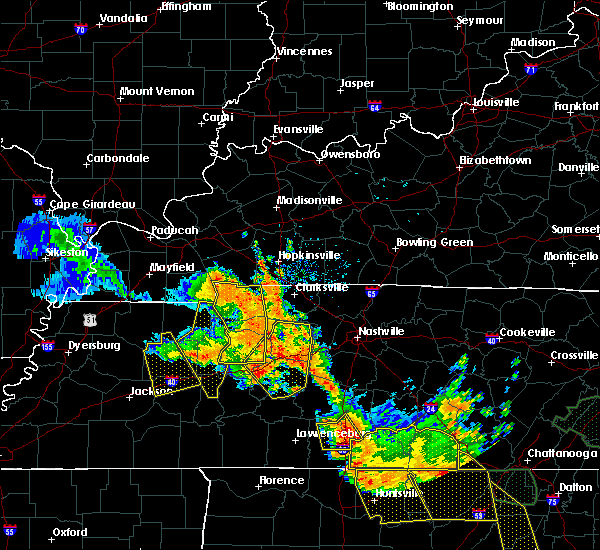 At 1214 pm cdt, a severe thunderstorm was located near camden, moving southeast at 35 mph (radar indicated). Hazards include 60 mph wind gusts. expect damage to roofs, siding, and trees At 1214 pm cdt, a severe thunderstorm was located near camden, moving southeast at 35 mph (radar indicated). Hazards include 60 mph wind gusts. expect damage to roofs, siding, and trees
|
| 6/28/2018 11:36 AM CDT |
 At 1136 am cdt, a severe thunderstorm was located near camden, moving southeast at 35 mph (radar indicated). Hazards include 60 mph wind gusts and quarter size hail. Hail damage to vehicles is expected. Expect wind damage to roofs, siding, and trees. At 1136 am cdt, a severe thunderstorm was located near camden, moving southeast at 35 mph (radar indicated). Hazards include 60 mph wind gusts and quarter size hail. Hail damage to vehicles is expected. Expect wind damage to roofs, siding, and trees.
|
| 6/1/2018 1:38 AM CDT |
 At 138 am cdt, a severe thunderstorm was located near atwood, or 9 miles west of huntingdon, moving east at 70 mph (radar indicated). Hazards include 60 mph wind gusts and quarter size hail. Hail damage to vehicles is expected. Expect wind damage to roofs, siding, and trees. At 138 am cdt, a severe thunderstorm was located near atwood, or 9 miles west of huntingdon, moving east at 70 mph (radar indicated). Hazards include 60 mph wind gusts and quarter size hail. Hail damage to vehicles is expected. Expect wind damage to roofs, siding, and trees.
|
| 6/1/2018 1:00 AM CDT |
 At 100 am cdt, a severe thunderstorm was located near huntingdon, moving east at 40 mph (radar indicated). Hazards include 60 mph wind gusts. expect damage to roofs, siding, and trees At 100 am cdt, a severe thunderstorm was located near huntingdon, moving east at 40 mph (radar indicated). Hazards include 60 mph wind gusts. expect damage to roofs, siding, and trees
|
| 6/1/2018 12:17 AM CDT |
 At 1216 am cdt, a severe thunderstorm was located near gleason, or near mckenzie, moving southeast at 25 mph (radar indicated). Hazards include 60 mph wind gusts and quarter size hail. Hail damage to vehicles is expected. Expect wind damage to roofs, siding, and trees. At 1216 am cdt, a severe thunderstorm was located near gleason, or near mckenzie, moving southeast at 25 mph (radar indicated). Hazards include 60 mph wind gusts and quarter size hail. Hail damage to vehicles is expected. Expect wind damage to roofs, siding, and trees.
|
| 6/1/2018 12:16 AM CDT |
 At 1216 am cdt, a severe thunderstorm was located near gleason, or near mckenzie, moving southeast at 25 mph (radar indicated). Hazards include 60 mph wind gusts and quarter size hail. Hail damage to vehicles is expected. Expect wind damage to roofs, siding, and trees. At 1216 am cdt, a severe thunderstorm was located near gleason, or near mckenzie, moving southeast at 25 mph (radar indicated). Hazards include 60 mph wind gusts and quarter size hail. Hail damage to vehicles is expected. Expect wind damage to roofs, siding, and trees.
|
| 5/19/2018 4:37 PM CDT |
 At 437 pm cdt, a severe thunderstorm was located near paris, moving east at 25 mph (radar indicated). Hazards include 60 mph wind gusts and quarter size hail. Hail damage to vehicles is expected. Expect wind damage to roofs, siding, and trees. At 437 pm cdt, a severe thunderstorm was located near paris, moving east at 25 mph (radar indicated). Hazards include 60 mph wind gusts and quarter size hail. Hail damage to vehicles is expected. Expect wind damage to roofs, siding, and trees.
|
| 2/24/2018 8:06 PM CST |
 At 805 pm cst, severe thunderstorms were located along a line extending from near big rock to 10 miles northeast of parsons, moving east at 65 mph (radar indicated). Hazards include 60 mph wind gusts. Expect damage to roofs, siding, and trees. locations impacted include, paris, lexington, mckenzie, huntingdon, camden, natchez trace state park, natchez trace state forest, paris landing state park, parsons, bruceton, cottage grove, blue goose, vale, bargerton, wildersville, springville, routon, parkers crossroads, hollow rock and puryear. A tornado watch remains in effect until 900 pm cst for southwestern, northwestern and middle tennessee. At 805 pm cst, severe thunderstorms were located along a line extending from near big rock to 10 miles northeast of parsons, moving east at 65 mph (radar indicated). Hazards include 60 mph wind gusts. Expect damage to roofs, siding, and trees. locations impacted include, paris, lexington, mckenzie, huntingdon, camden, natchez trace state park, natchez trace state forest, paris landing state park, parsons, bruceton, cottage grove, blue goose, vale, bargerton, wildersville, springville, routon, parkers crossroads, hollow rock and puryear. A tornado watch remains in effect until 900 pm cst for southwestern, northwestern and middle tennessee.
|
| 2/24/2018 7:27 PM CST |
 At 727 pm cst, severe thunderstorms were located along a line extending from near palmersville to near adair, moving east at 55 mph (radar indicated). Hazards include 60 mph wind gusts. expect damage to roofs, siding, and trees At 727 pm cst, severe thunderstorms were located along a line extending from near palmersville to near adair, moving east at 55 mph (radar indicated). Hazards include 60 mph wind gusts. expect damage to roofs, siding, and trees
|
| 7/5/2017 8:07 PM CDT |
 A severe thunderstorm warning remains in effect until 830 pm cdt for northeastern henderson. benton. southeastern henry and northern decatur counties. At 807 pm cdt, a severe thunderstorm was located near new johnsonville, or 11 miles southwest of waverly, moving east at 40 mph. A severe thunderstorm warning remains in effect until 830 pm cdt for northeastern henderson. benton. southeastern henry and northern decatur counties. At 807 pm cdt, a severe thunderstorm was located near new johnsonville, or 11 miles southwest of waverly, moving east at 40 mph.
|
| 7/5/2017 7:47 PM CDT |
 At 747 pm cdt, a severe thunderstorm was located 9 miles southeast of bruceton, or 10 miles south of camden, moving east at 40 mph (radar indicated). Hazards include 60 mph wind gusts. expect damage to roofs, siding, and trees At 747 pm cdt, a severe thunderstorm was located 9 miles southeast of bruceton, or 10 miles south of camden, moving east at 40 mph (radar indicated). Hazards include 60 mph wind gusts. expect damage to roofs, siding, and trees
|
| 5/27/2017 7:49 PM CDT |
 At 748 pm cdt, severe thunderstorms were located along a line extending from near waverly to 7 miles southwest of new johnsonville to near atwood, moving southeast at 60 mph (radar indicated). Hazards include 70 mph wind gusts and quarter size hail. Hail damage to vehicles is expected. expect considerable tree damage. wind damage is also likely to mobile homes, roofs, and outbuildings. Locations impacted include, huntingdon, camden, new johnsonville, bruceton, atwood, vale, trezevant, hollow rock, clarksburg, mclemoresville, howley, hickory flat, hillard, dollar, holladay, leach, sugar tree, tate, palmer shelter and buena vista. At 748 pm cdt, severe thunderstorms were located along a line extending from near waverly to 7 miles southwest of new johnsonville to near atwood, moving southeast at 60 mph (radar indicated). Hazards include 70 mph wind gusts and quarter size hail. Hail damage to vehicles is expected. expect considerable tree damage. wind damage is also likely to mobile homes, roofs, and outbuildings. Locations impacted include, huntingdon, camden, new johnsonville, bruceton, atwood, vale, trezevant, hollow rock, clarksburg, mclemoresville, howley, hickory flat, hillard, dollar, holladay, leach, sugar tree, tate, palmer shelter and buena vista.
|
| 5/27/2017 7:18 PM CDT |
 At 718 pm cdt, severe thunderstorms were located along a line extending from 11 miles south of canton to near mckenzie to near newbern, moving southeast at 40 mph (radar indicated). Hazards include 70 mph wind gusts and quarter size hail. Hail damage to vehicles is expected. expect considerable tree damage. Wind damage is also likely to mobile homes, roofs, and outbuildings. At 718 pm cdt, severe thunderstorms were located along a line extending from 11 miles south of canton to near mckenzie to near newbern, moving southeast at 40 mph (radar indicated). Hazards include 70 mph wind gusts and quarter size hail. Hail damage to vehicles is expected. expect considerable tree damage. Wind damage is also likely to mobile homes, roofs, and outbuildings.
|
| 3/27/2017 4:39 PM CDT |
 At 438 pm cdt, a severe thunderstorm was located 7 miles south of bruceton, or 9 miles southeast of huntingdon, moving east at 35 mph (radar indicated). Hazards include 60 mph wind gusts and quarter size hail. Hail damage to vehicles is expected. expect wind damage to roofs, siding, and trees. Locations impacted include, camden and holladay. At 438 pm cdt, a severe thunderstorm was located 7 miles south of bruceton, or 9 miles southeast of huntingdon, moving east at 35 mph (radar indicated). Hazards include 60 mph wind gusts and quarter size hail. Hail damage to vehicles is expected. expect wind damage to roofs, siding, and trees. Locations impacted include, camden and holladay.
|
| 3/27/2017 4:16 PM CDT |
 At 416 pm cdt, a severe thunderstorm was located 9 miles southwest of huntingdon, moving east at 35 mph (radar indicated). Hazards include 60 mph wind gusts and quarter size hail. Hail damage to vehicles is expected. Expect wind damage to roofs, siding, and trees. At 416 pm cdt, a severe thunderstorm was located 9 miles southwest of huntingdon, moving east at 35 mph (radar indicated). Hazards include 60 mph wind gusts and quarter size hail. Hail damage to vehicles is expected. Expect wind damage to roofs, siding, and trees.
|
| 3/9/2017 9:37 PM CST |
 At 937 pm cst, severe thunderstorms were located along a line extending from paris landing state park to near paris to mckenzie, moving southeast at 55 mph. brief tornadoes will be possible within the fast moving line of storms (radar indicated). Hazards include 70 mph wind gusts and quarter size hail. Hail damage to vehicles is expected. expect considerable tree damage. Wind damage is also likely to mobile homes, roofs, and outbuildings. At 937 pm cst, severe thunderstorms were located along a line extending from paris landing state park to near paris to mckenzie, moving southeast at 55 mph. brief tornadoes will be possible within the fast moving line of storms (radar indicated). Hazards include 70 mph wind gusts and quarter size hail. Hail damage to vehicles is expected. expect considerable tree damage. Wind damage is also likely to mobile homes, roofs, and outbuildings.
|
| 3/1/2017 6:10 AM CST |
 The severe thunderstorm warning for henderson, benton, carroll, henry and northern decatur counties will expire at 615 am cst, the storms which prompted the warning have moved out of the area. therefore the warning will be allowed to expire. however gusty winds are still possible with these thunderstorms. a tornado watch remains in effect until 800 am cst for western and west tennessee. The severe thunderstorm warning for henderson, benton, carroll, henry and northern decatur counties will expire at 615 am cst, the storms which prompted the warning have moved out of the area. therefore the warning will be allowed to expire. however gusty winds are still possible with these thunderstorms. a tornado watch remains in effect until 800 am cst for western and west tennessee.
|
| 3/1/2017 5:24 AM CST |
 At 524 am cst, severe thunderstorms were located along a line extending from near palmersville to near milan to near hillville, moving east at 65 mph (radar indicated). Hazards include 70 mph wind gusts. Expect considerable tree damage. Damage is likely to mobile homes, roofs, and outbuildings. At 524 am cst, severe thunderstorms were located along a line extending from near palmersville to near milan to near hillville, moving east at 65 mph (radar indicated). Hazards include 70 mph wind gusts. Expect considerable tree damage. Damage is likely to mobile homes, roofs, and outbuildings.
|
| 12/17/2016 7:50 PM CST |
 At 750 pm cst, a severe thunderstorm was located over paris landing state park, moving northeast at 70 mph (radar indicated). Hazards include 60 mph wind gusts. Expect damage to roofs, siding, and trees. locations impacted include, camden and big sandy. A tornado watch remains in effect until 900 pm cst for western tennessee. At 750 pm cst, a severe thunderstorm was located over paris landing state park, moving northeast at 70 mph (radar indicated). Hazards include 60 mph wind gusts. Expect damage to roofs, siding, and trees. locations impacted include, camden and big sandy. A tornado watch remains in effect until 900 pm cst for western tennessee.
|
| 12/17/2016 7:28 PM CST |
 At 727 pm cst, a severe thunderstorm was located near routon, or near mckenzie, moving northeast at 70 mph (radar indicated). Hazards include 60 mph wind gusts. Expect damage to roofs, siding, and trees. locations impacted include, paris, mckenzie, huntingdon, camden, paris landing state park, bruceton, atwood, cottage grove, springville, vale, routon, trezevant, hollow rock, puryear, big sandy, henry, mclemoresville, new zion, whitlock and india. A tornado watch remains in effect until 900 pm cst for western and west tennessee. At 727 pm cst, a severe thunderstorm was located near routon, or near mckenzie, moving northeast at 70 mph (radar indicated). Hazards include 60 mph wind gusts. Expect damage to roofs, siding, and trees. locations impacted include, paris, mckenzie, huntingdon, camden, paris landing state park, bruceton, atwood, cottage grove, springville, vale, routon, trezevant, hollow rock, puryear, big sandy, henry, mclemoresville, new zion, whitlock and india. A tornado watch remains in effect until 900 pm cst for western and west tennessee.
|
| 12/17/2016 7:07 PM CST |
 At 707 pm cst, a severe thunderstorm was located over bradford, or 8 miles northeast of trenton, moving northeast at 60 mph (radar indicated). Hazards include 60 mph wind gusts. expect damage to roofs, siding, and trees At 707 pm cst, a severe thunderstorm was located over bradford, or 8 miles northeast of trenton, moving northeast at 60 mph (radar indicated). Hazards include 60 mph wind gusts. expect damage to roofs, siding, and trees
|
| 8/1/2016 5:01 PM CDT |
 At 501 pm cdt, a severe thunderstorm was located near routon, or 7 miles northeast of mckenzie, moving southeast at 45 mph (radar indicated). Hazards include 60 mph wind gusts. Expect damage to roofs. siding. and trees. Locations impacted include, paris, mckenzie, camden, paris landing state park, bruceton, gleason, cottage grove, springville, vale, palmersville, routon, hollow rock, puryear, big sandy, henry, whitlock, india, haigler ridge, jones mill and porter court. At 501 pm cdt, a severe thunderstorm was located near routon, or 7 miles northeast of mckenzie, moving southeast at 45 mph (radar indicated). Hazards include 60 mph wind gusts. Expect damage to roofs. siding. and trees. Locations impacted include, paris, mckenzie, camden, paris landing state park, bruceton, gleason, cottage grove, springville, vale, palmersville, routon, hollow rock, puryear, big sandy, henry, whitlock, india, haigler ridge, jones mill and porter court.
|
| 8/1/2016 4:43 PM CDT |
 At 443 pm cdt, a severe thunderstorm was located over cottage grove, or 10 miles northwest of paris, moving southeast at 45 mph (radar indicated). Hazards include 60 mph wind gusts. Expect damage to roofs. siding. And trees. At 443 pm cdt, a severe thunderstorm was located over cottage grove, or 10 miles northwest of paris, moving southeast at 45 mph (radar indicated). Hazards include 60 mph wind gusts. Expect damage to roofs. siding. And trees.
|
| 6/15/2016 3:39 PM CDT |
 The severe thunderstorm warning for eastern weakley, northern carroll, benton and henry counties will expire at 345 pm cdt, the storm which prompted the warning has weakened below severe limits, and no longer poses an immediate threat to life or property. therefore the warning will be allowed to expire. however gusty winds and heavy rain are still possible with this thunderstorm. a severe thunderstorm watch remains in effect until 900 pm cdt for western tennessee. The severe thunderstorm warning for eastern weakley, northern carroll, benton and henry counties will expire at 345 pm cdt, the storm which prompted the warning has weakened below severe limits, and no longer poses an immediate threat to life or property. therefore the warning will be allowed to expire. however gusty winds and heavy rain are still possible with this thunderstorm. a severe thunderstorm watch remains in effect until 900 pm cdt for western tennessee.
|
| 6/15/2016 3:16 PM CDT |
 At 316 pm cdt, a severe thunderstorm was located over paris, moving east at 25 mph (radar indicated). Hazards include 60 mph wind gusts and nickel size hail. Expect damage to roofs. siding. and trees. Locations impacted include, paris, mckenzie, huntingdon, camden, paris landing state park, dresden, bruceton, gleason, cottage grove, springville, vale, palmersville, routon, hollow rock, puryear, big sandy, henry, whitlock, matheny grove and india. At 316 pm cdt, a severe thunderstorm was located over paris, moving east at 25 mph (radar indicated). Hazards include 60 mph wind gusts and nickel size hail. Expect damage to roofs. siding. and trees. Locations impacted include, paris, mckenzie, huntingdon, camden, paris landing state park, dresden, bruceton, gleason, cottage grove, springville, vale, palmersville, routon, hollow rock, puryear, big sandy, henry, whitlock, matheny grove and india.
|
| 6/15/2016 2:48 PM CDT |
 At 248 pm cdt, a severe thunderstorm was located near cottage grove, or 10 miles west of paris, moving east at 25 mph (radar indicated). Hazards include 60 mph wind gusts and penny size hail. Expect damage to roofs. siding. And trees. At 248 pm cdt, a severe thunderstorm was located near cottage grove, or 10 miles west of paris, moving east at 25 mph (radar indicated). Hazards include 60 mph wind gusts and penny size hail. Expect damage to roofs. siding. And trees.
|
| 5/12/2016 12:21 PM CDT |
 At 1220 pm cdt, severe thunderstorms were located along a line extending from 9 miles west of paris landing state park to 8 miles northeast of natchez trace state park, moving east at 40 mph (radar indicated). Hazards include 60 mph wind gusts and penny size hail. Expect damage to roofs. siding. and trees. Locations impacted include, paris, huntingdon, camden, paris landing state park, bruceton, springville, vale, routon, hollow rock, puryear, big sandy, henry, clarksburg, whitlock, india, haigler ridge, holladay, porter court, ephesus and osage. At 1220 pm cdt, severe thunderstorms were located along a line extending from 9 miles west of paris landing state park to 8 miles northeast of natchez trace state park, moving east at 40 mph (radar indicated). Hazards include 60 mph wind gusts and penny size hail. Expect damage to roofs. siding. and trees. Locations impacted include, paris, huntingdon, camden, paris landing state park, bruceton, springville, vale, routon, hollow rock, puryear, big sandy, henry, clarksburg, whitlock, india, haigler ridge, holladay, porter court, ephesus and osage.
|
| 5/12/2016 12:03 PM CDT |
 At 1203 pm cdt, severe thunderstorms were located along a line extending from near lynnville to 7 miles northwest of parkers crossroads, moving northeast at 35 mph (radar indicated). Hazards include 60 mph wind gusts and penny size hail. Expect damage to roofs. siding. And trees. At 1203 pm cdt, severe thunderstorms were located along a line extending from near lynnville to 7 miles northwest of parkers crossroads, moving northeast at 35 mph (radar indicated). Hazards include 60 mph wind gusts and penny size hail. Expect damage to roofs. siding. And trees.
|
| 4/27/2016 3:35 PM CDT |
 At 335 pm cdt, a severe thunderstorm was located near parkers crossroads, or 10 miles northwest of natchez trace state park, moving northeast at 35 mph (radar indicated). Hazards include 60 mph wind gusts and penny size hail. Expect damage to roofs. siding. And trees. At 335 pm cdt, a severe thunderstorm was located near parkers crossroads, or 10 miles northwest of natchez trace state park, moving northeast at 35 mph (radar indicated). Hazards include 60 mph wind gusts and penny size hail. Expect damage to roofs. siding. And trees.
|
| 2/2/2016 2:46 PM CST |
 A severe thunderstorm warning remains in effect until 300 pm cst for central benton county. at 245 pm cst. a severe thunderstorm was located near camden. moving northeast at 70 mph. hazard. 60 mph wind gusts and quarter size hail. source. Radar indicated. A severe thunderstorm warning remains in effect until 300 pm cst for central benton county. at 245 pm cst. a severe thunderstorm was located near camden. moving northeast at 70 mph. hazard. 60 mph wind gusts and quarter size hail. source. Radar indicated.
|
| 2/2/2016 2:26 PM CST |
 At 225 pm cst, a severe thunderstorm was located over wildersville, or near natchez trace state park, moving northeast at 70 mph (radar indicated). Hazards include 60 mph wind gusts and quarter size hail. Hail damage to vehicles is expected. Expect wind damage to roofs, siding and trees. At 225 pm cst, a severe thunderstorm was located over wildersville, or near natchez trace state park, moving northeast at 70 mph (radar indicated). Hazards include 60 mph wind gusts and quarter size hail. Hail damage to vehicles is expected. Expect wind damage to roofs, siding and trees.
|
| 12/23/2015 6:01 PM CST | At 601 pm cst, a severe thunderstorm producing a tornado was located 10 miles southeast of bruceton, or 10 miles south of camden, moving northeast at 55 mph (radar indicated rotation). Hazards include tornado. Flying debris will be dangerous to those caught without shelter. mobile homes will be damaged or destroyed. damage to roofs, windows and vehicles will occur. tree damage is likely. this dangerous storm will be near, new johnsonville around 615 pm cst. Other locations impacted by this tornadic thunderstorm include holladay. |
| 12/23/2015 5:55 PM CST | At 554 pm cst, a severe thunderstorm was located 9 miles south of bruceton, or 9 miles north of natchez trace state park, moving northeast at 60 mph (radar indicated). Hazards include 60 mph wind gusts and quarter size hail. Hail damage to vehicles is expected. Expect wind damage to roofs, siding and trees. |
| 7/1/2015 11:09 AM CDT |
 The severe thunderstorm warning for northeastern carroll and benton counties will expire at 1115 am cdt, the storm which prompted the warning has weakened below severe limits and exited the warned area. therefore the warning will be allowed to expire. however gusty winds are still possible with this thunderstorm. The severe thunderstorm warning for northeastern carroll and benton counties will expire at 1115 am cdt, the storm which prompted the warning has weakened below severe limits and exited the warned area. therefore the warning will be allowed to expire. however gusty winds are still possible with this thunderstorm.
|
| 7/1/2015 10:58 AM CDT |
 At 1057 am cdt, a severe thunderstorm was located 9 miles east of springville, or 12 miles northeast of camden, moving east at 40 mph (radar indicated). Hazards include 60 mph wind gusts and penny size hail. Expect damage to roofs. siding and trees. Locations impacted include, camden, bruceton, vale, hollow rock, big sandy, ephesus and crews store. At 1057 am cdt, a severe thunderstorm was located 9 miles east of springville, or 12 miles northeast of camden, moving east at 40 mph (radar indicated). Hazards include 60 mph wind gusts and penny size hail. Expect damage to roofs. siding and trees. Locations impacted include, camden, bruceton, vale, hollow rock, big sandy, ephesus and crews store.
|
| 7/1/2015 10:33 AM CDT |
 At 1033 am cdt, a severe thunderstorm was located near paris, moving east at 40 mph (radar indicated). Hazards include 60 mph wind gusts and penny size hail. Expect damage to roofs. siding and trees. Locations impacted include, paris, mckenzie, huntingdon, camden, bruceton, springville, vale, routon, hollow rock, big sandy, henry, new zion, india, haigler ridge, porter court, ephesus, osage, old springville, spring creek and manleyville. At 1033 am cdt, a severe thunderstorm was located near paris, moving east at 40 mph (radar indicated). Hazards include 60 mph wind gusts and penny size hail. Expect damage to roofs. siding and trees. Locations impacted include, paris, mckenzie, huntingdon, camden, bruceton, springville, vale, routon, hollow rock, big sandy, henry, new zion, india, haigler ridge, porter court, ephesus, osage, old springville, spring creek and manleyville.
|
| 7/1/2015 10:13 AM CDT |
 At 1013 am cdt, a severe thunderstorm was located near gleason, or near mckenzie, moving east at 40 mph (radar indicated). Hazards include 60 mph wind gusts and penny size hail. Expect damage to roofs. Siding and trees. At 1013 am cdt, a severe thunderstorm was located near gleason, or near mckenzie, moving east at 40 mph (radar indicated). Hazards include 60 mph wind gusts and penny size hail. Expect damage to roofs. Siding and trees.
|
| 6/29/2015 8:05 PM CDT |
 At 804 pm cdt, a severe thunderstorm was located near bruceton, or 10 miles southwest of camden, moving east at 15 mph (radar indicated). Hazards include 60 mph wind gusts and quarter size hail. Hail damage to vehicles is expected. expect wind damage to roofs, siding and trees. Locations impacted include, huntingdon, camden, bruceton, hollow rock, buena vista, crews store and i-40 near the tennessee river. At 804 pm cdt, a severe thunderstorm was located near bruceton, or 10 miles southwest of camden, moving east at 15 mph (radar indicated). Hazards include 60 mph wind gusts and quarter size hail. Hail damage to vehicles is expected. expect wind damage to roofs, siding and trees. Locations impacted include, huntingdon, camden, bruceton, hollow rock, buena vista, crews store and i-40 near the tennessee river.
|
| 6/29/2015 7:42 PM CDT |
 At 741 pm cdt, a severe thunderstorm was located near bruceton, or 8 miles northeast of huntingdon, moving east at 20 mph (radar indicated). Hazards include 60 mph wind gusts and quarter size hail. Hail damage to vehicles is expected. Expect wind damage to roofs, siding and trees. At 741 pm cdt, a severe thunderstorm was located near bruceton, or 8 miles northeast of huntingdon, moving east at 20 mph (radar indicated). Hazards include 60 mph wind gusts and quarter size hail. Hail damage to vehicles is expected. Expect wind damage to roofs, siding and trees.
|
| 6/8/2015 2:53 PM CDT |
 At 250 pm cdt, a severe thunderstorm was located near new johnsonville, and moving east at 30 mph (radar indicated). Hazards include 60 mph wind gusts and half dollar size hail. Hail damage to vehicles is expected. expect wind damage to roofs, siding and trees. The severe thunderstorm will be near, hurricane mills and waverly around 310 pm cdt. At 250 pm cdt, a severe thunderstorm was located near new johnsonville, and moving east at 30 mph (radar indicated). Hazards include 60 mph wind gusts and half dollar size hail. Hail damage to vehicles is expected. expect wind damage to roofs, siding and trees. The severe thunderstorm will be near, hurricane mills and waverly around 310 pm cdt.
|
| 4/16/2015 1:26 AM CDT | The national weather service in memphis has issued a * severe thunderstorm warning for. eastern carroll county in northwestern tennessee. southern benton county in middle tennessee. until 215 am cdt * at 126 am cdt. A severe thunderstorm was located over parkers. |
| 5/29/2012 7:30 AM CDT | Trees blown down on cedar grove road...northeast of camde in benton county TN, 4.6 miles SSE of Eva, TN |
| 1/1/0001 12:00 AM | Benton s.o. reported several locations in central benton county with trees blown dow in benton county TN, 3.9 miles SE of Eva, TN |
Hail Maps for Eva, TN

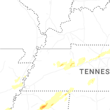


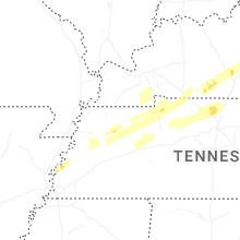


Connect with Interactive Hail Maps