

Hail Map for Fairchild, WI
The Fairchild, WI area has had 10 reports of on-the-ground hail by trained spotters, and has been under severe weather warnings 27 times during the past 12 months. Doppler radar has detected hail at or near Fairchild, WI on 49 occasions, including 2 occasions during the past year.
| Name: | Fairchild, WI |
| Where Located: | 56.4 miles NNE of La Crosse, WI |
| Map: | Google Map for Fairchild, WI |
| Population: | 550 |
| Housing Units: | 275 |
| More Info: | Search Google for Fairchild, WI |
2
The Top Recent Hail Date for Fairchild, WI is Thursday, May 15, 2025 (6th out of 49)

Hail and Wind Damage Spotted near Fairchild, WI
| Date / Time | Report Details |
|---|---|
| 5/15/2025 4:44 PM CDT |
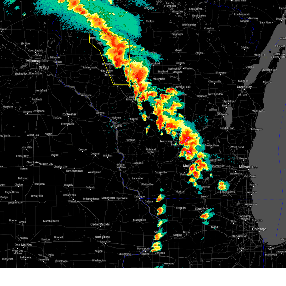 The severe thunderstorm warning that was previously in effect has been reissued for barron, chippewa, eau claire, and rusk counties and is in effect until 530 pm cdt. please refer to that bulletin for the latest severe weather information. The severe thunderstorm warning that was previously in effect has been reissued for barron, chippewa, eau claire, and rusk counties and is in effect until 530 pm cdt. please refer to that bulletin for the latest severe weather information.
|
| 5/15/2025 4:43 PM CDT |
 Svrmpx the national weather service in the twin cities has issued a * severe thunderstorm warning for, northeastern barron county in northwestern wisconsin, rusk county in northwestern wisconsin, chippewa county in west central wisconsin, eastern eau claire county in west central wisconsin, * until 530 pm cdt. * at 443 pm cdt, severe thunderstorms were located along a line from 7 miles northwest of haugen to near fairchild, or along a line from 15 miles northwest of rice lake to 33 miles southeast of eau claire, moving north at 50 mph (radar indicated). Hazards include 60 mph wind gusts and quarter size hail. Hail damage to vehicles is expected. Expect wind damage to roofs, siding, and trees. Svrmpx the national weather service in the twin cities has issued a * severe thunderstorm warning for, northeastern barron county in northwestern wisconsin, rusk county in northwestern wisconsin, chippewa county in west central wisconsin, eastern eau claire county in west central wisconsin, * until 530 pm cdt. * at 443 pm cdt, severe thunderstorms were located along a line from 7 miles northwest of haugen to near fairchild, or along a line from 15 miles northwest of rice lake to 33 miles southeast of eau claire, moving north at 50 mph (radar indicated). Hazards include 60 mph wind gusts and quarter size hail. Hail damage to vehicles is expected. Expect wind damage to roofs, siding, and trees.
|
| 5/15/2025 4:27 PM CDT | the severe thunderstorm warning has been cancelled and is no longer in effect |
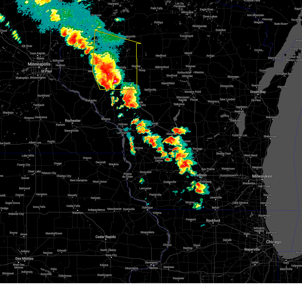
| 5/15/2025 4:27 PM CDT | At 427 pm cdt, a severe thunderstorm was located 10 miles south of weyerhaeuser, or 20 miles southwest of ladysmith, moving northeast at 50 mph (radar indicated). Hazards include 60 mph wind gusts and half dollar size hail. Hail damage to vehicles is expected. expect wind damage to roofs, siding, and trees. Locations impacted include, eau claire, rice lake, chippewa falls, altoona, lake hallie, stanley, bloomer, barron, lake wissota, chetek, cameron, augusta, cornell, cadott, fall creek, bruce, boyd, fairchild, new auburn and weyerhaeuser. |
| 5/15/2025 4:14 PM CDT | the severe thunderstorm warning has been cancelled and is no longer in effect |
| 5/15/2025 4:14 PM CDT | At 414 pm cdt, a severe thunderstorm was located near new auburn, or 22 miles north of eau claire, moving northeast at 50 mph (radar indicated). Hazards include 60 mph wind gusts and quarter size hail. Hail damage to vehicles is expected. expect wind damage to roofs, siding, and trees. Locations impacted include, eau claire, rice lake, chippewa falls, altoona, lake hallie, stanley, bloomer, barron, lake wissota, chetek, cameron, augusta, cornell, cadott, fall creek, bruce, boyd, fairchild, new auburn and dallas. |
| 5/15/2025 4:12 PM CDT |
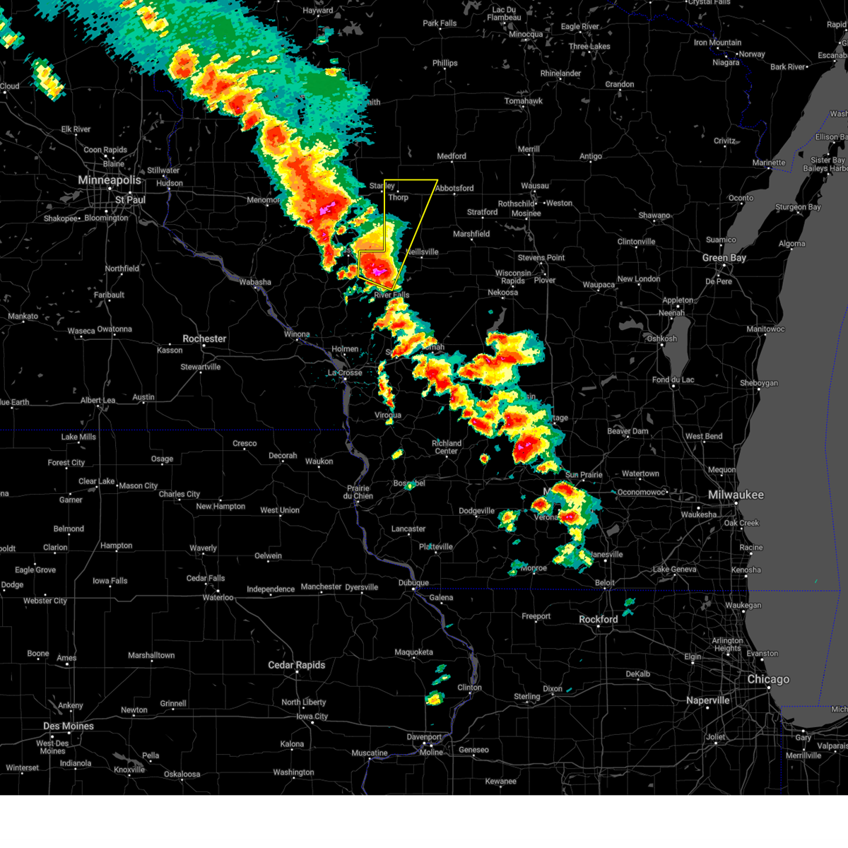 Svrarx the national weather service in la crosse has issued a * severe thunderstorm warning for, western clark county in central wisconsin, northwestern jackson county in west central wisconsin, * until 500 pm cdt. * at 412 pm cdt, a severe thunderstorm was located near humbird, or 16 miles northwest of black river falls, moving north at 55 mph (radar indicated). Hazards include 60 mph wind gusts and quarter size hail. Hail damage to vehicles is expected. expect wind damage to roofs, siding, and trees. this severe thunderstorm will be near, fairchild around 420 pm cdt. thorp around 445 pm cdt. other locations impacted by this severe thunderstorm include hog corners, mead lake, wildcat mound, highway 10 and 12, tioga, highway 10 and bald peak road, and county o and sterling avenue. This includes interstate 94 between mile markers 95 and 102. Svrarx the national weather service in la crosse has issued a * severe thunderstorm warning for, western clark county in central wisconsin, northwestern jackson county in west central wisconsin, * until 500 pm cdt. * at 412 pm cdt, a severe thunderstorm was located near humbird, or 16 miles northwest of black river falls, moving north at 55 mph (radar indicated). Hazards include 60 mph wind gusts and quarter size hail. Hail damage to vehicles is expected. expect wind damage to roofs, siding, and trees. this severe thunderstorm will be near, fairchild around 420 pm cdt. thorp around 445 pm cdt. other locations impacted by this severe thunderstorm include hog corners, mead lake, wildcat mound, highway 10 and 12, tioga, highway 10 and bald peak road, and county o and sterling avenue. This includes interstate 94 between mile markers 95 and 102.
|
| 5/15/2025 3:58 PM CDT |
 Svrmpx the national weather service in the twin cities has issued a * severe thunderstorm warning for, eastern barron county in northwestern wisconsin, southern rusk county in northwestern wisconsin, chippewa county in west central wisconsin, dunn county in west central wisconsin, eau claire county in west central wisconsin, northeastern pepin county in west central wisconsin, * until 445 pm cdt. * at 358 pm cdt, a line of severe thunderstorms was located from near prairie farm through elk mound through fall creek moving northeast at 50 mph (radar indicated). Hazards include 60 mph wind gusts and quarter size hail. Hail damage to vehicles is expected. Expect wind damage to roofs, siding, and trees. Svrmpx the national weather service in the twin cities has issued a * severe thunderstorm warning for, eastern barron county in northwestern wisconsin, southern rusk county in northwestern wisconsin, chippewa county in west central wisconsin, dunn county in west central wisconsin, eau claire county in west central wisconsin, northeastern pepin county in west central wisconsin, * until 445 pm cdt. * at 358 pm cdt, a line of severe thunderstorms was located from near prairie farm through elk mound through fall creek moving northeast at 50 mph (radar indicated). Hazards include 60 mph wind gusts and quarter size hail. Hail damage to vehicles is expected. Expect wind damage to roofs, siding, and trees.
|
| 5/15/2025 3:51 PM CDT |
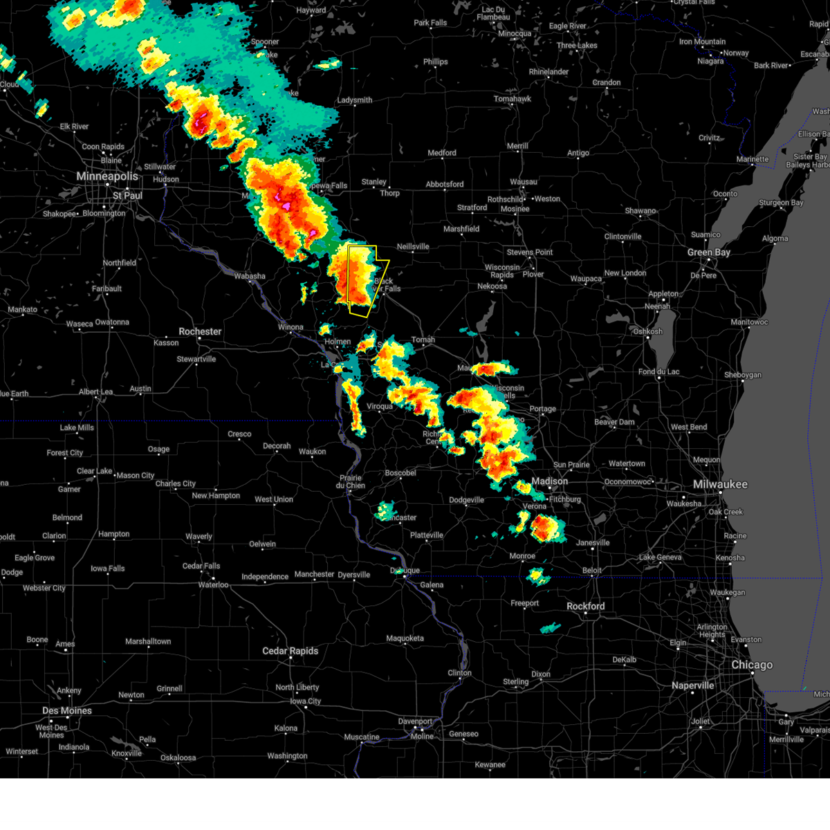 Svrarx the national weather service in la crosse has issued a * severe thunderstorm warning for, western jackson county in west central wisconsin, * until 415 pm cdt. * at 351 pm cdt, a severe thunderstorm was located 7 miles east of blair, or 11 miles west of black river falls, moving north at 55 mph (radar indicated). Hazards include 60 mph wind gusts and quarter size hail. Hail damage to vehicles is expected. expect wind damage to roofs, siding, and trees. this severe thunderstorm will remain over mainly rural areas of western jackson county, including the following locations, franklin, hixton, taylor, hixton alma center k o a, disco, york, and alma center. This includes interstate 94 between mile markers 92 and 111. Svrarx the national weather service in la crosse has issued a * severe thunderstorm warning for, western jackson county in west central wisconsin, * until 415 pm cdt. * at 351 pm cdt, a severe thunderstorm was located 7 miles east of blair, or 11 miles west of black river falls, moving north at 55 mph (radar indicated). Hazards include 60 mph wind gusts and quarter size hail. Hail damage to vehicles is expected. expect wind damage to roofs, siding, and trees. this severe thunderstorm will remain over mainly rural areas of western jackson county, including the following locations, franklin, hixton, taylor, hixton alma center k o a, disco, york, and alma center. This includes interstate 94 between mile markers 92 and 111.
|
| 4/28/2025 8:23 PM CDT |
 The storm which prompted the warning has moved out of the area. therefore, the warning will be allowed to expire. however, gusty winds are still possible with this thunderstorm. a tornado watch remains in effect until 1100 pm cdt for a portion of west central wisconsin. The storm which prompted the warning has moved out of the area. therefore, the warning will be allowed to expire. however, gusty winds are still possible with this thunderstorm. a tornado watch remains in effect until 1100 pm cdt for a portion of west central wisconsin.
|
| 4/28/2025 8:16 PM CDT |
 At 816 pm cdt, a tornado producing storm was located 11 miles south of stanley, or 28 miles east of eau claire, moving northeast at 50 mph (radar confirmed tornado). Hazards include damaging tornado and half dollar size hail. Flying debris will be dangerous to those caught without shelter. mobile homes will be damaged or destroyed. damage to roofs, windows and vehicles will occur. tree damage is likely. Locations impacted include, fairchild. At 816 pm cdt, a tornado producing storm was located 11 miles south of stanley, or 28 miles east of eau claire, moving northeast at 50 mph (radar confirmed tornado). Hazards include damaging tornado and half dollar size hail. Flying debris will be dangerous to those caught without shelter. mobile homes will be damaged or destroyed. damage to roofs, windows and vehicles will occur. tree damage is likely. Locations impacted include, fairchild.
|
| 4/28/2025 8:10 PM CDT | At 810 pm cdt, a tornado producing storm was located 9 miles northeast of augusta, or 24 miles east of eau claire, moving northeast at 50 mph (radar confirmed tornado). Hazards include damaging tornado and half dollar size hail. Flying debris will be dangerous to those caught without shelter. mobile homes will be damaged or destroyed. damage to roofs, windows and vehicles will occur. tree damage is likely. Locations impacted include, stanley, augusta, fairchild, ludington and lake eau claire county park. |
| 4/28/2025 8:07 PM CDT |
 At 807 pm cdt, a severe thunderstorm capable of producing a tornado was located 6 miles northeast of augusta, or 22 miles east of eau claire, moving northeast at 50 mph (radar indicated rotation). Hazards include tornado and half dollar size hail. Flying debris will be dangerous to those caught without shelter. mobile homes will be damaged or destroyed. damage to roofs, windows and vehicles will occur. tree damage is likely. Locations impacted include, stanley, augusta, fairchild, ludington and lake eau claire county park. At 807 pm cdt, a severe thunderstorm capable of producing a tornado was located 6 miles northeast of augusta, or 22 miles east of eau claire, moving northeast at 50 mph (radar indicated rotation). Hazards include tornado and half dollar size hail. Flying debris will be dangerous to those caught without shelter. mobile homes will be damaged or destroyed. damage to roofs, windows and vehicles will occur. tree damage is likely. Locations impacted include, stanley, augusta, fairchild, ludington and lake eau claire county park.
|
| 4/28/2025 8:02 PM CDT |
 Tormpx the national weather service in the twin cities has issued a * tornado warning for, southeastern chippewa county in west central wisconsin, eastern eau claire county in west central wisconsin, * until 830 pm cdt. * at 802 pm cdt, a severe thunderstorm capable of producing a tornado was located near augusta, or 19 miles east of eau claire, moving northeast at 50 mph (radar indicated rotation). Hazards include tornado. Flying debris will be dangerous to those caught without shelter. mobile homes will be damaged or destroyed. damage to roofs, windows and vehicles will occur. Tree damage is likely. Tormpx the national weather service in the twin cities has issued a * tornado warning for, southeastern chippewa county in west central wisconsin, eastern eau claire county in west central wisconsin, * until 830 pm cdt. * at 802 pm cdt, a severe thunderstorm capable of producing a tornado was located near augusta, or 19 miles east of eau claire, moving northeast at 50 mph (radar indicated rotation). Hazards include tornado. Flying debris will be dangerous to those caught without shelter. mobile homes will be damaged or destroyed. damage to roofs, windows and vehicles will occur. Tree damage is likely.
|
| 3/28/2025 8:38 PM CDT |
 The storms which prompted the warning have weakened below severe limits, and no longer pose an immediate threat to life or property. therefore, the warning will be allowed to expire. The storms which prompted the warning have weakened below severe limits, and no longer pose an immediate threat to life or property. therefore, the warning will be allowed to expire.
|
| 3/28/2025 8:27 PM CDT |
 the severe thunderstorm warning has been cancelled and is no longer in effect the severe thunderstorm warning has been cancelled and is no longer in effect
|
| 3/28/2025 8:27 PM CDT |
 At 826 pm cdt, severe thunderstorms were located along a line extending from near osseo to near whitehall to near independence, moving east at 45 mph (radar indicated). Hazards include quarter size hail. Damage to vehicles is expected. these severe storms will be near, whitehall and independence around 830 pm cdt. price around 835 pm cdt. other locations impacted by these severe thunderstorms include hixton, york, chimney rock, merrillan, north branch, elk creek, and the borst valley area. This includes interstate 94 between mile markers 88 and 108. At 826 pm cdt, severe thunderstorms were located along a line extending from near osseo to near whitehall to near independence, moving east at 45 mph (radar indicated). Hazards include quarter size hail. Damage to vehicles is expected. these severe storms will be near, whitehall and independence around 830 pm cdt. price around 835 pm cdt. other locations impacted by these severe thunderstorms include hixton, york, chimney rock, merrillan, north branch, elk creek, and the borst valley area. This includes interstate 94 between mile markers 88 and 108.
|
| 3/28/2025 7:56 PM CDT |
 Svrarx the national weather service in la crosse has issued a * severe thunderstorm warning for, northern buffalo county in west central wisconsin, northwestern jackson county in west central wisconsin, northern trempealeau county in west central wisconsin, * until 845 pm cdt. * at 756 pm cdt, severe thunderstorms were located along a line extending from mondovi to 6 miles east of modena to near alma, moving east at 45 mph (radar indicated). Hazards include quarter size hail. Damage to vehicles is expected. severe thunderstorms will be near, strum around 805 pm cdt. independence around 810 pm cdt. whitehall around 815 pm cdt. osseo around 820 pm cdt. price around 830 pm cdt. other locations impacted by these severe thunderstorms include york, chimney rock, mondovi airfield, north branch, county roads f and k k, the borst valley area, and eleva. This includes interstate 94 between mile markers 88 and 108. Svrarx the national weather service in la crosse has issued a * severe thunderstorm warning for, northern buffalo county in west central wisconsin, northwestern jackson county in west central wisconsin, northern trempealeau county in west central wisconsin, * until 845 pm cdt. * at 756 pm cdt, severe thunderstorms were located along a line extending from mondovi to 6 miles east of modena to near alma, moving east at 45 mph (radar indicated). Hazards include quarter size hail. Damage to vehicles is expected. severe thunderstorms will be near, strum around 805 pm cdt. independence around 810 pm cdt. whitehall around 815 pm cdt. osseo around 820 pm cdt. price around 830 pm cdt. other locations impacted by these severe thunderstorms include york, chimney rock, mondovi airfield, north branch, county roads f and k k, the borst valley area, and eleva. This includes interstate 94 between mile markers 88 and 108.
|
| 8/29/2024 8:00 PM CDT |
 At 800 pm cdt, severe thunderstorms were located along a line extending from near augusta to 6 miles north of north bend, moving northeast at 40 mph (radar indicated). Hazards include 60 mph wind gusts. Expect damage to roofs, siding, and trees. these severe storms will be near, price around 805 pm cdt. fairchild around 815 pm cdt. other locations impacted by these severe thunderstorms include franklin, hixton, taylor, beach corners, york, north branch, and thimble park. This includes interstate 94 between mile markers 88 and 111. At 800 pm cdt, severe thunderstorms were located along a line extending from near augusta to 6 miles north of north bend, moving northeast at 40 mph (radar indicated). Hazards include 60 mph wind gusts. Expect damage to roofs, siding, and trees. these severe storms will be near, price around 805 pm cdt. fairchild around 815 pm cdt. other locations impacted by these severe thunderstorms include franklin, hixton, taylor, beach corners, york, north branch, and thimble park. This includes interstate 94 between mile markers 88 and 111.
|
| 8/29/2024 7:32 PM CDT |
 Svrarx the national weather service in la crosse has issued a * severe thunderstorm warning for, western jackson county in west central wisconsin, trempealeau county in west central wisconsin, * until 830 pm cdt. * at 732 pm cdt, severe thunderstorms were located along a line extending from 7 miles northwest of strum to 7 miles west of galesville, moving east at 35 mph (radar indicated). Hazards include 60 mph wind gusts. Expect damage to roofs, siding, and trees. severe thunderstorms will be near, whitehall, galesville, independence, and strum around 740 pm cdt. blair around 745 pm cdt. osseo around 750 pm cdt. price around 805 pm cdt. fairchild around 810 pm cdt. other locations impacted by these severe thunderstorms include franklin, beach corners, york, chimney rock, north branch, tamarack, and the borst valley area. This includes interstate 94 between mile markers 88 and 111. Svrarx the national weather service in la crosse has issued a * severe thunderstorm warning for, western jackson county in west central wisconsin, trempealeau county in west central wisconsin, * until 830 pm cdt. * at 732 pm cdt, severe thunderstorms were located along a line extending from 7 miles northwest of strum to 7 miles west of galesville, moving east at 35 mph (radar indicated). Hazards include 60 mph wind gusts. Expect damage to roofs, siding, and trees. severe thunderstorms will be near, whitehall, galesville, independence, and strum around 740 pm cdt. blair around 745 pm cdt. osseo around 750 pm cdt. price around 805 pm cdt. fairchild around 810 pm cdt. other locations impacted by these severe thunderstorms include franklin, beach corners, york, chimney rock, north branch, tamarack, and the borst valley area. This includes interstate 94 between mile markers 88 and 111.
|
| 8/26/2024 10:09 PM CDT |
 At 1009 pm cdt, severe thunderstorms were located along a line extending from greenwood to near hatfield to near blair, moving east at 40 mph (radar indicated). Hazards include 60 mph wind gusts. Expect damage to roofs, siding, and trees. locations impacted include, black river falls, neillsville, whitehall, osseo, blair, independence, loyal, greenwood, fairchild, price, millston, humbird, hatfield, shortville, york, lynn, irving, northfield, merrillan, and willard. This includes interstate 94 between mile markers 88 and 132. At 1009 pm cdt, severe thunderstorms were located along a line extending from greenwood to near hatfield to near blair, moving east at 40 mph (radar indicated). Hazards include 60 mph wind gusts. Expect damage to roofs, siding, and trees. locations impacted include, black river falls, neillsville, whitehall, osseo, blair, independence, loyal, greenwood, fairchild, price, millston, humbird, hatfield, shortville, york, lynn, irving, northfield, merrillan, and willard. This includes interstate 94 between mile markers 88 and 132.
|
| 8/26/2024 10:09 PM CDT |
 The storm which prompted the warning has moved out of the area. therefore, the warning will be allowed to expire. however, gusty winds are still possible with this thunderstorm. a severe thunderstorm watch remains in effect until 1100 pm cdt for west central wisconsin. The storm which prompted the warning has moved out of the area. therefore, the warning will be allowed to expire. however, gusty winds are still possible with this thunderstorm. a severe thunderstorm watch remains in effect until 1100 pm cdt for west central wisconsin.
|
| 8/26/2024 9:59 PM CDT |
 Svrmpx the national weather service in the twin cities has issued a * severe thunderstorm warning for, southeastern chippewa county in west central wisconsin, eau claire county in west central wisconsin, * until 1015 pm cdt. * at 959 pm cdt, a severe thunderstorm was located near fairchild, or 15 miles west of neillsville, moving east at 60 mph (radar indicated). Hazards include 60 mph wind gusts and penny size hail. expect damage to roofs, siding, and trees Svrmpx the national weather service in the twin cities has issued a * severe thunderstorm warning for, southeastern chippewa county in west central wisconsin, eau claire county in west central wisconsin, * until 1015 pm cdt. * at 959 pm cdt, a severe thunderstorm was located near fairchild, or 15 miles west of neillsville, moving east at 60 mph (radar indicated). Hazards include 60 mph wind gusts and penny size hail. expect damage to roofs, siding, and trees
|
| 8/26/2024 9:42 PM CDT |
 Svrarx the national weather service in la crosse has issued a * severe thunderstorm warning for, clark county in central wisconsin, jackson county in west central wisconsin, northern trempealeau county in west central wisconsin, * until 1045 pm cdt. * at 941 pm cdt, severe thunderstorms were located along a line extending from 8 miles south of boyd to osseo to near independence, moving east at 50 mph (automated weather observations. at 927 pm cdt, a 64 mph wind gust was recorded with these thunderstorms at the eau claire airport). Hazards include 60 mph wind gusts. expect damage to roofs, siding, and trees Svrarx the national weather service in la crosse has issued a * severe thunderstorm warning for, clark county in central wisconsin, jackson county in west central wisconsin, northern trempealeau county in west central wisconsin, * until 1045 pm cdt. * at 941 pm cdt, severe thunderstorms were located along a line extending from 8 miles south of boyd to osseo to near independence, moving east at 50 mph (automated weather observations. at 927 pm cdt, a 64 mph wind gust was recorded with these thunderstorms at the eau claire airport). Hazards include 60 mph wind gusts. expect damage to roofs, siding, and trees
|
| 8/26/2024 9:40 PM CDT |
 At 939 pm cdt, a severe thunderstorm was located over augusta, or 22 miles southeast of eau claire, moving east at 60 mph (radar indicated). Hazards include 60 mph wind gusts and penny size hail. Expect damage to roofs, siding, and trees. Locations impacted include, eau claire, chippewa falls, altoona, lake hallie, stanley, lake wissota, augusta, cadott, fall creek, boyd, fairchild, and ludington. At 939 pm cdt, a severe thunderstorm was located over augusta, or 22 miles southeast of eau claire, moving east at 60 mph (radar indicated). Hazards include 60 mph wind gusts and penny size hail. Expect damage to roofs, siding, and trees. Locations impacted include, eau claire, chippewa falls, altoona, lake hallie, stanley, lake wissota, augusta, cadott, fall creek, boyd, fairchild, and ludington.
|
| 8/26/2024 9:40 PM CDT |
 the severe thunderstorm warning has been cancelled and is no longer in effect the severe thunderstorm warning has been cancelled and is no longer in effect
|
| 8/26/2024 8:58 PM CDT |
 Svrmpx the national weather service in the twin cities has issued a * severe thunderstorm warning for, pepin county in west central wisconsin, southeastern pierce county in west central wisconsin, southern dunn county in west central wisconsin, southern chippewa county in west central wisconsin, eau claire county in west central wisconsin, * until 1000 pm cdt. * at 857 pm cdt, a severe thunderstorm was located 8 miles south of menomonie, moving east at 65 mph (radar indicated). Hazards include 60 mph wind gusts and penny size hail. expect damage to roofs, siding, and trees Svrmpx the national weather service in the twin cities has issued a * severe thunderstorm warning for, pepin county in west central wisconsin, southeastern pierce county in west central wisconsin, southern dunn county in west central wisconsin, southern chippewa county in west central wisconsin, eau claire county in west central wisconsin, * until 1000 pm cdt. * at 857 pm cdt, a severe thunderstorm was located 8 miles south of menomonie, moving east at 65 mph (radar indicated). Hazards include 60 mph wind gusts and penny size hail. expect damage to roofs, siding, and trees
|
| 7/13/2024 5:02 PM CDT |
 At 501 pm cdt, severe thunderstorms were located along a line extending from 7 miles west of neillsville to near shortville to near millston, moving east at 40 mph (law enforcement reported power lines down near taylor and hixton). Hazards include 60 mph wind gusts. Expect damage to roofs, siding, and trees. these severe storms will be near, neillsville and shortville around 505 pm cdt. other locations impacted by these severe thunderstorms include new miner, ballard road and pray avenue, city point, wildcat mound, shamrock, the black river correctional center, and pigeon creek campground. This includes interstate 94 between mile markers 114 and 132. At 501 pm cdt, severe thunderstorms were located along a line extending from 7 miles west of neillsville to near shortville to near millston, moving east at 40 mph (law enforcement reported power lines down near taylor and hixton). Hazards include 60 mph wind gusts. Expect damage to roofs, siding, and trees. these severe storms will be near, neillsville and shortville around 505 pm cdt. other locations impacted by these severe thunderstorms include new miner, ballard road and pray avenue, city point, wildcat mound, shamrock, the black river correctional center, and pigeon creek campground. This includes interstate 94 between mile markers 114 and 132.
|
| 7/13/2024 4:55 PM CDT |
 Svrarx the national weather service in la crosse has issued a * severe thunderstorm warning for, southern clark county in central wisconsin, central jackson county in west central wisconsin, northwestern juneau county in central wisconsin, * until 545 pm cdt. * at 454 pm cdt, severe thunderstorms were located along a line extending from near humbird to near hatfield to millston, moving east at 40 mph (radar indicated). Hazards include 60 mph wind gusts. Expect damage to roofs, siding, and trees. severe thunderstorms will be near, neillsville and shortville around 500 pm cdt. other locations impacted by these severe thunderstorms include new miner, ballard road and pray avenue, city point, wildcat mound, shamrock, the black river correctional center, and pigeon creek campground. This includes interstate 94 between mile markers 114 and 132. Svrarx the national weather service in la crosse has issued a * severe thunderstorm warning for, southern clark county in central wisconsin, central jackson county in west central wisconsin, northwestern juneau county in central wisconsin, * until 545 pm cdt. * at 454 pm cdt, severe thunderstorms were located along a line extending from near humbird to near hatfield to millston, moving east at 40 mph (radar indicated). Hazards include 60 mph wind gusts. Expect damage to roofs, siding, and trees. severe thunderstorms will be near, neillsville and shortville around 500 pm cdt. other locations impacted by these severe thunderstorms include new miner, ballard road and pray avenue, city point, wildcat mound, shamrock, the black river correctional center, and pigeon creek campground. This includes interstate 94 between mile markers 114 and 132.
|
| 5/21/2024 7:22 PM CDT |
 The storm which prompted the warning has moved out of the area. therefore, the warning will be allowed to expire. a tornado watch remains in effect until midnight cdt for west central wisconsin. The storm which prompted the warning has moved out of the area. therefore, the warning will be allowed to expire. a tornado watch remains in effect until midnight cdt for west central wisconsin.
|
| 5/21/2024 7:11 PM CDT |
 the tornado warning has been cancelled and is no longer in effect the tornado warning has been cancelled and is no longer in effect
|
| 5/21/2024 7:11 PM CDT |
 At 710 pm cdt, a severe thunderstorm capable of producing a tornado was located 11 miles northeast of augusta, or 23 miles northwest of neillsville, moving northeast at 40 mph (radar indicated rotation). Hazards include tornado. Flying debris will be dangerous to those caught without shelter. mobile homes will be damaged or destroyed. damage to roofs, windows, and vehicles will occur. tree damage is likely. Locations impacted include, fairchild. At 710 pm cdt, a severe thunderstorm capable of producing a tornado was located 11 miles northeast of augusta, or 23 miles northwest of neillsville, moving northeast at 40 mph (radar indicated rotation). Hazards include tornado. Flying debris will be dangerous to those caught without shelter. mobile homes will be damaged or destroyed. damage to roofs, windows, and vehicles will occur. tree damage is likely. Locations impacted include, fairchild.
|
| 5/21/2024 7:07 PM CDT |
 At 706 pm cdt, severe thunderstorms were located along a line extending from 6 miles south of boyd to near fairchild to near hatfield to cataract, moving northeast at 65 mph (radar indicated). Hazards include 70 mph wind gusts and penny size hail. Expect considerable tree damage. damage is likely to mobile homes, roofs, and outbuildings. Locations impacted include, la crosse, onalaska, holmen, west salem, osseo, trempealeau, galesville, bangor, blair, fairchild, north bend, dakota, price, la crosse airport, brice prairie, french island, franklin, medary, burns, and york. At 706 pm cdt, severe thunderstorms were located along a line extending from 6 miles south of boyd to near fairchild to near hatfield to cataract, moving northeast at 65 mph (radar indicated). Hazards include 70 mph wind gusts and penny size hail. Expect considerable tree damage. damage is likely to mobile homes, roofs, and outbuildings. Locations impacted include, la crosse, onalaska, holmen, west salem, osseo, trempealeau, galesville, bangor, blair, fairchild, north bend, dakota, price, la crosse airport, brice prairie, french island, franklin, medary, burns, and york.
|
| 5/21/2024 7:07 PM CDT |
 the severe thunderstorm warning has been cancelled and is no longer in effect the severe thunderstorm warning has been cancelled and is no longer in effect
|
| 5/21/2024 7:03 PM CDT |
 Tormpx the national weather service in the twin cities has issued a * tornado warning for, eastern eau claire county in west central wisconsin, * until 730 pm cdt. * at 702 pm cdt, a severe thunderstorm capable of producing a tornado was located near augusta, or 23 miles east of eau claire, moving northeast at 40 mph (radar indicated rotation). Hazards include tornado. Flying debris will be dangerous to those caught without shelter. mobile homes will be damaged or destroyed. damage to roofs, windows, and vehicles will occur. tree damage is likely. This tornadic thunderstorm will remain over mainly rural areas of eastern eau claire county, including the following locations, lake eau claire county park. Tormpx the national weather service in the twin cities has issued a * tornado warning for, eastern eau claire county in west central wisconsin, * until 730 pm cdt. * at 702 pm cdt, a severe thunderstorm capable of producing a tornado was located near augusta, or 23 miles east of eau claire, moving northeast at 40 mph (radar indicated rotation). Hazards include tornado. Flying debris will be dangerous to those caught without shelter. mobile homes will be damaged or destroyed. damage to roofs, windows, and vehicles will occur. tree damage is likely. This tornadic thunderstorm will remain over mainly rural areas of eastern eau claire county, including the following locations, lake eau claire county park.
|
| 5/21/2024 7:02 PM CDT |
 At 702 pm cdt, a severe squall line capable of producing both tornadoes and extensive straight line wind damage was located along a line extending from price to black river falls, moving east at 75 mph (radar indicated rotation). Hazards include tornado. Flying debris will be dangerous to those caught without shelter. mobile homes will be damaged or destroyed. damage to roofs, windows, and vehicles will occur. tree damage is likely. these dangerous storms will be near, fairchild and hatfield around 705 pm cdt. This includes interstate 94 between mile markers 110 and 114. At 702 pm cdt, a severe squall line capable of producing both tornadoes and extensive straight line wind damage was located along a line extending from price to black river falls, moving east at 75 mph (radar indicated rotation). Hazards include tornado. Flying debris will be dangerous to those caught without shelter. mobile homes will be damaged or destroyed. damage to roofs, windows, and vehicles will occur. tree damage is likely. these dangerous storms will be near, fairchild and hatfield around 705 pm cdt. This includes interstate 94 between mile markers 110 and 114.
|
| 5/21/2024 7:02 PM CDT |
 the tornado warning has been cancelled and is no longer in effect the tornado warning has been cancelled and is no longer in effect
|
| 5/21/2024 6:51 PM CDT |
 At 651 pm cdt, a severe squall line capable of producing both tornadoes and extensive straight line wind damage was located along a line extending from near osseo to 9 miles west of black river falls, moving east at 70 mph (radar indicated rotation). Hazards include tornado. Flying debris will be dangerous to those caught without shelter. mobile homes will be damaged or destroyed. damage to roofs, windows, and vehicles will occur. tree damage is likely. these dangerous storms will be near, black river falls, osseo, and price around 655 pm cdt. fairchild around 700 pm cdt. other locations in the path of these tornadic storms include hatfield. This includes interstate 94 between mile markers 88 and 114. At 651 pm cdt, a severe squall line capable of producing both tornadoes and extensive straight line wind damage was located along a line extending from near osseo to 9 miles west of black river falls, moving east at 70 mph (radar indicated rotation). Hazards include tornado. Flying debris will be dangerous to those caught without shelter. mobile homes will be damaged or destroyed. damage to roofs, windows, and vehicles will occur. tree damage is likely. these dangerous storms will be near, black river falls, osseo, and price around 655 pm cdt. fairchild around 700 pm cdt. other locations in the path of these tornadic storms include hatfield. This includes interstate 94 between mile markers 88 and 114.
|
| 5/21/2024 6:40 PM CDT |
 Torarx the national weather service in la crosse has issued a * tornado warning for, northwestern jackson county in west central wisconsin, northeastern trempealeau county in west central wisconsin, * until 730 pm cdt. * at 639 pm cdt, severe thunderstorms capable of producing both tornadoes and extensive straight line wind damage were located along a line extending from 6 miles west of strum to 6 miles south of blair, moving east at 80 mph (radar indicated rotation. a radar confirmed tornado just recently occurred near arcadia). Hazards include tornado. Flying debris will be dangerous to those caught without shelter. mobile homes will be damaged or destroyed. damage to roofs, windows, and vehicles will occur. tree damage is likely. these dangerous storms will be near, whitehall, osseo, blair, and strum around 645 pm cdt. price around 650 pm cdt. black river falls and fairchild around 655 pm cdt. other locations in the path of these tornadic storms include hatfield. This includes interstate 94 between mile markers 88 and 115. Torarx the national weather service in la crosse has issued a * tornado warning for, northwestern jackson county in west central wisconsin, northeastern trempealeau county in west central wisconsin, * until 730 pm cdt. * at 639 pm cdt, severe thunderstorms capable of producing both tornadoes and extensive straight line wind damage were located along a line extending from 6 miles west of strum to 6 miles south of blair, moving east at 80 mph (radar indicated rotation. a radar confirmed tornado just recently occurred near arcadia). Hazards include tornado. Flying debris will be dangerous to those caught without shelter. mobile homes will be damaged or destroyed. damage to roofs, windows, and vehicles will occur. tree damage is likely. these dangerous storms will be near, whitehall, osseo, blair, and strum around 645 pm cdt. price around 650 pm cdt. black river falls and fairchild around 655 pm cdt. other locations in the path of these tornadic storms include hatfield. This includes interstate 94 between mile markers 88 and 115.
|
| 5/21/2024 6:33 PM CDT |
 At 633 pm cdt, severe thunderstorms were located along a line extending from near mondovi to near independence to galesville to near hokah, moving northeast at 70 mph (radar indicated). Hazards include 70 mph wind gusts and penny size hail. Expect considerable tree damage. damage is likely to mobile homes, roofs, and outbuildings. locations impacted include, la crosse, whitehall, onalaska, holmen, blair, strum, dakota, la crosse airport, brice prairie, french island, west salem, osseo, north bend, fairchild and price. this includes the following highways, interstate 94 between mile markers 88 and 111. Interstate 90 in wisconsin between mile markers 1 and 20. At 633 pm cdt, severe thunderstorms were located along a line extending from near mondovi to near independence to galesville to near hokah, moving northeast at 70 mph (radar indicated). Hazards include 70 mph wind gusts and penny size hail. Expect considerable tree damage. damage is likely to mobile homes, roofs, and outbuildings. locations impacted include, la crosse, whitehall, onalaska, holmen, blair, strum, dakota, la crosse airport, brice prairie, french island, west salem, osseo, north bend, fairchild and price. this includes the following highways, interstate 94 between mile markers 88 and 111. Interstate 90 in wisconsin between mile markers 1 and 20.
|
| 5/21/2024 6:09 PM CDT |
 Svrarx the national weather service in la crosse has issued a * severe thunderstorm warning for, buffalo county in west central wisconsin, la crosse county in west central wisconsin, western jackson county in west central wisconsin, northwestern monroe county in west central wisconsin, trempealeau county in west central wisconsin, * until 715 pm cdt. * at 609 pm cdt, severe thunderstorms were located along a line extending from near plainview to near rollingstone to near rushford to near mabel, moving northeast at 70 mph (radar indicated). Hazards include 70 mph wind gusts and penny size hail. Expect considerable tree damage. damage is likely to mobile homes, roofs, and outbuildings. severe thunderstorms will be near, winona, alma, buffalo, buffalo city, and fountain city around 615 pm cdt. arcadia and trempealeau around 625 pm cdt. galesville, independence, dakota, and brice prairie around 630 pm cdt. La crosse, whitehall, onalaska, holmen, la crosse airport, and french island around 635 pm cdt. Svrarx the national weather service in la crosse has issued a * severe thunderstorm warning for, buffalo county in west central wisconsin, la crosse county in west central wisconsin, western jackson county in west central wisconsin, northwestern monroe county in west central wisconsin, trempealeau county in west central wisconsin, * until 715 pm cdt. * at 609 pm cdt, severe thunderstorms were located along a line extending from near plainview to near rollingstone to near rushford to near mabel, moving northeast at 70 mph (radar indicated). Hazards include 70 mph wind gusts and penny size hail. Expect considerable tree damage. damage is likely to mobile homes, roofs, and outbuildings. severe thunderstorms will be near, winona, alma, buffalo, buffalo city, and fountain city around 615 pm cdt. arcadia and trempealeau around 625 pm cdt. galesville, independence, dakota, and brice prairie around 630 pm cdt. La crosse, whitehall, onalaska, holmen, la crosse airport, and french island around 635 pm cdt.
|
| 5/18/2024 4:15 PM CDT |
 the severe thunderstorm warning has been cancelled and is no longer in effect the severe thunderstorm warning has been cancelled and is no longer in effect
|
| 5/18/2024 4:03 PM CDT | Ping Pong Ball sized hail reported 0.2 miles N of Fairchild, WI, trained spotter reported hail between 1 inch and 1.5 inches in diameter coating the ground. |
| 5/18/2024 3:58 PM CDT | Quarter sized hail reported 0.2 miles N of Fairchild, WI, quarter sized hail reported. |
| 5/18/2024 3:56 PM CDT |
 Svrmpx the national weather service in the twin cities has issued a * severe thunderstorm warning for, southeastern eau claire county in west central wisconsin, * until 430 pm cdt. * at 355 pm cdt, a severe thunderstorm was located over price, or 21 miles northeast of whitehall, moving northeast at 35 mph (radar indicated). Hazards include 60 mph wind gusts and half dollar size hail. Hail damage to vehicles is expected. Expect wind damage to roofs, siding, and trees. Svrmpx the national weather service in the twin cities has issued a * severe thunderstorm warning for, southeastern eau claire county in west central wisconsin, * until 430 pm cdt. * at 355 pm cdt, a severe thunderstorm was located over price, or 21 miles northeast of whitehall, moving northeast at 35 mph (radar indicated). Hazards include 60 mph wind gusts and half dollar size hail. Hail damage to vehicles is expected. Expect wind damage to roofs, siding, and trees.
|
| 5/18/2024 3:54 PM CDT | Ping Pong Ball sized hail reported 4.2 miles NE of Fairchild, WI |
| 8/16/2023 11:31 PM CDT |
 At 1131 pm cdt, a severe thunderstorm was located over augusta, or 19 miles southeast of eau claire, moving east at 45 mph (radar indicated). Hazards include 60 mph wind gusts and quarter size hail. Hail damage to vehicles is expected. expect wind damage to roofs, siding, and trees. this severe thunderstorm will be near, fairchild around 1145 pm cdt. hail threat, radar indicated max hail size, 1. 00 in wind threat, radar indicated max wind gust, 60 mph. At 1131 pm cdt, a severe thunderstorm was located over augusta, or 19 miles southeast of eau claire, moving east at 45 mph (radar indicated). Hazards include 60 mph wind gusts and quarter size hail. Hail damage to vehicles is expected. expect wind damage to roofs, siding, and trees. this severe thunderstorm will be near, fairchild around 1145 pm cdt. hail threat, radar indicated max hail size, 1. 00 in wind threat, radar indicated max wind gust, 60 mph.
|
| 8/11/2023 6:56 PM CDT |
 The severe thunderstorm warning for eau claire county will expire at 700 pm cdt, the storm which prompted the warning has moved out of the area. therefore, the warning will be allowed to expire. a severe thunderstorm watch remains in effect until 1000 pm cdt for west central wisconsin. to report severe weather, contact your nearest law enforcement agency. they will relay your report to the national weather service the twin cities. The severe thunderstorm warning for eau claire county will expire at 700 pm cdt, the storm which prompted the warning has moved out of the area. therefore, the warning will be allowed to expire. a severe thunderstorm watch remains in effect until 1000 pm cdt for west central wisconsin. to report severe weather, contact your nearest law enforcement agency. they will relay your report to the national weather service the twin cities.
|
| 8/11/2023 6:20 PM CDT |
 At 620 pm cdt, a severe thunderstorm was located near fall creek, or 8 miles southeast of eau claire, moving east at 45 mph (radar indicated). Hazards include 60 mph wind gusts and quarter size hail. Hail damage to vehicles is expected. expect wind damage to roofs, siding, and trees. this severe thunderstorm will be near, augusta around 635 pm cdt. other locations in the path of this severe thunderstorm include fairchild. hail threat, radar indicated max hail size, 1. 00 in wind threat, radar indicated max wind gust, 60 mph. At 620 pm cdt, a severe thunderstorm was located near fall creek, or 8 miles southeast of eau claire, moving east at 45 mph (radar indicated). Hazards include 60 mph wind gusts and quarter size hail. Hail damage to vehicles is expected. expect wind damage to roofs, siding, and trees. this severe thunderstorm will be near, augusta around 635 pm cdt. other locations in the path of this severe thunderstorm include fairchild. hail threat, radar indicated max hail size, 1. 00 in wind threat, radar indicated max wind gust, 60 mph.
|
| 7/28/2023 7:10 PM CDT |
 The severe thunderstorm warning for southeastern eau claire county will expire at 715 pm cdt, the storm which prompted the warning has weakened below severe limits, and no longer poses an immediate threat to life or property. therefore, the warning will be allowed to expire. however small hail, gusty winds and heavy rain are still possible with this thunderstorm. a severe thunderstorm watch remains in effect until 1000 pm cdt for west central wisconsin. The severe thunderstorm warning for southeastern eau claire county will expire at 715 pm cdt, the storm which prompted the warning has weakened below severe limits, and no longer poses an immediate threat to life or property. therefore, the warning will be allowed to expire. however small hail, gusty winds and heavy rain are still possible with this thunderstorm. a severe thunderstorm watch remains in effect until 1000 pm cdt for west central wisconsin.
|
| 7/28/2023 6:50 PM CDT |
 At 650 pm cdt, a severe thunderstorm was located over price, or 21 miles northeast of whitehall, moving east at 25 mph (radar indicated). Hazards include golf ball size hail and 60 mph wind gusts. People and animals outdoors will be injured. expect hail damage to roofs, siding, windows, and vehicles. expect wind damage to roofs, siding, and trees. this severe thunderstorm will be near, fairchild around 705 pm cdt. thunderstorm damage threat, considerable hail threat, radar indicated max hail size, 1. 75 in wind threat, radar indicated max wind gust, 60 mph. At 650 pm cdt, a severe thunderstorm was located over price, or 21 miles northeast of whitehall, moving east at 25 mph (radar indicated). Hazards include golf ball size hail and 60 mph wind gusts. People and animals outdoors will be injured. expect hail damage to roofs, siding, windows, and vehicles. expect wind damage to roofs, siding, and trees. this severe thunderstorm will be near, fairchild around 705 pm cdt. thunderstorm damage threat, considerable hail threat, radar indicated max hail size, 1. 75 in wind threat, radar indicated max wind gust, 60 mph.
|
| 9/20/2022 10:06 PM CDT |
 At 1005 pm cdt, severe thunderstorms were located along a line extending from 5 miles north of fall creek to near mondovi, moving southeast at 35 mph (radar indicated). Hazards include two inch hail. People and animals outdoors will be injured. expect damage to roofs, siding, windows, and vehicles. locations impacted include, eau claire, altoona, lake hallie, augusta, fall creek, fairchild, ludington, foster, brackett, lake eau claire county park, allen and seymour. thunderstorm damage threat, considerable hail threat, radar indicated max hail size, 2. 00 in wind threat, radar indicated max wind gust, <50 mph. At 1005 pm cdt, severe thunderstorms were located along a line extending from 5 miles north of fall creek to near mondovi, moving southeast at 35 mph (radar indicated). Hazards include two inch hail. People and animals outdoors will be injured. expect damage to roofs, siding, windows, and vehicles. locations impacted include, eau claire, altoona, lake hallie, augusta, fall creek, fairchild, ludington, foster, brackett, lake eau claire county park, allen and seymour. thunderstorm damage threat, considerable hail threat, radar indicated max hail size, 2. 00 in wind threat, radar indicated max wind gust, <50 mph.
|
| 9/20/2022 9:45 PM CDT |
 At 944 pm cdt, severe thunderstorms were located along a line extending from near lake wissota to near eau galle, moving southeast at 35 mph (radar indicated). Hazards include two inch hail. People and animals outdoors will be injured. expect damage to roofs, siding, windows, and vehicles. locations impacted include, lake wissota, cadott, boyd and stanley. thunderstorm damage threat, considerable hail threat, radar indicated max hail size, 2. 00 in wind threat, radar indicated max wind gust, <50 mph. At 944 pm cdt, severe thunderstorms were located along a line extending from near lake wissota to near eau galle, moving southeast at 35 mph (radar indicated). Hazards include two inch hail. People and animals outdoors will be injured. expect damage to roofs, siding, windows, and vehicles. locations impacted include, lake wissota, cadott, boyd and stanley. thunderstorm damage threat, considerable hail threat, radar indicated max hail size, 2. 00 in wind threat, radar indicated max wind gust, <50 mph.
|
| 9/20/2022 9:28 PM CDT |
 At 927 pm cdt, severe thunderstorms were located along a line extending from 5 miles northwest of chippewa falls to 5 miles southwest of elmwood, moving southeast at 35 mph (radar indicated). Hazards include two inch hail. People and animals outdoors will be injured. expect damage to roofs, siding, windows, and vehicles. severe thunderstorms will be near, chippewa falls around 935 pm cdt. lake wissota around 940 pm cdt. other locations in the path of these severe thunderstorms include durand, cadott, boyd and stanley. thunderstorm damage threat, considerable hail threat, radar indicated max hail size, 2. 00 in wind threat, radar indicated max wind gust, <50 mph. At 927 pm cdt, severe thunderstorms were located along a line extending from 5 miles northwest of chippewa falls to 5 miles southwest of elmwood, moving southeast at 35 mph (radar indicated). Hazards include two inch hail. People and animals outdoors will be injured. expect damage to roofs, siding, windows, and vehicles. severe thunderstorms will be near, chippewa falls around 935 pm cdt. lake wissota around 940 pm cdt. other locations in the path of these severe thunderstorms include durand, cadott, boyd and stanley. thunderstorm damage threat, considerable hail threat, radar indicated max hail size, 2. 00 in wind threat, radar indicated max wind gust, <50 mph.
|
| 5/31/2022 1:39 AM CDT |
 At 139 am cdt, a severe thunderstorm was located over cadott, or 14 miles northeast of eau claire, moving northeast at 60 mph (radar indicated). Hazards include 60 mph wind gusts and nickel size hail. Expect damage to roofs, siding, and trees. this severe storm will be near, boyd around 145 am cdt. other locations in the path of this severe thunderstorm include stanley. hail threat, radar indicated max hail size, 0. 88 in wind threat, radar indicated max wind gust, 60 mph. At 139 am cdt, a severe thunderstorm was located over cadott, or 14 miles northeast of eau claire, moving northeast at 60 mph (radar indicated). Hazards include 60 mph wind gusts and nickel size hail. Expect damage to roofs, siding, and trees. this severe storm will be near, boyd around 145 am cdt. other locations in the path of this severe thunderstorm include stanley. hail threat, radar indicated max hail size, 0. 88 in wind threat, radar indicated max wind gust, 60 mph.
|
| 5/31/2022 1:25 AM CDT |
 At 125 am cdt, a severe thunderstorm was located over eau claire, moving northeast at 60 mph (radar indicated). Hazards include 60 mph wind gusts and nickel size hail. Expect damage to roofs, siding, and trees. this severe thunderstorm will be near, chippewa falls and lake wissota around 130 am cdt. cadott around 140 am cdt. other locations in the path of this severe thunderstorm include cornell. hail threat, radar indicated max hail size, 0. 88 in wind threat, radar indicated max wind gust, 60 mph. At 125 am cdt, a severe thunderstorm was located over eau claire, moving northeast at 60 mph (radar indicated). Hazards include 60 mph wind gusts and nickel size hail. Expect damage to roofs, siding, and trees. this severe thunderstorm will be near, chippewa falls and lake wissota around 130 am cdt. cadott around 140 am cdt. other locations in the path of this severe thunderstorm include cornell. hail threat, radar indicated max hail size, 0. 88 in wind threat, radar indicated max wind gust, 60 mph.
|
| 5/11/2022 11:53 PM CDT |
 The severe thunderstorm warning for rusk, chippewa and eastern eau claire counties will expire at midnight cdt, the storms which prompted the warning have weakened below severe limits, and no longer pose an immediate threat to life or property. therefore, the warning will be allowed to expire. however gusty winds and heavy rain are still possible with these thunderstorms. a tornado watch remains in effect until midnight cdt for northwestern and west central wisconsin. The severe thunderstorm warning for rusk, chippewa and eastern eau claire counties will expire at midnight cdt, the storms which prompted the warning have weakened below severe limits, and no longer pose an immediate threat to life or property. therefore, the warning will be allowed to expire. however gusty winds and heavy rain are still possible with these thunderstorms. a tornado watch remains in effect until midnight cdt for northwestern and west central wisconsin.
|
| 5/11/2022 10:53 PM CDT |
 At 1053 pm cdt, severe thunderstorms were located along a line extending from 5 miles south of exeland to 5 miles south of fall creek, moving east at 35 mph (trained weather spotters). Hazards include 60 mph wind gusts and quarter size hail. Hail damage to vehicles is expected. expect wind damage to roofs, siding, and trees. Severe thunderstorms will be near, augusta around 1110 pm cdt. At 1053 pm cdt, severe thunderstorms were located along a line extending from 5 miles south of exeland to 5 miles south of fall creek, moving east at 35 mph (trained weather spotters). Hazards include 60 mph wind gusts and quarter size hail. Hail damage to vehicles is expected. expect wind damage to roofs, siding, and trees. Severe thunderstorms will be near, augusta around 1110 pm cdt.
|
| 5/9/2022 9:22 PM CDT |
 The severe thunderstorm warning for eastern eau claire county will expire at 930 pm cdt, the storm which prompted the warning has weakened below severe limits, and has exited the warned area. therefore, the warning will be allowed to expire. a tornado watch remains in effect until 1000 pm cdt for west central wisconsin. The severe thunderstorm warning for eastern eau claire county will expire at 930 pm cdt, the storm which prompted the warning has weakened below severe limits, and has exited the warned area. therefore, the warning will be allowed to expire. a tornado watch remains in effect until 1000 pm cdt for west central wisconsin.
|
| 5/9/2022 8:59 PM CDT |
 At 859 pm cdt, a severe thunderstorm was located over osseo, or 16 miles north of whitehall, moving northeast at 50 mph (radar indicated). Hazards include 60 mph wind gusts and quarter size hail. Hail damage to vehicles is expected. expect wind damage to roofs, siding, and trees. this severe thunderstorm will be near, augusta around 905 pm cdt. Fairchild around 915 pm cdt. At 859 pm cdt, a severe thunderstorm was located over osseo, or 16 miles north of whitehall, moving northeast at 50 mph (radar indicated). Hazards include 60 mph wind gusts and quarter size hail. Hail damage to vehicles is expected. expect wind damage to roofs, siding, and trees. this severe thunderstorm will be near, augusta around 905 pm cdt. Fairchild around 915 pm cdt.
|
| 5/9/2022 8:23 PM CDT |
 At 822 pm cdt, a severe thunderstorm capable of producing a tornado was located near fall creek, or 13 miles southeast of eau claire, moving east at 60 mph (radar indicated rotation). Hazards include tornado and quarter size hail. Flying debris will be dangerous to those caught without shelter. mobile homes will be damaged or destroyed. damage to roofs, windows, and vehicles will occur. tree damage is likely. This dangerous storm will be near, augusta around 835 pm cdt. At 822 pm cdt, a severe thunderstorm capable of producing a tornado was located near fall creek, or 13 miles southeast of eau claire, moving east at 60 mph (radar indicated rotation). Hazards include tornado and quarter size hail. Flying debris will be dangerous to those caught without shelter. mobile homes will be damaged or destroyed. damage to roofs, windows, and vehicles will occur. tree damage is likely. This dangerous storm will be near, augusta around 835 pm cdt.
|
| 5/9/2022 8:18 PM CDT |
 At 818 pm cdt, severe thunderstorms were located along a line extending from 6 miles north of strum to near altura, moving east at 60 mph (radar indicated). Hazards include 60 mph wind gusts and quarter size hail. Hail damage to vehicles is expected. expect wind damage to roofs, siding, and trees. severe thunderstorms will be near, osseo around 825 pm cdt. arcadia around 845 pm cdt. independence around 850 pm cdt. whitehall around 855 pm cdt. blair and greenwood around 900 pm cdt. other locations impacted by these severe thunderstorms include highway 73 and 98, wildcat mound, tioga, highway 10 and bald peak road, york, cream and chimney rock. This includes interstate 94 between mile markers 88 and 114. At 818 pm cdt, severe thunderstorms were located along a line extending from 6 miles north of strum to near altura, moving east at 60 mph (radar indicated). Hazards include 60 mph wind gusts and quarter size hail. Hail damage to vehicles is expected. expect wind damage to roofs, siding, and trees. severe thunderstorms will be near, osseo around 825 pm cdt. arcadia around 845 pm cdt. independence around 850 pm cdt. whitehall around 855 pm cdt. blair and greenwood around 900 pm cdt. other locations impacted by these severe thunderstorms include highway 73 and 98, wildcat mound, tioga, highway 10 and bald peak road, york, cream and chimney rock. This includes interstate 94 between mile markers 88 and 114.
|
| 8/24/2021 7:11 AM CDT |
 The severe thunderstorm warning for southeastern chippewa and eau claire counties will expire at 715 am cdt, the storm which prompted the warning has weakened below severe limits, and no longer poses an immediate threat to life or property. therefore, the warning will be allowed to expire. however gusty winds and heavy rain are still possible with this thunderstorm. The severe thunderstorm warning for southeastern chippewa and eau claire counties will expire at 715 am cdt, the storm which prompted the warning has weakened below severe limits, and no longer poses an immediate threat to life or property. therefore, the warning will be allowed to expire. however gusty winds and heavy rain are still possible with this thunderstorm.
|
| 8/24/2021 7:00 AM CDT |
 At 700 am cdt, a severe thunderstorm was located near fall creek, or 14 miles southeast of eau claire, moving east at 45 mph (radar indicated). Hazards include 60 mph wind gusts and quarter size hail. Hail damage to vehicles is expected. expect wind damage to roofs, siding, and trees. this severe storm will be near, augusta around 705 am cdt. hail threat, radar indicated max hail size, 1. 00 in wind threat, radar indicated max wind gust, 60 mph. At 700 am cdt, a severe thunderstorm was located near fall creek, or 14 miles southeast of eau claire, moving east at 45 mph (radar indicated). Hazards include 60 mph wind gusts and quarter size hail. Hail damage to vehicles is expected. expect wind damage to roofs, siding, and trees. this severe storm will be near, augusta around 705 am cdt. hail threat, radar indicated max hail size, 1. 00 in wind threat, radar indicated max wind gust, 60 mph.
|
| 8/24/2021 6:50 AM CDT |
 At 650 am cdt, a severe thunderstorm was located near fall creek, or 11 miles southeast of eau claire, moving east at 55 mph (radar indicated). Hazards include 60 mph wind gusts and quarter size hail. Hail damage to vehicles is expected. expect wind damage to roofs, siding, and trees. this severe thunderstorm will be near, augusta around 700 am cdt. hail threat, radar indicated max hail size, 1. 00 in wind threat, radar indicated max wind gust, 60 mph. At 650 am cdt, a severe thunderstorm was located near fall creek, or 11 miles southeast of eau claire, moving east at 55 mph (radar indicated). Hazards include 60 mph wind gusts and quarter size hail. Hail damage to vehicles is expected. expect wind damage to roofs, siding, and trees. this severe thunderstorm will be near, augusta around 700 am cdt. hail threat, radar indicated max hail size, 1. 00 in wind threat, radar indicated max wind gust, 60 mph.
|
| 7/28/2021 10:49 PM CDT |
 At 1048 pm cdt, a severe thunderstorm was located near strum, or 11 miles north of whitehall, moving southeast at 40 mph (radar indicated). Hazards include 60 mph wind gusts and quarter size hail. Hail damage to vehicles is expected. expect wind damage to roofs, siding, and trees. Locations impacted include, augusta, fairchild, rock falls, foster, brackett and allen. At 1048 pm cdt, a severe thunderstorm was located near strum, or 11 miles north of whitehall, moving southeast at 40 mph (radar indicated). Hazards include 60 mph wind gusts and quarter size hail. Hail damage to vehicles is expected. expect wind damage to roofs, siding, and trees. Locations impacted include, augusta, fairchild, rock falls, foster, brackett and allen.
|
| 7/28/2021 10:18 PM CDT |
 At 1018 pm cdt, a severe thunderstorm was located 7 miles southwest of altoona, or 9 miles southwest of eau claire, moving southeast at 40 mph (radar indicated). Hazards include 60 mph wind gusts and quarter size hail. Hail damage to vehicles is expected. expect wind damage to roofs, siding, and trees. This severe thunderstorm will remain over mainly rural areas of northeastern pepin, southeastern dunn and eau claire counties, including the following locations, caryville, foster, brackett, lake eau claire county park, rock falls, ludington, allen and seymour. At 1018 pm cdt, a severe thunderstorm was located 7 miles southwest of altoona, or 9 miles southwest of eau claire, moving southeast at 40 mph (radar indicated). Hazards include 60 mph wind gusts and quarter size hail. Hail damage to vehicles is expected. expect wind damage to roofs, siding, and trees. This severe thunderstorm will remain over mainly rural areas of northeastern pepin, southeastern dunn and eau claire counties, including the following locations, caryville, foster, brackett, lake eau claire county park, rock falls, ludington, allen and seymour.
|
| 7/28/2021 10:05 PM CDT | 8-10 inch diameter trees down in fairchild. relayed to nws through eau county comms. time estimated by rada in eau claire county WI, 0.5 miles ENE of Fairchild, WI |
| 7/28/2021 9:30 PM CDT |
 At 929 pm cdt, a severe thunderstorm was located near cadott, or 12 miles northeast of eau claire, moving southeast at 35 mph (radar indicated). Hazards include 70 mph wind gusts and quarter size hail. Hail damage to vehicles is expected. expect considerable tree damage. wind damage is also likely to mobile homes, roofs, and outbuildings. This severe thunderstorm will be near, boyd around 940 pm cdt. At 929 pm cdt, a severe thunderstorm was located near cadott, or 12 miles northeast of eau claire, moving southeast at 35 mph (radar indicated). Hazards include 70 mph wind gusts and quarter size hail. Hail damage to vehicles is expected. expect considerable tree damage. wind damage is also likely to mobile homes, roofs, and outbuildings. This severe thunderstorm will be near, boyd around 940 pm cdt.
|
| 7/6/2021 3:20 PM CDT |
 At 320 pm cdt, severe thunderstorms were located along a line extending from 8 miles south of stanley to 8 miles southwest of humbird, moving east at 40 mph (radar indicated). Hazards include 60 mph wind gusts. Expect damage to roofs, siding, and trees. These severe thunderstorms will remain over mainly rural areas of eastern eau claire county, including the following locations, lake eau claire county park. At 320 pm cdt, severe thunderstorms were located along a line extending from 8 miles south of stanley to 8 miles southwest of humbird, moving east at 40 mph (radar indicated). Hazards include 60 mph wind gusts. Expect damage to roofs, siding, and trees. These severe thunderstorms will remain over mainly rural areas of eastern eau claire county, including the following locations, lake eau claire county park.
|
| 6/24/2021 3:46 PM CDT |
 At 346 pm cdt, a severe thunderstorm was located near fairchild, or 19 miles west of neillsville, moving east at 15 mph (radar indicated). Hazards include quarter size hail. Damage to vehicles is expected. this severe storm will be near, fairchild around 355 pm cdt. Other locations impacted by this severe thunderstorm include levis, requa and merrillan. At 346 pm cdt, a severe thunderstorm was located near fairchild, or 19 miles west of neillsville, moving east at 15 mph (radar indicated). Hazards include quarter size hail. Damage to vehicles is expected. this severe storm will be near, fairchild around 355 pm cdt. Other locations impacted by this severe thunderstorm include levis, requa and merrillan.
|
| 6/24/2021 3:41 PM CDT |
 At 340 pm cdt, a severe thunderstorm was located over price, or 19 miles northeast of whitehall, moving east at 15 mph (radar indicated). Hazards include quarter size hail. Damage to vehicles is expected. this severe storm will be near, fairchild around 355 pm cdt. other locations impacted by this severe thunderstorm include levis, requa and merrillan. This includes interstate 94 between mile markers 92 and 95. At 340 pm cdt, a severe thunderstorm was located over price, or 19 miles northeast of whitehall, moving east at 15 mph (radar indicated). Hazards include quarter size hail. Damage to vehicles is expected. this severe storm will be near, fairchild around 355 pm cdt. other locations impacted by this severe thunderstorm include levis, requa and merrillan. This includes interstate 94 between mile markers 92 and 95.
|
| 6/24/2021 3:32 PM CDT |
 At 332 pm cdt, a severe thunderstorm was located over price, or 18 miles northeast of whitehall, moving east at 15 mph (radar indicated). Hazards include quarter size hail. Damage to vehicles is expected. this severe storm will be near, fairchild around 355 pm cdt. other locations impacted by this severe thunderstorm include levis, requa and merrillan. This includes interstate 94 between mile markers 92 and 95. At 332 pm cdt, a severe thunderstorm was located over price, or 18 miles northeast of whitehall, moving east at 15 mph (radar indicated). Hazards include quarter size hail. Damage to vehicles is expected. this severe storm will be near, fairchild around 355 pm cdt. other locations impacted by this severe thunderstorm include levis, requa and merrillan. This includes interstate 94 between mile markers 92 and 95.
|
| 6/24/2021 3:21 PM CDT |
 At 321 pm cdt, a severe thunderstorm was located near osseo, or 16 miles northeast of whitehall, moving east at 20 mph (radar indicated). Hazards include quarter size hail. Damage to vehicles is expected. this severe thunderstorm will be near, price around 335 pm cdt. fairchild around 355 pm cdt. other locations impacted by this severe thunderstorm include levis, requa and merrillan. This includes interstate 94 between mile markers 92 and 95. At 321 pm cdt, a severe thunderstorm was located near osseo, or 16 miles northeast of whitehall, moving east at 20 mph (radar indicated). Hazards include quarter size hail. Damage to vehicles is expected. this severe thunderstorm will be near, price around 335 pm cdt. fairchild around 355 pm cdt. other locations impacted by this severe thunderstorm include levis, requa and merrillan. This includes interstate 94 between mile markers 92 and 95.
|
| 6/17/2021 9:21 PM CDT |
 The severe thunderstorm warning for eau claire county will expire at 930 pm cdt, the storms which prompted the warning have moved out of the area. therefore, the warning will be allowed to expire. a severe thunderstorm watch remains in effect until 100 am cdt for west central wisconsin. The severe thunderstorm warning for eau claire county will expire at 930 pm cdt, the storms which prompted the warning have moved out of the area. therefore, the warning will be allowed to expire. a severe thunderstorm watch remains in effect until 100 am cdt for west central wisconsin.
|
| 6/17/2021 9:03 PM CDT |
 At 903 pm cdt, severe thunderstorms were located along a line extending from near altoona to 6 miles east of mondovi, moving east at 50 mph (radar indicated). Hazards include 60 mph wind gusts and half dollar size hail. Hail damage to vehicles is expected. expect wind damage to roofs, siding, and trees. these severe storms will be near, fall creek around 910 pm cdt. augusta around 930 pm cdt. fairchild around 940 pm cdt. Other locations impacted by these severe thunderstorms include foster, brackett, lake eau claire county park, ludington, allen and seymour. At 903 pm cdt, severe thunderstorms were located along a line extending from near altoona to 6 miles east of mondovi, moving east at 50 mph (radar indicated). Hazards include 60 mph wind gusts and half dollar size hail. Hail damage to vehicles is expected. expect wind damage to roofs, siding, and trees. these severe storms will be near, fall creek around 910 pm cdt. augusta around 930 pm cdt. fairchild around 940 pm cdt. Other locations impacted by these severe thunderstorms include foster, brackett, lake eau claire county park, ludington, allen and seymour.
|
| 6/17/2021 8:51 PM CDT |
 At 851 pm cdt, severe thunderstorms were located along a line extending from 8 miles south of elk mound to 7 miles southeast of durand, moving east at 50 mph (radar indicated). Hazards include 60 mph wind gusts and half dollar size hail. Hail damage to vehicles is expected. expect wind damage to roofs, siding, and trees. these severe storms will be near, altoona around 905 pm cdt. eau claire around 910 pm cdt. fall creek around 915 pm cdt. augusta around 925 pm cdt. fairchild around 945 pm cdt. Other locations impacted by these severe thunderstorms include caryville, foster, brackett, lake eau claire county park, rock falls, ludington, allen and seymour. At 851 pm cdt, severe thunderstorms were located along a line extending from 8 miles south of elk mound to 7 miles southeast of durand, moving east at 50 mph (radar indicated). Hazards include 60 mph wind gusts and half dollar size hail. Hail damage to vehicles is expected. expect wind damage to roofs, siding, and trees. these severe storms will be near, altoona around 905 pm cdt. eau claire around 910 pm cdt. fall creek around 915 pm cdt. augusta around 925 pm cdt. fairchild around 945 pm cdt. Other locations impacted by these severe thunderstorms include caryville, foster, brackett, lake eau claire county park, rock falls, ludington, allen and seymour.
|
| 6/17/2021 8:34 PM CDT |
 At 834 pm cdt, severe thunderstorms were located along a line extending from 8 miles northeast of eau galle to near durand, moving east at 50 mph (radar indicated). Hazards include ping pong ball size hail and 60 mph wind gusts. People and animals outdoors will be injured. expect hail damage to roofs, siding, windows, and vehicles. expect wind damage to roofs, siding, and trees. severe thunderstorms will be near, altoona and lake hallie around 855 pm cdt. eau claire around 900 pm cdt. fall creek around 910 pm cdt. augusta around 920 pm cdt. fairchild around 930 pm cdt. Other locations impacted by these severe thunderstorms include caryville, foster, brackett, lake eau claire county park, rock falls, ludington, allen and seymour. At 834 pm cdt, severe thunderstorms were located along a line extending from 8 miles northeast of eau galle to near durand, moving east at 50 mph (radar indicated). Hazards include ping pong ball size hail and 60 mph wind gusts. People and animals outdoors will be injured. expect hail damage to roofs, siding, windows, and vehicles. expect wind damage to roofs, siding, and trees. severe thunderstorms will be near, altoona and lake hallie around 855 pm cdt. eau claire around 900 pm cdt. fall creek around 910 pm cdt. augusta around 920 pm cdt. fairchild around 930 pm cdt. Other locations impacted by these severe thunderstorms include caryville, foster, brackett, lake eau claire county park, rock falls, ludington, allen and seymour.
|
| 6/17/2021 6:58 PM CDT |
 At 658 pm cdt, a severe thunderstorm was located near augusta, or 22 miles southeast of eau claire, moving east at 60 mph (radar indicated). Hazards include 60 mph wind gusts and quarter size hail. Hail damage to vehicles is expected. expect wind damage to roofs, siding, and trees. This severe thunderstorm will remain over mainly rural areas of southeastern eau claire county. At 658 pm cdt, a severe thunderstorm was located near augusta, or 22 miles southeast of eau claire, moving east at 60 mph (radar indicated). Hazards include 60 mph wind gusts and quarter size hail. Hail damage to vehicles is expected. expect wind damage to roofs, siding, and trees. This severe thunderstorm will remain over mainly rural areas of southeastern eau claire county.
|
| 6/17/2021 6:40 PM CDT |
 The national weather service in the twin cities has issued a * severe thunderstorm warning for. southeastern eau claire county in west central wisconsin. until 715 pm cdt. At 640 pm cdt, a severe thunderstorm was located 8 miles southwest of fall creek, or 12 miles south of eau claire, moving east at 55. The national weather service in the twin cities has issued a * severe thunderstorm warning for. southeastern eau claire county in west central wisconsin. until 715 pm cdt. At 640 pm cdt, a severe thunderstorm was located 8 miles southwest of fall creek, or 12 miles south of eau claire, moving east at 55.
|
| 5/25/2021 5:11 PM CDT |
 At 510 pm cdt, severe thunderstorms were located along a line extending from near fairchild to 9 miles south of price to near galesville, moving east at 45 mph (law enforecment reported widespread wind damage across trempealeau county). Hazards include 60 mph wind gusts and penny size hail. Expect damage to roofs, siding, and trees. severe thunderstorms will be near, fairchild around 515 pm cdt. humbird around 525 pm cdt. greenwood around 530 pm cdt. hatfield around 535 pm cdt. loyal around 540 pm cdt. neillsville around 545 pm cdt. shortville around 550 pm cdt. millston around 600 pm cdt. other locations impacted by these severe thunderstorms include franklin, highway 73 and 98, shamrock, the black river correctional center, tioga, potters flowage and perry creek recreation area. This includes interstate 94 between mile markers 94 and 132. At 510 pm cdt, severe thunderstorms were located along a line extending from near fairchild to 9 miles south of price to near galesville, moving east at 45 mph (law enforecment reported widespread wind damage across trempealeau county). Hazards include 60 mph wind gusts and penny size hail. Expect damage to roofs, siding, and trees. severe thunderstorms will be near, fairchild around 515 pm cdt. humbird around 525 pm cdt. greenwood around 530 pm cdt. hatfield around 535 pm cdt. loyal around 540 pm cdt. neillsville around 545 pm cdt. shortville around 550 pm cdt. millston around 600 pm cdt. other locations impacted by these severe thunderstorms include franklin, highway 73 and 98, shamrock, the black river correctional center, tioga, potters flowage and perry creek recreation area. This includes interstate 94 between mile markers 94 and 132.
|
| 8/25/2020 12:41 AM CDT |
 The severe thunderstorm warning for eastern eau claire county will expire at 1245 am cdt, the storms which prompted the warning have weakened below severe limits, and no longer pose an immediate threat to life or property. therefore, the warning will be allowed to expire. however small hail and heavy rain are still possible with these thunderstorms. The severe thunderstorm warning for eastern eau claire county will expire at 1245 am cdt, the storms which prompted the warning have weakened below severe limits, and no longer pose an immediate threat to life or property. therefore, the warning will be allowed to expire. however small hail and heavy rain are still possible with these thunderstorms.
|
| 8/25/2020 12:34 AM CDT |
 At 1233 am cdt, severe thunderstorms were located along a line extending from 9 miles south of boyd to 10 miles southwest of greenwood, moving east at 25 mph (radar indicated). Hazards include quarter size hail. Damage to vehicles is expected. These severe thunderstorms will remain over mainly rural areas of eastern eau claire county, including the following locations, lake eau claire county park and ludington. At 1233 am cdt, severe thunderstorms were located along a line extending from 9 miles south of boyd to 10 miles southwest of greenwood, moving east at 25 mph (radar indicated). Hazards include quarter size hail. Damage to vehicles is expected. These severe thunderstorms will remain over mainly rural areas of eastern eau claire county, including the following locations, lake eau claire county park and ludington.
|
| 8/25/2020 12:28 AM CDT |
 At 1227 am cdt, a severe thunderstorm was located 8 miles east of fairchild, or 11 miles northwest of neillsville, moving east at 30 mph (radar indicated). Hazards include quarter size hail. Damage to vehicles is expected. this severe storm will be near, neillsville around 1250 am cdt. Other locations impacted by this severe thunderstorm include east fork campground, wildcat mound, highway 10 and 12, highway 95 and 73, highway 10 and bald peak road, bruce mound and lake arbutus. At 1227 am cdt, a severe thunderstorm was located 8 miles east of fairchild, or 11 miles northwest of neillsville, moving east at 30 mph (radar indicated). Hazards include quarter size hail. Damage to vehicles is expected. this severe storm will be near, neillsville around 1250 am cdt. Other locations impacted by this severe thunderstorm include east fork campground, wildcat mound, highway 10 and 12, highway 95 and 73, highway 10 and bald peak road, bruce mound and lake arbutus.
|
| 8/25/2020 12:13 AM CDT |
 At 1213 am cdt, severe thunderstorms were located along a line extending from near fall creek to 6 miles north of fairchild, moving east at 30 mph (radar indicated). Hazards include quarter size hail. Damage to vehicles is expected. these severe storms will be near, fairchild around 1220 am cdt. Other locations impacted by these severe thunderstorms include lake eau claire county park, ludington, brackett and seymour. At 1213 am cdt, severe thunderstorms were located along a line extending from near fall creek to 6 miles north of fairchild, moving east at 30 mph (radar indicated). Hazards include quarter size hail. Damage to vehicles is expected. these severe storms will be near, fairchild around 1220 am cdt. Other locations impacted by these severe thunderstorms include lake eau claire county park, ludington, brackett and seymour.
|
| 8/24/2020 11:59 PM CDT |
 The national weather service in la crosse has issued a * severe thunderstorm warning for. southwestern clark county in central wisconsin. northwestern jackson county in west central wisconsin. until 100 am cdt. At 1159 pm cdt, a severe thunderstorm was located over fairchild,. The national weather service in la crosse has issued a * severe thunderstorm warning for. southwestern clark county in central wisconsin. northwestern jackson county in west central wisconsin. until 100 am cdt. At 1159 pm cdt, a severe thunderstorm was located over fairchild,.
|
| 8/24/2020 11:59 PM CDT |
 The national weather service in the twin cities has issued a * severe thunderstorm warning for. eau claire county in west central wisconsin. until 1245 am cdt. At 1159 pm cdt, severe thunderstorms were located along a line extending from near altoona to near fairchild, moving east at 25. The national weather service in the twin cities has issued a * severe thunderstorm warning for. eau claire county in west central wisconsin. until 1245 am cdt. At 1159 pm cdt, severe thunderstorms were located along a line extending from near altoona to near fairchild, moving east at 25.
|
| 8/24/2020 11:34 PM CDT |
 At 1134 pm cdt, severe thunderstorms were located along a line extending from near price to near augusta, moving east at 25 mph (radar indicated). Hazards include ping pong ball size hail. People and animals outdoors will be injured. expect damage to roofs, siding, windows, and vehicles. These severe storms will be near, fairchild around 1150 pm cdt. At 1134 pm cdt, severe thunderstorms were located along a line extending from near price to near augusta, moving east at 25 mph (radar indicated). Hazards include ping pong ball size hail. People and animals outdoors will be injured. expect damage to roofs, siding, windows, and vehicles. These severe storms will be near, fairchild around 1150 pm cdt.
|
| 8/24/2020 11:26 PM CDT |
 At 1125 pm cdt, a severe thunderstorm was located near humbird, or 11 miles north of black river falls, moving southeast at 30 mph (radar indicated). Hazards include ping pong ball size hail. People and animals outdoors will be injured. expect damage to roofs, siding, windows, and vehicles. this severe storm will be near, hatfield around 1140 pm cdt. Other locations impacted by this severe thunderstorm include east fork campground, sand pillow, wildcat mound, highway 10 and 12, the black river correctional center, highway 10 and bald peak road and lake arbutus. At 1125 pm cdt, a severe thunderstorm was located near humbird, or 11 miles north of black river falls, moving southeast at 30 mph (radar indicated). Hazards include ping pong ball size hail. People and animals outdoors will be injured. expect damage to roofs, siding, windows, and vehicles. this severe storm will be near, hatfield around 1140 pm cdt. Other locations impacted by this severe thunderstorm include east fork campground, sand pillow, wildcat mound, highway 10 and 12, the black river correctional center, highway 10 and bald peak road and lake arbutus.
|
| 8/24/2020 11:19 PM CDT |
 At 1119 pm cdt, a severe thunderstorm was located near augusta, or 20 miles southeast of eau claire, moving east at 25 mph (radar indicated). Hazards include two inch hail. People and animals outdoors will be injured. expect damage to roofs, siding, windows, and vehicles. This severe storm will be near, fairchild around 1145 pm cdt. At 1119 pm cdt, a severe thunderstorm was located near augusta, or 20 miles southeast of eau claire, moving east at 25 mph (radar indicated). Hazards include two inch hail. People and animals outdoors will be injured. expect damage to roofs, siding, windows, and vehicles. This severe storm will be near, fairchild around 1145 pm cdt.
|
| 8/24/2020 11:19 PM CDT |
 At 1118 pm cdt, a severe thunderstorm was located over humbird, or 13 miles north of black river falls, moving southeast at 30 mph (radar indicated). Hazards include quarter size hail. Damage to vehicles is expected. this severe thunderstorm will be near, hatfield around 1140 pm cdt. Other locations impacted by this severe thunderstorm include east fork campground, sand pillow, wildcat mound, highway 10 and 12, the black river correctional center, highway 10 and bald peak road and lake arbutus. At 1118 pm cdt, a severe thunderstorm was located over humbird, or 13 miles north of black river falls, moving southeast at 30 mph (radar indicated). Hazards include quarter size hail. Damage to vehicles is expected. this severe thunderstorm will be near, hatfield around 1140 pm cdt. Other locations impacted by this severe thunderstorm include east fork campground, sand pillow, wildcat mound, highway 10 and 12, the black river correctional center, highway 10 and bald peak road and lake arbutus.
|
| 8/24/2020 11:11 PM CDT |
 At 1110 pm cdt, a severe thunderstorm was located near osseo, or 17 miles southeast of eau claire, moving southeast at 20 mph (radar indicated). Hazards include half dollar size hail. Damage to vehicles is expected. this severe thunderstorm will be near, augusta around 1130 pm cdt. fairchild around 1155 pm cdt. Other locations impacted by this severe thunderstorm include foster. At 1110 pm cdt, a severe thunderstorm was located near osseo, or 17 miles southeast of eau claire, moving southeast at 20 mph (radar indicated). Hazards include half dollar size hail. Damage to vehicles is expected. this severe thunderstorm will be near, augusta around 1130 pm cdt. fairchild around 1155 pm cdt. Other locations impacted by this severe thunderstorm include foster.
|
| 7/14/2020 4:34 PM CDT |
 At 434 pm cdt, a severe thunderstorm capable of producing a tornado was located near fairchild, or 19 miles northwest of neillsville, moving east at 40 mph (radar indicated rotation). Hazards include tornado. Flying debris will be dangerous to those caught without shelter. mobile homes will be damaged or destroyed. damage to roofs, windows, and vehicles will occur. tree damage is likely. This tornadic thunderstorm will remain over mainly rural areas of southeastern eau claire county. At 434 pm cdt, a severe thunderstorm capable of producing a tornado was located near fairchild, or 19 miles northwest of neillsville, moving east at 40 mph (radar indicated rotation). Hazards include tornado. Flying debris will be dangerous to those caught without shelter. mobile homes will be damaged or destroyed. damage to roofs, windows, and vehicles will occur. tree damage is likely. This tornadic thunderstorm will remain over mainly rural areas of southeastern eau claire county.
|
| 7/14/2020 4:33 PM CDT |
 At 433 pm cdt, a severe thunderstorm was located near fairchild, or 21 miles west of neillsville, moving east at 35 mph (radar indicated). Hazards include 60 mph wind gusts and penny size hail. Expect damage to roofs, siding, and trees. Locations impacted include, augusta and fairchild. At 433 pm cdt, a severe thunderstorm was located near fairchild, or 21 miles west of neillsville, moving east at 35 mph (radar indicated). Hazards include 60 mph wind gusts and penny size hail. Expect damage to roofs, siding, and trees. Locations impacted include, augusta and fairchild.
|
| 7/14/2020 4:23 PM CDT |
 At 422 pm cdt, a severe thunderstorm capable of producing a tornado was located over augusta, or 19 miles southeast of eau claire, moving east at 40 mph (radar indicated rotation). Hazards include tornado. Flying debris will be dangerous to those caught without shelter. mobile homes will be damaged or destroyed. damage to roofs, windows, and vehicles will occur. tree damage is likely. This dangerous storm will be near, fairchild around 435 pm cdt. At 422 pm cdt, a severe thunderstorm capable of producing a tornado was located over augusta, or 19 miles southeast of eau claire, moving east at 40 mph (radar indicated rotation). Hazards include tornado. Flying debris will be dangerous to those caught without shelter. mobile homes will be damaged or destroyed. damage to roofs, windows, and vehicles will occur. tree damage is likely. This dangerous storm will be near, fairchild around 435 pm cdt.
|
| 7/14/2020 4:20 PM CDT |
 At 419 pm cdt, a severe thunderstorm was located near fairchild, or 21 miles west of neillsville, moving east at 45 mph (radar indicated). Hazards include 60 mph wind gusts and penny size hail. Expect damage to roofs, siding, and trees. Locations impacted include, augusta, fairchild, ludington and lake eau claire county park. At 419 pm cdt, a severe thunderstorm was located near fairchild, or 21 miles west of neillsville, moving east at 45 mph (radar indicated). Hazards include 60 mph wind gusts and penny size hail. Expect damage to roofs, siding, and trees. Locations impacted include, augusta, fairchild, ludington and lake eau claire county park.
|
| 7/14/2020 4:10 PM CDT |
 At 410 pm cdt, a severe thunderstorm was located over augusta, or 18 miles southeast of eau claire, moving east at 45 mph (radar indicated). Hazards include 60 mph wind gusts and penny size hail. expect damage to roofs, siding, and trees At 410 pm cdt, a severe thunderstorm was located over augusta, or 18 miles southeast of eau claire, moving east at 45 mph (radar indicated). Hazards include 60 mph wind gusts and penny size hail. expect damage to roofs, siding, and trees
|
| 6/21/2020 8:06 PM CDT |
 The severe thunderstorm warning for southeastern eau claire county will expire at 815 pm cdt, the storm which prompted the warning has moved out of the area. therefore, the warning will be allowed to expire. however gusty winds and heavy rain are still possible with this thunderstorm. a severe thunderstorm watch remains in effect until 1100 pm cdt for west central wisconsin. The severe thunderstorm warning for southeastern eau claire county will expire at 815 pm cdt, the storm which prompted the warning has moved out of the area. therefore, the warning will be allowed to expire. however gusty winds and heavy rain are still possible with this thunderstorm. a severe thunderstorm watch remains in effect until 1100 pm cdt for west central wisconsin.
|
| 6/21/2020 7:37 PM CDT |
 At 736 pm cdt, a severe thunderstorm was located over augusta, or 19 miles southeast of eau claire, moving east at 15 mph (radar indicated). Hazards include 60 mph wind gusts and half dollar size hail. Hail damage to vehicles is expected. Expect wind damage to roofs, siding, and trees. At 736 pm cdt, a severe thunderstorm was located over augusta, or 19 miles southeast of eau claire, moving east at 15 mph (radar indicated). Hazards include 60 mph wind gusts and half dollar size hail. Hail damage to vehicles is expected. Expect wind damage to roofs, siding, and trees.
|
| 6/2/2020 5:50 PM CDT |
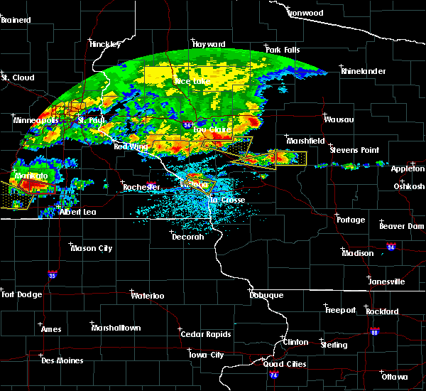 At 550 pm cdt, a severe thunderstorm was located near humbird, or 13 miles west of neillsville, moving east at 50 mph (radar indicated). Hazards include 60 mph wind gusts and quarter size hail. Hail damage to vehicles is expected. expect wind damage to roofs, siding, and trees. This severe thunderstorm will remain over mainly rural areas of southwestern clark, northwestern jackson and northeastern trempealeau counties, including the following locations, wildcat mound, highway 10 and 12, highway 10 and bald peak road, i 94 exit 98, merrillan, north branch and hixton alma center k o a. At 550 pm cdt, a severe thunderstorm was located near humbird, or 13 miles west of neillsville, moving east at 50 mph (radar indicated). Hazards include 60 mph wind gusts and quarter size hail. Hail damage to vehicles is expected. expect wind damage to roofs, siding, and trees. This severe thunderstorm will remain over mainly rural areas of southwestern clark, northwestern jackson and northeastern trempealeau counties, including the following locations, wildcat mound, highway 10 and 12, highway 10 and bald peak road, i 94 exit 98, merrillan, north branch and hixton alma center k o a.
|
| 6/2/2020 5:35 PM CDT |
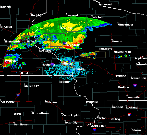 At 535 pm cdt, a severe thunderstorm was located over osseo, or 16 miles north of whitehall, moving east at 65 mph (radar indicated). Hazards include 60 mph wind gusts and quarter size hail. Hail damage to vehicles is expected. expect wind damage to roofs, siding, and trees. this severe thunderstorm will be near, price around 545 pm cdt. fairchild and humbird around 550 pm cdt. hatfield around 600 pm cdt. Other locations impacted by this severe thunderstorm include wildcat mound, highway 10 and 12, highway 10 and bald peak road, i 94 exit 98, merrillan, north branch and hixton alma center k o a. At 535 pm cdt, a severe thunderstorm was located over osseo, or 16 miles north of whitehall, moving east at 65 mph (radar indicated). Hazards include 60 mph wind gusts and quarter size hail. Hail damage to vehicles is expected. expect wind damage to roofs, siding, and trees. this severe thunderstorm will be near, price around 545 pm cdt. fairchild and humbird around 550 pm cdt. hatfield around 600 pm cdt. Other locations impacted by this severe thunderstorm include wildcat mound, highway 10 and 12, highway 10 and bald peak road, i 94 exit 98, merrillan, north branch and hixton alma center k o a.
|
| 9/24/2019 9:15 PM CDT | Trees and power lines blown dow in clark county WI, 3.7 miles WSW of Fairchild, WI |
| 9/24/2019 9:12 PM CDT | Tree uprooted and down across power lin in jackson county WI, 0.2 miles N of Fairchild, WI |
| 9/24/2019 9:06 PM CDT |
 At 905 pm cdt, severe thunderstorms were located along a line extending from near price to near blair, moving east at 50 mph. an area of strong winds was moving through northwest jackson county, between black river falls and the eau claire area (radar indicated). Hazards include 60 mph wind gusts. Expect damage to roofs, siding, and trees. severe thunderstorms will be near, price around 910 pm cdt. fairchild and humbird around 915 pm cdt. black river falls around 925 pm cdt. hatfield around 930 pm cdt. neillsville and greenwood around 940 pm cdt. loyal and shortville around 945 pm cdt. Other locations impacted by these severe thunderstorms include franklin, highway 73 and 98, the black river correctional center, tioga, i 94 exit 98, perry creek recreation area and lynn. At 905 pm cdt, severe thunderstorms were located along a line extending from near price to near blair, moving east at 50 mph. an area of strong winds was moving through northwest jackson county, between black river falls and the eau claire area (radar indicated). Hazards include 60 mph wind gusts. Expect damage to roofs, siding, and trees. severe thunderstorms will be near, price around 910 pm cdt. fairchild and humbird around 915 pm cdt. black river falls around 925 pm cdt. hatfield around 930 pm cdt. neillsville and greenwood around 940 pm cdt. loyal and shortville around 945 pm cdt. Other locations impacted by these severe thunderstorms include franklin, highway 73 and 98, the black river correctional center, tioga, i 94 exit 98, perry creek recreation area and lynn.
|
| 8/5/2019 5:56 PM CDT |
 The severe thunderstorm warning for southeastern eau claire county will expire at 600 pm cdt, the storm which prompted the warning has moved out of the area. therefore, the warning will be allowed to expire. however small hail, gusty winds and heavy rain are still possible with this thunderstorm. a severe thunderstorm watch remains in effect until 1000 pm cdt for west central wisconsin. The severe thunderstorm warning for southeastern eau claire county will expire at 600 pm cdt, the storm which prompted the warning has moved out of the area. therefore, the warning will be allowed to expire. however small hail, gusty winds and heavy rain are still possible with this thunderstorm. a severe thunderstorm watch remains in effect until 1000 pm cdt for west central wisconsin.
|
| 8/5/2019 5:54 PM CDT | Golf Ball sized hail reported 0.9 miles N of Fairchild, WI |
| 8/5/2019 5:50 PM CDT |
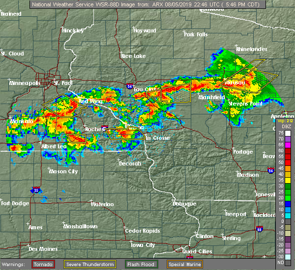 At 549 pm cdt, a severe thunderstorm was located over fairchild, or 17 miles west of neillsville, moving east at 40 mph (radar indicated). Hazards include golf ball size hail and 60 mph wind gusts. People and animals outdoors will be injured. expect hail damage to roofs, siding, windows, and vehicles. expect wind damage to roofs, siding, and trees. Locations impacted include, fairchild and price. At 549 pm cdt, a severe thunderstorm was located over fairchild, or 17 miles west of neillsville, moving east at 40 mph (radar indicated). Hazards include golf ball size hail and 60 mph wind gusts. People and animals outdoors will be injured. expect hail damage to roofs, siding, windows, and vehicles. expect wind damage to roofs, siding, and trees. Locations impacted include, fairchild and price.
|
| 8/5/2019 5:46 PM CDT | Golf Ball sized hail reported 1.1 miles ESE of Fairchild, WI |
| 8/5/2019 5:46 PM CDT |
 At 545 pm cdt, a severe thunderstorm was located over fairchild, or 20 miles west of neillsville, moving east at 40 mph (radar indicated). Hazards include 60 mph wind gusts and quarter size hail. Hail damage to vehicles is expected. expect wind damage to roofs, siding, and trees. This severe thunderstorm will remain over mainly rural areas of northwestern jackson county. At 545 pm cdt, a severe thunderstorm was located over fairchild, or 20 miles west of neillsville, moving east at 40 mph (radar indicated). Hazards include 60 mph wind gusts and quarter size hail. Hail damage to vehicles is expected. expect wind damage to roofs, siding, and trees. This severe thunderstorm will remain over mainly rural areas of northwestern jackson county.
|
| 8/5/2019 5:39 PM CDT |
 At 539 pm cdt, a severe thunderstorm was located over price, or 21 miles northeast of whitehall, moving east at 45 mph (radar indicated). Hazards include ping pong ball size hail and 60 mph wind gusts. People and animals outdoors will be injured. expect hail damage to roofs, siding, windows, and vehicles. Expect wind damage to roofs, siding, and trees. At 539 pm cdt, a severe thunderstorm was located over price, or 21 miles northeast of whitehall, moving east at 45 mph (radar indicated). Hazards include ping pong ball size hail and 60 mph wind gusts. People and animals outdoors will be injured. expect hail damage to roofs, siding, windows, and vehicles. Expect wind damage to roofs, siding, and trees.
|
| 8/5/2019 5:28 PM CDT |
 At 528 pm cdt, a severe thunderstorm was located over osseo, or 13 miles north of whitehall, moving east at 40 mph (radar indicated). Hazards include 60 mph wind gusts and quarter size hail. Hail damage to vehicles is expected. expect wind damage to roofs, siding, and trees. this severe thunderstorm will be near, price around 540 pm cdt. fairchild around 550 pm cdt. Other locations impacted by this severe thunderstorm include highway 53 and county e, levis and requa. At 528 pm cdt, a severe thunderstorm was located over osseo, or 13 miles north of whitehall, moving east at 40 mph (radar indicated). Hazards include 60 mph wind gusts and quarter size hail. Hail damage to vehicles is expected. expect wind damage to roofs, siding, and trees. this severe thunderstorm will be near, price around 540 pm cdt. fairchild around 550 pm cdt. Other locations impacted by this severe thunderstorm include highway 53 and county e, levis and requa.
|
| 7/19/2019 8:16 PM CDT |
 At 814 pm cdt, severe thunderstorms were located along a line extending from near marshfield to near shortville to hatfield, moving southeast at 40 mph (trained weather spotters. at 742 pm, damage to trees and power lines were reported near colby). Hazards include 70 mph wind gusts and penny size hail. Expect considerable tree damage. damage is likely to mobile homes, roofs, and outbuildings. these severe storms will be near, millston around 835 pm cdt. Other locations impacted by these severe thunderstorms include highway 73 and 98, shamrock, the black river correctional center, atwood, tioga, potters flowage and perry creek recreation area. At 814 pm cdt, severe thunderstorms were located along a line extending from near marshfield to near shortville to hatfield, moving southeast at 40 mph (trained weather spotters. at 742 pm, damage to trees and power lines were reported near colby). Hazards include 70 mph wind gusts and penny size hail. Expect considerable tree damage. damage is likely to mobile homes, roofs, and outbuildings. these severe storms will be near, millston around 835 pm cdt. Other locations impacted by these severe thunderstorms include highway 73 and 98, shamrock, the black river correctional center, atwood, tioga, potters flowage and perry creek recreation area.
|
| 7/19/2019 8:00 PM CDT |
 At 759 pm cdt, severe thunderstorms were located along a line extending from near spencer to near neillsville to humbird, moving southeast at 40 mph (trained weather spotters. these storms have a history of producing widespread damage to trees and power lines). Hazards include 70 mph wind gusts and penny size hail. Expect considerable tree damage. damage is likely to mobile homes, roofs, and outbuildings. severe thunderstorms will be near, shortville around 810 pm cdt. black river falls around 820 pm cdt. millston around 835 pm cdt. other locations impacted by these severe thunderstorms include highway 73 and 98, shamrock, the black river correctional center, atwood, tioga, potters flowage and perry creek recreation area. People attending ussa summerfest should seek safe shelter immediately!. At 759 pm cdt, severe thunderstorms were located along a line extending from near spencer to near neillsville to humbird, moving southeast at 40 mph (trained weather spotters. these storms have a history of producing widespread damage to trees and power lines). Hazards include 70 mph wind gusts and penny size hail. Expect considerable tree damage. damage is likely to mobile homes, roofs, and outbuildings. severe thunderstorms will be near, shortville around 810 pm cdt. black river falls around 820 pm cdt. millston around 835 pm cdt. other locations impacted by these severe thunderstorms include highway 73 and 98, shamrock, the black river correctional center, atwood, tioga, potters flowage and perry creek recreation area. People attending ussa summerfest should seek safe shelter immediately!.
|
| 6/14/2019 7:09 PM CDT |
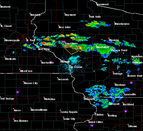 At 653 pm cdt, a severe thunderstorm was located over humbird, or 13 miles west of neillsville, moving southeast at 30 mph (radar indicated). Hazards include 60 mph wind gusts and quarter size hail. Hail damage to vehicles is expected. expect wind damage to roofs, siding, and trees. This severe thunderstorm will remain over mainly rural areas of southwestern clark and northwestern jackson counties, including the following locations, wildcat mound, highway 10 and 12, merrillan, snyder lake, highway 10 and bald peak road and alma center. At 653 pm cdt, a severe thunderstorm was located over humbird, or 13 miles west of neillsville, moving southeast at 30 mph (radar indicated). Hazards include 60 mph wind gusts and quarter size hail. Hail damage to vehicles is expected. expect wind damage to roofs, siding, and trees. This severe thunderstorm will remain over mainly rural areas of southwestern clark and northwestern jackson counties, including the following locations, wildcat mound, highway 10 and 12, merrillan, snyder lake, highway 10 and bald peak road and alma center.
|
| 6/14/2019 6:54 PM CDT |
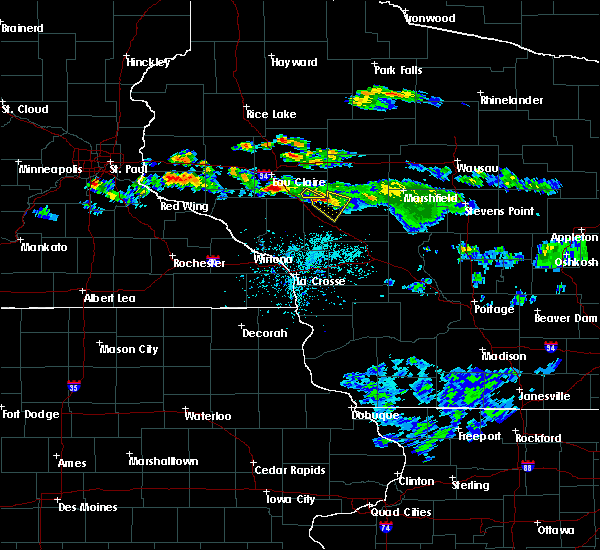 At 629 pm cdt, a severe thunderstorm was located over augusta, or 22 miles northeast of whitehall, moving southeast at 25 mph (radar indicated). Hazards include 60 mph wind gusts and quarter size hail. Hail damage to vehicles is expected. expect wind damage to roofs, siding, and trees. this severe thunderstorm will be near, price around 640 pm cdt. fairchild around 650 pm cdt. humbird around 655 pm cdt. Other locations impacted by this severe thunderstorm include wildcat mound, highway 10 and 12, highway 10 and bald peak road, alma center, levis, requa and merrillan. At 629 pm cdt, a severe thunderstorm was located over augusta, or 22 miles northeast of whitehall, moving southeast at 25 mph (radar indicated). Hazards include 60 mph wind gusts and quarter size hail. Hail damage to vehicles is expected. expect wind damage to roofs, siding, and trees. this severe thunderstorm will be near, price around 640 pm cdt. fairchild around 650 pm cdt. humbird around 655 pm cdt. Other locations impacted by this severe thunderstorm include wildcat mound, highway 10 and 12, highway 10 and bald peak road, alma center, levis, requa and merrillan.
|
| 6/14/2019 6:50 PM CDT |
 The severe thunderstorm warning for southeastern eau claire county will expire at 700 pm cdt, the storm which prompted the warning has moved out of the area. therefore, the warning will be allowed to expire. to report severe weather, contact your nearest law enforcement agency. they will relay your report to the national weather service the twin cities. The severe thunderstorm warning for southeastern eau claire county will expire at 700 pm cdt, the storm which prompted the warning has moved out of the area. therefore, the warning will be allowed to expire. to report severe weather, contact your nearest law enforcement agency. they will relay your report to the national weather service the twin cities.
|
| 6/14/2019 6:33 PM CDT |
 At 624 pm cdt, a severe thunderstorm was located near augusta, or 20 miles southeast of eau claire, moving southeast at 25 mph (radar indicated). Hazards include 60 mph wind gusts and quarter size hail. Hail damage to vehicles is expected. Expect wind damage to roofs, siding, and trees. At 624 pm cdt, a severe thunderstorm was located near augusta, or 20 miles southeast of eau claire, moving southeast at 25 mph (radar indicated). Hazards include 60 mph wind gusts and quarter size hail. Hail damage to vehicles is expected. Expect wind damage to roofs, siding, and trees.
|
| 6/14/2019 6:29 PM CDT |
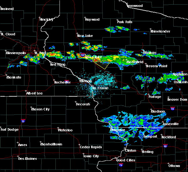 At 629 pm cdt, a severe thunderstorm was located over augusta, or 22 miles northeast of whitehall, moving southeast at 25 mph (radar indicated). Hazards include 60 mph wind gusts and quarter size hail. Hail damage to vehicles is expected. expect wind damage to roofs, siding, and trees. this severe thunderstorm will be near, price around 640 pm cdt. fairchild around 650 pm cdt. humbird around 655 pm cdt. Other locations impacted by this severe thunderstorm include wildcat mound, highway 10 and 12, highway 10 and bald peak road, alma center, levis, requa and merrillan. At 629 pm cdt, a severe thunderstorm was located over augusta, or 22 miles northeast of whitehall, moving southeast at 25 mph (radar indicated). Hazards include 60 mph wind gusts and quarter size hail. Hail damage to vehicles is expected. expect wind damage to roofs, siding, and trees. this severe thunderstorm will be near, price around 640 pm cdt. fairchild around 650 pm cdt. humbird around 655 pm cdt. Other locations impacted by this severe thunderstorm include wildcat mound, highway 10 and 12, highway 10 and bald peak road, alma center, levis, requa and merrillan.
|
| 6/14/2019 6:25 PM CDT |
 At 624 pm cdt, a severe thunderstorm was located near augusta, or 20 miles southeast of eau claire, moving southeast at 25 mph (radar indicated). Hazards include 60 mph wind gusts and quarter size hail. Hail damage to vehicles is expected. Expect wind damage to roofs, siding, and trees. At 624 pm cdt, a severe thunderstorm was located near augusta, or 20 miles southeast of eau claire, moving southeast at 25 mph (radar indicated). Hazards include 60 mph wind gusts and quarter size hail. Hail damage to vehicles is expected. Expect wind damage to roofs, siding, and trees.
|
| 9/20/2018 8:36 PM CDT |
 The severe thunderstorm warning for eastern chippewa and eau claire counties will expire at 845 pm cdt, the storms which prompted the warning have weakened below severe limits, and have exited the warned area. therefore, the warning will be allowed to expire. a tornado watch remains in effect until midnight cdt for west central wisconsin. to report severe weather, contact your nearest law enforcement agency. they will relay your report to the national weather service the twin cities. The severe thunderstorm warning for eastern chippewa and eau claire counties will expire at 845 pm cdt, the storms which prompted the warning have weakened below severe limits, and have exited the warned area. therefore, the warning will be allowed to expire. a tornado watch remains in effect until midnight cdt for west central wisconsin. to report severe weather, contact your nearest law enforcement agency. they will relay your report to the national weather service the twin cities.
|
| 9/20/2018 8:23 PM CDT |
 A severe thunderstorm warning remains in effect until 845 pm cdt for eastern chippewa and eau claire counties. at 822 pm cdt, severe thunderstorms were located along a line extending from near cornell to near osseo, moving east at 55 mph. hazard. 60 mph wind gusts. source. Radar indicated. A severe thunderstorm warning remains in effect until 845 pm cdt for eastern chippewa and eau claire counties. at 822 pm cdt, severe thunderstorms were located along a line extending from near cornell to near osseo, moving east at 55 mph. hazard. 60 mph wind gusts. source. Radar indicated.
|
| 9/20/2018 8:08 PM CDT |
 At 808 pm cdt, severe thunderstorms were located along a line extending from near bloomer to near eleva, moving east at 60 mph (radar indicated). Hazards include 60 mph wind gusts. Expect damage to roofs, siding, and trees. severe thunderstorms will be near, augusta and cornell around 830 pm cdt. fairchild around 835 pm cdt. other locations impacted by these severe thunderstorms include foster, brackett, holcombe, lake eau claire county park, bateman, ludington, otter lake, jim falls, allen and eagleton. this includes interstate 94 in wisconsin between mile markers 72 and 86. A tornado watch remains in effect until midnight cdt for west central wisconsin. At 808 pm cdt, severe thunderstorms were located along a line extending from near bloomer to near eleva, moving east at 60 mph (radar indicated). Hazards include 60 mph wind gusts. Expect damage to roofs, siding, and trees. severe thunderstorms will be near, augusta and cornell around 830 pm cdt. fairchild around 835 pm cdt. other locations impacted by these severe thunderstorms include foster, brackett, holcombe, lake eau claire county park, bateman, ludington, otter lake, jim falls, allen and eagleton. this includes interstate 94 in wisconsin between mile markers 72 and 86. A tornado watch remains in effect until midnight cdt for west central wisconsin.
|
| 8/27/2018 7:13 PM CDT |
 The severe thunderstorm warning for chippewa and eau claire counties will expire at 715 pm cdt. the storms which prompted the warning have weakened below severe limits, and no longer pose an immediate threat to life or property. therefore, the warning will be allowed to expire. However heavy rain is still possible with these thunderstorms. The severe thunderstorm warning for chippewa and eau claire counties will expire at 715 pm cdt. the storms which prompted the warning have weakened below severe limits, and no longer pose an immediate threat to life or property. therefore, the warning will be allowed to expire. However heavy rain is still possible with these thunderstorms.
|
| 8/27/2018 7:12 PM CDT |
 The severe thunderstorm warning for southwestern winona. southeastern buffalo. western jackson and trempealeau counties will expire at 715 pm cdt. the storms which prompted the warning have weakened below severe limits, and no longer pose an immediate threat to life or property. therefore the warning will be allowed to expire. However gusty winds. The severe thunderstorm warning for southwestern winona. southeastern buffalo. western jackson and trempealeau counties will expire at 715 pm cdt. the storms which prompted the warning have weakened below severe limits, and no longer pose an immediate threat to life or property. therefore the warning will be allowed to expire. However gusty winds.
|
| 8/27/2018 7:03 PM CDT |
 At 703 pm cdt, severe thunderstorms were located along a line extending from near cornell to near blair to near rushford, moving east at 45 mph (radar indicated). Hazards include 60 mph wind gusts. Expect damage to roofs, siding, and trees. these severe storms will be near, blair around 710 pm cdt. Other locations impacted by these severe thunderstorms include dodge, franklin, new hartford, york and wilson. At 703 pm cdt, severe thunderstorms were located along a line extending from near cornell to near blair to near rushford, moving east at 45 mph (radar indicated). Hazards include 60 mph wind gusts. Expect damage to roofs, siding, and trees. these severe storms will be near, blair around 710 pm cdt. Other locations impacted by these severe thunderstorms include dodge, franklin, new hartford, york and wilson.
|
| 8/27/2018 7:00 PM CDT |
 At 659 pm cdt, severe thunderstorms were located along a line extending from near chippewa moraine state rec area to foster, moving east at 55 mph (radar indicated). Hazards include 60 mph wind gusts. Expect damage to roofs, siding, and trees. these severe storms will be near, augusta and cornell around 710 pm cdt. fairchild around 715 pm cdt. Other locations impacted by these severe thunderstorms include holcombe, tilden, otter lake, jim falls, allen, chippewa moraine state rec area, foster, brackett, lake eau claire county park and bateman. At 659 pm cdt, severe thunderstorms were located along a line extending from near chippewa moraine state rec area to foster, moving east at 55 mph (radar indicated). Hazards include 60 mph wind gusts. Expect damage to roofs, siding, and trees. these severe storms will be near, augusta and cornell around 710 pm cdt. fairchild around 715 pm cdt. Other locations impacted by these severe thunderstorms include holcombe, tilden, otter lake, jim falls, allen, chippewa moraine state rec area, foster, brackett, lake eau claire county park and bateman.
|
| 8/27/2018 6:50 PM CDT |
 At 649 pm cdt, severe thunderstorms were located along a line extending from canton to near new auburn to near eleva, moving northeast at 65 mph (law enforcement reported widespread damage in pierce and st croix counties). Hazards include 70 mph wind gusts. Expect considerable tree damage. damage is likely to mobile homes, roofs, and outbuildings. these severe storms will be near, stanley and boyd around 715 pm cdt. Other locations impacted by these severe thunderstorms include caryville, holcombe, tilden, otter lake, jim falls, allen, sand creek, chippewa moraine state rec area, foster and brackett. At 649 pm cdt, severe thunderstorms were located along a line extending from canton to near new auburn to near eleva, moving northeast at 65 mph (law enforcement reported widespread damage in pierce and st croix counties). Hazards include 70 mph wind gusts. Expect considerable tree damage. damage is likely to mobile homes, roofs, and outbuildings. these severe storms will be near, stanley and boyd around 715 pm cdt. Other locations impacted by these severe thunderstorms include caryville, holcombe, tilden, otter lake, jim falls, allen, sand creek, chippewa moraine state rec area, foster and brackett.
|
| 8/27/2018 6:39 PM CDT |
 At 638 pm cdt, severe thunderstorms were located along a line extending from dallas to 6 miles northeast of colfax to lookout, moving northeast at 70 mph (law enforcement relayed multiple reports of wind damage across pierce and st croix counties). Hazards include 70 mph wind gusts. Expect considerable tree damage. damage is likely to mobile homes, roofs, and outbuildings. these severe storms will be near, bloomer and new auburn around 645 pm cdt. augusta around 700 pm cdt. Other locations impacted by these severe thunderstorms include cedar falls, caryville, holcombe, tainter lake, tilden, otter lake, jim falls, allen, sand creek and chippewa moraine state rec area. At 638 pm cdt, severe thunderstorms were located along a line extending from dallas to 6 miles northeast of colfax to lookout, moving northeast at 70 mph (law enforcement relayed multiple reports of wind damage across pierce and st croix counties). Hazards include 70 mph wind gusts. Expect considerable tree damage. damage is likely to mobile homes, roofs, and outbuildings. these severe storms will be near, bloomer and new auburn around 645 pm cdt. augusta around 700 pm cdt. Other locations impacted by these severe thunderstorms include cedar falls, caryville, holcombe, tainter lake, tilden, otter lake, jim falls, allen, sand creek and chippewa moraine state rec area.
|
| 8/27/2018 6:29 PM CDT |
 At 627 pm cdt, severe thunderstorms were located along a line extending from near menomonie to buffalo city to near chatfield, moving northeast at 55 mph. these storms have a history of 40 to 55 mph wind gusts (radar indicated). Hazards include 60 mph wind gusts. Expect damage to roofs, siding, and trees. these severe storms will be near, arcadia around 645 pm cdt. lewiston around 650 pm cdt. independence around 655 pm cdt. whitehall, stockton and blair around 700 pm cdt. Other locations impacted by these severe thunderstorms include dodge, franklin, new hartford, york and eleva. At 627 pm cdt, severe thunderstorms were located along a line extending from near menomonie to buffalo city to near chatfield, moving northeast at 55 mph. these storms have a history of 40 to 55 mph wind gusts (radar indicated). Hazards include 60 mph wind gusts. Expect damage to roofs, siding, and trees. these severe storms will be near, arcadia around 645 pm cdt. lewiston around 650 pm cdt. independence around 655 pm cdt. whitehall, stockton and blair around 700 pm cdt. Other locations impacted by these severe thunderstorms include dodge, franklin, new hartford, york and eleva.
|
| 8/27/2018 6:29 PM CDT |
 At 606 pm cdt, severe thunderstorms were located along a line extending from near elmwood to near plainview to near stewartville, moving northeast at 60 mph (radar indicated). Hazards include 60 mph wind gusts. Expect damage to roofs, siding, and trees. severe thunderstorms will be near, buffalo and buffalo city around 625 pm cdt. arcadia and lewiston around 640 pm cdt. stockton and rollingstone around 645 pm cdt. winona, independence, goodview and fountain city around 650 pm cdt. Other locations impacted by these severe thunderstorms include dodge, franklin, new hartford, york and eleva. At 606 pm cdt, severe thunderstorms were located along a line extending from near elmwood to near plainview to near stewartville, moving northeast at 60 mph (radar indicated). Hazards include 60 mph wind gusts. Expect damage to roofs, siding, and trees. severe thunderstorms will be near, buffalo and buffalo city around 625 pm cdt. arcadia and lewiston around 640 pm cdt. stockton and rollingstone around 645 pm cdt. winona, independence, goodview and fountain city around 650 pm cdt. Other locations impacted by these severe thunderstorms include dodge, franklin, new hartford, york and eleva.
|
| 8/27/2018 6:20 PM CDT |
 At 619 pm cdt, severe thunderstorms were located along a line extending from glenwood city to near menomonie to rattlesnake ridge, moving northeast at 80 mph. these are very dangerous storms (radar indicated). Hazards include 80 mph wind gusts. Flying debris will be dangerous to those caught without shelter. mobile homes will be heavily damaged. expect considerable damage to roofs, windows, and vehicles. extensive tree damage and power outages are likely. severe thunderstorms will be near, menomonie, boyceville and wheeler around 625 pm cdt. colfax around 630 pm cdt. ridgeland around 635 pm cdt. bloomer and new auburn around 640 pm cdt. cornell around 655 pm cdt. Augusta around 700 pm cdt. At 619 pm cdt, severe thunderstorms were located along a line extending from glenwood city to near menomonie to rattlesnake ridge, moving northeast at 80 mph. these are very dangerous storms (radar indicated). Hazards include 80 mph wind gusts. Flying debris will be dangerous to those caught without shelter. mobile homes will be heavily damaged. expect considerable damage to roofs, windows, and vehicles. extensive tree damage and power outages are likely. severe thunderstorms will be near, menomonie, boyceville and wheeler around 625 pm cdt. colfax around 630 pm cdt. ridgeland around 635 pm cdt. bloomer and new auburn around 640 pm cdt. cornell around 655 pm cdt. Augusta around 700 pm cdt.
|
| 8/27/2018 6:07 PM CDT |
 At 606 pm cdt, severe thunderstorms were located along a line extending from near elmwood to near plainview to near stewartville, moving northeast at 60 mph (radar indicated). Hazards include 60 mph wind gusts. Expect damage to roofs, siding, and trees. severe thunderstorms will be near, buffalo and buffalo city around 625 pm cdt. arcadia and lewiston around 640 pm cdt. stockton and rollingstone around 645 pm cdt. winona, independence, goodview and fountain city around 650 pm cdt. Other locations impacted by these severe thunderstorms include dodge, franklin, new hartford, york and eleva. At 606 pm cdt, severe thunderstorms were located along a line extending from near elmwood to near plainview to near stewartville, moving northeast at 60 mph (radar indicated). Hazards include 60 mph wind gusts. Expect damage to roofs, siding, and trees. severe thunderstorms will be near, buffalo and buffalo city around 625 pm cdt. arcadia and lewiston around 640 pm cdt. stockton and rollingstone around 645 pm cdt. winona, independence, goodview and fountain city around 650 pm cdt. Other locations impacted by these severe thunderstorms include dodge, franklin, new hartford, york and eleva.
|
| 7/12/2018 8:20 PM CDT |
 At 818 pm cdt, severe thunderstorms were located along a line extending from near humbird to 6 miles northwest of galesville, moving east at 35 mph (radar indicated). Hazards include 60 mph wind gusts. Expect damage to roofs, siding, and trees. these severe storms will be near, humbird and hatfield around 825 pm cdt. neillsville and shortville around 830 pm cdt. these storms have a history of producing wind damage. at 724 pm, this line blew down trees near mondovi. Other locations impacted by these severe thunderstorms include franklin, york, irving, northfield and merrillan. At 818 pm cdt, severe thunderstorms were located along a line extending from near humbird to 6 miles northwest of galesville, moving east at 35 mph (radar indicated). Hazards include 60 mph wind gusts. Expect damage to roofs, siding, and trees. these severe storms will be near, humbird and hatfield around 825 pm cdt. neillsville and shortville around 830 pm cdt. these storms have a history of producing wind damage. at 724 pm, this line blew down trees near mondovi. Other locations impacted by these severe thunderstorms include franklin, york, irving, northfield and merrillan.
|
| 7/12/2018 8:12 PM CDT |
 At 812 pm cdt, severe thunderstorms were located along a line extending from near price to 6 miles southwest of arcadia, moving east at 35 mph (radar indicated). Hazards include 60 mph wind gusts. Expect damage to roofs, siding, and trees. these severe storms will be near, price around 815 pm cdt. humbird around 820 pm cdt. neillsville, hatfield, north bend and blair around 830 pm cdt. Other locations impacted by these severe thunderstorms include franklin, york, irving, northfield and merrillan. At 812 pm cdt, severe thunderstorms were located along a line extending from near price to 6 miles southwest of arcadia, moving east at 35 mph (radar indicated). Hazards include 60 mph wind gusts. Expect damage to roofs, siding, and trees. these severe storms will be near, price around 815 pm cdt. humbird around 820 pm cdt. neillsville, hatfield, north bend and blair around 830 pm cdt. Other locations impacted by these severe thunderstorms include franklin, york, irving, northfield and merrillan.
|
| 7/12/2018 8:01 PM CDT |
 At 801 pm cdt, severe thunderstorms were located along a line extending from near glen flora to augusta, moving east at 35 mph (radar indicated). Hazards include 60 mph wind gusts and penny size hail. Expect damage to roofs, siding, and trees. Locations impacted include, stanley, lake wissota, augusta, cornell, cadott, fall creek, boyd, fairchild, hawkins, sheldon, ludington and conrath. At 801 pm cdt, severe thunderstorms were located along a line extending from near glen flora to augusta, moving east at 35 mph (radar indicated). Hazards include 60 mph wind gusts and penny size hail. Expect damage to roofs, siding, and trees. Locations impacted include, stanley, lake wissota, augusta, cornell, cadott, fall creek, boyd, fairchild, hawkins, sheldon, ludington and conrath.
|
| 7/12/2018 8:01 PM CDT |
 At 800 pm cdt, severe thunderstorms were located along a line extending from price to near fountain city, moving east at 35 mph (radar indicated). Hazards include 60 mph wind gusts. Expect damage to roofs, siding, and trees. these severe storms will be near, price and osseo around 805 pm cdt. humbird around 810 pm cdt. hatfield around 820 pm cdt. neillsville and blair around 825 pm cdt. shortville and north bend around 830 pm cdt. Other locations impacted by these severe thunderstorms include franklin, york, irving, northfield and merrillan. At 800 pm cdt, severe thunderstorms were located along a line extending from price to near fountain city, moving east at 35 mph (radar indicated). Hazards include 60 mph wind gusts. Expect damage to roofs, siding, and trees. these severe storms will be near, price and osseo around 805 pm cdt. humbird around 810 pm cdt. hatfield around 820 pm cdt. neillsville and blair around 825 pm cdt. shortville and north bend around 830 pm cdt. Other locations impacted by these severe thunderstorms include franklin, york, irving, northfield and merrillan.
|
| 7/12/2018 7:50 PM CDT |
 At 749 pm cdt, severe thunderstorms were located along a line extending from osseo to near buffalo city, moving east at 35 mph (radar indicated). Hazards include 60 mph wind gusts. Expect damage to roofs, siding, and trees. these severe storms will be near, osseo around 755 pm cdt. price around 800 pm cdt. arcadia and humbird around 815 pm cdt. neillsville, black river falls, hatfield and north bend around 830 pm cdt. Other locations impacted by these severe thunderstorms include franklin, york, irving, northfield and merrillan. At 749 pm cdt, severe thunderstorms were located along a line extending from osseo to near buffalo city, moving east at 35 mph (radar indicated). Hazards include 60 mph wind gusts. Expect damage to roofs, siding, and trees. these severe storms will be near, osseo around 755 pm cdt. price around 800 pm cdt. arcadia and humbird around 815 pm cdt. neillsville, black river falls, hatfield and north bend around 830 pm cdt. Other locations impacted by these severe thunderstorms include franklin, york, irving, northfield and merrillan.
|
| 7/12/2018 7:49 PM CDT |
 At 749 pm cdt, severe thunderstorms were located along a line extending from near sheldon to near augusta, moving east at 35 mph (radar indicated). Hazards include 60 mph wind gusts and penny size hail. Expect damage to roofs, siding, and trees. Locations impacted include, eau claire, chippewa falls, altoona, lake hallie, stanley, lake wissota, augusta, cornell, cadott, fall creek, boyd and fairchild. At 749 pm cdt, severe thunderstorms were located along a line extending from near sheldon to near augusta, moving east at 35 mph (radar indicated). Hazards include 60 mph wind gusts and penny size hail. Expect damage to roofs, siding, and trees. Locations impacted include, eau claire, chippewa falls, altoona, lake hallie, stanley, lake wissota, augusta, cornell, cadott, fall creek, boyd and fairchild.
|
| 7/12/2018 7:38 PM CDT |
 At 737 pm cdt, severe thunderstorms were located along a line extending from near osseo to 7 miles east of buffalo city, moving east at 45 mph (radar indicated). Hazards include 60 mph wind gusts. Expect damage to roofs, siding, and trees. severe thunderstorms will be near, price and osseo around 745 pm cdt. humbird around 755 pm cdt. hatfield and blair around 800 pm cdt. neillsville and north bend around 805 pm cdt. shortville around 810 pm cdt. millston around 825 pm cdt. Other locations impacted by these severe thunderstorms include franklin, york, irving, northfield and merrillan. At 737 pm cdt, severe thunderstorms were located along a line extending from near osseo to 7 miles east of buffalo city, moving east at 45 mph (radar indicated). Hazards include 60 mph wind gusts. Expect damage to roofs, siding, and trees. severe thunderstorms will be near, price and osseo around 745 pm cdt. humbird around 755 pm cdt. hatfield and blair around 800 pm cdt. neillsville and north bend around 805 pm cdt. shortville around 810 pm cdt. millston around 825 pm cdt. Other locations impacted by these severe thunderstorms include franklin, york, irving, northfield and merrillan.
|
| 7/12/2018 7:27 PM CDT |
 At 727 pm cdt, severe thunderstorms were located along a line extending from 7 miles west of conrath to near allen, moving east at 35 mph (radar indicated). Hazards include 60 mph wind gusts and penny size hail. expect damage to roofs, siding, and trees At 727 pm cdt, severe thunderstorms were located along a line extending from 7 miles west of conrath to near allen, moving east at 35 mph (radar indicated). Hazards include 60 mph wind gusts and penny size hail. expect damage to roofs, siding, and trees
|
| 7/12/2017 3:51 AM CDT |
 At 351 am cdt, severe thunderstorms were located along a line extending from near jim falls to near bateman to near seymour to 6 miles southeast of rock falls, moving east at 60 mph (radar indicated). Hazards include 60 mph wind gusts. Expect damage to roofs, siding, and trees. severe thunderstorms will be near, cornell, cadott and fall creek around 355 am cdt. boyd around 400 am cdt. stanley around 405 am cdt. Augusta around 415 am cdt. At 351 am cdt, severe thunderstorms were located along a line extending from near jim falls to near bateman to near seymour to 6 miles southeast of rock falls, moving east at 60 mph (radar indicated). Hazards include 60 mph wind gusts. Expect damage to roofs, siding, and trees. severe thunderstorms will be near, cornell, cadott and fall creek around 355 am cdt. boyd around 400 am cdt. stanley around 405 am cdt. Augusta around 415 am cdt.
|
| 6/16/2017 7:39 PM CDT |
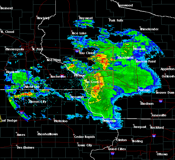 The severe thunderstorm warning for northwestern jackson county will expire at 745 pm cdt, the severe thunderstorm which prompted the warning has moved out of the warned area. therefore, the warning will be allowed to expire. a severe thunderstorm watch remains in effect until 1000 pm cdt for west central wisconsin. The severe thunderstorm warning for northwestern jackson county will expire at 745 pm cdt, the severe thunderstorm which prompted the warning has moved out of the warned area. therefore, the warning will be allowed to expire. a severe thunderstorm watch remains in effect until 1000 pm cdt for west central wisconsin.
|
| 6/16/2017 7:30 PM CDT |
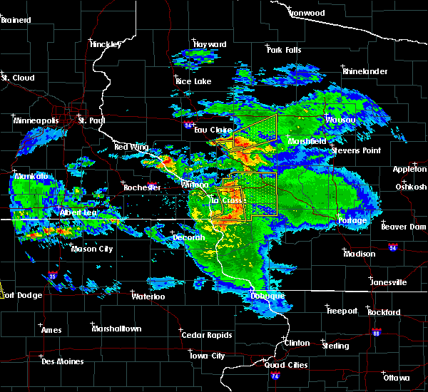 At 728 pm cdt, a severe thunderstorm was located over fairchild, or 17 miles west of neillsville, moving northeast at 30 mph (trained weather spotters. at 727 pm, ping pong size hail was reported fairchild). Hazards include ping pong ball size hail. People and animals outdoors will be injured. expect damage to roofs, siding, windows, and vehicles. This severe thunderstorm will remain over mainly rural areas of northwestern jackson county, including the following locations: requa. At 728 pm cdt, a severe thunderstorm was located over fairchild, or 17 miles west of neillsville, moving northeast at 30 mph (trained weather spotters. at 727 pm, ping pong size hail was reported fairchild). Hazards include ping pong ball size hail. People and animals outdoors will be injured. expect damage to roofs, siding, windows, and vehicles. This severe thunderstorm will remain over mainly rural areas of northwestern jackson county, including the following locations: requa.
|
| 6/16/2017 7:27 PM CDT | Half Dollar sized hail reported 1.1 miles ESE of Fairchild, WI, mping reported. |
| 6/16/2017 7:27 PM CDT | Ping Pong Ball sized hail reported 0.2 miles N of Fairchild, WI |
| 6/16/2017 7:25 PM CDT | Tree blown down near us highway 10 and county in clark county WI, 2.5 miles W of Fairchild, WI |
| 6/16/2017 7:25 PM CDT | Ping Pong Ball sized hail reported 0.2 miles N of Fairchild, WI, local business reports ping pong sized hail. |
| 6/16/2017 7:25 PM CDT |
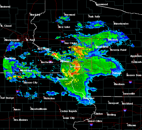 At 724 pm cdt, a severe thunderstorm was located over fairchild, or 18 miles west of neillsville, moving northeast at 40 mph (radar indicated). Hazards include 60 mph wind gusts and quarter size hail. Hail damage to vehicles is expected. expect wind damage to roofs, siding, and trees. Locations impacted include, fairchild. At 724 pm cdt, a severe thunderstorm was located over fairchild, or 18 miles west of neillsville, moving northeast at 40 mph (radar indicated). Hazards include 60 mph wind gusts and quarter size hail. Hail damage to vehicles is expected. expect wind damage to roofs, siding, and trees. Locations impacted include, fairchild.
|
| 6/16/2017 7:20 PM CDT |
 At 719 pm cdt, a severe thunderstorm was located over price, or 18 miles northeast of whitehall, moving northeast at 30 mph. this is a very dangerous storm (radar indicated). Hazards include baseball size hail. People and animals outdoors will be severely injured. expect shattered windows, extensive damage to roofs, siding, and vehicles. this severe storm will be near, fairchild around 730 pm cdt. Other locations impacted by this severe thunderstorm include york, northfield, levis, i 94 exit 98 and north branch. At 719 pm cdt, a severe thunderstorm was located over price, or 18 miles northeast of whitehall, moving northeast at 30 mph. this is a very dangerous storm (radar indicated). Hazards include baseball size hail. People and animals outdoors will be severely injured. expect shattered windows, extensive damage to roofs, siding, and vehicles. this severe storm will be near, fairchild around 730 pm cdt. Other locations impacted by this severe thunderstorm include york, northfield, levis, i 94 exit 98 and north branch.
|
| 6/16/2017 7:14 PM CDT |
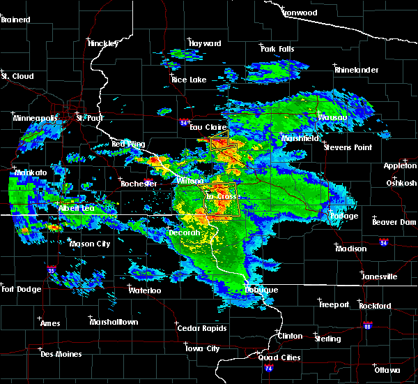 At 713 pm cdt, a severe thunderstorm was located over pleasantville, or near whitehall, moving northeast at 45 mph (radar indicated). Hazards include 60 mph wind gusts and quarter size hail. Hail damage to vehicles is expected. expect wind damage to roofs, siding, and trees. This severe thunderstorm will be near, fairchild around 745 pm cdt. At 713 pm cdt, a severe thunderstorm was located over pleasantville, or near whitehall, moving northeast at 45 mph (radar indicated). Hazards include 60 mph wind gusts and quarter size hail. Hail damage to vehicles is expected. expect wind damage to roofs, siding, and trees. This severe thunderstorm will be near, fairchild around 745 pm cdt.
|
| 6/16/2017 7:12 PM CDT |
 At 712 pm cdt, a severe thunderstorm was located near price, or 14 miles northeast of whitehall, moving northeast at 30 mph (trained weather spotters). Hazards include golf ball size hail. People and animals outdoors will be injured. expect damage to roofs, siding, windows, and vehicles. this severe storm will be near, price around 720 pm cdt. fairchild around 730 pm cdt. Other locations impacted by this severe thunderstorm include york, northfield, levis, i 94 exit 98 and north branch. At 712 pm cdt, a severe thunderstorm was located near price, or 14 miles northeast of whitehall, moving northeast at 30 mph (trained weather spotters). Hazards include golf ball size hail. People and animals outdoors will be injured. expect damage to roofs, siding, windows, and vehicles. this severe storm will be near, price around 720 pm cdt. fairchild around 730 pm cdt. Other locations impacted by this severe thunderstorm include york, northfield, levis, i 94 exit 98 and north branch.
|
| 6/16/2017 7:04 PM CDT |
 At 703 pm cdt, a severe thunderstorm was located 7 miles south of osseo, or 10 miles northeast of whitehall, moving northeast at 30 mph (trained weather spotters). Hazards include half dollar size hail. Damage to vehicles is expected. this severe thunderstorm will be near, price around 720 pm cdt. fairchild around 730 pm cdt. Other locations impacted by this severe thunderstorm include york, northfield, levis, i 94 exit 98 and north branch. At 703 pm cdt, a severe thunderstorm was located 7 miles south of osseo, or 10 miles northeast of whitehall, moving northeast at 30 mph (trained weather spotters). Hazards include half dollar size hail. Damage to vehicles is expected. this severe thunderstorm will be near, price around 720 pm cdt. fairchild around 730 pm cdt. Other locations impacted by this severe thunderstorm include york, northfield, levis, i 94 exit 98 and north branch.
|
| 6/11/2017 10:27 PM CDT |
 The severe thunderstorm warning for eastern eau claire county will expire at 1030 pm cdt, the storm which prompted the warning has weakened below severe limits, and has exited the warned area. therefore, the warning will be allowed to expire. The severe thunderstorm warning for eastern eau claire county will expire at 1030 pm cdt, the storm which prompted the warning has weakened below severe limits, and has exited the warned area. therefore, the warning will be allowed to expire.
|
| 6/11/2017 10:16 PM CDT |
 At 1016 pm cdt, a severe thunderstorm was located near lake eau claire county park, or 21 miles east of eau claire, moving east at 40 mph (radar indicated). Hazards include 60 mph wind gusts and quarter size hail. Hail damage to vehicles is expected. expect wind damage to roofs, siding, and trees. This severe thunderstorm will remain over mainly rural areas of eastern eau claire county, including the following locations: lake eau claire county park. At 1016 pm cdt, a severe thunderstorm was located near lake eau claire county park, or 21 miles east of eau claire, moving east at 40 mph (radar indicated). Hazards include 60 mph wind gusts and quarter size hail. Hail damage to vehicles is expected. expect wind damage to roofs, siding, and trees. This severe thunderstorm will remain over mainly rural areas of eastern eau claire county, including the following locations: lake eau claire county park.
|
| 6/11/2017 10:00 PM CDT |
 At 1000 pm cdt, a severe thunderstorm was located near fall creek, or 15 miles southeast of eau claire, moving east at 50 mph (radar indicated). Hazards include 60 mph wind gusts and quarter size hail. Hail damage to vehicles is expected. expect wind damage to roofs, siding, and trees. this severe storm will be near, augusta around 1005 pm cdt. Other locations impacted by this severe thunderstorm include lake eau claire county park, foster, brackett and allen. At 1000 pm cdt, a severe thunderstorm was located near fall creek, or 15 miles southeast of eau claire, moving east at 50 mph (radar indicated). Hazards include 60 mph wind gusts and quarter size hail. Hail damage to vehicles is expected. expect wind damage to roofs, siding, and trees. this severe storm will be near, augusta around 1005 pm cdt. Other locations impacted by this severe thunderstorm include lake eau claire county park, foster, brackett and allen.
|
| 6/11/2017 9:45 PM CDT |
 At 944 pm cdt, a severe thunderstorm was located over eleva, or 9 miles east of mondovi, moving east at 50 mph (radar indicated). Hazards include 60 mph wind gusts and quarter size hail. Hail damage to vehicles is expected. expect wind damage to roofs, siding, and trees. this severe thunderstorm will be near, fall creek around 1000 pm cdt. augusta around 1005 pm cdt. other locations impacted by this severe thunderstorm include lake eau claire county park, foster, brackett and allen. This includes interstate 94 in wisconsin between mile markers 74 and 87. At 944 pm cdt, a severe thunderstorm was located over eleva, or 9 miles east of mondovi, moving east at 50 mph (radar indicated). Hazards include 60 mph wind gusts and quarter size hail. Hail damage to vehicles is expected. expect wind damage to roofs, siding, and trees. this severe thunderstorm will be near, fall creek around 1000 pm cdt. augusta around 1005 pm cdt. other locations impacted by this severe thunderstorm include lake eau claire county park, foster, brackett and allen. This includes interstate 94 in wisconsin between mile markers 74 and 87.
|
| 5/16/2017 11:22 PM CDT |
 The severe thunderstorm warning for southern clark and northern jackson counties will expire at 1130 pm cdt, the storms which prompted the warning have weakened below severe limits, and no longer pose an immediate threat to life or property. therefore the warning will be allowed to expire. however heavy rain is still possible with these thunderstorms. a severe thunderstorm watch remains in effect until 500 am cdt for central and west central wisconsin. conditions remain favorable for severe thunderstorms to develop. The severe thunderstorm warning for southern clark and northern jackson counties will expire at 1130 pm cdt, the storms which prompted the warning have weakened below severe limits, and no longer pose an immediate threat to life or property. therefore the warning will be allowed to expire. however heavy rain is still possible with these thunderstorms. a severe thunderstorm watch remains in effect until 500 am cdt for central and west central wisconsin. conditions remain favorable for severe thunderstorms to develop.
|
| 5/16/2017 11:00 PM CDT |
 At 1058 pm cdt, clusters of storms, a few severe, were located along a line extending from taylor to merrillin and shortville, and are nearly stationary (radar indicated). Hazards include 60 mph wind gusts and quarter size hail. Hail damage to vehicles is expected. expect wind damage to roofs, siding, and trees. Locations impacted include, neillsville, fairchild, price, humbird, hatfield, shortville, sherwood, york, lynn, northfield, merrillan, alma center, levis, taylor, hixton, granton and north branch. At 1058 pm cdt, clusters of storms, a few severe, were located along a line extending from taylor to merrillin and shortville, and are nearly stationary (radar indicated). Hazards include 60 mph wind gusts and quarter size hail. Hail damage to vehicles is expected. expect wind damage to roofs, siding, and trees. Locations impacted include, neillsville, fairchild, price, humbird, hatfield, shortville, sherwood, york, lynn, northfield, merrillan, alma center, levis, taylor, hixton, granton and north branch.
|
| 5/16/2017 10:36 PM CDT |
 At 1033 pm cdt, severe thunderstorms were located along a line extending from near neillsville to 6 miles southeast of hatfield, moving east at 35 mph (radar indicated). Hazards include 60 mph wind gusts and half dollar size hail. Hail damage to vehicles is expected. expect wind damage to roofs, siding, and trees. these severe storms will be near, shortville around 1045 pm cdt. sherwood and lynn around 1100 pm cdt. Other locations impacted by more severe thunderstorms coming in from trempealeau county include york, taylor, northfield and merrillan. At 1033 pm cdt, severe thunderstorms were located along a line extending from near neillsville to 6 miles southeast of hatfield, moving east at 35 mph (radar indicated). Hazards include 60 mph wind gusts and half dollar size hail. Hail damage to vehicles is expected. expect wind damage to roofs, siding, and trees. these severe storms will be near, shortville around 1045 pm cdt. sherwood and lynn around 1100 pm cdt. Other locations impacted by more severe thunderstorms coming in from trempealeau county include york, taylor, northfield and merrillan.
|
| 5/16/2017 10:16 PM CDT |
 At 1015 pm cdt, severe thunderstorms were located along a line extending from near fairchild to near black river falls, moving east at 40 mph (radar indicated). Hazards include 60 mph wind gusts and half dollar size hail. Hail damage to vehicles is expected. expect wind damage to roofs, siding, and trees. these severe storms will be near, hatfield around 1030 pm cdt. neillsville around 1035 pm cdt. shortville around 1050 pm cdt. Other locations impacted by these severe thunderstorms include sherwood, york, lynn, northfield and merrillan. At 1015 pm cdt, severe thunderstorms were located along a line extending from near fairchild to near black river falls, moving east at 40 mph (radar indicated). Hazards include 60 mph wind gusts and half dollar size hail. Hail damage to vehicles is expected. expect wind damage to roofs, siding, and trees. these severe storms will be near, hatfield around 1030 pm cdt. neillsville around 1035 pm cdt. shortville around 1050 pm cdt. Other locations impacted by these severe thunderstorms include sherwood, york, lynn, northfield and merrillan.
|
| 5/16/2017 10:14 PM CDT | Quarter sized hail reported 5.7 miles ENE of Fairchild, WI |
| 5/16/2017 9:57 PM CDT |
 At 956 pm cdt, severe thunderstorms were located along a line extending from near price to near blair, moving east at 30 mph (radar indicated). Hazards include 60 mph wind gusts and half dollar size hail. Hail damage to vehicles is expected. expect wind damage to roofs, siding, and trees. severe thunderstorms will be near, price around 1005 pm cdt. fairchild and humbird around 1015 pm cdt. black river falls around 1025 pm cdt. hatfield around 1035 pm cdt. neillsville around 1040 pm cdt. shortville around 1100 pm cdt. Other locations impacted by these severe thunderstorms include sherwood, york, lynn, northfield and merrillan. At 956 pm cdt, severe thunderstorms were located along a line extending from near price to near blair, moving east at 30 mph (radar indicated). Hazards include 60 mph wind gusts and half dollar size hail. Hail damage to vehicles is expected. expect wind damage to roofs, siding, and trees. severe thunderstorms will be near, price around 1005 pm cdt. fairchild and humbird around 1015 pm cdt. black river falls around 1025 pm cdt. hatfield around 1035 pm cdt. neillsville around 1040 pm cdt. shortville around 1100 pm cdt. Other locations impacted by these severe thunderstorms include sherwood, york, lynn, northfield and merrillan.
|
| 4/9/2017 11:58 PM CDT |
 At 1158 pm cdt, a severe thunderstorm was located 9 miles east of fairchild, or 10 miles northwest of neillsville, moving northeast at 40 mph (radar indicated). Hazards include quarter size hail. Damage to vehicles is expected. this severe thunderstorm will be near, neillsville around 1205 am cdt. Other locations impacted by this severe thunderstorm include sherwood, york, northfield, merrillan and willard. At 1158 pm cdt, a severe thunderstorm was located 9 miles east of fairchild, or 10 miles northwest of neillsville, moving northeast at 40 mph (radar indicated). Hazards include quarter size hail. Damage to vehicles is expected. this severe thunderstorm will be near, neillsville around 1205 am cdt. Other locations impacted by this severe thunderstorm include sherwood, york, northfield, merrillan and willard.
|
| 4/9/2017 11:44 PM CDT |
 At 1143 pm cdt, a severe thunderstorm was located over fairchild, or 17 miles west of neillsville, moving northeast at 35 mph (radar indicated). Hazards include quarter size hail. Damage to vehicles is expected. this severe storm will be near, neillsville around 1205 am cdt. Other locations impacted by this severe thunderstorm include sherwood, york, northfield, merrillan and willard. At 1143 pm cdt, a severe thunderstorm was located over fairchild, or 17 miles west of neillsville, moving northeast at 35 mph (radar indicated). Hazards include quarter size hail. Damage to vehicles is expected. this severe storm will be near, neillsville around 1205 am cdt. Other locations impacted by this severe thunderstorm include sherwood, york, northfield, merrillan and willard.
|
| 4/9/2017 11:21 PM CDT |
 At 1121 pm cdt, a severe thunderstorm was located near price, or 13 miles northeast of whitehall, moving northeast at 40 mph (radar indicated). Hazards include ping pong ball size hail. People and animals outdoors will be injured. expect damage to roofs, siding, windows, and vehicles. this severe storm will be near, price around 1130 pm cdt. fairchild and humbird around 1140 pm cdt. neillsville around 1200 am cdt. Other locations impacted by this severe thunderstorm include sherwood, york, northfield, merrillan and willard. At 1121 pm cdt, a severe thunderstorm was located near price, or 13 miles northeast of whitehall, moving northeast at 40 mph (radar indicated). Hazards include ping pong ball size hail. People and animals outdoors will be injured. expect damage to roofs, siding, windows, and vehicles. this severe storm will be near, price around 1130 pm cdt. fairchild and humbird around 1140 pm cdt. neillsville around 1200 am cdt. Other locations impacted by this severe thunderstorm include sherwood, york, northfield, merrillan and willard.
|
| 4/9/2017 11:12 PM CDT |
 At 1111 pm cdt, a severe thunderstorm was located near whitehall, moving northeast at 35 mph (radar indicated). Hazards include golf ball size hail. People and animals outdoors will be injured. expect damage to roofs, siding, windows, and vehicles. this severe thunderstorm will be near, price around 1130 pm cdt. fairchild and humbird around 1140 pm cdt. neillsville around 1200 am cdt. Other locations impacted by this severe thunderstorm include sherwood, york, northfield, merrillan and willard. At 1111 pm cdt, a severe thunderstorm was located near whitehall, moving northeast at 35 mph (radar indicated). Hazards include golf ball size hail. People and animals outdoors will be injured. expect damage to roofs, siding, windows, and vehicles. this severe thunderstorm will be near, price around 1130 pm cdt. fairchild and humbird around 1140 pm cdt. neillsville around 1200 am cdt. Other locations impacted by this severe thunderstorm include sherwood, york, northfield, merrillan and willard.
|
| 7/5/2016 10:07 PM CDT |
 The severe thunderstorm warning for eau claire county will expire at 1015 pm cdt, the storm which prompted the warning has moved out of the area. therefore the warning will be allowed to expire. The severe thunderstorm warning for eau claire county will expire at 1015 pm cdt, the storm which prompted the warning has moved out of the area. therefore the warning will be allowed to expire.
|
| 7/5/2016 9:20 PM CDT |
 At 920 pm cdt, a severe thunderstorm was located near rock falls, or 8 miles northeast of mondovi, moving east at 35 mph (radar indicated). Hazards include 60 mph wind gusts and penny size hail. Expect damage to roofs. siding. and trees. this severe thunderstorm will be near, fall creek around 950 pm cdt. augusta around 1000 pm cdt. fairchild around 1015 pm cdt. other locations impacted by this severe thunderstorm include lake eau claire county park, allen, brackett and foster. This includes interstate 94 in wisconsin between mile markers 73 and 87. At 920 pm cdt, a severe thunderstorm was located near rock falls, or 8 miles northeast of mondovi, moving east at 35 mph (radar indicated). Hazards include 60 mph wind gusts and penny size hail. Expect damage to roofs. siding. and trees. this severe thunderstorm will be near, fall creek around 950 pm cdt. augusta around 1000 pm cdt. fairchild around 1015 pm cdt. other locations impacted by this severe thunderstorm include lake eau claire county park, allen, brackett and foster. This includes interstate 94 in wisconsin between mile markers 73 and 87.
|
| 6/10/2016 4:41 PM CDT |
 At 441 pm cdt, a severe thunderstorm was located over fall creek, or 10 miles southeast of eau claire, moving southeast at 35 mph (radar indicated). Hazards include 70 mph wind gusts and quarter size hail. Hail damage to vehicles is expected. expect considerable tree damage. wind damage is also likely to mobile homes, roofs, and outbuildings. locations impacted include, eau claire, altoona, lake hallie, stanley, augusta, fall creek, boyd, fairchild, ludington, foster, seymour and lake eau claire county park. A tornado watch remains in effect until 900 pm cdt for west central wisconsin. At 441 pm cdt, a severe thunderstorm was located over fall creek, or 10 miles southeast of eau claire, moving southeast at 35 mph (radar indicated). Hazards include 70 mph wind gusts and quarter size hail. Hail damage to vehicles is expected. expect considerable tree damage. wind damage is also likely to mobile homes, roofs, and outbuildings. locations impacted include, eau claire, altoona, lake hallie, stanley, augusta, fall creek, boyd, fairchild, ludington, foster, seymour and lake eau claire county park. A tornado watch remains in effect until 900 pm cdt for west central wisconsin.
|
| 6/10/2016 4:23 PM CDT |
 At 422 pm cdt, severe thunderstorms were located along a line extending from eidsvold to near eau claire, moving east at 45 mph (radar indicated). Hazards include 70 mph wind gusts and quarter size hail. Hail damage to vehicles is expected. expect considerable tree damage. Wind damage is also likely to mobile homes, roofs, and outbuildings. At 422 pm cdt, severe thunderstorms were located along a line extending from eidsvold to near eau claire, moving east at 45 mph (radar indicated). Hazards include 70 mph wind gusts and quarter size hail. Hail damage to vehicles is expected. expect considerable tree damage. Wind damage is also likely to mobile homes, roofs, and outbuildings.
|
| 6/3/2016 5:13 PM CDT |
 At 512 pm cdt, severe thunderstorms were located along a line extending from 8 miles northeast of fairchild to near hatfield, moving east at 30 mph (law enforcement reported trees down in the city of northfield). Hazards include 60 mph wind gusts. Expect damage to roofs. siding. and trees. severe thunderstorms will be near, hatfield around 515 pm cdt. neillsville around 530 pm cdt. greenwood around 535 pm cdt. shortville around 540 pm cdt. loyal around 545 pm cdt. abbotsford around 600 pm cdt. Other locations impacted by these severe thunderstorms include sherwood, colby, lynn, longwood and reseburg. At 512 pm cdt, severe thunderstorms were located along a line extending from 8 miles northeast of fairchild to near hatfield, moving east at 30 mph (law enforcement reported trees down in the city of northfield). Hazards include 60 mph wind gusts. Expect damage to roofs. siding. and trees. severe thunderstorms will be near, hatfield around 515 pm cdt. neillsville around 530 pm cdt. greenwood around 535 pm cdt. shortville around 540 pm cdt. loyal around 545 pm cdt. abbotsford around 600 pm cdt. Other locations impacted by these severe thunderstorms include sherwood, colby, lynn, longwood and reseburg.
|
| 6/3/2016 5:12 PM CDT | The severe thunderstorm warning for eastern eau claire county will expire at 515 pm cdt, the storm which prompted the warning has weakened below severe limits, and has exited the warned area. therefore the warning will be allowed to expire. |
| 6/3/2016 4:40 PM CDT |
 At 439 pm cdt, a severe thunderstorm was located over requa, or 16 miles northeast of whitehall, moving northeast at 35 mph (radar indicated). Hazards include 60 mph wind gusts and nickel size hail. Expect damage to roofs. siding. And trees. At 439 pm cdt, a severe thunderstorm was located over requa, or 16 miles northeast of whitehall, moving northeast at 35 mph (radar indicated). Hazards include 60 mph wind gusts and nickel size hail. Expect damage to roofs. siding. And trees.
|
| 5/31/2016 4:25 PM CDT | The severe thunderstorm warning for northern jackson county will expire at 430 pm cdt, the storm which prompted the warning has weakened below severe limits, and have exited the warned area. therefore the warning will be allowed to expire. however small hail, gusty winds and heavy rain are still possible with this thunderstorm. to report severe weather, contact your nearest law enforcement agency. they will relay your report to the national weather service la crosse. |
| 5/31/2016 4:20 PM CDT |
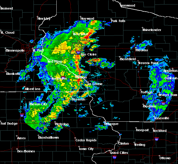 At 420 pm cdt, a severe thunderstorm was located over fairchild, or 18 miles west of neillsville, moving north at 30 mph (radar indicated). Hazards include quarter size hail. Damage to vehicles is expected. This severe thunderstorm will remain over mainly rural areas of northern jackson county. At 420 pm cdt, a severe thunderstorm was located over fairchild, or 18 miles west of neillsville, moving north at 30 mph (radar indicated). Hazards include quarter size hail. Damage to vehicles is expected. This severe thunderstorm will remain over mainly rural areas of northern jackson county.
|
| 5/31/2016 4:13 PM CDT |
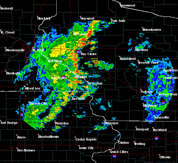 At 413 pm cdt, a severe thunderstorm was located near humbird, or 16 miles north of black river falls, moving north at 30 mph (radar indicated). Hazards include quarter size hail. Damage to vehicles is expected. this severe storm will be near, price around 420 pm cdt. fairchild around 425 pm cdt. Other locations impacted by this severe thunderstorm include alma center and north branch. At 413 pm cdt, a severe thunderstorm was located near humbird, or 16 miles north of black river falls, moving north at 30 mph (radar indicated). Hazards include quarter size hail. Damage to vehicles is expected. this severe storm will be near, price around 420 pm cdt. fairchild around 425 pm cdt. Other locations impacted by this severe thunderstorm include alma center and north branch.
|
| 5/31/2016 4:05 PM CDT |
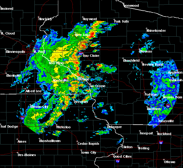 At 405 pm cdt, a severe thunderstorm was located near humbird, or 12 miles northwest of black river falls, moving north at 35 mph (radar indicated). Hazards include quarter size hail. Damage to vehicles is expected. this severe thunderstorm will be near, fairchild and price around 420 pm cdt. Other locations impacted by this severe thunderstorm include northfield, merrillan, alma center, levis and hixton. At 405 pm cdt, a severe thunderstorm was located near humbird, or 12 miles northwest of black river falls, moving north at 35 mph (radar indicated). Hazards include quarter size hail. Damage to vehicles is expected. this severe thunderstorm will be near, fairchild and price around 420 pm cdt. Other locations impacted by this severe thunderstorm include northfield, merrillan, alma center, levis and hixton.
|
| 5/25/2016 4:42 PM CDT | The severe thunderstorm warning for eastern eau claire county will expire at 445 pm cdt, the storm which prompted the warning has moved out of the area. therefore the warning will be allowed to expire. to report severe weather, contact your nearest law enforcement agency. they will relay your report to the national weather service the twin cities. |
| 5/25/2016 4:21 PM CDT |
 At 421 pm cdt, a severe thunderstorm was located near rock dam lake, or 22 miles northwest of neillsville, moving northeast at 25 mph (radar indicated). Hazards include 60 mph wind gusts and half dollar size hail. Hail damage to vehicles is expected. Expect wind damage to roofs, siding, and trees. At 421 pm cdt, a severe thunderstorm was located near rock dam lake, or 22 miles northwest of neillsville, moving northeast at 25 mph (radar indicated). Hazards include 60 mph wind gusts and half dollar size hail. Hail damage to vehicles is expected. Expect wind damage to roofs, siding, and trees.
|
| 7/24/2015 11:19 PM CDT |
 At 1118 pm cdt, a severe thunderstorm capable of producing a tornado was located over augusta, or 22 miles southeast of eau claire, moving southeast at 30 mph (radar indicated rotation). Hazards include tornado. Flying debris will be dangerous to those caught without shelter. mobile homes will be damaged or destroyed. damage to roofs, windows and vehicles will occur. tree damage is likely. this dangerous storm will be near, fairchild around 1130 pm cdt. Other locations impacted by this tornadic thunderstorm include lake eau claire county park. At 1118 pm cdt, a severe thunderstorm capable of producing a tornado was located over augusta, or 22 miles southeast of eau claire, moving southeast at 30 mph (radar indicated rotation). Hazards include tornado. Flying debris will be dangerous to those caught without shelter. mobile homes will be damaged or destroyed. damage to roofs, windows and vehicles will occur. tree damage is likely. this dangerous storm will be near, fairchild around 1130 pm cdt. Other locations impacted by this tornadic thunderstorm include lake eau claire county park.
|
| 7/24/2015 11:04 PM CDT |
 At 1103 pm cdt, a severe thunderstorm capable of producing a tornado was located over lake eau claire county park, or 17 miles southeast of eau claire, moving southeast at 35 mph (radar indicated rotation). Hazards include tornado. Flying debris will be dangerous to those caught without shelter. mobile homes will be damaged or destroyed. damage to roofs, windows and vehicles will occur. tree damage is likely. this dangerous storm will be near, fairchild around 1125 pm cdt. Other locations impacted by this tornadic thunderstorm include ludington, augusta and lake eau claire county park. At 1103 pm cdt, a severe thunderstorm capable of producing a tornado was located over lake eau claire county park, or 17 miles southeast of eau claire, moving southeast at 35 mph (radar indicated rotation). Hazards include tornado. Flying debris will be dangerous to those caught without shelter. mobile homes will be damaged or destroyed. damage to roofs, windows and vehicles will occur. tree damage is likely. this dangerous storm will be near, fairchild around 1125 pm cdt. Other locations impacted by this tornadic thunderstorm include ludington, augusta and lake eau claire county park.
|
| 7/24/2015 10:38 PM CDT |
 At 1037 pm cdt, a severe thunderstorm capable of producing a tornado was located over lake wissota, or 8 miles east of eau claire, moving southeast at 35 mph (radar indicated rotation). Hazards include tornado. Flying debris will be dangerous to those caught without shelter. mobile homes will be damaged or destroyed. damage to roofs, windows and vehicles will occur. tree damage is likely. this dangerous storm will be near, fall creek around 1050 pm cdt. augusta around 1105 pm cdt. fairchild around 1120 pm cdt. Other locations impacted by this tornadic thunderstorm include ludington and lake eau claire county park. At 1037 pm cdt, a severe thunderstorm capable of producing a tornado was located over lake wissota, or 8 miles east of eau claire, moving southeast at 35 mph (radar indicated rotation). Hazards include tornado. Flying debris will be dangerous to those caught without shelter. mobile homes will be damaged or destroyed. damage to roofs, windows and vehicles will occur. tree damage is likely. this dangerous storm will be near, fall creek around 1050 pm cdt. augusta around 1105 pm cdt. fairchild around 1120 pm cdt. Other locations impacted by this tornadic thunderstorm include ludington and lake eau claire county park.
|
| 7/18/2015 3:06 AM CDT |
 At 305 am cdt, severe thunderstorms were located along a line extending from near humbird to onalaska, moving east at 45 mph (law enforcement. numerous reports of trees down in arcadia and near eleva). Hazards include 60 mph wind gusts. Expect damage to roofs. siding and trees. these severe storms will be near, hatfield around 310 am cdt. sparta around 330 am cdt. fort mc coy around 340 am cdt. tomah around 350 am cdt. Other locations impacted by these severe thunderstorms include franklin, medary, leon, burns and new hartford. At 305 am cdt, severe thunderstorms were located along a line extending from near humbird to onalaska, moving east at 45 mph (law enforcement. numerous reports of trees down in arcadia and near eleva). Hazards include 60 mph wind gusts. Expect damage to roofs. siding and trees. these severe storms will be near, hatfield around 310 am cdt. sparta around 330 am cdt. fort mc coy around 340 am cdt. tomah around 350 am cdt. Other locations impacted by these severe thunderstorms include franklin, medary, leon, burns and new hartford.
|
| 7/18/2015 3:02 AM CDT |
 At 301 am cdt, severe thunderstorms were located along a line extending from near fairchild to near la crosse airport, moving east at 45 mph (law enforcement. numerous reports of trees down from buffalo city to fountain city in buffalo county with these storms). Hazards include 60 mph wind gusts. Expect damage to roofs. siding and trees. these severe storms will be near, fairchild around 305 am cdt. hatfield around 310 am cdt. bangor around 320 am cdt. sparta around 330 am cdt. fort mc coy around 340 am cdt. tomah around 350 am cdt. Other locations impacted by these severe thunderstorms include franklin, medary, leon, burns and new hartford. At 301 am cdt, severe thunderstorms were located along a line extending from near fairchild to near la crosse airport, moving east at 45 mph (law enforcement. numerous reports of trees down from buffalo city to fountain city in buffalo county with these storms). Hazards include 60 mph wind gusts. Expect damage to roofs. siding and trees. these severe storms will be near, fairchild around 305 am cdt. hatfield around 310 am cdt. bangor around 320 am cdt. sparta around 330 am cdt. fort mc coy around 340 am cdt. tomah around 350 am cdt. Other locations impacted by these severe thunderstorms include franklin, medary, leon, burns and new hartford.
|
| 7/18/2015 2:52 AM CDT |
 The severe thunderstorm warning for chippewa and eau claire counties will expire at 300 am cdt, the storms which prompted the warning have moved out of the area. therefore the warning will be allowed to expire. however gusty winds are still possible with these thunderstorms. a severe thunderstorm watch remains in effect until 700 am cdt for west central wisconsin. The severe thunderstorm warning for chippewa and eau claire counties will expire at 300 am cdt, the storms which prompted the warning have moved out of the area. therefore the warning will be allowed to expire. however gusty winds are still possible with these thunderstorms. a severe thunderstorm watch remains in effect until 700 am cdt for west central wisconsin.
|
| 7/18/2015 2:45 AM CDT |
 At 245 am cdt, severe thunderstorms were located along a line extending from near island lake to near boyd to near taylor, moving east at 55 mph (trained weather spotters). Hazards include 60 mph wind gusts. Expect damage to roofs. siding and trees. these severe storms will be near, stanley and boyd around 250 am cdt. other locations impacted by these severe thunderstorms include tilden, jim falls, ludington, foster, chippewa moraine state rec area, seymour, lake eau claire county park, eagleton, holcombe and otter lake. this includes the following highways, interstate 94 in wisconsin between mile markers 65 and 86. u. s. Highway 53 between mile markers 86 and 116. At 245 am cdt, severe thunderstorms were located along a line extending from near island lake to near boyd to near taylor, moving east at 55 mph (trained weather spotters). Hazards include 60 mph wind gusts. Expect damage to roofs. siding and trees. these severe storms will be near, stanley and boyd around 250 am cdt. other locations impacted by these severe thunderstorms include tilden, jim falls, ludington, foster, chippewa moraine state rec area, seymour, lake eau claire county park, eagleton, holcombe and otter lake. this includes the following highways, interstate 94 in wisconsin between mile markers 65 and 86. u. s. Highway 53 between mile markers 86 and 116.
|
| 7/18/2015 2:43 AM CDT |
 At 239 am cdt, severe thunderstorms were located along a line extending from near osseo to 9 miles northeast of rushford, moving east at 55 mph (law enforcement. numerous reports of trees down from buffalo city to fountain city in buffalo county with these storms). Hazards include 60 mph wind gusts. Expect damage to roofs. siding and trees. severe thunderstorms will be near, price around 245 am cdt. fairchild and galesville around 255 am cdt. la crosse, onalaska, holmen and la crosse airport around 300 am cdt. west salem and north bend around 310 am cdt. bangor around 315 am cdt. sparta and cataract around 325 am cdt. fort mc coy around 335 am cdt. tomah around 345 am cdt. People at the la crosse county fair in west salem should seek safe shelter immediately!. At 239 am cdt, severe thunderstorms were located along a line extending from near osseo to 9 miles northeast of rushford, moving east at 55 mph (law enforcement. numerous reports of trees down from buffalo city to fountain city in buffalo county with these storms). Hazards include 60 mph wind gusts. Expect damage to roofs. siding and trees. severe thunderstorms will be near, price around 245 am cdt. fairchild and galesville around 255 am cdt. la crosse, onalaska, holmen and la crosse airport around 300 am cdt. west salem and north bend around 310 am cdt. bangor around 315 am cdt. sparta and cataract around 325 am cdt. fort mc coy around 335 am cdt. tomah around 345 am cdt. People at the la crosse county fair in west salem should seek safe shelter immediately!.
|
| 7/18/2015 2:34 AM CDT |
 At 233 am cdt, severe thunderstorms were located along a line extending from near island lake to near bateman to near independence, moving east at 55 mph (trained weather spotters). Hazards include 60 mph wind gusts. Expect damage to roofs. siding and trees. these severe storms will be near, cadott and boyd around 240 am cdt. stanley around 250 am cdt. other locations impacted by these severe thunderstorms include tilden, jim falls, ludington, foster, chippewa moraine state rec area, seymour, lake eau claire county park, eagleton, holcombe and otter lake. this includes the following highways, interstate 94 in wisconsin between mile markers 57 and 86. u. s. Highway 53 between mile markers 86 and 126. At 233 am cdt, severe thunderstorms were located along a line extending from near island lake to near bateman to near independence, moving east at 55 mph (trained weather spotters). Hazards include 60 mph wind gusts. Expect damage to roofs. siding and trees. these severe storms will be near, cadott and boyd around 240 am cdt. stanley around 250 am cdt. other locations impacted by these severe thunderstorms include tilden, jim falls, ludington, foster, chippewa moraine state rec area, seymour, lake eau claire county park, eagleton, holcombe and otter lake. this includes the following highways, interstate 94 in wisconsin between mile markers 57 and 86. u. s. Highway 53 between mile markers 86 and 126.
|
| 7/18/2015 2:16 AM CDT |
 At 216 am cdt, severe thunderstorms were located along a line extending from near hillsdale to near tilden to near gilmanton, moving east at 55 mph (trained weather spotters). Hazards include 60 mph wind gusts. Expect damage to roofs. siding and trees. these severe storms will be near, chippewa falls and bloomer around 220 am cdt. lake wissota around 225 am cdt. cadott around 235 am cdt. boyd around 240 am cdt. stanley around 245 am cdt. fairchild around 255 am cdt. other locations impacted by these severe thunderstorms include tainter lake, hoffman hills rec area, tilden, jim falls, caryville, ludington, foster, chippewa moraine state rec area, seymour and lake eau claire county park. this includes the following highways, interstate 94 in wisconsin between mile markers 45 and 86. u. s. Highway 53 between mile markers 86 and 126. At 216 am cdt, severe thunderstorms were located along a line extending from near hillsdale to near tilden to near gilmanton, moving east at 55 mph (trained weather spotters). Hazards include 60 mph wind gusts. Expect damage to roofs. siding and trees. these severe storms will be near, chippewa falls and bloomer around 220 am cdt. lake wissota around 225 am cdt. cadott around 235 am cdt. boyd around 240 am cdt. stanley around 245 am cdt. fairchild around 255 am cdt. other locations impacted by these severe thunderstorms include tainter lake, hoffman hills rec area, tilden, jim falls, caryville, ludington, foster, chippewa moraine state rec area, seymour and lake eau claire county park. this includes the following highways, interstate 94 in wisconsin between mile markers 45 and 86. u. s. Highway 53 between mile markers 86 and 126.
|
| 7/18/2015 2:00 AM CDT |
 At 159 am cdt, severe thunderstorms were located along a line extending from clayton to tainter lake to near nelson, moving east at 55 mph (trained weather spotters). Hazards include 60 mph wind gusts. Expect damage to roofs. siding and trees. severe thunderstorms will be near, colfax around 205 am cdt. bloomer and dallas around 215 am cdt. chippewa falls around 220 am cdt. lake wissota around 225 am cdt. cadott around 235 am cdt. boyd around 240 am cdt. stanley around 245 am cdt. other locations impacted by these severe thunderstorms include tainter lake, hoffman hills rec area, tilden, jim falls, caryville, ludington, foster, chippewa moraine state rec area, seymour and lake eau claire county park. this includes the following highways, interstate 94 in wisconsin between mile markers 45 and 86. u. s. Highway 53 between mile markers 86 and 126. At 159 am cdt, severe thunderstorms were located along a line extending from clayton to tainter lake to near nelson, moving east at 55 mph (trained weather spotters). Hazards include 60 mph wind gusts. Expect damage to roofs. siding and trees. severe thunderstorms will be near, colfax around 205 am cdt. bloomer and dallas around 215 am cdt. chippewa falls around 220 am cdt. lake wissota around 225 am cdt. cadott around 235 am cdt. boyd around 240 am cdt. stanley around 245 am cdt. other locations impacted by these severe thunderstorms include tainter lake, hoffman hills rec area, tilden, jim falls, caryville, ludington, foster, chippewa moraine state rec area, seymour and lake eau claire county park. this includes the following highways, interstate 94 in wisconsin between mile markers 45 and 86. u. s. Highway 53 between mile markers 86 and 126.
|
| 7/13/2015 5:48 PM CDT |
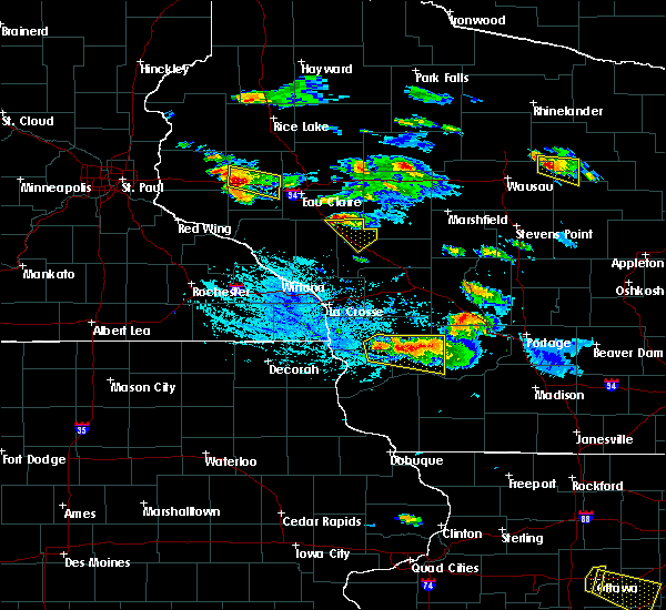 A severe thunderstorm warning remains in effect until 630 pm cdt for northwestern jackson and northeastern trempealeau counties. at 547 pm cdt. a severe thunderstorm was located near osseo. or 14 miles northeast of whitehall. moving southeast at 30 mph. Nickel sized hail was reported from a gas station in osseo with very little wind as the storm passed. A severe thunderstorm warning remains in effect until 630 pm cdt for northwestern jackson and northeastern trempealeau counties. at 547 pm cdt. a severe thunderstorm was located near osseo. or 14 miles northeast of whitehall. moving southeast at 30 mph. Nickel sized hail was reported from a gas station in osseo with very little wind as the storm passed.
|
| 7/13/2015 5:40 PM CDT |
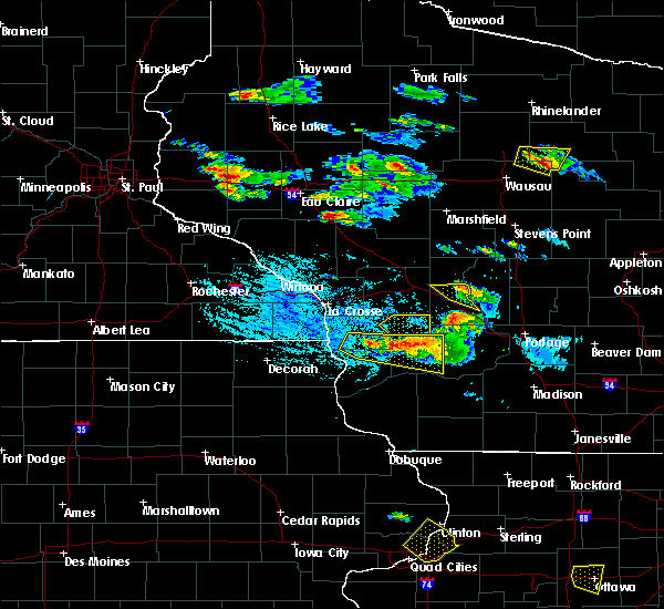 At 540 pm cdt, a severe thunderstorm was located near osseo, or 17 miles north of whitehall, moving southeast at 40 mph (radar indicated). Hazards include half dollar size hail. Damage to vehicles is expected. this severe thunderstorm will be near, price around 550 pm cdt. fairchild around 555 pm cdt. Other locations impacted by this severe thunderstorm include york, northfield, merrillan, alma center and levis. At 540 pm cdt, a severe thunderstorm was located near osseo, or 17 miles north of whitehall, moving southeast at 40 mph (radar indicated). Hazards include half dollar size hail. Damage to vehicles is expected. this severe thunderstorm will be near, price around 550 pm cdt. fairchild around 555 pm cdt. Other locations impacted by this severe thunderstorm include york, northfield, merrillan, alma center and levis.
|
| 5/3/2015 7:57 PM CDT | The severe thunderstorm warning for southeastern chippewa and eau claire counties will expire at 800 pm cdt. the storms which prompted the warning have weakened below severe limits. and exited the warned area. therefore the warning will be allowed to expire. to report severe weather. Contact your nearest law enforcement. |
| 5/3/2015 7:33 PM CDT | At 733 pm cdt, severe thunderstorms were located along a line extending from near bateman to near fall creek to near strum, moving east at 40 mph (radar indicated). Hazards include ping pong ball size hail and 60 mph wind gusts. People and animals outdoors will be injured. expect hail damage to roofs, siding, windows and vehicles. expect wind damage to roofs, siding and trees. locations impacted include, eau claire, chippewa falls, altoona, lake hallie, stanley, lake wissota, augusta, cadott, fall creek, boyd, fairchild and ludington. 1. 50in. |
| 5/3/2015 7:25 PM CDT | At 724 pm cdt, severe thunderstorms were located along a line extending from near bloomer to near lake wissota to eleva, moving east at 45 mph (radar indicated). Hazards include ping pong ball size hail and 60 mph wind gusts. People and animals outdoors will be injured. expect hail damage to roofs, siding, windows and vehicles. expect wind damage to roofs, siding and trees. locations impacted include, eau claire, chippewa falls, altoona, lake hallie, stanley, bloomer, lake wissota, augusta, cornell, cadott, fall creek and boyd. 1. 50in. |
| 5/3/2015 6:53 PM CDT | At 653 pm cdt, severe thunderstorms were located along a line extending from near ridgeland to hoffman hills rec area to near durand, moving east at 45 mph (radar indicated). Hazards include ping pong ball size hail and 60 mph wind gusts. People and animals outdoors will be injured. expect hail damage to roofs, siding, windows and vehicles. Expect wind damage to roofs, siding and trees. |
| 6/27/2014 4:34 PM CDT | Large tree branches dow in clark county WI, 10.5 miles SW of Fairchild, WI |
| 5/31/2013 5:14 PM CDT | Half Dollar sized hail reported 3 miles E of Fairchild, WI |
| 5/29/2013 4:50 PM CDT | Large tree down in the center of tow in eau claire county WI, 0.5 miles S of Fairchild, WI |
Hail Maps for Fairchild, WI


Connect with Interactive Hail Maps