

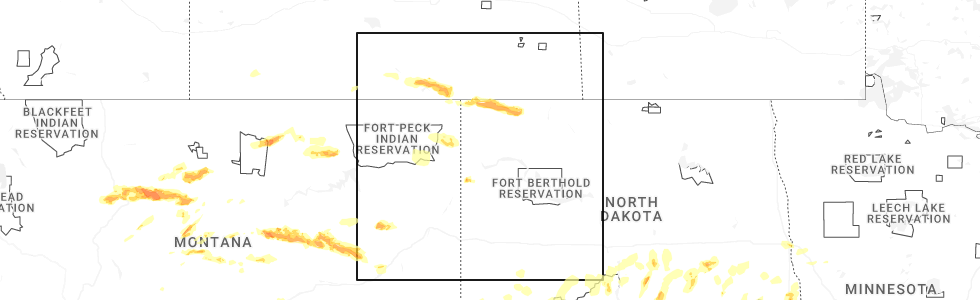
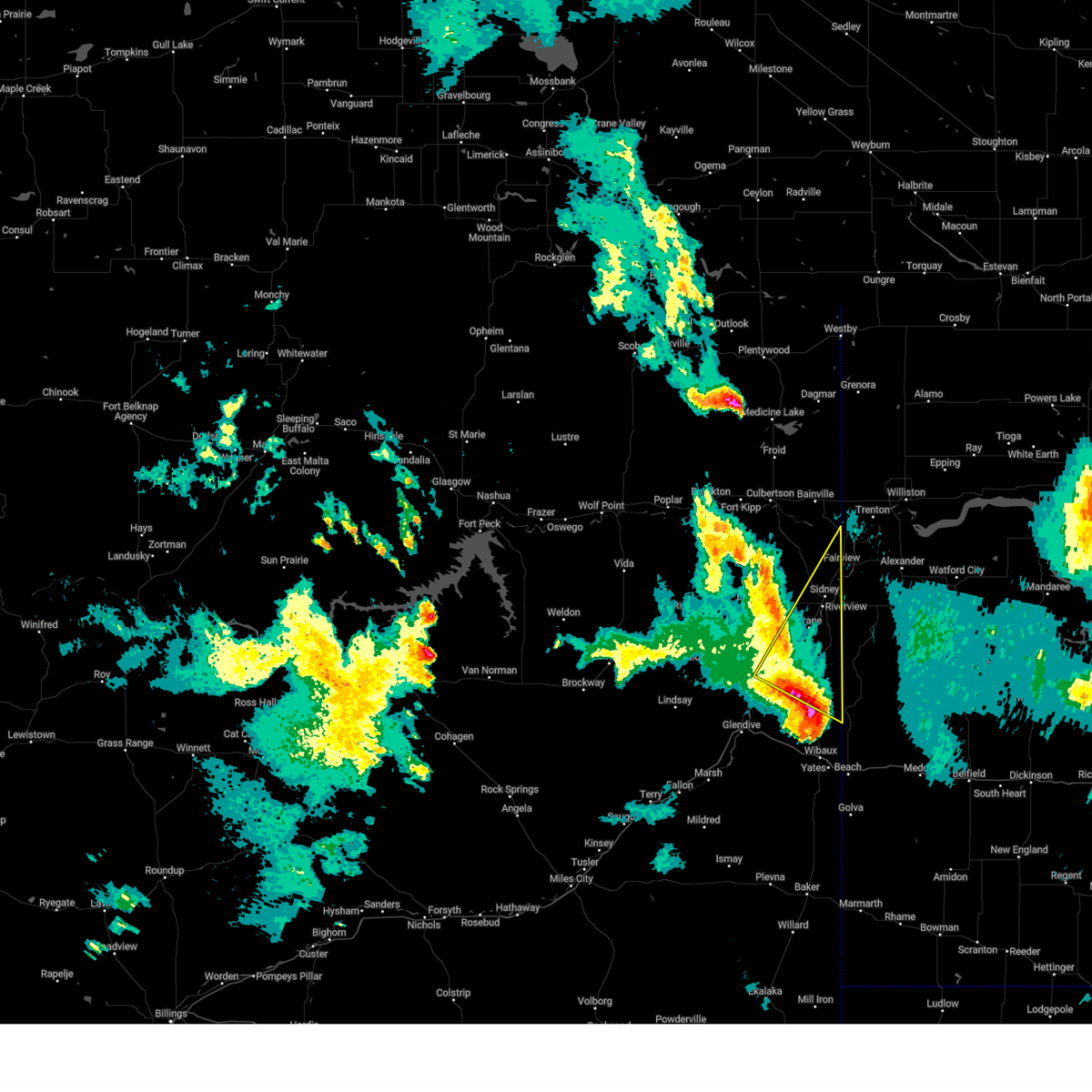
Hail Map for Fairview, MT
The Fairview, MT area has had 19 reports of on-the-ground hail by trained spotters, and has been under severe weather warnings 12 times during the past 12 months. Doppler radar has detected hail at or near Fairview, MT on 33 occasions, including 1 occasion during the past year.
| Name: | Fairview, MT |
| Where Located: | 28.6 miles SW of Williston, ND |
| Map: | Google Map for Fairview, MT |
| Population: | 840 |
| Housing Units: | 383 |
| More Info: | Search Google for Fairview, MT |
0
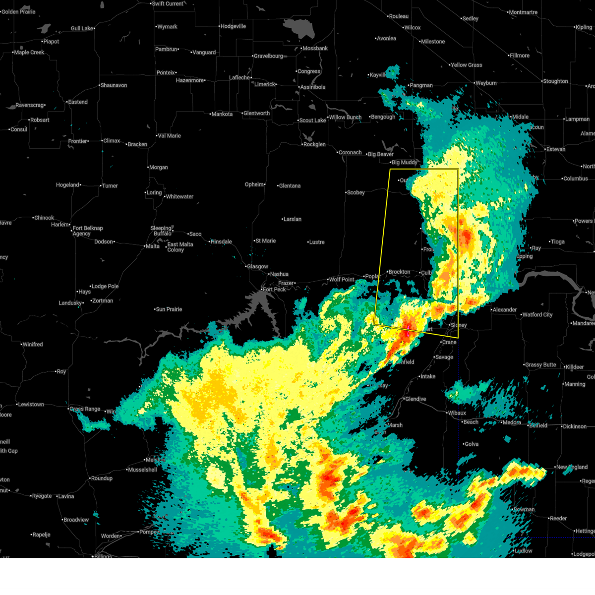
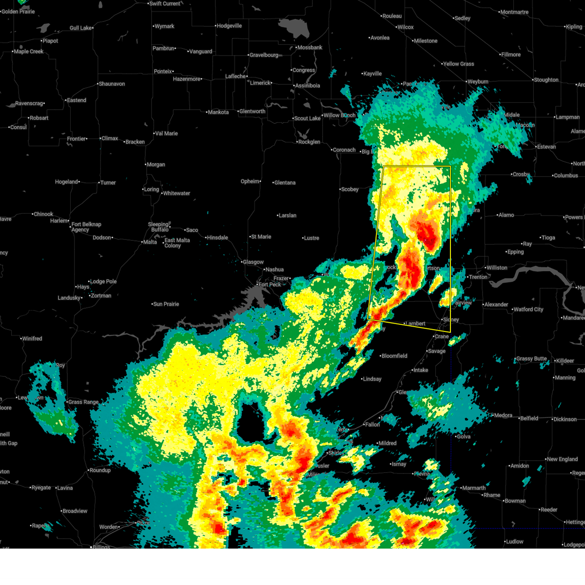
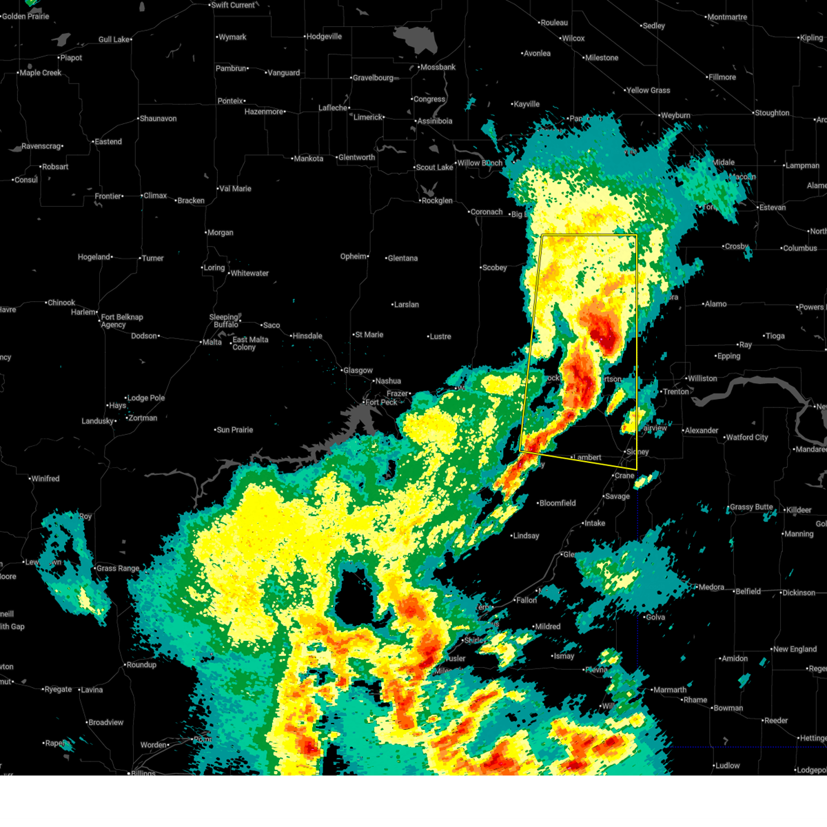
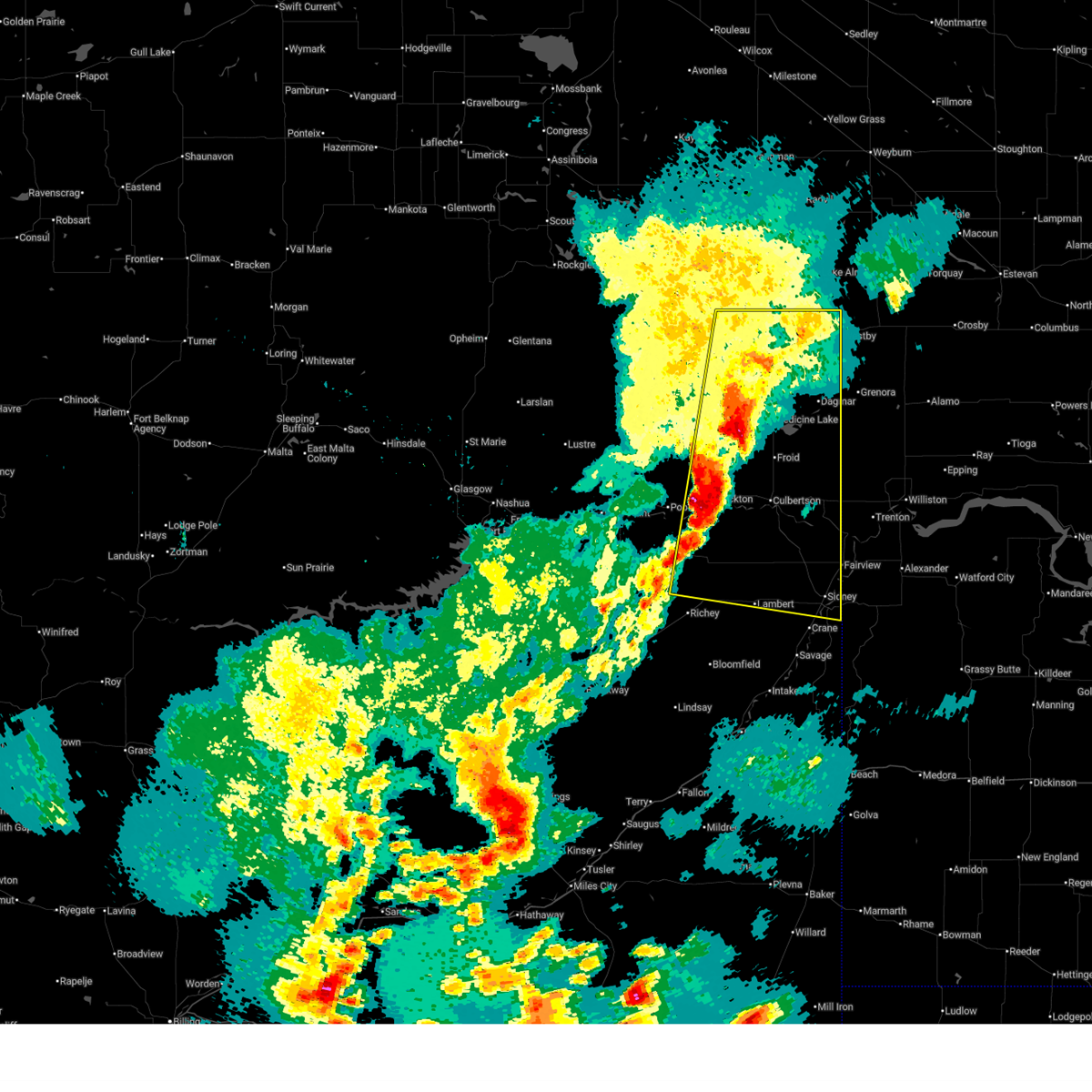
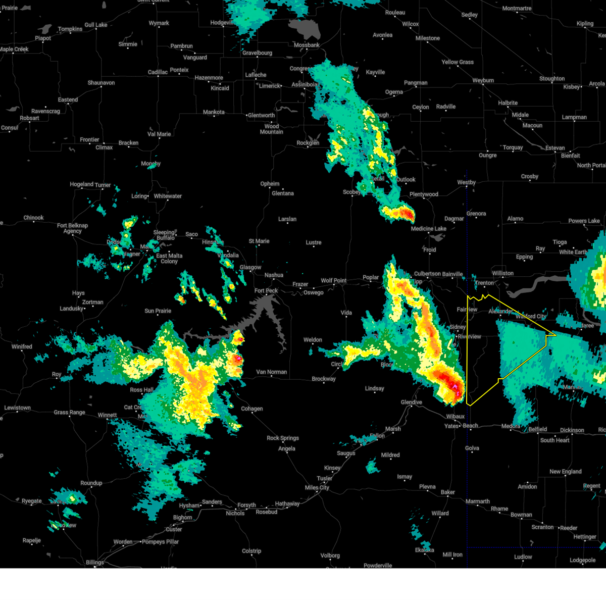
The Top Recent Hail Date for Fairview, MT is Sunday, June 15, 2025 (29th out of 33)
Hail and Wind Damage Spotted near Fairview, MT
| Date / Time | Report Details |
|---|---|
| 6/15/2025 11:23 PM MDT |
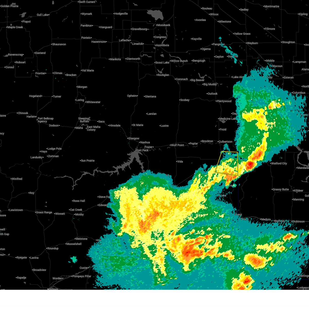 The storm which prompted the warning has weakened below severe limits, and no longer poses an immediate threat to life or property. therefore, the warning will be allowed to expire. however, gusty winds and heavy rain are still possible with this thunderstorm. a severe thunderstorm watch remains in effect until 100 am mdt for northeastern montana. The storm which prompted the warning has weakened below severe limits, and no longer poses an immediate threat to life or property. therefore, the warning will be allowed to expire. however, gusty winds and heavy rain are still possible with this thunderstorm. a severe thunderstorm watch remains in effect until 100 am mdt for northeastern montana.
|
| 6/15/2025 11:08 PM MDT |
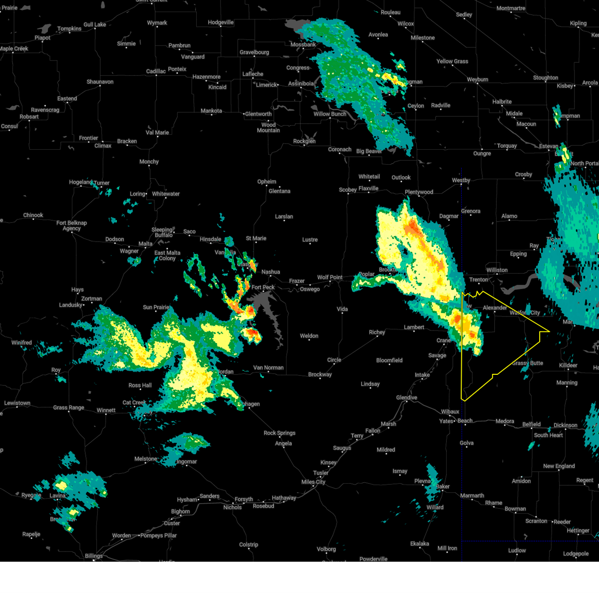
 At 1108 pm mdt, a severe thunderstorm was located near sidney, moving east at 25 mph (radar indicated). Hazards include 60 mph wind gusts. Expect damage to roofs, siding, and trees. Locations impacted include, wooley, sidney, and fairview. At 1108 pm mdt, a severe thunderstorm was located near sidney, moving east at 25 mph (radar indicated). Hazards include 60 mph wind gusts. Expect damage to roofs, siding, and trees. Locations impacted include, wooley, sidney, and fairview.
|
| 6/15/2025 10:48 PM MDT |
 Svrggw the national weather service in glasgow has issued a * severe thunderstorm warning for, northeastern richland county in northeastern montana, * until 1130 pm mdt. * at 1048 pm mdt, a severe thunderstorm was located over sidney, moving east at 40 mph (radar indicated). Hazards include 60 mph wind gusts. expect damage to roofs, siding, and trees Svrggw the national weather service in glasgow has issued a * severe thunderstorm warning for, northeastern richland county in northeastern montana, * until 1130 pm mdt. * at 1048 pm mdt, a severe thunderstorm was located over sidney, moving east at 40 mph (radar indicated). Hazards include 60 mph wind gusts. expect damage to roofs, siding, and trees
|
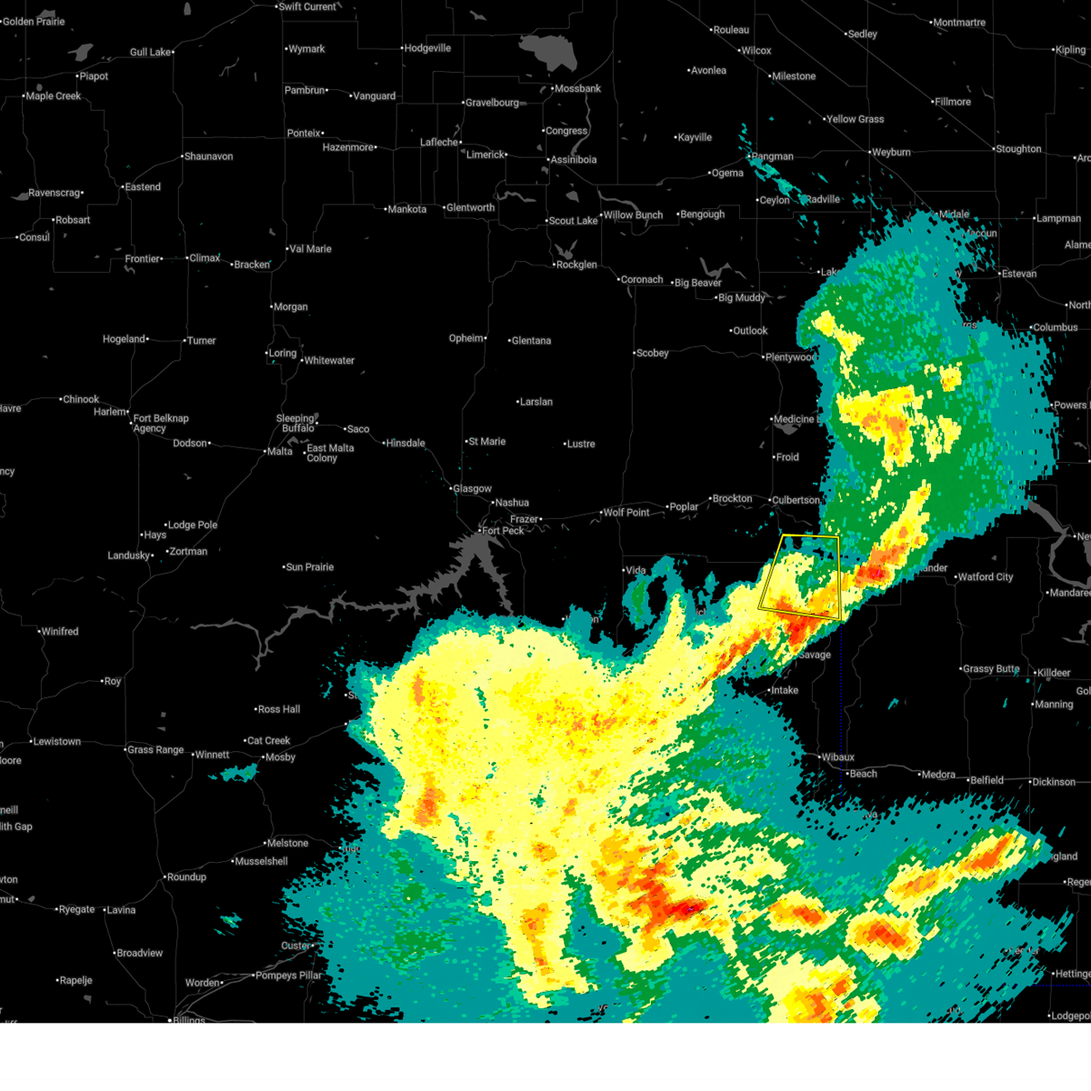
| 6/15/2025 10:41 PM MDT |
 The storms which prompted the warning have weakened below severe limits, and no longer pose an immediate threat to life or property. therefore, the warning will be allowed to expire. however, gusty winds are still possible with these thunderstorms. a severe thunderstorm watch remains in effect until 100 am mdt for northeastern montana. The storms which prompted the warning have weakened below severe limits, and no longer pose an immediate threat to life or property. therefore, the warning will be allowed to expire. however, gusty winds are still possible with these thunderstorms. a severe thunderstorm watch remains in effect until 100 am mdt for northeastern montana.
|
| 6/15/2025 10:14 PM MDT |
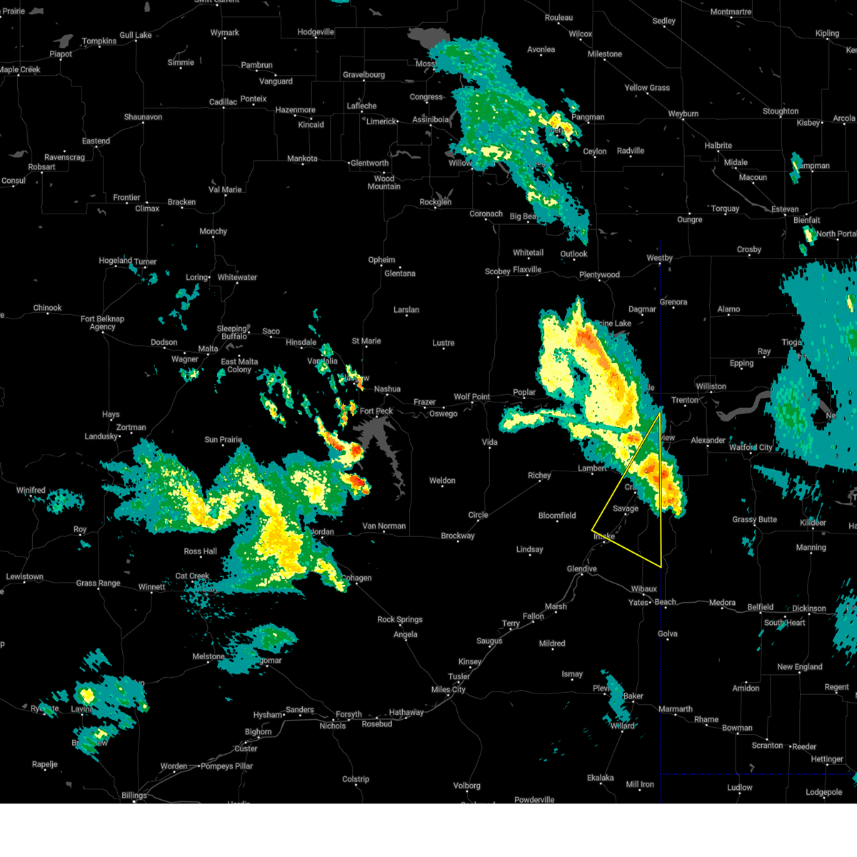
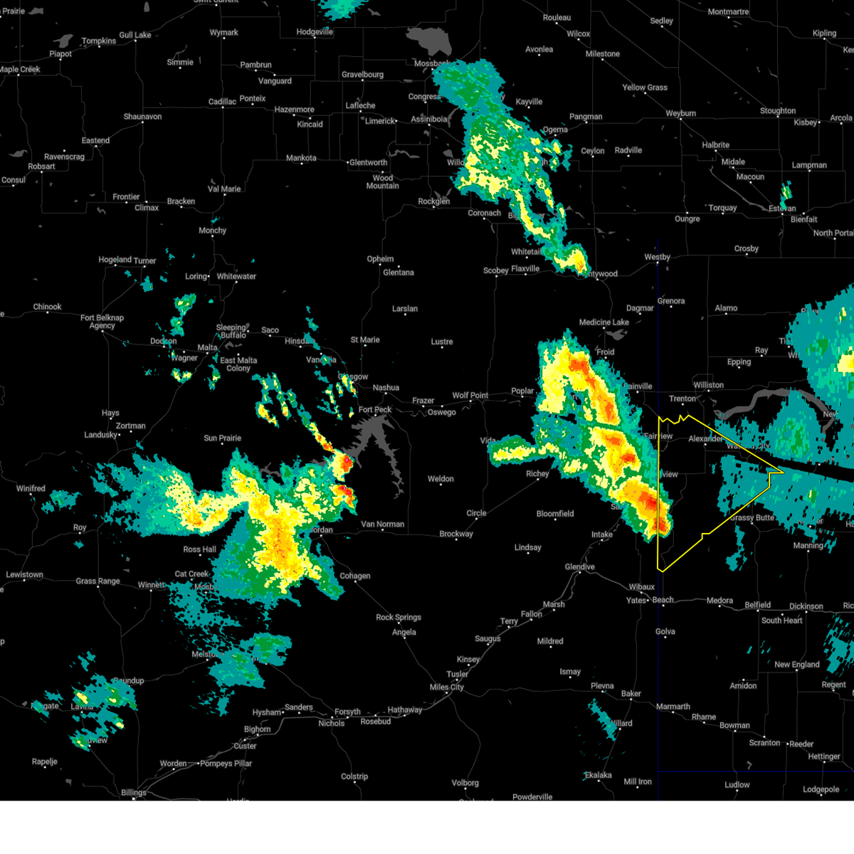
 At 1013 pm mdt, severe thunderstorms were located along a line extending from 7 miles northwest of grenora to 6 miles north of lambert, moving east at 40 mph (radar indicated). Hazards include 70 mph wind gusts and quarter size hail. Hail damage to vehicles is expected. expect considerable tree damage. wind damage is also likely to mobile homes, roofs, and outbuildings. Locations impacted include, reserve, medicine lake, archer, raymond, bainville, enid, outlook, comertown, nohly, wooley, fairview, froid, mccabe, westby, plentywood, coalridge, culbertson, snowden, fort kipp, and dagmar. At 1013 pm mdt, severe thunderstorms were located along a line extending from 7 miles northwest of grenora to 6 miles north of lambert, moving east at 40 mph (radar indicated). Hazards include 70 mph wind gusts and quarter size hail. Hail damage to vehicles is expected. expect considerable tree damage. wind damage is also likely to mobile homes, roofs, and outbuildings. Locations impacted include, reserve, medicine lake, archer, raymond, bainville, enid, outlook, comertown, nohly, wooley, fairview, froid, mccabe, westby, plentywood, coalridge, culbertson, snowden, fort kipp, and dagmar.
|
| 6/15/2025 10:14 PM MDT |
 the severe thunderstorm warning has been cancelled and is no longer in effect the severe thunderstorm warning has been cancelled and is no longer in effect
|
| 6/15/2025 9:40 PM MDT |
 Svrggw the national weather service in glasgow has issued a * severe thunderstorm warning for, southeastern daniels county in northeastern montana, eastern roosevelt county in northeastern montana, sheridan county in northeastern montana, richland county in northeastern montana, * until 1045 pm mdt. * at 939 pm mdt, severe thunderstorms were located along a line extending from 8 miles north of medicine lake to 6 miles north of richey, moving east at 35 mph (radar indicated). Hazards include 60 mph wind gusts and quarter size hail. Hail damage to vehicles is expected. Expect wind damage to roofs, siding, and trees. Svrggw the national weather service in glasgow has issued a * severe thunderstorm warning for, southeastern daniels county in northeastern montana, eastern roosevelt county in northeastern montana, sheridan county in northeastern montana, richland county in northeastern montana, * until 1045 pm mdt. * at 939 pm mdt, severe thunderstorms were located along a line extending from 8 miles north of medicine lake to 6 miles north of richey, moving east at 35 mph (radar indicated). Hazards include 60 mph wind gusts and quarter size hail. Hail damage to vehicles is expected. Expect wind damage to roofs, siding, and trees.
|
| 9/20/2024 8:45 PM MDT | Mesonet station mtsoo 16.0 sw bainville (mt dot in richland county MT, 13.8 miles ESE of Fairview, MT |
| 9/12/2024 8:32 PM CDT |
 the severe thunderstorm warning has been cancelled and is no longer in effect the severe thunderstorm warning has been cancelled and is no longer in effect
|
| 9/12/2024 7:24 PM MDT |
 the severe thunderstorm warning has been cancelled and is no longer in effect the severe thunderstorm warning has been cancelled and is no longer in effect
|
| 9/12/2024 8:13 PM CDT |
 At 812 pm cdt/712 pm mdt/, a severe thunderstorm was located 5 miles northeast of skaar, or 21 miles southeast of sidney, moving northeast at 45 mph (radar indicated). Hazards include 60 mph wind gusts. Expect damage to roofs, siding, and trees. Locations impacted include, watford city, alexander, arnegard, east fairview, skaar, theodore roosevelt national park north unit, trotters, fort union trading post, cartwright, sather dam, charbonneau, and rawson. At 812 pm cdt/712 pm mdt/, a severe thunderstorm was located 5 miles northeast of skaar, or 21 miles southeast of sidney, moving northeast at 45 mph (radar indicated). Hazards include 60 mph wind gusts. Expect damage to roofs, siding, and trees. Locations impacted include, watford city, alexander, arnegard, east fairview, skaar, theodore roosevelt national park north unit, trotters, fort union trading post, cartwright, sather dam, charbonneau, and rawson.
|
| 9/12/2024 7:57 PM CDT |
 Svrbis the national weather service in bismarck has issued a * severe thunderstorm warning for, northwestern golden valley county in southwestern north dakota, western mckenzie county in northwestern north dakota, * until 845 pm cdt/745 pm mdt/. * at 757 pm cdt/657 pm mdt/, a severe thunderstorm was located near skaar, or 24 miles north of wibaux, moving northeast at 55 mph (radar indicated). Hazards include 60 mph wind gusts and quarter size hail. Hail damage to vehicles is expected. Expect wind damage to roofs, siding, and trees. Svrbis the national weather service in bismarck has issued a * severe thunderstorm warning for, northwestern golden valley county in southwestern north dakota, western mckenzie county in northwestern north dakota, * until 845 pm cdt/745 pm mdt/. * at 757 pm cdt/657 pm mdt/, a severe thunderstorm was located near skaar, or 24 miles north of wibaux, moving northeast at 55 mph (radar indicated). Hazards include 60 mph wind gusts and quarter size hail. Hail damage to vehicles is expected. Expect wind damage to roofs, siding, and trees.
|
| 9/12/2024 6:51 PM MDT |
 Svrggw the national weather service in glasgow has issued a * severe thunderstorm warning for, northeastern wibaux county in northeastern montana, southeastern roosevelt county in northeastern montana, southeastern richland county in northeastern montana, east central dawson county in northeastern montana, * until 745 pm mdt. * at 650 pm mdt, a severe thunderstorm was located 11 miles east of intake, or 20 miles north of wibaux, moving northeast at 60 mph (radar indicated). Hazards include 60 mph wind gusts and quarter size hail. Hail damage to vehicles is expected. Expect wind damage to roofs, siding, and trees. Svrggw the national weather service in glasgow has issued a * severe thunderstorm warning for, northeastern wibaux county in northeastern montana, southeastern roosevelt county in northeastern montana, southeastern richland county in northeastern montana, east central dawson county in northeastern montana, * until 745 pm mdt. * at 650 pm mdt, a severe thunderstorm was located 11 miles east of intake, or 20 miles north of wibaux, moving northeast at 60 mph (radar indicated). Hazards include 60 mph wind gusts and quarter size hail. Hail damage to vehicles is expected. Expect wind damage to roofs, siding, and trees.
|
| 6/27/2024 6:29 PM MDT |
 the severe thunderstorm warning has been cancelled and is no longer in effect the severe thunderstorm warning has been cancelled and is no longer in effect
|
| 6/27/2024 5:47 PM MDT |
 Svrggw the national weather service in glasgow has issued a * severe thunderstorm warning for, eastern wibaux county in northeastern montana, southeastern roosevelt county in northeastern montana, richland county in northeastern montana, northeastern dawson county in northeastern montana, * until 645 pm mdt. * at 547 pm mdt, severe thunderstorms were located along a line extending from 11 miles northwest of lambert to 14 miles northwest of carlyle, moving northeast at 35 mph (radar indicated). Hazards include 70 mph wind gusts and half dollar size hail. Hail damage to vehicles is expected. expect considerable tree damage. Wind damage is also likely to mobile homes, roofs, and outbuildings. Svrggw the national weather service in glasgow has issued a * severe thunderstorm warning for, eastern wibaux county in northeastern montana, southeastern roosevelt county in northeastern montana, richland county in northeastern montana, northeastern dawson county in northeastern montana, * until 645 pm mdt. * at 547 pm mdt, severe thunderstorms were located along a line extending from 11 miles northwest of lambert to 14 miles northwest of carlyle, moving northeast at 35 mph (radar indicated). Hazards include 70 mph wind gusts and half dollar size hail. Hail damage to vehicles is expected. expect considerable tree damage. Wind damage is also likely to mobile homes, roofs, and outbuildings.
|
| 6/27/2024 4:50 PM MDT |
 Svrggw the national weather service in glasgow has issued a * severe thunderstorm warning for, northern wibaux county in northeastern montana, southeastern richland county in northeastern montana, northeastern dawson county in northeastern montana, * until 545 pm mdt. * at 449 pm mdt, a severe thunderstorm was located 9 miles southwest of lambert, or 30 miles west of sidney, moving east at 20 mph (radar indicated). Hazards include 70 mph wind gusts and ping pong ball size hail. People and animals outdoors will be injured. expect hail damage to roofs, siding, windows, and vehicles. expect considerable tree damage. Wind damage is also likely to mobile homes, roofs, and outbuildings. Svrggw the national weather service in glasgow has issued a * severe thunderstorm warning for, northern wibaux county in northeastern montana, southeastern richland county in northeastern montana, northeastern dawson county in northeastern montana, * until 545 pm mdt. * at 449 pm mdt, a severe thunderstorm was located 9 miles southwest of lambert, or 30 miles west of sidney, moving east at 20 mph (radar indicated). Hazards include 70 mph wind gusts and ping pong ball size hail. People and animals outdoors will be injured. expect hail damage to roofs, siding, windows, and vehicles. expect considerable tree damage. Wind damage is also likely to mobile homes, roofs, and outbuildings.
|
| 6/15/2024 9:12 PM MDT |
 The storms which prompted the warning have weakened below severe limits, and no longer pose an immediate threat to life or property. therefore, the warning will be allowed to expire. however, gusty winds are still possible with these thunderstorms. The storms which prompted the warning have weakened below severe limits, and no longer pose an immediate threat to life or property. therefore, the warning will be allowed to expire. however, gusty winds are still possible with these thunderstorms.
|
| 6/15/2024 9:54 PM CDT |
 At 954 pm cdt, severe thunderstorms were located along a line extending from near plentywood to 13 miles northeast of bainville to 5 miles northwest of skaar, moving east at 45 mph (radar indicated). Hazards include 70 mph wind gusts and quarter size hail. Hail damage to vehicles is expected. expect considerable tree damage. wind damage is also likely to mobile homes, roofs, and outbuildings. Locations impacted include, williston, fairview, grenora, alexander, westby, arnegard, epping, writing rock state historical site, bonetrail, skaar, hanks city, alkabo, fort union trading post, east fairview, trenton, cartwright, charbonneau, blacktail lake, zahl, and sather dam. At 954 pm cdt, severe thunderstorms were located along a line extending from near plentywood to 13 miles northeast of bainville to 5 miles northwest of skaar, moving east at 45 mph (radar indicated). Hazards include 70 mph wind gusts and quarter size hail. Hail damage to vehicles is expected. expect considerable tree damage. wind damage is also likely to mobile homes, roofs, and outbuildings. Locations impacted include, williston, fairview, grenora, alexander, westby, arnegard, epping, writing rock state historical site, bonetrail, skaar, hanks city, alkabo, fort union trading post, east fairview, trenton, cartwright, charbonneau, blacktail lake, zahl, and sather dam.
|
| 6/15/2024 8:49 PM MDT |
 the severe thunderstorm warning has been cancelled and is no longer in effect the severe thunderstorm warning has been cancelled and is no longer in effect
|
| 6/15/2024 8:49 PM MDT |
 At 849 pm mdt, severe thunderstorms were located along a line extending from 12 miles northeast of plentywood to 6 miles east of bainville to near skaar, moving east at 50 mph (radar indicated). Hazards include 70 mph wind gusts and quarter size hail. Hail damage to vehicles is expected. expect considerable tree damage. wind damage is also likely to mobile homes, roofs, and outbuildings. Locations impacted include, sidney, plentywood, culbertson, fairview, medicine lake, bainville, froid, westby, archer, savage, lambert, outlook, reserve, raymond, comertown, nohly, wooley, crane, mccabe, and midway. At 849 pm mdt, severe thunderstorms were located along a line extending from 12 miles northeast of plentywood to 6 miles east of bainville to near skaar, moving east at 50 mph (radar indicated). Hazards include 70 mph wind gusts and quarter size hail. Hail damage to vehicles is expected. expect considerable tree damage. wind damage is also likely to mobile homes, roofs, and outbuildings. Locations impacted include, sidney, plentywood, culbertson, fairview, medicine lake, bainville, froid, westby, archer, savage, lambert, outlook, reserve, raymond, comertown, nohly, wooley, crane, mccabe, and midway.
|
| 6/15/2024 9:33 PM CDT |
 Svrbis the national weather service in bismarck has issued a * severe thunderstorm warning for, western mckenzie county in northwestern north dakota, williams county in northwestern north dakota, western divide county in northwestern north dakota, * until 1030 pm cdt. * at 933 pm cdt, severe thunderstorms were located along a line extending from 5 miles southwest of archer to 7 miles northwest of bainville to 7 miles southwest of savage, moving east at 40 mph (radar indicated). Hazards include 70 mph wind gusts and quarter size hail. Hail damage to vehicles is expected. expect considerable tree damage. Wind damage is also likely to mobile homes, roofs, and outbuildings. Svrbis the national weather service in bismarck has issued a * severe thunderstorm warning for, western mckenzie county in northwestern north dakota, williams county in northwestern north dakota, western divide county in northwestern north dakota, * until 1030 pm cdt. * at 933 pm cdt, severe thunderstorms were located along a line extending from 5 miles southwest of archer to 7 miles northwest of bainville to 7 miles southwest of savage, moving east at 40 mph (radar indicated). Hazards include 70 mph wind gusts and quarter size hail. Hail damage to vehicles is expected. expect considerable tree damage. Wind damage is also likely to mobile homes, roofs, and outbuildings.
|
| 6/15/2024 8:26 PM MDT |
 Svrggw the national weather service in glasgow has issued a * severe thunderstorm warning for, eastern daniels county in northeastern montana, eastern roosevelt county in northeastern montana, sheridan county in northeastern montana, richland county in northeastern montana, northeastern dawson county in northeastern montana, * until 915 pm mdt. * at 826 pm mdt, severe thunderstorms were located along a line extending from 6 miles southwest of port of raymond to near culbertson to 7 miles north of intake, moving east at 50 mph (radar indicated). Hazards include 70 mph wind gusts and quarter size hail. Hail damage to vehicles is expected. expect considerable tree damage. Wind damage is also likely to mobile homes, roofs, and outbuildings. Svrggw the national weather service in glasgow has issued a * severe thunderstorm warning for, eastern daniels county in northeastern montana, eastern roosevelt county in northeastern montana, sheridan county in northeastern montana, richland county in northeastern montana, northeastern dawson county in northeastern montana, * until 915 pm mdt. * at 826 pm mdt, severe thunderstorms were located along a line extending from 6 miles southwest of port of raymond to near culbertson to 7 miles north of intake, moving east at 50 mph (radar indicated). Hazards include 70 mph wind gusts and quarter size hail. Hail damage to vehicles is expected. expect considerable tree damage. Wind damage is also likely to mobile homes, roofs, and outbuildings.
|
| 5/17/2024 2:33 PM MDT |
 the severe thunderstorm warning has been cancelled and is no longer in effect the severe thunderstorm warning has been cancelled and is no longer in effect
|
| 5/17/2024 3:22 PM CDT |
 Svrbis the national weather service in bismarck has issued a * severe thunderstorm warning for, northwestern mckenzie county in northwestern north dakota, southwestern williams county in northwestern north dakota, * until 415 pm cdt. * at 322 pm cdt, a severe thunderstorm was located over east fairview, or 14 miles northeast of sidney, moving east at 45 mph (radar indicated). Hazards include 60 mph wind gusts and half dollar size hail. Hail damage to vehicles is expected. Expect wind damage to roofs, siding, and trees. Svrbis the national weather service in bismarck has issued a * severe thunderstorm warning for, northwestern mckenzie county in northwestern north dakota, southwestern williams county in northwestern north dakota, * until 415 pm cdt. * at 322 pm cdt, a severe thunderstorm was located over east fairview, or 14 miles northeast of sidney, moving east at 45 mph (radar indicated). Hazards include 60 mph wind gusts and half dollar size hail. Hail damage to vehicles is expected. Expect wind damage to roofs, siding, and trees.
|
| 5/17/2024 2:07 PM MDT |
 Svrggw the national weather service in glasgow has issued a * severe thunderstorm warning for, southeastern roosevelt county in northeastern montana, northeastern richland county in northeastern montana, * until 245 pm mdt. * at 207 pm mdt, a severe thunderstorm was located near fort union trading post, or 16 miles north of sidney, moving east at 50 mph (radar indicated). Hazards include 60 mph wind gusts and quarter size hail. Hail damage to vehicles is expected. Expect wind damage to roofs, siding, and trees. Svrggw the national weather service in glasgow has issued a * severe thunderstorm warning for, southeastern roosevelt county in northeastern montana, northeastern richland county in northeastern montana, * until 245 pm mdt. * at 207 pm mdt, a severe thunderstorm was located near fort union trading post, or 16 miles north of sidney, moving east at 50 mph (radar indicated). Hazards include 60 mph wind gusts and quarter size hail. Hail damage to vehicles is expected. Expect wind damage to roofs, siding, and trees.
|
| 5/17/2024 2:05 PM MDT | Half Dollar sized hail reported 13.5 miles E of Fairview, MT, mainly quarter size hail with some up to the size of half dollars. winds gusts no more than 40 mph. precipitation measured 0.20 inch. |
| 8/30/2023 8:52 PM MDT |
 At 851 pm mdt, severe thunderstorms were located along a line extending from 6 miles northwest of medicine lake to 7 miles north of skaar, moving northeast at 35 mph (radar indicated). Hazards include 60 mph wind gusts. expect damage to roofs, siding, and trees At 851 pm mdt, severe thunderstorms were located along a line extending from 6 miles northwest of medicine lake to 7 miles north of skaar, moving northeast at 35 mph (radar indicated). Hazards include 60 mph wind gusts. expect damage to roofs, siding, and trees
|
| 8/1/2023 4:23 PM MDT |
 At 422 pm mdt, severe thunderstorms were located along a line extending from 9 miles south of culbertson to near richey, moving northeast at 35 mph (radar indicated). Hazards include 60 mph wind gusts and quarter size hail. Hail damage to vehicles is expected. Expect wind damage to roofs, siding, and trees. At 422 pm mdt, severe thunderstorms were located along a line extending from 9 miles south of culbertson to near richey, moving northeast at 35 mph (radar indicated). Hazards include 60 mph wind gusts and quarter size hail. Hail damage to vehicles is expected. Expect wind damage to roofs, siding, and trees.
|
| 7/30/2023 4:28 AM MDT |
 At 428 am mdt, a severe thunderstorm was located near froid, or 10 miles north of culbertson, moving southeast at 40 mph (radar indicated). Hazards include quarter size hail. damage to vehicles is expected At 428 am mdt, a severe thunderstorm was located near froid, or 10 miles north of culbertson, moving southeast at 40 mph (radar indicated). Hazards include quarter size hail. damage to vehicles is expected
|
| 7/23/2023 12:27 AM MDT |
 The severe thunderstorm warning for southeastern roosevelt and northeastern richland counties will expire at 1230 am mdt, the storm which prompted the warning has moved out of the area. therefore, the warning will be allowed to expire. The severe thunderstorm warning for southeastern roosevelt and northeastern richland counties will expire at 1230 am mdt, the storm which prompted the warning has moved out of the area. therefore, the warning will be allowed to expire.
|
| 7/23/2023 12:17 AM MDT |
 At 117 am cdt, a severe thunderstorm was located 6 miles southwest of fairview, or 7 miles north of sidney, moving southeast at 45 mph (radar indicated). Hazards include 60 mph wind gusts and quarter size hail. Hail damage to vehicles is expected. expect wind damage to roofs, siding, and trees. this severe thunderstorm will remain over mainly rural areas of southwestern mckenzie county, including the following locations, cartwright, sather dam, charbonneau and fort buford state historical site. hail threat, radar indicated max hail size, 1. 00 in wind threat, radar indicated max wind gust, 60 mph. At 117 am cdt, a severe thunderstorm was located 6 miles southwest of fairview, or 7 miles north of sidney, moving southeast at 45 mph (radar indicated). Hazards include 60 mph wind gusts and quarter size hail. Hail damage to vehicles is expected. expect wind damage to roofs, siding, and trees. this severe thunderstorm will remain over mainly rural areas of southwestern mckenzie county, including the following locations, cartwright, sather dam, charbonneau and fort buford state historical site. hail threat, radar indicated max hail size, 1. 00 in wind threat, radar indicated max wind gust, 60 mph.
|
| 7/23/2023 12:06 AM MDT |
 At 1206 am mdt, a severe thunderstorm was located 10 miles southwest of bainville, or 12 miles southeast of culbertson, moving southeast at 45 mph (radar indicated). Hazards include 60 mph wind gusts and quarter size hail. Hail damage to vehicles is expected. expect wind damage to roofs, siding, and trees. locations impacted include, sidney, culbertson, fairview, bainville, mccabe, snowden, nohly and wooley. hail threat, radar indicated max hail size, 1. 00 in wind threat, observed max wind gust, 60 mph. At 1206 am mdt, a severe thunderstorm was located 10 miles southwest of bainville, or 12 miles southeast of culbertson, moving southeast at 45 mph (radar indicated). Hazards include 60 mph wind gusts and quarter size hail. Hail damage to vehicles is expected. expect wind damage to roofs, siding, and trees. locations impacted include, sidney, culbertson, fairview, bainville, mccabe, snowden, nohly and wooley. hail threat, radar indicated max hail size, 1. 00 in wind threat, observed max wind gust, 60 mph.
|
| 7/22/2023 11:43 PM MDT |
 At 1142 pm mdt, a severe thunderstorm was located near culbertson, moving southeast at 45 mph (radar indicated). Hazards include ping pong ball size hail and 60 mph wind gusts. People and animals outdoors will be injured. expect hail damage to roofs, siding, windows, and vehicles. expect wind damage to roofs, siding, and trees. locations impacted include, sidney, culbertson, fairview, bainville, froid, mccabe, snowden, fort kipp, homestead, nohly and wooley. hail threat, radar indicated max hail size, 1. 50 in wind threat, radar indicated max wind gust, 60 mph. At 1142 pm mdt, a severe thunderstorm was located near culbertson, moving southeast at 45 mph (radar indicated). Hazards include ping pong ball size hail and 60 mph wind gusts. People and animals outdoors will be injured. expect hail damage to roofs, siding, windows, and vehicles. expect wind damage to roofs, siding, and trees. locations impacted include, sidney, culbertson, fairview, bainville, froid, mccabe, snowden, fort kipp, homestead, nohly and wooley. hail threat, radar indicated max hail size, 1. 50 in wind threat, radar indicated max wind gust, 60 mph.
|
| 7/22/2023 11:24 PM MDT |
 At 1124 pm mdt, a severe thunderstorm was located 11 miles west of froid, or 14 miles northwest of culbertson, moving southeast at 45 mph (radar indicated). Hazards include ping pong ball size hail and 60 mph wind gusts. People and animals outdoors will be injured. expect hail damage to roofs, siding, windows, and vehicles. Expect wind damage to roofs, siding, and trees. At 1124 pm mdt, a severe thunderstorm was located 11 miles west of froid, or 14 miles northwest of culbertson, moving southeast at 45 mph (radar indicated). Hazards include ping pong ball size hail and 60 mph wind gusts. People and animals outdoors will be injured. expect hail damage to roofs, siding, windows, and vehicles. Expect wind damage to roofs, siding, and trees.
|
| 7/11/2023 4:27 PM MDT |
 At 527 pm cdt, a severe thunderstorm was located near fairview, or 9 miles northeast of sidney, moving southeast at 30 mph (radar indicated). Hazards include 60 mph wind gusts and quarter size hail. Hail damage to vehicles is expected. expect wind damage to roofs, siding, and trees. this severe thunderstorm will remain over mainly rural areas of west central mckenzie county, including the following locations, charbonneau, cartwright and sather dam. hail threat, radar indicated max hail size, 1. 00 in wind threat, radar indicated max wind gust, 60 mph. At 527 pm cdt, a severe thunderstorm was located near fairview, or 9 miles northeast of sidney, moving southeast at 30 mph (radar indicated). Hazards include 60 mph wind gusts and quarter size hail. Hail damage to vehicles is expected. expect wind damage to roofs, siding, and trees. this severe thunderstorm will remain over mainly rural areas of west central mckenzie county, including the following locations, charbonneau, cartwright and sather dam. hail threat, radar indicated max hail size, 1. 00 in wind threat, radar indicated max wind gust, 60 mph.
|
| 7/11/2023 4:02 PM MDT |
 At 402 pm mdt, a severe thunderstorm was located near east fairview, or 15 miles northeast of sidney, moving southeast at 45 mph (radar indicated). Hazards include 60 mph wind gusts and half dollar size hail. Hail damage to vehicles is expected. expect wind damage to roofs, siding, and trees. locations impacted include, fairview, fort union trading post, east fairview, snowden, nohly, wooley and fort union. hail threat, radar indicated max hail size, 1. 25 in wind threat, radar indicated max wind gust, 60 mph. At 402 pm mdt, a severe thunderstorm was located near east fairview, or 15 miles northeast of sidney, moving southeast at 45 mph (radar indicated). Hazards include 60 mph wind gusts and half dollar size hail. Hail damage to vehicles is expected. expect wind damage to roofs, siding, and trees. locations impacted include, fairview, fort union trading post, east fairview, snowden, nohly, wooley and fort union. hail threat, radar indicated max hail size, 1. 25 in wind threat, radar indicated max wind gust, 60 mph.
|
| 7/11/2023 3:59 PM MDT |
 At 459 pm cdt, a severe thunderstorm was located 9 miles northwest of fairview, or 15 miles north of sidney, moving southeast at 25 mph (radar indicated). Hazards include 60 mph wind gusts and half dollar size hail. Hail damage to vehicles is expected. expect wind damage to roofs, siding, and trees. this severe thunderstorm will be near, fairview and east fairview around 420 pm mdt. other locations impacted by this severe thunderstorm include charbonneau, cartwright and sather dam. hail threat, radar indicated max hail size, 1. 25 in wind threat, radar indicated max wind gust, 60 mph. At 459 pm cdt, a severe thunderstorm was located 9 miles northwest of fairview, or 15 miles north of sidney, moving southeast at 25 mph (radar indicated). Hazards include 60 mph wind gusts and half dollar size hail. Hail damage to vehicles is expected. expect wind damage to roofs, siding, and trees. this severe thunderstorm will be near, fairview and east fairview around 420 pm mdt. other locations impacted by this severe thunderstorm include charbonneau, cartwright and sather dam. hail threat, radar indicated max hail size, 1. 25 in wind threat, radar indicated max wind gust, 60 mph.
|
| 7/11/2023 3:25 PM MDT |
 At 325 pm mdt, a severe thunderstorm was located near culbertson, moving southeast at 40 mph (radar indicated). Hazards include 60 mph wind gusts and half dollar size hail. Hail damage to vehicles is expected. Expect wind damage to roofs, siding, and trees. At 325 pm mdt, a severe thunderstorm was located near culbertson, moving southeast at 40 mph (radar indicated). Hazards include 60 mph wind gusts and half dollar size hail. Hail damage to vehicles is expected. Expect wind damage to roofs, siding, and trees.
|
| 6/4/2023 5:21 PM MDT |
 At 520 pm mdt, severe thunderstorms were located along a line extending from near east fairview to 17 miles southwest of terry, moving northwest at 25 mph (trained weather spotter reported an estimated wind gust of 60 mph at 5:20 pm). Hazards include 60 mph wind gusts and penny size hail. expect damage to roofs, siding, and trees At 520 pm mdt, severe thunderstorms were located along a line extending from near east fairview to 17 miles southwest of terry, moving northwest at 25 mph (trained weather spotter reported an estimated wind gust of 60 mph at 5:20 pm). Hazards include 60 mph wind gusts and penny size hail. expect damage to roofs, siding, and trees
|
| 5/25/2023 7:39 PM MDT |
 At 839 pm cdt, severe thunderstorms were located along a line extending from 6 miles west of alexander to 11 miles north of skaar, moving northwest at 15 mph (radar indicated). Hazards include 60 mph wind gusts and quarter size hail. Hail damage to vehicles is expected. expect wind damage to roofs, siding, and trees. locations impacted include, alexander, fort union trading post, east fairview, trenton, cartwright, sather dam, fort buford state historical site, charbonneau and fort union. hail threat, radar indicated max hail size, 1. 00 in wind threat, radar indicated max wind gust, 60 mph. At 839 pm cdt, severe thunderstorms were located along a line extending from 6 miles west of alexander to 11 miles north of skaar, moving northwest at 15 mph (radar indicated). Hazards include 60 mph wind gusts and quarter size hail. Hail damage to vehicles is expected. expect wind damage to roofs, siding, and trees. locations impacted include, alexander, fort union trading post, east fairview, trenton, cartwright, sather dam, fort buford state historical site, charbonneau and fort union. hail threat, radar indicated max hail size, 1. 00 in wind threat, radar indicated max wind gust, 60 mph.
|
| 5/25/2023 7:35 PM MDT |
 At 734 pm mdt, severe thunderstorms were located along a line extending from near alexander to 10 miles northeast of skaar, moving north at 20 mph (radar indicated). Hazards include 60 mph wind gusts and quarter size hail. Hail damage to vehicles is expected. Expect wind damage to roofs, siding, and trees. At 734 pm mdt, severe thunderstorms were located along a line extending from near alexander to 10 miles northeast of skaar, moving north at 20 mph (radar indicated). Hazards include 60 mph wind gusts and quarter size hail. Hail damage to vehicles is expected. Expect wind damage to roofs, siding, and trees.
|
| 5/25/2023 7:28 PM MDT |
 At 827 pm cdt, severe thunderstorms were located along a line extending from 5 miles west of alexander to 8 miles north of skaar, moving northwest at 15 mph (radar indicated). Hazards include ping pong ball size hail and 60 mph wind gusts. People and animals outdoors will be injured. expect hail damage to roofs, siding, windows, and vehicles. expect wind damage to roofs, siding, and trees. severe thunderstorms will be near, fort union trading post around 915 pm cdt. other locations impacted by these severe thunderstorms include cartwright, sather dam, fort buford state historical site, trenton, fort union and charbonneau. hail threat, radar indicated max hail size, 1. 50 in wind threat, radar indicated max wind gust, 60 mph. At 827 pm cdt, severe thunderstorms were located along a line extending from 5 miles west of alexander to 8 miles north of skaar, moving northwest at 15 mph (radar indicated). Hazards include ping pong ball size hail and 60 mph wind gusts. People and animals outdoors will be injured. expect hail damage to roofs, siding, windows, and vehicles. expect wind damage to roofs, siding, and trees. severe thunderstorms will be near, fort union trading post around 915 pm cdt. other locations impacted by these severe thunderstorms include cartwright, sather dam, fort buford state historical site, trenton, fort union and charbonneau. hail threat, radar indicated max hail size, 1. 50 in wind threat, radar indicated max wind gust, 60 mph.
|
| 5/25/2023 6:55 PM MDT |
 At 755 pm cdt, a severe thunderstorm was located 12 miles southwest of alexander, or 19 miles east of sidney, moving northwest at 25 mph (radar indicated). Hazards include ping pong ball size hail and 60 mph wind gusts. People and animals outdoors will be injured. expect hail damage to roofs, siding, windows, and vehicles. expect wind damage to roofs, siding, and trees. locations impacted include, alexander, cartwright, sather dam and charbonneau. hail threat, radar indicated max hail size, 1. 50 in wind threat, radar indicated max wind gust, 60 mph. At 755 pm cdt, a severe thunderstorm was located 12 miles southwest of alexander, or 19 miles east of sidney, moving northwest at 25 mph (radar indicated). Hazards include ping pong ball size hail and 60 mph wind gusts. People and animals outdoors will be injured. expect hail damage to roofs, siding, windows, and vehicles. expect wind damage to roofs, siding, and trees. locations impacted include, alexander, cartwright, sather dam and charbonneau. hail threat, radar indicated max hail size, 1. 50 in wind threat, radar indicated max wind gust, 60 mph.
|
| 5/25/2023 6:50 PM MDT |
 At 750 pm cdt, a severe thunderstorm was located 13 miles south of alexander, or 21 miles east of sidney, moving northwest at 25 mph (radar indicated). Hazards include 60 mph wind gusts and quarter size hail. Hail damage to vehicles is expected. Expect wind damage to roofs, siding, and trees. At 750 pm cdt, a severe thunderstorm was located 13 miles south of alexander, or 21 miles east of sidney, moving northwest at 25 mph (radar indicated). Hazards include 60 mph wind gusts and quarter size hail. Hail damage to vehicles is expected. Expect wind damage to roofs, siding, and trees.
|
| 8/17/2022 6:57 PM MDT |
 At 656 pm mdt, a severe thunderstorm was located 8 miles northwest of sidney, moving southeast at 30 mph (radar indicated). Hazards include 60 mph wind gusts and half dollar size hail. Hail damage to vehicles is expected. Expect wind damage to roofs, siding, and trees. At 656 pm mdt, a severe thunderstorm was located 8 miles northwest of sidney, moving southeast at 30 mph (radar indicated). Hazards include 60 mph wind gusts and half dollar size hail. Hail damage to vehicles is expected. Expect wind damage to roofs, siding, and trees.
|
| 7/18/2022 4:53 PM MDT |
 At 453 pm mdt, a severe thunderstorm was located 13 miles west of richey, or 18 miles northeast of circle, moving east at 55 mph (radar indicated). Hazards include 60 mph wind gusts and quarter size hail. Hail damage to vehicles is expected. Expect wind damage to roofs, siding, and trees. At 453 pm mdt, a severe thunderstorm was located 13 miles west of richey, or 18 miles northeast of circle, moving east at 55 mph (radar indicated). Hazards include 60 mph wind gusts and quarter size hail. Hail damage to vehicles is expected. Expect wind damage to roofs, siding, and trees.
|
| 7/9/2022 11:48 PM MDT |
 At 1148 pm mdt, severe thunderstorms were located along a line extending from 13 miles southwest of richey to 12 miles south of terry, moving east at 60 mph (radar indicated). Hazards include 70 mph wind gusts and half dollar size hail. Hail damage to vehicles is expected. expect considerable tree damage. wind damage is also likely to mobile homes, roofs, and outbuildings. locations impacted include, sidney, glendive, terry, wibaux, fallon, fairview, richey, savage, west glendive, intake, bloomfield, lambert, carlyle, lindsay, east fairview, enid, wooley, crane, mildred and calypso. thunderstorm damage threat, considerable hail threat, radar indicated max hail size, 1. 25 in wind threat, radar indicated max wind gust, 70 mph. At 1148 pm mdt, severe thunderstorms were located along a line extending from 13 miles southwest of richey to 12 miles south of terry, moving east at 60 mph (radar indicated). Hazards include 70 mph wind gusts and half dollar size hail. Hail damage to vehicles is expected. expect considerable tree damage. wind damage is also likely to mobile homes, roofs, and outbuildings. locations impacted include, sidney, glendive, terry, wibaux, fallon, fairview, richey, savage, west glendive, intake, bloomfield, lambert, carlyle, lindsay, east fairview, enid, wooley, crane, mildred and calypso. thunderstorm damage threat, considerable hail threat, radar indicated max hail size, 1. 25 in wind threat, radar indicated max wind gust, 70 mph.
|
| 7/9/2022 11:27 PM MDT |
 At 1126 pm mdt, severe thunderstorms were located along a line extending from 10 miles northwest of circle to 15 miles north of miles city, moving east at 60 mph (radar indicated). Hazards include 70 mph wind gusts and half dollar size hail. Hail damage to vehicles is expected. expect considerable tree damage. Wind damage is also likely to mobile homes, roofs, and outbuildings. At 1126 pm mdt, severe thunderstorms were located along a line extending from 10 miles northwest of circle to 15 miles north of miles city, moving east at 60 mph (radar indicated). Hazards include 70 mph wind gusts and half dollar size hail. Hail damage to vehicles is expected. expect considerable tree damage. Wind damage is also likely to mobile homes, roofs, and outbuildings.
|
| 7/9/2022 10:30 PM MDT |
 At 1030 pm mdt, severe thunderstorms were located along a line extending from 11 miles southwest of vida to 14 miles west of terry, moving east at 60 mph (radar indicated). Hazards include 70 mph wind gusts and half dollar size hail. Hail damage to vehicles is expected. expect considerable tree damage. Wind damage is also likely to mobile homes, roofs, and outbuildings. At 1030 pm mdt, severe thunderstorms were located along a line extending from 11 miles southwest of vida to 14 miles west of terry, moving east at 60 mph (radar indicated). Hazards include 70 mph wind gusts and half dollar size hail. Hail damage to vehicles is expected. expect considerable tree damage. Wind damage is also likely to mobile homes, roofs, and outbuildings.
|
| 7/9/2022 1:41 AM MDT | At 140 am mdt, severe thunderstorms were located along a line extending from 6 miles southeast of bonetrail to 7 miles southwest of beach, moving east at 45 mph (radar indicated). Hazards include 60 mph wind gusts and quarter size hail. Hail damage to vehicles is expected. expect wind damage to roofs, siding, and trees. locations impacted include, sidney, wibaux, fairview, hodges, snowden, saint phillip, nohly, wooley and yates. hail threat, radar indicated max hail size, 1. 00 in wind threat, radar indicated max wind gust, 60 mph. |
| 7/9/2022 1:23 AM MDT | At 123 am mdt, severe thunderstorms were located along a line extending from 9 miles southwest of bonetrail to 17 miles southwest of wibaux, moving east at 50 mph (radar indicated). Hazards include 60 mph wind gusts and quarter size hail. Hail damage to vehicles is expected. Expect wind damage to roofs, siding, and trees. |
| 7/9/2022 2:21 AM CDT |
 At 221 am cdt/121 am mdt/, severe thunderstorms were located along a line extending from 10 miles east of fortuna to 4 miles south of alamo to 10 miles south of sidney, moving east at 50 mph (radar indicated). Hazards include 60 mph wind gusts and penny size hail. Expect damage to roofs, siding, and trees. these severe storms will be near, alamo around 225 am cdt. crosby around 235 am cdt. tioga and noonan around 250 am cdt. other locations impacted by these severe thunderstorms include hamlet, zahl, cartwright, sather dam, lewis and clark state park, charbonneau, appam, ambrose, spring brook and white tail bay recreation area. hail threat, radar indicated max hail size, 0. 75 in wind threat, radar indicated max wind gust, 60 mph. At 221 am cdt/121 am mdt/, severe thunderstorms were located along a line extending from 10 miles east of fortuna to 4 miles south of alamo to 10 miles south of sidney, moving east at 50 mph (radar indicated). Hazards include 60 mph wind gusts and penny size hail. Expect damage to roofs, siding, and trees. these severe storms will be near, alamo around 225 am cdt. crosby around 235 am cdt. tioga and noonan around 250 am cdt. other locations impacted by these severe thunderstorms include hamlet, zahl, cartwright, sather dam, lewis and clark state park, charbonneau, appam, ambrose, spring brook and white tail bay recreation area. hail threat, radar indicated max hail size, 0. 75 in wind threat, radar indicated max wind gust, 60 mph.
|
| 7/9/2022 1:09 AM MDT | At 108 am mdt, severe thunderstorms were located along a line extending from 8 miles north of archer to 7 miles east of richey, moving east at 70 mph (radar indicated). Hazards include 60 mph wind gusts and penny size hail. Expect damage to roofs, siding, and trees. locations impacted include, sidney, glendive, plentywood, culbertson, wibaux, fairview, medicine lake, bainville, froid, westby, port of raymond, savage, west glendive, intake, lambert, reserve, raymond, enid, comertown and nohly. hail threat, radar indicated max hail size, 0. 75 in wind threat, observed max wind gust, 60 mph. |
| 7/9/2022 2:07 AM CDT |
 At 206 am cdt/106 am mdt/, severe thunderstorms were located along a line extending from near alkabo to 8 miles southeast of grenora to 10 miles north of savage, moving east at 50 mph (radar indicated). Hazards include 60 mph wind gusts and penny size hail. Expect damage to roofs, siding, and trees. these severe storms will be near, alkabo around 210 am cdt. fortuna around 215 am cdt. alamo around 225 am cdt. crosby and wildrose around 240 am cdt. noonan around 255 am cdt. arnegard around 300 am cdt. watford city around 310 am cdt. other locations impacted by these severe thunderstorms include hamlet, zahl, cartwright, sather dam, lewis and clark state park, charbonneau, appam, ambrose, spring brook and white tail bay recreation area. hail threat, radar indicated max hail size, 0. 75 in wind threat, radar indicated max wind gust, 60 mph. At 206 am cdt/106 am mdt/, severe thunderstorms were located along a line extending from near alkabo to 8 miles southeast of grenora to 10 miles north of savage, moving east at 50 mph (radar indicated). Hazards include 60 mph wind gusts and penny size hail. Expect damage to roofs, siding, and trees. these severe storms will be near, alkabo around 210 am cdt. fortuna around 215 am cdt. alamo around 225 am cdt. crosby and wildrose around 240 am cdt. noonan around 255 am cdt. arnegard around 300 am cdt. watford city around 310 am cdt. other locations impacted by these severe thunderstorms include hamlet, zahl, cartwright, sather dam, lewis and clark state park, charbonneau, appam, ambrose, spring brook and white tail bay recreation area. hail threat, radar indicated max hail size, 0. 75 in wind threat, radar indicated max wind gust, 60 mph.
|
| 7/9/2022 12:54 AM MDT | Sioux pass mt dot sit in richland county MT, 14.1 miles ESE of Fairview, MT |
| 7/9/2022 12:53 AM MDT | At 1252 am mdt, severe thunderstorms were located along a line extending from 6 miles north of redstone to near richey, moving east at 60 mph (radar indicated). Hazards include 60 mph wind gusts and nickel size hail. Expect considerable tree damage. damage is likely to mobile homes, roofs, and outbuildings. locations impacted include, sidney, glendive, plentywood, poplar, culbertson, wibaux, fairview, brockton, medicine lake, bainville, froid, richey, westby, archer, port of raymond, savage, west glendive, intake, bloomfield and lambert. thunderstorm damage threat, considerable hail threat, radar indicated max hail size, 0. 88 in wind threat, observed max wind gust, 70 mph. |
| 7/9/2022 12:38 AM MDT | At 1237 am mdt, severe thunderstorms were located along a line extending from 6 miles north of redstone to richey, moving east at 70 mph (radar indicated). Hazards include 60 mph wind gusts and nickel size hail. expect damage to roofs, siding, and trees |
| 7/9/2022 1:35 AM CDT |
 At 134 am cdt/1234 am mdt/, severe thunderstorms were located along a line extending from 9 miles southeast of port of raymond to 5 miles southeast of froid to 9 miles southwest of lambert, moving east at 55 mph (radar indicated). Hazards include 60 mph wind gusts and penny size hail. Expect damage to roofs, siding, and trees. severe thunderstorms will be near, westby around 1250 am mdt. alkabo around 200 am cdt. fortuna and bonetrail around 205 am cdt. epping around 225 am cdt. crosby around 230 am cdt. ray around 235 am cdt. noonan around 240 am cdt. tioga around 245 am cdt. other locations impacted by these severe thunderstorms include hamlet, zahl, cartwright, sather dam, lewis and clark state park, charbonneau, appam, ambrose, spring brook and white tail bay recreation area. hail threat, radar indicated max hail size, 0. 75 in wind threat, radar indicated max wind gust, 60 mph. At 134 am cdt/1234 am mdt/, severe thunderstorms were located along a line extending from 9 miles southeast of port of raymond to 5 miles southeast of froid to 9 miles southwest of lambert, moving east at 55 mph (radar indicated). Hazards include 60 mph wind gusts and penny size hail. Expect damage to roofs, siding, and trees. severe thunderstorms will be near, westby around 1250 am mdt. alkabo around 200 am cdt. fortuna and bonetrail around 205 am cdt. epping around 225 am cdt. crosby around 230 am cdt. ray around 235 am cdt. noonan around 240 am cdt. tioga around 245 am cdt. other locations impacted by these severe thunderstorms include hamlet, zahl, cartwright, sather dam, lewis and clark state park, charbonneau, appam, ambrose, spring brook and white tail bay recreation area. hail threat, radar indicated max hail size, 0. 75 in wind threat, radar indicated max wind gust, 60 mph.
|
| 7/9/2022 12:07 AM MDT | At 1206 am mdt, severe thunderstorms were located along a line extending from 6 miles southeast of port of scobey to 11 miles southeast of vida, moving east at 60 mph (radar indicated). Hazards include 60 mph wind gusts and penny size hail. Expect damage to roofs, siding, and trees. locations impacted include, sidney, wolf point, plentywood, scobey, poplar, culbertson, fairview, brockton, medicine lake, bainville, froid, richey, westby, flaxville, archer, port of raymond, madoc, lambert, bredette and redstone. hail threat, radar indicated max hail size, 0. 75 in wind threat, observed max wind gust, 60 mph. |
| 7/8/2022 11:41 PM MDT | At 1140 pm mdt, severe thunderstorms were located along a line extending from 11 miles north of peerless to 12 miles west of vida, moving east at 60 mph (radar indicated). Hazards include 70 mph wind gusts and penny size hail. Expect considerable tree damage. Damage is likely to mobile homes, roofs, and outbuildings. |
| 7/6/2022 4:06 PM MDT |
 At 406 pm mdt, a severe thunderstorm was located 10 miles southeast of culbertson, moving southeast at 30 mph (radar indicated). Hazards include two inch hail and 60 mph wind gusts. People and animals outdoors will be injured. expect hail damage to roofs, siding, windows, and vehicles. Expect wind damage to roofs, siding, and trees. At 406 pm mdt, a severe thunderstorm was located 10 miles southeast of culbertson, moving southeast at 30 mph (radar indicated). Hazards include two inch hail and 60 mph wind gusts. People and animals outdoors will be injured. expect hail damage to roofs, siding, windows, and vehicles. Expect wind damage to roofs, siding, and trees.
|
| 7/2/2022 5:41 PM MDT |
 At 541 pm mdt, a severe thunderstorm was located 11 miles west of fairview, or 12 miles northwest of sidney, moving east at 30 mph (radar indicated). Hazards include 60 mph wind gusts and quarter size hail. Hail damage to vehicles is expected. expect wind damage to roofs, siding, and trees. locations impacted include, sidney, fairview, east fairview and wooley. hail threat, radar indicated max hail size, 1. 00 in wind threat, radar indicated max wind gust, 60 mph. At 541 pm mdt, a severe thunderstorm was located 11 miles west of fairview, or 12 miles northwest of sidney, moving east at 30 mph (radar indicated). Hazards include 60 mph wind gusts and quarter size hail. Hail damage to vehicles is expected. expect wind damage to roofs, siding, and trees. locations impacted include, sidney, fairview, east fairview and wooley. hail threat, radar indicated max hail size, 1. 00 in wind threat, radar indicated max wind gust, 60 mph.
|
| 7/2/2022 5:12 PM MDT |
 At 511 pm mdt, a severe thunderstorm was located 16 miles north of lambert, or 16 miles south of culbertson, moving east at 30 mph (radar indicated). Hazards include 60 mph wind gusts and quarter size hail. Hail damage to vehicles is expected. Expect wind damage to roofs, siding, and trees. At 511 pm mdt, a severe thunderstorm was located 16 miles north of lambert, or 16 miles south of culbertson, moving east at 30 mph (radar indicated). Hazards include 60 mph wind gusts and quarter size hail. Hail damage to vehicles is expected. Expect wind damage to roofs, siding, and trees.
|
| 7/8/2021 5:55 PM MDT |
 The severe thunderstorm warning for southeastern roosevelt and northeastern richland counties will expire at 600 pm mdt, the severe thunderstorm which prompted the warning has moved out of the warned area. therefore, the warning will be allowed to expire. a severe thunderstorm watch remains in effect until 800 pm mdt for northeastern montana. The severe thunderstorm warning for southeastern roosevelt and northeastern richland counties will expire at 600 pm mdt, the severe thunderstorm which prompted the warning has moved out of the warned area. therefore, the warning will be allowed to expire. a severe thunderstorm watch remains in effect until 800 pm mdt for northeastern montana.
|
| 7/8/2021 5:32 PM MDT |
 At 532 pm mdt, a severe thunderstorm was located 12 miles southeast of culbertson, moving east at 50 mph (radar indicated). Hazards include 60 mph wind gusts and penny size hail. Expect damage to roofs, siding, and trees. Locations impacted include, culbertson, fairview, bainville, east fairview, mccabe, snowden, nohly and fort union. At 532 pm mdt, a severe thunderstorm was located 12 miles southeast of culbertson, moving east at 50 mph (radar indicated). Hazards include 60 mph wind gusts and penny size hail. Expect damage to roofs, siding, and trees. Locations impacted include, culbertson, fairview, bainville, east fairview, mccabe, snowden, nohly and fort union.
|
| 7/8/2021 5:16 PM MDT | Golf Ball sized hail reported 2 miles N of Fairview, MT, golf ball sized hail report from social media. |
| 7/8/2021 5:15 PM MDT | Golf Ball sized hail reported 2.7 miles N of Fairview, MT, golf ball sized hail report on social media. |
| 7/8/2021 5:15 PM MDT | Ping Pong Ball sized hail reported 0.1 miles WSW of Fairview, MT, ping pong ball sized hail report from social media. |
| 7/8/2021 5:14 PM MDT | Ping Pong Ball sized hail reported 0.1 miles WSW of Fairview, MT, quarter to ping-pong ball sized hail report on social media. |
| 7/8/2021 4:57 PM MDT |
 At 457 pm mdt, a severe thunderstorm was located 8 miles south of brockton, or 11 miles southeast of poplar, moving east at 50 mph (radar indicated). Hazards include 60 mph wind gusts and penny size hail. expect damage to roofs, siding, and trees At 457 pm mdt, a severe thunderstorm was located 8 miles south of brockton, or 11 miles southeast of poplar, moving east at 50 mph (radar indicated). Hazards include 60 mph wind gusts and penny size hail. expect damage to roofs, siding, and trees
|
| 7/8/2021 4:46 PM MDT |
 At 446 pm mdt, severe thunderstorms were located along a line extending from 9 miles northeast of bonetrail to 10 miles northeast of bainville to near sidney, moving east at 40 mph (radar indicated). Hazards include 60 mph wind gusts and quarter size hail. Hail damage to vehicles is expected. expect wind damage to roofs, siding, and trees. Locations impacted include, sidney, fairview, bainville, snowden, nohly, wooley and fort union. At 446 pm mdt, severe thunderstorms were located along a line extending from 9 miles northeast of bonetrail to 10 miles northeast of bainville to near sidney, moving east at 40 mph (radar indicated). Hazards include 60 mph wind gusts and quarter size hail. Hail damage to vehicles is expected. expect wind damage to roofs, siding, and trees. Locations impacted include, sidney, fairview, bainville, snowden, nohly, wooley and fort union.
|
| 7/8/2021 4:14 PM MDT |
 At 413 pm mdt, severe thunderstorms were located along a line extending from 7 miles southwest of grenora to near bainville to near lambert, moving east at 40 mph (radar indicated). Hazards include 60 mph wind gusts and quarter size hail. Hail damage to vehicles is expected. Expect wind damage to roofs, siding, and trees. At 413 pm mdt, severe thunderstorms were located along a line extending from 7 miles southwest of grenora to near bainville to near lambert, moving east at 40 mph (radar indicated). Hazards include 60 mph wind gusts and quarter size hail. Hail damage to vehicles is expected. Expect wind damage to roofs, siding, and trees.
|
| 6/10/2021 9:55 PM MDT |
 At 955 pm mdt, severe thunderstorms were located along a line extending from near bainville to 7 miles north of alexander, moving northeast at 40 mph (radar indicated). Hazards include 60 mph wind gusts and penny size hail. Expect damage to roofs, siding, and trees. Locations impacted include, sidney, fairview, bainville, snowden, nohly, wooley and fort union. At 955 pm mdt, severe thunderstorms were located along a line extending from near bainville to 7 miles north of alexander, moving northeast at 40 mph (radar indicated). Hazards include 60 mph wind gusts and penny size hail. Expect damage to roofs, siding, and trees. Locations impacted include, sidney, fairview, bainville, snowden, nohly, wooley and fort union.
|
| 6/10/2021 10:46 PM CDT |
 At 1046 pm cdt/946 pm mdt/, a severe thunderstorm was located 10 miles west of williston, moving northeast at 35 mph (radar indicated). Hazards include 70 mph wind gusts and ping pong ball size hail. People and animals outdoors will be injured. expect hail damage to roofs, siding, windows, and vehicles. expect considerable tree damage. wind damage is also likely to mobile homes, roofs, and outbuildings. this severe storm will be near, williston around 1055 pm cdt. Other locations impacted by this severe thunderstorm include cartwright, fort buford state historical site and trenton. At 1046 pm cdt/946 pm mdt/, a severe thunderstorm was located 10 miles west of williston, moving northeast at 35 mph (radar indicated). Hazards include 70 mph wind gusts and ping pong ball size hail. People and animals outdoors will be injured. expect hail damage to roofs, siding, windows, and vehicles. expect considerable tree damage. wind damage is also likely to mobile homes, roofs, and outbuildings. this severe storm will be near, williston around 1055 pm cdt. Other locations impacted by this severe thunderstorm include cartwright, fort buford state historical site and trenton.
|
| 6/10/2021 10:27 PM CDT |
 At 1027 pm cdt/927 pm mdt/, a severe thunderstorm was located near fort union trading post, or 18 miles southwest of williston, moving northeast at 35 mph. this is a very dangerous storm (radar indicated). Hazards include 80 mph wind gusts and golf ball size hail. Flying debris will be dangerous to those caught without shelter. mobile homes will be heavily damaged. expect considerable damage to roofs, windows, and vehicles. extensive tree damage and power outages are likely. this severe storm will be near, williston around 1055 pm cdt. Other locations impacted by this severe thunderstorm include cartwright, fort buford state historical site and trenton. At 1027 pm cdt/927 pm mdt/, a severe thunderstorm was located near fort union trading post, or 18 miles southwest of williston, moving northeast at 35 mph. this is a very dangerous storm (radar indicated). Hazards include 80 mph wind gusts and golf ball size hail. Flying debris will be dangerous to those caught without shelter. mobile homes will be heavily damaged. expect considerable damage to roofs, windows, and vehicles. extensive tree damage and power outages are likely. this severe storm will be near, williston around 1055 pm cdt. Other locations impacted by this severe thunderstorm include cartwright, fort buford state historical site and trenton.
|
| 6/10/2021 10:23 PM CDT |
 At 1022 pm cdt/922 pm mdt/, a severe thunderstorm was located over fort union trading post, or 20 miles north of sidney, moving northeast at 35 mph (radar indicated). Hazards include 70 mph wind gusts and ping pong ball size hail. People and animals outdoors will be injured. expect hail damage to roofs, siding, windows, and vehicles. expect considerable tree damage. Wind damage is also likely to mobile homes, roofs, and outbuildings. At 1022 pm cdt/922 pm mdt/, a severe thunderstorm was located over fort union trading post, or 20 miles north of sidney, moving northeast at 35 mph (radar indicated). Hazards include 70 mph wind gusts and ping pong ball size hail. People and animals outdoors will be injured. expect hail damage to roofs, siding, windows, and vehicles. expect considerable tree damage. Wind damage is also likely to mobile homes, roofs, and outbuildings.
|
| 6/10/2021 9:15 PM MDT |
 At 915 pm mdt, severe thunderstorms were located along a line extending from 14 miles northwest of lambert to near sidney, moving northeast at 65 mph (radar indicated). Hazards include two inch hail and 70 mph wind gusts. People and animals outdoors will be injured. expect hail damage to roofs, siding, windows, and vehicles. expect considerable tree damage. Wind damage is also likely to mobile homes, roofs, and outbuildings. At 915 pm mdt, severe thunderstorms were located along a line extending from 14 miles northwest of lambert to near sidney, moving northeast at 65 mph (radar indicated). Hazards include two inch hail and 70 mph wind gusts. People and animals outdoors will be injured. expect hail damage to roofs, siding, windows, and vehicles. expect considerable tree damage. Wind damage is also likely to mobile homes, roofs, and outbuildings.
|
| 6/10/2021 9:45 PM CDT |
 At 945 pm cdt/845 pm mdt/, a severe thunderstorm was located near williston, moving north at 20 mph. this is a very dangerous storm (radar indicated). Hazards include baseball size hail and 70 mph wind gusts. People and animals outdoors will be severely injured. expect shattered windows, extensive damage to roofs, siding, and vehicles. this severe storm will be near, epping around 1015 pm cdt. Other locations impacted by this severe thunderstorm include zahl, sather dam, cartwright, lewis and clark state park, charbonneau, appam, spring brook, fort union, fort buford state historical site and wheelock. At 945 pm cdt/845 pm mdt/, a severe thunderstorm was located near williston, moving north at 20 mph. this is a very dangerous storm (radar indicated). Hazards include baseball size hail and 70 mph wind gusts. People and animals outdoors will be severely injured. expect shattered windows, extensive damage to roofs, siding, and vehicles. this severe storm will be near, epping around 1015 pm cdt. Other locations impacted by this severe thunderstorm include zahl, sather dam, cartwright, lewis and clark state park, charbonneau, appam, spring brook, fort union, fort buford state historical site and wheelock.
|
| 6/10/2021 9:40 PM CDT |
 At 939 pm cdt/839 pm mdt/, a severe thunderstorm was located near williston, moving north at 30 mph (emergency management). Hazards include two inch hail and 70 mph wind gusts. People and animals outdoors will be injured. expect hail damage to roofs, siding, windows, and vehicles. expect considerable tree damage. wind damage is also likely to mobile homes, roofs, and outbuildings. Locations impacted include, epping and alamo. At 939 pm cdt/839 pm mdt/, a severe thunderstorm was located near williston, moving north at 30 mph (emergency management). Hazards include two inch hail and 70 mph wind gusts. People and animals outdoors will be injured. expect hail damage to roofs, siding, windows, and vehicles. expect considerable tree damage. wind damage is also likely to mobile homes, roofs, and outbuildings. Locations impacted include, epping and alamo.
|
| 6/10/2021 9:36 PM CDT |
 At 935 pm cdt/835 pm mdt/, a severe thunderstorm was located 8 miles northeast of williston, moving north at 30 mph (emergency management). Hazards include golf ball size hail and 70 mph wind gusts. People and animals outdoors will be injured. expect hail damage to roofs, siding, windows, and vehicles. expect considerable tree damage. wind damage is also likely to mobile homes, roofs, and outbuildings. this severe storm will be near, epping around 945 pm cdt. Other locations in the path of this severe thunderstorm include alamo. At 935 pm cdt/835 pm mdt/, a severe thunderstorm was located 8 miles northeast of williston, moving north at 30 mph (emergency management). Hazards include golf ball size hail and 70 mph wind gusts. People and animals outdoors will be injured. expect hail damage to roofs, siding, windows, and vehicles. expect considerable tree damage. wind damage is also likely to mobile homes, roofs, and outbuildings. this severe storm will be near, epping around 945 pm cdt. Other locations in the path of this severe thunderstorm include alamo.
|
| 6/10/2021 9:28 PM CDT |
 At 927 pm cdt/827 pm mdt/, a severe thunderstorm was located near williston, moving north at 30 mph. additional severe storms stretch to the south-southwest through trenton and cartwright, also moving north at 30 mph (radar indicated). Hazards include ping pong ball size hail and 60 mph wind gusts. People and animals outdoors will be injured. expect hail damage to roofs, siding, windows, and vehicles. expect wind damage to roofs, siding, and trees. this severe thunderstorm will be near, epping around 945 pm cdt. Other locations in the path of this severe thunderstorm include alamo. At 927 pm cdt/827 pm mdt/, a severe thunderstorm was located near williston, moving north at 30 mph. additional severe storms stretch to the south-southwest through trenton and cartwright, also moving north at 30 mph (radar indicated). Hazards include ping pong ball size hail and 60 mph wind gusts. People and animals outdoors will be injured. expect hail damage to roofs, siding, windows, and vehicles. expect wind damage to roofs, siding, and trees. this severe thunderstorm will be near, epping around 945 pm cdt. Other locations in the path of this severe thunderstorm include alamo.
|
| 6/10/2021 9:11 PM CDT |
 At 910 pm cdt/810 pm mdt/, a severe thunderstorm was located over williston, moving north at 20 mph. additional storms stretch off to the south-southwest over the trenton and cartwright areas (radar indicated). Hazards include ping pong ball size hail and 60 mph wind gusts. People and animals outdoors will be injured. expect hail damage to roofs, siding, windows, and vehicles. expect wind damage to roofs, siding, and trees. Locations impacted include, williston, fairview, alexander, east fairview, trenton, sather dam, cartwright, fort buford state historical site and charbonneau. At 910 pm cdt/810 pm mdt/, a severe thunderstorm was located over williston, moving north at 20 mph. additional storms stretch off to the south-southwest over the trenton and cartwright areas (radar indicated). Hazards include ping pong ball size hail and 60 mph wind gusts. People and animals outdoors will be injured. expect hail damage to roofs, siding, windows, and vehicles. expect wind damage to roofs, siding, and trees. Locations impacted include, williston, fairview, alexander, east fairview, trenton, sather dam, cartwright, fort buford state historical site and charbonneau.
|
| 6/10/2021 8:50 PM CDT |
 At 850 pm cdt/750 pm mdt/, a severe thunderstorm was located 6 miles southwest of williston, moving north at 20 mph (radar indicated). Hazards include ping pong ball size hail and 60 mph wind gusts. People and animals outdoors will be injured. expect hail damage to roofs, siding, windows, and vehicles. expect wind damage to roofs, siding, and trees. Locations impacted include, williston, fairview, alexander, east fairview, trenton, sather dam, cartwright, fort buford state historical site and charbonneau. At 850 pm cdt/750 pm mdt/, a severe thunderstorm was located 6 miles southwest of williston, moving north at 20 mph (radar indicated). Hazards include ping pong ball size hail and 60 mph wind gusts. People and animals outdoors will be injured. expect hail damage to roofs, siding, windows, and vehicles. expect wind damage to roofs, siding, and trees. Locations impacted include, williston, fairview, alexander, east fairview, trenton, sather dam, cartwright, fort buford state historical site and charbonneau.
|
| 6/10/2021 8:45 PM CDT |
 At 845 pm cdt/745 pm mdt/, a severe thunderstorm was located 8 miles southwest of williston, moving north at 20 mph (radar indicated). Hazards include ping pong ball size hail and 60 mph wind gusts. People and animals outdoors will be injured. expect hail damage to roofs, siding, windows, and vehicles. Expect wind damage to roofs, siding, and trees. At 845 pm cdt/745 pm mdt/, a severe thunderstorm was located 8 miles southwest of williston, moving north at 20 mph (radar indicated). Hazards include ping pong ball size hail and 60 mph wind gusts. People and animals outdoors will be injured. expect hail damage to roofs, siding, windows, and vehicles. Expect wind damage to roofs, siding, and trees.
|
| 6/10/2021 6:16 PM CDT |
 At 616 pm cdt/516 pm mdt/, a severe thunderstorm capable of producing a tornado was located near east fairview, or 11 miles northeast of sidney, moving north at 25 mph (radar indicated rotation). Hazards include tornado and half dollar size hail. Flying debris will be dangerous to those caught without shelter. mobile homes will be damaged or destroyed. damage to roofs, windows, and vehicles will occur. tree damage is likely. This tornadic thunderstorm will remain over mainly rural areas of west central mckenzie county, including the following locations, cartwright. At 616 pm cdt/516 pm mdt/, a severe thunderstorm capable of producing a tornado was located near east fairview, or 11 miles northeast of sidney, moving north at 25 mph (radar indicated rotation). Hazards include tornado and half dollar size hail. Flying debris will be dangerous to those caught without shelter. mobile homes will be damaged or destroyed. damage to roofs, windows, and vehicles will occur. tree damage is likely. This tornadic thunderstorm will remain over mainly rural areas of west central mckenzie county, including the following locations, cartwright.
|
| 6/10/2021 5:00 PM MDT |
 At 559 pm cdt/459 pm mdt/, a line of severe thunderstorms were located 10 miles north of skaar, or 14 miles southeast of sidney, moving east northeast at 20 mph (radar indicated). Hazards include 70 mph wind gusts and half dollar size hail. Hail damage to vehicles is expected. expect considerable tree damage. wind damage is also likely to mobile homes, roofs, and outbuildings. Locations impacted include, williston, fairview, alexander, fort union trading post, east fairview, skaar, trenton, sather dam, cartwright, fort buford state historical site, charbonneau and fort union. At 559 pm cdt/459 pm mdt/, a line of severe thunderstorms were located 10 miles north of skaar, or 14 miles southeast of sidney, moving east northeast at 20 mph (radar indicated). Hazards include 70 mph wind gusts and half dollar size hail. Hail damage to vehicles is expected. expect considerable tree damage. wind damage is also likely to mobile homes, roofs, and outbuildings. Locations impacted include, williston, fairview, alexander, fort union trading post, east fairview, skaar, trenton, sather dam, cartwright, fort buford state historical site, charbonneau and fort union.
|
| 6/10/2021 4:45 PM MDT |
 At 543 pm cdt/443 pm mdt/, a line of severe thunderstorms were located around sidney, moving east northeast at 15 mph (radar indicated). Hazards include 70 mph wind gusts and half dollar size hail. Hail damage to vehicles is expected. expect considerable tree damage. wind damage is also likely to mobile homes, roofs, and outbuildings. This severe thunderstorm will remain over mainly rural areas of western mckenzie and southwestern williams counties, including the following locations, sather dam, cartwright, fort buford state historical site, trenton, fort union and charbonneau. At 543 pm cdt/443 pm mdt/, a line of severe thunderstorms were located around sidney, moving east northeast at 15 mph (radar indicated). Hazards include 70 mph wind gusts and half dollar size hail. Hail damage to vehicles is expected. expect considerable tree damage. wind damage is also likely to mobile homes, roofs, and outbuildings. This severe thunderstorm will remain over mainly rural areas of western mckenzie and southwestern williams counties, including the following locations, sather dam, cartwright, fort buford state historical site, trenton, fort union and charbonneau.
|
| 6/10/2021 4:38 PM MDT |
 At 437 pm mdt, a severe thunderstorm was located near sidney, moving northeast at 20 mph (public). Hazards include ping pong ball size hail and 60 mph wind gusts. People and animals outdoors will be injured. expect hail damage to roofs, siding, windows, and vehicles. Expect wind damage to roofs, siding, and trees. At 437 pm mdt, a severe thunderstorm was located near sidney, moving northeast at 20 mph (public). Hazards include ping pong ball size hail and 60 mph wind gusts. People and animals outdoors will be injured. expect hail damage to roofs, siding, windows, and vehicles. Expect wind damage to roofs, siding, and trees.
|
| 6/10/2021 5:25 PM CDT |
 At 525 pm cdt/425 pm mdt/, a severe thunderstorm was located 5 miles southeast of sidney, moving northeast at 20 mph (radar indicated). Hazards include golf ball size hail and 70 mph wind gusts. People and animals outdoors will be injured. expect hail damage to roofs, siding, windows, and vehicles. expect considerable tree damage. wind damage is also likely to mobile homes, roofs, and outbuildings. Locations impacted include, fairview, alexander, east fairview, sather dam, cartwright and charbonneau. At 525 pm cdt/425 pm mdt/, a severe thunderstorm was located 5 miles southeast of sidney, moving northeast at 20 mph (radar indicated). Hazards include golf ball size hail and 70 mph wind gusts. People and animals outdoors will be injured. expect hail damage to roofs, siding, windows, and vehicles. expect considerable tree damage. wind damage is also likely to mobile homes, roofs, and outbuildings. Locations impacted include, fairview, alexander, east fairview, sather dam, cartwright and charbonneau.
|
| 6/10/2021 5:13 PM CDT |
 At 513 pm cdt/413 pm mdt/, a severe thunderstorm was located near sidney, moving northeast at 20 mph (radar indicated). Hazards include golf ball size hail and 70 mph wind gusts. People and animals outdoors will be injured. expect hail damage to roofs, siding, windows, and vehicles. expect considerable tree damage. wind damage is also likely to mobile homes, roofs, and outbuildings. Locations impacted include, fairview and east fairview. At 513 pm cdt/413 pm mdt/, a severe thunderstorm was located near sidney, moving northeast at 20 mph (radar indicated). Hazards include golf ball size hail and 70 mph wind gusts. People and animals outdoors will be injured. expect hail damage to roofs, siding, windows, and vehicles. expect considerable tree damage. wind damage is also likely to mobile homes, roofs, and outbuildings. Locations impacted include, fairview and east fairview.
|
| 6/10/2021 4:12 PM MDT |
 At 411 pm mdt, a severe thunderstorm capable of producing a tornado was located near sidney, moving north at 15 mph (radar indicated rotation). Hazards include tornado and ping pong ball size hail. Flying debris will be dangerous to those caught without shelter. mobile homes will be damaged or destroyed. damage to roofs, windows, and vehicles will occur. tree damage is likely. this dangerous storm will be near, fairview around 440 pm mdt. Other locations impacted by this tornadic thunderstorm include nohly, snowden, wooley, fort union and crane. At 411 pm mdt, a severe thunderstorm capable of producing a tornado was located near sidney, moving north at 15 mph (radar indicated rotation). Hazards include tornado and ping pong ball size hail. Flying debris will be dangerous to those caught without shelter. mobile homes will be damaged or destroyed. damage to roofs, windows, and vehicles will occur. tree damage is likely. this dangerous storm will be near, fairview around 440 pm mdt. Other locations impacted by this tornadic thunderstorm include nohly, snowden, wooley, fort union and crane.
|
| 6/10/2021 4:51 PM CDT |
 At 450 pm cdt/350 pm mdt/, a severe thunderstorm was located over sidney, moving northeast at 30 mph (radar indicated). Hazards include golf ball size hail and 70 mph wind gusts. People and animals outdoors will be injured. expect hail damage to roofs, siding, windows, and vehicles. expect considerable tree damage. wind damage is also likely to mobile homes, roofs, and outbuildings. this severe thunderstorm will be near, fairview and east fairview around 410 pm mdt. Other locations in the path of this severe thunderstorm include alexander. At 450 pm cdt/350 pm mdt/, a severe thunderstorm was located over sidney, moving northeast at 30 mph (radar indicated). Hazards include golf ball size hail and 70 mph wind gusts. People and animals outdoors will be injured. expect hail damage to roofs, siding, windows, and vehicles. expect considerable tree damage. wind damage is also likely to mobile homes, roofs, and outbuildings. this severe thunderstorm will be near, fairview and east fairview around 410 pm mdt. Other locations in the path of this severe thunderstorm include alexander.
|
| 6/10/2021 3:49 PM MDT |
 At 348 pm mdt, severe thunderstorms were located along a line extending from 8 miles west of bonetrail to 10 miles east of fort union trading post to 14 miles southwest of alexander, moving northeast at 35 mph (public). Hazards include ping pong ball size hail and 60 mph wind gusts. People and animals outdoors will be injured. expect hail damage to roofs, siding, windows, and vehicles. expect wind damage to roofs, siding, and trees. Locations impacted include, sidney, culbertson, fairview, bainville, froid, mccabe, snowden, homestead, midway, nohly, wooley and crane. At 348 pm mdt, severe thunderstorms were located along a line extending from 8 miles west of bonetrail to 10 miles east of fort union trading post to 14 miles southwest of alexander, moving northeast at 35 mph (public). Hazards include ping pong ball size hail and 60 mph wind gusts. People and animals outdoors will be injured. expect hail damage to roofs, siding, windows, and vehicles. expect wind damage to roofs, siding, and trees. Locations impacted include, sidney, culbertson, fairview, bainville, froid, mccabe, snowden, homestead, midway, nohly, wooley and crane.
|
| 6/10/2021 3:14 PM MDT |
 At 314 pm mdt, severe thunderstorms were located along a line extending from 6 miles southeast of froid to 8 miles northwest of fairview to 9 miles northeast of savage, moving northeast at 35 mph (radar indicated). Hazards include ping pong ball size hail and 60 mph wind gusts. People and animals outdoors will be injured. expect hail damage to roofs, siding, windows, and vehicles. Expect wind damage to roofs, siding, and trees. At 314 pm mdt, severe thunderstorms were located along a line extending from 6 miles southeast of froid to 8 miles northwest of fairview to 9 miles northeast of savage, moving northeast at 35 mph (radar indicated). Hazards include ping pong ball size hail and 60 mph wind gusts. People and animals outdoors will be injured. expect hail damage to roofs, siding, windows, and vehicles. Expect wind damage to roofs, siding, and trees.
|
| 6/8/2021 10:23 PM MDT |
 At 1022 pm mdt, severe thunderstorms were located along a line extending from 7 miles south of bainville to near sidney to intake, moving east at 45 mph (radar indicated). Hazards include 60 mph wind gusts and quarter size hail. Hail damage to vehicles is expected. expect wind damage to roofs, siding, and trees. Locations impacted include, sidney, fairview, bainville, lambert, savage, intake, snowden, midway, nohly, wooley, burns and crane. At 1022 pm mdt, severe thunderstorms were located along a line extending from 7 miles south of bainville to near sidney to intake, moving east at 45 mph (radar indicated). Hazards include 60 mph wind gusts and quarter size hail. Hail damage to vehicles is expected. expect wind damage to roofs, siding, and trees. Locations impacted include, sidney, fairview, bainville, lambert, savage, intake, snowden, midway, nohly, wooley, burns and crane.
|
| 6/8/2021 9:53 PM MDT |
 At 952 pm mdt, severe thunderstorms were located along a line extending from 12 miles southwest of culbertson to lambert to 11 miles northwest of west glendive, moving east at 45 mph (radar indicated). Hazards include 60 mph wind gusts and quarter size hail. Hail damage to vehicles is expected. Expect wind damage to roofs, siding, and trees. At 952 pm mdt, severe thunderstorms were located along a line extending from 12 miles southwest of culbertson to lambert to 11 miles northwest of west glendive, moving east at 45 mph (radar indicated). Hazards include 60 mph wind gusts and quarter size hail. Hail damage to vehicles is expected. Expect wind damage to roofs, siding, and trees.
|
| 6/8/2021 5:27 PM MDT |
 At 527 pm mdt, severe thunderstorms were located along a line extending from 8 miles southwest of lambert to 13 miles north of wibaux, moving north at 40 mph (radar indicated). Hazards include ping pong ball size hail and 60 mph wind gusts. People and animals outdoors will be injured. expect hail damage to roofs, siding, windows, and vehicles. Expect wind damage to roofs, siding, and trees. At 527 pm mdt, severe thunderstorms were located along a line extending from 8 miles southwest of lambert to 13 miles north of wibaux, moving north at 40 mph (radar indicated). Hazards include ping pong ball size hail and 60 mph wind gusts. People and animals outdoors will be injured. expect hail damage to roofs, siding, windows, and vehicles. Expect wind damage to roofs, siding, and trees.
|
| 10/30/2020 7:56 PM MDT |
 At 756 pm mdt, showers were located along a line extending from 7 miles southeast of port of whitetail to 11 miles southeast of bredette to 6 miles west of poplar, moving east at 45 mph. these showers have a history of mixing down wind gusts to around 60 mph (radar indicated). Hazards include 60 mph wind gusts. expect damage to roofs, siding, and trees At 756 pm mdt, showers were located along a line extending from 7 miles southeast of port of whitetail to 11 miles southeast of bredette to 6 miles west of poplar, moving east at 45 mph. these showers have a history of mixing down wind gusts to around 60 mph (radar indicated). Hazards include 60 mph wind gusts. expect damage to roofs, siding, and trees
|
| 8/27/2020 6:48 PM MDT | Mesonet station mtsoo at sioux pass on mt-1 in richland county MT, 13.8 miles ESE of Fairview, MT |
| 7/10/2020 3:20 PM MDT |
 At 320 pm mdt, severe thunderstorms were located along a line extending from 8 miles southwest of bainville to 6 miles north of skaar, moving east at 40 mph (radar indicated). Hazards include 60 mph wind gusts. Expect damage to roofs, siding, and trees. Locations impacted include, sidney, fairview, bainville, nohly, snowden and wooley. At 320 pm mdt, severe thunderstorms were located along a line extending from 8 miles southwest of bainville to 6 miles north of skaar, moving east at 40 mph (radar indicated). Hazards include 60 mph wind gusts. Expect damage to roofs, siding, and trees. Locations impacted include, sidney, fairview, bainville, nohly, snowden and wooley.
|
| 7/10/2020 3:03 PM MDT |
 At 302 pm mdt, severe thunderstorms were located along a line extending from 10 miles south of culbertson to 7 miles southeast of savage, moving east at 40 mph (radar indicated). Hazards include 60 mph wind gusts and quarter size hail. Hail damage to vehicles is expected. expect wind damage to roofs, siding, and trees. Locations impacted include, sidney, fairview, bainville, savage, snowden, midway, nohly, wooley and crane. At 302 pm mdt, severe thunderstorms were located along a line extending from 10 miles south of culbertson to 7 miles southeast of savage, moving east at 40 mph (radar indicated). Hazards include 60 mph wind gusts and quarter size hail. Hail damage to vehicles is expected. expect wind damage to roofs, siding, and trees. Locations impacted include, sidney, fairview, bainville, savage, snowden, midway, nohly, wooley and crane.
|
| 7/10/2020 2:45 PM MDT |
 At 244 pm mdt, severe thunderstorms were located along a line extending from 16 miles south of brockton to near intake, moving east at 40 mph (mesonet measured 58 mph wind gust). Hazards include 60 mph wind gusts and quarter size hail. Hail damage to vehicles is expected. Expect wind damage to roofs, siding, and trees. At 244 pm mdt, severe thunderstorms were located along a line extending from 16 miles south of brockton to near intake, moving east at 40 mph (mesonet measured 58 mph wind gust). Hazards include 60 mph wind gusts and quarter size hail. Hail damage to vehicles is expected. Expect wind damage to roofs, siding, and trees.
|
| 7/7/2020 9:17 PM CDT |
 At 915 pm cdt/815 pm mdt/, severe thunderstorms were located along a line extending from 10 miles northwest of fortuna, to 3 miles west of williston, 14 miles southwest of alexander, moving east at 60 mph (radar indicated). Hazards include 70 mph wind gusts and penny size hail. Expect considerable tree damage. damage is likely to mobile homes, roofs, and outbuildings. Locations impacted include, williston, watford city, crosby, tioga, ray, grenora, alexander, westby, noonan, arnegard, wildrose, epping, alamo, fortuna, writing rock state historical site, bonetrail, alkabo, fort union trading post, east fairview and trenton. At 915 pm cdt/815 pm mdt/, severe thunderstorms were located along a line extending from 10 miles northwest of fortuna, to 3 miles west of williston, 14 miles southwest of alexander, moving east at 60 mph (radar indicated). Hazards include 70 mph wind gusts and penny size hail. Expect considerable tree damage. damage is likely to mobile homes, roofs, and outbuildings. Locations impacted include, williston, watford city, crosby, tioga, ray, grenora, alexander, westby, noonan, arnegard, wildrose, epping, alamo, fortuna, writing rock state historical site, bonetrail, alkabo, fort union trading post, east fairview and trenton.
|
| 7/7/2020 8:04 PM MDT |
 At 803 pm mdt, severe thunderstorms were located along a line extending from near bonetrail to near east fairview to west glendive, moving east at 60 mph (radar indicated). Hazards include 60 mph wind gusts. Expect damage to roofs, siding, and trees. Locations impacted include, sidney, glendive, culbertson, wibaux, fallon, fairview, bainville, froid, savage, west glendive, intake, lambert, carlyle, nohly, wooley, crane, mildred, mccabe, midway and hoyt. At 803 pm mdt, severe thunderstorms were located along a line extending from near bonetrail to near east fairview to west glendive, moving east at 60 mph (radar indicated). Hazards include 60 mph wind gusts. Expect damage to roofs, siding, and trees. Locations impacted include, sidney, glendive, culbertson, wibaux, fallon, fairview, bainville, froid, savage, west glendive, intake, lambert, carlyle, nohly, wooley, crane, mildred, mccabe, midway and hoyt.
|
| 7/7/2020 8:43 PM CDT |
 At 842 pm cdt/742 pm mdt/, severe thunderstorms were located across northeastern montana, 15 miles west of the north dakota border. movement of these storms was to the east at 60 mph (radar indicated). Hazards include 70 mph wind gusts and nickel size hail. Expect considerable tree damage. Damage is likely to mobile homes, roofs, and outbuildings. At 842 pm cdt/742 pm mdt/, severe thunderstorms were located across northeastern montana, 15 miles west of the north dakota border. movement of these storms was to the east at 60 mph (radar indicated). Hazards include 70 mph wind gusts and nickel size hail. Expect considerable tree damage. Damage is likely to mobile homes, roofs, and outbuildings.
|
| 7/7/2020 7:24 PM MDT |
 At 724 pm mdt, severe thunderstorms were located along a line extending from 9 miles southwest of froid to 12 miles northwest of lambert to 14 miles northwest of terry, moving east at 55 mph (radar indicated). Hazards include 70 mph wind gusts. Expect considerable tree damage. Damage is likely to mobile homes, roofs, and outbuildings. At 724 pm mdt, severe thunderstorms were located along a line extending from 9 miles southwest of froid to 12 miles northwest of lambert to 14 miles northwest of terry, moving east at 55 mph (radar indicated). Hazards include 70 mph wind gusts. Expect considerable tree damage. Damage is likely to mobile homes, roofs, and outbuildings.
|
| 7/7/2020 7:11 PM MDT |
 At 710 pm mdt, severe thunderstorms were located along a line extending from 6 miles east of froid to 10 miles northeast of lambert to 11 miles south of lindsay, moving east at 90 mph (radar indicated). Hazards include 60 mph wind gusts. Expect damage to roofs, siding, and trees. Locations impacted include, sidney, glendive, wolf point, poplar, culbertson, circle, fairview, brockton, bainville, froid, richey, savage, west glendive, brockway, skaar, intake, bloomfield, lambert, vida and lindsay. At 710 pm mdt, severe thunderstorms were located along a line extending from 6 miles east of froid to 10 miles northeast of lambert to 11 miles south of lindsay, moving east at 90 mph (radar indicated). Hazards include 60 mph wind gusts. Expect damage to roofs, siding, and trees. Locations impacted include, sidney, glendive, wolf point, poplar, culbertson, circle, fairview, brockton, bainville, froid, richey, savage, west glendive, brockway, skaar, intake, bloomfield, lambert, vida and lindsay.
|
| 7/7/2020 6:27 PM MDT |
 At 627 pm mdt, severe thunderstorms were located along a line extending from 12 miles north of wolf point to 14 miles southwest of vida to near hillside, moving east at 70 mph (radar indicated). Hazards include 70 mph wind gusts and quarter size hail. Hail damage to vehicles is expected. expect considerable tree damage. Wind damage is also likely to mobile homes, roofs, and outbuildings. At 627 pm mdt, severe thunderstorms were located along a line extending from 12 miles north of wolf point to 14 miles southwest of vida to near hillside, moving east at 70 mph (radar indicated). Hazards include 70 mph wind gusts and quarter size hail. Hail damage to vehicles is expected. expect considerable tree damage. Wind damage is also likely to mobile homes, roofs, and outbuildings.
|
| 6/29/2020 6:23 PM CDT |
 At 623 pm cdt/523 pm mdt/, a severe thunderstorm was located 8 miles northeast of trotters, or 25 miles southeast of sidney, moving north at 50 mph (radar indicated). Hazards include two inch hail and 60 mph wind gusts. People and animals outdoors will be injured. expect hail damage to roofs, siding, windows, and vehicles. expect wind damage to roofs, siding, and trees. this severe storm will be near, alexander around 700 pm cdt. Other locations impacted by this severe thunderstorm include sather dam, cartwright, charbonneau and rawson. At 623 pm cdt/523 pm mdt/, a severe thunderstorm was located 8 miles northeast of trotters, or 25 miles southeast of sidney, moving north at 50 mph (radar indicated). Hazards include two inch hail and 60 mph wind gusts. People and animals outdoors will be injured. expect hail damage to roofs, siding, windows, and vehicles. expect wind damage to roofs, siding, and trees. this severe storm will be near, alexander around 700 pm cdt. Other locations impacted by this severe thunderstorm include sather dam, cartwright, charbonneau and rawson.
|
| 5/20/2020 8:36 PM MDT |
 At 835 pm mdt, severe thunderstorms were located along a line extending from 10 miles northeast of circle to near savage, moving north at 65 mph (radar indicated). Hazards include 70 mph wind gusts. Expect considerable tree damage. Damage is likely to mobile homes, roofs, and outbuildings. At 835 pm mdt, severe thunderstorms were located along a line extending from 10 miles northeast of circle to near savage, moving north at 65 mph (radar indicated). Hazards include 70 mph wind gusts. Expect considerable tree damage. Damage is likely to mobile homes, roofs, and outbuildings.
|
| 9/17/2019 9:06 PM CDT |
 A severe thunderstorm warning remains in effect until 945 pm cdt/845 pm mdt/ for northwestern mckenzie and southwestern williams counties. at 905 pm cdt/805 pm mdt/, a severe thunderstorm was located near alexander, or 18 miles south of williston, moving north at 30 mph. hazard. Ping pong ball size hail and 60 mph wind gusts. A severe thunderstorm warning remains in effect until 945 pm cdt/845 pm mdt/ for northwestern mckenzie and southwestern williams counties. at 905 pm cdt/805 pm mdt/, a severe thunderstorm was located near alexander, or 18 miles south of williston, moving north at 30 mph. hazard. Ping pong ball size hail and 60 mph wind gusts.
|
| 9/17/2019 8:48 PM CDT |
 The national weather service in bismarck has issued a * severe thunderstorm warning for. northwestern mckenzie county in northwestern north dakota. southwestern williams county in northwestern north dakota. until 945 pm cdt/845 pm mdt/. At 847 pm cdt/747 pm mdt/, a severe thunderstorm was located 11. The national weather service in bismarck has issued a * severe thunderstorm warning for. northwestern mckenzie county in northwestern north dakota. southwestern williams county in northwestern north dakota. until 945 pm cdt/845 pm mdt/. At 847 pm cdt/747 pm mdt/, a severe thunderstorm was located 11.
|
| 9/2/2019 10:37 AM MDT |
 The severe thunderstorm warning for southeastern roosevelt and northeastern richland counties will expire at 1045 am mdt, the storm which prompted the warning will soon move out of the area. therefore, the warning will be allowed to expire at 1045 am. to report severe weather, contact your nearest law enforcement agency. they will relay your report to the national weather service glasgow. The severe thunderstorm warning for southeastern roosevelt and northeastern richland counties will expire at 1045 am mdt, the storm which prompted the warning will soon move out of the area. therefore, the warning will be allowed to expire at 1045 am. to report severe weather, contact your nearest law enforcement agency. they will relay your report to the national weather service glasgow.
|
| 9/2/2019 10:35 AM MDT | Ping Pong Ball sized hail reported 0.4 miles E of Fairview, MT, in fairfield. info/photo from facebook. |
| 9/2/2019 10:12 AM MDT |
 At 1012 am mdt, a severe thunderstorm was located near fairview, or 8 miles north of sidney, moving east at 45 mph (public). Hazards include ping pong ball size hail. People and animals outdoors will be injured. expect damage to roofs, siding, windows, and vehicles. Locations impacted include, sidney, fairview, fort union trading post, east fairview, snowden, nohly, wooley and fort union. At 1012 am mdt, a severe thunderstorm was located near fairview, or 8 miles north of sidney, moving east at 45 mph (public). Hazards include ping pong ball size hail. People and animals outdoors will be injured. expect damage to roofs, siding, windows, and vehicles. Locations impacted include, sidney, fairview, fort union trading post, east fairview, snowden, nohly, wooley and fort union.
|
| 9/2/2019 9:58 AM MDT |
 At 958 am mdt, a severe thunderstorm was located 13 miles northwest of sidney, moving east at 45 mph (trained weather spotters). Hazards include golf ball size hail. People and animals outdoors will be injured. expect damage to roofs, siding, windows, and vehicles. Locations impacted include, sidney, fairview, fort union trading post, east fairview, snowden, nohly, wooley and fort union. At 958 am mdt, a severe thunderstorm was located 13 miles northwest of sidney, moving east at 45 mph (trained weather spotters). Hazards include golf ball size hail. People and animals outdoors will be injured. expect damage to roofs, siding, windows, and vehicles. Locations impacted include, sidney, fairview, fort union trading post, east fairview, snowden, nohly, wooley and fort union.
|
| 9/2/2019 9:40 AM MDT |
 At 939 am mdt, a severe thunderstorm was located 11 miles north of lambert, or 22 miles south of culbertson, moving east at 45 mph (radar indicated). Hazards include 60 mph wind gusts and quarter size hail. Hail damage to vehicles is expected. Expect wind damage to roofs, siding, and trees. At 939 am mdt, a severe thunderstorm was located 11 miles north of lambert, or 22 miles south of culbertson, moving east at 45 mph (radar indicated). Hazards include 60 mph wind gusts and quarter size hail. Hail damage to vehicles is expected. Expect wind damage to roofs, siding, and trees.
|
| 7/16/2019 8:44 PM MDT |
 At 842 pm mdt, a severe thunderstorm was located near lambert, or 24 miles west of sidney, moving east at 40 mph. at 832 pm mdt, a train spotter reported wind gusts to 60 mph 10 miles northeast of bloomfield (trained weather spotters). Hazards include 60 mph wind gusts. expect damage to roofs, siding, and trees At 842 pm mdt, a severe thunderstorm was located near lambert, or 24 miles west of sidney, moving east at 40 mph. at 832 pm mdt, a train spotter reported wind gusts to 60 mph 10 miles northeast of bloomfield (trained weather spotters). Hazards include 60 mph wind gusts. expect damage to roofs, siding, and trees
|
| 7/16/2019 8:17 PM MDT |
 At 816 pm mdt, severe thunderstorms were located along a line extending from 10 miles southeast of culbertson to 11 miles west of fairview to 10 miles southwest of sidney to 7 miles north of bloomfield, moving east at 25 mph (radar indicated). Hazards include 60 mph wind gusts. Expect damage to roofs, siding, and trees. Locations impacted include, sidney, fairview, lambert, snowden, nohly, wooley, crane and fort union. At 816 pm mdt, severe thunderstorms were located along a line extending from 10 miles southeast of culbertson to 11 miles west of fairview to 10 miles southwest of sidney to 7 miles north of bloomfield, moving east at 25 mph (radar indicated). Hazards include 60 mph wind gusts. Expect damage to roofs, siding, and trees. Locations impacted include, sidney, fairview, lambert, snowden, nohly, wooley, crane and fort union.
|
| 7/16/2019 7:48 PM MDT |
 At 748 pm mdt, severe thunderstorms were located along a line extending from 8 miles south of culbertson to 19 miles west of sidney to near lambert to 14 miles northeast of bloomfield, moving east at 35 mph (radar indicated). Hazards include 60 mph wind gusts and quarter size hail. Hail damage to vehicles is expected. Expect wind damage to roofs, siding, and trees. At 748 pm mdt, severe thunderstorms were located along a line extending from 8 miles south of culbertson to 19 miles west of sidney to near lambert to 14 miles northeast of bloomfield, moving east at 35 mph (radar indicated). Hazards include 60 mph wind gusts and quarter size hail. Hail damage to vehicles is expected. Expect wind damage to roofs, siding, and trees.
|
| 7/21/2018 5:48 PM MDT |
 At 547 pm mdt, a severe thunderstorm was located near east fairview, or 16 miles northeast of sidney, moving east at 25 mph (a wind gust to 58 mph was measured at the sidney airport at 5:41 pm mdt). Hazards include 60 mph wind gusts and quarter size hail. Hail damage to vehicles is expected. expect wind damage to roofs, siding, and trees. Locations impacted include, sidney, fairview, wooley and crane. At 547 pm mdt, a severe thunderstorm was located near east fairview, or 16 miles northeast of sidney, moving east at 25 mph (a wind gust to 58 mph was measured at the sidney airport at 5:41 pm mdt). Hazards include 60 mph wind gusts and quarter size hail. Hail damage to vehicles is expected. expect wind damage to roofs, siding, and trees. Locations impacted include, sidney, fairview, wooley and crane.
|
| 7/21/2018 5:20 PM MDT |
 At 519 pm mdt, a severe thunderstorm was located near fort union trading post, or 16 miles north of sidney, moving east at 25 mph (radar indicated). Hazards include 70 mph wind gusts and half dollar size hail. Hail damage to vehicles is expected. expect considerable tree damage. wind damage is also likely to mobile homes, roofs, and outbuildings. Locations impacted include, sidney, fairview, snowden, nohly, wooley, fort union and crane. At 519 pm mdt, a severe thunderstorm was located near fort union trading post, or 16 miles north of sidney, moving east at 25 mph (radar indicated). Hazards include 70 mph wind gusts and half dollar size hail. Hail damage to vehicles is expected. expect considerable tree damage. wind damage is also likely to mobile homes, roofs, and outbuildings. Locations impacted include, sidney, fairview, snowden, nohly, wooley, fort union and crane.
|
| 7/21/2018 4:53 PM MDT |
 At 453 pm mdt, a severe thunderstorm was located 10 miles southeast of culbertson, moving east at 25 mph (radar indicated). Hazards include 70 mph wind gusts and ping pong ball size hail. People and animals outdoors will be injured. expect hail damage to roofs, siding, windows, and vehicles. expect considerable tree damage. Wind damage is also likely to mobile homes, roofs, and outbuildings. At 453 pm mdt, a severe thunderstorm was located 10 miles southeast of culbertson, moving east at 25 mph (radar indicated). Hazards include 70 mph wind gusts and ping pong ball size hail. People and animals outdoors will be injured. expect hail damage to roofs, siding, windows, and vehicles. expect considerable tree damage. Wind damage is also likely to mobile homes, roofs, and outbuildings.
|
| 7/21/2018 4:37 PM MDT |
 At 435 pm mdt, a severe thunderstorm was located near bainville, or 15 miles east of culbertson, moving east at 25 mph. this is a very dangerous storm (trained weather spotters). Hazards include 80 mph wind gusts and tennis ball size hail. windows have been broken due to the very large hail and destructive winds with this storm. a funnel cloud has also been reported 10 miles south-southeast of culbertson at 4:29 pm. Flying debris will be dangerous to those caught without shelter. mobile homes will be heavily damaged. expect considerable damage to roofs, windows, and vehicles. extensive tree damage and power outages are likely. Locations impacted include, fairview, bainville, mccabe, nohly, snowden and fort union. At 435 pm mdt, a severe thunderstorm was located near bainville, or 15 miles east of culbertson, moving east at 25 mph. this is a very dangerous storm (trained weather spotters). Hazards include 80 mph wind gusts and tennis ball size hail. windows have been broken due to the very large hail and destructive winds with this storm. a funnel cloud has also been reported 10 miles south-southeast of culbertson at 4:29 pm. Flying debris will be dangerous to those caught without shelter. mobile homes will be heavily damaged. expect considerable damage to roofs, windows, and vehicles. extensive tree damage and power outages are likely. Locations impacted include, fairview, bainville, mccabe, nohly, snowden and fort union.
|
| 7/21/2018 4:20 PM MDT |
 At 420 pm mdt, a severe thunderstorm was located near bainville, or 10 miles northeast of culbertson, moving east at 25 mph. this is a very dangerous storm (radar indicated). Hazards include 80 mph wind gusts and tennis ball size hail. Flying debris will be dangerous to those caught without shelter. mobile homes will be heavily damaged. expect considerable damage to roofs, windows, and vehicles. Extensive tree damage and power outages are likely. At 420 pm mdt, a severe thunderstorm was located near bainville, or 10 miles northeast of culbertson, moving east at 25 mph. this is a very dangerous storm (radar indicated). Hazards include 80 mph wind gusts and tennis ball size hail. Flying debris will be dangerous to those caught without shelter. mobile homes will be heavily damaged. expect considerable damage to roofs, windows, and vehicles. Extensive tree damage and power outages are likely.
|
| 7/10/2018 7:48 PM MDT |
 At 748 pm mdt, severe thunderstorms were located along a line extending from 11 miles east of port of whitetail to near poplar, moving east at 35 mph (radar indicated). Hazards include 60 mph wind gusts. expect damage to roofs, siding, and trees At 748 pm mdt, severe thunderstorms were located along a line extending from 11 miles east of port of whitetail to near poplar, moving east at 35 mph (radar indicated). Hazards include 60 mph wind gusts. expect damage to roofs, siding, and trees
|
| 7/9/2018 11:38 PM MDT |
 The severe thunderstorm warning for southeastern roosevelt and northeastern richland counties will expire at 1145 pm mdt, the storms which prompted the warning have moved out of the area. therefore, the warning will be allowed to expire. however gusty winds are still possible with these thunderstorms. The severe thunderstorm warning for southeastern roosevelt and northeastern richland counties will expire at 1145 pm mdt, the storms which prompted the warning have moved out of the area. therefore, the warning will be allowed to expire. however gusty winds are still possible with these thunderstorms.
|
| 7/9/2018 11:17 PM MDT |
 At 1117 pm mdt, severe thunderstorms were located along a line extending from 9 miles northwest of williston to 7 miles west of fairview, moving southeast at 40 mph (radar indicated). Hazards include 60 mph wind gusts and quarter size hail. Hail damage to vehicles is expected. expect wind damage to roofs, siding, and trees. Locations impacted include, sidney, fairview, nohly, snowden and wooley. At 1117 pm mdt, severe thunderstorms were located along a line extending from 9 miles northwest of williston to 7 miles west of fairview, moving southeast at 40 mph (radar indicated). Hazards include 60 mph wind gusts and quarter size hail. Hail damage to vehicles is expected. expect wind damage to roofs, siding, and trees. Locations impacted include, sidney, fairview, nohly, snowden and wooley.
|
| 7/9/2018 11:55 PM CDT |
 At 1155 pm cdt/1055 pm mdt/, a severe thunderstorm was located 10 miles north of arnegard, or 12 miles northwest of watford city, moving southeast at 25 mph (radar indicated). Hazards include two inch hail and 70 mph wind gusts. People and animals outdoors will be injured. expect hail damage to roofs, siding, windows, and vehicles. expect considerable tree damage. wind damage is also likely to mobile homes, roofs, and outbuildings. this severe storm will be near, watford city around 1225 am cdt. Other locations impacted by this severe thunderstorm include cartwright, lewis and clark state park, charbonneau, charlson, spring brook, white tail bay recreation area, keene, fort buford state historical site, wheelock and rawson. At 1155 pm cdt/1055 pm mdt/, a severe thunderstorm was located 10 miles north of arnegard, or 12 miles northwest of watford city, moving southeast at 25 mph (radar indicated). Hazards include two inch hail and 70 mph wind gusts. People and animals outdoors will be injured. expect hail damage to roofs, siding, windows, and vehicles. expect considerable tree damage. wind damage is also likely to mobile homes, roofs, and outbuildings. this severe storm will be near, watford city around 1225 am cdt. Other locations impacted by this severe thunderstorm include cartwright, lewis and clark state park, charbonneau, charlson, spring brook, white tail bay recreation area, keene, fort buford state historical site, wheelock and rawson.
|
| 7/9/2018 10:54 PM MDT |
 At 1053 pm mdt, severe thunderstorms were located along a line extending from 10 miles southwest of grenora to near culbertson, moving southeast at 40 mph (radar indicated). Hazards include 60 mph wind gusts and quarter size hail. Hail damage to vehicles is expected. Expect wind damage to roofs, siding, and trees. At 1053 pm mdt, severe thunderstorms were located along a line extending from 10 miles southwest of grenora to near culbertson, moving southeast at 40 mph (radar indicated). Hazards include 60 mph wind gusts and quarter size hail. Hail damage to vehicles is expected. Expect wind damage to roofs, siding, and trees.
|
| 7/9/2018 11:42 PM CDT |
 At 1141 pm cdt/1041 pm mdt/, a severe thunderstorm was located 11 miles southeast of williston, moving southeast at 25 mph (public). Hazards include tennis ball size hail and 70 mph wind gusts. People and animals outdoors will be injured. expect hail damage to roofs, siding, windows, and vehicles. expect considerable tree damage. wind damage is also likely to mobile homes, roofs, and outbuildings. this severe thunderstorm will be near, watford city around 1225 am cdt. Other locations impacted by this severe thunderstorm include cartwright, lewis and clark state park, charbonneau, charlson, spring brook, white tail bay recreation area, keene, fort buford state historical site, wheelock and rawson. At 1141 pm cdt/1041 pm mdt/, a severe thunderstorm was located 11 miles southeast of williston, moving southeast at 25 mph (public). Hazards include tennis ball size hail and 70 mph wind gusts. People and animals outdoors will be injured. expect hail damage to roofs, siding, windows, and vehicles. expect considerable tree damage. wind damage is also likely to mobile homes, roofs, and outbuildings. this severe thunderstorm will be near, watford city around 1225 am cdt. Other locations impacted by this severe thunderstorm include cartwright, lewis and clark state park, charbonneau, charlson, spring brook, white tail bay recreation area, keene, fort buford state historical site, wheelock and rawson.
|
| 6/28/2018 8:27 PM MDT |
 The severe thunderstorm warning for southeastern roosevelt and northeastern richland counties will expire at 830 pm mdt, the storms which prompted the warning have moved out of the area. therefore, the warning will be allowed to expire. however gusty winds and heavy rain are still possible with these thunderstorms. a tornado watch remains in effect until 1100 pm mdt for northeastern montana. The severe thunderstorm warning for southeastern roosevelt and northeastern richland counties will expire at 830 pm mdt, the storms which prompted the warning have moved out of the area. therefore, the warning will be allowed to expire. however gusty winds and heavy rain are still possible with these thunderstorms. a tornado watch remains in effect until 1100 pm mdt for northeastern montana.
|
| 6/28/2018 9:27 PM CDT |
 At 926 pm cdt/826 pm mdt/, severe thunderstorms were located along a line extending from 6 miles east of bonetrail to 18 miles northeast of trotters, moving east at 60 mph (emergency management reported 65 mph winds 8 miles west of williston). Hazards include 70 mph wind gusts and quarter size hail. Hail damage to vehicles is expected. expect considerable tree damage. wind damage is also likely to mobile homes, roofs, and outbuildings. these severe storms will be near, theodore roosevelt national park north unit around 945 pm cdt. other locations impacted by these severe thunderstorms include zahl, sather dam, cartwright, lewis and clark state park, charbonneau, appam, charlson, spring brook, white tail bay recreation area and keene. A tornado watch remains in effect until 1100 pm cdt/1000 pm mdt/ for southwestern and northwestern north dakota. At 926 pm cdt/826 pm mdt/, severe thunderstorms were located along a line extending from 6 miles east of bonetrail to 18 miles northeast of trotters, moving east at 60 mph (emergency management reported 65 mph winds 8 miles west of williston). Hazards include 70 mph wind gusts and quarter size hail. Hail damage to vehicles is expected. expect considerable tree damage. wind damage is also likely to mobile homes, roofs, and outbuildings. these severe storms will be near, theodore roosevelt national park north unit around 945 pm cdt. other locations impacted by these severe thunderstorms include zahl, sather dam, cartwright, lewis and clark state park, charbonneau, appam, charlson, spring brook, white tail bay recreation area and keene. A tornado watch remains in effect until 1100 pm cdt/1000 pm mdt/ for southwestern and northwestern north dakota.
|
| 6/28/2018 8:17 PM MDT |
 At 817 pm mdt, severe thunderstorms were located along a line extending from near bonetrail to 7 miles northwest of alexander, moving east at 75 mph (radar indicated). Hazards include 70 mph wind gusts. Expect considerable tree damage. damage is likely to mobile homes, roofs, and outbuildings. locations impacted include, fairview, bainville, froid, east fairview, mccabe, snowden, nohly and fort union. A tornado watch remains in effect until 1100 pm mdt for northeastern montana. At 817 pm mdt, severe thunderstorms were located along a line extending from near bonetrail to 7 miles northwest of alexander, moving east at 75 mph (radar indicated). Hazards include 70 mph wind gusts. Expect considerable tree damage. damage is likely to mobile homes, roofs, and outbuildings. locations impacted include, fairview, bainville, froid, east fairview, mccabe, snowden, nohly and fort union. A tornado watch remains in effect until 1100 pm mdt for northeastern montana.
|
| 6/28/2018 9:15 PM CDT |
 At 915 pm cdt/815 pm mdt/, severe thunderstorms were located along a line extending from bonetrail to 13 miles northeast of skaar, moving east at 60 mph (radar indicated). Hazards include 70 mph wind gusts and quarter size hail. Hail damage to vehicles is expected. expect considerable tree damage. wind damage is also likely to mobile homes, roofs, and outbuildings. these severe storms will be near, bonetrail around 920 pm cdt. alamo around 935 pm cdt. theodore roosevelt national park north unit around 945 pm cdt. other locations impacted by these severe thunderstorms include zahl, sather dam, cartwright, lewis and clark state park, charbonneau, appam, charlson, spring brook, white tail bay recreation area and keene. A tornado watch remains in effect until 1100 pm cdt/1000 pm mdt/ for southwestern and northwestern north dakota. At 915 pm cdt/815 pm mdt/, severe thunderstorms were located along a line extending from bonetrail to 13 miles northeast of skaar, moving east at 60 mph (radar indicated). Hazards include 70 mph wind gusts and quarter size hail. Hail damage to vehicles is expected. expect considerable tree damage. wind damage is also likely to mobile homes, roofs, and outbuildings. these severe storms will be near, bonetrail around 920 pm cdt. alamo around 935 pm cdt. theodore roosevelt national park north unit around 945 pm cdt. other locations impacted by these severe thunderstorms include zahl, sather dam, cartwright, lewis and clark state park, charbonneau, appam, charlson, spring brook, white tail bay recreation area and keene. A tornado watch remains in effect until 1100 pm cdt/1000 pm mdt/ for southwestern and northwestern north dakota.
|
| 6/28/2018 8:05 PM MDT | Large cottonwood tree uprooted and 2 evergreen trees snappe in richland county MT, 7.6 miles S of Fairview, MT |
| 6/28/2018 8:47 PM CDT |
 At 847 pm cdt/747 pm mdt/, severe thunderstorms were located along a line extending from near froid to 4 miles west of savage, moving east at 60 mph (radar indicated). Hazards include 70 mph wind gusts and quarter size hail. Hail damage to vehicles is expected. expect considerable tree damage. wind damage is also likely to mobile homes, roofs, and outbuildings. severe thunderstorms will be near, bonetrail around 915 pm cdt. alamo around 935 pm cdt. theodore roosevelt national park north unit around 940 pm cdt. other locations impacted by these severe thunderstorms include zahl, sather dam, cartwright, lewis and clark state park, charbonneau, appam, charlson, spring brook, white tail bay recreation area and keene. A tornado watch remains in effect until 1100 pm cdt/1000 pm mdt/ for southwestern and northwestern north dakota. At 847 pm cdt/747 pm mdt/, severe thunderstorms were located along a line extending from near froid to 4 miles west of savage, moving east at 60 mph (radar indicated). Hazards include 70 mph wind gusts and quarter size hail. Hail damage to vehicles is expected. expect considerable tree damage. wind damage is also likely to mobile homes, roofs, and outbuildings. severe thunderstorms will be near, bonetrail around 915 pm cdt. alamo around 935 pm cdt. theodore roosevelt national park north unit around 940 pm cdt. other locations impacted by these severe thunderstorms include zahl, sather dam, cartwright, lewis and clark state park, charbonneau, appam, charlson, spring brook, white tail bay recreation area and keene. A tornado watch remains in effect until 1100 pm cdt/1000 pm mdt/ for southwestern and northwestern north dakota.
|
| 6/28/2018 7:42 PM MDT |
 At 741 pm mdt, severe thunderstorms were located along a line extending from 6 miles southwest of froid to 6 miles north of lambert, moving east at 75 mph (radar indicated). Hazards include 70 mph wind gusts and nickel size hail. Expect considerable tree damage. Damage is likely to mobile homes, roofs, and outbuildings. At 741 pm mdt, severe thunderstorms were located along a line extending from 6 miles southwest of froid to 6 miles north of lambert, moving east at 75 mph (radar indicated). Hazards include 70 mph wind gusts and nickel size hail. Expect considerable tree damage. Damage is likely to mobile homes, roofs, and outbuildings.
|
| 6/1/2018 4:07 PM MDT | Archway to ranch snapped by strong winds and a roof of a barn was partially torn of in richland county MT, 18.5 miles SE of Fairview, MT |
| 6/1/2018 4:00 PM MDT | Storm damage reported in richland county MT, 16.2 miles ESE of Fairview, MT |
| 6/1/2018 4:00 PM MDT | Golf Ball sized hail reported 16.2 miles ESE of Fairview, MT |
| 5/30/2018 11:40 PM MDT |
 The severe thunderstorm warning for east central richland county will expire at 1145 pm mdt, the storm which prompted the warning has weakened below severe limits, and no longer poses an immediate threat to life or property. therefore the warning will be allowed to expire. The severe thunderstorm warning for east central richland county will expire at 1145 pm mdt, the storm which prompted the warning has weakened below severe limits, and no longer poses an immediate threat to life or property. therefore the warning will be allowed to expire.
|
| 5/30/2018 11:27 PM MDT |
 At 1126 pm mdt, a severe thunderstorm was located near fairview, or near sidney, moving east at 20 mph (radar indicated). Hazards include 60 mph wind gusts and quarter size hail. Hail damage to vehicles is expected. expect wind damage to roofs, siding, and trees. Locations impacted include, sidney, fairview and wooley. At 1126 pm mdt, a severe thunderstorm was located near fairview, or near sidney, moving east at 20 mph (radar indicated). Hazards include 60 mph wind gusts and quarter size hail. Hail damage to vehicles is expected. expect wind damage to roofs, siding, and trees. Locations impacted include, sidney, fairview and wooley.
|
| 5/30/2018 11:07 PM MDT |
 At 1106 pm mdt, a severe thunderstorm was located near sidney, moving east at 20 mph (radar indicated). Hazards include 60 mph wind gusts and quarter size hail. Hail damage to vehicles is expected. Expect wind damage to roofs, siding, and trees. At 1106 pm mdt, a severe thunderstorm was located near sidney, moving east at 20 mph (radar indicated). Hazards include 60 mph wind gusts and quarter size hail. Hail damage to vehicles is expected. Expect wind damage to roofs, siding, and trees.
|
| 5/26/2018 11:52 PM MDT |
 The severe thunderstorm warning for northeastern wibaux, southeastern mccone, northeastern prairie, southeastern richland and dawson counties will expire at midnight mdt, the storms which prompted the warning have weakened below severe limits, and no longer pose an immediate threat to life or property. therefore the warning will be allowed to expire. however, gusty winds and heavy rain are still possible with these thunderstorms. a severe thunderstorm watch remains in effect until 100 am mdt for northeastern montana. The severe thunderstorm warning for northeastern wibaux, southeastern mccone, northeastern prairie, southeastern richland and dawson counties will expire at midnight mdt, the storms which prompted the warning have weakened below severe limits, and no longer pose an immediate threat to life or property. therefore the warning will be allowed to expire. however, gusty winds and heavy rain are still possible with these thunderstorms. a severe thunderstorm watch remains in effect until 100 am mdt for northeastern montana.
|
| 5/26/2018 11:30 PM MDT |
 At 1128 pm mdt, a line of thunderstorms were located along a line extending from near fairview to 10 miles southwest of lindsay, moving southeast at 30 mph (doppler radar indicated). Hazards include 70 mph wind gusts. Expect considerable tree damage. damage is likely to mobile homes, roofs, and outbuildings. Locations impacted include, sidney, glendive, fallon, fairview, bloomfield, savage, west glendive, intake, lindsay, east fairview, hoyt, wooley, crane, forest park, stipek, marsh, midway and burns. At 1128 pm mdt, a line of thunderstorms were located along a line extending from near fairview to 10 miles southwest of lindsay, moving southeast at 30 mph (doppler radar indicated). Hazards include 70 mph wind gusts. Expect considerable tree damage. damage is likely to mobile homes, roofs, and outbuildings. Locations impacted include, sidney, glendive, fallon, fairview, bloomfield, savage, west glendive, intake, lindsay, east fairview, hoyt, wooley, crane, forest park, stipek, marsh, midway and burns.
|
| 5/26/2018 11:02 PM MDT |
 At 1100 pm mdt, severe thunderstorms were located along a line extending from 12 miles west of fort union trading post to 9 miles west of lindsay, moving southeast at 30 mph (asos measured 66 mph wind gust in sidney). Hazards include 70 mph wind gusts. Expect considerable tree damage. Damage is likely to mobile homes, roofs, and outbuildings. At 1100 pm mdt, severe thunderstorms were located along a line extending from 12 miles west of fort union trading post to 9 miles west of lindsay, moving southeast at 30 mph (asos measured 66 mph wind gust in sidney). Hazards include 70 mph wind gusts. Expect considerable tree damage. Damage is likely to mobile homes, roofs, and outbuildings.
|
| 5/26/2018 10:48 PM MDT | Mesonet station mtsoo... sioux pas in richland county MT, 13.8 miles ESE of Fairview, MT |
| 5/23/2018 8:37 PM MDT |
 The severe thunderstorm warning for east central richland county will expire at 845 pm mdt, the storm which prompted the warning has weakened below severe limits, and no longer poses an immediate threat to life or property. therefore the warning will be allowed to expire. however heavy rain is still possible with this thunderstorm. The severe thunderstorm warning for east central richland county will expire at 845 pm mdt, the storm which prompted the warning has weakened below severe limits, and no longer poses an immediate threat to life or property. therefore the warning will be allowed to expire. however heavy rain is still possible with this thunderstorm.
|
| 5/23/2018 8:18 PM MDT |
 At 818 pm mdt, a severe thunderstorm was located near sidney, moving northeast at 20 mph (radar indicated). Hazards include 60 mph wind gusts and quarter size hail. Hail damage to vehicles is expected. expect wind damage to roofs, siding, and trees. Locations impacted include, sidney, fairview and wooley. At 818 pm mdt, a severe thunderstorm was located near sidney, moving northeast at 20 mph (radar indicated). Hazards include 60 mph wind gusts and quarter size hail. Hail damage to vehicles is expected. expect wind damage to roofs, siding, and trees. Locations impacted include, sidney, fairview and wooley.
|
| 5/23/2018 8:02 PM MDT |
 At 801 pm mdt, a severe thunderstorm was located 9 miles west of sidney, moving northeast at 20 mph (radar indicated). Hazards include 60 mph wind gusts and quarter size hail. Hail damage to vehicles is expected. Expect wind damage to roofs, siding, and trees. At 801 pm mdt, a severe thunderstorm was located 9 miles west of sidney, moving northeast at 20 mph (radar indicated). Hazards include 60 mph wind gusts and quarter size hail. Hail damage to vehicles is expected. Expect wind damage to roofs, siding, and trees.
|
| 8/31/2017 4:52 PM MDT |
 At 451 pm mdt, a severe thunderstorm was located over bainville, or 14 miles east of culbertson, moving northeast at 10 mph (radar indicated). Hazards include quarter size hail. damage to vehicles is expected At 451 pm mdt, a severe thunderstorm was located over bainville, or 14 miles east of culbertson, moving northeast at 10 mph (radar indicated). Hazards include quarter size hail. damage to vehicles is expected
|
| 7/20/2017 2:14 PM MDT |
 The national weather service in glasgow has issued a * severe thunderstorm warning for. east central richland county in northeastern montana. Until 245 pm mdt * at 213 pm mdt, a severe thunderstorm was located near fairview, or near sidney, moving northeast at 40 mph. The national weather service in glasgow has issued a * severe thunderstorm warning for. east central richland county in northeastern montana. Until 245 pm mdt * at 213 pm mdt, a severe thunderstorm was located near fairview, or near sidney, moving northeast at 40 mph.
|
| 7/10/2017 7:45 PM MDT | Public reports 60 mph wind gust in the town of fairview... m in richland county MT, 0.7 miles S of Fairview, MT |
| 9/2/2016 10:07 PM MDT |
 The severe thunderstorm warning for northeastern richland and southeastern roosevelt counties will expire at 1015 pm mdt, the storm which prompted the warning has weakened below severe limits, and no longer pose an immediate threat to life or property. therefore, the warning will be allowed to expire. however gusty winds are still possible with this thunderstorm. The severe thunderstorm warning for northeastern richland and southeastern roosevelt counties will expire at 1015 pm mdt, the storm which prompted the warning has weakened below severe limits, and no longer pose an immediate threat to life or property. therefore, the warning will be allowed to expire. however gusty winds are still possible with this thunderstorm.
|
| 9/2/2016 9:44 PM MDT |
 At 943 pm mdt, a severe thunderstorm was located 14 miles south of culbertson, moving northeast at 20 mph (radar indicated). Hazards include 60 mph wind gusts and penny size hail. Expect damage to roofs. siding. and trees. Locations impacted include, sidney, fairview, bainville, fort union trading post, east fairview, mccabe, nohly, wooley, snowden and fort union. At 943 pm mdt, a severe thunderstorm was located 14 miles south of culbertson, moving northeast at 20 mph (radar indicated). Hazards include 60 mph wind gusts and penny size hail. Expect damage to roofs. siding. and trees. Locations impacted include, sidney, fairview, bainville, fort union trading post, east fairview, mccabe, nohly, wooley, snowden and fort union.
|
| 9/2/2016 9:19 PM MDT |
 At 918 pm mdt, a severe thunderstorm was located 12 miles northeast of lambert, or 17 miles northwest of sidney, moving northeast at 20 mph (radar indicated). Hazards include 60 mph wind gusts and penny size hail. Expect damage to roofs. siding. And trees. At 918 pm mdt, a severe thunderstorm was located 12 miles northeast of lambert, or 17 miles northwest of sidney, moving northeast at 20 mph (radar indicated). Hazards include 60 mph wind gusts and penny size hail. Expect damage to roofs. siding. And trees.
|
| 9/2/2016 8:57 PM MDT |
 At 856 pm mdt, a severe thunderstorm was located near savage, or 19 miles southwest of sidney, moving northeast at 45 mph (trained weather spotters). Hazards include 60 mph wind gusts. Expect damage to roofs. siding. and trees. Locations impacted include, sidney, glendive, wibaux, fairview, richey, west glendive, intake, bloomfield, savage, lambert, lindsay, east fairview, yates, burns, stipek, enid, wooley, forest park, saint phillip and crane. At 856 pm mdt, a severe thunderstorm was located near savage, or 19 miles southwest of sidney, moving northeast at 45 mph (trained weather spotters). Hazards include 60 mph wind gusts. Expect damage to roofs. siding. and trees. Locations impacted include, sidney, glendive, wibaux, fairview, richey, west glendive, intake, bloomfield, savage, lambert, lindsay, east fairview, yates, burns, stipek, enid, wooley, forest park, saint phillip and crane.
|
| 9/2/2016 8:23 PM MDT |
 At 823 pm mdt, a severe thunderstorm was located near bloomfield, or 17 miles northwest of glendive, moving northeast at 45 mph (trained weather spotters). Hazards include 60 mph wind gusts. Expect damage to roofs. siding. And trees. At 823 pm mdt, a severe thunderstorm was located near bloomfield, or 17 miles northwest of glendive, moving northeast at 45 mph (trained weather spotters). Hazards include 60 mph wind gusts. Expect damage to roofs. siding. And trees.
|
| 7/22/2016 9:37 PM CDT |
 At 936 pm cdt/836 pm mdt/, a severe thunderstorm was located 6 miles southeast of fort union trading post, or 17 miles northeast of sidney, moving north at 40 mph (radar indicated). Hazards include 60 mph wind gusts and quarter size hail. Hail damage to vehicles is expected. Expect wind damage to roofs, siding, and trees. At 936 pm cdt/836 pm mdt/, a severe thunderstorm was located 6 miles southeast of fort union trading post, or 17 miles northeast of sidney, moving north at 40 mph (radar indicated). Hazards include 60 mph wind gusts and quarter size hail. Hail damage to vehicles is expected. Expect wind damage to roofs, siding, and trees.
|
| 7/5/2016 2:34 AM MDT |
 At 234 am mdt, a severe thunderstorm was located 11 miles northwest of sidney, moving east at 45 mph (radar indicated). Hazards include quarter size hail. damage to vehicles is expected At 234 am mdt, a severe thunderstorm was located 11 miles northwest of sidney, moving east at 45 mph (radar indicated). Hazards include quarter size hail. damage to vehicles is expected
|
| 6/24/2016 9:10 PM MDT | Storm damage reported in richland county MT, 13.8 miles ESE of Fairview, MT |
| 6/24/2016 10:03 PM CDT |
 At 1001 pm cdt/901 pm mdt/, severe thunderstorms were located along a line extending from 43 miles north of fortuna to near theodore roosevelt national park north unit, moving northeast at 60 mph. these are very dangerous storms (radar indicated). Hazards include 80 mph wind gusts and quarter size hail. Flying debris will be dangerous to those caught without shelter. mobile homes will be heavily damaged. expect considerable damage to roofs, windows, and vehicles. extensive tree damage and power outages are likely. these severe storms will be near, tioga around 1015 pm cdt mandaree around 1030 pm cdt. Other locations impacted by these severe thunderstorms include keene, rawson, sather dam, twin buttes, fort buford state historical site, wheelock, trenton, oakdale, appam and white earth bay recreation area. At 1001 pm cdt/901 pm mdt/, severe thunderstorms were located along a line extending from 43 miles north of fortuna to near theodore roosevelt national park north unit, moving northeast at 60 mph. these are very dangerous storms (radar indicated). Hazards include 80 mph wind gusts and quarter size hail. Flying debris will be dangerous to those caught without shelter. mobile homes will be heavily damaged. expect considerable damage to roofs, windows, and vehicles. extensive tree damage and power outages are likely. these severe storms will be near, tioga around 1015 pm cdt mandaree around 1030 pm cdt. Other locations impacted by these severe thunderstorms include keene, rawson, sather dam, twin buttes, fort buford state historical site, wheelock, trenton, oakdale, appam and white earth bay recreation area.
|
| 6/24/2016 9:34 PM CDT |
 At 932 pm cdt/832 pm mdt/, severe thunderstorms were located along a line extending from 25 miles north of port of raymond to 7 miles northeast of trotters, moving northeast at 60 mph. these are very dangerous storms (radar indicated). Hazards include 80 mph wind gusts and quarter size hail. Flying debris will be dangerous to those caught without shelter. mobile homes will be heavily damaged. expect considerable damage to roofs, windows, and vehicles. extensive tree damage and power outages are likely. severe thunderstorms will be near, theodore roosevelt national park north unit around 1005 pm cdt. williston and watford city around 1000 pm cdt mandaree around 1030 pm cdt. Other locations impacted by these severe thunderstorms include keene, rawson, sather dam, twin buttes, fort buford state historical site, wheelock, trenton, oakdale, appam and white earth bay recreation area. At 932 pm cdt/832 pm mdt/, severe thunderstorms were located along a line extending from 25 miles north of port of raymond to 7 miles northeast of trotters, moving northeast at 60 mph. these are very dangerous storms (radar indicated). Hazards include 80 mph wind gusts and quarter size hail. Flying debris will be dangerous to those caught without shelter. mobile homes will be heavily damaged. expect considerable damage to roofs, windows, and vehicles. extensive tree damage and power outages are likely. severe thunderstorms will be near, theodore roosevelt national park north unit around 1005 pm cdt. williston and watford city around 1000 pm cdt mandaree around 1030 pm cdt. Other locations impacted by these severe thunderstorms include keene, rawson, sather dam, twin buttes, fort buford state historical site, wheelock, trenton, oakdale, appam and white earth bay recreation area.
|
| 6/24/2016 8:19 PM MDT |
 At 819 pm mdt, severe thunderstorms were located along a line extending from 13 miles west of medicine lake to 11 miles northwest of sidney, moving east at 55 mph (radar indicated). Hazards include 70 mph wind gusts and nickel size hail. Expect considerable tree damage. damage is likely to mobile homes, roofs, and outbuildings. Locations impacted include, poplar, culbertson, fairview, brockton, medicine lake, bainville, froid, bredette, east fairview, mccabe, reserve, homestead, fort kipp, nohly, snowden, sprole, fort union and dagmar. At 819 pm mdt, severe thunderstorms were located along a line extending from 13 miles west of medicine lake to 11 miles northwest of sidney, moving east at 55 mph (radar indicated). Hazards include 70 mph wind gusts and nickel size hail. Expect considerable tree damage. damage is likely to mobile homes, roofs, and outbuildings. Locations impacted include, poplar, culbertson, fairview, brockton, medicine lake, bainville, froid, bredette, east fairview, mccabe, reserve, homestead, fort kipp, nohly, snowden, sprole, fort union and dagmar.
|
| 6/24/2016 7:50 PM MDT |
 At 750 pm mdt, severe thunderstorms were located along a line extending from 8 miles northwest of bredette to near richey, moving east at 65 mph (radar indicated). Hazards include 70 mph wind gusts and nickel size hail. Expect considerable tree damage. Damage is likely to mobile homes, roofs, and outbuildings. At 750 pm mdt, severe thunderstorms were located along a line extending from 8 miles northwest of bredette to near richey, moving east at 65 mph (radar indicated). Hazards include 70 mph wind gusts and nickel size hail. Expect considerable tree damage. Damage is likely to mobile homes, roofs, and outbuildings.
|
| 6/21/2016 9:41 PM CDT |
 The tornado warning for northwestern mckenzie county will expire at 945 pm cdt/845 pm mdt/, the storm which prompted the warning no longer appears capable of producing a tornado. therefore the warning will be allowed to expire. a severe thunderstorm watch remains in effect until 200 am cdt/100 am mdt/ for northwestern north dakota. remember, a severe thunderstorm warning still remains in effect until 1000 pm cdt. The tornado warning for northwestern mckenzie county will expire at 945 pm cdt/845 pm mdt/, the storm which prompted the warning no longer appears capable of producing a tornado. therefore the warning will be allowed to expire. a severe thunderstorm watch remains in effect until 200 am cdt/100 am mdt/ for northwestern north dakota. remember, a severe thunderstorm warning still remains in effect until 1000 pm cdt.
|
| 6/21/2016 9:31 PM CDT |
 At 930 pm cdt/830 pm mdt/, a severe thunderstorm capable of producing a tornado was located 8 miles west of alexander, or 19 miles northeast of sidney, moving east at 45 mph (radar indicated rotation). Hazards include tornado and tennis ball size hail. Flying debris will be dangerous to those caught without shelter. mobile homes will be damaged or destroyed. damage to roofs, windows, and vehicles will occur. tree damage is likely. Locations impacted include, fairview, east fairview, charbonneau and cartwright. At 930 pm cdt/830 pm mdt/, a severe thunderstorm capable of producing a tornado was located 8 miles west of alexander, or 19 miles northeast of sidney, moving east at 45 mph (radar indicated rotation). Hazards include tornado and tennis ball size hail. Flying debris will be dangerous to those caught without shelter. mobile homes will be damaged or destroyed. damage to roofs, windows, and vehicles will occur. tree damage is likely. Locations impacted include, fairview, east fairview, charbonneau and cartwright.
|
| 6/21/2016 9:28 PM CDT |
 At 928 pm cdt/828 pm mdt/, a severe thunderstorm was located 8 miles east of east fairview, or 17 miles northeast of sidney, moving east at 40 mph (radar indicated). Hazards include tennis ball size hail and 70 mph wind gusts. People and animals outdoors will be injured. expect hail damage to roofs, siding, windows, and vehicles. expect considerable tree damage. wind damage is also likely to mobile homes, roofs, and outbuildings. this severe storm will be near, alexander around 945 pm cdt. arnegard around 1000 pm cdt. Other locations impacted by this severe thunderstorm include fort buford state historical site, charbonneau, rawson, trenton and cartwright. At 928 pm cdt/828 pm mdt/, a severe thunderstorm was located 8 miles east of east fairview, or 17 miles northeast of sidney, moving east at 40 mph (radar indicated). Hazards include tennis ball size hail and 70 mph wind gusts. People and animals outdoors will be injured. expect hail damage to roofs, siding, windows, and vehicles. expect considerable tree damage. wind damage is also likely to mobile homes, roofs, and outbuildings. this severe storm will be near, alexander around 945 pm cdt. arnegard around 1000 pm cdt. Other locations impacted by this severe thunderstorm include fort buford state historical site, charbonneau, rawson, trenton and cartwright.
|
| 6/21/2016 8:19 PM MDT | Golf Ball sized hail reported 6.3 miles S of Fairview, MT, golf ball sized hail occurred for 11 minutes from 819 pm mdt until 830 pm mdt. |
| 6/21/2016 8:18 PM MDT |
 At 818 pm mdt, a severe thunderstorm capable of producing a tornado was located near fort union trading post, or 18 miles northeast of sidney, moving east at 50 mph (radar indicated rotation). Hazards include tornado and quarter size hail. Flying debris will be dangerous to those caught without shelter. mobile homes will be damaged or destroyed. damage to roofs, windows, and vehicles will occur. tree damage is likely. Locations impacted include, fairview, bainville, snowden, fort union and nohly. At 818 pm mdt, a severe thunderstorm capable of producing a tornado was located near fort union trading post, or 18 miles northeast of sidney, moving east at 50 mph (radar indicated rotation). Hazards include tornado and quarter size hail. Flying debris will be dangerous to those caught without shelter. mobile homes will be damaged or destroyed. damage to roofs, windows, and vehicles will occur. tree damage is likely. Locations impacted include, fairview, bainville, snowden, fort union and nohly.
|
| 6/21/2016 9:14 PM CDT |
 At 913 pm cdt/813 pm mdt/, a confirmed tornado was located near fairview, or 13 miles north of sidney, moving east at 45 mph (law enforcement confirmed tornado). Hazards include damaging tornado and tennis ball size hail. Flying debris will be dangerous to those caught without shelter. mobile homes will be damaged or destroyed. damage to roofs, windows, and vehicles will occur. tree damage is likely. This tornadic thunderstorm will remain over mainly rural areas of northwestern mckenzie county, including the following locations: charbonneau and cartwright. At 913 pm cdt/813 pm mdt/, a confirmed tornado was located near fairview, or 13 miles north of sidney, moving east at 45 mph (law enforcement confirmed tornado). Hazards include damaging tornado and tennis ball size hail. Flying debris will be dangerous to those caught without shelter. mobile homes will be damaged or destroyed. damage to roofs, windows, and vehicles will occur. tree damage is likely. This tornadic thunderstorm will remain over mainly rural areas of northwestern mckenzie county, including the following locations: charbonneau and cartwright.
|
| 6/21/2016 8:10 PM MDT | Golf Ball sized hail reported 16.7 miles SE of Fairview, MT |
| 6/21/2016 8:08 PM MDT | Sioux pass dot ob site on mt 16 in richland county MT, 13.8 miles ESE of Fairview, MT |
| 6/21/2016 9:05 PM CDT |
 At 905 pm cdt/805 pm mdt/, a severe thunderstorm was located 7 miles southwest of fort union trading post, or 16 miles north of sidney, moving east at 40 mph (radar indicated). Hazards include tennis ball size hail and 70 mph wind gusts. People and animals outdoors will be injured. expect hail damage to roofs, siding, windows, and vehicles. expect considerable tree damage. wind damage is also likely to mobile homes, roofs, and outbuildings. this severe thunderstorm will be near, fairview, fort union trading post and east fairview around 815 pm mdt. alexander around 945 pm cdt. arnegard around 1000 pm cdt. Other locations impacted by this severe thunderstorm include fort buford state historical site, charbonneau, rawson, trenton and cartwright. At 905 pm cdt/805 pm mdt/, a severe thunderstorm was located 7 miles southwest of fort union trading post, or 16 miles north of sidney, moving east at 40 mph (radar indicated). Hazards include tennis ball size hail and 70 mph wind gusts. People and animals outdoors will be injured. expect hail damage to roofs, siding, windows, and vehicles. expect considerable tree damage. wind damage is also likely to mobile homes, roofs, and outbuildings. this severe thunderstorm will be near, fairview, fort union trading post and east fairview around 815 pm mdt. alexander around 945 pm cdt. arnegard around 1000 pm cdt. Other locations impacted by this severe thunderstorm include fort buford state historical site, charbonneau, rawson, trenton and cartwright.
|
| 6/21/2016 8:01 PM MDT | Golf Ball sized hail reported 13.2 miles ESE of Fairview, MT, social media report. |
| 6/21/2016 7:57 PM MDT |
 At 756 pm mdt, a tornado producing storm was located 15 miles southwest of bainville, or 15 miles southeast of culbertson, moving east at 50 mph (radar confirmed tornado). Hazards include damaging tornado and quarter size hail. Flying debris will be dangerous to those caught without shelter. mobile homes will be damaged or destroyed. damage to roofs, windows, and vehicles will occur. Tree damage is likely. At 756 pm mdt, a tornado producing storm was located 15 miles southwest of bainville, or 15 miles southeast of culbertson, moving east at 50 mph (radar confirmed tornado). Hazards include damaging tornado and quarter size hail. Flying debris will be dangerous to those caught without shelter. mobile homes will be damaged or destroyed. damage to roofs, windows, and vehicles will occur. Tree damage is likely.
|
| 6/21/2016 7:13 PM MDT |
 At 711 pm mdt, a severe thunderstorm was located over poplar, moving east at 60 mph (trained weather spotters reported quarter size hail 7 ne of wolf point at 658 pm mdt). Hazards include 60 mph wind gusts and quarter size hail. Hail damage to vehicles is expected. Expect wind damage to roofs, siding, and trees. At 711 pm mdt, a severe thunderstorm was located over poplar, moving east at 60 mph (trained weather spotters reported quarter size hail 7 ne of wolf point at 658 pm mdt). Hazards include 60 mph wind gusts and quarter size hail. Hail damage to vehicles is expected. Expect wind damage to roofs, siding, and trees.
|
| 6/18/2016 10:54 PM MDT |
 The severe thunderstorm warning for sheridan, richland and eastern roosevelt counties will expire at 1100 pm mdt, the storms which prompted the warning have moved out of the area. therefore, the warning will be allowed to expire. a severe thunderstorm watch remains in effect until midnight mdt for northeastern montana. The severe thunderstorm warning for sheridan, richland and eastern roosevelt counties will expire at 1100 pm mdt, the storms which prompted the warning have moved out of the area. therefore, the warning will be allowed to expire. a severe thunderstorm watch remains in effect until midnight mdt for northeastern montana.
|
| 6/18/2016 10:19 PM MDT |
 At 1019 pm mdt, severe thunderstorms were located along a line extending from 10 miles west of westby to 14 miles northwest of sidney, moving east at 50 mph (trained weather spotters). Hazards include two inch hail and 70 mph wind gusts. People and animals outdoors will be injured. expect hail damage to roofs, siding, windows, and vehicles. expect considerable tree damage. wind damage is also likely to mobile homes, roofs, and outbuildings. Locations impacted include, sidney, plentywood, culbertson, fairview, medicine lake, bainville, froid, westby, port of raymond, lambert, mccabe, wooley, coalridge, comertown, homestead, crane, fort union, dooley, reserve and enid. At 1019 pm mdt, severe thunderstorms were located along a line extending from 10 miles west of westby to 14 miles northwest of sidney, moving east at 50 mph (trained weather spotters). Hazards include two inch hail and 70 mph wind gusts. People and animals outdoors will be injured. expect hail damage to roofs, siding, windows, and vehicles. expect considerable tree damage. wind damage is also likely to mobile homes, roofs, and outbuildings. Locations impacted include, sidney, plentywood, culbertson, fairview, medicine lake, bainville, froid, westby, port of raymond, lambert, mccabe, wooley, coalridge, comertown, homestead, crane, fort union, dooley, reserve and enid.
|
| 6/18/2016 9:54 PM MDT |
 At 952 pm mdt, severe thunderstorms were located along a line extending from 7 miles south of port of raymond to 15 miles south of brockton, moving east at 45 mph (trained weather spotters). Hazards include two inch hail and 70 mph wind gusts. People and animals outdoors will be injured. expect hail damage to roofs, siding, windows, and vehicles. expect considerable tree damage. Wind damage is also likely to mobile homes, roofs, and outbuildings. At 952 pm mdt, severe thunderstorms were located along a line extending from 7 miles south of port of raymond to 15 miles south of brockton, moving east at 45 mph (trained weather spotters). Hazards include two inch hail and 70 mph wind gusts. People and animals outdoors will be injured. expect hail damage to roofs, siding, windows, and vehicles. expect considerable tree damage. Wind damage is also likely to mobile homes, roofs, and outbuildings.
|
| 7/27/2015 7:40 PM MDT |
 At 738 pm mdt, severe thunderstorms were located along a line extending from 9 miles south of poplar to 6 miles north of fairview, and moving north at 85 mph. these are very dangerous storms (trained weather spotters). Hazards include 80 mph wind gusts and quarter size hail. Flying debris will be dangerous to those caught without shelter. mobile homes will be heavily damaged. expect considerable damage to roofs, windows and vehicles. extensive tree damage and power outages are likely. severe thunderstorms will be near, poplar and culbertson around 745 pm mdt. bainville around 750 pm mdt. froid around 755 pm mdt. bredette and medicine lake around 805 pm mdt. flaxville and plentywood around 815 pm mdt. madoc and whitetail around 820 pm mdt. Other locations in the warning include sprole, snowden, fort kipp, mccabe, homestead, reserve, dagmar, navajo, coalridge and antelope. At 738 pm mdt, severe thunderstorms were located along a line extending from 9 miles south of poplar to 6 miles north of fairview, and moving north at 85 mph. these are very dangerous storms (trained weather spotters). Hazards include 80 mph wind gusts and quarter size hail. Flying debris will be dangerous to those caught without shelter. mobile homes will be heavily damaged. expect considerable damage to roofs, windows and vehicles. extensive tree damage and power outages are likely. severe thunderstorms will be near, poplar and culbertson around 745 pm mdt. bainville around 750 pm mdt. froid around 755 pm mdt. bredette and medicine lake around 805 pm mdt. flaxville and plentywood around 815 pm mdt. madoc and whitetail around 820 pm mdt. Other locations in the warning include sprole, snowden, fort kipp, mccabe, homestead, reserve, dagmar, navajo, coalridge and antelope.
|
| 7/27/2015 7:20 PM MDT |
 At 719 pm mdt, severe thunderstorms were located along a line extending from 8 miles northwest of bloomfield to 9 miles east of intake, and moving north at 35 mph (radar indicated). Hazards include 60 mph wind gusts. Expect damage to roofs. siding and trees. severe thunderstorms will be near, richey and savage around 740 pm mdt. Other locations in the warning include burns and midway. At 719 pm mdt, severe thunderstorms were located along a line extending from 8 miles northwest of bloomfield to 9 miles east of intake, and moving north at 35 mph (radar indicated). Hazards include 60 mph wind gusts. Expect damage to roofs. siding and trees. severe thunderstorms will be near, richey and savage around 740 pm mdt. Other locations in the warning include burns and midway.
|
| 7/27/2015 6:47 PM MDT |
 At 642 pm mdt, severe thunderstorms were located along a line extending from lindsay to 13 miles west of wibaux, and moving north at 45 mph (radar indicated). Hazards include 60 mph wind gusts. Expect damage to roofs. siding and trees. severe thunderstorms will be near, glendive around 655 pm. mdt. intake and bloomfield around 705 pm mdt. savage around 715 pm mdt. lambert around 730 pm mdt. Other locations in the warning include stipek, burns, midway, enid, crane and wooley. At 642 pm mdt, severe thunderstorms were located along a line extending from lindsay to 13 miles west of wibaux, and moving north at 45 mph (radar indicated). Hazards include 60 mph wind gusts. Expect damage to roofs. siding and trees. severe thunderstorms will be near, glendive around 655 pm. mdt. intake and bloomfield around 705 pm mdt. savage around 715 pm mdt. lambert around 730 pm mdt. Other locations in the warning include stipek, burns, midway, enid, crane and wooley.
|
| 7/15/2015 6:50 PM CDT |
 At 648 pm cdt /548 pm mdt/, a severe thunderstorm was located 9 miles northeast of fort union, or 13 miles west of williston, moving north at 25 mph (radar indicated). Hazards include ping pong ball size hail and 60 mph wind gusts. People and animals outdoors will be injured. expect hail damage to roofs, siding, windows and vehicles. expect wind damage to roofs, siding and trees. this severe thunderstorm will remain over mainly rural areas of southwestern williams and northwestern mckenzie counties, including the following locations, fort buford state historical site, rawson, trenton, sather dam, lewis and clark state park, charbonneau and cartwright. another severe thunderstorm was located between cartwright and sather dam in northwestern mckenzie county. This storm was also capable of producing large hail up to the size of ping pong balls. At 648 pm cdt /548 pm mdt/, a severe thunderstorm was located 9 miles northeast of fort union, or 13 miles west of williston, moving north at 25 mph (radar indicated). Hazards include ping pong ball size hail and 60 mph wind gusts. People and animals outdoors will be injured. expect hail damage to roofs, siding, windows and vehicles. expect wind damage to roofs, siding and trees. this severe thunderstorm will remain over mainly rural areas of southwestern williams and northwestern mckenzie counties, including the following locations, fort buford state historical site, rawson, trenton, sather dam, lewis and clark state park, charbonneau and cartwright. another severe thunderstorm was located between cartwright and sather dam in northwestern mckenzie county. This storm was also capable of producing large hail up to the size of ping pong balls.
|
| 7/15/2015 6:34 PM CDT |
 At 633 pm cdt /533 pm mdt/, a severe thunderstorm was located 9 miles northwest of alexander, or 17 miles southwest of williston, moving north at 25 mph (radar indicated). Hazards include ping pong ball size hail and 60 mph wind gusts. People and animals outdoors will be injured. expect hail damage to roofs, siding, windows and vehicles. expect wind damage to roofs, siding and trees. this severe storm will be near, williston around 715 pm cdt. Other locations impacted by this severe thunderstorm include fort buford state historical site, rawson, trenton, sather dam, lewis and clark state park, charbonneau and cartwright. At 633 pm cdt /533 pm mdt/, a severe thunderstorm was located 9 miles northwest of alexander, or 17 miles southwest of williston, moving north at 25 mph (radar indicated). Hazards include ping pong ball size hail and 60 mph wind gusts. People and animals outdoors will be injured. expect hail damage to roofs, siding, windows and vehicles. expect wind damage to roofs, siding and trees. this severe storm will be near, williston around 715 pm cdt. Other locations impacted by this severe thunderstorm include fort buford state historical site, rawson, trenton, sather dam, lewis and clark state park, charbonneau and cartwright.
|
| 7/15/2015 6:10 PM CDT |
 At 610 pm cdt /510 pm mdt/, a severe thunderstorm was located 7 miles northwest of alexander, or 16 miles south of williston, moving north at 25 mph (radar indicated). Hazards include 60 mph wind gusts and half dollar size hail. Hail damage to vehicles is expected. expect wind damage to roofs, siding and trees. this severe thunderstorm will be near, williston around 655 pm cdt. Other locations impacted by this severe thunderstorm include fort buford state historical site, rawson, trenton, sather dam, lewis and clark state park, charbonneau and cartwright. At 610 pm cdt /510 pm mdt/, a severe thunderstorm was located 7 miles northwest of alexander, or 16 miles south of williston, moving north at 25 mph (radar indicated). Hazards include 60 mph wind gusts and half dollar size hail. Hail damage to vehicles is expected. expect wind damage to roofs, siding and trees. this severe thunderstorm will be near, williston around 655 pm cdt. Other locations impacted by this severe thunderstorm include fort buford state historical site, rawson, trenton, sather dam, lewis and clark state park, charbonneau and cartwright.
|
| 7/4/2015 3:45 PM MDT |
 At 342 pm mdt, a severe thunderstorm was located 7 miles southeast of culbertson, and moving east at 30 mph (radar indicated). Hazards include 60 mph wind gusts and quarter size hail. Hail damage to crops and plants is expected. some damage to vehicles is possible. expect wind damage to roofs, siding and trees. the severe thunderstorm will be near, bainville around 405 pm mdt. Other locations in the warning include snowden, fort union and nohly. At 342 pm mdt, a severe thunderstorm was located 7 miles southeast of culbertson, and moving east at 30 mph (radar indicated). Hazards include 60 mph wind gusts and quarter size hail. Hail damage to crops and plants is expected. some damage to vehicles is possible. expect wind damage to roofs, siding and trees. the severe thunderstorm will be near, bainville around 405 pm mdt. Other locations in the warning include snowden, fort union and nohly.
|
| 7/4/2015 3:15 PM MDT |
 At 312 pm mdt, a severe thunderstorm was located 11 miles southeast of brockton, and moving east at 30 mph (radar indicated). Hazards include 60 mph wind gusts and quarter size hail. Hail damage to crops and plants is expected. some damage to vehicles is possible. expect wind damage to roofs, siding and trees. the severe thunderstorm will be near, culbertson around 335 pm mdt. bainville around 405 pm mdt. Other locations in the warning include snowden, fort union and nohly. At 312 pm mdt, a severe thunderstorm was located 11 miles southeast of brockton, and moving east at 30 mph (radar indicated). Hazards include 60 mph wind gusts and quarter size hail. Hail damage to crops and plants is expected. some damage to vehicles is possible. expect wind damage to roofs, siding and trees. the severe thunderstorm will be near, culbertson around 335 pm mdt. bainville around 405 pm mdt. Other locations in the warning include snowden, fort union and nohly.
|
| 6/30/2015 5:43 PM MDT | Golf Ball sized hail reported 1.5 miles W of Fairview, MT, hail lasted from 615 pm cdt to 635 pm cdt. measured 0.35 inch of rain. |
| 6/30/2015 4:27 PM MDT | Golf Ball sized hail reported 10.1 miles ESE of Fairview, MT, mostly dime size with some golf ball sized and heavy rain. winds estimated 30 to 35 mph. |
| 6/30/2015 4:24 PM MDT |
 At 422 pm mdt, a severe thunderstorm was located 10 miles west of fairview, and moving southeast at 30 mph (radar indicated). Hazards include 60 mph wind gusts and quarter size hail. Hail damage to crops and plants is expected. some damage to vehicles is possible. expect wind damage to roofs, siding and trees. the severe thunderstorm will be near, sidney around 445 pm mdt. Other locations in the warning include wooley. At 422 pm mdt, a severe thunderstorm was located 10 miles west of fairview, and moving southeast at 30 mph (radar indicated). Hazards include 60 mph wind gusts and quarter size hail. Hail damage to crops and plants is expected. some damage to vehicles is possible. expect wind damage to roofs, siding and trees. the severe thunderstorm will be near, sidney around 445 pm mdt. Other locations in the warning include wooley.
|
| 6/30/2015 4:04 PM MDT |
 At 402 pm mdt, a severe thunderstorm was located 14 miles southeast of culbertson, and moving southeast at 30 mph (radar indicated). Hazards include 60 mph wind gusts and quarter size hail. Hail damage to crops and plants is expected. some damage to vehicles is possible. expect wind damage to roofs, siding and trees. the severe thunderstorm will be near, sidney around 445 pm mdt. Other locations in the warning include wooley. At 402 pm mdt, a severe thunderstorm was located 14 miles southeast of culbertson, and moving southeast at 30 mph (radar indicated). Hazards include 60 mph wind gusts and quarter size hail. Hail damage to crops and plants is expected. some damage to vehicles is possible. expect wind damage to roofs, siding and trees. the severe thunderstorm will be near, sidney around 445 pm mdt. Other locations in the warning include wooley.
|
| 6/19/2015 4:30 PM MDT | Golf Ball sized hail reported 0.1 miles WSW of Fairview, MT, social media report. |
| 6/19/2015 4:25 PM MDT | Half Dollar sized hail reported 0.1 miles WSW of Fairview, MT, social media report. |
| 6/19/2015 4:25 PM MDT |
 At 418 pm mdt, a severe thunderstorm was located 6 miles northwest of fairview, and moving east at 35 mph (radar indicated). Hazards include 60 mph wind gusts and half dollar size hail. Hail damage to vehicles is expected. expect wind damage to roofs, siding and trees. The severe thunderstorm will affect mainly rural areas of northeastern richland and southeastern roosevelt counties. At 418 pm mdt, a severe thunderstorm was located 6 miles northwest of fairview, and moving east at 35 mph (radar indicated). Hazards include 60 mph wind gusts and half dollar size hail. Hail damage to vehicles is expected. expect wind damage to roofs, siding and trees. The severe thunderstorm will affect mainly rural areas of northeastern richland and southeastern roosevelt counties.
|
| 6/19/2015 4:20 PM MDT | Storm damage reported in richland county MT, 10.1 miles ESE of Fairview, MT |
| 6/19/2015 4:19 PM MDT | Trees down in fairview via social media report in richland county MT, 0.1 miles WSW of Fairview, MT |
| 6/19/2015 4:12 PM MDT |
 At 411 pm mdt, a severe thunderstorm was located 13 miles southwest of bainville, and moving east at 60 mph (radar indicated). Hazards include 60 mph wind gusts and half dollar size hail. Hail damage to vehicles is expected. expect wind damage to roofs, siding and trees. the severe thunderstorm will be near, fairview around 425 pm mdt. Other locations in the warning include snowden, nohly and fort union. At 411 pm mdt, a severe thunderstorm was located 13 miles southwest of bainville, and moving east at 60 mph (radar indicated). Hazards include 60 mph wind gusts and half dollar size hail. Hail damage to vehicles is expected. expect wind damage to roofs, siding and trees. the severe thunderstorm will be near, fairview around 425 pm mdt. Other locations in the warning include snowden, nohly and fort union.
|
| 7/24/2014 7:30 PM MDT | Golf Ball sized hail reported 12.4 miles ESE of Fairview, MT |
| 4/18/2014 6:07 PM MDT | Sioux pass mt dot mesonet station gusted to 60 mph in richland county MT, 13.2 miles ESE of Fairview, MT |
| 7/13/2013 3:55 PM MDT | Quarter sized hail reported 0.1 miles WSW of Fairview, MT, pea to quarter inch hail |
| 5/14/2013 9:08 AM MDT | Winds were 49mph gusting to 61 mph from 908 am to 912 am at the sioux pass mesonet sit in richland county MT, 13.8 miles ESE of Fairview, MT |
| 5/14/2013 9:08 AM MDT | Winds were 49mph gusting to 61 mph from 908 pm to 912 pm at the sioux pass mesonet sit in richland county MT, 13.8 miles ESE of Fairview, MT |
| 5/13/2013 9:09 PM MDT | Winds were 49mph gusting to 61 mph from 908 am to 912 am at the sioux pass mesonet sit in richland county MT, 13.8 miles ESE of Fairview, MT |
| 5/13/2013 9:08 PM MDT | Winds were 49mph gusting to 61 mph from 908 pm to 912 pm at the sioux pass mesonet sit in richland county MT, 13.8 miles ESE of Fairview, MT |
| 6/26/2012 5:00 PM MDT | Measured by richland county agrimet station. in this vic in richland county MT, 12.1 miles ESE of Fairview, MT |
| 6/24/2012 12:27 PM MDT | Quarter sized hail reported 0.8 miles NNE of Fairview, MT, slightly larger than quarter hail...mostly dime size after |
| 6/24/2012 8:20 AM MDT | Quarter sized hail reported 16.2 miles ESE of Fairview, MT, mainly pea sized hail...covered the ground...heavy rain wih a total of 0.98 inches. |
| 8/31/2011 8:25 PM MDT | Quarter sized hail reported 3.8 miles SSW of Fairview, MT, late report. very brief hail...lasted a few minutes at most. |
Hail Maps for Fairview, MT
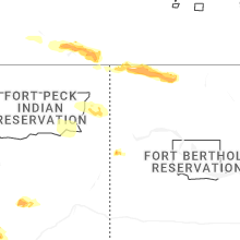


Connect with Interactive Hail Maps