

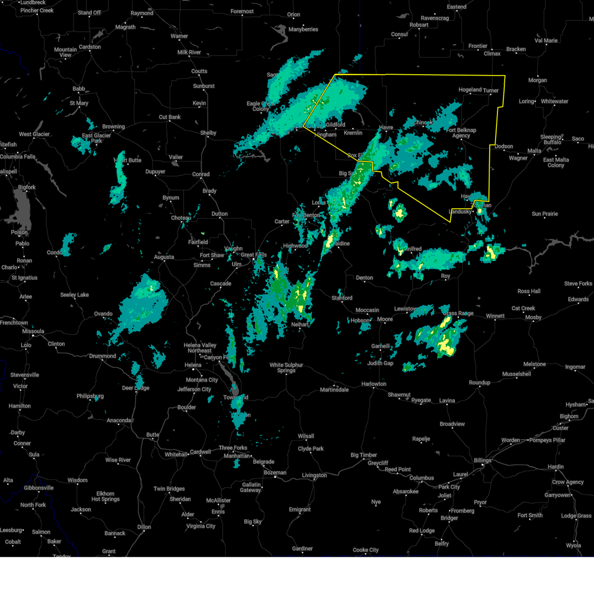
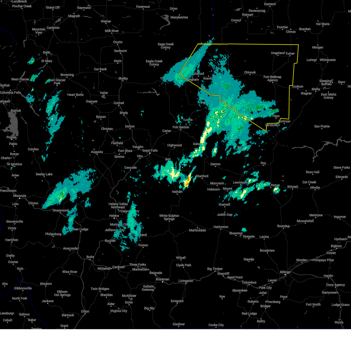
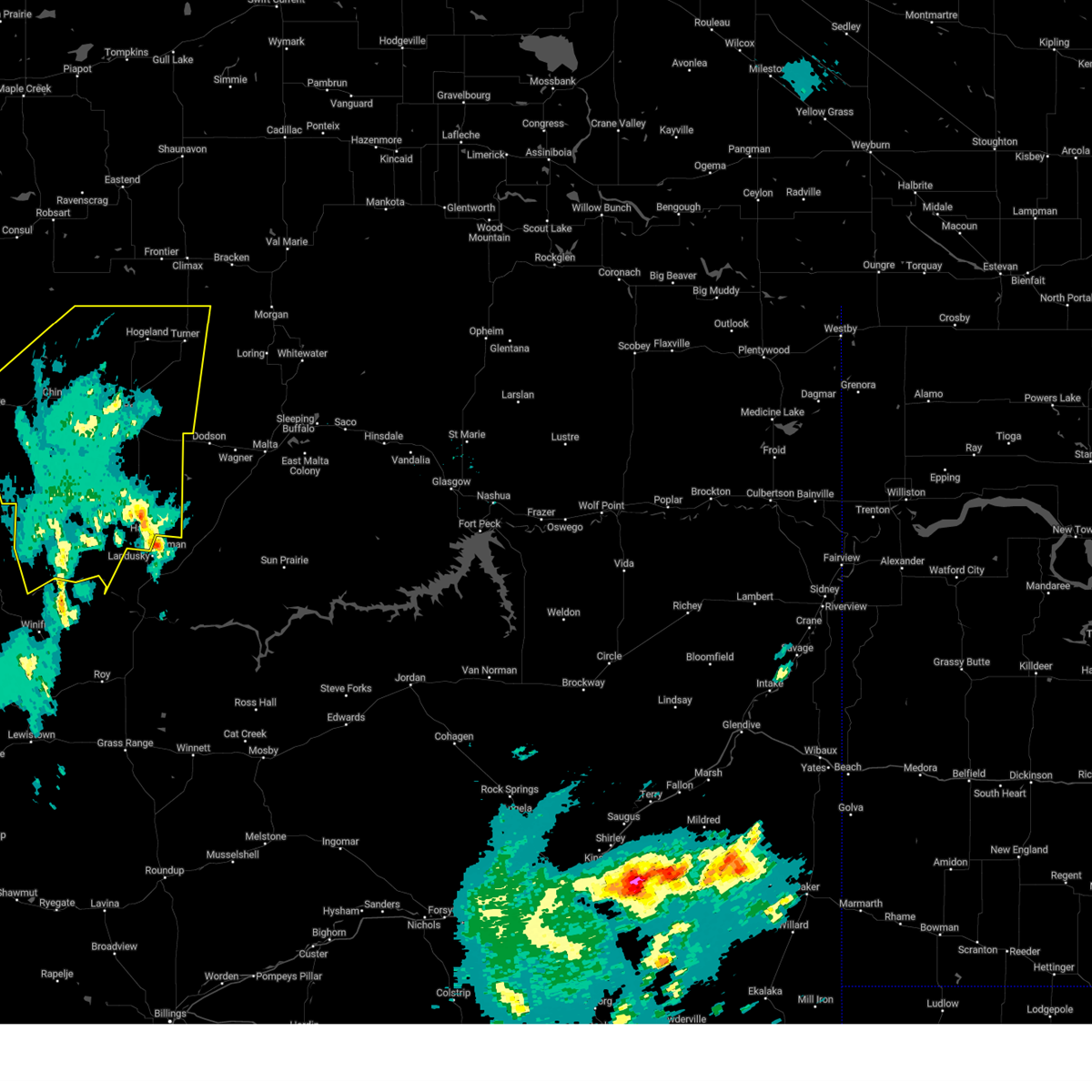
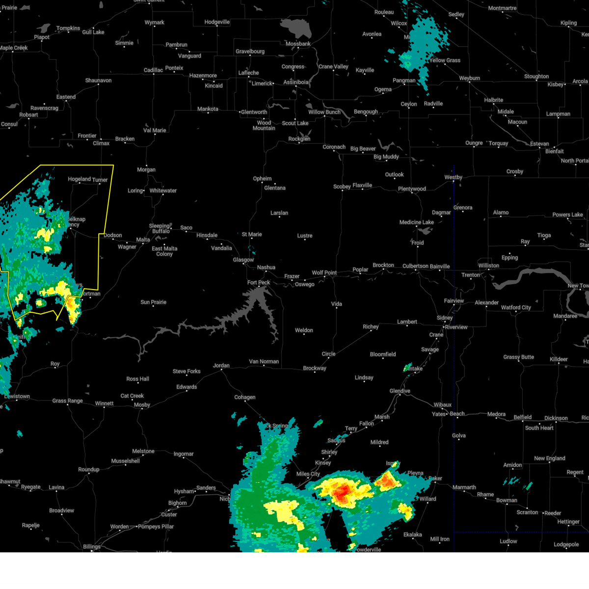
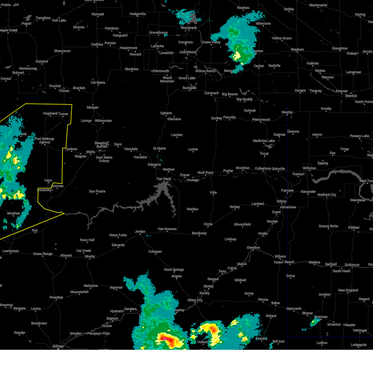
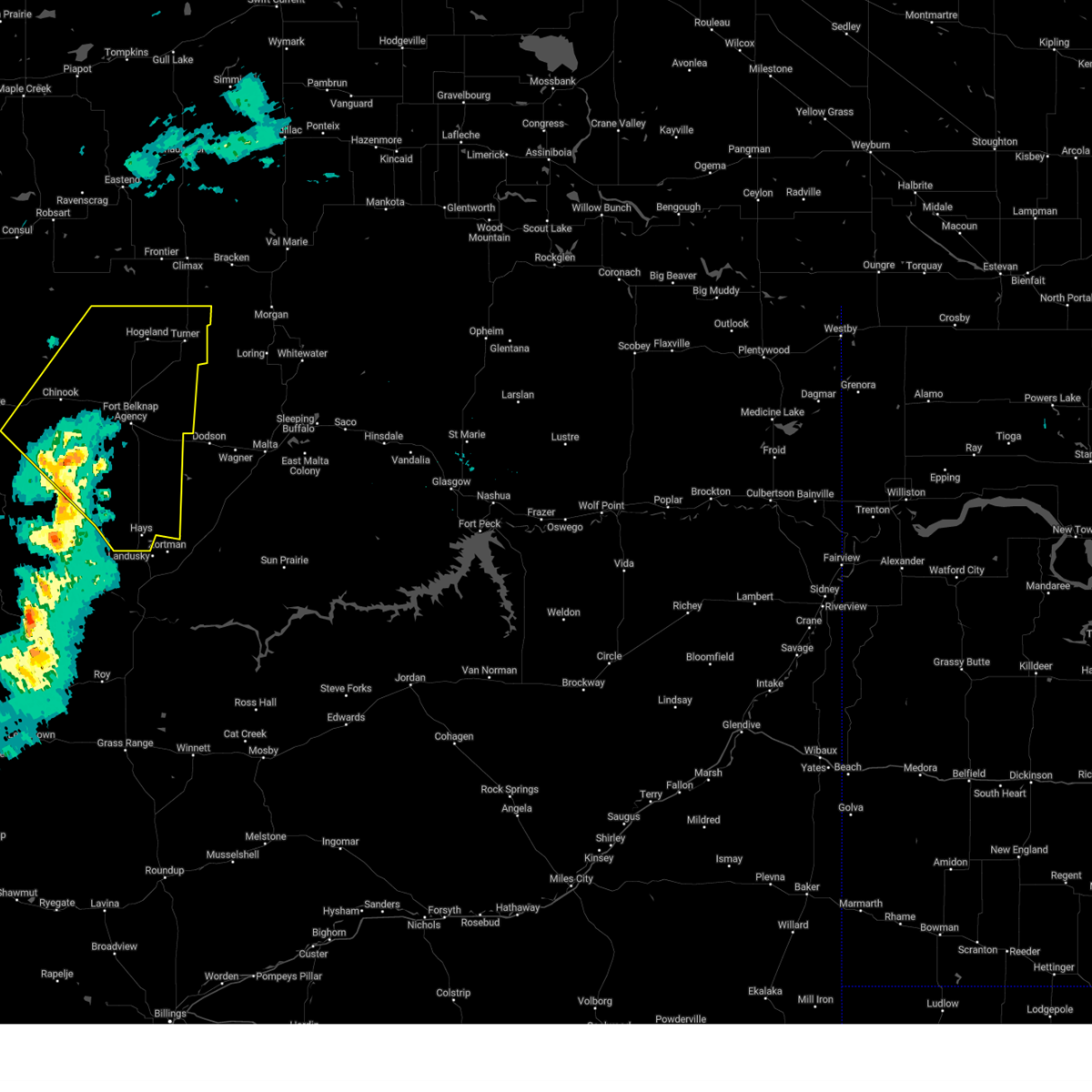
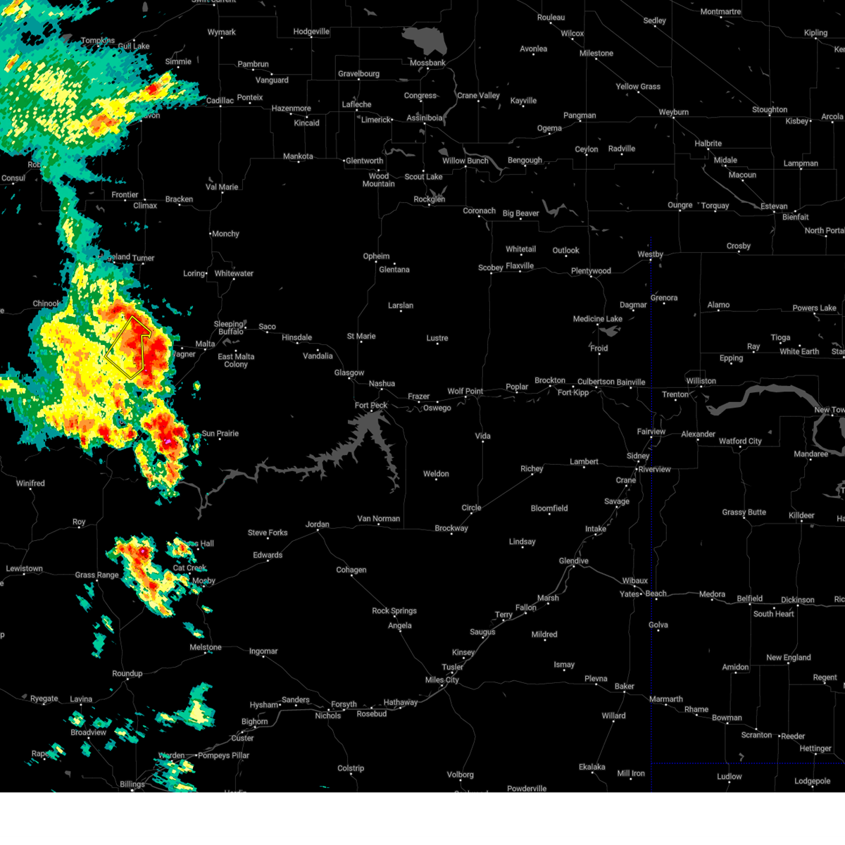
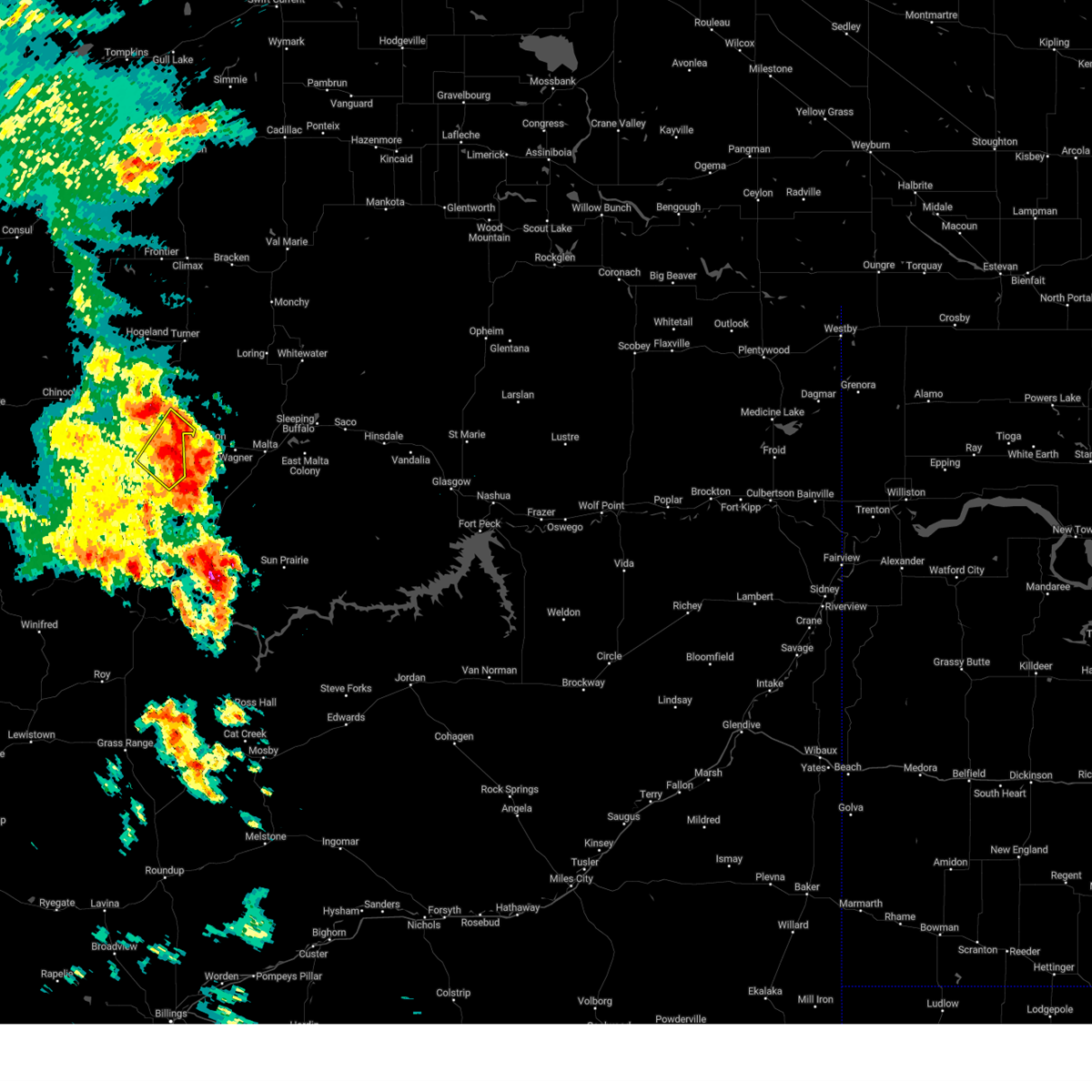
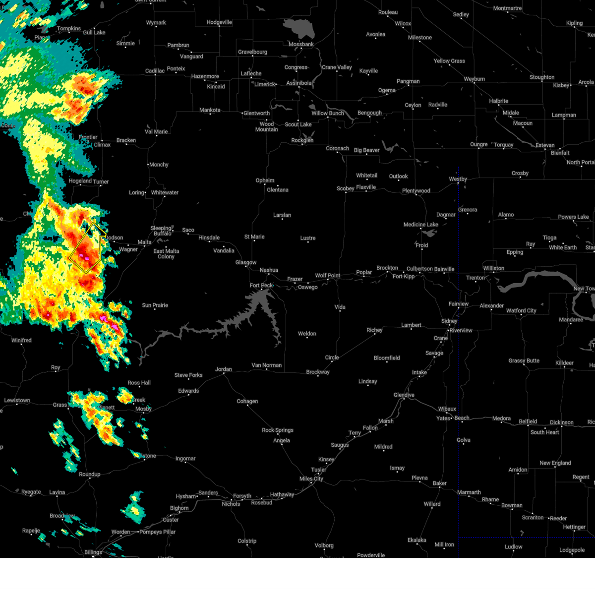
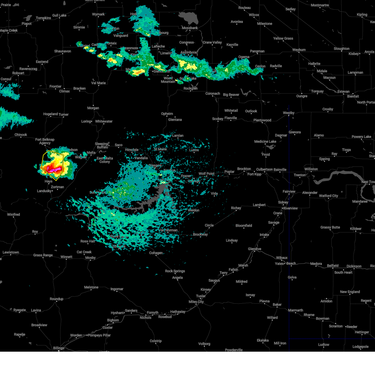
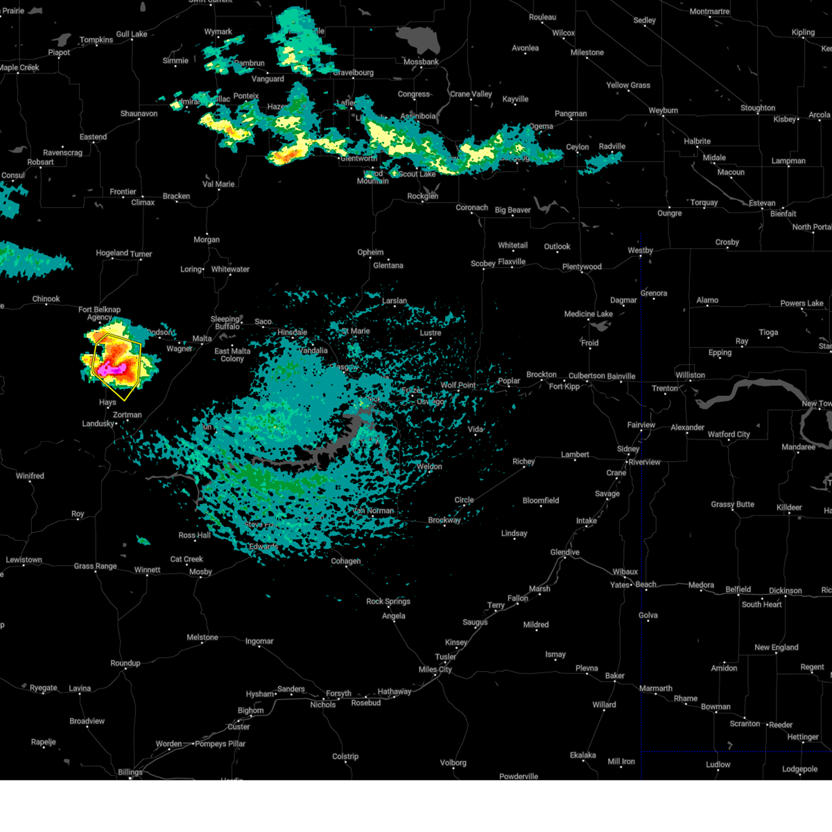
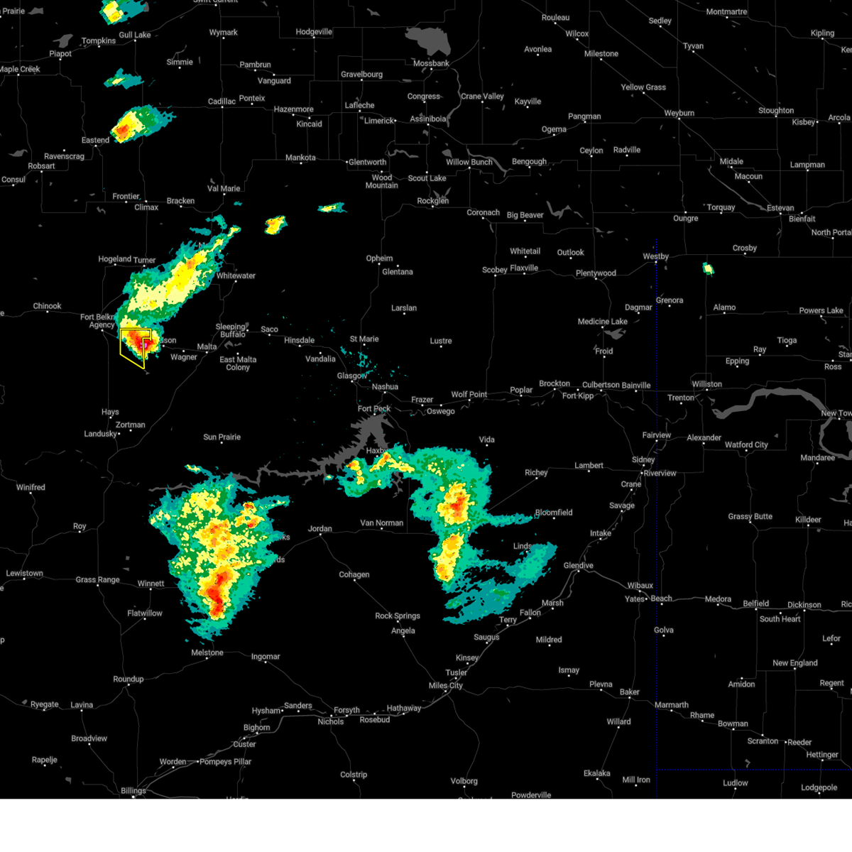
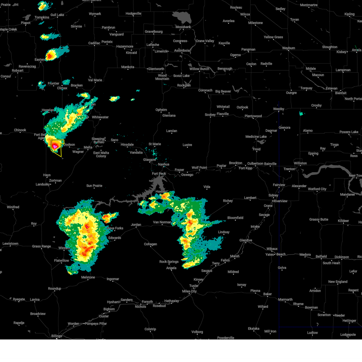
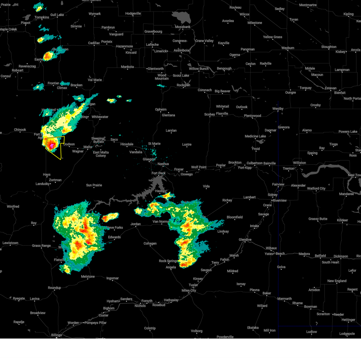
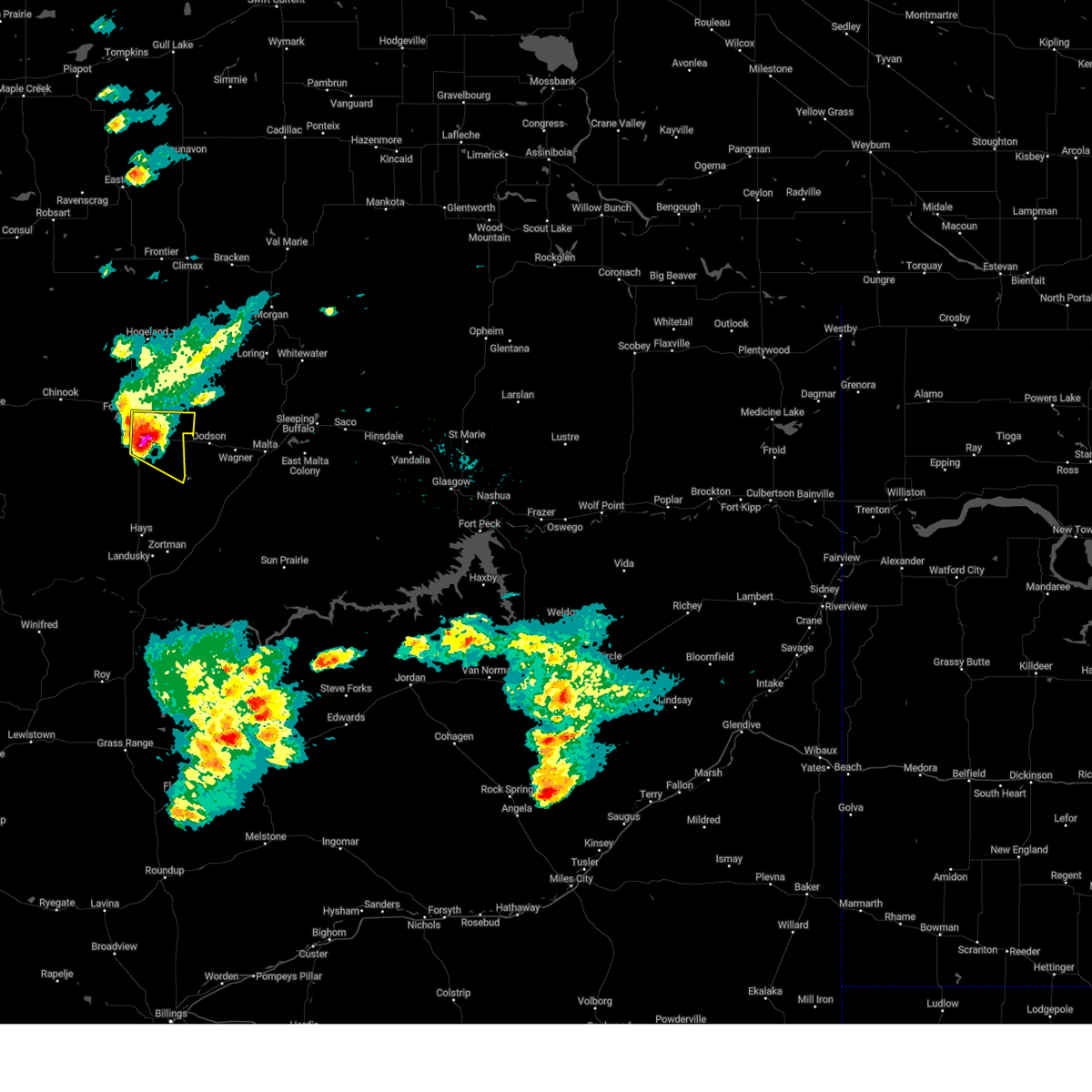
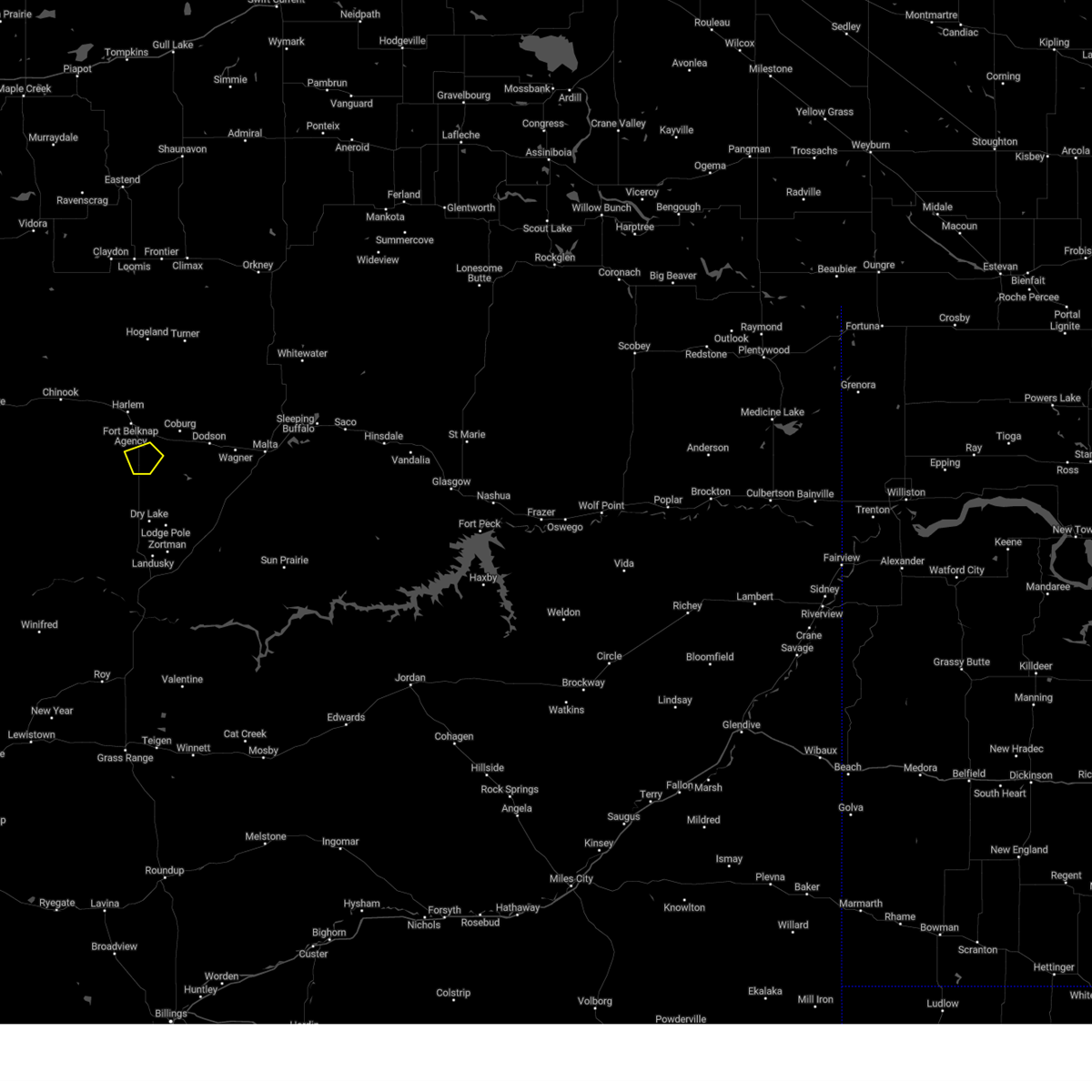
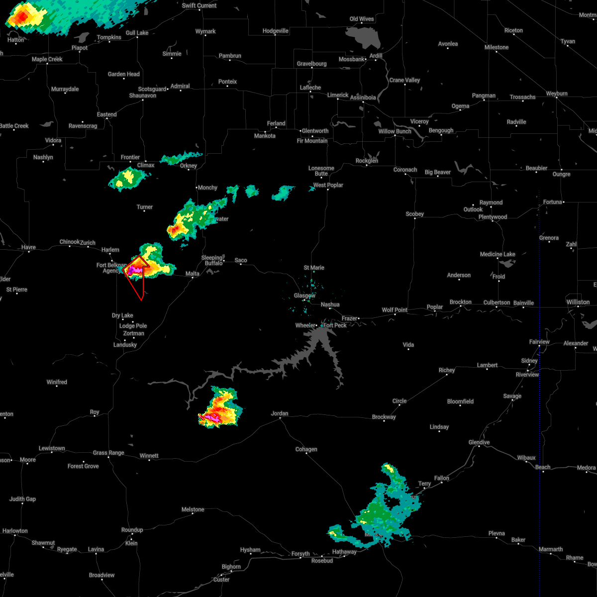
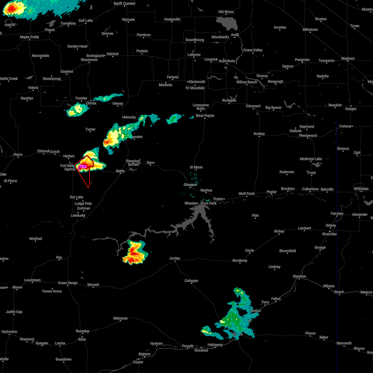
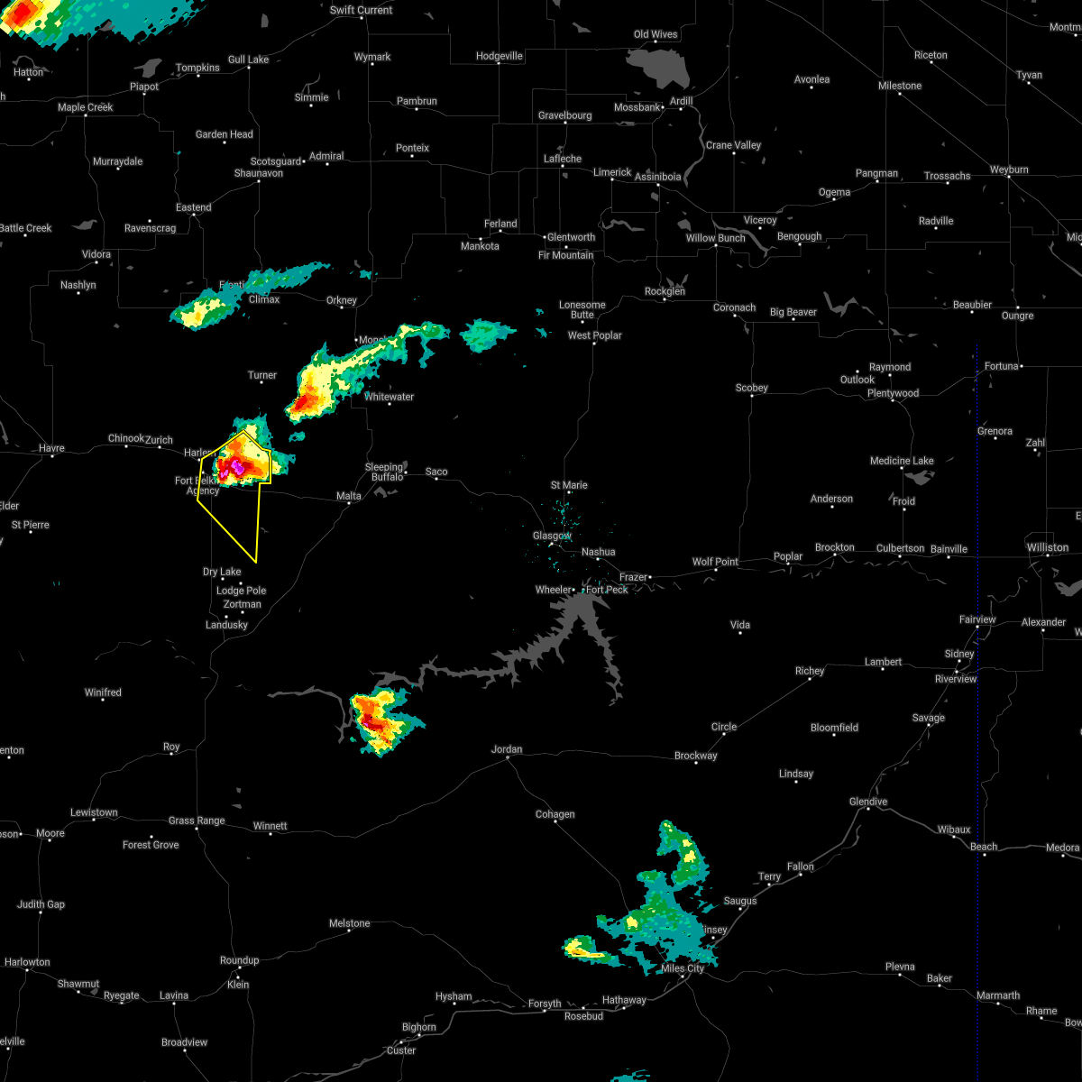
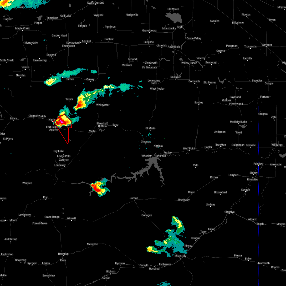
Hail Map for Fort Belknap Agency, MT
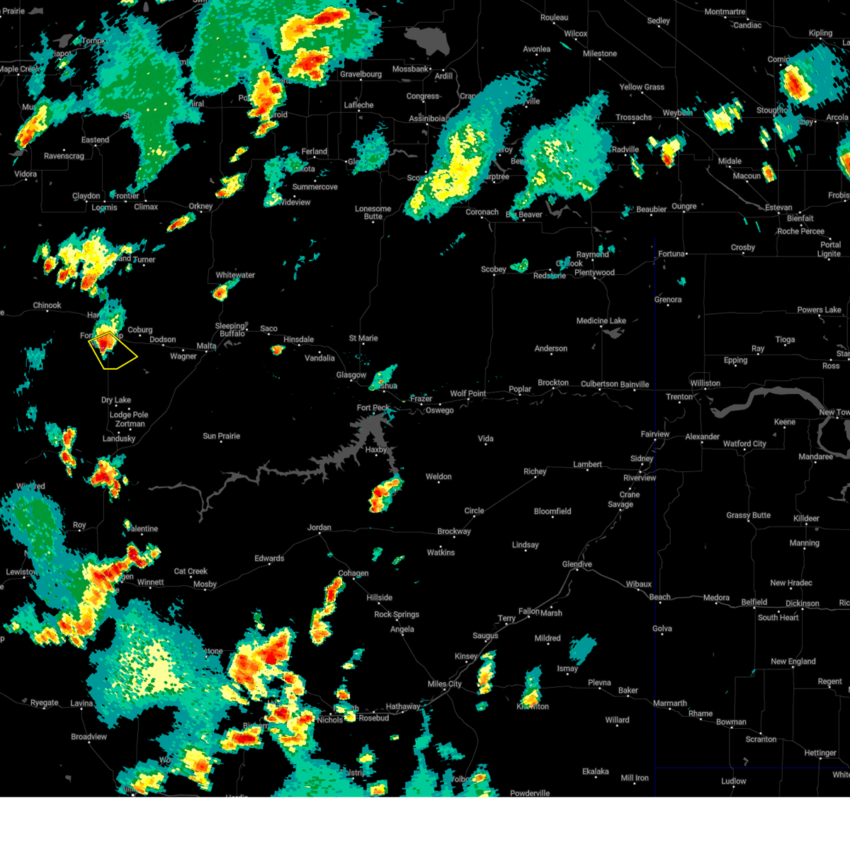
The Fort Belknap Agency, MT area has had 0 reports of on-the-ground hail by trained spotters, and has been under severe weather warnings 29 times during the past 12 months. Doppler radar has detected hail at or near Fort Belknap Agency, MT on 35 occasions, including 4 occasions during the past year.
| Name: | Fort Belknap Agency, MT |
| Where Located: | 46.4 miles ESE of Havre, MT |
| Map: | Google Map for Fort Belknap Agency, MT |
| Population: | 1293 |
| Housing Units: | 412 |
| More Info: | Search Google for Fort Belknap Agency, MT |
1
The Top Recent Hail Date for Fort Belknap Agency, MT is Friday, September 20, 2024 (12th out of 35)

Hail and Wind Damage Spotted near Fort Belknap Agency, MT
| Date / Time | Report Details |
|---|---|
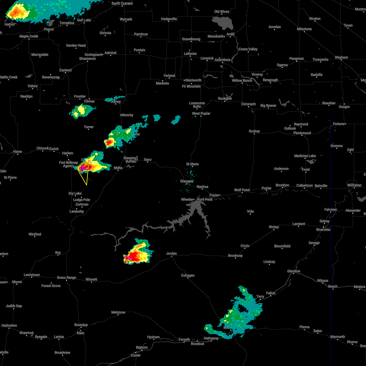
| 5/12/2025 4:40 PM MDT |
 the severe thunderstorm warning has been cancelled and is no longer in effect the severe thunderstorm warning has been cancelled and is no longer in effect
|
| 5/12/2025 4:06 PM MDT |
 Svrtfx the national weather service in great falls has issued a * severe thunderstorm warning for, blaine county in north central montana, hill county in north central montana, * until 500 pm mdt. * at 403 pm mdt, severe thunderstorm winds were moving through portions of hill and blaine county (radar indicated). Hazards include 60 mph wind gusts. expect damage to roofs, siding, and trees Svrtfx the national weather service in great falls has issued a * severe thunderstorm warning for, blaine county in north central montana, hill county in north central montana, * until 500 pm mdt. * at 403 pm mdt, severe thunderstorm winds were moving through portions of hill and blaine county (radar indicated). Hazards include 60 mph wind gusts. expect damage to roofs, siding, and trees
|
| 5/11/2025 6:54 PM MDT |
 the severe thunderstorm warning has been cancelled and is no longer in effect the severe thunderstorm warning has been cancelled and is no longer in effect
|
| 5/11/2025 6:34 PM MDT |
 the severe thunderstorm warning has been cancelled and is no longer in effect the severe thunderstorm warning has been cancelled and is no longer in effect
|
| 5/11/2025 6:34 PM MDT |
 At 631 pm mdt, scattered severe thunderstorm wind gusts were located over portions of hill and blaine counties (radar indicated). Hazards include 60 mph wind gusts. Expect damage to roofs, siding, and trees. Locations impacted include, beaver creek, lohman, lodge pole, cleveland, zurich, hays, harlem, havre, chinook, fort belknap, turner, lloyd, and hogeland. At 631 pm mdt, scattered severe thunderstorm wind gusts were located over portions of hill and blaine counties (radar indicated). Hazards include 60 mph wind gusts. Expect damage to roofs, siding, and trees. Locations impacted include, beaver creek, lohman, lodge pole, cleveland, zurich, hays, harlem, havre, chinook, fort belknap, turner, lloyd, and hogeland.
|
| 5/11/2025 5:56 PM MDT |
 Svrtfx the national weather service in great falls has issued a * severe thunderstorm warning for, northern fergus county in central montana, blaine county in north central montana, southeastern hill county in north central montana, northeastern chouteau county in north central montana, * until 730 pm mdt. * at 554 pm mdt, severe thunderstorms were located along a line extending from 19 miles northwest of chinook to 21 miles northeast of roy, moving northeast at 30 mph (radar indicated). Hazards include 60 mph wind gusts. expect damage to roofs, siding, and trees Svrtfx the national weather service in great falls has issued a * severe thunderstorm warning for, northern fergus county in central montana, blaine county in north central montana, southeastern hill county in north central montana, northeastern chouteau county in north central montana, * until 730 pm mdt. * at 554 pm mdt, severe thunderstorms were located along a line extending from 19 miles northwest of chinook to 21 miles northeast of roy, moving northeast at 30 mph (radar indicated). Hazards include 60 mph wind gusts. expect damage to roofs, siding, and trees
|
| 5/10/2025 6:43 PM MDT |
 The storms which prompted the warning have moved out of the warned area. therefore, the warning will be allowed to expire. however, gusty winds are still possible with these thunderstorms. remember, a severe thunderstorm warning still remains in effect for northeastern blaine county in north central montana until 730 pm mdt. The storms which prompted the warning have moved out of the warned area. therefore, the warning will be allowed to expire. however, gusty winds are still possible with these thunderstorms. remember, a severe thunderstorm warning still remains in effect for northeastern blaine county in north central montana until 730 pm mdt.
|
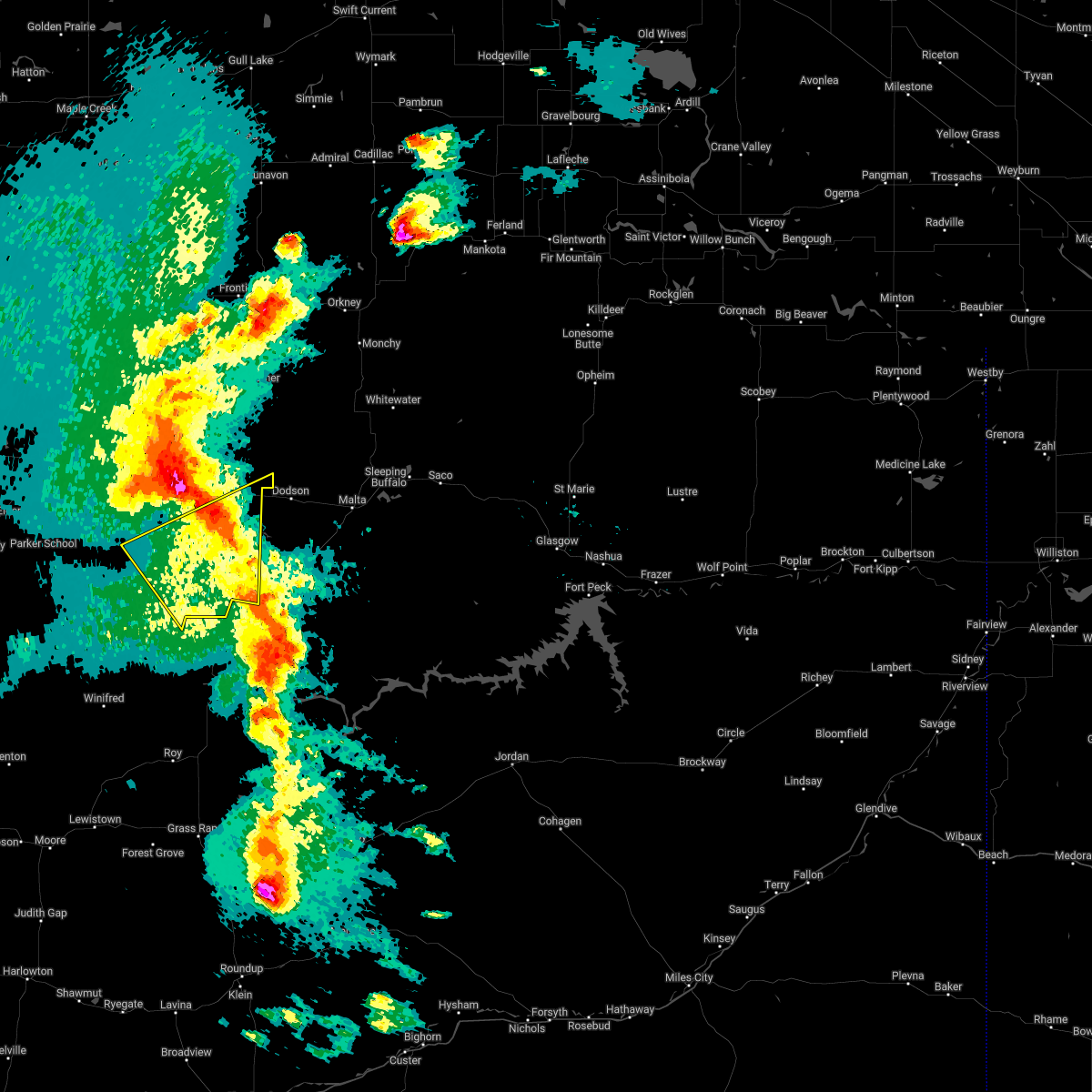
| 5/10/2025 6:28 PM MDT |
 At 628 pm mdt, severe thunderstorms were located along a line extending from 14 miles north of harlem to 16 miles east of fort belknap to 11 miles south of dodson, moving northeast at 55 mph (radar indicated). Hazards include 60 mph wind gusts. Expect damage to roofs, siding, and trees. Locations impacted include, hays, harlem, lodge pole, hogeland, fort belknap, and turner. At 628 pm mdt, severe thunderstorms were located along a line extending from 14 miles north of harlem to 16 miles east of fort belknap to 11 miles south of dodson, moving northeast at 55 mph (radar indicated). Hazards include 60 mph wind gusts. Expect damage to roofs, siding, and trees. Locations impacted include, hays, harlem, lodge pole, hogeland, fort belknap, and turner.
|
| 5/10/2025 6:09 PM MDT |
 the severe thunderstorm warning has been cancelled and is no longer in effect the severe thunderstorm warning has been cancelled and is no longer in effect
|
| 5/10/2025 6:09 PM MDT |
 At 608 pm mdt, severe thunderstorms were located along a line extending from 7 miles east of chinook to 6 miles south of fort belknap to 11 miles northeast of hays, moving east at 55 mph (radar indicated). Hazards include 60 mph wind gusts. Expect damage to roofs, siding, and trees. Locations impacted include, hays, harlem, fort belknap, turner, lodge pole, hogeland, cleveland, and zurich. At 608 pm mdt, severe thunderstorms were located along a line extending from 7 miles east of chinook to 6 miles south of fort belknap to 11 miles northeast of hays, moving east at 55 mph (radar indicated). Hazards include 60 mph wind gusts. Expect damage to roofs, siding, and trees. Locations impacted include, hays, harlem, fort belknap, turner, lodge pole, hogeland, cleveland, and zurich.
|
| 5/10/2025 5:48 PM MDT |
 Svrtfx the national weather service in great falls has issued a * severe thunderstorm warning for, blaine county in north central montana, southeastern hill county in north central montana, * until 645 pm mdt. * at 547 pm mdt, severe thunderstorms were located along a line extending from 12 miles southwest of chinook to 21 miles southwest of fort belknap to 6 miles southwest of hays, moving northeast at 55 mph (public). Hazards include 60 mph wind gusts. expect damage to roofs, siding, and trees Svrtfx the national weather service in great falls has issued a * severe thunderstorm warning for, blaine county in north central montana, southeastern hill county in north central montana, * until 645 pm mdt. * at 547 pm mdt, severe thunderstorms were located along a line extending from 12 miles southwest of chinook to 21 miles southwest of fort belknap to 6 miles southwest of hays, moving northeast at 55 mph (public). Hazards include 60 mph wind gusts. expect damage to roofs, siding, and trees
|
| 8/19/2024 9:59 PM MDT |
 The storms which prompted the warning have weakened below severe limits, and have exited the warned area. therefore, the warning will be allowed to expire. The storms which prompted the warning have weakened below severe limits, and have exited the warned area. therefore, the warning will be allowed to expire.
|
| 8/19/2024 9:48 PM MDT |
 the severe thunderstorm warning has been cancelled and is no longer in effect the severe thunderstorm warning has been cancelled and is no longer in effect
|
| 8/19/2024 9:48 PM MDT |
 At 948 pm mdt, severe thunderstorms were located along a line extending from 33 miles east of sunburst to 6 miles west of gildford to near azure to 24 miles southeast of parker school, moving east at 65 mph (radar indicated). Hazards include 70 mph wind gusts. Expect considerable tree damage. damage is likely to mobile homes, roofs, and outbuildings. Locations impacted include, chinook, harlem, hays, fort belknap, lohman, lodge pole, lloyd, cleveland, zurich, and simpson. At 948 pm mdt, severe thunderstorms were located along a line extending from 33 miles east of sunburst to 6 miles west of gildford to near azure to 24 miles southeast of parker school, moving east at 65 mph (radar indicated). Hazards include 70 mph wind gusts. Expect considerable tree damage. damage is likely to mobile homes, roofs, and outbuildings. Locations impacted include, chinook, harlem, hays, fort belknap, lohman, lodge pole, lloyd, cleveland, zurich, and simpson.
|
| 8/19/2024 9:10 PM MDT |
 At 909 pm mdt, severe thunderstorms were located along a line extending from 34 miles east of sunburst to near gildford to 6 miles north of azure to 25 miles southeast of parker school, moving east at 65 mph (automated weather observation system). Hazards include 70 mph wind gusts. Expect considerable tree damage. damage is likely to mobile homes, roofs, and outbuildings. locations impacted include, havre, chinook, chester, big sandy, harlem, parker school, beaver creek, hays, joplin, azure, inverness, agency, st. Pierre, gildford, sangrey, boneau, fort belknap, box elder, hingham, and rudyard. At 909 pm mdt, severe thunderstorms were located along a line extending from 34 miles east of sunburst to near gildford to 6 miles north of azure to 25 miles southeast of parker school, moving east at 65 mph (automated weather observation system). Hazards include 70 mph wind gusts. Expect considerable tree damage. damage is likely to mobile homes, roofs, and outbuildings. locations impacted include, havre, chinook, chester, big sandy, harlem, parker school, beaver creek, hays, joplin, azure, inverness, agency, st. Pierre, gildford, sangrey, boneau, fort belknap, box elder, hingham, and rudyard.
|
| 8/19/2024 8:56 PM MDT |
 Svrtfx the national weather service in great falls has issued a * severe thunderstorm warning for, northern liberty county in north central montana, northeastern toole county in north central montana, blaine county in north central montana, hill county in north central montana, northeastern chouteau county in north central montana, * until 1000 pm mdt. * at 855 pm mdt, severe thunderstorms were located along a line extending from 25 miles east of sunburst to near inverness to near box elder to 19 miles southeast of parker school, moving east at 65 mph (radar indicated). Hazards include 60 mph wind gusts. expect damage to roofs, siding, and trees Svrtfx the national weather service in great falls has issued a * severe thunderstorm warning for, northern liberty county in north central montana, northeastern toole county in north central montana, blaine county in north central montana, hill county in north central montana, northeastern chouteau county in north central montana, * until 1000 pm mdt. * at 855 pm mdt, severe thunderstorms were located along a line extending from 25 miles east of sunburst to near inverness to near box elder to 19 miles southeast of parker school, moving east at 65 mph (radar indicated). Hazards include 60 mph wind gusts. expect damage to roofs, siding, and trees
|
| 8/19/2024 3:13 AM MDT |
 The storm which prompted the warning has weakened below severe limits, and is exiting the warned area. therefore, the warning will be allowed to expire. however, small hail, gusty winds and heavy rain are still possible with this thunderstorm. The storm which prompted the warning has weakened below severe limits, and is exiting the warned area. therefore, the warning will be allowed to expire. however, small hail, gusty winds and heavy rain are still possible with this thunderstorm.
|
| 8/19/2024 3:05 AM MDT |
 At 305 am mdt, a severe thunderstorm was located 13 miles southwest of dodson, or 27 miles north of zortman, moving northeast at 25 mph (radar indicated). Hazards include 60 mph wind gusts and quarter size hail. Hail damage to vehicles is expected. expect wind damage to roofs, siding, and trees. This severe thunderstorm will remain over mainly rural areas of east central blaine county. At 305 am mdt, a severe thunderstorm was located 13 miles southwest of dodson, or 27 miles north of zortman, moving northeast at 25 mph (radar indicated). Hazards include 60 mph wind gusts and quarter size hail. Hail damage to vehicles is expected. expect wind damage to roofs, siding, and trees. This severe thunderstorm will remain over mainly rural areas of east central blaine county.
|
| 8/19/2024 2:52 AM MDT |
 Svrtfx the national weather service in great falls has issued a * severe thunderstorm warning for, east central blaine county in north central montana, * until 315 am mdt. * at 252 am mdt, a severe thunderstorm was located 16 miles southeast of fort belknap, or 24 miles north of zortman, moving northeast at 25 mph (radar indicated). Hazards include 60 mph wind gusts and quarter size hail. Hail damage to vehicles is expected. expect wind damage to roofs, siding, and trees. This severe thunderstorm will remain over mainly rural areas of east central blaine county. Svrtfx the national weather service in great falls has issued a * severe thunderstorm warning for, east central blaine county in north central montana, * until 315 am mdt. * at 252 am mdt, a severe thunderstorm was located 16 miles southeast of fort belknap, or 24 miles north of zortman, moving northeast at 25 mph (radar indicated). Hazards include 60 mph wind gusts and quarter size hail. Hail damage to vehicles is expected. expect wind damage to roofs, siding, and trees. This severe thunderstorm will remain over mainly rural areas of east central blaine county.
|
| 7/13/2024 3:31 PM MDT |
 A severe thunderstorm watch remains in effect until 900 pm mdt for north central montana. remember, a severe thunderstorm warning still remains in effect for southeast blaine county until 4 pm. A severe thunderstorm watch remains in effect until 900 pm mdt for north central montana. remember, a severe thunderstorm warning still remains in effect for southeast blaine county until 4 pm.
|
| 7/13/2024 3:21 PM MDT |
 At 320 pm mdt, a severe thunderstorm was located 11 miles south of fort belknap, or 28 miles north of zortman, moving southeast at 30 mph (trained weather spotters). Hazards include 60 mph wind gusts, quarter size hail, frequent lightning and brief heavy downpours. Hail damage to vehicles is expected. expect wind damage to roofs, siding, and trees. This severe thunderstorm will remain over mainly rural areas of east central blaine county. At 320 pm mdt, a severe thunderstorm was located 11 miles south of fort belknap, or 28 miles north of zortman, moving southeast at 30 mph (trained weather spotters). Hazards include 60 mph wind gusts, quarter size hail, frequent lightning and brief heavy downpours. Hail damage to vehicles is expected. expect wind damage to roofs, siding, and trees. This severe thunderstorm will remain over mainly rural areas of east central blaine county.
|
| 7/13/2024 3:12 PM MDT |
 The storm which prompted the warning is moving out of the area. therefore, the warning will be allowed to expire. a severe thunderstorm watch remains in effect until 900 pm mdt for north central montana. remember, a severe thunderstorm warning still remains in effect for portions of blaine county until 330 pm. The storm which prompted the warning is moving out of the area. therefore, the warning will be allowed to expire. a severe thunderstorm watch remains in effect until 900 pm mdt for north central montana. remember, a severe thunderstorm warning still remains in effect for portions of blaine county until 330 pm.
|
| 7/13/2024 3:09 PM MDT |
 Svrtfx the national weather service in great falls has issued a * severe thunderstorm warning for, east central blaine county in north central montana, * until 330 pm mdt. * at 307 pm mdt, a severe thunderstorm was located near fort belknap, or 23 miles southeast of chinook, moving southeast at 35 mph (trained weather spotters). Hazards include 60 mph wind gusts, quarter size hail, frequent lightning and brief heavy downpours. Hail damage to vehicles is expected. expect wind damage to roofs, siding, and trees. This severe thunderstorm will remain over mainly rural areas of east central blaine county. Svrtfx the national weather service in great falls has issued a * severe thunderstorm warning for, east central blaine county in north central montana, * until 330 pm mdt. * at 307 pm mdt, a severe thunderstorm was located near fort belknap, or 23 miles southeast of chinook, moving southeast at 35 mph (trained weather spotters). Hazards include 60 mph wind gusts, quarter size hail, frequent lightning and brief heavy downpours. Hail damage to vehicles is expected. expect wind damage to roofs, siding, and trees. This severe thunderstorm will remain over mainly rural areas of east central blaine county.
|
| 7/13/2024 3:00 PM MDT |
 At 259 pm mdt, a severe thunderstorm was located 7 miles west of harlem, or 13 miles east of chinook, moving east at 20 mph (trained weather spotters). Hazards include 60 mph wind gusts, quarter size hail, frequent lightning and brief heavy downpours. Hail damage to vehicles is expected. expect wind damage to roofs, siding, and trees. Locations impacted include, harlem and fort belknap. At 259 pm mdt, a severe thunderstorm was located 7 miles west of harlem, or 13 miles east of chinook, moving east at 20 mph (trained weather spotters). Hazards include 60 mph wind gusts, quarter size hail, frequent lightning and brief heavy downpours. Hail damage to vehicles is expected. expect wind damage to roofs, siding, and trees. Locations impacted include, harlem and fort belknap.
|
| 7/13/2024 2:44 PM MDT |
 A severe thunderstorm watch remains in effect until 900 pm mdt for north central montana. to report severe weather, contact your nearest law enforcement agency. they will relay your report to the national weather service great falls. remember, a severe thunderstorm warning still remains in effect for portions of blaine county. A severe thunderstorm watch remains in effect until 900 pm mdt for north central montana. to report severe weather, contact your nearest law enforcement agency. they will relay your report to the national weather service great falls. remember, a severe thunderstorm warning still remains in effect for portions of blaine county.
|
| 7/13/2024 2:40 PM MDT |
 Svrtfx the national weather service in great falls has issued a * severe thunderstorm warning for, central blaine county in north central montana, * until 315 pm mdt. * at 239 pm mdt, a severe thunderstorm was located 7 miles southeast of chinook, moving east at 20 mph (radar indicated). Hazards include 60 mph wind gusts, quarter size hail, frequent lightning and brief heavy rain. Hail damage to vehicles is expected. Expect wind damage to roofs, siding, and trees. Svrtfx the national weather service in great falls has issued a * severe thunderstorm warning for, central blaine county in north central montana, * until 315 pm mdt. * at 239 pm mdt, a severe thunderstorm was located 7 miles southeast of chinook, moving east at 20 mph (radar indicated). Hazards include 60 mph wind gusts, quarter size hail, frequent lightning and brief heavy rain. Hail damage to vehicles is expected. Expect wind damage to roofs, siding, and trees.
|
| 7/13/2024 2:35 PM MDT |
 At 234 pm mdt, a severe thunderstorm was located 10 miles west of harlem, or 10 miles east of chinook, moving east at 20 mph (radar indicated). Hazards include 60 mph wind gusts and quarter size hail. Hail damage to vehicles is expected. expect wind damage to roofs, siding, and trees. Locations impacted include, harlem, fort belknap, and zurich. At 234 pm mdt, a severe thunderstorm was located 10 miles west of harlem, or 10 miles east of chinook, moving east at 20 mph (radar indicated). Hazards include 60 mph wind gusts and quarter size hail. Hail damage to vehicles is expected. expect wind damage to roofs, siding, and trees. Locations impacted include, harlem, fort belknap, and zurich.
|
| 7/13/2024 2:34 PM MDT |
 At 233 pm mdt, a severe thunderstorm was located 9 miles east of chinook, moving east at 20 mph (radar indicated). Hazards include 60 mph wind gusts and quarter size hail. Hail damage is expected. expect wind damage to roofs, siding, and trees. Locations impacted include, harlem, fort belknap, and zurich. At 233 pm mdt, a severe thunderstorm was located 9 miles east of chinook, moving east at 20 mph (radar indicated). Hazards include 60 mph wind gusts and quarter size hail. Hail damage is expected. expect wind damage to roofs, siding, and trees. Locations impacted include, harlem, fort belknap, and zurich.
|
| 7/13/2024 2:18 PM MDT |
 Svrtfx the national weather service in great falls has issued a * severe thunderstorm warning for, central blaine county in north central montana, * until 245 pm mdt. * at 216 pm mdt, a severe thunderstorm was located near chinook, moving east at 20 mph (radar indicated). Hazards include 60 mph wind gusts, quarter size hail and frequent lightning. Hail damage is expected. Expect wind damage to roofs, siding, and trees. Svrtfx the national weather service in great falls has issued a * severe thunderstorm warning for, central blaine county in north central montana, * until 245 pm mdt. * at 216 pm mdt, a severe thunderstorm was located near chinook, moving east at 20 mph (radar indicated). Hazards include 60 mph wind gusts, quarter size hail and frequent lightning. Hail damage is expected. Expect wind damage to roofs, siding, and trees.
|
| 6/20/2024 6:55 PM MDT |
 The storm which prompted the warning has weakened below severe limits, and no longer poses an immediate threat to life or property. therefore, the warning will be allowed to expire. however, small hail is still possible with this thunderstorm. The storm which prompted the warning has weakened below severe limits, and no longer poses an immediate threat to life or property. therefore, the warning will be allowed to expire. however, small hail is still possible with this thunderstorm.
|
| 6/20/2024 6:40 PM MDT |
 At 639 pm mdt, a severe thunderstorm was located 7 miles north of dodson, or 21 miles northwest of malta, moving east at 25 mph (radar indicated). Hazards include 60 mph wind gusts and quarter size hail. Hail damage to vehicles is expected. expect wind damage to roofs, siding, and trees. This severe thunderstorm will remain over mainly rural areas of east central blaine county. At 639 pm mdt, a severe thunderstorm was located 7 miles north of dodson, or 21 miles northwest of malta, moving east at 25 mph (radar indicated). Hazards include 60 mph wind gusts and quarter size hail. Hail damage to vehicles is expected. expect wind damage to roofs, siding, and trees. This severe thunderstorm will remain over mainly rural areas of east central blaine county.
|
| 6/20/2024 6:29 PM MDT |
 At 628 pm mdt, a severe thunderstorm was located 9 miles northwest of dodson, or 25 miles northwest of malta, moving east at 25 mph (radar indicated). Hazards include 60 mph wind gusts and half dollar size hail. Hail damage to vehicles is expected. expect wind damage to roofs, siding, and trees. This severe thunderstorm will remain over mainly rural areas of east central blaine county. At 628 pm mdt, a severe thunderstorm was located 9 miles northwest of dodson, or 25 miles northwest of malta, moving east at 25 mph (radar indicated). Hazards include 60 mph wind gusts and half dollar size hail. Hail damage to vehicles is expected. expect wind damage to roofs, siding, and trees. This severe thunderstorm will remain over mainly rural areas of east central blaine county.
|
| 6/20/2024 6:19 PM MDT |
 At 618 pm mdt, a severe thunderstorm was located 12 miles northwest of dodson, or 29 miles west of malta, moving east at 25 mph (radar indicated). Hazards include 60 mph wind gusts and half dollar size hail. Hail damage to vehicles is expected. expect wind damage to roofs, siding, and trees. This severe thunderstorm will remain over mainly rural areas of east central blaine county. At 618 pm mdt, a severe thunderstorm was located 12 miles northwest of dodson, or 29 miles west of malta, moving east at 25 mph (radar indicated). Hazards include 60 mph wind gusts and half dollar size hail. Hail damage to vehicles is expected. expect wind damage to roofs, siding, and trees. This severe thunderstorm will remain over mainly rural areas of east central blaine county.
|
| 6/20/2024 6:01 PM MDT |
 At 601 pm mdt, a severe thunderstorm was located near fort belknap, or 28 miles east of chinook, moving east at 20 mph (radar indicated). Hazards include 60 mph wind gusts and half dollar size hail. Hail damage to vehicles is expected. expect wind damage to roofs, siding, and trees. Locations impacted include, harlem and fort belknap. At 601 pm mdt, a severe thunderstorm was located near fort belknap, or 28 miles east of chinook, moving east at 20 mph (radar indicated). Hazards include 60 mph wind gusts and half dollar size hail. Hail damage to vehicles is expected. expect wind damage to roofs, siding, and trees. Locations impacted include, harlem and fort belknap.
|
| 6/20/2024 5:42 PM MDT |
 this will be replaced with another severe thunderstorm warning this will be replaced with another severe thunderstorm warning
|
| 6/20/2024 5:41 PM MDT |
 Svrtfx the national weather service in great falls has issued a * severe thunderstorm warning for, east central blaine county in north central montana, * until 700 pm mdt. * at 539 pm mdt, a severe thunderstorm was located near fort belknap, or 19 miles southeast of chinook, moving east at 25 mph (radar indicated). Hazards include golf ball size hail and 60 mph wind gusts. People and animals outdoors will be injured. expect hail damage to roofs, siding, windows, and vehicles. Expect wind damage to roofs, siding, and trees. Svrtfx the national weather service in great falls has issued a * severe thunderstorm warning for, east central blaine county in north central montana, * until 700 pm mdt. * at 539 pm mdt, a severe thunderstorm was located near fort belknap, or 19 miles southeast of chinook, moving east at 25 mph (radar indicated). Hazards include golf ball size hail and 60 mph wind gusts. People and animals outdoors will be injured. expect hail damage to roofs, siding, windows, and vehicles. Expect wind damage to roofs, siding, and trees.
|
| 6/20/2024 5:31 PM MDT |
 At 531 pm mdt, a severe thunderstorm was located over harlem, or 20 miles east of chinook, moving east at 25 mph (radar indicated). Hazards include golf ball size hail and 60 mph wind gusts. People and animals outdoors will be injured. expect hail damage to roofs, siding, windows, and vehicles. expect wind damage to roofs, siding, and trees. Locations impacted include, harlem, fort belknap, and zurich. At 531 pm mdt, a severe thunderstorm was located over harlem, or 20 miles east of chinook, moving east at 25 mph (radar indicated). Hazards include golf ball size hail and 60 mph wind gusts. People and animals outdoors will be injured. expect hail damage to roofs, siding, windows, and vehicles. expect wind damage to roofs, siding, and trees. Locations impacted include, harlem, fort belknap, and zurich.
|
| 6/20/2024 5:12 PM MDT |
 At 511 pm mdt, a severe thunderstorm was located 8 miles west of harlem, or 12 miles east of chinook, moving east at 25 mph (radar indicated). Hazards include golf ball size hail and 60 mph wind gusts. People and animals outdoors will be injured. expect hail damage to roofs, siding, windows, and vehicles. expect wind damage to roofs, siding, and trees. Locations impacted include, chinook, harlem, fort belknap, and zurich. At 511 pm mdt, a severe thunderstorm was located 8 miles west of harlem, or 12 miles east of chinook, moving east at 25 mph (radar indicated). Hazards include golf ball size hail and 60 mph wind gusts. People and animals outdoors will be injured. expect hail damage to roofs, siding, windows, and vehicles. expect wind damage to roofs, siding, and trees. Locations impacted include, chinook, harlem, fort belknap, and zurich.
|
| 6/20/2024 4:59 PM MDT |
 Svrtfx the national weather service in great falls has issued a * severe thunderstorm warning for, central blaine county in north central montana, * until 545 pm mdt. * at 458 pm mdt, a severe thunderstorm was located 8 miles southeast of chinook, moving east at 25 mph (radar indicated). Hazards include 60 mph wind gusts and half dollar size hail. Hail damage to vehicles is expected. Expect wind damage to roofs, siding, and trees. Svrtfx the national weather service in great falls has issued a * severe thunderstorm warning for, central blaine county in north central montana, * until 545 pm mdt. * at 458 pm mdt, a severe thunderstorm was located 8 miles southeast of chinook, moving east at 25 mph (radar indicated). Hazards include 60 mph wind gusts and half dollar size hail. Hail damage to vehicles is expected. Expect wind damage to roofs, siding, and trees.
|
| 8/30/2023 12:37 AM MDT |
 At 1235 am mdt, a severe thunderstorm was located near havre, moving northeast at 35 mph (observed). Hazards include 65 mph wind gusts. expect damage to roofs, siding, and trees At 1235 am mdt, a severe thunderstorm was located near havre, moving northeast at 35 mph (observed). Hazards include 65 mph wind gusts. expect damage to roofs, siding, and trees
|
| 7/30/2023 9:55 PM MDT |
 The severe thunderstorm warning for northeastern blaine county will expire at 1000 pm mdt, the storms which prompted the warning have weakened below severe limits, and have exited the warned area. therefore, the warning will be allowed to expire. strong gusty winds and small hail are still possible. The severe thunderstorm warning for northeastern blaine county will expire at 1000 pm mdt, the storms which prompted the warning have weakened below severe limits, and have exited the warned area. therefore, the warning will be allowed to expire. strong gusty winds and small hail are still possible.
|
| 7/30/2023 9:47 PM MDT |
 At 946 pm mdt, a severe thunderstorm was located 13 miles east of harlem, or 32 miles northwest of malta, moving east at 30 mph (radar indicated). Hazards include 60 mph wind gusts and quarter size hail. Hail damage to vehicles is expected. expect wind damage to roofs, siding, and trees. locations impacted include, harlem, fort belknap, turner and hogeland. hail threat, radar indicated max hail size, 1. 00 in wind threat, radar indicated max wind gust, 60 mph. At 946 pm mdt, a severe thunderstorm was located 13 miles east of harlem, or 32 miles northwest of malta, moving east at 30 mph (radar indicated). Hazards include 60 mph wind gusts and quarter size hail. Hail damage to vehicles is expected. expect wind damage to roofs, siding, and trees. locations impacted include, harlem, fort belknap, turner and hogeland. hail threat, radar indicated max hail size, 1. 00 in wind threat, radar indicated max wind gust, 60 mph.
|
| 7/30/2023 9:13 PM MDT |
 At 912 pm mdt, a severe thunderstorm was located over harlem, or 17 miles east of chinook, moving east at 30 mph (radar indicated). Hazards include 60 mph wind gusts and quarter size hail. Hail damage to vehicles is expected. Expect wind damage to roofs, siding, and trees. At 912 pm mdt, a severe thunderstorm was located over harlem, or 17 miles east of chinook, moving east at 30 mph (radar indicated). Hazards include 60 mph wind gusts and quarter size hail. Hail damage to vehicles is expected. Expect wind damage to roofs, siding, and trees.
|
| 7/30/2023 9:01 PM MDT |
 At 859 pm mdt, a severe thunderstorm was located 14 miles north of harlem, or 18 miles northeast of chinook, moving east at 35 mph (radar indicated). Hazards include 60 mph wind gusts and quarter size hail. Hail damage to vehicles is expected. expect wind damage to roofs, siding, and trees. locations impacted include, harlem, fort belknap and zurich. hail threat, radar indicated max hail size, 1. 00 in wind threat, radar indicated max wind gust, 60 mph. At 859 pm mdt, a severe thunderstorm was located 14 miles north of harlem, or 18 miles northeast of chinook, moving east at 35 mph (radar indicated). Hazards include 60 mph wind gusts and quarter size hail. Hail damage to vehicles is expected. expect wind damage to roofs, siding, and trees. locations impacted include, harlem, fort belknap and zurich. hail threat, radar indicated max hail size, 1. 00 in wind threat, radar indicated max wind gust, 60 mph.
|
| 7/30/2023 8:25 PM MDT |
 At 824 pm mdt, a severe thunderstorm was located 9 miles northwest of chinook, moving east at 35 mph (radar indicated). Hazards include 60 mph wind gusts and quarter size hail. Hail damage to vehicles is expected. Expect wind damage to roofs, siding, and trees. At 824 pm mdt, a severe thunderstorm was located 9 miles northwest of chinook, moving east at 35 mph (radar indicated). Hazards include 60 mph wind gusts and quarter size hail. Hail damage to vehicles is expected. Expect wind damage to roofs, siding, and trees.
|
| 6/7/2023 4:50 PM MDT |
 At 449 pm mdt, a severe thunderstorm was located 11 miles south of fort belknap, or 28 miles north of zortman, moving south at 10 mph (radar indicated). Hazards include 60 mph wind gusts and penny size hail. Expect damage to roofs, siding, and trees. this severe thunderstorm will remain over mainly rural areas of central blaine county. hail threat, radar indicated max hail size, 0. 75 in wind threat, radar indicated max wind gust, 60 mph. At 449 pm mdt, a severe thunderstorm was located 11 miles south of fort belknap, or 28 miles north of zortman, moving south at 10 mph (radar indicated). Hazards include 60 mph wind gusts and penny size hail. Expect damage to roofs, siding, and trees. this severe thunderstorm will remain over mainly rural areas of central blaine county. hail threat, radar indicated max hail size, 0. 75 in wind threat, radar indicated max wind gust, 60 mph.
|
| 6/7/2023 4:31 PM MDT |
 At 431 pm mdt, a severe thunderstorm was located 7 miles south of fort belknap, or 28 miles southeast of chinook, moving southeast at 20 mph (radar indicated). Hazards include 70 mph wind gusts and quarter size hail. Hail damage to vehicles is expected. expect considerable tree damage. wind damage is also likely to mobile homes, roofs, and outbuildings. this severe thunderstorm will remain over mainly rural areas of east central blaine county. thunderstorm damage threat, considerable hail threat, radar indicated max hail size, 1. 00 in wind threat, radar indicated max wind gust, 70 mph. At 431 pm mdt, a severe thunderstorm was located 7 miles south of fort belknap, or 28 miles southeast of chinook, moving southeast at 20 mph (radar indicated). Hazards include 70 mph wind gusts and quarter size hail. Hail damage to vehicles is expected. expect considerable tree damage. wind damage is also likely to mobile homes, roofs, and outbuildings. this severe thunderstorm will remain over mainly rural areas of east central blaine county. thunderstorm damage threat, considerable hail threat, radar indicated max hail size, 1. 00 in wind threat, radar indicated max wind gust, 70 mph.
|
| 7/9/2022 8:12 PM MDT |
 The severe thunderstorm warning for blaine county will expire at 815 pm mdt, the storms which prompted the warning have moved out of the area. therefore, the warning will be allowed to expire. a severe thunderstorm watch remains in effect until 1000 pm mdt for north central montana. The severe thunderstorm warning for blaine county will expire at 815 pm mdt, the storms which prompted the warning have moved out of the area. therefore, the warning will be allowed to expire. a severe thunderstorm watch remains in effect until 1000 pm mdt for north central montana.
|
| 7/9/2022 7:51 PM MDT |
 At 751 pm mdt, severe thunderstorms were located along a line extending from 23 miles west of turner to fort belknap to 20 miles west of hays, moving east at 55 mph (radar indicated). Hazards include 60 mph wind gusts. Expect damage to roofs, siding, and trees. locations impacted include, chinook, harlem, fort belknap, turner, lodge pole, lloyd, hogeland, cleveland and zurich. hail threat, radar indicated max hail size, <. 75 in wind threat, radar indicated max wind gust, 60 mph. At 751 pm mdt, severe thunderstorms were located along a line extending from 23 miles west of turner to fort belknap to 20 miles west of hays, moving east at 55 mph (radar indicated). Hazards include 60 mph wind gusts. Expect damage to roofs, siding, and trees. locations impacted include, chinook, harlem, fort belknap, turner, lodge pole, lloyd, hogeland, cleveland and zurich. hail threat, radar indicated max hail size, <. 75 in wind threat, radar indicated max wind gust, 60 mph.
|
| 7/9/2022 7:35 PM MDT |
 At 735 pm mdt, severe thunderstorms were located along a line extending from 34 miles northeast of havre to 10 miles southeast of chinook to 20 miles southeast of parker school, moving east at 55 mph (radar indicated). Hazards include 60 mph wind gusts. Expect damage to roofs, siding, and trees. locations impacted include, chinook, harlem, fort belknap, turner, parker school, lohman, lodge pole, lloyd, hogeland, cleveland and zurich. hail threat, radar indicated max hail size, <. 75 in wind threat, radar indicated max wind gust, 60 mph. At 735 pm mdt, severe thunderstorms were located along a line extending from 34 miles northeast of havre to 10 miles southeast of chinook to 20 miles southeast of parker school, moving east at 55 mph (radar indicated). Hazards include 60 mph wind gusts. Expect damage to roofs, siding, and trees. locations impacted include, chinook, harlem, fort belknap, turner, parker school, lohman, lodge pole, lloyd, hogeland, cleveland and zurich. hail threat, radar indicated max hail size, <. 75 in wind threat, radar indicated max wind gust, 60 mph.
|
| 7/9/2022 7:24 PM MDT |
 At 723 pm mdt, severe thunderstorms were located along a line extending from 29 miles north of havre to 8 miles southwest of chinook to 15 miles south of parker school, moving east at 50 mph (radar indicated). Hazards include 70 mph wind gusts. Expect considerable tree damage. damage is likely to mobile homes, roofs, and outbuildings. this storm produce wind gusts near 65 mph as it went through the city of havre. locations impacted include, havre, chinook, harlem, parker school, beaver creek, agency, fort belknap, turner, azure, sangrey, st. pierre, rocky boy, lohman, lodge pole, cleveland, zurich, lloyd and hogeland. thunderstorm damage threat, considerable hail threat, radar indicated max hail size, <. 75 in wind threat, radar indicated max wind gust, 70 mph. At 723 pm mdt, severe thunderstorms were located along a line extending from 29 miles north of havre to 8 miles southwest of chinook to 15 miles south of parker school, moving east at 50 mph (radar indicated). Hazards include 70 mph wind gusts. Expect considerable tree damage. damage is likely to mobile homes, roofs, and outbuildings. this storm produce wind gusts near 65 mph as it went through the city of havre. locations impacted include, havre, chinook, harlem, parker school, beaver creek, agency, fort belknap, turner, azure, sangrey, st. pierre, rocky boy, lohman, lodge pole, cleveland, zurich, lloyd and hogeland. thunderstorm damage threat, considerable hail threat, radar indicated max hail size, <. 75 in wind threat, radar indicated max wind gust, 70 mph.
|
| 7/9/2022 6:58 PM MDT |
 At 658 pm mdt, a severe thunderstorm was located over havre, moving east at 55 mph (radar indicated). Hazards include 60 mph wind gusts and penny size hail. expect damage to roofs, siding, and trees At 658 pm mdt, a severe thunderstorm was located over havre, moving east at 55 mph (radar indicated). Hazards include 60 mph wind gusts and penny size hail. expect damage to roofs, siding, and trees
|
| 7/8/2022 9:37 PM MDT |
 The severe thunderstorm warning for east central blaine county will expire at 945 pm mdt, the storm which prompted the warning has moved out of the area. therefore, the warning will be allowed to expire. however gusty winds are still possible in the wake of this thunderstorm. a severe thunderstorm watch remains in effect until 1000 pm mdt for north central montana. to report severe weather, contact your nearest law enforcement agency. they will relay your report to the national weather service great falls. The severe thunderstorm warning for east central blaine county will expire at 945 pm mdt, the storm which prompted the warning has moved out of the area. therefore, the warning will be allowed to expire. however gusty winds are still possible in the wake of this thunderstorm. a severe thunderstorm watch remains in effect until 1000 pm mdt for north central montana. to report severe weather, contact your nearest law enforcement agency. they will relay your report to the national weather service great falls.
|
| 7/8/2022 9:19 PM MDT |
 At 917 pm mdt, severe thunderstorms were located along a line extending from 15 miles north of havre to 9 miles west of harlem to near fort belknap, moving northeast at 45 mph (radar indicated). Hazards include 70 mph wind gusts and ping pong ball size hail. People and animals outdoors will be injured. expect hail damage to roofs, siding, windows, and vehicles. expect considerable tree damage. wind damage is also likely to mobile homes, roofs, and outbuildings. Locations impacted include, harlem, fort belknap, turner, hogeland and zurich. At 917 pm mdt, severe thunderstorms were located along a line extending from 15 miles north of havre to 9 miles west of harlem to near fort belknap, moving northeast at 45 mph (radar indicated). Hazards include 70 mph wind gusts and ping pong ball size hail. People and animals outdoors will be injured. expect hail damage to roofs, siding, windows, and vehicles. expect considerable tree damage. wind damage is also likely to mobile homes, roofs, and outbuildings. Locations impacted include, harlem, fort belknap, turner, hogeland and zurich.
|
| 7/8/2022 9:08 PM MDT |
 At 908 pm mdt, a severe thunderstorm was located near fort belknap, or 29 miles east of chinook, moving east at 65 mph. this is a destructive storm for fort belknap and harlem (radar indicated). Hazards include 80 mph wind gusts and quarter size hail. Flying debris will be dangerous to those caught without shelter. mobile homes will be heavily damaged. expect considerable damage to roofs, windows, and vehicles. Extensive tree damage and power outages are likely. At 908 pm mdt, a severe thunderstorm was located near fort belknap, or 29 miles east of chinook, moving east at 65 mph. this is a destructive storm for fort belknap and harlem (radar indicated). Hazards include 80 mph wind gusts and quarter size hail. Flying debris will be dangerous to those caught without shelter. mobile homes will be heavily damaged. expect considerable damage to roofs, windows, and vehicles. Extensive tree damage and power outages are likely.
|
| 7/8/2022 8:58 PM MDT |
 At 857 pm mdt, severe thunderstorms were located along a line extending from 8 miles south of fort belknap to 6 miles northeast of zortman to 18 miles west of fourchette, moving northeast at 45 mph (radar indicated). Hazards include 70 mph wind gusts. Expect considerable tree damage. Damage is likely to mobile homes, roofs, and outbuildings. At 857 pm mdt, severe thunderstorms were located along a line extending from 8 miles south of fort belknap to 6 miles northeast of zortman to 18 miles west of fourchette, moving northeast at 45 mph (radar indicated). Hazards include 70 mph wind gusts. Expect considerable tree damage. Damage is likely to mobile homes, roofs, and outbuildings.
|
| 7/8/2022 8:48 PM MDT |
 At 847 pm mdt, severe thunderstorms were located along a line extending from 6 miles northwest of beaver creek to 13 miles south of chinook to 21 miles southwest of fort belknap, moving northeast at 45 mph (radar and automated sensor indicated. at 845 pm, 60 mph wind was reported chinook). Hazards include 70 mph wind gusts and ping pong ball size hail. People and animals outdoors will be injured. expect hail damage to roofs, siding, windows, and vehicles. expect considerable tree damage. wind damage is also likely to mobile homes, roofs, and outbuildings. Locations impacted include, havre, chinook, harlem, beaver creek, fort belknap, turner, lohman, lloyd, kremlin, hogeland, cleveland and zurich. At 847 pm mdt, severe thunderstorms were located along a line extending from 6 miles northwest of beaver creek to 13 miles south of chinook to 21 miles southwest of fort belknap, moving northeast at 45 mph (radar and automated sensor indicated. at 845 pm, 60 mph wind was reported chinook). Hazards include 70 mph wind gusts and ping pong ball size hail. People and animals outdoors will be injured. expect hail damage to roofs, siding, windows, and vehicles. expect considerable tree damage. wind damage is also likely to mobile homes, roofs, and outbuildings. Locations impacted include, havre, chinook, harlem, beaver creek, fort belknap, turner, lohman, lloyd, kremlin, hogeland, cleveland and zurich.
|
| 7/8/2022 8:41 PM MDT |
 At 840 pm mdt, severe thunderstorms were located along a line extending from 7 miles northwest of beaver creek to 13 miles south of chinook to 23 miles southwest of fort belknap, moving northeast at 40 mph (radar indicated). Hazards include 70 mph wind gusts and ping pong ball size hail. People and animals outdoors will be injured. expect hail damage to roofs, siding, windows, and vehicles. expect considerable tree damage. Wind damage is also likely to mobile homes, roofs, and outbuildings. At 840 pm mdt, severe thunderstorms were located along a line extending from 7 miles northwest of beaver creek to 13 miles south of chinook to 23 miles southwest of fort belknap, moving northeast at 40 mph (radar indicated). Hazards include 70 mph wind gusts and ping pong ball size hail. People and animals outdoors will be injured. expect hail damage to roofs, siding, windows, and vehicles. expect considerable tree damage. Wind damage is also likely to mobile homes, roofs, and outbuildings.
|
| 7/8/2022 8:26 PM MDT |
 At 826 pm mdt, severe thunderstorms were located along a line extending from 19 miles east of parker school to 16 miles southwest of hays to 22 miles southwest of zortman to 11 miles southeast of grass range, moving east at 40 mph (radar indicated). Hazards include 70 mph wind gusts and nickel size hail. Expect considerable tree damage. Damage is likely to mobile homes, roofs, and outbuildings. At 826 pm mdt, severe thunderstorms were located along a line extending from 19 miles east of parker school to 16 miles southwest of hays to 22 miles southwest of zortman to 11 miles southeast of grass range, moving east at 40 mph (radar indicated). Hazards include 70 mph wind gusts and nickel size hail. Expect considerable tree damage. Damage is likely to mobile homes, roofs, and outbuildings.
|
| 7/11/2021 6:51 PM MDT |
 The severe thunderstorm warning for blaine, eastern hill and east central chouteau counties will expire at 700 pm mdt, wind speeds have weakened. therefore, the warning will be allowed to expire. however, gusty winds of 40 to 50 mph are still possible over the next 30 to 60 minutes. The severe thunderstorm warning for blaine, eastern hill and east central chouteau counties will expire at 700 pm mdt, wind speeds have weakened. therefore, the warning will be allowed to expire. however, gusty winds of 40 to 50 mph are still possible over the next 30 to 60 minutes.
|
| 7/11/2021 6:26 PM MDT |
 At 625 pm mdt, severe thunderstorms were located along a line extending from 16 miles west of turner to 20 miles west of hays, moving east at 45 mph (radar indicated). Hazards include 60 mph wind gusts. the severe wind gusts are occurring with only light to moderate rainfall. Expect damage to roofs, siding, and trees. Locations impacted include, chinook, harlem, hays, fort belknap, turner, lohman, lodge pole, lloyd, hogeland, cleveland and zurich. At 625 pm mdt, severe thunderstorms were located along a line extending from 16 miles west of turner to 20 miles west of hays, moving east at 45 mph (radar indicated). Hazards include 60 mph wind gusts. the severe wind gusts are occurring with only light to moderate rainfall. Expect damage to roofs, siding, and trees. Locations impacted include, chinook, harlem, hays, fort belknap, turner, lohman, lodge pole, lloyd, hogeland, cleveland and zurich.
|
| 7/11/2021 5:55 PM MDT |
 At 554 pm mdt, severe thunderstorms were located along a line extending from 25 miles north of chinook to 15 miles southeast of parker school, moving east at 50 mph (radar indicated). Hazards include 60 mph wind gusts. much of the severe wind gusts are occurring with only light to moderate rainfall. expect damage to roofs, siding, and trees At 554 pm mdt, severe thunderstorms were located along a line extending from 25 miles north of chinook to 15 miles southeast of parker school, moving east at 50 mph (radar indicated). Hazards include 60 mph wind gusts. much of the severe wind gusts are occurring with only light to moderate rainfall. expect damage to roofs, siding, and trees
|
| 7/6/2021 8:45 PM MDT |
 At 844 pm mdt, a severe thunderstorm was located 9 miles southwest of dodson, or 25 miles west of malta, moving southeast at 30 mph (radar indicated). Hazards include golf ball size hail and 60 mph wind gusts. People and animals outdoors will be injured. expect hail damage to roofs, siding, windows, and vehicles. expect wind damage to roofs, siding, and trees. This severe thunderstorm will remain over mainly rural areas of east central blaine county. At 844 pm mdt, a severe thunderstorm was located 9 miles southwest of dodson, or 25 miles west of malta, moving southeast at 30 mph (radar indicated). Hazards include golf ball size hail and 60 mph wind gusts. People and animals outdoors will be injured. expect hail damage to roofs, siding, windows, and vehicles. expect wind damage to roofs, siding, and trees. This severe thunderstorm will remain over mainly rural areas of east central blaine county.
|
| 7/6/2021 8:40 PM MDT |
 At 839 pm mdt, a severe thunderstorm capable of producing a tornado was located 8 miles west of dodson, or 25 miles west of malta, moving southeast at 30 mph (radar indicated rotation). Hazards include tornado and golf ball size hail. Flying debris will be dangerous to those caught without shelter. mobile homes will be damaged or destroyed. damage to roofs, windows, and vehicles will occur. tree damage is likely. This tornadic thunderstorm will cross us highway 2 east of fort belknap. At 839 pm mdt, a severe thunderstorm capable of producing a tornado was located 8 miles west of dodson, or 25 miles west of malta, moving southeast at 30 mph (radar indicated rotation). Hazards include tornado and golf ball size hail. Flying debris will be dangerous to those caught without shelter. mobile homes will be damaged or destroyed. damage to roofs, windows, and vehicles will occur. tree damage is likely. This tornadic thunderstorm will cross us highway 2 east of fort belknap.
|
| 7/6/2021 8:32 PM MDT |
 At 831 pm mdt, a severe thunderstorm capable of producing a tornado was located 11 miles northwest of dodson, or 28 miles west of malta, moving southeast at 30 mph (radar indicated rotation). Hazards include tornado and golf ball size hail. Flying debris will be dangerous to those caught without shelter. mobile homes will be damaged or destroyed. damage to roofs, windows, and vehicles will occur. tree damage is likely. This tornadic thunderstorm will be crossing us highway 2 east of fort belknap. At 831 pm mdt, a severe thunderstorm capable of producing a tornado was located 11 miles northwest of dodson, or 28 miles west of malta, moving southeast at 30 mph (radar indicated rotation). Hazards include tornado and golf ball size hail. Flying debris will be dangerous to those caught without shelter. mobile homes will be damaged or destroyed. damage to roofs, windows, and vehicles will occur. tree damage is likely. This tornadic thunderstorm will be crossing us highway 2 east of fort belknap.
|
| 7/6/2021 8:22 PM MDT |
 At 822 pm mdt, severe thunderstorms were located along a line extending from 12 miles west of loring to 12 miles northeast of harlem, moving southeast at 25 mph (radar indicated). Hazards include golf ball size hail and 60 mph wind gusts. People and animals outdoors will be injured. expect hail damage to roofs, siding, windows, and vehicles. expect wind damage to roofs, siding, and trees. Locations impacted include, fort belknap. At 822 pm mdt, severe thunderstorms were located along a line extending from 12 miles west of loring to 12 miles northeast of harlem, moving southeast at 25 mph (radar indicated). Hazards include golf ball size hail and 60 mph wind gusts. People and animals outdoors will be injured. expect hail damage to roofs, siding, windows, and vehicles. expect wind damage to roofs, siding, and trees. Locations impacted include, fort belknap.
|
| 7/6/2021 8:20 PM MDT |
 At 820 pm mdt, a severe thunderstorm capable of producing a tornado was located 9 miles east of fort belknap, or 31 miles east of chinook, moving southeast at 30 mph (radar indicated rotation). Hazards include tornado and golf ball size hail. Flying debris will be dangerous to those caught without shelter. mobile homes will be damaged or destroyed. damage to roofs, windows, and vehicles will occur. tree damage is likely. This tornadic thunderstorm will remain over mainly rural areas of east central blaine county. At 820 pm mdt, a severe thunderstorm capable of producing a tornado was located 9 miles east of fort belknap, or 31 miles east of chinook, moving southeast at 30 mph (radar indicated rotation). Hazards include tornado and golf ball size hail. Flying debris will be dangerous to those caught without shelter. mobile homes will be damaged or destroyed. damage to roofs, windows, and vehicles will occur. tree damage is likely. This tornadic thunderstorm will remain over mainly rural areas of east central blaine county.
|
| 7/6/2021 8:10 PM MDT |
 At 810 pm mdt, severe thunderstorms were located along a line extending from 11 miles east of turner to 13 miles north of harlem, moving southeast at 25 mph (radar indicated). Hazards include golf ball size hail and 60 mph wind gusts. People and animals outdoors will be injured. expect hail damage to roofs, siding, windows, and vehicles. expect wind damage to roofs, siding, and trees. Locations impacted include, harlem and fort belknap. At 810 pm mdt, severe thunderstorms were located along a line extending from 11 miles east of turner to 13 miles north of harlem, moving southeast at 25 mph (radar indicated). Hazards include golf ball size hail and 60 mph wind gusts. People and animals outdoors will be injured. expect hail damage to roofs, siding, windows, and vehicles. expect wind damage to roofs, siding, and trees. Locations impacted include, harlem and fort belknap.
|
| 7/6/2021 8:02 PM MDT |
 At 802 pm mdt, severe thunderstorms were located along a line extending from 10 miles east of turner to 14 miles north of harlem, moving southeast at 25 mph (radar indicated). Hazards include golf ball size hail and 60 mph wind gusts. People and animals outdoors will be injured. expect hail damage to roofs, siding, windows, and vehicles. expect wind damage to roofs, siding, and trees. Locations impacted include, harlem, fort belknap and turner. At 802 pm mdt, severe thunderstorms were located along a line extending from 10 miles east of turner to 14 miles north of harlem, moving southeast at 25 mph (radar indicated). Hazards include golf ball size hail and 60 mph wind gusts. People and animals outdoors will be injured. expect hail damage to roofs, siding, windows, and vehicles. expect wind damage to roofs, siding, and trees. Locations impacted include, harlem, fort belknap and turner.
|
| 7/6/2021 7:52 PM MDT |
 At 751 pm mdt, severe thunderstorms were located along a line extending from 9 miles northeast of turner to 17 miles north of harlem, moving southeast at 25 mph (radar indicated). Hazards include golf ball size hail and 60 mph wind gusts. People and animals outdoors will be injured. expect hail damage to roofs, siding, windows, and vehicles. expect wind damage to roofs, siding, and trees. Locations impacted include, harlem, fort belknap, turner, hogeland and zurich. At 751 pm mdt, severe thunderstorms were located along a line extending from 9 miles northeast of turner to 17 miles north of harlem, moving southeast at 25 mph (radar indicated). Hazards include golf ball size hail and 60 mph wind gusts. People and animals outdoors will be injured. expect hail damage to roofs, siding, windows, and vehicles. expect wind damage to roofs, siding, and trees. Locations impacted include, harlem, fort belknap, turner, hogeland and zurich.
|
| 7/6/2021 7:43 PM MDT |
 At 743 pm mdt, severe thunderstorms were located along a line extending from 9 miles northeast of turner to 19 miles north of harlem, moving southeast at 25 mph (radar indicated). Hazards include golf ball size hail and 60 mph wind gusts. People and animals outdoors will be injured. expect hail damage to roofs, siding, windows, and vehicles. expect wind damage to roofs, siding, and trees. Locations impacted include, harlem, fort belknap, turner, hogeland and zurich. At 743 pm mdt, severe thunderstorms were located along a line extending from 9 miles northeast of turner to 19 miles north of harlem, moving southeast at 25 mph (radar indicated). Hazards include golf ball size hail and 60 mph wind gusts. People and animals outdoors will be injured. expect hail damage to roofs, siding, windows, and vehicles. expect wind damage to roofs, siding, and trees. Locations impacted include, harlem, fort belknap, turner, hogeland and zurich.
|
| 7/6/2021 7:27 PM MDT |
 At 726 pm mdt, severe thunderstorms were located along a line extending from 12 miles north of turner to 25 miles north of harlem, moving southeast at 20 mph (radar indicated). Hazards include golf ball size hail and 60 mph wind gusts. People and animals outdoors will be injured. expect hail damage to roofs, siding, windows, and vehicles. Expect wind damage to roofs, siding, and trees. At 726 pm mdt, severe thunderstorms were located along a line extending from 12 miles north of turner to 25 miles north of harlem, moving southeast at 20 mph (radar indicated). Hazards include golf ball size hail and 60 mph wind gusts. People and animals outdoors will be injured. expect hail damage to roofs, siding, windows, and vehicles. Expect wind damage to roofs, siding, and trees.
|
| 7/6/2021 7:22 PM MDT |
 At 722 pm mdt, severe thunderstorms were located along a line extending from 14 miles north of turner to 30 miles north of chinook, moving southeast at 20 mph (radar indicated). Hazards include golf ball size hail and 60 mph wind gusts. People and animals outdoors will be injured. expect hail damage to roofs, siding, windows, and vehicles. expect wind damage to roofs, siding, and trees. Locations impacted include, harlem, turner and hogeland. At 722 pm mdt, severe thunderstorms were located along a line extending from 14 miles north of turner to 30 miles north of chinook, moving southeast at 20 mph (radar indicated). Hazards include golf ball size hail and 60 mph wind gusts. People and animals outdoors will be injured. expect hail damage to roofs, siding, windows, and vehicles. expect wind damage to roofs, siding, and trees. Locations impacted include, harlem, turner and hogeland.
|
| 7/6/2021 7:15 PM MDT |
 At 714 pm mdt, severe thunderstorms were located along a line extending from 15 miles north of turner to 31 miles north of chinook, moving southeast at 20 mph (radar indicated). Hazards include golf ball size hail and 60 mph wind gusts. People and animals outdoors will be injured. expect hail damage to roofs, siding, windows, and vehicles. expect wind damage to roofs, siding, and trees. Locations impacted include, harlem, turner and hogeland. At 714 pm mdt, severe thunderstorms were located along a line extending from 15 miles north of turner to 31 miles north of chinook, moving southeast at 20 mph (radar indicated). Hazards include golf ball size hail and 60 mph wind gusts. People and animals outdoors will be injured. expect hail damage to roofs, siding, windows, and vehicles. expect wind damage to roofs, siding, and trees. Locations impacted include, harlem, turner and hogeland.
|
| 7/6/2021 6:50 PM MDT |
 At 649 pm mdt, severe thunderstorms were located along a line extending from 22 miles north of turner to 35 miles north of chinook, moving southeast at 20 mph (radar indicated). Hazards include golf ball size hail and 60 mph wind gusts. People and animals outdoors will be injured. expect hail damage to roofs, siding, windows, and vehicles. Expect wind damage to roofs, siding, and trees. At 649 pm mdt, severe thunderstorms were located along a line extending from 22 miles north of turner to 35 miles north of chinook, moving southeast at 20 mph (radar indicated). Hazards include golf ball size hail and 60 mph wind gusts. People and animals outdoors will be injured. expect hail damage to roofs, siding, windows, and vehicles. Expect wind damage to roofs, siding, and trees.
|
| 7/7/2020 4:14 PM MDT |
 At 413 pm mdt, severe thunderstorms were located near chinook, moving east northeast at 45 mph (radar indicated). Hazards include ping pong ball size hail and 60 mph wind gusts. People and animals outdoors will be injured. expect hail damage to roofs, siding, windows, and vehicles. Expect wind damage to roofs, siding, and trees. At 413 pm mdt, severe thunderstorms were located near chinook, moving east northeast at 45 mph (radar indicated). Hazards include ping pong ball size hail and 60 mph wind gusts. People and animals outdoors will be injured. expect hail damage to roofs, siding, windows, and vehicles. Expect wind damage to roofs, siding, and trees.
|
| 7/14/2019 7:13 PM MDT |
 The severe thunderstorm warning for northeastern blaine county will expire at 715 pm mdt, the storms which prompted the warning have moved out of the area. therefore, the warning will be allowed to expire. The severe thunderstorm warning for northeastern blaine county will expire at 715 pm mdt, the storms which prompted the warning have moved out of the area. therefore, the warning will be allowed to expire.
|
| 7/14/2019 7:04 PM MDT |
 At 704 pm mdt, severe thunderstorms were located along a line extending from 11 miles north of harlem to 13 miles south of fort belknap, moving east at 55 mph (radar indicated). Hazards include 60 mph wind gusts and penny size hail. Expect damage to roofs, siding, and trees. Locations impacted include, harlem and fort belknap. At 704 pm mdt, severe thunderstorms were located along a line extending from 11 miles north of harlem to 13 miles south of fort belknap, moving east at 55 mph (radar indicated). Hazards include 60 mph wind gusts and penny size hail. Expect damage to roofs, siding, and trees. Locations impacted include, harlem and fort belknap.
|
| 7/14/2019 6:41 PM MDT |
 At 641 pm mdt, severe thunderstorms were located along a line extending from 6 miles northeast of chinook to 21 miles southwest of fort belknap, moving east at 50 mph (radar indicated). Hazards include 60 mph wind gusts and penny size hail. Expect damage to roofs, siding, and trees. Locations impacted include, chinook, harlem, fort belknap, cleveland and zurich. At 641 pm mdt, severe thunderstorms were located along a line extending from 6 miles northeast of chinook to 21 miles southwest of fort belknap, moving east at 50 mph (radar indicated). Hazards include 60 mph wind gusts and penny size hail. Expect damage to roofs, siding, and trees. Locations impacted include, chinook, harlem, fort belknap, cleveland and zurich.
|
| 7/14/2019 6:09 PM MDT |
 At 608 pm mdt, severe thunderstorms were located along a line extending from near beaver creek to 6 miles east of parker school, moving east at 55 mph (radar indicated). Hazards include 60 mph wind gusts and quarter size hail. Hail damage to vehicles is expected. Expect wind damage to roofs, siding, and trees. At 608 pm mdt, severe thunderstorms were located along a line extending from near beaver creek to 6 miles east of parker school, moving east at 55 mph (radar indicated). Hazards include 60 mph wind gusts and quarter size hail. Hail damage to vehicles is expected. Expect wind damage to roofs, siding, and trees.
|
| 6/27/2019 7:34 PM MDT |
 At 734 pm mdt, severe thunderstorms were located along a line extending from 17 miles northwest of turner to 21 miles east of roy, moving east at 30 mph (radar indicated). Hazards include 70 mph wind gusts and quarter size hail. Hail damage to vehicles is expected. expect wind damage to roofs, siding, and trees. Locations impacted include, hays, turner, valentine, lodge pole, hogeland and fred robinson bridge. At 734 pm mdt, severe thunderstorms were located along a line extending from 17 miles northwest of turner to 21 miles east of roy, moving east at 30 mph (radar indicated). Hazards include 70 mph wind gusts and quarter size hail. Hail damage to vehicles is expected. expect wind damage to roofs, siding, and trees. Locations impacted include, hays, turner, valentine, lodge pole, hogeland and fred robinson bridge.
|
| 6/27/2019 7:12 PM MDT |
 At 712 pm mdt, severe thunderstorms were located along a line extending from 27 miles west of turner to 12 miles east of roy, moving east at 30 mph (radar indicated). Hazards include 60 mph wind gusts and quarter size hail. Hail damage to vehicles is expected. expect wind damage to roofs, siding, and trees. Locations impacted include, harlem, hays, fort belknap, turner, fred robinson bridge, valentine, lodge pole and hogeland. At 712 pm mdt, severe thunderstorms were located along a line extending from 27 miles west of turner to 12 miles east of roy, moving east at 30 mph (radar indicated). Hazards include 60 mph wind gusts and quarter size hail. Hail damage to vehicles is expected. expect wind damage to roofs, siding, and trees. Locations impacted include, harlem, hays, fort belknap, turner, fred robinson bridge, valentine, lodge pole and hogeland.
|
| 6/27/2019 6:45 PM MDT |
 At 645 pm mdt, severe thunderstorms were located along a line extending from 27 miles north of chinook to near roy, moving east at 35 mph (radar indicated). Hazards include 60 mph wind gusts and quarter size hail. Hail damage to vehicles is expected. Expect wind damage to roofs, siding, and trees. At 645 pm mdt, severe thunderstorms were located along a line extending from 27 miles north of chinook to near roy, moving east at 35 mph (radar indicated). Hazards include 60 mph wind gusts and quarter size hail. Hail damage to vehicles is expected. Expect wind damage to roofs, siding, and trees.
|
| 6/27/2019 6:19 PM MDT |
 The national weather service in great falls has issued a * severe thunderstorm warning for. northeastern fergus county in central montana. southern blaine county in north central montana. southeastern hill county in north central montana. Eastern chouteau county in north central montana. The national weather service in great falls has issued a * severe thunderstorm warning for. northeastern fergus county in central montana. southern blaine county in north central montana. southeastern hill county in north central montana. Eastern chouteau county in north central montana.
|
| 6/9/2018 11:15 PM MDT |
 At 1114 pm mdt, a severe thunderstorm was located 10 miles west of harlem, or 11 miles southeast of chinook, moving north at 35 mph (radar indicated). Hazards include 60 mph wind gusts and half dollar size hail. Hail damage to vehicles is expected. expect wind damage to roofs, siding, and trees. Locations impacted include, harlem, cleveland and zurich. At 1114 pm mdt, a severe thunderstorm was located 10 miles west of harlem, or 11 miles southeast of chinook, moving north at 35 mph (radar indicated). Hazards include 60 mph wind gusts and half dollar size hail. Hail damage to vehicles is expected. expect wind damage to roofs, siding, and trees. Locations impacted include, harlem, cleveland and zurich.
|
| 6/9/2018 10:47 PM MDT |
 At 1046 pm mdt, a severe thunderstorm was located 21 miles southwest of fort belknap, or 24 miles south of chinook, moving north at 35 mph (radar indicated). Hazards include 60 mph wind gusts and half dollar size hail. Hail damage to vehicles is expected. Expect wind damage to roofs, siding, and trees. At 1046 pm mdt, a severe thunderstorm was located 21 miles southwest of fort belknap, or 24 miles south of chinook, moving north at 35 mph (radar indicated). Hazards include 60 mph wind gusts and half dollar size hail. Hail damage to vehicles is expected. Expect wind damage to roofs, siding, and trees.
|
| 7/2/2016 3:08 PM MDT |
 At 308 pm mdt, a severe thunderstorm was located 8 miles east of fort belknap, or 31 miles east of chinook, moving east at 10 mph (trained weather spotters). Hazards include quarter size hail. Damage to vehicles is expected. Locations impacted include, fort belknap. At 308 pm mdt, a severe thunderstorm was located 8 miles east of fort belknap, or 31 miles east of chinook, moving east at 10 mph (trained weather spotters). Hazards include quarter size hail. Damage to vehicles is expected. Locations impacted include, fort belknap.
|
| 7/2/2016 2:53 PM MDT |
 At 251 pm mdt, a severe thunderstorm was located near fort belknap, or 27 miles east of chinook, moving east at 10 mph (trained weather spotters. at 250 pm mdt quarter sized hail was reported at fort belknap). Hazards include quarter size hail. damage to vehicles is expected At 251 pm mdt, a severe thunderstorm was located near fort belknap, or 27 miles east of chinook, moving east at 10 mph (trained weather spotters. at 250 pm mdt quarter sized hail was reported at fort belknap). Hazards include quarter size hail. damage to vehicles is expected
|
| 6/21/2016 3:57 PM MDT |
 The severe thunderstorm warning for northeastern blaine county will expire at 400 pm mdt, the storm which prompted the warning has moved out of the area. therefore the warning will be allowed to expire. however, large hail and gusty winds will remain possible until the storm moves out of the area. The severe thunderstorm warning for northeastern blaine county will expire at 400 pm mdt, the storm which prompted the warning has moved out of the area. therefore the warning will be allowed to expire. however, large hail and gusty winds will remain possible until the storm moves out of the area.
|
| 6/21/2016 3:31 PM MDT |
 At 330 pm mdt, a severe thunderstorm was located near harlem, or 25 miles east of chinook, moving east at 50 mph (trained weather spotters. at 315 pm...spotters reported quarter size hail in chinook. this storm will be capable of hail up to half dollar size). Hazards include 60 mph wind gusts and half dollar size hail. Hail damage to vehicles is expected. expect wind damage to roofs, siding, and trees. Locations impacted include, harlem and fort belknap. At 330 pm mdt, a severe thunderstorm was located near harlem, or 25 miles east of chinook, moving east at 50 mph (trained weather spotters. at 315 pm...spotters reported quarter size hail in chinook. this storm will be capable of hail up to half dollar size). Hazards include 60 mph wind gusts and half dollar size hail. Hail damage to vehicles is expected. expect wind damage to roofs, siding, and trees. Locations impacted include, harlem and fort belknap.
|
| 6/21/2016 3:18 PM MDT |
 At 317 pm mdt, a severe thunderstorm was located 8 miles west of harlem, or 12 miles east of chinook, moving east at 45 mph. this storm has a history of producing wind gusts to 50 mph and wind gusts to 60 mph will be possible (radar indicated). Hazards include 60 mph wind gusts and quarter size hail. Hail damage to vehicles is expected. Expect wind damage to roofs, siding, and trees. At 317 pm mdt, a severe thunderstorm was located 8 miles west of harlem, or 12 miles east of chinook, moving east at 45 mph. this storm has a history of producing wind gusts to 50 mph and wind gusts to 60 mph will be possible (radar indicated). Hazards include 60 mph wind gusts and quarter size hail. Hail damage to vehicles is expected. Expect wind damage to roofs, siding, and trees.
|
| 6/18/2016 6:55 PM MDT |
 The severe thunderstorm warning for east central blaine county will expire at 700 pm mdt, the storms which prompted the warning have moved out of the area. therefore the warning will be allowed to expire. a severe thunderstorm watch remains in effect until 1000 pm mdt for north central montana. The severe thunderstorm warning for east central blaine county will expire at 700 pm mdt, the storms which prompted the warning have moved out of the area. therefore the warning will be allowed to expire. a severe thunderstorm watch remains in effect until 1000 pm mdt for north central montana.
|
| 6/18/2016 6:43 PM MDT |
 At 642 pm mdt, severe thunderstorms were located along a line extending from 16 miles southwest of loring to 6 miles northeast of hays, moving east at 70 mph (radar indicated along with a spotter report of golf ball sized hail). Hazards include golf ball size hail and 60 mph wind gusts. People and animals outdoors will be injured. expect hail damage to roofs, siding, windows, and vehicles. expect wind damage to roofs, siding, and trees. Locations impacted include, lodge pole. At 642 pm mdt, severe thunderstorms were located along a line extending from 16 miles southwest of loring to 6 miles northeast of hays, moving east at 70 mph (radar indicated along with a spotter report of golf ball sized hail). Hazards include golf ball size hail and 60 mph wind gusts. People and animals outdoors will be injured. expect hail damage to roofs, siding, windows, and vehicles. expect wind damage to roofs, siding, and trees. Locations impacted include, lodge pole.
|
| 6/18/2016 6:29 PM MDT |
 At 627 pm mdt, severe thunderstorms were located along a line extending from 14 miles northeast of harlem to 12 miles west of hays, moving east at 60 mph (radar indicated). Hazards include golf ball size hail. People and animals outdoors will be injured. Expect damage to roofs, siding, windows, and vehicles. At 627 pm mdt, severe thunderstorms were located along a line extending from 14 miles northeast of harlem to 12 miles west of hays, moving east at 60 mph (radar indicated). Hazards include golf ball size hail. People and animals outdoors will be injured. Expect damage to roofs, siding, windows, and vehicles.
|
| 6/18/2016 5:54 PM MDT |
 At 553 pm mdt, a severe thunderstorm capable of producing a tornado was located 21 miles east of parker school, or 31 miles south of chinook, moving east at 55 mph (radar indicated rotation). Hazards include tornado and golf ball size hail. Flying debris will be dangerous to those caught without shelter. mobile homes will be damaged or destroyed. damage to roofs, windows, and vehicles will occur. tree damage is likely. This tornadic thunderstorm will remain over mainly rural areas of central blaine county. At 553 pm mdt, a severe thunderstorm capable of producing a tornado was located 21 miles east of parker school, or 31 miles south of chinook, moving east at 55 mph (radar indicated rotation). Hazards include tornado and golf ball size hail. Flying debris will be dangerous to those caught without shelter. mobile homes will be damaged or destroyed. damage to roofs, windows, and vehicles will occur. tree damage is likely. This tornadic thunderstorm will remain over mainly rural areas of central blaine county.
|
| 6/10/2016 9:15 PM MDT |
 At 914 pm mdt, a severe thunderstorm was located 7 miles northwest of denton, or 20 miles northeast of stanford, moving northeast at 50 mph (radar indicated). Hazards include 60 mph wind gusts and quarter size hail. Hail damage to vehicles is expected. Expect wind damage to roofs, siding, and trees. At 914 pm mdt, a severe thunderstorm was located 7 miles northwest of denton, or 20 miles northeast of stanford, moving northeast at 50 mph (radar indicated). Hazards include 60 mph wind gusts and quarter size hail. Hail damage to vehicles is expected. Expect wind damage to roofs, siding, and trees.
|
| 6/9/2016 2:43 PM MDT |
 At 242 pm mdt, a severe thunderstorm was located over chinook, moving northeast at 40 mph (radar indicated). Hazards include 60 mph wind gusts and quarter size hail. Hail damage to vehicles is expected. expect wind damage to roofs, siding, and trees. Locations impacted include, chinook, harlem, fort belknap, zurich and lohman. At 242 pm mdt, a severe thunderstorm was located over chinook, moving northeast at 40 mph (radar indicated). Hazards include 60 mph wind gusts and quarter size hail. Hail damage to vehicles is expected. expect wind damage to roofs, siding, and trees. Locations impacted include, chinook, harlem, fort belknap, zurich and lohman.
|
| 6/9/2016 2:17 PM MDT |
 At 217 pm mdt, a severe thunderstorm was located 8 miles east of havre, moving northeast at 40 mph (radar indicated). Hazards include 60 mph wind gusts and quarter size hail. Hail damage to vehicles is expected. Expect wind damage to roofs, siding, and trees. At 217 pm mdt, a severe thunderstorm was located 8 miles east of havre, moving northeast at 40 mph (radar indicated). Hazards include 60 mph wind gusts and quarter size hail. Hail damage to vehicles is expected. Expect wind damage to roofs, siding, and trees.
|
| 7/4/2015 11:13 PM MDT | The severe thunderstorm warning for central blaine county will expire at 1115 pm mdt, the storm which prompted the warning has moved out of the area. therefore the warning will be allowed to expire. a severe thunderstorm watch remains in effect until 500 am mdt for north central montana. |
| 7/4/2015 10:43 PM MDT |
 At 1042 pm mdt, a severe thunderstorm was located 12 miles south of fort belknap agency, or 29 miles southeast of chinook, moving southeast at 50 mph (radar indicated). Hazards include golf ball size hail and 70 mph wind gusts. People and animals outdoors will be injured. expect hail damage to roofs, siding, windows and vehicles. expect considerable tree damage. wind damage is also likely to mobile homes, roofs and outbuildings. Locations impacted include, harlem, hays, fort belknap, fort belknap agency, lodge pole and zurich. At 1042 pm mdt, a severe thunderstorm was located 12 miles south of fort belknap agency, or 29 miles southeast of chinook, moving southeast at 50 mph (radar indicated). Hazards include golf ball size hail and 70 mph wind gusts. People and animals outdoors will be injured. expect hail damage to roofs, siding, windows and vehicles. expect considerable tree damage. wind damage is also likely to mobile homes, roofs and outbuildings. Locations impacted include, harlem, hays, fort belknap, fort belknap agency, lodge pole and zurich.
|
| 7/4/2015 10:24 PM MDT |
 The severe thunderstorm warning for eastern hill and southern blaine counties will expire at 1030 pm mdt, the storm which prompted the warning has moved out of the area. therefore the warning will be allowed to expire. a severe thunderstorm watch remains in effect until 500 am mdt for north central montana. The severe thunderstorm warning for eastern hill and southern blaine counties will expire at 1030 pm mdt, the storm which prompted the warning has moved out of the area. therefore the warning will be allowed to expire. a severe thunderstorm watch remains in effect until 500 am mdt for north central montana.
|
| 7/4/2015 10:23 PM MDT |
 At 1022 pm mdt, a severe thunderstorm was located 13 miles south of chinook, moving southeast at 55 mph (radar indicated). Hazards include golf ball size hail and 70 mph wind gusts. People and animals outdoors will be injured. expect hail damage to roofs, siding, windows and vehicles. expect considerable tree damage. Wind damage is also likely to mobile homes, roofs and outbuildings. At 1022 pm mdt, a severe thunderstorm was located 13 miles south of chinook, moving southeast at 55 mph (radar indicated). Hazards include golf ball size hail and 70 mph wind gusts. People and animals outdoors will be injured. expect hail damage to roofs, siding, windows and vehicles. expect considerable tree damage. Wind damage is also likely to mobile homes, roofs and outbuildings.
|
| 7/4/2015 10:04 PM MDT |
 At 1002 pm mdt, a severe thunderstorm was located 11 miles southeast of saddle butte, or 13 miles southeast of havre, moving southeast at 50 mph (trained weather spotters). Hazards include golf ball to soft ball size hail and 70 mph wind gusts. People and animals outdoors will be injured. expect hail damage to roofs, siding, windows and vehicles. expect considerable tree damage. wind damage is also likely to mobile homes, roofs and outbuildings. locations impacted include, havre, chinook, harlem, fort belknap agency, west havre, saddle butte, havre north, azure, beaver creek, fort belknap, st. Pierre, parker school, herron, sangrey, agency, boneau, rocky boy, kremlin, lloyd and zurich. At 1002 pm mdt, a severe thunderstorm was located 11 miles southeast of saddle butte, or 13 miles southeast of havre, moving southeast at 50 mph (trained weather spotters). Hazards include golf ball to soft ball size hail and 70 mph wind gusts. People and animals outdoors will be injured. expect hail damage to roofs, siding, windows and vehicles. expect considerable tree damage. wind damage is also likely to mobile homes, roofs and outbuildings. locations impacted include, havre, chinook, harlem, fort belknap agency, west havre, saddle butte, havre north, azure, beaver creek, fort belknap, st. Pierre, parker school, herron, sangrey, agency, boneau, rocky boy, kremlin, lloyd and zurich.
|
| 7/4/2015 9:50 PM MDT |
 At 949 pm mdt, a severe thunderstorm was located over west havre, or over havre, moving southeast at 45 mph (radar indicated). Hazards include 70 mph wind gusts and quarter size hail. Hail damage to vehicles is expected. expect considerable tree damage. Wind damage is also likely to mobile homes, roofs and outbuildings. At 949 pm mdt, a severe thunderstorm was located over west havre, or over havre, moving southeast at 45 mph (radar indicated). Hazards include 70 mph wind gusts and quarter size hail. Hail damage to vehicles is expected. expect considerable tree damage. Wind damage is also likely to mobile homes, roofs and outbuildings.
|
| 7/7/2014 4:00 AM MDT | 75 mph wind gust at the fort belknap raws location. time of event is radar estimate in blaine county MT, 7.6 miles NNE of Fort Belknap Agency, MT |
| 5/28/2014 8:20 PM MDT | 60 mph wind gust at the fort belknap raws. time of event is estimate in blaine county MT, 7.6 miles NNE of Fort Belknap Agency, MT |
| 8/29/2013 10:45 PM MDT | Storm damage reported in blaine county MT, 6.4 miles NE of Fort Belknap Agency, MT |
| 6/19/2013 10:18 PM MDT | 62 mph thunderstorm wind gust reported at fort belknap raws site at 1018 pm md in blaine county MT, 7.6 miles NNE of Fort Belknap Agency, MT |
Hail Maps for Fort Belknap Agency, MT


Connect with Interactive Hail Maps