

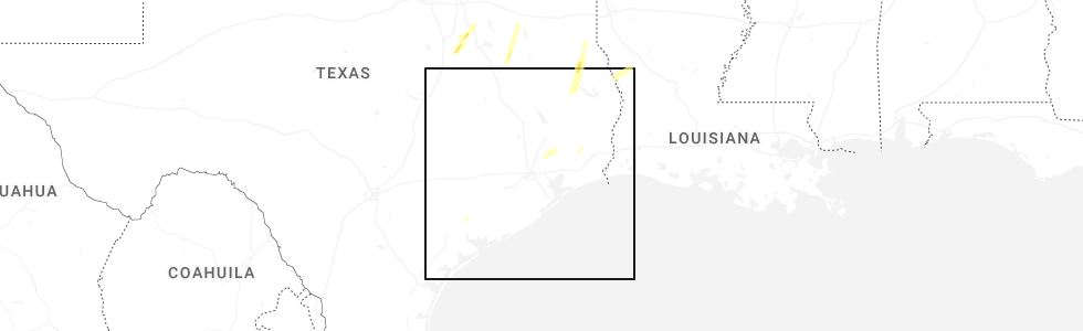
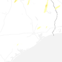
Hail Map for Ganado, TX
The Ganado, TX area has had 3 reports of on-the-ground hail by trained spotters, and has been under severe weather warnings 0 times during the past 12 months. Doppler radar has detected hail at or near Ganado, TX on 25 occasions, including 2 occasions during the past year.
| Name: | Ganado, TX |
| Where Located: | 84.9 miles SW of Houston, TX |
| Map: | Google Map for Ganado, TX |
| Population: | 2003 |
| Housing Units: | 765 |
| More Info: | Search Google for Ganado, TX |
0
The Top Recent Hail Date for Ganado, TX is Thursday, December 26, 2024 (25th out of 25)
Hail and Wind Damage Spotted near Ganado, TX
| Date / Time | Report Details |
|---|---|
| 5/13/2024 3:19 PM CDT |
 the severe thunderstorm warning has been cancelled and is no longer in effect the severe thunderstorm warning has been cancelled and is no longer in effect
|
| 5/13/2024 3:04 PM CDT |
 At 304 pm cdt, a severe thunderstorm was located near edna, moving east at 25 mph (radar indicated). Hazards include ping pong ball size hail and 60 mph wind gusts. People and animals outdoors will be injured. expect hail damage to roofs, siding, windows, and vehicles. expect wind damage to roofs, siding, and trees. Locations impacted include, edna, ganado, lolita, lake texana dam, and vanderbilt. At 304 pm cdt, a severe thunderstorm was located near edna, moving east at 25 mph (radar indicated). Hazards include ping pong ball size hail and 60 mph wind gusts. People and animals outdoors will be injured. expect hail damage to roofs, siding, windows, and vehicles. expect wind damage to roofs, siding, and trees. Locations impacted include, edna, ganado, lolita, lake texana dam, and vanderbilt.
|
| 5/13/2024 2:40 PM CDT |
 Svrhgx the national weather service in league city has issued a * severe thunderstorm warning for, central jackson county in south central texas, * until 330 pm cdt. * at 239 pm cdt, a severe thunderstorm was located near inez, or 10 miles northeast of victoria, moving northeast at 25 mph (radar indicated). Hazards include ping pong ball size hail and 60 mph wind gusts. People and animals outdoors will be injured. expect hail damage to roofs, siding, windows, and vehicles. Expect wind damage to roofs, siding, and trees. Svrhgx the national weather service in league city has issued a * severe thunderstorm warning for, central jackson county in south central texas, * until 330 pm cdt. * at 239 pm cdt, a severe thunderstorm was located near inez, or 10 miles northeast of victoria, moving northeast at 25 mph (radar indicated). Hazards include ping pong ball size hail and 60 mph wind gusts. People and animals outdoors will be injured. expect hail damage to roofs, siding, windows, and vehicles. Expect wind damage to roofs, siding, and trees.
|
| 10/5/2023 8:39 AM CDT |
 At 839 am cdt, severe thunderstorms were located along a line extending from near wharton to 8 miles south of el campo to near lolita, moving southeast at 40 mph (radar indicated). Hazards include 60 mph wind gusts. Expect damage to roofs, siding, and trees. locations impacted include, el campo, edna, ganado, la ward, pierce, lolita, blessing, markham, cordele, vanderbilt, louise, midfield, lake texana dam, and danevang. hail threat, radar indicated max hail size, <. 75 in wind threat, observed max wind gust, 60 mph. At 839 am cdt, severe thunderstorms were located along a line extending from near wharton to 8 miles south of el campo to near lolita, moving southeast at 40 mph (radar indicated). Hazards include 60 mph wind gusts. Expect damage to roofs, siding, and trees. locations impacted include, el campo, edna, ganado, la ward, pierce, lolita, blessing, markham, cordele, vanderbilt, louise, midfield, lake texana dam, and danevang. hail threat, radar indicated max hail size, <. 75 in wind threat, observed max wind gust, 60 mph.
|
| 10/5/2023 8:21 AM CDT |
 At 820 am cdt, severe thunderstorms were located along a line extending from near pierce to near ganado to near inez, moving east at 40 mph. at 812 am cdt, victoria reported a 61 mph gust with this line of storms (radar indicated). Hazards include 60 mph wind gusts. expect damage to roofs, siding, and trees At 820 am cdt, severe thunderstorms were located along a line extending from near pierce to near ganado to near inez, moving east at 40 mph. at 812 am cdt, victoria reported a 61 mph gust with this line of storms (radar indicated). Hazards include 60 mph wind gusts. expect damage to roofs, siding, and trees
|
| 9/25/2023 8:05 PM CDT |
 At 805 pm cdt, a severe thunderstorm was located over edna, moving south at 30 mph (radar indicated). Hazards include quarter size hail. damage to vehicles is expected At 805 pm cdt, a severe thunderstorm was located over edna, moving south at 30 mph (radar indicated). Hazards include quarter size hail. damage to vehicles is expected
|
| 7/23/2023 6:21 PM CDT |
 The severe thunderstorm warning for south central wharton and east central jackson counties will expire at 630 pm cdt, the storm which prompted the warning has weakened below severe limits, and no longer poses an immediate threat to life or property. therefore, the warning will be allowed to expire. The severe thunderstorm warning for south central wharton and east central jackson counties will expire at 630 pm cdt, the storm which prompted the warning has weakened below severe limits, and no longer poses an immediate threat to life or property. therefore, the warning will be allowed to expire.
|
| 7/23/2023 6:10 PM CDT | Dispatch reports trees and power lines down in ganado due to thunderstorm wind damag in jackson county TX, 0.3 miles NW of Ganado, TX |
| 7/23/2023 5:56 PM CDT |
 At 556 pm cdt, a severe thunderstorm was located near ganado, or 11 miles east of edna, moving southeast at 10 mph (radar indicated). Hazards include 60 mph wind gusts and quarter size hail. Hail damage to vehicles is expected. Expect wind damage to roofs, siding, and trees. At 556 pm cdt, a severe thunderstorm was located near ganado, or 11 miles east of edna, moving southeast at 10 mph (radar indicated). Hazards include 60 mph wind gusts and quarter size hail. Hail damage to vehicles is expected. Expect wind damage to roofs, siding, and trees.
|
| 4/28/2023 9:12 PM CDT |
 The severe thunderstorm warning for jackson county will expire at 915 pm cdt, the storms which prompted the warning have weakened below severe limits, and no longer pose an immediate threat to life or property. therefore, the warning will be allowed to expire. however gusty winds are still possible with these thunderstorms. a severe thunderstorm watch remains in effect until midnight cdt for south central texas. The severe thunderstorm warning for jackson county will expire at 915 pm cdt, the storms which prompted the warning have weakened below severe limits, and no longer pose an immediate threat to life or property. therefore, the warning will be allowed to expire. however gusty winds are still possible with these thunderstorms. a severe thunderstorm watch remains in effect until midnight cdt for south central texas.
|
| 4/28/2023 8:58 PM CDT |
 At 857 pm cdt, severe thunderstorms were located along a line extending from near ganado to near inez, moving southeast at 40 mph (radar indicated). Hazards include 60 mph wind gusts and penny size hail. expect damage to roofs, siding, and trees At 857 pm cdt, severe thunderstorms were located along a line extending from near ganado to near inez, moving southeast at 40 mph (radar indicated). Hazards include 60 mph wind gusts and penny size hail. expect damage to roofs, siding, and trees
|
| 4/28/2023 8:31 PM CDT |
 At 831 pm cdt, severe thunderstorms were located along a line extending from speaks to 9 miles south of ezzell to fordtran, moving southeast at 35 mph (radar indicated). Hazards include 60 mph wind gusts and quarter size hail. Hail damage to vehicles is expected. Expect wind damage to roofs, siding, and trees. At 831 pm cdt, severe thunderstorms were located along a line extending from speaks to 9 miles south of ezzell to fordtran, moving southeast at 35 mph (radar indicated). Hazards include 60 mph wind gusts and quarter size hail. Hail damage to vehicles is expected. Expect wind damage to roofs, siding, and trees.
|
| 4/21/2023 3:27 AM CDT |
 At 326 am cdt, severe thunderstorms were located along a line extending from near kendleton to near wharton to 6 miles south of pierce to 9 miles east of ganado, moving east at 45 mph (radar indicated). Hazards include 60 mph wind gusts and penny size hail. expect damage to roofs, siding, and trees At 326 am cdt, severe thunderstorms were located along a line extending from near kendleton to near wharton to 6 miles south of pierce to 9 miles east of ganado, moving east at 45 mph (radar indicated). Hazards include 60 mph wind gusts and penny size hail. expect damage to roofs, siding, and trees
|
| 4/21/2023 3:16 AM CDT |
 At 316 am cdt, severe thunderstorms were located along a line extending from 11 miles southeast of eagle lake to near pierce to 8 miles east of ganado to 6 miles north of lolita, moving east at 35 mph (radar indicated). Hazards include 60 mph wind gusts and penny size hail. Expect damage to roofs, siding, and trees. locations impacted include, el campo, edna, ganado, pierce, nada, egypt, louise and garwood. hail threat, radar indicated max hail size, 0. 75 in wind threat, radar indicated max wind gust, 60 mph. At 316 am cdt, severe thunderstorms were located along a line extending from 11 miles southeast of eagle lake to near pierce to 8 miles east of ganado to 6 miles north of lolita, moving east at 35 mph (radar indicated). Hazards include 60 mph wind gusts and penny size hail. Expect damage to roofs, siding, and trees. locations impacted include, el campo, edna, ganado, pierce, nada, egypt, louise and garwood. hail threat, radar indicated max hail size, 0. 75 in wind threat, radar indicated max wind gust, 60 mph.
|
| 4/21/2023 2:59 AM CDT |
 At 259 am cdt, severe thunderstorms were located along a line extending from 8 miles southwest of eagle lake to 13 miles northwest of el campo to 6 miles north of ganado to near edna, moving east at 35 mph (radar indicated). Hazards include 60 mph wind gusts and penny size hail. expect damage to roofs, siding, and trees At 259 am cdt, severe thunderstorms were located along a line extending from 8 miles southwest of eagle lake to 13 miles northwest of el campo to 6 miles north of ganado to near edna, moving east at 35 mph (radar indicated). Hazards include 60 mph wind gusts and penny size hail. expect damage to roofs, siding, and trees
|
| 4/21/2023 2:35 AM CDT |
 At 235 am cdt, a severe thunderstorm was located 9 miles northeast of fordtran, or 16 miles northwest of edna, moving southeast at 30 mph (radar indicated). Hazards include 60 mph wind gusts and quarter size hail. Hail damage to vehicles is expected. expect wind damage to roofs, siding, and trees. locations impacted include, el campo, edna, ganado, lolita, cordele, morales, lake texana dam and louise. hail threat, radar indicated max hail size, 1. 00 in wind threat, radar indicated max wind gust, 60 mph. At 235 am cdt, a severe thunderstorm was located 9 miles northeast of fordtran, or 16 miles northwest of edna, moving southeast at 30 mph (radar indicated). Hazards include 60 mph wind gusts and quarter size hail. Hail damage to vehicles is expected. expect wind damage to roofs, siding, and trees. locations impacted include, el campo, edna, ganado, lolita, cordele, morales, lake texana dam and louise. hail threat, radar indicated max hail size, 1. 00 in wind threat, radar indicated max wind gust, 60 mph.
|
| 4/21/2023 2:09 AM CDT |
 At 209 am cdt, a severe thunderstorm was located 7 miles southeast of yoakum, moving southeast at 30 mph (radar indicated). Hazards include golf ball size hail and 70 mph wind gusts. People and animals outdoors will be injured. expect hail damage to roofs, siding, windows, and vehicles. expect considerable tree damage. Wind damage is also likely to mobile homes, roofs, and outbuildings. At 209 am cdt, a severe thunderstorm was located 7 miles southeast of yoakum, moving southeast at 30 mph (radar indicated). Hazards include golf ball size hail and 70 mph wind gusts. People and animals outdoors will be injured. expect hail damage to roofs, siding, windows, and vehicles. expect considerable tree damage. Wind damage is also likely to mobile homes, roofs, and outbuildings.
|
| 4/5/2023 7:39 PM CDT |
 The severe thunderstorm warning for northwestern jackson county will expire at 745 pm cdt, the storm which prompted the warning has weakened below severe limits, and no longer poses an immediate threat to life or property. therefore, the warning will be allowed to expire. however small hail is still possible with this thunderstorm. The severe thunderstorm warning for northwestern jackson county will expire at 745 pm cdt, the storm which prompted the warning has weakened below severe limits, and no longer poses an immediate threat to life or property. therefore, the warning will be allowed to expire. however small hail is still possible with this thunderstorm.
|
| 4/5/2023 7:14 PM CDT |
 At 713 pm cdt, a severe thunderstorm was located near inez, or 9 miles northeast of victoria, moving northeast at 40 mph (radar indicated). Hazards include half dollar size hail. damage to vehicles is expected At 713 pm cdt, a severe thunderstorm was located near inez, or 9 miles northeast of victoria, moving northeast at 40 mph (radar indicated). Hazards include half dollar size hail. damage to vehicles is expected
|
| 1/24/2023 12:56 PM CST |
 The severe thunderstorm warning for southwestern wharton and northeastern jackson counties will expire at 100 pm cst, the storm which prompted the warning has weakened below severe limits, and has exited the warned area. therefore, the warning will be allowed to expire. a tornado watch remains in effect until 600 pm cst for south central and southeastern texas. to report severe weather, contact your nearest law enforcement agency. they will relay your report to the national weather service league city. The severe thunderstorm warning for southwestern wharton and northeastern jackson counties will expire at 100 pm cst, the storm which prompted the warning has weakened below severe limits, and has exited the warned area. therefore, the warning will be allowed to expire. a tornado watch remains in effect until 600 pm cst for south central and southeastern texas. to report severe weather, contact your nearest law enforcement agency. they will relay your report to the national weather service league city.
|
| 1/24/2023 12:38 PM CST |
 At 1237 pm cst, a severe thunderstorm was located over ganado, or 11 miles northeast of edna, moving northeast at 40 mph (radar indicated). Hazards include 60 mph wind gusts and quarter size hail. Hail damage to vehicles is expected. expect wind damage to roofs, siding, and trees. Locations impacted include, el campo, ganado and louise. At 1237 pm cst, a severe thunderstorm was located over ganado, or 11 miles northeast of edna, moving northeast at 40 mph (radar indicated). Hazards include 60 mph wind gusts and quarter size hail. Hail damage to vehicles is expected. expect wind damage to roofs, siding, and trees. Locations impacted include, el campo, ganado and louise.
|
| 1/24/2023 12:25 PM CST |
 At 1224 pm cst, a severe thunderstorm was located over edna, moving northeast at 40 mph (radar indicated). Hazards include 60 mph wind gusts and quarter size hail. Hail damage to vehicles is expected. Expect wind damage to roofs, siding, and trees. At 1224 pm cst, a severe thunderstorm was located over edna, moving northeast at 40 mph (radar indicated). Hazards include 60 mph wind gusts and quarter size hail. Hail damage to vehicles is expected. Expect wind damage to roofs, siding, and trees.
|
| 5/25/2022 2:02 AM CDT |
 At 201 am cdt, severe thunderstorms were located along a line extending from near speaks to near olivia to 21 miles southwest of matagorda island state park, moving east at 30 mph (radar indicated). Hazards include 60 mph wind gusts. expect damage to roofs, siding, and trees At 201 am cdt, severe thunderstorms were located along a line extending from near speaks to near olivia to 21 miles southwest of matagorda island state park, moving east at 30 mph (radar indicated). Hazards include 60 mph wind gusts. expect damage to roofs, siding, and trees
|
| 1/19/2022 8:27 PM CST |
 At 826 pm cst, a severe thunderstorm was located 8 miles south of speaks, or 11 miles north of edna, moving east at 25 mph (radar indicated). Hazards include 60 mph wind gusts and quarter size hail. Hail damage to vehicles is expected. Expect wind damage to roofs, siding, and trees. At 826 pm cst, a severe thunderstorm was located 8 miles south of speaks, or 11 miles north of edna, moving east at 25 mph (radar indicated). Hazards include 60 mph wind gusts and quarter size hail. Hail damage to vehicles is expected. Expect wind damage to roofs, siding, and trees.
|
| 5/19/2021 3:25 AM CDT |
 At 325 am cdt, severe thunderstorms located near ganado, or near edna, moving east at 50-60 mph (radar indicated). Hazards include 60 mph wind gusts and penny size hail. expect damage to roofs, siding, and trees At 325 am cdt, severe thunderstorms located near ganado, or near edna, moving east at 50-60 mph (radar indicated). Hazards include 60 mph wind gusts and penny size hail. expect damage to roofs, siding, and trees
|
| 5/16/2020 2:11 AM CDT |
 The severe thunderstorm warning for south central wharton and jackson counties will expire at 215 am cdt, the storms which prompted the warning have weakened below severe limits, and have exited the warned area. therefore, the warning will be allowed to expire. a severe thunderstorm watch remains in effect until 500 am cdt for south central and southeastern texas. The severe thunderstorm warning for south central wharton and jackson counties will expire at 215 am cdt, the storms which prompted the warning have weakened below severe limits, and have exited the warned area. therefore, the warning will be allowed to expire. a severe thunderstorm watch remains in effect until 500 am cdt for south central and southeastern texas.
|
| 5/16/2020 1:54 AM CDT |
 At 154 am cdt, severe thunderstorms were located along a line extending from near edna to dacosta, moving east at 55 mph (radar indicated). Hazards include 60 mph wind gusts. Expect damage to roofs, siding, and trees. Locations impacted include, edna, ganado, point comfort, la ward, olivia, alamo beach, lolita, port alto, vanderbilt and lake texana dam. At 154 am cdt, severe thunderstorms were located along a line extending from near edna to dacosta, moving east at 55 mph (radar indicated). Hazards include 60 mph wind gusts. Expect damage to roofs, siding, and trees. Locations impacted include, edna, ganado, point comfort, la ward, olivia, alamo beach, lolita, port alto, vanderbilt and lake texana dam.
|
| 5/16/2020 1:33 AM CDT |
 At 133 am cdt, severe thunderstorms were located along a line extending from fordtran to near oak village, moving east at 55 mph (radar indicated). Hazards include 60 mph wind gusts. expect damage to roofs, siding, and trees At 133 am cdt, severe thunderstorms were located along a line extending from fordtran to near oak village, moving east at 55 mph (radar indicated). Hazards include 60 mph wind gusts. expect damage to roofs, siding, and trees
|
| 4/19/2020 12:24 PM CDT |
 At 1223 pm cdt, a severe thunderstorm was located 8 miles west of el campo, moving northeast at 35 mph (radar indicated). Hazards include ping pong ball size hail and 60 mph wind gusts. People and animals outdoors will be injured. expect hail damage to roofs, siding, windows, and vehicles. wind damage to roofs, siding, and trees are possible. Locations impacted include, el campo, wharton, ganado, pierce, egypt, louise and danevang. At 1223 pm cdt, a severe thunderstorm was located 8 miles west of el campo, moving northeast at 35 mph (radar indicated). Hazards include ping pong ball size hail and 60 mph wind gusts. People and animals outdoors will be injured. expect hail damage to roofs, siding, windows, and vehicles. wind damage to roofs, siding, and trees are possible. Locations impacted include, el campo, wharton, ganado, pierce, egypt, louise and danevang.
|
| 4/19/2020 12:05 PM CDT |
 At 1203 pm cdt, a severe thunderstorm was located near ganado, or 12 miles northeast of edna, moving northeast at 30 mph (radar indicated). Hazards include 60 mph wind gusts and quarter size hail. Hail damage to vehicles is expected. Wind damage to roofs, siding, and trees is possible. At 1203 pm cdt, a severe thunderstorm was located near ganado, or 12 miles northeast of edna, moving northeast at 30 mph (radar indicated). Hazards include 60 mph wind gusts and quarter size hail. Hail damage to vehicles is expected. Wind damage to roofs, siding, and trees is possible.
|
| 6/17/2019 3:41 AM CDT |
 The severe thunderstorm warning for southwestern colorado, southwestern wharton and jackson counties will expire at 345 am cdt, the storms which prompted the warning have weakened below severe limits, and no longer pose an immediate threat to life or property. therefore, the warning will be allowed to expire. however gusty winds are still possible with these thunderstorms. a severe thunderstorm watch remains in effect until 500 am cdt for south central and southeastern texas. to report severe weather, contact your nearest law enforcement agency. they will relay your report to the national weather service league city. The severe thunderstorm warning for southwestern colorado, southwestern wharton and jackson counties will expire at 345 am cdt, the storms which prompted the warning have weakened below severe limits, and no longer pose an immediate threat to life or property. therefore, the warning will be allowed to expire. however gusty winds are still possible with these thunderstorms. a severe thunderstorm watch remains in effect until 500 am cdt for south central and southeastern texas. to report severe weather, contact your nearest law enforcement agency. they will relay your report to the national weather service league city.
|
| 6/17/2019 3:19 AM CDT |
 At 319 am cdt, severe thunderstorms were located along a line extending from near sublime to near ezzell to 8 miles east of fordtran, moving east at 55 mph (radar indicated). Hazards include 60 mph wind gusts. expect damage to roofs, siding, and trees At 319 am cdt, severe thunderstorms were located along a line extending from near sublime to near ezzell to 8 miles east of fordtran, moving east at 55 mph (radar indicated). Hazards include 60 mph wind gusts. expect damage to roofs, siding, and trees
|
| 6/6/2019 7:16 PM CDT |
 At 714 pm cdt, a cluster of severe thunderstorms was located from wharton down towards ganado, moving east 30 mph (radar indicated). Hazards include 60 mph wind gusts and quarter size hail. Hail damage to vehicles is expected. expect wind damage to roofs, siding, and trees. Locations impacted include, el campo, wharton, ganado, pierce, markham, boling-iago, blessing, cordele, louise, midfield and danevang. At 714 pm cdt, a cluster of severe thunderstorms was located from wharton down towards ganado, moving east 30 mph (radar indicated). Hazards include 60 mph wind gusts and quarter size hail. Hail damage to vehicles is expected. expect wind damage to roofs, siding, and trees. Locations impacted include, el campo, wharton, ganado, pierce, markham, boling-iago, blessing, cordele, louise, midfield and danevang.
|
| 6/6/2019 6:46 PM CDT |
 At 643 pm cdt, a cluster of severe thunderstorms were located from nada down towards cordele, moving east at 35 mph (radar indicated). Hazards include 60 mph wind gusts and quarter size hail. Hail damage to vehicles is expected. Expect wind damage to roofs, siding, and trees. At 643 pm cdt, a cluster of severe thunderstorms were located from nada down towards cordele, moving east at 35 mph (radar indicated). Hazards include 60 mph wind gusts and quarter size hail. Hail damage to vehicles is expected. Expect wind damage to roofs, siding, and trees.
|
| 5/9/2019 11:46 PM CDT |
 At 1146 pm cdt, severe thunderstorms were located along a line extending from near salem to inez to near port lavaca to near seadrift, moving east at 40 mph (radar indicated). Hazards include 60 mph wind gusts. expect damage to roofs, siding, and trees At 1146 pm cdt, severe thunderstorms were located along a line extending from near salem to inez to near port lavaca to near seadrift, moving east at 40 mph (radar indicated). Hazards include 60 mph wind gusts. expect damage to roofs, siding, and trees
|
| 4/7/2019 10:32 AM CDT |
 At 1031 am cdt, a severe thunderstorm was located near ganado, or 11 miles southwest of el campo, moving northeast at 40 mph (radar indicated). Hazards include 60 mph wind gusts. Expect damage to roofs, siding, and trees. Locations impacted include, edna, ganado, la ward, cordele and louise. At 1031 am cdt, a severe thunderstorm was located near ganado, or 11 miles southwest of el campo, moving northeast at 40 mph (radar indicated). Hazards include 60 mph wind gusts. Expect damage to roofs, siding, and trees. Locations impacted include, edna, ganado, la ward, cordele and louise.
|
| 4/7/2019 10:14 AM CDT |
 At 1014 am cdt, a severe thunderstorm was located near ganado, or near edna, moving northeast at 40 mph (radar indicated). Hazards include 60 mph wind gusts. expect damage to roofs, siding, and trees At 1014 am cdt, a severe thunderstorm was located near ganado, or near edna, moving northeast at 40 mph (radar indicated). Hazards include 60 mph wind gusts. expect damage to roofs, siding, and trees
|
| 3/29/2018 1:19 AM CDT |
 At 118 am cdt, a severe thunderstorm was located near el campo, moving northeast at 55 mph (radar indicated). Hazards include ping pong ball size hail and 60 mph wind gusts. People and animals outdoors will be injured. expect hail damage to roofs, siding, windows, and vehicles. expect wind damage to roofs, siding, and trees. Locations impacted include, el campo, wharton, edna, needville, east bernard, ganado, kendleton, pierce, boling-iago, cordele, egypt, louise, hungerford, nada and garwood. At 118 am cdt, a severe thunderstorm was located near el campo, moving northeast at 55 mph (radar indicated). Hazards include ping pong ball size hail and 60 mph wind gusts. People and animals outdoors will be injured. expect hail damage to roofs, siding, windows, and vehicles. expect wind damage to roofs, siding, and trees. Locations impacted include, el campo, wharton, edna, needville, east bernard, ganado, kendleton, pierce, boling-iago, cordele, egypt, louise, hungerford, nada and garwood.
|
| 3/29/2018 1:06 AM CDT |
 At 106 am cdt, a severe thunderstorm was located near ganado, or 10 miles northeast of edna, moving northeast at 55 mph (radar indicated). Hazards include 60 mph wind gusts and quarter size hail. Hail damage to vehicles is expected. Expect wind damage to roofs, siding, and trees. At 106 am cdt, a severe thunderstorm was located near ganado, or 10 miles northeast of edna, moving northeast at 55 mph (radar indicated). Hazards include 60 mph wind gusts and quarter size hail. Hail damage to vehicles is expected. Expect wind damage to roofs, siding, and trees.
|
| 4/2/2017 5:40 PM CDT | Golf Ball sized hail reported 9.3 miles NNW of Ganado, TX, large hail destroyed vehicle windshield near state highway 172 and 111 south. golfball or larger hail. |
| 4/2/2017 5:37 PM CDT |
 At 537 pm cdt, a severe thunderstorm was located 8 miles northeast of la ward, or 14 miles east of edna, moving northeast at 35 mph (radar indicated). Hazards include 60 mph wind gusts and quarter size hail. Hail damage to vehicles is expected. Expect wind damage to roofs, siding, and trees. At 537 pm cdt, a severe thunderstorm was located 8 miles northeast of la ward, or 14 miles east of edna, moving northeast at 35 mph (radar indicated). Hazards include 60 mph wind gusts and quarter size hail. Hail damage to vehicles is expected. Expect wind damage to roofs, siding, and trees.
|
| 2/14/2017 7:25 AM CST |
 At 724 am cst, severe thunderstorms were located along a line extending from near wallis to near lolita, moving east at 30 mph (radar indicated). Hazards include 60 mph wind gusts. expect damage to roofs, siding, and trees At 724 am cst, severe thunderstorms were located along a line extending from near wallis to near lolita, moving east at 30 mph (radar indicated). Hazards include 60 mph wind gusts. expect damage to roofs, siding, and trees
|
| 2/14/2017 6:28 AM CST |
 At 628 am cst, severe thunderstorms were located along a line extending from 6 miles northeast of speaks to 6 miles northeast of salem, moving northeast at 45 mph (radar indicated). Hazards include 60 mph wind gusts. expect damage to roofs, siding, and trees At 628 am cst, severe thunderstorms were located along a line extending from 6 miles northeast of speaks to 6 miles northeast of salem, moving northeast at 45 mph (radar indicated). Hazards include 60 mph wind gusts. expect damage to roofs, siding, and trees
|
| 3/18/2016 11:56 PM CDT |
 At 1156 pm cdt, a severe thunderstorm was located near inez, or 9 miles southwest of edna, moving east at 30 mph (radar indicated). Hazards include 60 mph wind gusts and quarter size hail. Hail damage to vehicles is expected. Expect wind damage to roofs, siding, and trees. At 1156 pm cdt, a severe thunderstorm was located near inez, or 9 miles southwest of edna, moving east at 30 mph (radar indicated). Hazards include 60 mph wind gusts and quarter size hail. Hail damage to vehicles is expected. Expect wind damage to roofs, siding, and trees.
|
| 8/11/2015 7:50 PM CDT |
 At 749 pm cdt, doppler radar indicated a line of severe thunderstorms from wharton to just south of nada, and moving southwest at 25 mph. At 749 pm cdt, doppler radar indicated a line of severe thunderstorms from wharton to just south of nada, and moving southwest at 25 mph.
|
| 5/24/2015 3:39 AM CDT | At 338 am cdt, doppler radar indicated a line of severe thunderstorms capable of producing damaging winds in excess of 60 mph. these storms were located along a line extending from near speaks to 6 miles north of la ward to near alamo beach, and moving northeast at 45 mph. |
| 5/24/2015 2:53 AM CDT | At 253 am cdt, doppler radar indicated a severe thunderstorm capable of producing damaging winds in excess of 60 mph. this storm was located over bloomington, or 10 miles northeast of mcfaddin, and moving northeast at 40 mph. |
| 5/13/2015 3:56 PM CDT | The tornado warning for southwestern wharton and northeastern jackson counties will expire at 400 pm cdt, the storm which prompted the warning has weakened below severe limits, and no longer appears to be capable of producing a tornado. therefore the warning will be allowed to expire. to report severe weather, contact your nearest law enforcement agency. they will relay your report to the national weather service league city. |
| 5/13/2015 3:45 PM CDT | At 343 pm cdt, radar showed the shower producing the funnel cloud was moving north of lake texana. a tornado may develop at any time. this dangerous storm was located near ganado, or 9 miles northeast of edna, moving north at 20 mph. another stronger shower was developing over the southern part of lake texana. funnel clouds may develop with this shower as well. locations impacted include, edna, ganado and cordele. |
| 5/13/2015 3:35 PM CDT | At 333 pm cdt, the public and trained weather spotters reported a funnel cloud over lake texana near ganado, or 7 miles northeast of edna. a tornado may develop at any time. doppler radar showed this dangerous storm moving north at 20 mph. |
| 4/25/2015 7:39 AM CDT | At 739 am cdt, doppler radar indicated a severe thunderstorm capable of producing quarter size hail. this storm was located over la ward, or 13 miles southeast of edna, and moving northeast at 50 mph. |
| 4/17/2015 6:18 PM CDT | At 617 pm cdt, doppler radar indicated a line of severe thunderstorms capable of producing quarter size hail and damaging winds in excess of 60 mph. these storms were located along a line extending from 9 miles southeast of weimar to 6 miles northwest of el campo to 7 miles south of ganado, moving east at 45 mph. the most intense part of the storm was moving into el campo. locations impacted include, el campo, edna, ganado, la ward, pierce, lolita, lake texana dam, louise, altair, rock island, garwood, vanderbilt and nada. |
| 4/17/2015 6:03 PM CDT | At 601 pm cdt, doppler radar indicated a line of severe thunderstorms capable of producing quarter size hail and damaging winds in excess of 60 mph. these storms were located along a line extending from near sublime to 11 miles north of ganado to near inez, moving east at 30 mph. jackson county sheriffs office reported trees down in morales at 558 pm. locations impacted include, el campo, edna, ganado, la ward, pierce, lolita, altair, lake texana dam, sheridan, louise, rock island, garwood, vanderbilt and nada. |
| 4/17/2015 5:45 PM CDT | At 544 pm cdt, doppler radar indicated a line of severe thunderstorms capable of producing quarter size hail and damaging winds in excess of 60 mph. these storms were located along a line extending from near hallettsville to near speaks to near wood hi, and moving east at 45 mph. |
| 1/1/0001 12:00 AM | Quarter sized hail reported 0.3 miles NW of Ganado, TX, quarter size hail in ganado with mostly penny size hail. |
| 5/26/2011 1:50 AM CDT | Wind gust measured with a portable weather station in jackson county TX, 0.3 miles NW of Ganado, TX |
| 5/26/2011 1:50 AM CDT | Tennis Ball sized hail reported 0.3 miles NW of Ganado, TX, windows broken on cars and houses due to the hail |
| 1/1/0001 12:00 AM | Roof ripped off a trailer home in jackson county TX, 9.7 miles SE of Ganado, TX |
Hail Maps for Ganado, TX


Connect with Interactive Hail Maps